Embed Size (px)
Citation preview

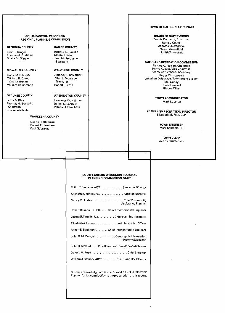
SOUTHEASTERN WISCONSIN REGIONAL PLANNING COMMISSION
KENOSHA COUNTY RACINE COUNTY
Leon T. Dreger Richard A. Hansen Thomas J. Gorlinski Martin J. ltzin Sheila M. Siegler Jean M. Jacobson,
Secretary
MILWAUKEE COUNTY WALWORTH COUNTY
Daniel J. Diliberti Anthony F. Balestrieri William R. Drew, Allen L. Morrison,
Vice Chairman Treasurer William Heinemann Robert J. Voss
OZAUKEE COUNTY WASHINGTON COUNTY
Leroy A. Bley Lawrence W. Hillman Thomas H. Buestrin, Daniel S. Schmidt
Chairman Patricia J. Strachota Gus W. Wirth, Jr.
WAUKESHA COUNTY
Duane H. Bluemke Robert F. Hamilton Paul G. Vrakas
TOWN OF CALEDONIA OFFICIALS
BOARD OF SUPERVISORS Dennis Kornwolf, Chairman
Ronald Couns Jonathan Delagrave
Susan Greenfield Judith Tomachek
PARKS AND RECREATION COMMISSION Richard C. Nelsen, Chairman Henly Kucera, Vice-Chairman Marty Christensen, Secretary
Roger Christensen Jonathan Delagrave, Town Board Liaison
Mel Gulley Jerrie Howard Gladys Olley
TOWN ADMINISTRATOR Mark Luberda
PARKS AND RECREATION DIRECTOR Elizabeth M. Paul, CLP
TOWN ENGINEER Mark Schmalz, PE
TOWN CLERK Wendy Christensen
SOUTHEASTERN WISCONSIN REGIONAL PLANNING COMMISSION STAFF
Philip C. Evenson, AlCP . . . . . . . . . . . . . . Executive Director
Kenneth R. Yunker, PE.. . . . . . . . . . . . . . . Assistant Director
Nancy M. Anderson. . . . . . . . . . . . . . . . . . Chief Community Assistance Planner
Robert P. Biebel, PE, PH. . . . . Chief Environmental Engineer
Leland H. Kreblin, RLS . . . . . . . . . . Chief Planning Illustrator
ElizabethA.Larsen. .............. Administrativeofficer
RobertE. Beglinger. . . . . . . . ChiefTransportation Engineer
John G. McDougall. . . . . . . . . . . . . Geographiclnformation SystemsManager
John R. Meland . . . . Chief Economic Development Planner
Donald M. Reed . . . . . . . . . . . . . . . . . . . . . . . Chief Biologist
William J. Stauber,AICP . . . . . . . . . Chief Land Use Planner
Special acknowledgment is due Donald P. Heckel, SEWRPC Planner,for hiscontribution tothe preparation of this report.

COMMUNITY ASSISTANCE PLANNING REPORT NUMBER 1 79 (2nd Edition)
A PARK AND OPEN SPACE PLAN FOR THE TOWN OF CALEDONIA RACINE COUNTY, WISCONSIN
Prepared by the
Southeastern Wisconsin Regional Planning Commission P.O. Box 1607 Old Courthouse
916 N. East Avenue Waukesha, Wisconsin 53 187- 1607
April 2000
Inside Region $3.00 Outside Region $6.00

(This page intentionally left blank)

TABLE OF CONTENTS
Chapter I-INTRODUCTION ......................... Plan Context ......................................................... Town Request ...................................................... Advisory Committee ............................................ Planning Area ....................................................... Report Format ......................................................
Chapter 11-INVENTORY FINDINGS .......... .......................................................... Introduction
Resident Population ............................................. Land Use Base ..................................................... Park and Open Space Sites ..................................
Existing Park and Open Space Sites ................. Natural Resource Features ...................................
Surface Water Resources .................................. Wetlands ........................................................... Woodlands ........................................................ Environmental Corridors ..................................
Primary Environmental Corridors ................. Secondary Environmental Corridors and Isolated Natural Resource Areas ..........
Natural Areas and Critical Species Habitat Sites ..........................
Prime Agricultural Land ................................... .............................................................. Summary
Page
Chapter 111-PARK AND OPEN SPACE OBJECTIVES. PRINCIPLES. STANDARDS. AND NEEDS ANALYSIS ...............................
Introduction .......................................................... Objectives. Principles. and Standards ..................
Plan Objectives ................................................. Plan Standards .................................................. Application of Park and
Open Space Standards .................................... Park and Open Space Needs ................................
Forecast Population .......................................... Resource-Oriented Sites and Facilities .............
Recommended Resource-Oriented Outdoor .......................................... Sites and Facilities
Parkways and Trails ......................................... ....... Nonresource-Oriented Sites and Facilities ....... Site Needs Based on Per Capita Standards
Site Needs Based on Service Area Standards ..................................
Facility Needs Based on Per Capita Standards ......................................
Facility Needs Based on Service Area Standards ..................................
........................................... Baseball Diamonds Basketball Goals ...............................................
.......................................................... Playfields ...................................................... Playgrounds .................................................... Soccer Fields
Softball Fields (Sandlot) ................................... ............................ Softball Diamonds (League)
................................................... Tennis Courts ....................... Open Space Preservation Needs
.............................................................. Summary
Page
......... Chapter IV-RECOMMENDED PLAN ......................................................... Introduction
Areawide Park and ......................... Open Space Recommendations ....................... Major Parks and Trail Facilities
..................................... Open Space Preservation Primary Environmental Corridors ....................
................ Secondary Environmental Corridors ...................... Isolated Natural Resource Areas
Natural Areas and Critical ...................................... Species Habitat Sites
................................. Prime Agricultural Lands Town Park and Open Space
............................................. Recommendations Proposed Park and
Open Space Sites and Facilities ..................
Page Page
Existing Park and Open Space . . Sites and Facilities ................................. . .....
Plan Implementation ..... . .. . ... . . .. . . ... .. . .. . .. .. ... .. .. .. .. . . Wisconsin Department of Natural Resources .......................................
Wisconsin Department of Transportation ............................................
Racine County .................................................. City of Racine ........................................... . ....... Town of Caledonia ........................................... Other Plan Implementation Considerations.. . . . . Plan Costs ......................................................... Maintenance Impact ..........................................
Appendix
A
Summary ............................................................. .
Chapter VCUMMARY .................................. . . Inventory Fmdmgs .............. ................................. Park and Open Space Objectives,
Principles, Standards and Needs Analysis ...........................................
Recommended Plan ........................................ ..... Areawide Park and Open Space
Recommendations . . . . . . . . . . . . . . . . . . . . . . . . . . . . . . . . . . . . . . . . . . Open Space Preservation .................................. Town Park and Open Space Recommendations . . . .. . . . . . . . . . . . . . . . . . . . . . . . . . . . . . . . . . . . . .
LIST OF APPENDICES
Page
Outdoor Recreation and Open Space Planning Objectives, Principles, and Standards for the Town of Caledonia ............................................................... 69
Resolution 2000- 19 ................................................................................................................... 79
LIST OF TABLES
Table Chapter I1
Resident Population of the Town of Caledonia Planning Area: 1900- 1998 ..................................... Existing Land Uses in the Town of Caledonia Planning Area: 1995 ............................................... Park and Open Space Sites in the Town of Caledonia Planning Area: 1999 ................................... Selected Outdoor Recreation Facilities in the Town of Caledonia Planning Area: 1999. ........ . .... . .. Environmental Corridors and Isolated Natural Resource Areas in the Town of Caledonia Planning Area: 1990 ............................................................................... Natural Areas and Critical Species Habitat Sites in the Town of Caledonia Planning Area: 1994 ...............................................................................
Chapter III
Per Capita Acreage Requirements for Community and Neighborhood Parks in the Town of Caledonia Planning Area ....................................................... Per Capita Requirements for Selected Outdoor Recreation Facilities in the Town of Caledonia Planning Area ..........................................................................
Page
Table
Chapter IV
Figure
1
Recommended Protection of Natural Areas and Critical Species Habitat Sites in the Town of Caledonia Planning Area .................................................................... 52 Recommended Acquisition and Development at Proposed and Existing Park Sites in the Town of Caledonia ........................................................................... 54
LIST OF FIGURES
Page Chapter I1
Resident Population of the Town of Caledonia Planning Area: 1900-1998 .................................... 6
LIST OF MAPS
Page Chapter I
Location of the Town of Caledonia Planning Area in the Southeastern Wisconsin Region.. .... . . . . . . 2
Chapter I1
Generalized Historical Urban Growth in the Town of Caledonia Planning Area: 1950-1 995 ........ . 7 Existing Land Use in the Town of Caledonia Planning Area: 1995 ................................................. 9 Park and Open Space Sites in the Town of Caledonia Planning Area: 1999 ................................... 10 Town-Owned Park and Open Space Sites in the Town of Caledonia: 1999 .................................... 14 Surface Water Drainage and Floodlands in the Town of Caledonia ................................................ 16 Environmentally Significant Lands in the Town of Caledonia Planning Area: 1990 ...................... 19 Natural Areas and Critical Species Habitat Sites in the Town of Caledonia Planning Area: 1994 ........................................ . . ............. . . . . . 2 1 Prime Agricultural Lands in the Town of Caledonia Planning Area: 1995 ......... .................. . ... . .. . . 24
Chapter 111
Planned Residential Areas in the Town of Caledonia Urban Service Area IVot Adequately Served by a Community Park ................................................................................. 32 Planned Residential Areas in the Town of Caledonia Urban Service Area Not Adequately Served by a Neighborhood Park ....................................................... 33 Planned Residential Areas in the Town of Caledonia Urban Service Area Not Adequately Served by a Baseball Diamond ..... ..... ................. ...... . . . 35 Planned Residential Areas in the Town of Caledonia Urban Service Area Not Adequately Served by a Basketball Goal .................................................................................. 36 Planned Residential Areas in the Town of Caledonia Urban Service Area Not Adequately Served by a Playfield ........................................................................ 37
Map Page
15 Planned Residential Areas in the Town of Caledonia Urban Service Area Not Adequately Served by a Playground .................................................................... 38
16 Planned Residential Areas in the Town of Caledonia Urban Service Area Not Adequately Served by a Soccer Field .................................................................. 40
17 Planned Residential Areas in the Town of Caledonia Urban Service Area Not Adequately Served by a Sandlot Softball Field ................................................... 41
18 Planned Residential Areas in the Town of Caledonia Urban Service Area Not Adequately Served by a League Softball Diamond ............................................. 42
19 Planned Residential Areas in the Town of Caledonia Urban Service Area Not Adequately Served by a Tennis Court ................................................................. 43
Chapter IV
20 A Park and Open Space Plan for Racine County .............................................................................. 47 2 1 Recommended Outdoor Recreation Plan for the Town of Caledonia .............................................. 48 22 Recommended Open Space Preservation Plan
for the Town of Caledonia Planning Area: 2020 .............................................................................. 50
Chapter I
INTRODUCTION
PLAN CONTEXT
Broadly defined, recreation is an activity or experience undertaken solely for the pleasure or satisfaction derived from it. Recreation can be experienced indoors or outdoors. It encompasses a wide variety of human activities, including rest and reflection, development of personal and social skills, meeting challenges, and recovering from disappointment. Recreation includes both mental and physical exercise and personal enjoyment. Although recreational preferences may vary from individual to individual, recreation occu- pies a necessary and significant place in every person's life. For the purpose of this report, recreation will be viewed in a narrower framework as including only those recreational activities typically carried on outdoors.
The intent of the park and open space plan for the Town of Caledonia is to guide the preservation, acquisition, and development of land for park, outdoor recreation, and related open space purposes as needed to satisfy the recreational needs of Town residents and to protect and enhance the important natural resources within the Town. The plan seeks to provide a variety of recreational sites and facilities that will offer oppor- tunities for Town residents to participate in a wide range of active and passive recreational pursuits.
Park and open space acquisition, development, and use have long been issues of concern to public officials and citizen leaders because of the importance of outdoor recreation sites and areas for natural resource protection. On December 1, 1977, the Southeastern Wisconsin Regional Planning Commission adopted SEWRPC Planning Report No. 27, A Regional Park and Open
Space Plan for Southeastern Wisconsin: 2000, which identifies existing and probable future park and open space needs within the Region and recommends a system of large resource-oriented parks, recreational corridors, a regional trail system, and smaller non- resource-oriented urban parks, together with attendant recreational facilities. That plan, as it related to Racine County, was adopted by the Racine County Board in 1978. At the request of the Racine County Highway and Parks Committee, the regional park and open space plan was refined and detailed within Racine County through preparation of a park and open space plan for the County in 1988.' The Racine County park plan is currently being updated.
TOWN REQUEST
The Town of Caledonia, on November 5, 1996, requested that the Regional Planning Commission assist in the preparation of a new park and open space plan for the Town. The plan is to reflect recent park and open space acquisition and development activities within the Town and is also intended to maintain Town eligibility to apply for and receive Federal and State aids in partial support of the acquisition and develop- ment of park and open space sites and facilities. The requested new plan is documented in this report. This plan updates an earlier park and open space plan prepared for the Town by the Regional Planning Commission. That plan, which has a design year of
'~ocumented in SEWRPC Community Assistance Plan- ning Report No. 134, A Park and Open Space Plan for Racine County, September 1988.
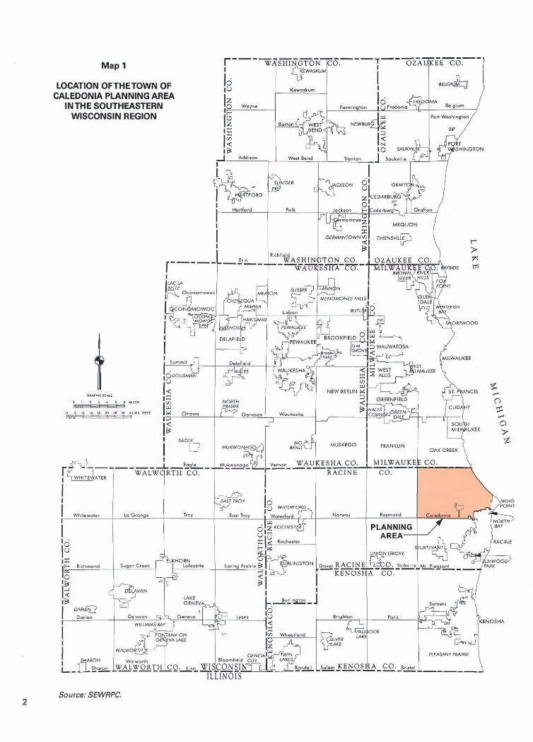
Map 1
LOCATION OFTHETOWN OF CALEDONIA PLANNING AREA
INTHE SOUTHEASTERN WISCONSIN REGION
Source: SEWRPC.
2010, is documented in the first edition of this report published in 1989.
of Wind Point, on the southeast by the City of Racine, on the south by the Town of Mount Pleasant, and on the west by IH 94 and the Town of Raymond.
ADVISORY COMMITTEE REPORT FORMAT
The planning process was conducted under the guidance of the Town of Caledonia Parks and Recreation Commission. The Commission consists of government officials and citizens fiom the Town of Caledonia. A list of the Park Commission members is provided on the inside cover of this report.
PLANNING AREA
The planning area, as shown on Map 1, consists of the Town of Caledonia, which is located in U.S. Public Land Survey Township 4 North and Ranges 22 and 23 East in northeastern Racine County. The planning area also includes Johnson Park, which is part of the City of Racine but is surrounded by the Town. The Town encompasses an area of about 46 square miles. As further shown on Map 1, the Town is bounded on the north by the City of Oak Creek in Milwaukee County, on the east by Lake Michigan and the Village
The findings and recommendations of the Town park and open space plan are set forth in this report. Following this introductory chapter, Chapter I1 presents information about the Town pertinent to park and open space planning, including information on the resident population, the land use pattern, and natural resources within the Town. An inventory of existing park and open space sites and facilities within the Town is also included in Chapter TI. Chapter I11 presents the objectives, principles, and supporting standards which served as the basis for the development of the Town's park and open space plan. Chapter TI1 also provides an analysis of outdoor recreation site and facility needs and open space preservation needs in theTown. The recommended park and open space plan and plan implementation measures are presented in Chapter IV. Lastly, Chapter V presents a summary of the plan.

(This page intentionally left blank)
Chapter I1
INVENTORY FINDINGS
INTRODUCTION
The proper formulation of a sound park and open space plan requires the collection of inventory data related to population and population distribution, the pattern of land use development, existing park and open space sites and facilities, and natural resources within the planning area. The inventory findings for the Town of Caledonia planning area are presented in this chapter.
RESIDENT POPULATION
Resident population levels are an important con- sideration in any park and open space planning effort. Data otl the historic and existing resident population of the planning area are presented in Table 1 and shown in Figure 1. The planning area includes the Town of Caledonia and Johnson Park, which is sur- rounded by the Town but part of the City of Racine. The resident population of the Town of Caledonia in 1990 was 20,999 persons.
As indicated in Table 1, the resident population of the Town of Caledonia increased steadily from the 1900 population of 2,805 persons to 1920, when the popu- lation totaled 3,479 persons. Between 1920 and 1930 the Town experienced a 13 percent decrease in popula- tion, from 3,479 persons to 3,031 persons. From 1930 to 1970 the population increased considerably to 16,748 persons. Between 1970 and 1980, the population continued to increase, albeit at a slower rate than the previous four decade period, to 20,940 persons. Between 1980 and 1990 the population change was negligible as it increased slightly to 20,999 persons.
The estimated population level for 1998 is 22,654 persons, an increase of 1,655 persons, or 8 percent, from 1990.
LAND USE BASE
Land use is an important determinant of both the supply of, and the demand for, outdoor recreation and related open space facilities. Accordingly, an understanding of the amount, type, and spatial distribution of urban and rural land uses within the planning area, as well as the historical conversion of rural lands to urban uses, is an important consideration in this park and open space planning effort. This section presents a description of the historical urban development and the existing land use base within the Caledonia planning area.
The historic pattern of urban growth in ,le Town of Caledonia planning area is shown on Map 2. Map 2 identifies areas of the Town where residential structures or other buildings have been constructed in relatively compact groups, thereby indicating concentrations of residential, commercial, industrial, governmental, insti- tutional, or other urban land uses. In 1950 urban land uses in the Town consisted largely of two subdivisions located in the southeastern and southwestern portions of the Town, together with a cluster of development in the northeastern portion of the Town, north of Six-Mile Road. Together these areas encompassed approximately 275 acres. In the years following 1950, urban devel- opment began to occur in areas scattered throughout the Town, with the majority fronting on existing roadways. The Town experienced its greatest period of urban growth between 1950 and 1963 when an addi-
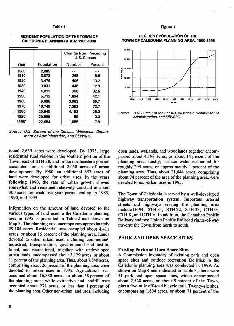
Table 1 Figure 1
RESIDENT POPULATION OF THE TOWN OF RESIDENT POPULATION OF THE CALEDONIA PLANNING AREA: 1900-1998 TOWN OF CALEDONIA PLANNING AREA: 1900-1998
Source: U.S. Bureau of the Census, Wisconsin Depart- ment of Administration, and SEWRPC.
Year
1900 1910 1920 1930 1940 1950 1960 1970 1980 1990 1998'
tional 2,639 acres were developed. By 1975, large residential subdivisions in the southern portion of the Town, east of STH 38, and in the northeastern portion accounted for an additional 2,050 acres of urban development. By 1980, an additional 857 acres of land were developed for urban uses. In the years following 1980, the rate of urban growth slowed somewhat and remained relatively constant at about 300 acres for each five-year period ending in 1985, 1990, and 1995.
Information on the amount of land devoted to the various types of land uses in the Caledonia planning area in 1995 is presented in Table 2 and shown on Map 3. The planning area encompasses approximately 29,184 acres. Residential uses occupied about 4,4 1 1
Population
2,805 3,073 3,479 3,031 4,O 19 5,7 13 9,696
16,748 20,940 20,999 22,654
acres, or about 15 percent of the planning area. Lands devoted to other urban uses, including commercial, industrial, transportation, governmental and institu- tional, and recreational, together with undeveloped urban lands, encompassed about 3,129 acres, or about 1 1 percent of the planning area. Thus, about 7,540 acres, comprising about 26 percent of the planning area, were devoted to urban uses in 1995. Agricultural uses occupied about 16,880 acres, or about 58 percent of the planning area; while extractive and landfill uses occupied about 271 acres, or less than 1 percent of the planning area. Other non-urban land uses, including
1900 1810 1820 1830 1840 1850 1880 1970 1980 ISSO 2000
YEAR
Change from Preceding U.S. Census
Source: U.S. Bureau of the Census, Wisconsin Department of Administration, and SEWRPC.
Number - - 268 406
-448 988
1,694 3,983 7,052 4,192
59 1,655
open lands, wetlands, and woodlands together encom- passed about 4,198 acres, or about 14 percent of the planning area. Lastly, surface water accounted for roughly 295 acres, or approximately 1 percent of the planning area. Thus, about 21,644 acres, comprising about 74 percent of the area of the planning area, were devoted to non-urban uses in 1995.
Percent - - 9.6
13.2 -12.9 32.6 42.1 69.7 72.7 25.0 0.3 7.9
The Town of Caledonia is served by a well-developed highway transportation system. Important arterial streeG and highways serving the planning area include IH 94, STH 3 1, STH 32, STH 3 8, CTH G, CTH K, and CTH V. In addition, the Canadian Pacific Railway and two Union Pacific Railroad rights-of-way traverse the Town from north to south.
PARK AND OPEN SPACE SITES
Existing Park and Open Space Sites A Commission inventory of existing park and open space sites and outdoor recreation facilities in the Caledonia planning area was conducted in 1999. As shown on Map 4 and indicated in Table 3, there were 51 park and open space sites, which encompassed about 2,528 acres, or about 9 percent of the Town, plus a five-mile off-road bicycle trail. Twenty-six sites, encompassing 1,804 acres, or about 71 percent of the
Map 2
GENERALIZED HISTORICAL URBAN GROWTH INTHETOWN OF CALEDONIA PLANNING AREA: 1950-1995
ORAPWlC SCALE
4 M!LE
_r
I) 2100 4800 1200FEET
Source: SEWRPC.
Table 2
EXISTING LAND USES IN THE TOWN OF CALEDONIA PLANNING AREA: 1995
Source: SEWRPC,
total park and open space site acreage, were publicly owned, including the trail facility. The remaining 25 sites, encompassing 724 acres, or 29 percent of the park and open space site acreage, were privately owned. As indicated in Table 4, selected outdoor recreational facilities in the planning area in 1999 included three baseball diamonds, 42 basketball goals, 20 soccer fields, 16 playgrounds, nine league softball diamonds, 12 sandlot softball diamonds, and 21 tennis courts. Playfields were located at 16 sites. Other significant outdoor recreation facilities avail- able within the Town include a trout pond, a water slide, numerous campsites, two 18-hole golf courses, a wide variety of hiking and nature trails, and two ice skating rinks.
Land Use Category
Urban Residential .................................................................................... Commercial ................................................................................... Industrial ....................................................................................... Transportation, Communication, and Utilities ........................... Governmental and Institutional .................................................. Recreational .................................................................................. Undeveloped Urban .....................................................................
Subtotal
Rural Undeveloped Rural ...................................................................... Agricultural ................................................................................... Extractive and Landfill ................................................................. Wetlands ....................................................................................... Woodlands .................................................................................... Surface Water ...............................................................................
Subtotal
Total
As shown on Map 5 and indicated in Table 3, the Town of Caledonia, in 1999, owned 13 park and open space sites, which together encompassed about 341 acres, or about 1 percent of the area of the Town. A description of each of the Town sites is presented below:
Percent of Subtotal
58.5 2.5 2.4
23.5 4.0 6.6 2.5
100.0
6.2 78.0
1.2 7.6 5.6 1.4
100.0
- -
Acres
4,411 193 179
1,774 302 496 185
7,540
1,341 16,880
27 1 1,643 1,214
295
2 1,644
29,184
Caledonia-Mt. Pleasant Memorial Park: Cale- donia-Mt. Pleasant Memorial Park is a 52-acre community park located in the southern portion of the Town and is jointly owned by the Towns of Caledonia and Mt. Pleasant. The site includes a baseball diamond, four basketball goals, two soccer fields, a playfield, a playground, one league softball diamond, two sandlot softball diamonds, two tennis courts, sand volleyball courts, informal and group picnic areas, and rest rooms.
Percent of Planning Area
15.1 0.7 0.6 6.1 1 .O 1.7 0.6
25.8
4.6 57.9 0.9 5.6 4.2 1 .O
74.2
100.0
2. Chapla Park: Chapla Park is a 10-acre neighbor- hood park located along the Lake Michigan shoreline south of Cliffside Park in the north- eastern portion of the Town. The site provides open space for passive recreational pursuits and also contains an ice rink.
3. Crawford Park: Crawford Park is a 17-acre undeveloped neighborhood park located in the eastern portion of the Town.

Map 3
EXISTING LAND USE INTHETOWN OF CALEDONIA PLANNING AREA: 1995
NT PLEASANT
SINGLE-FAMILYRESIDENII*L
MULI I IAMI IY RESIDENTIAL
COMMERCIAL
INDUSTRIAL
TWINSPORTITIOH.COMMUNICATION.ANDUTlLlTlES
GOVERNMENTALANDlNSTlTUTlONliL
PMKSANORECREATIONAL
WETLmDS
WOODLANOS
EXTRACTIVEANDLANOFILL
SURFACE W l i E R
0 *ORICULT"~L*NOOTHEROPENLANDS
-.- TOWNOF WLEDONIACIYIIDIVIS10N BOUNDARY
Source: SEWRPC.

Map 4
PARK AND OPEN SPACE SITES INTHETOWN OF CALEDONIA PLANNINGAREA: 1999
PUBLICLYOWNEDSITE
PRIVATELY OWNED SITE
$5 REFERENCE NUMBERCSEE TPgLES BAND41
-.- TOWN OF CALEDOIIIACNIL DIVtSIONBOUNDW
GRAPHICSCALE
; l MlLE - Source: SEWRPC.
, Table 3
PARK AND OPEN SPACE SITES IN THE TOWN OF CALEDONIA PLANNING AREA: 1999
NOTE: The Prairie School and Wind Point School were utilized in the needs analysis for playgrounds in Chapter Ill but are not included in this list because they are not located within the Town of Caledonia civil division.
Number on Map 4
1 2 3 4 5 6 7 8 9
10 11 12 13 14 15 16 17 18 19 20 2 1 22 23 24 25 26
27 28 29 30 31 32 33 34 35 36 37 38 39 40 41 42 43 44 45 46 47 48 49 59 51
a ~ h e MRK (Milwaukee-Racine-Kenoshal Off-Road Bicycle Trail is a five-mile crushed limestone trail and is a joint venture between Racine County and the Wisconsin Electric Power Company. . . blncludes only those lands within the Town o f Caledonia. Source: SEWRPC.
Site Name
Public
Caddy Vista School Caledonia-Mt. Pleasant Memorial Park Chapla Park Cliffside Park Crawford Park Eastside Community Center Gomey Park Johnson Park Linwood Park MRK Off-Road Bicycle Trail Nicholson Wildlife Refuge North Park School Olympia Brown Elementary School Open Space Site Renak-Polak Maple-Beech Woods Root River Parkway Root River Parkway Tabor-Sokol Memorial Park Town-Owned Land (County Line Park) Town-Owned Land Town-Owned Land (5 W Mile Park-Marsh) Town-Owned Land Town-Owned Land W. Allen Gifford Elementary and Junior High School Woodland Park 2nd Division Memorial Marker and Wayside
Subtotal - 26 Sites
Private
Aboagye Acquisition Armstrong Park Crestview Home Owners Park Fieldhouse Pub & Eatery Greater Racine Kennel Club Husher Pub and Grill New Marshal Right-of-way Orrin C. Steams Park Prince of Peace Lutheran Church Private Ball Field Racine Tennis Club Racine County Line Rifle Club Range River Bend Nature Center Serbian Soccer Club of Milwaukee Soccer Complex of Racine (SCORE) St. John's Evangelical Lutheran School St. Louis Parish School St. Rita's School Stoney's Drive and Putt South Hills Country Club Trinity Evangelical Lutheran School Trout Ponds Prairie Wisconsin Electric Power Company Gun Club Witt's End Yogi Bear Jellystone Park
Subtotal - 25 sites
Total 51 sites
Ownership
Racine Unified School District Towns of CaledoniaIMt. Pleasant Town of Caledonia Racine County Town of Caledonia Town of Caledonia Town of Caledonia City of Racine Town of Caledonia Racine County and WEPCO Town of Caledonia Racine Unified School District Racine Unified School District Racine .Unified School District University of Wisconsin Racine County Milwaukee County Racine County Town of Caledonia Town of Caledonia Town of Caledonia Town of Caledonia Town of Caledonia Racine Unified School District Town of Caledonia State of Wisconsin
- -
Caledonia Conservancy Private Private Commercial Organizational Commercial Caledonia Conservancy Private Organizational Private Commercial Organizational Organizational Organizational Organizational Organizational Organizational Organizational Commercial Commercial Organizational Caledonia Conservancy Organizational Commercial Commercial
- - - -
Location
T 4N-R22E, Section 4 T 4N-R22E. Section 33 T 4N-R23E, Section 8 T4N-R23E, Section 7 T 4N-R23E. Section 20 T 4N-R23E. Section 18 T4N-R22E, Section 3 T 4N-R22E. Section 25 T 4N-R22E. Section 14 T 4N-R23E. Various T 4N-R22E, Section 21 T 4N-R23E. Section 29 T 4N-R23E, Section 21 T4N-R23E, Section 17 T4N-R22E, Section 14 T 4N-R23E. Section 30 T 4N-R22E, Section 4 T 4N-R23E, Section 19 T 4N-R22E. Section 2 T 4N-R22E. Section 4 T 4N-R23E, Section 17 T 4N-R23E. Section 28 T 4N-R22E, Section 33 T 4N-R22E. Section 34 T 4N-R23E, Section 18 T 4N-R22E, Section 12
- -
T 4N-R22E. Section 25 T 4N-R23E. Section 31 T 4N-R23E. Section 17 T 4N-R22E, Section 9 T 4NR22E, Section 11 T 4N-R22E. Section 9 T 4N-R22E, Section 11 T 4N-R22E. Section 35 T 4N-R23E. Section 7 T 4N-R23E, Section 18 T 4N-R23E, Section 21 T 4N-R23E, Section 6 T 4N-R23E. Section 31 T 4N-R22E. Section 6 T 4N-R22E, Section 33 T 4N-R22E, Section 6 T 4N-R22E. Section 18 T 4N-R23E, Section 29 T 4N-R23E. Section 20 T 4N-R22E, Section 31 T 4N-R22E. Section 9 T 4N-R22E. Section 24 T 4N-R23E. Section 6 T 4N-R22E. Section 17 T 4N-R22E. Section 4
- -
- -
Acreage
7 52 10
233 17 1
28 357
18 a - -
127 4
24 29
107 6mb 39"
1 17 7
2 1 2 1 18 12 4 2
1,804
6 139
5 2
20 3 2 3 3 3
11 80 87 41 55
1 9 8
14 134'
4 28 2 1
63
724
2,528

Table 4
SELECTED OUTDOOR RECREATION FACILITIES IN THE TOWN OF CALEDONIA PLANNING AREA: 1999
1 Number I Regulation I Basketball I Ice 1 1 Site Name On M ~ D 4 Baseball Goal Skatina soccer I 1 League I Sandlot I Tennis I Fields Plavfields Plavaround Softball Softball Courts Other Facilities
Public Caddy Vista School Caledonia-Mt. Pleasant Memorial Park
Chapla Park Cliffside Park
Crawford Park Eastside Community Center Gorney Park Johnson Park
Linwood Park
MRK Off-Road Bicycle Trail Nicholson Wildlife Refuge Nonh Park School Olympia Brown Elementary School
Open Space Site Renak-Polak Maple-Beech Woods
Root River Parhay Root River Parkway Tabor-Sokol Memorial Park Town-Owned Land
(County Line Park-Marsh) Town-Owned Land Town-Owned Land
(5 H Mile Park) Town-Owned Land Town-Owned Land W. Allen Gifford Elementary and Junior High School
Woodland Park 32"' Division Memorial Marker and Wayside
Volleyball, Tether ball Recreation building. Sand volleyball, Inform8llgroup picnic areas Passive use Campsites, Informal/ group picnic areas, Bicycle and hiking trails Undeveloped park site Multiuse center Trout pond. Hiking trail 18 hole golf and driving range, Informal/group p~cnic areas. River frontage Recreation building. Horseshoes, lnformall group picnic areas, River frontage Five-mile off-road bicycle trail Nature trail
- - Nature trail, Major lake access
I Natural area
Passive use, River access f'assive use Informal picnic areas Undeveloped park site
- - Undeveloped park site
Informal picnic areas, Nature trail Passive use, Informal picnic areas
4. Eastside Community Center: The Caledonia Community Center is an indoor multi-use center located on a one-acre site in the east-central portion of the Town.
Subtotal
5. Gorney Park: Gorney Park is a 28-acre community park located in the northern portion of the Town. The site includes a baseball diamond, a league softball diamond, a soccer field, a playfield, a playground, rest rooms, a trout pond accessible to disabled persons, and a walking trail.
6. Linwood Park: Linwood Park is an 18-acre neighborhood park located in the central portion
- -
of the Town. The site includes a playfield, a playground, informal picnic areas, horseshoe pits, and Root River frontage.
7. Nicholson Wildlife Refuge: The Nicholson Wildlife Refuge is a 127-acre natural area of
3
countywide or regional significance located in the southwestern portion of the Town. The site includes trail facilities and provides open space for educational and passive recreational pursuits.
8. Town-Owned Land: This Town-owned site is a seven-acre detention basin for stormwater management purposes. The site is located in the northern portion of the Town immediately south
29 2 9 8 9 6 8 8 - -
Table 4 (continued)
Source: Town of Caledonia Park Commission and SEWRPC.
of the Caddy Vista South subdivision. The site may provide opportunities for limited recrea- tion use.
Site Name
Private Aboagye Acquisition Armstrong Park
Crestview Home Owners Park Fieldhouse Pub &Eatery Greater Racine Kennel Club Husher Pub & Grill
New Marshal Right-of-way Orrin C. Stearns Park
Prince of Peace Lutheran Church
Private Ball Field Racine Tennis Club Racine County Line
Rifle Club Range River Bend Nature Center
Serbian Soccer Club of Milwaukee
Soccer Complex of Racine (SCORE)
St. John's Evangelical Lutheran School
St. Louis Parish School St. Rita's School Stoney's Drive and Putt South Hills Country Club Trinity Evangelical
Lutheran School Trout Ponds Prairie
Wisconsin Electric Power Company Gun Club
Win's End Yogi Bear Jellystone Park
Subtotal
Total
9. Town-Owned Land: This Town-owned site is a 21-acre detention basin for stormwater man- agement purposes. The site is located in the eastern portion of the Town south of CTH G and west of Erie Street. The site may provide opportunities for limited recreation use.
10. Town-Owned Land: This Town-owned site is an 18-acre detention basin for stormwater man- agement purposes. The site is located in the southwestern portion of the Town immedi-
Number On Map 4
27 28
29 30 31 32
33 34
35
36 37 38
39
40
41
42
43 44 45 46 47
48
49
50 51
- - - -
Basketball Goal
- - - -
. - - - - - - -
- - - -
- -
- - 1
- -
- -
- -
- -
1
2 4 . - . .
4
- -
- -
- - 1
13
42
ately northwest, and adjacent to, Caledonia- Mt. Pleasant Memorial Park.
Soccer Fields
- - 1
- - - . - - - -
- - - -
- -
- - - - . - - -
2
7
- -
- - 1 - - - - - -
- -
- -
. - - -
11
20
Regulation Baseball
- - - -
- - - - - - - -
- - - -
- -
- - - - - -
- -
- -
- -
. -
- - - - - - - - . -
- -
- -
- - - .
0
3
Ice Skating
- - - -
- - - - - - - -
- - - -
- -
. - - - - -
- -
- -
- -
- -
- - - - - - - - - -
- -
- -
- - - -
0
2
1 1. Town-Owned Land (County Line Park): County Line Park is a 17-acre undeveloped neighborhood park located in the northern portion of the Town.
12. Town-Owned Land (5 % Mile Park): 5 % Mile Park is a 21-acre undeveloped neighborhood park located in the eastern portion of the Town south of 5 !4 Mile Road and north of Five Mile Road.
Playfields
- - X
X - - - - - -
- - - -
X
- - . .
- -
- -
- -
- -
X
X X - - . - X
- -
- -
- - X
8
16
13. Woodland Park: Woodland Park is a four-acre neighborhood park located in the east-central
Playground
. .
X
X - - - - . - - - - -
X
- - - - - -
- -
-.
- -
X
X X - - - - X
- -
- -
- - - -
7
16
League Softball
- - 2
- - - - - - - -
- - - -
- -
1 - - - -
- -
- -
- -
- -
- - - - -.
- - - -
- -
- -
- - . -
3
9
Sandlot Softball
- - 2
- - - - - - - -
- - - -
- -
- - - - - -
- -
- -
- -
- -
- - 1 . - - - - -
- -
- -
- - 1
4
12
Tennis Courts
- - 4
- - - - - . - -
- - - -
- - - - 9 - -
- -
- -
- -
- -
- - . - - - - - - .
- -
- -
- - - -
13
2 1
Other Facilities
- - Informallgroup picnic areas, Hiking trail, Miniature golf, Driving range. Sand volleyball Sand volleyball Sand volleyball, Horseshoe pits
. .
Sand volleyball, Horseshoe pits, Informal picnic area Hiking trail Passive use, Informal picnic area, Swimming beach
- -
- - Swimming pool, Volleyball Shooting range
Passive use, Nature study, Hiking trails, River access
Group picnic area, Recreation building
- -
- -
- - - -
Miniature golf, Driving range 18 hole golf
- -
Nature preserve, HikinglNature trails Shooting range
Informal picnic area, Horseshoe pits Campsites, Informal1 group picnic areas, Miniature golf, Water slide, Outdoor theater, Sand volleyball courts, Horseshoe pits
- - - -
Map 5
TOWN-OWNED PARK AND OPEN SPACE SITES INTHETOWN OF CALEDONIA PLANNINGAREA. 1999
TOWN-OWNED PARKOROPEN SPACE SITE
1 CALEOONlA-Ml. PLEASANIYEMDRI&LPARK
2 CHAPLAPARK
3 CRAWFORD wnn
4 EASTSIDECOUMUNI~CENTER
5 GORNEYPARK
6 LlNwoaoPARK
7 NICHOLSONWILDLIFEREFUGE
8 TOWN-OWNED LANO (STORMWATER DETENTION BASIN SITE)
g i o w a a w s o LaND(sT0nMwaiER DETEWTlON8ASIN SITE1
10 TOWN-OWNEOLAND(STORMWAIEROETENTlONBASII181iEI
11 TOWN-OWNED LAN0 (COUNT" LINE PARKI
12 TOWN-OWNED LAND (5 H MILE PARKI
13 w o o o r ~ ~ o PaRn
-a- 1885 TOWN OFCALEOON*CIVII DlYlSlON BOUNDARY
GRAPHICSCALE
I MILE C____
Source: SEWRPC.

portion of the Town behind the Eastside Community Center. The site includes an informal picnic area and a nature trail.
NATURAL RESOURCE FEATURES
The natural resources of an area are important determinants of the ability of an area to provide a pleasant and habitable environment for all forms of life and to maintain its social and economic well being. The planning of parks and open spaces should seek to preserve the most significant remaining aspects of the natural resource base to help retain the ecological balance and natural beauty of the area. A description of the natural resource base of the Caledonia planning area, including surface water resources, wetlands, woodlands, environmental corridors, natural areas, and prime agricultural lands, is presented in this section.
Surface Water Resources Surface water resources and associated floodlands, shown on Map 6, form a particularly important element of the natural resource base of the Town of Caledonia. Lakes and streams provide water-related activities, an attractive setting for properly planned residential development, and enhance the aesthetic quality of the Town. Rivers and streams may be classified as perennial or intermittent. The perennial and certain intermittent streams within the Town are shown on Map 6. Perennial streams are defined as watercourses that maintain, at a minimum, a small continuous flow throughout the year except under unusual drought conditions. Intermittent streams are defined as watercourses that do not maintain a continuous flow throughout the year. Within the Town, a total of approximately 67 linear miles of perennial and intermittent rivers and streams were identified.
The floodlands of a river or stream are the wide generally sloping areas contiguous to, and usually lying on both sides of, the river or stream channel. Rivers and streams occupy their channels most of the time. However, during even minor flood events, stream discharges increase markedly, and the channel may not be able to contain and convey all of the flow. As a result, stages increase and the river or stream spreads laterally over the floodland. The periodic flow of a river onto its floodlands is a normal phenomenon and, in the absence of costly structural flood control works, will occur regardless of whether urban development exists on the floodland or not.
For planning and regulatory purposes, floodlands are normally defined as the areas, excluding the channel, subject to inundation by the 100-year recurrence interval flood event. This is the event that would be reached or exceeded in severity once on average every 100 years or, stated another way, there is a 1 percent chance of this event being reached or exceeded in severity in any given year. Floodland areas are generally not well suited to urban develop- ment, not only because of the flood hazard, but also because of the presence of high water tables and of soils poorly suited to urban use. The floodland areas, however, generally contain such important elements of the natural resource base as woodlands, wetlands, and wildlife habitat and, therefore, constitute prime locations for needed open space areas. Every effort should be made to discourage indiscriminate and incompatible urban development on floodlands, while encouraging compatible park and open space use.
Floodlands have been delineated and refined within the Town of Caledonia under the Racine County Federal Flood Insurance Study in October of 1981 and SEWRPC Community Assistance Planning Report No. 152, A Stormwater Drainage and Flood Control System for the Milwaukee Metropolitan Sewerage District, December 1990. These floodland delineations are shown on Map 6 and encompass an area of approximately 1,641 acres, or about 6 percent of the planning area.
Wetlands Wetlands are defined by the Regional Planning Commission as areas in which the water table is at, near, or above the land surface and which is charac- terized by both hydric soils and the growth of sedges, cattails, and other wetland vegetation. Wetlands generally occur in depressions and near the bottom of slopes, particularly along lakeshores and stream banks, and on large land areas that are poorly drained.
Wetlands perform an important set of natural functions which include supporting a wide variety of desirable, and sometimes unique, forms of plant and animal life; stabilization of lake levels and stream flows; entrapment and storage of plant nutrients in runoff, thus reducing the rate of enrichment of surface waters and noxious weed and algae growth; contribution to the atmospheric oxygen and water supplies; reduction in stormwater runoff by providing areas for floodwater impoundment and storage; protection of shorelines from erosion; entrapment of soil particles suspended in runoff and reduction of stream sedimentation; provision of
Map 6
SURFACE WATER DRAINAGE AND FLOODLANDS INTHETOWN OF CALEDONIA
I SURFACE WATER
PERENNIAL STREAM
, J INTERMITTENT S T R E W
-00-YEA8 RECURRENCE INTERV*LFLOODPLAIN
& WATERSHEDBOVHDARI
-.- l9SS TOWNOFCALEDONII\CIYILDIYISION BOUNDARY GRAPHICSCALE
0 4 4 UllE C__
0 2100 1000 7200 FEET
Source: Federal Emergency ManagementAgency and SEWRPC

groundwater recharge and discharge areas; and pro- vision of opportunities for certain scientific, educational, and recreational pursuits.
As shown on Map 3 and indicated in Table 2, wetlands covered about 1,643 acres or about 6 percent of the planning area in 1995. It should be noted that such areas as tamarack swamps and other lowland wooded areas are classified as wetlands rather than woodlands because the water table is located at, near, or above the land surface, and such areas are characterized by hydric soils that support hydrophytic trees and shrubs.
Woodlands Woodlands are defined by the Regional Planning Commission as those upland areas one acre or more in size with 17 or more deciduous trees per acre, each measuring at least four inches in diameter at breast height and having 50 percent or more tree canopy coverage. Coniferous tree plantations and reforestation projects are also identified as woodlands.
Woodlands provide an attractive natural resource of immeasurable value. Under good management, wood- lands can serve a variety of beneficial functions. In addition to contributing to clean air and water and regulating surface water runoff, woodlands can con- tribute to the maintenance of a diversity of plant and animal life. Woodlands, which may require a century or more to develop, can be destroyed through mismanagement within a comparatively short time. The deforestation of hillsides contributes to rapid stormwater runoff, the siltation of lakes and streams, and the destruction of wildlife habitat.
Woodlands can and should be maintained for their scenic, wildlife habitat, educational, and recreational value and for air and water quality protection. As shown on Map 3, woodlands occur in scattered locations throughout the Town. In 1995, woodland areas covered 1,214 acres, or about 4 percent of the planning area.
Environmental Corridors Ecological balance and natural beauty are important determinants of the ability of an area to provide a pleasant and habitable environment for all forms of life and to maintain its social and economic well being.
One of the most important tasks completed under the regional planning program for southeastern Wisconsin has been the identification and delineation of those areas in the Region in which concentrations of the best remaining elements of the natural resource base
occur. The protection and preservation of such areas in essentially natural, open uses is crucial in maintaining both the ecological balance and natural beauty of the Region and the Town of Caledonia planning area.
Identification of environmental corridors is based upon the presence of one or more of the following important elements of the natural resource base: 1) rivers, streams, lakes, and associated shorelands and floodlands; 2) wetlands; 3) woodlands; 4) prairies; 5) wildlife habitat areas; 6) wet, poorly drained, and organic soils; and 7) rugged terrain and high relief topography. The presence of elements that are closely related to the natural resource base, including park and open space sites, natural areas, historic sites, and scenic viewpoints, are also considered in the delineation of environmental corridors.'
The delineation of these natural resource and resource- related elements on a map results in an essentially linear pattern of relatively narrow, elongated areas which have been termed "environmental corridors" by the Regional Planning Commission. Primary environ- mental corridors include a wide variety of the impor- tant natural resource and resource-related elements and are at least 400 acres in size, two miles in length, and 200 feet in width. Secondary environmental corridors generally connect with the primary environ- mental corridors and are at least 100 acres in size and one mile in length. Isolated natural resource areas consist of smaller concentrations of natural resource base elements, have a minimum of five acres, and are separated physically from the environmental corridors by intensive urban or agricultural land uses.
In any consideration of environmental corridors and isolated natural resource areas, it is important to note that the preservation of such resources can assist in flood flow attenuation, water pollution abatement, and favorable climate modification. In addition, because of the many interacting relationships between living organisms and their environment, the destruction or deterioration of any one element of the natural resource base may lead to a chain reaction of deterioration and destruction of other elements. The draining and filling of wetlands, for example, may destroy fish spawning grounds, wildlife habitat, groundwater recharge areas, and the natural filtration action and
' A detailed description of the process of refining the delineation of environmental corridors in Southeastern Wisconsin is presented in SE WRPC Technical Record, Vol. 4, No. 2, pages I through 21.
17

floodwater storage hc t ions of interconnecting stream systems. The resulting deterioration of surface water quality may, in turn, lead to deterioration of the quality of groundwater, which serves as a source of domestic, municipal, and industrial water supply and on which low flows in rivers and streams may depend. Similarly, the destruction of woodland cover may result in soil erosion and stream siltation, more rapid stormwater runoff and attendant increased flood flows and stages, and destruction of wildlife habitat.
Although the effects of any one of these environ- mental changes may not in and of itself be over- whelming, the combined effects will eventually create serious environmental and developmental problems. These problems include flooding, water pollution, deterioration and destruction of wildlife habitat, loss of groundwater recharge areas, and destruction of the unique natural beauty of the area. The need to maintain the integrity of the remaining environmental corridors and isolated natural areas thus becomes apparent.
Primary Environmental Corridors As shown on Map 7, in 1990 the primary environmental corridors were located, for the most part, along the Root River and the northern reach of Husher Creek, as well as the entire stretch of the Lake Michigan shoreline located within the Town of Caledonia. As indicated in Table 5, these corridors encompassed a total area of about 1,860 acres, or about 6 percent of the planning area.
The generalized natural resource composition of the primary environmental corridors is summarized in Table 5. Of the 1,860 acres of primary environmental corridor located in the Town in 1990, 214 acres, or 12 percent, were surface water; 778 acres, or 42 percent, were wetlands; 421 acres, or 23 percent, were woodlands; and 447 acres, or 23 percent, consisted of other resources.
The primary environmental corridors include the best remaining woodlands, wetlands, and wildlife habitat areas and are, in effect, composites of the best remaining residual elements of the natural resource base of the planning area. These corridors have truly immeasurable environmental and recreational value. The protection of the primary environmental corri- dors from intrusion by incompatible rural and urban uses, and thereby from degradation and destruction, should be one of the principal objectives of the Town park and open space plan. Their preservation in an essentially open, natural state-including park
18
and open space uses, limited agricultural uses, and very low density residential useswill serve to maintain a high level of environmental quality in the planning area, protect its natural beauty, and provide valuable recreation opportunities.
Secondary Environmental Corridors and Isolated Natural Resource Areas In addition to the primary environmental corridors, other concentrations of natural resource base elements exist within the Town. Although separate from the primary environmental corridors, secondary environmental corridors and isolated natural resource areas may provide surface water drainage, maintain pockets of natural resource features, provide wildlife habitat and corridors for the movement of wildlife, and provide good locations for local parks, natural areas, and the development of local trails. Although not as important as primary environmental corridors, secondary environmental corridors and isolated natural resource areas should also be preserved in essentially open, natural uses to the extent practicable.
As shown in Map 7 and indicated in Table 5, secondary environmental corridors were located along an inter- mittent stream in the eastern portion of the Town, as well as Hoods Creek south of STH 38, and also occupied a large portion of the Nicholson Wildlife Refuge. These sites encompassed a total of about 240 acres, or less than 1 percent of the area of the Town. In addition, as further shown on Map 7 and indicated in Table 5, there were 1,304 acres of isolated natural resource areas scattered throughout the planning area.
Natural Areas and Critical Species Habitat Sites Natural areas are defined by the Regional Planning Commission as tracts of land or water so little modified by human activity, or sufficiently recovered from the affects of such activity, that they contain intact native plant and animal communities believed to be repre- sentative of the landscape before European settlement. Natural areas are classified into one of the following three categories: natural areas of statewide or greater significance (NA-I); natural areas of countywide or regional significance (NA-2); or natural areas of local significance (NA-3). Classification of an area into one of these three categories is based upon consideration of the diversity of plant and animal species and community types present; the structure and integrity of the native plant or animal community; the extent ofdisturbance by human activity, such as logging, grazing, water level changes, and pollution; the commonness of the plant and animal communities
Map 7
ENVIRONMENTALLY SIGNIFICANT LANDS INTHETOWN OF CALEDONIA PLANNINGAREA: 1990
- it- &' i i ~ 4i
GRAPHICSCALE
,M,LE - 0 2100 4800 7200FEET
Source: SEWRPC.
Table 5
ENVIRONMENTAL CORRIDORS AND ISOLATED NATURAL RESOURCE AREAS IN THE
TOWN OF CALEDONIA PLANNING AREA: 1990
Source: SEWRPC,
present; any unique natural features within the area; the size of the area; and the educational value.
Resource
Surface Water Wetland Woodland Other Resources
L
Total
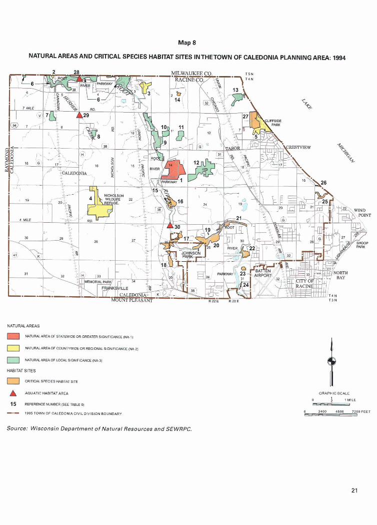
A comprehensive inventory of natural area sites and critical species habitat sites in Racine County was completed in 1994 by the Regional Planning Com- mission2. As shown on Map 8 and indicated in Table 6, 13 natural areas were identified within the Town of Caledonia. These sites covered a total of 901 acres, or about 3 percent of the planning area.
Total
Critical species habitat sites are defined by the Regional Planning Commission as areas that support rare, threatened or endangered plant or animal species. Seventeen critical species habitat sites were also identified within the Town. These sites are also shown on Map 8 and identified in Table 6. These sites covered about 334 acres of land, or about I percent of the area of the Town, and approximately 18 linear miles of surface water.
Total Acres
258 1,382
1,152 61 2
3,404
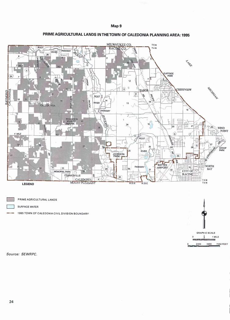
Prime Agricultural Land It is useful for planning purposes to distinguish between prime agricultural lands and other farming areas. Prime agricultural lands are those lands which, in terms of farm size, the total area being farmed, and soil characteristics, are best suited for the pro-
Percent of Total
7.0 42.0
34.0 17.0
100.0
Primary Environmental
Corridor
Documented in SEWRPC Planning Report No. 42, A Regional Natural Areas and Critical Species Habitat Protection and Management Plan for Southeastern Wisconsin, September 1997. 20
Total Acres
214 778
42 1 447
1,860
duction of food and fiber. A number of important public purposes are served by the preservation of prime agricultural lands. Such public purposes include maintenance of agricultural reserves, conservation of energy, maintenance of open space, protection of environmentally significant areas, control of public costs, preservation of the local economic base, and preservation of the rural lifestyle. As shown on Map 9, these areas encompassed about 8,439 acres, or about 29 percent of the planning area in 1995.
Percent of Total
12.0 42.0
23.0 23.0
100.0
Secondary Environmental
Corridor
SUMMARY
Isolated Natural Resource Area
Total Acres
8 124
46 62
240
This chapter has presented a general description of the Caledonia planning area, including a description of population levels, existing land use, existing park and open space sites, and natural resource features such as environmental corridors and natural areas, and prime agricultural lands. The key components of this chapter are as follows:
Total Acres
36 480
685 103
1,304
Percent of Total
3.0 52.0
19.0 26.0
100.0
1. In 1990, the resident population of the Town of Caledonia was 20,999 persons. The resident population level of the Town for the year 1998 was estimated at 22,654.
Percent of Total
3.0 37.0
52.0 8.0
100.0
2. The Caledonia planning area, in 1995 encom- passed about 29,184 acres. Of this total, about 7,540 acres, or about 26 percent, were in urban uses. Residential use accounted for the largest percentage of lands developed for urban use,
Map 8
NATURAL AREASAND CRITICAL SPECIES HABITAT SITES INTHETOWN OF CALEDONIA PLANNING AREA: 1994
?EAS
NRUIYIEAOF STATEW1DE OR ORE4TER SlONFICWCE (M-I)
NATUR4L*REAOf C W N W l D E OR REUIONALSlONinCANCE (NA Z ]
1 N4TUWIIWEAW mC&L SIGNIFICWCE (W.31
ITAT SITES
I CRITWSPECIES W I T A T SITE
AQUATlCHABlTATAREA
15 REFERENCE NUMBER (SEE TABLE 61
-.- 1895 TOWN OF CALEDONIACIVILDlYlSlON BOUNDARY
GRAPHIC SCALE
0 ; , M,LE P
I) 21011 4800 7POOPEET C
Source: Wisconsin Department of Natural Resources and SEWRPC.
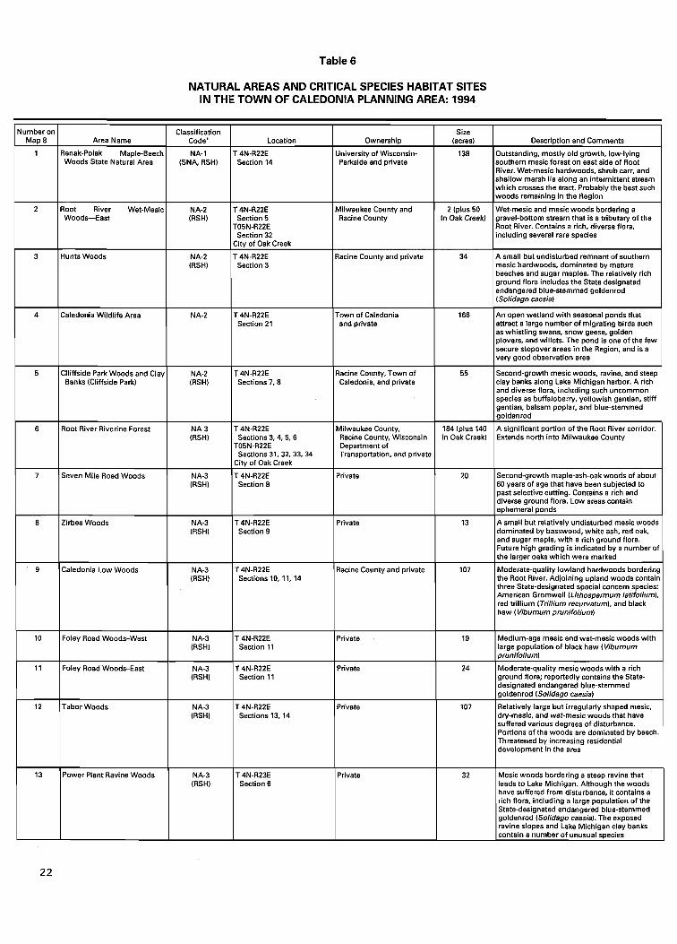
Table 6
NATURAL AREAS AND CRITICAL SPECIES HABITAT SITES IN THE TOWN OF CALEDONIA PLANNING AREA: 1994
Number on Map 8
1
2
3
4
5
6
7
8
9
10
11
Area Name
Renak-Polak Maple-Beech Woods State Natural Area
Root River Wet-Mesic Woods-East
Hunts Woods
Caledonia Wildlife Area
Clliffside Park Woods and Clay Banks (Cliffside Park)
Root River Riverine Forest
Seven Mile Road Woods
Zirbes Woods
Caledonia Low Woods
Foley Road Woods-West
Foley Road Woods-East
designated endangered blue-stemmed goldenrod (Solidago caesia)
12 Tabor Woods NA-3 T 4N-R22E Private 107 Relatively large but irregularly shaped mesic, (RSH) Sections 13, 14 dry-mesic, and wet-mesic woods that have
Classification Code'
NA-1 (SNA, RSH)
NA-2 (RSH)
NA-2 (RSH)
NA-2
NA-2 (RSH)
NA-3 (RSH)
NA-3 (RSH)
NA-3 (RSH)
NA-3 (RSH)
NA-3 (RSH)
NA-3 (FISH)
13
Location
T4N-R22E Section 14
T 4N-R22E Section 5
T05N-R22E Section 32
City of Oak Creek
T 4N-R22E Section 3
T 4N-R22E Section 21
T 4N-R22E Sections 7,8
----- T 4N-R22E
Sections 3,4,5, 6 T05N-R22E Sections 31, 32, 33, 34
City of Oak Creek
T 4N-R22E Section 8
T 4N-R22E Section 9
T 4N-R22E Sections 10, 11, 14
T 4N-R22E Section 11
T 4N-R22E Section 11
--
suffered various degrees of disturbance. Portions of the woods are dominated by beech. Threatened by increasing residential development in the area
Ownership
University of Wisconsin- Parkside and private
Milwaukee County and Racine County
Racine County and private
Town of Caledonia and private
Racine County, Town of Caledonia, and private
Milwaukee County, Racine County, Wisconsin Department of Transportation, and private
Private
Private
Racine County and private
Private
Private
Power Plant Ravine Woods NA-3 T 4N-R23E Private (RSH) Section 6 leads to Lake Michigan. Although the woods
have suffered from disturbance, i t contains a rich flora, including a large population of the State-designated endangered blue-stemmed goldenrod (Solidago caesia). The exposed ravine slopes and Lake Michigan clay banks contain a number of unusual species
Size (acres)
138
2 (plus 50 In Oak Creek)
34
166
55
184 (plus 140
Description and Comments
Outstanding, mostly old growth, low-lying southern mesicforest on east side of Root River. Wet-mesic hardwoods, shrub carr, and shallow marsh lie along an intermittent stream which crosses the tract. Probably the best such woods remaining in the Region
Wet-mesic and mesic woods bordering a gravel-bottom stream that is a tributary of the Root River. Contains a rich, diverse flora, including several rare species
A small but undisturbed remnant of southern mesic hardwoods, dominated by mature beeches and sugar maples. The relatively rich ground flora includes the State designated endangered blue-stemmed goldenrod (Solidago caesia)
An open wetland with seasonal ponds that attract a large number of migrating birds such as whistling swans, snow geese, golden plovers, and willets. The pond is one of the few secure stopover areas in the Region, and is a very good observation area
Second-growth mesic woods, ravine, and steep clay banks along Lake Michigan harbor. A rich and diverse flora, including such uncommon species as buffaloberry, yellowish gentian, stiff gentian, balsam poplar, and blue-stemmed goldenrod
in Oak Creek)
20
13
107
19
Extends north into Milwaukee County
Second-growth maple-ash-oak woods of about 60 years of age that have been subjected to past selective cutting. Contains a rich and diverse ground flora. Low areas contain ephemeral ponds
A small but relatively undisturbed mesic woods dominated by basswood, white ash, red oak, and sugar maple, with a rich ground flora. Future high grading is indicated by a number of the larger oaks which were marked
Moderate-quality lowland hardwoods bordering the Root River. Adjoining upland woods contain three State-designated special concern species: American Gromwell (Lithospermum latifolium), red trillium (Trillium recurvatum), and black haw (Viburnum prunifolium)
Medium-age mesic and wet-mesic woods with large population of black haw (Viburnum prunifolium)
ground flora; reportedly contains the State-
Table 6 (continued)
a ~ ~ - l identifies Natural Area sites of statewide or greatersignificance NA-2 identifies Natural Area sites of countywide or ragionel significance NA-3 identifies Natural Area sites of local significance SNA, or State Natural Area, identifies those sites officially designated as State Natural Areas by the State of Wisconsin Natural Areas Presewation Council. RSH, or Rare Species Habitat, identifies those sites which support rare, threatened, or endangered animal or plant species officiaNy designated by the Wisconsin Department of Natural Resources.
b ~ h e Caledonia Site South Critical Species Habitat site is located entirely within the Caledonia Sanitary Sewer Right of Way.
Source: Wisconsin Department of Natural Resources and SEWRPC.
Map 9
PRIME AGRICULTURAL LANDS INTHETOWN OF CALEDONIA PLANNING AREA: 1995
PRIMEAGRICULTURALLANDS
0 SURFACE WATER
-- l995TOWN OF CALEOONlAClVlLDlVlSlON BOUNDARY
ORAPHIC SCALE
0 3 l MILE - Source: SEWRPC.
encompassing about 4,411 acres, or about 15 percent of the planning area and about 59 percent of the urban lands within the Town. The remaining 2 1,644 acres, about 74 percent of the planning area, were devoted to rural uses. Agricultural uses occupied a significant portion of the Town of Caledonia, encompassing about 16,880 acres, or about 58 percent of the planning area; other non-urban land uses include- ing extractive and landfill, woodlands, wetlands, and other open lands, together encompassed about 4,764 acres, or about 16 percent of the planning area.
A 1999 inventory of the existing park and open space sites and outdoor recreation facili- ties in the planning area found that there were fifty-one such sites, which together encom- passed about 2,528 acres, or about 9 percent of the Town, and one off-road bicycle trail facility.
4. In the planning area in 1990 primary environ- mental corridors encompassed about 1,860 acres, or about 6 percent of the planning area. Secondary environmental corridors encompassed a total of about 240 acres, or less than 1 percent of the planning area. Isolated natural resource areas encompassed about 1,304 acres, or about 4 percent of the planning area.
5. The planning area also includes 13 natural areas, 14 critical species habitat sites, and three aquatic habitat areas encompassing about 1,23 5 acres. One of the natural areas within the Town is considered to be of statewide or greater significance.
6. Agricultural lands encompassed about 16,880 acres, or about 58 percent of the planning area in 1995. Of this total, about 8,439 acres, com- prising about 29 percent of the planning area, were identified as prime agricultural lands.

(This page intentionally left blank)
Chapter I11
PARK AND OPEN SPACE OBJECTIVES, PRINCIPLES, STANDARDS, AND NEEDS ANALYSIS
INTRODUCTION
This chapter sets forth the objectives, principles, and standards used in the preparation of this park and open space plan for the Town of Caledonia. Objectives guide the preparation of plans, while the standards listed under each objective provide the specific measures used to design the plan. The standards are applied to the anticipated 2020 population of the Town to help determine the need for additional park sites and facilities. Needs identified through the application of the standards are identified in this chapter. Recommen- dations intended to provide the needed sites and facilities are presented in Chapter IV.
OBJECTIVES, PRINCIPLES, AND STANDARDS
The Regional Planning Commission, as part of the regional park and open space planning program completed in 1977, formulated a comprehensive set of park and related open space preservation, acquisition, and development objectives. Because the study viewed all park and open space facilities as an integral part of an areawide system, the objectives addressed community, neighborhood, and regional park and open space facilities.
The attainment of all objectives is considered desirable to provide Town residents with opportunities for high quality recreation experiences. The responsibility for providing the necessary parks, open space lands, and associated recreation facilities is shared among various levels of government. The adopted Racine County park
and open space plan' and this Town plan divide the responsibility for providing parks and recreation facilities into two levels. The provision of large resource-oriented parks, resource-oriented recreation facilities, parkways, and area-wide recreation trails is largely assigned to the state and county levels of government. The responsibility for providing smaller community and neighborhood parks and facilities for intensive outdoor recreation activities, as well as local trails within the Town, is assigned to the Town of Caledonia. The responsibility for protecting environ- mental corridors and isolated natural resource areas is shared by all levels of government.
Plan 0 bjectives The following seven park and open space preservation, acquisition, and development objectives were adapted to and used in the development of the park and open space plan for the Town of Caledonia.
1. To provide an integrated system of public out- door recreation sites and corridors which will afford Town residents adequate opportunities to participate in a wide range of outdoor recrea- tion activities.
2. To provide sufficient outdoor recreation facilities to afford Town residents adequate opportunities
'Documented in SEWRPC Community Assistance Planning Report No. 134, A Park and Open Space Plan for Racine County, Septemberl988.
2 7
to participate in intensive nonresource-oriented outdoor recreation activities.
3. To provide sufficient outdoor recreation facilities to afford Town residents adequate opportunities to participate in intensive resource-oriented out- door recreation activities.
4. To provide sufficient outdoor recreation facilities to afford Town residents adequate opportunities to participate in trail-related outdoor recreation activities.
5. To "povide sufficient surface water access areas to afford Town residents adequate opportunities to participate in water-based outdoor recreation activities, consistent with safe and enjoyable inland lake and river use and the maintenance of good water quality.
6. To preserve sufficient open space lands in essentially natural, open uses to assure the pro- tection of the underlying and sustaining natural resource base and enhancement of the social and economic well-being, environmental quality, and biodiversity of the Town.
7. To satisfy outdoor recreation and related open space needs in an efficient and economical way.
Plan Standards Each objective and its accompanying standards are set forth in Appendix A. The standards provide the specific measures used to design the plan and evaluate how well the plan meets the objectives.
Two types of standards, per capita and accessibility, are used to help estimate the number, size, and distribution of outdoor recreation sites and facilities needed to serve the anticipated future population of the Town. The per capita standards help estimate the total number of acres needed to satisfy requirements for park and recrea- tion land based on the anticipated future residential population of the Town. The accessibility, or service area, standards are intended to ensure that public parks and facilities in urban areas are spatially distributed in a manner that is convenient and efficient for the population they are intended to serve. In some situations, while per capita standards may be satisfied, a need may still exist for additional sites or facilities because of the relative inaccessibility or distance of an existing site or facility to some Town residents. 2 8
Application of Park and Open Space Standards The Town of Caledonia has a unique mix of urban and rural land uses. In general, most urban land uses occur in the southern portion of the Town, south of Three Mile Road; and in the eastern portion, mainly east of STH 3 1. Also included is the Caddy Vista area in the northwestern portion of the Town. The western portion of the Town, roughly between the Root River corridor and Interstate Highway 94, is predominantly rural in nature with large tracts of land dedicated to agricultural uses. The population density in the rural portion of the Town does not warrant the provision of urban-type parks. However, a town-owned park and limited recreation facilities may be warranted in order to promote a desirable sense of community; to serve as a focal point for civic events; and to meet certain outdoor recreation needs, such as the need for softball diamonds and picnic areas. In those portions of the Town that are developed for urban use or planned for such development, urban facilities and services, including neighborhood parks, should be provided. Under the regional water quality manage- ment plan, portions of the Town are proposed to be served with public sanitary sewers. For purposes of this plan, it is recommended that the residents of lands lying within the planned sewer service area, as documented in SEWRF'C Community Assistance Planning Report No. 147, Sanitary Sewer Service Area for the City of Racine and Environs, Novem- ber 1986, be served with urban parks and related outdoor recreation facilities. In addition, one town- owned park should be provided in the rural portion of the Town.
PARK AND OPEN SPACE NEEDS
Forecast Population The need for outdoor recreation sites and facilities within the Town is determined by applying the standards set forth in Appendix A for the size, number, and spatial distribution of public parks and outdoor recreation facilities to the anticipated future resident population of the Town of Caledonia planning area.
As noted in Chapter 11, the 1990 Town population, based on the most recent decennial census, was 20,999 persons. The 1998 Town population, based on an estimate prepared by the Wisconsin Department of Administration, was 22,654 persons, an increase of 1,655 residents. ?le anticipated resident population of the Caledonia planning area under the adopted 2020 regional land use plan is about 26,700 persons.
However, the adopted Town land use plan2 depicts additional areas for urban development beyond those designated in the regional land use plan. It is expected that these additional areas could accommodate about 2,300 residents in addition to those envisioned under the regional plan. Thus, the needs analysis presented in this chapter is based on a 2020 Caledonia planning area population level of 29,000 persons.
Resource-Oriented Sites and Facilities As previously noted, the responsibility for the acquisition and development of such resource-oriented recreation sites and facilities such as major parks, parkways, and trails is typically assigned to the state and county levels of government. The Racine County Park and Open Space Plan sets forth recommendations for these sites and facilities. Accordingly, the need for such sites and facilities within the Town will not be addressed in this Town park and open space plan. Rather, a description of the recommendations of the County plan as they relate to the Town of Caledonia follows.
Recommended Resource-Oriented Outdoor Sites and Facilities A major park is defined as an outdoor recreation site of 100 acres or more which relies heavily for its recreation value and character on natural resource amenities, and provides opportunities for a wide variety of recreation pursuits. Within the planning area, the Racine County park and open space plan recommends that the County acquire additional land and develop additional facili- ties at Cliffside ParP. In addition, the plan recommends that the City of Racine continue to maintain the existing golf course, picnicking, and other facilities at Johnson Park. These two existing county and city owned parks, as well as other major parks in the vicinity of the Town of Caledonia planning area, should provide adequate opportunities for intensive resource-oriented outdoor recreation activities for Town residents. Thus, no need exists for additional major parks or facilities within the Town of Caledonia planning area.
Parkways and Trails Primary environmental corridors located in urban or urbanizing areas in southeastern Wisconsin that are held
'~ocumented in Town of Caledonia Land Use Plan, August 1996, revised May 1999, prepared by HNTB.
3 ~ h e recommendation to expand CIzfSside Park is to be reevaluated when the County park plan is updated in 2000.
in public ownership are often termed "parkways." Parkways are generally located along a stream, river, or other linear natural feature and, thus, often serve as ideal locations for trails. The County park and open space plan recommends that the County acquire and maintain land as parkway along the Root River from the City of Racine upstream to the Racine-Milwaukee County line. The plan also recommends that a trail for hiking and biking be established within the Root River Parkway.
The County park plan also recommends the estab- lishment of a trail along Lake Michigan. Within the Town, the trail are located on a former interurban rail- road right-of-way, known as the MRK Racine County bike trail. In addition, about six miles of the Racine County bicycle route are located on Seven Mile Road in the Town of Caledonia. These trail and bike route facilities, along with the trail facilities in recommended recreation corridors adjacent to the Town, should provide adequate opportunities for participation in trail-related activities for the residents of the Town.
Nonresource-Oriented Sites and Facilities The standards set forth under Objective No. 2 in Appendix A are concerned with the provision of adequate sites and facilities for nonresource-oriented recreation activities. Nonresource-oriented activities are those that do not depend upon the presence of such natural resources as woodlands, slopes, lakes, or wide expanses of land. Nonresource-oriented facilities include ball diamonds, soccer fields, tennis courts, swimming pools, and basketball courts and goals, which are typically provided at community and neighborhood parks and public schools. The standards specify per capita and accessibility requirements for nonresource- oriented recreation sites and facilities in urban areas. The need for urban outdoor recreation sites and facilities may be determined by applying the standards set forth in AppendixA to the anticipated 2020 resident population level of 29,000 persons. The results of that analysis are presented in this chapter. A recommended plan to address the identified needs is presented in Chapter IV.
Community parks range in size from 25 to 99 acres, have a service radius of two miles, and generally provide community-oriented facilities such as basebal l diamonds, softball diam~nds, and swimming pools. Neighborhood parks range in size from five to 24 acres and have a service radius of 0.5 miles in high density residential areas, 0.75 miles in medium density residential areas, and 1.0 miles in low density residential areas. The Town of Caledonia generally consists of low-
29
density residential areas, thus, a service radius of 1.0 mile was applied. Neighborhood parks provide facilities for children's outdoor recreation activities, such as playground and playfield activities, ice-skating, basketball, and other court games.
Community parks can fill the need for neighborhood parks because community parks generally include typical neighborhood park facilities (playfields and playgrounds) in addition to community park facilities (baseball diamonds and swimming pools). Both com- munity and neighborhood parks should also provide landscaped areas for passive recreation uses such as picnicking, walking, and general relaxation.
School outdoor recreation sites, while not generally perceived as parks, provide areas for the pursuit of nonresource-related activities in urban areas. Public school outdoor recreation sites are, therefore, taken into account in the application of the per capita acreage standards for urban outdoor recreation sites and facilities and in the application of service area standards for recreation facilities. Because school sites generally do not provide areas for picnicking and other passive uses, school sites are not considered when applying the service area standards for outdoor recreation sites. Even though the Racine Unified School District sites are public, events and policies of the District may limit the availability and use of certain facilities to the gen- eral public.
As previously noted, neighborhood park sites provide facilities for children's outdoor recreation activities. Such facilities should be accessible through a convenient and safe pedestrian circulation pattern. In the accessibility analysis for neighborhood parks, fea- tures such as major roads, rivers, and railroads were considered as barriers preventing pedestrian access from residential areas to neighborhood parks and recreation facilities.
Site Needs Based on Per Capita Standards The results of applying the per capita area standards to the planned 2020 population level for the Town of Caledonia planning area are presented in Table 7. Application of the per capita standards indicate a need for about 26 additional acres of public outdoor recrea- tion lands in the planning area at public school sites by the year 2020. However, the amount of acreage in existing public park sites compensates for the relatively low amount of recreation land at public school sites.
Site Needs Based on Service Area Standards In addition to meeting the per capita area standards, the spatial distribution of community and neighborhood parks should provide ready access by Town residents in urban areas. It is important to note that areas developed with non-residential uses need not be served with community or neighborhood parks. Therefore, those areas developed with commercial, industrial, and institutional uses are not considered in determining the need for additional park sites.
As shown on Map 10, application of the two-mile service area radius to existing parks providing com- munity facilities, Caledonia-Mt. Pleasant Memorial, Cliffside, Crawford, Gorney, Johnson, and Shoop Parks, indicates that the entire planned urban service area is adequately served by a community park. While Crawford Park does not meet the definition of a community park, relative to size, it is anticipated that it will provide community park facilities and, thus, has been included in this portion of the needs analysis.
As shown on Map 1 1, application of the 1.0 mile service area radius to existing parks providing neighborhood facilities, Chapla, Crawford, Linwood, and 5% Mile Parks, as well as to the community parks noted above, indicates that large portions within the planned urban service area are not adequately served by a neigh- borhood park. In addition, there are two small areas within the planned urban service area which, although within the 1 .O-mile service area radius, are considered inadequately served due to accessibility barriers.
Facility Needs Based on Per Capita Standards The facility standards set forth under Objective No. 2 in AppendixA are concerned with providing an adequate number and distribution of outdoor recrea- tion facilities to afford Town residents adequate opportunities to participate in intensive outdoor recreation activities such as baseball, softball, and tennis. The results of applying the adopted per capita facility standards to the planned year 2020 population levels for the planning area are presented in Table 8. The existing quantity of each facility includes those located in public and private sites within the Town. Facilities at public sites include those at community parks, neighborhood parks, and public schools. Facilities at private sites include those at private schools and subdivision open space sites.
As shown in Table 8, a need was identified through the application of the standards for one additional
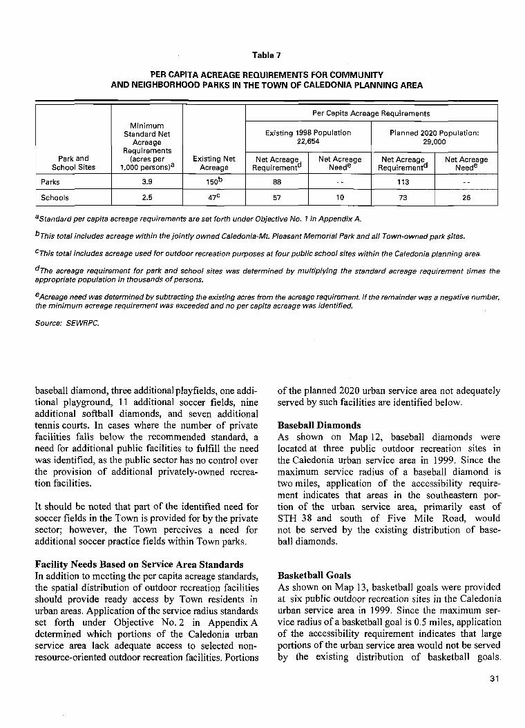
Table 7
PER CAPITA ACREAGE REQUIREMENTS FOR COMMLlNlTY AND NEIGHBORHOOD PARKS IN THE TOWN OF CALEDONIA PLANNING AREA
aStandard per capita acreage requirements are set forth under Objective No. 7 in Appendix A.
b ~ h i s total includes acreage within the jointly owned Caledonia-Mt. Pleasant Memorial Park and all Town-owned park sites.
Park and School Sites
Parks
Schools
CThis total includes acreage used for outdoor recreation purposes at four public school sites within the Caledonia planning area.
Minimum Standard Net
Acreage Requirements
(acres per 1,000 personsla
3.9
2.5
Existing Net Acreage
1 5ob
47C
d ~ h e acreage requirement for park and school sites was determined by multiplying the standard acreage requirement times the appropriate population in thousands of persons.
eAcreage need was determined by subtracting the existing acres from the acreage requirement. If the remainder was a negative number, the minimum acreage requirement was exceeded and no per capita acreage was identified.
Per Capita Acreage Requirements
Source: SEWRPC.
baseball diamond, three additional playfields, one addi- tional playground, 11 additional soccer fields, nine additional softball diamonds, and seven additional tennis courts. In cases where the number of private facilities falls below the recommended standard, a need for additional public facilities to fulfill the need was identified, as the public sector has no control over the provision of additional privately-owned recrea- tion facilities.
Existing 1998 Population 22,654
It should be noted that part of the identified need for soccer fields in the Town is provided for by the private sector; however, the Town perceives a need for additional soccer practice fields within Town parks.
Net Acreage ~ e ~ u i r e m e n t ~
88
57
Planned 2020 Population: 29.000
Facility Needs Based on Service Area Standards In addition to meeting the per capita acreage standards, the spatial distribution of outdoor recreation facilities should provide ready access by Town residents in urban areas. Application of the service radius standards set forth under Objective No. 2 in Appendix A determined which portions of the Caledonia urban service area lack adequate access to selected non- resource-oriented outdoor recreation facilities. Portions
Net Acreage ~ e e d ~
- -
10
Net Acreage ~ e ~ u i r e m e n t ~
113
73
of the planned 2020 urban service area not adequately served by such facilities are identified below.
Net Acreage Neede
- -
2 6
Baseball Diamonds As shown on Map 12, baseball diamonds were located at three public outdoor recreation sites in the Caledonia urban service area in 1999. Since the maximum service radius of a baseball diamond is two miles, application of the accessibility require- ment indicates that areas in the southeastern por- tion of the urban service area, primarily east of STH 38 and south of Five Mile Road, would not be served by the existing distribution of base- ball diamonds.
Basketball Goals As shown on Map 13, basketball goals were provided at six public outdoor recreation sites in the Caledonia urban service area in 1999. Since the maximum ser- vice radius of a basketball goal is 0.5 miles, application of the accessibility requirement indicates that large portions of the urban service area would not be served by the existing distribution of basketball goals.
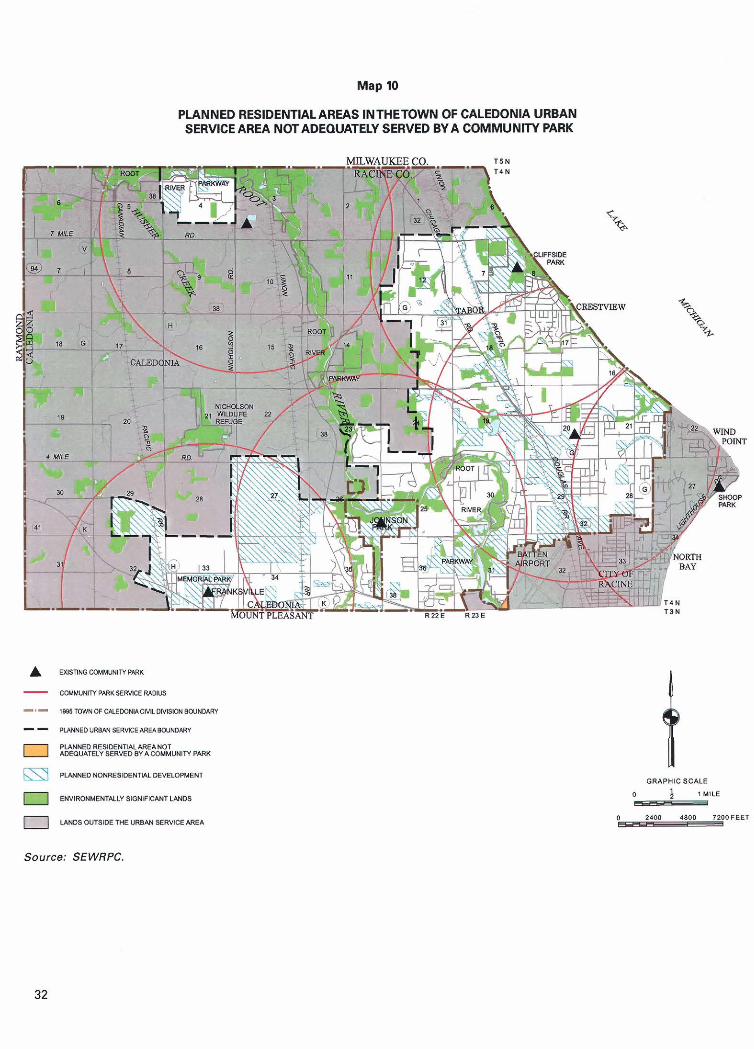
Map 10
PLANNED RESIDENTIAL AREAS INTHETOWN OF CALEDONIA URBAN SERVICE AREA NOT ADEQUATELY SERVED BY A COMMUNITV PARK
Source: SEWRPC.
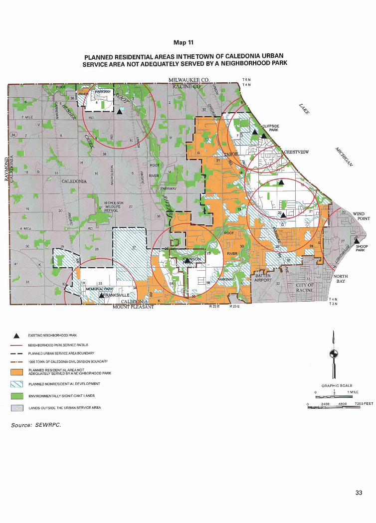
Map 11
PLANNED RESIDENTIAL AREAS INTHETOWN OF CALEDONIA URBAN SERVlCE AREA NOT ADEQUATELY SERVED BY A NEIGHBORHOOD PARK
ORAPHIC SCALE
0 ; l MlLE - 4800 7200FEET
o-
Source: SEWRPC.
Table 8
PER CAPITA REOLllREMENTS FOR SELECTED OUTDOOR RECREATION FACILITIES IN THE TOWN OF CALEDONIA PLANNING AREA
aPer capita facility requirements are set forth under Objective No. 2 in Appendix A.
b ~ h e facility requirement was determined by multiplying the facility requirement per 1,000 residents by the anticipated 2020 Town population of 29,000 persons.
Minimum Per Capita Facility Requirementsa
C ~ h e facility need was determined by subtracting the existing number of facilities from the facility requirement In cases where the existing number of facilities exceeds the facility requirement, no facility need was identified. In cases where either the number of existing public facilities or the total number of facilities was less than the number called for under the standards, a need for additional public facilities to fulfill the requirement was identified.
Playfield Activities
Facility ~ e ~ u i r e m e n t ~
3 1
4
26 6
32
Activity
Baseball
Basketball
Source: SEWRPC.
Play fields As shown on Map 14, playfields were provided at seven public outdoor recreation sites in the Caledonia urban service area in 1999. Since the maximum service radius of a playfield is 0.5 miles, application of the accessibility requirements indicates that large portions of the urban service area would not be served by the existing distribution of playfields.
Existing Number
of Facilities
3 0
3
29 13
42
Facility
Diamond
Goal
Playgrounds As shown on Map 15, playgrounds were located at eight public outdoor recreation sites in the Caledonia urban service area in 1999. Since the maximum service radius for a playground is 0.5 mile, application of the accessibility requirement indicates that large portions of the urban service area would not be served by the existing distribution of playgrounds.
Facility ~eed'
1 Public
- -
Owner
Public Nonpublic
Total
Public Nonpublic
Total
Facility per 1.000
Residents
0.09 0.01
0.10
0.91 0.22
1.13

PLANNED RESIDENTIAL AREAS INMETOWN OF CALEDONIA URBAN SERVICE AREA NOT ADEQUATELY SERVED BY A BASEBALL DIAMOND
v T 4 N TSN
Source: SEWRPC.
PLANNED RESIDENTIAL AREAS INTHETOWN OF CALEDONIA URBAN SERVICE AREA NOT ADEQUATELY SERVED BY A BASKETBALL GOAL
A U I J T I N G B * S ~ ~ E T B A L L ~ ~ * L
- BASKETBULQOALSSERYlCER*L)IUS
-.- ~ ~ T O ~ N O F U L E D O N I A C I ~ L D M S I O N ~ ~ U N D A R ~ - - PLANIIEDUR~ANSERV~EAREABOVND/\RY
PLANNEDRESIDENTIALAREAYOT 1 ~DEQUATEWSERVEDBYABASKETBALLDOAL
PLANNEDNONRE8IOENl!ALDEVELOPMENT
I ENYIRONMENTALLYSIOLIIFICANTLANOS
LANDSOUTSIOETHEURBIUI~ERYICEARE~
Source: SEWRPC.
PLANNED RESIDENTIAL AREAS INTHETOWN OF CALEDONIA URBAN SERVlCE AREA NOT ADEQUATELY SERVED BY A PLAYMELD
EXISTINGPVIYFIEUI
- PLAYFIELD SEWICE W U S
-.- I(BSTOWNOFCALEDONIACIWLDIVISI0NBOUNDARY
- - PLANNED"R~SERwCE*REABO"YD*RY
Ib2t5?Ff?Ak~EFb$!E!Y"~~ELo PLANNED NONRESIDEWTIALDEYELOPMENT
ENVIRONMENTALCIIlOWlFlCiVlTUNDS
LANDSOUTSIDE THE URBAN SERVICE AREA
GRAPHICSCALE
$ ?MILE - 0 2400 48BO ,LOOFEET _r
Source: SEWRPC.
PLANNED RESIDENTIAL AREAS INTHETOWN OF CALEDONIA URBAN SERVICE AREA NOT ADEQUATELY SERVED BY A PLAYGROUND
GRAPHIC SCALE
? M!LE I_
1200FEET o-
Source: SEWRPC.
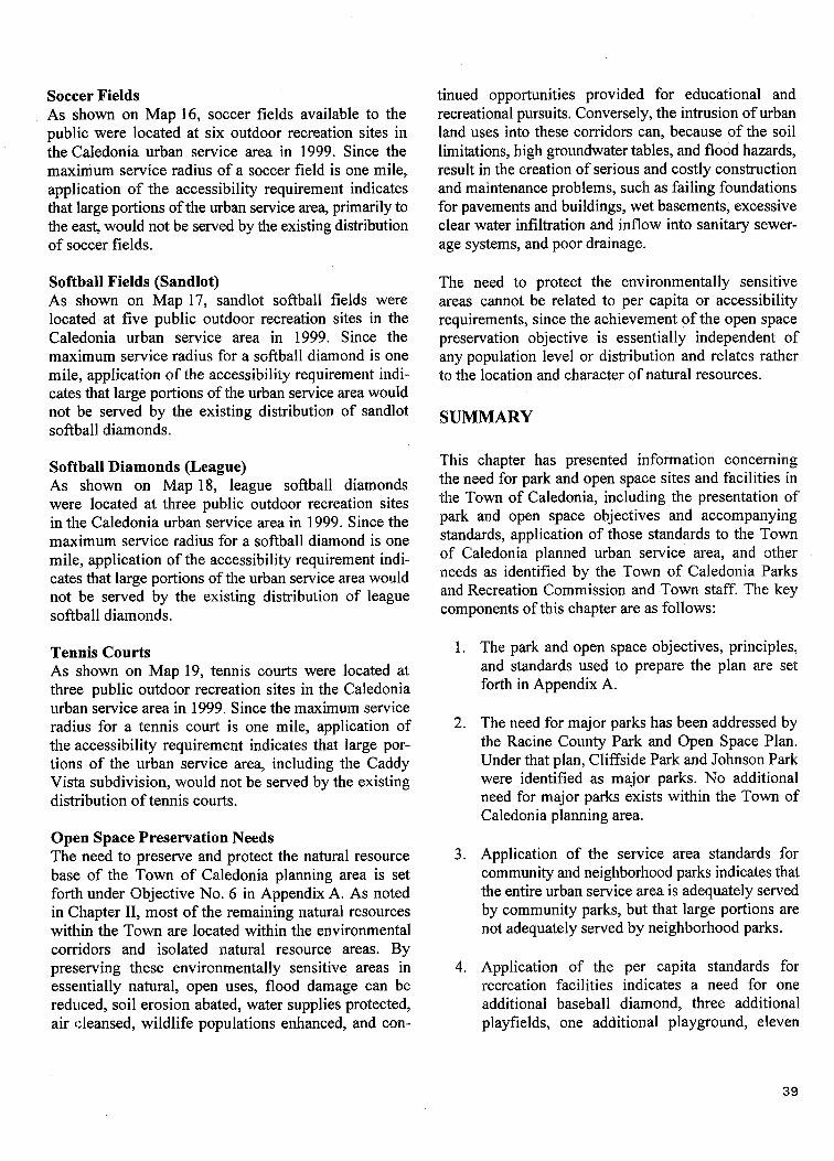
Soccer Fields As shown on Map 16, soccer fields available to the public were located at six outdoor recreation sites in the Caledonia urban service area in 1999. Since the maximum service radius of a soccer field is one mile, application of the accessibility requirement indicates that large portions of the urban service area, primarily to the east, would not be served by the existing distribution of soccer fields.
Softball Fields (Sandlot) As shown on Map 17, sandlot softball fields were located at five public outdoor recreation sites in the Caledonia urban service area in 1999. Since the maximum service radius for a softball diamond is one mile, application of the accessibility requirement indi- cates that large portions of the urban service area would not be served by the existing distribution of sandlot softball diamonds.
Softball Diamonds (League) As shown on Map 18, league softball diamonds were located at three public outdoor recreation sites in the Caledonia urban service area in 1999. Since the maximum service radius for a softball diamond is one mile, application of the accessibility requirement indi- cates that large portions of the urban service area would not be served by the existing distribution of league softball diamonds.
Tennis Courts As shown on Map 19, tennis courts were located at three public outdoor recreation sites in the Caledonia urban service area in 1999. Since the maximum service radius for a tennis court is one mile, application of the accessibility requirement indicates that large por- tions of the urban service area, including the Caddy Vista subdivision, would not be served by the existing distribution of tennis courts.
Open Space Preservation Needs The need to preserve and protect the natural resource base of the Town of Caledonia planning area is set forth under Objective No. 6 in Appendix A. As noted in Chapter 11, most of the remaining natural resources within the Town are located within the environmental corridors and isolated natural resource areas. By preserving these environmentally sensitive areas in essentially natural, open uses, flood damage can be reduced, soil erosion abated, water supplies protected, air cleansed, wildlife populations enhanced, and con-
tinued opportunities provided for educational and recreational pursuits. Conversely, the intrusion of urban land uses into these corridors can, because of the soil limitations, high groundwater tables, and flood hazards, result in the creation of serious and costly construction and maintenance problems, such as failing foundations for pavements and buildings, wet basements, excessive clear water infiltration and inflow into sanitary sewer- age systems, and poor drainage.
The need to protect the environmentally sensitive areas cannot be related to per capita or accessibility requirements, since the achievement of the open space preservation objective is essentially independent of any population level or distribution and relates rather to the location and character of natural resources.
SUMMARY
This chapter has presented information concerning the need for park and open space sites and facilities in the Town of Caledonia, including the presentation of park and open space objectives and accompanying standards, application of those standards to the Town of Caledonia planned urban service area, and other needs as identified by the Town of Caledonia Parks and Recreation Commission and Town staff. The key components of this chapter are as follows:
1. The park and open space objectives, principles, and standards used to prepare the plan are set forth in Appendix A.
2. The need for major parks has been addressed by the Racine County Park and Open Space Plan. Under that plan, Cliffside Park and Johnson Park were identified as major parks. No additional need for major parks exists within the Town of Caledonia planning area.
3. Application of the service area standards for community and neighborhood parks indicates that the entire urban service area is adequately served by community parks, but that large portions are not adequately served by neighborhood parks.
4. Application of the per capita standards for recreation facilities indicates a need for one additional baseball diamond, three additional playfields, one additional playground, eleven
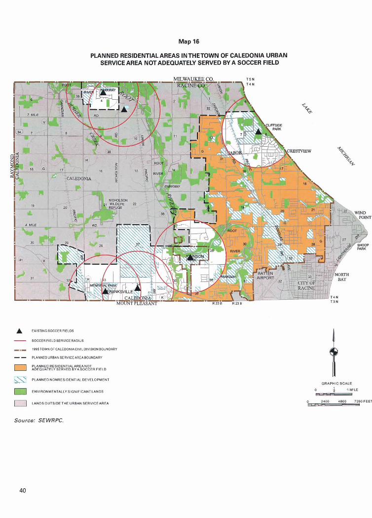
PLANNED RESlDENTlAL AREAS INTHETOWN OF CALEDONIA URBAN SERVICE AREA NOT ADEQUATELY SERVED W A SOCCER FIELD
EXlSTlNGSOCCERFlELDS
- SOCCERIIELDSERVICEWOIUS
. l8OSTOWNOFCALEOONIACIYILDIVISIONBOUNOARY
- - PUNNEDURB*NSERYICEAREABO"NDARY
PLANNED RESIDENTIALAREANOT 8 *DERUATELYSERVEDBYASOCCERFlELD
PLANNEDNONRESlOEWTlMDEYELOPMENT
U ENVIRONMENTALLYSIGNIFICANTLANDS
UNOSOUTSIDETHEURBANSERVICEAREA
GRAPHIC SCALE
0 l MILE - Source: SEWRPC.
PLANNED RESIDENTIAL AREAS INTHETOWN OF CALEDONIA URBAN SERVICE AREA NOT ADEQUATELY SERVED BY A SANDLOT SOFTBALL FIELD
Source: SEWRPC.

PLANNED RESIDENTIAL AREAS INTHETOWN OF CALEDONIA URBAN SERVICE AREA NOT ADEQUATELY SERVED BY A LEAGUE SOFTBALL DlAMOND
Source: SEWRPC
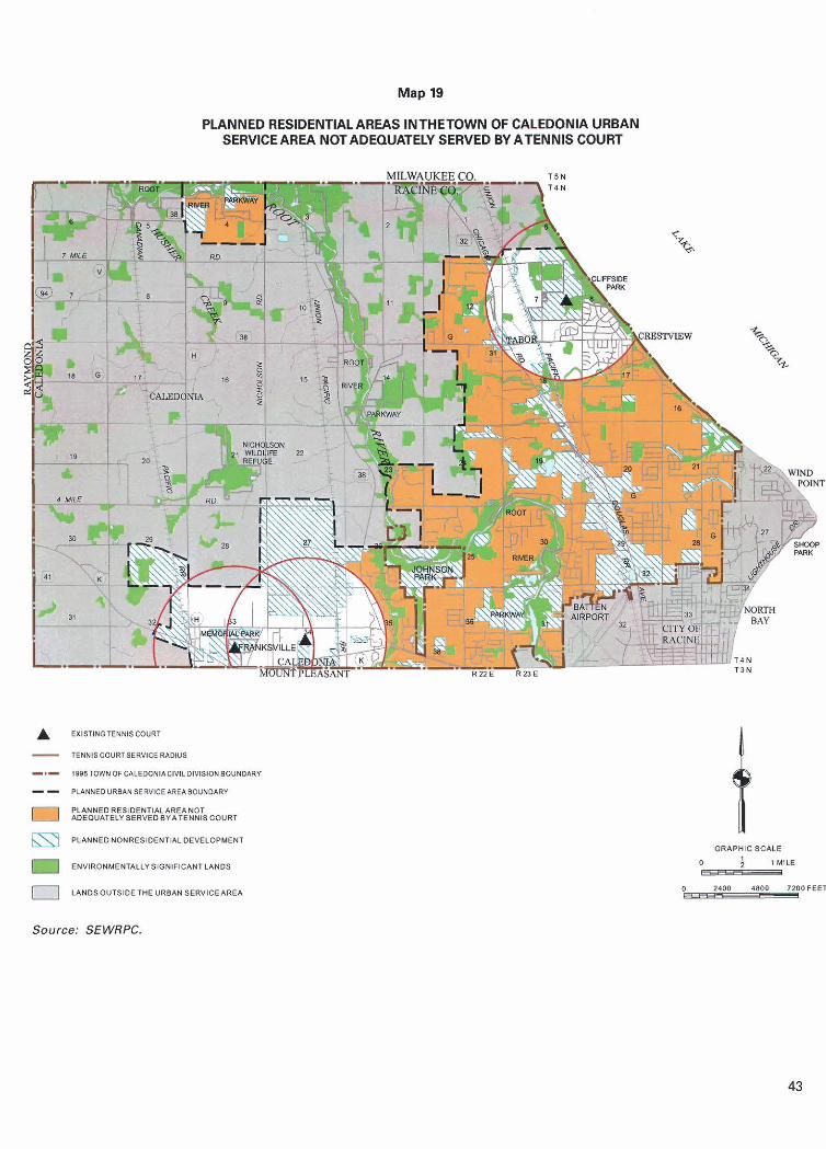
Map 19
PLANNED RESIDENTLALAREAS INTHETOWN OF CALEDONLA URBAN SERVICE AREA NOT ADEQUATELY SERVED BY ATENNB COURT
EXlSTlNCrTENNlSCOURT
- TENNlSCOURTSERVlCEMDIUS
-a- 1981TOWNOF~LEOONlACIYILDIYISIDNBOUNDARY
- - PL*NNED"RB*NSER"ICE*RE*BOUND*RY
PLAIINEDRE51DENTIALAREANOT I 1 ADEQUATELYSERVEDBYATENNISCOURT
f PLANNEDNONRESIDENTIALDEVELOPMENT
U ENVIRONMENTALLYSIGNIFICANTLANDS
LANDSOUTSIDETHEVRBANSERYICEAREA
GRAPHICSCALE
0 4 $MILE _I
O 0 4800 ?ZOOFEET
Source: SEWRPC.

additional soccer fields, nine additional softball playgrounds, soccer fields, sandlot softball fields, diamonds, and seven additional tennis courts. league softball diamonds, and tennis courts.
5. Application of the service area standards for 6. The maintenance of environmental corridors recreation facilities indicates several areas within and isolated natural resource areas in essen- the Caledonia urban service area that are not tially natural, open uses, would generally serve adequately served by the existing distribution of to meet the open space preservation needs of baseball diamonds, basketball goals, playfields, the Town.
Chapter IV
RECOMMENDED PLAN
INTRODUCTION
The primary purpose of the park and open space planning program for the Town of Caledonia is the preparation of a sound and workable plan to guide the acquisition of lands and development of facilities needed to satisfy the outdoor recreation demands of the resident population of the Town, and to protect and enhance the underlying and sustaining natural resource base. Careful consideration was given in the planning effort to the maintenance, redevelopment, and expansion of existing sites and facilities as well as to the acquisition and development of new sites and facilities. Important preliminary steps in the development of the plan included the collection of the necessary planning data, presented in Chapter 11, and the preparation of park and open space acquisition and development objectives, principles, and standards and the identification of park and open space needs, presented in Chapter 111. The recommended park and open space plan for the Town of Caledonia planning area is presented in this chapter. The recommended plan consists of an open space preservation element and an outdoor recreation element and has a 2020 design year.
The implementation of recommendations directed at meeting the park and open space objectives is generally the responsibility of several levels of government. Resource-oriented outdoor recreation objectives requir- ing the provision of large parks, areawide trail facili- ties, and facilities for such activities as golfing, camping, and boating, are typically the responsibility of the State and County levels of government. Nonresource-oriented outdoor recreation objecitves requiring the provision of smaller local parks for
activities such as softball, tennis, soccer, and children's playground activities are typically the responsibility of the local level of government.
Natural resource base preservation objectives to protect important natural resource features including environ- mental corridors, isolated natural resource areas, prime agricultural lands, and natural areas are the responsi- bility of all levels of government.
The first part of this chapter summarizes the areawide park and open space plan recommendations for the planning area, which are included SEWRPC Com- munity Assistance Planning Report No. 134, A Park and Open Space Plan for Racine County, September 1988. Included in that plan are recommendations for the provision of resource-oriented outdoor recreation sites and facilities and the protection of the environmental corridors and isolated natural resource areas in Racine County, including areas in and adjacent to the Town of Caledonia. The second section of this chapter sets forth recommendations for the provision of local park and open space sites and facilities in the Town of Caledonia by the Town. A third section describes actions needed to implement the plan, including an estimate of the acquisition, development, and maintenance costs of needed and existing park and open space sites and facilities by the Town. A summary of the plan is included in the last section of the chapter.
AREAWIDE PARK AND OPEN SPACE RECOMMENDATIONS
The regional park and open space plan, as amended by the park and open space plan for Racine County,
contains recommendations which, if implemented, would provide residents of Racine County with opportunities to participate in a wide range of resource- oriented outdoor recreation activities. Those recom- mendations, which have been incorporated into this Town plan, are concerned with the provision of major parks, which provide opportunities for intensive resource-oriented outdoor recreation activities, and recreation corridors, which provide opportunities for various trail-oriented activities. In addition, the plan contains recommendations for the protection and preservation of open space lands, including natural resource features such as woodlands, wetlands, flood- lands, and natural areas located within the environ- mental corridors and isolated natural resource areas of the Town, as well as prime agricultural lands.
Major Parks and Trail Facilities The park and open space plan for Racine County recommends that the State and County levels of government assume responsibility for the provision of major parks. As shown on Map 20, the County plan recommends that a total of eight major public outdoor recreation sites be provided in the County. Two major parks, Cliffside and Johnson, would continue to be provided and maintained by the County and the City of Racine, respectively, within the Town of Caledonia planning area. In addition, the plan recommends that Racine County acquire additional land and develop additional facilities at Cliffside Park,' as outlined in SEWRPC Community Assistance Planning Report No. 80, A Lake Michigan Public Access Study for Racine County, Wisconsin, September 1982.
The county plan also recommends that about 69 miles of recreation trails be provided in the County as part of the 500-mile regionwide system of recreation corridor^.^ As shown on Map 20, portions of two recreation corridors, the 18-mile Lake Michigan and 17-mile Root River Parkway, are proposed to be located in the Town of Caledonia planning area. A five-mile segment of the Lake Michigan corridor would be generally located near the Lake Michigan shoreline, on the existing and
' The recommendation to expand Clrffside Park is to be reevaluated when the County park plan is updated in 2000.
' A recreation corridor is defined as a trail at least 15 miles in length located within areas of scenic, scientijk, historic, or other cultural interest which provides opportunities for such linear outdoor recreation activities as biking, hiking, and cross-country skiing. 46
proposed MRK Racine County off-street bicycle trail, and the remainder along public road rights-of-way. The Root River Parkway segment would be located along the main stem of the Root ~ i v e r ? generally on County-owned Root River Parkway lands, and would connect with the Root River recreation corridor, in Milwaukee County, on the north and the proposed Pike Creek trail, in the Town of Mt. Pleasant, on the south, via the proposed on-street bicycle way for CTH K. Combined, these comdor segments would provide about 21 linear miles of recreation trails within the planning area. In addition, about six miles of the Racine County bicycle trail are located on public road rights-of-way in the Town.
In 1995, the Commission adopted a regional bicycle and pedestrian plan4 which recommends a network of on- and off-street bicycle ways within the County. That plan, which largely incorporates the recommendations for bicycle facilities contained in the adopted park and open space plan for Racine County, provides for bicycle access to the major activity centers located within the Racine planning area, including: Cliffside and Johnson Parks, the Regency Mall, the Sturtevant Amtrak railway passenger station, the Mt. Pleasant industrial center, and the office, retail, governmental, institutional, and industrial development located within or adjacent to the Racine central business district. The specific locations of these existing and proposed trail facilities are shown on Map 21.
Much of the Root River Parkway and recreation corri- dor within the Town of Caledonia planning area con- sists of floodlands associated with the Root River. Floodlands are not well suited to urban development due to flood hazards, high water tables, and incom- patible soils. It is recommended that floodlands be preserved and protected in essentially natural, open uses including parks and parkways. It should be noted that certain outdoor recreation facilities may be suit- able for development in floodland areas not covered by wetlands or areas of unsuitable soil. Such lands may accommodate playfields, playgrounds, or trails.
The regional bicycle way system plan recommended the relocation of that portion of the proposed off-street Root River trail between Northwestern Avenue and Four Mile Road to an on-street bike route on North Green Bay Road.
Documented in SEWPRC Planning Report No. 43, A Regional Bicycle and Pedestrian Facilities System Plan for Southeastern Wisconsin: 20 10, Januaiy 1995.
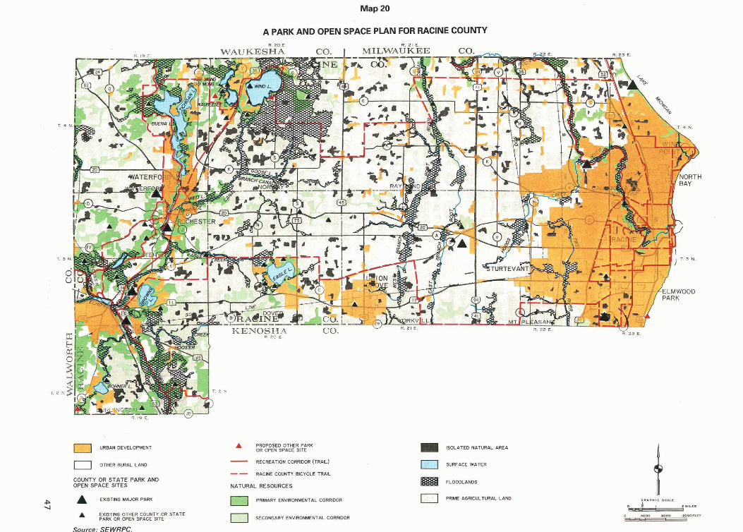
Map 20
A PARK AND OPEN SPACE PLAN FOR RACINE COUNTY
URSANOEMLOPMENT
0 O T K R RUIAL LAND
COUNTY OR STATE PARK A M OPEN SPACE SITES
E X S m B MUOR PAW
A EXlsTW O T ~ R CWNTI OR STATE Pam OR o P f N SPICE SITE
Source: SEWRPC.
A PROPOSE0 OTeER PmK OR WEN SPACE SITE
- RECREAnON CORRDOR (TRAL)
-- SACWE C O W T I BlCICLE TR&L
NATURAL RESOURCES
- A R I ENVIRCNW7.L C M O O R
SECOWIIRY ENVRCINKMTAL CORRDO'
ISOLhTED N&TL*IhL IIREA
SURFACE WATER
FLOOOL&NDS
0 P R l M AORICULTURaL LlSO
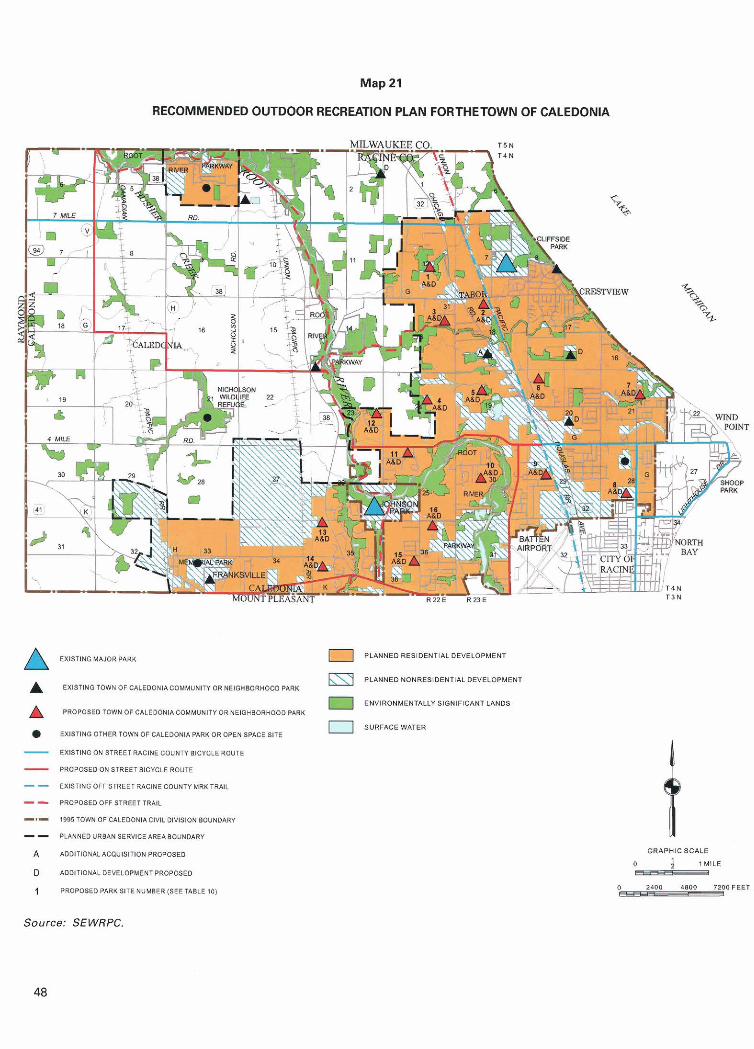
Map 21
RECOMMENDED OUTDOOR RECREATION PLAN FORTHETOWN OF CALEDONIA
I PLANNED RESIDENTIAL DEVELOPMENT
PLANNEONONRESIDENTIAL DEVELOPMENT EXlSTlNGTOWNOPCALEOONYCOMMUNlr(ORNElOH80RH000 PARK
ENVIRONMENTALLY SIONIFICAYT LANDS PROPOSEOTOWNOFCALEMIIII.COMMUNlTYORNEIOHBORH(IODPARK
SURFACE WATER EXlsrlNO OTHER TOWN OF CALEDONIAPARK OROPEN SPACE SlTE
- EXISTING ON STREET WCINECOUNTY BICYCLE ROUTE - PROPOSEDONSIREET81CYCLEROVTE - - EXISTING OFF STREET ~ C M E C O U N T Y M R K i W l L - - PROPOSEDOFFSTREETTRM
-.- ISQ5TOWNOFCALEDONIACIY~LOIYISIONBDUNOARY
- - PUNNEDURBAY SERYICEAREABOVNDARY
A aoolrloNar*coularlo~pno~os~o
D AODlTlONALDEVEiOPMENTPROPOSED
1 PROPOSEDPARI( SlTENUMBER(SEE TABLE $0)
GRAPHICSCALE
0 $MILE - 0 2900 4800 72ODFEET
Source: SEWRPC.

Development of any facilities within floodlands should be carefully evaluated on a site specific basis, with consideration given to natural resource concerns as well as the effects of periodic flooding on the use of the facilities being considered.
OPEN SPACE PRESERVATION
The location and extent of the important open space lands in the Town of Caledonia, including the important surface water, wetlands, floodlands and woodlands within the environmental corridors and isolated natural resource areas, and prime agricultural lands are described in Chapter I1 of this report. The preservation of these open space lands in essentially natural, open uses would serve to maintain a high level of envir- onmental quality in, and protect the natural beauty of, the Town of Caledonia, as well as provide valuable recreational opportunities for residents of the Town. Such preservation will also help to avoid the creation of serious and costly environmental and developmental problems within the Town.
While the park plan is part of the basis for preservation of environmentally significant lands in essentially natural, open space uses, other factors such as the reduction of flood damage, soil erosion, storm water management, air cleansing, reduction of crowding, protection of wildlife habitat, enhancement of educa- tional and scientific areas, all go beyond the park plan and reflect other community planning goals and objectives. These elements add to residential property values, create subdivision amenities, and enhance the quality of life in the Town.
Primary Environmental Corridors The planned primary environmental corridors, shown on Map 22, encompass approximately 1,932 acres of land. This represents an increase of about 72 acres over the primary environmental corridors identified in 1990 and shown on Map 7. The increase is due to about 66 acres of floodlands along the Root River and a six-acre natural area site of local significance, Power Plant Ravine Woods, being added to the primary environmental corridor. Under the plan, all primary environmental corridors would be preserved in essen- tially natural, open uses. It is recognized that public as well as certain private outdoor recreation and related open space uses can serve to protect such environmental corridors. The plan recommends that, to the extent practicable, such public and private uses be maintained for resource preservation and limited recreation purposes and that such maintenance be preserved
through proper zoning. The plan further recommends that primary environmental corridor lands located within the planned urban service area, which cannot be maintained in private use or are required for public recreation uses, be acquired by the public. These lands and their proposed public ownership have been identified on Map 22. It is envisioned that the remaining primary environmental corridors located in the rural portions of the planning area will be preserved through proper zoning, with the exception of those lands within natural areas, which are proposed for public acquisition, also identified on Map 22.
Secondary Environmental Corridors The planned secondary environmental corridors, shown on Map 22, encompass approximately 271 acres of land. This represents an increase of about 3 1 acres over the secondary environmental corridors identified in 1990 and shown on Map 7. The increase is due to about three acres of floodlands along Hoods Creek being added to the secondary environmental corridor, as well as 28 acres in and around the Nicholson Wildlife Refuge being classified as secondary environmental corridor. It is recommended that secondary environmental corridor lands which are presently held in public or private park and open space use be maintained in such use. The secondary environmental corridor lands within the urban service area not in public or private park and open space use are proposed to be protected through proper zoning and considered for public park and open space acquisition as detailed drainage and neighborhood planning proceed. It is envisioned that secondary environmental corridor lands located in rural portions of the planning area would be preserved through proper zoning, with the exception of about 33 acres of land within the Caledonia Wildlife Natural Area (Nicholson Wildlife Refuge) proposed to be acquired by the Town of Caledonia.
Isolated Natural Resource Areas The planned isolated natural resource areas, shown on Map 22, encompass about 1,264 acres. This represents a decrease of about 40 acres from the number of acres in isolated natural resource areas identified in 1990 and shown on Map 7. It is recommended that such areas be preserved and protected in essentially natural, open uses. Under this plan, isolated natural resource areas currently held in public or private park and open space use would continue to be maintained in such use. It is recommended that the Town acquire the 25 acre isolated natural resource area adjacent to Woodland Park. Iso- lated natural resource areas within the planned urban service area that are not in public or private park and
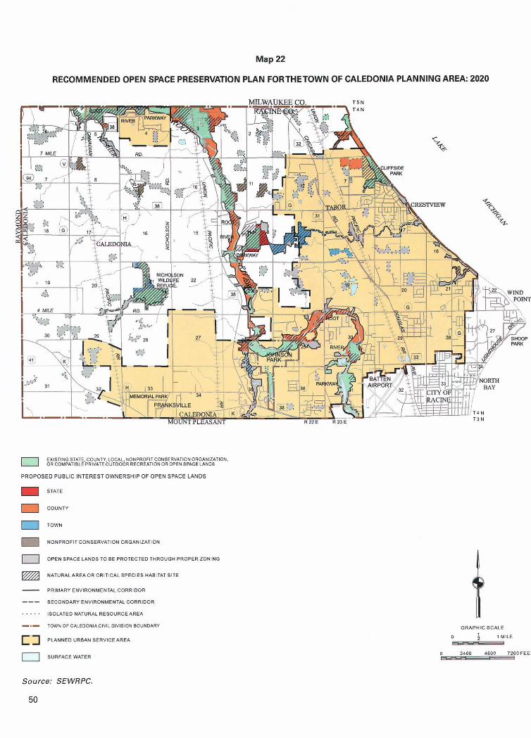
Map 22
RECOMMENDED OPEN SPACE PRESERVATION PLAN FORTHETOWN OF CALEDONIA PLANNING AREA: 2020
EXlSTlNGSTI\TE.COVNM,IOCAL. NOIlPROFliCONSERYATIONORGIINIUTION. ORCOMPATIBLEPRlVlTEOVTDOORRECREAilONOROPENSPACELANOS
PROPOSED PUBLIC INTERESTOWNERSHIP OF OPEN SPACE LANDS
STATE
COUNTY
1 TOWN
NONPROFIT CONSERVATION OROhN12ATIOY
OPENSPACE LANDSTOBE PR0TECTEDTHROU.H PROPERZONINO
@ NATURALAREAORCRITIC*L SPECIES HABITATSITE
- PRIMARY ENVIRONMENTAL CORRIDOR
--- SECOND&RI ENVIRONMENTAL CORRIDOR
. . . . . ISOLATED NATUWL RESOURCE AREA
-.- TOWN OF C1LEDONIACIYILDIYISION BOUNDARY
PWNNED " R U N SERVICE AREA
0 SURFhCE WATER
GRAPHICSCALE
0 l MILE _C
Source: SEWRPC.

open space use are proposed to be protected through proper zoning and considered for park and open space use as detailed drainage and neighborhood planning proceed. It is envisioned that isolated natural resource area lands located in rural portions of the planning area would be protected through proper zoning, with the exception of four natural area sites, together encompassing approximately 76 acres, proposed to be acquired by a nonprofit conservation organization.
Natural Areas and Critical Species Habitat Sites Recommendations developed through the regional natural areas and critical species habitat protection and management plan, as documented in SEWRPC Planning Report No. 42, A Natural Areas and Critical Species Habitat Protection Management Plan for Southeastern Wisconsin, have been incorporated into this park and open space plan. That plan sets forth a number of recommendations related to the preservation of identi- fied natural areas and critical species habitat sites within the Town of Caledonia planning area.
As noted in Chapter 11, there are 13 natural area sites, 14 critical species habitat sites, and three aquatic habitat areas within the planning area. Natural areas and critical species habitat sites recommended to be protected through acquisition meet at least one of the following criteria: 1) the site lies within a primary environmental corridor; 2) the site supports rare, threatened, or endan- gered plant, bird, or animal species; and 3) the site is already at least partially in public interest ownership. It is recommended that all but one site, the Shenvood Property, identified as site 14 on Map 8 in Chapter 11, be protected through public or non-profit conservation organization ownership. Table 9 lists each natural area and critical species habitat site to be acquired and the proposed acquisition agency; these recommendations are also reflected on Map 22.
Specific aquatic habitat area plan recommendations were not formulated under the natural areas planning effort since such habitats are under the direct man- agement authority of the Wisconsin Department of Natural Resources. The natural areas plan, as well as this Town park plan, recommend that the Department of Natural Resources implement management and regulatory efforts necessary to ensure the long term viability of the aquatic habitats and their critical species.
Prime Agricultural Lands As noted in Chapter I1 of this report, prime agricultural lands, the majority of which lie outside of the planned
urban service area and west of STH 38, encompass about 8,439 acres, about 29 percent of the total area of the Town. Under the plan, those prime agricultural lands located within the planned urban service area are planned for conversion to residential and other urban land uses. It is recommended that the remaining prime agricultural lands be maintained in agricultural use and protected for such use through proper zoning.
TOWN PARK AND OPEN SPACE RECOMMENDATIONS
The results of the analysis of outdoor recreation needs, presented in Chapter I11 of this report, indicated that there is a need in the Town of Caledonia for additional neighborhood park sites and associated facilities, including additional ball diamonds,playfields, and soccer fields. Such parks and facilities are intended to meet the outdoor recreation needs of the residents of the Town of Caledonia and are recommended to be provided by the Town. Because the need for neighbor- hood parks is greater in more densely populated urban areas than in rural areas, recommendations for such parks focus on that portion of the Town within the urban service area. Residents of the rural portion of the Town are adequately served by the Town's existing community parks, Gorney Park and the Caledonia- Mt. Pleasant Memorial Park.
To meet the needs identified in Chapter 111, the park and open space plan for the Town of Caledonia, as shown on Map 21, recommends the acquisition and development by the Town of 16 new community and neighborhood park sites within the planned urban service area, as well as the continued maintenance of Town-owned community and neighborhood parks and other Town- owned park and open space sites. In addition, the plan recommends the development of community park facilities at Crawford Park, neighborhood park facilities at 5% Mile Park, the acquisition of additional land and development of facilities at the Nicholson Wildlife Refuge, as recommended in SEWPRC Community Assistance Planning Report No. 146, A Wildlife Habitat Management Plan for the Nicholson Wildlife Center, May 1986, and the acquisition of additional land at Woodland Park. The plan further recommends a local system of bicycle and pedestrian routes and paths throughout the planning area interconnecting park and open space sites whenever feasible and the acquisition of open space lands within the environmental corridors and isolated natural resource areas. It is important to note that the proposed
5 1

Table 9
RECOMMENDED PROTECTION OF NATURAL AREAS AND CRITICAL SPECIES HABITAT SITES IN THE TOWN OF CALEDONIA PLANNING AREA
NOTE: This table is a refinement of the recommendations made in SEWRPC Planning Report No. 42, A Natural Areas and Critical Species Habitat Protection and Management Plan for Southeastern Wisconsin, September 1997.
Town of Caledonia Caledonia Low Woods
a ~ ~ - 1 identifies Natural Area sites o f statewide or greater significance. NA-2 identifies Natural Area sites o f countywide or regional significance. NA-3 identifies Natural Area sites o f local significance. CSH identifies critical species habitat sites.
20
2 1
22
23
24
25
26
27
Total
b ~ i t e No. 14 on Map 8 lSherwood Property (CSHII is not proposed to be acquired.
his site is located entirely within the Caledonia Sanitary Sewer Right o f Way.
Town of Caiedonia
Town of Caledonia
Town of Caledonia
Town of Caledonia
Town of Caledonia
Town of Caledonia
Town of Caledonia
Town of Caledonia
- -
d ~ o e s not include 55 acres o f this critical species habitat site located within the Cliffside Park Woods and Clay Banks Natural Area.
Source: Wisconsin Department o f Natural Resources and SEWRPC.
Caledonia Sanitary Sewer R.O.W.
Four Mile Road Woods
Caledonia Low Woods
River Bend Upland Woods
Root River Strip Woods
Dominican Ravine
Breakers Woods
Cliffside Park Old Field
- -
CSH
CSH
CSH
CSH
CSH
CSH
CSH
CSH - -
13 - - 20
13
10
- -
- - 5
800
62
30
9 - -
-
16
5 - - 519
75
30
29
13
10
16
5
5'
1,336
Racine County
Racine County
Racine County
Racine County
Racine County
Nonprofit Conservation Organization
Nonprofit Conservation Organization
Racine County - -
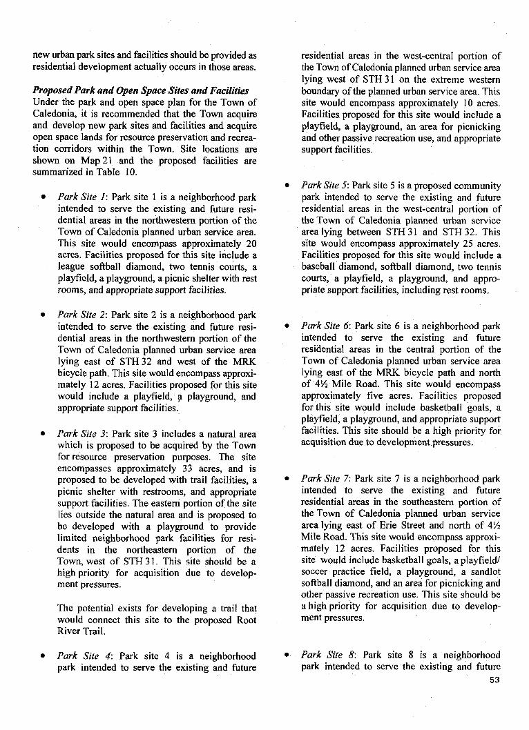
new urban park sites and facilities should be provided as residential development actually occurs in those areas.
Proposed Park and Open Space Sites and Facilities Under the park and open space plan for the Town of Caledonia, it is recommended that the Town acquire and develop new park sites and facilities and acquire open space lands for resource preservation and recrea- tion corridors within the Town. Site locations are shown on Map 21 and the proposed facilities are summarized in Table 10.
Park Site 1: Park site 1 is a neighborhood park intended to serve the existing and future resi- dential areas in the northwestern portion of the Town of Caledonia planned urban service area. This site would encompass approximately 20 qcres. Facilities proposed for this site include a league softball diamond, two tennis courts, a playfield, a playground, a picnic shelter with rest rooms, and appropriate support facilities.
Park Site 2: Park site 2 is a neighborhood park intended to serve the existing and future resi- dential areas in the northwestern portion of the Town of Caledonia planned urban service area lying east of STH 32 and west of the MRK bicycle path. This site would encompass approxi- mately 12 acres. Facilities proposed for this site would include a playfield, p playground, and appropriate support facilities.
Park Site 3: Park site 3 includes a natural area which is proposed to be acquired by the Town for resource preservation purposes. The site encompasses approximately 33 acres, and is proposed to be developed with trail facilities, a picnic shelter with restrooms, and appropriate support facilities. The eastern portion of the site lies outside the natural area and is proposed to be developed with a playground to provide limited neighborhood park facilities for resi- dents in the northeastern portion of the Town, west of STH 31. This site should be a high priority for acquisition due to develop- ment pressures.
The potential exists for developing a trail that would connect this site to the proposed Root River Trail.
Park Site 4: Park site 4 is a neighborhood park intended to serve the existing and future
residential areas in the west-central portion of the Town of Caledonia planned urban service area lying west of STH 31 on the extreme western boundary of the planned urban service area. This site would encompass approximately 10 acres. Facilities proposed for this site would include a playfield, a playground, an area for picnicking and other passive recreation use, and appropriate support facilities.
Park Site 5: Park site 5 is a proposed community park intended to serve the existing and future residential areas in the west-central portion of the Town of Caledonia planned urban service area lying between STH 3 1 and STH 32. This site would encompass approximately 25 acres. Facilities proposed for this site would include a baseball diamond, softball diamond, two tennis courts, a playfield, a playground, and appro- priate support facilities, including rest rooms.
Park Site 6: Park site 6 is a neighborhood park intended to serve the existing and future residential areas in the central portion of the Town of Caledonia planned urban service area lying east of the MRK bicycle path and north of 4% Mile Road. This site would encompass approximately five acres. Facilities proposed for this site would include basketball goals, a playfield, a playground, and appropriate support facilities. This site should be a high priority for acquisition due to development pressures.
Park Site 7: Park site 7 is a neighborhood park intended to serve the existing and future residential areas in the southeastern portion of the Town of Caledonia planned urban service area lying east of Erie Street and north of 4% Mile Road. This site would encompass approxi- mately 12 acres. Facilities proposed for this site would include basketball goals, a playfield1 soccer practice field, a playground, a sandlot softball diamond, and an area for picnicking and other passive recreation use. This site should be a high priority for acquisition due to develop- ment pressures.
Park Site 8: Park site 8 is a neighborhood park intended to serve the existing and future
5 3
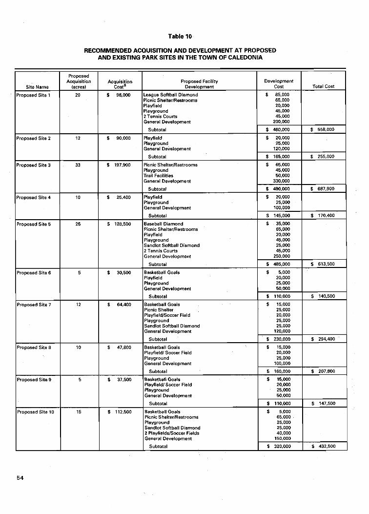
Table 10
RECOMMENDED ACQUISITION AND DEVELOPMENT AT PROPOSED AND EXISTING PARK SITES IN THE TOWN OF CALEDONIA
Development Cost
$ 85,000 65,000 20,000 45.000 45,000
200,000
$ 460,000
$ 20,000 25,000
120,000
$ 165,000
$ 65,000 45,000 50,000
330,000
$ 490,000
$ 20,000 25,000
100.000
$ 145,000
$ 35,000 65,000 20,000 45,000 25,000 45,000
250,000
$ 485,000
$ 5,000 20,000 25,000 50,000
$ 110.000
$ 15,000 25,000 20,000 25,000 25,000
120,000
$ 230,000
$ 15,000 20,000 25,000
100.000
$ 160,000
$ 15,000 20,000 25,000 50,000
$ 110.000
0 5,000 65,000 25,000 25,000 40,000
150,000
$ 320,000
Proposed Facility Development
League Softball Diamond Picnic Shelter/Restrooms Playfield Playground 2 Tennis Courts General Development
Subtotal
Playfield Playground General Development
Subtotal
Picnic Shelter/Restrooms Playground Trail Facilities General Development
Subtotal
Playfield Playground General Development
Subtotal
Baseball Diamond Picnic Shelter/Restrooms Playfield Playground Sandlot Softball Diamond 2 Tennis Courts General Development
Subtotal
Basketball Goals Playfield Playground General Development
Subtotal
Basketball Goals Picnic Shelter Playfield/Soccer Field Playground Sandlot Softball Diamond General Development
Subtotal
Basketball Goals Playfield1 Soccer Field Playground General Development
Subtotal
Basketball Goals Playfieldl Soccer Field Playground General Development
Subtotal
Basketball Goals Picnic Shelter/Restrooms Playground Sandlot Softball Diamond 2 Playfields/Soccer Fields General Development
Subtotal
Site Name
Proposed Site 1
Proposed Site 2
Proposed Site 3
Proposed Site 4
Proposed Site 5
Proposed Site 6
Proposed Site 7
Proposed Site 8
Proposed Site 9
Proposed Site 10
Total Cost
$ 558.000
$ 255,000
$ 687,900
$ 170,400
$ 613,500
$ 140,500
$ 294,400
$ 207,800
$ 147,500
$ 432,500
Proposed Acquisition
(acres)
20
12
33
10
25
5
12
10
5
15
Acquisition costa
$ 96,000
$ 90,000
$ 197,900
$ 25,400
$ 128,500
$ 30,500
$ 64,400
$ 47,800
$ 37.500
$ 112,500
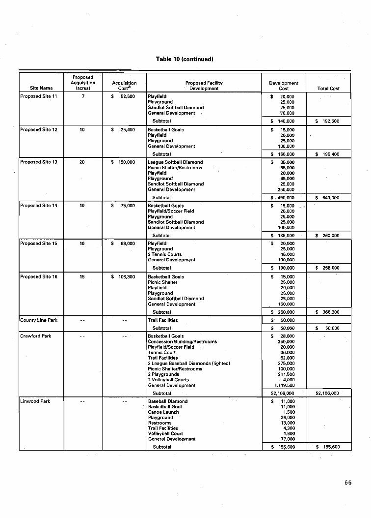
Table 10 (continued)
l~roposed Site 11 1 7
Site Name
I proposed Site 14 I
Proposed Acquisition
(acres)
Proposed Site 16
Development Cost
$ 20,000
Acquisition costa
$ 52,500
Proposed Facility Development
Playfield
$ 35,400
$ 150,000
Total Cost -4 Playground Sandlot Softball Diamond General Development
Subtotal
Basketball Goals Playfield Playground General Development
Subtotal
League Softball Diamond Picnic ShelterRestrooms Playfield Playground Sandlot Softball Diamond General Development
Subtotal
$ 75,000
I I Subtotal 1 $ 185,000 1 $ 260,000 10 I $ 68,000 l~layf ie ld I $ 20,000 1
25,000 25,000 70,000
$ 140,000
$ 15,000 20,000 25,000
100.000
Basketball Goals Playfield/Soccer Field Playground Sandlot Softball Diamond General Development
I 1 Plavaround I 25.000 1
I 2 ~ e n n i s Courts General Development
Subtotal $ 190,000
Picnic Shelter 25,000 Playfield 20,000 Playground 25,000 Sandlot Softball Diamond 25,000 General Development 150,000
Crawford Park
County Line Park - -
- - Basketball Goals Concession Building/Restrooms PlayfieldISoccer Field Tennis Court Trail Facilities 2 League Baseball Diamonds (lighted) Picnic ShelteriRestrooms 2 Playgrounds 2 Volleyball Courts General Development
Subtotal
-inwood Park
- -
- -
Subtotal
Trail Facilities
Subtotal
- -
$ 260,000
$ 50,000
$ 50.000
$ 366,300
$ 50.000
Baseball Diamond Basketball Goal CanoeLaunch Playground Restrooms Trail Facilities Volleyball Court General Development
Subtotal
$ 11.000 11.000 1,500
36,000 13,000 4,300 1,800
77,000
$ 155,600 $ 155,600
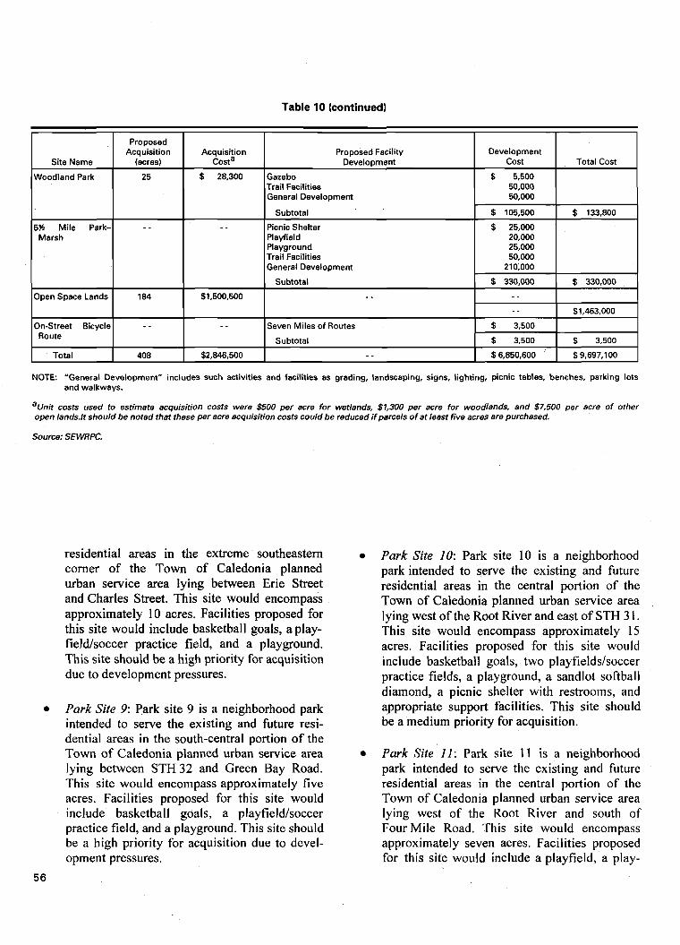
Table 10 (continued)
NOTE: "General Development" includes such activities and facilities as grading, landscaping, signs, lighting, picnic tables, benches, parking lots and walkways.
Site Name
Woodland Park
5% Mile Park- Marsh
Open Space Lands
On-Street Bicycle Route
Total
a ~ n i t costs used to estimate acquisition costs were $500 per acre for wetlands, $1,300 per acre for woodlands, and $7,500 per acre o f other open 1ands.lt should be noted that these per acre acquisition costs could be reduced if parcels o f at least five acres are purchased.
Source: SEWRPC.
Proposed Acquisition
(acres)
25
- -
184
- -
408
residential areas in the extreme southeastern corner of the Town of Caledonia planned urban service area lying between Erie Street and Charles Street. This site would encompass approximately 10 acres. Facilities proposed for this site would include basketball goals, a play- fieldsoccer practice field, and a playground. This site should be a high priority for acquisition due to development pressures.
Park Site 9: Park site 9 is a neighborhood park intended to serve the existing and future resi- dential areas in the south-central portion of the Town of Caledonia planned urban service area lying between STH 32 and Green Bay Road. This site would encompass approximately five acres. Facilities proposed for this site would include basketball goals, a playfield/soccer practice field, and a playground. This site should be a high priority for acquisition due to devel- opment pressures.
5 6
Acquisition costa
$ 28,300
- -
$1,500,500
- -
$2,846,500
Park Site 10: Park site 10 is a neighborhood park intended to serve the existing and future residential areas in the central portion of the Town of Caledonia planned urban service area lying west of the Root River and east of STH 3 1. This site would encompass approximately 15 acres. Facilities proposed for this site would include basketball goals, two playfields/soccer practice fields, a playground, a sandlot softball diamond, a picnic shelter with restrooms, and appropriate support facilities. This site should be a medium priority for acquisition.
Park Site I I : Park site 1 1 is a neighborhood park intended to serve the existing and future residential areas in the central portion of the Town of Caledonia planned urban service area lying west of the Root River and south of Four Mile Road. This site would encompass approximately seven acres. Facilities proposed for this site would include a playfield, a play-
Proposed Facility Development
Gazebo Trail Facilities General Development
Subtotal
Picnic Shelter Playfield Playground Trail Facilities General Development
Subtotal
- -
Seven Miles of Routes
Subtotal
- -
Development Cost
$ 5,500 50,000 50,000
$ 105,500
$ 25,000 20,000 25,000 50,000
210,000
$ 330,000
- - - -
$ 3,500
$ 3,500
$6,850,600
Total Cost
$ 133,800
$ 330,000
$1,463,000
$ 3,500
$9,697,100
ground, a sandlot softball diamond, and appro- priate support facilities. This site should be a high priority for acquisition due to develop- ment pressures.
Park Site 12: Park Site 12 is a neighborhood park intended to serve the existing and future residential areas in the west-central portion of the Town of Caledonia planned urban service area lying northeast of the Root River and north of Four Mile Road. This site would encompass 10 acres. Facilities proposed for this site would include basketball goals, a playfield, a play- ground, an area for picnicking and other passive recreation use, and appropriate support facilities.
Park Site 13: Park site 13 is a proposed neighborhood park intended to serve the existing and future residential areas in the southwestern portion of the Town of Caledonia planned urban service area lying west of STH 38 and north of Dunkelow Road. This site would encompass approximately 20 acres. Facilities proposed for this site would include a playfield, a play- ground, league softball diamonds, a sandlot soft- ball diamond, an area for picnicking and other passive recreation use, and appropriate support facilities, including rest rooms. This site should be a medium priority for acquisition.
Park Site 14: Park site 14 is a neighborhood park intended to serve the existing and future residential areas in the southwestern portion of the Town of Caledonia planned urban service area lying west of STH 38, south of Dunkelow Road, and north of Northwestern Avenue. This site would encompass approximately 10 acres. Facilities proposed for this site would include basketball goals, a playfield/soccer practice field, a playground, a sandlot softball diamond, and appropriate support facilities. This site should be a high priority for acquisition due to development pressures.
Park Site 15: Park site 15 is a neighborhood park intended to serve the existing and future residential areas in the south-central portion of the Town of Caledonia planned urban service area lying between Johnson Park and Newman Road, north of Northwestern Avenue. This site would encompass approximately 10 acres. Facili- ties proposed for this site would include a playfield, a playground, an area for picnicking
and other passive recreation use, two tennis courts, and appropriate support facilities.
Park Site 16: Park site 16 is a neighborhood park intended to serve the existing and future residential areas in the southern portion of the Town of Caledonia planned urban service area lying between Newman Road and STH 3 1. This site would encompass approximately 15 acres. Facilities proposed for this site would include a playfield, a playground, an area for picnicking and other passive recreation use, a sandlot softball diamond, basketball goals, and appropriate support facilities.
Existing Park and Open Space Sites and Facilities Under the park and open space plan for the Town of Caledonia, it is recommended that the Town acquire additional lands adjacent to select park and open space sites and supply additional facilities at select park sites. These recommendations are outlined below.
County Line Park: County Line Park is a 17-acre undeveloped neighborhood park intended to serve the existing and future residential areas in the northeastern portion of the Town. No additional land is proposed for acquisition for this site. It is envisioned that this site would be best suited as a nature preserve due to its character and land-locked location. Facilities proposed for this site include a hiking trail.
Crawford Park: Crawford Park is a 17-acre undeveloped neighborhood park intended to serve the southeastern portion of the Town of Caledonia planned urban service area. As noted in Chapter 111, while this site does not meet the definition of a community park, relative to size, it is anticipated that it will provide community park facilities. Facilities proposed for this site include a playfield/soccer field, two play- grounds, two picnic shelters with rest rooms, two lighted league baseball diamonds, trail facilities, a tennis court, basketball goals, and appropriate support facilities.
Linwood Park: Linwood Park is an 18-acre neighborhood park intended to serve the central portion of the Town of Caledonia. It is recom- mended that the Town relocate facilities out of the floodplain and restore the area along the Root River to a natural setting. New facilities proposed for this site include a baseball diamond,
5 7
a basketball goal, a canoe launch, a playground, rest rooms, trail facilities, and a volleyball court.
Woodland Park: Woodland Park is a four-acre neighborhood park intended to serve the north- central portion of the Town of Caledonia planned urban service area. It is recommended that the Town acquire a 25-acre isolated natural resource area adjacent to the park. Facilities proposed for this site include a gazebo, a nature trail, and an area for passive recreation use.
5% Mile Park-Marsh: 5% Mile Park-Marsh is a 2 1 -acre undeveloped neighborhood park intended to serve the north-central portion of the Town of Caledonia planned urban service area lying between 5% Mile Road and 4% Mile Road. No additional land is proposed for acquisition for this site. Facilities proposed for this site include a playfield, a playground, a picnic shelter, and trail facilities.
Open Space LanA: As shown on Map 22, it is recommended that the Town acquire 119 acres of primary environmental corridor lands, 40 acres of secondary environmental corridor lands, and 25 acres of isolated natural resource areas, for a total of 184 acres. These lands are intended to be preserved in essentially natural, open space uses and used for future park and trail facilities as needed. The preservation of these lands will serve to maintain a high level of environmental quality and natural beauty in the Town, as well as help avoid the creation of serious and costly environmental and developmental problems.
Bicycle and Pedestrian Route and Trail System: As shown on Map 21, it is recommended that the Town cooperate with Racine County, the Wisconsin Department of Transportation, and adjoining local governments to develop a system of bicycle and pedestrian routes and paths. It is envisioned that this system would interconnect with major parks in the Town and in adjacent municipalities, and includes a proposed trail within the Root River Parkway. This system is proposed to include about seven miles of routes associated with street rights-of-way and about 23 miles of trails associated with environmen- tally significant lands within the Town. It should be noted that the bicycle routes and trails shown on Map 21 reflect the recom- mendations of the regional bicycle way system
5 8
plan with the addition of a proposed bicycle way along CTH V, CTH G, CTH H, and Five Mile Road.
Recommendations for new parks include the acquisition of lands by the Town for recreational and open space purposes, as shown on Map 21. The red symbols on the plan map indicate a need for additional park lands in the area designated. The location of the symbol represents a generalized location and should not be construed as definitive. There may be other sites in the area that are also suitable for development as a park. It is important to note that all proposed facility development should comply with the accessibility requirements set forth under Federal Law in the Americans with Disabilities Act.
PLAN IMPLEMENTATION
The recommended park and open space plan is not complete until the steps required to implement the plan have been specified. This section includes a description of the actions required by the Wisconsin Department of Natural Resources, the Wisconsin Department of Transportation, Racine County, the City of Racine, and by the Town of Caledonia to implement the recommended park and open space plan for the Town.
Wisconsin Department of Natural Resources The Wisconsin Department of Natural Resources (DNR) has authority and responsibility for park development, natural resources protection, water quality management, and water use regulation. Certain DNR functions have particular importance in the implementation of county and local as well as State level park and apen space plans. The Department has the obligatior~ to prepare a comprehensive Statewide outdoor recpea- tion plan and to develop long-range water resource management plans; the authority to protect, develop, and regulate the use of State parks, forests, fish and game, lakes and streams, certain plant life, and other natural resources; and the authority to adminirster, within the State, the Federal grant program known as the Land and Water Conservation (LAWCON) fund program and the Wisconsin Stewardship Program. The LAWCON fund and Wisconsin Stewardlihip programs are intended to assist in the acquisition and development of local parks and urban g~een spaces. The DNR also has the responsibility to estat dish standards for floodland and shoreland zoning; and the authority to adopt, in the absence of satisfactory local action, floodland and shoreland zoning ordinances.
More specifically, relative to the implementation of the Town park and open space plan, it is important that the Department endorse the plan, thus qualifying the Town to apply for and receive available State and Federal outdoor recreation grants in support of plan implementation. In addition, the DNR should use available regulatory authority to guide urban devel- opment in accordance with the location and extent of the urban service area proposed under this plan and to enhance the environmental quality in the Town.
Lastly, the Town of Caledonia Department of Parks and Recreation is concerned with low water levels at the Nicholson Wildlife Refuge, which could affect its long-term health. It is recommended that the Department of Natural Resources work with the Town of Caledonia Parks and Recreation Department to address this concern, thus ensuring the viability of this area.
Wisconsin Department of Transportation It is recommended that the Wisconsin Department of Transportation construct the bicycle ways recommended by this park and open space plan to be provided within the right-of-way of a State trunk highway or connecting street at the time the street or highway is constructed or reconstructed. It is recognized that major bicycle-related improvements, such as the addi- tion of bicycle lanes, may not be able to be accom- modated at the time the street is simply resurfaced. However, consideration should be given to re-striping the street or making other improvements to better accommodate bicycle travel, be it utilitarian or recrea- tional in nature. It is anticipated that paving highway shoulders to accommodate bicycle travel will be accomplished at the time a street or highway is resurfaced. The State should make proper arrange- ments to provide for the maintenance of bicycle facilities, including, if necessary, entering into operating or maintenance agreements with other units or agencies of government.
It is recommended that the Wisconsin Department of Transportation continue to make transportation grants available for the construction of the recommended bikeways, including those recommended to be located off-street and on County and local streets.
It is further recommended that the Wisconsin Depart- ment of Transportation promptly notify the Wisconsin Department of Natural Resources, the County park department, the Town of Caledonia, and the Regional Planning Commission of any railway abandonment
proposed within the Town of Caledonia planning area. The Department should work with the aforementioned agencies to evaluate the feasibility of acquiring the railway right-of-way proposed to be abandoned for recreation purposes, including use as off-street bicycle and pedestrian ways.
Racine County Racine County has the authority and responsibility for the acquisition, development, and maintenance of the major parks and trails within recreation corridors in the County. It is recommended that Racine County continue to provide and maintain one major park, Cliffside Park, within the Town of Caledonia.
Additionally, the County should acquire additional lands and provide additional facilities at Cliffside Park. Under this proposal, an additional 305 acres of land along the Lake Michigan shoreline within the Town would be acquired for park purposes. Proposed additional facility development includes the provision of a nature center, additional picnic areas, a winter sports area, boat launch facilities, and other resource- oriented facilities and support facilities, such as parking lots, rest rooms, shelters, necessary utilities and landscaping; development of additional, environmen- tally sensitive, trail facilities for hiking, on- and off-road bicycling, and cross-country skiing; as well as the management or restoration of native plant communities at the site.=
Under this plan, Racine County is also responsible for the acquisition of additional lands in the Root River Parkway in the Town of Caledonia. Under this proposal, the County would acquire an additional 559 acres of land in the Town for parkway purposes. It is also recommended that the County develop a variety of resource-oriented outdoor recreation facilities in por- tions of the parkway, including trail facilities for biking, hiking, cross-country skiing, nature study, and horse- back riding; river access, picnic areas, and areas for passive recreation pursuits; and support facilities such as parking lots and rest rooms. Lands proposed for acquisition as part of the Root River Parkway are shown on Map 22. It is recommended that the County continue development of the MRK Trail northward from Seven Mile Road to the Racine County-Milwaukee County line, also the northern Town line. It is envisioned that
As noted earlier in this chapter, Racine County is in the process of updating its park and open space plan. Recommendations related to Cliffside Park muy be modified as a result of that update.
59
Milwaukee County would extend the trail to Bender Park, located along the Lake Michigan shoreline in southern Milwaukee County, and eventually connect the trail to the Oak Creek Parkway, also in Milwaukee County. It is important to note that, on the south, the MRK Trail now connects with bike routes in the City of Racine that traverse Lake Michigan shoreline parks in the City and eventually connect to Racine and Kenosha County trails south to the Wisconsin-Illinois state line.
It is also recommended that Racine County acquire the natural areas identified for County acquisition on Map 22 and in Table 9, which reflect recommendations made by the regional natural areas plan. Finally, it is recommended that Racine County continue to assist the Town, as necessary, in the preparation of neighborhood and subneighborhood plans for areas within the Caledonia urban service area.
City of Racine The City of Racine has the authority and responsibility for the provision and maintenance of one major park, Johnson Park, within the Town of Caledonia planning area. It is recommended that the City continue to provide and maintain the existing golf course, picnick- ing, and other facilities within this park.
Town of Caledonia Under the recommended plan, shown on Maps 21 and 22, the Town of Caledonia would have responsibility for the provision of a variety of outdoor recreation sites and facilities, including the acquisition and development of several new park sites and facilities, the acquisition of environmentally sensitive lands within the Town, and the maintenance of existing Town park sites and facilities. Implementation of these recom- mendations would result in the attainment of the park acquisition and development and open space preserva- tion objectives presented in Chapter I11 of this report.
It is further recommended that the Town adequately maintain all existing Town-owned park and open space sites and outdoor recreation facilities. The maintenance activities of these sites would include, as necessary, repair and resurfacing of parking lots and walkways; the resurfacing of court areas, such as volleyball, basketball, and tennis courts; the provision, repair, or replacement of such support facilities as sport field lighting, park benches, picnic tables, and drinking fountains; the repair or replacement of rest room facilities, water supply facilities, maintenance buildings, picnic shelters and community buildings; and the maintenance of
lawns, gardens and other landscape plantings. In a jdi- tion, such maintenance activities would also include the provision of additional playground equipment, play- field areas, picnic tables and areas for passive recrea- tional use. It is also recommended that any existing outdoor recreation facility not meeting the accessibility requirements set forth under Federal Law in the Americans with Disabilities Act be brought into compliance in a timely fashion.
Other Plan Implementation Considerations The park and open space plan for the Town of Caledonia proposes that the Town acquire and develop new park sites and facilities and acquire certain open space lands along perennial streams and within natural areas within the Town. The Town zoning ordinance can serve to protect those lands proposed for park and open space uses from incompatible urban uses. Changes to the zoning district map should be made as appro- priate to reflect the proposed park and open space land acquisitions and protective zoning recommended in this plan.
It is also important to note that, while the usual manner of acquisition of park and open space land consists of the purchase of fee simple interest, there are other methods of acquiring land. These other methods may include the purchase and leaseback of land; the acqui- sition of land subject to a life estate; the acquisition of tax delinquent land and acquisition through a gift, donation, or dedication. Further, the Town utilizes impact fees charged to new residential developments, equal to $750 per dwelling unit, to offset the costs associated with continued residential development for public utilities, parks, and other services provided to the Town's urban residents.
Lastly, due to anticipated development pressures and the need to serve existing residents within the planned urban service area, the following have been identified as high priority sites for acquisition: proposed park sites 3,6,7,8,9, 11, and 14. In addition, sites 10 and 13 have been identified as medium priority sites for acquisition.
Plan Costs Implementation of the park and open space plan for the Town of Caledonia, as presented herein and summarized in Table 10, would entail a total cost to the Town of $9,697,100 over a 20-year plan imple- mentation period. This does not include the costs associated with maintaining existing park facilities. As indicated in Table 10, the majority of this cost, about $6,850,600, or 71 percent, would be required for the

development of new outdoor recreation facilities, trails, and bicycle routes throughout the Town. The remaining $2,846,500 would be required for the acquisition by the Town of land for new park sites and for preservation of environmentally significant lands in the Town.
It is important to note that, even though the open space lands to be acquired by the Town are delegated to the parks department for maintenance and management purposes, many of these lands are beneficial to other Town departments and have minimal, if any, recrea- tional value. Examples of such lands include wetlands, detention basins and floodplains needed by the Department of Public Works for stormwater manage- ment, and large open space areas benefiting the water utility by serving as ground water recharge areas. These lands provide a long-term benefit to the Town and to the quality of life of the residents.
As already noted, the estimated acquisition and development costs of $9,697,100 would be distributed over a 20-year plan implementation period. This would approximate an expenditure of about $484,855 per year. Under the assumption that the population of the Town would approximate 29,000 persons by the year 2020, the average annual acquisition and develop- ment costs would be about $18.77 per capita9er year. It should be noted that, to the extent that such costs are reduced through the use of alternative methods of land acquisition, and through the use of available State and Federal funds for acquisition and develop- ment, the costs to the Town could be significantly reduced.
Maintenance Impact Recommended new facilities will require that mainte- nance and upkeep costs be planned and budgeted for over the planning period. The Town of Caledonia Parks and Recreation Department operates on an annual maintenance budget of approximately $67,000 (in 2000). Of this, about $40,000, or 60 percent, is allocated to the jointly owned Caledonia-Mt. Pleasant Memorial Park. Assuming the Town of Mt. Pleasant matches this
The average annual per capita costs were estimated by dividing the estimated average annual costs by the average annual population over the 20 year plan implementation period. The average population was determined by calculuting the uverage of he 1998 population estimate by the Wisconsin Department of Administration of about 22,654 persons and the plan design year 2020 population of about 29,000 persons, which is 25,827persons.
allocation, the per acre cost, for maintenance purposes, is approximately $1,538. The remaining $27,000 in the Town of Caledonia maintenance budget is allocated to maintenance of the Town's parks, which is equivalent to approximately $98 per acre and is extremely low. For example, the City of West Bend Parks, Recreation, and Forestry Department operates on an annual maintenance budget of approximately $600,000 (1999) and maintains approximately 500 acres of parkland. This is equivalent to approximately $1,200 per acre. The City of Racine Parks Department operates on an annual maintenance budget of approximately $2,000,000 (1999) and maintains approximately 1,050 acres of parkland. This is the equivalent of approxi- mately $1,905 per acre. Thus, it is recommended that the Town of Caledonia parks department budget, relative to maintenance, be increased to bring the Town in line with the joint park, other communities, and the rate of inflation.
Further, the parks department budget allocates approximately $13,000 for staffing purposes. This equates to approximately three part-time seasonal staff members' and does not allow the Town to be proactive in terms of maintenance. It is recommended that the budget, relative to staffing, be increased to allow for at least one full-time maintenance person, in addition to part-time seasonal staff.
Since new community and neighborhood parks will be developed as the Town grows and expands, it is recommended that, in addition to the aforementioned recommended budget increases, the maintenance budget grow gradually to meet this demand as the Town tax base expands; in effect, having the new subdivisions and neighborhoods pay for the maintenance of the new neighborhood parks. Facility development at existing Town parks is also likely to increase maintenance efforts by the Parks and Recreation Department.
Finally, it is recommended that, due to development pressure, the Town of Caledonia review its park impact fees to allow for expeditious acquisition of the high- and medium-priority recommended park sites.
It is clear that, due to the Department's limited maintenance budget, the growth of the Town may adversely affect the ability of the Department to maintain the existing and planned park and open space recommendations of the plan unless additional funds are provided.
6 1

SUMMARY Caledonia and maintain the golf course, picnic areas, and other facilities at this site.
The recommended park and open space plan consists of both areawide park and open space recommendations and Town park and open space recommendations. The areawide park and open space recommendations are based on the regional park and open space plan as amended by the park and open space plan for Racine County.
The key components of the plan are as follows:
1. The Wisconsin Department of Natural Resources should acquire and protect natural areas and critical species habitat sites as called for in the regional natural areas plan.
2. The Wisconsin Department of Transportation should give consideration to bicyclists when constructing or reconstructing a State trunk highway or connecting street and notify interested parties of any railway abandonment proposed within the Town of Caledonia planning area.
3. Racine County should continue to provide and maintain one major park, Cliffside Park, within the Town of Caledonia and acquire additional lands at this site. The County should continue to acquire and develop lands for the Root River Parkway and trail within the Town of Caledonia. The County should also acquire and protect natural areas as called for in the regional natural areas plan.
4. The City of Racine should continue to provide one major park, Johnson Park, within the Town of
5. The Town of Caledonia should provide community park facilities at Crawford Park and Park Site 5.
6. Sixteen new community and neighborhood parks are proposed to be acquired and developed by the Town of Caledonia.
7. The Town should provide neighborhood park facilities at 5% Mile Park, an undeveloped Town- owned park.
8. A local system of bicycle and pedestrian trails and routes throughout the community is recom- mended to be developed by the Town of Caledonia.
9. The Town should acquire approximately 184 acres of environmentally significant lands to be preserved in essentially natural, open uses.
10. The cost to the Town to implement the plan would be $9,697,100 over a 20-year plan implemen- tation period. This represents an annual expen- diture of about $484,855, or about $18.77 per capita per year. Through the use of alternative methods of land acquisition, as well as available Federal and State funds and impact fees, the cost to the Town could be significantly reduced.
11. The Town should increase its annual parks department budget, relative to maintenance and staffing, and review its impact fees.

Chapter V
SUMMARY
On December 1, 1977, the Southeastern Wisconsin Regional Planning Commission adopted SEWRPC Planning Report No. 27, A Regional Park and Open Space Plan for Southeastern Wisconsin: 2000, which sets forth a plan intended to guide the preservation, acquisition, and development of lands needed for outdoor recreation and for the protection of natural resources within the seven county Southeastern Wisconsin Region. At the request of Racine County, the Regional Planning Commission refined and detailed the regional plan as it relates to the County in SEWRPC Community Assistance Planning Report No. 134, A Park and Open Space Plan for Racine County. The County plan was adopted in 1989 by the Racine County Board. A second edition of that plan is currently underway. The regional plan, and the County plan, recommend that each local unit of government refine and detail the adopted regional and county plans as those plans relate to the local municipal jurisdiction.
In 1987, the Town of Caledonia Parks and Recreation Commission requested that the Regional Planning Commission prepare a park plan for the Town. The resulting park and open space plan, which has a design year of 2010, is documented in SEWRPC Community Assistance Planning Report No. 179, A Park and Open Space Plan for the Town of Caledonia, November 1989. In 1996, the Parks and Recreation Commission requested that the Regional Planning Commission assist the Town in the preparation of a new park and open space plan. The Town of Caledonia Parks and Recreation staff helped guide the necessary planning work. The new plan, which has a design year of 2020, was approved by the Town Parks and Recreation Commission on February 10, 2000. The plan was
adopted by the Caledonia Town Board on April 18, 2000. The adopting resolution is included as Appendix B.
INVENTORY FINDINGS
The planning area used for the preparation of this plan encompasses about 46 square miles, or 29,184 acres, and includes all of the Town of Caledonia and Johnson Park, which is part of the City of Racine but surrounded by the Town of Caledonia. The Town had a 1998 estimated population level of 22,654 persons. In 1995, about 7,540 acres, or about 26 percent of the planning area, was developed for urban use. Residential land uses encompassed about 4,4 1 1 acres or 15 percent of the planning area. Transportation, communication and utility land uses encompassed about 1,774 acres, or about 6 percent, while governmental and institutional land uses encompassed about 302 acres, or about 1 percent, of the planning area. Commercial and manufacturing uses encompassed 372 acres, or about 1 percent of the planning area. Natural resource areas including woodlands, wetlands and surface waters encompassed 4,493 acres, or about 15 percent of the planning area.
An inventory of existing outdoor recreation and open space sites and facilities was conducted in 1999. The inventory identified 5 1 such sites encompassing 2,528 acres, or about 9 percent of the planning area. Of the 5 1 recreation and open space sites, 26 sites encompassing 1,804 acres, or about 7 1 percent of the area devoted to outdoor recreation and open space uses, were publicly owned. The Town of Caledonia owned 13 sites, which together encompassed 34 1 acres.
The most important features of the natural resource base in the Town of Caledonia planning area, including the best remaining woodlands, wetlands, wildlife habitat areas, undeveloped floodlands, and sites having historic, scenic, scientific, cultural, and recreational value, occur in linear areas termed environmental corridors. By definition, primary environmental corridors include a variety of the aforelisted natural resource features and are at least 400 acres in size, two miles in length, and 200 feet in width. In 1990, primary environmental corridors encompassed about 1,860 acres, or about 6 percent of the planning area. Secondary environmental corridors are at least 100 acres in size and one mile in length. Secondary environmental corridors in 1990 encompassed about 240 acres, or less than 1 percent of the planning area. Smaller pockets of natural resource base elements, termed isolated natural resource areas, are a minimum of five acres in size and are separated physically from the environmental corridors by inten- sive urban or agricultural uses. These isolated natural resource areas encompassed about 1,304 acres, or about 4 percent of the planning area, in 1990.
A total of 13 natural areas encompassing 90 1 acres were identified in the planning area in 1994. These sites are located within the environmental corridors and isolated natural resource areas. The planning area also contains 14 critical species habitat sites encompassing about 334 acres, and three aquatic habitat sites within streams and rivers.
PARK AND OPEN SPACE OBJECTIVES, PRINCIPLES, STANDARDS AND NEEDS ANALYSIS
The formulation of objectives to be used in plan design and evaluation is a necessary part of any sound planning process. Seven park and open space preservation, acquisition, and development objectives were formu- lated under the regional park and open space planning program. These objectives were adapted for use in the development of the park and open space plan for the Town of Caledonia. Each of the objectives is accompanied by a set of standards which provide specific measures that can be, and were, used in the design of the plan and in the evaluation of how well the plan meets the objectives. Both per capita and accessibility standards were formulated and used to help determine the number, size, and distribution of outdoor recreation sites and facilities needed to serve the existing and probable future resident population of the Town.
Responsibility fbr the acquisition and development of major parks and other natural resource-oriented out- door recreation and open space sites and facilities rests primarily with the State and County levels of government. Recommendations relating to the acquisi- tion, improvement, and maintenance of such sites and facilities within the Town of Caledonia planning area are set forth in the Racine County Park and Open Space Plan.
Responsibility for providing community and neighbor- hood parks and nonresource-oriented recreational facilities rests with local units of government. The need for community and neighborhood parks in the Town of Caledonia urban service area was deter- mined by applying the park and open space standards to the anticipated 2020 resident population level of 29,000 persons within the Town of Caledonia plan- ning area. Application of the per capita standards indicated a need for an additional 26 acres of public outdoor recreation land. Application of the accessi- bility standards indicated a need for additional neighborhood park sites in several portions of the urban service area.
Application of both the per capita and accessibility standards for nonresource-oriented recreation facili- ties indicated a need within the urban service area for additional baseball diamonds, playfields, play- grounds, soccer fields, ball diamonds, and tennis courts.
The need to protect the natural resources of the planning area cannot be determined on the basis of per capita or accessibility standards, since such need is related directly to the location and character of the natural resources concerned rather than to population levels or distribution. The maintenance of the environmental corridors and isolated natural resource areas in essentially natural, open uses would generally serve to meet the natural resource preservation and protection objectives within the planning area.
RECOMMENDED PLAN
The park and open space plan includes recommen- dations concerning open space preservation and both areawide and local outdoor recreation site and facility needs. The plan addresses all of the needs identi- fied through application of the per capita and accessi- bility standards.

Areawide Park and Open Space Recommendations In accordance with the recommendations of the Racine County park and open space plan relating to areawide parks and recreational facilities, the County would continue to provide and maintain one major park, Cliffside Park, and the City of Racine would continue to provide and maintain one major park, Johnson Park, within the Town of Caledonia planning area. Other areawide planning recommendations call for Racine County to acquire lands along the Root River for resource protection and recreational purposes. The County should also continue to acquire additional lands and develop additional facilities at Cliffside Park.
Open Space Preservation It is recommended that all planned environmental corridors and isolated natural resource areas in the Caledonia planning area be held in a combination of public and private ownership or protected through proper zoning for natural resource preservation, flood control, and outdoor recreation purposes. Under the plan, it is anticipated that the area within the primary environmental corridor will increase from the 1990 level by about 72 acres, to 1,932 acres, or about 7 percent of the planning area. Secondary environmental corridors would encompass 271 acres, or about 1 percent of the planning area, and isolated natural resource areas would encompass 1,264 acres, or about 4 percent of the planning area, in the year 2020.
The plan recommends that certain primary environ- mental corridor lands within the planning area serve as the basis for a Root River parkway recreation corridor system. The plan also recommends that the 13 identified natural areas, 13 of the 14 identified criti- cal species habitat sites, and all three of the aquatic areas within the planning area be protected through public interest ownership and be preserved in essentially natural, open space uses in accordance with the recommendations of the regional natural areas plan.
Town Park and Open Space Recommendations The plan recommends the acquisition and develop- ment by the Town of 16 new community and neighborhood park sites within the planned urban service area, as well as the continued maintenance of existing Town-owned community and neighborhood parks and other Town-owned open space sites to provide additional needed recreational facilities such as ball diamonds, playfields, playgrounds, and other facili- ties typically found in community and neighborhood parks. Additionally, the plan recommends the devel- opment of community park facilities at Crawford Park, neighborhood park facilities at 5% Mile Park, the acquisition of additional land and development of facilities at Nicholson Wildlife Refuge, and the acquisi- tion of additional land at Woodland Park.
The plan further recommends a local system of bicycle and pedestrian routes and paths throughout the planning area interconnecting park and open space sites whenever feasible. The plan also recommends that the Town acquire 184 acres of environmentally significant lands to be preserved in essentially natural, open space uses.
Implementation of the recommended plan would entail a total cost to the Town of about $9,697,100 over a 20-year plan implementation period. The majority of this cost, about $6,850,600 or 71 percent, would be needed for the development of outdoor recreation facilities, trails, and bicycle routes throughut the Town. The remaining $2,846,500 would be required for the acquisition, by the Town, of land for new park sites and for preservation of environmentally significant lands in the Town.
Implementation of the plan over time would help to ensure a pleasant, healthful environment with diverse recreational opportunities for Town residents and visitors.

(This page intentionally left blank)

APPENDICES

(This page intentionally left blank)
APPENDIX A
OUTDOOR RECREATION AND OPEN SPACE PLANNING OBJECTIVES, PRINCIPLES, AND STANDARDS FOR THE
TOWN OF CALEDONIA
OBJECTIVE NO. 1
The provision of an integrated system of public outdoor recreation sites and related open space areas which allow the resident population of the Town adequate opportunity to participate in a wide range of outdoor recreation activities.
PRINCIPLE
Attainment and maintenance of good physical and mental health is an inherent right of all residents of the Town. The provision of public general use outdoor recreation sites and related open space areas contributes to the attainment and maintenance of physical and mental health by providing opportunities to participate in a wide range of both intensive and extensive outdoor recreation activities. Moreover, an integrated park and related open space system properly related to the natural resource base, such as the existing surface water network, can generate the dual benefits of satisfying recreational demands in an appropriate setting while protecting and preserving valuable natural resource amenities. Finally, an integrated system of public general use outdoor recreation sites and related open space areas can contribute to the orderly growth of the Town by lending form and structure to urban development patterns.
A. PUBLIC OUTDOOR RECREATION SITES
PRINCIPLE
Public general use outdoor recreation sites promote the maintenance of proper physical and mental health both by providing opportunities to participate in such athletic recreational activities as baseball, swimming, tennis, and ice- skating-activities that facilitate the maintenance of proper physical health because of the exercise involved-as well as opportunities to participate in such less athletic activities such as pleasure walking, picnicking, or just rest and reflection. These activities tend to reduce everyday tensions and anxieties and thereby help maintain proper physical and mental well being. Well designed and properly located public general-use outdoor recreation sites also provide a sense of community, bringing people together for social and cultural as well as recreational activities, and thus contribute to the desirability and stability of residential neighborhoods and therefore the communities in which such facilities are provided.
STANDARDS
1. The public sector should provide general use outdoor recreation sites sufficient in size and number to meet the recreation demands of the resident population. Such sites should contain the natural resource or man-made amenities appropriate to the recreational activities to be accommodated therein and be spatially distributed in a manner which provides ready access by the resident population. To achieve this standard, the following public general use outdoor recreation site requirements should be met as indicated below:
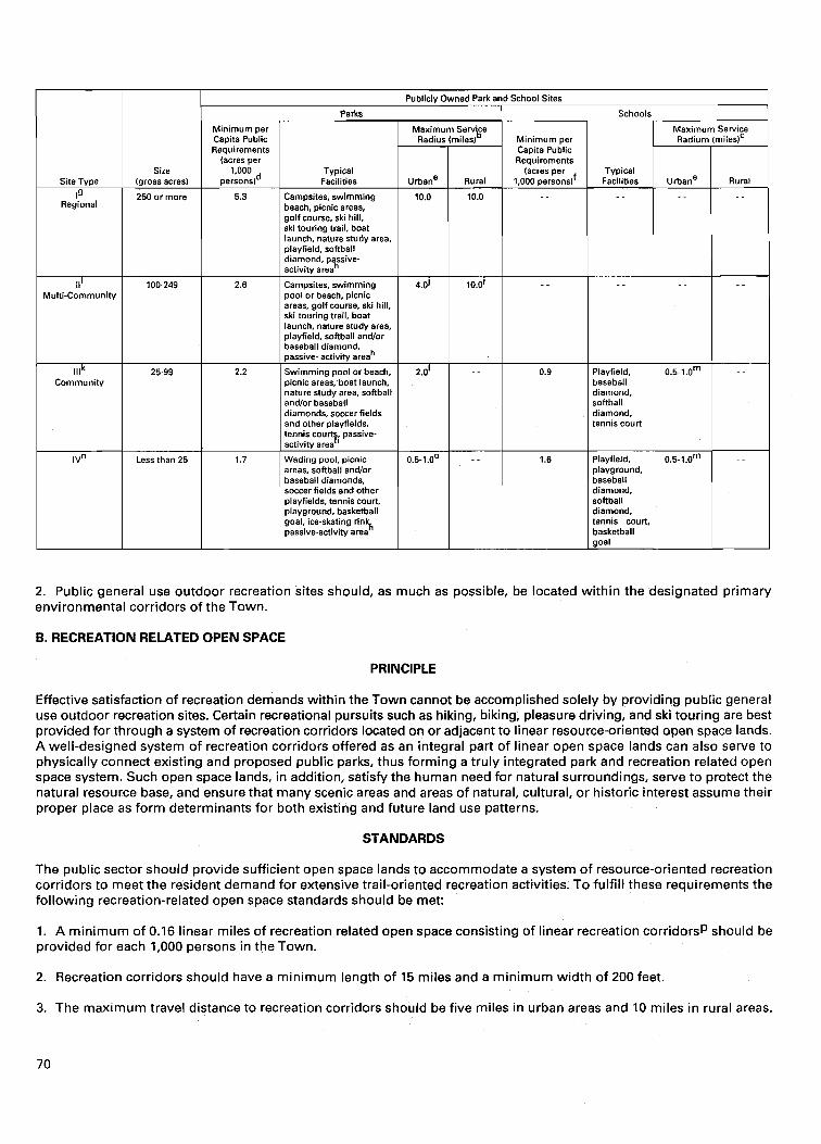
size
I
250 or more Regional
Publicly Owned Park and School Sites
(acres per 1.000 Typical
Dersons)d Facilities
111 Multi-Community
lllk Community
IV"
5.3 Campsites, swimming beach, picnic areas, golf course, ski hill, ski touring trail, boat launch, nature study area, playfield, softball diamond. oassive-
100-249
25-99
Less than 25
I activity areah 2.6 I Campsites, swimming 1 4.0) 1 10.0~
Rural
pool or beach, picnic areas, golf course, ski hill. ski-touring trail, boat launch, nature study area, ~lavfield, softball and/or
Swimming pool or beach, picnic areas, boat launch, nature study area, softball and/or baseball diamonds, soccer fields and other playfields, tennis courts. oassive-
Requirements (acres per
1,000 persondf
I activity areah ' 1.7 Wading pool, picnic
areas, softball andlor baseball diamonds, soccer fields and other playfields, tennis court playground, basketball goal, ice-skating rin 'k passive-activity area
Typical Facilities Rural I urbane
1 softball diamond, tennis court I I playground, baseball diamond, softball diamond, tennis court, basketball
2. Public general use outdoor recreation sites should, as much as possible, be located within the designated primary environmental corridors of the Town.
B. RECREATION RELATED OPEN SPACE
PRINCIPLE
Effective satisfaction of recreation demands within the Town cannot be accomplished solely by providing public general use outdoor recreation sites. Certain recreational pursuits such as hiking, biking, pleasure driving, and ski touring are best provided for through a system of recreation corridors located on or adjacent to linear resource-oriented open space lands. A well-designed system of recreation corridors offered as an integral part of linear open space lands can also serve to physically connect existing and proposed public parks, thus forming a truly integrated park and recreation related open space system. Such open space lands, in addition, satisfy the human need for natural surroundings, serve to protect the natural resource base, and ensure that many scenic areas and areas of natural, cultural, or historic interest assume their proper place as form determinants for both existing and future land use patterns.
STANDARDS
The public sector should provide sufficient open space lands to accommodate a system of resource-oriented recreation corridors to meet the resident demand for extensive trail-oriented recreation activities. To fulfill these requirements the following recreation-related open space standards should be met:
1. A minimum of 0.16 linear miles of recreation related open space consisting of linear recreation corridorsp should be provided for each 1,000 persons in the Town.
2. Recreation corridors should have a minimum length of 15 miles and a minimum width of 200 feet.
3. The maximum travel distance to recreation corridors should be five miles in urban areas and 10 miles in rural areas.
4. Resource-orientated recreation corridors should maximize the use of:
a. Primary environmental corridors as locations for trail-oriented recreation activities.
b. Outdoor recreation facilities provided at existing public park sites.
c. Existing trail-type facilities within the Town.
0B.IECTIVE NO. 2
The provision of sufficient outdoor recreation facilities to allow the resident population of the Town adequate opportunity to participate in intensive nonresource-oriented outdoor recreation activities.
PRINCIPLE
Participation in intensive nonresource-oriented outdoor recreation activities including basketball, baseball, ice-skating, soccer, playfield and playground activities, softball, pool swimming, and tennis provides ag individual with both the opportunity for physical exercise and an opportbnity to test and expand his or her physical capability. Such activities also provide an outlet for mental tension and anxiety as well as a diversion from other human activities. Competition in the various intensive nonresource-related activities also provides an opportunity to share recreational experiences, participate in team play, and gain understanding of other human beings.
STANDARD
A sufficient number of facilities for participation in intensive nonresource-oriented outdoor recreation activities should be provided throughout the Town. To achieve this standard, the following per capita requirements and design criteria for various facilities should be met as indicated below:
Minimum
Activity
Baseball
Basketball
Ice-skating
Playfield Activities
Playground Activities
Soccer
Softball
Swimming
Tennis
Sewice Radius
of Facility (miles)'
2.0
0.5
0.5
0.5
0.5
1 .O
1.0
3.0 3.0
1 .O
per Capita
Facility
Diamond
Goal
Rink
Playfield
Playground
Field
Diamond
Pool
Court
Typical Location of Facility
Types 11. Ill and IV general use site
Type lV general use site
Type lV general use site
Type lV general use site
Type lV general use site
Multizommunity. community, and neighborhood parks
Type 11. Ill, and IV general use site
Type ll and Ill general use site
Type 11, Ill, and IV general use site
Facility Requirementsq
Owner
Public Nonpublic Total
Public Nonpublic Total
Public Nonpublic Total
Public Nonpublic Total
Public Nonpublic Total
Public Nonpublic Total
Public Nonpublic Total
Public Nonpublic Total
Public Nonpublic Total
Facility Requirements
(acres per facility)
2.8 acres per diamond
0.07 acre per goal
0.30 acre per rink minimum
1.0 acre per playfield minimum
0.25 acre per playground minimum
1.0 acre minimum
1.70 acre per diamond
0.13 acre per pool minimum
0.15 acre per court
Facility per 1,000
Urban Residents
0.09 0.01 0.10~
0.91 0.22 1.13
0.15' - - 0.15
0.39 0.11 0.50
0.35 0.07 0.42
0.69 0.17 0.86
0.53 0.07 0.60
0.015~ - - 0.015
0.50 0.10 0.60
Design Standards
Additional Suggested Support Facilities
Parking (30 spaces per diamond) Night lighting Concessions and bleacherst Buffer and landscape - -
Warming house
Buffer area
Buffer and landscape
Buffer
Parking (20 space per diamond) =t Nighttime lighting
Buffer
Bathhouse and concessions Parking (400 square feet per space) Buffer and landscaping
Parking (2.0 space per court) f Nighttime lighting Buffer
Support Facility Requirements
(acres per facility)
0.28 acre per diamond -.
0.02 acre minimum 1.40 acres per diamond . .
0.05 acre - -
0.65 acre minimum
0.37 acre
.65 acre
0.18 acre per diamond - -
0.80 acre per diamond
0.13 acre minimum 0.26 acre minimum 0.70 acre minimum
0.02 acre per court -.
0.15 acre per court
Total Land Requirement
(acres per facility)
4.5
0.07
0.35 minimum
1.65 minimum
0.62 minimum
1.65
2.68
1.22 minimum
0.32
OBJECTIVE NO. 3
The provision of sufficient outdoor recreation facilities to allow the resident population of the Town adequate opportunity to participate in intensive resource-oriented outdoor recreation activities.
PRINCIPLE
Participation in intensive resource-oriented outdoor recreation activities including camping, golf, picnicking, downhill skiing, and stream and lake swimming provides an opportunity for individuals t o experience the exhilaration of recreational activity in natural surroundings as well as an opportunity for physical exercise. In addition, the family can participate as a unit in certain intensive resource-orientated activities such as camping, picnicking, and beach swimming.
STANDARD
A sufficient number of facilities for participation in intensive resource-oriented outdoor recreation activities should be provided throughout the Town. To meet this standard, the following per capita requirements and design criteria for various facilities should be met as indicated below:
OBJECTIVE NO. 4
The provision of sufficient outdoor recreation facilities to allow the resident population of the Town adequate opportunity to participate in extensive land-based outdoor recreation activities.
Activity
Camping
Golf
Picnicking
Skiing
Swimming
PRINCIPLE
Participation in extensive land-based outdoor recreation activities including biking, hiking, horseback riding, nature study, pleasure driving, ski-touring, and snowmobiling provides opportunity for contact with natural, cultural, historic, and scenic features. In addition, such activities can increase an individual's perception and intensify awareness of the surroundings, contribute to a better understanding of the environment, and provide a wider range of vision and comprehension of all forms of life both as this life may have existed in the past and as i t exists i n the present. Similar to intensive resource-
Service Radius
of Facility (mileslx
25.0
10.0
25.0
10.0
Minimum per Capita
Facility
Campsite
Regulation 18-hole course
Tables
Developed slope (acres)
Beach (linear feet)
Typical Location of Facility
Type l and ll general use sites
Type l and ll general use sites
Type I, 11, Ill, and lV general use sites
Type I, 11.111 general use sites
Type I, ll, Ill general use sites
Facility
Owner
Public Nonpublic Total
Public Nonpublic Total
Public Nonpublic Total
Public Nonpublic Total
Public Nonpublic Total
Facility Requirements
(acres per facility)
0.33 acre per campsite
135 acres per course
0.07 acre per table minimum
1.0 acre per acre of developed slope
40 square feet per linear foot (average)
F4equirementW
Per Capita Requirements
(facility per 1.000 residents)
0.35 1.47 1.82
0.013 0.027 0.040
6.35y 2.39 8.74
0.010
0.090
0.100
Design
Additional Suggested Support Facilities
Rest rooms-showers Utility hookups Natural area backup lands
Clubhouse, parking, Maintenance
Practice area
Woodland or water areas
Buffer
Parking
Shelters and grills Buffer and parking overflow
Chalet
Parking
Ski tows (and lights)
Buffer and maintenance
Landscape
Parking
Bathhouse- concessions
Buffer areas
Major Inland Lakes
6 12 18
Standards
Support Facility
Requirements (acres per facility)
- - - -
1.5 acres per campsite
8.0 acres per course 5.0 acres per course 35.0 acres per course 2.0 acres per course
0.02 acre per table (1.5 space per table)
- - 0.02 acre per table
0.13 acre minimum
0.25 acre per acre of slope
0.40 acre per acre of slope
0.40 acre per acre of slope
0.35 acre per acre of slope
0.2 acre per acre of beach
0.10 acre minimum
10 square feet per linear foot
Total Land Requirements
(acres per facility)
1.83
185.0
0'11
2.1
- - Lake
Michigan
16 - - 16
Resource Requirements
Ungrazed wooded area Presence of surface water Suitable topography and soils
Suitable topography and soils
Presence of.surface water Form-giving vegetation desirable
Topography with scenic views
Shade trees Presence of surface water desirable
Suitable soils
Suitable topognphy and soils (20 percent slope minimum)
North or northeast exposure
Natural beach Good water quality
orientated activity, the family as a unit also can participate in extensive land based recreation activities; such participation also serves to strengthen social relationships within the family. For activities like biking, hiking, and nature study, participation provides an opportunity to educate younger members of the family in the importance of environmental issues which may become of greater concern as they approach adulthood.
STANDARD
A sufficient number of facilities for participation in land-based outdoor recreation activities should be provided throughout the Town. Public facilities provided for these activities should be located within the linear resource-orientated recreation corridors identified in Objective No. 1. To meet this standard, the following per capita standards and design criteria should be met as indicated below:
OBJECTIVE NO. 5
The provision of sufficient access areas to allow the resident population of the Town adequate opportunity to participate in water-based outdoor recreation activities on the major inland lakes and rivers and on Lake Michigan which are consistent with enjoyable surface water use and the maintenance of adequate water quality.
Minimum per Capita Public
PRINCIPLE
Typical Location of Facility
Scenic roadways Recreation corridor
Recreation corridor
Recreation corridor Type I general use site
Type I. 11. Ill general use sites
Recreation corridor Type I, 11, Ill general use
sites
Scenic roadways Recreation corridor
Recreation corridor Types l and I1 general
use sites
Private lands (leased for public use)
Facility
Activity
Biking
Hiking
Horseback Riding
Nature Study
Pleasure Driving
Ski-touring
Snowmobiling
The major inland lakes and rivers of the Town and Lake Michigan accommodate participation in extensive water-based recreation activities, including canoeing, fishing, ice fishing, motorboating, sailing, and water-skiing, which may involve unique forms of physical exercise or simply provide opportunities for rest and relaxation within a particularly attractive natural setting. Participation in extensive water-based recreation activities requires access to the major inland lakes and rivers and Lake Michigan and such access should be available to the general public.
STANDARDS
Minimum Facility
Requirements (acres per
linear mile)
- - 1.45
0.73
1.21
- -
0.73
- -
0.97
1.45
Requirementsaa
Facility
Route Trail
Trail
Trail
Center
Trail
Route
Trail
Trail
1. Access sites available for use by the general public on streams and major lakes, that is, lakes of 50 acres or larger, should be provided in accordance with the requirements established by the Wisconsin Department of Natural Resources in Sections NR 1.90 and NR 1.91 of the Wisconsin Administrative Code.
Per Capita Requirements (linear mile per 1,000 residents)
- - bb
0.16
0.16
0.05
1 per County
0.02
- - CC
0.02
0.11
Design Standards
Suggested Suppott
Facilities and Backup Lands
Route markers Backup lands with Resource amenities
Backup lands with Resource amenities
Backup lands with Resource amenities
Interpretive center Building Parking
Backup lands with Resource amenities
Route markers
Backup lands with Resource amenities
Backup lands, including Resource amenities and open lands
Minimum Support Facility Requirements
(acres per linear mile)
- - 24.2
24.2
24.2
- -
24.2
- -
24.2
24.2
Resource Requirements
- - Diversity of scenic, historic, natural, and cultural features
Suitable topography (5 percent slope average maximum) and soils
Diversity of scenlc, historic, natural, and cultural features
Suitable topography and soils
Diversity of scenic, historic, natural, and cultural features
Suitable topography and soils
Diversity of natural features, including a variety of plant and animal species
Suitable topography and soils Diversity of natural features. including a vanety of plant and animal species
Suitable topography and soils
- -
Suitable natural and open areas Rolling topography
Suitable natural and open areas Suitable topography (8 percent slope average maximum) and soils

2. Access sites providing parking should be provided on major streams throughout the Town. The maximum interval between access points on major canoeable streamsdd should be 10 miles.
OBJECTIVE NO. 6
The preservation of sufficient open-space lands for protection of the underlying and sustaining natural resource base and enhancement of the social and economic well-being, environmental quality, and biodiversityee of the Town.
PRINCIPLE
Ecological balance and natural beauty within the Town are primary determinants of the ability to provide a pleasant and habitable environment for all forms of life and to maintain the social and economic well being of the Town. Preservation of the most significant aspects of the natural resource base, that is, primary environmental corridors, natural areas and critical species habitat sites, and prime agricultural lands, contributes to the maintenance of ecological balance, natural beauty, and economic well being of the Town.
A. PRIMARY ENVIRONMENTAL CORRIDORS
PRINCIPLE
The primary environmental corridors are a composite of the best individual elements of the natural resource base including surface water, streams, and rivers and their associated floodlands and shorelands; woodlands, wetlands, wildlife habitat; areas of groundwater discharge and recharge; organic soils, rugged terrain, and high relief topography; and significant geological formations and physiographic features. By protecting these elements of the natural resource base, flood damage can be reduced, soil erosion abated, water supplies protected, air cleansed, wildlife population enhanced, biological diversity preserved, and continued opportunities provided for scientific, educational, and recreational pursuits.
STANDARD
All remaining nonurban lands within the designated primary environmental corridors in the Town should be preserved in essentially natural open uses.
B. NATURAL AREAS AND CRITICAL SPECIES HABITATS
PRINCIPLE
Natural areas and critical species habitats are important in a number of ways--including economically, insofar as they support advances in agriculture and medicine; functionally, insofar as they enhance surface water and groundwater quality, minimize erosion, and enhance air quality; educationally; recreationally; aesthetically; in basic scientific research; and in maintaining biological and genetic diversity. In a less tangible but equally important way, natural areas and critical species habitats contribute to mental well-being and to the overall quality of human life.
STANDARDS
The remaining natural areas and critical species habitat areas should be preserved.
C. PRIME AGRICULTURAL LANDS
PRINCIPLE
Prime agricultural lands, in addition to providing food and fiber, can supply significant wildlife habitat; contribute to maintaining an ecological balance between plants and animals; offer locations close to urban centers for the production of certain food commodities which may require nearby population concentrations for an efficient production-distribution relationship; provide opportunities for agricultural and agriculture-related employment; provide open spaces which give form and structure to urban development; and serve to maintain the natural beauty and unique cultural heritage of the Town.
STANDARDS
1. Prime agricultural lands should be preserved for agricultural use.
2. Agricultural lands surrounding adjacent high-value scientific, educational, or recreational resources should be considered for preservation to provide a buffer between such resources and urban development.
OBJECTIVE NO. 7
The efficient and economical satisfaction of outdoor recreation and related open space needs meeting all other objectives at the lowest possible cost.
PRINCIPLE
The total resources of the Town are limited, and any undue investment in park and open space lands must occur at the expense of other public investment.
STANDARD
The sum total of all expenditures required to meet park demands and open space needs should be minimized.
Footnotes
urban areas facilities for intensive nonresource-oriented recreational activities are commonly located in Type 111 or Type IV school outdoor recreation sites. These facilities often provide a substitute for facilities usually located in parks by providing opportunities for participation in intensive non-resource-orientated activities. It is important to note, however, that school outdoor recreation sites do not generally contain natural areas which provide space for passive recreational use.
b ~ h e identification of a maximum service radius for each park type is intended to provide another guideline to assist in the determination of park requirements and to assure that each resident of the Town has ready access to the variety of outdoor recreation facilities commonly located in parks, including space and facilities for both active and passive outdoor recreational use.
CThe identification of a maximum service radius for each school site is intended to assist in the determination of active outdoor recreation facility requirements and to assure that each urban resident has ready access to the types of active intensive nonresource-oriented facilities commonly located in school recreation areas.
d ~ o r Type I and Type I1 parks, which generally provide facilities for resource-orientated outdoor recreation activities for the total population of the Town, the minimum per capita acreage requirements apply to the total resident population of the Town. For Type 111 and Type IV sites, which generally provide facilities for intensive nonresource-oriented outdoor recreation activities primarily in urban areas, the minimum per capita acreage requirements apply to the resident population of the Town residing in urban areas.
eUrban areas are defined as areas containing a closely spaced network of minor streets which include concentrations of residential, commercial, industrial, governmental, or institutional land uses having a minimum total area of 160 acres and a minimum population of 500 persons. Such areas usually are incorporated and are served by sanitary sewerage systems. These areas have been further classified into the following densities: low-density urban areas or areas with 0.70 to 2.29 dwelling units per net residential acre, medium-density urban areas or areas with 2.30 to 6.99 dwelling units per net residential acre, and high-density urban areas or areas with 7.00 to 17.99 dwelling units per net residential acre.
f ~ o r public school sites, which generally provide facilities for intensive nonresource-orientated outdoor recreation activities, the minimum per capita acreage requirements apply to the resident population of the Town residing in urban areas.
Type I sites are defined as large outdoor recreation sites with a multi-County service area. Such sites rely heavily for their recreational value and character on natural resource amenities and provide opportunities for participation in a wide variety of resource-oriented outdoor recreation pursuits.
h~ passive activity area is defined as an area within an outdoor recreation site which provides an opportunity for such less athletic recreational pursuits as pleasure walking, rest and relaxation, and informal picnicking. Such areas are generally located in parks or in urban open space sites, and usually consist of a landscaped area with mowed lawn, shade trees, and benches.
Type 11 sites are defined as intermediate size sites having a Countywide or multi-community service area. Like Type I sites, such sites rely for their recreational value and character on natural resource amenities. Type I1 parks, however, usually provide a smaller variety of recreational facilities and have smaller areas devoted to any given activity.
jln general, each resident of the Town should reside within 10 miles of a Type I or Type I1 park. It should be noted, however, that within urban areas, having a population of 40,000 or greater, each urban resident should reside within four miles of a Type I or Type I1 park.
k ~ y p e 111 sites are defined as intermediate size sites having a multi-neighborhood service area. Such sites rely more on the development characteristics of the area to be served than on natural resource amenities for location.
Iln urban areas the need for a Type 111 park is met by the presence of a Type I1 or Type I park. Thus, within urban areas having a population of 7,500 or greater, each urban resident should be within two miles of a Type 111, 11, or I park.
The service radius of school outdoor recreation sites, for park and open space planning purposes, is governed primarily by individual outdoor recreation facilities within the school site. For example, school outdoor recreation sites which provide such facilities as playfields, playgrounds, and basketball goals typically have a service radius of one-half mile, which is the maximum service radius assigned to such facilities (see standards presented under Objective 2). As another example school outdoor recreation sites which provide tennis courts and softball diamonds typically have a service radius of one mile, which is the maximum service radius assigned to such facilities (see standards presented under Objective 2). It is important to note that areas which offer space for passive recreational use are generally not provided at school outdoor recreation sites and therefore Type Ill and Type IV school sites generally do not meet Type Ill and Type IV park accessibility requirements.
"Type IV sites are defined as small sites which have a neighborhood as the service area. Such sites usually provide facilities for intensive nonresource-oriented outdoor recreation activities and are generally provided in urban areas. Recreation lands at the neighborhood level should most desirably be provided through a joint community-school district venture, with the facilities and recreational land area required to be provided on one site available to serve the recreation demands of both the school student and resident neighborhood population. Using the Type IV park standard of 1.7 acres per thousand residents and the school standard of 1.6 acres per thousand residents, a total of 3.3 acres per thousand residents or approximately 21 acres of recreation lands in a typical medium-density neighborhood would be provided. These acreage standards relate to lands required to provide for recreation facilities typically located in a neighborhood and are exclusive of the school building site and associated parking area and any additional natural areas which may be incorporated into the design of the park site such as drainageways and associated storm water retention basins, areas of poor soils, and floodland areas.
O The maximum service radius of Type IVparks is governed primarily by the population density in the vicinity of the park. In high-density urban areas, each urban resident should reside within 0.5 mile of a Type IV park; in medium-density urban areas, each resident should reside within 0.75 mile of a Type IV park; and in low-density urban areas, each resident should reside within one mile of a Type IVpark. It should be noted that the requirement for a Type IV park also is met by a Type I, 11, or 111 park within 0.5-1.0 mile service radius in high-, medium-, and low-density urban areas, respectively. Further, it should be noted that in the application of the service radius criterion for Type IV sites, only multi-use parks five acres or greater in area should be considered as satisfying the maximum service radius requirement. Such park sites generally provide areas which offer space for passive recreational uses, as well as facilities which provide opportunities for active recreational uses.
PA recreation corridor is defined as a publicly owned continuous linear expanse of land which is generally located within scenic areas or areas of natural, cultural, or historical interest and which provides opportunities for participation in trail- oriented outdoor recreational activities especially through the provision of trails designated for such activities as biking, hiking, horseback riding, nature study, and ski-touring.
q Facilities for intensive nonresource-oriented outdoor recreation activities generally serve urban areas. The minimum per capita requirements for facilities for intensive nonresource-oriented outdoor recreation activities, therefore, apply to the total resident population in each urban area of the Town.
'For each facility for intensive nonresource-oriented activity, the service radius indicates the maximum distance a participant should have to travel from his or her place of residence to participate in the corresponding activity.
SEach urban area having a population of 2,500 or greater should have at least one baseball diamond.

t ~ u p p o r t facilities such as night lighting, concessions, and bleachers generally should not be provided in Type IV sites. These sites typically do not contain sufficient acreage to allow an adequate buffer between such support facilities and surrounding neighborhood residences. 1
Each urban area should have at least one ice-skating rink.
"Each urban area having a population of 7,500 or greater should have one public swimming pool or beach.
WFacilities for intensive resource-orientated activities serve both rural and urban residents of the Town. The minimum per capita requirements for facilities for intensive resource-oriented activities, therefore, apply to the total resident population of the Town.
XParticipants in intensive resource-oriented recreational activities travel relatively long distances from their home. The approximate service radius indicates the normal maximum distance a participant in the respective resource-oriented activity should have to travel from his or her place of residence to participate in the corresponding activity.
YThe allocation of the 6.35 picnic tables per thousand residents to publicly owned general-use sites is as follows: 3.80 tables per thousand residents of the Town to be located in Type I and Type I1 parks to meet the resource-oriented picnicking needs of the Town and 2.55 tables per thousand residents of urban areas in the Town to be located in Type 111 and Type IV parks to meet local picnicking needs in urban areas of the Town.
ZA picnic area is commonly provided adjacent to a swimming beach as a support facility. Thus, the total amount of acreage required for support facilities must be determined on a site-by-site basis.
aaBoth urban and rural residents of the Town participate in extensive land-based outdoor recreation activities. Thus, minimum per capita requirements for trails for extensive land-based activities apply to the total resident population of the Town.
b b ~ i k e routes are located on existing public roadways; therefore, no requirement is indicated.
CcPleasure-driving routes are located on existing public roadways; therefore, no requirement is provided. However, a recreation corridor may provide a uniquely suitable area for the development of a system of scenic driving routes.
d d ~ a j o r canoeable streams are defined as those streams which have a minimum width of 50 feet over a distance of at least 10 miles.
ee Biodiversity refers to the number and abundance of animal and plant species, their genetic composition and variability, and the ecological connection between and among species.
Source: SE WRPC.

(This page intentionally left blank)
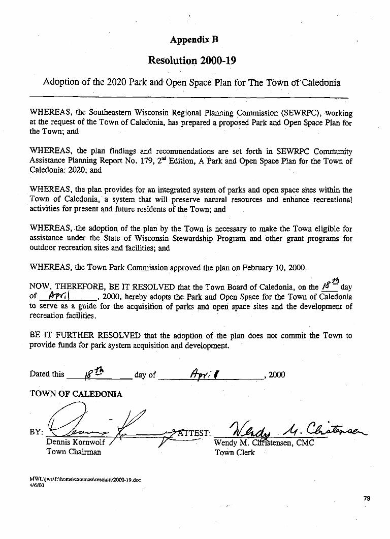
Appendix B
Resolution 2000-19
Adoption of the 2020 Park and Open Space Plan for The Tdwn oTCaledonla
WHEREAS, the Southeastern Wisconsin Regional Planning Commission (SEWRPC), working at the request of the Town of Caledonia, has prepared a proposed Park and Open Space Plan for the Town; and
WHEREAS, the plan findings and recommendations are set forth in SEWRPC Commanity Assistance Planning Report No. 179, 2"d Edition, A Park and Open Space Plan for the Town of Caledonia: 2020; and
WHEREAS, the plan provides for an integrated system of parks and open space sites within the Town of Caledonia, a system that will preserve natural resources and enhance recreational activities for present and future residents of the Town; and
WHEREAS, the adoption of the plan by the Town is necessary to make the Town eligible for assistance under the State of Wisconsin Stewardship Program and other grant programs for outdoor recreation sites and facilities; and
WHEREAS, the Town Park Commission approved the plan on February 10, 2000. f i
NOW, THEREFORE, BE IT RESOLVED that the Town Board of Caledonia, on the - day of &GI , 2000, hereby adopts the Park and Open Space for the Town of Caledonia to serve as a guide for the acquisition of parks and open space sites and the development of recreation facilities.
BE IT FURTHER RESOLVED that the adoption of the plan does not commit the Town to provide funds for park system acquisition and development.
Dated this !8* day of , ~ O O o
TOWN OF CALEDOMA
BY: - e F - TEST: WenZ%tens?iM?
Town Chairman Town Clerk