Embed Size (px)
Citation preview
Texas Historical Commission staff (SEM), 12/19/2012, 1/16/2013, 1/23/13 27” x 42” Official Texas Historical Marker with post Cameron County (Job #12CF01) Subject (Atlas ) UTM: 14 000000E 0000000N Location: Brownsville, end of Sabal Palm Road running south of FM 1792
RABB PLANTATION TODAY, COMMONLY REFERRED TO AS THE RABB PLANTATION, THIS WAS
ORIGINALLY KNOWN AS RANCHO SAN TOMAS AND, THEN, SAN TOMAS
PLANTATION. IT ENCOMPASSED 20,353 ACRES STRETCHING NORTH FROM THE
BANKS OF THE RIO GRANDE TO THE ARROYO COLORADO. IN 1885, MIFFLIN
KENEDY CONVEYED SAN TOMAS TO HIS STEPDAUGHTER, MARIA VICENTA
STARCK. IN 1892, AFTER THE MARRIAGE OF FRANK RABB TO HER DAUGHTER,
LILLIAN, MARIA VICENTA STARCK TRANSFERRED 1/2 UNDIVIDED INTEREST IN
SAN TOMAS TO FRANK RABB. THAT SAME YEAR, THE RABB AND STARCK
FAMILIES BUILT A QUEEN ANNE STYLE HOUSE THAT SERVED AS THE WORKING
HEADQUARTERS OF THE PLANTATION. IT REPRESENTED THE LIVING STYLE AND
UPWARD MOBILITY OF THE ENTREPRENEURS AND POLITICAL ELITE OF SOUTH
TEXAS AT THE END OF THE 19TH CENTURY. ITS VICTORIAN ARCHITECTURE
SIGNIFIED A SHIFT FROM THE SPRAWLING SOUTHWEST RANCHOS AND
“BORDER BRICK” TRADITION, AND IS THE ONLY EXAMPLE OF ITS TYPE IN
CAMERON COUNTY. THE RABB PLANTATION ENCOMPASSED NUMEROUS
OUTBUILDINGS, INCLUDING A BRICK OUTHOUSE, FOREMAN’S HOUSE, STABLE
AND WORKERS’ BUILDINGS. MANY OF THESE BUILDINGS HAVE DISAPPEARED.
AT SAN TOMAS, RABB FOLLOWED THE LEAD OF THE NEIGHBORING BRULEY
PLANTATION AND EXPERIMENTED WITH IRRIGATION SYSTEMS, AGRICULTURAL
CROPS AND NEW LIVESTOCK BREEDS, TRYING TO ADAPT THEM TO THE SOUTH
TEXAS CLIMATE. THESE BEGINNINGS HELPED PROPEL THE AGRICULTURAL
BOOM THAT EMERGED IN THE EARLY 20TH CENTURY. FRANK RABB DIED IN 1932
AND THE LAND AROUND THE HOUSE PASSED TO HIS ESTATE, AND THEN TO HIS
SECOND WIFE, MARGARET MCCORMICK RABB. IN THE 1970s, THE ACREAGE
AROUND THE HOUSE WAS CONVEYED TO THE NATIONAL AUDUBON SOCIETY
AND ESTABLISHED AS A SANCTUARY FOR WILDLIFE. IN 2010, THE HOUSE WAS
CONVEYED TO THE GORGAS SCIENCE FOUNDATION.
RECORDED TEXAS HISTORIC LANDMARK – 2012
MARKER IS PROPERTY OF THE STATE OF TEXAS

RECORDED TEXAS HISTORIC LANDMARK MARKERS: 2012 Official Texas Historical Marker
Sponsorship Application Form Valid September 1, 2011 to November 15, 2011 only
This form constitutes a public request for the Texas Historical Commission (THC) to consider approval of an Official Texas Historical Marker for the topic noted in this application. The THC will review the request and make its determination based on rules and procedures of the program. Filing of the application for sponsorship is for the purpose of providing basic information to be used in the evaluation process. The final determination of eligibility and therefore approval for a state marker will be made by the THC. This form is to be used for Recorded Texas Historic Landmark (RTHL) requests only for buildings or structures. Please see separate forms for either Historic Texas Cemeteries or subject markers. Proposed marker topic (THC will determine official title): Rabb Plantation County: Cameron Town (nearest county town on current state highway map): Brownsville Street address of marker site or directions from town noted above: The end of Sabal Palm Road running south of FM 1792 Marker Coordinates: If you know the location coordinates of the proposed marker site, enter them in one of the formats below: UTM Zone Easting Northing Lat: 25 51' 08.38NLong: 97 25' 03.97W(deg, min, sec or decimal degrees) Otherwise, give a precise verbal description here (e.g. northwest corner of 3rd and Elm, or FM 1411, 2.6 miles east of McWhorter Creek): NOTE: RTHL markers must be placed at the structure being marked. RECORDED TEXAS HISTORIC LANDMARK MARKERS Definition: Recorded Texas Historic Landmark (RTHL) markers are awarded to buildings and structures deemed worthy of preservation for their historical associations and architectural significance. RTHL is a legal designation and comes with a measure of protection; it is the highest honor the state can bestow on a historic building or structure, and the designation is required for this type of marker. The RTHL designation becomes effective upon approval by the THC. Official Texas Historical Markers signify the RTHL designation, which comes only through application to and approval by the THC and must include public display of an Official Texas Historical Marker. Owners of RTHL-designated properties must give the THC 60 days written notice before any alterations are made to the exterior of the structure. RTHL status is a permanent designation and is not to be removed

from the property in the event of a transfer of ownership. Only the THC can remove the designation or recall the marker. The marker must remain with the structure and may not be removed or displayed elsewhere until or unless the THC gives express approval in writing for such action. Once designated as RTHL, properties are subject to provisions of Texas Government Code, Section 442.006(f). Criteria: 1. Age: Properties eligible for the RTHL designation and marker must be at least 50 years
old. 2. Historical significance: Architectural significance alone is not enough to qualify a
property for RTHL designation. It must have a significant historical association, which can come from an event that occurred at the site; through individuals who owned or lived on the property; or, in the case of bridges, industrial plants, schoolhouses and other non-residential properties, through documented significance to the larger community.
3. Architectural significance: Properties deemed architecturally significant are outstanding examples of architectural history through design, materials, structural type or construction methods. In all cases, eligible architectural properties must display integrity; that is, the structure should be in a good state of repair, maintain its appearance from its period of significance and be considered an exemplary model of preservation. Architectural significance is often best determined by the relevance of the property to broader contexts, including geography. Any changes over the years should be compatible with original design and reflect compliance with accepted preservation practices, e.g., the Secretary of the Interior’s Standards for Rehabilitation.
4. Good state of repair: Structures not considered by the THC to be in a good state of repair are ineligible for RTHL designation. The THC reserves the sole right to make that determination relative to eligibility for RTHL markers.
SPECIAL CONSIDERATION FOR RTHL DOCUMENTATION: National Register properties Properties individually listed in the National Register of Historic Places (NR) under either Criterion A or B and Criterion C (Architecture) may not require additional documentation of the building’s history or architecture. In such cases, only an RTHL application needs to be submitted. The THC has sole discretion to determine whether such documentation is satisfactory and correct or if documentation needs to be updated.
Check this box if the property is individually listed in the NR. Year listed: Courthouses Historic county courthouses with documented master plans accepted through the THC’s Texas Historic Courthouse Preservation Program (THCPP) may not require additional documentation of the building’s history or architecture. In such cases, only an RTHL application needs to be submitted. The THC has sole discretion to determine whether such documentation is satisfactory and correct or if documentation needs to be updated.
Check this box if the property is a courthouse with a master plan accepted through the THC’s THCPP. APPLICATION REQUIREMENTS

Any individual, group or county historical commission (CHC) may apply to the THC to request an Official Texas Historical Marker for what it deems a worthy topic. Only complete marker applications that contain all the required elements can be accepted or processed by the THC (for RTHL markers, the required elements are: sponsorship application form; narrative history; documentation; legal description; site plan; floor plan; historic photograph; and current photographs clearly showing each side of the structure—please resize digital photographs to 1-2 MB, or approximately 1024 x 768 pixels).
• Completed applications must be duly reviewed, verified and approved by the county historical commission (CHC) in the county in which the marker will be placed. Paper copies of applications, whether mailed or delivered, cannot be accepted in lieu of the electronic version.
• The sponsorship application form, narrative history and documentation must be submitted as Microsoft Word or Word-compatible documents and sent via email attachments to the THC by no later than November 15, 2011. THC email accepts mail no larger than 10 MB.
• Required font style and type size are a Times variant and 12-point. • Narrative histories must be typed in a double-spaced (or 1.5-spaced) format and
include separate sections on context, overview and significance. • The narrative history must include documentation in the form of reference notes,
which can be either footnotes or endnotes. Documentation associated with applications should be broad-based and demonstrate a survey of all available resources, both primary and secondary.
• Upon notification of the successful preliminary review of required elements by the THC, a non-refundable application fee of $100 is required. Please send payment with the invoice which THC provides.
APPROVAL BY COUNTY HISTORICAL COMMISSION The duly appointed marker representative (chair or marker chair) noted below for the county historical commission will be the sole contact with the THC for this marker application. To ensure accuracy, consistency and efficiency, all information from and to the THC relative to the application, throughout the review and production processes, will be by direct communication with the CHC representative. All other inquiries (calls, emails, letters) to the THC will be referred to the CHC representative for response. By filling out the information below and filing the application with the THC, the CHC contact is notifying the THC that the application and documentation have been reviewed and verified by the CHC, and that the material meets all current requirements of the Official Texas Historical Marker program. As chair or duly appointed marker chair, I certify the following:
Representatives of the CHC have met or talked with the potential marker sponsor and discussed the marker program policies as outlined on the THC web site. CHC members have reviewed the history and documentation for accuracy and made corrections or notes as necessary. It is the determination of the CHC that the topic, history and documentation meet criteria for eligibility.
CHC comments or concerns about this application, if any:
Name of CHC contact (chair or marker chair): Norman Rozeff

Mailing address:1013 E. Cenizo street City, Zip: Harlingen, TX 78550
Daytime phone:956 425-2932 Email address: [email protected]
PERMISSION OF PROPERTY OWNER FOR MARKER PLACEMENT Property owner: Gorgas Science Foundation, Inc. Address:2335 Hudson Blvd. City, state, zip:Brownsville, TX 78526 Phone:(956) 561-3671 Email address: [email protected] Legal Description of the property (metes and bounds, lot and block, etc.): Being 30.00 acres of land, more or less, out of that certain tract of land commonly referred to as the “Palm Grove Plantation” in Shares 29 and 30 of the ESPIRITU SANTO GRANT in Cameron County, Texas, and being out of Blocks 200 and 300 as shown on the Plat of the E.S. Hunt, et al Subdivision, recorded in Volume 1, Page 26, of the Cameron County Map Records and of the El Jardin Re-Subdivision recorded in Volume 4, Page 48, of the Cameron County Map Records Upon receipt of the application, the THC will provide the owner with a letter that outlines the legal responsibility of ownership under the Recorded Texas Historic Landmark statute. The letter must be signed by the owner and returned to the THC before the evaluation can be completed. NOTE: The property owner will not receive any additional copies of correspondence from the THC. All procedural correspondence (notice of receipt, request for additional information, inscription, shipping notice, etc.) will be sent by email to the CHC representative, who is encouraged to share the information with all interested parties as necessary. SPONSORSHIP PAYMENT INFORMATION Prospective sponsors please note the following:
• Payment must be received in full within 45 days of the official approval notice and must be accompanied by the THC payment form. The THC is unable to process partial payments or to delay payment due to processing procedures of the sponsor. Applications not paid in the time frame required may, at the sole discretion of the THC, be cancelled or postponed.
• Payment relates to sponsorship of the marker in partnership with the THC, which provides the match for program costs.
• Payment does not constitute ownership of a marker; Recorded Texas Historic Landmark markers and other Official Texas Historical Markers are the property of the State of Texas.
• If, at any time during the marker process, sponsorship is withdrawn, a refund can be processed, but the THC will retain the application fee of $100.
• The Official Texas Historical Marker Program provides no means of recognizing sponsors or property owners through marker text, incising or supplemental plaques.
Marker sponsor (may be individual or organization): Gorgas Science Foundation, Inc. Contact person (if applicable): Lawrence Lof Mailing address:1247 Lakeside Blvd. City, zip: Brownsville, TX 78520 Phone: (956) 561-3671 Email address (required):[email protected] SHIPPING INSTRUCTIONS In order to facilitate marker delivery, residence addresses, post office box numbers and rural route numbers are not permitted. To avoid additional shipping charges or delays, use a business street address (open 8 a.m.—5 p.m., Monday through Friday). Name: Gorgas Science Foundation Street address:2335 Hudson Blvd. Brownsville, Texas City, zip: Brownsville, TX 78526 Daytime phone (required): (956) 561-3671 Email (required): [email protected] TYPE AND SIZE OF RECORDED TEXAS HISTORIC LANDMARK MARKERS As part of its review process, the THC will determine the appropriate size marker and provide options, if any, for the approved topic based on its own review criteria, including, but not exclusive of, historical significance, replication of information in other THC markers, relevance to the Statewide Preservation Plan and the amount of available documented information provided in the application narrative. In making its determination, however, the THC will also take into account the preference of the CHC, as noted below. The sponsor/CHC prefers the following size marker:
27” x 42” RTHL marker with post ($1500) 27” X 42” RTHL marker without post* ($1500) 18” x 28” RTHL marker with post ($1000) 18” x 28” RTHL marker without post* ($1000) RTHL medallion and 16” x 12” plaque with post ($750) RTHL medallion and 16” x 12” plaque without post* ($750)
*For an RTHL marker without post, indicate to what surface material it will be mounted:
wood masonry metal other (specify)
SUBMITTING THE APPLICATION (via email required) When the CHC has determined the application is complete, the history has been verified and the topic meets the requirements of the Official Texas Historical Marker Program, the
materials should be forwarded to the THC by email at the following address: [email protected]. The CHC or marker chair should send an email containing the following attachments
(see attachment function under file menu or toolbox on your computer): ▫ This application form ▫ The narrative history (including documentation) ▫ Legal description of the property ▫ Detailed floor plan for each floor of the structure ▫ Detailed site plan of the property ▫ At least one historic photograph ▫ Current photographs clearly showing each side of the structure
RECORDS RETENTION BY CHC: The CHC must retain hard copies of the application as well as an online version, at least for the duration of the marker process. The THC is not responsible for lost applications, for incomplete applications or for applications not properly filed according to the program requirements. For additional information about any aspect of the Official Texas Historical Marker Program, see the Markers page on the THC web site (http://www.thc.state.tx.us/markerdesigs/madmark.html) Texas Historical Commission
History Programs Division P.O. Box 12276, Austin, TX 78711-2276 Phone 512/463-5853 [email protected]

The Rabb Plantation House 1. Context
The three decades prior to the 20th Century were ones of transition and transformation for
the Lower Rio Grande Valley of Texas. Subsistence ranching, long the economic engine
of the region, was giving way to an agro-industrial one. Despite the lack of adequate
transportation connecting the Valley to other areas of the state, the slowly growing
population itself offered a market for some products. Primarily, expanded agriculture
was made possible by two developments. One was the installation of lift pumps on the
Rio Grande, and the second was the construction of gravity-flow canals to carry irrigation
away from the immediate river margins. Together they enabled irrigation of the "Wild
Horse Desert", heretofore only marginally productive due to the vagaries, especially
multi-year droughts, of the Valley climate. 1
Frank Rabb was quite representative of the numerous dynamic men who peopled the
Valley at this period. He was a rancher, farmer, land promoter, politician, intriguer, and
wheeler-dealer. In many ways, he played a major role in the evolution of the Rio Grande
Delta and the history of a dynamic period in history. The growth of his plantations and
the construction of a Victorian mansion characterize the relatively rapid economic
evolution of the Valley just before and, especially after, the coming of the railroad in
1904.2

II. Overview
Rabb Plantation
The Rabb Plantation House is located along the Rio Grande in Southeastern Cameron
County just within the city limits of Brownsville ( Fig 1a & 1b).
The Rabb Plantation House represented the living style and upward mobility of the early
entrepreneurs of South Texas at the close of the 19th Century. Its architecture signified a
shift from the sprawling Southwest ranchos and indigenous “border brick” traditions.
More importantly it is the only extant example of its type in Cameron County.
The Rabb Plantation originally included 20,353 acres of land in share 29 of the Epiritu
Santo land grant and includes all the land in a strip stretching north from the Rio Grande
to the Arroyo Colorado (Fig 2a). Over its long history, was identified by several names.
For much of the 19th century it was known as Rancho San Tomas. In dozens of
references in the Daily Herald between 1892 and 1910 it was almost always referred to as
San Tomas Plantation. This reflected the shift to agriculture and away from ranching.
Later it was sometimes referred to as Rancho de Las Palmas or Palm Grove Plantation.
Maps at the turn in the 20th century still referred the site as San Tomas but indicated the
presence of the Rabb House (Fig 3). By the 1930s the San Tomas name had been lost
and it became known to as the Rabb Plantation.
The area around San Tomas was a riparian landscape dominated by a dense palm / ebony
forest. Early Spanish explorers described miles of palms and called it “Rio de las
Palmas.” These palms were more widespread south in Mexico but extended into the
delta area. In this exceptionally biodiverse region, the palm forest is the most “tropical”

ecosystem in South Texas. At one time as many as 40,000 - 60,000 acres of palm forest
lined the river. By the 20th century, the Rabb Plantation sheltered one of the last
remaining groves of native Sabal Palms (Sabal mexicana). ( Southwestern Naturalist
September , 1996, page 218). This remnant core forms the nucleus around which sabal
palm reforestation has occurred at Sabal Palm Sanctuary and remains the rarest and most
distinct ecosystem in the Rio Grande Delta region.
Early land maps of the San Tomas ranch area show clusters of small houses on high land
along the river. Annually, floods spread across the broad delta… especially along its
lower course. The people of the area build their homes close to the river because it was a
critical source of transport, commerce, and fresh water but because it also provided some
protection from flooding. On alluvial deltas, natural levies develop close to the river
where the greatest amount of deposition from the overflows occurs. The annual floods
usually spread past the islands of highland near the bank of the river. On a 1911 map
this gradient, exploited by early settlers, is clearly marked (Fig 3).
Some years, the spring floods fed by melting snow in distant mountains came with a
vengeance. Worse were the floods caused by hurricanes. Whatever the cause, floods
often changed the course of a river as it meandered across the flat alluvial delta. At times
after the river subsided, the new course would be miles away. After the Rio Grande
became in international border large tracts of land would occasionally be marooned on
the opposite side of the border. In the case of the Rabb Plantation, this happened in 1895
when La Canasta Banco, a tract in Mexico, was left high and dry on the US side (Fig 3).
Frank W. Rabb purchased this displaced property from the owner in Mexico. This
extended San Tomas Plantation south along the river once again.

When we look at the Rio Grande today, it’s hard to imagine that this pitiful creek was
often descried as North America’s second Mississippi. From 1828 – 1902 a large fleet
of shallow draft steamboats plied the river with cargo and passengers. The Rio Grande
served as the highway for the region. Before the railroad came in the 20th century, access
and proximity to the river was an important factor… not only for water but for
transportation and trade.3 The Rabb Plantation had a riverboat landing. The house Rabb
stood on the high ground close to the river as it made a bend on two sides and was
probably visible form the river as it made a statement about the success of its owner.
Ironically, the change in the river’s course in 1895 left it a good distance from the river.
River transportation also tied together Rabb’s other agricultural interests. In the 1890s
Frank Rabb purchased another large river property at Santa Maria on the western edge of
Cameron County. At that time it was the second largest population center in Cameron
County. He acquired this property in Santa Maria in 1892 for $30,000 and added to the
ranch acreage. The ranch complex faces the river, where boat landings and shipping
wharves were built. Rabb repaired and painted the ranch house complex, which became
known as Casa Blanca as well as Rancho Santa María. This property is still visible
today from the Military Highway across the Road from Our Lady of Visitation Church in
Santa Maria. In the end, Rabb had the two finest ranches on the delta on which he
pioneered irrigation and experimented with new crops that were later to form the
mainstay of delta agriculture. . The Daily Herald often mentioned the comings and
goings of Rabb and his family as they traveled through Brownsville between San Tomas
and Santa Maria. Often that trip was made on the last operating river steamer, the
“Bessie”.

Like many large ranches in the nineteenth century, the Rabb Plantation was a small self-
sufficient city and included numerous out-building. (Fig 5)
In addition to the main house an incredibly well built brick outhouse (Fig 6) with
louvered shutters survives as does a frame house that according to local tradition was the
foreman’s house built before the construction of main house. The foreman’s house was
originally two rooms. Interestingly, it was framed with vertical palm logs buried in the
ground. The exterior is sheathed with relatively recent wide plank clapboards (Fig 7).
Underneath, the original board and batten sheathing is visible.
Most of the worker’s buildings and other buildings dating back to the San Tomas Ranch
as shown on the 1911 map have disappeared. They were probably of jacal construction
and melted back into the soil after they were abandoned. In an intreguing note in the
Daily Herald in October 27, 1892, mention is made of a new “handsome brick stable”.
Although this would have been a major structure, no evidence of its location has yet been
found. In the future, an attempt will be made to locate all the missing structures. Most
are probably obscured in heavy brush or were destroyed by modern mechanical
agriculture.
Tradition has it that the massive ancient ebony trees along the pre 1895 bend of the river
behind the house mark the spot where river steamers tied up.
III. The Structure
The Queen Anne Style

In a short article Jackie Craven comments on Queen Anne Architecture in the USA--
Reigning Style of America's Industrial Age. She writes: Of all the Victorian house styles,
Queen Anne is the most elaborate and the most eccentric. The style is often called
romantic and feminine, yet it is the product of a most unromantic era -- the machine age.
Queen Anne became an architectural fashion in the 1880s and 1890s, when the industrial
revolution was building up steam. North America was caught up in the excitement of new
technologies. Factory-made, precut architectural parts were shuttled across the country on
a rapidly expanding train network. Exuberant builders combined these pieces to create
innovative, and sometimes excessive, homes.
Also, widely-published pattern books touted spindles and towers and other flourishes we
associate with Queen Anne architecture. Country folk yearned for fancy city trappings.
Wealthy industrialists pulled out all stops as they built lavish "castles" using Queen Anne
ideas. Fanciful and flamboyant, America's Queen Anne architecture takes on many
shapes. Some Queen Anne houses are lavishly decorated. Others are restrained in their
embellishments. The Rabb House comes closest to the category defined as "Spindled".
"This is the style we most frequently think of when we hear the term "Queen Anne."
These are "gingerbread" houses with delicate turned porch posts and lacy, ornamental
spindles. This type of decoration is often called Eastlake because it resembles the work of
the famous English furniture designer, Charles Eastlake. Queen Anne architecture is not
an orderly or easily classified. Bay windows, balconies, stained glass, turrets, porches,
brackets, and an abundance of decorative details combine in unexpected ways." 4
Building the Rabb Plantation House

In 1891 Frank Rabb, partnering with his mother-in-law Maria Vicenta Vidal Stark, began
work the large two-story Victorian house that dominated high ground overlooking the
Rio Grande, a few miles downriver from Brownsville. It was built at a total cost of
$15,000.00. At the time, it must have been one of the grandest homes in the region
making a statement of wealth and prosperity for 25 year old Frank Rabb and his new wife
Lillian… a couple anxious to make their mark on society and politics of the region. A
handwritten note recently found in the Newel Post (Fig 8) in the front hall gave some
detail to the house’s construction. In the note the contractor, Jason McCoy, guaranteed to
have it finished before Christmas dinner 1892. Skilled carpenters who worked on the
building were Charles Morrison, John Falls, Stafford Corkill, Josefoun Tonks; painters
Gallahaut & Bensery; trim by Shaw, Spucha & Ed Lagats.
The house was complete on April 8th 1892. The note ended with: “In god we trust the
rest pay cash. Six month with fleas & ticks; San Tomas Ranch; March 28th 1892”
Architectural Details
The large two story house was dominated by wrap around porches on two floors (Fig 9,
Fig 10a - 10f, Fig 11a & 11b)
Windows/ Shutters
Every window was fitted with louvered storm shutters (Fig 12). They protected the large
single pane double hung windows that fall into two general sizes… 41x76 inches and 41x
101 inches. Shutters are currently in rough, deteriorated condition.
Front Entry Doors / Stained Glass
The double front doors have a tiffany style stained glass inserts in the upper half and

transom (Fig 13a & 13b). A round beveled clear glass etched with initials R S… Rabb –
Starck dominates the center (Fig 13c). The upper sash of the front parlor window has 24
small multi colored surrounding a clear center pane (Fig 13d).
Brickwork, Quoins and Chimneys
Before the railroad, brick was often locally made in the small communities and ranches
nearby in the tradition of the “border brick culture” long practiced on both sides of the
Rio Grande. San Tomas bricks were made a short distance to the west of the house As
was customary, they were made with the “brand” of the maker or ranch. In this case, the
brand was a crossed S&T (Fig 14). . Workers making molds would often fail to make a
reverse image needed in a mold. The resulting impression on the finished brick was often
reversed. Quoins (Fig 15) were carried by ship to Point Isabel and by mule train to the
plantation.
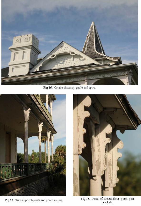
Three ornate brick work chimney stacks exit above the roof line (Fig 16). Each chimney
house 4 flues.
Exterior Woodwork and Trim
Turned porch posts (Fig 17 & Fig 18), porch brackets (Fig 19), roof brackets (Fig 20),
appliquéd frieze board (Fig 21) and coffered frieze boards (Fig 22), railings (Fig 23),
shingle design (Fig 24), dormers (Fig 25), gables (Fig 26)
Roof Spire
Large spire on the roof had a dual purpose (Fig 27). It was decorative, but it also
provided access the roof in the center of the house which at 40 ft would have been
difficult to reach otherwise. A small door behind the spire can be reached by a ladder

from the attic opens on to a section of flat roof at the center of the roof (Fig 28).
Water, Cisterns
Water for the house was provided by two huge cisterns that were fed by gutters on the
main house. An early picture showed a windmill behind the house (Fig 29). It lifted
water from the cisterns to a large raised cypress water tank.
Fireplaces
The house was heated by 12 fireplaces. Every room had a different style mantel that
ranged from simple to ornate (Fig 30). Some were faced with granite, others with low
relief art tile (Fig 31). All fireplace throats have except in the kitchen had finely cast iron
closures (Fig 32). The large double-room kitchen had two fireplaces. One was at floor
level and probably served as heating or baking. A second fireplace was used for cooking
(Fig 33). It was raised to a comfortable working height and was fitted for cooking
implements.
Interior Woodwork
The floors are clear long leaf southern yellow pine. The hall retains original newel post
(Fig 34) and dining room retains striking fluted wainscoting (Fig 35).
Lighting
Several of the 4 burner hanging brass angle oil lamps survived in the attic. (Fig 36a &
36b) The angle lamp was the epitome of oil lamp development and was specially
designed to cast no shadow below the lamp. Unfortunately, the last residents of the house
had a preference for crystal chandeliers and other original lighting has been lost. It is
uncertain when the house was electrified. Since the existing wiring was more recent than
“knob and tube”, it must have been done after the 1920s.

Modifications over time:
Several old modifications changed the basic layout of the house over the years. The
porch on both floors on the south side was extended 3 feet at some point… 6ft to 9ft.
The original piers at 6ft remain visible under the porch (Fig 37). This modification
required that the porch roof also had to be extended. This was done by kicking out the
slope of the roof. The workmanship on this modification was extremely well done and
fits seamlessly. Judging by a door that now opens onto the north kitchen porch roof,
there was once a second floor porch at one time (Fig 38). A 10 ft section of the second
floor porch on the south side was enclosed to accommodate a bathroom (Fig 39).
A Distinguished Guest In April 1909 the Valley would host a distinguished visitor. This was William Jennings
Bryant, "The Great Commoner." He had three times, in 1896, 1900, and 1908, been the
presidential nominee of the Democratic Party. He was a strong advocate of free silver,
anti-imperialism, and trust busting.5 Invited to Brownsville by the land prospector, John
Conway, Bryant was escorted by R.N. Magill and Frank Rabb, who drove him through
the South Texas Gardens, an orchard planted for the specific purpose of demonstrating
just what could be grown in the region. Bryan observed the experimental plantings.6 He
then went on to Hidalgo County where he was to purchase land east of Mission.
In subsequent visits Bryant would be a guest at the Robb Plantation House.7 This would
eventually pay dividends to Rabb when Bryant became Secretary of State in Woodrow
Wilson's administration. Bryant occupied this post from 1913 until 1916, when he broke
with the President after Wilson brought the country into the Great War. Bryant supported
Rabb's nomination as Collector of Customs at Laredo and Rabb's nomination was sent by

Wilson to the Senate for confirmation on August 28, 1913.8 Gathering the wrath of South
Texas political boss James B. Wells, Rabb had worked hardily for Wilson's nomination
on the Democratic ticket.
If Bryant was a welcomed guest at the ranch, it came as a surprise, when, on August 10,
1915, the Rabb Ranch at Palm Gardens was raided by a force of Carranzistas.9 This was
odd as Rabb had given succor in all manners to General Blanco and the Carranzistas.
General Overview of the Chain of Ownership of Rabb House
In 1892 the newly constructed Victorian mansion at San Tomas served as the working
headquarters of a huge 20,353 acre ranch and agricultural plantation that stretched from
banks of the Rio Grande River to the Arroyo Colorado. Over the succeeding decades, it
was lost on the court house steps, regained and finally subdivided. In 2010 the last
remaining 30 acres of San Tomas along with the Rabb House was conveyed to Gorgas
Science Foundation.
In 1781 the Potrero del Espiritu Santo Grant, commonly referred to as the Espiritu Santo
Grant was made to Jose Salvador de la Garza and confirmed by the Texas legislature
February 10 1852. In 1885 Mifflin Kenedy conveyed San Tomas (also known a Share
29) to his step daughter Maria Vicenta Starck (Book “F” page 734 and 735) although it
wasn’t until 1889 that a Cameron County Court confirmed Mifflin Kenedy’s ownership
in the partition the estate Doña Maria Estefana Goseascochea de Cavasos y de Cortina...
granddaughter of Jose Salvador de la Garza (Book “F” page 414) (Fig 2a and 2b)

1892 after the marriage of Frank Rabb to her daughter Lillian, Maria Vicenta Starck
transferred ½ undivided interest in San Tomas to Frank Rabb. (Book “I” – pages 356 –
358)
In 1896, in order to purchase more land and expand their interests, Frank Rabb and Maria
Vicenta Starck mortgaged San Tomas to the British and American Mortgage Company
for a $17,000 . (Book #3 page 512)
Unable to pay the mortgage, after countless notices in the Daily Herald, San Tomas was
sold at auction at the “courthouse door” to British and American on Jan 1, 1901. This
left Frank Rabb and Maria Vicenta Starck with only a 200 acre homestead in the south
east end of San Tomas including the area around the plantation house (Vol. “L” pages
119 – 123)
The eastern side of San Tomas previously owned by Frank Rabb began to return to his
control in early 1903 when it was conveyed from British and American to T. R. Blalock.
(Vol. M Pages 24 – 30) In1906 Frank Rabb buys and regains control of his undivided ½
interest from Blalock (Vol “P” pages 87 – 93)
The western side of San Tomas follows a slightly more tortuous route to Rabb ownership.
Despite the mortgage, in1899 Maria Vicenta Starck had conveyed her ½ share to the west
of Frank Rabb to her half sister Sarah Kenedy Spohn. (Book “K” Pages 462 - 464).
Sarah Spohn then conveyed her ½ interest to E C Shireman. Reserved from this transfer
was a 176 acre tract that Maria Vicenta had previously conveyed to her son Charles
Starck just to the west side of Frank Rabb’s tract.

About this time, the Herald reported that Mrs. M. V. Starck had released her ½ interested
in San Tomas to Frank Rabb for $5,000. (Brownsville Daily Herald, Vol. 16, No. 133,
Friday, December 6, 1907) and in 1908 Shireman formally conveyed the western ½ of
San Tomas to Frank Rabb minus the acreage previously conveyed to Maria Vicenta’s son
Charles. Large sections of San Tomas were subdivided and sold. In 1920 San Tomas is
resubdivided. The plat clearly indicates the Starck and Rabb sections. (Fig 4a and 4b)
1932 Frank Rabb died and the land around the Rabb house passed to his estate and then
to his recently married and widowed wife... Margaret McCormick Rabb. His former wife
- Lillian Starck Rabb died in 1933 retaining no claim on the estate. Mrs. McCormick
Rabb was appointed as Administratrix of the estate in 1937.
1957 The Rabb Plantation House was purchased by Ben F. Vaughan, Jr. of Corpus
Christi. In the 1970’s the 527 acres around the house was conveyed to National Audubon
Society and was established as a sanctuary for wildlife. In 1995, 30 acres including the
Rabb House was conveyed to National Audubon Society. In 2010 the 30 acres with the
Rabb House was conyed from National Audubon to Gorgas Science Foundation. (Fig 1a
and 1b)

1 Norman Rozeff, Sugarcane and the Development of the Lower Rio Grande Valley, 1875-1922, Edinburg: New Santander Press, 2007, 13, 23, 140. 2 Norman Rozeff, Uriah Lott, Railroad Builder, Valley Morning Star (Harlingen), 11/23/08. 3 Pat Kelley, River of Lost Dreams, Lincoln: University of Nebraska Press, 1986, 16-30. 4 Jackie Craven, 28 August 2011. http:// About.com Guide. 5 28 August 2011 http://en.wikipedia.org/wiki/William_Jennings_Bryant. 6 Mary Margaret McAllen Amberson, I'd Rather Sleep in Texas, Austin: Texas State Historical Society, 2003, 446-447. 7 Evan Anders, Boss Rule in South Texas, Austin: University of Texas Press, 1979, 202. 8 Ibid. Anders, 204. 9 Ibid. Amberson, 476.


![[Drum]Johnny Rabb - 30 Days to Better Hand - 5 Pages](https://img.pdfslide.us/doc/110x75/56d6bdc71a28ab30168f4c93/drumjohnny-rabb-30-days-to-better-hand-5-pages.jpg)