Embed Size (px)
Citation preview
November 2011
Mackas Sand Pty Ltd
Determination of Maximum Predicted Groundwater Level and Maximum Extraction Level at Lot 218 and 220, Salt Ash
Determination of Maximum Predicted Groundwater Level and Maximum Extraction
Depth at Lot 218 and 220, Salt Ash
Prepared by
Umwelt (Australia) Pty Limited
on behalf of
Mackas Sand Pty Ltd
2/20 The Boulevarde PO Box 838
Toronto NSW 2283
Ph: 02 4950 5322 Fax: 02 4950 5737
Email: [email protected] Website: www.umwelt.com.au
Project Director: Peter Jamieson Project Co-Ordinator Andy Goodwin Report No. 1646/R24/V3 Date: November 2011
Umwelt (Australia) Pty Limited 1646/R24/V3 November 2011 i
TABLE OF CONTENTS
1.0 Introduction ................................................................................. 1 1.1 Major Project Approval Requirements ............................................... 1 1.2 Previous Relevant Studies and Modelling ......................................... 2
2.0 Groundwater Monitoring Data .................................................... 3
2.1 HWC Groundwater Data ....................................................................... 3 2.2 Mackas Sand Groundwater Level Monitoring Data ........................... 4
3.0 Groundwater Modelling Methods ............................................... 5
3.1 Groundwater Model Properties ........................................................... 6 3.2 Calibration ............................................................................................. 7
4.0 Groundwater Modelling Results .............................................. 13
4.1 Average Groundwater Level on Lot 220 ........................................... 13 4.2 Maximum Predicted Groundwater Level on Lot 220 ....................... 13 4.3 Average Modelled Groundwater Level on Lot 218 ........................... 14 4.4 Maximum Predicted Groundwater Level on Lot 218 ....................... 14
5.0 Maximum Extraction Depth ...................................................... 14
5.1 Maximum Depth for Extraction – Lot 220 ......................................... 14 5.2 Maximum Depth for Extraction – Lot 218 ......................................... 15
6.0 Conclusion ................................................................................. 15
7.0 References ................................................................................. 16
Umwelt (Australia) Pty Limited 1646/R24/V3 November 2011 ii
FIGURES 1.1 Locality Plan – Mackas Sand Operations ................................................... 1 1.2 Groundwater Model Extent (EA Umwelt April 2009) .................................. 2 1.3 Average Predicted Groundwater Level (EA Umwelt April 2009) ............... 2 1.4 Maximum Predicted Groundwater Level (EA Umwelt April 2009) ............. 2 1.5 Maximum Predicted Groundwater Levels (SKM) ....................................... 2 2.1 Groundwater Model Layout and Monitoring Locations ............................. 3 2.2 Recorded Groundwater Levels - Monitoring Bores SP1 to SP6/BL 158...4 3.1 Final Calibration Results Compared with HWC Bores .............................. 8 3.2 Final Calibration Results Compared with Mackas Sand Bores ................ 8 4.1 Average Modelled Groundwater Level for Lot 218 and Lot 220 .............. 13 4.2 Modelled Maximum Predicted Groundwater Level for Lot 218 and Lot 220 ........................................................................................................ 13 5.1 Maximum Extract Depth Map showing Minimum Final Landform Elevation for Lot 218 and Lot 220 .............................................................. 14
APPENDICES 1 HWC Groundwater Monitoring Bore Data

Umwelt (Australia) Pty Limited 1646/R24/V3 November 2011 1
1.0 Introduction
1.1 Major Project Approval Requirements
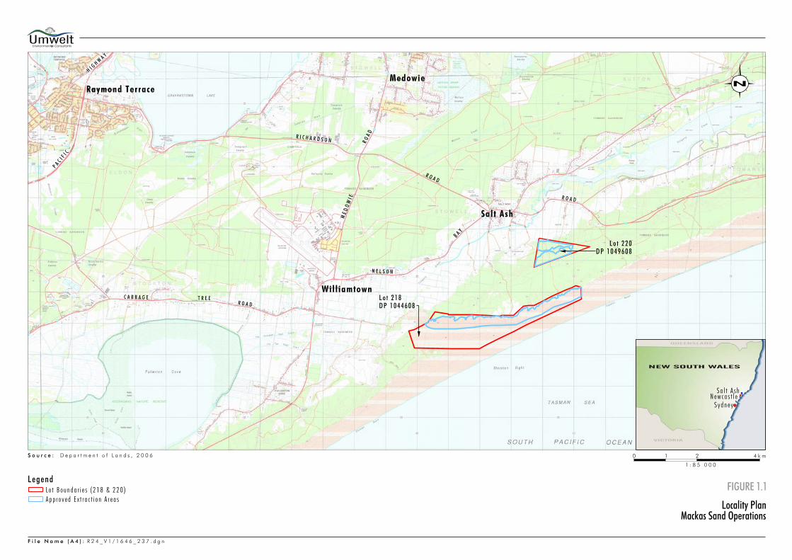
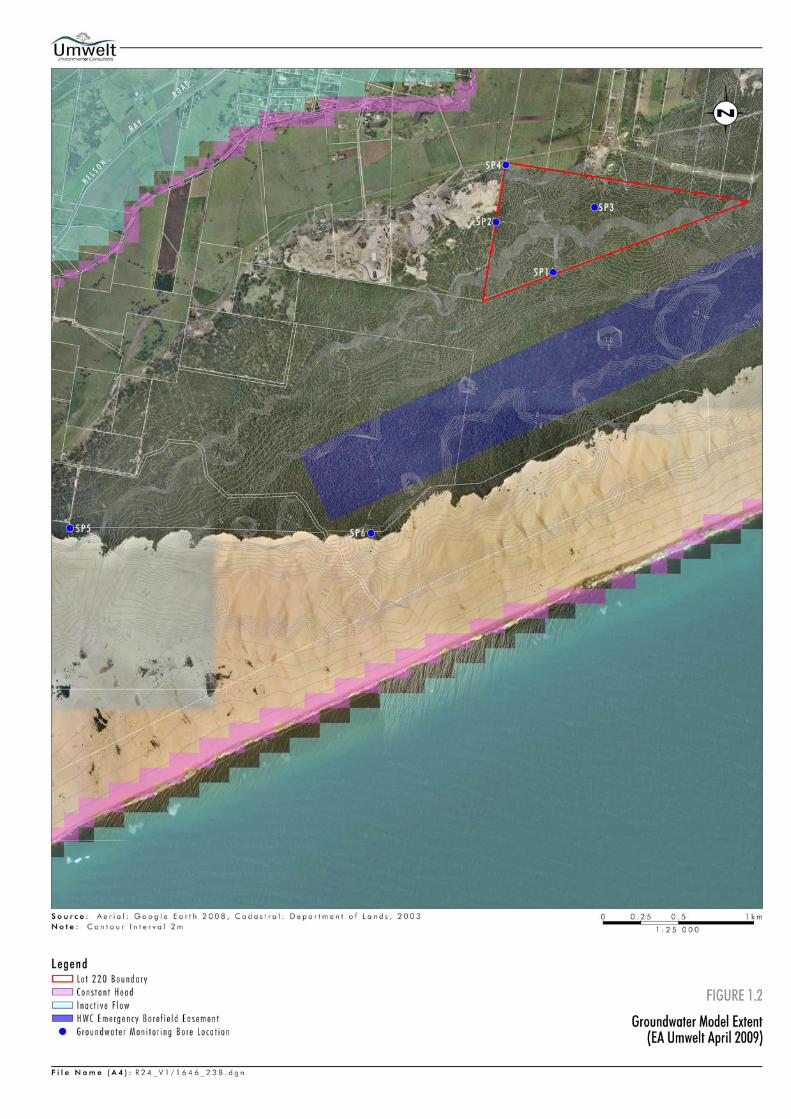
In September 2009 Mackas Sand Pty Limited (Mackas Sand) was granted Major Project Approval 08_0142 under Section 75J of the Environmental Planning and Assessment Act 1979 to extract construction and industrial grade sand resources at Lot 218 DP 1044608 (Lot 218) and Lot 220 DP 1049608 (Lot 220) Stockton Bight, NSW on behalf of the Worimi Local Aboriginal Land Council (WLALC). Major Project Approval 08_0142 requirements in regard to groundwater also form part of the licence requirements under Condition 13 of the Hunter Water (Special Areas) Regulation 2003. The location of the approved extraction areas is shown on Figure 1.1. The approved extraction areas are located on the North Stockton Sandbeds which form part of the Tomago Tomaree Stockton groundwater aquifer. Condition 2 of Schedule 3 states: Maximum Extraction Depth Map
2. The Proponent shall: (a) establish the average year and highest predicted groundwater levels for the site
based on all available (and at least 12 months) site specific and HWC groundwater monitoring data;
(b) engage a suitably qualified and experienced expert to establish the maximum
extraction depths to which extraction can be undertaken on site, to comply with Condition 7 of Schedule 2;
(c) submit a Maximum Extraction Depth Map (contour map or similar) for the project to
the Director-General within 6 months of the date of this approval; and (d) comply with the extraction depths specified in the map, to the satisfaction of the
Director-General. The approval requires the preparation of a Maximum Extraction Depth Map based on maximum predicted groundwater levels that have been established using available site specific and Hunter Water Corporation (HWC) groundwater monitoring data.
Condition 7 of Schedule 2 of Major Project Approval 08_0142_states: 7. The Proponent shall not undertake any extraction within: (a) 2 metres of the average year groundwater level; and (b) 1 metre of the highest predicted groundwater level.
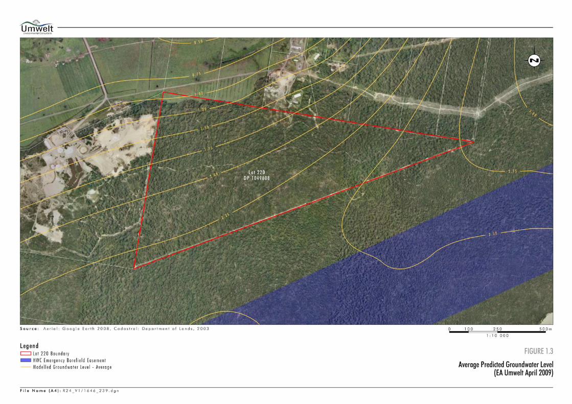
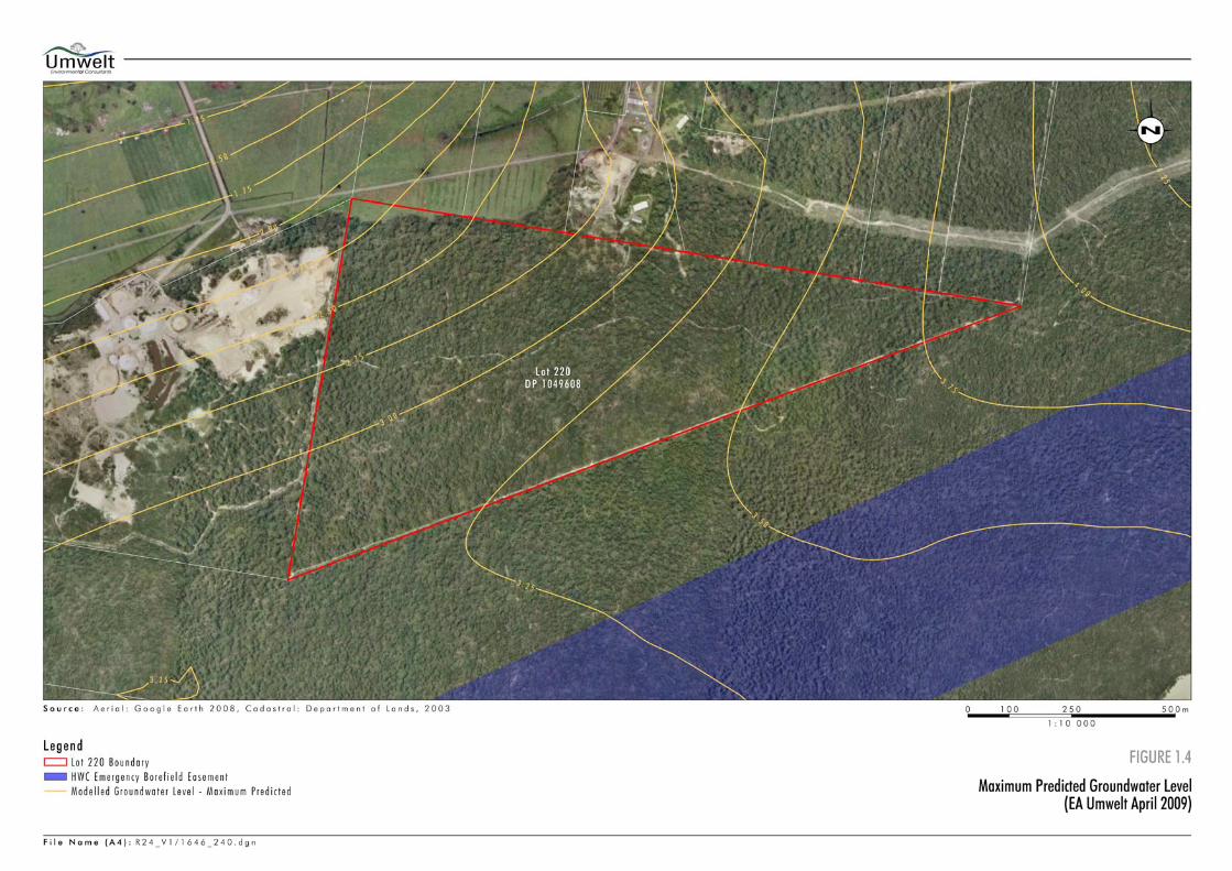
Average and maximum groundwater levels for Lot 220 were initially determined as part of the Environmental Assessment (Umwelt, April 2009) using groundwater data obtained from a series of six bores located on or adjacent to Lots 218 and 220. These bores were installed specifically for the project. Umwelt (Australia) Pty Limited (Umwelt) was engaged by Mackas Sand to undertake the necessary groundwater modelling to review maximum predicted groundwater levels and maximum extraction depths for Lots 218 and 220 in accordance with the requirements of Condition 2 of Schedule 3 of Major Project Approval 08_0142.
Umwelt (Australia) Pty Limited 1646/R24/V3 November 2011 2
1.2 Previous Relevant Studies and Modelling
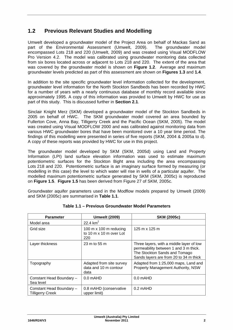
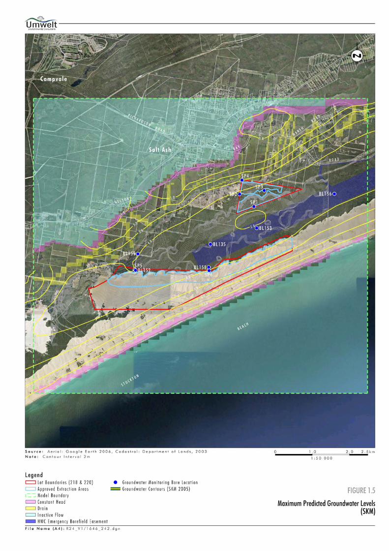
Umwelt developed a groundwater model of the Project Area on behalf of Mackas Sand as part of the Environmental Assessment (Umwelt, 2009). The groundwater model encompassed Lots 218 and 220 (Umwelt, 2009) and was created using Visual MODFLOW Pro Version 4.2. The model was calibrated using groundwater monitoring data collected from six bores located across or adjacent to Lots 218 and 220. The extent of the area that was covered by the groundwater model is shown on Figure 1.2. Average and maximum groundwater levels predicted as part of this assessment are shown on Figures 1.3 and 1.4. In addition to the site specific groundwater level information collected for the development, groundwater level information for the North Stockton Sandbeds has been recorded by HWC for a number of years with a nearly continuous database of monthly record available since approximately 1995. A copy of this information was provided to Umwelt by HWC for use as part of this study. This is discussed further in Section 2.1. Sinclair Knight Merz (SKM) developed a groundwater model of the Stockton Sandbeds in 2005 on behalf of HWC. The SKM groundwater model covered an area bounded by Fullerton Cove, Anna Bay, Tilligerry Creek and the Pacific Ocean (SKM, 2005). The model was created using Visual MODFLOW 2000 and was calibrated against monitoring data from various HWC groundwater bores that have been monitored over a 10 year time period. The findings of this modelling were presented in series of five reports (SKM, 2004 & 2005a to d). A copy of these reports was provided by HWC for use in this project. The groundwater model developed by SKM (SKM, 2005d) using Land and Property Information (LPI) land surface elevation information was used to estimate maximum potentiometric surfaces for the Stockton Bight area including the area encompassing Lots 218 and 220. Potentiometric surface is an imaginary surface formed by measuring (or modelling in this case) the level to which water will rise in wells of a particular aquifer. The modelled maximum potentiometric surface generated by SKM (SKM, 2005c) is reproduced on Figure 1.5. Figure 1.5 has been derived from Figure 27 of SKM, 2005c. Groundwater aquifer parameters used in the Modflow models prepared by Umwelt (2009) and SKM (2005c) are summarised in Table 1.1.
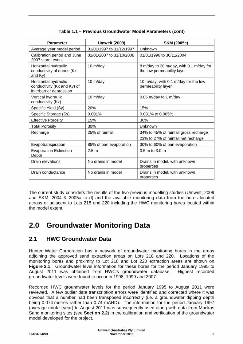
Table 1.1 – Previous Groundwater Model Parameters
Parameter Umwelt (2009) SKM (2005c) Model area 22.4 km2 Grid size 100 m x 100 m reducing
to 10 m x 10 m over Lot 220
125 m x 125 m
Layer thickness 23 m to 55 m Three layers, with a middle layer of low permeability between 1 and 3 m thick. The Stockton Sands and Tomago Sands layers are from 20 to 34 m thick
Topography Adapted from site survey data and 10 m contour data
Adapted from 1:25,000 maps, Land and Property Management Authority, NSW
Constant Head Boundary – Sea level
0.0 mAHD 0.0 mAHD
Constant Head Boundary – Tilligerry Creek
0.8 mAHD (conservative upper limit)
0.2 mAHD
Umwelt (Australia) Pty Limited 1646/R24/V3 November 2011 3
Table 1.1 – Previous Groundwater Model Parameters (cont)
Parameter Umwelt (2009) SKM (2005c) Average year model period 01/01/1997 to 31/12/1997 Unknown Calibration period and June 2007 storm event
01/01/2007 to 31/10/2008 01/01/1996 to 30/11/2004
Horizontal hydraulic conductivity of dunes (Kx and Ky)
10 m/day 8 m/day to 20 m/day, with 0.1 m/day for the low permeability layer
Horizontal hydraulic conductivity (Kx and Ky) of interbarrier depression
10 m/day 10 m/day, with 0.1 m/day for the low permeability layer
Vertical hydraulic conductivity (Kz)
10 m/day 0.05 m/day to 1 m/day
Specific Yield (Sy) 20% 15% Specific Storage (Ss) 0.001% 0.001% to 0.005%
Effective Porosity 15% 30% Total Porosity 30% Unknown Recharge 25% of rainfall 34% to 45% of rainfall gross recharge
23% to 27% of rainfall net recharge Evapotranspiration 85% of pan evaporation 30% to 60% of pan evaporation Evaporation Extinction Depth
2.5 m 0.5 m to 3.0 m
Drain elevations No drains in model Drains in model, with unknown properties
Drain conductance No drains in model Drains in model, with unknown properties
The current study considers the results of the two previous modelling studies (Umwelt, 2009 and SKM, 2004 & 2005a to d) and the available monitoring data from the bores located across or adjacent to Lots 218 and 220 including the HWC monitoring bores located within the model extent.
2.0 Groundwater Monitoring Data
2.1 HWC Groundwater Data
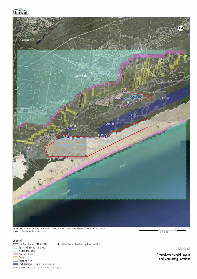
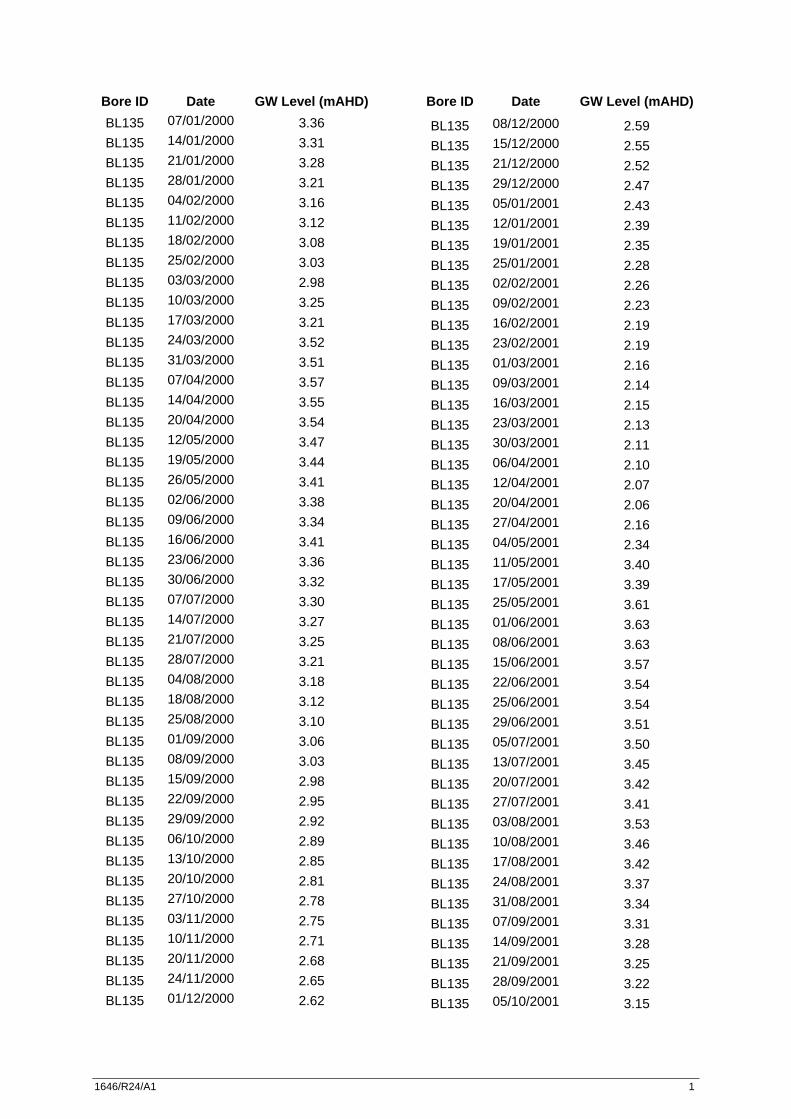
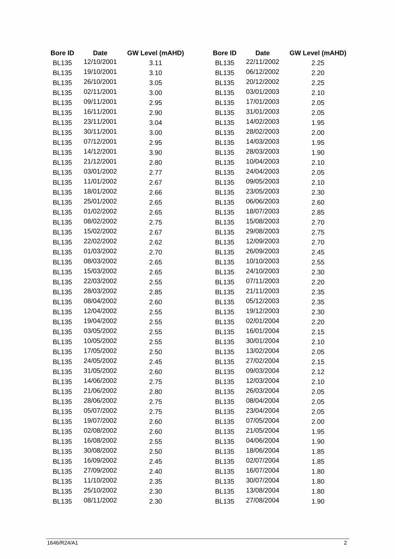
Hunter Water Corporation has a network of groundwater monitoring bores in the areas adjoining the approved sand extraction areas on Lots 218 and 220. Locations of the monitoring bores and proximity to Lot 218 and Lot 220 extraction areas are shown on Figure 2.1. Groundwater level information for these bores for the period January 1995 to August 2011 was obtained from HWC’s groundwater database. Highest recorded groundwater levels were found to occur in 1998, 1999 and 2007. Recorded HWC groundwater levels for the period January 1995 to August 2011 were reviewed. A few outlier data transcription errors were identified and corrected where it was obvious that a number had been transposed incorrectly (i.e. a groundwater dipping depth being 0.074 metres rather than 0.74 mAHD). The information for the period January 1997 (average rainfall year) to August 2011 was subsequently used along with data from Mackas Sand monitoring sites (see Section 2.2) in the calibration and verification of the groundwater model developed for the project.
Umwelt (Australia) Pty Limited 1646/R24/V3 November 2011 4
A copy of HWC groundwater information used in calibration of the model is provided in Appendix 1. 2.2 Mackas Sand Groundwater Level Monitoring Data
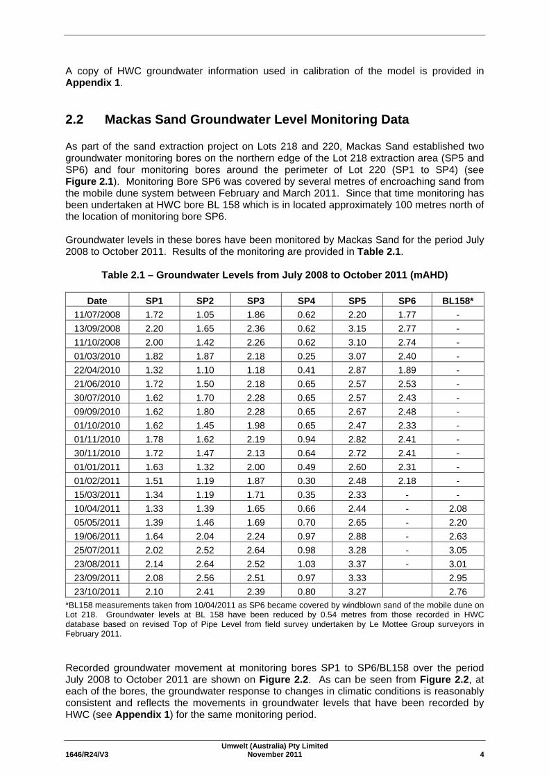
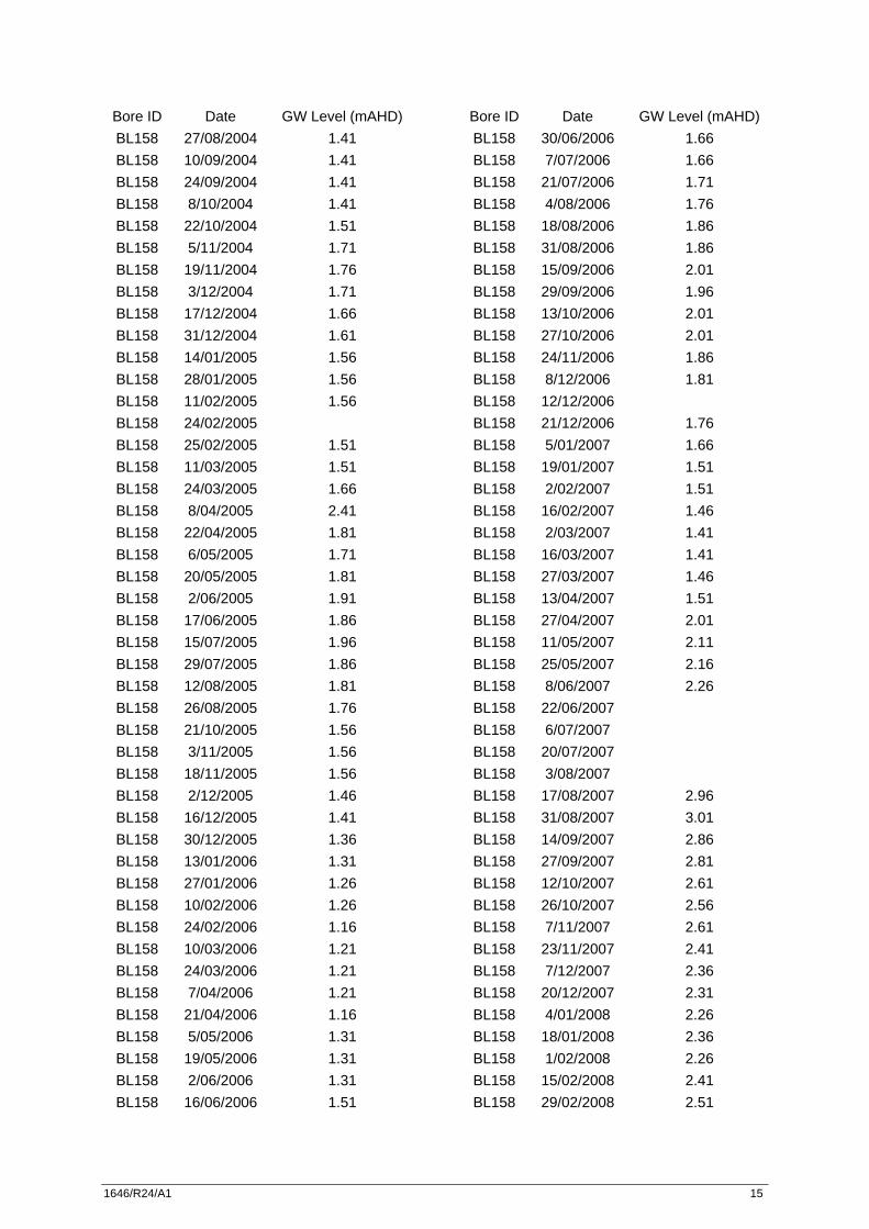
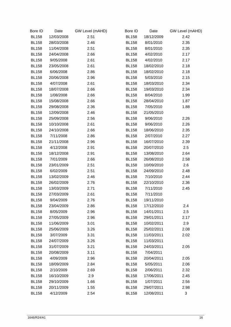
As part of the sand extraction project on Lots 218 and 220, Mackas Sand established two groundwater monitoring bores on the northern edge of the Lot 218 extraction area (SP5 and SP6) and four monitoring bores around the perimeter of Lot 220 (SP1 to SP4) (see Figure 2.1). Monitoring Bore SP6 was covered by several metres of encroaching sand from the mobile dune system between February and March 2011. Since that time monitoring has been undertaken at HWC bore BL 158 which is in located approximately 100 metres north of the location of monitoring bore SP6. Groundwater levels in these bores have been monitored by Mackas Sand for the period July 2008 to October 2011. Results of the monitoring are provided in Table 2.1.
Table 2.1 – Groundwater Levels from July 2008 to October 2011 (mAHD)
Date SP1 SP2 SP3 SP4 SP5 SP6 BL158* 11/07/2008 1.72 1.05 1.86 0.62 2.20 1.77 - 13/09/2008 2.20 1.65 2.36 0.62 3.15 2.77 - 11/10/2008 2.00 1.42 2.26 0.62 3.10 2.74 - 01/03/2010 1.82 1.87 2.18 0.25 3.07 2.40 - 22/04/2010 1.32 1.10 1.18 0.41 2.87 1.89 - 21/06/2010 1.72 1.50 2.18 0.65 2.57 2.53 - 30/07/2010 1.62 1.70 2.28 0.65 2.57 2.43 - 09/09/2010 1.62 1.80 2.28 0.65 2.67 2.48 - 01/10/2010 1.62 1.45 1.98 0.65 2.47 2.33 - 01/11/2010 1.78 1.62 2.19 0.94 2.82 2.41 - 30/11/2010 1.72 1.47 2.13 0.64 2.72 2.41 - 01/01/2011 1.63 1.32 2.00 0.49 2.60 2.31 - 01/02/2011 1.51 1.19 1.87 0.30 2.48 2.18 - 15/03/2011 1.34 1.19 1.71 0.35 2.33 - - 10/04/2011 1.33 1.39 1.65 0.66 2.44 - 2.08 05/05/2011 1.39 1.46 1.69 0.70 2.65 - 2.20 19/06/2011 1.64 2.04 2.24 0.97 2.88 - 2.63 25/07/2011 2.02 2.52 2.64 0.98 3.28 - 3.05 23/08/2011 2.14 2.64 2.52 1.03 3.37 - 3.01 23/09/2011 2.08 2.56 2.51 0.97 3.33 2.95 23/10/2011 2.10 2.41 2.39 0.80 3.27 2.76
*BL158 measurements taken from 10/04/2011 as SP6 became covered by windblown sand of the mobile dune on Lot 218. Groundwater levels at BL 158 have been reduced by 0.54 metres from those recorded in HWC database based on revised Top of Pipe Level from field survey undertaken by Le Mottee Group surveyors in February 2011. Recorded groundwater movement at monitoring bores SP1 to SP6/BL158 over the period July 2008 to October 2011 are shown on Figure 2.2. As can be seen from Figure 2.2, at each of the bores, the groundwater response to changes in climatic conditions is reasonably consistent and reflects the movements in groundwater levels that have been recorded by HWC (see Appendix 1) for the same monitoring period.
Umwelt (Australia) Pty Limited 1646/R24/V3 November 2011 5
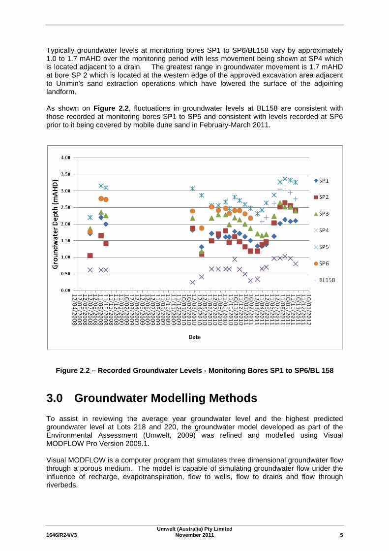
Typically groundwater levels at monitoring bores SP1 to SP6/BL158 vary by approximately 1.0 to 1.7 mAHD over the monitoring period with less movement being shown at SP4 which is located adjacent to a drain. The greatest range in groundwater movement is 1.7 mAHD at bore SP 2 which is located at the western edge of the approved excavation area adjacent to Unimin's sand extraction operations which have lowered the surface of the adjoining landform. As shown on Figure 2.2, fluctuations in groundwater levels at BL158 are consistent with those recorded at monitoring bores SP1 to SP5 and consistent with levels recorded at SP6 prior to it being covered by mobile dune sand in February-March 2011.
Figure 2.2 – Recorded Groundwater Levels - Monitoring Bores SP1 to SP6/BL 158
3.0 Groundwater Modelling Methods To assist in reviewing the average year groundwater level and the highest predicted groundwater level at Lots 218 and 220, the groundwater model developed as part of the Environmental Assessment (Umwelt, 2009) was refined and modelled using Visual MODFLOW Pro Version 2009.1. Visual MODFLOW is a computer program that simulates three dimensional groundwater flow through a porous medium. The model is capable of simulating groundwater flow under the influence of recharge, evapotranspiration, flow to wells, flow to drains and flow through riverbeds.
Umwelt (Australia) Pty Limited 1646/R24/V3 November 2011 6
Visual MODFLOW is widely used for the assessment of the impacts of development on unconfined groundwater systems. In Visual MODFLOW, the aquifer is represented by a grid of blocks known as ‘cells’, the locations of which are described in terms of rows, columns and layers. A number of layers can be defined in Visual MODFLOW to reflect vertical changes in aquifer properties. The major aquifer properties required by Visual MODFLOW include: • surface topography and layer thickness;
• hydraulic conductivity;
• aquifer storage parameters;
• recharge;
• evapotranspiration; and
• flow boundary conditions including no flow boundaries, rivers and areas of constant head.
3.1 Groundwater Model Properties
The groundwater model developed for sand extraction operation as part of the Environmental Assessment (Umwelt 2009) shown on Figure 1.2 covered an area of 22.4 km2 extending from the Pacific Ocean in the south to Tilligerry Creek in the north (refer to Figure 2.1). The grid size used in the model was 100 metres by 100 metres, reducing to a 10 metre by 10 metre grid over the approved extraction area on Lot 220 and in the vicinity of the adjoining groundwater monitoring bores. The groundwater aquifer was modelled as a single sand layer extending from bedrock at -23 mAHD to the ground surface. The ground surface ranges in elevation from 0 mAHD at the coast to approximately 32 mAHD at the highest point of the dune system. As part of this current study, the Environmental Assessment model (Umwelt 2009) has been extended approximately 2 kilometres westward and 1 kilometre eastward to remove edge effects and provide greater accuracy at the western end of Lot 218 and eastern end of Lot 220 respectively. The extended model covers an area of 32.5 km2. Ground surface elevation in the model was derived initially using a digital terrain model of the area developed from Land Property Information (LPI) 1:25,000 topographical map series data. This topographic information from LPI was found to be inaccurate in several locations and particularly in the vicinity of the inter-barrier depression between the stabilised dunes of Stockton Bight and Tilligerry Creek where the LPI landform reported elevations of 8 to 10 mAHD. The interbarrier depression typically has an elevation ranging from less than 2 mAHD to 3 mAHD. Similarly, the swale between the mobile dune system on Lot 218 and the stabilised dune ridge that extends into Lot 220 contains low-lying areas that typically have an elevation of 2 mAHD to 4 mAHD rather than the 8 to 10 mAHD that is shown in the LPI data. Elevation information in the digital terrain model was supplemented to improve the accuracy of the terrain model. This was done using detailed topographic survey data for Lot 220 that was collected specifically for the study and surveyed ground level information where it was available at HWC and Mackas Sand groundwater monitoring bore locations. Changes to elevation were made predominately in the areas surrounding the monitoring bores that we used in calibration of the model.
Umwelt (Australia) Pty Limited 1646/R24/V3 November 2011 7
The groundwater model uses two constant head boundaries to simulate the influence of the Pacific Ocean and Tilligerry Creek on groundwater levels. The location of the constant head boundaries are shown in Figure 2.1. A series of drains that have been constructed across the surface of the interbarrier depression between the Holocene sand dunes and Tilligerry Creek and 14' Foot Drain/Fullerton Cove drainage systems were also included in the model as shown on Figure 2.1. Meteorological data from the Bureau of Meteorology Station at Williamtown RAAF Base (Station 061078) was used to calculate recharge and evapotranspiration data for the model. The groundwater model was run as a steady-state model using meteorological data from the year 1997. This year was a 50th percentile rainfall year (considering the period from 1960 to 2006) and is considered representative of an ‘average year’. For the purposes of calibration, and to investigate the impact on groundwater levels of the significant volumes of rain that fell on the North Stockton aquifer as a result of heavy rainfall periods particularly during 1999 and 2007, the groundwater model was run as a transient model over the period from January 1997 (average year) to August 2011, using meteorological data from Station 061078. Analysis of HWC time series groundwater level information provided in Appendix 1 shows that highest groundwater levels in the North Stockton aquifer were recorded in May to August 1999. Groundwater level information for HWC groundwater monitoring bores in the surrounding area (BL130, BL135, BL152, BL153, BL156, BL158 BL159 and SK6438) and the six groundwater monitoring bores established for the project (SP1 to SP6) was available during this period and was used in calibrating the groundwater model. Monitoring bore SP 6 was covered by several metres of encroaching sand from the mobile dune field between February and March 2011 and could not be used after this time. Recorded May to August 1999 groundwater levels were higher than those recorded in 2007 during which high levels of rainfall were received over several months of low evaporation including the June 2007 storm (which was in excess of a 100 year average recurrence interval (ARI) event). The groundwater level recorded in August 1999 are considered to be representative of maximum groundwater levels at the site as is required by Condition 7(b) of Schedule 2 of Project Approval 08_0142. 3.2 Calibration
The groundwater model was calibrated for the period from January 1997 to August 2011 using corrected water table elevation measurements from HWC groundwater bores within the model domain and groundwater bores within the Project Area. The locations of the groundwater monitoring bores are shown in Figure 2.1. The HWC groundwater monitoring bores include: • BL135;
• BL152;
• BL153;
• BL156;
• BL158;
• BL159; and
• SK6438.
Umwelt (Australia) Pty Limited 1646/R24/V3 November 2011 8
Monitoring bore SK6438 which is located at Tilligerry Creek was used to observe tidal fluctuations in the creek at the model boundary and to determine an average water level for the northern boundary of the model. The monitoring bores located within Lots 218 and 220 (see Figure 2.1) that were used to calibrate the model include: • SP1;
• SP2;
• SP3;
• SP4;
• SP5; and
• SP6 (until March 2011).
Calibration of the model involved changing the following parameters to provide calculated groundwater levels which approached the observed water table elevations over the same time period: • hydraulic conductivity;
• specific yield;
• recharge as a percentage of rainfall;
• evapotranspiration as a percentage of pan evaporation;
• extinction depth (i.e. the depth below the ground surface at which evaporation ceases to have an effect); and
• the location and conductance of drain cells in the model.
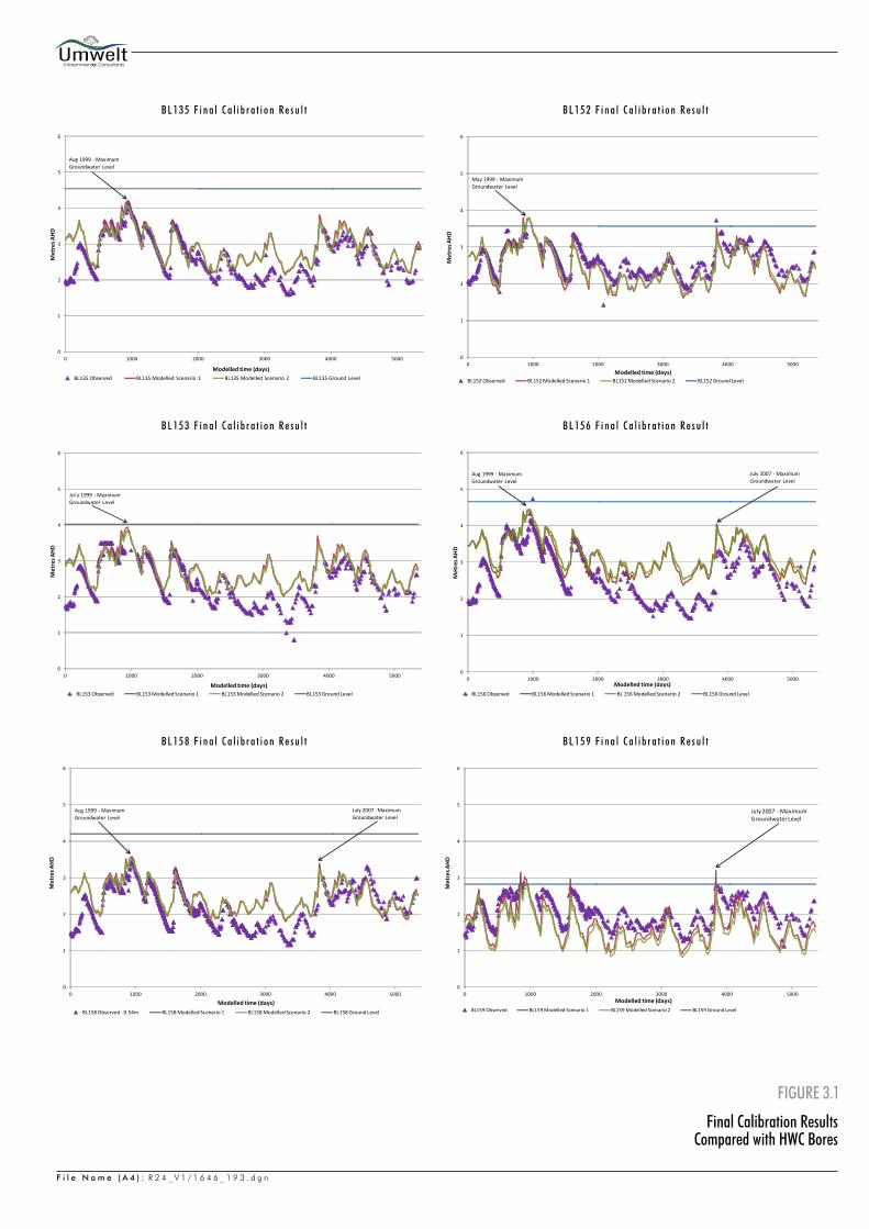
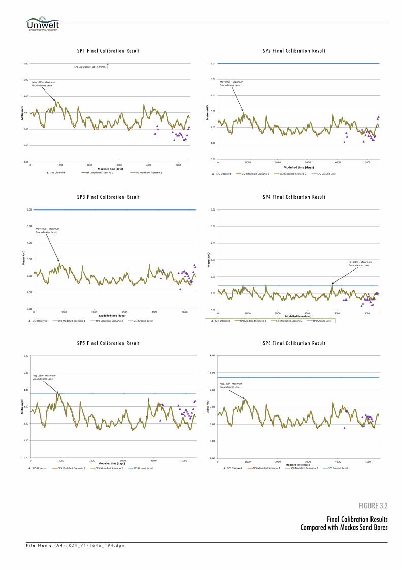
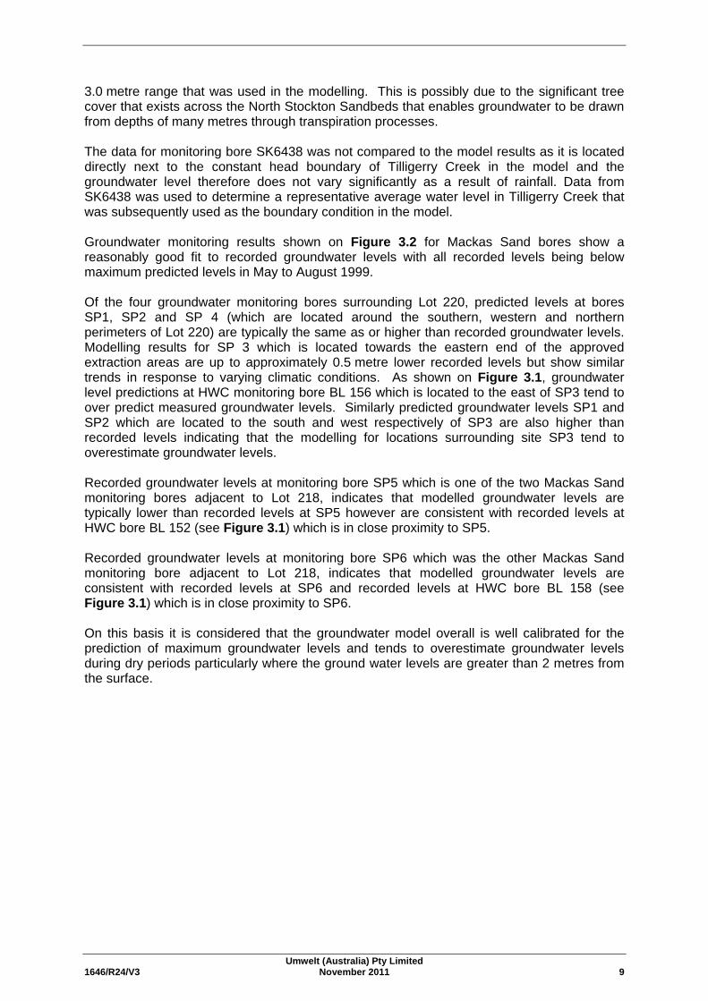
The parameters used in the original modelling undertaken by Umwelt (2009), the parameters used by SKM (2005c) in the modelling studies undertaken for HWC and the range over which these parameters were investigated by the current study are provided in Table 3.1. The final values chosen in the calibration of the model that provided the best calibration to the HWC and site specific groundwater level information are listed in Table 3.2. As set out in Table 3.2, two scenarios were modelled (Scenario 1 and Scenario 2) reflecting the range of vertical and hydraulic conductivities, porosities, recharge rates, evapo-transpiration rates and Tilligerry Creek boundary conditions that were modelled. The final calibration results are presented in Figures 3.1 and 3.2, and show the recorded HWC and Mackas Sand groundwater monitoring levels compared to predicted groundwater elevations for modelling Scenario 1 and Scenario 2. Groundwater monitoring results shown on Figure 3.1 for HWC bores show a very good fit to recorded groundwater levels particularly during wet periods, that result in maximum groundwater levels. As shown on Figure 3.1, modelling results from bore BL152 and BL 159 where the groundwater level is within 2 metres of the surface show a good fit to recorded data through wet and dry periods. Modelling results for bores BL 135, BL153, BL 156 and BL 158 where the groundwater level can be in excess of 3 metres from the surface show a good fit during wet periods but over-estimate groundwater levels during dry periods by up to 1.5 metres indicating that the evaporation extinction depth is greater than the 1.5 to
0
1
2
3
4
5
6
0 1000 2000 3000 4000 5000
Met
res A
HD
Modelled time (days)BL135 Observed BL135 Modelled Scenario 1 BL135 Modelled Scenario 2 BL135 Ground Level
Aug 1999 - Maximum Groundwater Level
0
1
2
3
4
5
6
0 1000 2000 3000 4000 5000
Met
res A
HD
Modelled time (days)BL152 Observed BL152 Modelled Scenario 1 BL152 Modelled Scenario 2 BL152 Ground Level
May 1999 - Maximum Groundwater Level
0
1
2
3
4
5
6
0 1000 2000 3000 4000 5000
Met
res A
HD
Modelled time (days)BL153 Observed BL153 Modelled Scenario 1 BL153 Modelled Scenario 2 BL153 Ground Level
Jul y 1999 - Maximum Groundwater Level
0
1
2
3
4
5
6
0 1000 2000 3000 4000 5000
Met
res A
HD
Modelled time (days)BL156 Observed BL156 Modelled Scenario 1 BL 156 Modelled Scenario 2 BL156 Ground Level
Aug 1999 - MaximumGroundwater Level
July 2007 - Maximum Groundwater Level
0
1
2
3
4
5
6
0 1000 2000 3000 4000 5000
Met
res A
HD
Modelled time (days)BL158 Observed - 0.54m BL158 Modelled Scenario 1 BL158 Modelled Scenario 2 BL158 Ground Level
Aug 1999 - Maximum Groundwater Level
July 2007- Maximum Groundwater Level
0
1
2
3
4
5
6
0 1000 2000 3000 4000 5000
Met
res A
HD
Modelled time (days)BL159 Observed BL159 Modelled Scenario 1 BL159 Modelled Scenario 2 BL159 Ground Level
July 2007 - Maximum Groundwater Level
0.00
1.00
2.00
3.00
4.00
5.00
6.00
0 1000 2000 3000 4000 5000
Met
res A
HD
Modelled time (days)SP1 Observed SP1 Modelled Scenario 1 SP1 Modelled Scenario 2
May 1999 - Maximum Groundwater Level
SP1 Groundlevel at 17.2mAHD
0.00
1.00
2.00
3.00
4.00
5.00
6.00
0 1000 2000 3000 4000 5000
Met
res A
HD
Modelled time (days)
SP2 Observed SP2 Modelled Scenario 1 SP2 Modelled Scenario 2 SP2 Ground Level
May 1999 - Maximum Groundwater Level
0.00
1.00
2.00
3.00
4.00
5.00
6.00
0 1000 2000 3000 4000 5000
Met
res A
HD
Modelled time (days)
SP3 Observed SP3 Modelled Scenario 1 SP3 Modelled Scenario 2 SP3 Ground Level
May 1999 - Maximum Groundwater Level
0.00
1.00
2.00
3.00
4.00
5.00
6.00
0 1000 2000 3000 4000 5000
Met
res A
HD
Modelled time (days)SP4 Observed SP4 Modelled Scenario 1 SP4 Modelled Scenario 2 SP4 Ground Level
July 2007 - Maximum Groundwater Level
0.00
1.00
2.00
3.00
4.00
5.00
6.00
0 1000 2000 3000 4000 5000
Met
res A
HD
Modelled time (days)SP5 Observed SP5 Modelled Scenario 1 SP5 Modelled Scenario 2 SP5 Ground Level
Aug 1999 - Maximum Groundwater Level
0.00
1.00
2.00
3.00
4.00
5.00
6.00
0 1000 2000 3000 4000 5000
Met
res
AHD
Modelled time (days)SP6 Observed SP6 Modelled Scenario 1 SP6 Modelled Scenario 2 SP6 Ground Level
Aug 1999 - Maximum Groundwater Level
Umwelt (Australia) Pty Limited 1646/R24/V3 November 2011 9
3.0 metre range that was used in the modelling. This is possibly due to the significant tree cover that exists across the North Stockton Sandbeds that enables groundwater to be drawn from depths of many metres through transpiration processes. The data for monitoring bore SK6438 was not compared to the model results as it is located directly next to the constant head boundary of Tilligerry Creek in the model and the groundwater level therefore does not vary significantly as a result of rainfall. Data from SK6438 was used to determine a representative average water level in Tilligerry Creek that was subsequently used as the boundary condition in the model. Groundwater monitoring results shown on Figure 3.2 for Mackas Sand bores show a reasonably good fit to recorded groundwater levels with all recorded levels being below maximum predicted levels in May to August 1999. Of the four groundwater monitoring bores surrounding Lot 220, predicted levels at bores SP1, SP2 and SP 4 (which are located around the southern, western and northern perimeters of Lot 220) are typically the same as or higher than recorded groundwater levels. Modelling results for SP 3 which is located towards the eastern end of the approved extraction areas are up to approximately 0.5 metre lower recorded levels but show similar trends in response to varying climatic conditions. As shown on Figure 3.1, groundwater level predictions at HWC monitoring bore BL 156 which is located to the east of SP3 tend to over predict measured groundwater levels. Similarly predicted groundwater levels SP1 and SP2 which are located to the south and west respectively of SP3 are also higher than recorded levels indicating that the modelling for locations surrounding site SP3 tend to overestimate groundwater levels. Recorded groundwater levels at monitoring bore SP5 which is one of the two Mackas Sand monitoring bores adjacent to Lot 218, indicates that modelled groundwater levels are typically lower than recorded levels at SP5 however are consistent with recorded levels at HWC bore BL 152 (see Figure 3.1) which is in close proximity to SP5. Recorded groundwater levels at monitoring bore SP6 which was the other Mackas Sand monitoring bore adjacent to Lot 218, indicates that modelled groundwater levels are consistent with recorded levels at SP6 and recorded levels at HWC bore BL 158 (see Figure 3.1) which is in close proximity to SP6. On this basis it is considered that the groundwater model overall is well calibrated for the prediction of maximum groundwater levels and tends to overestimate groundwater levels during dry periods particularly where the ground water levels are greater than 2 metres from the surface.
Umwelt (Australia) Pty Limited 1646/R24/V3 November 2011 10
Table 3.1 – Groundwater Model Parameters
Parameter Umwelt (2009) SKM (2005c) Calibration Range for Current Study (Umwelt 2011)
Model area 22.4 km2 35.3 km2 Grid size 100 m x 100 m reducing to
10 m x 10 m over Lot 220 125 m x 125 m 100 m x 100 m reducing to 10 m x 10 m over Lot 220
and cells in close proximity to monitoring wells. Layer thickness 23 m to 55 m Three layers, with a middle layer of low
permeability between 1 and 3 m thick. The Stockton Sands and Tomago Sands layers are from 20 to 34 m thick.
Single layer of 23 m to 55 m
Topography Adapted from site survey data and 10 m contour data.
Adapted from 1:25,000 maps, Land and Property Management Authority, NSW.
Adapted from site survey data and 10 m contour data from Land and Property Management Authority which was modified to take into consideration elevation information from site specific surveys, HWC and observations recorded during field investigations.
Constant Head Boundary – Sea level
0.0 mAHD 0.0 mAHD 0.0 mAHD
Constant Head Boundary – Tilligerry Creek
0.8 mAHD (conservative upper limit)
0.2 mAHD 0.1 mAHD to 0.4 mAHD. Average groundwater elevation of HWC monitoring bore SK6438, which is immediately adjacent to Tilligerry Creek.
Average year model period 01/01/1997 to 31/12/1997 Unknown 01/01/1997 to 31/12/1997 Calibration period and June 2007 storm event
01/01/2007 to 31/10/2008 01/01/1996 to 30/11/2004 01/01/2006 to 31/07/2011
Horizontal hydraulic conductivity of dunes (Kx and Ky)
10 m/day 8 m/day to 20 m/day, with 0.1 m/day for the low permeability layer
10 m/day to 20 m/day
Horizontal hydraulic conductivity (Kx and Ky) of interbarrier depression
10 m/day 10 m/day, with 0.1 m/day for the low permeability layer
5 m/day to 20 m/day
Vertical hydraulic conductivity (Kz)
10 m/day 0.05 m/day to 1 m/day 0.005 m/day to 20 m/day
Umwelt (Australia) Pty Limited 1646/R24/V3 November 2011 11
Table 3.1 – Groundwater Model Parameters (cont)
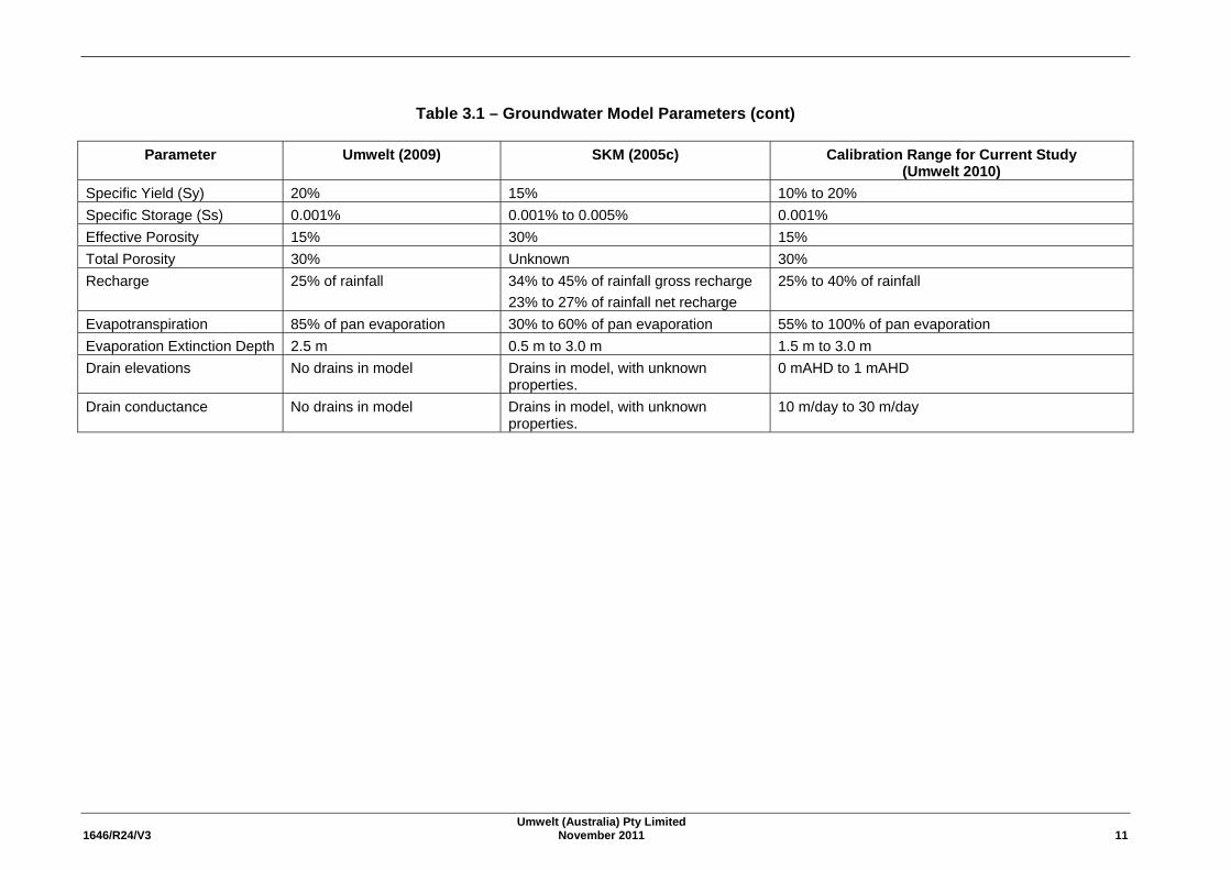
Parameter Umwelt (2009) SKM (2005c) Calibration Range for Current Study (Umwelt 2010)
Specific Yield (Sy) 20% 15% 10% to 20% Specific Storage (Ss) 0.001% 0.001% to 0.005% 0.001%
Effective Porosity 15% 30% 15% Total Porosity 30% Unknown 30% Recharge 25% of rainfall 34% to 45% of rainfall gross recharge
23% to 27% of rainfall net recharge 25% to 40% of rainfall
Evapotranspiration 85% of pan evaporation 30% to 60% of pan evaporation 55% to 100% of pan evaporation Evaporation Extinction Depth 2.5 m 0.5 m to 3.0 m 1.5 m to 3.0 m Drain elevations No drains in model Drains in model, with unknown
properties. 0 mAHD to 1 mAHD
Drain conductance No drains in model Drains in model, with unknown properties.
10 m/day to 30 m/day
Umwelt (Australia) Pty Limited 1646/R24/V3 November 2011 12
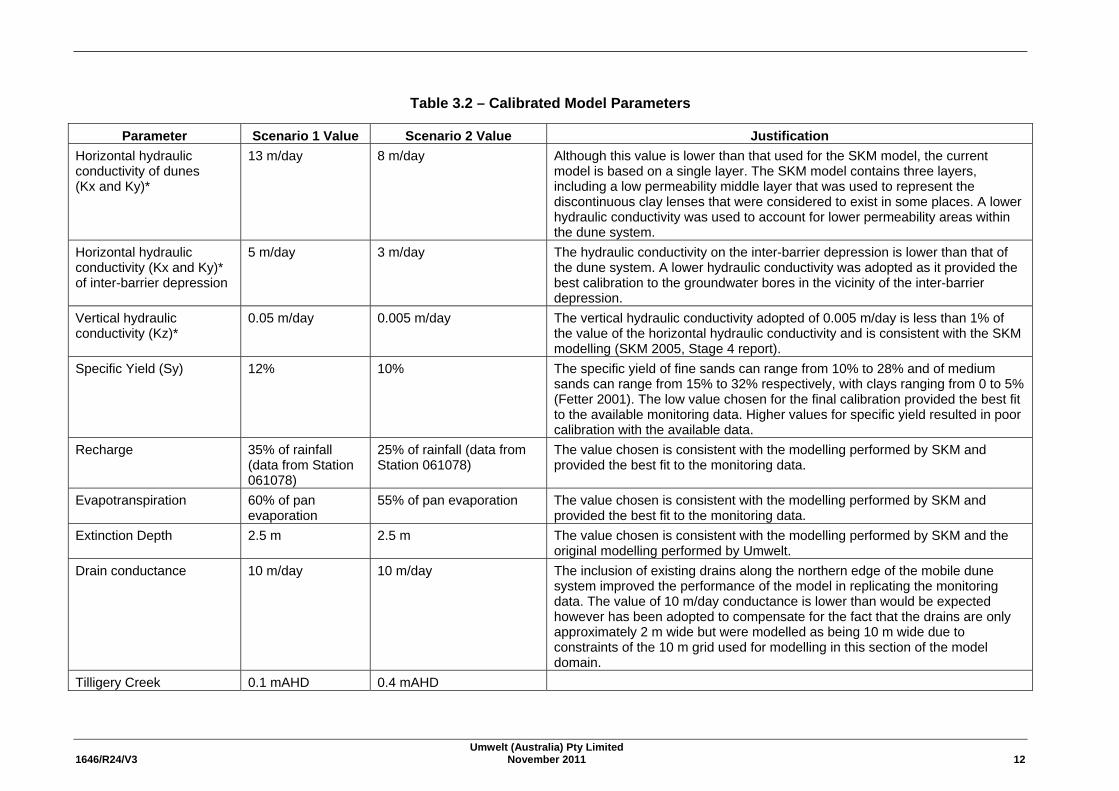
Table 3.2 – Calibrated Model Parameters
Parameter Scenario 1 Value Scenario 2 Value Justification Horizontal hydraulic conductivity of dunes (Kx and Ky)*
13 m/day 8 m/day Although this value is lower than that used for the SKM model, the current model is based on a single layer. The SKM model contains three layers, including a low permeability middle layer that was used to represent the discontinuous clay lenses that were considered to exist in some places. A lower hydraulic conductivity was used to account for lower permeability areas within the dune system.
Horizontal hydraulic conductivity (Kx and Ky)* of inter-barrier depression
5 m/day 3 m/day The hydraulic conductivity on the inter-barrier depression is lower than that of the dune system. A lower hydraulic conductivity was adopted as it provided the best calibration to the groundwater bores in the vicinity of the inter-barrier depression.
Vertical hydraulic conductivity (Kz)*
0.05 m/day 0.005 m/day The vertical hydraulic conductivity adopted of 0.005 m/day is less than 1% of the value of the horizontal hydraulic conductivity and is consistent with the SKM modelling (SKM 2005, Stage 4 report).
Specific Yield (Sy) 12% 10% The specific yield of fine sands can range from 10% to 28% and of medium sands can range from 15% to 32% respectively, with clays ranging from 0 to 5% (Fetter 2001). The low value chosen for the final calibration provided the best fit to the available monitoring data. Higher values for specific yield resulted in poor calibration with the available data.
Recharge 35% of rainfall (data from Station 061078)
25% of rainfall (data from Station 061078)
The value chosen is consistent with the modelling performed by SKM and provided the best fit to the monitoring data.
Evapotranspiration 60% of pan evaporation
55% of pan evaporation The value chosen is consistent with the modelling performed by SKM and provided the best fit to the monitoring data.
Extinction Depth 2.5 m 2.5 m The value chosen is consistent with the modelling performed by SKM and the original modelling performed by Umwelt.
Drain conductance 10 m/day 10 m/day The inclusion of existing drains along the northern edge of the mobile dune system improved the performance of the model in replicating the monitoring data. The value of 10 m/day conductance is lower than would be expected however has been adopted to compensate for the fact that the drains are only approximately 2 m wide but were modelled as being 10 m wide due to constraints of the 10 m grid used for modelling in this section of the model domain.
Tilligery Creek 0.1 mAHD 0.4 mAHD
Umwelt (Australia) Pty Limited 1646/R24/V3 November 2011 13
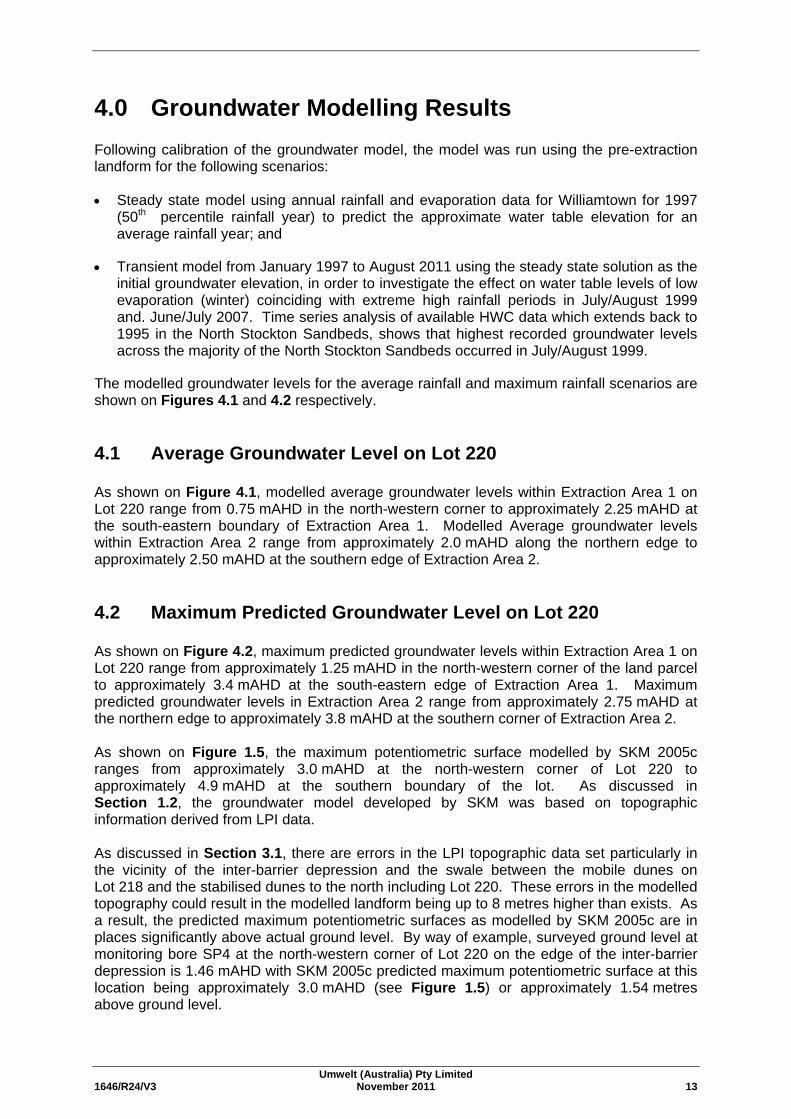
4.0 Groundwater Modelling Results Following calibration of the groundwater model, the model was run using the pre-extraction landform for the following scenarios: • Steady state model using annual rainfall and evaporation data for Williamtown for 1997
(50th percentile rainfall year) to predict the approximate water table elevation for an average rainfall year; and
• Transient model from January 1997 to August 2011 using the steady state solution as the initial groundwater elevation, in order to investigate the effect on water table levels of low evaporation (winter) coinciding with extreme high rainfall periods in July/August 1999 and. June/July 2007. Time series analysis of available HWC data which extends back to 1995 in the North Stockton Sandbeds, shows that highest recorded groundwater levels across the majority of the North Stockton Sandbeds occurred in July/August 1999.
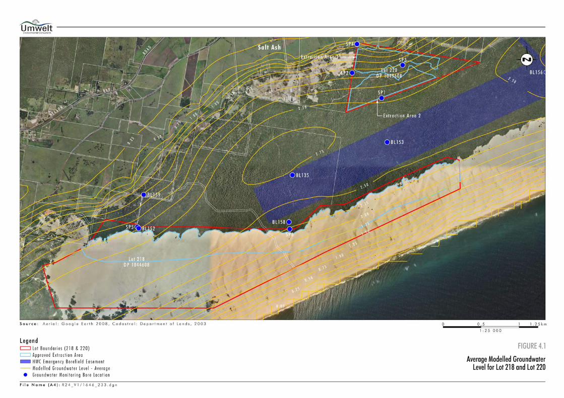
The modelled groundwater levels for the average rainfall and maximum rainfall scenarios are shown on Figures 4.1 and 4.2 respectively. 4.1 Average Groundwater Level on Lot 220
As shown on Figure 4.1, modelled average groundwater levels within Extraction Area 1 on Lot 220 range from 0.75 mAHD in the north-western corner to approximately 2.25 mAHD at the south-eastern boundary of Extraction Area 1. Modelled Average groundwater levels within Extraction Area 2 range from approximately 2.0 mAHD along the northern edge to approximately 2.50 mAHD at the southern edge of Extraction Area 2. 4.2 Maximum Predicted Groundwater Level on Lot 220
As shown on Figure 4.2, maximum predicted groundwater levels within Extraction Area 1 on Lot 220 range from approximately 1.25 mAHD in the north-western corner of the land parcel to approximately 3.4 mAHD at the south-eastern edge of Extraction Area 1. Maximum predicted groundwater levels in Extraction Area 2 range from approximately 2.75 mAHD at the northern edge to approximately 3.8 mAHD at the southern corner of Extraction Area 2. As shown on Figure 1.5, the maximum potentiometric surface modelled by SKM 2005c ranges from approximately 3.0 mAHD at the north-western corner of Lot 220 to approximately 4.9 mAHD at the southern boundary of the lot. As discussed in Section 1.2, the groundwater model developed by SKM was based on topographic information derived from LPI data. As discussed in Section 3.1, there are errors in the LPI topographic data set particularly in the vicinity of the inter-barrier depression and the swale between the mobile dunes on Lot 218 and the stabilised dunes to the north including Lot 220. These errors in the modelled topography could result in the modelled landform being up to 8 metres higher than exists. As a result, the predicted maximum potentiometric surfaces as modelled by SKM 2005c are in places significantly above actual ground level. By way of example, surveyed ground level at monitoring bore SP4 at the north-western corner of Lot 220 on the edge of the inter-barrier depression is 1.46 mAHD with SKM 2005c predicted maximum potentiometric surface at this location being approximately 3.0 mAHD (see Figure 1.5) or approximately 1.54 metres above ground level.
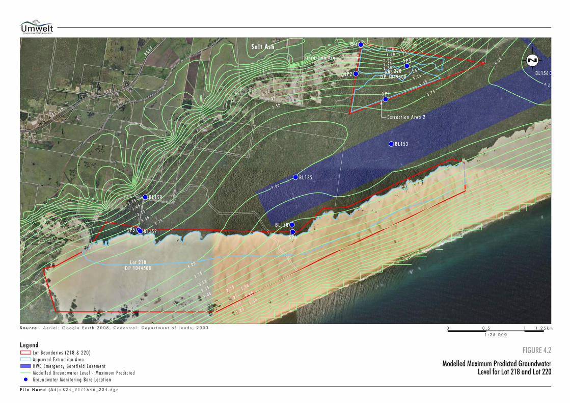
Umwelt (Australia) Pty Limited 1646/R24/V3 November 2011 14
Similarly as shown on Figure 1.5, SKM 2005c predicted maximum potentiometric surface adjacent to monitoring bore BL153 is approximately 5.0 mAHD which is approximately 2.15 metres above the ground level surveyed by Le Mottee surveyors of 2.85 mAHD. Taking these matters into account it is considered that the maximum predicted groundwater level in the vicinity of Lot 220 is 1 to 2.0 metres lower than the maximum potentiometric surface predicted for these locations by SKM 2005c. 4.3 Average Modelled Groundwater Level on Lot 218
As shown on Figure 4.1, modelled average groundwater levels within the approved extraction area on Lot 218 range from approximately 1.75 mAHD along the south-eastern edge of the extraction area to 2.50 mAHD in the south-western edge of the extraction area. 4.4 Maximum Predicted Groundwater Level on Lot 218
As shown on Figure 4.2, maximum predicted groundwater levels in the approved extraction area on Lot 218 range from approximately 2.75 mAHD along the south-eastern edge of the extraction area and 3.5 mAHD along the north-western edge of the extraction area to approximately 4.0 mAHD in the south-western edge of the extraction area. As shown on Figure 1.5, the maximum potentiometric surface modelled by SKM 2005c at the south-eastern boundary of Lot 218 is approximately 2 mAHD which is approximately 0.5 metres lower than the maximum predicted groundwater level of 2.5 mAHD shown on Figure 4.2. Maximum predicted potentiometric surface at monitoring bores SP5 and BL152 in the north-western corner of Lot 218 is approximately 3.6 mAHD (see Figure 1.5) which is consistent with the predicted maximum groundwater level at this location shown on Figure 4.2. Surveyed ground level at monitoring bore SP5 is 3.8 mAHD and at BL152 is 3.6 mAHD indicating the maximum predicted groundwater level at this location is approximately at ground level.
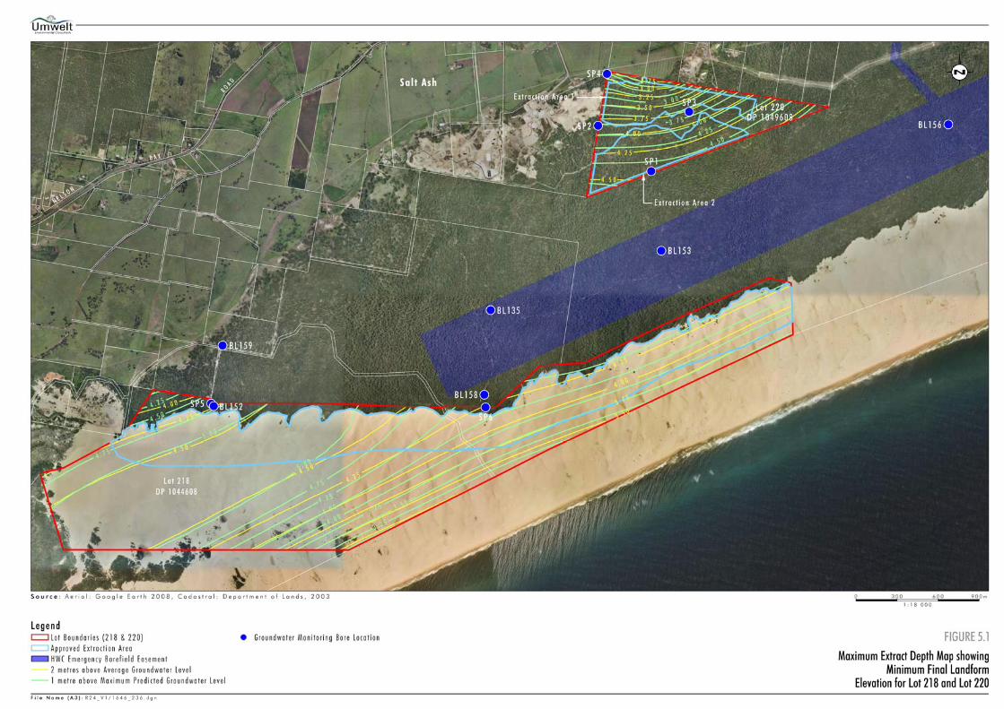
5.0 Maximum Extraction Depth The model results shown on Figures 4.1 to 4.2 were used to determine the maximum depth of sand extraction taking into consideration the requirements of Conditions 7a and 7b of Major Project Approval 08_0142 which specifies that the maximum depth of extraction is to a level 2 metres above the average groundwater level and 1 metre above the maximum predicted groundwater level. 5.1 Maximum Depth for Extraction – Lot 220
Figure 5.1 shows contours of the maximum depth to which extraction can take place on Lot 220 in accordance with the requirements of Conditions 7a and 7b of Major Project Approval 08_0142. The contours are based on: • average the groundwater level shown on Figure 4.1 plus 2 metres; and
• maximum predicted groundwater level shown on Figure 4.2 plus 1 metre.
Umwelt (Australia) Pty Limited 1646/R24/V3 November 2011 15
As can be seen from Figure 5.1, the maximum depth to which extraction can occur on Lot 220 varies from approximately 2.75 mAHD at the north-western edge of Extraction Area 1 to approximately 3.75 mAHD at the south-eastern boundary of Extraction Area 1. The maximum depth to which extraction can take place in Extraction Area 2 on Lot 220 ranges from approximately 4.0 mAHD along the northern boundary of the area to approximately 5.0 mAHD along the southern boundary and is reasonably consistent for both the 2 metres above average groundwater level and 1 metre above maximum predicted criteria set out in Conditions 7a and 7b of Major Project Approval 08_142. 5.2 Maximum Depth for Extraction – Lot 218
Figure 5.1 shows contours of the maximum depth to which extraction can take place on Lot 218 in accordance with the requirements of Conditions 7a and 7b of Major Project Approval 08_0142. The contours are based on: • average the groundwater level shown on Figure 4.1 plus 2 metres; and
• maximum predicted groundwater level shown on Figure 4.2 plus 1 metre.
As can be seen from Figure 5.1, the maximum depth to which extraction can occur on Lot 218 varies from approximately 3.75 mAHD along the south-eastern boundary of approved extraction area to approximately 5.0 mAHD approximately 1 kilometre east of the south-western end of the approved Lot 218 extraction area.
6.0 Conclusion Revisions to the groundwater model developed for the Mackas Sand project (Umwelt 2009) and further calibration using HWC groundwater monitoring data from 1997 to 2011 along with extension of the model boundaries, inclusion of drainage along the northern boundary of Lot 220, revision to the Tilligerry Creek boundary condition and refinement of the landform has improved the accuracy of the model and increased the level of confidence that can be placed in the model results. The revised model has been calibrated against 11 monitoring bores compared to six previously and approximately 15 months of groundwater level observations from within the project area and approximately fifteen years of monthly data for the surrounding area. The calibration achieved represents the best achieved fit of the model established to the monitoring data available. The integrity of the elevation information used away from monitoring bores, particularly in the vicinity of the swale between the stabilised dunes on Lot 220 and the mobile dunes on Lot 218 and the inter-barrier depression between Lot 220 and Tilligerry Creek has been improved as best is possible with available topographic information. The modelling results demonstrate a very good fit to HWC and a good fit to Mackas Sand groundwater level information particularly during wet periods that have been used to determine the maximum predicted groundwater levels. Predicted average and maximum groundwater levels shown on Figure 4.1 and 4.2 respectively have been used to establish the maximum depth to which extraction can occur and the level of the final landform on Lots 218 and 220 as shown on Figure 5.1.
Umwelt (Australia) Pty Limited 1646/R24/V3 November 2011 16
To provide for ongoing review of the groundwater model, monthly groundwater monitoring information from the Mackas Sand monitoring bores (SP1 to SP5) and HWC monitoring bores (BL135, BL152, BL153, BL156, BL158 and BL 159) will continue to be reviewed as part of groundwater monitoring reporting. In addition it is proposed to establish additional groundwater bores within each of the approved Lot 218 and Lot 220 extraction areas to enable groundwater levels relative to the extraction floor to be monitored. If groundwater levels at these bores come within 1 metre of the approved maximum extraction depth, the groundwater model will be recalibrated and the maximum extraction depth reassessed in consultation with DP&I, NOW and HWC.
7.0 References HWC Groundwater Database. Sinclair Knight Merz, 2004. North Stockton Sandbeds Groundwater Investigations: Stage 1
Report – Preliminary Data Analysis and Bore Siting. Report prepared for Hunter Water Corporation.
Sinclair Knight Merz, 2005a. Preparation of Numerical Groundwater Model and Estimation of
Safe Extractive Yield for the North Stockton Sandbeds: Stage 2 Report – Field Work. Report prepared for Hunter Water Corporation.
Sinclair Knight Merz, 2005b. Preparation of Numerical Groundwater Model and Estimation of
Safe Extractive Yield for the North Stockton Sandbeds: Stage 3 Report – Hydrogeological Conceptualisation. Report prepared for Hunter Water Corporation.
Sinclair Knight Merz, 2005c. Preparation of Numerical Groundwater Model and Estimation of
Safe Extractive Yield for the North Stockton Sandbeds: Stage 4 Report – Development of Numerical Models. Report prepared for Hunter Water Corporation.
Sinclair Knight Merz, 2005d. Preparation of Numerical Groundwater Model and Estimation of
Safe Extractive Yield for the North Stockton Sandbeds: Stage 5 Report – Long Term Sustainable Yield. Report prepared for Hunter Water Corporation.
Umwelt (Australia) Pty Limited, 2009. Environmental Assessment of Sand Extraction
Operations from Lot 218 DP 1044608 and Lot 220 DP 1049608, Salt Ash. Report prepared for Mackas Sand.
APPENDIX 1
HWC Groundwater Monitoring Bore Data
1646/R24/A1 1
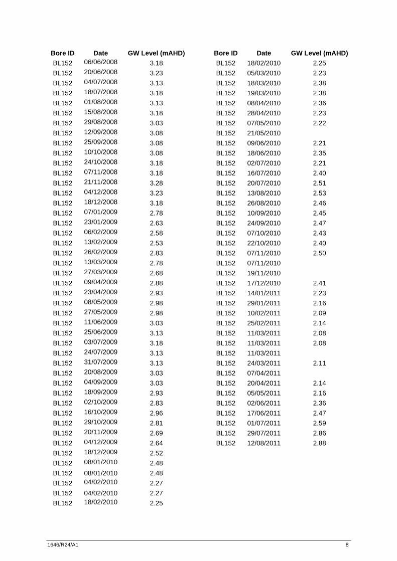
Bore ID Date GW Level (mAHD) BL135 07/01/2000 3.36 BL135 14/01/2000 3.31 BL135 21/01/2000 3.28 BL135 28/01/2000 3.21 BL135 04/02/2000 3.16 BL135 11/02/2000 3.12 BL135 18/02/2000 3.08 BL135 25/02/2000 3.03 BL135 03/03/2000 2.98 BL135 10/03/2000 3.25 BL135 17/03/2000 3.21 BL135 24/03/2000 3.52 BL135 31/03/2000 3.51 BL135 07/04/2000 3.57 BL135 14/04/2000 3.55 BL135 20/04/2000 3.54 BL135 12/05/2000 3.47 BL135 19/05/2000 3.44 BL135 26/05/2000 3.41 BL135 02/06/2000 3.38 BL135 09/06/2000 3.34 BL135 16/06/2000 3.41 BL135 23/06/2000 3.36 BL135 30/06/2000 3.32 BL135 07/07/2000 3.30 BL135 14/07/2000 3.27 BL135 21/07/2000 3.25 BL135 28/07/2000 3.21 BL135 04/08/2000 3.18 BL135 18/08/2000 3.12 BL135 25/08/2000 3.10 BL135 01/09/2000 3.06 BL135 08/09/2000 3.03 BL135 15/09/2000 2.98 BL135 22/09/2000 2.95 BL135 29/09/2000 2.92 BL135 06/10/2000 2.89 BL135 13/10/2000 2.85 BL135 20/10/2000 2.81 BL135 27/10/2000 2.78 BL135 03/11/2000 2.75 BL135 10/11/2000 2.71 BL135 20/11/2000 2.68 BL135 24/11/2000 2.65 BL135 01/12/2000 2.62
Bore ID Date GW Level (mAHD)
BL135 08/12/2000 2.59 BL135 15/12/2000 2.55 BL135 21/12/2000 2.52 BL135 29/12/2000 2.47 BL135 05/01/2001 2.43 BL135 12/01/2001 2.39 BL135 19/01/2001 2.35 BL135 25/01/2001 2.28 BL135 02/02/2001 2.26 BL135 09/02/2001 2.23 BL135 16/02/2001 2.19 BL135 23/02/2001 2.19 BL135 01/03/2001 2.16 BL135 09/03/2001 2.14 BL135 16/03/2001 2.15 BL135 23/03/2001 2.13 BL135 30/03/2001 2.11 BL135 06/04/2001 2.10 BL135 12/04/2001 2.07 BL135 20/04/2001 2.06 BL135 27/04/2001 2.16 BL135 04/05/2001 2.34 BL135 11/05/2001 3.40 BL135 17/05/2001 3.39 BL135 25/05/2001 3.61 BL135 01/06/2001 3.63 BL135 08/06/2001 3.63 BL135 15/06/2001 3.57 BL135 22/06/2001 3.54 BL135 25/06/2001 3.54 BL135 29/06/2001 3.51 BL135 05/07/2001 3.50 BL135 13/07/2001 3.45 BL135 20/07/2001 3.42 BL135 27/07/2001 3.41 BL135 03/08/2001 3.53 BL135 10/08/2001 3.46 BL135 17/08/2001 3.42 BL135 24/08/2001 3.37 BL135 31/08/2001 3.34 BL135 07/09/2001 3.31 BL135 14/09/2001 3.28 BL135 21/09/2001 3.25 BL135 28/09/2001 3.22 BL135 05/10/2001 3.15
1646/R24/A1 2
Bore ID Date GW Level (mAHD) BL135 12/10/2001 3.11 BL135 19/10/2001 3.10 BL135 26/10/2001 3.05 BL135 02/11/2001 3.00 BL135 09/11/2001 2.95 BL135 16/11/2001 2.90 BL135 23/11/2001 3.04 BL135 30/11/2001 3.00 BL135 07/12/2001 2.95 BL135 14/12/2001 3.90 BL135 21/12/2001 2.80 BL135 03/01/2002 2.77 BL135 11/01/2002 2.67 BL135 18/01/2002 2.66 BL135 25/01/2002 2.65 BL135 01/02/2002 2.65 BL135 08/02/2002 2.75 BL135 15/02/2002 2.67 BL135 22/02/2002 2.62 BL135 01/03/2002 2.70 BL135 08/03/2002 2.65 BL135 15/03/2002 2.65 BL135 22/03/2002 2.55 BL135 28/03/2002 2.85 BL135 08/04/2002 2.60 BL135 12/04/2002 2.55 BL135 19/04/2002 2.55 BL135 03/05/2002 2.55 BL135 10/05/2002 2.55 BL135 17/05/2002 2.50 BL135 24/05/2002 2.45 BL135 31/05/2002 2.60 BL135 14/06/2002 2.75 BL135 21/06/2002 2.80 BL135 28/06/2002 2.75 BL135 05/07/2002 2.75 BL135 19/07/2002 2.60 BL135 02/08/2002 2.60 BL135 16/08/2002 2.55 BL135 30/08/2002 2.50 BL135 16/09/2002 2.45 BL135 27/09/2002 2.40 BL135 11/10/2002 2.35 BL135 25/10/2002 2.30 BL135 08/11/2002 2.30
Bore ID Date GW Level (mAHD) BL135 22/11/2002 2.25 BL135 06/12/2002 2.20 BL135 20/12/2002 2.25 BL135 03/01/2003 2.10 BL135 17/01/2003 2.05 BL135 31/01/2003 2.05 BL135 14/02/2003 1.95 BL135 28/02/2003 2.00 BL135 14/03/2003 1.95 BL135 28/03/2003 1.90 BL135 10/04/2003 2.10 BL135 24/04/2003 2.05 BL135 09/05/2003 2.10 BL135 23/05/2003 2.30 BL135 06/06/2003 2.60 BL135 18/07/2003 2.85 BL135 15/08/2003 2.70 BL135 29/08/2003 2.75 BL135 12/09/2003 2.70 BL135 26/09/2003 2.45 BL135 10/10/2003 2.55 BL135 24/10/2003 2.30 BL135 07/11/2003 2.20 BL135 21/11/2003 2.35 BL135 05/12/2003 2.35 BL135 19/12/2003 2.30 BL135 02/01/2004 2.20 BL135 16/01/2004 2.15 BL135 30/01/2004 2.10 BL135 13/02/2004 2.05 BL135 27/02/2004 2.15 BL135 09/03/2004 2.12 BL135 12/03/2004 2.10 BL135 26/03/2004 2.05 BL135 08/04/2004 2.05 BL135 23/04/2004 2.05 BL135 07/05/2004 2.00 BL135 21/05/2004 1.95 BL135 04/06/2004 1.90 BL135 18/06/2004 1.85 BL135 02/07/2004 1.85 BL135 16/07/2004 1.80 BL135 30/07/2004 1.80 BL135 13/08/2004 1.80 BL135 27/08/2004 1.90
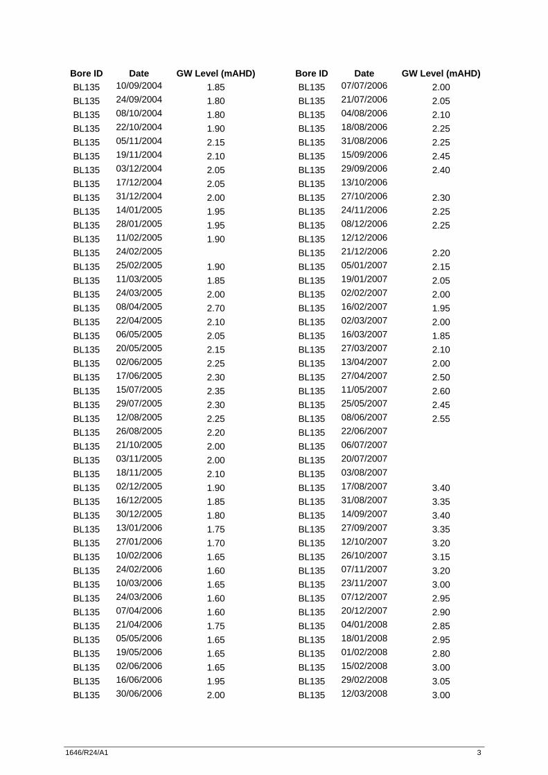
1646/R24/A1 3
Bore ID Date GW Level (mAHD) BL135 10/09/2004 1.85 BL135 24/09/2004 1.80 BL135 08/10/2004 1.80 BL135 22/10/2004 1.90 BL135 05/11/2004 2.15 BL135 19/11/2004 2.10 BL135 03/12/2004 2.05 BL135 17/12/2004 2.05 BL135 31/12/2004 2.00 BL135 14/01/2005 1.95 BL135 28/01/2005 1.95 BL135 11/02/2005 1.90 BL135 24/02/2005
BL135 25/02/2005 1.90 BL135 11/03/2005 1.85 BL135 24/03/2005 2.00 BL135 08/04/2005 2.70 BL135 22/04/2005 2.10 BL135 06/05/2005 2.05 BL135 20/05/2005 2.15 BL135 02/06/2005 2.25 BL135 17/06/2005 2.30 BL135 15/07/2005 2.35 BL135 29/07/2005 2.30 BL135 12/08/2005 2.25 BL135 26/08/2005 2.20 BL135 21/10/2005 2.00 BL135 03/11/2005 2.00 BL135 18/11/2005 2.10 BL135 02/12/2005 1.90 BL135 16/12/2005 1.85 BL135 30/12/2005 1.80 BL135 13/01/2006 1.75 BL135 27/01/2006 1.70 BL135 10/02/2006 1.65 BL135 24/02/2006 1.60 BL135 10/03/2006 1.65 BL135 24/03/2006 1.60 BL135 07/04/2006 1.60 BL135 21/04/2006 1.75 BL135 05/05/2006 1.65 BL135 19/05/2006 1.65 BL135 02/06/2006 1.65 BL135 16/06/2006 1.95 BL135 30/06/2006 2.00
Bore ID Date GW Level (mAHD) BL135 07/07/2006 2.00 BL135 21/07/2006 2.05 BL135 04/08/2006 2.10 BL135 18/08/2006 2.25 BL135 31/08/2006 2.25 BL135 15/09/2006 2.45 BL135 29/09/2006 2.40 BL135 13/10/2006
BL135 27/10/2006 2.30 BL135 24/11/2006 2.25 BL135 08/12/2006 2.25 BL135 12/12/2006
BL135 21/12/2006 2.20 BL135 05/01/2007 2.15 BL135 19/01/2007 2.05 BL135 02/02/2007 2.00 BL135 16/02/2007 1.95 BL135 02/03/2007 2.00 BL135 16/03/2007 1.85 BL135 27/03/2007 2.10 BL135 13/04/2007 2.00 BL135 27/04/2007 2.50 BL135 11/05/2007 2.60 BL135 25/05/2007 2.45 BL135 08/06/2007 2.55 BL135 22/06/2007
BL135 06/07/2007
BL135 20/07/2007
BL135 03/08/2007
BL135 17/08/2007 3.40 BL135 31/08/2007 3.35 BL135 14/09/2007 3.40 BL135 27/09/2007 3.35 BL135 12/10/2007 3.20 BL135 26/10/2007 3.15 BL135 07/11/2007 3.20 BL135 23/11/2007 3.00 BL135 07/12/2007 2.95 BL135 20/12/2007 2.90 BL135 04/01/2008 2.85 BL135 18/01/2008 2.95 BL135 01/02/2008 2.80 BL135 15/02/2008 3.00 BL135 29/02/2008 3.05 BL135 12/03/2008 3.00
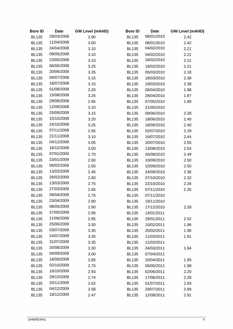
1646/R24/A1 4
Bore ID Date GW Level (mAHD) BL135 28/03/2008 2.90 BL135 11/04/2008 3.00 BL135 24/04/2008 3.10 BL135 09/05/2008 3.10 BL135 23/05/2008 3.10 BL135 06/06/2008 3.25 BL135 20/06/2008 3.35 BL135 04/07/2008 3.15 BL135 18/07/2008 3.15 BL135 01/08/2008 3.20 BL135 15/08/2008 3.25 BL135 29/08/2008 2.95 BL135 12/09/2008 3.10 BL135 25/09/2008 3.15 BL135 10/10/2008 3.20 BL135 24/10/2008 3.25 BL135 07/11/2008 2.95 BL135 21/11/2008 3.10 BL135 04/12/2008 3.05 BL135 18/12/2008 3.00 BL135 07/01/2009 2.70 BL135 23/01/2009 2.60 BL135 06/02/2009 2.50 BL135 13/02/2009 2.45 BL135 26/02/2009 2.80 BL135 13/03/2009 2.75 BL135 27/03/2009 2.65 BL135 09/04/2009 2.75 BL135 23/04/2009 2.80 BL135 08/05/2009 2.90 BL135 27/05/2009 2.95 BL135 11/06/2009 2.95 BL135 25/06/2009 3.30 BL135 03/07/2009 3.35 BL135 24/07/2009 3.35 BL135 31/07/2009 3.35 BL135 20/08/2009 3.30 BL135 04/09/2009 3.00 BL135 18/09/2009 2.85 BL135 02/10/2009 2.75 BL135 16/10/2009 2.93 BL135 29/10/2009 2.74 BL135 20/11/2009 2.62 BL135 04/12/2009 2.58 BL135 18/12/2009 2.47
Bore ID Date GW Level (mAHD) BL135 08/01/2010 2.42 BL135 08/01/2010 2.42 BL135 04/02/2010 2.21 BL135 04/02/2010 2.21 BL135 18/02/2010 2.21 BL135 18/02/2010 2.21 BL135 05/03/2010 2.18 BL135 18/03/2010 2.38 BL135 19/03/2010 2.38 BL135 08/04/2010 1.98 BL135 28/04/2010 1.87 BL135 07/05/2010 1.89 BL135 21/05/2010 BL135 09/06/2010 2.28 BL135 18/06/2010 2.40 BL135 18/06/2010 2.40 BL135 02/07/2010 2.29 BL135 16/07/2010 2.44 BL135 20/07/2010 2.55 BL135 13/08/2010 2.54 BL135 26/08/2010 2.49 BL135 10/09/2010 2.50 BL135 10/09/2010 2.50 BL135 24/09/2010 2.36 BL135 07/10/2010 2.32 BL135 22/10/2010 2.26 BL135 07/11/2010 2.35 BL135 07/11/2010 BL135 19/11/2010 BL135 17/12/2010 2.28 BL135 14/01/2011 BL135 29/01/2011 2.02 BL135 10/02/2011 1.96 BL135 25/02/2011 1.96 BL135 11/03/2011 1.91 BL135 11/03/2011 BL135 24/03/2011 1.94 BL135 07/04/2011 BL135 20/04/2011 1.95 BL135 05/05/2011 1.98 BL135 02/06/2011 2.20 BL135 17/06/2011 2.28 BL135 01/07/2011 2.93 BL135 29/07/2011 2.89 BL135 12/08/2011 2.91
1646/R24/A1 5
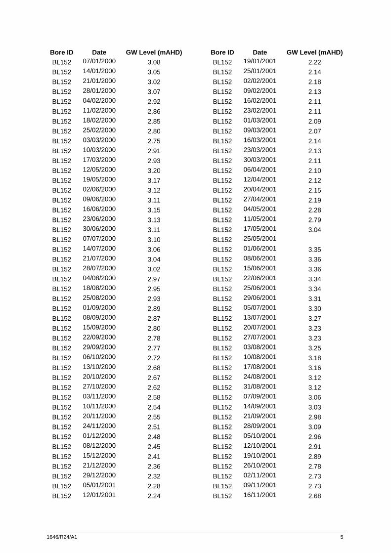
Bore ID Date GW Level (mAHD) BL152 07/01/2000 3.08 BL152 14/01/2000 3.05 BL152 21/01/2000 3.02 BL152 28/01/2000 3.07 BL152 04/02/2000 2.92 BL152 11/02/2000 2.86 BL152 18/02/2000 2.85 BL152 25/02/2000 2.80 BL152 03/03/2000 2.75 BL152 10/03/2000 2.91 BL152 17/03/2000 2.93 BL152 12/05/2000 3.20 BL152 19/05/2000 3.17 BL152 02/06/2000 3.12 BL152 09/06/2000 3.11 BL152 16/06/2000 3.15 BL152 23/06/2000 3.13 BL152 30/06/2000 3.11 BL152 07/07/2000 3.10 BL152 14/07/2000 3.06 BL152 21/07/2000 3.04 BL152 28/07/2000 3.02 BL152 04/08/2000 2.97 BL152 18/08/2000 2.95 BL152 25/08/2000 2.93 BL152 01/09/2000 2.89 BL152 08/09/2000 2.87 BL152 15/09/2000 2.80 BL152 22/09/2000 2.78 BL152 29/09/2000 2.77 BL152 06/10/2000 2.72 BL152 13/10/2000 2.68 BL152 20/10/2000 2.67 BL152 27/10/2000 2.62 BL152 03/11/2000 2.58 BL152 10/11/2000 2.54 BL152 20/11/2000 2.55 BL152 24/11/2000 2.51 BL152 01/12/2000 2.48 BL152 08/12/2000 2.45 BL152 15/12/2000 2.41 BL152 21/12/2000 2.36 BL152 29/12/2000 2.32 BL152 05/01/2001 2.28 BL152 12/01/2001 2.24
Bore ID Date GW Level (mAHD) BL152 19/01/2001 2.22 BL152 25/01/2001 2.14 BL152 02/02/2001 2.18 BL152 09/02/2001 2.13 BL152 16/02/2001 2.11 BL152 23/02/2001 2.11 BL152 01/03/2001 2.09 BL152 09/03/2001 2.07 BL152 16/03/2001 2.14 BL152 23/03/2001 2.13 BL152 30/03/2001 2.11 BL152 06/04/2001 2.10 BL152 12/04/2001 2.12 BL152 20/04/2001 2.15 BL152 27/04/2001 2.19 BL152 04/05/2001 2.28 BL152 11/05/2001 2.79 BL152 17/05/2001 3.04 BL152 25/05/2001
BL152 01/06/2001 3.35 BL152 08/06/2001 3.36 BL152 15/06/2001 3.36 BL152 22/06/2001 3.34 BL152 25/06/2001 3.34 BL152 29/06/2001 3.31 BL152 05/07/2001 3.30 BL152 13/07/2001 3.27 BL152 20/07/2001 3.23 BL152 27/07/2001 3.23 BL152 03/08/2001 3.25 BL152 10/08/2001 3.18 BL152 17/08/2001 3.16 BL152 24/08/2001 3.12 BL152 31/08/2001 3.12 BL152 07/09/2001 3.06 BL152 14/09/2001 3.03 BL152 21/09/2001 2.98 BL152 28/09/2001 3.09 BL152 05/10/2001 2.96 BL152 12/10/2001 2.91 BL152 19/10/2001 2.89 BL152 26/10/2001 2.78 BL152 02/11/2001 2.73 BL152 09/11/2001 2.73 BL152 16/11/2001 2.68
1646/R24/A1 6
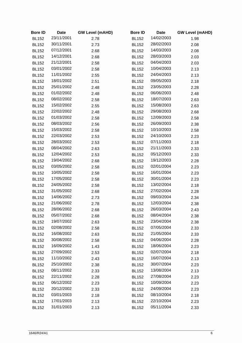
Bore ID Date GW Level (mAHD) BL152 23/11/2001 2.78 BL152 30/11/2001 2.73 BL152 07/12/2001 2.68 BL152 14/12/2001 2.68 BL152 21/12/2001 2.58 BL152 03/01/2002 2.58 BL152 11/01/2002 2.55 BL152 18/01/2002 2.51 BL152 25/01/2002 2.48 BL152 01/02/2002 2.48 BL152 08/02/2002 2.58 BL152 15/02/2002 2.55 BL152 22/02/2002 2.48 BL152 01/03/2002 2.58 BL152 08/03/2002 2.56 BL152 15/03/2002 2.58 BL152 22/03/2002 2.53 BL152 28/03/2002 2.53 BL152 08/04/2002 2.63 BL152 12/04/2002 2.53 BL152 19/04/2002 2.68 BL152 03/05/2002 2.58 BL152 10/05/2002 2.58 BL152 17/05/2002 2.58 BL152 24/05/2002 2.58 BL152 31/05/2002 2.68 BL152 14/06/2002 2.73 BL152 21/06/2002 2.78 BL152 28/06/2002 2.68 BL152 05/07/2002 2.68 BL152 19/07/2002 2.63 BL152 02/08/2002 2.58 BL152 16/08/2002 2.63 BL152 30/08/2002 2.58 BL152 16/09/2002 1.43 BL152 27/09/2002 2.53 BL152 11/10/2002 2.43 BL152 25/10/2002 2.38 BL152 08/11/2002 2.33 BL152 22/11/2002 2.28 BL152 06/12/2002 2.23 BL152 20/12/2002 2.33 BL152 03/01/2003 2.18 BL152 17/01/2003 2.13 BL152 31/01/2003 2.13
Bore ID Date GW Level (mAHD) BL152 14/02/2003 1.98 BL152 28/02/2003 2.08 BL152 14/03/2003 2.08 BL152 28/03/2003 2.03 BL152 04/04/2003 2.03 BL152 10/04/2003 2.13 BL152 24/04/2003 2.13 BL152 09/05/2003 2.18 BL152 23/05/2003 2.28 BL152 06/06/2003 2.48 BL152 18/07/2003 2.63 BL152 15/08/2003 2.63 BL152 29/08/2003 2.68 BL152 12/09/2003 2.58 BL152 26/09/2003 2.38 BL152 10/10/2003 2.58 BL152 24/10/2003 2.23 BL152 07/11/2003 2.18 BL152 21/11/2003 2.33 BL152 05/12/2003 2.33 BL152 19/12/2003 2.28 BL152 02/01/2004 2.23 BL152 16/01/2004 2.23 BL152 30/01/2004 2.23 BL152 13/02/2004 2.18 BL152 27/02/2004 2.28 BL152 09/03/2004 2.34 BL152 12/03/2004 2.38 BL152 26/03/2004 2.43 BL152 08/04/2004 2.38 BL152 23/04/2004 2.38 BL152 07/05/2004 2.33 BL152 21/05/2004 2.33 BL152 04/06/2004 2.28 BL152 18/06/2004 2.23 BL152 02/07/2004 2.18 BL152 16/07/2004 2.13 BL152 30/07/2004 2.23 BL152 13/08/2004 2.13 BL152 27/08/2004 2.23 BL152 10/09/2004 2.23 BL152 24/09/2004 2.23 BL152 08/10/2004 2.18 BL152 22/10/2004 2.23 BL152 05/11/2004 2.33
1646/R24/A1 7
Bore ID Date GW Level (mAHD) BL152 19/11/2004 2.38 BL152 03/12/2004 2.38 BL152 17/12/2004 2.43 BL152 31/12/2004 2.33 BL152 14/01/2005 2.28 BL152 28/01/2005 2.28 BL152 11/02/2005 2.28 BL152 24/02/2005
BL152 25/02/2005 2.33 BL152 11/03/2005 2.33 BL152 24/03/2005 2.43 BL152 08/04/2005 1.03 BL152 22/04/2005 2.48 BL152 06/05/2005 2.53 BL152 20/05/2005 2.63 BL152 02/06/2005 2.68 BL152 17/06/2005 2.63 BL152 15/07/2005 2.73 BL152 29/07/2005 2.68 BL152 12/08/2005 2.59 BL152 26/08/2005 2.58 BL152 21/10/2005 2.38 BL152 03/11/2005 2.33 BL152 18/11/2005 2.28 BL152 02/12/2005 2.28 BL152 16/12/2005 2.18 BL152 30/12/2005 2.08 BL152 13/01/2006 2.03 BL152 27/01/2006 1.98 BL152 10/02/2006 1.93 BL152 24/02/2006 1.88 BL152 10/03/2006 1.98 BL152 24/03/2006 1.93 BL152 07/04/2006 1.88 BL152 21/04/2006 1.83 BL152 05/05/2006 1.88 BL152 19/05/2006 1.83 BL152 02/06/2006 1.98 BL152 16/06/2006 2.48 BL152 30/06/2006 2.18 BL152 07/07/2006 2.23 BL152 21/07/2006 2.23 BL152 04/08/2006 2.33 BL152 18/08/2006 2.38 BL152 31/08/2006 2.38
Bore ID Date GW Level (mAHD) BL152 15/09/2006 2.58 BL152 29/09/2006 2.48 BL152 13/10/2006
BL152 27/10/2006 2.58 BL152 24/11/2006 2.58 BL152 08/12/2006 2.53 BL152 12/12/2006
BL152 21/12/2006 2.53 BL152 05/01/2007 2.38 BL152 19/01/2007 2.23 BL152 02/02/2007 2.18 BL152 16/02/2007 2.23 BL152 02/03/2007 2.18 BL152 16/03/2007 2.18 BL152 27/03/2007 2.13 BL152 13/04/2007 2.33 BL152 27/04/2007 2.53 BL152 11/05/2007 2.58 BL152 25/05/2007 2.78 BL152 08/06/2007 2.93 BL152 22/06/2007 3.73 BL152 06/07/2007
BL152 20/07/2007
BL152 03/08/2007
BL152 17/08/2007 3.38 BL152 31/08/2007 3.38 BL152 14/09/2007 3.43 BL152 27/09/2007 3.38 BL152 12/10/2007 3.13 BL152 26/10/2007 3.08 BL152 07/11/2007 3.08 BL152 23/11/2007 2.98 BL152 07/12/2007 2.98 BL152 20/12/2007 2.93 BL152 04/01/2008 2.88 BL152 18/01/2008 3.08 BL152 01/02/2008 2.78 BL152 15/02/2008 2.88 BL152 29/02/2008 2.98 BL152 12/03/2008 2.93 BL152 28/03/2008 2.83 BL152 11/04/2008 2.93 BL152 24/04/2008 3.08 BL152 09/05/2008 3.03 BL152 23/05/2008 2.98
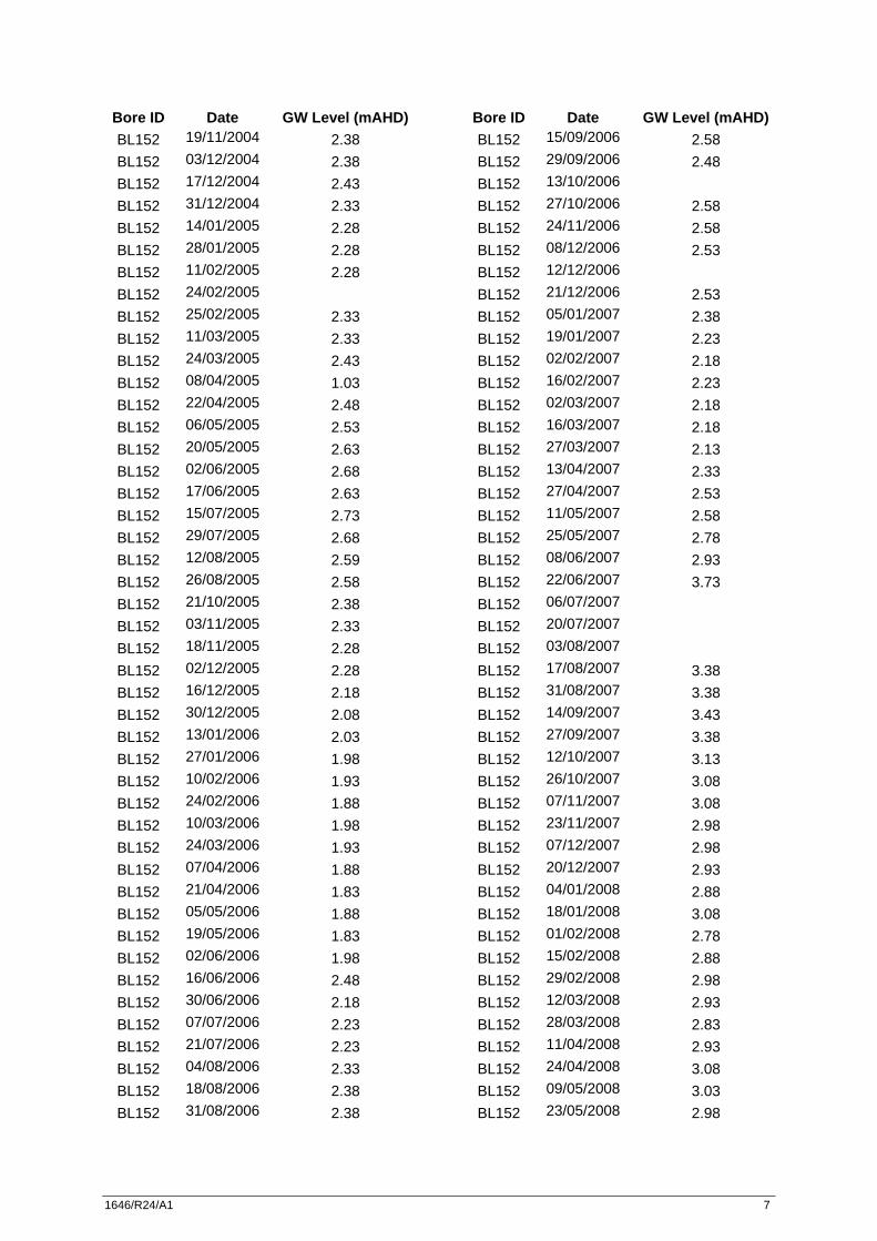
1646/R24/A1 8
Bore ID Date GW Level (mAHD) BL152 06/06/2008 3.18 BL152 20/06/2008 3.23 BL152 04/07/2008 3.13 BL152 18/07/2008 3.18 BL152 01/08/2008 3.13 BL152 15/08/2008 3.18 BL152 29/08/2008 3.03 BL152 12/09/2008 3.08 BL152 25/09/2008 3.08 BL152 10/10/2008 3.08 BL152 24/10/2008 3.18 BL152 07/11/2008 3.18 BL152 21/11/2008 3.28 BL152 04/12/2008 3.23 BL152 18/12/2008 3.18 BL152 07/01/2009 2.78 BL152 23/01/2009 2.63 BL152 06/02/2009 2.58 BL152 13/02/2009 2.53 BL152 26/02/2009 2.83 BL152 13/03/2009 2.78 BL152 27/03/2009 2.68 BL152 09/04/2009 2.88 BL152 23/04/2009 2.93 BL152 08/05/2009 2.98 BL152 27/05/2009 2.98 BL152 11/06/2009 3.03 BL152 25/06/2009 3.13 BL152 03/07/2009 3.18 BL152 24/07/2009 3.13 BL152 31/07/2009 3.13 BL152 20/08/2009 3.03 BL152 04/09/2009 3.03 BL152 18/09/2009 2.93 BL152 02/10/2009 2.83 BL152 16/10/2009 2.96 BL152 29/10/2009 2.81 BL152 20/11/2009 2.69 BL152 04/12/2009 2.64 BL152 18/12/2009 2.52 BL152 08/01/2010 2.48 BL152 08/01/2010 2.48 BL152 04/02/2010 2.27 BL152 04/02/2010 2.27 BL152 18/02/2010 2.25
Bore ID Date GW Level (mAHD) BL152 18/02/2010 2.25 BL152 05/03/2010 2.23 BL152 18/03/2010 2.38 BL152 19/03/2010 2.38 BL152 08/04/2010 2.36 BL152 28/04/2010 2.23 BL152 07/05/2010 2.22 BL152 21/05/2010 BL152 09/06/2010 2.21 BL152 18/06/2010 2.35 BL152 02/07/2010 2.21 BL152 16/07/2010 2.40 BL152 20/07/2010 2.51 BL152 13/08/2010 2.53 BL152 26/08/2010 2.46 BL152 10/09/2010 2.45 BL152 24/09/2010 2.47 BL152 07/10/2010 2.43 BL152 22/10/2010 2.40 BL152 07/11/2010 2.50 BL152 07/11/2010 BL152 19/11/2010 BL152 17/12/2010 2.41 BL152 14/01/2011 2.23 BL152 29/01/2011 2.16 BL152 10/02/2011 2.09 BL152 25/02/2011 2.14 BL152 11/03/2011 2.08 BL152 11/03/2011 2.08 BL152 11/03/2011 BL152 24/03/2011 2.11 BL152 07/04/2011 BL152 20/04/2011 2.14 BL152 05/05/2011 2.16 BL152 02/06/2011 2.36 BL152 17/06/2011 2.47 BL152 01/07/2011 2.59 BL152 29/07/2011 2.86 BL152 12/08/2011 2.88

1646/R24/A1 9
Bore ID Date GW Level (mAHD) BL153 07/01/2000 4.07 BL153 14/01/2000 4.03 BL153 21/01/2000 4.00 BL153 28/01/2000 3.93 BL153 04/02/2000 3.86 BL153 11/02/2000 3.82 BL153 18/02/2000 3.79 BL153 25/02/2000 3.74 BL153 03/03/2000 3.68 BL153 10/03/2000 4.07 BL153 17/03/2000 3.95 BL153 12/05/2000 4.20 BL153 19/05/2000 4.17 BL153 26/05/2000 4.15 BL153 02/06/2000 4.11 BL153 09/06/2000 4.07 BL153 16/06/2000 4.15 BL153 23/06/2000 4.09 BL153 30/06/2000 4.06 BL153 07/07/2000 4.02 BL153 14/07/2000 4.00 BL153 21/07/2000 3.97 BL153 28/07/2000 3.94 BL153 04/08/2000 3.90 BL153 18/08/2000 3.85 BL153 25/08/2000 3.83 BL153 01/09/2000 3.79 BL153 08/09/2000 3.76 BL153 15/09/2000 3.71 BL153 22/09/2000 3.68 BL153 29/09/2000 3.65 BL153 06/10/2000 3.61 BL153 13/10/2000 3.58 BL153 20/10/2000 3.53 BL153 27/10/2000 3.50 BL153 03/11/2000 3.47 BL153 10/11/2000 3.43 BL153 20/11/2000 3.41 BL153 24/11/2000 3.37 BL153 01/12/2000 3.35 BL153 08/12/2000 3.31 BL153 15/12/2000 3.28 BL153 21/12/2000 3.24 BL153 29/12/2000 3.18 BL153 05/01/2001 3.14
Bore ID Date GW Level (mAHD) BL153 12/01/2001 2.09 BL153 19/01/2001 3.05 BL153 25/01/2001 2.98 BL153 02/02/2001 2.95 BL153 09/02/2001 2.92 BL153 16/02/2001 2.88 BL153 23/02/2001 2.88 BL153 01/03/2001 2.86 BL153 09/03/2001 2.84 BL153 16/03/2001 2.90 BL153 23/03/2001 2.85 BL153 30/03/2001 2.83 BL153 06/04/2001 2.81 BL153 12/04/2001 2.80 BL153 20/04/2001 2.78 BL153 27/04/2001 2.79 BL153 04/05/2001 3.02 BL153 11/05/2001 4.11 BL153 17/05/2001 4.04 BL153 25/05/2001 4.29 BL153 01/06/2001 4.29 BL153 08/06/2001 4.28 BL153 15/06/2001 4.28 BL153 22/06/2001 4.28 BL153 25/06/2001 4.28 BL153 29/06/2001 4.17 BL153 05/07/2001 4.16 BL153 13/07/2001 4.13 BL153 20/07/2001 4.09 BL153 27/07/2001 4.12 BL153 03/08/2001 4.26 BL153 10/08/2001 4.17 BL153 17/08/2001 4.12 BL153 24/08/2001 4.07 BL153 31/08/2001 4.11 BL153 07/09/2001 4.03 BL153 14/09/2001 3.99 BL153 21/09/2001 3.96 BL153 28/09/2001 4.03 BL153 05/10/2001 3.93 BL153 12/10/2001 3.86 BL153 19/10/2001 3.85 BL153 26/10/2001 3.80 BL153 02/11/2001 3.75 BL153 09/11/2001 3.75

1646/R24/A1 10
Bore ID Date GW Level (mAHD) BL153 16/11/2001 3.70 BL153 23/11/2001 3.85 BL153 30/11/2001 3.77 BL153 07/12/2001 3.75 BL153 14/12/2001 3.70 BL153 21/12/2001 3.60 BL153 03/01/2002 3.50 BL153 11/01/2002 3.45 BL153 18/01/2002 3.43 BL153 25/01/2002 3.40 BL153 01/02/2002 3.41 BL153 08/02/2002 3.50 BL153 15/02/2002 3.40 BL153 22/02/2002 3.37 BL153 01/03/2002 3.35 BL153 08/03/2002 3.30 BL153 15/03/2002 3.30 BL153 22/03/2002 3.25 BL153 28/03/2002 3.20 BL153 08/04/2002 3.20 BL153 12/04/2002 3.15 BL153 19/04/2002 1.85 BL153 03/05/2002 3.15 BL153 10/05/2002 3.15 BL153 17/05/2002 3.15 BL153 24/05/2002 3.15 BL153 31/05/2002 3.20 BL153 14/06/2002 3.35 BL153 21/06/2002 3.45 BL153 28/06/2002 3.30 BL153 05/07/2002 3.35 BL153 19/07/2002 3.20 BL153 02/08/2002 3.15 BL153 16/08/2002 3.15 BL153 30/08/2002 3.10 BL153 16/09/2002 3.10 BL153 27/09/2002 3.05 BL153 11/10/2002 3.00 BL153 25/10/2002 2.95 BL153 08/11/2002 2.95 BL153 22/11/2002
BL153 06/12/2002 2.90 BL153 20/12/2002 2.95 BL153 03/01/2003 2.80 BL153 17/01/2003 2.75
Bore ID Date GW Level (mAHD) BL153 31/01/2003 2.70 BL153 14/02/2003 2.65 BL153 28/02/2003 2.70 BL153 14/03/2003 2.65 BL153 28/03/2003 2.65 BL153 04/04/2003 2.85 BL153 10/04/2003 2.90 BL153 24/04/2003 2.80 BL153 09/05/2003 2.90 BL153 23/05/2003 3.10 BL153 06/06/2003 3.40 BL153 18/07/2003 3.55 BL153 15/08/2003 3.50 BL153 29/08/2003 3.50 BL153 12/09/2003 3.40 BL153 26/09/2003 3.20 BL153 10/10/2003 3.35 BL153 24/10/2003 3.05 BL153 07/11/2003 2.95 BL153 21/11/2003 3.10 BL153 05/12/2003 3.10 BL153 19/12/2003 3.05 BL153 02/01/2004 2.95 BL153 16/01/2004 2.85 BL153 30/01/2004 2.80 BL153 13/02/2004 2.75 BL153 27/02/2004 2.85 BL153 09/03/2004 2.82 BL153 12/03/2004 2.80 BL153 26/03/2004 2.75 BL153 08/04/2004 2.70 BL153 23/04/2004 2.70 BL153 07/05/2004 2.65 BL153 21/05/2004 2.60 BL153 04/06/2004 2.60 BL153 18/06/2004 2.55 BL153 02/07/2004 2.55 BL153 16/07/2004 2.50 BL153 30/07/2004 2.50 BL153 13/08/2004 2.50 BL153 27/08/2004 2.55 BL153 10/09/2004 2.50 BL153 24/09/2004 2.50 BL153 08/10/2004 2.45 BL153 22/10/2004 2.65
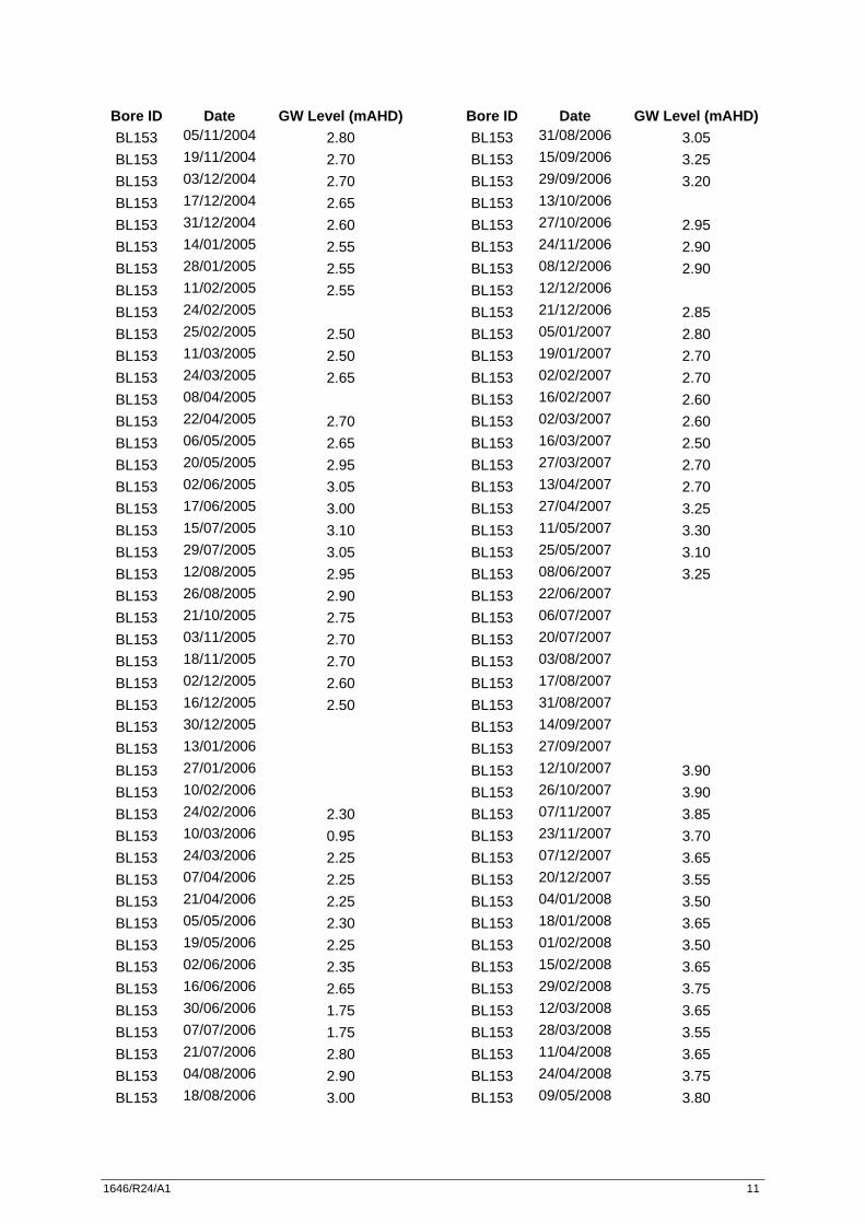
1646/R24/A1 11
Bore ID Date GW Level (mAHD) BL153 05/11/2004 2.80 BL153 19/11/2004 2.70 BL153 03/12/2004 2.70 BL153 17/12/2004 2.65 BL153 31/12/2004 2.60 BL153 14/01/2005 2.55 BL153 28/01/2005 2.55 BL153 11/02/2005 2.55 BL153 24/02/2005
BL153 25/02/2005 2.50 BL153 11/03/2005 2.50 BL153 24/03/2005 2.65 BL153 08/04/2005
BL153 22/04/2005 2.70 BL153 06/05/2005 2.65 BL153 20/05/2005 2.95 BL153 02/06/2005 3.05 BL153 17/06/2005 3.00 BL153 15/07/2005 3.10 BL153 29/07/2005 3.05 BL153 12/08/2005 2.95 BL153 26/08/2005 2.90 BL153 21/10/2005 2.75 BL153 03/11/2005 2.70 BL153 18/11/2005 2.70 BL153 02/12/2005 2.60 BL153 16/12/2005 2.50 BL153 30/12/2005
BL153 13/01/2006
BL153 27/01/2006
BL153 10/02/2006
BL153 24/02/2006 2.30 BL153 10/03/2006 0.95 BL153 24/03/2006 2.25 BL153 07/04/2006 2.25 BL153 21/04/2006 2.25 BL153 05/05/2006 2.30 BL153 19/05/2006 2.25 BL153 02/06/2006 2.35 BL153 16/06/2006 2.65 BL153 30/06/2006 1.75 BL153 07/07/2006 1.75 BL153 21/07/2006 2.80 BL153 04/08/2006 2.90 BL153 18/08/2006 3.00
Bore ID Date GW Level (mAHD) BL153 31/08/2006 3.05 BL153 15/09/2006 3.25 BL153 29/09/2006 3.20 BL153 13/10/2006
BL153 27/10/2006 2.95 BL153 24/11/2006 2.90 BL153 08/12/2006 2.90 BL153 12/12/2006
BL153 21/12/2006 2.85 BL153 05/01/2007 2.80 BL153 19/01/2007 2.70 BL153 02/02/2007 2.70 BL153 16/02/2007 2.60 BL153 02/03/2007 2.60 BL153 16/03/2007 2.50 BL153 27/03/2007 2.70 BL153 13/04/2007 2.70 BL153 27/04/2007 3.25 BL153 11/05/2007 3.30 BL153 25/05/2007 3.10 BL153 08/06/2007 3.25 BL153 22/06/2007
BL153 06/07/2007
BL153 20/07/2007
BL153 03/08/2007
BL153 17/08/2007
BL153 31/08/2007
BL153 14/09/2007
BL153 27/09/2007
BL153 12/10/2007 3.90 BL153 26/10/2007 3.90 BL153 07/11/2007 3.85 BL153 23/11/2007 3.70 BL153 07/12/2007 3.65 BL153 20/12/2007 3.55 BL153 04/01/2008 3.50 BL153 18/01/2008 3.65 BL153 01/02/2008 3.50 BL153 15/02/2008 3.65 BL153 29/02/2008 3.75 BL153 12/03/2008 3.65 BL153 28/03/2008 3.55 BL153 11/04/2008 3.65 BL153 24/04/2008 3.75 BL153 09/05/2008 3.80

1646/R24/A1 12
Bore ID Date GW Level (mAHD) BL153 23/05/2008 3.75 BL153 06/06/2008 3.90 BL153 20/06/2008 3.95 BL153 04/07/2008 3.95 BL153 18/07/2008 4.00 BL153 01/08/2008 4.05 BL153 15/08/2008 4.05 BL153 29/08/2008 3.75 BL153 12/09/2008 3.85 BL153 25/09/2008 3.90 BL153 10/10/2008 3.95 BL153 24/10/2008 3.95 BL153 07/11/2008 3.75 BL153 21/11/2008 3.85 BL153 04/12/2008 3.80 BL153 18/12/2008 3.75 BL153 07/01/2009 3.40 BL153 23/01/2009 3.30 BL153 06/02/2009 3.20 BL153 13/02/2009 3.15 BL153 26/02/2009 3.50 BL153 13/03/2009 3.40 BL153 27/03/2009 3.35 BL153 09/04/2009 3.45 BL153 23/04/2009 3.55 BL153 08/05/2009 3.65 BL153 27/05/2009 3.65 BL153 11/06/2009 3.65 BL153 25/06/2009 4.05 BL153 03/07/2009 4.00 BL153 24/07/2009 3.95 BL153 31/07/2009 3.95 BL153 20/08/2009 3.85 BL153 04/09/2009 3.65 BL153 18/09/2009 3.48 BL153 02/10/2009 3.36 BL153 16/10/2009 3.57 BL153 29/10/2009 3.45 BL153 20/11/2009 3.33 BL153 04/12/2009 3.31 BL153 18/12/2009 3.22 BL153 08/01/2010 3.15 BL153 08/01/2010 3.15 BL153 04/02/2010 2.93 BL153 04/02/2010 2.93
Bore ID Date GW Level (mAHD) BL153 18/02/2010 2.93 BL153 18/02/2010 2.93 BL153 05/03/2010 2.90 BL153 18/03/2010 3.04 BL153 19/03/2010 3.04 BL153 08/04/2010 2.69 BL153 28/04/2010 2.57 BL153 07/05/2010 2.59 BL153 21/05/2010 BL153 09/06/2010 3.04 BL153 18/06/2010 3.12 BL153 02/07/2010 3.05 BL153 16/07/2010 3.16 BL153 20/07/2010 3.26 BL153 13/08/2010 3.23 BL153 26/08/2010 3.16 BL153 10/09/2010 3.19 BL153 24/09/2010 3.04 BL153 07/10/2010 3.01 BL153 22/10/2010 2.94 BL153 07/11/2010 3.05 BL153 07/11/2010 BL153 19/11/2010 BL153 17/12/2010 -2.29 BL153 14/01/2011 -0.16 BL153 29/01/2011 -2.57 BL153 10/02/2011 -2.66 BL153 25/02/2011 3.10 BL153 11/03/2011 3.06 BL153 11/03/2011 BL153 24/03/2011 3.11 BL153 07/04/2011 BL153 20/04/2011 3.08 BL153 05/05/2011 3.08 BL153 02/06/2011 2.82 BL153 17/06/2011 2.95 BL153 01/07/2011 3.05 BL153 29/07/2011 3.56 BL153 12/08/2011 3.57
1646/R24/A1 13
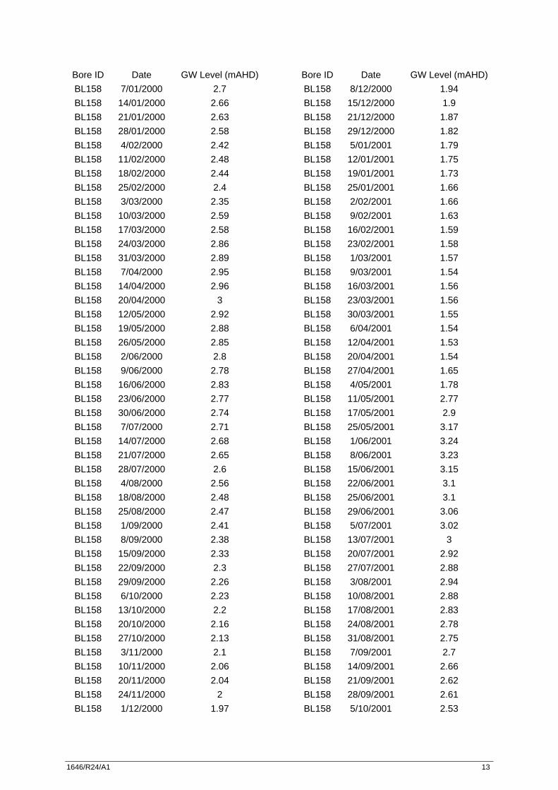
Bore ID Date GW Level (mAHD) BL158 7/01/2000 2.7 BL158 14/01/2000 2.66 BL158 21/01/2000 2.63 BL158 28/01/2000 2.58 BL158 4/02/2000 2.42 BL158 11/02/2000 2.48 BL158 18/02/2000 2.44 BL158 25/02/2000 2.4 BL158 3/03/2000 2.35 BL158 10/03/2000 2.59 BL158 17/03/2000 2.58 BL158 24/03/2000 2.86 BL158 31/03/2000 2.89 BL158 7/04/2000 2.95 BL158 14/04/2000 2.96 BL158 20/04/2000 3 BL158 12/05/2000 2.92 BL158 19/05/2000 2.88 BL158 26/05/2000 2.85 BL158 2/06/2000 2.8 BL158 9/06/2000 2.78 BL158 16/06/2000 2.83 BL158 23/06/2000 2.77 BL158 30/06/2000 2.74 BL158 7/07/2000 2.71 BL158 14/07/2000 2.68 BL158 21/07/2000 2.65 BL158 28/07/2000 2.6 BL158 4/08/2000 2.56 BL158 18/08/2000 2.48 BL158 25/08/2000 2.47 BL158 1/09/2000 2.41 BL158 8/09/2000 2.38 BL158 15/09/2000 2.33 BL158 22/09/2000 2.3 BL158 29/09/2000 2.26 BL158 6/10/2000 2.23 BL158 13/10/2000 2.2 BL158 20/10/2000 2.16 BL158 27/10/2000 2.13 BL158 3/11/2000 2.1 BL158 10/11/2000 2.06 BL158 20/11/2000 2.04 BL158 24/11/2000 2 BL158 1/12/2000 1.97
Bore ID Date GW Level (mAHD) BL158 8/12/2000 1.94 BL158 15/12/2000 1.9 BL158 21/12/2000 1.87 BL158 29/12/2000 1.82 BL158 5/01/2001 1.79 BL158 12/01/2001 1.75 BL158 19/01/2001 1.73 BL158 25/01/2001 1.66 BL158 2/02/2001 1.66 BL158 9/02/2001 1.63 BL158 16/02/2001 1.59 BL158 23/02/2001 1.58 BL158 1/03/2001 1.57 BL158 9/03/2001 1.54 BL158 16/03/2001 1.56 BL158 23/03/2001 1.56 BL158 30/03/2001 1.55 BL158 6/04/2001 1.54 BL158 12/04/2001 1.53 BL158 20/04/2001 1.54 BL158 27/04/2001 1.65 BL158 4/05/2001 1.78 BL158 11/05/2001 2.77 BL158 17/05/2001 2.9 BL158 25/05/2001 3.17 BL158 1/06/2001 3.24 BL158 8/06/2001 3.23 BL158 15/06/2001 3.15 BL158 22/06/2001 3.1 BL158 25/06/2001 3.1 BL158 29/06/2001 3.06 BL158 5/07/2001 3.02 BL158 13/07/2001 3 BL158 20/07/2001 2.92 BL158 27/07/2001 2.88 BL158 3/08/2001 2.94 BL158 10/08/2001 2.88 BL158 17/08/2001 2.83 BL158 24/08/2001 2.78 BL158 31/08/2001 2.75 BL158 7/09/2001 2.7 BL158 14/09/2001 2.66 BL158 21/09/2001 2.62 BL158 28/09/2001 2.61 BL158 5/10/2001 2.53
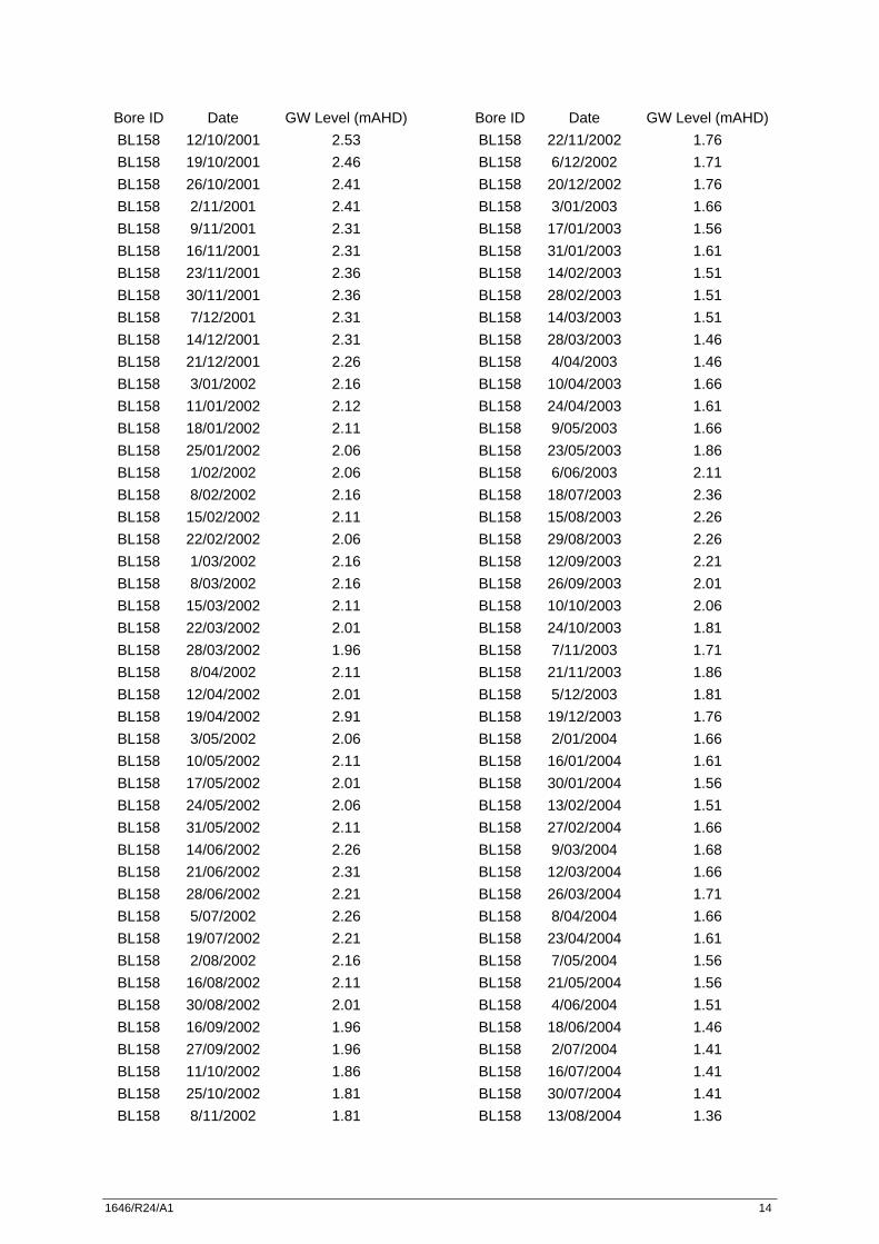
1646/R24/A1 14
Bore ID Date GW Level (mAHD) BL158 12/10/2001 2.53 BL158 19/10/2001 2.46 BL158 26/10/2001 2.41 BL158 2/11/2001 2.41 BL158 9/11/2001 2.31 BL158 16/11/2001 2.31 BL158 23/11/2001 2.36 BL158 30/11/2001 2.36 BL158 7/12/2001 2.31 BL158 14/12/2001 2.31 BL158 21/12/2001 2.26 BL158 3/01/2002 2.16 BL158 11/01/2002 2.12 BL158 18/01/2002 2.11 BL158 25/01/2002 2.06 BL158 1/02/2002 2.06 BL158 8/02/2002 2.16 BL158 15/02/2002 2.11 BL158 22/02/2002 2.06 BL158 1/03/2002 2.16 BL158 8/03/2002 2.16 BL158 15/03/2002 2.11 BL158 22/03/2002 2.01 BL158 28/03/2002 1.96 BL158 8/04/2002 2.11 BL158 12/04/2002 2.01 BL158 19/04/2002 2.91 BL158 3/05/2002 2.06 BL158 10/05/2002 2.11 BL158 17/05/2002 2.01 BL158 24/05/2002 2.06 BL158 31/05/2002 2.11 BL158 14/06/2002 2.26 BL158 21/06/2002 2.31 BL158 28/06/2002 2.21 BL158 5/07/2002 2.26 BL158 19/07/2002 2.21 BL158 2/08/2002 2.16 BL158 16/08/2002 2.11 BL158 30/08/2002 2.01 BL158 16/09/2002 1.96 BL158 27/09/2002 1.96 BL158 11/10/2002 1.86 BL158 25/10/2002 1.81 BL158 8/11/2002 1.81
Bore ID Date GW Level (mAHD) BL158 22/11/2002 1.76 BL158 6/12/2002 1.71 BL158 20/12/2002 1.76 BL158 3/01/2003 1.66 BL158 17/01/2003 1.56 BL158 31/01/2003 1.61 BL158 14/02/2003 1.51 BL158 28/02/2003 1.51 BL158 14/03/2003 1.51 BL158 28/03/2003 1.46 BL158 4/04/2003 1.46 BL158 10/04/2003 1.66 BL158 24/04/2003 1.61 BL158 9/05/2003 1.66 BL158 23/05/2003 1.86 BL158 6/06/2003 2.11 BL158 18/07/2003 2.36 BL158 15/08/2003 2.26 BL158 29/08/2003 2.26 BL158 12/09/2003 2.21 BL158 26/09/2003 2.01 BL158 10/10/2003 2.06 BL158 24/10/2003 1.81 BL158 7/11/2003 1.71 BL158 21/11/2003 1.86 BL158 5/12/2003 1.81 BL158 19/12/2003 1.76 BL158 2/01/2004 1.66 BL158 16/01/2004 1.61 BL158 30/01/2004 1.56 BL158 13/02/2004 1.51 BL158 27/02/2004 1.66 BL158 9/03/2004 1.68 BL158 12/03/2004 1.66 BL158 26/03/2004 1.71 BL158 8/04/2004 1.66 BL158 23/04/2004 1.61 BL158 7/05/2004 1.56 BL158 21/05/2004 1.56 BL158 4/06/2004 1.51 BL158 18/06/2004 1.46 BL158 2/07/2004 1.41 BL158 16/07/2004 1.41 BL158 30/07/2004 1.41 BL158 13/08/2004 1.36
1646/R24/A1 15
Bore ID Date GW Level (mAHD) BL158 27/08/2004 1.41 BL158 10/09/2004 1.41 BL158 24/09/2004 1.41 BL158 8/10/2004 1.41 BL158 22/10/2004 1.51 BL158 5/11/2004 1.71 BL158 19/11/2004 1.76 BL158 3/12/2004 1.71 BL158 17/12/2004 1.66 BL158 31/12/2004 1.61 BL158 14/01/2005 1.56 BL158 28/01/2005 1.56 BL158 11/02/2005 1.56 BL158 24/02/2005 BL158 25/02/2005 1.51 BL158 11/03/2005 1.51 BL158 24/03/2005 1.66 BL158 8/04/2005 2.41 BL158 22/04/2005 1.81 BL158 6/05/2005 1.71 BL158 20/05/2005 1.81 BL158 2/06/2005 1.91 BL158 17/06/2005 1.86 BL158 15/07/2005 1.96 BL158 29/07/2005 1.86 BL158 12/08/2005 1.81 BL158 26/08/2005 1.76 BL158 21/10/2005 1.56 BL158 3/11/2005 1.56 BL158 18/11/2005 1.56 BL158 2/12/2005 1.46 BL158 16/12/2005 1.41 BL158 30/12/2005 1.36 BL158 13/01/2006 1.31 BL158 27/01/2006 1.26 BL158 10/02/2006 1.26 BL158 24/02/2006 1.16 BL158 10/03/2006 1.21 BL158 24/03/2006 1.21 BL158 7/04/2006 1.21 BL158 21/04/2006 1.16 BL158 5/05/2006 1.31 BL158 19/05/2006 1.31 BL158 2/06/2006 1.31 BL158 16/06/2006 1.51
Bore ID Date GW Level (mAHD) BL158 30/06/2006 1.66 BL158 7/07/2006 1.66 BL158 21/07/2006 1.71 BL158 4/08/2006 1.76 BL158 18/08/2006 1.86 BL158 31/08/2006 1.86 BL158 15/09/2006 2.01 BL158 29/09/2006 1.96 BL158 13/10/2006 2.01 BL158 27/10/2006 2.01 BL158 24/11/2006 1.86 BL158 8/12/2006 1.81 BL158 12/12/2006 BL158 21/12/2006 1.76 BL158 5/01/2007 1.66 BL158 19/01/2007 1.51 BL158 2/02/2007 1.51 BL158 16/02/2007 1.46 BL158 2/03/2007 1.41 BL158 16/03/2007 1.41 BL158 27/03/2007 1.46 BL158 13/04/2007 1.51 BL158 27/04/2007 2.01 BL158 11/05/2007 2.11 BL158 25/05/2007 2.16 BL158 8/06/2007 2.26 BL158 22/06/2007 BL158 6/07/2007 BL158 20/07/2007 BL158 3/08/2007 BL158 17/08/2007 2.96 BL158 31/08/2007 3.01 BL158 14/09/2007 2.86 BL158 27/09/2007 2.81 BL158 12/10/2007 2.61 BL158 26/10/2007 2.56 BL158 7/11/2007 2.61 BL158 23/11/2007 2.41 BL158 7/12/2007 2.36 BL158 20/12/2007 2.31 BL158 4/01/2008 2.26 BL158 18/01/2008 2.36 BL158 1/02/2008 2.26 BL158 15/02/2008 2.41 BL158 29/02/2008 2.51
1646/R24/A1 16
Bore ID Date GW Level (mAHD) BL158 12/03/2008 2.51 BL158 28/03/2008 2.46 BL158 11/04/2008 2.51 BL158 24/04/2008 2.66 BL158 9/05/2008 2.61 BL158 23/05/2008 2.61 BL158 6/06/2008 2.86 BL158 20/06/2008 2.96 BL158 4/07/2008 2.61 BL158 18/07/2008 2.66 BL158 1/08/2008 2.66 BL158 15/08/2008 2.66 BL158 29/08/2008 2.36 BL158 12/09/2008 2.46 BL158 25/09/2008 2.56 BL158 10/10/2008 2.61 BL158 24/10/2008 2.66 BL158 7/11/2008 2.86 BL158 21/11/2008 2.96 BL158 4/12/2008 2.91 BL158 18/12/2008 2.91 BL158 7/01/2009 2.66 BL158 23/01/2009 2.51 BL158 6/02/2009 2.51 BL158 13/02/2009 2.46 BL158 26/02/2009 2.76 BL158 13/03/2009 2.71 BL158 27/03/2009 2.61 BL158 9/04/2009 2.76 BL158 23/04/2009 2.86 BL158 8/05/2009 2.96 BL158 27/05/2009 2.96 BL158 11/06/2009 3.01 BL158 25/06/2009 3.26 BL158 3/07/2009 3.31 BL158 24/07/2009 3.26 BL158 31/07/2009 3.21 BL158 20/08/2009 3.11 BL158 4/09/2009 2.96 BL158 18/09/2009 2.84 BL158 2/10/2009 2.69 BL158 16/10/2009 2.9 BL158 29/10/2009 1.66 BL158 20/11/2009 1.55 BL158 4/12/2009 2.54
Bore ID Date GW Level (mAHD) BL158 18/12/2009 2.42 BL158 8/01/2010 2.35 BL158 8/01/2010 2.35 BL158 4/02/2010 2.17 BL158 4/02/2010 2.17 BL158 18/02/2010 2.18 BL158 18/02/2010 2.18 BL158 5/03/2010 2.15 BL158 18/03/2010 2.34 BL158 19/03/2010 2.34 BL158 8/04/2010 1.99 BL158 28/04/2010 1.87 BL158 7/05/2010 1.88 BL158 21/05/2010 BL158 9/06/2010 2.26 BL158 9/06/2010 2.26 BL158 18/06/2010 2.35 BL158 2/07/2010 2.27 BL158 16/07/2010 2.39 BL158 20/07/2010 2.5 BL158 13/08/2010 2.64 BL158 26/08/2010 2.58 BL158 10/09/2010 2.6 BL158 24/09/2010 2.48 BL158 7/10/2010 2.44 BL158 22/10/2010 2.36 BL158 7/11/2010 2.45 BL158 7/11/2010 BL158 19/11/2010 BL158 17/12/2010 2.4 BL158 14/01/2011 2.5 BL158 29/01/2011 2.17 BL158 10/02/2011 2.9 BL158 25/02/2011 2.08 BL158 11/03/2011 2.02 BL158 11/03/2011 BL158 24/03/2011 2.05 BL158 7/04/2011 BL158 20/04/2011 2.05 BL158 5/05/2011 2.06 BL158 2/06/2011 2.32 BL158 17/06/2011 2.45 BL158 1/07/2011 2.56 BL158 29/07/2011 2.98 BL158 12/08/2011 3
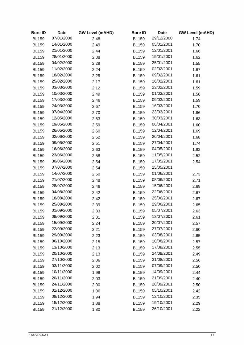
1646/R24/A1 17
Bore ID Date GW Level (mAHD) BL159 07/01/2000 2.48 BL159 14/01/2000 2.49 BL159 21/01/2000 2.44 BL159 28/01/2000 2.38 BL159 04/02/2000 2.29 BL159 11/02/2000 2.24 BL159 18/02/2000 2.25 BL159 25/02/2000 2.17 BL159 03/03/2000 2.12 BL159 10/03/2000 2.49 BL159 17/03/2000 2.46 BL159 24/03/2000 2.67 BL159 07/04/2000 2.70 BL159 12/05/2000 2.63 BL159 19/05/2000 2.59 BL159 26/05/2000 2.60 BL159 02/06/2000 2.52 BL159 09/06/2000 2.51 BL159 16/06/2000 2.63 BL159 23/06/2000 2.58 BL159 30/06/2000 2.54 BL159 07/07/2000 2.54 BL159 14/07/2000 2.50 BL159 21/07/2000 2.48 BL159 28/07/2000 2.46 BL159 04/08/2000 2.42 BL159 18/08/2000 2.42 BL159 25/08/2000 2.39 BL159 01/09/2000 2.33 BL159 08/09/2000 2.31 BL159 15/09/2000 2.24 BL159 22/09/2000 2.21 BL159 29/09/2000 2.23 BL159 06/10/2000 2.15 BL159 13/10/2000 2.13 BL159 20/10/2000 2.13 BL159 27/10/2000 2.06 BL159 03/11/2000 2.02 BL159 10/11/2000 1.98 BL159 20/11/2000 2.03 BL159 24/11/2000 2.00 BL159 01/12/2000 1.96 BL159 08/12/2000 1.94 BL159 15/12/2000 1.88 BL159 21/12/2000 1.80
Bore ID Date GW Level (mAHD) BL159 29/12/2000 1.74 BL159 05/01/2001 1.70 BL159 12/01/2001 1.66 BL159 19/01/2001 1.62 BL159 25/01/2001 1.55 BL159 02/02/2001 1.67 BL159 09/02/2001 1.61 BL159 16/02/2001 1.61 BL159 23/02/2001 1.59 BL159 01/03/2001 1.58 BL159 09/03/2001 1.59 BL159 16/03/2001 1.70 BL159 23/03/2001 1.66 BL159 30/03/2001 1.63 BL159 06/04/2001 1.60 BL159 12/04/2001 1.69 BL159 20/04/2001 1.68 BL159 27/04/2001 1.74 BL159 04/05/2001 1.92 BL159 11/05/2001 2.52 BL159 17/05/2001 2.54 BL159 25/05/2001
BL159 01/06/2001 2.73 BL159 08/06/2001 2.71 BL159 15/06/2001 2.69 BL159 22/06/2001 2.67 BL159 25/06/2001 2.67 BL159 29/06/2001 2.65 BL159 05/07/2001 2.63 BL159 13/07/2001 2.61 BL159 20/07/2001 2.57 BL159 27/07/2001 2.60 BL159 03/08/2001 2.65 BL159 10/08/2001 2.57 BL159 17/08/2001 2.55 BL159 24/08/2001 2.49 BL159 31/08/2001 2.56 BL159 07/09/2001 2.50 BL159 14/09/2001 2.44 BL159 21/09/2001 2.40 BL159 28/09/2001 2.50 BL159 05/10/2001 2.42 BL159 12/10/2001 2.35 BL159 19/10/2001 2.29 BL159 26/10/2001 2.22
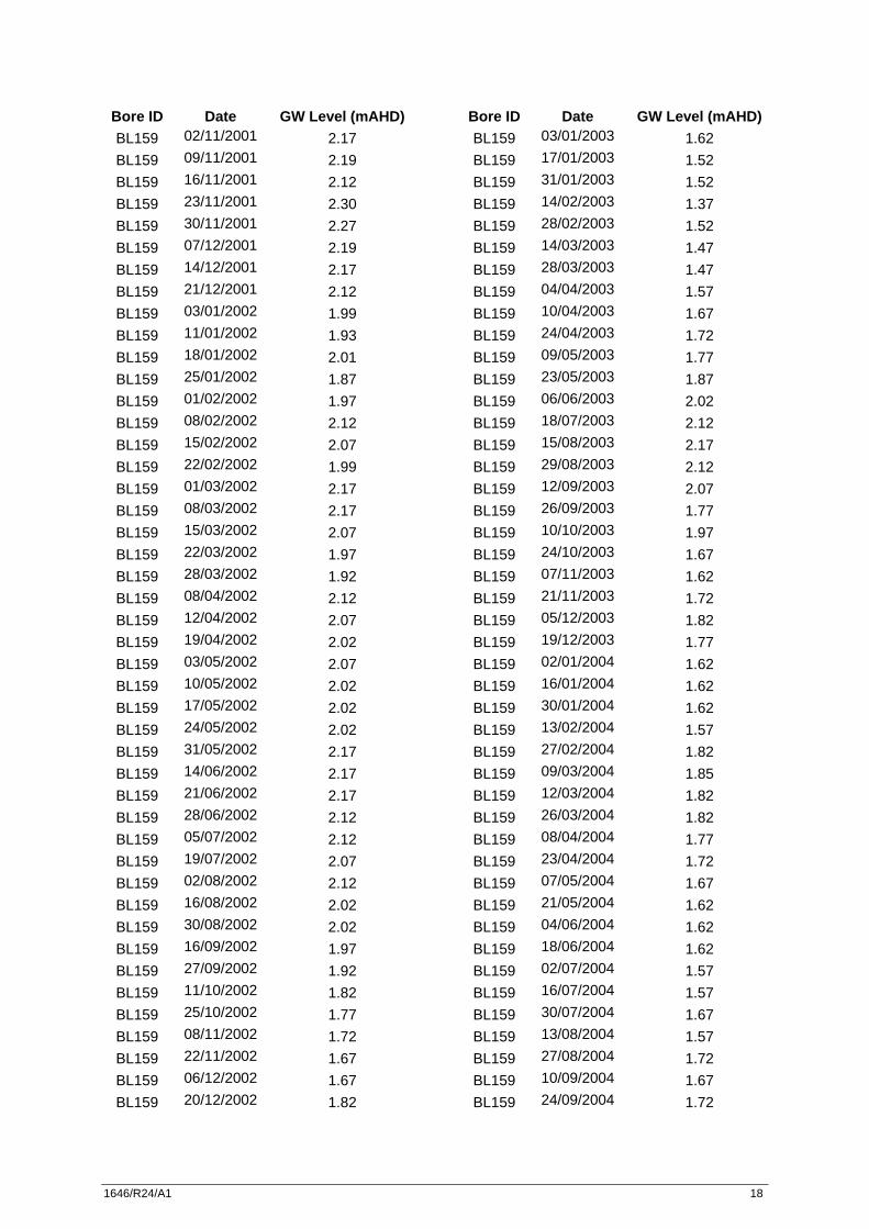
1646/R24/A1 18
Bore ID Date GW Level (mAHD) BL159 02/11/2001 2.17 BL159 09/11/2001 2.19 BL159 16/11/2001 2.12 BL159 23/11/2001 2.30 BL159 30/11/2001 2.27 BL159 07/12/2001 2.19 BL159 14/12/2001 2.17 BL159 21/12/2001 2.12 BL159 03/01/2002 1.99 BL159 11/01/2002 1.93 BL159 18/01/2002 2.01 BL159 25/01/2002 1.87 BL159 01/02/2002 1.97 BL159 08/02/2002 2.12 BL159 15/02/2002 2.07 BL159 22/02/2002 1.99 BL159 01/03/2002 2.17 BL159 08/03/2002 2.17 BL159 15/03/2002 2.07 BL159 22/03/2002 1.97 BL159 28/03/2002 1.92 BL159 08/04/2002 2.12 BL159 12/04/2002 2.07 BL159 19/04/2002 2.02 BL159 03/05/2002 2.07 BL159 10/05/2002 2.02 BL159 17/05/2002 2.02 BL159 24/05/2002 2.02 BL159 31/05/2002 2.17 BL159 14/06/2002 2.17 BL159 21/06/2002 2.17 BL159 28/06/2002 2.12 BL159 05/07/2002 2.12 BL159 19/07/2002 2.07 BL159 02/08/2002 2.12 BL159 16/08/2002 2.02 BL159 30/08/2002 2.02 BL159 16/09/2002 1.97 BL159 27/09/2002 1.92 BL159 11/10/2002 1.82 BL159 25/10/2002 1.77 BL159 08/11/2002 1.72 BL159 22/11/2002 1.67 BL159 06/12/2002 1.67 BL159 20/12/2002 1.82
Bore ID Date GW Level (mAHD) BL159 03/01/2003 1.62 BL159 17/01/2003 1.52 BL159 31/01/2003 1.52 BL159 14/02/2003 1.37 BL159 28/02/2003 1.52 BL159 14/03/2003 1.47 BL159 28/03/2003 1.47 BL159 04/04/2003 1.57 BL159 10/04/2003 1.67 BL159 24/04/2003 1.72 BL159 09/05/2003 1.77 BL159 23/05/2003 1.87 BL159 06/06/2003 2.02 BL159 18/07/2003 2.12 BL159 15/08/2003 2.17 BL159 29/08/2003 2.12 BL159 12/09/2003 2.07 BL159 26/09/2003 1.77 BL159 10/10/2003 1.97 BL159 24/10/2003 1.67 BL159 07/11/2003 1.62 BL159 21/11/2003 1.72 BL159 05/12/2003 1.82 BL159 19/12/2003 1.77 BL159 02/01/2004 1.62 BL159 16/01/2004 1.62 BL159 30/01/2004 1.62 BL159 13/02/2004 1.57 BL159 27/02/2004 1.82 BL159 09/03/2004 1.85 BL159 12/03/2004 1.82 BL159 26/03/2004 1.82 BL159 08/04/2004 1.77 BL159 23/04/2004 1.72 BL159 07/05/2004 1.67 BL159 21/05/2004 1.62 BL159 04/06/2004 1.62 BL159 18/06/2004 1.62 BL159 02/07/2004 1.57 BL159 16/07/2004 1.57 BL159 30/07/2004 1.67 BL159 13/08/2004 1.57 BL159 27/08/2004 1.72 BL159 10/09/2004 1.67 BL159 24/09/2004 1.72
1646/R24/A1 19
Bore ID Date GW Level (mAHD) BL159 08/10/2004 1.72 BL159 22/10/2004 1.82 BL159 05/11/2004 1.87 BL159 19/11/2004 1.82 BL159 03/12/2004 1.82 BL159 17/12/2004 1.82 BL159 31/12/2004 1.67 BL159 14/01/2005 1.62 BL159 28/01/2005 1.57 BL159 11/02/2005 1.67 BL159 24/02/2005
BL159 25/02/2005 1.67 BL159 11/03/2005 1.67 BL159 24/03/2005 1.87 BL159 08/04/2005 1.67 BL159 22/04/2005 1.97 BL159 06/05/2005 1.87 BL159 20/05/2005 2.12 BL159 02/06/2005 2.07 BL159 17/06/2005 2.02 BL159 15/07/2005 2.17 BL159 29/07/2005 2.07 BL159 12/08/2005 1.97 BL159 26/08/2005 1.92 BL159 21/10/2005 1.72 BL159 03/11/2005 1.72 BL159 18/11/2005 1.72 BL159 02/12/2005 1.72 BL159 16/12/2005 1.62 BL159 30/12/2005 1.47 BL159 13/01/2006 1.42 BL159 27/01/2006 1.37 BL159 10/02/2006 1.27 BL159 24/02/2006 1.27 BL159 10/03/2006 1.37 BL159 24/03/2006 1.32 BL159 07/04/2006 1.32 BL159 21/04/2006 1.32 BL159 05/05/2006 1.37 BL159 19/05/2006 1.32 BL159 02/06/2006 1.52 BL159 16/06/2006 1.27 BL159 30/06/2006 1.72 BL159 07/07/2006 1.72
Bore ID Date GW Level (mAHD) BL159 21/07/2006 1.82 BL159 04/08/2006 1.87 BL159 18/08/2006 1.92 BL159 31/08/2006 1.92 BL159 15/09/2006 2.12 BL159 29/09/2006 2.07 BL159 13/10/2006
BL159 27/10/2006 1.92 BL159 24/11/2006 1.92 BL159 08/12/2006 1.87 BL159 12/12/2006
BL159 21/12/2006 1.82 BL159 05/01/2007 1.72 BL159 19/01/2007 1.62 BL159 02/02/2007 1.57 BL159 16/02/2007 1.62 BL159 02/03/2007 1.57 BL159 16/03/2007 1.57 BL159 27/03/2007 1.47 BL159 13/04/2007 1.72 BL159 27/04/2007 2.17 BL159 11/05/2007 2.22 BL159 25/05/2007 2.07 BL159 08/06/2007 2.17 BL159 22/06/2007 2.72 BL159 06/07/2007 2.77 BL159 20/07/2007
BL159 03/08/2007 2.77 BL159 17/08/2007 2.67 BL159 31/08/2007 2.62 BL159 14/09/2007 2.72 BL159 27/09/2007 2.62 BL159 12/10/2007 2.47 BL159 26/10/2007 2.42 BL159 07/11/2007 2.47 BL159 23/11/2007 2.37 BL159 07/12/2007 2.32 BL159 20/12/2007 2.22 BL159 04/01/2008 2.17 BL159 18/01/2008 1.67 BL159 01/02/2008 2.27 BL159 15/02/2008 2.42 BL159 29/02/2008 2.52 BL159 12/03/2008 2.37
1646/R24/A1 20
Bore ID Date GW Level (mAHD) BL159 28/03/2008 2.27 BL159 11/04/2008 2.37 BL159 24/04/2008 2.52 BL159 09/05/2008 2.47 BL159 23/05/2008 2.47 BL159 06/06/2008 2.62 BL159 20/06/2008 2.57 BL159 04/07/2008 2.52 BL159 18/07/2008 2.57 BL159 01/08/2008 2.57 BL159 15/08/2008 2.62 BL159 29/08/2008 2.42 BL159 12/09/2008 2.52 BL159 25/09/2008 2.52 BL159 10/10/2008 2.52 BL159 24/10/2008 2.62 BL159 07/11/2008 2.17 BL159 21/11/2008 2.27 BL159 04/12/2008 2.22 BL159 18/12/2008 2.17 BL159 07/01/2009 2.07 BL159 23/01/2009 1.92 BL159 06/02/2009 1.87 BL159 13/02/2009 1.87 BL159 26/02/2009 2.22 BL159 13/03/2009 2.17 BL159 27/03/2009 2.07 BL159 09/04/2009 2.27 BL159 23/04/2009 2.32 BL159 08/05/2009 2.37 BL159 27/05/2009 2.42 BL159 11/06/2009 2.47 BL159 25/06/2009 2.57 BL159 03/07/2009 2.57 BL159 24/07/2009 2.52 BL159 31/07/2009 2.57 BL159 20/08/2009 2.47 BL159 04/09/2009 2.32 BL159 18/09/2009 2.22 BL159 02/10/2009 2.12 BL159 16/10/2009 2.15 BL159 29/10/2009 2.19 BL159 20/11/2009 2.08 BL159 04/12/2009 2.04 BL159 18/12/2009 1.95
Bore ID Date GW Level (mAHD) BL159 08/01/2010 1.89 BL159 08/01/2010 1.89 BL159 04/02/2010 1.74 BL159 04/02/2010 1.74 BL159 18/02/2010 1.64 BL159 18/02/2010 1.64 BL159 05/03/2010 1.62 BL159 18/03/2010 1.76 BL159 19/03/2010 1.76 BL159 08/04/2010 1.29 BL159 28/04/2010 1.15 BL159 07/05/2010 1.12 BL159 21/05/2010 BL159 09/06/2010 1.87 BL159 09/06/2010 1.87 BL159 18/06/2010 1.96 BL159 02/07/2010 1.88 BL159 16/07/2010 1.99 BL159 20/07/2010 2.10 BL159 13/08/2010 2.07 BL159 26/08/2010 2.00 BL159 10/09/2010 1.99 BL159 24/09/2010 1.89 BL159 07/10/2010 1.86 BL159 22/10/2010 1.81 BL159 07/11/2010 1.90 BL159 07/11/2010 BL159 19/11/2010 BL159 17/12/2010 1.84 BL159 14/01/2011 1.65 BL159 29/01/2011 1.57 BL159 29/01/2011 1.57 BL159 10/02/2011 1.50 BL159 25/02/2011 1.46 BL159 11/03/2011 1.41 BL159 11/03/2011 BL159 24/03/2011 1.45 BL159 07/04/2011 BL159 20/04/2011 1.69 BL159 05/05/2011 1.70 BL159 02/06/2011 1.88 BL159 17/06/2011 2.08 BL159 01/07/2011 2.13 BL159 29/07/2011 2.36 BL159 12/08/2011 2.37

Umwelt (Australia) Pty Limited2/20 The Boulevarde
PO Box 838Toronto NSW 2283
Ph. 02 4950 5322Fax 02 4950 5737