Embed Size (px)
Citation preview

Quinebaug Woods Management Plan
2006
©

Quinebaug Woods Reservation Management Plan Location: Holland, MA Acreage: 36 acres Completed by: Edie Dondero, Planner Steve Fluet, Superintendent, Wachusett Management Unit Dick O’Brien, Central Regional Director Russ Hopping, Ecology Program Manager Date: June 2006 Supporting Reports and Materials: ● Haller, Margaret and Ben. 2002. A History of the Camp at Quinebaug
Woods in Holland, Massachusetts, 1931-2001. Montclair, New Jersey: Bookcraft.
• Classification of the Natural Communities of Massachusetts, Natural Heritage & Endangered Species Program, Swain and Kearsley, 2000 (draft).
• Griffith, G.E., J.M. Omernik, S.M. Pierson and C.W. Kiilsgaard. 1994. The Massachusetts ecological regions project. U.S. Environmental Protection Agency, Environmental Research Laboratory. Corvallis, OR.
• Hopping, R. 2002. Quinebaug Woods Natural Community Descriptions. The Trustees of Reservations. Leominster, MA.
• Quinebaug Woods Breeding Bird Survey, 2002. The Trustees of Reservations. Leominster, MA.
● 2001 color ortho aerial photography (1” = 300’) ● MassGIS data
● Soil Survey, Worcester County, Massachusetts


1 Introduction Quinebaug Woods became the 90th property of The Trustees of Reservations in 2001. It is a small property of 38 acres that borders a portion of the Quinebaug River. The reservation receives very little visitation and is not likely to ever become a destination property. On-the-ground management has been minimal due to a number of factors, including the reservation’s small size and minimal use. This management plan summarizes the history of the property, describes the existing natural and cultural resources and the visitor experience, and makes several management recommendations to be implemented over the next ten years. A prescribed routine management program for the reservation is also included. Locus map of Quinebaug Woods, Holland, MA
2 Land Use History The area known today as the town of Holland, Massachusetts was first settled by Joseph Blodgett, who purchased land there in 1730. Before settlement, it was likely that the area was inhabited by Nipmuc peoples, who dwelled along fresh water bodies in central Massachusetts. In 1783, Holland was incorporated as the East Parish of South Brimfield; it wasn’t until 1835 that Holland achieved the necessary fifty voters to be incorporated as a town. The population of Holland remained small (estimated at 300 in 1912) until the 1920s when the unspoiled landscape and bargain real estate began attracting buyers. Among these buyers was William Haller, a professor at Barnard College of Columbia University who resided in northern New Jersey. For over ten years Professor Haller and his family- his wife, Malleville and their three children, Bill Jr., Ben and Maria- rented a cottage on Holland Pond where they would spend their summers. Then, in 1931, Haller purchased nearly one hundred acres of woodland on the west bank of the Quinebaug River. The land included a hill just north of the Hamilton Reservoir dam that was referred to locally as a “hogback”- an exposed rocky ridge. An old logging road ran to the top of the hill and, here, the Hallers built a cottage.
“Native hemlock was used for the framing, white pine for boarding and shingles, and black birch for the floors. Although the chestnut trees on the property, as elsewhere, were already dead, huge white skeletons still standing furnished wood highly prized for its resistance to rot. Chestnut was used for the posts to support the
Quinebaug Woods Management Plan 1

floor and for sills which touched the ground. Eight-foot long red cedar posts were the choice for the supports where the house extended out over the cliff. The cottage was centered on a large fireplace and massive chimney of native rock. The stones came from old walls on the property and the abandoned foundation of an inn, also on Haller property.”1
The Hallers enjoyed the rustic lifestyle of the Quinebaug camp for many years. Kerosene lamps were used for light since the cabin was never wired for electricity, water was hauled up the hill from a well beside Dug Hill Road, gas for a cook stove was delivered regularly, and before plumbing was installed, a two-hole privy existed behind the barn. Malleville raised hens for their eggs and kept goats; a mare and a pony were used to run errands in lieu of an automobile during the gas rationing of World War II. Saturday night picnics on the shore of the lake2 were traditional, as were family parties on the hill. When the Haller children were grown and married, they continued to visit the camp each summer, now accompanied by their own children. The Hallers would eventually become year-round residents of Holland. Bill Sr. and Malleville moved permanently into a small house built for them by the lake where they lived out their last years; their son Ben gave a parcel of land across the river from the hill to his son William to build a home and a second parcel to his sister Maria who, in turn, passed the land to her son John. Eventually, Ben had the cabin on the hill torn down, despite the protests of some family members. He felt a wilderness camp was no longer viable in the middle of the heavily settled community that Holland had become. The cabin had been repeatedly vandalized, and extensive repairs had been necessary each spring. In 2001, Ben and Margaret Haller made a gift of their 38 acres of land on the hill, including the site of the former camp, to The Trustees. In 2002, Quinebaug Woods became the 90th property of The Trustees of Reservations. 3 Cultural Resources The only known cultural resources on the reservation are the former cabin site and the original chimney still sitting atop the ridge. While it is an interesting landscape feature, this site has little historical or cultural significance either locally or regionally. To date, staff has not made any efforts to maintain the chimney as a landscape feature. Although it is structurally stable at present, it may pose a threat to visitor safety in time. Therefore, staff recommends that the top half of the chimney be removed, leaving the bottom half with fire box as a remembrance of the cabin’s existence at the site.
1 Haller, Margaret and Ben. 2002. A History of the Camp at Quinebaug Woods in Holland, Massachusetts, 1931-2001. Montclair, New Jersey: Bookcraft. 2 It is unclear whether the authors were referring to Holland Pond or East Brimfield Lake.
Quinebaug Woods Management Plan 2
4 Natural Resources 4.1 Site Description Quinebaug Woods is located within the Lower Worcester Plateau/Eastern Connecticut Upland Ecoregion.3 Forest covers the entire property; hemlock is abundant and suppresses understory diversity. A ridgeline of exposed bedrock, also referred to as a “hogback,” is a prominent feature along the western boundary. This rock is composed of Paxton and Partridge schists, neutral to slightly acidic metamorphic rocks containing limy quartz and feldspar sandstone. Several small clearings occur along this ridgeline, as does an exemplary vernal pool. A view of the nearby hills can be seen from the largest of the clearings- the former site of the Haller cabin. The Quinebaug River forms much of the property’s eastern boundary. Timber harvesting occurred throughout the 20th century, most recently in 2000. The reservation is adjacent to significant acreage owned by the U.S. Army Corps of Engineers, the Holland Pond Recreational Area. The Leadmine Wildlife Management Area, managed by the Massachusetts Division of Fisheries and Wildlife, is located across Sturbridge Road from the reservation. Other protected lands in the area include the Norcross Wildlife Sanctuary and The Trustees’ Tantiusques Reservation. 4.2 Natural Communities At least six community types were identified at Quinebaug Woods in a 2002 survey, as shown on Map 2:4
• Circumneutral Rocky Summit/Rock Outcrop Community & Circumneutral Rock
Cliff Community & Circumneutral Talus Forest/Woodland • Woodland Vernal Pool • Oak-Hemlock-White Pine Forest • Mixed Oak Forest (Red Oak and Mountain Laurel) • Riparian (Red Maple Swamp and Shrub Swamp) • Hemlock Hardwood Swamp
Two of these community types are listed by the Massachusetts Natural Heritage and Endangered Species Program (MNHESP) as priorities for conservation. The first, Circumneutral Rocky Summit/Rock Outcrop & Circumneutral Rock Cliff & Circumneutral Talus Forest/Woodland, is a mosaic of three priority communities and is limited to a relatively small area (<1 acre) along the summit and east-facing slope of the hogback ridge. These communities intergrade into one another as topography, soil depth, moisture and sunlight vary. Together, they support an interesting and diverse assemblage of plants. At least two watch-list species and many unusual species occur in this limited area. 3 Griffith, G.E., J.M. Omernik, S.M. Pierson and C.W. Kiilsgaard. 1994. The Massachusetts ecological regions project. U.S. Environmental Protection Agency, Environmental Research Laboratory. Corvallis, OR. No. 17587-74-70. 4 Hopping, R. 2002. Quinebaug Woods Natural Community Descriptions. The Trustees of Reservations. Leominster, MA.
Quinebaug Woods Management Plan 3

Map 2: Natural Community Types at Quinebaug Woods
Quinebaug Woods Management Plan 4
The second priority community found within the Quinebaug Woods reservation is Woodland Vernal Pools. There are at least five functioning or potential vernal pools on the property, falling within two categories: those in depressions within uplands and those near or within the floodplain of the Quinebaug River. Floodplain pools are small pools that have formed in channels, possibly created during a period of high flood water when the River overflowed its banks. Salamander egg masses and frogs have been located in these pools. The single upland pool is a large pool (approximately 10x50 meters) that is exemplary5 and clearly functioning as habitat for obligate vernal pool species. Spotted salamanders, wood frogs, mole salamanders and fairy shrimp have all been documented within the pool. In 2001, this vernal pool was certified by the Opacum Land Trust. The presence of hemlock woolly adelgid6 (HWA) has been confirmed at Quinebaug Woods. Because eastern hemlock (Thuja canadensis) is a dominant tree species at the property, HWA has the potential to dramatically transform the appearance and species composition of the reservation. Timber harvesting on the property in 2000 attempted to minimize the impact of HWA by removing many hemlocks and, thus, encouraging other species to develop. While hemlock can provide valuable wildlife habitat, its loss at Quinebaug Woods will likely have a greater impact on the reservation’s scenery than its ecology. Species dependent on hemlock will undoubtedly decline, but plant species diversity will likely benefit due to an increase in the amount of available sunlight. While biological control may be an option at Quinebaug Woods, other sites with more significant hemlock stands exist where this option may be more beneficial. The entire length of the Quinebaug River from Holland Pond to the Hamilton Reservoir has been designated as Living Waters Core Habitat by MNHESP. Waterbodies designated as Core Habitat represent some of the best habitat for fish and aquatic insects in the State. The River supports two species of mussels of special concern- creeper (Strophitus undulatus) and triangle floater (Alasmidonta undulata)- and the bridle shiner (Notropis bifrenatus), a fish species also of special concern. It is unlikely that suitable habitat exists for the bridle shiner in the portions of the River that flow through Quinebaug Woods. 4.3 Wildlife In 2002, a breeding bird survey was conducted on the reservation in order to inform management of Quinebaug Woods. During the survey, a total of 37 species of birds were identified on the property including seven species (19% of total) listed as Massachusetts Priority Neotropical Migrant Bird Species. A male northern parula (Parula americana) was observed singing along the river in June 2002. It is unlikely that this state-listed, threatened warbler is breeding on the property as it was only observed on one occasion. It is more likely that this individual was an unpaired male or a late migrant. Brown-headed cowbirds were one of the few problematic or non-native species observed. These birds pose a risk to neotropical migrants in that their habit of laying their eggs in the nests
5 Exemplary plant communities are those that are of exceptional quality. 6 The HWA is a tiny aphid-like insect that feeds on the hemlock by inserting its mouthparts into the base of the individual needles. In addition to obtaining all its nutrients from the tree, the HWA secretes a substance that may be toxic to the tree.
Quinebaug Woods Management Plan 5
of other species impacts the productivity of native, neotropical migrants. In June 2002, a Louisiana waterthrush was observed feeding an immature cowbird. The acreage of Quinebaug Woods alone is not large enough to support viable populations of wide-ranging species (e.g., barred owl, broad-winged hawk). However, in conjunction with other contiguous or nearby protected open space, the reservation plays an important role in supporting both wide-ranging and interior species. This may also be true of wide-ranging mammal species, in addition to birds. One significant issue that has the potential to alter bird species composition at Quinebaug Woods is the loss of eastern hemlock trees from HWA. This will likely have the most significant impact on black-throated green and blackburnian warblers and blue-headed vireo, species that prefer mature mixed forest or conifers as habitat. 4.4 Rare Species No state-listed plant species (i.e., species listed by the state as endangered, threatened or of special concern) have been observed on the property to date. Further investigations, particularly within the Circumneutral Rocky Summit/Rock Outcrop community mosaic, may indeed reveal the presence of state-listed species. However, at least two watch-list7 species are known to occur on the property. Upwards of 50 or more clumps of rock spikemoss (Selaginella rupestris) were documented in 2002 growing along the margin of the clearing at the top of the ridge where the chimney stands. These plants are vulnerable to trampling from visitors and shading from woody plants. In addition, one butternut (Juglans cinerea) tree is growing at the southeastern base of the rock outcrop that forms the ridge-top. Several plants were observed that are unusual in central Massachusetts: four-leaved milkweed, ebony spleenwort, maidenhair spleenwort, Venus’ looking-glass, fragile fern, rusty woodsia, pale corydalis, and fern-leaf false foxglove. While none of these species are considered rare, the number of these species growing within a limited area in association with each other is unusual. In addition, some of these species are notable for their abundance, particularly the spleenworts and fragile fern, or because they are host plants for rare invertebrate species. 4.5 Significant Threats to Natural Resources Hemlock Woolly Adelgid: Because hemlock is a dominant tree species at the reservation, HWA has the potential to dramatically transform the appearance and species composition of the property as native hemlocks have no resistance to this exotic insect. A forest cutting project in 2000 focused on minimizing the adelgid’s impact by removing many hemlocks in order to encourage the growth of other tree species. Wildlife species that prefer hemlock as their primary habitat will undoubtedly decline at the reservation with the loss of these trees. However, plant species diversity will likely benefit since the 7 The MNHESP maintains an unofficial “watch-list” of species that are uncommon or possible rare. This list includes species removed from the official regulatory list and species suspected of being rare or declining but for which information is lacking.
Quinebaug Woods Management Plan 6
dense shade from the abundance of hemlocks has suppressed understory plants. While biological control may be an option to combat HWA, more significant hemlock sites exist where this expensive option would be better applied. Invasive exotic plants: Invasive plants are present at the reservation though, at this time, they do not appear to be threatening any feature at the reservation. This status may change as light levels increase due to the decline and possible loss of eastern hemlock. Areas of current concentration include the circumneutral communities and riparian areas. Removing invasives from these two areas would help protect two of the more significant plant communities present. Deer browse: Abundant deer browse has been observed at the reservation, especially within the circumneutral communities, threatening the long term viability of some species and the communities as a whole. Succession: Many unusual plants, including the rock spikemoss, at the summit require early successional habitat. Past clearing around the former cabin site perpetuated the existence of these species. Unless the trees and shrubs along the eastern margin of the clearing are periodically cut, they will eventually block the amount of available sunlight and alter the growing conditions in this relatively small area, thus threatening the rare and unusual plants. Development of adjoining parcel: Quinebaug Woods is a small reservation which is vulnerable to the effects of land use on adjacent parcels. In particular, the exemplary vernal pool occurs close to the property boundary. Development of the adjoining parcel would threaten the upland habitat around this pool, and the reservation as a whole, since it would isolate the reservation and potentially make it more subject to illegal uses (e.g., motorized vehicles). This would reduce the reservation’s capacity to support biodiversity by effectively removing half of the existing habitat at this location. 5 Scenery and Aesthetics By far, the most scenic portion of Quinebaug Woods is its border with the Quinebaug River. A portion of the trail in the eastern half of the reservation runs parallel to the River for a stretch; this stretch of trail and the views of the River it provides are the primary scenic feature of the property. At one time, scenic vistas were afforded from the top of the ridge at the cabin site and at the end of a spur trail to the northeast. The views from these overlooks are now obstructed by vegetation. If the reservation experienced more visitation, it might be a worthwhile investment of resources to open these views once again. At this time, however, current circumstances suggest that maintaining the vistas would not be a wise use of staff and financial resources. Some clearing will be needed, however, as described above, in order to provide adequate sunlight to the rare and unusual plants at the summit of the ridge.
Quinebaug Woods Management Plan 7
6 The Visitor Experience Quinebaug Woods gets a minimal amount of visitor use. A few local residents use the reservation for hiking and dog walking and there is evidence that fishermen access the Quinebaug River from the property. The lack of a parking area at the reservation and the fact that a formal opening of the property was never held are perhaps the two most likely contributing factors to the very low rate of visitation. Further, the property was not listed in The Trustees’ Property Guide until 2005. Outside of the local residents who live nearby, it is suspected that few people know the reservation exists. Because the property is used so infrequently, the trail does not receive the normal amount of wear and tear and, thus, requires more maintenance just to be kept open. Also, with so few visitors around and no staff presence, no deterrent to prohibited uses exists. There are no visitor services provided at the property. A trail map is posted near the entrance and a brochure box holds Trustees’ membership brochures. There are no takeaway trail maps or property brochures available to visitors. Rules and regulations are similar to those at other Trustees’ properties and prohibit camping, fires, and motorized vehicle use. It is worth noting that even under the best management arrangement, low visitation to this property would still be expected. However, some very basic steps can be taken to engage those visitors who do visit the property, including the installation of a parking area and a bulletin board displaying basic information about the property and The Trustees. Once these basic services are in place, staff can then assess other steps or opportunities to increase visitation or to engage visitors more deeply in property management. 6.1 Threats to the Visitor Experience The illegal use of all-terrain vehicles (ATVs) on the property is evident. It appears that the ATVs are entering the property from abutting lands and, because the old woods road which forms the loop trail around the reservation is wide, the vehicles have unimpeded access throughout the western half of the reservation. Because ATV use is a serious threat to ecological resources, including water resources, and degrades the visitor experience, efforts to deter and eliminate this illegal activity should be taken. 7 Overview of Current Management The Trustees of Reservations divides its properties into five regions and numerous management units. The Quinebaug Woods reservation has historically been a part of the Quaboag Hills Management Unit within the Central Region. Due to staffing shortfalls resulting in the elimination of the Quaboag Hills Superintendent position, however, the property is currently managed by The Trustees’ Wachusett Management Unit (WMU). This unit is staffed by one full-time, year-round Superintendent and a seasonal laborer and is based at the Doyle Conservation Center in Leominster, a one-hour drive northeast
Quinebaug Woods Management Plan 8

of Quinebaug Woods. Because of limited staff resources, the distance from Leominster, and higher priorities at other properties, Quinebaug Woods receives a minimal level of maintenance. The following table highlights the current management regime at the property. Table 1: Current Management Program at Quinebaug Woods
Task Type8 Frequency Season Annual Hours Invested
Is this the correct task?
Notes
Property inspection: pickup trash, stock brochures, walk portion of trail.
GM 6x per year All 3 Yes Superintendent generally spends one-half hour at the property on each visit. Travel time is not included, as the property is generally visited when en route to other nearby reservations.
Clear trails: remove downed trees, cut back vegetation overhanging or growing on trail.
VM Annual Summer 6 Yes Sup’t and seasonal spend 2 hours each summer on trail clearing. Additional hours account for travel time.
TOTAL
9 hrs
Although WMU staff spends only a total of nine hours per year at Quinebaug Woods, given the current lack of public use of the property, this amount of time has, until this time, been adequate. However, threats to significant resources that have been identified in this plan (e.g., invasive plants and ATV use) will necessitate a greater investment of staff time in the coming years. Should visitation rates at the property increase, even more routine maintenance and more staff time may eventually be required. Typical hand and power tools used to manage and maintain Quinebaug Woods are stored at the Doyle Conservation Center. Larger equipment, including a Z-trac mower, a Ford F-250 pickup truck with utility trailer, a 45-hp tractor/backhoe, a 6-inch capacity wood chipper, a 7-foot deck mower, a 1-ton dump truck, and a 12-ton trailer are also available. Existing equipment resources are more than sufficient to meet current property management goals at Quinebaug Woods. The annual interest on the reservation’s endowment totals approximately $5000. This sum is sufficient to cover the fully allocated annual expenses at the property which, in Fiscal Year 2007, amounted to $1500. These expenses consisted of property stewardship, travel expenses and a portion of the salary of the Wachusett Management Unit Superintendent. Because the endowment for Quinebaug Woods is not restricted to the property, any annual surplus is used to offset expenses at other properties within the management unit.
8 VM= Visitor management; GM= General property management
Quinebaug Woods Management Plan 9

8 Land Conservation The parcels to the east of the Quinebaug River, with frontage on Sturbridge Road, have been developed with single family houses. Similarly, the parcels south of Dug Hill Road contain single family homes. The only undeveloped parcel abutting Quinebaug Woods is a 30-acre parcel (assessor’s Map 13, Lot E-3) located to the east of the reservation and owned by relatives of the original donors. The property is largely wooded, contains a certified vernal pool, and has the remains of several old “camp” structures. Because of Quinebaug Woods’ small size, the protection of this parcel is critical to maintaining the reservation’s ecological integrity. Specifically, protecting this parcel will buffer the exemplary vernal pool and prevent further habitat fragmentation and encroachment. Soon after Quinebaug Woods was established, the owners of the parcel contacted The Trustees of Reservations about possibly conserving some of their land. An agreement acceptable to both parties was never reached, however. Staff should continue to maintain a relationship with the owners of this parcel and pursue any opportunities to protect this parcel that may arise in the future.
9 Recommended Actions and Implementation Table 2 lists seven recommended actions designed to address the significant threats identified in this plan and/or to enhance the visitor experience and, possibly, increase visitation to the property. The actions will be implemented over the next ten years, the horizon of this management plan, which have been divided into three phases as follows: Phase 1- Fiscal Years 2007-2009 (April 2007- March 2009); Phase 2- Fiscal Years 2010-2012; and Phase 3- Fiscal Years 2013-2015. Each recommended action was assigned a priority rating, defined here:
Critical actions will address:
• urgent safety issues • threats that are causing serious damage to the to the property’s
significant resources • issues that are seriously degrading the visitor experience • regulatory requirements.
Needed actions will address: • threats to the property’s resources that are not causing an imminent
threat to their integrity • key Trustees’ initiatives (such as expanded educational and
interpretive programming) • basic improvements to visitor services
Desired actions will address: • enhancements that optimize the visitor’s experience or the property’s
resources.
Quinebaug Woods Management Plan 10

Quinebaug Woods Management Plan 11
Typically, these priority rankings coincide with phases 1, 2, and 3. However, there are some instances where “needed” or “desired” actions can be addressed earlier in the process. Some of these actions may be “quick and cheap” fixes that advance our goals with little effort; some may be done sooner because of funding or volunteer opportunities. The total costs for implementing the new recommended actions (shown in 2006 dollars) are estimated to be $6,750. All of these costs will require supplemental funds, as they cannot be accommodated by the current property operating budget.

Table 2: Recommended Actions and Implementation Schedule
Recommended Action Description/Rationale Rank Phase StaffHours
Volunteer Opp?
Costs BudgetSource
Notes
1 Implement ATV exclusion methods.
This effort would include the installation of a chain gate along the woods road at the reservation boundary near the entrance and the placing of barriers (i.e., boulders) in the woods road where it leaves TTOR property.
C 1 32 Yes $500 S 32 hours = 2 days for 2 staff. Costs for purchase of access gate materials.
2 Conduct an updated invasive species survey and outline control efforts.
Controlling invasive plants before they become a greater threat will increase the efficacy of control efforts over the long term. Riparian and circumneutral areas should be the targets.
N 1 16 No $0 None Staff hours = 16 hrs for RE to survey; implementation of control efforts detailed in routine management table (Table 3).
3 Blaze the trail. Because the trail gets little use and endures minimal wear, it gets overgrown with vegetation in places rather quickly. Blazing will keep its location evident to all visitors.
N 2 8 Yes $0 None
4 Remove the top portion of the chimney.
Removing the top half of the chimney will alleviate safety hazards to visitors as the structure ages. Photo-documentation of the structure is necessary before dismantling.
N 2 24 No $0 None When taking down the chimney, impacts to rare plants should be avoided (see Natural Resources section for location).
Quinebaug Woods Management Plan 12

ds Management Plan 13
5 Construct a 3-4 car parking
lot. One reason for the minimal visitation to Quinebaug may be the lack of a parking area. Constructing a small lot will encourage more use of the property.
N 3 40 No $5500 C Cost of construction & removal of one tree by a contractor.
6 Install a bulletin board in the parking area.
Once the parking lot is created, a bulletin board should be erected, as it is the most basic of visitor services. The bulletin board should serve to welcome and orient visitors to the property.
N 3 4 Yes $750 S
7 Monitor rare species. Monitoring will allow staff to assess population health and impacts from shading and trampling.
N Ongoing 6 No $0 None Staff hours = 2 hrs every 3-5 years for RE to monitor.
8 Encourage bow hunting on the property.
Bow hunting is a permitted use of the property. Encouraging more hunting may help alleviate the effects of excessive deer browse on vegetation, especially the rare and unusual plants.
N Ongoing 20 No $0 None Assumes 2 hours per year for posting, publicizing hunting.
TOTALS 150 $6750
Quinebaug Woo
Quinebaug Woods Management Plan 14
10 Prescribed Routine Management Section seven described the current management program for the property and made a preliminary assessment of whether or not these tasks represent an appropriate investment of staff and financial resources. Based on this assessment, as well as the full understanding of the property’s needs that has emerged from this planning effort, staff has developed a prescribed routine management program for Quinebaug Woods which is presented in Table 3. This program is intended to guide staff in developing annual work plans and budgets and in making decisions on how to allocate time spent at Quinebaug Woods. In Table 3, Current and Acceptable Performance Level will be ranked using one of the six following categories:
New: The task is a new addition to the routine management program that has not historically been conducted. Poor: The task is not being conducted at present or is conducted in a manner/at a frequency that is damaging to significant resources or the visitor experience. Inadequate: The task is currently being conducted at a level that is threatening resources or the visitor experience. Adequate: The task is currently completed at a level that falls short of the ideal management, but does not hinder resource protection or the visitor experience. Strong: The task is completed in a manner/at a frequency that represents the ideal. Excessive: A disproportionate amount of staff and/or financial resources are being invested in completing the task.
The Trustees recognizes that although it ultimately strives to be “strong” in all of its property and visitor management actions, given limited staffing and financial resources, there are some actions where an “adequate” ranking is most appropriate. To set the expectation that staff can and will achieve a “strong” ranking in every task is unrealistic and does not demonstrate the exemplary stewardship for which the organization is known. It is also acknowledged that seasonal weather fluctuations, critical unplanned events, and a multitude of other factors may also influence several aspects of routine maintenance.
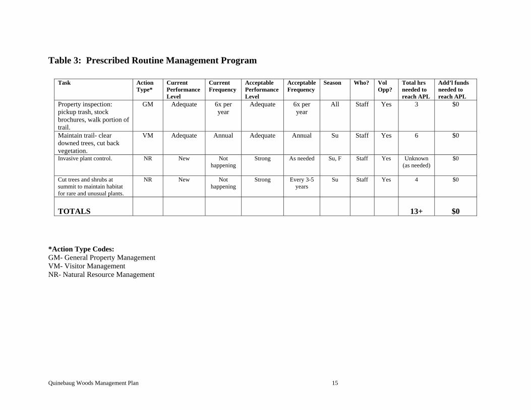
Table 3: Prescribed Routine Management Program
Task ActionType*
Current Performance Level
Current Frequency
Acceptable Performance Level
Acceptable Frequency
Season Who? VolOpp?
Total hrs needed to reach APL
Add’l funds needed to reach APL
Property inspection: pickup trash, stock brochures, walk portion of trail.
GM Adequate 6x peryear
Adequate 6x peryear
All Staff Yes 3 $0
Maintain trail- clear downed trees, cut back vegetation.
VM Adequate Annual Adequate Annual Su Staff Yes 6 $0
Invasive plant control.
NR New Nothappening
Strong As needed Su, F Staff Yes Unknown (as needed)
$0
Cut trees and shrubs at summit to maintain habitat for rare and unusual plants.
NR New Nothappening
Strong Every 3-5years
Su Staff Yes 4 $0
TOTALS
13+
$0
*Action Type Codes: GM- General Property Management VM- Visitor Management NR- Natural Resource Management
Quinebaug Woods Management Plan 15