Embed Size (px)
Citation preview
Queensland Coastal Plan
Tomorrow’s Queensland: strong, green, smart, healthy and fair
Queensland Coastal Planii
Prepared by: Environment Planning Department of Environment and Resource Management GPO Box 2454
Brisbane Qld 4001
© State of Queensland (Department of Environment and Resource Management) 2011
This document has been prepared with all due diligence and care, based on the best available information at the time of publication. The department holds no responsibility for any errors or omissions within this document. Any decisions made by other parties based on this document are solely the responsibility of those parties. Information contained in this document is from a number of sources and, as such, does not necessarily represent government or departmental policy.
If you need to access this document in a language other than English, please call the Translating and Interpreting Service (TIS National) on 131 450 and ask them to telephone Library Services on +61 7 3224 8412.
This publication can be made available in alternative formats (including large print and audiotape) on request for people with a vision impairment. Contact (07) 322 48412 or email <[email protected]>.
March 2011
#29672

Queensland Coastal Plan iii
More than 80 per cent of Queenslanders live on the coast. The state has the longest and most scenic coastline on Australia’s eastern seaboard. It is much loved by Queenslanders and visitors alike because it brings so many benefits to our economy and lifestyle.
While it remains a great place to live and work, Queensland’s coast is also home to many special environmental features worth protecting, such as ancient sand dunes, rainforests, beautiful beaches and native wildlife.
We also need to be aware that one of the greatest challenges to our coastal lifestyle and economies is sea-level rise brought about by climate change. Our coast is also facing rapid population growth. We are all responsible for ensuring it is protected for future generations and that responsible planning is promoted and entrenched from the Gold Coast to the Gulf of Carpentaria.
The Queensland Government is leading by example with the development of a new Queensland Coastal Plan to ensure that our precious coastal qualities are preserved and infrastructure and livelihoods are protected from coastal hazard impacts. It seeks to do this in a way that sees opportunities for sustainable development promoted and public access to the foreshore maintained, and where possible, enhanced.
The Queensland Coastal Plan addresses management of the coast and planning for future urban development in the coastal zone by incorporating the State Policy for Coastal Management and State Planning Policy for Coastal Protection. The Queensland Coastal Plan reduces overlap with other policy initiatives and consolidates planning and natural resource management policies with best practice guidelines.
The Queensland Coastal Plan provides greater certainty for the community, landholders, local councils and developers about how the coastal policies necessary to create sustainable and safe coastal communities will be achieved.
The Hon. Paul Lucas MP Deputy Premier Attorney-General, Minister for Local Government and Special Minister of State
The Hon. Kate Jones MP Minister for Environment and Resource Management
Foreword
Queensland Coastal Planiv
Contents
State Policy for Coastal Management ....................1
State Planning Policy for Coastal Protection ....... 33
The Queensland Coastal Plan was approved by the Queensland Government and will not commence until statutory instruments are in place. Until that occurs development proposals are to continue being assessed guided by policy contained in the existing State Coastal Management Plan.
Queensland Coastal Plan 1
State Policy for Coastal Management
Queensland Coastal Plan2
Contents
Part 1 — Introduction ...................................................... 3
Purpose............................................................................3
Application.......................................................................3
Area.to.which.the.policy.applies........................................3
Background......................................................................3
Implementation................................................................4
Part 2 — Overall policy outcomes ................................... 5
Part 3 — Specific policy outcomes .................................. 6
1.. Protecting.coastal.processes.in.erosion.prone.areas..6
Principle ...................................................................6
Policies ....................................................................6
Notes .......................................................................6
2.. Buildings.and.structures.in.erosion.prone.areas........7
Principle ...................................................................7
Policies ....................................................................7
Notes .......................................................................8
3.. Dune.management....................................................9
Principle ...................................................................9
Policies ....................................................................9
Notes .......................................................................9
4.. Management.of.areas.of.ecological.significance...... 10
Principle ................................................................. 10
Policies .................................................................. 10
Notes ..................................................................... 10
5.. Indigenous.cultural.heritage.................................... 11
Principle ................................................................. 11
Policies .................................................................. 11
Notes ..................................................................... 11
6.. Public.access.and.use.of.the.coast.......................... 12
Principle ................................................................. 12
Policies .................................................................. 12
Notes ..................................................................... 12
7.. Buildings.and.structures.on.State.coastal.land.................................................... 14
Principle ................................................................. 14
Policies .................................................................. 14
Notes ..................................................................... 14
8.. Driving.on.beaches.................................................. 15
Principle ................................................................. 15
Policies .................................................................. 15
Notes ..................................................................... 15
9.. Management.planning............................................. 17
Principle ................................................................. 17
Policies .................................................................. 17
Notes ..................................................................... 17
10.. Monitoring.and.review............................................. 19
Principle ................................................................. 19
Policies .................................................................. 19
Notes ..................................................................... 19
11.. Knowledge.sharing.and.information........................20
Principle .................................................................20
Policies ..................................................................20
Notes .....................................................................20
12.. Community.engagement.......................................... 21
Principle ................................................................. 21
Policies .................................................................. 21
Notes ..................................................................... 21
13.. Review.of.the.State.policy.for.coastal.management...............................................22
Review of the policy ................................................22
Appendices.................................................................. 23
Appendix.1.–.Locations.where.specific.management.actions.are.required........................................................23
Appendix.2.–.Coastal.land.management.plan—sample.framework......................................................................28
Appendix.3.–.References,.links.and.further.information....29
Appendix.4.–.Factors.for.determining.overriding.need.in.
the.public.interest—applicable.to.policy.6.6(a)...............32
Queensland Coastal Plan 3
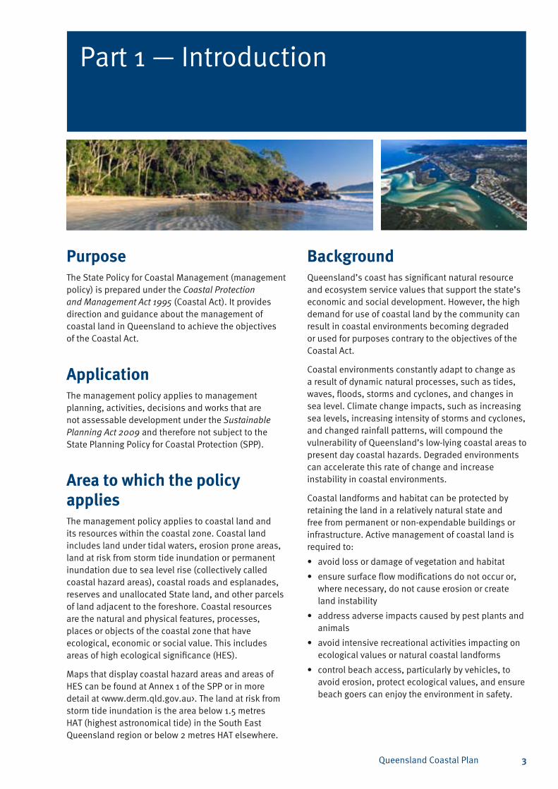
Part 1 — Introduction
Purpose The State Policy for Coastal Management (management policy) is prepared under the Coastal Protection and Management Act 1995 (Coastal Act). It provides direction and guidance about the management of coastal land in Queensland to achieve the objectives of the Coastal Act.
Application The management policy applies to management planning, activities, decisions and works that are not assessable development under the Sustainable Planning Act 2009 and therefore not subject to the State Planning Policy for Coastal Protection (SPP).
Area to which the policy appliesThe management policy applies to coastal land and its resources within the coastal zone. Coastal land includes land under tidal waters, erosion prone areas, land at risk from storm tide inundation or permanent inundation due to sea level rise (collectively called coastal hazard areas), coastal roads and esplanades, reserves and unallocated State land, and other parcels of land adjacent to the foreshore. Coastal resources are the natural and physical features, processes, places or objects of the coastal zone that have ecological, economic or social value. This includes areas of high ecological significance (HES).
Maps that display coastal hazard areas and areas of HES can be found at Annex 1 of the SPP or in more detail at <www.derm.qld.gov.au>. The land at risk from storm tide inundation is the area below 1.5 metres HAT (highest astronomical tide) in the South East Queensland region or below 2 metres HAT elsewhere.
Background Queensland’s coast has significant natural resource and ecosystem service values that support the state’s economic and social development. However, the high demand for use of coastal land by the community can result in coastal environments becoming degraded or used for purposes contrary to the objectives of the Coastal Act.
Coastal environments constantly adapt to change as a result of dynamic natural processes, such as tides, waves, floods, storms and cyclones, and changes in sea level. Climate change impacts, such as increasing sea levels, increasing intensity of storms and cyclones, and changed rainfall patterns, will compound the vulnerability of Queensland’s low-lying coastal areas to present day coastal hazards. Degraded environments can accelerate this rate of change and increase instability in coastal environments.
Coastal landforms and habitat can be protected by retaining the land in a relatively natural state and free from permanent or non-expendable buildings or infrastructure. Active management of coastal land is required to:
avoid loss or damage of vegetation and habitat•
ensure surface flow modifications do not occur or, • where necessary, do not cause erosion or create land instability
address adverse impacts caused by pest plants and • animals
avoid intensive recreational activities impacting on • ecological values or natural coastal landforms
control beach access, particularly by vehicles, to • avoid erosion, protect ecological values, and ensure beach goers can enjoy the environment in safety.
Queensland Coastal Plan4
ImplementationThe management polices are primarily intended to be implemented by the managers of state and local government controlled coastal land and owners of private coastal land. However, the policies will also be of importance for others, such as community groups, research organisations, businesses and individuals involved in undertaking activities on coastal land.
Authorities responsible for making statutory decisions about coastal land, and infrastructure organisations are to have regard to management policies in their decision-making processes. Examples of these processes include those made under the:
Environmental Protection Act 1994 •
Forestry Act 1959•
Land Act 1994 •
Local Government Act 2009 •
Marine Parks Act 2004•
Nature Conservation Act 1992 (NCA)•
Recreation Areas Management Act 2006•
State Development and Public Works Organisation • Act 1971
Transport Infrastructure Act 1994•
Vegetation Management Act 1999•
Water Act 2000.•
Most State coastal land has either been reserved for public purposes (including for coastal protection and management purposes) under the Land Act, been designated as a protected area under the NCA, is unallocated State land or is designated as esplanades or roads. Public purpose reserves are generally managed by trustees with most trustees being local government. Reserves must be managed for the purpose for which they have been reserved.
Unallocated State land, esplanades and roads are administered under the Land Act. Unless declared to be state-controlled roads (for which the Department of Transport and Main Roads is responsible) roads and esplanades are generally managed by local government. The Department of Environment and Resource Management (DERM) directly manages protected areas and unallocated State land.
Coastal land is also managed by public and corporate bodies responsible for infrastructure, such as ports, airports and marinas or minor maritime facilities, such as public boat ramps and jetties. These areas are often held under lease, reserved for relevant infrastructure purposes or held as freehold land.
Owners and occupiers of private land may undertake activities on their land provided they do so in accordance with relevant laws and policies. This includes a general environmental duty to not cause environmental harm as required by the Environmental Protection Act. Sections 3 and 4 of the management policy particularly apply to private land management activities on private land containing dunes and foreshores or areas of ecological significance.
Queensland Coastal Plan 5
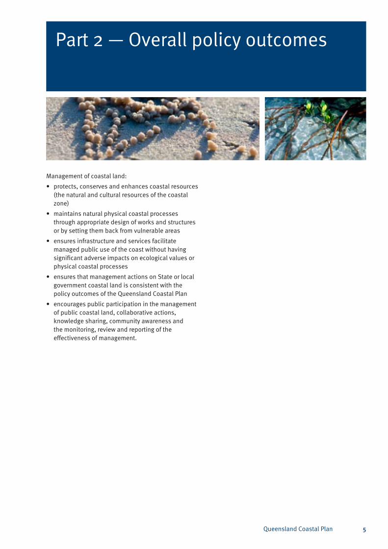
Part 2 — Overall policy outcomes
Management of coastal land:
protects, conserves and enhances coastal resources • (the natural and cultural resources of the coastal zone)
maintains natural physical coastal processes • through appropriate design of works and structures or by setting them back from vulnerable areas
ensures infrastructure and services facilitate • managed public use of the coast without having significant adverse impacts on ecological values or physical coastal processes
ensures that management actions on State or local • government coastal land is consistent with the policy outcomes of the Queensland Coastal Plan
encourages public participation in the management • of public coastal land, collaborative actions, knowledge sharing, community awareness and the monitoring, review and reporting of the effectiveness of management.
Queensland Coastal Plan6
Part 3 — Specific policy outcomes
Policies1.1 Land stabilisation against wind and water erosion
and foreshore and dune building processes are maintained by the protection, management and rehabilitation of native vegetation.
1.2 Natural fluctuations of the coast (erosion and accretion) are allowed to occur without interruption by establishing and maintaining coastal buffer zones free of buildings and structures except where they are temporary and removable and for recreation or safety purposes.
1.3 Longshore transport of sand is not disrupted by structures or dredging except where it does not significantly impact on coastal management or can be compensated for by sand bypassing or the addition of new sediment to balance the loss.
1.4 Sand volume in the dune and active beach systems which contribute to physical coastal processes is not reduced by works or structures, except where:
there is no significant impact on coastal a) processes
beach nourishment with sand from outside the b) active beach system is undertaken
the works or structures are necessary for the c) protection of property.
NotesThe coast is subject to continual change as a result of natural forces associated with the combined actions of the sea and the weather. Coastal processes transport sediment resulting in ongoing erosion or accretion of land along the coast. This policy is to ensure coastal processes are maintained, including natural fluctuations and longshore sand movement which is critical to the maintenance of beaches and foreshore areas.
Erosion prone areas are areas which are subject to coastal erosion or permanent inundation within a 50-year planning cycle. Ideally, coastal erosion should be managed by soft protection measures that involve the augmentation or relocation of natural coastal sediments. This includes beach nourishment, beach scraping and dune reprofiling.
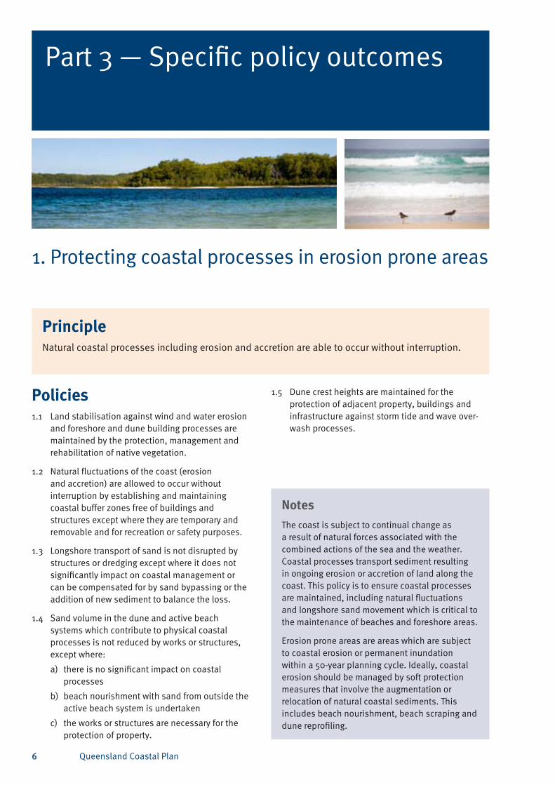
1. Protecting coastal processes in erosion prone areas
PrincipleNatural coastal processes including erosion and accretion are able to occur without interruption.
1.5 Dune crest heights are maintained for the protection of adjacent property, buildings and infrastructure against storm tide and wave over-wash processes.
Queensland Coastal Plan 7
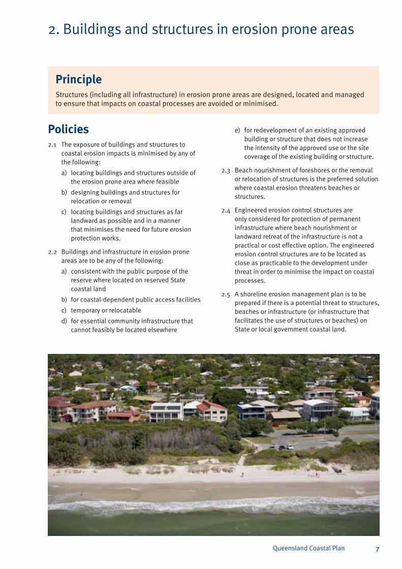
2. Buildings and structures in erosion prone areas
Policies2.1 The exposure of buildings and structures to
coastal erosion impacts is minimised by any of the following:
locating buildings and structures outside of a) the erosion prone area where feasible
designing buildings and structures for b) relocation or removal
locating buildings and structures as far c) landward as possible and in a manner that minimises the need for future erosion protection works.
2.2 Buildings and infrastructure in erosion prone areas are to be any of the following:
consistent with the public purpose of the a) reserve where located on reserved State coastal land
for coastal-dependent public access facilitiesb)
temporary or relocatablec)
for essential community infrastructure that d) cannot feasibly be located elsewhere
for redevelopment of an existing approved e) building or structure that does not increase the intensity of the approved use or the site coverage of the existing building or structure.
2.3 Beach nourishment of foreshores or the removal or relocation of structures is the preferred solution where coastal erosion threatens beaches or structures.
2.4 Engineered erosion control structures are only considered for protection of permanent infrastructure where beach nourishment or landward retreat of the infrastructure is not a practical or cost effective option. The engineered erosion control structures are to be located as close as practicable to the development under threat in order to minimise the impact on coastal processes.
2.5 A shoreline erosion management plan is to be prepared if there is a potential threat to structures, beaches or infrastructure (or infrastructure that facilitates the use of structures or beaches) on State or local government coastal land.
PrincipleStructures (including all infrastructure) in erosion prone areas are designed, located and managed to ensure that impacts on coastal processes are avoided or minimised.
Queensland Coastal Plan8
NotesInappropriately located structures, facilities and activities can adversely impact on coastal processes and result in loss of amenity, on-going public costs and risks to public safety. The intent of this policy is to manage erosion prone areas to provide and maintain a buffer between permanent buildings and structures and the landward edge of the foreshore. Managing coastal land to allow natural fluctuations of the coast to occur without interruption or intervention will ensure that, in most cases, costly works are avoided and beaches are naturally maintained.
Managing coastal processes with erosion control works such as seawalls, groynes and artificial reefs can adversely affect coastal processes by trapping or redirecting sediments. The consequence is usually the loss of sand from beaches, receding shorelines, loss of foreshore vegetation and increased coastal erosion adjacent to the area in which erosion control works are undertaken.
Where dunal buffer zones are of insufficient width to protect permanent development from coastal erosion, re-establishment or widening of the dunal buffer zone can maintain the amenity of the coast and natural coastal processes. This is achieved through beach nourishment or removal or relocation of structures on the dunes rather than engineered coastal protection. In some circumstances, land within the erosion prone area (such as clay soils and marine muds) may not be compatible with dune and beach processes or it may comprise imported fill or contaminated material. In these circumstances engineered coastal protection works may be appropriate solutions.
In areas which are under constant threat of erosion, a strategy of retreat from the erosion prone area is the preferred option. For existing development which has social and economic value, erosion control works should be initiated only as a last resort in an instance when erosion presents an immediate threat to public safety, property, and/or infrastructure that is not expendable.
Where shoreline erosion is a potential threat to development, DERM’s preferred method for managing this issue on State or local government coastal land is the preparation and implementation of a shoreline erosion management plan (SEMP). SEMPs are intended to investigate the causes of expected future impacts that erosion may cause.
NotesAnalysis of the social, environmental and economic aspects of the options then provides a robust and rigorous basis for decision making. The guideline Preparation of a Shoreline Erosion Management Plan (available at <www.derm.qld.gov.au>) provides detailed guidance on how to develop a SEMP, as does Annex 5 of the SPP guideline. Appendix 1, item 1 of this policy lists priority areas where the preparation of a SEMP is considered necessary. SEMPs may form part of a broader management plan for coastal land.
Structures and public infrastructure are essential to provide safe and equitable access to, and use of, coastal land. Suitable infrastructure for the purpose of this policy may include:
structures such as picnic tables, barbeques, • coastal trails and bikeways that—either in isolation or as part of a group of associated structures—are considered to be expendable when threatened by coastal erosion
specially designed portable or demountable • structures, such as surf life saving observation towers and equipment sheds
lookouts, shelter sheds, elevated decks and • pergolas that—either in isolation or as part of a group of associated structures—are considered to be non-permanent development
demountable structures which are not founded • on permanent concrete pads, do not require permanent services such as water, electricity or sewage and are capable of being easily and quickly removed when threatened by coastal erosion.
Unsuitable infrastructure and activities include:
permanent or non-expendable development •
rock, concrete or other fixed structures located • on the foreshore of open beaches, unless such structures are required for beach retention
buildings, car parks, roads, pipes, drains, • excavation, golf courses, and other non-coastal-dependent sporting or recreational facilities, power and telephone lines, extraction operations, sewage pump stations and similar structures
clearing, thinning, or other damage to native • vegetation except for establishing or maintaining limited recreation areas (note: fire-break clearing, mowing, and works for public safety are acceptable)
any other types of works or structures which may • lead to wind or water erosion.
Queensland Coastal Plan 9
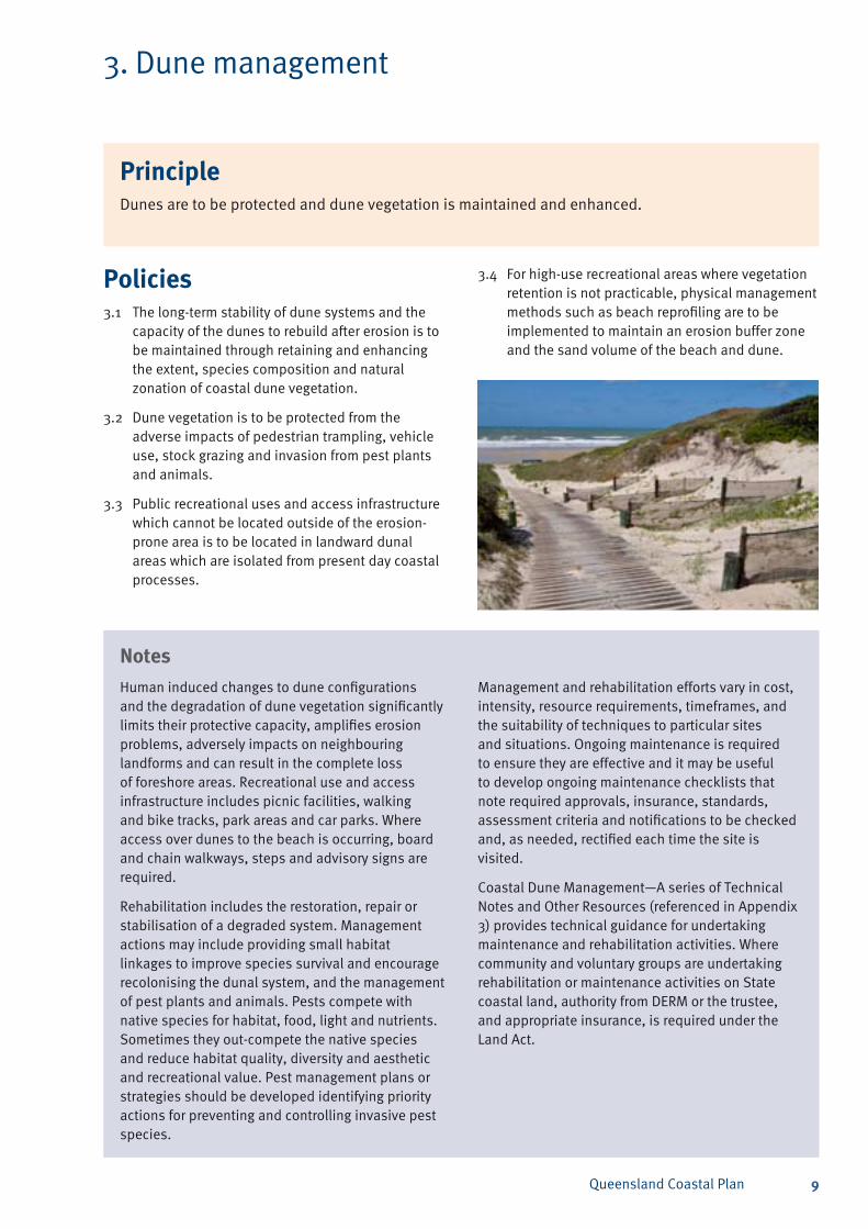
3. Dune management
Policies3.1 The long-term stability of dune systems and the
capacity of the dunes to rebuild after erosion is to be maintained through retaining and enhancing the extent, species composition and natural zonation of coastal dune vegetation.
3.2 Dune vegetation is to be protected from the adverse impacts of pedestrian trampling, vehicle use, stock grazing and invasion from pest plants and animals.
3.3 Public recreational uses and access infrastructure which cannot be located outside of the erosion-prone area is to be located in landward dunal areas which are isolated from present day coastal processes.
PrincipleDunes are to be protected and dune vegetation is maintained and enhanced.
NotesHuman induced changes to dune configurations and the degradation of dune vegetation significantly limits their protective capacity, amplifies erosion problems, adversely impacts on neighbouring landforms and can result in the complete loss of foreshore areas. Recreational use and access infrastructure includes picnic facilities, walking and bike tracks, park areas and car parks. Where access over dunes to the beach is occurring, board and chain walkways, steps and advisory signs are required.
Rehabilitation includes the restoration, repair or stabilisation of a degraded system. Management actions may include providing small habitat linkages to improve species survival and encourage recolonising the dunal system, and the management of pest plants and animals. Pests compete with native species for habitat, food, light and nutrients. Sometimes they out-compete the native species and reduce habitat quality, diversity and aesthetic and recreational value. Pest management plans or strategies should be developed identifying priority actions for preventing and controlling invasive pest species.
NotesManagement and rehabilitation efforts vary in cost, intensity, resource requirements, timeframes, and the suitability of techniques to particular sites and situations. Ongoing maintenance is required to ensure they are effective and it may be useful to develop ongoing maintenance checklists that note required approvals, insurance, standards, assessment criteria and notifications to be checked and, as needed, rectified each time the site is visited.
Coastal Dune Management—A series of Technical Notes and Other Resources (referenced in Appendix 3) provides technical guidance for undertaking maintenance and rehabilitation activities. Where community and voluntary groups are undertaking rehabilitation or maintenance activities on State coastal land, authority from DERM or the trustee, and appropriate insurance, is required under the Land Act.
3.4 For high-use recreational areas where vegetation retention is not practicable, physical management methods such as beach reprofiling are to be implemented to maintain an erosion buffer zone and the sand volume of the beach and dune.
Queensland Coastal Plan10
4. Management of areas of ecological significance
Policies4.1 Areas of HES and other ecological values are to be
protected, enhanced and rehabilitated to a natural state by:
conserving, protecting and restoring natural a) ecosystems and habitats
maintaining, enhancing or establishing habitat b) connectivity for species movement
using endemic plants species when c) undertaking rehabilitation
managing pest plants and animalsd)
restricting pedestrian and vehicle access to e) defined and managed paths and tracks
designing and locating access, paths and f) tracks to avoid sensitive areas—in particular, feeding, nesting or roosting sites of shorebirds, and nesting areas of turtles
instigating temporary or seasonal closures to g) pedestrian and/or vehicle access to protect nesting or roosting species.
4.2 Active or intensive public activities are located, and buildings and structures are sited and designed, to avoid adverse impacts on HES areas and disturbing nesting or roosting species.
4.3 Where impacts from activities, structures and infrastructure cannot feasibly be avoided, management actions are to be taken to minimise impacts, and where possible, undertake rehabilitative actions to ensure there is no loss of the impacted values overall.
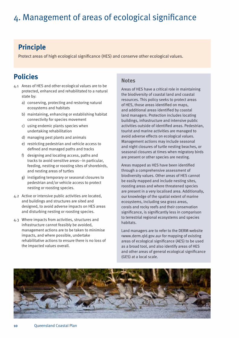
NotesAreas of HES have a critical role in maintaining the biodiversity of coastal land and coastal resources. This policy seeks to protect areas of HES, those areas identified on maps, and additional areas identified by coastal land managers. Protection includes locating buildings, infrastructure and intensive public activities outside of identified areas. Pedestrian, tourist and marine activities are managed to avoid adverse effects on ecological values. Management actions may include seasonal and night closures of turtle nesting beaches, or seasonal closures at times when migratory birds are present or other species are nesting.
Areas mapped as HES have been identified through a comprehensive assessment of biodiversity values. Other areas of HES cannot be easily mapped and include nesting sites, roosting areas and where threatened species are present in a very localised area. Additionally, our knowledge of the spatial extent of marine ecosystems, including sea grass areas, corals and rocky reefs and their conservation significance, is significantly less in comparison to terrestrial regional ecosystems and species habitats.
Land managers are to refer to the DERM website <www.derm.qld.gov.au> for mapping of existing areas of ecological significance (AES) to be used as a broad tool, and also identify areas of HES and other areas of general ecological significance (GES) at a local scale.
PrincipleProtect areas of high ecological significance (HES) and conserve other ecological values.
Queensland Coastal Plan 11
5. Indigenous cultural heritage
Policies5.1 Traditional Owners are to be encouraged to
participate in planning for the management of the coast.
NotesIndigenous Traditional Owners have been managing their cultural resources for tens of thousands of years as part of an ongoing practice of culture. The degree of Traditional Owner involvement in the management of coastal and marine areas varies and is often limited by past tenure decisions.
Currently, Indigenous Traditional Owners have varying levels of involvement in the management of their ancestral homeland estate depending on land and sea ownership, access, and opportunity or financial and material capacity. Under the Community Services (Aborigines) Act 1984 and the Community Services (Torres Strait) Act 1984, the following statutory bodies have been established to manage land under deed of grant in trust:
the Aboriginal Coordinating Council which • assists and coordinates Aboriginal councils
the Island Coordinating Council which assists • and coordinates Island councils
15 Aboriginal council areas•
16 (Torres Strait) Island council areas.•
NotesAboriginal councils and Island councils undertake the management of land and are similar to local governments in a number of functions. Indigenous Traditional Owners also have involvement in the management of land including land over which native title rights and interests have been determined, the Indigenous Land Corporation hand-backs, and acquisitions by federal and state government programs.
The participation of Traditional Owners in the preparation of management plans is essential to ensure Indigenous cultural heritage is appropriately protected and Traditional Owners are able to access their cultural resources. Incorporating Indigenous land management knowledge, where this can be provided by Traditional Owners, provides a significant and valuable contribution to the achievement of the objectives of the Coastal Act.
PrincipleThe living culture of Indigenous Traditional Owners and their connection with cultural resources on the coast and in marine areas is maintained and enhanced.
5.2 Management plans and programs are to facilitate access by the Traditional Owners to their coastal cultural resources and for undertaking cultural activities.
Queensland Coastal Plan12
6. Public access and use of the coast
Policies6.1 Use of coastal land ensures public access to the
coast is maintained or enhanced.
6.2 Exclusive private access to the foreshore and exclusive private use of beaches is to be avoided.
6.3 New public access facilities are only to be provided where:
there is a demonstrated community demand; a) or
there is a need to ensure public safety; andb)
the location, design and maintenance provides c) and enhances equitable and safe public recreation and access opportunities.
6.4 Undeveloped esplanades and road reserves on the coast that contain significant coastal resources are not to be constructed unless this is required to provide access to private property that has no other legal access.
6.5 The undeveloped roads and esplanades listed in Appendix 1, item 2 are to be retained in a natural, undeveloped state and not formally developed for vehicular purposes.
6.6 Tenure decisions for State coastal land do not result in the loss of public access to coastal land or the foreshore or public use of these areas except where:
there is an overriding need in the public a) interest consistent with the factors set out in Appendix 4, or
it is to either establish or support a public b) benefit asset.
6.7 Notwithstanding policy 6.6(a) or 6.6(b), tenure decisions are to ensure that the activity for which tenure is granted:
achieves the policy outcomes of the a) Queensland Coastal Plan to the maximum extent practicable
provides an environmental offset for any b) residual adverse impact on an area of high ecological significance that cannot be avoided as a result of undertaking the activity
provides for the natural effect of physical c) coastal processes to continue outside the area subject to the activity.
6.8 Public access facilities and walkways to the foreshore are located, designed, constructed and managed to avoid erosion, minimise footprint and prevent adverse impacts on coastal resources.
PrinciplePublic access and use of the coast is maintained and enhanced for current and future generations.
NotesThe intent of this policy is to ensure there is to be no net loss of public access to the foreshore or of public use of State coastal land, the foreshore or coastal waters, while not compromising the protection of coastal resources.
Some existing uses of State land, such as unapproved beach or fishing huts or jetties, have the potential to dictate future settlement patterns. These huts are generally inappropriately sited within areas vulnerable to coastal processes. This can lead to significant long-term costs to the community if settlements develop in these areas. The Land Act 1994 provides for the administration of permits to occupy relating to fishing huts and beach huts. This does not establish an ongoing use right.
The establishment, management and maintenance of structures, such as public access walkways and recreational facilities, are the most appropriate management responses to avoid impacts on significant species and coastal habitats. This will ensure the long-term stability of dunes and other vulnerable coastal landforms, and prevent the introduction of non-native plants and animals.
Queensland Coastal Plan 13
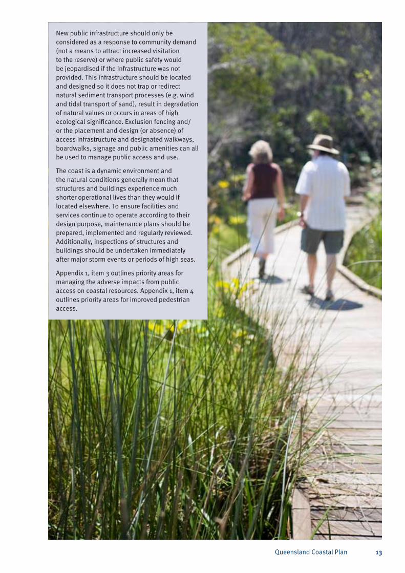
New public infrastructure should only be considered as a response to community demand (not a means to attract increased visitation to the reserve) or where public safety would be jeopardised if the infrastructure was not provided. This infrastructure should be located and designed so it does not trap or redirect natural sediment transport processes (e.g. wind and tidal transport of sand), result in degradation of natural values or occurs in areas of high ecological significance. Exclusion fencing and/or the placement and design (or absence) of access infrastructure and designated walkways, boardwalks, signage and public amenities can all be used to manage public access and use.
The coast is a dynamic environment and the natural conditions generally mean that structures and buildings experience much shorter operational lives than they would if located elsewhere. To ensure facilities and services continue to operate according to their design purpose, maintenance plans should be prepared, implemented and regularly reviewed. Additionally, inspections of structures and buildings should be undertaken immediately after major storm events or periods of high seas.
Appendix 1, item 3 outlines priority areas for managing the adverse impacts from public access on coastal resources. Appendix 1, item 4 outlines priority areas for improved pedestrian access.
Queensland Coastal Plan14
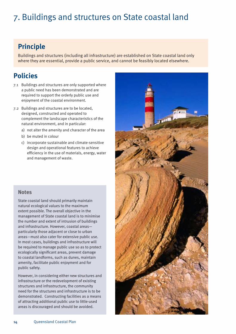
7. Buildings and structures on State coastal land
Policies7.1 Buildings and structures are only supported where
a public need has been demonstrated and are required to support the orderly public use and enjoyment of the coastal environment.
7.2 Buildings and structures are to be located, designed, constructed and operated to complement the landscape characteristics of the natural environment, and in particular:
not alter the amenity and character of the area a)
be muted in colourb)
incorporate sustainable and climate-sensitive c) design and operational features to achieve efficiency in the use of materials, energy, water and management of waste.
NotesState coastal land should primarily maintain natural ecological values to the maximum extent possible. The overall objective in the management of State coastal land is to minimise the number and extent of intrusion of buildings and infrastructure. However, coastal areas—particularly those adjacent or close to urban areas—must also cater for extensive public use. In most cases, buildings and infrastructure will be required to manage public use so as to protect ecologically significant areas, prevent damage to coastal landforms, such as dunes, maintain amenity, facilitate public enjoyment and for public safety.
However, in considering either new structures and infrastructure or the redevelopment of existing structures and infrastructure, the community need for the structures and infrastructure is to be demonstrated. Constructing facilities as a means of attracting additional public use to little-used areas is discouraged and should be avoided.
PrincipleBuildings and structures (including all infrastructure) are established on State coastal land only where they are essential, provide a public service, and cannot be feasibly located elsewhere.
Queensland Coastal Plan 15
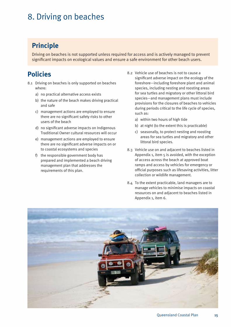
8. Driving on beaches
Policies8.1 Driving on beaches is only supported on beaches
where:
no practical alternative access exists a)
the nature of the beach makes driving practical b) and safe
management actions are employed to ensure c) there are no significant safety risks to other users of the beach
no significant adverse impacts on Indigenous d) Traditional Owner cultural resources will occur
management actions are employed to ensure e) there are no significant adverse impacts on or to coastal ecosystems and species
the responsible government body has f) prepared and implemented a beach driving management plan that addresses the requirements of this plan.
PrincipleDriving on beaches is not supported unless required for access and is actively managed to prevent significant impacts on ecological values and ensure a safe environment for other beach users.
8.2 Vehicle use of beaches is not to cause a significant adverse impact on the ecology of the foreshore—including foreshore plant and animal species, including nesting and roosting areas for sea turtles and migratory or other littoral bird species—and management plans must include provisions for the closures of beaches to vehicles during periods critical to the life cycle of species, such as:
within two hours of high tidea)
at night (to the extent this is practicable)b)
seasonally, to protect nesting and roosting c) areas for sea turtles and migratory and other littoral bird species.
8.3 Vehicle use on and adjacent to beaches listed in Appendix 1, item 5 is avoided, with the exception of access across the beach at approved boat ramps and access by vehicles for emergency or official purposes such as lifesaving activities, litter collection or wildlife management.
8.4 To the extent practicable, land managers are to manage vehicles to minimise impacts on coastal resources on and adjacent to beaches listed in Appendix 1, item 6.
Queensland Coastal Plan16
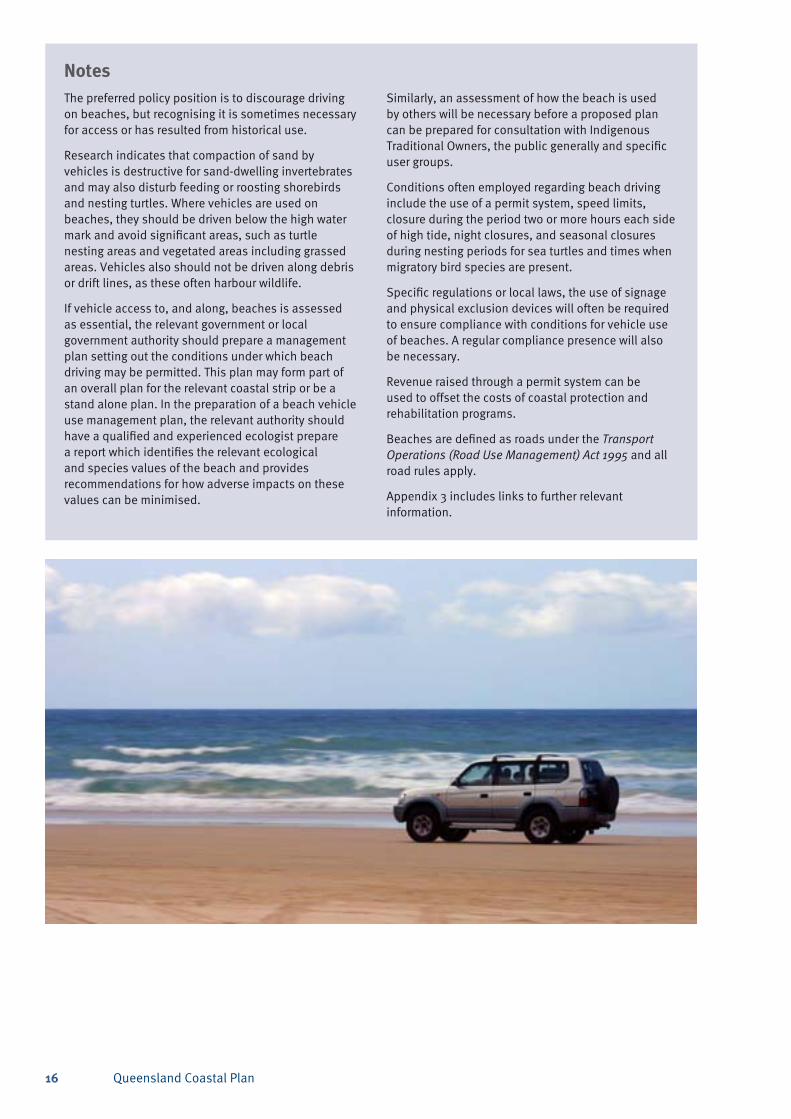
NotesThe preferred policy position is to discourage driving on beaches, but recognising it is sometimes necessary for access or has resulted from historical use.
Research indicates that compaction of sand by vehicles is destructive for sand-dwelling invertebrates and may also disturb feeding or roosting shorebirds and nesting turtles. Where vehicles are used on beaches, they should be driven below the high water mark and avoid significant areas, such as turtle nesting areas and vegetated areas including grassed areas. Vehicles also should not be driven along debris or drift lines, as these often harbour wildlife.
If vehicle access to, and along, beaches is assessed as essential, the relevant government or local government authority should prepare a management plan setting out the conditions under which beach driving may be permitted. This plan may form part of an overall plan for the relevant coastal strip or be a stand alone plan. In the preparation of a beach vehicle use management plan, the relevant authority should have a qualified and experienced ecologist prepare a report which identifies the relevant ecological and species values of the beach and provides recommendations for how adverse impacts on these values can be minimised.
NotesSimilarly, an assessment of how the beach is used by others will be necessary before a proposed plan can be prepared for consultation with Indigenous Traditional Owners, the public generally and specific user groups.
Conditions often employed regarding beach driving include the use of a permit system, speed limits, closure during the period two or more hours each side of high tide, night closures, and seasonal closures during nesting periods for sea turtles and times when migratory bird species are present.
Specific regulations or local laws, the use of signage and physical exclusion devices will often be required to ensure compliance with conditions for vehicle use of beaches. A regular compliance presence will also be necessary.
Revenue raised through a permit system can be used to offset the costs of coastal protection and rehabilitation programs.
Beaches are defined as roads under the Transport Operations (Road Use Management) Act 1995 and all road rules apply.
Appendix 3 includes links to further relevant information.

Queensland Coastal Plan 17
9. Management planning
NotesLocal area coastal management plans aim to ensure that management and maintenance activities are sensitive to the fragility of coastal land while also being effective, efficient, and practical. The type, structure, content and implementation mechanisms identified in a management plan is at the discretion of the state coastal land manager and should be tailored to suit the purpose for which the land is used and any special management considerations.
A sample land management plan template for coastal areas is included in Appendix 2. Support and guidance can be provided by DERM in relation to the coastal management components of the land management plan.
It is desirable that coastal reserves have a DERM-approved management plan which designates areas for beach access, parks or passive recreational purposes that:
avoid any sensitive natural areas, such as • wetlands, unstable dunes, or the habitats of rare and threatened species
avoid any culturally significant sites, except • where the nature of that cultural significance is consistent with its use and access by the general public
are to be available to the general public and • not confer any level of exclusivity for certain users.
The Land Act 1994 makes provision for the minister to require a trustee to prepare and submit a land management plan for reserved land managed by trustees. In some circumstances, a trustee will be required to prepare a land management plan for the primary use of the trust land, including for newly created trust land. However, it is generally a requirement that a land management plan is to be prepared when trust land is subject to secondary uses (refer to DERM’s Policy Secondary Use of Trust Land PUX/901/209).
PrincipleManagement and use of coastal land is guided by plans of management.
Policies9.1 State coastal land managers are encouraged
to prepare and implement local area coastal management plans (management plans) that achieve the outcomes of the Queensland Coastal Plan.
9.2 Management plans should preferably include a:
description of the physical coastal processes a) of the area and a statement of management practices and actions for maintaining these processes
shoreline erosion-management plan (SEMP) if b) coastal erosion is posing a threat to structures and infrastructure that cannot be relocated or removed or where the public beach may be lost
description of the natural coastal resources c) of the area and a statement of management practices and actions for their conservation or rehabilitation
description of the recreation, public access d) and scenic values of the area and a statement of the management practices and actions to be employed to manage these values
beach driving management plan if driving on e) beaches is necessary
statement of the performance indicators, f) monitoring and reporting arrangements
program of annual works and maintenance.g)
9.3 The community, Indigenous Traditional Owners, relevant interest groups and the Department of Environment and Resource Management (DERM) are to be consulted in the preparation of management plans, with a final copy of plans provided to DERM.
9.4 Management actions on State coastal land, including works and the establishment of structures and infrastructure, are to be consistent with the relevant management plan for the area, the Queensland Coastal Plan, and the purpose for which the land is reserved (where relevant).

Queensland Coastal Plan18
Guidance on management planning for trust land administered under the Land Act is provided in the Land Management Planning for Reserves or Deeds of Grant in Trust–Information Kit. The information kit may be useful to other land managers in the development of management plans regardless of the tenure of the land.
A local government may prepare a management plan for one or more trust lands of similar purpose within its jurisdiction (e.g. all reserves for beach protection and coastal management purposes within the local government area). Such a land management plan for State coastal land may complement or incorporate other relevant land management documentation such as a SEMP or a pest management plan for the local area. However, where local governments have existing coastal planning tools in place, such as foreshore master plans, it may be more efficient to incorporate the objectives of a management plan instead of having separate coastal planning documents (refer to previous policy explanations in this document for advice on additional issues to be addressed in management plans).
Local government may need to develop internal business procedures to ensure the management plan is triggered for consideration when use, management and operational decisions are to be made about coastal land.
Dealings by state land managers include resource allocation, tenure decisions, covenants and the development and implementation of management arrangements on State coastal land. Such dealings are to be consistent with the Queensland Coastal Plan and, where a management plan has been prepared, all decisions about the use of the land are to ensure that the objectives of the plan are achieved to the maximum extent practicable.
Where private interests are permitted on State coastal land they should be compatible with the policy outcomes of the Queensland Coastal Plan and requirements of management plans. Rural land managers on the coast are encouraged to prepare a property vegetation management plan that sets out how land-use activities are to be sustainably managed to maintain their important economic role in Queensland. A property vegetation management plan would include specific provisions to ensure the protection of coastal resources and their values, particularly coastal waters, dunes and areas of high ecological significance. Appendix 3 outlines additional management tools, strategies and voluntary codes of practice for primary industries.
The areas listed in Appendix 1, item 7 are to be allocated a tenure that recognises their importance in protecting coastal resources and their values.
Priority areas for local area coastal management planning are listed in Appendix 1, item 8.
Queensland Coastal Plan 19
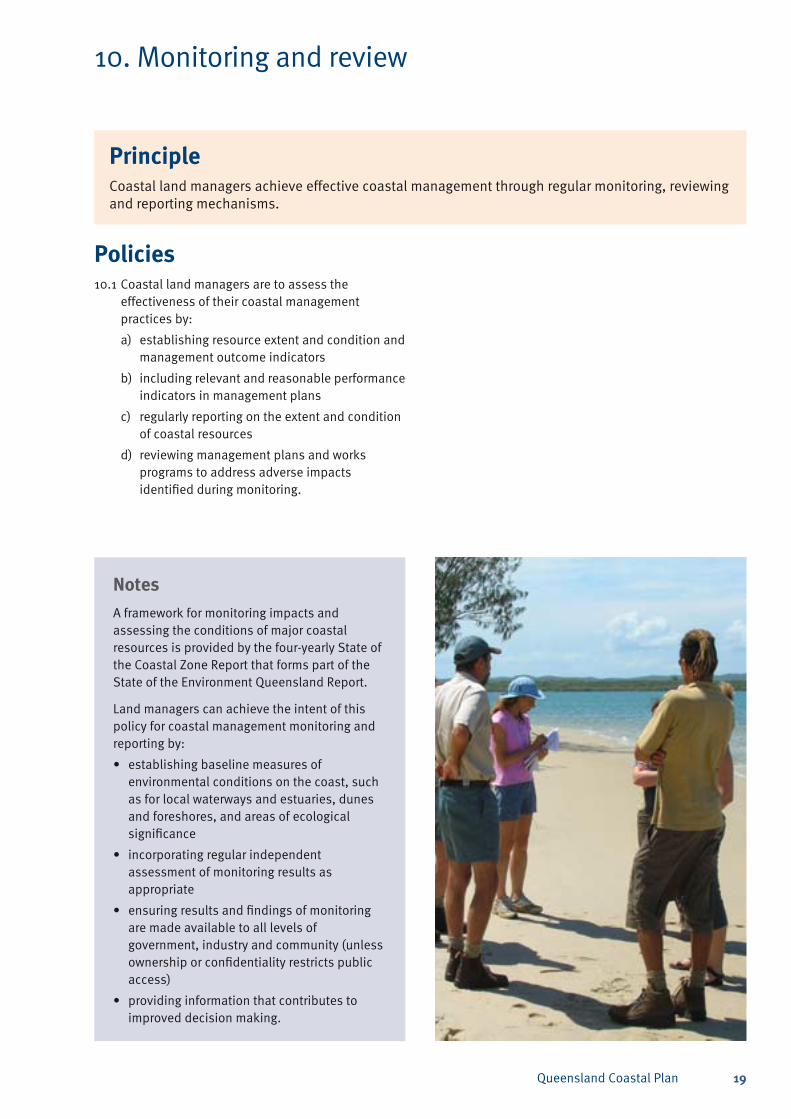
10. Monitoring and review
Policies10.1 Coastal land managers are to assess the
effectiveness of their coastal management practices by:
establishing resource extent and condition and a) management outcome indicators
including relevant and reasonable performance b) indicators in management plans
regularly reporting on the extent and condition c) of coastal resources
reviewing management plans and works d) programs to address adverse impacts identified during monitoring.
NotesA framework for monitoring impacts and assessing the conditions of major coastal resources is provided by the four-yearly State of the Coastal Zone Report that forms part of the State of the Environment Queensland Report.
Land managers can achieve the intent of this policy for coastal management monitoring and reporting by:
establishing baseline measures of • environmental conditions on the coast, such as for local waterways and estuaries, dunes and foreshores, and areas of ecological significance
incorporating regular independent • assessment of monitoring results as appropriate
ensuring results and findings of monitoring • are made available to all levels of government, industry and community (unless ownership or confidentiality restricts public access)
providing information that contributes to • improved decision making.
PrincipleCoastal land managers achieve effective coastal management through regular monitoring, reviewing and reporting mechanisms.
Queensland Coastal Plan20
11. Knowledge sharing and information
Policies11.1 Coastal land managers share knowledge of
coastal management issues through:
facilitated participation, collaboration and a) integration within, and between, programs and community networks
improved knowledge sharing between b) organisations with a common interest in maintaining and protecting coastal resources
NotesThe National Cooperative Approach to Integrated Coastal Zone Management—Framework and Implementation Plan 2006 has a fundamental goal to maintain, restore or improve coastal ecosystem quality and the societies these ecosystems support. This is essential for the achievement of long-term, ecologically sustainable development of the coast. National integrated coastal zone management seeks to achieve coastal protection and management through a holistic approach using skills and knowledge from many levels and sectors responsible for the governance, expertise and land management across coastal areas and catchments.
The managed portals of DERM and other state government departments provide access for coastal land managers and others to research data and latest developments, such as in papers, project reports, technical notes and mapping products. CoastInfo, which is accessible on the DERM website <www.derm.qld.gov.au/coastinfo> has been developed to provide a portal of relevant links to search, view and share information relevant to coastal planning, management and conservation. Two-way information sharing is also considered important between coastal managers, assessors and researchers. Collaborative projects that involve volunteers, councils, landholders and managers are encouraged to also create new pathways for knowledge transfer and reduce project costs.
NotesTo maximise CoastInfo’s effectiveness as an information portal, and subject to legal or customary constraints, all levels of government, the private sector and the community are encouraged to make accessible their coastal information that properly catalogues data and metadata and coordinates the capture and management of information.
DERM provides advice on implementing and interpreting the Queensland Coastal Plan. The department also offers support and guidance to local governments wishing to develop a local coastal management plan, shoreline erosion management plans or plans to manage vehicles on beaches.
Awareness and understanding of coastal issues can be encouraged within communities through community-based social marketing strategies and the provision of education and awareness programs and information via websites, schools, libraries, shopping centres, beachside venues, interpretive signage and information disseminated by government agencies, private land managers, and tourism and wildlife-related businesses.
Information can be obtained from the DERM website <www.derm.qld.gov.au> or by emailing queries to <[email protected]>.
PrincipleKnowledge and awareness of coastal resources and their management is shared with the community.
effective promotion of awareness and c) understanding of coastal issues to encourage environmentally responsible behaviours (stewardship) in the community.
Queensland Coastal Plan 21
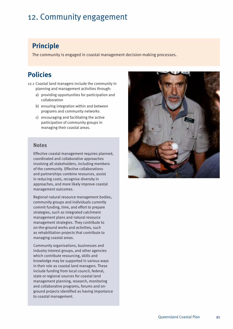
12. Community engagement
Policies12.1 Coastal land managers include the community in
planning and management activities through:
providing opportunities for participation and a) collaboration
ensuring integration within and between b) programs and community networks
encouraging and facilitating the active c) participation of community groups in managing their coastal areas.
PrincipleThe community is engaged in coastal management decision-making processes.
NotesEffective coastal management requires planned, coordinated and collaborative approaches involving all stakeholders, including members of the community. Effective collaborations and partnerships combine resources, assist in reducing costs, recognise diversity in approaches, and more likely improve coastal management outcomes.
Regional natural resource management bodies, community groups and individuals currently commit funding, time, and effort to prepare strategies, such as integrated catchment management plans and natural resource management strategies. They contribute to on-the-ground works and activities, such as rehabilitation projects that contribute to managing coastal areas.
Community organisations, businesses and industry interest groups, and other agencies which contribute resourcing, skills and knowledge may be supported in various ways in their role as coastal land managers. These include funding from local council, federal, state or regional sources for coastal land management planning, research, monitoring and collaborative programs, forums and on-ground projects identified as having importance to coastal management.
Queensland Coastal Plan22
13. Review of the State policy for coastal management
Review of the policy13.1 A report will be provided on the state of the
coast zone at least every four years as part of Queensland’s comprehensive report on the state of the environment. It will include an assessment of the condition of coastal resources and evaluate the efficiency and effectiveness of coastal management strategies, programs and activities in relation to the protection, restoration and enhancement of the coastal zone. An assessment of the coastal management policy will be included.
13.2 The policy will be reviewed within seven years of its commencement. DERM will assess the policy’s performance based on the quality and number of land management plans or shoreline erosion management plans prepared to address issues covered in this policy. Data for this assessment will be a record of advice provided by state and local government land managers at the time of the review. As part of the land management process, local land managers will be responsible for assessing the performance and outcomes of their individual coastal land management plans.
Queensland Coastal Plan 23
Appendices
Appendix 1 – Locations where specific management actions are required
Item 1Priority areas for preparation of shoreline erosion management plans (SEMP).
Refer to notes – Policy 2.
Note: SC references * are to erosion prone area maps published on DERM’s website. See <www.derm.qld.gov.au/ecoaccess/coastal_development/assessment_of_development_on_coastal_land/ erosion_prone_areas.html>.
Some localities may already have shoreline erosion management plans in use, or currently be in the process of developing a SEMP.
South-east Queensland coastMaroochy–SC3369*•
Caloundra–SC3368*•
Caboolture–SC3367*•
Pine Rivers–SC4002*•
Redcliffe–SC4006*•
Brisbane–SC3366*•
Redland, in particular Amity Point–SC3365*•
Logan–SC4072*•
Beaudesert–SC4071*•
Ipswich–SC4074*•
Gold Coast–SC3363* and SC3364*.•
Curtis coast Curtis Coast Region–SC3379* and SC3380*•
Bangalee, Wild Cattle Island•
Heron Island•
Seaward side of Curtis Island and Facing Island•
Mainland foreshore between Boyne Island and • Colosseum Inlet
Toogoom•
Heron Island. •
Cardwell–Hinchinbrook coastHinchinbrook Shire–SC3392*•
Cardwell Shire (former)–SC3393*•
South Mission Beach foreshore•
Hull Heads (north of Tully Heads, Rockingham • Parish)
Tully Heads (south of South Mission Beach, • Rockingham Parish)
Cardwell•
Dungeness (between Lucinda and the mouth of the • Seymour River, Marathon Parish)
Lucinda (Cordelia Parish)•
Taylors Beach foreshore (south of Lucinda, Cordelia • Parish)
Cassady Beach dunes (Forrest Beach, Cordelia • Parish).
Wet tropical coastJohnstone Shire Council (former)–SC3395*•
Kurrimine Beach•
Coconuts•
Flying Fish Point•
Cairns City Council (former)–SC3394*•
Brampton Beach•
Machans and Holloways beaches•
Trinity Beach•
Kewarra Beach•
Clifton Beach•
Palm Beach at Palm Cove•
Green Island•
Cooya and Palm Beach•
Douglas Shire Council (former)–SC3396*•
Ellis Beach•
Wonga Beach to Dayman Point. •
Queensland Coastal Plan24
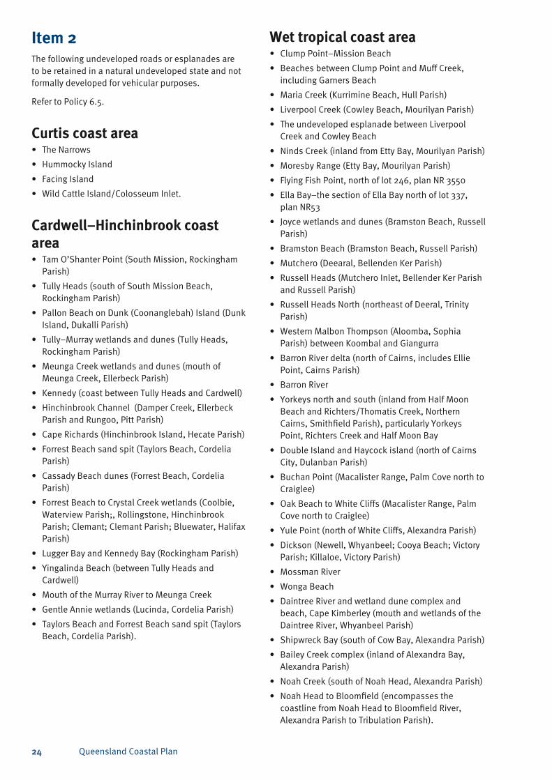
Item 2The following undeveloped roads or esplanades are to be retained in a natural undeveloped state and not formally developed for vehicular purposes.
Refer to Policy 6.5.
Curtis coast areaThe Narrows •
Hummocky Island•
Facing Island •
Wild Cattle Island/Colosseum Inlet. •
Cardwell–Hinchinbrook coast area
Tam O’Shanter Point (South Mission, Rockingham • Parish)
Tully Heads (south of South Mission Beach, • Rockingham Parish)
Pallon Beach on Dunk (Coonanglebah) Island (Dunk • Island, Dukalli Parish)
Tully–Murray wetlands and dunes (Tully Heads, • Rockingham Parish)
Meunga Creek wetlands and dunes (mouth of • Meunga Creek, Ellerbeck Parish)
Kennedy (coast between Tully Heads and Cardwell)•
Hinchinbrook Channel (Damper Creek, Ellerbeck • Parish and Rungoo, Pitt Parish)
Cape Richards (Hinchinbrook Island, Hecate Parish)•
Forrest Beach sand spit (Taylors Beach, Cordelia • Parish)
Cassady Beach dunes (Forrest Beach, Cordelia • Parish)
Forrest Beach to Crystal Creek wetlands (Coolbie, • Waterview Parish;, Rollingstone, Hinchinbrook Parish; Clemant; Clemant Parish; Bluewater, Halifax Parish)
Lugger Bay and Kennedy Bay (Rockingham Parish)•
Yingalinda Beach (between Tully Heads and • Cardwell)
Mouth of the Murray River to Meunga Creek•
Gentle Annie wetlands (Lucinda, Cordelia Parish)•
Taylors Beach and Forrest Beach sand spit (Taylors • Beach, Cordelia Parish).
Wet tropical coast areaClump Point–Mission Beach•
Beaches between Clump Point and Muff Creek, • including Garners Beach
Maria Creek (Kurrimine Beach, Hull Parish)•
Liverpool Creek (Cowley Beach, Mourilyan Parish)•
The undeveloped esplanade between Liverpool • Creek and Cowley Beach
Ninds Creek (inland from Etty Bay, Mourilyan Parish)•
Moresby Range (Etty Bay, Mourilyan Parish)•
Flying Fish Point, north of lot 246, plan NR 3550•
Ella Bay–the section of Ella Bay north of lot 337, • plan NR53
Joyce wetlands and dunes (Bramston Beach, Russell • Parish)
Bramston Beach (Bramston Beach, Russell Parish)•
Mutchero (Deearal, Bellenden Ker Parish)•
Russell Heads (Mutchero Inlet, Bellender Ker Parish • and Russell Parish)
Russell Heads North (northeast of Deeral, Trinity • Parish)
Western Malbon Thompson (Aloomba, Sophia • Parish) between Koombal and Giangurra
Barron River delta (north of Cairns, includes Ellie • Point, Cairns Parish)
Barron River•
Yorkeys north and south (inland from Half Moon • Beach and Richters/Thomatis Creek, Northern Cairns, Smithfield Parish), particularly Yorkeys Point, Richters Creek and Half Moon Bay
Double Island and Haycock island (north of Cairns • City, Dulanban Parish)
Buchan Point (Macalister Range, Palm Cove north to • Craiglee)
Oak Beach to White Cliffs (Macalister Range, Palm • Cove north to Craiglee)
Yule Point (north of White Cliffs, Alexandra Parish)•
Dickson (Newell, Whyanbeel; Cooya Beach; Victory • Parish; Killaloe, Victory Parish)
Mossman River•
Wonga Beach•
Daintree River and wetland dune complex and • beach, Cape Kimberley (mouth and wetlands of the Daintree River, Whyanbeel Parish)
Shipwreck Bay (south of Cow Bay, Alexandra Parish)•
Bailey Creek complex (inland of Alexandra Bay, • Alexandra Parish)
Noah Creek (south of Noah Head, Alexandra Parish)•
Noah Head to Bloomfield (encompasses the • coastline from Noah Head to Bloomfield River, Alexandra Parish to Tribulation Parish).
Queensland Coastal Plan 25
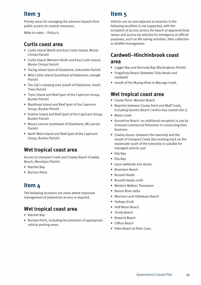
Item 3Priority areas for managing the adverse impacts from public access on coastal resources.
Refer to notes – Policy 6.
Curtis coast areaCurtis Island (North and East Curtis Island, Monte • Christo Parish)
Curtis Island (Western North and East Curtis Island, • Monte Christo Parish)
Facing Island (east of Gladstone, Gatcombe Parish)•
Wild Cattle Island (southeast of Gladstone, Iveragh • Parish)
The Lily’s camping area (south of Gladstone, South • Trees Parish)
Tryon Island and Reef (part of the Capricorn Group, • Bunker Parish)
Masthead Island and Reef (part of the Capricorn • Group, Bunker Parish)
Erskine Island and Reef (part of the Capricorn Group, • Bunker Parish)
Mount Larcom (northwest of Gladstone, Mt Larcom • Parish)
North West Island and Reef (part of the Capricorn • Group, Bunker Parish).
Wet tropical coast areaAccess to Liverpool Creek and Cowley Beach (Cowley Beach, Mourilyan Parish)
Ratchet Bay•
Buchan Point.•
Item 4The following locations are areas where improved management of pedestrian access is required.
Wet tropical coast areaRatchet Bay•
Buchan Point, including the provision of appropriate • vehicle parking areas.
Item 5Vehicle use on and adjacent to beaches in the following localities is not supported, with the exception of access across the beach at approved boat ramps and access by vehicles for emergency or official purposes, such as life saving activities, litter collection or wildlife management.
Cardwell–Hinchinbrook coast area
Lugger Bay and Kennedy Bay (Rockingham Parish)•
Yingalinda Beach (between Tully Heads and • Cardwell)
mouth of the Murray River to Meunga Creek.•
Wet tropical coast areaClump Point–Mission Beach•
Beaches between Clump Point and Muff Creek, • including Garners Beach ( within key coastal site 1)
Maria Creek•
Kurramine Beach–an additional exception is use by • licensed commercial fishermen in conducting their business
Cowley dunes–between the township and the • mouth of Liverpool Creek (the existing track on the esplanade south of the township is suitable for managed vehicle use)
Etty Bay•
Ella Bay•
Joyce wetlands and dunes•
Bramston Beach•
Russell Heads•
Russell Heads north•
Western Malbon Thompson•
Barron River delta•
Machans and Holloways Beach•
Yorkeys Knob•
Half Moon Beach•
Trinity Beach•
Kewarra Beach•
Clifton Beach•
Palm Beach at Palm Cove.•
Queensland Coastal Plan26
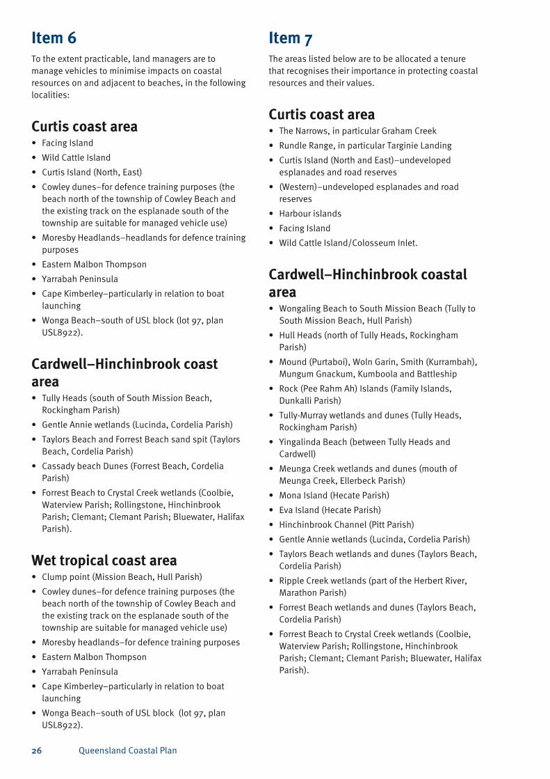
Item 6To the extent practicable, land managers are to manage vehicles to minimise impacts on coastal resources on and adjacent to beaches, in the following localities:
Curtis coast areaFacing Island •
Wild Cattle Island •
Curtis Island (North, East)•
Cowley dunes–for defence training purposes (the • beach north of the township of Cowley Beach and the existing track on the esplanade south of the township are suitable for managed vehicle use)
Moresby Headlands–headlands for defence training • purposes
Eastern Malbon Thompson•
Yarrabah Peninsula•
Cape Kimberley–particularly in relation to boat • launching
Wonga Beach–south of USL block (lot 97, plan • USL8922).
Cardwell–Hinchinbrook coast area
Tully Heads (south of South Mission Beach, • Rockingham Parish)
Gentle Annie wetlands (Lucinda, Cordelia Parish)•
Taylors Beach and Forrest Beach sand spit (Taylors • Beach, Cordelia Parish)
Cassady beach Dunes (Forrest Beach, Cordelia • Parish)
Forrest Beach to Crystal Creek wetlands (Coolbie, • Waterview Parish; Rollingstone, Hinchinbrook Parish; Clemant; Clemant Parish; Bluewater, Halifax Parish).
Wet tropical coast areaClump point (Mission Beach, Hull Parish)•
Cowley dunes–for defence training purposes (the • beach north of the township of Cowley Beach and the existing track on the esplanade south of the township are suitable for managed vehicle use)
Moresby headlands–for defence training purposes•
Eastern Malbon Thompson•
Yarrabah Peninsula•
Cape Kimberley–particularly in relation to boat • launching
Wonga Beach–south of USL block (lot 97, plan • USL8922).
Item 7The areas listed below are to be allocated a tenure that recognises their importance in protecting coastal resources and their values.
Curtis coast areaThe Narrows, in particular Graham Creek•
Rundle Range, in particular Targinie Landing•
Curtis Island (North and East)–undeveloped • esplanades and road reserves
(Western)–undeveloped esplanades and road • reserves
Harbour islands•
Facing Island•
Wild Cattle Island/Colosseum Inlet.•
Cardwell–Hinchinbrook coastal area
Wongaling Beach to South Mission Beach (Tully to • South Mission Beach, Hull Parish)
Hull Heads (north of Tully Heads, Rockingham • Parish)
Mound (Purtaboi), Woln Garin, Smith (Kurrambah), • Mungum Gnackum, Kumboola and Battleship
Rock (Pee Rahm Ah) Islands (Family Islands, • Dunkalli Parish)
Tully-Murray wetlands and dunes (Tully Heads, • Rockingham Parish)
Yingalinda Beach (between Tully Heads and • Cardwell)
Meunga Creek wetlands and dunes (mouth of • Meunga Creek, Ellerbeck Parish)
Mona Island (Hecate Parish)•
Eva Island (Hecate Parish)•
Hinchinbrook Channel (Pitt Parish)•
Gentle Annie wetlands (Lucinda, Cordelia Parish)•
Taylors Beach wetlands and dunes (Taylors Beach, • Cordelia Parish)
Ripple Creek wetlands (part of the Herbert River, • Marathon Parish)
Forrest Beach wetlands and dunes (Taylors Beach, • Cordelia Parish)
Forrest Beach to Crystal Creek wetlands (Coolbie, • Waterview Parish; Rollingstone, Hinchinbrook Parish; Clemant; Clemant Parish; Bluewater, Halifax Parish).
Queensland Coastal Plan 27
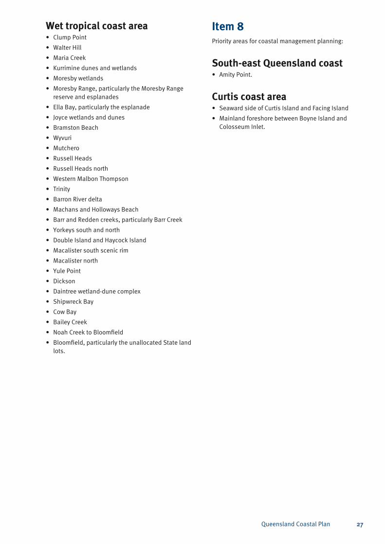
Wet tropical coast areaClump Point•
Walter Hill•
Maria Creek•
Kurrimine dunes and wetlands•
Moresby wetlands•
Moresby Range, particularly the Moresby Range • reserve and esplanades
Ella Bay, particularly the esplanade•
Joyce wetlands and dunes•
Bramston Beach•
Wyvuri•
Mutchero•
Russell Heads•
Russell Heads north•
Western Malbon Thompson•
Trinity•
Barron River delta•
Machans and Holloways Beach•
Barr and Redden creeks, particularly Barr Creek•
Yorkeys south and north•
Double Island and Haycock Island•
Macalister south scenic rim•
Macalister north•
Yule Point•
Dickson•
Daintree wetland-dune complex•
Shipwreck Bay•
Cow Bay•
Bailey Creek•
Noah Creek to Bloomfield•
Bloomfield, particularly the unallocated State land • lots.
Item 8Priority areas for coastal management planning:
South-east Queensland coastAmity Point.•
Curtis coast areaSeaward side of Curtis Island and Facing Island•
Mainland foreshore between Boyne Island and • Colosseum Inlet.
Queensland Coastal Plan28
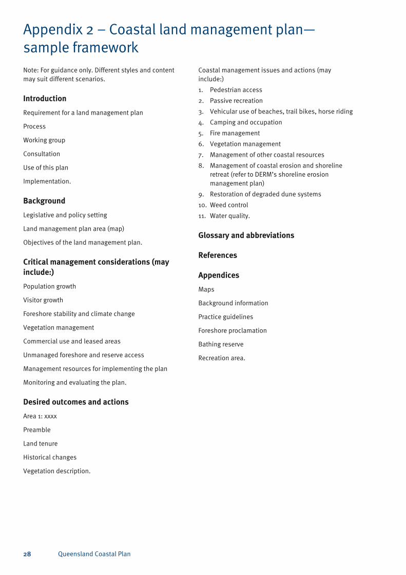
Appendix 2 – Coastal land management plan—sample frameworkNote: For guidance only. Different styles and content may suit different scenarios.
Introduction
Requirement for a land management plan
Process
Working group
Consultation
Use of this plan
Implementation.
Background
Legislative and policy setting
Land management plan area (map)
Objectives of the land management plan.
Critical management considerations (may include:)
Population growth
Visitor growth
Foreshore stability and climate change
Vegetation management
Commercial use and leased areas
Unmanaged foreshore and reserve access
Management resources for implementing the plan
Monitoring and evaluating the plan.
Desired outcomes and actions
Area 1: xxxx
Preamble
Land tenure
Historical changes
Vegetation description.
Coastal management issues and actions (may include:)
Pedestrian access1.
Passive recreation2.
Vehicular use of beaches, trail bikes, horse riding 3.
Camping and occupation4.
Fire management5.
Vegetation management6.
Management of other coastal resources7.
Management of coastal erosion and shoreline 8. retreat (refer to DERM’s shoreline erosion management plan)
Restoration of degraded dune systems9.
Weed control10.
Water quality.11.
Glossary and abbreviations
References
Appendices
Maps
Background information
Practice guidelines
Foreshore proclamation
Bathing reserve
Recreation area.
Queensland Coastal Plan 29
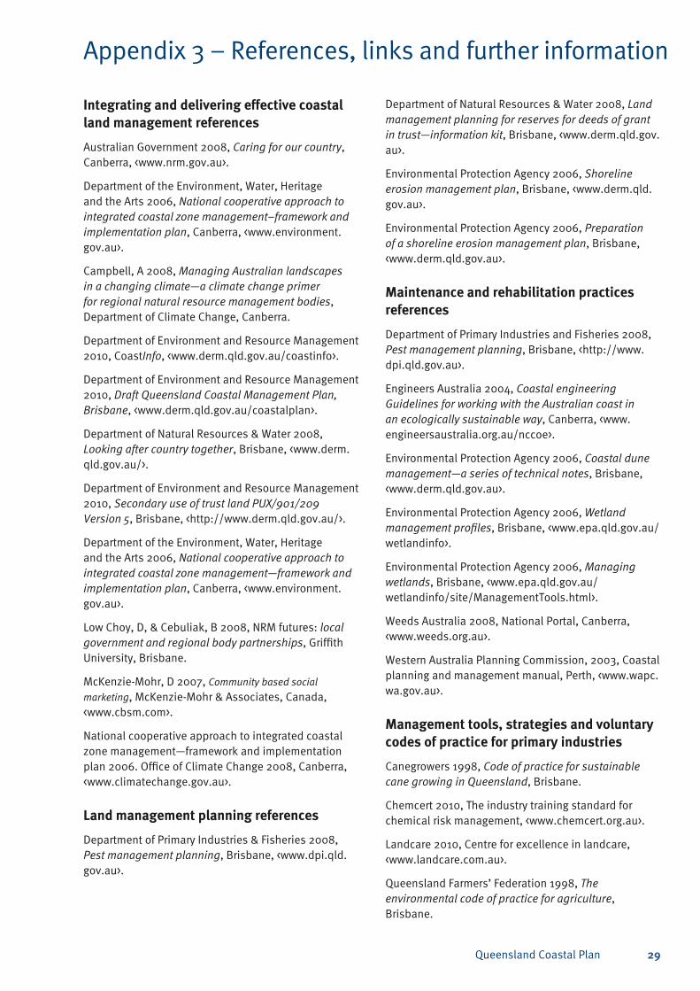
Integrating and delivering effective coastal land management references
Australian Government 2008, Caring for our country, Canberra, <www.nrm.gov.au>.
Department of the Environment, Water, Heritage and the Arts 2006, National cooperative approach to integrated coastal zone management–framework and implementation plan, Canberra, <www.environment.gov.au>.
Campbell, A 2008, Managing Australian landscapes in a changing climate—a climate change primer for regional natural resource management bodies, Department of Climate Change, Canberra.
Department of Environment and Resource Management 2010, CoastInfo, <www.derm.qld.gov.au/coastinfo>.
Department of Environment and Resource Management 2010, Draft Queensland Coastal Management Plan, Brisbane, <www.derm.qld.gov.au/coastalplan>.
Department of Natural Resources & Water 2008, Looking after country together, Brisbane, <www.derm.qld.gov.au/>.
Department of Environment and Resource Management 2010, Secondary use of trust land PUX/901/209 Version 5, Brisbane, <http://www.derm.qld.gov.au/>.
Department of the Environment, Water, Heritage and the Arts 2006, National cooperative approach to integrated coastal zone management—framework and implementation plan, Canberra, <www.environment.gov.au>.
Low Choy, D, & Cebuliak, B 2008, NRM futures: local government and regional body partnerships, Griffith University, Brisbane.
McKenzie-Mohr, D 2007, Community based social
marketing, McKenzie-Mohr & Associates, Canada, <www.cbsm.com>.
National cooperative approach to integrated coastal zone management—framework and implementation plan 2006. Office of Climate Change 2008, Canberra, <www.climatechange.gov.au>.
Land management planning references
Department of Primary Industries & Fisheries 2008, Pest management planning, Brisbane, <www.dpi.qld.gov.au>.
Appendix 3 – References, links and further information
Department of Natural Resources & Water 2008, Land management planning for reserves for deeds of grant in trust—information kit, Brisbane, <www.derm.qld.gov.au>.
Environmental Protection Agency 2006, Shoreline erosion management plan, Brisbane, <www.derm.qld.gov.au>.
Environmental Protection Agency 2006, Preparation of a shoreline erosion management plan, Brisbane, <www.derm.qld.gov.au>.
Maintenance and rehabilitation practices references
Department of Primary Industries and Fisheries 2008, Pest management planning, Brisbane, <http://www.dpi.qld.gov.au>.
Engineers Australia 2004, Coastal engineering Guidelines for working with the Australian coast in an ecologically sustainable way, Canberra, <www.engineersaustralia.org.au/nccoe>.
Environmental Protection Agency 2006, Coastal dune management—a series of technical notes, Brisbane, <www.derm.qld.gov.au>.
Environmental Protection Agency 2006, Wetland management profiles, Brisbane, <www.epa.qld.gov.au/wetlandinfo>.
Environmental Protection Agency 2006, Managing wetlands, Brisbane, <www.epa.qld.gov.au/wetlandinfo/site/ManagementTools.html>.
Weeds Australia 2008, National Portal, Canberra, <www.weeds.org.au>.
Western Australia Planning Commission, 2003, Coastal planning and management manual, Perth, <www.wapc.wa.gov.au>.
Management tools, strategies and voluntary codes of practice for primary industries
Canegrowers 1998, Code of practice for sustainable cane growing in Queensland, Brisbane.
Chemcert 2010, The industry training standard for chemical risk management, <www.chemcert.org.au>.
Landcare 2010, Centre for excellence in landcare, <www.landcare.com.au>.
Queensland Farmers’ Federation 1998, The environmental code of practice for agriculture, Brisbane.
Queensland Coastal Plan30
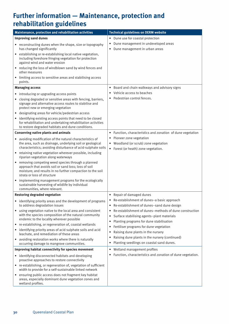
Further information — Maintenance, protection and rehabilitation guidelines
Maintenance, protection and rehabilitation activities Technical guidelines on DERM website
Improving sand dunes
reconstructing dunes when the shape, size or topography • has changed significantly
establishing or re-establishing local native vegetation, • including foreshore fringing vegetation for protection against wind and water erosion
reducing the loss of windblown sand by wind fences and • other measures
limiting access to sensitive areas and stabilising access • points.
Dune use for coastal protection•
Dune management in undeveloped areas•
Dune management in urban areas•
Managing access
introducing or upgrading access points•
closing degraded or sensitive areas with fencing, barriers, • signage and alternative access routes to stabilise and protect new or emerging vegetation
designating areas for vehicle/pedestrian access•
identifying existing access points that need to be closed • for rehabilitation and undertaking rehabilitation activities to restore degraded habitats and dune conditions.
Board and chain walkways and advisory signs•
Vehicle access to beaches•
Pedestrian control fences.•
Conserving native plants and animals
avoiding modification of the natural characteristics of • the area, such as drainage, underlying soil or geological characteristics; avoiding disturbance of acid-sulphate soils
retaining native vegetation wherever possible, including • riparian vegetation along waterways
removing competing weed species through a planned • approach that avoids soil or sand loss; loss of soil moisture; and results in no further compaction to the soil strata or loss of structure
implementing management programs for the ecologically • sustainable harvesting of wildlife by individual communities, where relevant.
Function, characteristics and zonation of dune vegetation•
Pioneer zone vegetation•
Woodland (or scrub) zone vegetation•
Forest (or heath) zone vegetation.•
Restoring degraded vegetation
identifying priority areas and the development of programs • to address degradation issues
using vegetation native to the local area and consistent • with the species composition of the natural community endemic to the locality wherever possible
re-establishing, or regeneration of, coastal wetlands •
identifying priority areas of acid sulphate soils and acid • leachate, and remediation of these areas
avoiding restoration works where there is naturally • occurring damage to mangrove communities.
Repair of damaged dunes•
Re-establishment of dunes–a basic approach•
Re-establishment of dunes–sand dune design•
Re-establishment of dunes–methods of dune construction•
Surface stabilising agents–plant materials •
Planting programs for dune stabilisation•
Fertiliser programs for dune vegetation•
Raising dune plants in the nursery•
Raising dune plants in the nursery (continued)•
Planting seedlings on coastal sand dunes.•
Improving habitat connectivity for species movement
identifying disconnected habitats and developing • proactive approaches to restore connectivity
re-establishing, or regeneration of, vegetation of sufficient • width to provide for a self-sustainable linked network
ensuring public access does not fragment key habitat • areas, especially dominant dune vegetation zones and wetland profiles.
Wetland management profiles•
Function, characteristics and zonation of dune vegetation.•
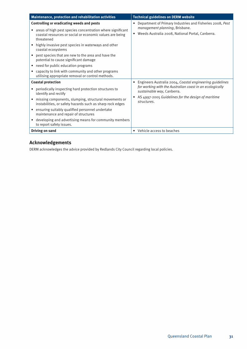
Queensland Coastal Plan 31
Maintenance, protection and rehabilitation activities Technical guidelines on DERM website
Controlling or eradicating weeds and pests
areas of high pest species concentration where significant • coastal resources or social or economic values are being threatened
highly invasive pest species in waterways and other • coastal ecosystems
pest species that are new to the area and have the • potential to cause significant damage
need for public education programs•
capacity to link with community and other programs • utilising appropriate removal or control methods.
Department of Primary Industries and Fisheries 2008, • Pest management planning, Brisbane.
Weeds Australia 2008, National Portal, Canberra.•
Coastal protection
periodically inspecting hard protection structures to • identify and rectify
missing components, slumping, structural movements or • instabilities, or safety hazards such as sharp rock edges
ensuring suitably qualified personnel undertake • maintenance and repair of structures
developing and advertising means for community members • to report safety issues.
Engineers Australia 2004, • Coastal engineering guidelines for working with the Australian coast in an ecologically sustainable way, Canberra.
AS 4997-2005 • Guidelines for the design of maritime structures.
Driving on sand Vehicle access to beaches•
AcknowledgementsDERM acknowledges the advice provided by Redlands City Council regarding local policies.
Queensland Coastal Plan32
Appendix 4 — Factors for determining overriding need in the public interest—applicable to policy 6.6(a)A4.1 The applicant for the tenure must establish:
that the overall social, economic and a) environmental benefits of granting the tenure outweigh the conflict with the policy outcome; and
the activity for which the tenure is to be b) granted cannot be located elsewhere so as to avoid conflicting with the policy outcome.
A4.2 The following do not establish an overriding need in the public interest:
uses requiring relatively few locational a) requirements to function; or
an interest in or options over a site; or b)
a site’s availability.c)
Queensland Coastal Plan 33
State Planning Policy for Coastal Protection
Queensland Coastal Plan34
Contents
Part A — Explanatory statement ................................... 35
Purpose .........................................................................35
Background ...................................................................35
Implementing the policy ................................................36
Reflecting regional plans in designated regions .............36
Part B — Application of the policy................................. 37
State planning policy and State planning policy guidelines ............................................................37
Area to which the policy applies .....................................37
Development to which the policy applies for preparing planning instruments and designations ...........................................................37
Development to which the policy applies for development assessment .........................................37
Development outside the scope of the policy for development assessment ...............................38
Part C — Overall policy outcome ................................... 39
1.. Land-use.planning...................................................40
Principle .................................................................40
Policies ..................................................................40
Notes ..................................................................... 41
2.. Coastal.hazards.......................................................42
Principle .................................................................42
Policies ..................................................................42
2.1 Defining coastal hazrd areas .....................42
Notes ........................................................42
2.2 Where development may occur in coastal hazard areas .................................43
Notes ........................................................43
2.3 Development in an erosion prone area ..........................................................44
Notes ........................................................44
2.4 Coastal protection work.............................46
Notes ........................................................46
2.5 Development in high and medium coastal hazard areas .................................47
Notes ........................................................47
3.. Nature.conservation................................................49
Principle .................................................................49
Policies ..................................................................49
Notes .....................................................................49
4.. Scenic.amenity........................................................ 51
Principle ................................................................. 51
Policies .................................................................. 51
Notes ..................................................................... 51
5.. Public.access..........................................................52
Principle .................................................................52
Policies ..................................................................52
Notes .....................................................................53
6.. Coastal-dependent.development.............................54
Principle .................................................................54
Policies ..................................................................54
6.1 Development in a designated maritime development area.......................54
Notes ........................................................54
6.2 Development for minor public maritime infrastructure .............................. 55
Notes ........................................................ 55
6.3 Private marine access structures ...............56
Notes ........................................................56
6.4 Aquaculture .............................................. 57
Notes ........................................................ 57
6.5 Dredging and disposal of dredged material ....................................................58
Notes ........................................................58
6.6 Reclamation ..............................................59
Notes ........................................................59
7.. Canals.and.artificial.waterways............................... 60
Principle ................................................................ 60
Policies ................................................................. 60
Part D — Acceptable circumstances for not fully achieving the policy ..................................................... 61
Part E — Implementation .............................................. 62
Making or amending a planning instrument ...................62
Development assessment ..............................................62
Part F — Information and advice on the policy .............. 63
Sources of information and advice .................................63
Review of the policy .......................................................63
Annexes ....................................................................... 64
Annex 1 — Maps of the Queensland coastal zone ...........64
Annex 2 — Development assessment code ....................74
Annex 3 — Storm-tide inundation areas .........................94
Annex 4 — Planning requirements for specified areas ... 96
Annex 5 — Factors for determining overriding need in the public interest .............................................97
Glossary ......................................................................98
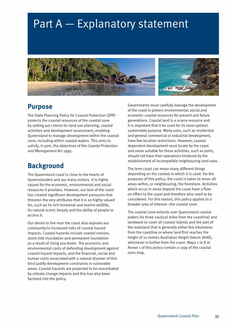
Queensland Coastal Plan 35
Part A — Explanatory statement
PurposeThe State Planning Policy for Coastal Protection (SPP) protects the coastal resources of the coastal zone by setting out criteria for land-use planning, coastal activities and development assessment, enabling Queensland to manage development within the coastal zone, including within coastal waters. This aims to satisfy, in part, the objectives of the Coastal Protection and Management Act 1995.
Background The Queensland coast is close to the hearts of Queenslanders and our many visitors. It is highly valued for the economic, environmental and social resources it provides. However, our love of the coast has created significant development pressures that threaten the very attributes that it is so highly valued for, such as its rich terrestrial and marine wildlife, its natural scenic beauty and the ability of people to access it.
Our desire to live near the coast also exposes our community to increased risks of coastal hazard impacts. Coastal hazards include coastal erosion, storm tide inundation and permanent inundation as a result of rising sea levels. The economic and environmental costs of defending development against coastal hazard impacts, and the financial, social and human costs associated with a natural disaster of this kind justify development constraints in vulnerable areas. Coastal hazards are projected to be exacerbated by climate change impacts and this has also been factored into the policy.
Governments must carefully manage the development of the coast to protect environmental, social and economic coastal resources for present and future generations. Coastal land is a scarce resource and it is important that it be used for its most optimal sustainable purpose. Many uses, such as residential and general commercial or industrial development, have few location restrictions. However, coastal-dependent development must locate by the coast and areas suitable for these activities, such as ports, should not have their operations hindered by the establishment of incompatible neighbouring land uses.
The term coast can mean many different things depending on the context in which it is used. For the purposes of this policy, the coast is taken to mean all areas within, or neighbouring, the foreshore. Activities which occur in areas beyond the coast have a flow-on effect to the coast and therefore also need to be considered. For this reason, this policy applies to a broader area of interest—the coastal zone.
The coastal zone extends over Queensland coastal waters (to three nautical miles from the coastline) and landward to cover all coastal islands and the part of the mainland that is generally either five kilometres from the coastline or where land first reaches the height of 10 metres Australian Height Datum (AHD), whichever is further from the coast. Maps 1 to 8 at Annex 1 of this policy contain a copy of the coastal zone map.
Queensland Coastal Plan36
Implementing the policyThe SPP will shape land-use planning, coastal activities and development assessment decisions within the coastal zone under the Sustainable Planning Act 2009 (SPA). The SPP will inform regional plans as well as local government planning schemes and decisions on development applications. For those local governments whose jurisdiction includes part of the coastal zone, the policy will also provide detailed guidance about how to design and locate development to avoid coastal hazard risks—especially those increased by climate change-related sea-level rise.
The Department of Environment and Resource Management (DERM) is a concurrence agency or assessment manager under the SPA’s integrated development assessment system (IDAS) for assessable development in the coastal management district that may affect coastal resources. The coastal management district predominantly incorporates erosion prone areas. In addition, it may include areas of high ecological significance adjacent to the coast, such as coastal wetlands. DERM will apply this policy in the coastal management district in undertaking its assessment role under IDAS.
Reflecting regional plans in designated regionsRegional plans that have been prepared under the SPA endorse the protection of each region’s coasts. This includes protecting their coastal wetlands, marine ecosystems, beaches or foreshores and other natural values. Existing regional plan policies also advocate the need to allow for natural fluctuations in physical coastal processes and maintain resilience to climate change impacts, such as projected sea-level rise. In general, this SPP is consistent with these existing regional plans and it is intended that this policy will assist in decision making under these plans.
It is intended that this policy will also play a part in the preparation of any future regional plans under the SPA to align regional plan policies with the outcomes of this SPP.
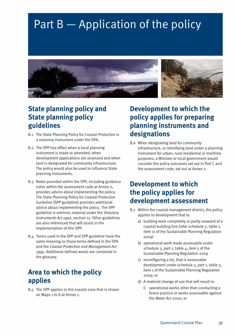
Queensland Coastal Plan 37
Part B — Application of the policy
State planning policy and State planning policy guidelinesB.1 The State Planning Policy for Coastal Protection is
a statutory instrument under the SPA.
B.2 The SPP has effect when a local planning instrument is made or amended, when development applications are assessed and when land is designated for community infrastructure. The policy would also be used to influence State planning instruments.
B.3 Notes provided within the SPP, including guidance notes within the assessment code at Annex 2, provides advice about implementing the policy. The State Planning Policy for Coastal Protection Guideline (SPP guideline) provides additional advice about implementing the policy. The SPP guideline is extrinsic material under the Statutory Instruments Act 1992, section 15. Other guidelines are also referenced that will assist in the implementation of this SPP.
B.4 Terms used in the SPP and SPP guideline have the same meaning as those terms defined in the SPA and the Coastal Protection and Management Act 1995. Additional defined words are contained in the glossary.
Area to which the policy appliesB.5 The SPP applies to the coastal zone that is shown
on Maps 1 to 8 at Annex 1.
Development to which the policy applies for preparing planning instruments and designationsB.6 When designating land for community
infrastructure, or identifying land under a planning instrument for urban, rural residential or maritime purposes, a Minister or local government would consider the policy outcomes set out in Part C and the assessment code, set out at Annex 2.
Development to which the policy applies for development assessmentB.7 Within the coastal management district, the policy
applies to development that is:
building work completely or partly seaward of a a) coastal building line (refer schedule 7, table 1, item 11 of the Sustainable Planning Regulation 2009)
operational work made assessable under b) schedule 3, part 1, table 4, item 5 of the Sustainable Planning Regulation 2009
reconfiguring a lot, that is assessable c) development under schedule 3, part 1, table 3, item 1 of the Sustainable Planning Regulation 2009; or
A material change of use that will result in:d)
operational works other than conducting a i) forest practice or works assessable against the Water Act 2000; or
Queensland Coastal Plan38
building work that is:ii)
the construction of new premises with A. a gross floor area of greater than 1000 square metres; or
the enlargement of the gross floor area B. of an existing premises by more than 1000 square metres, or to be greater than 1000 square metres in total; or
within 500 metres of the coastline C. unless there are existing, built structures on a lot seaward of the development site and the seaward lot is not State coastal land.
B.8 Within the coastal zone but outside the coastal management district this policy would apply to development that is:
a material change of use:a)
that would require clearing vegetation in i) an area of high ecological significance; or
that would require new permanent ii) structures for accommodation purposes within the coastal hazard area; or
that would result in building work within iii) 500 metres of the coastline unless:
there are existing built structures on • a lot seaward of the development site and the seaward lot is not State coastal land; or
the building work only extends an • existing structure and does not increase the height of the structure.
that would require filling an area greater iv) than 1000 square metres within the coastal hazard area; or
b) reconfiguring a lot within the coastal hazard area that would result in an increase in the number of lots and an increase in the number of residential dwellings or premises; and
c) carrying out operational work that involves:
filling an area greater than 1000 square i) metres within the coastal hazard area; or
clearing vegetation in an area of high ii) ecological significance.
Development outside the scope of the policy for development assessmentB.9 Despite B.7 and B.8, the policy will not apply to:
building work that is assessable only against a) the Building Act 1975
carrying out operational work that is clearing b) an area of high ecological significance to the extent necessary for a domestic activity.
Queensland Coastal Plan 39
Part C — Overall policy outcome
C.1 Development in the coastal zone is planned, located, designed, constructed and operated to:
avoid the social, financial and environmental a) costs arising from the impacts of coastal hazards, taking into account the projected effects of climate change
manage the coast to protect, conserve and b) rehabilitate coastal resources and biological diversity
preferentially allocate land on the coast for c) coastal-dependent development.
C.2 The policy outcome will be achieved when development to which the policy applies is consistent with each of the principles, policies and applicable specific outcomes set out in the code at Annex 2, for the following topic areas:
Land-use planning1.
Coastal hazards2.
Nature conservation3.
Scenic amenity4.
Public access5.
Coastal-dependent development6.
Canals and artificial waterways.7.
Queensland Coastal Plan40
Policies1.1 Urban development is to be consolidated by
favouring infill and redevelopment of existing urban localities and minimising the extent of the development footprint in the coastal zone and avoiding the exposure of communities to the impacts of coastal hazards.
1.2 Urban development is to follow a nodal settlement pattern and avoids creating or extending settlements in a ribbon or linear pattern along the coast unless, for a particular area, such a pattern is necessary due to landform constraints and/or the efficient provision of infrastructure.
1.3 Planning instruments are to show high and medium coastal hazard areas as a constraint on future development.
1.4 A planning instrument is to avoid allocating new areas for urban purposes within a coastal hazard area, other than for:
coastal-dependent development; ora)
industrial development; or b)
temporary or relocatable uses, including open c) space or recreation facilities.
1.5 Despite section 1.4, in the coastal and island communities located in local government areas between and including Wujal Wujal Aboriginal Shire and Burke Shire, expansion of existing settlements may occur within coastal hazard areas if:
the settlements (including development for a) community and infrastructure purposes) cannot feasibly be located outside of the coastal hazard areas
options for infill and consolidation of existing b) developed areas on less vulnerable land are exhausted
sufficient space is allocated adjacent to the c) settlements for the construction of erosion-control structures that will minimise present and future coastal hazard risks to vulnerable communities
dwellings, development for accommodation d) purposes, community refuge buildings and essential community service infrastructure are located and designed to minimise the need for future erosion control structures.
1.6 Local planning instruments are to incorporate a coastal hazard adaptation strategy (adaptation strategy) for urban localities that are projected to be within a high coastal hazard area between the commencement of the SPP and the year 2100. The adaptation strategy is based on an assessment of the mitigation options that will mitigate the hazard, including retreat, avoidance, and defence and a cost-benefit analysis to determine the most cost effective works or actions, taking into account long-term social, financial and environmental factors.
1.7 The adaptation strategy is to describe the:
mitigation works or actions to be undertaken a) to mitigate the coastal hazard
cost of undertaking the works or actions b)
funding scheme or arrangements that will be c) established to pay for the works or actions to be completed
timeline for the commencement and d) completion of the mitigation works or actions.
1.8 The adaptation strategy is to be incorporated into a local planning instrument for the relevant high coastal hazard area.
1.9 Planning instruments are to allocate land for urban development outside areas of high ecological significance.
1.10 Planning instruments are to protect areas of high and locally important scenic preference values, including scenic coastal landscapes of state significance, where these areas or landscapes were previously identified in a relevant planning scheme.
1.11 Planning instruments are to allocate coastal-dependent land uses adjacent to tidal water in preference to other uses.
1. Land-use planning
PrincipleAllocating areas for urban development avoids or minimises the exposure of communities to the risk of adverse coastal hazard impacts, maximises the conservation of coastal resources and preferentially allocates land on the coast for coastal-dependent development.
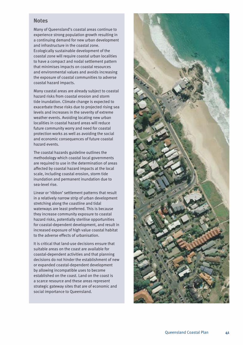
Queensland Coastal Plan 41
NotesMany of Queensland’s coastal areas continue to experience strong population growth resulting in a continuing demand for new urban development and infrastructure in the coastal zone. Ecologically sustainable development of the coastal zone will require coastal urban localities to have a compact and nodal settlement pattern that minimises impacts on coastal resources and environmental values and avoids increasing the exposure of coastal communities to adverse coastal hazard impacts.
Many coastal areas are already subject to coastal hazard risks from coastal erosion and storm tide inundation. Climate change is expected to exacerbate these risks due to projected rising sea levels and increases in the severity of extreme weather events. Avoiding locating new urban localities in coastal hazard areas will reduce future community worry and need for coastal protection works as well as avoiding the social and economic consequences of future coastal hazard events.
The coastal hazards guideline outlines the methodology which coastal local governments are required to use in the determination of areas affected by coastal hazard impacts at the local scale, including coastal erosion, storm tide inundation and permanent inundation due to sea-level rise.
Linear or ‘ribbon’ settlement patterns that result in a relatively narrow strip of urban development stretching along the coastline and tidal waterways are least preferred. This is because they increase community exposure to coastal hazard risks, potentially sterilise opportunities for coastal-dependent development, and result in increased exposure of high value coastal habitat to the adverse effects of urbanisation.
It is critical that land-use decisions ensure that suitable areas on the coast are available for coastal-dependent activities and that planning decisions do not hinder the establishment of new or expanded coastal-dependent development by allowing incompatible uses to become established on the coast. Land on the coast is a scarce resource and these areas represent strategic gateway sites that are of economic and social importance to Queensland.
Queensland Coastal Plan42
2. Coastal hazards
PrincipleCommunities and development are protected from adverse coastal hazard impacts taking into account the projected effects of climate change and the preference for allowing the natural fluctuation of the foreshore and foreshore ecosystems to continue, including, in response to rising sea levels.
NotesCoastal hazard areas are areas at risk from coastal erosion, permanent inundation due to projected sea level rise, or storm tide inundation.
Climate change effects, such as increasing sea levels and cyclone intensity will increase the likelihood and extent of area affected by coastal hazards. Accurate assessment and determination of coastal hazard areas is critical to inform land-use planning, development assessment and adaptation strategies.
Coastal hazard areas are determined using a projected sea-level rise factor of 0.8 metres by 2100, based on the upper range of the projections published by the IPCC1.
The IPCC is an international body set up by the World Meteorological Organisation and United Nations Environment Program that assesses and summarises the latest scientific literature from across the world regarding human induced climate change, and reports on a regular basis. In these
Notesreports, the IPCC summarises the most reliable data about climate change for use by policy makers.
Utilising the upper range is considered most appropriate for deriving a sea-level rise figure for planning purposes because greenhouse gas emissions, temperature and sea levels, as measured, are currently tracking above IPCC projections.
A long-term horizon has been chosen to reflect the longevity and relative permanence arising from most development decisions. Once development rights are granted there is a reasonable expectation that they are perpetual. This right cannot generally be removed without compensation. A precautionary approach is taken as there are significant social, economic and environmental implications for under-estimating sea-level rise, including the potential for loss of life and property. IPCC has not yet published projections for beyond 2100. It is anticipated that the IPCC will release revised projections for sea-level rise in 2014.
Policies2.1 Definingcoastalhazardareas
2.1.1 Coastal hazard areas are to be identified in accordance with the methodology set out in the coastal hazards guideline using the following factors to account for the projected impacts of climate change by the year 2100:
a sea-level rise factor of 0.8 metresa)
an increase in the maximum cyclone b) intensity by 10 per cent.
2.1.2 A review of the methodology in the coastal hazards guideline and the factors to account for the projected impacts of climate change that are referred to in section 2.1.1 will be initiated within six months of either of the following events:
release of a new assessment report by the c) United Nations’ Intergovernmental Panel on Climate Change (IPCC) that refers to global emissions, temperature or sea-level rise trends
the making of an Australian d) intergovernmental agreement or policy adopting sea-level rise and storm intensity factors for land-use planning and development assessment purposes.
1 Refer to IPCC (2007) Climate Change 2007: Synthesis Report. Contribution of Working Groups I, II and III to the Fourth Assessment Report of the Intergovernmental Panel on Climate Change, Core Writing Team, Pachauri, R.K and Reisinger, A.(eds.). IPCC, Geneva, Switzerland, 104 pp; and IPCC, 2007: Climate Change 2007: The Physical Science Basis. Contribution of Working Group I to the Fourth Assessment Report of the Intergovernmental Panel on Climate Change [Solomon, S., D. Qin, M. Manning, Z. Chen, M. Marquis, K.B. Averyt, M. Tignor and H.L. Miller (eds.)]. Cambridge University Press, Cambridge, United Kingdom and New York, NY, USA, 996 pp.
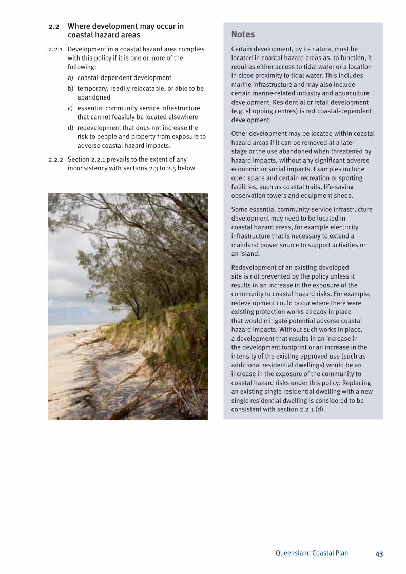
Queensland Coastal Plan 43
NotesCertain development, by its nature, must be located in coastal hazard areas as, to function, it requires either access to tidal water or a location in close proximity to tidal water. This includes marine infrastructure and may also include certain marine-related industry and aquaculture development. Residential or retail development (e.g. shopping centres) is not coastal-dependent development.
Other development may be located within coastal hazard areas if it can be removed at a later stage or the use abandoned when threatened by hazard impacts, without any significant adverse economic or social impacts. Examples include open space and certain recreation or sporting facilities, such as coastal trails, life-saving observation towers and equipment sheds.
Some essential community-service infrastructure development may need to be located in coastal hazard areas, for example electricity infrastructure that is necessary to extend a mainland power source to support activities on an island.
Redevelopment of an existing developed site is not prevented by the policy unless it results in an increase in the exposure of the community to coastal hazard risks. For example, redevelopment could occur where there were existing protection works already in place that would mitigate potential adverse coastal hazard impacts. Without such works in place, a development that results in an increase in the development footprint or an increase in the intensity of the existing approved use (such as additional residential dwellings) would be an increase in the exposure of the community to coastal hazard risks under this policy. Replacing an existing single residential dwelling with a new single residential dwelling is considered to be consistent with section 2.2.1 (d).
2.2 Wheredevelopmentmayoccurincoastalhazardareas
2.2.1 Development in a coastal hazard area complies with this policy if it is one or more of the following:
coastal-dependent developmenta)
temporary, readily relocatable, or able to be b) abandoned
essential community service infrastructure c) that cannot feasibly be located elsewhere
redevelopment that does not increase the d) risk to people and property from exposure to adverse coastal hazard impacts.
2.2.2 Section 2.2.1 prevails to the extent of any inconsistency with sections 2.3 to 2.5 below.
Queensland Coastal Plan44
2.3 Developmentinanerosionpronearea
2.3.1 Permanent development within the coastal management district that is not of a type referred to in section 2.2.1 is to be located outside an erosion prone area.
2.3.2 Development in an erosion prone area within the coastal management district that is temporary, readily relocatable, or able to be abandoned complies with this policy only if it:
is demonstrated that it is not feasible to a) locate the development outside of the erosion prone area; and
locates built structures as far landward as b) practicable; or
locates habitable buildings landward of an c) applicable coastal building line; or where there is no coastal building line, landward of the alignment of adjacent habitable buildings.
2.3.3 Redevelopment of permanent development in an erosion prone area within the coastal management district complies with this policy only if the development is of a type referred to in section 2.2.1 or the development:
re-locates built structures outside of the a) erosion prone area, wherever feasible; or
re-locates built structures as far landward b) as possible and landward of an applicable coastal building line; or where there is no coastal building line, landward of the alignment of adjacent habitable buildings; and
provides sufficient space seaward of the c) development within the premises to allow for the construction of erosion control structures, such as a sea wall.
2.3.4 Redevelopment in an erosion prone area within the coastal management district is to result in a reduction of risk for existing development from adverse coastal erosion impacts
2.3.5 Despite sections 2.3.1 to 2.3.4, development within a maritime development area complies with this policy if coastal protection works remove the erosion threat to development in an erosion prone area.
2.3.6 Subject to the provisions of the Coastal Protection and Management Act 1995, where land within the coastal management district is proposed to be reconfigured to create additional allotments, the erosion prone area is to be surrendered to the State and dedicated as a reserve for coastal management purposes unless there is substantial development seaward of the development site including maritime development within a maritime development area.
2.3.7 Development in an erosion prone area within the coastal management district complies with this policy only if it:
maintains vegetation on coastal landforms a) outside a maritime development area or port, where its removal or damage may:
de-stabilise the area and increase the i) potential for erosion; or
interrupt natural sediment trapping ii) processes or dune or land building processes
b) maintains sediment volumes of dunes and near shore coastal landforms, or where a reduction in sediment volumes cannot be avoided, increased risks to development from coastal erosion are mitigated by location, design, construction and operating standards
c) maintains physical coastal processes outside the development footprint for the development, including longshore transport of sediment along the coast
d) does not increase the risk of shoreline erosion for areas adjacent to the development footprint.
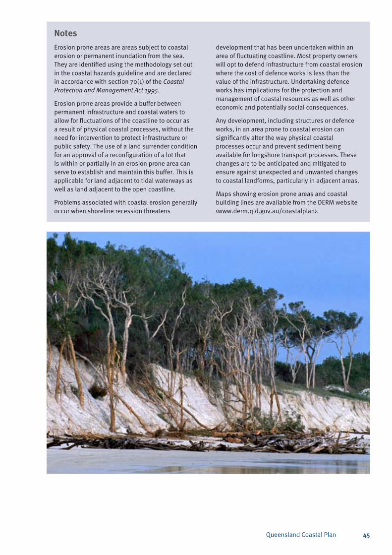
Queensland Coastal Plan 45
NotesErosion prone areas are areas subject to coastal erosion or permanent inundation from the sea. They are identified using the methodology set out in the coastal hazards guideline and are declared in accordance with section 70(1) of the Coastal Protection and Management Act 1995.
Erosion prone areas provide a buffer between permanent infrastructure and coastal waters to allow for fluctuations of the coastline to occur as a result of physical coastal processes, without the need for intervention to protect infrastructure or public safety. The use of a land surrender condition for an approval of a reconfiguration of a lot that is within or partially in an erosion prone area can serve to establish and maintain this buffer. This is applicable for land adjacent to tidal waterways as well as land adjacent to the open coastline.
Problems associated with coastal erosion generally occur when shoreline recession threatens
Notesdevelopment that has been undertaken within an area of fluctuating coastline. Most property owners will opt to defend infrastructure from coastal erosion where the cost of defence works is less than the value of the infrastructure. Undertaking defence works has implications for the protection and management of coastal resources as well as other economic and potentially social consequences.
Any development, including structures or defence works, in an area prone to coastal erosion can significantly alter the way physical coastal processes occur and prevent sediment being available for longshore transport processes. These changes are to be anticipated and mitigated to ensure against unexpected and unwanted changes to coastal landforms, particularly in adjacent areas.
Maps showing erosion prone areas and coastal building lines are available from the DERM website <www.derm.qld.gov.au/coastalplan>.
Queensland Coastal Plan46
2.4Coastalprotectionwork
2.4.1 Development that is coastal protection work complies with this policy only if:
the development is consistent with a a) shoreline erosion management plan; or
the development protects coastal-dependent b) development; or
there is a demonstrated need to protect c) existing permanent structures from an imminent threat of coastal erosion; and abandonment or relocation of the structures is not feasible.
2.4.2 Coastal protection works that involve beach nourishment techniques are preferred over erosion control structures, wherever feasible.
2.4.3 Where a relevant shoreline erosion management plan has not been prepared, development to protect private property from an imminent threat of coastal erosion complies with this policy only if:
erosion control structures are located wholly a) on private land; or
erosion control structures are located on b) private land to the maximum extent feasible, where it can be demonstrated that it is not feasible to locate the structures wholly on private land.
NotesCoastal protection work, by its nature, alters the way physical coastal processes occur. This can have implications for ecology and local amenity as well as having the effect of merely transferring the erosion problem to adjacent areas. Erosion control structures such as rock seawalls prevent the coastline from fluctuating naturally in response to varying sea levels and weather conditions. This can result in intertidal habitats being squeezed between the sea and the hardened coastline. In extreme cases, sandy beaches on the seaward side of the structure can be lost altogether, along with the associated intertidal habitat and public access.
In addition to these coastal process issues, effective management of coastal erosion can be complex due to competing interests in the land, varying land tenure and the potentially high number of stakeholders. For these reasons, proactive planning in the form of a shoreline erosion management plan is the preferred approach for directing coastal protection works.
Where a shoreline erosion management plan has not been prepared and coastal protection work is required to protect existing permanent structures from coastal erosion threats, beach nourishment is favoured in preference to erosion-control structures such as seawalls and groynes. The location and materials for beach nourishment works are to ensure the natural characteristics and landform of the beach or foreshore is maintained.
Erosion control structures such as sea walls and groynes are only to be initiated as a last resort where erosion presents an imminent threat to public safety or infrastructure that cannot practicably be removed or relocated. Where erosion protection structures are necessary, maintaining physical coastal processes outside the area subject to the coastal protection works is required to avoid adverse impacts on adjacent coastal landforms and associated ecosystems.
Structures to reclaim land to facilitate further development on the land (as opposed to structures to protect development on the land) are not considered coastal protection work for the purposes of this policy.
Queensland Coastal Plan 47
2.5 Developmentinhighandmediumcoastalhazardareas
2.5.1 Development within an urban locality that is not of a type referred to in section 2.2.1 is to be located outside a high coastal hazard area unless the development is consistent with a relevant adaptation strategy prepared under section 1.6 of this policy.
2.5.2 Where an adaptation strategy prepared under section 1.6 of this policy has not been incorporated into a local planning instrument, development within an urban locality that is also in a high coastal hazard area complies with this policy if:
the development is of a type referred to in a) section 2.2.1; or
the development does not result in an b) increase in the intensity of development on the premises; or
a risk assessment (as outlined in the SPP c) guideline) demonstrates that adverse coastal hazard impacts from a defined storm tide event that affect the development (including its operation) can be mitigated through location, design, construction and operating standards or through existing defensive structures, and either:
the relevant development application i) is made within three years of the commencement of this SPP; or
the preparation of an adaptation ii) strategy referred to under section 1.6 has substantially commenced, and the relevant development application has been made within five years of the commencement of this SPP.
2.5.3 Development within a greenfield area and that is not of a type referred to in section 2.2.1 is located outside a high coastal hazard area.
2.5.4 Development within an urban locality in a medium coastal hazard area only complies with this policy if:
the development is of a type referred to in a) section 2.2.1; or
the development does not result in an b) increase in the intensity of development on the site; or
a risk assessment (as outlined in the SPP c) guideline) demonstrates that adverse coastal hazard impacts from a defined storm tide event that affect the development (including its operation) is avoided through location, design, construction and operating standards; or through existing defensive structures.
2.5.5 Development within a greenfield area in a medium coastal hazard area only complies with this policy if:
the development is of a type referred to in a) section 2.2.1; or
the development is for non-residential b) purposes and a risk assessment (as outlined in the SPP guideline) demonstrates that adverse coastal hazard impacts from a defined storm tide event that affect the development (including its operation) is avoided through location, design, construction and operating standards; or through existing defensive structures.
2.5.6 Development within a non-urban locality that is also in a coastal hazard area only complies with this policy if the development:
is not urban development; or a)
is of a type referred to in section 2.2.1.b)
2.5.7 Despite section 2.5.1, 2.5.2, 2.5.3, 2.5.4, 2.5.5, and 2.5.6, development within a maritime development area or for small to medium-scale tourist development, that is also in a coastal hazard area, complies with this policy if the development:
locates development for accommodation a) purposes outside the high coastal hazard area; or
is in accordance with a relevant adaptation b) strategy prepared under section 1.6; or
a risk assessment (as outlined in the SPP c) guideline) demonstrates that adverse coastal hazard impacts from a defined storm tide event that affect the development (including its operation) can be mitigated through location, design, construction and operating standards; or through existing defensive structures.
2.5.8 Development for essential community service infrastructure is to be located, designed, and constructed to ensure it is able to function during, and after, a recommended storm-tide inundation event.
2.5.9 Development that complies with sections 2.5.1 to 2.5.7 and is in a coastal hazard area complies with this policy only if the development is located, designed, constructed and operated to:
maintain dune crest heights, or where a a) reduction in crest heights cannot be avoided mitigate risks to development from wave overtopping and storm surge inundation
ensure structures can sustain flooding from b) a defined storm tide event
maintain the safety of people living and c) working on the premises from a defined storm tide event.
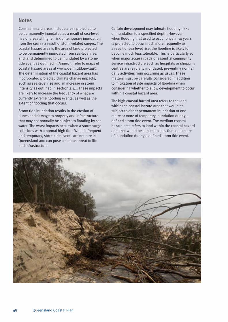
Queensland Coastal Plan48
NotesCoastal hazard areas include areas projected to be permanently inundated as a result of sea-level rise or areas at higher risk of temporary inundation from the sea as a result of storm-related surges. The coastal hazard area is the area of land projected to be permanently inundated from sea-level rise, and land determined to be inundated by a storm- tide event as outlined in Annex 3 (refer to maps of coastal hazard areas at <www.derm.qld.gov.au>). The determination of the coastal hazard area has incorporated projected climate change impacts, such as sea-level rise and an increase in storm intensity as outlined in section 2.1.1. These impacts are likely to increase the frequency of what are currently extreme flooding events, as well as the extent of flooding that occurs.
Storm tide inundation results in the erosion of dunes and damage to property and infrastructure that may not normally be subject to flooding by sea water. The worst impacts occur when a storm surge coincides with a normal high tide. While infrequent and temporary, storm tide events are not rare in Queensland and can pose a serious threat to life and infrastructure.
NotesCertain development may tolerate flooding risks or inundation to a specified depth. However, when flooding that used to occur once in 10 years is projected to occur much more frequently as a result of sea level rise, the flooding is likely to become much less tolerable. This is particularly so when major access roads or essential community service infrastructure such as hospitals or shopping centres are regularly inundated, preventing normal daily activities from occurring as usual. These matters must be carefully considered in addition to mitigation of site impacts of flooding when considering whether to allow development to occur within a coastal hazard area.
The high coastal hazard area refers to the land within the coastal hazard area that would be subject to either permanent inundation or one metre or more of temporary inundation during a defined storm tide event. The medium coastal hazard area refers to land within the coastal hazard area that would be subject to less than one metre of inundation during a defined storm tide event.
Queensland Coastal Plan 49
Policies3.1 Development is to be located outside of, and not
impact on, areas of high ecological significance unless the development is for a purpose specified below:
urban purposes within an urban localitya)
any purpose within a maritime development b) area or aquaculture development area
development associated with a port or airportc)
tidal water intake or discharge infrastructure d) for aquaculture development on land
minor public maritime infrastructure and e) associated pedestrian and vehicle access facilities
extraction purposes within a key resource area. f)
3.2 Development that is for a purpose specified in section 3.1 is to be located, designed and operated to avoid adverse impacts on areas of high ecological significance, or where avoidance is not feasible, minimise impacts and provide an environmental offset for any residual impacts.
3.3 Development in coastal waters is to:
maintain the habitat value and ecological a) functionality of dugong protection areas
comply with the prescribed development b) purposes for declared fish habitat areas as per the requirements of the Fisheries Act 1994, including the relevant fisheries management policies and guidelines
comply with State Marine Park zoning plans c) and management plans, Commonwealth Great Barrier Reef Marine Park zoning plans and special management areas.
3.4 Development is not to adversely impact on the habitat of threatened species where the habitat supports a critical life stage ecological process, such as feeding, breeding or roosting.
3.5 Development is to minimise adverse impacts on areas of general ecological significance and other ecological values.
NotesThe natural environment of the coastal zone underpins a significant part of the Queensland economy and lifestyle. However, the use and enjoyment of the coastal zone and its resources continues to place significant pressure on the biological diversity and ecological health of the terrestrial, wetland and marine ecosystems.
Areas of high ecological significance (HES) have a critical role in maintaining the biodiversity of the coastal zone. The policy seeks to protect areas of HES, including those that have been identified on maps contained within the policy and any additional areas identified by planning instruments or peer reviewed scientific studies, as areas of high ecological significance. See maps at Annex 1.
Mapped areas of HES are the result of a comprehensive assessment of biodiversity interests in the coastal zone and include the protected area estate, endangered and of concern regional ecosystems, high value coastal wetlands and core essential habitat for selected threatened species.
Other areas of HES may be areas that support a critical life stage ecological process of a threatened species, such as feeding, breeding or roosting sites. The intent of the policy is to protect areas of HES from the adverse impacts of development.
Maps of high and general ecological significance (areas of ecological significance) have been included to improve outcome certainty for decision making. However, it is acknowledged that some ecological values are difficult to map spatially in an accurate or effective manner or where there is insufficient data, for example, habitat for highly mobile species. The policies requiring the protection or conservation of areas of high or general ecological significance respectively do not apply if a field assessment
3. Nature conservation
PrincipleAreas of high ecological significance are protected and areas of general ecological significance on land and other ecological values are conserved.
Queensland Coastal Plan50
demonstrates that the mapping is incorrect and the development, in fact, will not impact on mapped values. To minimise regulatory costs, only basic site assessments will be required to demonstrate HES values are not present where values are readily identifiable.
Additional policy requirements apply to cater for threatened species habitat that cannot be easily mapped, such as shorebird roosting or sea turtle nesting areas.
For certain development activities, it is acknowledged that it may not be practically possible to avoid having adverse impacts on areas of HES without preventing development from occurring. Where this has been demonstrated, development is to be managed to minimise impacts and any residual impacts are to be offset.
An environmental offset is an action taken to counter-balance any unavoidable negative environmental impacts that might result from an activity or development. The requirement to provide an environmental offset for certain development activities is an additional tool for ensuring effective valuing of areas of HES. The provision of an environmental offset is to be guided by the Queensland Government Environmental Offsets Policy 2008, and any relevant specific issue offset policy.
Areas of general ecological significance also have a role in maintaining the biodiversity of the coastal zone. The policy seeks to conserve these areas including those that have been identified on maps contained within the policy and any additional areas identified by planning instruments or peer reviewed scientific studies as areas of general ecological significance. See maps at Annex 1. Areas of general ecological significance have not been identified within coastal waters. Consequently, an additional
policy requirement applies for minimising impacts on other ecological values, for example—marine ecosystems, such as seagrass beds and coral areas.
Dugong protection areas, fish habitat areas and marine park zones are also shown on maps at Annex 1 of this policy.
Dugong protection areas are legislated under the Queensland Fisheries Act 1994. Dugong protection areas are also prescribed under the Nature Conservation Act 1992, and more recently through Species Conservation (Dugong Protection) Special Management Areas declared under the Great Barrier Reef Marine Park Zoning Plan 2003 (Commonwealth).
Fish habitat areas are established and regulated under the Fisheries Act 1994. The key provisions under the Fisheries Act deal with marine plants and other fish habitats, declared fish habitat areas and waterway barriers. Marine plants include salt marsh, mangrove and seagrass communities.
Marine parks are established under the Marine Parks Act 2004. The principal way of managing marine parks is to develop a zoning plan which clearly identifies the different zones within the park and the types of activities that may, or may not, be permitted within each zone. The State Great Barrier Reef Coast Marine Park zoning plan is consistent with the Great Barrier Reef Marine Park Zoning Plan 2003 (Commonwealth).
A development activity that may occur in a fish habitat area under the Fisheries Act, or in a marine park zone under the Marine Parks Act, or within a dugong protection area without any further authority being granted under the relevant stated Act, is deemed to satisfy section 3.3 of this policy.
Queensland Coastal Plan 51
Policies4.1 The dominance of the natural character of
the coast is to be maintained or enhanced when viewed from the foreshore unless the development is:
within ports or airports; ora)
within a maritime development area or b) aquaculture development area; or
for minor public maritime infrastructure. c)
NotesThe scenic qualities of the coast are a significant factor in its popularity for both residents and visitors to the coast. The scenic value of an area can bring significant economic benefits to a local community. Where not sensitively managed, coastal development may undermine the very scenic values which draw such development in the first instance. This policy aims to protect the scenic preference values of the coast by ensuring that development is undertaken in context with the surrounding landscape and/or built environment.
Where the existing scenic amenity values of the coast draw heavily on a predominantly natural undeveloped landscape character, new development should be undertaken in a manner which maintains or enhances the dominance of this character. Such development is to be located and designed to minimise significant losses of natural character when viewed from the foreshore. This is particularly the case for coastal landscapes that are vulnerable to visual impacts due to their prominence (such as headlands), their unique natural values (such as world heritage areas), or
Notestheir popularity (such as the view from a popular lookout or destination). Methods to maintain and/or improve natural scenic amenity values most commonly include locating structure/s so that they are partly or fully hidden from important viewing locations and providing or restoring vegetated buffers between development and coastal waters.
Some coastal locations are already heavily developed and the dominant character of the coast is urban. Other areas have significantly modified coastal landscapes where native vegetation has been replaced with landscaped parklands, public access facilities, or marine infrastructure. In these areas, this SPP has no development outcome requirements relating to scenic amenity. Local government or the relevant coastal management authority is best placed to make decisions about whether future development is in keeping with the preferred scenic characteristics of urbanised areas, and what activities can be undertaken to enhance the scenic amenity of the coast at these localities.
4. Scenic amenity
PrincipleThe scenic amenity of the coast is protected and enhanced.
4.2 Development is to maximise opportunities to maintain and/or enhance natural scenic amenity values through the maintenance and restoration of vegetated buffers between development and coastal waters where practicable, unless the development is development specified in 4.1.
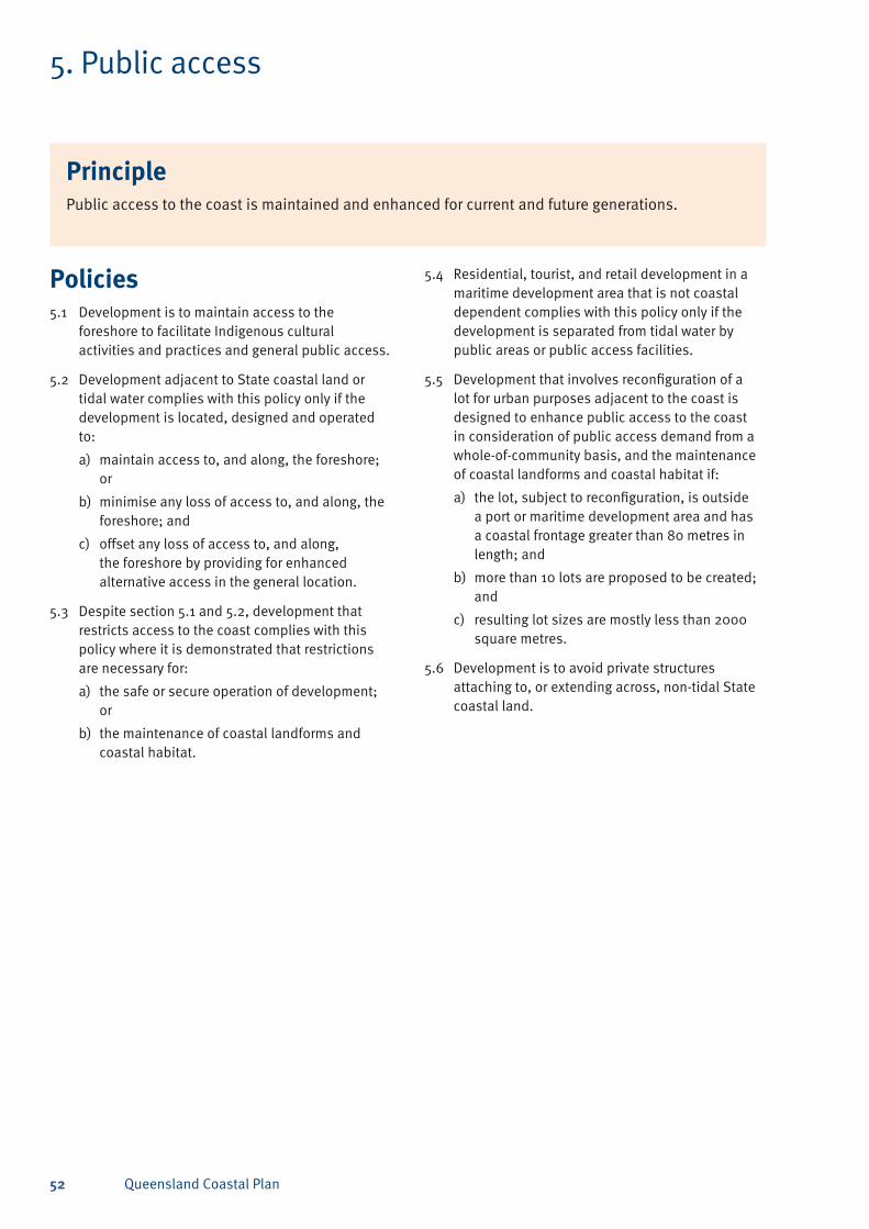
Queensland Coastal Plan52
Policies5.1 Development is to maintain access to the
foreshore to facilitate Indigenous cultural activities and practices and general public access.
5.2 Development adjacent to State coastal land or tidal water complies with this policy only if the development is located, designed and operated to:
maintain access to, and along, the foreshore; a) or
minimise any loss of access to, and along, the b) foreshore; and
offset any loss of access to, and along, c) the foreshore by providing for enhanced alternative access in the general location.
5.3 Despite section 5.1 and 5.2, development that restricts access to the coast complies with this policy where it is demonstrated that restrictions are necessary for:
the safe or secure operation of development; a) or
the maintenance of coastal landforms and b) coastal habitat.
5. Public access
PrinciplePublic access to the coast is maintained and enhanced for current and future generations.
5.4 Residential, tourist, and retail development in a maritime development area that is not coastal dependent complies with this policy only if the development is separated from tidal water by public areas or public access facilities.
5.5 Development that involves reconfiguration of a lot for urban purposes adjacent to the coast is designed to enhance public access to the coast in consideration of public access demand from a whole-of-community basis, and the maintenance of coastal landforms and coastal habitat if:
the lot, subject to reconfiguration, is outside a) a port or maritime development area and has a coastal frontage greater than 80 metres in length; and
more than 10 lots are proposed to be created; b) and
resulting lot sizes are mostly less than 2000 c) square metres.
5.6 Development is to avoid private structures attaching to, or extending across, non-tidal State coastal land.
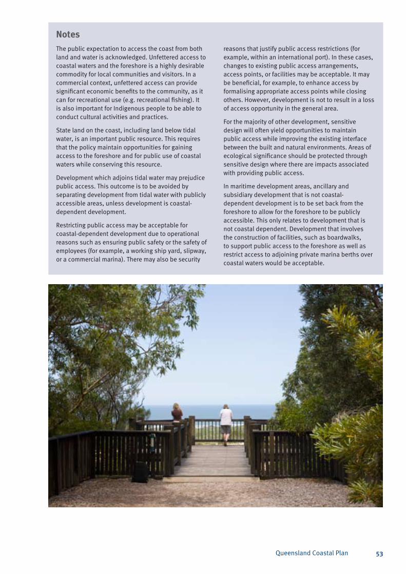
Queensland Coastal Plan 53
NotesThe public expectation to access the coast from both land and water is acknowledged. Unfettered access to coastal waters and the foreshore is a highly desirable commodity for local communities and visitors. In a commercial context, unfettered access can provide significant economic benefits to the community, as it can for recreational use (e.g. recreational fishing). It is also important for Indigenous people to be able to conduct cultural activities and practices.
State land on the coast, including land below tidal water, is an important public resource. This requires that the policy maintain opportunities for gaining access to the foreshore and for public use of coastal waters while conserving this resource.
Development which adjoins tidal water may prejudice public access. This outcome is to be avoided by separating development from tidal water with publicly accessible areas, unless development is coastal-dependent development.
Restricting public access may be acceptable for coastal-dependent development due to operational reasons such as ensuring public safety or the safety of employees (for example, a working ship yard, slipway, or a commercial marina). There may also be security
Notesreasons that justify public access restrictions (for example, within an international port). In these cases, changes to existing public access arrangements, access points, or facilities may be acceptable. It may be beneficial, for example, to enhance access by formalising appropriate access points while closing others. However, development is not to result in a loss of access opportunity in the general area.
For the majority of other development, sensitive design will often yield opportunities to maintain public access while improving the existing interface between the built and natural environments. Areas of ecological significance should be protected through sensitive design where there are impacts associated with providing public access.
In maritime development areas, ancillary and subsidiary development that is not coastal-dependent development is to be set back from the foreshore to allow for the foreshore to be publicly accessible. This only relates to development that is not coastal dependent. Development that involves the construction of facilities, such as boardwalks, to support public access to the foreshore as well as restrict access to adjoining private marina berths over coastal waters would be acceptable.
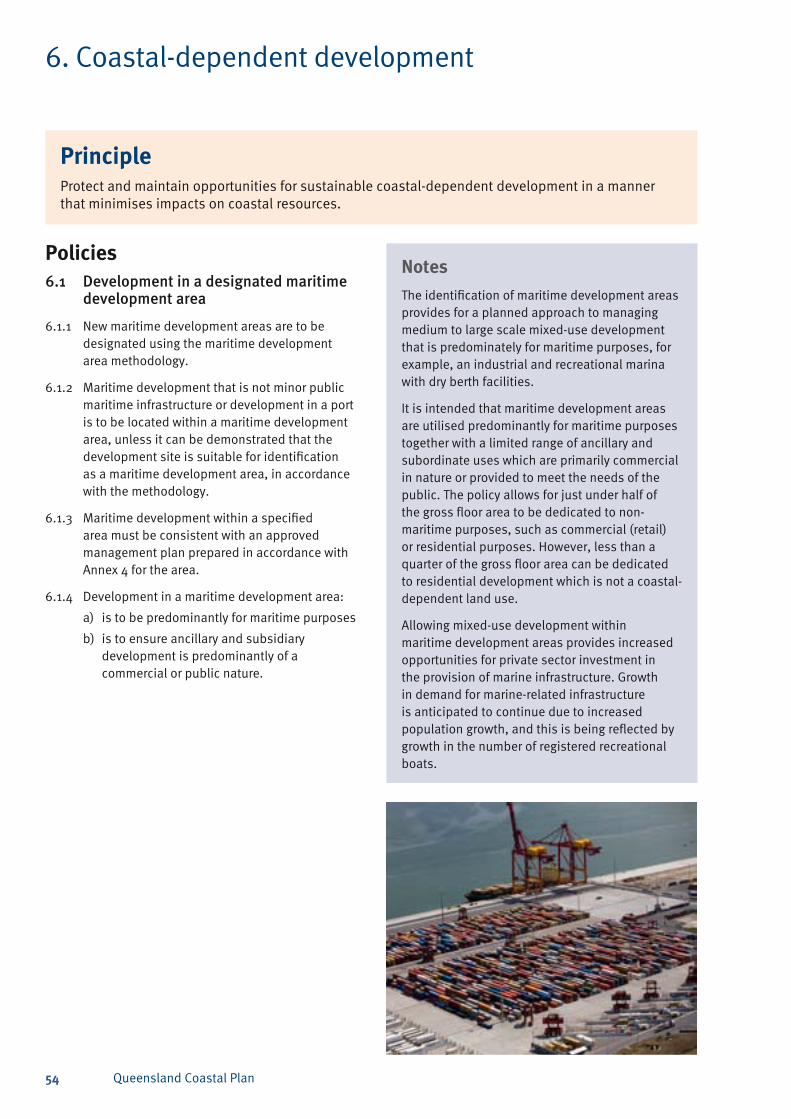
Queensland Coastal Plan54
6. Coastal-dependent development
PrincipleProtect and maintain opportunities for sustainable coastal-dependent development in a manner that minimises impacts on coastal resources.
Policies6.1 Developmentinadesignatedmaritime
developmentarea
6.1.1 New maritime development areas are to be designated using the maritime development area methodology.
6.1.2 Maritime development that is not minor public maritime infrastructure or development in a port is to be located within a maritime development area, unless it can be demonstrated that the development site is suitable for identification as a maritime development area, in accordance with the methodology.
6.1.3 Maritime development within a specified area must be consistent with an approved management plan prepared in accordance with Annex 4 for the area.
6.1.4 Development in a maritime development area:
is to be predominantly for maritime purposesa)
is to ensure ancillary and subsidiary b) development is predominantly of a commercial or public nature.
NotesThe identification of maritime development areas provides for a planned approach to managing medium to large scale mixed-use development that is predominately for maritime purposes, for example, an industrial and recreational marina with dry berth facilities.
It is intended that maritime development areas are utilised predominantly for maritime purposes together with a limited range of ancillary and subordinate uses which are primarily commercial in nature or provided to meet the needs of the public. The policy allows for just under half of the gross floor area to be dedicated to non-maritime purposes, such as commercial (retail) or residential purposes. However, less than a quarter of the gross floor area can be dedicated to residential development which is not a coastal-dependent land use.
Allowing mixed-use development within maritime development areas provides increased opportunities for private sector investment in the provision of marine infrastructure. Growth in demand for marine-related infrastructure is anticipated to continue due to increased population growth, and this is being reflected by growth in the number of registered recreational boats.
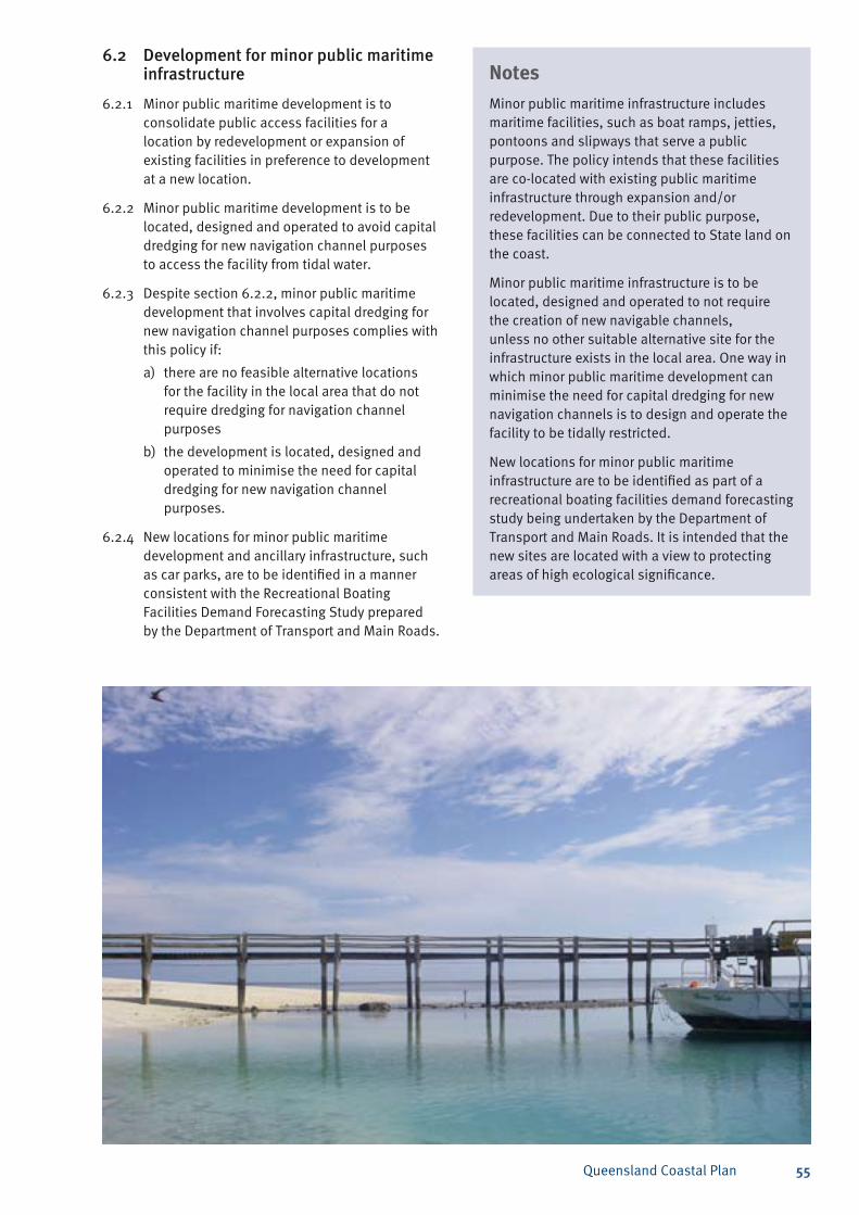
Queensland Coastal Plan 55
6.2 Developmentforminorpublicmaritimeinfrastructure
6.2.1 Minor public maritime development is to consolidate public access facilities for a location by redevelopment or expansion of existing facilities in preference to development at a new location.
6.2.2 Minor public maritime development is to be located, designed and operated to avoid capital dredging for new navigation channel purposes to access the facility from tidal water.
6.2.3 Despite section 6.2.2, minor public maritime development that involves capital dredging for new navigation channel purposes complies with this policy if:
there are no feasible alternative locations a) for the facility in the local area that do not require dredging for navigation channel purposes
the development is located, designed and b) operated to minimise the need for capital dredging for new navigation channel purposes.
6.2.4 New locations for minor public maritime development and ancillary infrastructure, such as car parks, are to be identified in a manner consistent with the Recreational Boating Facilities Demand Forecasting Study prepared by the Department of Transport and Main Roads.
NotesMinor public maritime infrastructure includes maritime facilities, such as boat ramps, jetties, pontoons and slipways that serve a public purpose. The policy intends that these facilities are co-located with existing public maritime infrastructure through expansion and/or redevelopment. Due to their public purpose, these facilities can be connected to State land on the coast.
Minor public maritime infrastructure is to be located, designed and operated to not require the creation of new navigable channels, unless no other suitable alternative site for the infrastructure exists in the local area. One way in which minor public maritime development can minimise the need for capital dredging for new navigation channels is to design and operate the facility to be tidally restricted.
New locations for minor public maritime infrastructure are to be identified as part of a recreational boating facilities demand forecasting study being undertaken by the Department of Transport and Main Roads. It is intended that the new sites are located with a view to protecting areas of high ecological significance.
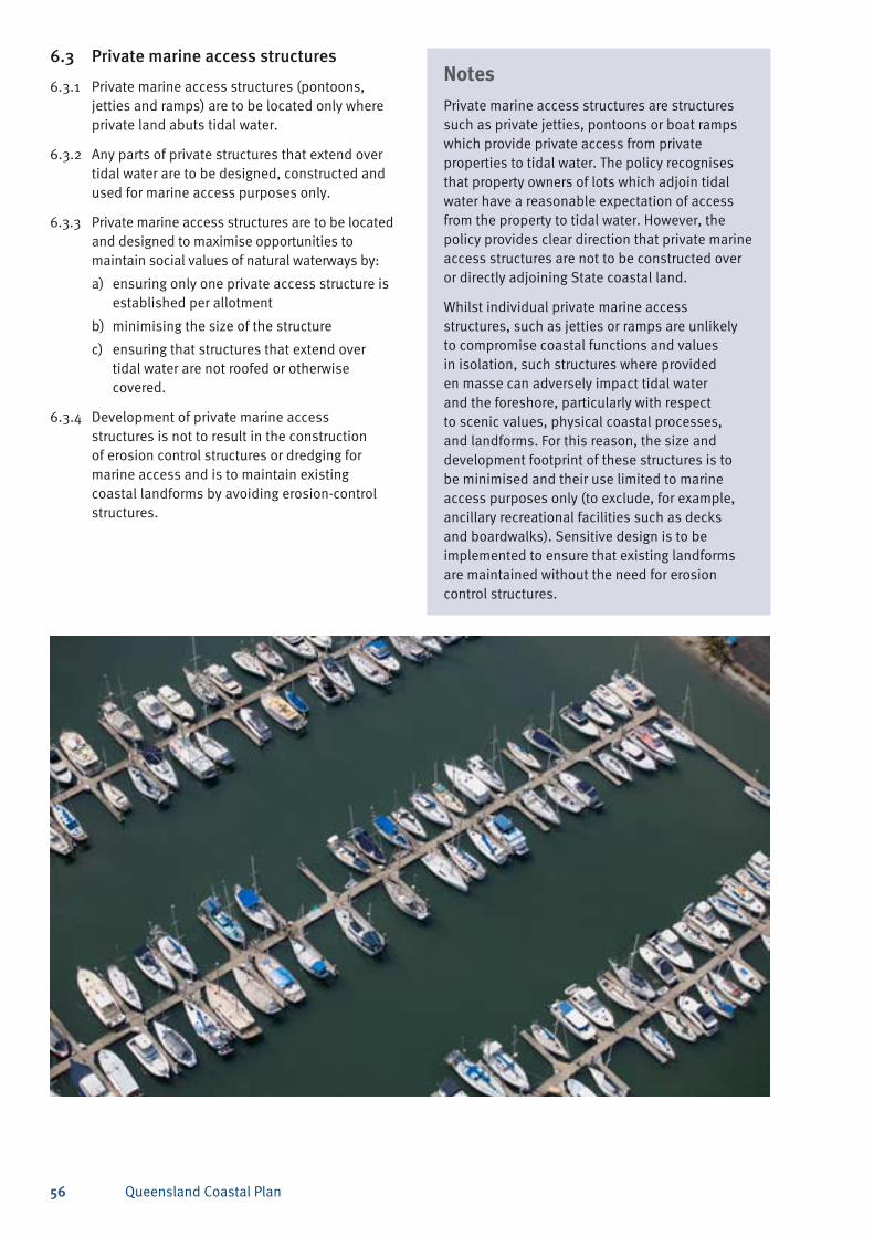
Queensland Coastal Plan56
6.3 Privatemarineaccessstructures
6.3.1 Private marine access structures (pontoons, jetties and ramps) are to be located only where private land abuts tidal water.
6.3.2 Any parts of private structures that extend over tidal water are to be designed, constructed and used for marine access purposes only.
6.3.3 Private marine access structures are to be located and designed to maximise opportunities to maintain social values of natural waterways by:
ensuring only one private access structure is a) established per allotment
minimising the size of the structureb)
ensuring that structures that extend over c) tidal water are not roofed or otherwise covered.
6.3.4 Development of private marine access structures is not to result in the construction of erosion control structures or dredging for marine access and is to maintain existing coastal landforms by avoiding erosion-control structures.
NotesPrivate marine access structures are structures such as private jetties, pontoons or boat ramps which provide private access from private properties to tidal water. The policy recognises that property owners of lots which adjoin tidal water have a reasonable expectation of access from the property to tidal water. However, the policy provides clear direction that private marine access structures are not to be constructed over or directly adjoining State coastal land.
Whilst individual private marine access structures, such as jetties or ramps are unlikely to compromise coastal functions and values in isolation, such structures where provided en masse can adversely impact tidal water and the foreshore, particularly with respect to scenic values, physical coastal processes, and landforms. For this reason, the size and development footprint of these structures is to be minimised and their use limited to marine access purposes only (to exclude, for example, ancillary recreational facilities such as decks and boardwalks). Sensitive design is to be implemented to ensure that existing landforms are maintained without the need for erosion control structures.
Queensland Coastal Plan 57
6.4 Aquaculture
6.4.1 New aquaculture development areas are to be identified and designated using the aquaculture development area methodology.
6.4.2 Aquaculture development is to occur within an aquaculture development area unless it can be demonstrated that an alternative development site is suitable for identification as an aquaculture development area in accordance with the aquaculture development area methodology.
6.4.3 Aquaculture development in aquaculture development areas is to maximise opportunities to protect ecological values by ensuring the development is designed, constructed and operated to minimise attracting wildlife.
6.4.4 Aquaculture development is to maximise opportunities to preserve ecological values by ensuring waste water effluent meets the requirements of the Environment Protection Policy (Water) and ponds are managed to minimise leakage to groundwater systems.
NotesThe identification of aquaculture development areas provides for a planned approach to managing future coastal-dependent aquaculture development. The aquaculture development area methodology provides for the identification of suitable sites for aquaculture where their environmental impacts can be minimised. The methodology to be used for identifying new aquaculture development areas can be found on the Department of Employment, Economic Development and Innovation website at <www.deedi.qld.gov.au>.
Impacts on the environment from aquaculture development vary depending on both the product being farmed and the location of the development (land or marine-based). Both forms of aquaculture are attractive to predatory wildlife and the development should be designed and operated to mitigate the problem.
In the case of marine-based aquaculture, the addition of solids and nutrients to the marine environment may result in environmental degradation and a subsequent shift in the population and distribution of marine flora and fauna. Conversely, a net removal of nutrients from the water column may occur with similar impacts on the surrounding environment and level of biodiversity. Other adverse impacts associated with marine-based aquaculture result primarily from the installation of wharf facilities and other infrastructure.
Land-based aquaculture can also have impacts on the environment, particularly with respect to effluent discharge and infiltration of groundwater systems which ultimately discharge to the marine environment.
Aquaculture development is regulated under the Environmental Protection Act 1994 as an environmentally relevant activity. The quality of discharges released from aquaculture activities will be managed under this legislation to meet the requirements of the Environmental Protection Policy (Water).
Aquaculture development can also attract native animals and birds. Providing permits to destroy wildlife is not considered a sustainable response to this problem. A more acceptable outcome is that the design and operation of aquaculture facilities minimises attracting nuisance wildlife.
Queensland Coastal Plan58
6.5 Dredginganddisposalofdredgedmaterial
6.5.1 Material removed from land above highest astronomical tide or from an artificial waterway is not to be disposed of in coastal waters unless for approved reclamation or coastal protection works.
6.5.2 Contaminated dredged material is not to be disposed of in coastal waters.
6.5.3 Capital and maintenance dredging and material disposal is to be undertaken according to a management plan prepared for the activity.
6.5.4 The disposal of material complies with this policy only if disposal methods and disposal sites:
are identified in a management plan for the a) construction and operational phases of the development; and
are designed and located to provide b) sufficient capacity to manage the volume of material generated from excavation or dredging activities for the life of the development; and
provide that dredged material that is c) suitable for disposal in coastal waters is (in order of preference):
kept within the active sediment transport i) system from which it has been removed; or
used for beach nourishment; or ii)
used for a beneficial purpose; or iii)
placed at an approved dredged material iv) disposal site.
NotesThe removal and placement of material in coastal waters can have significant impacts on coastal resources, ranging from effects on water quality and sediment supply for maintaining sandy beaches to the loss of important marine habitat for iconic species, such as dugong.
Capital dredging refers to dredging for the construction of new capital works, such as a new navigation channel or other new marine infrastructure. The matters that are to be described in a management plan for the activity are outlined in the SPP guideline.
Material removed from artificial waterways is not to be disposed of in coastal waters. Navigation channels, harbour swing basins, berth pockets and berth approach or departure paths in port areas are not considered artificial waterways. However, if material was excavated for the creation and maintenance of new navigation channels, harbours, swing basins, berth pockets or berth approach and departure paths above highest astronomical tide, this material cannot be disposed of in coastal waters.
In addition, material removed from under tidal water may only be disposed of at sea in accordance with the National Assessment Guidelines for Dredging 2009 <www.environment.gov.au/coasts/pollution/dumping/publications/guidelines.html>.
Where material taken from below tidal water may be disposed of at sea, it is to be placed in a manner that maintains physical coastal processes for beach and foreshore stability for the area that will be affected by the removal of the material. Where material is to be disposed of on land, the disposal methods and sites must be identified and secured for this purpose in advance of any approval for dredging.
Dredging undertaken in the context of extractive industry—where the primary purpose for removing material from below tidal water is the commercial use of the quarry material—is not subject to the provisions contained in this policy. Extractive industry is an environmentally relevant activity which is managed in accordance with the provisions of the Environmental Protection Act 1994.
Queensland Coastal Plan 59
6.6 Reclamation
6.6.1 Reclamation complies with this policy only if it is necessary for:
maritime development within a designated a) maritime development area; or
development in a port or airport where b) supported by a statutory land-use plan; or
development of essential community service c) infrastructure; or
development of a minor public maritime d) infrastructure; or
coastal protection work. e)
NotesReclamation results in the loss of intertidal and tidal coastal landforms and ecosystems. Because of the significant associated environmental impacts that can result from reclamation, it may only occur to support specific development activities as listed.
Ports are required to prepare land-use plans under the Transport Infrastructure Act 1994 for their port land.
This would be the relevant statutory plan that is to identify areas required for reclamation to support port development activities. It would be expected that the land-use plan would generally identify the location and area proposed to be reclaimed but not necessarily the exact dimensions. Commonwealth privatised airports are required to prepare a development plan under the Airports Act 1996 (Commonwealth). This would be a relevant statutory plan that is to identify areas required for reclamation to support airport development activities. Greenfield areas do not include reclaimed land in port areas.
Queensland Coastal Plan60
Policies7.1.1 Development that involves the construction of
canals or artificial waterways connected to tidal water either directly or indirectly (for example, through a lock and weir system) is to occur only within a maritime development area, or a port.
NotesA canal is an artificial waterway that is, or is to be, connected to tidal water and used for providing boating access to tidal water without the use of a lock, weir or similar structure. Reference to a canal includes the navigation channel which may be required to be constructed in tidal water to provide access to the canal from tidal water. An artificial waterway means an artificial channel, lake or other body of water including any associated access channel that may or may not be connected to tidal water by way of a lock and weir or similar structure. Canals and artificial waterways do not include tidal water intake or discharge infrastructure for aquaculture development.
In the past, canals and artificial waterways have been one option for achieving a range of development outcomes, such as for residential development. As these development outcomes can be achieved without being located adjacent to tidal water to function, residential canal estates are not coastal-dependent development. However, canals and artificial waterways are otherwise considered as coastal-dependent development.
NotesThe construction of canals and artificial waterways is likely to have significant permanent and long-running adverse environmental impacts. Many canals and artificial waterways also require ongoing maintenance work to ensure boat accessibility and water quality. Poor hydraulic functioning of the waterway and stormwater and urban run-off from residential estates can create toxic algae blooms due to nutrient-rich water and insufficient flushing. Insufficient flushing of the waterway can also result in sedimentation. Alternatively, excessive flushing from large runoff events may result in unanticipated erosion. Remedial action required to maintain the canal or artificial waterway can lead to further environmental impacts. For example, if additional dredged material disposal sites are required for disposing of dredged material.
For these reasons, development of new canal and artificial waterway estates is restricted to maritime development areas and ports where development is to be predominately to facilitate the provision of maritime infrastructure.
7. Canals and artificial waterways
PrincipleCoastal resources are protected from canal or artificial waterway development.
7.1.2 The design, location, construction and operation of artificial tidal waterways is to maintain the tidal prism volume of the natural waterway to which it is connected.
Queensland Coastal Plan 61
Part D — Acceptable circumstances for not fully achieving the policy
D.1 Despite the specific principles and policies outlined above, the acceptable circumstances for not fully achieving the policy outcome are where the proposed development:
provides an overriding need in the public a) interest in accordance with the factors outlined at Annex 5; or
is a development commitment; orb)
is for a public benefit asset. c)
D.2 Nevertheless, development described in D.1 is still required to:
achieve the policy outcomes of this plan a) and the development outcome(s) set out in the development assessment code, where relevant, to the maximum extent practicable where this would not compromise the intrinsic characteristics of the development
provide an environmental offset for any b) residual adverse impact on an area of high ecological significance that cannot be avoided
provide for the natural effect of physical c) coastal processes to continue outside the development area.
Queensland Coastal Plan62
Part E — Implementation
Making or amending a planning instrumentE.1 When making or amending a regional plan or a
local planning instrument, the SPP outcomes will be achieved when:
coastal hazard areas, erosion prone areas, a) areas of high ecological significance, and areas of general ecological significance are identified by zones or overlays contained in a local planning instrument
adaptation strategies for relevant coastal b) hazard areas are appropriately incorporated in a local planning instrument
development to which the policy applies is c) made assessable or self assessable
the allocation of uses and any assessment d) codes are consistent with the principles and policies of the SPP and the specific outcomes of the development assessment code(s) at Annex 2
the planning instrument states the matters that e) will be the subject of an information request if they are not included with the development application for development to which the policy applies. For example, information regarding the determination of coastal hazard risks.
E.2 The SPP guideline and other associated guidelines such as the coastal hazards guideline contain information and advice on how to achieve the policy outcome through a planning instrument.
Development assessmentE.3 When undertaking development assessment,
the policy outcome will be achieved when development to which the SPP applies achieves compliance with the SPP principles and policies and the development assessment code at Annex 2. In determining compliance with the code:
development complies with the code if it a) complies with the purpose of the code
development which complies with the code’s b) overall outcomes complies with the purpose of the code
development which complies with the c) performance outcomes complies with the code’s overall outcomes and the purpose of the code
where acceptable outcomes are identified for d) performance outcomes, development which complies with the acceptable outcomes complies with the performance outcomes, code’s overall outcomes and the purpose of the code.
Queensland Coastal Plan 63
Part F — Information and advice on the policy
Sources of information and adviceF.1 The Queensland Department of Environment
and Resource Management provides advice on implementing and interpreting the SPP and on reflecting the policy in a planning instrument in relation to its jurisdictional interests in coastal protection and management.
F.2 The Queensland Department of Local Government and Planning provides technical advice on reflecting the SPP in a planning instrument and the operation of the integrated development assessment system (IDAS).
Review of the policyF.3 The SPP will be reviewed within 10 years of its
commencement.
F.4 Performance assessment criteria contained within the SPP guideline will be used to inform the review of the policy.
Queensland Coastal Plan64
Annexes
A1.1 The maps also show the coastal management district, areas of ecological significance, maritime development areas, aquaculture development areas and port locations.
A1.2 The following maps are indicative only. Large-scale maps are available through the DERM website. Paper copies can also be inspected at the department’s regional offices. Mapping methodologies used for data layers are described in the SPP guidelines.
For more detailed mapping information of the local area based on lot and plan numbers, refer to <www.derm.qld.gov.au/environmental_management/coast_and_oceans/coastal_management/coastal_plan_maps.php>.
Annex 1 — Maps of the Queensland coastal zone
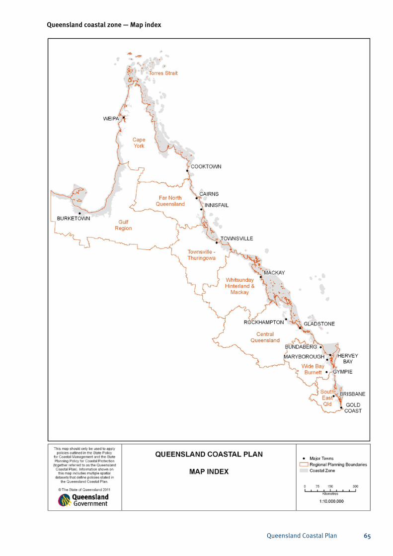
Queensland Coastal Plan 65
Queensland coastal zone — Map index
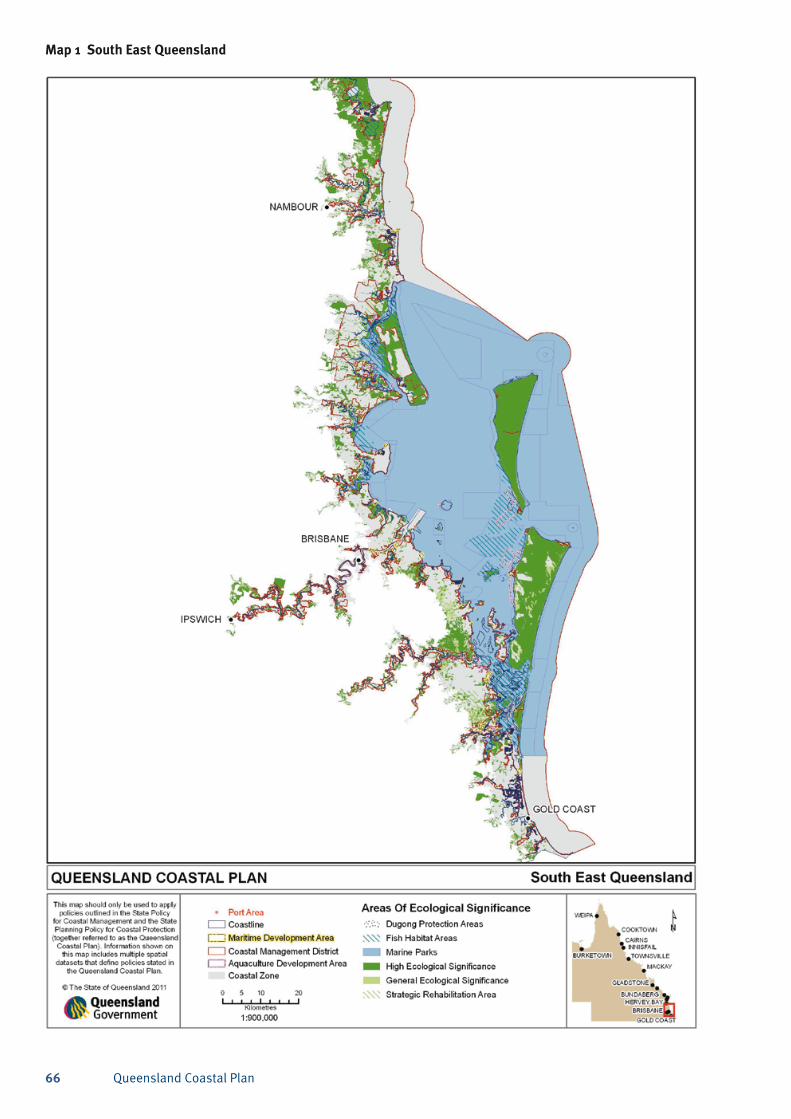
Queensland Coastal Plan66
Map 1 South East Queensland
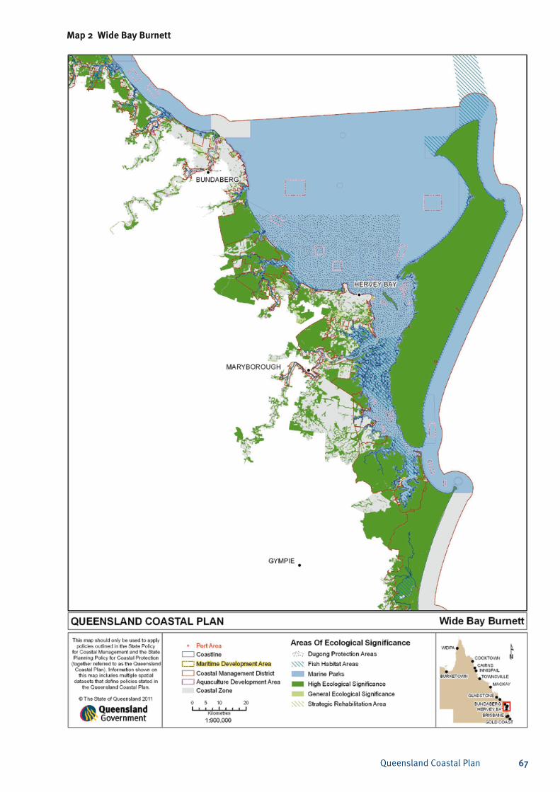
Queensland Coastal Plan 67
Map 2 Wide Bay Burnett
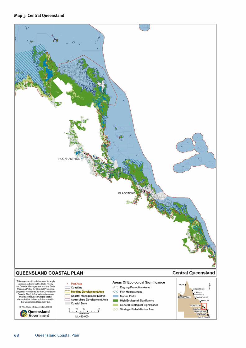
Queensland Coastal Plan68
Map 3 Central Queensland
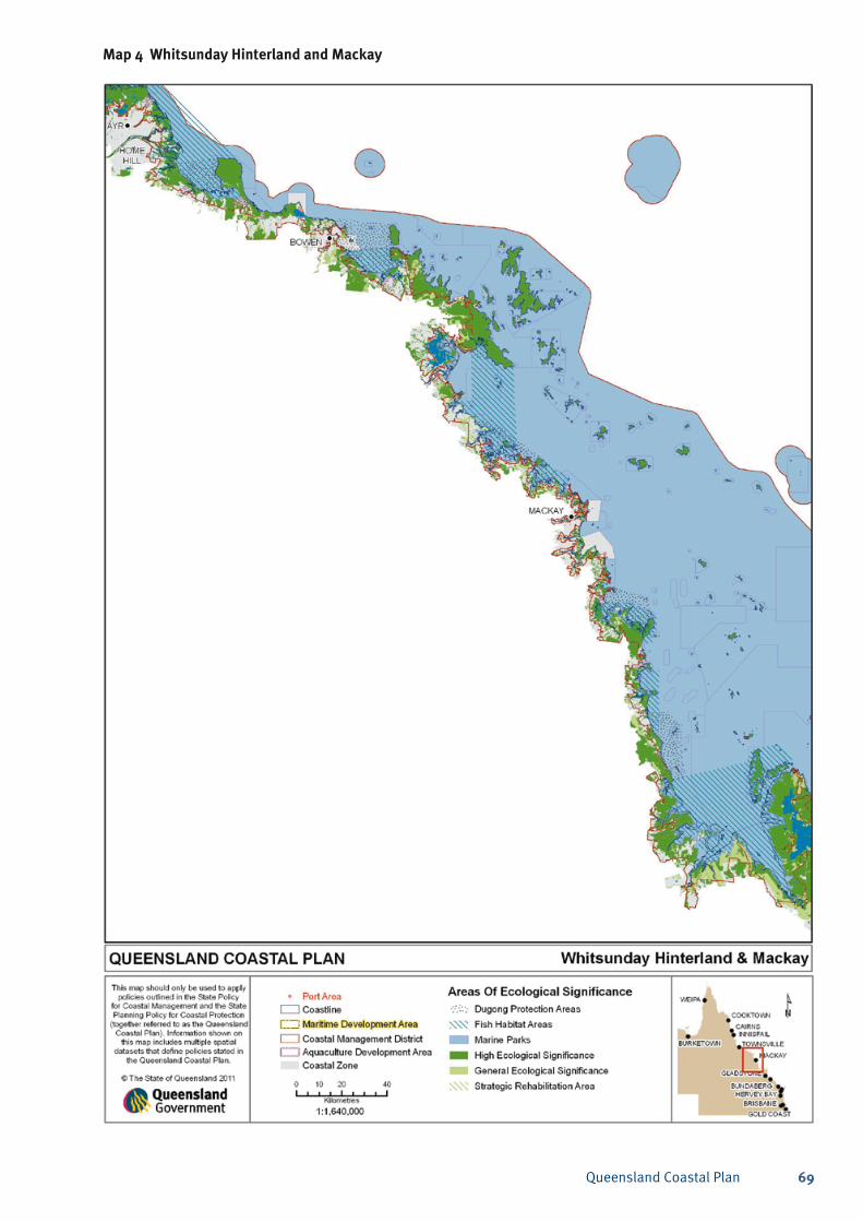
Queensland Coastal Plan 69
Map 4 Whitsunday Hinterland and Mackay
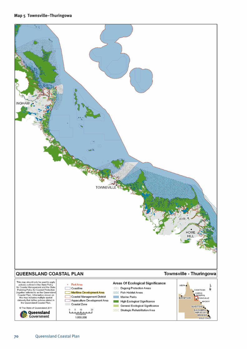
Queensland Coastal Plan70
Map 5 Townsville–Thuringowa
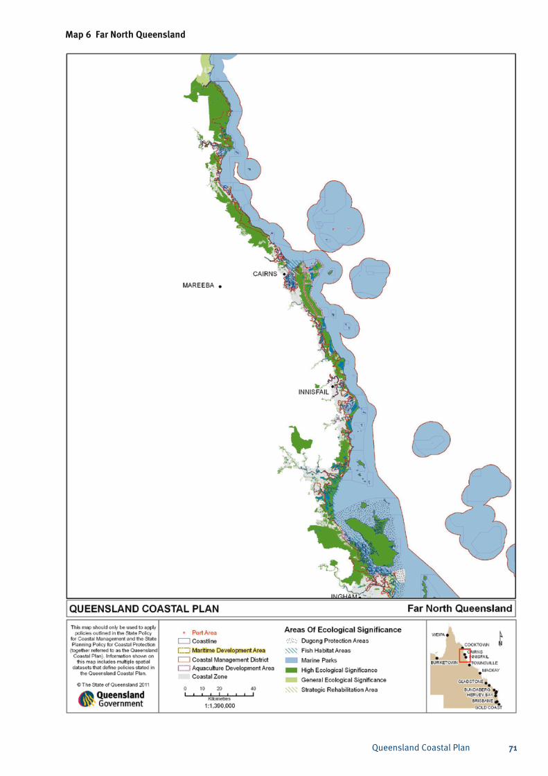
Queensland Coastal Plan 71
Map 6 Far North Queensland
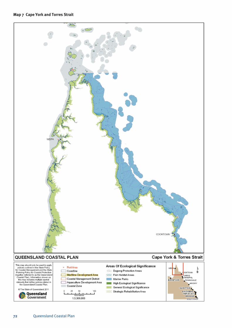
Queensland Coastal Plan72
Map 7 Cape York and Torres Strait
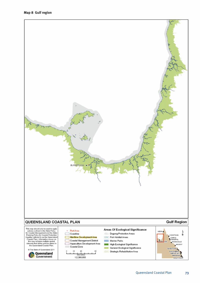
Queensland Coastal Plan 73
Map 8 Gulf region
Queensland Coastal Plan74
The purpose of the code A2.1 The purpose of this code is to achieve the overall
outcomes sought by the State Planning Policy for Coastal Protection:
A2.2 Development in the coastal zone is planned, designed, constructed and operated to:
avoid the social, financial and environmental a) costs arising from the impacts of coastal hazards, taking into account the predicted effects of climate change; and
protect, conserve, rehabilitate and manage the b) coast, including its resources and biological diversity.
Overall outcomes A2.3 The purpose of the code will be achieved through
the following overall outcomes:
The conservation of coastal resources is a) maximised and the exposure of communities to the risk of adverse coastal hazard impacts is minimised.
Communities, infrastructure and coastal b) ecosystems are protected from adverse coastal hazard impacts, taking into account the projected effects of climate change.
Areas of high ecological significance are c) protected and other ecological values are conserved.
Opportunities for sustainable coastal-d) dependent development are protected and maintained in a manner that minimises impacts on coastal resources.
Scenic amenity of the coast is protected and e) enhanced.
Public access to the foreshore is maintained f) and enhanced for current and future generations.
Annex 2 – Development assessment code
Application of the codeA2.4 This code is a development assessment code for
use in the integrated development assessment system under the Sustainable Planning Act 2009 (SPA).
A2.5 This code is to be used where a relevant adopted planning scheme does not explicitly state that it appropriately reflects the policy. This code may also be used by the local government to reflect the SPP in their planning scheme, in accordance with section B.2 of the SPP.
A2.6 This code will apply when assessing development described in Part B.7–B.8 of the SPP.
A2.7 DERM may be a concurrence agency or assessment manager for development applications within the coastal management district. However, in accordance with schedule 7 of the SPA, DERM’s concurrence agency jurisdiction does not extend to matters relating to scenic amenity. The assessment of section 3 of this code (landscape protection) is therefore carried out only by the local government.
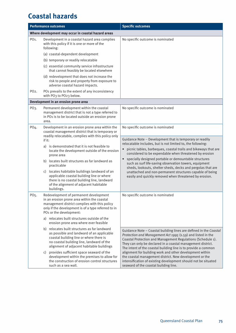
Queensland Coastal Plan 75
Coastal hazardsPerformance outcomes Specific outcomes
Where development may occur in coastal hazard areas
PO1. Development in a coastal hazard area complies with this policy if it is one or more of the following:
(a) coastal-dependent development
(b) temporary or readily relocatable
(c) essential community service infrastructure that cannot feasibly be located elsewhere
(d) redevelopment that does not increase the risk to people and property from exposure to adverse coastal hazard impacts.
PO2. PO1 prevails to the extent of any inconsistency with PO3 to PO23 below.
No specific outcome is nominated
Development in an erosion prone area
PO3. Permanent development within the coastal management district that is not a type referred to in PO1 is to be located outside an erosion prone area.
No specific outcome is nominated
PO4. Development in an erosion prone area within the coastal management district that is temporary or readily relocatable, complies with this policy only if it:
a) is demonstrated that it is not feasible to locate the development outside of the erosion prone area
b) locates built structures as far landward as practicable
c) locates habitable buildings landward of an applicable coastal building line or where there is no coastal building line, landward of the alignment of adjacent habitable buildings.
No specific outcome is nominated
Guidance Note – Development that is temporary or readily relocatable includes, but is not limited to, the following:
picnic tables, barbeques, coastal trails and bikeways that are • considered to be expendable when threatened by erosion
specially designed portable or demountable structures • such as surf life-saving observation towers, equipment sheds, lookouts, shelter sheds, decks and pergolas that are unattached and non-permanent structures capable of being easily and quickly removed when threatened by erosion.
PO5. Redevelopment of permanent development in an erosion prone area within the coastal management district complies with this policy only if the development is of a type referred to in PO1 or the development:
a) relocates built structures outside of the erosion prone area where ever feasible
b) relocates built structures as far landward as possible and landward of an applicable coastal building line or where there is no coastal building line, landward of the alignment of adjacent habitable buildings
c) provides sufficient space seaward of the development within the premises to allow for the construction of erosion control structures such as a sea wall.
No specific outcome is nominated
Guidance Note – Coastal building lines are defined in the Coastal Protection and Management Act 1995 (s.59) and listed in the Coastal Protection and Management Regulations (Schedule 1). They can only be declared in a coastal management district. The intent of the coastal building line is to provide a common alignment for building work and other development within the coastal management district. New development or the intensification of existing development should not be situated seaward of the coastal building line.
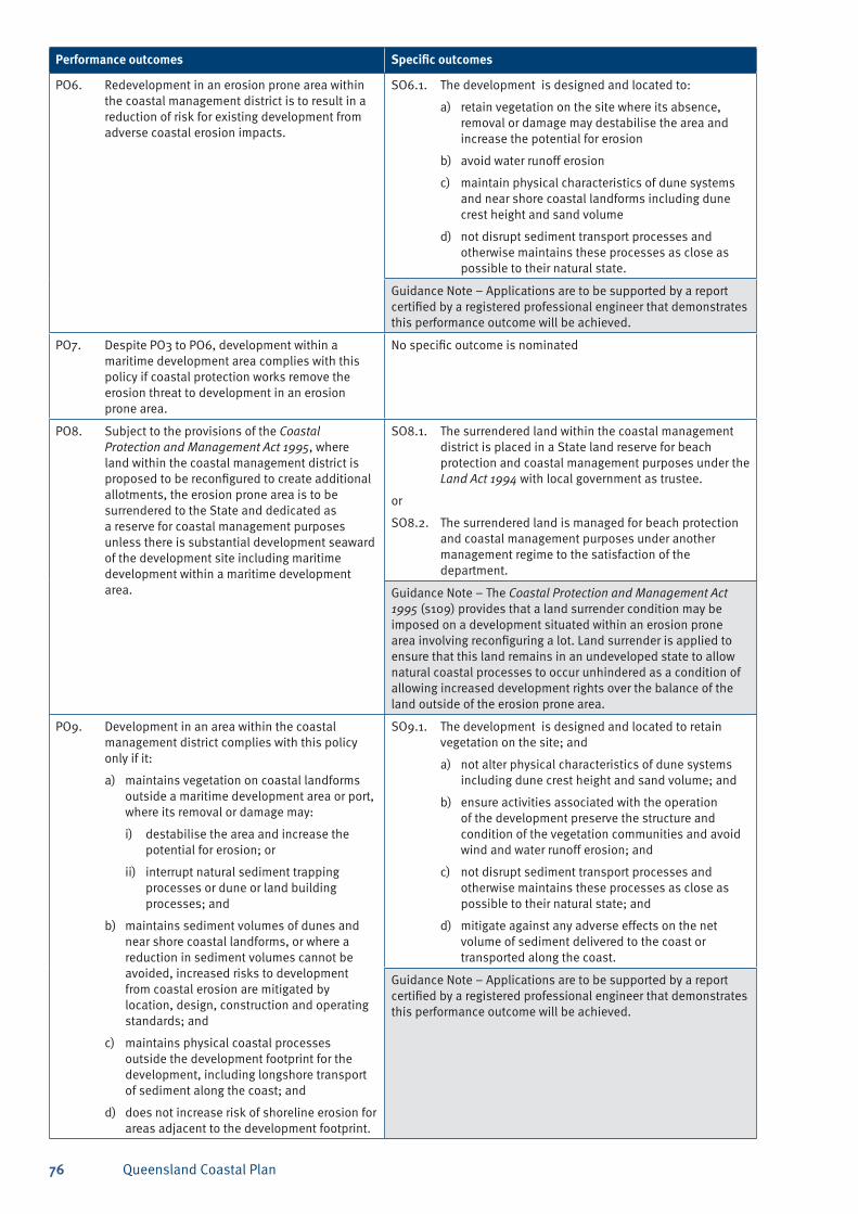
Queensland Coastal Plan76
Performance outcomes Specific outcomes
PO6. Redevelopment in an erosion prone area within the coastal management district is to result in a reduction of risk for existing development from adverse coastal erosion impacts.
SO6.1. The development is designed and located to:
a) retain vegetation on the site where its absence, removal or damage may destabilise the area and increase the potential for erosion
b) avoid water runoff erosion
c) maintain physical characteristics of dune systems and near shore coastal landforms including dune crest height and sand volume
d) not disrupt sediment transport processes and otherwise maintains these processes as close as possible to their natural state.
Guidance Note – Applications are to be supported by a report certified by a registered professional engineer that demonstrates this performance outcome will be achieved.
PO7. Despite PO3 to PO6, development within a maritime development area complies with this policy if coastal protection works remove the erosion threat to development in an erosion prone area.
No specific outcome is nominated
PO8. Subject to the provisions of the Coastal Protection and Management Act 1995, where land within the coastal management district is proposed to be reconfigured to create additional allotments, the erosion prone area is to be surrendered to the State and dedicated as a reserve for coastal management purposes unless there is substantial development seaward of the development site including maritime development within a maritime development area.
SO8.1. The surrendered land within the coastal management district is placed in a State land reserve for beach protection and coastal management purposes under the Land Act 1994 with local government as trustee.
or
SO8.2. The surrendered land is managed for beach protection and coastal management purposes under another management regime to the satisfaction of the department.
Guidance Note – The Coastal Protection and Management Act 1995 (s109) provides that a land surrender condition may be imposed on a development situated within an erosion prone area involving reconfiguring a lot. Land surrender is applied to ensure that this land remains in an undeveloped state to allow natural coastal processes to occur unhindered as a condition of allowing increased development rights over the balance of the land outside of the erosion prone area.
PO9. Development in an area within the coastal management district complies with this policy only if it:
a) maintains vegetation on coastal landforms outside a maritime development area or port, where its removal or damage may:
i) destabilise the area and increase the potential for erosion; or
ii) interrupt natural sediment trapping processes or dune or land building processes; and
b) maintains sediment volumes of dunes and near shore coastal landforms, or where a reduction in sediment volumes cannot be avoided, increased risks to development from coastal erosion are mitigated by location, design, construction and operating standards; and
c) maintains physical coastal processes outside the development footprint for the development, including longshore transport of sediment along the coast; and
d) does not increase risk of shoreline erosion for areas adjacent to the development footprint.
SO9.1. The development is designed and located to retain vegetation on the site; and
a) not alter physical characteristics of dune systems including dune crest height and sand volume; and
b) ensure activities associated with the operation of the development preserve the structure and condition of the vegetation communities and avoid wind and water runoff erosion; and
c) not disrupt sediment transport processes and otherwise maintains these processes as close as possible to their natural state; and
d) mitigate against any adverse effects on the net volume of sediment delivered to the coast or transported along the coast.
Guidance Note – Applications are to be supported by a report certified by a registered professional engineer that demonstrates this performance outcome will be achieved.
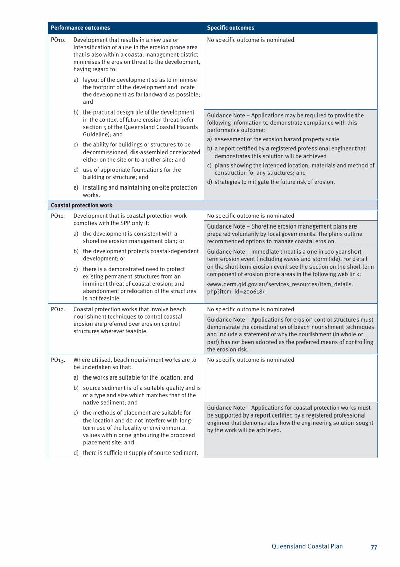
Queensland Coastal Plan 77
Performance outcomes Specific outcomes
PO10. Development that results in a new use or intensification of a use in the erosion prone area that is also within a coastal management district minimises the erosion threat to the development, having regard to:
a) layout of the development so as to minimise the footprint of the development and locate the development as far landward as possible; and
b) the practical design life of the development in the context of future erosion threat (refer section 5 of the Queensland Coastal Hazards Guideline); and
c) the ability for buildings or structures to be decommissioned, dis-assembled or relocated either on the site or to another site; and
d) use of appropriate foundations for the building or structure; and
e) installing and maintaining on-site protection works.
No specific outcome is nominated
Guidance Note – Applications may be required to provide the following information to demonstrate compliance with this performance outcome:
assessment of the erosion hazard property scalea)
a report certified by a registered professional engineer that b) demonstrates this solution will be achieved
plans showing the intended location, materials and method of c) construction for any structures; and
strategies to mitigate the future risk of erosion.d)
Coastal protection work
PO11. Development that is coastal protection work complies with the SPP only if:
a) the development is consistent with a shoreline erosion management plan; or
b) the development protects coastal-dependent development; or
c) there is a demonstrated need to protect existing permanent structures from an imminent threat of coastal erosion; and abandonment or relocation of the structures is not feasible.
No specific outcome is nominated
Guidance Note – Shoreline erosion management plans are prepared voluntarily by local governments. The plans outline recommended options to manage coastal erosion.
Guidance Note – Immediate threat is a one in 100-year short-term erosion event (including waves and storm tide). For detail on the short-term erosion event see the section on the short-term component of erosion prone areas in the following web link:
<www.derm.qld.gov.au/services_resources/item_details.php?item_id=200618>
PO12. Coastal protection works that involve beach nourishment techniques to control coastal erosion are preferred over erosion control structures wherever feasible.
No specific outcome is nominated
Guidance Note – Applications for erosion control structures must demonstrate the consideration of beach nourishment techniques and include a statement of why the nourishment (in whole or part) has not been adopted as the preferred means of controlling the erosion risk.
PO13. Where utilised, beach nourishment works are to be undertaken so that:
a) the works are suitable for the location; and
b) source sediment is of a suitable quality and is of a type and size which matches that of the native sediment; and
c) the methods of placement are suitable for the location and do not interfere with long-term use of the locality or environmental values within or neighbouring the proposed placement site; and
d) there is sufficient supply of source sediment.
No specific outcome is nominated
Guidance Note – Applications for coastal protection works must be supported by a report certified by a registered professional engineer that demonstrates how the engineering solution sought by the work will be achieved.
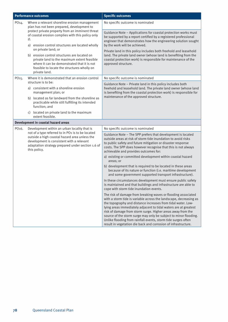
Queensland Coastal Plan78
Performance outcomes Specific outcomes
PO14. Where a relevant shoreline erosion management plan has not been prepared, development to protect private property from an imminent threat of coastal erosion complies with this policy only if:
a) erosion control structures are located wholly on private land; or
b) erosion control structures are located on private land to the maximum extent feasible where it can be demonstrated that it is not feasible to locate the structures wholly on private land.
No specific outcome is nominated
Guidance Note – Applications for coastal protection works must be supported by a report certified by a registered professional engineer that demonstrates how the engineering solution sought by the work will be achieved.
Private land in this policy includes both freehold and leasehold land. The private land owner (whose land is benefiting from the coastal protection work) is responsible for maintenance of the approved structure.
PO15. Where it is demonstrated that an erosion control structure is to be:
a) consistent with a shoreline erosion management plan; or
b) located as far landward from the shoreline as practicable while still fulfilling its intended function; and
c) located on private land to the maximum extent feasible.
No specific outcome is nominated
Guidance Note – Private land in this policy includes both freehold and leasehold land. The private land owner (whose land is benefiting from the coastal protection work) is responsible for maintenance of the approved structure.
Development in coastal hazard areas
PO16. Development within an urban locality that is not of a type referred to in PO1 is to be located outside a high coastal hazard area unless the development is consistent with a relevant adaptation strategy prepared under section 1.6 of this policy.
No specific outcome is nominated
Guidance Note – The SPP prefers that development is located outside areas at risk of storm tide inundation to avoid risks to public safety and future mitigation or disaster response costs. The SPP does however recognise that this is not always achievable and provides outcomes for:
existing or committed development within coastal hazard a) areas; or
development that is required to be located in these areas b) because of its nature or function (i.e. maritime development and some government supported transport infrastructure).
In these circumstances development must ensure public safety is maintained and that buildings and infrastructure are able to cope with storm tide inundation events.
The risk of damage from breaking waves or flooding associated with a storm tide is variable across the landscape, decreasing as the topography and distance increases from tidal water. Low-lying areas immediately adjacent to tidal waters are at greatest risk of damage from storm surge. Higher areas away from the source of the storm surge may only be subject to minor flooding. Unlike flooding from rainfall events, storm tide surges often result in vegetation die back and corrosion of infrastructure.
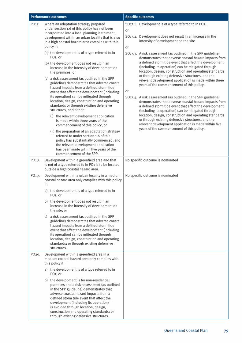
Queensland Coastal Plan 79
Performance outcomes Specific outcomes
PO17. Where an adaptation strategy prepared under section 1.6 of this policy has not been incorporated into a local planning instrument, development within an urban locality that is also in a high coastal hazard area complies with this policy if:
(a) the development is of a type referred to in PO1; or
(b) the development does not result in an increase in the intensity of development on the premises; or
(c) a risk assessment (as outlined in the SPP guideline) demonstrates that adverse coastal hazard impacts from a defined storm tide event that affect the development (including its operation) can be mitigated through location, design, construction and operating standards or through existing defensive structures, and either:
(i) the relevant development application is made within three years of the commencement of this policy; or
(ii) the preparation of an adaptation strategy referred to under section 1.6 of this policy has substantially commenced, and the relevant development application has been made within five years of the commencement of the SPP.
SO17.1. Development is of a type referred to in PO1.
or
SO17.2. Development does not result in an increase in the intensity of development on the site.
or
SO17.3. A risk assessment (as outlined in the SPP guideline) demonstrates that adverse coastal hazard impacts from a defined storm tide event that affect the development (including its operation) can be mitigated through location, design, construction and operating standards or through existing defensive structures, and the relevant development application is made within three years of the commencement of this policy.
or
SO17.4. A risk assessment (as outlined in the SPP guideline) demonstrates that adverse coastal hazard impacts from a defined storm tide event that affect the development (including its operation) can be mitigated through location, design, construction and operating standards or through existing defensive structures, and the relevant development application is made within five years of the commencement of this policy.
PO18. Development within a greenfield area and that is not of a type referred to in PO1 is to be located outside a high coastal hazard area.
No specific outcome is nominated
PO19. Development within a urban locality in a medium coastal hazard area only complies with this policy if:
a) the development is of a type referred to in PO1; or
b) the development does not result in an increase in the intensity of development on the site; or
c) a risk assessment (as outlined in the SPP guideline) demonstrates that adverse coastal hazard impacts from a defined storm tide event that affect the development (including its operation) can be mitigated through location, design, construction and operating standards; or through existing defensive structures.
No specific outcome is nominated
PO20. Development within a greenfield area in a medium coastal hazard area only complies with this policy if:
a) the development is of a type referred to in PO1; or
b) the development is for non-residential purposes and a risk assessment (as outlined in the SPP guideline) demonstrates that adverse coastal hazard impacts from a defined storm tide event that affect the development (including its operation) is avoided through location, design, construction and operating standards; or through existing defensive structures.
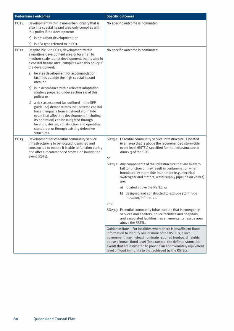
Queensland Coastal Plan80
Performance outcomes Specific outcomes
PO21. Development within a non-urban locality that is also in a coastal hazard area only complies with this policy if the development:
a) is not urban development; or
b) is of a type referred to in PO1.
No specific outcome is nominated
PO22. Despite PO16 to PO21, development within a maritime development area or for small to medium-scale tourist development, that is also in a coastal hazard area, complies with this policy if the development:
a) locates development for accommodation facilities outside the high coastal hazard area; or
b) is in accordance with a relevant adaptation strategy prepared under section 1.6 of this policy; or
c) a risk assessment (as outlined in the SPP guideline) demonstrates that adverse coastal hazard impacts from a defined storm tide event that affect the development (including its operation) can be mitigated through location, design, construction and operating standards; or through existing defensive structures.
No specific outcome is nominated
PO23. Development for essential community service infrastructure is to be located, designed and constructed to ensure it is able to function during and after a recommended storm tide inundation event (RSTE).
SO23.1. Essential community service infrastructure is located in an area that is above the recommended storm-tide event level (RSTEL) specified for that infrastructure at Annex 3 of the SPP.
or
SO23.2. Any components of the infrastructure that are likely to fail to function or may result in contamination when inundated by storm tide inundation (e.g. electrical switchgear and motors, water supply pipeline air valves) are:
a) located above the RSTEL; or
b) designed and constructed to exclude storm tide intrusion/infiltration.
and
SO23.3. Essential community infrastructure that is emergency services and shelters, police facilities and hospitals, and associated facilities has an emergency rescue area above the RSTEL.
Guidance Note – For localities where there is insufficient flood information to identify one or more of the RSTELs, a local government may instead nominate required freeboard heights above a known flood level (for example, the defined storm tide event) that are estimated to provide an approximately equivalent level of flood immunity to that achieved by the RSTELs.
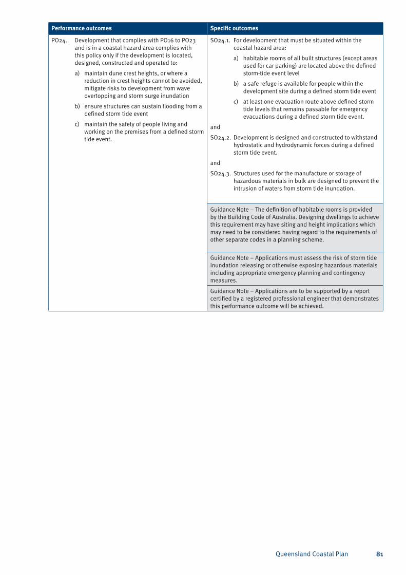
Queensland Coastal Plan 81
Performance outcomes Specific outcomes
PO24. Development that complies with PO16 to PO23 and is in a coastal hazard area complies with this policy only if the development is located, designed, constructed and operated to:
a) maintain dune crest heights, or where a reduction in crest heights cannot be avoided, mitigate risks to development from wave overtopping and storm surge inundation
b) ensure structures can sustain flooding from a defined storm tide event
c) maintain the safety of people living and working on the premises from a defined storm tide event.
SO24.1. For development that must be situated within the coastal hazard area:
a) habitable rooms of all built structures (except areas used for car parking) are located above the defined storm-tide event level
b) a safe refuge is available for people within the development site during a defined storm tide event
c) at least one evacuation route above defined storm tide levels that remains passable for emergency evacuations during a defined storm tide event.
and
SO24.2. Development is designed and constructed to withstand hydrostatic and hydrodynamic forces during a defined storm tide event.
and
SO24.3. Structures used for the manufacture or storage of hazardous materials in bulk are designed to prevent the intrusion of waters from storm tide inundation.
Guidance Note – The definition of habitable rooms is provided by the Building Code of Australia. Designing dwellings to achieve this requirement may have siting and height implications which may need to be considered having regard to the requirements of other separate codes in a planning scheme.
Guidance Note – Applications must assess the risk of storm tide inundation releasing or otherwise exposing hazardous materials including appropriate emergency planning and contingency measures.
Guidance Note – Applications are to be supported by a report certified by a registered professional engineer that demonstrates this performance outcome will be achieved.
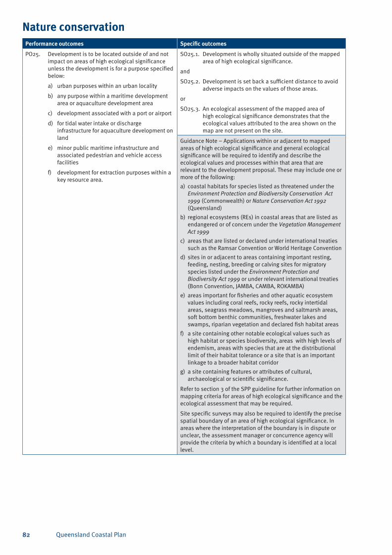
Queensland Coastal Plan82
Nature conservationPerformance outcomes Specific outcomes
PO25. Development is to be located outside of and not impact on areas of high ecological significance unless the development is for a purpose specified below:
a) urban purposes within an urban locality
b) any purpose within a maritime development area or aquaculture development area
c) development associated with a port or airport
d) for tidal water intake or discharge infrastructure for aquaculture development on land
e) minor public maritime infrastructure and associated pedestrian and vehicle access facilities
f) development for extraction purposes within a key resource area.
SO25.1. Development is wholly situated outside of the mapped area of high ecological significance.
and
SO25.2. Development is set back a sufficient distance to avoid adverse impacts on the values of those areas.
or
SO25.3. An ecological assessment of the mapped area of high ecological significance demonstrates that the ecological values attributed to the area shown on the map are not present on the site.
Guidance Note – Applications within or adjacent to mapped areas of high ecological significance and general ecological significance will be required to identify and describe the ecological values and processes within that area that are relevant to the development proposal. These may include one or more of the following:
coastal habitats for species listed as threatened under the a) Environment Protection and Biodiversity Conservation Act 1999 (Commonwealth) or Nature Conservation Act 1992 (Queensland)
regional ecosystems (REs) in coastal areas that are listed as b) endangered or of concern under the Vegetation Management Act 1999
areas that are listed or declared under international treaties c) such as the Ramsar Convention or World Heritage Convention
sites in or adjacent to areas containing important resting, d) feeding, nesting, breeding or calving sites for migratory species listed under the Environment Protection and Biodiversity Act 1999 or under relevant international treaties (Bonn Convention, JAMBA, CAMBA, ROKAMBA)
areas important for fisheries and other aquatic ecosystem e) values including coral reefs, rocky reefs, rocky intertidal areas, seagrass meadows, mangroves and saltmarsh areas, soft bottom benthic communities, freshwater lakes and swamps, riparian vegetation and declared fish habitat areas
a site containing other notable ecological values such as f) high habitat or species biodiversity, areas with high levels of endemism, areas with species that are at the distributional limit of their habitat tolerance or a site that is an important linkage to a broader habitat corridor
a site containing features or attributes of cultural, g) archaeological or scientific significance.
Refer to section 3 of the SPP guideline for further information on mapping criteria for areas of high ecological significance and the ecological assessment that may be required.
Site specific surveys may also be required to identify the precise spatial boundary of an area of high ecological significance. In areas where the interpretation of the boundary is in dispute or unclear, the assessment manager or concurrence agency will provide the criteria by which a boundary is identified at a local level.
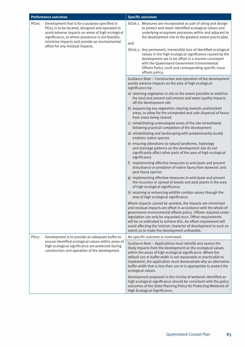
Queensland Coastal Plan 83
Performance outcomes Specific outcomes
PO26. Development that is for a purpose specified in PO25 is to be located, designed and operated to avoid adverse impacts on areas of high ecological significance, or where avoidance is not feasible, minimise impacts and provide an environmental offset for any residual impacts.
SO26.1. Measures are incorporated as part of siting and design to protect and retain identified ecological values and underlying ecosystem processes within and adjacent to the development site to the greatest extent practicable.
and
SO26.2. Any permanent, irreversible loss of identified ecological values in the high ecological significance caused by the development are to be offset in a manner consistent with the Queensland Government Environmental Offsets Policy 2008 and corresponding specific issue offsets policy.
Guidance Note – Construction and operation of the development avoids adverse impacts on the area of high ecological significance by:
retaining vegetation in situ to the extent possible to stabilise a) the land and prevent soil erosion and water quality impacts off the development site
sequencing any vegetation clearing towards undisturbed b) areas, to allow for the unimpeded and safe dispersal of fauna from areas being cleared
rehabilitating undeveloped areas of the site immediately c) following practical completion of the development
rehabilitating and landscaping with predominantly locally d) endemic native species
ensuring alterations to natural landforms, hydrology e) and drainage patterns on the development site do not significantly affect other parts of the area of high ecological significance
implementing effective measures to anticipate and prevent f) disturbance or predation of native fauna from domestic and pest fauna species
implementing effective measures to anticipate and prevent g) the incursion or spread of weeds and pest plants in the area of high ecological significance
retaining or enhancing wildlife corridor values through the h) area of high ecological significance.
Where impacts cannot be avoided, the impacts are minimised and residual impacts are offset in accordance with the whole-of-government environmental offsets policy. Offsets required under legislation can only be requested once. Offset requirements will be co-ordinated to achieve this. An offset requirement will avoid affecting the intrinsic character of development to such an extent as to make the development unfeasible.
PO27. Development is to provide an adequate buffer to ensure identified ecological values within areas of high ecological significance are protected during construction and operation of the development.
No specific outcome is nominated
Guidance Note – Applications must identify and assess the likely impacts from the development on the ecological values within the areas of high ecological significance. Where the default 100 m buffer width is not reasonable or practicable to implement, the application must demonstrate why an alternative buffer width that is less than 100 m is appropriate to protect the ecological values.
Development proposed in the vicinity of wetlands identified as high ecological significance should be consistent with the policy outcomes of the State Planning Policy for Protecting Wetlands of High Ecological Significance.
Queensland Coastal Plan84
Performance outcomes Specific outcomes
PO28. Development is not to interrupt, interfere or otherwise adversely impact on underlying natural ecosystem processes such as water quality, hydrology, geomorphology and biological processes and interactions that affect or maintain the identified ecological values within an area of high ecological significance.
No specific outcome is nominated
Guidance Note – Applications must identify the ecological values within the areas of high ecological significance and general ecological significance and assess the likely impacts from the development on those values. This includes both direct and indirect impacts to those values that may result from changes to underlying ecosystem processes such as water quality, changes to hydrological or hydrodynamics processes that could result in changes to the natural flow regime (quantity, timing and duration of flows) or the stability of landforms (such as increased scour or erosion of bed and banks of waterways) and biological processes such as species interaction and processes that maintain wildlife populations.
Development proposed in the vicinity of wetlands identified as high ecological significance should be consistent with the policy outcomes of the State Planning Policy for Protecting Wetlands of High Ecological Significance.
PO29. Development in coastal waters:
a) maintain the habitat value and ecological functionality of dugong protection areas
b) comply with the prescribed development purposes for declared fish habitat areas as per the requirements of the Fisheries Act 1994 including the relevant fisheries management policies and guidelines
c) comply with State Marine Park zoning plans and management plans, Commonwealth Great Barrier Reef Marine Park zoning plans and special management areas.
No specific outcome is nominated
Guidance Note – The habitat values of dugong protection areas should be maintained in accordance with the Nature Conservation Act 1992 for the protection of native wildlife and its habitat. This includes the protection of seagrass ecosystems susceptible to the effects of dredging and land reclamation.
Dugong protection areas are listed and regulated under the Fisheries Amendment Regulation 2008. Maps of fisheries regulated waters can be found at: <http://www.dpi.qld.gov.au/28_13448.htm>.
Dugong protection area maps can also be found in the Conservation and Management of Dugong in Queensland Conservation Plan 1999–2004 given effect under the Nature Conservation Act 1992 at: <www.derm.qld.gov.au/services_resources/item_list.php?series_id=205627>.
The Fisheries Act 1994 provides protection measures for fish habitat. Fish habitat area maps can be found at: <www.dpi.qld.gov.au>.
Development permitted under the Fisheries Act is deemed to comply with this requirement.
The Great Barrier Reef Marine Park is recognised as a matter of national environmental significance, which means it is protected under the Environment Protection and Biodiversity Conservation Act 1999 (EPBC Act). As well as the permit requirements of the Great Barrier Reef Marine Park Act 1975 (GBRMP Act) and Regulations, an activity will need to be referred to the federal environment minister if it is likely to have a significant impact on the environment, if the activity is within the marine park, and the environment of the Great Barrier Reef Marine Park or other nationally protected matters if the activity is outside the marine park.
Further information on the EPBC Act can be found at: <www.environment.gov.au>.
Development that may be conducted in marine parks under the Marine Park Regulation 2006 and the EPBC Act is deemed to comply with this requirement.
Marine park zoning plans and management plans can be found at: <www.derm.qld.gov.au/parks_and_forests/marine_parks/zoning_plans>.
The Great Barrier Reef Marine Park Zoning Plan and zoning maps can be found at: <www.gbrmpa.gov.au>.
Queensland Coastal Plan 85
Performance outcomes Specific outcomes
PO30. Development is not to adversely impact on the habitat of threatened species where the habitat supports a critical life stage ecological process such as feeding, breeding, or roosting.
SO30.1. Measures are to be incorporated as part of siting and design to protect and retain identified ecological values and underlying ecosystem processes within or adjacent to the development site to the greatest extent practicable.
and
SO30.2. Other forms of potential human disturbance to these areas, such as presence of vehicles, pedestrian use, increased exposure to domestic animals, noise and lighting impacts, etc. are to be avoided or adverse impacts mitigated.
Guidance Note – Applications for development must identify any threatened species or their habitats that may be affected by the proposal. In particular, applications are to identify and describe how the development avoids adverse impacts on any critical life stage ecological processes within or adjacent to the development area.
Note–species listed as threatened species under the Environmental Protection and Biodiversity Conservation Act 1999 (Commonwealth) are matters of national environmental significance and actions that will have, or are likely to have, a significant impact on a listed threatened species or ecological community are regulated under that Act.
PO31. Development is to minimise adverse impacts on areas of general ecological significance and other ecological values.
SO31.1. Measures are to be incorporated as part of siting and design to protect and retain identified ecological values and underlying ecosystem processes within or adjacent to the development site to the greatest extent practicable.
and
SO31.2. Development is to minimise capital dredging or the disposal of material in coastal waters during key biological events (such as fish aggregations or spawning) for fish species found in the area.
Guidance Note – Construction and operation of the development avoids further adverse impacts within the area of general ecological significance by:
retaining vegetation in situ to the extent possible to stabilise a) the land and prevent soil erosion and water quality impacts off the development site
sequencing any vegetation clearing towards undisturbed b) areas, to allow for the unimpeded and safe dispersal of fauna from areas being cleared
rehabilitating undeveloped areas of the site immediately c) following practical completion of the development
rehabilitating and landscaping with predominantly locally d) endemic native species
ensuring alterations to natural landforms, hydrology e) and drainage patterns on the development site do not significantly affect other parts of the area of high ecological significance
implementing effective measures to anticipate and prevent f) disturbance or predation of native fauna from domestic and pest fauna species
implementing effective measures to anticipate and prevent g) the incursion or spread of weeds and pest plants in the area of high ecological significance
retaining or enhancing wildlife corridor values through the h) area of high ecological significance.
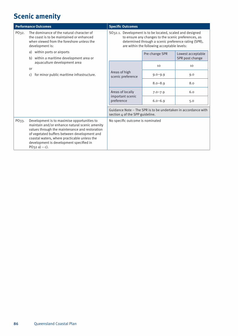
Queensland Coastal Plan86
Scenic amenityPerformance Outcomes Specific Outcomes
PO32. The dominance of the natural character of the coast is to be maintained or enhanced when viewed from the foreshore unless the development is:
a) within ports or airports
b) within a maritime development area or aquaculture development area
or
c) for minor public maritime infrastructure.
SO32.1. Development is to be located, scaled and designed to ensure any changes to the scenic preferences, as determined through a scenic preference rating (SPR), are within the following acceptable levels:
Pre change SPR Lowest acceptable SPR post change
Areas of high scenic preference
10 10
9.0–9.9 9.0
8.0–8.9 8.0
Areas of locally important scenic preference
7.0–7.9 6.0
6.0–6.9 5.0
Guidance Note – The SPR is to be undertaken in accordance with section 4 of the SPP guideline.
PO33. Development is to maximise opportunities to maintain and/or enhance natural scenic amenity values through the maintenance and restoration of vegetated buffers between development and coastal waters, where practicable unless the development is development specified in PO32 a) – c).
No specific outcome is nominated
Queensland Coastal Plan 87
Public accessPerformance outcomes Specific outcomes
PO34. Development is to maintain access to the foreshore to facilitate Indigenous cultural activities and practices.
No specific outcome is nominated
Guidance Note – Appropriate access to the foreshore for traditional purposes and cultural usage should be determined in consultation with the relevant Traditional Owners for the area.
PO35. Development adjacent to State coastal land or tidal water complies with this policy only if the development is located, designed and operated to:
a) maintain public access to and along the foreshore; or
b) minimise any loss of public access to and along the foreshore; and
c) offset any loss of public access to and along the foreshore by providing for enhanced alternative access in the general location.
SO35.1. Appropriate public access (for pedestrians and/or vehicles) is provided through the site to the foreshore
and
SO35.2 Coastal structures are located and designed to:
a) allow safe and unimpeded access to, over, under or around the structure
b) ensure emergency vehicles can access the area near the development.
Guidance Note – Public or commercial infrastructure on the coast where access restrictions are required for safety, security and operations include for example, airports, ports, boat harbours and marinas, mining and gas terminals and jetties.
PO36. Despite PO34 and PO35, development that restricts public access to the coast complies with this policy where it is demonstrated that restrictions are necessary for:
a) the safe or secure operation of development; or
b) the maintenance of coastal landforms and coastal habitat.
No specific outcome is nominated
Guidance Note – Public or commercial infrastructure on the coast where access restrictions are required for safety, security and operations include for example, airports, ports, boat harbours, marina berths, and mining and gas terminals and jetties.
PO37. Residential, tourist, and retail development in a maritime development area that is not coastal dependent complies with this policy only if the development is separated from tidal water by public areas or public access facilities.
No specific outcome is nominated
PO38. Development that involves reconfiguration of a lot for urban purposes adjacent to the coast is designed to enhance public access to the coast in consideration of public access demand from a whole of community basis and the maintenance of coastal landforms and coastal habitat if:
a) the lot subject to reconfiguration is outside a port or maritime development area and has a coastal frontage greater than 80 metres in length
b) more than 10 lots are proposed to be created
c) resulting lot sizes are mostly less than 2000 square metres.
No specific outcome is nominated
PO39. Development is to avoid private structures attaching to or extending across non-tidal State coastal land.
SO39.1. Private marine access structures such as jetties, pontoon, and similar structures do not attach to, or extend across State coastal land that is situated above high water mark.
Guidance Note – State coastal land excludes freehold and leasehold land. Where a private marine access structure is proposed across State Land, a permit or allocation of land under the Land Act 1994 is required.
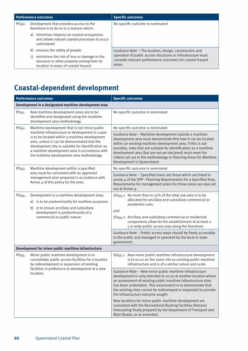
Queensland Coastal Plan88
Performance outcomes Specific outcomes
PO40. Development that provides access to the foreshore is to do so in a manner which:
a) minimises impacts on coastal ecosystems and allows natural coastal processes to occur unhindered
b) ensures the safety of people
c) minimises the risk of loss or damage to the structure or other property arising from its location in areas of coastal hazard.
No specific outcome is nominated
Guidance Note – The location, design, construction and operation of public access structures or infrastructure must consider relevant performance outcomes for coastal hazard areas.
Coastal-dependent developmentPerformance outcomes Specific outcomes
Development in a designated maritime development area
PO41. New maritime development areas are to be identified and designated using the maritime development area methodology.
No specific outcome is nominated
PO42. Maritime development that is not minor public maritime infrastructure or development in a port is to be located within a maritime development area, unless it can be demonstrated that the development site is suitable for identification as a maritime development area in accordance with the maritime development area methodology.
No specific outcome is nominated
Guidance Note – Maritime development outside a maritime development area must demonstrate first how it can be located within an existing maritime development area. If this is not possible, sites that are suitable for identification as a maritime development area (but are not yet declared) must meet the criteria set out in the methodology in Planning Areas for Maritime Development in Queensland.
PO43. Maritime development within a specified area must be consistent with an approved management plan prepared in accordance with Annex 4 of this policy for the area.
No specific outcome is nominated
Guidance Note – Specified areas are those which are listed in annex 4 of the SPP– Planning Requirements for a Specified Area. Requirements for management plans for these areas are also set out at Annex 4.
PO44. Development in a maritime development area:
a) is to be predominantly for maritime purposes
b) is to ensure ancillary and subsidiary development is predominantly of a commercial or public nature.
SO44.1. No more than to 25% of the total use area is to be allocated for ancillary and subsidiary commercial or residential uses.
and
SO44.2. Ancillary and subsidiary commercial or residential components allow for the establishment of at least a 5 m wide public access way along the foreshore.
Guidance Note – Public access ways should be freely accessible to the public and managed or operated by the local or state government.
Development for minor public maritime infrastructure
PO45. Minor public maritime development is to consolidate public access facilities for a location by redevelopment or expansion of existing facilities in preference to development at a new location.
SO45.1. New minor public maritime infrastructure development is to occur on the same site as existing public maritime infrastructure and is of a similar nature and scale.
Guidance Note – New minor public maritime infrastructure development is only intended to occur at another location where an assessment of existing public maritime infrastructure sites has been undertaken. This assessment is to demonstrate that the existing sites cannot be redeveloped or expanded to provide the infrastructure outcome sought.
New locations for minor public maritime development are consistent with the Recreational Boating Facilities Demand Forecasting Study prepared by the Department of Transport and Main Roads, or as amended.
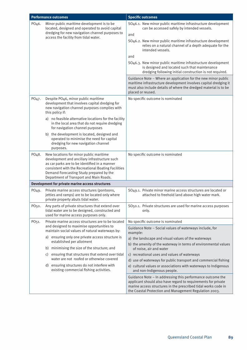
Queensland Coastal Plan 89
Performance outcomes Specific outcomes
PO46. Minor public maritime development is to be located, designed and operated to avoid capital dredging for new navigation channel purposes to access the facility from tidal water.
SO46.1. New minor public maritime infrastructure development can be accessed safely by intended vessels.
and
SO46.2. New minor public maritime infrastructure development relies on a natural channel of a depth adequate for the intended vessels.
and
SO46.3. New minor public maritime infrastructure development is designed and located such that maintenance dredging following initial construction is not required.
Guidance Note – Where an application for the new minor public maritime infrastructure development involves capital dredging it must also include details of where the dredged material is to be placed or reused.
PO47. Despite PO46, minor public maritime development that involves capital dredging for new navigation channel purposes complies with this policy if:
a) no feasible alternative locations for the facility in the local area that do not require dredging for navigation channel purposes
b) the development is located, designed and operated to minimise the need for capital dredging for new navigation channel purposes.
No specific outcome is nominated
PO48. New locations for minor public maritime development and ancillary infrastructure such as car parks are to be identified in a manner consistent with the Recreational Boating Facilities Demand Forecasting Study prepared by the Department of Transport and Main Roads.
No specific outcome is nominated
Development for private marine access structures
PO49. Private marine access structures (pontoons, jetties and ramps) are to be located only where private property abuts tidal water.
SO49.1. Private minor marine access structures are located or attached to freehold land above high water mark.
PO50. Any parts of private structures that extend over tidal water are to be designed, constructed and used for marine access purposes only.
SO50.1. Private structures are used for marine access purposes only.
PO51. Private marine access structures are to be located and designed to maximise opportunities to maintain social values of natural waterways by:
a) ensuring only one private access structure is established per allotment
b) minimising the size of the structure; and
c) ensuring that structures that extend over tidal water are not roofed or otherwise covered
d) ensuring structures do not interfere with existing commercial fishing activities.
No specific outcome is nominated
Guidance Note – Social values of waterways include, for example:
the landscape and visual values of the waterwaysa)
the amenity of the waterway in terms of environmental values b) of noise, air and water
recreational uses and values of waterwaysc)
use of waterways for public transport and commercial fishingd)
cultural values or associations with waterways to Indigenous e) and non-Indigenous people.
Guidance Note – In addressing this performance outcome the applicant should also have regard to requirements for private marine access structures in the prescribed tidal works code in the Coastal Protection and Management Regulation 2003.
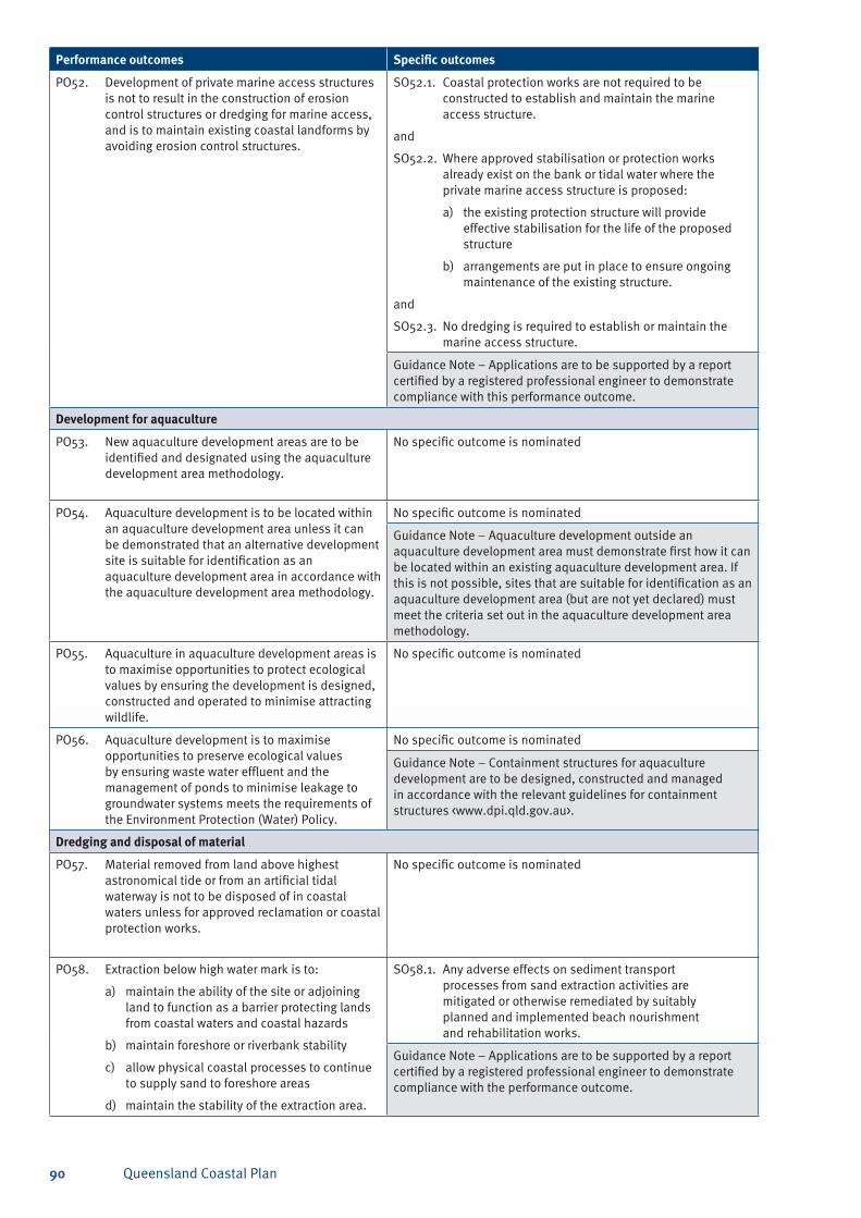
Queensland Coastal Plan90
Performance outcomes Specific outcomes
PO52. Development of private marine access structures is not to result in the construction of erosion control structures or dredging for marine access, and is to maintain existing coastal landforms by avoiding erosion control structures.
SO52.1. Coastal protection works are not required to be constructed to establish and maintain the marine access structure.
and
SO52.2. Where approved stabilisation or protection works already exist on the bank or tidal water where the private marine access structure is proposed:
a) the existing protection structure will provide effective stabilisation for the life of the proposed structure
b) arrangements are put in place to ensure ongoing maintenance of the existing structure.
and
SO52.3. No dredging is required to establish or maintain the marine access structure.
Guidance Note – Applications are to be supported by a report certified by a registered professional engineer to demonstrate compliance with this performance outcome.
Development for aquaculture
PO53. New aquaculture development areas are to be identified and designated using the aquaculture development area methodology.
No specific outcome is nominated
PO54. Aquaculture development is to be located within an aquaculture development area unless it can be demonstrated that an alternative development site is suitable for identification as an aquaculture development area in accordance with the aquaculture development area methodology.
No specific outcome is nominated
Guidance Note – Aquaculture development outside an aquaculture development area must demonstrate first how it can be located within an existing aquaculture development area. If this is not possible, sites that are suitable for identification as an aquaculture development area (but are not yet declared) must meet the criteria set out in the aquaculture development area methodology.
PO55. Aquaculture in aquaculture development areas is to maximise opportunities to protect ecological values by ensuring the development is designed, constructed and operated to minimise attracting wildlife.
No specific outcome is nominated
PO56. Aquaculture development is to maximise opportunities to preserve ecological values by ensuring waste water effluent and the management of ponds to minimise leakage to groundwater systems meets the requirements of the Environment Protection (Water) Policy.
No specific outcome is nominated
Guidance Note – Containment structures for aquaculture development are to be designed, constructed and managed in accordance with the relevant guidelines for containment structures <www.dpi.qld.gov.au>.
Dredging and disposal of material
PO57. Material removed from land above highest astronomical tide or from an artificial tidal waterway is not to be disposed of in coastal waters unless for approved reclamation or coastal protection works.
No specific outcome is nominated
PO58. Extraction below high water mark is to:
a) maintain the ability of the site or adjoining land to function as a barrier protecting lands from coastal waters and coastal hazards
b) maintain foreshore or riverbank stability
c) allow physical coastal processes to continue to supply sand to foreshore areas
d) maintain the stability of the extraction area.
SO58.1. Any adverse effects on sediment transport processes from sand extraction activities are mitigated or otherwise remediated by suitably planned and implemented beach nourishment and rehabilitation works.
Guidance Note – Applications are to be supported by a report certified by a registered professional engineer to demonstrate compliance with the performance outcome.
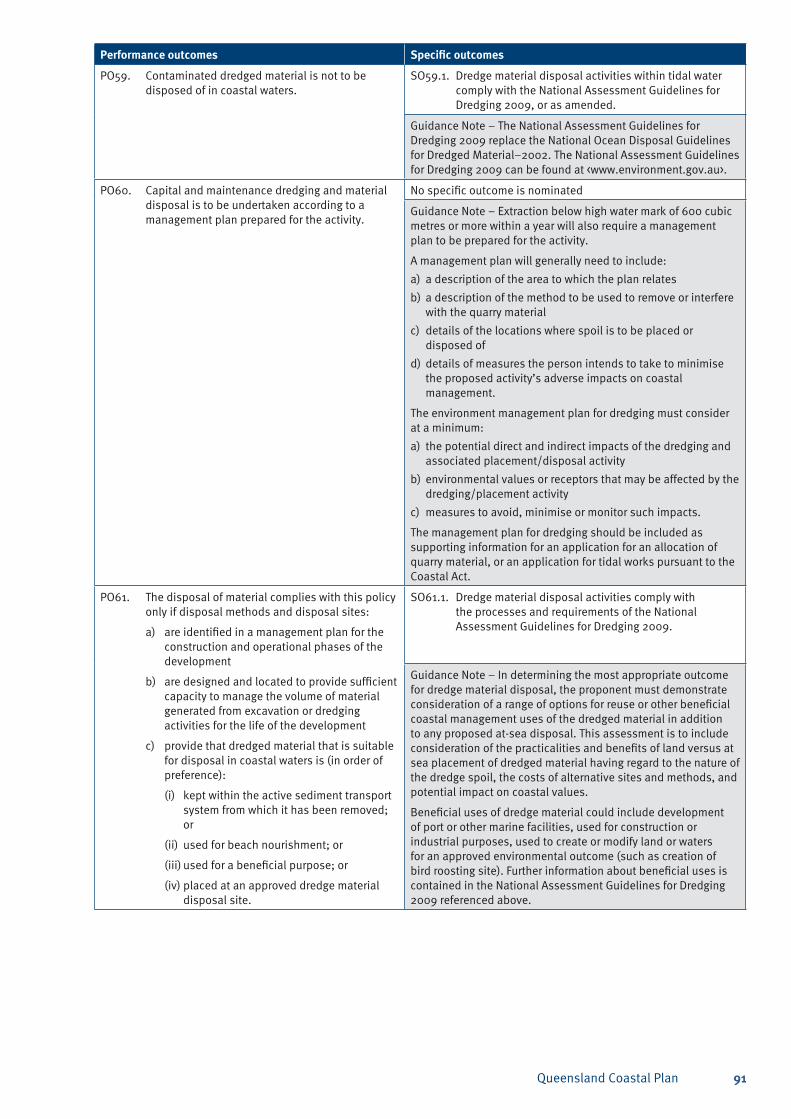
Queensland Coastal Plan 91
Performance outcomes Specific outcomes
PO59. Contaminated dredged material is not to be disposed of in coastal waters.
SO59.1. Dredge material disposal activities within tidal water comply with the National Assessment Guidelines for Dredging 2009, or as amended.
Guidance Note – The National Assessment Guidelines for Dredging 2009 replace the National Ocean Disposal Guidelines for Dredged Material–2002. The National Assessment Guidelines for Dredging 2009 can be found at <www.environment.gov.au>.
PO60. Capital and maintenance dredging and material disposal is to be undertaken according to a management plan prepared for the activity.
No specific outcome is nominated
Guidance Note – Extraction below high water mark of 600 cubic metres or more within a year will also require a management plan to be prepared for the activity.
A management plan will generally need to include:
a description of the area to which the plan relatesa)
a description of the method to be used to remove or interfere b) with the quarry material
details of the locations where spoil is to be placed or c) disposed of
details of measures the person intends to take to minimise d) the proposed activity’s adverse impacts on coastal management.
The environment management plan for dredging must consider at a minimum:
the potential direct and indirect impacts of the dredging and a) associated placement/disposal activity
environmental values or receptors that may be affected by the b) dredging/placement activity
measures to avoid, minimise or monitor such impacts.c)
The management plan for dredging should be included as supporting information for an application for an allocation of quarry material, or an application for tidal works pursuant to the Coastal Act.
PO61. The disposal of material complies with this policy only if disposal methods and disposal sites:
a) are identified in a management plan for the construction and operational phases of the development
b) are designed and located to provide sufficient capacity to manage the volume of material generated from excavation or dredging activities for the life of the development
c) provide that dredged material that is suitable for disposal in coastal waters is (in order of preference):
(i) kept within the active sediment transport system from which it has been removed; or
(ii) used for beach nourishment; or
(iii) used for a beneficial purpose; or
(iv) placed at an approved dredge material disposal site.
SO61.1. Dredge material disposal activities comply with the processes and requirements of the National Assessment Guidelines for Dredging 2009.
Guidance Note – In determining the most appropriate outcome for dredge material disposal, the proponent must demonstrate consideration of a range of options for reuse or other beneficial coastal management uses of the dredged material in addition to any proposed at-sea disposal. This assessment is to include consideration of the practicalities and benefits of land versus at sea placement of dredged material having regard to the nature of the dredge spoil, the costs of alternative sites and methods, and potential impact on coastal values.
Beneficial uses of dredge material could include development of port or other marine facilities, used for construction or industrial purposes, used to create or modify land or waters for an approved environmental outcome (such as creation of bird roosting site). Further information about beneficial uses is contained in the National Assessment Guidelines for Dredging 2009 referenced above.
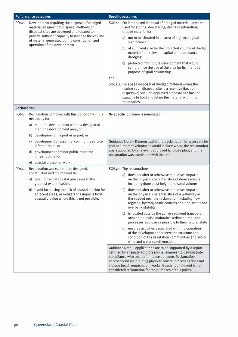
Queensland Coastal Plan92
Performance outcomes Specific outcomes
PO62. Development requiring the disposal of dredged material ensures that disposal methods or disposal sites are designed and located to provide sufficient capacity to manage the volume of material generated during construction and operation of the development.
SO62.1. For land based disposal of dredged material, any area used for storing, dewatering, drying or rehandling dredge material is:
a) not to be situated in an area of high ecological significance
b) of sufficient size for the projected volume of dredge material from relevant capital or maintenance dredging
c) protected from future development that would compromise the use of the area for its intended purpose of spoil dewatering
and
SO62.2. For at-sea disposal of dredged material where the marine spoil disposal site is a retentive (i.e. non-dispersive) site, the approved disposal site has the capacity to hold and retain the material within its boundaries.
Reclamation
PO63. Reclamation complies with this policy only if it is necessary for:
a) maritime development within a designated maritime development area; or
b) development in a port or airport; or
c) development of essential community service infrastructure; or
d) development of minor public maritime infrastructure; or
e) coastal protection work.
No specific outcome is nominated
Guidance Note – Demonstrating that reclamation is necessary for port or airport development would include where the reclamation was supported by a relevant approved land-use plan, and the reclamation was consistent with that plan.
PO64. Reclamation works are to be designed, constructed and maintained to:
a) retain physical coastal processes to the greatest extent feasible
b) avoid increasing the risk of coastal erosion for adjacent areas, or mitigate the impacts from coastal erosion where this is not possible.
SO64.1. The reclamation:
a) does not alter or otherwise minimises impacts on the physical characteristics of dune systems including dune crest height and sand volume
b) does not alter or otherwise minimises impacts on the physical characteristics of a waterway or the seabed near the reclamation including flow regimes, hydrodynamic controls and tidal water and riverbank stability
c) is located outside the active sediment transport area or otherwise maintains sediment transport processes as close as possible to their natural state
d) ensures activities associated with the operation of the development preserve the structure and condition of the vegetation communities and avoid wind and water runoff erosion.
Guidance Note – Applications are to be supported by a report certified by a registered professional engineer to demonstrate compliance with the performance outcome. Reclamation necessary for maintaining physical coastal processes does not include beach nourishment works. Beach nourishment is not considered reclamation for the purposes of this policy.
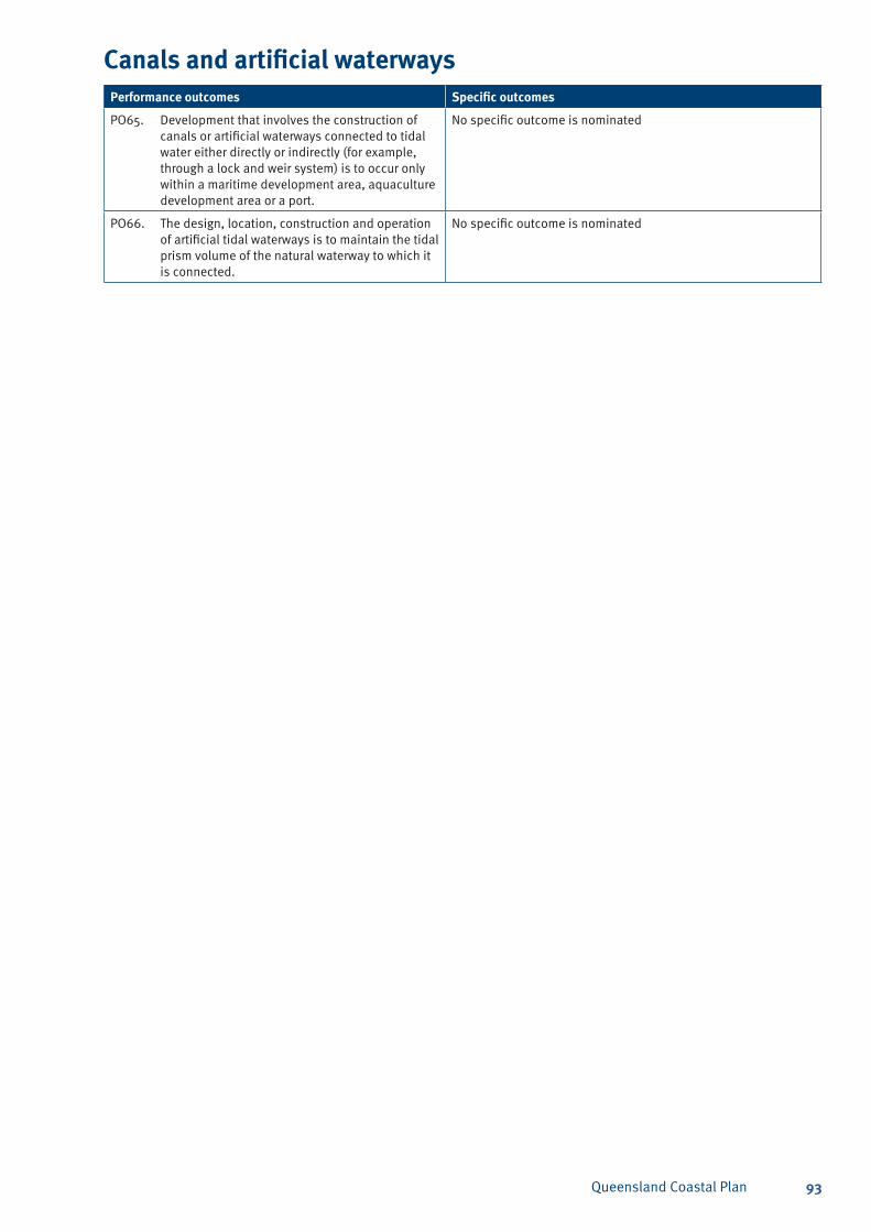
Queensland Coastal Plan 93
Canals and artificial waterwaysPerformance outcomes Specific outcomes
PO65. Development that involves the construction of canals or artificial waterways connected to tidal water either directly or indirectly (for example, through a lock and weir system) is to occur only within a maritime development area, aquaculture development area or a port.
No specific outcome is nominated
PO66. The design, location, construction and operation of artificial tidal waterways is to maintain the tidal prism volume of the natural waterway to which it is connected.
No specific outcome is nominated
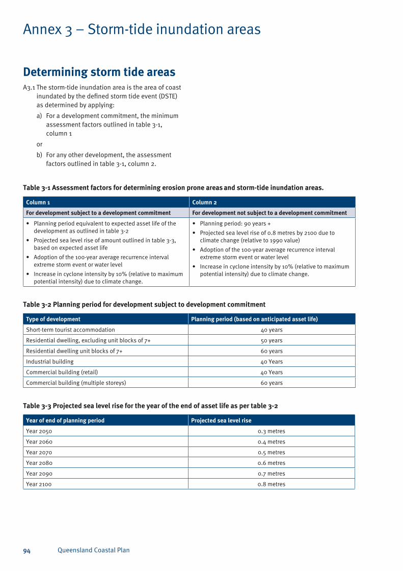
Queensland Coastal Plan94
Determining storm tide areasA3.1 The storm-tide inundation area is the area of coast
inundated by the defined storm tide event (DSTE) as determined by applying:
For a development commitment, the minimum a) assessment factors outlined in table 3-1, column 1
or
For any other development, the assessment b) factors outlined in table 3-1, column 2.
Annex 3 – Storm-tide inundation areas
Table 3-1 Assessment factors for determining erosion prone areas and storm-tide inundation areas.
Column 1 Column 2
For development subject to a development commitment For development not subject to a development commitment
Planning period equivalent to expected asset life of the • development as outlined in table 3-2
Projected sea level rise of amount outlined in table 3-3, • based on expected asset life
Adoption of the 100-year average recurrence interval • extreme storm event or water level
Increase in cyclone intensity by 10% (relative to maximum • potential intensity) due to climate change.
Planning period: 90 years +•
Projected sea level rise of 0.8 metres by 2100 due to • climate change (relative to 1990 value)
Adoption of the 100-year average recurrence interval • extreme storm event or water level
Increase in cyclone intensity by 10% (relative to maximum • potential intensity) due to climate change.
Table 3-2 Planning period for development subject to development commitment
Type of development Planning period (based on anticipated asset life)
Short-term tourist accommodation 40 years
Residential dwelling, excluding unit blocks of 7+ 50 years
Residential dwelling unit blocks of 7+ 60 years
Industrial building 40 Years
Commercial building (retail) 40 Years
Commercial building (multiple storeys) 60 years
Table 3-3 Projected sea level rise for the year of the end of asset life as per table 3-2
Year of end of planning period Projected sea level rise
Year 2050 0.3 metres
Year 2060 0.4 metres
Year 2070 0.5 metres
Year 2080 0.6 metres
Year 2090 0.7 metres
Year 2100 0.8 metres
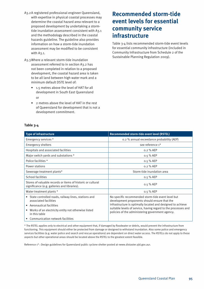
Queensland Coastal Plan 95
A3.2 A registered professional engineer Queensland, with expertise in physical coastal processes may determine the coastal hazard area relevant to a proposed development by undertaking a storm-tide inundation assessment consistent with A3.1 and the methodology described in the coastal hazards guideline. The guideline also provides information on how a storm-tide inundation assessment may be modified to be consistent with A3.1.
A3.3 Where a relevant storm-tide inundation assessment referred to in section A3.2 has not been completed in relation to a proposed development, the coastal hazard area is taken to be all land between high water mark and a minimum default DSTE level of:
1.5 metres above the level of HAT for all • development in South East Queensland
or
2 metres above the level of HAT in the rest • of Queensland for development that is not a development commitment.
Table 3-4
Type of infrastructure Recommended storm-tide event level (RSTEL)
Emergency services * 0.2 % annual exceedance probability (AEP)
Emergency shelters see reference 1*
Hospitals and associated facilities 0.2 % AEP
Major switch yards and substations * 0.5 % AEP
Police facilities * 0.5 % AEP
Power stations 0.2 % AEP
Sewerage treatment plants* Storm-tide inundation area
School facilities 0.5 % AEP
Stores of valuable records or items of historic or cultural significance (e.g. galleries and libraries).
0.5 % AEP
Water treatment plants * 0.5 % AEP
State controlled roads, railway lines, stations and • associated facilities
Aeronautical facilities•
Works of an electricity entity not otherwise listed • in this table
Communication network facilities •
No specific recommended storm-tide event level but development proponents should ensure that the infrastructure is optimally located and designed to achieve suitable levels of service, having regard to the processes and policies of the administering government agency.
* The RSTEL applies only to electrical and other equipment that, if damaged by floodwater or debris, would prevent the infrastructure from functioning. This equipment should either be protected from damage or designed to withstand inundation. Also some police and emergency services facilities (e.g. water police and search and rescue operations) are dependent on direct water access. The RSTELs do not apply to these aspects but other operational areas should be located above the RSTEL to the greatest extent feasible. Reference 1* : Design guidelines for Queensland public cyclone shelter posted at <www.distaster.qld.gov.au>.
Recommended storm-tide event levels for essential community service infrastructureTable 3-4 lists recommended storm-tide event levels for essential community infrastructure (included in Community Infrastructure from Schedule 2 of the Sustainable Planning Regulation 2009).
Queensland Coastal Plan96
Table 4.1 lists maritime development areas that are specified areas for the purposes of this policy.
Table 4.1
Name Map number Property description
Cooktown marine precinct (relevant parts only)
MDA_002_003 Lot 2 CP889652;
Lot 82 BS246;
Lot 1 SP148759; and
Land/ water (unnamed lot) east of 3USL8248 (exclusion zone of GBRMP) excluding those portions of the lot that are navigation channels or that are subject to existing development
Annex 4 – Planning requirements for specified areas
h) accessibility to the site including the limit and extent of dredging and tidal works operations required
i) the susceptibility of the site to coastal hazards (i.e. coastal erosion and storm tide inundation)
j) waters mentioned in the Environmental Protection (Water) Policy 1997, schedule 1, column 1, having regard to the environmental values and water quality objectives stated in a document mentioned in column 2 of that schedule for the waters
k) wild river areas under the Wild Rivers Act 2005
l) economic demand or need for maritime development by the surrounding regional and local communities for recreational boating facilities, commercial boating facilities, and trading vessel facilities
m) social needs for maritime development by the surrounding regional and local communities for access to maritime transport services in times of crisis and/or emergency, such as the wet season, cyclones or other natural disasters in localities in North and Far North Queensland.
A4.4 The management plan should discuss how it has considered the above factors when determining appropriate uses for the area. The management plan should also discuss how the proposed uses for the site meet the policy outcome of this policy. This discussion should be supported by maps that identify:
a) proposed uses on the site
b) the location of any of the above factors on and adjacent to the site.
A4.5 Development applications must be in accordance with the approved management plan for the area. Where a management plan does not exist, development applications will not be considered.
A4.1 Before development applications will be considered in the relevant parts of a specified area a management plan must be prepared. The purpose of the management plan is to identify appropriate uses, including the nature and scale of the use, for the specified area in consideration of a range of factors. Development of new minor public maritime infrastructure does not need to undertake a specified area management plan.
A4.2 Management plans will only be supported where they have been prepared by either the local government, Department of Local Government and Planning or Department of Transport and Main Roads.
A4.3 Factors to be considered in the preparation of a management plan include:
a) ecological values, including areas of high ecological significance identified in maps contained at Annex 1
b) protected areas or species under the Nature Conservation Act 1992
c) fish habitat areas identified by the Fisheries Act 1994, and the protection and management measures stipulated by the legislation
d) management of acid sulphate soils in accordance with State Planning Policy 2/02 Planning and Managing Acid Sulphate Soils
e) marine park zoning under the Marine Parks Act 2004
f) cultural heritage sites listed on the Queensland Heritage Register and conserved under the Queensland Heritage Act 1992
g) development entitlements and obligations for the area including land tenure arrangements, designations and zonings
Queensland Coastal Plan 97
A5.1 The applicant for the development must establish:
the overall social, economic and environmental a) benefits of the development outweigh:
any detrimental effect upon the natural i) values of the site and adjacent areas; and
conflicts with the policy outcome of this ii) policy; and
b) the development cannot be located elsewhere so as to avoid conflicting with the policy outcome of this policy.
Annex 5 – Factors for determining overriding need in the public interest
A5.2 The following do not establish an overriding need in the public interest:
uses requiring relatively few locational a) requirements to function; or
interests in or options over a site; or b)
a site’s availability or ownership. c)
Queensland Coastal Plan98
Accommodationpurposes: accommodation for the purpose of short or long-term residential accommodation, tourist accommodation, hospital accommodation and any other institutional accommodation such as schools or gaols.
Aquaculture: as defined under the Fisheries Act 1994.
Aquaculturedevelopmentarea:
a) an area shown on maps 1–8 at Annex 1 of this policy as an aquaculture development area; or
b) a specific area where it has been demonstrated to the satisfaction of the Department of Environment and Resource Management that the area is suitable for identification as an aquaculture development area in accordance with the aquaculture development area methodology.
Aquaculturedevelopmentareamethodology: refer to Methodology for Selection of Aquaculture Development Areas in the Coastal Zone available from <www.deedi.qld.gov.au>.
Areaofgeneralecologicalsignificance: an area shown on maps 1–8 at Annex 1 of this SPP as an area of general ecological significance.
Areaofhighecologicalsignificance:
a) an area shown on Maps 1–8 in Annex 1 of this SPP as an area of high ecological significance unless an ecological assessment undertaken by a qualified person demonstrates to the satisfaction of an assessment manager or concurrence agency that the attributed values are not present within the area; or
b) an area identified in a planning instrument as an area of high ecological significance unless an ecological assessment undertaken by a qualified person demonstrates to the satisfaction of an assessment manager or concurrence agency that the attributed values are not present within the area.
Areaofhighscenicpreference(scenicpreferenceratingof8,9or10): an area within 500 m of the coastline or 500 m of the bank of a waterway or estuary and are characterised by natural environments with little or no built elements.
Areaoflocallyimportantscenicpreference(scenicpreferenceratingof6and7): an area within 500 m of the coastline or 500 m of the bank of a waterway or estuary and generally contain some built elements.
Glossary
Areaofscenicpreference: an area within 500 m of the coastline or 500 m of the bank of a waterway or estuary, excluding views entirely within the urban domain and areas with a pre-change scenic preference rating of five or less.
Artificial(tidalandnon-tidal)waterway: as defined in the Coastal Protection and Management Act 1995.
Beachnourishment: the replenishment of a beach system using imported sediment to balance erosion losses or to re-establish a wider dunal buffer zone.
Canal: as defined under the Coastal Protection and Management Act 1995.
Capitaldredging: new dredging for navigation, to enlarge existing channels, ports, marinas and boat harbours. It also includes excavation to create trenches for pipes, cables, immersed tube tunnels, to remove material unsuitable for foundations and to remove overburden or aggregate.
Climatechange: a change in the state of the global climate induced by anthroprogenic change to the atmospheric content of greenhouse gases and that persists for an extended period, typically decades or longer.
Coast: as defined under the Coastal Protection and Management Act 1995.
Coastalbuildingline: as defined under the Coastal Protection and Management Act 1995.
Coastal-dependentdevelopment: development that requires access to tidal waters to function. Coastal-dependent development may include but is not limited to maritime development including ports, harbours and navigation channels, aquaculture involving marine species, desalinisation plants, tidal generators, erosion control structures and beach nourishment. To remove any doubt, residential development in any form is not coastal-dependent development.
Coastalactivities: development activities within coastal waters.
Coastalerosion: the wearing away of land or the removal of beach or dune sediments by wave or wind action, tidal currents and water flows.
Coastalhazard: coastal erosion and storm tide inundation, or permanent inundation due to sea level rise.
Queensland Coastal Plan 99
Coastalhazardadaptationstrategy: (adaptation strategy) identifies and assesses areas at risk from coastal hazards, outlines mitigation measures that will be undertaken to facilitate development in hazard areas where the identified risks will effectively be addressed.
Coastalhazardarea: the area that is at risk from storm tide inundation, coastal erosion, or permanent inundation due to sea level rise.
Coastalhazardrisk: exposure to the chance of injury or loss from a coastal hazard impact.
Coastallandforms: the physical features of the earth’s surface on the coast such as beaches and coastal dunes, coastal plains, river mouths, river banks and cliffs.
Coastalmanagementdistrict(CMD): as defined under the Coastal Protection and Management Act 1995. The coastal management district is shown on Maps 1–8 at Annex 1 of this SPP.
Coastalprotectionwork: any permanent or periodic work undertaken primarily to deliberately alter physical coastal processes such as sediment transport, to manage the effects of coastal hazards.
Coastalresources: as defined under the Coastal Protection and Management Act 1995.
Coastalwaters: as defined under the Coastal Protection and Management Act 1995.
Coastalwetlands: as defined under the Coastal Protection and Management Act 1995.
Coastalzone: as defined under the Coastal Protection and Management Act 1995. The coastal zone is shown on Maps 1–8 at Annex 1 of this SPP.
Coastline: the interim coastline for regional coastal management plans published by the Environmental Protection Agency on 5 June 2006. The coastline is most accurately represented in a published dataset available for the whole of Queensland’s coastline which has evolved in response to specific projects (such as the SEQ Coastal Management Plan). The coastline is generally consistent with mean high water springs (MHWS), except where vegetation obscures the coastline, in which case the coastline follows the outer (seaward) edge of the vegetation. The dataset includes offshore and onshore islands and estuary channels greater than 20 metres wide. Excerpts from the dataset are available upon request from DERM.
CommonwealthGreatBarrierReefMarinePark: the Great Barrier Reef Marine Park established under the Great Barrier Reef Marine Park Act 1975 (Commonwealth).
Contaminateddredgedmaterial: dredged material that contains contaminants of concern as prescribed in the National Assessment Guidelines for Dredging 2009.
Culturalresourcesofthecoastalzone: the places or objects that have anthropological, archaeological, historical, scientific, spiritual, visual or sociological significance or value, including such significance or value under Aboriginal tradition or Island custom.
Definedstormtideevent(DSTE): the event (measured in terms of likelihood of reoccurrence) and associated inundation level adopted to manage the development of a particular area. The defined storm-tide event is the 1% annual exceedance probability (AEP) storm tide, equivalent to one in 100-year average recurrence interval (ARI) unless otherwise indicated for essential community service infrastructure.
Demonstratedneed: (for coastal protection work) means evidence has been provided including arguments and reasoning to prove the case that:
a) retreat is not a feasible option; and
b) there are no alternative solutions to the erosion problem; and
c) there is a necessity to undertake works to prevent a foreseeable risk of coastal erosion
damaging permanent structures that are i) utilised by persons on an on-going basis; or
causing safety hazards that cannot be ii) remediated using any other means (e.g. closing or re-routing walking tracks).
Development: as defined in the Sustainable Planning Act 2009.
Developmentcommitment: A development commitment means a development that:
a) has a valid preliminary approval as of the date of commencement of this policy
b) arises from and is necessary to give effect to a valid development approval
c) is located within a state development area and is consistent with the development scheme prepared for the state development area
d) the Coordinator-General has evaluated an environmental impact statement under Part 4 of the State Development and Public Works Organisation Act 1971, and the report recommends the approval of the development (with or without conditions)
e) is government supported transport infrastructure and the development is consistent with a government approval to construct given before the date of commencement of this policy
f) is consistent with a designation of land for community infrastructure under the Sustainable Planning Act 2009.
Queensland Coastal Plan100
Domesticactivity: the construction or use of a dwelling house on a lot and any reasonably associated building or structure, including, for example:
a) a caretaker’s residence; or
b) a granny flat; or
c) a building or structure used for a home business where that business is internal to the building or structure of the associated residential use.
Dredging: the mechanical removal of dredged material from below tidal water.
Dredgedmaterial: mud, sand, coral, ballast, shingle, gravel, clay, earth and other material removed by dredging from the bed of Queensland tidal and non-tidal waters.
Drylandmarina: a marina created by the excavation of land above high water mark.
Dugongprotectionareas: as described in the Fisheries Regulation 2008.
Dwellinghouse: as defined in the Queensland planning provisions.
Ecologicalvalues: the intrinsic natural qualities, characteristics or worth attributable to an ecosystem.
Ecologicallysustainabledevelopment: as defined under the Coastal Protection and Management Act 1995.
Ecosystem: a dynamic complex of plant, animal and micro-organism communities and their non-living environment interacting as a functional unit.
Erosioncontrolstructures: structures designed to protect land or to permanently alter sediment transport processes and include structures such as seawalls or revetments (rock walls), groynes, artificial reefs, and breakwaters.
Erosionpronearea: as defined under the Coastal Protection and Management Act 1995.
Essentialcommunityserviceinfrastructure: emergency services infrastructure, emergency shelters, police facilities, hospitals and associated facilities, stores of valuable records or heritage items, power stations and substations, major switch yards, communications facilities, sewerage treatment plants, water treatment plants and public benefit assets.
Feasible: capable of being done, effected or accomplished in consideration of the short or long- term costs to an individual or a community or in consideration of the likely success or failure of the action.
Foreshore: as defined under the Coastal Protection and Management Act 1995.
Fishhabitatarea: a declared fish habitat area under the Fisheries Regulation 2008.
Governmentsupportedtransportinfrastructure: as defined under the Transport Infrastructure Act 1994.
Greenfield: undeveloped land that has been identified within a planning instrument as being investigated for future urban development (e.g. emerging communities zone of the Queensland planning provisions). It generally requires new roads and services to support urban development and is found on the fringes of existing urban localities.
Hardprotectionstructures: built coastal hazard protection works designed to protect land or to permanently alter sediment transport processes and include structures such as seawalls (rock walls), groynes, artificial reefs and breakwaters.
Highcoastalhazardarea:
a) the part of the erosion prone area that is within the coastal management district
b) land that is projected to be permanently inundated due to sea level rise
c) the part of the storm tide inundation area that is projected to be temporarily inundated to a depth of one metre or more during a defined storm tide event (refer to the coastal hazards guideline).
Highestastronomicaltide(HAT): the highest sea level which can be predicted to occur under average meteorological conditions and any combination of astronomical conditions.
Industrial(development): industry activities as referred to within the Queensland planning provisions excluding service industry activities.
Infill(development): new development within an urban locality on a premises that is either vacant or has previously been used for another urban purpose.
Keyresourcearea(KRA): a key resource area defined under State Planning Policy 1/07: Protection of Extractive Resources.
Land: as defined under the Coastal Protection and Management Act 1995.
Landforcommunityinfrastructure: land designated for community infrastructure under the Sustainable Planning Act 2009.
Management: includes actions required to protect, conserve or rehabilitate coastal resources and to achieve ecologically sustainable development.
Queensland Coastal Plan 101
MarinePark: as declared under the Marine Parks Act 2004 or relevant Commonwealth legislation.
Material: dredged material or material excavated from land including mud, sand, gravel, clay and earth.
Maritimedevelopment: development that requires location in, or adjacent to, tidal waters to function.
Maritimedevelopmentarea:
a) an area shown on maps 1–8 at Annex 1 of this policy as a maritime development area
b) a specific area where it has been demonstrated to the satisfaction of the Department of Environment and Resource Management that the area is suitable for identification as a maritime development area in accordance with the maritime development area methodology.
Maritimedevelopmentareamethodology: refer to Planning Areas for Maritime Development in Queensland available from <www.derm.qld.gov.au>.
Mediumcoastalhazardarea: land that is within the storm-tide inundation area that is projected to be temporarily inundated to a depth of less than one metre inundation during a defined storm tide event (refer to the coastal hazards guideline).
Medium-scaletouristdevelopment: a development catering for short-term accommodation for tourist activity that contains no more than 300 persons and any associated ancillary facilities and is consistent with any applicable State planning regulatory provisions or regional plan.
Minorpublicmaritimeinfrastructure: maritime facilities such as boat ramps, pontoons slipways that serve a public purpose including minor community infrastructure such as wharves and public jetties defined under the Sustainable Planning Regulation 2009 (Schedule 2).
Nodalsettlementpattern: settlement that occurs in a consolidated and clustered form within the landscape and is distinctly separate from nearby settlements.
Offset(environmental): an action taken to counter-balance any unavoidable negative environmental impacts that might result from an activity or a development. Environmental offsets are measures taken which are outside the scope of the activities of the development, to counter-balance adverse environmental impacts. An offset can be located within or outside the geographic site of the activity or development (Queensland Government Environmental Offsets Policy 2008).
Openspaceandrecreationfacilities: outdoor facilities that are capable of sustaining a defined storm tide inundation event without significant damage. Such facilities include but are not limited to those associated with the outdoor sport and recreation and park uses of the Queensland planning provisions.
Otherecologicalvalues: ecological values that are not able to be spatially represented due to a lack of spatial data or the inherent characteristics of the organism or environmental attribute (e.g. a highly mobile species).
Physicalcoastalprocesses: natural processes of the coast including sediment transport; fluctuations in the location and form of the foreshore, dune systems and associated ecosystems; tides; changes in sea level and coastal hazards (e.g. storm tide surge), ecological processes (e.g. migration of plant and animal species) and the natural water cycle (e.g. coastal wetlands’ role in nutrient filtration and flood mitigation).
Port: a port area as defined under the Transport Infrastructure Act 1994.
Predominantlyformaritimepurposes: that more than 50 per cent of the non-tidal land within a maritime development area is to be used for maritime purposes or public access.
Predominantlyofacommercialnature: that of the proportion of a maritime development area that is not used for maritime purposes or public access more than 50 per cent is to be used for commercial purposes.
Premises: as defined under the Sustainable Planning Act 2009.
Privateland means land that is–
a) freehold land, or land contracted to be granted in fee simple by the State
b) subject to a lease, licence, permit or other authority issued under an Act by or for the State, other than a permit issued under the Land Act 1994, section 177(1)2 or a lease issued over a protected area.
Privatemarineaccessstructure: maritime development constructed to provide private access to private land from tidal water. Private marine access structures may include jetties, ramps, floating docks, fixed piers and gangways. Private marine access structures do not include multiple berth marinas; or roofed structures or decks and boardwalks that are not intended for use as access structures.
Protectedarea: as defined under the Nature Conservation Act 1992.
2 Note: reference to a permit under section 177(1) of the Land Act 1994 refers to a permit to occupy unallocated State land, a reserve or a road.
Queensland Coastal Plan102
Publicbenefitasset:
a) transport infrastructure described in the definition of community infrastructure in Schedule 2 of the Sustainable Planning Regulation 2009 (excluding wharves, public jetties, ports, port facilities and navigational facilities) and transport infrastructure described in the definition of development infrastructure in Schedule 3 of the Sustainable Planning Act 2009 (excluding ferry terminals)
b) eronautical facilities of State significance described in SPP 1/02: Development in the Vicinity of Certain Airports and Aviation Facilities, and associated facilities
c) emergency services facilities
d) domestic gas pipelines
e) operating works under the Electricity Act 1994
f) storage, works and administrative facilities associated with the provision or maintenance of the essential community service infrastructure.
QueenslandPlanningProvisions: the standard planning scheme provisions as defined under the Sustainable Planning Act 2009.
Reclamation: as defined in the Marine Parks Act 2004 but not including beach nourishment.
Recommendedstormtideevent(RSTE): the storm tide event that would correlate with the recommended storm tide event level for particular types of essential community service infrastructure referred to in Annex 3.
Recommendedstormtideeventlevel(RSTEL): the storm-tide event level identified in Annex 3 that is recommended for particular types of essential community service infrastructure.
Redevelopment: development on an already developed site including infill development. Redevelopment includes, but is not limited to the expansion of a building footprint or addition of a structure, reconstruction or remodelling an exterior, demolition of existing development and replacement with an alternative structural development, the establishment of an alternative type of use and associated land disturbing activities.
Regionalplan: a regional plan made under the Sustainable Planning Act 2009 for a designated region.
Ruralresidentialpurpose: a residential purpose involving single dwellings on lots greater than 2500 m2 (and usually less than 60 hectares).
Scenicamenity: landforms and seascapes creating the region’s visual imagery including (but not limited to) mountain ranges, coastal escarpments, beaches, rivers, valleys, agricultural land, creeks, rainforests, wetlands, estuaries and islands.
Sceniccoastallandscapesofstatesignificance: areas of outstanding and distinctive scenic quality that are high priority areas for scenic landscape management within Queensland.
Scenicpreference: the rating of the community’s liking for scenery of open space compared to areas occupied by built structures, measured using photographs (Preston 2001)3. The rating measures the relative contribution of each place in the landscape to the collective appreciation of open space as viewed from places that are important to the public.
Scenicpreferencerating: the numerical value ascribed to the communities preference of a view, ranging from one (least preferred) to 10 (most preferred).
Scenicpreferencevalues: the relative contribution of visual elements (built or natural) to the community liking for a view or an area. Visual elements are assessed collectively to determine the scenic preference of the area.
Sedimenttransportprocess: any natural displacement and transport of coastal sediments forced by waves, tides, water flows and wind.
Sensitivecoastalareas: may include roosting and nesting sites, intertidal invertebrate communities, seagrass feeding areas of turtles and dugongs and areas of high biological diversity, erosion prone areas, unstable dunes and steep landscapes.
Shorelineerosionmanagementplan: a planning document prepared by local government or other coastal land management organisation and endorsed by the Department of Environment and Resource Management that sets out an agreed set of options and recommendations to manage responses to current or potential future erosion in hotspot areas. Information about how to prepare a shoreline erosion management plan is outlined in the SPP Guideline.
Short-termaccommodation: as defined under the Queensland Planning Provisions.
Significantproject: as defined under the State Development and Public Works Organisation Act 1971.
Singleresidence: one house or abode and includes any reasonably associated built structure such as a garage.
3 Preston, R. 2001, Scenic Amenity measuring community appreciation of landscape aesthetics at Moggill and Glen Rock, Department of Natural Resources and Mines, Environmental Protection Agency, Brisbane.
Queensland Coastal Plan 103
Specifiedarea: the maritime development areas listed at Annex 4 excluding those portions of the area that are navigation channels or subject to existing development.
Small-scaletouristdevelopment: development catering for nature based tourism with a maximum of 15 habitable rooms for short-term accommodation and any associated ancillary facilities.
Statecoastalland: land within the coastal management district (including land below tidal waters) other than land that is:
a) freehold land, or land contracted to be granted in fee simple by the State
b) in a watercourse or lake as defined under the Water Act 2000
c) subject to a lease, licence, permit or other authority issued under an Act by or for the State, other than a permit issued under the Land Act 1994, section 177(1)4 or a lease issued over a protected area.
Statedevelopmentarea: as defined under the State Development and Public Works Organisation Act 1971.
Stateplanningpolicy: as defined under the Sustainable Planning Act 2009.
Stateplanningregulatoryprovisions: as defined under the Sustainable Planning Act 2009.
Stormtide: the temporary elevation of coastal water by a storm surge combined with the normally occurring astronomical tide.
Storm-tideinundationarea: the area of land determined to be inundated by a storm tide as outlines at Annex 3.
Threatenedspecies: any species of wildlife indigenous to Australia that is declared under the Nature Conservation Act 1992 as extinct in the wild, endangered or vulnerable wildlife.
Tidalwaterwaymeansawaterway: as defined in the Fisheries Act 1994.
Tidalwater: as defined in the Coastal Protection and Management Act 1995.
Urbandevelopment: development for urban purposes. It does not include rural land uses such as agriculture and horticulture.
Urbanlocalitymeansanareathatis:
a) an urban footprint or rural living area in a regional plan; or
b) allocated under a planning scheme for an urban or rural residential purpose and the allocation is consistent with any applicable state planning regulatory provisions and regional plan
c) an existing settlement or township that is not designated as urban under an applicable planning scheme or regional plan but is located in a local government area between and including Wujal Wujal Aboriginal Shire and Burke Shire (e.g. Doomadgee, Burketown and Normanton townships).
Urbanpurposes: as defined under the Sustainable Planning Regulation 2009.
Vegetation: as defined under the Coastal Protection and Management Act 1995.
Vehicle: includes all forms of mechanical transport, including buggies, trail bikes, helicopters and aeroplanes.
Vessel: a craft for travelling on water, for example, a ship, boat, jet ski, windsurfer, kayak.
Watercourse: as defined in the Sustainable Planning Regulation 2009.
Wildlife: any plant or animal, as defined in the Nature Conservation Act 1992.
4 Land Act 1994, section 177 (Chief executive may issue permit).