Embed Size (px)
Citation preview
Central West and South West 397
Chapter 9
Queensland Agricultural Land AuditCentral West and South West
Central West and South West 398
Chapter contents
9.1 Regional agricultural profile 400
9.1.1 Economic profile 4019.1.2 Strengths, weaknesses, opportunities and threats 4049.1.3 Climate 4069.1.4 Water resources 4079.1.5 Infrastructure 4089.1.6 Vegetation 409
9.2 Current and potential agricultural land use 410
9.2.1 Important agricultural area 4139.2.2 Industry profiles 413
9.3 Data confidence 420
9.4 Sources of information 421
9.4.1 Bibliography 4219.4.2 Further studies 421
Central West and South West 399
Maps
Map 9.1 Location of the Central West and South West Agricultural Land Audit regions 400Map 9.2 Water resources—Central West 423Map 9.3 Water resources—South West 425Map 9.4 Infrastructure—Central West 427Map 9.5 Infrastructure—South West 429Map 9.6 Vegetation management—Central West 431Map 9.7 Vegetation management—South West 433Map 9.8 Current land use—Central West 435Map 9.9 Current land use—South West 437Map 9.10 Important agricultural areas—Central West and South West 439Map 9.11 Current pasture production (land condition B)—Central West 441Map 9.12 Potential pasture production (land condition A)—Central West 443Map 9.13 Current pasture production (land condition B)—South West 445Map 9.14 Potential pasture production (land condition A)—South West 447Map 9.15 Sown pastures—Central West 449Map 9.16 Sown pasture—South West 451Map 9.17 Intensive livestock—Central West 453Map 9.18 Intensive livestock—South West 455Map 9.19 Broadacre cropping and horticulture—Central West 457Map 9.20 Broadacre cropping—South West 459Map 9.21 Annual horticulture—South West 461Map 9.22 Perennial horticulture—South West 463Map 9.23 Native forestry—Central West 465Map 9.24 Native forestry—South West 467Map 9.25 Data confidence—Central West 469Map 9.26 Data confidence—South West 471
Tables
Table 9.1 The change in land values for the Central West and South West regions 403Table 9.2 Current and potential land area—Central West 411Table 9.3 Current and potential land area—South West 412Table 9.4 Current and potential land area for forestry—Central West 417Table 9.5 Current and potential land area for forestry—South West 418
Central West and South West 400
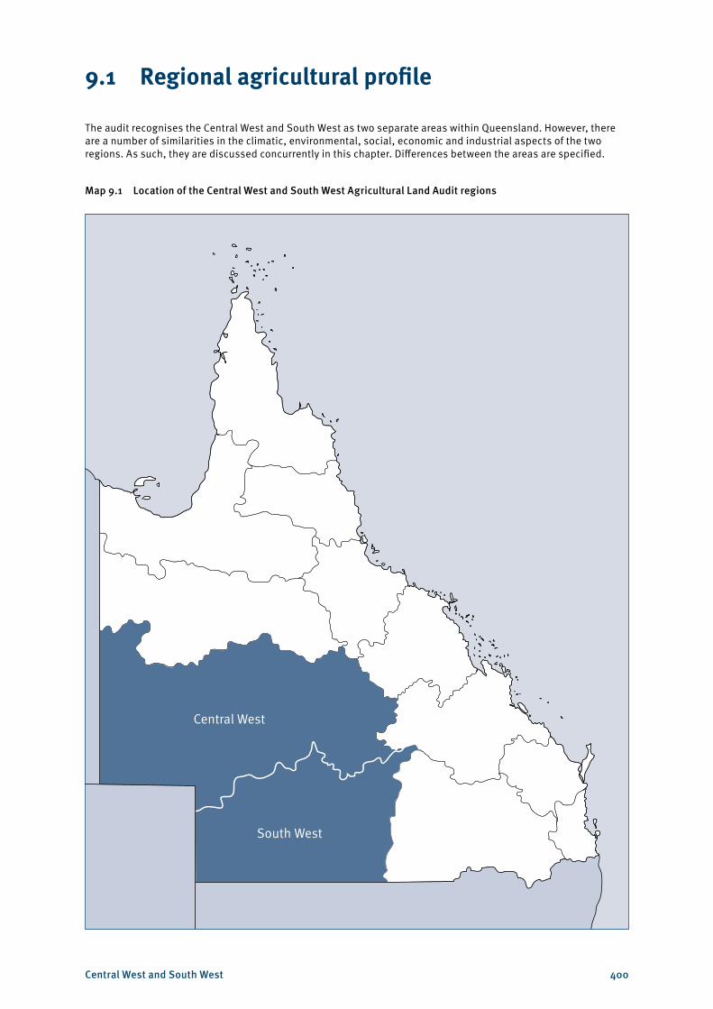
9.1 Regional agricultural profile
The audit recognises the Central West and South West as two separate areas within Queensland. However, there are a number of similarities in the climatic, environmental, social, economic and industrial aspects of the two regions. As such, they are discussed concurrently in this chapter. Differences between the areas are specified.
Map 9.1 Location of the Central West and South West Agricultural Land Audit regions
Central West
South West
Central West and South West 401
9.1.1 Economic profile
The Central West and South West regions cover the south-west of Queensland from just north of Urandangi on the Northern Territory border, eastwards to just east of Alpha and southward through Morven to the New South Wales border (see Map 9.1). The regions are comprised of the 11 local government areas of Barcaldine Regional Council, Barcoo Shire Council, Blackall–Tambo Regional Council, Boulia Shire Council, Bulloo Shire Council, Diamantina Shire Council, Longreach Regional Council, Murweh Shire Council, Paroo Shire Council, Quilpie Shire Council and Winton Shire Council. They have a combined total area of 62.5 million hectares or 36.1 per cent of the total area of Queensland.
The key centres for the provision of agricultural and service facilities are Longreach, Charleville, Cunnamulla, Blackall, Barcaldine, Quilpie, Boulia and Winton. Although these towns have a low urban density, they service vast areas. Charleville, Longreach and Barcaldine are also the major administrative centres for a range of state government services, and are the focal point for employment and economic development in these regions. Those living in the north-western part of the Central West usually conduct their business outside the region in Mount Isa or Cloncurry.
The main industries driving the economy of the South West and Central West regions are agriculture (specifically cattle and sheep grazing), tourism and increasingly mining, gas and petroleum.
According to the agricultural census, the value of agricultural production in the Central West was $486.5 million in 2010–11, with $414.6 million derived from the slaughter of cattle. Wool was the second-most valuable agricultural commodity within the region, worth approximately $42.3 million, while slaughtered sheep were worth $21.5 million. Hay and goat production also added to the economy of the region and there are a range of crop alternatives (including cotton, sorghum and wheat) irrigators may be able to grow, depending on return.
Agricultural production in the South West was valued at $276.9 million in 2010–11, drawn from a greater variety of commodities. Like the Central West, cattle slaughter is the most significant industry, worth $174.6 million in 2010–11. Wool was worth $31.8 million and sheep slaughter was valued at $14.6 million in 2010–11. Similarly, cotton is one choice of irrigated crop that can be grown depending on markets and returns and, in 2010–11, was worth $36.8 million in the Paroo Shire. Grapes, canola, hay, sorghum and wheat are also produced in the Paroo Shire. The Murweh Shire produces hay and cereal crops (mainly wheat and sorghum).
Though primary production is a key component of the South West and Central West economies, the discovery of oil and gas reserves in the 1980s also saw the development of significant resources and the establishment of the energy industry in the area. Both regions are also renowned for opal mining, and tourism has increased in both areas particularly around Winton, Quilpie and Eromanga with discoveries of large dinosaur fossils.
Both regions experienced an economic boom period in the 1950s, due to the increased demand for, and value of, wool. However, since the 1960s there has been a slow decline in population—largely due to droughts, a falling commodity price for wool and the loss of younger people as they seek opportunities in larger centres and other areas. As of 30 June 2011, the population of the two regions was 20 562 people, only 0.45 per cent of the population of Queensland. While the South West region’s population remained constant, in the year to 30 June 2011 the Central West recorded growth of 0.2 per cent. This is in contrast to a growth rate of 1.1 per cent for Queensland as a whole. In the South West and Central West regions, 64.7 per cent of people were aged between 15 and 64 years. The median age was 37.6 years, which is marginally higher than the state average of 36.6 years. Within these regions, Winton Shire had the highest median age of 43.4 years and Boulia Shire the lowest median age of 29.4 years.1
1 Australian Bureau of Statistics 2012, Queensland regional profiles (generated 5 December 2012), Office of Economic and Statistical Research, Queensland Treasury and Trade, <http://statistics.oesr.qld.gov.au/qld-regional-profiles>.
Central West and South West 402
While, in December 2011, both regions recorded lower levels of unemployment than the state average (3.4 per cent for the Central West and 4.5 per cent for the South West compared with 5.5 per cent for the state), there is a great deal of variability within these regions. Bulloo and Quilpie had unemployment rates of only 1.3 per cent and Barcoo had a rate of 1.6 per cent. However, Boulia had an unemployment rate of 10.5 per cent and Diamantina had a rate of 8.9 per cent.2 In addition to being the economic drivers within these regions, the agriculture, forestry and fishing industries are also the main employers. These industries account for 27.5 per cent of employed people in the Central West and 26.2 per cent of employed people in the South West. Public administration and safety was second-largest employer, accounting for 11 per cent and 12.1 per cent of employed persons, respectively.
People who live and work in these regions experience challenges such as long distances to essential services, remoteness, limited access to transport networks, limited access to markets, outward migration (particularly among young people) and difficulty in attracting and retaining skilled workers. As a result, the South West and Central West regions are expected to experience a population growth of only 0.1 per cent and 0.2 percent per annum respectively over the next 20 years. In comparison, Queensland as a whole is expected to record a population growth of 1.8 per cent per annum over the same period.
The South West and Central West regions experience extreme temperatures, droughts and floods. The regions’ climate ranges from arid to semi-arid and has highly variable rainfall, with an annual average of less than 200 mm in the far south-west to more than 400 mm in the eastern reaches of the regions. Temperature is also highly variable and ranges from -5 °C to 49 °C. Evaporation significantly exceeds precipitation in the regions. Floods play a major role in maintaining the river systems. The highly variable climate is one of the major challenges for both the pastoral industry and town communities. Refer to Section 9.1.3 for additional information on climate in the Central West and South West regions.
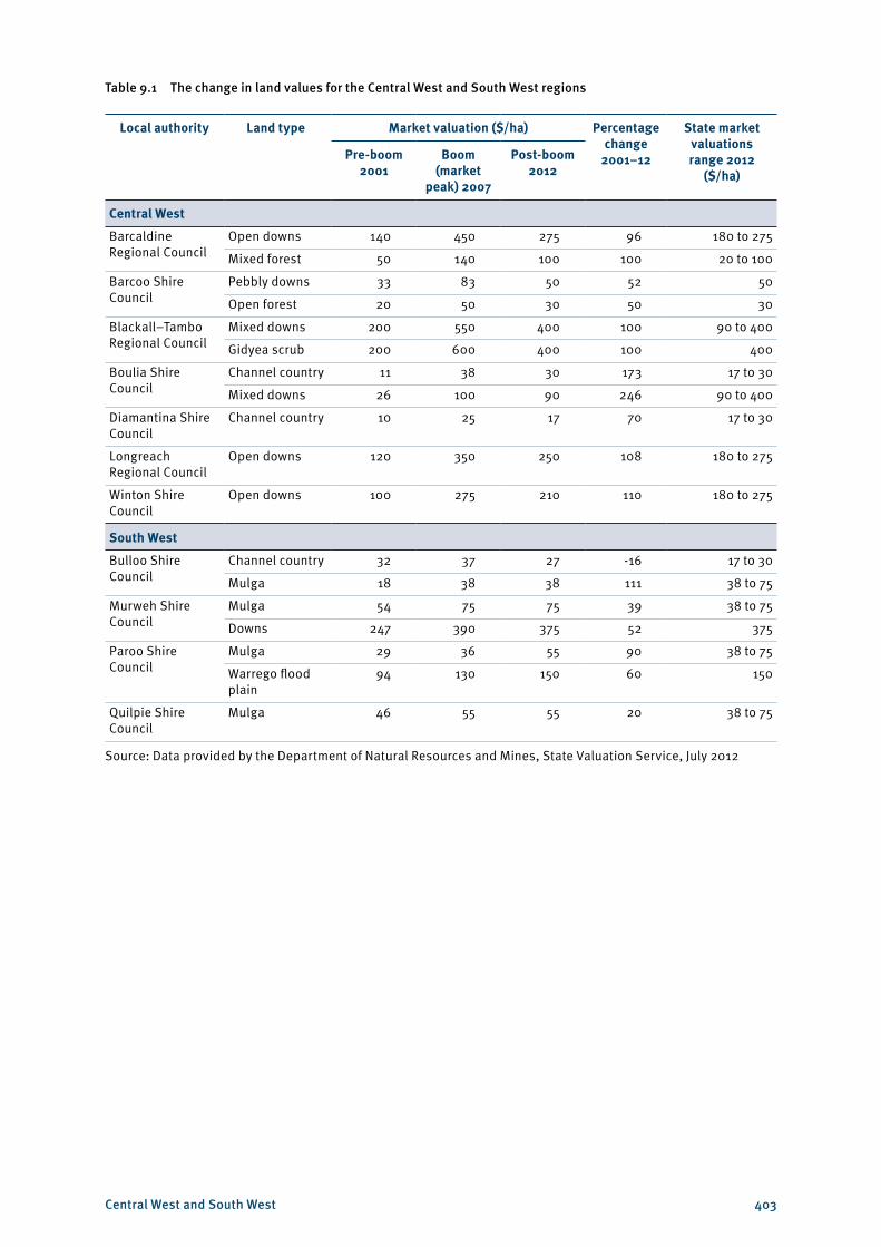
In 2012, the highest value land types (see Table 9.1) were the gidyea scrub land and mixed downs land within the Blackall–Tambo local government area (in the Central West) at $400 per hectare. Gidyea scrub is not present in any other local government area within Queensland. Mixed downs are also exhibited within the Boulia Shire, though the land value was only 22.5 per cent of that of Blackall–Tambo. Channel country within the Bulloo Shire is the only land type between the two regions to have demonstrated negative growth in its value over the 2001–12 period. While the value did diminish within the Bulloo Shire, its starting value in 2001 was around three times greater than the value of comparable land in the Boulia and Diamantina Shires ($32 per hectare as opposed to $11 per hectare and $10 per hectare respectively).
2 Australian Bureau of Statistics 2012, Queensland regional profiles (generated 5 December 2012), Office of Economic and Statistical Research, Queensland Treasury and Trade, <http://statistics.oesr.qld.gov.au/qld-regional-profiles>.
Central West and South West 403
Table 9.1 The change in land values for the Central West and South West regions
Local authority Land type Market valuation ($/ha) Percentage change
2001–12
State market valuations range 2012
($/ha)Pre-boom
2001Boom
(market peak) 2007
Post-boom 2012
Central West
Barcaldine Regional Council
Open downs 140 450 275 96 180 to 275
Mixed forest 50 140 100 100 20 to 100
Barcoo Shire Council
Pebbly downs 33 83 50 52 50
Open forest 20 50 30 50 30
Blackall–Tambo Regional Council
Mixed downs 200 550 400 100 90 to 400
Gidyea scrub 200 600 400 100 400
Boulia Shire Council
Channel country 11 38 30 173 17 to 30
Mixed downs 26 100 90 246 90 to 400
Diamantina Shire Council
Channel country 10 25 17 70 17 to 30
Longreach Regional Council
Open downs 120 350 250 108 180 to 275
Winton Shire Council
Open downs 100 275 210 110 180 to 275
South West
Bulloo Shire Council
Channel country 32 37 27 -16 17 to 30
Mulga 18 38 38 111 38 to 75
Murweh Shire Council
Mulga 54 75 75 39 38 to 75
Downs 247 390 375 52 375
Paroo Shire Council
Mulga 29 36 55 90 38 to 75
Warrego flood plain
94 130 150 60 150
Quilpie Shire Council
Mulga 46 55 55 20 38 to 75
Source: Data provided by the Department of Natural Resources and Mines, State Valuation Service, July 2012
Central West and South West 404
9.1.2 Strengths, weaknesses, opportunities and threats
Key regional issues
• There is an opportunity to target higher value niche markets through enhanced production specifications and branding, such as certified organic beef products.
• A declining population and the loss of animal husbandry skills, among other agricultural knowledge, will continue to have an increasingly negative impact upon the productivity of the region.
Strengths
The strengths of these regions include the following:• Hot and often dry summers limit parasite infestations. • In some instances, out-of-season crop production is possible, creating niche opportunities within
the market.• There are significant areas that receive beneficial flooding of low-sloping, highly productive pastures
during moderate through to major flood events. These areas are significant for the beef production system. These flood events occur on a regular basis.
• The dry climate and associated low occurrence of diseases has enabled the western area to have a history of fairly low chemical use, so organic, grass-fed animal production can be cost-effective for meat producers.
• Large areas of land with a mix of land types provide a variety of grazing production options.• There are saleyards at Longreach, Blackall, Winton and Charleville—and outside the region, Charters
Towers, Townsville and Gracemere. Animals are also sold directly to meatworks (Dinmore, Biloela and Rockhampton) and the live export trade. The state’s largest saleyards at Roma are on the Darling Downs, just east of the South West region.
• Large cattle companies, or large family operators, often have the capacity to obtain economies of scale. In some cases they also have vertically integrated production systems (finishing properties and meatworks, as well as breeding properties).
• The Central West is linked to Rockhampton by a railway line that runs from Winton. The South West is linked by railway line from Quilpie to Ipswich and to the Port of Brisbane. Road transport corridors link the regions to Townsville, Rockhampton, South East Queensland, the Northern Territory, northern New South Wales and the east coast of Australia.
• Queensland’s traditional hardwood and cypress pine timbers are world class, and may attract increasing demand as international availability of this high-quality specialty timber declines.
Weaknesses
The weaknesses of these regions include the following:• Prolonged dry periods can limit the ability for long-term supply of quality produce. There are high
levels of evaporation, and seasonal conditions can significantly impact on feed quantity and quality. In the Central West, summer is generally very hot. In the South West, there is high climatic variability and the region is subject to temperature extremes in summer and winter, as well as extremes in the wet and dry seasons. This variability in climate translates to uncertainty in economic returns from year to year, making it difficult for landholders to obtain finance or maintain a lifestyle. Frosts in the South West can also limit crop options.
• Some soils are relatively low in nutrients and there is the potential for water tables to rise in some soils, leading to salinity in some areas. As very few plant species can withstand high levels of salt, salinity is a major threat to agricultural industries.
Central West and South West 405
• The two regions are covered by four water planning schemes, including the Lake Eyre Basin water resource plan that regulates the use of groundwater in the area. There are relatively few allocations for surface water and so restrictions on use are primarily based upon water availability, rather than competition between uses. Groundwater can vary in quality. Shallow groundwater sources tend to be brackish. Deeper water from the Great Artesian Basin is generally better quality; however, it may contain minerals that are not suitable for all types of soil or crops. Refer to Section 9.1.4 for additional information on water resources within the regions.
• Stocking for long periods may not be sustainable, limiting the capacity of producers to manage stock sales to match market opportunities.
• Some lease tenure conditions may not allow the substantial use of coal seam gas water.• Distances to markets means high freight costs and potential spoilage issues. In prolonged wet
seasons, roads can be closed for a significant period of time (sometimes greater than six months in the South West). Post-wet damage can also severely limit the load restriction after the water has cleared.
• Transport times can limit market access (e.g. the Meat Standards Australia grading system currently precludes cattle from western Queensland due to the length of time spent in transit).
• There are difficulties in attracting and retaining skilled and unskilled workers and residents to the region due to its isolation. In some centres, unemployment rates are extremely low due to competition between the tourism, resource, government administration and agricultural sectors. It is also difficult to provide affordable housing or provide opportunities for young people (many migrate to larger urban centres).
• There is a general lack of labour for emergency responses in events such as bushfires, floods and locust plagues.
• In the South West, cross-border issues between New South Wales and Queensland—such as different road rules, time differences due to daylight saving, tax anomalies and legislative differences—create difficulties for agribusiness in the southern parts of the region.
Opportunities
The opportunities for expanded agricultural production in these regions include the following:• The impacts of shifting climate patterns may require some relocation or adaptation by agricultural
industries. Shifting climate patterns may lead to higher temperatures (particularly night temperatures) and reduced frequency of frosts, which could alter opportunities for cropping. Please refer to Section 9.1.3 for additional information on climate within the regions.
• Potential new transport infrastructure, generated by demand from the resource sector, may benefit agriculture through more frequent, reliable and affordable access to markets.
• There are opportunities for the agricultural sector to improve herd and flock reproductive efficiency and feeding processes. Localised meat processing—particularly of sheep, which do not require finishing elsewhere—would value-add to the regional economy.
• The expansion of agriculture-based tourism (i.e. host farms and tour groups) may increase the short- to medium-term viability for some producers.
• Opportunities are available through the sustainable development of the cypress pine timber industry and the native forest hardwood timber industry. Some potential may also exist for improved santalum varieties, particularly if short-term irrigation is available.
• New information and communication technology can create new opportunities, socially and commercially. The internet partially removes issues associated with remoteness through the provision of education, goods and services, as well as access to markets and means of communication.
Central West and South West 406
Threats
The threats to agricultural production in these regions include the following:• Some potential exists for rising water tables and increased salinity in irrigated lands. The potential
for expansion of irrigation in the region using the water derived from the coal seam gas industry may lead to less-resilient soils being irrigated.
• Decreasing populations may further reduce the availability of labour resources, increasing the reliance on labour sources external to these regions.
• Loss of transport infrastructure, such as the rail links to both Quilpie and Cunnamulla, would be a significant impediment to economic development in the future.
• High total grazing pressure, due to the incidence of kangaroos and feral goats, is a major issue for landholders within these regions and makes it difficult to spell paddocks.
9.1.3 Climate
Rainfall in the regions is summer-dominant—historically, 60–70 per cent of rainfall is received from October to March. Rainfall patterns reflect the extreme climatic influences of summer monsoons from the north and winter low pressure systems moving from the south. The southern portion of Queensland lies at the edge of both major weather systems, which results in poor rainfall reliability. In addition, rainfall variability is higher in the west of the region than in the east. The high rainfall variability limits consistency for agricultural supply.
In the Central West, average annual rainfall ranges from 200 mm in the western areas to 450 mm in the east. However, rainfall is highly variable from month to month and year to year. For example, in 2006, Boulia recorded an annual rainfall of 96.5 mm, while in January 2007 it received 173.9 mm and recorded no rainfall in February, April, July, August or September, resulting in an annual rainfall of 265.8 mm. In the South West, the average annual rainfall is around 370 mm per year and is likewise variable—in 2010, Thargomindah received more than double the rainfall recorded for any of the previous 10 years (889.5 mm). For both regions, total rainfall in the dry season is generally half of that received during the wet season. The regions’ rivers are often dry but can flood, often from multiple channels and upstream rainfall.
Evaporation is extremely high—between 2000 mm and 3500 mm annually across the regions, which is more than four times the annual rainfall. Evaporation management is an important factor in maintaining soil moisture, as loss of moisture varies with the amount of ground cover and the time of the year. High evaporation losses in summer are detrimental to above-ground water storages for livestock and cropping operations.
The Central West has an average daily temperature range of 15.5–31.5 °C. Frosts are common in winter and there are a significant number of days above 35 °C each year. The South West region has an average daily temperature range of 13.5–28.5 °C.
The climate in both regions has become warmer over the last 100 years, and it is projected that the regions will continue to become warmer, with more days over 35 °C. Rainfall is expected to become even more variable in the future, with longer dry periods and more intense rainfall.
Central West and South West 407
9.1.4 Water resources
The South West and Central West regions form part of the Lake Eyre catchment and include parts of the channel country, Mitchell downs and desert uplands biogeographic regions. The catchments of the Warrego, Paroo and Bulloo rivers, and parts of the Diamantina, Georgina, Cooper Creek, Burdekin and Balonne–Culgoa river systems fall within the regions (see Maps 9.2 and 9.3). The Diamantina, Georgina and Cooper Creek catchments feed into the Lake Eyre Basin. The Warrego, Paroo and Balonne–Culgoa catchments feed into the Murray–Darling Basin. The Bulloo River system is considered a self-contained terminal system.
Those catchments of the Central West and South West that fall within the Murray–Darling Basin or Lake Eyre Basin are subject to intergovernmental agreements. The southern part of the Belyando River is also part of the Burdekin catchment and thus subject to relevant Great Barrier Reef management requirements.
The Great Artesian Basin water resource plan has water available in the general reserve—approximately 11 500 ML within the Central West and South West. Allocations are tradable; however, there are regulations in place to protect the basin’s springs. Many of the groundwater recharge areas are in the east—some discharge of the water occurs around Boulia.
Access to surface water within the Central West and South West is managed through water resource plans for Georgina and Diamantina, Cooper Creek, Warrego, Paroo, Bulloo and Nebine. The Georgina and Diamantina water resource plan and Cooper Creek water resource plan only manage surface water within their areas. Groundwater is managed through the Great Artesian Basin water resource plan.
The Georgina and Diamantina water resource plan has approximately 8800 ML available for irrigation and other large projects, from the 22 000 ML of unallocated water within the plan. The latter figure, however, is further divided between a number of sub-catchments. Allocations within the Georgina and Diamantina water resource plan area are tied to land parcels and cannot be traded, so their use is dependent on what each landholder wants to do at the time. At present there are only two irrigators within the catchment.
The Cooper Creek water resource plan does not allow for any new irrigation from the 2200 ML of unallocated flows. The greatest portion of unallocated flow is available for ‘strategic’ uses, generally significant projects. There is also unallocated water for general use, town water and Indigenous use. Water entitlements are generally tied to land parcels; however, a small amount of trading may occur around the Longreach waterhole. While there is no opportunity for the expansion of irrigation licences, most of those existing within the water resource plan area are currently under-utilised.
Within the Warrego, Paroo, Bulloo and Nebine water resource plan, only 9500 ML was unallocated—8000 ML within the Warrego catchment and 1500 ML within the Bulloo and Nebine catchments were unallocated for ‘future use’. Much of this unallocated water, however, was given to the Commonwealth in the Murray–Darling Basin negotiations. Despite that, the existing allocations, which are based on licences that existed prior to the advent of water resource plans, are under-utilised. Landholders are only using approximately 50–70 per cent of their allocations for purposes such as supplementary feeding and irrigated agriculture, including cotton, wheat, grape and citrus production. Water trading is allowable within the water resource plan, allowing for some expansion should a landholder wish to undertake irrigated agricultural practices.
Central West and South West 408
The Burdekin Basin water resource plan covers a small area within the Central West region. Water trading is allowed across the Burdekin Basin water resource plan area, but tends to occur within one zone or sub-catchment. There is a total of 130 000 ML of unallocated water in the Belyando–Suttor sub-catchment that lies across the Mackay, Isaac and Whitsunday; Charters Towers; and Central West regions—only a portion of this water would be available in the Central West region around Alpha.
Many landholders are not using their water allocations to their full capacity. There are also a number of sleeper irrigation water licences, yet to be activated, that could potentially be used to increase agricultural production. Should irrigation technology be improved, it may broaden the options for water use. In the Central West, town wastewater may be increasingly used for irrigation, such as santalum or leucaena production. Water produced during coal seam gas extraction may also be used in areas of arable soils; however, its use will be dependent on the quality, quantity and longevity of supply.
The Cooper Creek and Georgina Diamantina catchments are currently covered by Wild Rivers legislation. This legislation limits high-impact developments within the affected area; however, this legislation is set to be repealed—protection of these rivers will occur through means that place fewer limitations on industry within Queensland. The Queensland Government has established the Western Rivers Advisory Panel from a cross-section of the community, as part of its new approach to strike an effective balance between river protection and sustainable development for these river systems. The Queensland Government intends to design a framework that will preserve environmental values and support the agricultural and resource pillars of the Queensland economy.
9.1.5 Infrastructure
The regions are relatively isolated in terms of community and industrial infrastructure. Three east–west train lines run from the west towards the coast—Winton to Rockhampton (via Longreach and Emerald), Quilpie to Brisbane, and Mount Isa to Townsville. However, the latter line is usually used to capacity for coal export (see Maps 9.4 and 9.5). The line between Winton and Emerald was damaged by the January 2011 floods and was not repaired until late 2012. While this railway is used for the transport of cattle towards the coast for finishing and export, the predominant mode of animal transport is via road.
In terms of cattle grazing systems, the Central West and South West regions are primarily used for the breeding and backgrounding of cattle, with some fattening in the channel country. However, most animals are often finished further east in regions such as the Darling Downs and Central Highlands. The cattle are mainly sold at saleyards in Longreach, Blackall, Winton and Charleville, and outside the region in Charters Towers, Roma, Graceville and Townsville—some saleyards are regarded as specialists in the sale of specific classes of stock. Direct-to-abattoir sales are also a significant sale method and the internet is also used to sell stock. Where a landholder sells their cattle depends on a combination of the cost of transport, the recent prices at each saleyard and the cost of processing the animals through a specific lot. Sheep are generally transported south, by road, to Dubbo in New South Wales.
The South West (from Quilpie) is linked via rail to Ipswich and the Port of Brisbane. This is a valuable resource for delivering livestock to processing facilities, as well as domestic and international distribution. Currently, most rural commodities from this region are moved via road transport, leaving the valuable rail infrastructure under-utilised. However, with mineral exploration increasing in the South West region, competition between the resource and agricultural industries over transport infrastructure may increase.
Central West and South West 409
9.1.6 Vegetation
The soils of the Central West and South West regions are primarily red earth or clay varieties. Compared to the rest of the state the land types are relatively low in value, largely due to isolation and constraints upon productivity. Many of these land types are predominantly treeless—particularly the open downs that make up a large part of the region, including the Winton–Longreach–Barcaldine area. However, other land types, such as the desert uplands and mulga lands, are more densely vegetated. Where vegetation occurs, it is generally native; however, introduced species such as parkinsonia, cactus and prickly acacia do occur in some areas.
There are restrictions on clearing areas of land within the Central West and South West regions under the Vegetation Management Act 1999 (see Maps 9.6 and 9.7). Areas marked ‘clearing not permitted’ is land for which there are constraints under the Vegetation Management Act to clear land for agriculture purposes. ‘Clearing requires further verification’ identifies land for which there may be varying levels of constraint under the Vegetation Management Act.
In the Central West region, 20.8 million hectares (or 52.5 per cent of the region) requires further verification or approval before clearing, primarily related to a lack of regional ecosystem mapping, and 12.3 million hectares (or 31.1 per cent of the region) cannot be cleared, including national parks that cover just over 5 per cent of the region.
In the South West region, 3.1 million hectares (or 13.7 per cent of the region) requires further verification or approval before clearing and 16.3 million hectares (or 70.9 per cent of the region) cannot be cleared, including national parks that cover 1.9 per cent of the South West region.
Restrictions on clearing are not a major constraint on industry within these regions, as clearing has already occurred around the regional centres and transport routes. Low density vegetation may also be suitable for coexistence with the grazing industry, as over 70 per cent of both regions are used for mixed forestry and grazing practices. In other areas, due to the lack of available moisture, the impact of trees on pasture production can be quite significant and invasive species can significantly reduce the productivity of paddocks.
Within the Central West and South West there are areas that have not had their regional ecosystem mapped by the Queensland Herbarium. Clearing permits within these areas require site mapping, adding to the approval period. However, certain ecosystems within the desert channels natural resource management region (taking in the local government areas of Winton, Longreach, Barcaldine, Blackall–Tambo and Barcoo) can be cleared under an area management plan, rather than requiring an application and permit process. This area management plan was specifically drafted for gidgee control. Similar area management plans exist for fodder harvesting on properties in the Paroo Shire (Moonjaree area management plan) and east of Charleville (South West area management plan).3
Amendments to the Vegetation Management Act 1999 (tabled in Parliament in March 2013) will remove constraints on clearing high-value regrowth vegetation on freehold land across the state, and create opportunities to clear vegetation for high-value agriculture. The audit mapping will be updated in the future to reflect these amendments when the laws come into force.
3 Queensland Government, 2012, Winton, Longreach, Barcaldine, Blackall–Tambo and Barcoo shires thinning and encroachment area management plan, State of Queensland, <http://www.derm.qld.gov.au/vegetation/clearing/pdf/desert_channels_amp.pdf>.
Central West and South West 410
9.2 Current and potential agricultural land use
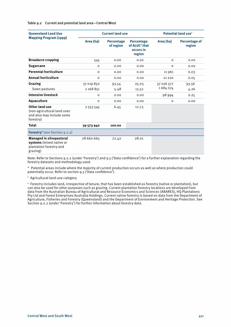
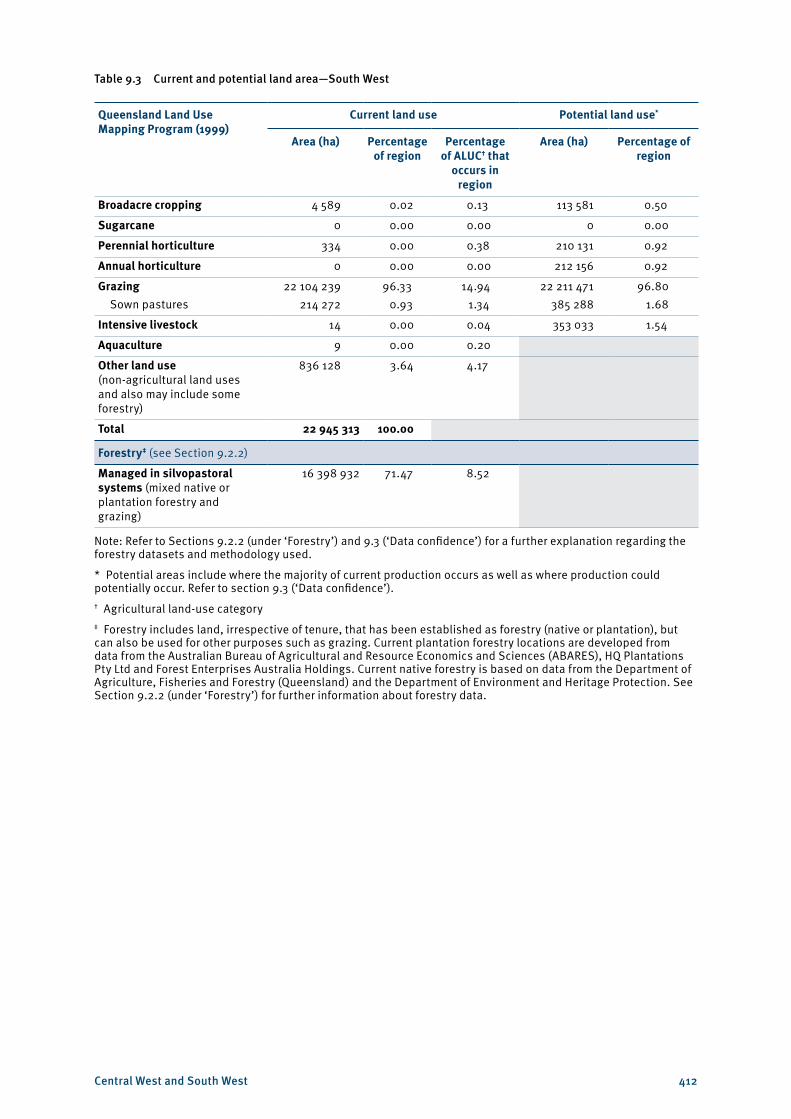
The primary land use for both regions is grazing—93.5 per cent in the Central West and 96.3 per cent in the South West (see Tables 9.2 and 9.3). Cropping in the Central West is so minimal, it is insignificant compared to the rest of the state. While a greater area of land in the South West is used for plant industries, the figure is again insignificant, with less than 1 per cent of the state’s horticultural and cropping land occurring in this region. See Maps 9.8 and 9.9 for current agricultural land use in the Central West and South West.
The far-western parts of these regions are almost exclusively grazing lands. Due to the climate and extensive grazing systems, there is a low incidence of parasites in this area. As a result, historical chemical usage is low, which has allowed many landholders to market their products as organic and reap the benefits of premium prices. However, the reduced number of organically accredited feed supplements can make the production system difficult to manage in poorer climatic conditions.
The channel country in the west of the regions is a significant area that is subject to periodic beneficial flooding, which is used in a certain way by larger pastoral companies in particular. Areas that have been beneficially flooded in a season can be used to rapidly gain weight on cattle. These weight gains can be at the same levels as feedlot weight gains for several months at a time. As a result, large companies transport significant numbers of stock, as beneficial flooding occurs as part of their backgrounding or fattening processes.
Sown pastures are not widespread within the Central West and South West regions. In the South West they account for less than 1 per cent of land usage, while in the Central West, 5.5 per cent of the land area is under sown pastures (see Tables 9.2 and 9.3).
The eastern parts of the regions are also predominately used for grazing; however, small areas of land are also used for other agricultural industries. Sheep production is centred in the area from Winton to Tambo in the Central West, down through Augathella and Cunnamulla to the New South Wales border in the South West. This area is preferred for sheep production due to its proximity to markets in New South Wales.
The regions’ few horticultural and crop producers are located along the Warrego River, where there is greater certainty in water supply. Irrigated dates have been successfully grown near Eulo and Thargomindah, and figs are also being produced in Thargomindah. Table grapes and citrus are produced around Cunamulla and Charleville.
While most of the cropping in these regions is opportunistic fodder cropping, other crops can also be grown. Irrigated grains and cotton have been grown around Cunnamulla and Charleville. In this eastern part of the South West region, some landholders use fodder cropping as a means of controlling brigalow regrowth.
Central West and South West 411
Table 9.2 Current and potential land area—Central West
Queensland Land Use Mapping Program (1999)
Current land use Potential land use*
Area (ha) Percentage of region
Percentage of ALUC† that
occurs in region
Area (ha) Percentage of region
Broadacre cropping 545 0.00 0.02 0 0.00
Sugarcane 0 0.00 0.00 0 0.00
Perennial horticulture 0 0.00 0.00 11 961 0.03
Annual horticulture 0 0.00 0.00 21 220 0.05
Grazing Sown pastures
37 019 8502 168 851
93.545.48
25.0313.52
37 026 577 1 684 074
93.564.26
Intensive livestock 0 0.00 0.00 98 994 0.25
Aquaculture 0 0.00 0.00 0 0.00
Other land use (non-agricultural land uses and also may include some forestry)
2 553 545 6.45 12.73
Total 39 573 940 100.00
Forestry‡ (see Section 9.2.2)
Managed in silvopastoral systems (mixed native or plantation forestry and grazing)
28 660 665 72.42 28.01
Note: Refer to Sections 9.2.2 (under ‘Forestry’) and 9.3 (‘Data confidence’) for a further explanation regarding the forestry datasets and methodology used.
* Potential areas include where the majority of current production occurs as well as where production could potentially occur. Refer to section 9.3 (‘Data confidence’).† Agricultural land-use category‡ Forestry includes land, irrespective of tenure, that has been established as forestry (native or plantation), but can also be used for other purposes such as grazing. Current plantation forestry locations are developed from data from the Australian Bureau of Agricultural and Resource Economics and Sciences (ABARES), HQ Plantations Pty Ltd and Forest Enterprises Australia Holdings. Current native forestry is based on data from the Department of Agriculture, Fisheries and Forestry (Queensland) and the Department of Environment and Heritage Protection. See Section 9.2.2 (under ‘Forestry’) for further information about forestry data.
Central West and South West 412
Table 9.3 Current and potential land area—South West
Queensland Land Use Mapping Program (1999)
Current land use Potential land use*
Area (ha) Percentage of region
Percentage of ALUC† that
occurs in region
Area (ha) Percentage of region
Broadacre cropping 4 589 0.02 0.13 113 581 0.50
Sugarcane 0 0.00 0.00 0 0.00
Perennial horticulture 334 0.00 0.38 210 131 0.92
Annual horticulture 0 0.00 0.00 212 156 0.92
Grazing Sown pastures
22 104 239214 272
96.330.93
14.941.34
22 211 471385 288
96.801.68
Intensive livestock 14 0.00 0.04 353 033 1.54
Aquaculture 9 0.00 0.20
Other land use (non-agricultural land uses and also may include some forestry)
836 128 3.64 4.17
Total 22 945 313 100.00
Forestry‡ (see Section 9.2.2)
Managed in silvopastoral systems (mixed native or plantation forestry and grazing)
16 398 932 71.47 8.52
Note: Refer to Sections 9.2.2 (under ‘Forestry’) and 9.3 (‘Data confidence’) for a further explanation regarding the forestry datasets and methodology used.
* Potential areas include where the majority of current production occurs as well as where production could potentially occur. Refer to section 9.3 (‘Data confidence’).† Agricultural land-use category‡ Forestry includes land, irrespective of tenure, that has been established as forestry (native or plantation), but can also be used for other purposes such as grazing. Current plantation forestry locations are developed from data from the Australian Bureau of Agricultural and Resource Economics and Sciences (ABARES), HQ Plantations Pty Ltd and Forest Enterprises Australia Holdings. Current native forestry is based on data from the Department of Agriculture, Fisheries and Forestry (Queensland) and the Department of Environment and Heritage Protection. See Section 9.2.2 (under ‘Forestry’) for further information about forestry data.
Central West and South West 413
9.2.1 Important agricultural area
In the Central West and South West regions, one area has been identified as an important agricultural area. This important area is depicted on a single map covering the two regions, due to its overlapping nature.
An important agricultural area is an area that has all the requirements for agriculture to be successful and sustainable, is part of a critical mass of land with similar characteristics and is strategically significant to the region or the state. Map 9.10 shows the general location of the important agricultural area for the Central West and South West regions.
Channel country
The channel country is 29 million hectares of grassland in the Australian outback, covering parts of the Central West and South West regions, as well as areas of the Northern Territory, South Australia and New South Wales. This area is of particular importance to Queensland’s agricultural industry, as it is the centre of the state’s (and country’s) organic beef production (see Case study 9.1).
Climate and isolation combine to create a substantial area of grazing country with a low incidence of pests, which remains chemical-free. While average rainfall is low and long-term average pasture yields average only 1500 kg per hectare, flood plains throughout the region can provide higher levels of pasture growth in good seasons. However, some landholders have had to relinquish their organic status when, in dry years, they have had to supplement cattle feed with non-organic food stock. Potential improvements could be made in pasture production, however, if land were improved to condition A.
9.2.2 Industry profiles
Grazing
Current
In the Central West and South West, breeding, grow out and backgrounding are the primary cattle grazing production system components undertaken, either for direct export or finishing in Queensland’s eastern regions. In opportune times, cattle can also be finished in the channel country and Mitchell grasslands of the Central West and the Warrego flood plain of the South West.
The low incidence of pests has led to low usage of chemicals. In the far-western parts of the regions in particular, organic beef is easily attainable, creating alternative marketing opportunities for these landholders.
The kangaroo population in the Central West and South West regions has rapidly expanded in recent times. With this additional grazing pressure, landholders are only able to run approximately 75 per cent of the herd. Prickly acacia is also a large strain on production in the northern parts of the Central West. Georgina gidgee and heartleaf are toxic—stock is run at only 30–40 per cent of carrying capacity where these weeds occur.
The South West and Central West were traditionally more evenly split between sheep and cattle production. However, sheep production has become relatively more difficult and less profitable. This is largely due to changes within the labour market, increasing impacts of wild dogs, aging landholder demographics and the price of wool falling after the collapse of the Wool Floor Price Scheme in 1989. Sheep are labour intensive—they require skilled workers for shearing, drenching and dipping. These workers are increasingly hard to attract, due to competition with the mining sector and the social isolation of properties in the regions.
Central West and South West 414
Despite this, sheep are the second-most valuable agricultural commodity in the Central West and South West regions. This industry is located on the Mitchell grass downs from Winton towards Augathella, encompassing Longreach, Aramac, Barcaldine, Blackall and Tambo. This area has few watercourses, which can be problematic for sheep, but is far enough away from the range country so that wild dogs are not a significant problem. The area encompassing Quilpie, Cunnamulla, Wyandra, Charleville and Eromanga, and extending as far south as the New South Wales border and as far east as the Maranoa River (in the Darling Downs region) is also useful for the industry. While animals are fattened in the south-eastern part of the region and into the Darling Downs, wool is produced around Quilpie.
The eastern portion of the South West and the south-eastern portion of the Central West are also suited to sheep due to the proximity and accessibility of markets in Dubbo, New South Wales. Like the cattle industry, there is little history of chemical usage within the sheep industry. However, there is currently no market premium for organic wool production. If this market develops in the future, it may provide an opportunity for expansion within the regions.
Within the regions, some areas (which would otherwise be suitable for sheep production) are grazed by cattle in preference to sheep due to issues with wild dogs.
Potential
The potential area for grazing in the Central West and South West regions is 93.6 per cent of the Central West and 96.8 per cent of the South West (see Maps 9.12 and 9.14). As the greatest portion of the regions is already grazed, potential improvements in productivity do not come from increasing the area of land used, but through improved land and herd management. There is an opportunity in many areas to improve the condition of the land, which would improve output. As Maps 9.11–9.14 show, transitioning from class B to class A land condition may potentially lead to greater pasture production, particularly in the southern part of the Central West as well as the eastern part of this region around Longreach, Barcaldine and Alpha. Improving land condition may also lead to greater pasture growth in the channel country, in the far western portion of the South West region and in the ashy downs areas to the north-east of the Central West.
There is also potential for expanding fodder crop production within the region. This would add value to the regions’ economies and also help maintain productivity during dry years. As some areas have unallocated water available and in many cases existing licences are under-utilised, the potential for additional fodder cropping is not unreasonable, particularly in the areas north-east of Augathella identified for horticultural production. This same area may also be suitable for sown pastures, which may improve ground condition as well as cattle nutrition and weight gain.
The region has the additional bonus of low chemical usage. Organics are a market niche that is continuing to grow, as there is increased market concern about chemicals in food. This expanding market may give Central West and South West graziers the opportunity to expand while drawing premium prices for their product.
There is relatively low potential for sown pastures within the Central West and South West regions. This is primarily due to poor soil quality as well as lack of water. The areas most suitable are those patches of better soils, where there is higher rainfall, around Alpha in the Central West and north-east of Augathella in the South West (see Maps 9.15 and 9.16).
Central West and South West 415
Case study 9.1 Organic beef in the Central West and South West
While isolation and climate do place limitations on agricultural production in far-western Queensland, these factors also provide a market opportunity in terms of organic beef production. Low humidity, temperature variability and fewer opportunities for pest introduction combine to create an environment where chemical usage is rare or non-existent.
There are approximately 37 organic beef properties within the region, many of these producing for OBE Beef—which, according to IBISWorld, is the world’s largest organic beef producer.4 This company is comprised of 28 producers running 100 000 cattle within the arid channel country, a region that covers parts of the Northern Territory, Queensland, South Australia and New South Wales. Currently, OBE Beef accounts for 5 per cent of the global market, though their share is expected to rise by 25–30 per cent per annum.
Although the channel country is not currently sown pastures, nor has the potential to be sown, many of the plants and grasses that grow in the area are both palatable and nutritious, particularly the Cooper clover.
The company is not only involved in the grazing aspect of organic beef production, but also processing, shipping, customs, inventory management, distribution and marketing.5 This ensures that both the company and the customer have certainty over the organic status of the meat, from paddock to plate. In the past, some organic producers have realised a price premium of 20–30 per cent for their prime cuts. However, these cuts account for only about 30 per cent of the carcase and the remainder may have to be sold at conventional market rates.
Intensive livestock
Current
Feedlots occur primarily in the eastern reaches of the Central West, on the Belyando River around Alpha (see Maps 9.17 and 9.18). This is consistent with the industry’s requirements for water and potential for grain crops, though no cropping occurs in this area. Some of the feedlots identified may not be currently operational, but maintain a licence to take advantage of opportunities that may arise.
Feedlots also require additional labour to run extensive grazing enterprises and there is a shortage of suitable labour currently in the region.
Potential
Expansion opportunities in the region are constrained by transport costs and distance, land condition and water access. The types of vegetation in the region are also better suited to breeding, with finishing occurring in areas that are closer to processing facilities and markets, such as the Darling Downs.
Potential access to good-quality water is a necessity for establishment of feedlots. Water security is important for feedlots, with the resource likely to become more important as water availability declines due to climate variability and competing uses between different industries and the environment.
4 Department of Agriculture, Fisheries and Forestry 2012, ‘Beef supply chain—high level economic analysis’ draft, State of Queensland.
5 Department of Agriculture, Fisheries and Forestry 2004, The Australian organic industry—a summary, Australian Government.
Central West and South West 416
Broadacre cropping
Current
The greatest part of broadacre crop production within the Central West and South West regions is focused on fodder crops, supporting the grazing industry upon which the regions’ economies are based. However, statistically, the area of land used for broadacre cropping is insignificant—only 0.02 per cent of the South West and only 545 hectares in the Central West (see Maps 9.19 and 9.20). Fodder crops can be grown on land in poorer condition and can survive the temperature variability that is associated with these regions. Additionally, some landholders may use fodder cropping as a means of controlling brigalow regrowth.
Irrigated grains and cotton have also been grown along the Warrego River, particularly around Cunamulla and Charleville. Most existing crop production is not located on land identified as having potential for the industry. This is likely due to opportunistic cropping, where landholders have allocated water or rainfall allows.
Potential
In areas of both the Central West and South West regions, there may be unallocated water available for agricultural production (Georgina Diamantina, Great Artesian Basin and Burdekin water resource plans in particular). Furthermore, existing water licences are currently under-utilised. Full exploitation of water resources within the regions could lead to an expansion of cropping industries within the area. This is particularly true of fodder crops. Improvements in land condition and increasing the level of nitrogen within the soil could also lead to productivity improvements.
Horticulture
Current
Most of the horticulture in the regions is opportunistic. Irrigated dates have been successfully grown near Eulo and Thargominda, figs in Thargominda, and grapes and citrus around Cunamulla and Charleville (see Map 9.19). However, land-use data statistics show that perennial horticulture accounts for only 0.0015 per cent of the land in the South West, with no land being identified as being used for horticulture within the Central West.
Most of the horticultural industries within the regions are located outside areas identified as biophysically suitable for horticultural production. There may, however, be patches of brigalow soils that have a higher level of productivity than the dominant land class of an area.
Potential
The greatest potential for horticultural production is around the Belyando River and north-east of Alpha. The Belyando River sits within the Burdekin catchment and there is 130 000 ML of water available in the general reserve in the Belyando–Suttor sub-catchment. The sub-catchment is primarily located within the Mackay, Isaac and Whitsunday region—as such, there may not be significant water availability within the Central West region.
In areas of both the Central West and South West regions, there may be unallocated water available for agricultural production. Furthermore, existing water licences are currently under-utilised. Full exploitation of water resources within the regions could lead to a significant expansion of horticultural industries within these areaa. The successful production of dates, figs and citrus within these areas suggest further expansion of horticulture within the region is possible, particularly for the growing of fruit and vegetables for personal consumption within the region.6
6 ABC Western Queensland 2008, ‘Specialty foods out west’, ABC, viewed 12 December 2012, <http://www.abc.net.au/local/stories/2008/10/10/2387930.htm>.
Central West and South West 417
Forestry
Current
Central West and South West are currently small forestry production and timber processing regions in Queensland. The regions currently generate less than 5 per cent of Queensland’s native cypress and hardwood forestry production for the Queensland timber processing industry. Forestry production predominately comes from timber resource areas (native) on state-owned lands under the Forestry Act 1959, and native forest practice notification areas on private (freehold) land under the Vegetation Management Act 1999.7 Almost all of this land is also grazed and generally managed as silvopastoral systems—production systems that combine forestry and grazing in a mutually beneficial way.
Native forestry currently occurs mostly on the eastern sides of the regions on state-owned land and private land that is generally also used for grazing. Patches of sandalwood also occur through out the regions (see Maps 9.23 and 9.24). Native forestry in the Central West and South West (cypress and hardwood) produces a number of forest products suitable for a number of uses, including sawn construction and appearance timber, poles, bridging girders, fencing timbers and craftwood. In addition, native Queensland sandalwood is harvested for its aromatic timber properties. Hardwood fencing timbers are an important resource for grazing and other agricultural land uses. The key commercial native forestry tree species in the Central West and South West include white cypress pine, ironbark, spotted gum and sandalwood, as well as a broad range of other suitable tree species.
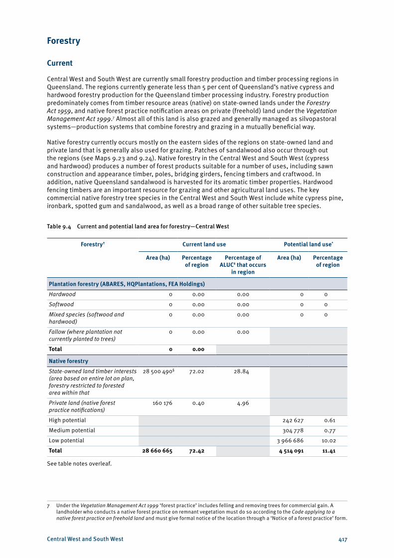
Table 9.4 Current and potential land area for forestry—Central West
Forestry† Current land use Potential land use*
Area (ha) Percentage of region
Percentage of ALUC‡ that occurs
in region
Area (ha) Percentage of region
Plantation forestry (ABARES, HQPlantations, FEA Holdings)
Hardwood 0 0.00 0.00 0 0
Softwood 0 0.00 0.00 0 0
Mixed species (softwood and hardwood)
0 0.00 0.00 0 0
Fallow (where plantation not currently planted to trees)
0 0.00 0.00
Total 0 0.00
Native forestry
State-owned land timber interests (area based on entire lot on plan, forestry restricted to forested area within that
28 500 490§ 72.02 28.84
Private land (native forest practice notifications)
160 176 0.40 4.96
High potential 242 627 0.61
Medium potential 304 778 0.77
Low potential 3 966 686 10.02
Total 28 660 665 72.42 4 514 091 11.41
See table notes overleaf.
7 Under the Vegetation Management Act 1999 ‘forest practice’ includes felling and removing trees for commercial gain. A landholder who conducts a native forest practice on remnant vegetation must do so according to the Code applying to a native forest practice on freehold land and must give formal notice of the location through a ‘Notice of a forest practice’ form.
Central West and South West 418
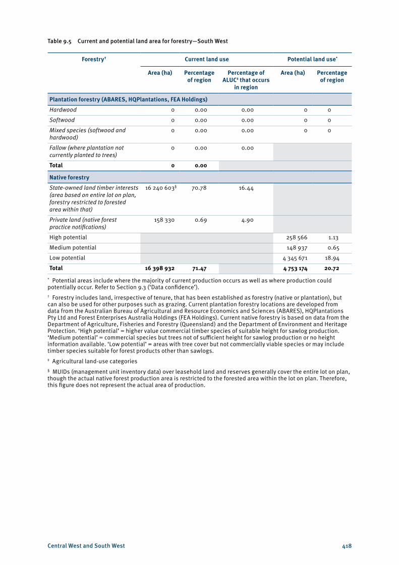
Table 9.5 Current and potential land area for forestry—South West
Forestry† Current land use Potential land use*
Area (ha) Percentage of region
Percentage of ALUC‡ that occurs
in region
Area (ha) Percentage of region
Plantation forestry (ABARES, HQPlantations, FEA Holdings)
Hardwood 0 0.00 0.00 0 0
Softwood 0 0.00 0.00 0 0
Mixed species (softwood and hardwood)
0 0.00 0.00 0 0
Fallow (where plantation not currently planted to trees)
0 0.00 0.00
Total 0 0.00
Native forestry
State-owned land timber interests (area based on entire lot on plan, forestry restricted to forested area within that)
16 240 603§ 70.78 16.44
Private land (native forest practice notifications)
158 330 0.69 4.90
High potential 258 566 1.13
Medium potential 148 937 0.65
Low potential 4 345 671 18.94
Total 16 398 932 71.47 4 753 174 20.72
* Potential areas include where the majority of current production occurs as well as where production could potentially occur. Refer to Section 9.3 (‘Data confidence’).† Forestry includes land, irrespective of tenure, that has been established as forestry (native or plantation), but can also be used for other purposes such as grazing. Current plantation forestry locations are developed from data from the Australian Bureau of Agricultural and Resource Economics and Sciences (ABARES), HQPlantations Pty Ltd and Forest Enterprises Australia Holdings (FEA Holdings). Current native forestry is based on data from the Department of Agriculture, Fisheries and Forestry (Queensland) and the Department of Environment and Heritage Protection. ‘High potential’ = higher value commercial timber species of suitable height for sawlog production. ‘Medium potential’ = commercial species but trees not of sufficient height for sawlog production or no height information available. ‘Low potential’ = areas with tree cover but not commercially viable species or may include timber species suitable for forest products other than sawlogs.‡ Agricultural land-use categories§ MUIDs (management unit inventory data) over leasehold land and reserves generally cover the entire lot on plan, though the actual native forest production area is restricted to the forested area within the lot on plan. Therefore, this figure does not represent the actual area of production.
Central West and South West 419
On state-owned land, the denotation of a management unit (MUID)8 on the lot on plan indicates commercial native forestry (including sandalwood) or quarry material interest. However, the actual native forest production area is generally restricted to the forested area within the parcel. There is currently timber interests based on MUIDs on 16 240 603 hectares within the South West region (70.78 per cent of the region—see Map 9.24), recognising that this figure is not the actual area of native forestry production on state land but includes large areas that potentially have areas of native sandalwood. A similar area of land is under MUIDs in the Central West region. Harvesting of these MUIDs is scheduled on a routine basis in conjunction with the current state timber supply commitments and market demand.
On private land (freehold), forest practice notifications (managing, felling and removal of native trees for commercial purposes) cover 158 330 hectares in the South West (0.7 per cent of the region) and 160 176 hectares in the Central West. The actual area of production is generally restricted to the forested areas within those areas (see Tables 9.4 and 9.5).
Plantation forestry is non-existent in the Central West and South West due to the regions’ low rainfall.
There are a number of small timber processing facilities within and outside the Central West and South West sourcing the regions’ native cypress and hardwood forestry products (see Maps 9.23 and 9.24). There are also a number of portable sawmills and fencing timber processors servicing the regions’ forestry production that are not mapped. Sawmills are located on the regions’ eastern sides where most of the forestry production occurs—Alpha and Augathella. A sawmill in Tambo closed in 2011 due to labour shortages.
Potential
There is generally only limited potential for increased forestry production in the Central West and South West due mostly to the regions’ low rainfall. There is some potential for increased hardwood native forestry production associated with mulga and gidgee, plus a broad range of other suitable tree species, aimed at high-value niche markets (i.e. fine furniture, musical instrument manufacture, etc.) due to their wide distribution; potentially large, sustainably harvestable volumes; and promising timber properties.
Forestry production is currently operating in some of the potential areas and, in others, potential production is yet to be realised. While the native forestry mapping is reasonably accurate, it is primarily based on the regional ecosystem mapping data used for the Vegetation Management Act 1999 and some identified inaccuracies exist.
The potential high, medium and low production areas identified for native forestry expansion in the Central West and South West are limited—high 242 627 hectares and medium 304 778 hectares (0.6 and 0.8 per cent of the region) for Central West, and high 258 566 hectares and medium 148 937 hectares (1.13 and 0.65 per cent) for the South West—see Maps 9.23 and 9.24. Opportunities exist to increase native forestry production on the mapped potential areas on a long-term basis, while having minimal impacts on the other pastoral land uses.
Most existing timber processors in the region, which are predominately native cypress and hardwood processors, have some capacity to expand production if increased log timber comes onstream. Demand for native hardwood forest products is high and native cypress forest products is medium, which is forecast to stay that way in the medium to long term.
Overall, the regions currently have a small forestry production output for Queensland, and have only limited opportunity for forestry production growth and associated downstream timber processing sector growth.
8 MUID—management unit inventory data