Embed Size (px)
Citation preview
Page 1 of 47 ABN 20 123 133 166
Unit 6/11 Colin Grove, West Perth PO Box 256 West Perth WA 6872
Ph (08) 9481 5866 Fax: (08) 9481 5966
www.horseshoemetals.com.au
QUARTERLY REPORT PERIOD ENDED 30 JUNE 2013
HIGHLIGHTS
Horseshoe Lights Project (HOR: 100%)
40% increase to Mineral Resource Estimate at the Horseshoe Lights Project;
New Resource Statement is 12.85Mt @ 1.00% Cu, and 0.1 g/t Au for 128,600 tonnes of contained copper and 36,000 oz gold using a 0.5% Cu cut-off grade;
Multiple intervals of copper mineralisation recorded in two diamond drill holes drilled on western side of open pit (HDD007 and HDD009), and
Geophysical study identifies additional target areas for future exploration.
Kumarina Project (HOR: 100%)
Mineral Resource Estimate work completed on Rinaldi Prospect, and
New drilling target identified at recently located workings at Snell North Prospect.
Corporate
Share Placement of 7.857 million shares @ 7 cents per share completed, raising $549,990, and
Early participation in WA Mining Rehabilitation Fund approved, releasing $1,066,500 environment bond and cash back to the Company.
ASX/MEDIA ANNOUNCEMENT
31 JULY 2013 ASX Code:
HOR Management
Mr Jeremy Shervington Non-Executive Chairman
Mr Neil Marston Managing Director
Mr Michael Fotios Non-Executive Director
Mr Stuart Hall Non-Executive Director
Mr Damian Delaney Company Secretary
Issued Capital
Shares: 83.8 Million Options: 10.8 Million Share Price: $0.07 Market Capitalisation: $5.9 Million Cash at Bank (30 June 2013)
$0.6 Million
For
per
sona
l use
onl
y

QUARTERLY REPORT FOR THE PERIOD ENDED 30 JUNE 2013
Page 2 of 47
OVERVIEW
Horseshoe Metals Limited (ASX: HOR) (“Horseshoe Metals” or “the Company”), through its wholly owned subsidiary, Murchison Copper Mines Pty Ltd, holds a 100% interest in the Horseshoe Lights and Kumarina Projects located in the Peak Hill Mineral Field, north of Meekatharra in Western Australia (see Figure 1).
Figure 1 – Projects Location Plan
EXPLORATION AND EVALUATION Horseshoe Lights Project (HOR: 100%) (GRR: 3% NSR Royalty)
The Horseshoe Lights Project covers an area of approximately 80 km2 including the closed Horseshoe Lights copper-gold mine, which is located 75km west of Sandfire Resources NL’s DeGrussa Copper-Gold mine. Historical production from the Horseshoe Lights mine was 313,000 oz gold and 54,800 tonnes of copper.
Mineral Resource Estimation
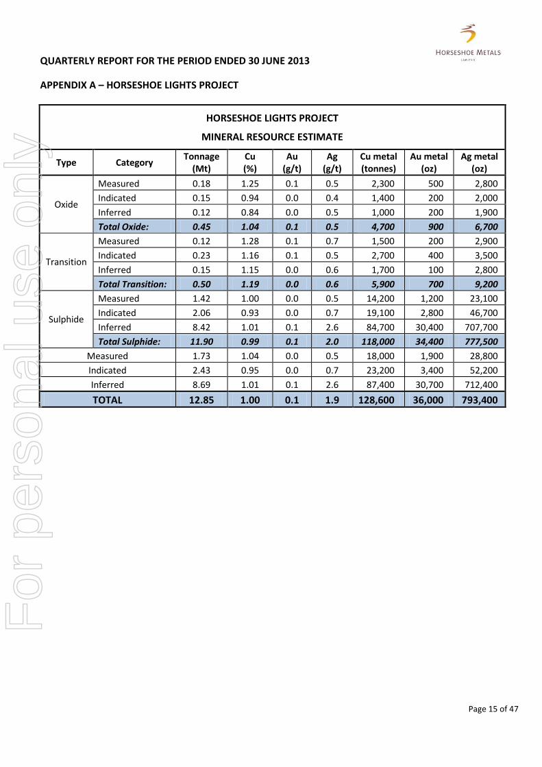
An updated Mineral Resource estimation for the Horseshoe Lights deposit was completed during the quarter.
The updated total Measured, Indicated and Inferred Mineral Resource Estimation increased by 40% to 12.85 million tonnes @ 1.00% Cu and 0.1 g/t Au for 128,600 tonnes Cu and 36,000 oz Au (using a cut-off grade of 0.5% Cu).
Horseshoe commissioned independent resource industry consulting group CSA Global Pty Ltd to undertake the Mineral Resource estimation, following the completion of drilling by the Company in May 2013.
For all areas subjected to recent drilling the Mineral Resource has been classified into three categories (Measured, Indicated or Inferred) based on the geological confidence and data quality. As there has been no twinning of historic drill holes within the Main Zone beneath the existing pit, the entire resource south of 7194150mN has been classified into the Inferred category (see Figure 2).
Details of the Mineral Resource estimate using a 0.5% Cu cut-off grade are shown in Appendix A, which meets the reporting requirements of the new 2012 Edition of the “Australasian Code for Reporting of Exploration Results, Mineral Resources and Ore Reserves”.
Diamond Drilling
During the quarter three new diamond drill holes, HDD007 - HDD009 were completed with an additional historical hole (DDH55) being re-entered and extended. The location of the drill hole collars is shown in Figure 2.
For
per
sona
l use
onl
y

QUARTERLY REPORT FOR THE PERIOD ENDED 30 JUNE 2013
Page 3 of 47
HDD007 and HDD009 were designed to test for extensions of copper/gold mineralisation down dip of the Main Zone beneath the existing Horseshoe Lights open pit.
Laboratory assays for 104 samples from two diamond drill holes, HDD007 & HDD009, were received. Significant assay results are shown in Table 1.
The best intersection in HDD007 was 4.3m (264.7 – 269.0m) @ 2.6% Cu including 1m @ 10.0% Cu and 0.1 g/t Au consisting of semi-massive Chalcocite and stringers of Chalcopyrite (see Plate 1).
Plate 1: HDD007 core from 265.3 to 268.9m showing sample intervals of high grade copper mineralisation
Numerous other intervals of chalcopyrite mineralisation intersected between 264m - 331m down hole depth in HDD007 confirm that a broad mineralised zone exists down dip of previous drilling and remains open at depth.
The best intersection in HDD009 was 4.1m (308.9 – 313.0m) @ 1.5% Cu.
Copper mineralisation identified in both HDD007 and HDD009 is consistent with the Company’s geological modelling and confirms the potential for further down dip extensions to the west of the existing open pit as well as the southerly down plunge extension, which is yet to be tested.
HDD008 was designed to test a volcanogenic-hosted massive sulphide (VMS) exploration target beneath Chert Hill, south east of the existing open pit.
The main contact between the Ravelstone and the Narracoota Formations was intersected a lot higher up HDD008 than expected at 172.92 metres. Furthermore the Dolerite contact was not intersected at ~540m as expected, with the hole ending in Mafic Volcanics at 572.7 metres. This means the volcanic sequence of the Narracoota Formation in this area is at least 400 metres thick.
No significant copper mineralisation was logged in HDD008.
Chalcocite (9.0% Cu) Chalcocite / Chalcopyrite (10.4% Cu)
Disseminated Chalcopyrite
For
per
sona
l use
onl
y
QUARTERLY REPORT FOR THE PERIOD ENDED 30 JUNE 2013
Page 4 of 47
Geophysical Study
During the quarter a detailed Geophysical Study was completed at the Horseshoe Lights project, using all available exploration data generated by the Company over the last 3 years, plus historical information such as soil sampling and drilling data. The study was conducted by Resource Potential Pty Ltd.
The aim of the study was:
to obtain the best possible understanding of the geology at, and surrounding, the Horseshoe Lights mine; and
to identify exploration targets for the next stage of drilling by the Company.
The study has identified large fold and thrust structures at mine corridor scale, and tracked the very detailed location of the East-West trending thrust fault that separates the Bryah Group from the Bangemall Group. The Horseshoe Lights mine is located on the Western limb of a SSE plunging anticline, with several parasitic folds and interpreted North-South thrust repetitions in the East. These features are cut by late stage cross faults that may contain Au bearing quartz veins (see Figure 3).
The Westerly dipping VMS mineralisation in the Horseshoe pit is truncated abruptly along a NE trending late stage fault. Apparent dextral offset of geological units suggests a south-side-down offset occurs across this fault. Therefore, mineralisation may continue deeper to the South and to the East of the southern limit of the open cut. This makes the Chert Hill area prospective for deep drilling, because the Narracoota Fmn – Ravelstone Fmn contact is interpreted to occur along an anticlinal axis under this hill.
This Chert Hill area has been tested with one hole to date (HDD008) however additional drilling using fences of 2 to 3 deep drillholes has been recommended, especially where there are coincident gravity and IP chargeability anomalies.
VMS targets have been identified further to the SSE of the mine by structural and geophysical (IP and gravity) targeting, and are also recommended for deep drilling. IP and gravity targets also occur to the South of the mine, but these anomalies may be in the Ravelstone Formation and have a lower priority than the other geophysical VMS targets.
Several historical copper and gold soil geochemical anomalies have been identified south of the Horseshoe Lights Mine on the adjoining Exploration Licence and Prospecting Licences in Ravelstone Formation rocks which warrant follow-up exploration. Five East-West drilling transects have been recommended to cross the more prominent geochemical anomalies and adjacent structures (see Figure 3).
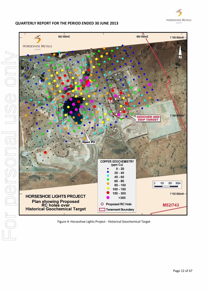
A copper target generated from a historical (pre 1980’s mining) soil geochemical survey have been identified in Narracoota Formation rocks to the East of the mine. Fences of RC holes are proposed to test this target which is located just to the east of the open cut, and in a favourable geological position. (see Figure 4). There has been very limited drilling in this area due to the leach vats and tailings dam infrastructure of the 1980’s mining operations.
For
per
sona
l use
onl
y

QUARTERLY REPORT FOR THE PERIOD ENDED 30 JUNE 2013
Page 5 of 47
Future Activities
The area East of the Horseshoe Lights Open Pit is of particular interest as it has a complex geological setting that was difficult to interpret from airborne geophysics due to the data interference created by the old plant, buildings and other infrastructure. Resource Potential has recommended a ground-based magnetic survey based on east-west oriented lines at 25m spacings be completed to provide high resolution information.
A Down Hole Electromagnetic Survey (”DHEM”) commenced subsequent to the quarter, in mid-July 2013 with the aim of testing for off-hole conductors that may represent massive sulphide copper/gold mineralisation within the Narracoota Formation, where it lies largely untested beneath the overlying Ravelstone Formation. An interpretation of the DHEM survey results is expected to be available in August.
During the next quarter the Company intends to: 1. Undertake the ground magnetic survey, and 2. Commence the next phase of drilling to the east of the open pit.
Overall the Company is of the view that there remains excellent potential to substantially grow the copper inventory at the Horseshoe Lights Project with targeted drilling and exploration in other largely untested areas.
Kumarina Project (HOR: 100%)
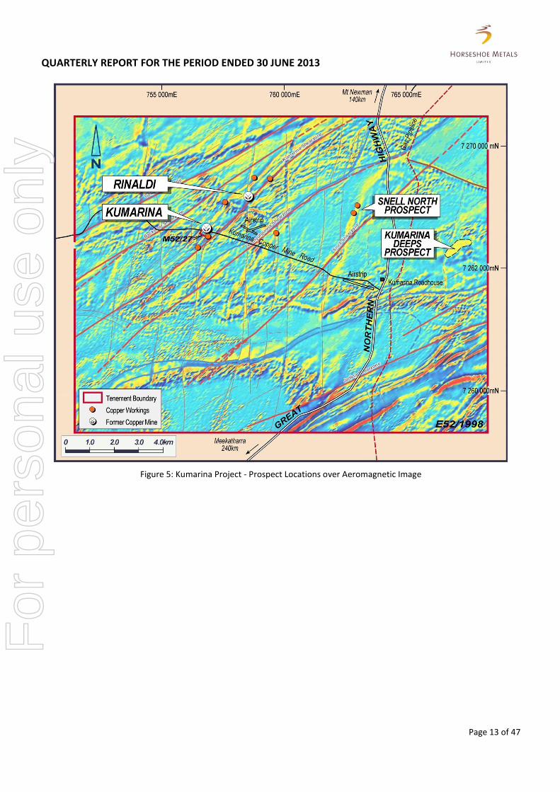
The Kumarina Project consists of one exploration licence and one mining lease covering approximately 217 km2. Drilling by the Company in 2011 and 2012 identified significant copper mineralisation at the Rinaldi Prospect.
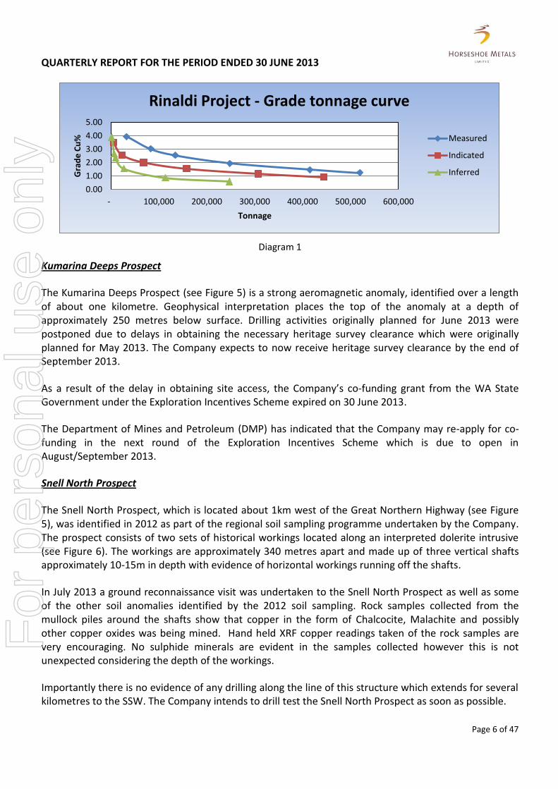
Rinaldi Prospect - Mineral Resource Estimation
In the previous quarter the Company announced a maiden resource consistent with the 2004 JORC code and guidelines for the reporting of Mineral Resource Estimates for the Rinaldi Prospect.
During the June 2013 quarter work was undertaken to ensure the Mineral Resource Estimates for the Rinaldi Prospect meets the reporting requirements of the new 2012 Edition of the “Australasian Code for Reporting of Exploration Results, Mineral Resources and Ore Reserves” which are set out in Appendix B.
Using a cut-off grade of 0.5% Cu, the Mineral Resource estimate is 835,000 tonnes @ 1.3% Cu for 10,600 tonnes of contained copper.
The Mineral Resource is predominately in the Measured and Indicated categories as shown in Diagram 1 below, providing a high level of confidence in the continuity of the mineralisation.
Additional drilling is being considered to test extensions to the Mineral Resource at the Rinaldi Prospect.
For
per
sona
l use
onl
y
QUARTERLY REPORT FOR THE PERIOD ENDED 30 JUNE 2013
Page 6 of 47
Diagram 1
Kumarina Deeps Prospect
The Kumarina Deeps Prospect (see Figure 5) is a strong aeromagnetic anomaly, identified over a length of about one kilometre. Geophysical interpretation places the top of the anomaly at a depth of approximately 250 metres below surface. Drilling activities originally planned for June 2013 were postponed due to delays in obtaining the necessary heritage survey clearance which were originally planned for May 2013. The Company expects to now receive heritage survey clearance by the end of September 2013.
As a result of the delay in obtaining site access, the Company’s co-funding grant from the WA State Government under the Exploration Incentives Scheme expired on 30 June 2013.
The Department of Mines and Petroleum (DMP) has indicated that the Company may re-apply for co-funding in the next round of the Exploration Incentives Scheme which is due to open in August/September 2013.
Snell North Prospect
The Snell North Prospect, which is located about 1km west of the Great Northern Highway (see Figure 5), was identified in 2012 as part of the regional soil sampling programme undertaken by the Company. The prospect consists of two sets of historical workings located along an interpreted dolerite intrusive (see Figure 6). The workings are approximately 340 metres apart and made up of three vertical shafts approximately 10-15m in depth with evidence of horizontal workings running off the shafts.
In July 2013 a ground reconnaissance visit was undertaken to the Snell North Prospect as well as some of the other soil anomalies identified by the 2012 soil sampling. Rock samples collected from the mullock piles around the shafts show that copper in the form of Chalcocite, Malachite and possibly other copper oxides was being mined. Hand held XRF copper readings taken of the rock samples are very encouraging. No sulphide minerals are evident in the samples collected however this is not unexpected considering the depth of the workings.
Importantly there is no evidence of any drilling along the line of this structure which extends for several kilometres to the SSW. The Company intends to drill test the Snell North Prospect as soon as possible.
0.00
1.00
2.00
3.00
4.00
5.00
- 100,000 200,000 300,000 400,000 500,000 600,000
Gra
de
Cu
%
Tonnage
Rinaldi Project - Grade tonnage curve
Measured
Indicated
Inferred
For
per
sona
l use
onl
y

QUARTERLY REPORT FOR THE PERIOD ENDED 30 JUNE 2013
Page 7 of 47
Future Activities
During the next quarter the Company intends to: 1. Conduct additional field reconnaissance work of soil anomalies to identify potential drill targets ; 2. Obtain DMP approvals for drilling at the Snell North prospect; 3. Undertake a heritage survey of proposed drill sites at the Kumarina Deeps, Snell North, and any
other proposed drilling locations. This survey is now scheduled for late September 2013, and 4. Commence drilling once heritage survey site clearances are obtained.
CORPORATE
As at 30 June 2013, the Company had cash at bank of $619,973.
$1,066,500 secured from Mining Rehabilitation Fund
In addition, the Company has $1,066,500 held on a term deposit as cash backing for the environmental rehabilitation bond on the Horseshoe Lights Project. On 25 July 2013 the Company was advised of its successful application for early participation in the newly created Mining Rehabilitation Fund established by the Western Australian Government’s Department of Mines and Petroleum. Accordingly the Company’s environmental rehabilitatation bond, which relates to existing infrastructure, the flotation tailings dam, various waste dumps, stockpiles and other general disturbances, will be retired and the $1,066,500 held by the Company’s bankers will be released for use by the Company.
Placement and Rights Issue
During the quarter the Company completed a placement of 7,857,000 new ordinary shares to new and existing sophisticated investors at an issue price of $0.07 per share, raising $549,990 before costs.
During the quarter the Company also initiated a Rights Issue based on (1) one new share for every five (5) shares held at the record date of 5 July 2013. The new shares will be issued at $0.07 per share raising up to $1,172,883 before costs (“Offer”). The Offer has been partially underwritten by Azure Capital Limited (“Azure”) up to $295,160 which represents approximately 25% of the Offer raising.
The Company’s Non-Executive Director Michael Fotios and/or his nominees, will provide support to the Offer, as sub-underwriters to Azure, for any shortfall up to $267,385. Other officers of the Company have also become sub-underwriting parties to the Offer shortfall for up to $27,775 by accepting shares in lieu of outstanding fees.
ENDS For further information please contact: Neil Marston James Moses Managing Director Media and Investor Relations Horseshoe Metals Limited Mandate Corporate Ph: +61 8 9481 5866 M: +61 420 991 574 E: [email protected] T: +61 2 8211 0612 E: [email protected]
For
per
sona
l use
onl
y
QUARTERLY REPORT FOR THE PERIOD ENDED 30 JUNE 2013
Page 8 of 47
About Horseshoe Metals Limited
Horseshoe Metals Limited (ASX: HOR) is a copper and gold focused company with a package of tenements covering approximately 300km2 in the highly prospective Peak Hill Mineral Field, located north of Meekatharra in Western Australia. The Company’s projects are the Horseshoe Lights Project and the Kumarina Project.
About the Horseshoe Lights Project
The Horseshoe Lights Project includes the old open pit of the Horseshoe Lights copper-gold mine which operated intermittently between 1946 and 1994, producing over 300,000 ounces of gold and 54,000 tonnes of copper. The Horseshoe Lights ore body is interpreted as a deformed volcanic-hosted massive sulphide (VHMS) deposit that has undergone supergene alteration to generate the gold-enriched and copper-depleted cap that was the target of initial mining. The deposit is hosted by quartz-sericite and quartz-chlorite schists of the Lower Proterozoic Narracoota Volcanics, which also host Sandfire Resources’ DeGrussa Cu-Au mine.
Past mining was focused on the Main Zone, a series of lensoid ore zones which passed with depth from a gold-rich oxide zone through zones of high-grade chalcocite mineralisation into massive pyrite-chalcopyrite. To the west and east of the Main Zone, copper mineralisation in the Northwest Stringer Zone and Motters Zone consists of veins and disseminations of chalcopyrite and pyrite and their upper oxide copper extensions. Previous operators of the mine drilled approximately 829 RC and 70 diamond drill-holes, many of which do not exceed 100m in depth and, in the case of some of the waste dump sterilisation holes drilled in the 1980’s, did not assay for copper.
Prior to the commencement of drilling by Horseshoe in 2010, the project had not been subjected to any significant exploration since the 1990’s and Horseshoe believes that systematic drilling, combined with the application of modern geophysical methods, can upgrade the known resources and may lead to new discoveries in the mine area.
About the Kumarina Project
The copper deposits at the Kumarina Project were discovered in 1913 and worked intermittently until 1973. The workings extend over nearly 5km as a series of pits, shafts and shallow open cuts. At the main Kumarina Copper Mine, the workings are entirely underground with drives from the main shaft extending for some 200m in the upper levels and for about 100m in the lower levels at a depth of 49m below surface. Incomplete records post-1960s make it difficult to estimate the total copper production from the workings. However, indications are that the Kumarina Copper mine was the second largest producer in the Bangemall Basin group of copper mines. Recorded production to the late 1960s is 481 tonnes of copper ore at a high-grade of 37.0% Cu and 2,340 tonnes at a grade of 17.51% Cu.
Reverse circulation percussion drilling programmes were completed by Horseshoe during 2011 and 2012. Results of the drilling programmes identified significant shallow copper mineralisation at the Rinaldi Prospect along a north – south oriented fault. The Company’s 2012 diamond drilling programme of seven holes intersected copper with some high grade zones returning one metre assays of up to 15.2% copper.
For
per
sona
l use
onl
y

QUARTERLY REPORT FOR THE PERIOD ENDED 30 JUNE 2013
Page 9 of 47
Table 1 Horseshoe Lights Project
Significant Drilling Intersections (0.25% Cu cut-off)
Hole No and Depth
Northing (m)
Easting (m)
Planned Azimuth &
Dip (degrees)
FROM (m)
TO (m)
Interval (m)
Cu (%)
Au (g/t)
Zn (%)
HDD007 (440.8m)
7194005 662749 60o/-60o 264.70 269.00 4.3 2.6 - -
including 265.25 266.25 1.0 10.0 0.1 -
281.75 282.00 0.25 1.4 - -
297.05 301.75 4.7 0.3
304.75 305.05 0.3 2.1 0.2 -
327.10 327.73 0.63 3.3 0.1 -
330.50 331.16 0.66 1.2 0.2 -
HDD009 (510.3m)
7194001 662749 90o/-60o 303.45 306.45 3.0 0.5 0.1 0.2
308.90 313.00 4.1 1.5 - -
including 311.70 312.00 0.3 3.6 0.2 -
318.60 318.90 0.3 0.2 0.1 1.5
332.45 332.70 0.25 3.0 0.3 1.0
343.20 343.50 0.30 1.8 0.2 -
349.80 350.1 0.30 0.3 0.1 0.2
457.60 458.35 0.75 2.7 - -
462.00 462.80 0.80 0.4 - -
472.00 473.18 1.18 0.4 - -
Notes: Coordinates GDA94 Zone 50. All holes located by DGPS with accuracy ± 5 metres. All down-hole surveys at 30 metre intervals. Samples collected by cutting core. Four acid digest and Cu analyses by OES. Insufficient geological information is available to determine the true widths of mineralisation reported.
For
per
sona
l use
onl
y

QUARTERLY REPORT FOR THE PERIOD ENDED 30 JUNE 2013
Page 10 of 47
Figure 2: Horseshoe Lights Project - Drill Hole Location Plan F
or p
erso
nal u
se o
nly

QUARTERLY REPORT FOR THE PERIOD ENDED 30 JUNE 2013
Page 11 of 47
Figure 3: Horseshoe Lights Project - Plan showing Geophysical Interpretation
For
per
sona
l use
onl
y
QUARTERLY REPORT FOR THE PERIOD ENDED 30 JUNE 2013
Page 12 of 47
Figure 4: Horseshoe Lights Project - Historical Geochemical Target
For
per
sona
l use
onl
y
QUARTERLY REPORT FOR THE PERIOD ENDED 30 JUNE 2013
Page 13 of 47
Figure 5: Kumarina Project - Prospect Locations over Aeromagnetic Image
For
per
sona
l use
onl
y

QUARTERLY REPORT FOR THE PERIOD ENDED 30 JUNE 2013
Page 14 of 47
Figure 6: Snell North Prospect - Plan showing Geophysical Interpretation
For
per
sona
l use
onl
y
QUARTERLY REPORT FOR THE PERIOD ENDED 30 JUNE 2013
APPENDIX A – HORSESHOE LIGHTS PROJECT
Page 15 of 47
HORSESHOE LIGHTS PROJECT
MINERAL RESOURCE ESTIMATE
Type Category Tonnage
(Mt) Cu (%)
Au (g/t)
Ag (g/t)
Cu metal (tonnes)
Au metal (oz)
Ag metal (oz)
Oxide
Measured 0.18 1.25 0.1 0.5 2,300 500 2,800
Indicated 0.15 0.94 0.0 0.4 1,400 200 2,000
Inferred 0.12 0.84 0.0 0.5 1,000 200 1,900
Total Oxide: 0.45 1.04 0.1 0.5 4,700 900 6,700
Transition
Measured 0.12 1.28 0.1 0.7 1,500 200 2,900
Indicated 0.23 1.16 0.1 0.5 2,700 400 3,500
Inferred 0.15 1.15 0.0 0.6 1,700 100 2,800
Total Transition: 0.50 1.19 0.0 0.6 5,900 700 9,200
Sulphide
Measured 1.42 1.00 0.0 0.5 14,200 1,200 23,100
Indicated 2.06 0.93 0.0 0.7 19,100 2,800 46,700
Inferred 8.42 1.01 0.1 2.6 84,700 30,400 707,700
Total Sulphide: 11.90 0.99 0.1 2.0 118,000 34,400 777,500
Measured 1.73 1.04 0.0 0.5 18,000 1,900 28,800
Indicated 2.43 0.95 0.0 0.7 23,200 3,400 52,200
Inferred 8.69 1.01 0.1 2.6 87,400 30,700 712,400
TOTAL 12.85 1.00 0.1 1.9 128,600 36,000 793,400
For
per
sona
l use
onl
y
QUARTERLY REPORT FOR THE PERIOD ENDED 30 JUNE 2013
APPENDIX A (CONTINUED)
Page 16 of 47
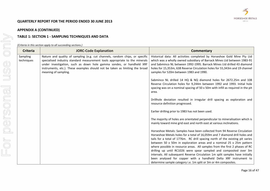
TABLE 1: SECTION 1 - SAMPLING TECHNIQUES AND DATA
(Criteria in this section apply to all succeeding sections.)
Criteria JORC-Code Explanation Commentary
Sampling techniques
Nature and quality of sampling (e.g. cut channels, random chips, or specific specialised industry standard measurement tools appropriate to the minerals under investigation, such as down hole gamma sondes, or handheld XRF instruments, etc.). These examples should not be taken as limiting the broad meaning of sampling.
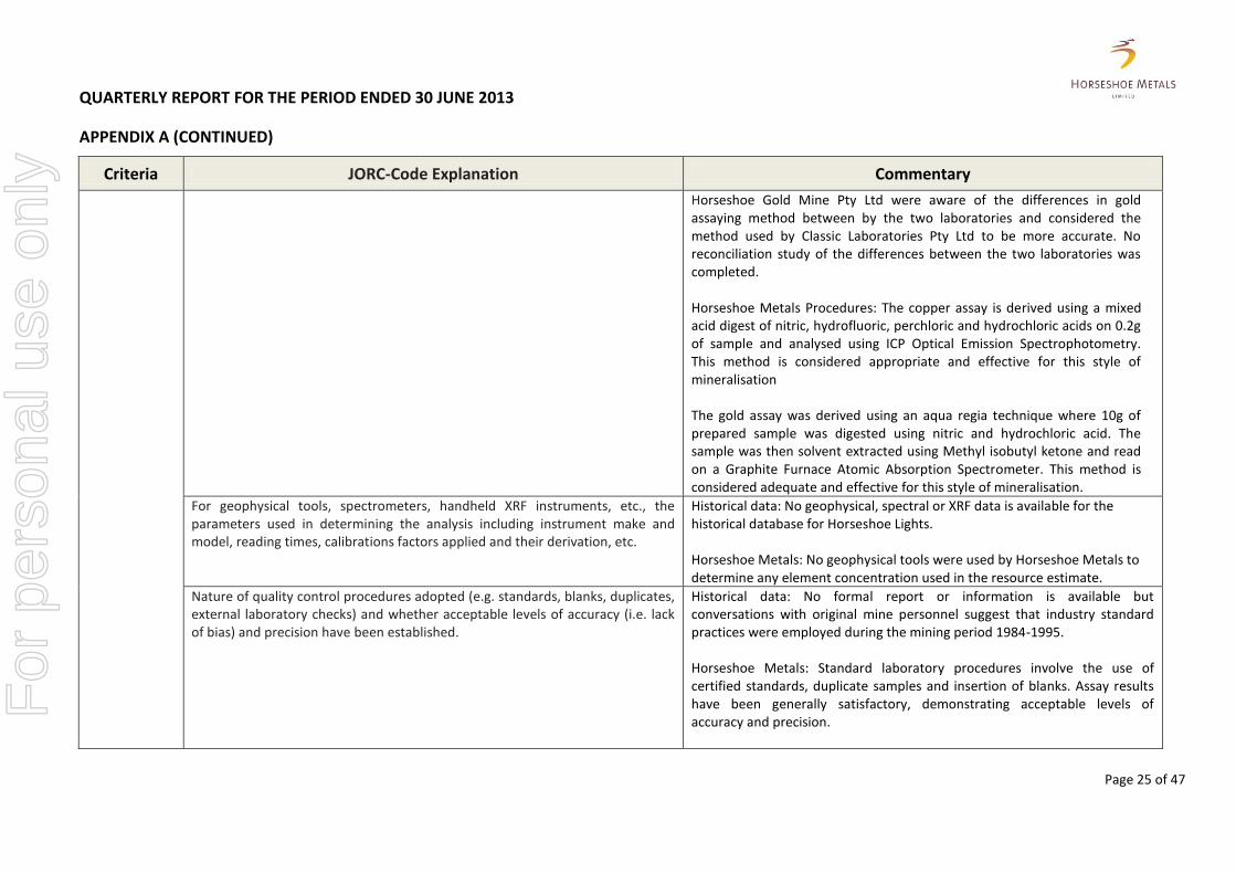
Historical data: All activities completed by Horseshoe Gold Mine Pty Ltd which was a wholly owned subsidiary of Barrack Mines Ltd between 1983-91 and Sabminco NL between 1992-1995. Barrack Mines Ltd drilled 43 diamond holes for 15,353m, 638 Reverse Circulation holes for 55,343m and 19 channel samples for 520m between 1983 and 1990. Sabminco NL drilled 14 HQ & NQ diamond holes for 2672.25m and 108 Reverse Circulation holes for 9,244m between 1992 and 1993. Initial hole spacing was on a nominal spacing of 50 x 50m with infill as required in the pit area. Drillhole deviation resulted in irregular drill spacing as exploration and resource definition progressed. Earlier drilling prior to 1983 has not been used. The majority of holes are orientated perpendicular to mineralisation which is mainly toward mine grid east and north east at various inclinations. Horseshoe Metals: Samples have been collected from 94 Reverse Circulation Horseshoe Metals holes for a total of 16,059m and 7 diamond drill holes and tails for a total of 1776m. RC drill spacing north of the existing pit varies between 50 x 50m in exploration areas and a nominal 25 x 25m pattern where possible in resource areas. All samples from the first 2 phases of RC drilling up until RC1026 were spear sampled and composited over 3m intervals. All subsequent Reverse Circulation 1m split samples have initially been analysed for copper with a handheld Delta XRF instrument to determine sample category i.e. 1m split or 3m or 4m composites.
For
per
sona
l use
onl
y
QUARTERLY REPORT FOR THE PERIOD ENDED 30 JUNE 2013
APPENDIX A (CONTINUED)
Page 17 of 47
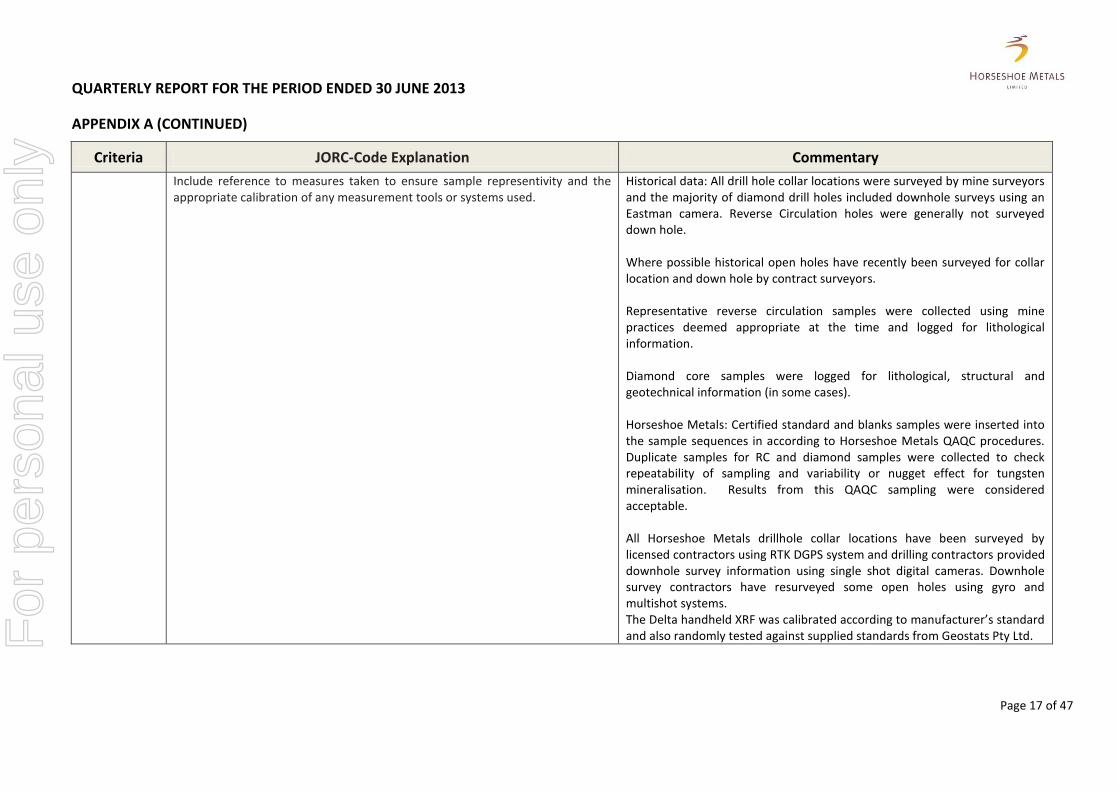
Criteria JORC-Code Explanation Commentary
Include reference to measures taken to ensure sample representivity and the appropriate calibration of any measurement tools or systems used.
Historical data: All drill hole collar locations were surveyed by mine surveyors and the majority of diamond drill holes included downhole surveys using an Eastman camera. Reverse Circulation holes were generally not surveyed down hole. Where possible historical open holes have recently been surveyed for collar location and down hole by contract surveyors. Representative reverse circulation samples were collected using mine practices deemed appropriate at the time and logged for lithological information. Diamond core samples were logged for lithological, structural and geotechnical information (in some cases). Horseshoe Metals: Certified standard and blanks samples were inserted into the sample sequences in according to Horseshoe Metals QAQC procedures. Duplicate samples for RC and diamond samples were collected to check repeatability of sampling and variability or nugget effect for tungsten mineralisation. Results from this QAQC sampling were considered acceptable. All Horseshoe Metals drillhole collar locations have been surveyed by licensed contractors using RTK DGPS system and drilling contractors provided downhole survey information using single shot digital cameras. Downhole survey contractors have resurveyed some open holes using gyro and multishot systems. The Delta handheld XRF was calibrated according to manufacturer’s standard and also randomly tested against supplied standards from Geostats Pty Ltd. F
or p
erso
nal u
se o
nly

QUARTERLY REPORT FOR THE PERIOD ENDED 30 JUNE 2013
APPENDIX A (CONTINUED)
Page 18 of 47
Criteria JORC-Code Explanation Commentary
Aspects of the determination of mineralisation that are Material to the Public Report. In cases where ‘industry standard’ work has been done this would be relatively simple (e.g. ‘reverse circulation drilling was used to obtain 1 m samples from which 3 kg was pulverised to produce a 30 g charge for fire assay’). In other cases more explanation may be required, such as where there is coarse gold that has inherent sampling problems. Unusual commodities or mineralisation types (e.g. submarine nodules) may warrant disclosure of detailed information.
Historical data: Reverse Circulation samples were collected mainly on 1m & 2m intervals and prepared for assaying at the onsite laboratory of Horseshoe Gold Mine Pty Ltd, and/or at accredited laboratories. Diamond core is HQ, NQ and BQ was mainly half cut sampled on geological intervals (0.1m to 3.1m) and assayed using the same techniques as the reverse circulation samples. Horseshoe Metals: Horseshoe Metals samples were submitted to three accredited laboratories: Genalysis, Labwest and Quantum Analytical Services (QAS). The Copper assay is derived using a mixed acid digest of nitric, hydrofluoric, perchloric and hydrochloric acids on 0.2g of sample and analysed using ICP Optical Emission Spectrophotometry. This method is considered appropriate and effective for this style of mineralisation. Horseshoe Metals RC samples were riffle split from a regularly cleaned cyclone and split into a calico bag and a plastic green bag on a 1:7 ratio. Samples from the first 2 phases of RC drilling up until RC1026 were spear sampled and composited over 3m intervals. Any significant composite assay value was re-split using the original 1m calico bag and subsequently re-assayed. All other 1m split samples were initially analysed for copper with a field portable Delta XRF instrument to determine sample category i.e. 1m split or 3m or 4m composites. All Horseshoe Metals diamond core was recovered from the drillhole and boxed into 1 metre long plastic core trays at the drill site. The core trays can hold up to 4-5 m of core depending on the diameter.
Drilling techniques
Drill type (e.g. core, reverse circulation, open-hole hammer, rotary air blast, auger, Bangka, sonic, etc.) and details (e.g. core diameter, triple or standard tube, depth of diamond tails, face-sampling bit or other type, whether core is oriented and if so, by what method, etc.).
Historical data: With reference to the historical database Barrack Mines Ltd and Sabminco NL used 16 rotary air blast (RAB) holes, 756 reverse circulation (RC) and 57 diamond holes for resource definition and exploration.
For
per
sona
l use
onl
y

QUARTERLY REPORT FOR THE PERIOD ENDED 30 JUNE 2013
APPENDIX A (CONTINUED)
Page 19 of 47
Criteria JORC-Code Explanation Commentary
No formal drilling reports are available outlining details of RC drill programs during the mining period 1983-1994 but conversations with original mine personnel suggest that industry standard practices were employed during the mining period 1983-1994. Diamond drilling is HQ, NQ and BQ core with the majority using Reverse Circulation pre-collars to various depths. Only alpha angles were recorded in geological logs. Horseshoe Metals; A total of 94 Reverse Circulation holes for 16,059m and 7 diamond drill holes, including 3 diamond tails for 1111.6m were used in the resource calculation. The four diamond holes from surface totalled 1111.6m of HQ diameter core and 5.8m of NQ core. The diamond tails totalled 196.3m of which 39.5m was HQ diameter core and 156.8m of NQ diameter core. Diamond rigs use hydraulic power wireless drilling methods with three and six metre runs.
Drill sample recovery
Method of recording and assessing core and chip sample recoveries and results assessed.
Historical data: No formal recovery technique is recorded for RC or RAB drilling by either Barrack Mines Ltd or Sabminco NL. Diamond core recovery statistics are recorded in hard copy for the majority of historical diamond holes. No formal assessment of core recovery has been made to date. Horseshoe Metals: RC recovery for Horseshoe holes was visually assessed, recorded on drill logs and considered to be acceptable within the mineralized zones. Diamond core recovery for Horseshoe Metals holes is logged and recorded in the database. No significant core loss issue exists. The average core recovery is 97.4%.
For
per
sona
l use
onl
y
QUARTERLY REPORT FOR THE PERIOD ENDED 30 JUNE 2013
APPENDIX A (CONTINUED)
Page 20 of 47
Criteria JORC-Code Explanation Commentary
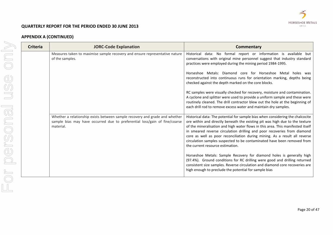
Measures taken to maximise sample recovery and ensure representative nature of the samples.
Historical data: No formal report or information is available but conversations with original mine personnel suggest that industry standard practices were employed during the mining period 1984-1995. Horseshoe Metals: Diamond core for Horseshoe Metal holes was reconstructed into continuous runs for orientation marking, depths being checked against the depth marked on the core blocks. RC samples were visually checked for recovery, moisture and contamination. A cyclone and splitter were used to provide a uniform sample and these were routinely cleaned. The drill contractor blew out the hole at the beginning of each drill rod to remove excess water and maintain dry samples.
Whether a relationship exists between sample recovery and grade and whether sample bias may have occurred due to preferential loss/gain of fine/coarse material.
Historical data: The potential for sample bias when considering the chalcocite ore within and directly beneath the existing pit was high due to the texture of the mineralisation and high water flows in this area. This manifested itself in smeared reverse circulation drilling and poor recoveries from diamond core as well as poor reconciliation during mining. As a result all reverse circulation samples suspected to be contaminated have been removed from the current resource estimation. Horseshoe Metals: Sample Recovery for diamond holes is generally high (97.4%). Ground conditions for RC drilling were good and drilling returned consistent size samples. Reverse circulation and diamond core recoveries are high enough to preclude the potential for sample bias
For
per
sona
l use
onl
y

QUARTERLY REPORT FOR THE PERIOD ENDED 30 JUNE 2013
APPENDIX A (CONTINUED)
Page 21 of 47
Criteria JORC-Code Explanation Commentary
Logging Whether core and chip samples have been geologically and geotechnically logged to a level of detail to support appropriate Mineral Resource estimation, mining studies and metallurgical studies.
Historical data: All reverse circulation and diamond drilling was logged to a level of detail considered sufficient at the time of mining. However, the nature of deposit that has been subject to strong weathering and alteration makes identification of stratigraphical units very difficult. The lack of an early stratigraphical interpretation model and limited understanding of the deposit style has also has caused inconsistency in the logging by various geologists. As a consequence, only the overlying sediments and underlying shale and dolerite have been logged according to their primary rock type. Barrack Mines Ltd and Sabminco NL used similar mine-specific geological codes to describe the geological units. A metamorphic and alteration methodology was used to describe the volcanic stratigraphy but interpretation of the various descriptions is very difficult. Horseshoe Metals: Logging of Horseshoe Metals reverse circulation drilling identifies all aspects of lithology, colour, weathering, texture, alteration and mineralisation. All primary recorded on site data was directly imported into a drill hole database and checked against the original data. During logging part of the RC sample was sieved, logged and placed in RC chip trays. The logging also includes references to wet samples in the comments. All reverse circulation samples have been photographed in wet form and the chip trays have been retained for physical inspection onsite or in the Perth office. Original logging of historical diamond core described lithology, colour and mineralisation content as well as some geotechnical data including core recovery, RQD data and alpha angle measurements. Approximately 10% of the original diamond holes in areas outside the existing pit have been re-logged and photographed so far. Diamond core for Horseshoe Metals holes was logged for recovery and RQD. Information on structure, lithology and alteration zones was recorded. Diamond core trays are stored on site for future reference. All drill data is digitally captured and stored in a central database.
For
per
sona
l use
onl
y

QUARTERLY REPORT FOR THE PERIOD ENDED 30 JUNE 2013
APPENDIX A (CONTINUED)
Page 22 of 47
Criteria JORC-Code Explanation Commentary
Whether logging is qualitative or quantitative in nature. Core (or costean, channel, etc.) photography.
Historical data: Original logging of reverse circulation and diamond core describes lithology, colour and mineralisation content only in handwritten form on hard copies. Approximately 10% of the original diamond holes in areas outside the existing pit have been re-logged and photographed so far. Horseshoe Metals: Logging of all samples includes lithology, colour, weathering, mineralogy and mineralisation for holes. All reverse circulation samples have been photographed in chip trays in wet form and all diamond core trays have been photographed in dry and wet form.
The total length and percentage of the relevant intersections logged. The entire length of all Horseshoe Metals RC and diamond holes for 100% of the drilling in the database was logged in full.
Sub-sampling techniques and sample preparation
If core, whether cut or sawn and whether quarter, half or all core taken. All diamond core sampled intervals were half core cut for HQ, NQ and BQ diameter.
If non-core, whether riffled, tube sampled, rotary split, etc. and whether sampled wet or dry.
In this instance dry samples were collected using a cyclone and split with a Jones riffle splitter. Wet samples were collected using a conventional revolving wet splitter.
For all sample types, the nature, quality and appropriateness of the sample preparation technique.
Historical data: No formal report or information is available but conversations with original mine personnel suggest that industry standard practices were employed during the mining period 1984-1995. Horseshoe Metals: The numbered calico samples bags collected by Horseshoe Metals at the exploration site were bagged into polyweave and bulkie bags and transported to the freight company depot in Meekatharra and then transported by road to the laboratory in Perth. Each laboratory has used appropriate sample preparation facilities and the required analytical equipment. At the laboratory the diamond core samples were sorted, reconciled, placed in trays on trolleys and dried in a gas oven at 110°C for a minimum of 8 hours or until dry. Samples ranging from 300g - ≤3kg were crushed to nominal
For
per
sona
l use
onl
y

QUARTERLY REPORT FOR THE PERIOD ENDED 30 JUNE 2013
APPENDIX A (CONTINUED)
Page 23 of 47
Criteria JORC-Code Explanation Commentary
~10mm using a jaw crusher and then pulverised using LM2, LM5 or Mixer Mill pulverisers. Samples >3kg were Boyd crushed to a nominal ~3mm and split in half using Boyd rotary split divider, one half was then pulverised and the other half retained, bagged and stored. After pulverising a 150g craft geochemical (pulp) packet was taken directly from the pulveriser bowl and submitted for analysis. Sample preparation for RC samples were similar but did not require the crushing circuit and so went straight to the pulverisers. Samples weighing >3kg were riffle split first and then pulverised. The sample preparation technique is considered to be appropriate.
Quality control procedures adopted for all sub-sampling stages to maximise representivity of samples.
Historical data: No formal report or information is available but conversations with original mine personnel suggest that industry standard practices were employed during the mining period 1984-1995. Horseshoe Metals: Field QAQC procedures included the insertion of field duplicates, blanks and commercial standards. Standards were inserted at intervals of 30. If a duplicate or blank falls on the 30th sample, the standard sample number was changed to suit. All laboratory QC data is reported within the structure of the final reports. A blank was included at the start of every job and then after every 90 samples. One duplicate and one CRM was included at random within each set of 24 analysed. One sample preparation split was performed in 25 samples. Wet sieving of at least one sample in every batch was undertaken to confirm % -75um.
For
per
sona
l use
onl
y
QUARTERLY REPORT FOR THE PERIOD ENDED 30 JUNE 2013
APPENDIX A (CONTINUED)
Page 24 of 47
Criteria JORC-Code Explanation Commentary
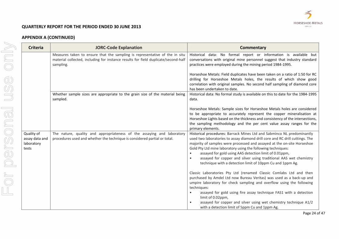
Measures taken to ensure that the sampling is representative of the in situ material collected, including for instance results for field duplicate/second-half sampling.
Historical data: No formal report or information is available but conversations with original mine personnel suggest that industry standard practices were employed during the mining period 1984-1995. Horseshoe Metals: Field duplicates have been taken on a ratio of 1:50 for RC drilling for Horseshoe Metals holes, the results of which show good correlation with original samples. No second half sampling of diamond core has been undertaken to date.
Whether sample sizes are appropriate to the grain size of the material being sampled.
Historical data: No formal study is available on this to date for the 1984-1995 data. Horseshoe Metals: Sample sizes for Horseshoe Metals holes are considered to be appropriate to accurately represent the copper mineralisation at Horseshoe Lights based on the thickness and consistency of the intersections, the sampling methodology and the per cent value assay ranges for the primary elements.
Quality of assay data and laboratory tests
The nature, quality and appropriateness of the assaying and laboratory procedures used and whether the technique is considered partial or total.
Historical procedures: Barrack Mines Ltd and Sabminco NL predominantly used two laboratories to assay diamond drill core and RC drill cuttings. The majority of samples were processed and assayed at the on-site Horseshoe Gold Pty Ltd mine laboratory using the following techniques: • assayed for gold using AAS detection limit of 0.01ppm, • assayed for copper and silver using traditional AAS wet chemistry
technique with a detection limit of 10ppm Cu and 1ppm Ag. Classic Laboratories Pty Ltd (renamed Classic Comlabs Ltd and then purchased by Amdel Ltd now Bureau Veritas) was used as a back-up and umpire laboratory for check sampling and overflow using the following techniques: • assayed for gold using fire assay technique FAS1 with a detection
limit of 0.02ppm, • assayed for copper and silver using wet chemistry technique A1/2
with a detection limit of 5ppm Cu and 1ppm Ag.
For
per
sona
l use
onl
y
QUARTERLY REPORT FOR THE PERIOD ENDED 30 JUNE 2013
APPENDIX A (CONTINUED)
Page 25 of 47
Criteria JORC-Code Explanation Commentary
Horseshoe Gold Mine Pty Ltd were aware of the differences in gold assaying method between by the two laboratories and considered the method used by Classic Laboratories Pty Ltd to be more accurate. No reconciliation study of the differences between the two laboratories was completed. Horseshoe Metals Procedures: The copper assay is derived using a mixed acid digest of nitric, hydrofluoric, perchloric and hydrochloric acids on 0.2g of sample and analysed using ICP Optical Emission Spectrophotometry. This method is considered appropriate and effective for this style of mineralisation The gold assay was derived using an aqua regia technique where 10g of prepared sample was digested using nitric and hydrochloric acid. The sample was then solvent extracted using Methyl isobutyl ketone and read on a Graphite Furnace Atomic Absorption Spectrometer. This method is considered adequate and effective for this style of mineralisation.
For geophysical tools, spectrometers, handheld XRF instruments, etc., the parameters used in determining the analysis including instrument make and model, reading times, calibrations factors applied and their derivation, etc.
Historical data: No geophysical, spectral or XRF data is available for the historical database for Horseshoe Lights. Horseshoe Metals: No geophysical tools were used by Horseshoe Metals to determine any element concentration used in the resource estimate.
Nature of quality control procedures adopted (e.g. standards, blanks, duplicates, external laboratory checks) and whether acceptable levels of accuracy (i.e. lack of bias) and precision have been established.
Historical data: No formal report or information is available but conversations with original mine personnel suggest that industry standard practices were employed during the mining period 1984-1995. Horseshoe Metals: Standard laboratory procedures involve the use of certified standards, duplicate samples and insertion of blanks. Assay results have been generally satisfactory, demonstrating acceptable levels of accuracy and precision.
For
per
sona
l use
onl
y
QUARTERLY REPORT FOR THE PERIOD ENDED 30 JUNE 2013
APPENDIX A (CONTINUED)
Page 26 of 47
Criteria JORC-Code Explanation Commentary
Verification of sampling and assaying
The verification of significant intersections by either independent or alternative company personnel.
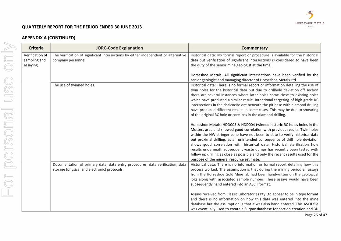
Historical data: No formal report or procedure is available for the historical data but verification of significant intersections is considered to have been the duty of the senior mine geologist at the time. Horseshoe Metals: All significant intersections have been verified by the senior geologist and managing director of Horseshoe Metals Ltd.
The use of twinned holes. Historical data: There is no formal report or information detailing the use of twin holes for the historical data but due to drillhole deviation off section there are several instances where later holes come close to existing holes which have produced a similar result. Intentional targeting of high grade RC intersections in the chalcocite ore beneath the pit base with diamond drilling have produced different results in some cases. This may be due to smearing of the original RC hole or core loss in the diamond drilling. Horseshoe Metals: HDD003 & HDD004 twinned historic RC holes holes in the Motters area and showed good correlation with previous results. Twin holes within the NW stringer zone have not been to date to verify historical data but proximal drilling, as an unintended consequence of drill hole deviation shows good correlation with historical data. Historical sterilisation hole results underneath subsequent waste dumps has recently been tested with follow up drilling as close as possible and only the recent results used for the purpose of the mineral resource estimate.
Documentation of primary data, data entry procedures, data verification, data storage (physical and electronic) protocols.
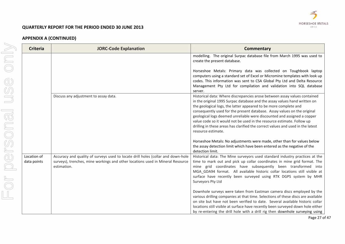
Historical data: There is no information or formal report detailing how this process worked. The assumption is that during the mining period all assays from the Horseshoe Gold Mine lab had been handwritten on the geological logs along with associated sample number. These assays would have been subsequently hand entered into an ASCII format. Assays received from Classic Laboratories Pty Ltd appear to be in type format and there is no information on how this data was entered into the mine database but the assumption is that it was also hand entered. This ASCII file was eventually used to create a Surpac database for section creation and 3D
For
per
sona
l use
onl
y
QUARTERLY REPORT FOR THE PERIOD ENDED 30 JUNE 2013
APPENDIX A (CONTINUED)
Page 27 of 47
Criteria JORC-Code Explanation Commentary
modelling. The original Surpac database file from March 1995 was used to create the present database. Horseshoe Metals: Primary data was collected on Toughbook laptop computers using a standard set of Excel or Micromine templates with look up codes. This information was sent to CSA Global Pty Ltd and Delta Resource Management Pty Ltd for compilation and validation into SQL database server.
Discuss any adjustment to assay data. Historical data: Where discrepancies arose between assay values contained in the original 1995 Surpac database and the assay values hand written on the geological logs, the latter appeared to be more complete and consequently used for the present database. Assay values on the original geological logs deemed unreliable were discounted and assigned a copper value code so it would not be used in the resource estimate. Follow up drilling in these areas has clarified the correct values and used in the latest resource estimate. Horseshoe Metals: No adjustments were made, other than for values below the assay detection limit which have been entered as the negative of the detection limit.
Location of data points
Accuracy and quality of surveys used to locate drill holes (collar and down-hole surveys), trenches, mine workings and other locations used in Mineral Resource estimation.
Historical data: The Mine surveyors used standard industry practices at the time to mark out and pick up collar coordinates in mine grid format. The mine grid coordinates have subsequently been transformed into MGA_GDA94 format. All available historic collar locations still visible at surface have recently been surveyed using RTK DGPS system by MHR Surveyors Pty Ltd Downhole surveys were taken from Eastman camera discs employed by the various drilling companies at that time. Selections of these discs are available on site but have not been verified to date. Several available historic collar locations still visible at surface have recently been surveyed down hole either by re-entering the drill hole with a drill rig then downhole surveying using
For
per
sona
l use
onl
y
QUARTERLY REPORT FOR THE PERIOD ENDED 30 JUNE 2013
APPENDIX A (CONTINUED)
Page 28 of 47
Criteria JORC-Code Explanation Commentary
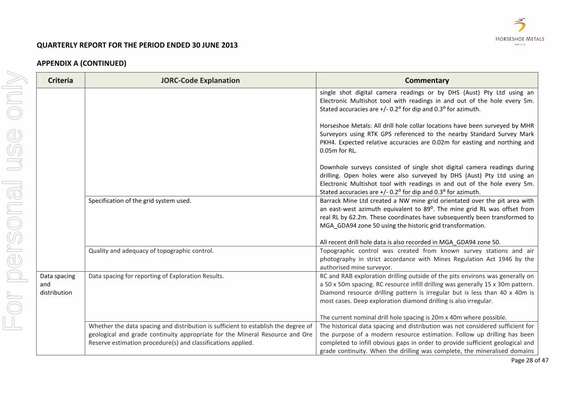
single shot digital camera readings or by DHS (Aust) Pty Ltd using an Electronic Multishot tool with readings in and out of the hole every 5m. Stated accuracies are +/- 0.2⁰ for dip and 0.3⁰ for azimuth. Horseshoe Metals: All drill hole collar locations have been surveyed by MHR Surveyors using RTK GPS referenced to the nearby Standard Survey Mark PKH4. Expected relative accuracies are 0.02m for easting and northing and 0.05m for RL. Downhole surveys consisted of single shot digital camera readings during drilling. Open holes were also surveyed by DHS (Aust) Pty Ltd using an Electronic Multishot tool with readings in and out of the hole every 5m. Stated accuracies are +/- 0.2⁰ for dip and 0.3⁰ for azimuth.
Specification of the grid system used. Barrack Mine Ltd created a NW mine grid orientated over the pit area with an east-west azimuth equivalent to 89⁰. The mine grid RL was offset from real RL by 62.2m. These coordinates have subsequently been transformed to MGA_GDA94 zone 50 using the historic grid transformation. All recent drill hole data is also recorded in MGA_GDA94 zone 50.
Quality and adequacy of topographic control. Topographic control was created from known survey stations and air photography in strict accordance with Mines Regulation Act 1946 by the authorised mine surveyor.
Data spacing and distribution
Data spacing for reporting of Exploration Results. RC and RAB exploration drilling outside of the pits environs was generally on a 50 x 50m spacing. RC resource infill drilling was generally 15 x 30m pattern. Diamond resource drilling pattern is irregular but is less than 40 x 40m is most cases. Deep exploration diamond drilling is also irregular. The current nominal drill hole spacing is 20m x 40m where possible.
Whether the data spacing and distribution is sufficient to establish the degree of geological and grade continuity appropriate for the Mineral Resource and Ore Reserve estimation procedure(s) and classifications applied.
The historical data spacing and distribution was not considered sufficient for the purpose of a modern resource estimation. Follow up drilling has been completed to infill obvious gaps in order to provide sufficient geological and grade continuity. When the drilling was complete, the mineralised domains
For
per
sona
l use
onl
y

QUARTERLY REPORT FOR THE PERIOD ENDED 30 JUNE 2013
APPENDIX A (CONTINUED)
Page 29 of 47
Criteria JORC-Code Explanation Commentary
display sufficient geological and grade continuity for the mineral resource procedures and classifications applied to support the definition of Measured Indicated and Inferred Mineral Resources under the 2012 JORC code.
Whether sample compositing has been applied. Historical data: Within the resource area 2m composite RC & diamond core samples were routinely taken from 1m splits. Horseshoe Metals: Sample compositing over a length of 3 or 4m has been applied to samples returning a reading of <1000ppm using a fpXRF.
Orientation of data in relation to geological structure
Whether the orientation of sampling achieves unbiased sampling of possible structures and the extent to which this is known, considering the deposit type.
The majority of drilling was orientated mine grid east which is slightly oblique to the mineralised trends but intersection angles are closer to perpendicular in most cases.
If the relationship between the drilling orientation and the orientation of key mineralised structures is considered to have introduced a sampling bias, this should be assessed and reported if material.
A consistent sampling bias is not considered to be an issue for the purpose of this resource estimation. Diamond drilling confirmed that drilling orientation did not introduce any bias regarding the orientation of key mineralised structures.
Sample security
The measures taken to ensure sample security. Historical data: All drill samples were assayed onsite at the Horseshoe Gold Mine Pty Ltd laboratory or at Classic Laboratories Pty Ltd in Meekatharra or Perth. Pulps have been in storage on site within the core yard. Chain of custody is managed by Horseshoe Metals. All sample numbers are generated in the site office. Once samples intervals are selected, the numbers are assigned to each sample. The sample numbers are not left in the core box (where the sample was taken from), but the core is marked for the taken sample intervals so it would be possible to reconcile the laboratory results against the particular intervals of core. The sample number, drillhole name and sampled interval are recorded in the sampling sheets. All samples are stored onsite and delivered to the freight company depot at Meekatharra by Horseshoe personnel for delivery to Perth and the assay laboratory. Samples are tracked and receipt is acknowledged by laboratory staff.
For
per
sona
l use
onl
y

QUARTERLY REPORT FOR THE PERIOD ENDED 30 JUNE 2013
APPENDIX A (CONTINUED)
Page 30 of 47
Criteria JORC-Code Explanation Commentary
Audits or reviews
The results of any audits or reviews of sampling techniques and data. Sampling techniques are consistent with industry standards. Consistency of data was validated by CSA Global Pty Ltd while loading into the database (Depth from < Depth to; interval is within hole depth, check for overlapping samples or intervals, etc.). Any data which fails the database constraints and cannot be loaded is returned to Horseshoe Metals for validation and correction. Global consistency was also checked later on by plotting sections using the database and reconciling assays.
TABLE 1: SECTION 3 - ESTIMATION AND REPORTING OF MINERAL RESOURCES
(Criteria listed in section 1 also apply to this section.)
Criteria JORC-Code Explanation Commentary
Database integrity
Measures taken to ensure that data has not been corrupted by, for example, transcription or keying errors, between its initial collection and its use for Mineral Resource estimation purposes.
Bulk of estimate based on recent drilling. Unreliable historical data omitted from resource estimate. Horseshoe Metals Ltd primary data was collected on laptop computers in Excel or Micromine tables using drop down codes. Field data and original assay certificates compiled and validated by database administrators. Drilling data provided in Micromine tables for collar, survey, lithology and assay data.
Data validation procedures used. Validation of the data import include checks for overlapping intervals, missing survey data, missing and incorrectly recorded assay data, missing lithological data and missing collars.
Site visits Comment on any site visits undertaken by the Competent Person and the outcome of those visits.
The site was visited by Geoff Willetts, Senior Geologist for Horseshoe Metals, on a number of occasions. CSA Global have previously supervised drilling programs at Horseshoe Lights between 2012-11 and provided previous resource estimate.
If no site visits have been undertaken indicate why this is the case. Not applicable.
Geological interpretation
Confidence in (or conversely, the uncertainty of) the geological interpretation of the mineral deposit.
Interpretation based on Horseshoe Metals RC and diamond drilling validated geological logging and assays. There is a reasonable level of confidence in the geological interpretation of mineralised lodes that is traceable over numerous drill holes and drill sections. Additional work is required to better define exact geometry and the extents of the interpreted mineralised lodes.
For
per
sona
l use
onl
y

QUARTERLY REPORT FOR THE PERIOD ENDED 30 JUNE 2013
APPENDIX A (CONTINUED)
Page 31 of 47
Criteria JORC-Code Explanation Commentary
Nature of the data used and of any assumptions made. Drill hole intercept logging and assay results have formed basis for the geological interpretation.
The effect, if any, of alternative interpretations on Mineral Resource estimation. Attempts to further delineate individual shoots and remove internal waste using grade intervals results in lower tonnage but higher grades.
The use of geology in guiding and controlling Mineral Resource estimation. The interpreted late dolerite sill and Bangemall sediment basement were used to limit the interpolation of grade at depth. No geology data was used within the interpreted domains
The factors affecting continuity both of grade and geology. The volcanic package at Horseshoe Lights has been subjected to complex folding and faulting events along with associated alteration within a wide shear zone. As such the interpretation of mineralised shoots is subjective.
Dimensions The extent and variability of the Mineral Resource expressed as length (along strike or otherwise), plan width, and depth below surface to the upper and lower limits of the Mineral Resource.
Horseshoe Lights deposit strike length is ~700m, width variable up to 30m, and down-dip extent of 250m+ north of pit. Mineralisation is from actual surface and extends to between 210-480m vertical depth.
Estimation and modelling techniques
The nature and appropriateness of the estimation technique(s) applied and key assumptions, including treatment of extreme grade values, domaining, interpolation parameters and maximum distance of extrapolation from data points. If a computer assisted estimation method was chosen include a description of computer software and parameters used.
Grade estimation was by Multiple Indicator Kriging (MIK) using Micromine 2011 software. The interpretation was extended perpendicular to the corresponding first and last interpreted cross section to the distance equal to a half distance between the adjacent exploration lines which is approximately 40m; If a mineralised envelope did not extend to the adjacent drillhole section, it was projected half way to the next section and terminated. The general direction and dip of the envelopes was maintained. Grade interpolation search ellipses based on Variography. First pass search radii are ⅓ semivariogram ranges, second pass – full semivariogram ranges.
For
per
sona
l use
onl
y

QUARTERLY REPORT FOR THE PERIOD ENDED 30 JUNE 2013
APPENDIX A (CONTINUED)
Page 32 of 47
Criteria JORC-Code Explanation Commentary
The availability of check estimates, previous estimates and/or mine production records and whether the Mineral Resource estimate takes appropriate account of such data.
The MIK estimate was completed concurrently with OK and two check Inverse Distance Weighting (IDW) estimates. The MIK estimate used the parameters obtained from the modelled variograms. The results of the check estimates correlate well. Resource estimate represents a 40% increase on CSA Global previous estimate.
The assumptions made regarding recovery of by-products. No assumptions have been made.
Estimation of deleterious elements or other non-grade variables of economic significance (e.g. sulphur for acid mine drainage characterisation).
No deleterious material assessment was made during the estimation.
In the case of block model interpolation, the block size in relation to the average sample spacing and the search employed.
The block model was constructed using a 5mE x 10mN x 5mRL parent block size, with subcelling to 1mE x 2mN x 1mRL for domain volume resolution. The parent cell size was chosen on the basis of the general morphology of mineralised bodies and in order to avoid the generation of too large block models. The subcelling size was chosen to maintain the resolution of the mineralised bodies. The subcells were optimised in the models where possible to form larger cells. The search radii were determined by means of the evaluation of the semivariogram parameters, which determined the kriging weights to be applied to samples at specified distances. The first search radii for all lodes were selected to be equal to two thirds of the semivariogram long ranges in all directions. Model cells that did not receive a grade estimate from the first interpolation run were used in the next interpolation with greater search radii equal to full long semivariogram ranges in all directions. The model cells that did not receive grades from the first two runs were then estimated using radii incremented by the full long semivariogram ranges. When model cells were estimated using radii not exceeding the full semivariogram ranges, a restriction of at least three samples from at least two drillholes was applied to increase the reliability of the estimates.
Any assumptions behind modelling of selective mining units. No selective mining units were assumed in this estimate.
Any assumptions about correlation between variables. No strong correlations were found between the grade variables.
For
per
sona
l use
onl
y

QUARTERLY REPORT FOR THE PERIOD ENDED 30 JUNE 2013
APPENDIX A (CONTINUED)
Page 33 of 47
Criteria JORC-Code Explanation Commentary
Description of how the geological interpretation was used to control the resource estimates.
The 0.18% Cu grade envelopes were defined. Hard boundaries between the grade envelopes used to select sample populations for grade estimation.
Discussion of basis for using or not using grade cutting or capping. No grade cutting was applied, because MIK was used for the grade interpolation. The last bin defined for MIK is likely to contain occasional very high values, the estimate for this bin only is calculated using the median, which gives a more conservative value for positively skewed data than the mean.
The process of validation, the checking process used, the comparison of model data to drill hole data, and use of reconciliation data if available.
Validation of the block model consisted of comparison of the block model volume to the wireframe volume. Grade estimates were validated by statistical comparison with the drill data, visual comparison of grade trends in the model with the drill data trends. No reconciliation data is available at this early stage of the project.
Moisture Whether the tonnages are estimated on a dry basis or with natural moisture, and the method of determination of the moisture content.
Tonnages are estimated on a dry basis
Cut-off parameters
The basis of the adopted cut-off grade(s) or quality parameters applied. Mineralised domain interpreted on grade ≥0.18% based on statistical mean of drill data. Statistical analysis showed natural breaks in the Cu grade population distribution at approximately 0.18% which formed the basis for the decision regarding determination of mineralisation envelope cut-off grade. Mineral Resources estimated at a range of cut-offs.
Mining factors or assumptions
Assumptions made regarding possible mining methods, minimum mining dimensions and internal (or, if applicable, external) mining dilution. It is always necessary as part of the process of determining reasonable prospects for eventual economic extraction to consider potential mining methods, but the assumptions made regarding mining methods and parameters when estimating Mineral Resources may not always be rigorous. Where this is the case, this should be reported with an explanation of the basis of the mining assumptions made.
Possible mining methods are existing open pit cut back and selective underground operation from bottom of pit
For
per
sona
l use
onl
y
QUARTERLY REPORT FOR THE PERIOD ENDED 30 JUNE 2013
APPENDIX A (CONTINUED)
Page 34 of 47
Criteria JORC-Code Explanation Commentary
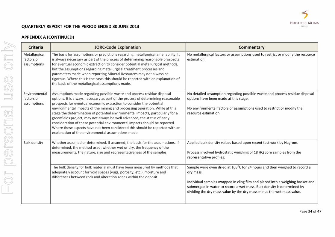
Metallurgical factors or assumptions
The basis for assumptions or predictions regarding metallurgical amenability. It is always necessary as part of the process of determining reasonable prospects for eventual economic extraction to consider potential metallurgical methods, but the assumptions regarding metallurgical treatment processes and parameters made when reporting Mineral Resources may not always be rigorous. Where this is the case, this should be reported with an explanation of the basis of the metallurgical assumptions made.
No metallurgical factors or assumptions used to restrict or modify the resource estimation
Environmental factors or assumptions
Assumptions made regarding possible waste and process residue disposal options. It is always necessary as part of the process of determining reasonable prospects for eventual economic extraction to consider the potential environmental impacts of the mining and processing operation. While at this stage the determination of potential environmental impacts, particularly for a greenfields project, may not always be well advanced, the status of early consideration of these potential environmental impacts should be reported. Where these aspects have not been considered this should be reported with an explanation of the environmental assumptions made.
No detailed assumption regarding possible waste and process residue disposal options have been made at this stage. No environmental factors or assumptions used to restrict or modify the resource estimation.
Bulk density Whether assumed or determined. If assumed, the basis for the assumptions. If determined, the method used, whether wet or dry, the frequency of the measurements, the nature, size and representativeness of the samples.
Applied bulk density values based upon recent test work by Nagrom. Process involved hydrostatic weighing of 18 HQ core samples from the representative profiles.
The bulk density for bulk material must have been measured by methods that adequately account for void spaces (vugs, porosity, etc.), moisture and differences between rock and alteration zones within the deposit.
Sample were oven dried at 105⁰C for 24 hours and then weighed to record a dry mass. Individual samples wrapped in cling film and placed into a weighing basket and submerged in water to record a wet mass. Bulk density is determined by dividing the dry mass value by the dry mass minus the wet mass value.
For
per
sona
l use
onl
y
QUARTERLY REPORT FOR THE PERIOD ENDED 30 JUNE 2013
APPENDIX A (CONTINUED)
Page 35 of 47
Criteria JORC-Code Explanation Commentary
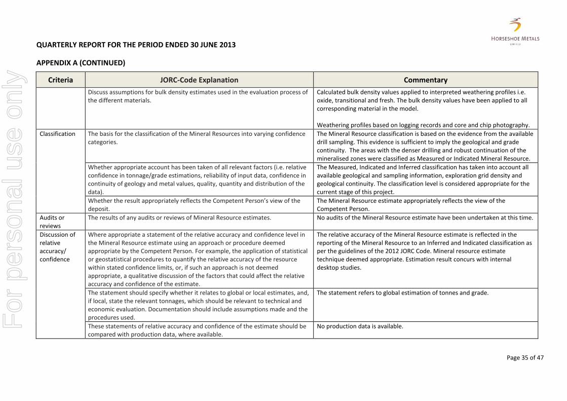
Discuss assumptions for bulk density estimates used in the evaluation process of the different materials.
Calculated bulk density values applied to interpreted weathering profiles i.e. oxide, transitional and fresh. The bulk density values have been applied to all corresponding material in the model. Weathering profiles based on logging records and core and chip photography.
Classification The basis for the classification of the Mineral Resources into varying confidence categories.
The Mineral Resource classification is based on the evidence from the available drill sampling. This evidence is sufficient to imply the geological and grade continuity. The areas with the denser drilling and robust continuation of the mineralised zones were classified as Measured or Indicated Mineral Resource.
Whether appropriate account has been taken of all relevant factors (i.e. relative confidence in tonnage/grade estimations, reliability of input data, confidence in continuity of geology and metal values, quality, quantity and distribution of the data).
The Measured, Indicated and Inferred classification has taken into account all available geological and sampling information, exploration grid density and geological continuity. The classification level is considered appropriate for the current stage of this project.
Whether the result appropriately reflects the Competent Person’s view of the deposit.
The Mineral Resource estimate appropriately reflects the view of the Competent Person.
Audits or reviews
The results of any audits or reviews of Mineral Resource estimates.
No audits of the Mineral Resource estimate have been undertaken at this time.
Discussion of relative accuracy/ confidence
Where appropriate a statement of the relative accuracy and confidence level in the Mineral Resource estimate using an approach or procedure deemed appropriate by the Competent Person. For example, the application of statistical or geostatistical procedures to quantify the relative accuracy of the resource within stated confidence limits, or, if such an approach is not deemed appropriate, a qualitative discussion of the factors that could affect the relative accuracy and confidence of the estimate.
The relative accuracy of the Mineral Resource estimate is reflected in the reporting of the Mineral Resource to an Inferred and Indicated classification as per the guidelines of the 2012 JORC Code. Mineral resource estimate technique deemed appropriate. Estimation result concurs with internal desktop studies.
The statement should specify whether it relates to global or local estimates, and, if local, state the relevant tonnages, which should be relevant to technical and economic evaluation. Documentation should include assumptions made and the procedures used.
The statement refers to global estimation of tonnes and grade.
These statements of relative accuracy and confidence of the estimate should be compared with production data, where available.
No production data is available.
For
per
sona
l use
onl
y

QUARTERLY REPORT FOR THE PERIOD ENDED 30 JUNE 2013
APPENDIX B – KUMARINA PROJECT
Page 36 of 47
RINALDI PROSPECT
MINERAL RESOURCE ESTIMATION
Cut-off grade Cu (%)
Tonnes Cu (%) Cu (t) Resource Category
0.25
519,000 1.24 6,500 Measured
444,000 0.91 4,050 Indicated
247,000 0.6 1,450 Inferred
1,210,000 1.0 12,000 TOTAL
0.5
415,000 1.46 6,100 Measured
307,000 1.16 3,500 Indicated
114,000 0.9 1,000 Inferred
835,000 1.3 10,600 TOTAL
1.0
248,000 1.94 4,900 Measured
157,000 1.55 2,400 Indicated
27,000 1.6 400 Inferred
432,000 1.8 7,700 TOTAL
1.5
134,000 2.54 3,400 Measured
68,000 2.00 1,400 Indicated
9,000 2.4 200 Inferred
211,000 2.4 5,000 TOTAL
2.0
83,000 3.03 2,500 Measured
23,000 2.57 600 Indicated
7,000 2.7 200 Inferred
112,000 2.9 3,300 TOTAL
3.0
32,000 3.94 1,280 Measured
5,000 3.50 170 Indicated
1,000 3.9 50 Inferred
38,000 3.9 1,500 TOTAL Note: Above figures may not sum due to rounding
Significant figures do not imply any added level of precision.
For
per
sona
l use
onl
y
QUARTERLY REPORT FOR THE PERIOD ENDED 30 JUNE 2013
APPENDIX B (CONTINUED)
Page 37 of 47
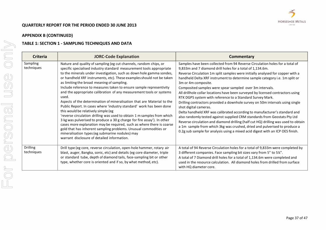
TABLE 1: SECTION 1 - SAMPLING TECHNIQUES AND DATA
Criteria JORC-Code Explanation Commentary
Sampling techniques
Nature and quality of sampling (eg cut channels, random chips, or specific specialised industry standard measurement tools appropriate to the minerals under investigation, such as down hole gamma sondes, or handheld XRF instruments, etc). These examples should not be taken as limiting the broad meaning of sampling. Include reference to measures taken to ensure sample representivity and the appropriate calibration of any measurement tools or systems used. Aspects of the determination of mineralisation that are Material to the Public Report. In cases where ‘industry standard’ work has been done this would be relatively simple (eg ‘reverse circulation drilling was used to obtain 1 m samples from which 3 kg was pulverised to produce a 30 g charge for fire assay’). In other cases more explanation may be required, such as where there is coarse gold that has inherent sampling problems. Unusual commodities or mineralisation types (eg submarine nodules) may warrant disclosure of detailed information.
Samples have been collected from 94 Reverse Circulation holes for a total of 9,833m and 7 diamond drill holes for a total of 1,134.6m.
Reverse Circulation 1m split samples were initially analysed for copper with a handheld Delta XRF instrument to determine sample category i.e. 1m split or 3m or 4m composite.
Composited samples were spear sampled over 3m intervals.
All drillhole collar locations have been surveyed by licensed contractors using RTK DGPS system with reference to a Standard Survey Mark.
Drilling contractors provided a downhole survey on 50m intervals using single shot digital cameras.
Delta handheld XRF was calibrated according to manufacturer’s standard and also randomly tested against supplied CRM standards from Geostats Pty Ltd
Reverse circulation and diamond drilling (half cut HQ) drilling was used to obtain a 1m sample from which 3kg was crushed, dried and pulverised to produce a 0.2g sub sample for analysis using a mixed acid digest with an ICP OES finish.
Drilling techniques
Drill type (eg core, reverse circulation, open-hole hammer, rotary air blast, auger, Bangka, sonic, etc) and details (eg core diameter, triple or standard tube, depth of diamond tails, face-sampling bit or other type, whether core is oriented and if so, by what method, etc).
A total of 94 Reverse Circulation holes for a total of 9,833m were completed by 3 different companies. Face sampling bit sizes vary from 5" to 5¼".
A total of 7 Diamond drill holes for a total of 1,134.6m were completed and used in the resource calculation. All diamond holes from drilled from surface with HQ diameter core.
F
or p
erso
nal u
se o
nly

QUARTERLY REPORT FOR THE PERIOD ENDED 30 JUNE 2013
APPENDIX B (CONTINUED)
Page 38 of 47
Criteria JORC-Code Explanation Commentary
Drill sample recovery
Method of recording and assessing core and chip sample recoveries and results assessed.
Measures taken to maximise sample recovery and ensure representative nature of the samples.
Whether a relationship exists between sample recovery and grade and whether sample bias may have occurred due to preferential loss/gain of fine/coarse material.
No assessment of Reverse Circulation sample recovery has been made to date but visual estimates suggest sample recovery is good.
Diamond core recoveries have been recorded but not assessed to date.
All Reverse Circulation samples were riffle split from cyclones which were regularly cleaned during drilling.
Diamond core is reconstructed into continuous runs in an angle iron for orientation mark up.
Actual depths are compared with drillers core block record and rod counts.
Reverse circulation and diamond core recoveries are high enough to preclude the potential for sample bias.
Logging Whether core and chip samples have been geologically and geotechnically logged to a level of detail to support appropriate Mineral Resource estimation, mining studies and metallurgical studies.
Whether logging is qualitative or quantitative in nature. Core (or costean, channel, etc)
Photography.
The total length and percentage of the relevant intersections logged.
Logging of reverse circulation chip samples identifies primary lithologies where possible, alteration and possible structures.
Diamond core logging records lithology, RQD and structural measurements where possible.
No metallurgical study or data has been recorded.
Logging of all samples includes lithology, colour, weathering, mineralogy and mineralisation.
Reverse circulation samples have been photographed in chip trays in wet form. Diamond core trays have been photographed in dry and wet form. Total length of all drill holes have been 100% logged.
For
per
sona
l use
onl
y
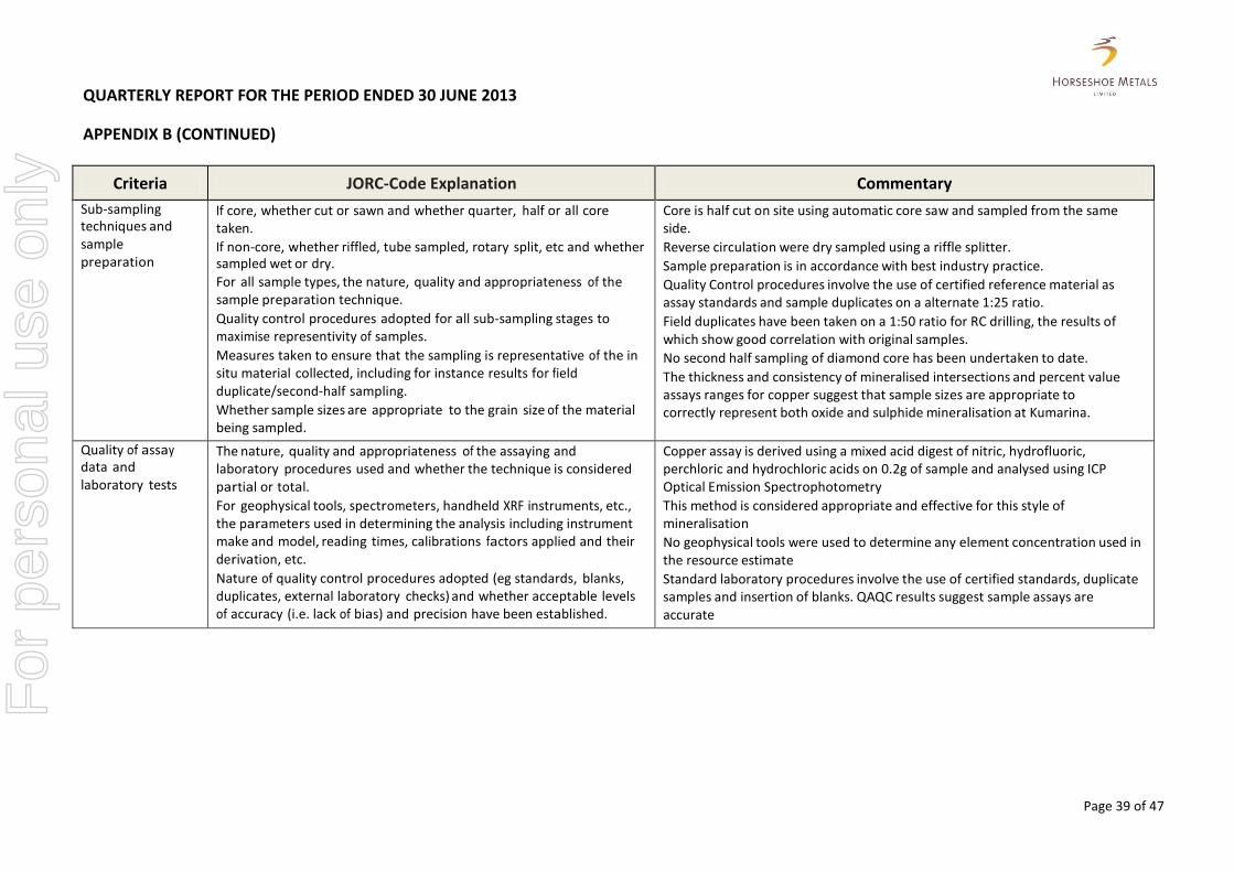
QUARTERLY REPORT FOR THE PERIOD ENDED 30 JUNE 2013
APPENDIX B (CONTINUED)
Page 39 of 47
Criteria JORC-Code Explanation Commentary
Sub-sampling techniques and sample preparation
If core, whether cut or sawn and whether quarter, half or all core taken.
If non-core, whether riffled, tube sampled, rotary split, etc and whether sampled wet or dry.
For all sample types, the nature, quality and appropriateness of the sample preparation technique.
Quality control procedures adopted for all sub-sampling stages to maximise representivity of samples.
Measures taken to ensure that the sampling is representative of the in situ material collected, including for instance results for field duplicate/second-half sampling.
Whether sample sizes are appropriate to the grain size of the material being sampled.
Core is half cut on site using automatic core saw and sampled from the same side.
Reverse circulation were dry sampled using a riffle splitter.
Sample preparation is in accordance with best industry practice.
Quality Control procedures involve the use of certified reference material as assay standards and sample duplicates on a alternate 1:25 ratio.
Field duplicates have been taken on a 1:50 ratio for RC drilling, the results of which show good correlation with original samples.
No second half sampling of diamond core has been undertaken to date.
The thickness and consistency of mineralised intersections and percent value assays ranges for copper suggest that sample sizes are appropriate to correctly represent both oxide and sulphide mineralisation at Kumarina.
Quality of assay data and laboratory tests
The nature, quality and appropriateness of the assaying and laboratory procedures used and whether the technique is considered partial or total.
For geophysical tools, spectrometers, handheld XRF instruments, etc., the parameters used in determining the analysis including instrument make and model, reading times, calibrations factors applied and their derivation, etc.
Nature of quality control procedures adopted (eg standards, blanks, duplicates, external laboratory checks) and whether acceptable levels of accuracy (i.e. lack of bias) and precision have been established.
Copper assay is derived using a mixed acid digest of nitric, hydrofluoric, perchloric and hydrochloric acids on 0.2g of sample and analysed using ICP Optical Emission Spectrophotometry
This method is considered appropriate and effective for this style of mineralisation
No geophysical tools were used to determine any element concentration used in the resource estimate
Standard laboratory procedures involve the use of certified standards, duplicate samples and insertion of blanks. QAQC results suggest sample assays are accurate
For
per
sona
l use
onl
y
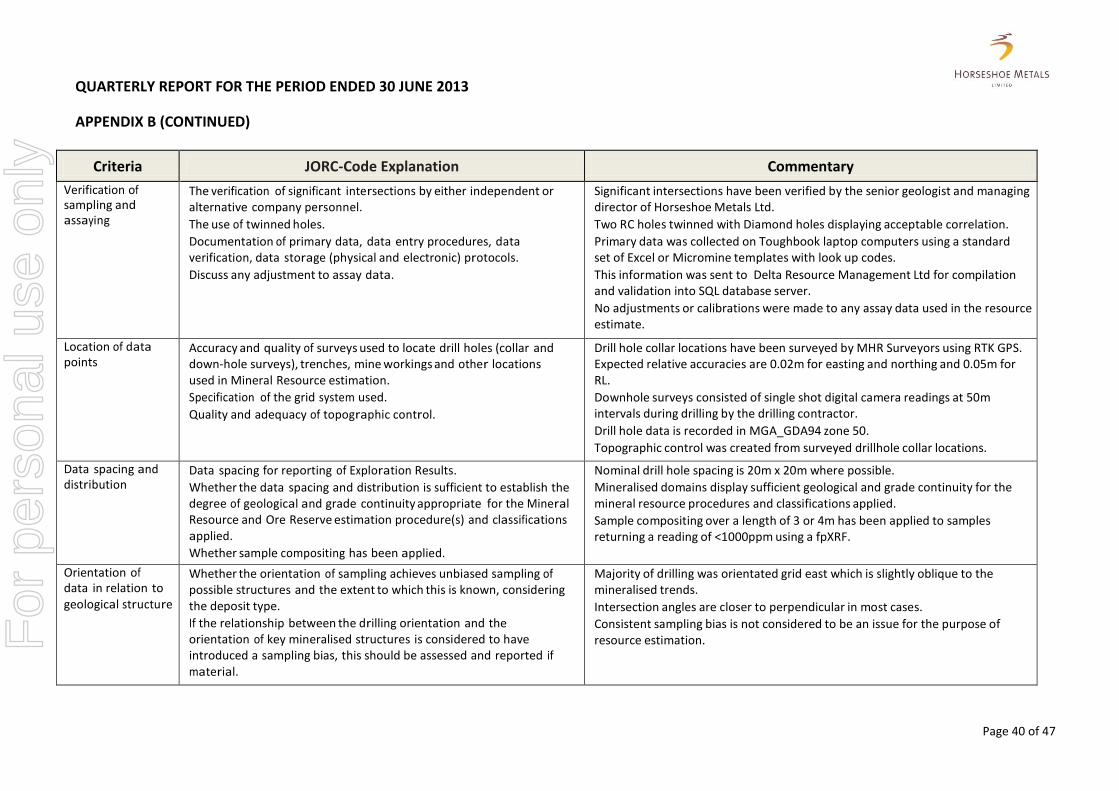
QUARTERLY REPORT FOR THE PERIOD ENDED 30 JUNE 2013
APPENDIX B (CONTINUED)
Page 40 of 47
Criteria JORC-Code Explanation Commentary
Verification of sampling and assaying
The verification of significant intersections by either independent or alternative company personnel.
The use of twinned holes.
Documentation of primary data, data entry procedures, data verification, data storage (physical and electronic) protocols.
Discuss any adjustment to assay data.
Significant intersections have been verified by the senior geologist and managing director of Horseshoe Metals Ltd.
Two RC holes twinned with Diamond holes displaying acceptable correlation.
Primary data was collected on Toughbook laptop computers using a standard set of Excel or Micromine templates with look up codes.
This information was sent to Delta Resource Management Ltd for compilation and validation into SQL database server.
No adjustments or calibrations were made to any assay data used in the resource estimate.
Location of data points
Accuracy and quality of surveys used to locate drill holes (collar and down-hole surveys), trenches, mine workings and other locations used in Mineral Resource estimation.
Specification of the grid system used.
Quality and adequacy of topographic control.
Drill hole collar locations have been surveyed by MHR Surveyors using RTK GPS. Expected relative accuracies are 0.02m for easting and northing and 0.05m for RL.
Downhole surveys consisted of single shot digital camera readings at 50m intervals during drilling by the drilling contractor.
Drill hole data is recorded in MGA_GDA94 zone 50.
Topographic control was created from surveyed drillhole collar locations.
Data spacing and distribution
Data spacing for reporting of Exploration Results.
Whether the data spacing and distribution is sufficient to establish the degree of geological and grade continuity appropriate for the Mineral Resource and Ore Reserve estimation procedure(s) and classifications applied.
Whether sample compositing has been applied.
Nominal drill hole spacing is 20m x 20m where possible.
Mineralised domains display sufficient geological and grade continuity for the mineral resource procedures and classifications applied.
Sample compositing over a length of 3 or 4m has been applied to samples returning a reading of <1000ppm using a fpXRF.
Orientation of data in relation to geological structure
Whether the orientation of sampling achieves unbiased sampling of possible structures and the extent to which this is known, considering the deposit type.
If the relationship between the drilling orientation and the orientation of key mineralised structures is considered to have introduced a sampling bias, this should be assessed and reported if material.
Majority of drilling was orientated grid east which is slightly oblique to the mineralised trends.
Intersection angles are closer to perpendicular in most cases.
Consistent sampling bias is not considered to be an issue for the purpose of resource estimation. F
or p
erso
nal u
se o
nly
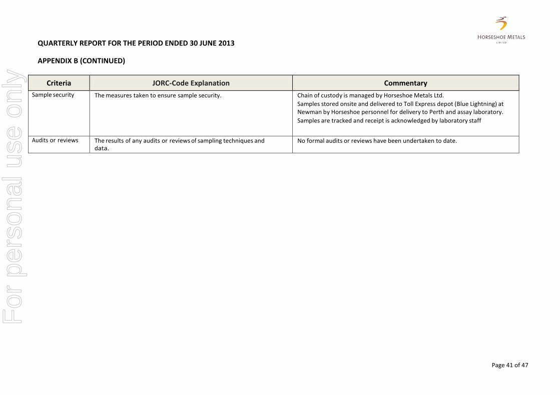
QUARTERLY REPORT FOR THE PERIOD ENDED 30 JUNE 2013
APPENDIX B (CONTINUED)
Page 41 of 47
Criteria JORC-Code Explanation Commentary
Sample security The measures taken to ensure sample security. Chain of custody is managed by Horseshoe Metals Ltd.
Samples stored onsite and delivered to Toll Express depot (Blue Lightning) at Newman by Horseshoe personnel for delivery to Perth and assay laboratory.
Samples are tracked and receipt is acknowledged by laboratory staff
Audits or reviews The results of any audits or reviews of sampling techniques and data.
No formal audits or reviews have been undertaken to date.
For
per
sona
l use
onl
y
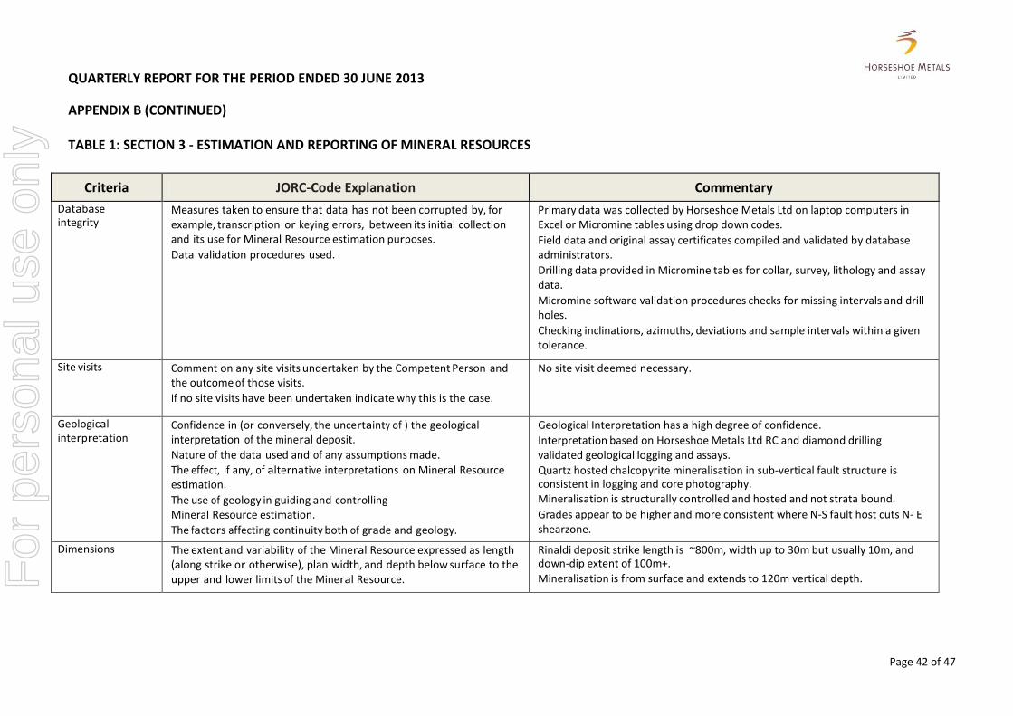
QUARTERLY REPORT FOR THE PERIOD ENDED 30 JUNE 2013
APPENDIX B (CONTINUED)
Page 42 of 47
TABLE 1: SECTION 3 - ESTIMATION AND REPORTING OF MINERAL RESOURCES
Criteria JORC-Code Explanation Commentary
Database integrity
Measures taken to ensure that data has not been corrupted by, for example, transcription or keying errors, between its initial collection and its use for Mineral Resource estimation purposes.
Data validation procedures used.
Primary data was collected by Horseshoe Metals Ltd on laptop computers in Excel or Micromine tables using drop down codes.
Field data and original assay certificates compiled and validated by database administrators.
Drilling data provided in Micromine tables for collar, survey, lithology and assay data.
Micromine software validation procedures checks for missing intervals and drill holes.
Checking inclinations, azimuths, deviations and sample intervals within a given tolerance.
Site visits Comment on any site visits undertaken by the Competent Person and the outcome of those visits.
If no site visits have been undertaken indicate why this is the case.
No site visit deemed necessary.
Geological interpretation
Confidence in (or conversely, the uncertainty of ) the geological interpretation of the mineral deposit.
Nature of the data used and of any assumptions made.
The effect, if any, of alternative interpretations on Mineral Resource estimation.
The use of geology in guiding and controlling Mineral Resource estimation.
The factors affecting continuity both of grade and geology.
Geological Interpretation has a high degree of confidence.
Interpretation based on Horseshoe Metals Ltd RC and diamond drilling validated geological logging and assays.
Quartz hosted chalcopyrite mineralisation in sub-vertical fault structure is consistent in logging and core photography. Mineralisation is structurally controlled and hosted and not strata bound.
Grades appear to be higher and more consistent where N-S fault host cuts N- E shearzone.
Dimensions The extent and variability of the Mineral Resource expressed as length (along strike or otherwise), plan width, and depth below surface to the upper and lower limits of the Mineral Resource.
Rinaldi deposit strike length is ~800m, width up to 30m but usually 10m, and down-dip extent of 100m+.
Mineralisation is from surface and extends to 120m vertical depth. For
per
sona
l use
onl
y
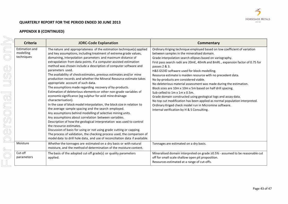
QUARTERLY REPORT FOR THE PERIOD ENDED 30 JUNE 2013
APPENDIX B (CONTINUED)
Page 43 of 47
Criteria JORC-Code Explanation Commentary
Estimation and modelling techniques
The nature and appropriateness of the estimation technique(s) applied and key assumptions, including treatment of extreme grade values, domaining, interpolation parameters and maximum distance of extrapolation from data points. If a computer assisted estimation method was chosen include a description of computer software and parameters used.
The availability of check estimates, previous estimates and/or mine production records and whether the Mineral Resource estimate takes appropriate account of such data.
The assumptions made regarding recovery of by-products.
Estimation of deleterious elements or other non-grade variables of economic significance (eg sulphur for acid mine drainage characterisation).
In the case of block model interpolation, the block size in relation to the average sample spacing and the search employed.
Any assumptions behind modelling of selective mining units.
Any assumptions about correlation between variables. Description of how the geological interpretation was used to control the resource estimates. Discussion of basis for using or not using grade cutting or capping.
The process of validation, the checking process used, the comparison of model data to drill hole data, and use of reconciliation data if available.
Ordinary Kriging technique employed based on low coefficient of variation between samples in the mineralised domain.
Grade interpolation search ellipses based on variography.
First pass search radii are 20mE, 40mN and 8mRL , expansion factor of 0.75 for passes 2 & 3.
H&S GS3© software used for block modelling.
Resource estimate is maiden resource with no precedent data.
No by-products are considered viable. No deleterious material assessment was made during the estimation.
Block sizes are 10m x 10m x 5m based on half drill spacing.
Sub-celled to 1m x 1m x 0.5m. Grade domain constructed using geological logs and assay data. No top cut modification has been applied as normal population interpreted.
Ordinary Kriged check model run in Micromine software.
Internal verification by H & S Consulting.
Moisture Whether the tonnages are estimated on a dry basis or with natural moisture, and the method of determination of the moisture content.
Tonnages are estimated on a dry basis.
Cut-off parameters
The basis of the adopted cut-off grade(s) or quality parameters applied.
Mineralised domain interpreted on grade ≥0.5% - assumed to be reasonable cut off for small scale shallow open pit proposition.
Resources estimated at a range of cut-offs.
For
per
sona
l use
onl
y
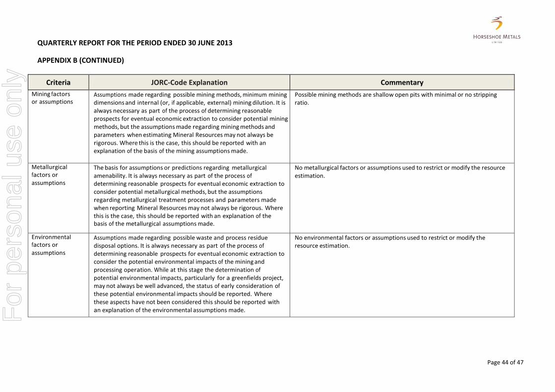
QUARTERLY REPORT FOR THE PERIOD ENDED 30 JUNE 2013
APPENDIX B (CONTINUED)
Page 44 of 47
Criteria JORC-Code Explanation Commentary
Mining factors or assumptions
Assumptions made regarding possible mining methods, minimum mining dimensions and internal (or, if applicable, external) mining dilution. It is always necessary as part of the process of determining reasonable prospects for eventual economic extraction to consider potential mining methods, but the assumptions made regarding mining methods and parameters when estimating Mineral Resources may not always be rigorous. Where this is the case, this should be reported with an explanation of the basis of the mining assumptions made.
Possible mining methods are shallow open pits with minimal or no stripping ratio.
Metallurgical factors or assumptions
The basis for assumptions or predictions regarding metallurgical amenability. It is always necessary as part of the process of determining reasonable prospects for eventual economic extraction to consider potential metallurgical methods, but the assumptions regarding metallurgical treatment processes and parameters made when reporting Mineral Resources may not always be rigorous. Where this is the case, this should be reported with an explanation of the basis of the metallurgical assumptions made.
No metallurgical factors or assumptions used to restrict or modify the resource estimation.
Environmental factors or assumptions
Assumptions made regarding possible waste and process residue disposal options. It is always necessary as part of the process of determining reasonable prospects for eventual economic extraction to consider the potential environmental impacts of the mining and processing operation. While at this stage the determination of potential environmental impacts, particularly for a greenfields project, may not always be well advanced, the status of early consideration of these potential environmental impacts should be reported. Where these aspects have not been considered this should be reported with an explanation of the environmental assumptions made.
No environmental factors or assumptions used to restrict or modify the resource estimation.
For
per
sona
l use
onl
y
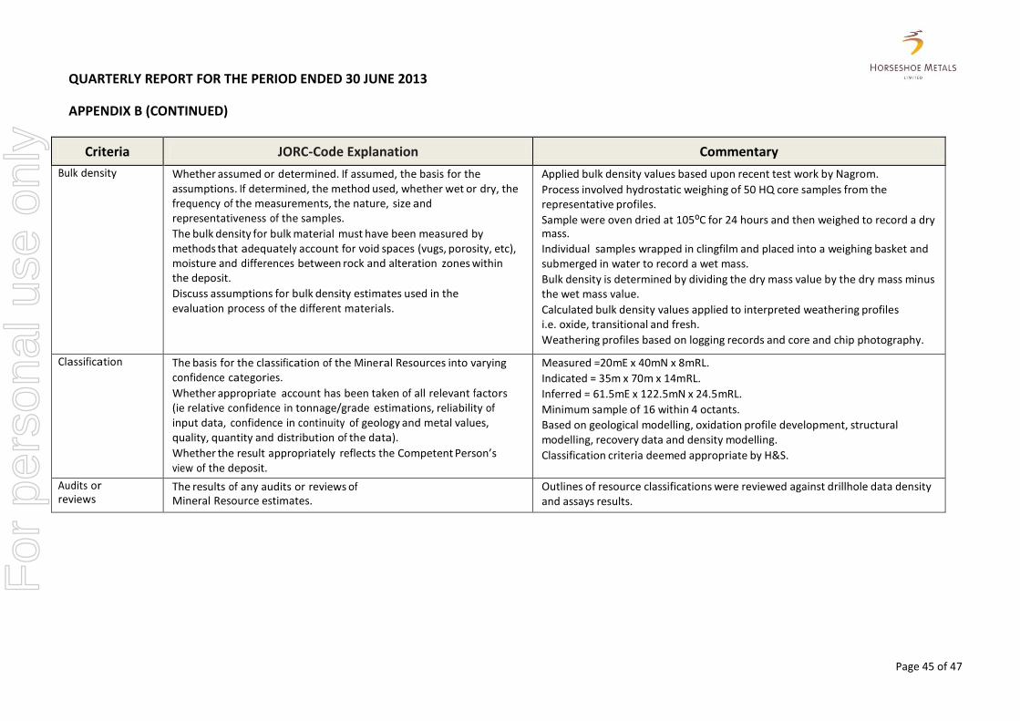
QUARTERLY REPORT FOR THE PERIOD ENDED 30 JUNE 2013
APPENDIX B (CONTINUED)
Page 45 of 47
Criteria JORC-Code Explanation Commentary
Bulk density Whether assumed or determined. If assumed, the basis for the assumptions. If determined, the method used, whether wet or dry, the frequency of the measurements, the nature, size and representativeness of the samples.
The bulk density for bulk material must have been measured by methods that adequately account for void spaces (vugs, porosity, etc), moisture and differences between rock and alteration zones within the deposit.
Discuss assumptions for bulk density estimates used in the evaluation process of the different materials.
Applied bulk density values based upon recent test work by Nagrom.
Process involved hydrostatic weighing of 50 HQ core samples from the representative profiles.
Sample were oven dried at 105⁰C for 24 hours and then weighed to record a dry mass.
Individual samples wrapped in clingfilm and placed into a weighing basket and submerged in water to record a wet mass.
Bulk density is determined by dividing the dry mass value by the dry mass minus the wet mass value.
Calculated bulk density values applied to interpreted weathering profiles i.e. oxide, transitional and fresh.
Weathering profiles based on logging records and core and chip photography.
Classification The basis for the classification of the Mineral Resources into varying confidence categories.
Whether appropriate account has been taken of all relevant factors (ie relative confidence in tonnage/grade estimations, reliability of input data, confidence in continuity of geology and metal values, quality, quantity and distribution of the data).
Whether the result appropriately reflects the Competent Person’s view of the deposit.
Measured =20mE x 40mN x 8mRL.
Indicated = 35m x 70m x 14mRL.
Inferred = 61.5mE x 122.5mN x 24.5mRL.
Minimum sample of 16 within 4 octants.
Based on geological modelling, oxidation profile development, structural modelling, recovery data and density modelling.
Classification criteria deemed appropriate by H&S.
Audits or reviews
The results of any audits or reviews of Mineral Resource estimates.
Outlines of resource classifications were reviewed against drillhole data density and assays results.
For
per
sona
l use
onl
y
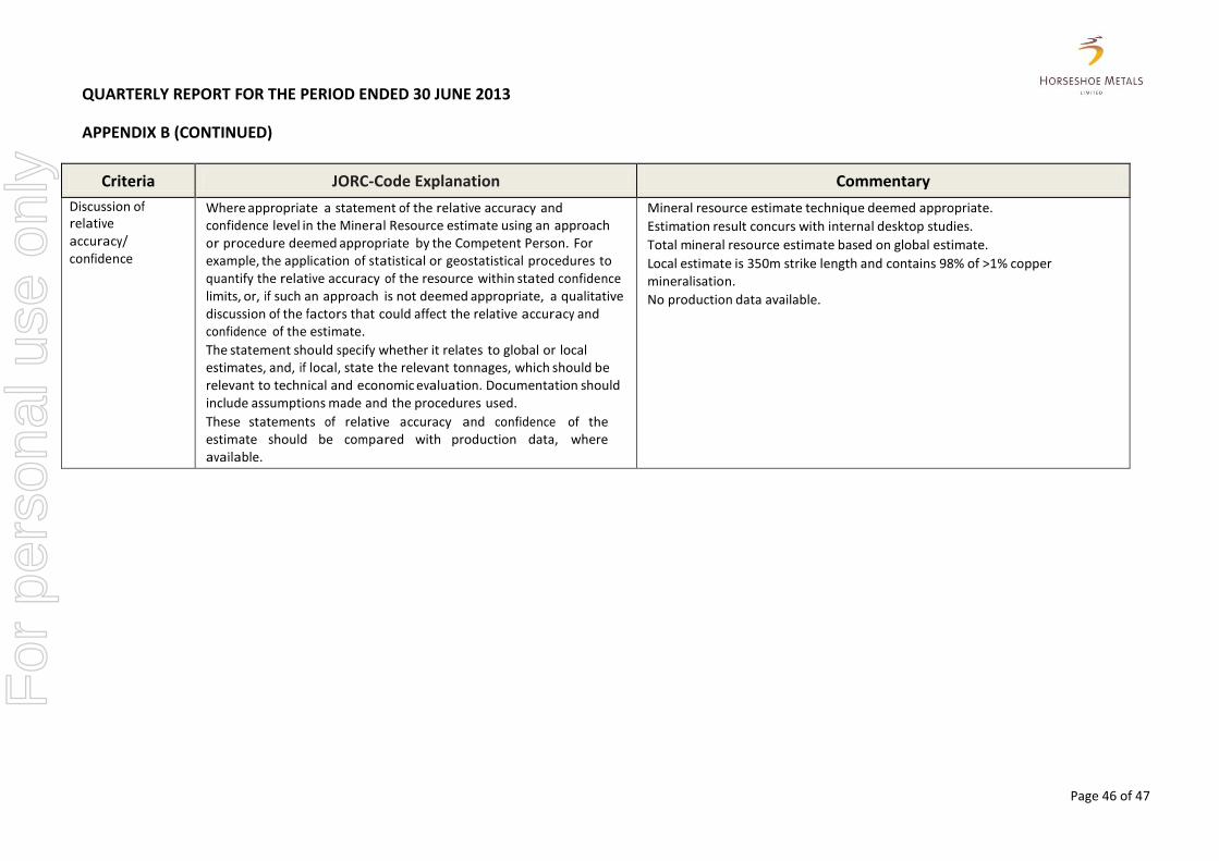
QUARTERLY REPORT FOR THE PERIOD ENDED 30 JUNE 2013
APPENDIX B (CONTINUED)
Page 46 of 47
Criteria JORC-Code Explanation Commentary
Discussion of relative accuracy/ confidence
Where appropriate a statement of the relative accuracy and confidence level in the Mineral Resource estimate using an approach or procedure deemed appropriate by the Competent Person. For example, the application of statistical or geostatistical procedures to quantify the relative accuracy of the resource within stated confidence limits, or, if such an approach is not deemed appropriate, a qualitative discussion of the factors that could affect the relative accuracy and confidence of the estimate.
The statement should specify whether it relates to global or local estimates, and, if local, state the relevant tonnages, which should be relevant to technical and economic evaluation. Documentation should include assumptions made and the procedures used.
These statements of relative accuracy and confidence of the estimate should be compared with production data, where available.
Mineral resource estimate technique deemed appropriate.
Estimation result concurs with internal desktop studies.
Total mineral resource estimate based on global estimate.
Local estimate is 350m strike length and contains 98% of >1% copper mineralisation.
No production data available.
For
per
sona
l use
onl
y
QUARTERLY REPORT FOR THE PERIOD ENDED 30 JUNE 2013
Page 47 of 47
COMPETENT PERSONS STATEMENT
The information in the report to which this statement is attached that relates to Exploration Results is based on information compiled by Mr Geoff Willetts, BSc. (Hons) MSc. who is a Member of the Australian Institute of Geoscientists. Geoff Willetts is employed full-time by Horseshoe Metals Limited. Geoff Willetts has sufficient experience which is relevant to the style of mineralisation and type of deposit under consideration and to the activity which he is undertaking to qualify as a Competent Person as defined in the 2012 Edition of the ‘Australasian Code for Reporting of Exploration Results, Mineral Resources and Ore Reserves’. Geoff Willetts consents to the inclusion in the report of the matters based on his information in the form and context in which it appears. The information in this report that relates to the Horseshoe Lights Project Mineral Resources is based on information compiled by Mr. Dmitry Pertel, who is a member of the Australian Institute of Geoscientists. Mr. Pertel is an employee of CSA Global Pty Ltd. Mr. Pertel has sufficient experience relevant to the style of mineralisation and type of deposit under consideration and to the activity which he is undertaking to qualify as a Competent Person as defined in the 2012 Edition of the “Australasian Code for Reporting of Exploration Results, Mineral Resources and Ore Reserves”. Mr. Pertel consents to the inclusion in the report of the matters based on his information in the form and context in which it appears. The information in this announcement that relates to the Kumarina Project (Rinaldi Prospect) Mineral Resources is based on information compiled by or under the supervision of Mr Robert Spiers, who is a member of the Australian Institute of Geoscientists. Mr Spiers has sufficient experience which is relevant to the style of mineralisation and type of deposit under consideration and to the activity which he is undertaking to qualify as a Competent Person as defined in the 2012 Edition of the “Australasian Code for Reporting of Exploration Results, Mineral Resources and Ore Reserves”. Mr Robert Spiers is an independent consultant to Horseshoe Metals Limited and a full time employee and Director of H&S Consultants Pty Ltd (formerly Hellman & Schofield Pty Ltd). Mr Spiers consents to the inclusion in the report of the matters based on his information in the form and context in which it appears.
For
per
sona
l use
onl
y