Embed Size (px)
Citation preview
DRŽAVNA GEODETSKA UPRAVA
Gruška 20 / 10 000 Zagreb
www.dgu.hr
Quality Elements and Measures of
Relief and Aesthetics on Croatian
Topographic Map TK25
Branko Puceković
Zagreb, 10. 10. 2014.
Zagreb, 10. 10. 2014. www.dgu.hr
Quality Elements and Measures of Relief and
Aesthetics on Croatian Topographic Map TK25
Content
1. Introduction
2. Quality control of TK25
3. International Standard Organization (ISO)
4. Quality elements as recommended by the ICA
5. Application on printed maps
Example 1
Example 2
6. Conclusions
Zagreb, 10. 10. 2014. www.dgu.hr
1. Introduction
Objective: to identifythe quality elements on printed (an analogous)
sheets of TK25 and how they can be measured
First sheet in 2002 available for official use
Production 594 sheets
Quality control by Croatian Geodetic Institute (CGI)
Zagreb, 10. 10. 2014. www.dgu.hr
2. Quality control of TK25
Quality control in CGI 2002 – 2010:
margin content,
map frame and coordinate grid,
map description,
trigonometric points (according to the official database and compatibility with relief),
relief review,
check of settlements (spatial units registry), objects and utility (according to the TD,
generalization),
hydrography (objects, types of waters, compatibility with relief, generalization),
traffic (categorization, objects, generalization),
cover and land types,
check of toponyms (according to the sources), edge matching, maritime and
underwater objects, depth contours, field checking (check with reality, accuracy) and
general alignment of topographic symbols with cartographic key (Specification)
including standardization of different producers.
Zagreb, 10. 10. 2014. www.dgu.hr
3. International Standard Organization (ISO)
Croatian Standards Institute adopted:
EN ISO 19113
EN ISO 19114,
EN ISO 19115 and
International document ISO/TS 19138
in English as Croatian technical specification.
Zagreb, 10. 10. 2014. www.dgu.hr
3. International Standard Organization (ISO)
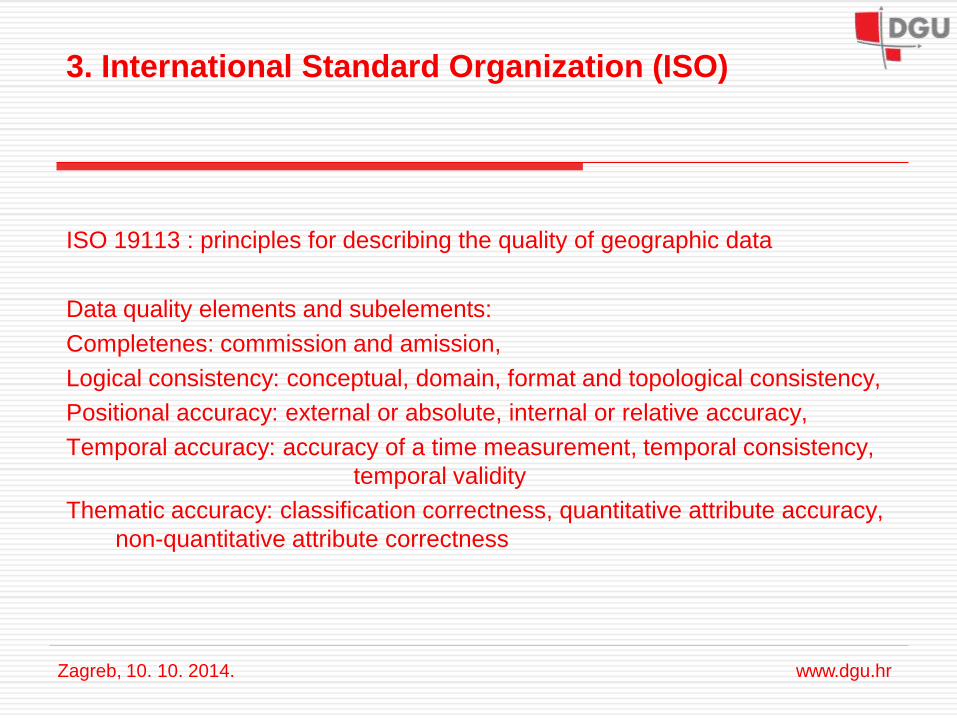
ISO 19113 : principles for describing the quality of geographic data
Data quality elements and subelements:
Completenes: commission and amission,
Logical consistency: conceptual, domain, format and topological consistency,
Positional accuracy: external or absolute, internal or relative accuracy,
Temporal accuracy: accuracy of a time measurement, temporal consistency,
temporal validity
Thematic accuracy: classification correctness, quantitative attribute accuracy,
non-quantitative attribute correctness
Zagreb, 10. 10. 2014. www.dgu.hr
3. International Standard Organization (ISO)
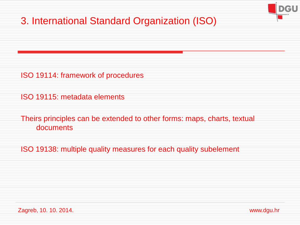
ISO 19114: framework of procedures
ISO 19115: metadata elements
Theirs principles can be extended to other forms: maps, charts, textual
documents
ISO 19138: multiple quality measures for each quality subelement
Zagreb, 10. 10. 2014. www.dgu.hr
4. Quality elements as recommended by the ICA
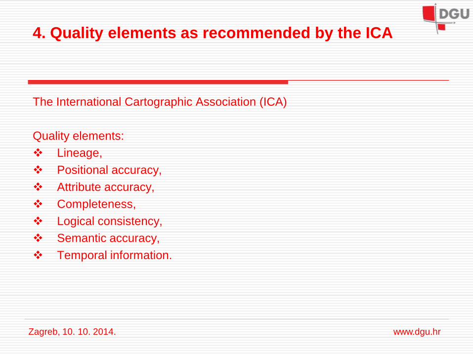
The International Cartographic Association (ICA)
Quality elements:
Lineage,
Positional accuracy,
Attribute accuracy,
Completeness,
Logical consistency,
Semantic accuracy,
Temporal information.
Zagreb, 10. 10. 2014. www.dgu.hr
5. Application on printed maps
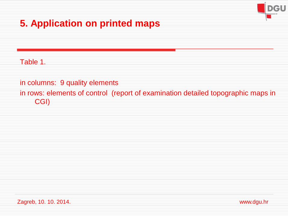
Table 1.
in columns: 9 quality elements
in rows: elements of control (report of examination detailed topographic maps in
CGI)
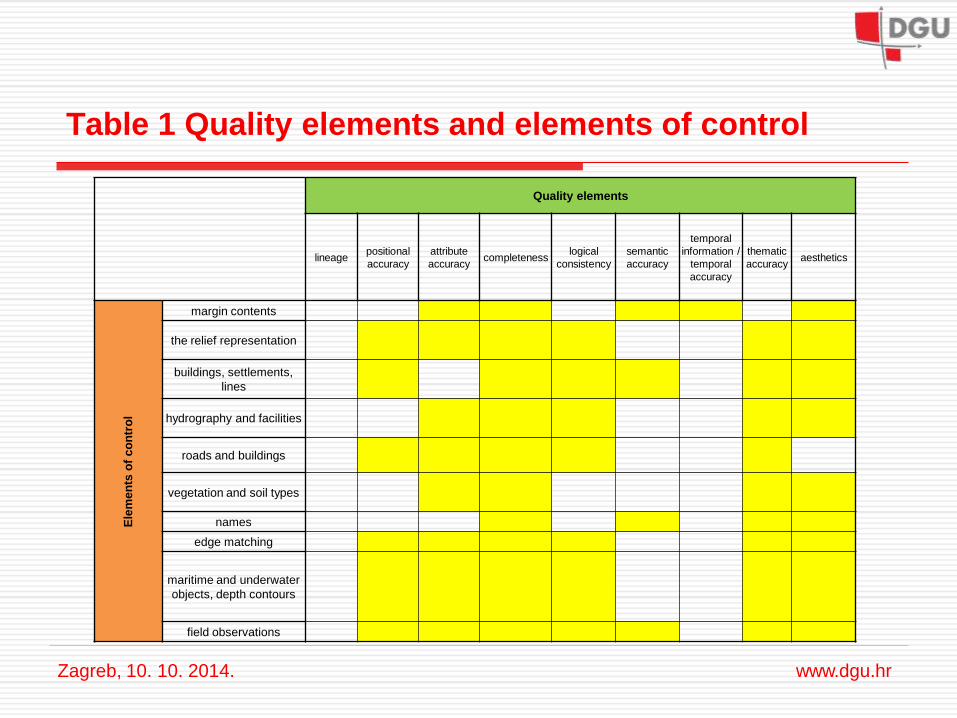
Table 1 Quality elements and elements of control
Zagreb, 10. 10. 2014. www.dgu.hr
Quality elements
lineage positional
accuracy
attribute
accuracy completeness
logical
consistency
semantic
accuracy
temporal
information /
temporal
accuracy
thematic
accuracy aesthetics
Ele
men
ts o
f co
ntr
ol
margin contents
the relief representation
buildings, settlements,
lines
hydrography and facilities
roads and buildings
vegetation and soil types
names
edge matching
maritime and underwater
objects, depth contours
field observations
5. Application on printed maps
Table 2.
in columns: 9 quality elements
in rows: quality measures for relief presentation
Zagreb, 10. 10. 2014. www.dgu.hr
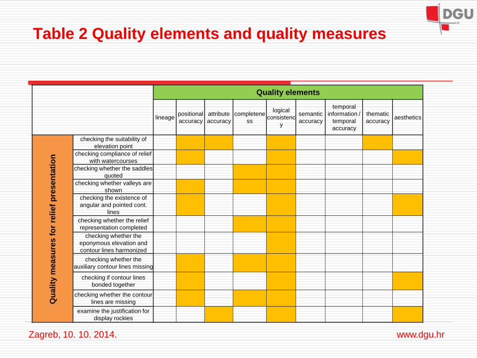
Table 2 Quality elements and quality measures
Zagreb, 10. 10. 2014. www.dgu.hr
Quality elements
lineage positional
accuracy
attribute
accuracy
completene
ss
logical
consistenc
y
semantic
accuracy
temporal
information /
temporal
accuracy
thematic
accuracy aesthetics
Qu
ali
ty m
easu
res f
or
reli
ef
pre
sen
tati
on
checking the suitability of
elevation point
checking compliance of relief
with watercourses
checking whether the saddles
quoted
checking whether valleys are
shown
checking the existence of
angular and pointed cont.
lines
checking whether the relief
representation completed
checking whether the
eponymous elevation and
contour lines harmonized
checking whether the
auxiliary contour lines missing
checking if contour lines
bonded together
checking whether the contour
lines are missing
examine the justification for
display rockies
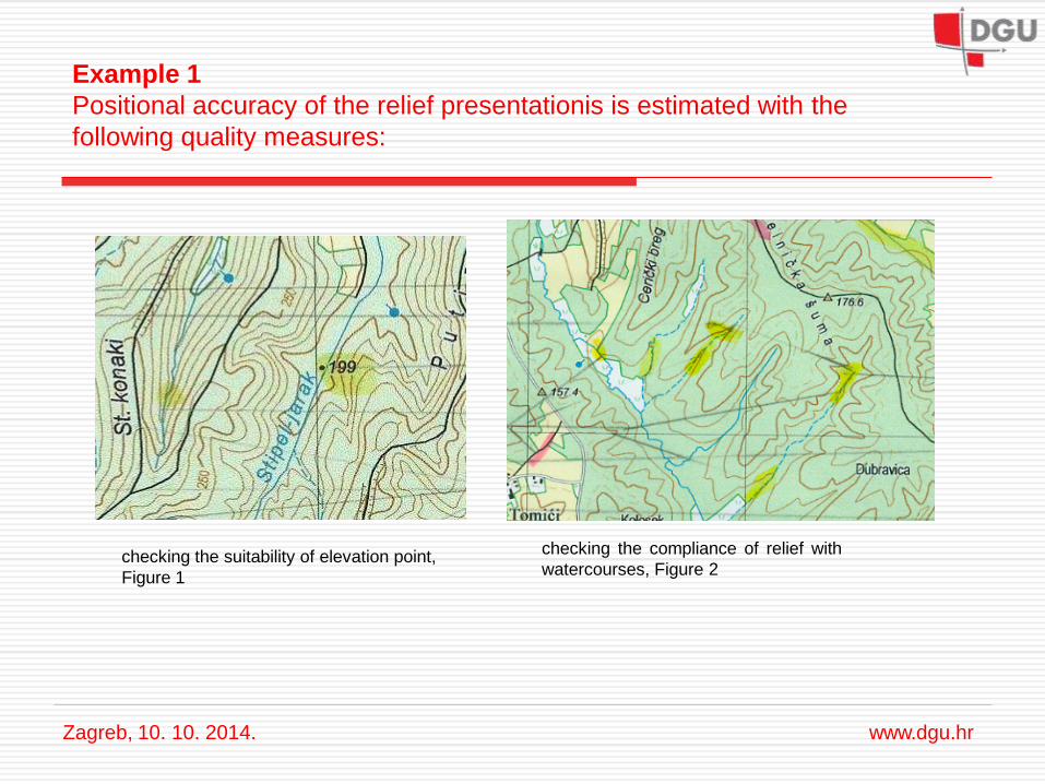
Example 1
Positional accuracy of the relief presentationis is estimated with the
following quality measures:
Zagreb, 10. 10. 2014. www.dgu.hr
checking the suitability of elevation point,
Figure 1
checking the compliance of relief with
watercourses, Figure 2
Example 1
Positional accuracy of the relief presentationis is estimated with the
following quality measures:
Zagreb, 10. 10. 2014. www.dgu.hr
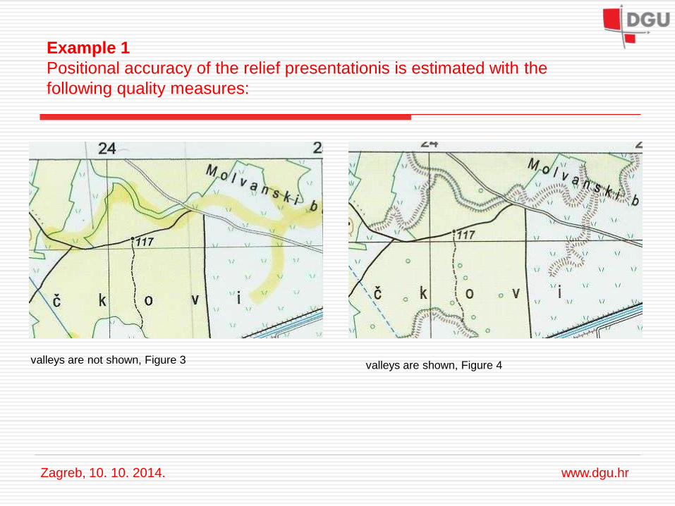
valleys are not shown, Figure 3
valleys are shown, Figure 4
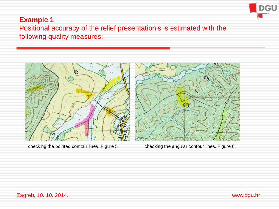
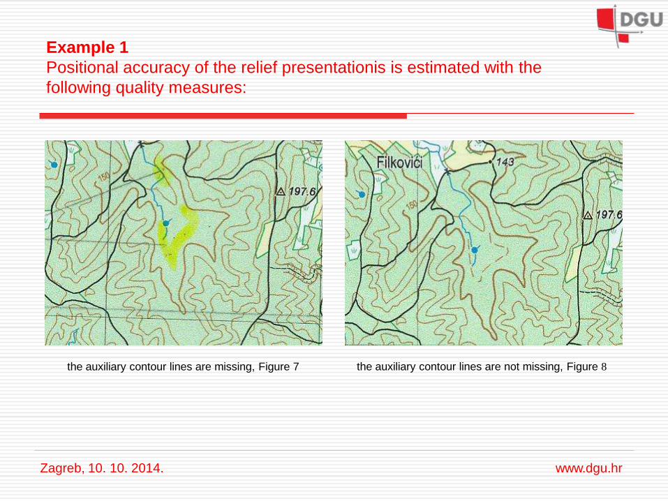
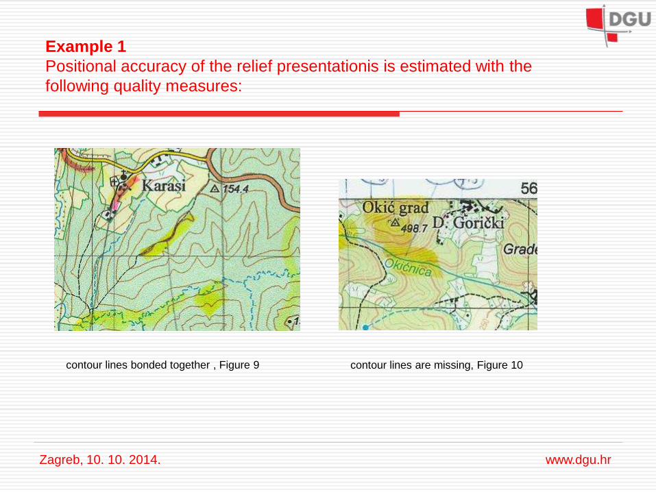
Example 1
Positional accuracy of the relief presentationis is estimated with the
following quality measures:
Zagreb, 10. 10. 2014. www.dgu.hr
checking the pointed contour lines, Figure 5
checking the angular contour lines, Figure 6
Example 1
Positional accuracy of the relief presentationis is estimated with the
following quality measures:
Zagreb, 10. 10. 2014. www.dgu.hr
the auxiliary contour lines are missing, Figure 7
the auxiliary contour lines are not missing, Figure 8
Example 1
Positional accuracy of the relief presentationis is estimated with the
following quality measures:
Zagreb, 10. 10. 2014. www.dgu.hr
contour lines are missing, Figure 10
contour lines bonded together , Figure 9
Example 1
Recommended procedures for improving the quality of maps are:
to choose a new location for the elevations,
to align relief with watercourses,
to display the valleys,
to round square and pointed contour lines,
to draw auxiliary contour lines,
to show contour lines that are missing,
to separate contour lines that are bonded together .
Zagreb, 10.10. 2014. www.dgu.hr
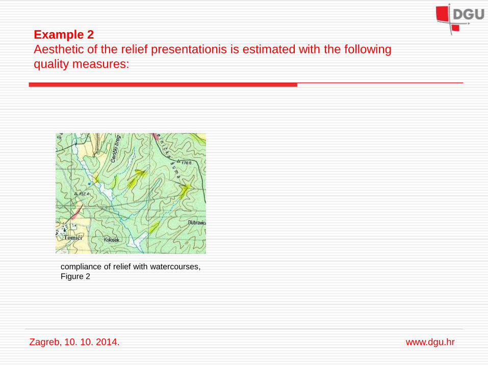
Example 2
Aesthetic of the relief presentationis is estimated with the following
quality measures:
Zagreb, 10. 10. 2014. www.dgu.hr
compliance of relief with watercourses,
Figure 2
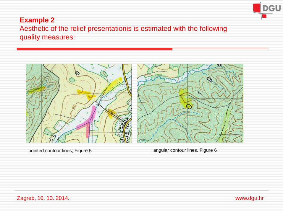
Example 2
Aesthetic of the relief presentationis is estimated with the following
quality measures:
Zagreb, 10. 10. 2014. www.dgu.hr
pointed contour lines, Figure 5
angular contour lines, Figure 6
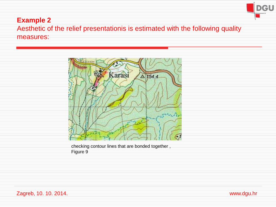
checking contour lines that are bonded together ,
Figure 9
Example 2
Aesthetic of the relief presentationis is estimated with the following quality
measures:
Zagreb, 10. 10. 2014. www.dgu.hr
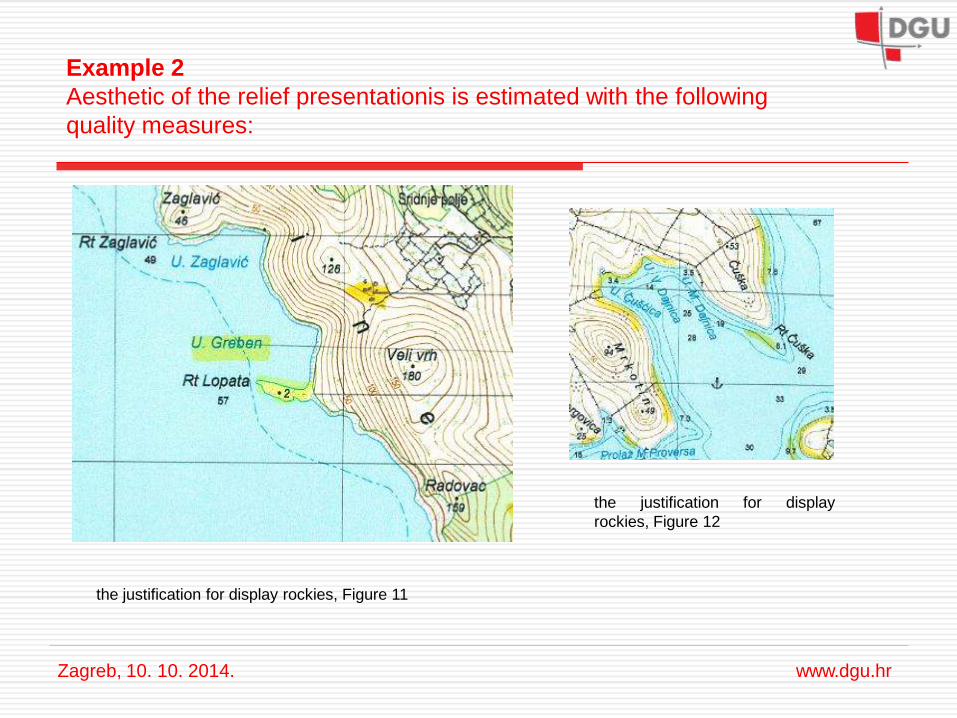
Example 2
Aesthetic of the relief presentationis is estimated with the following
quality measures:
Zagreb, 10. 10. 2014. www.dgu.hr
the justification for display rockies, Figure 11
the justification for display
rockies, Figure 12
Example 2
Recommended procedures for improving the quality of maps are:
to align relief with watercourse,
to round angular and pointed contour lines,
to separate bonded together contour lines,
to display rockies on correct places.
Negdje, 00. 00. 2011. www.dgu.hr
Zagreb, 10. 10. 2014. www.dgu.hr
6. Conclusions
- almost all quality elements can be determined using the elements of control,
except lineage,
- quality measures that affect the positional accuracy are recognized,
- quality measures that affect the aesthetics are recognized,
- I identified the existence of quality measures,
- I determined procedures to improve the quality of the map,
- for all statements in this article I have used examples, proofs and my
experience in quality control.
Thank you for your attention!
Zagreb 10. 10. 2014. www.dgu.hr