Embed Size (px)
Citation preview

#2 12877 Kidston Road Dock Page 1 of 3
QP Checklist – Mar 27/16 www.naitoenvironmental.com Project #400-129-01
Qualified Professional Checklist for Foreshore Works - Okanagan LLP
Project Name: New Dock at #2 12877 Kidston Road, Coldstream, BC Date: March 27, 2016
Project Summary: Construct 29 m long new dock with 18 untreated wood piles and untreated wood timbers and
decking.
NOTE: The items in this checklist apply to the site of works and the surrounding area.
Have you … Yes No N/A Explain
1.0 SITE SURVEY 1.1 reviewed existing
fish, emergent
vegetation, SAR &
habitat mapping
data, including:
a) Conservation Data Centre (CDC)? X 12 mapped occurrences of 11
SAR and 1 ecosystem at risk
within 3 km radius1; as well
as 11 masked occurrences;
unmasked occurrences are
distant from site or otherwise
not of concern; masked
occurrences unknown but not
likely to be affected by dock,
however should be
investigated if there is any
future riparian disturbance
(e.g., by trail or stairs)
b) local MOE (Ecosystem Staff)? X used OLLP and other online
resources
c) Foreshore Inventory Mapping? X OLLP no colour zone, FIM2
Segment 76 on Mapsheet 14
– gravel/single family; high
impact rating (>40%);
moderate habitat index rating;
no staging/migration/salmon
spawning stream/mussels;
moderate juvenile rearing; no
kokanee spawning zones
d) Sensitive Ecosystem Inventory? X SEI3 Polygon 9986 - 60%
Coniferous Woodland, 40%
Sparsely Vegetated Shrubby
Rock Outcrop
1 BC Conservation Data Centre: CDC iMap (web application). 2015. Victoria, BC, Canada. Available
http://maps.gov.bc.ca/ess/sv/cdc/ Accessed March 14, 2016. 2 J. Schleppe and A. Cormano, Kalamalka Lake Aquatic Habitat Index, 2012. Prepared by Ecoscape Environmental Consultants Ltd
for Okanagan Collaborative Conservation Program. November. 3 Iverson, K., Sensitive Ecosystems Inventory: Coldstream-Vernon, 2007. Prepared by Iverson & MacKenzie Biological Consulting
Ltd. for multiple agency partners. June.

#2 12877 Kidston Road Dock Page 2 of 3
QP Checklist – Mar 27/16 www.naitoenvironmental.com Project #400-129-01
Have you … Yes No N/A Explain
1.2 conducted any inventories to confirm presence/absence of
fish, emergent vegetation and SAR or their habitats on site?
X site visit conducted Mar 4/16;
no emergent vegetation or
SAR observed; no mussels or
shells; property is within
IDFxh1a (grassland phase of
Interior Douglas-fir very dry
hot BEC zone); intact riparian
vegetation (Photo 1) has
Ponderosa pine and Douglas-
fir to 50 cm, and typical
riparian species including
rose, red-osier dogwood,
hawthorn
1.3 confirmed environmentally sensitive features or ecosystems
on the site? (only if the upland is within an environmental
development permit area)
X SEI Coniferous Woodland
and shrubby sparsely
vegetated
1.4 evaluated and described local soil and foreshore substrate? X substrate was gravel and
cobble over sand, low shore
spawning potential (Photo 2)
1.5 assessed potential changes to local shoreline and stream
mouth accretion/erosion dynamics? (only required for
marina, infill and erosion protection works)
X not a marina, infill, or erosion
protection works
2.0 SITE DESIGN & RECOMMENDATIONS 2.1 applied DFO’s principal of ‘no
net loss’?
a) Redesign? X none required (figure
attached)
b) Relocate? X design will not result in loss
of fish habitat
c) Mitigation? X follow BMPs for working in
and around water
d) Compensation? X not required
2.2 followed the Habitat Officer’s Terms and Conditions? X depth ≥0.8 m below low
water mark before dock
widens and at boat lift
location
2.3 followed all BMPs? If not, have you described in the EIA
alternatives to BMPs that are being used (pg #)
X BMPs followed
2.4 included measures to avoid or minimize impacts to aquatic
and riparian habitat?
(in relation to existing or potential fish and SAR use)
X follow BMPs; all construction
access from water
2.5 included measures to avoid or minimize impacts to any fish,
emergent vegetation or SAR identified on the site?
X follow BMPs
2.6 applied the least risk timing windows? X June 1 to September 30 due to
potential shore spawning
2.7 minimized the footprint of the works? X 18 wood piles
2.8 considered one common lakeshore access on multiple lot
sites?
X site is single lot
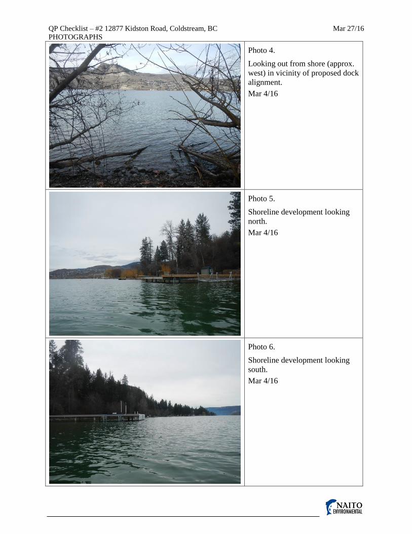
2.9 maintained a 50 m lakeshore frontage between moorage
structures on single lots? X docks on adjacent lots north
and south ~20 m away (Photo
5, Photo 6)

#2 12877 Kidston Road Dock Page 3 of 3
QP Checklist – Mar 27/16 www.naitoenvironmental.com Project #400-129-01
Have you … Yes No N/A Explain
2.10 minimized access related disturbance from
machinery/equipment?
X access by boat or barge
2.11 included measures to ensure no erosion or sediment releases
result from proposed works?
X minimal substrate disturbance
will result from construction
3.0 MONITORING & REPORTING
3.1 included provisions to ensure protective measures & BMPs
are followed? X full-time monitoring at
startup
3.2 included provisions for monitoring to ensure the completed
works function as expected over time? X not deemed necessary
3.3 provided recommendations for any impacts from future
maintenance? X none anticipated
3.4 considered long term water quality issues? X none anticipated
3.5 reported new SAR occurrences to MOE Ecosystem Staff
and CDC using CDC Field Observation Forms X no new SAR occurrences
3.6 reported null data for rare plant species to MOE Ecosystem
Staff (Osoyoos Lake Only) X not Osoyoos Lake
4.0 LEGISLATIVE REQUIREMENTS 4.1 avoided a HADD or serious harm? X low risk activity
4.2 received a letter of advice or authorization from DFO if the
works do cause a HADD or serious harm? X no HADD or serious harm
4.3 conducted a RAR assessment for upland works? If yes, list
RAR assessment # and indicate if the RAR assessment
included provisions for foreshore access
X no foreshore access required
for dock construction; no
RAR assessment requested
for possible stairs or trail to
dock
This development activity is in the following zone: Black Red Yellow No Colour
The development activity risk is Very High High Moderate Low
I confirm that all information provided in this checklist is to the best of my professional knowledge true and
complete.
____________________________________
Original signature of Qualified Professional
__Gerry Naito_____________________
Printed Name of Qualified Professional
RPBio #708 (BC College of Applied Biology)
Professional Association #
__March 27__, 2016
Date
Attachments: Photographs (2 pages × 3 photos)
Figure 1 – Plan and Section Views of Proposed New Dock

QP Checklist – #2 12877 Kidston Road, Coldstream, BC Mar 27/16
PHOTOGRAPHS
Photo 1.
Looking toward shore showing
existing riparian vegetation.
Mar 4/16
Photo 2.
Typical substrate of gravel and
cobble on bed of sand.
Mar 4/16
Photo 3.
Looking toward shore (approx.
east) along proposed dock
alignment.
Mar 4/16
QP Checklist – #2 12877 Kidston Road, Coldstream, BC Mar 27/16
PHOTOGRAPHS
Photo 4.
Looking out from shore (approx.
west) in vicinity of proposed dock
alignment.
Mar 4/16
Photo 5.
Shoreline development looking
north.
Mar 4/16
Photo 6.
Shoreline development looking
south.
Mar 4/16

0 5 10 15 20 25 30 35 40
ELEV
ATI
ON
(m
)
PLAN VIEW
#2 12877 KIDSTON ROAD, COLDSTREAM, BCEnvironmental Review of New DockMarch 2016
388
1.5
0
SECTION VIEW
392.00 m HIGH WATER LEVEL
391.20 m LOW WATER LEVEL
390.40 m (0.8 m BELOW LOW WATER)
FIGURE 1. PLAN AND SECTION VIEWS OF PROPOSED NEW DOCK AT #2 12877 KIDSTON ROAD, COLDSTREAM, BC
DISTANCE FROM HIGH WATER MARK (m)
Vernon, BC
www.naitoenvironmental.com
4.90
3.00
29.00
KALAMALKA LAKE
DEP
TH R
EQU
IRED
BEF
OR
E D
OC
K W
IDEN
ING
3.0
0
10
.004.90
2.5
0
389
390
391
392
4.90 4.90
3.00
0.8
0
UNTREATED WOOD PILES, TIMBERS, AND DECKINGBOAT LIFT
1.50
4.90 4.90 4.90 4.90 1.50
4.90
4.90
21.10