Embed Size (px)
Citation preview

1st IWA International Symposium on Water and Wastewater Technologies in Ancient Civilizations
PYMATUNING EARTHQUAKE IN PENNSYLVANIA (USA) AND LATE MINOAN CRISIS ON CRETE
Yuri GorokhovichCenter for International Earth Science Information Network (CIESIN)
at Columbia University
Gary FleegerPennsylvania Geological Survey, Department of Conservation and Natural
Resources

1st IWA International Symposium on Water and Wastewater Technologies in Ancient Civilizations
Knossos

1st IWA International Symposium on Water and Wastewater Technologies in Ancient Civilizations
Phaistos

1st IWA International Symposium on Water and Wastewater Technologies in Ancient Civilizations
The era of first palaces ended about 1700 BCE during widespread earthquake activity and then much stronger disaster at the end of Late Minoan IIIA-IIIB (1300 - 1450 BCE) hit the island. After that none of the houses and palaces were rebuilt and some of the towns were left unoccupied.
Late Minoan Crisis on Crete:

1st IWA International Symposium on Water and Wastewater Technologies in Ancient Civilizations
Late Minoan Crisis on Crete:New settlements started appearing on the western part of the island. The style of arts became simple and bold.
Minoan vase
Mycenean vase
Source: Aegean Prehistory, A Review, 1994

1st IWA International Symposium on Water and Wastewater Technologies in Ancient Civilizations
Late Minoan (1300 – 1700 years BCE) Crisis Milestones:The restored sequence of events for the Knossos Palace includes:
• Middle Minoan (MM, c.2200 B.C.–1500 BCE) destruction and some burning;• Evan’s/Hood’s MM - LM (c.1500 B.C.–1000 BCE) earthquake destruction and
burning at the beginning;• LM IA earthquake destruction possibly coincided with eruption of Thera (~1700 –
1600 BCE);• LM IB partial earthquake destruction and burning (~1500 BCE);• LM IIIA2 – IIIB Knossos destruction (~1300 – 1400 BCE)
Of more than 59 sites on Crete, including palaces and remnants of dwellings, 18 certainly suffered from earthquakes, i.e. almost 1/3 of them.
The result of crisis was transition to Mycenean style with different art, culture and language
Source: Driessen, J. and C.F. Macdonald. (1997) The Troubled Island. Minoan Crete before and after the Santorini Eruption (Aegaeum 17).

1st IWA International Symposium on Water and Wastewater Technologies in Ancient Civilizations
Possible reasons for the Late Minoan Crisis:Earthquake hypothesis: Sir Arthur Evans (1928)
Tsunami from Thera (Santorini) eruption: Dr. Spyridon Marinatos (1939)
Hypothesis checks:Too little amount of tephra (volcanic material) was found on Crete (Vitaliano, C.J. and D.B. Vitaliano, 1974).
The tsunami hypothesis did not receive support from modeling experts (Koenig, 2001) and latest geologic studies (Dominey-Howes, 2004).
The evidence: the only evidence on which geologists and archeologists agree is earthquake activity. Nur and Cline (2000) suggested “seismic storms”; the evidence of severe earthquake activity during the end of Protopalatial (1700 BCE) and the Neopalatial (1450 BCE) periods come from the research work of Monaco and Tortorici (2004).
1st IWA International Symposium on Water and Wastewater Technologies in Ancient Civilizations
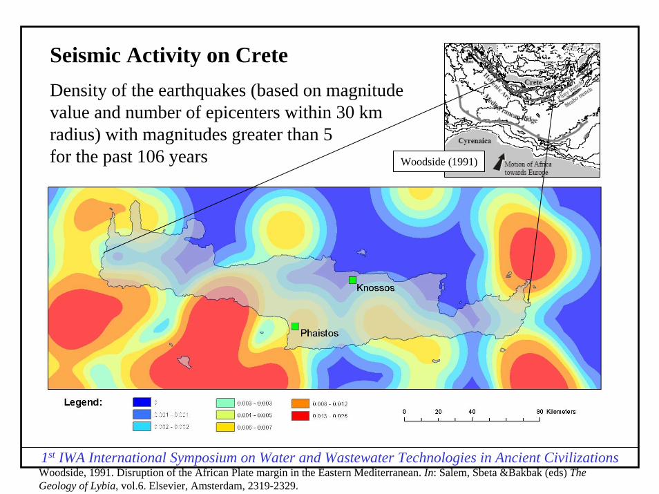
Seismic Activity on CreteDensity of the earthquakes (based on magnitude value and number of epicenters within 30 km radius) with magnitudes greater than 5 for the past 106 years Woodside (1991)
Woodside, 1991. Disruption of the African Plate margin in the Eastern Mediterranean. In: Salem, Sbeta &Bakbak (eds) The Geology of Lybia, vol.6. Elsevier, Amsterdam, 2319-2329.

1st IWA International Symposium on Water and Wastewater Technologies in Ancient Civilizations
The hydrologic hypothesis was developed using the following input:
1. Water Resources in Cretan PalacesThree main sources of water supply in these palaces were underground cisterns,wells, springs and surface water. Assuming that most other palaces and sites on Crete had similar water supply systems, all of them would be vulnerable to the same factors of danger from earthquakes including:
- aqueduct rupture(s);- depletion of groundwater sources (wells);- climatic change causing the decline of precipitation;- change in water quality (seawater intrusion, turbidity, discoloration, etc.).
2. Seismicity and Related Hydrogeologic ChangesGeneral hazards to potential water supply in relation to earthquakes include dry wells, broken aqueduct systems and turbid or gaseous (with carbon-dioxide) water.The groundwater changes in wells occurred as “an instantaneous water-level offset, or step, which may be either increase or a decrease and may occur near or far from the epicenter.” The surface water changes consist of “increases in stream, spring, and seep discharge, some instances of springs going dry or the appearance of new springs and a very few examples of decreases in spring discharge.”

1st IWA International Symposium on Water and Wastewater Technologies in Ancient Civilizations
Hydrogeologic hypothesis: an earthquake activity could potentially influence the decline of water table in locations ofMinoan palaces, usually situated on high elevations.
A repeated series of earthquakes could increase aquifer’s permeability; this would cause a decline of groundwater for a long period of time and eventually influence local people to migrate in search of a new water supply and better places to live.
Source: Gorokhovich Y. 2005. Abandonment of Minoan Palaces on Crete in Relation to the Earthquake Induced Changes in Ground Water Supply. Journal of Archeological Sciences. Vol. 32, 2

1st IWA International Symposium on Water and Wastewater Technologies in Ancient Civilizations
CASE STUDY? PROVE?Basis of the principles of actualism:
‘…the ruins of an older world are visible in the present structure of our planet, and the strata which now compose our continents have been once beneath the sea, and were formed out of the waste of pre-existing continents. The same forces are still destroying, by chemical decomposition or mechanical violence, even the hardest rocks.” - James Hutton
Source: Lyell Charles, Principles of Geology (I), 1830.

1st IWA International Symposium on Water and Wastewater Technologies in Ancient Civilizations
CASE STUDY: Pymatuning Earthquake, Pennsylvania, USASeptember 25, 1998
In an earthquake in Pymatuning, PA in 1998 a Foucault's pendulum acting as a seismoscope scribed this incredible work of earthquake art
Source: U.S. Geological Survey, http://earthquake.usgs.gov/scitech/

1st IWA International Symposium on Water and Wastewater Technologies in Ancient Civilizations
PYMATUNING EARTHQUAKE, PENNSYLVANIA, USASeptember 25, 1998

1st IWA International Symposium on Water and Wastewater Technologies in Ancient Civilizations
Hydrologic effect of the earthquake
Courtesy Gary Fleeger, USGS, PA

1st IWA International Symposium on Water and Wastewater Technologies in Ancient Civilizations
Hydrologic effect of the earthquake
Courtesy Gary Fleeger, USGS, PA

1st IWA International Symposium on Water and Wastewater Technologies in Ancient Civilizations
Hydrologic effect of the earthquake
Courtesy Gary Fleeger, USGS, PA
1st IWA International Symposium on Water and Wastewater Technologies in Ancient Civilizations
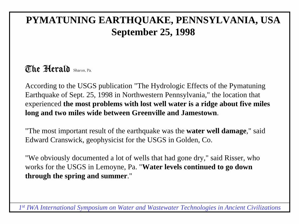
PYMATUNING EARTHQUAKE, PENNSYLVANIA, USASeptember 25, 1998
According to the USGS publication "The Hydrologic Effects of the PymatuningEarthquake of Sept. 25, 1998 in Northwestern Pennsylvania," the location that experienced the most problems with lost well water is a ridge about five miles long and two miles wide between Greenville and Jamestown.
"The most important result of the earthquake was the water well damage," said Edward Cranswick, geophysicist for the USGS in Golden, Co.
"We obviously documented a lot of wells that had gone dry," said Risser, who works for the USGS in Lemoyne, Pa. "Water levels continued to go down through the spring and summer."

1st IWA International Symposium on Water and Wastewater Technologies in Ancient Civilizations
PYMATUNING EARTHQUAKE, PENNSYLVANIA, USASeptember 25, 1998
More than 90 homes lost well water after the earthquake, said Jim Thompson of the Mercer County Emergency Management Agency. Most homeowner's insurance policies do not cover well water loss, so residents had to drill new wells at their own expense. "It costs $3,000 to $4,000 to drill a new well, and most families can't afford it…"
About 30 families who live east of Greenville are without water. The cost of new well is up to $2,000
It took more than a month to drill new wells and provide communities of Greenville and Jamestown with water.
Social impacts of disrupted water supply in Pennsylvania included immediate help from local and federal authorities, charities and churches to provide inhabitants of the “hydrologic island”between Jamestown and Greenville with water supply. This included filling bath tubs from fire trucks and supply of bottled water from local supermarkets and stores. In similar case in California in December 22, 2004, San Luis Obispo County residents had to trim their herds due to the loss of water from springs immediately after earthquake (Campbell, 2004).

1st IWA International Symposium on Water and Wastewater Technologies in Ancient Civilizations
Geological
Settings
Courtesy Gary Fleeger, USGS, PA

1st IWA International Symposium on Water and Wastewater Technologies in Ancient Civilizations
The mystery of water disappearance – the concept of “Hydrologic Island”:
“Hydrologic Island” zone “has its recharge area at a topographic high and its discharge area at a topographic low that are located adjacent to each other” (Toth, 1963)
Norvatov and Popov (1961) defined this zone as “upper zone of active flow, whose geographical zonality coincides with climatic belts. The lower boundary of this zone coincides with the local base levels of rivers”.
Valley bottom,river
rain recharge zonehilltop

1st IWA International Symposium on Water and Wastewater Technologies in Ancient Civilizations
Hydrologic Island Concept: Earthquake shocks can increase the permeability of the aquifer rocks and cause its depletion and lower its level
Valley bottom,river
hilltoprecharge zone
Aquifer levelbefore earthquake
rain
Aquifer levelafter earthquake

1st IWA International Symposium on Water and Wastewater Technologies in Ancient Civilizations
Seismic Effect on Permeability of Rocks
Seismic wave propagation
before seismic effect after seismic effect
water is kept within the layer, vertical and horizontal movements are restricted
water can move downward due to the increased porosity
Some sedimentary rocks (e.g. shales) are anisotropic to the effect of seismic waves

1st IWA International Symposium on Water and Wastewater Technologies in Ancient Civilizations
The concept of “Hydrologic Island” in Pennsylvania

1st IWA International Symposium on Water and Wastewater Technologies in Ancient Civilizations
The concept of “Hydrologic Island” applied for Crete
1st IWA International Symposium on Water and Wastewater Technologies in Ancient Civilizations
Conclusions:
1. Phaistos has more similarity with “hydrologic island” settings in Pennsylvania than Knossos. However, more detailed analysis is needed near both palaces to identify specific geologic and hydrogeologic conditions.
2. The epicentre of the Pymatuning earthquake was located within 3-5 km from the affected “hydrologic island” and its depth was 5 km. These conditions, coupled with geologic structure resulted in the loss of the underground water flow. Considering the high frequency of earthquakes on Crete during Bronze Age there is a possibility of an earthquake epicenter occurrence, similarly close to palaces located on the hill.
3. In ancient Crete, 3600 years ago social effects similar to ones experienced by people in Pennsylvania in 1998 (supply of bottled water from supermarkets and stores, filling bath tubs by fire department) would mean the retreat of population and search for new water supply sources. The migration would highly increase vulnerability of population to political and social problems.

1st IWA International Symposium on Water and Wastewater Technologies in Ancient Civilizations
Central Coast earthquake still challenging ranchersIssue Date: April 28, 2004By Kate Campbell Assistant Editor
As the hills and fields in San Luis Obispo County continue to tremble, farmers and ranchers work on repairing damage from the 6.5 magnitude earthquake that struck the area Dec. 22. They're contending with uncertain water supplies and damage to roads and fields.
Following the earthquake, natural springs stopped flowing on some ranches in the county and new ones popped up in areas were springs hadn't existed before. Irrigation lines snapped, water storage tanks were tossed around and some wells collapsed or were severely damaged.
San Luis Obispo County produces livestock and crops valued at about a half billion dollars a year. Winegrapes and cattle are the top commodities, and vegetable crops, like broccoli and lettuce, also contribute significantly to the county's overall agricultural production.

1st IWA International Symposium on Water and Wastewater Technologies in Ancient Civilizations
The wells have not come back to life.
"It's scary," said Walter, who is a widow. "I have 65 head of pure-bred Charolais cattle and we have no water. Right after the quake, Red Cross delivered water, then a private contractor delivered water. I have a 20,000-gallon holding tank and a gravity flow system. Walter said she thinks the water source that was in the hillside and supplied the ranch for nearly 60 years may have collapsed during the quake. The wells were drilled through solid rock about 125 feet into the hillside. "Now there's no sign of water at all. There have been problems with ranch wells throughout this whole area, all along Highway 41."
Joy Fitzhugh, Cambria cattle rancher and legislative analyst for the San Luis Obispo County Farm Bureau, said that what used to be a stockpond for her herd of beef cattle has now become more like a flushing toilet. Fitzhugh said that at this point "because of the drought and uncertainty over our water supply, we're trimming our herd and waiting to see what happens. We don't know where a spring will pop up next and whether it will flow consistently." She said local experts seem divided about what the ultimate impact of all the seismic activity will have on local groundwater supplies.

1st IWA International Symposium on Water and Wastewater Technologies in Ancient Civilizations
1929. Aug. 12. Attica, Wyoming County, N.Y.
The earthquake was strongest in eastern Attica and the region to the east. In Attica, 250 chimneys were thrown down, several brick buildings were damaged, and a crack formed in the railroad embankment near the railroad station. East of town, almost every monument was knocked over in the Brainerd Cemetery. West of Attica Reservoir, several wells went dry and a crack formed in the bottom of one well. Several chimneys also fell a few km north of Attica at Batavia, and at Warsaw, 20 km southeast; only slight damage occurred at other towns. It was felt from New Hampshire to Michigan and from Maryland to northern Ontario. Magnitude 4.4 Ms NLI, 4.9 M
Source: Earthquake Data for New York State by Carl W. Stover and Jerry Coffman, Seismicity of the United States, 1568-1989 (Revised). (U.S. Geological Survey Professional Paper 1527.) Washington : U.S. Government Printing Office, 1993, pp. 313-319.

1st IWA International Symposium on Water and Wastewater Technologies in Ancient Civilizations
1944. Sept. 5 (Sept. 4). Between Massena, N.Y., and Cornwall, Ontario, Canada.
This severe earthquake was felt from Canada south to Maryland and from Maine west to Indiana. It caused property damage estimated at $2 million at Massena and Cornwall. Many chimneys in that area required rebuilding, and several structures were unsafe for occupancy until repaired. Residents of St. Lawrence County reported that many water wells went dry.
Source: Earthquake Data for New York State by Carl W. Stover and Jerry Coffman, Seismicity of the United States, 1568-1989 (Revised). (U.S. Geological Survey Professional Paper 1527.) Washington : U.S. Government Printing Office, 1993, pp. 313-319.
1st IWA International Symposium on Water and Wastewater Technologies in Ancient Civilizations
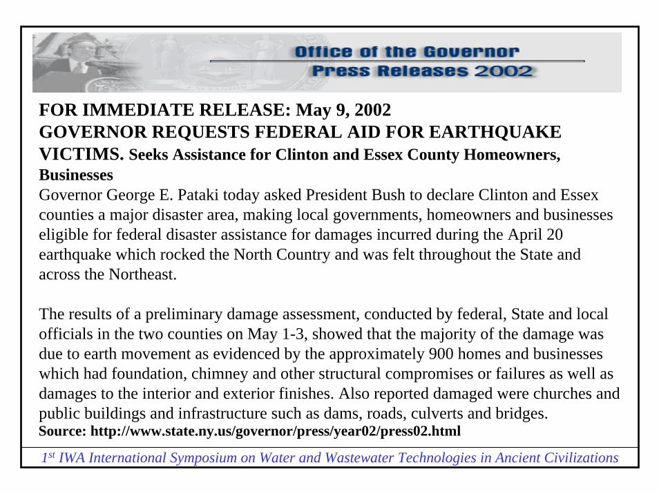
FOR IMMEDIATE RELEASE: May 9, 2002GOVERNOR REQUESTS FEDERAL AID FOR EARTHQUAKE VICTIMS. Seeks Assistance for Clinton and Essex County Homeowners, Businesses Governor George E. Pataki today asked President Bush to declare Clinton and Essex counties a major disaster area, making local governments, homeowners and businesses eligible for federal disaster assistance for damages incurred during the April 20 earthquake which rocked the North Country and was felt throughout the State and across the Northeast.
The results of a preliminary damage assessment, conducted by federal, State and local officials in the two counties on May 1-3, showed that the majority of the damage was due to earth movement as evidenced by the approximately 900 homes and businesses which had foundation, chimney and other structural compromises or failures as well as damages to the interior and exterior finishes. Also reported damaged were churches and public buildings and infrastructure such as dams, roads, culverts and bridges. Source: http://www.state.ny.us/governor/press/year02/press02.html

1st IWA International Symposium on Water and Wastewater Technologies in Ancient Civilizations
Additionally, a number of wells were reported as undrinkable or going dry as aresult of the quake and the State Department of Health is assisting local governments to ensure the safety of drinking water supplies. Some municipal sewer and private water systems were impacted and are still being assessed. The Department of Environmental Conservation's Dam Safety Team verified that three dams sustained damage caused by the quake. The dams had water levels lowered and pose no imminent hazard.
The earthquake struck at approximately 6:50 a.m. Saturday, April 20, registering 5.0 Mw (moment magnitude). The quake's epicenter was approximately four miles from the hamlet of Ausable Forks in the Town of Jay, Essex County. The Governor implemented the State Emergency Operations Plan and declared a State Disaster Emergency for the two counties, making the full resources of State agencies available to assist the counties in their response and recovery efforts.
Source: http://www.state.ny.us/governor/press/year02/press02.html

1st IWA International Symposium on Water and Wastewater Technologies in Ancient Civilizations
El Salvador Earthquake 7.6 on January 13, 2001
Source: http://www.fprespa.org/earthquake.htm
Most Living Water Wells Survive First Earthquake
In the lower Lempa area many hand-dug wells were damaged during the earthquake but the Living Water wells fared quite well. One well which was right in a spot where the earth split was damaged. The Living Water wells are even more critical than ever now that most of the wells dug by families on or near their land are filled with sand, dirt and other waste.

1st IWA International Symposium on Water and Wastewater Technologies in Ancient Civilizations
Save The Children, 5 March, 2001
Source: http://www.reliefweb.int/w/rwb.nsf/0/e359db1cf90b8f5585256a0e006d044a?OpenDocument
El Salvador earthquake situation report 5 Mar 2001
In addition, prior to the earthquake, the country was on yellow alert for a retro-virus that was causing high mortality rates due to diarrhea within the 0-5-year-old population. The damaged wells and water systems that have resulted from the quake, as well as water source contamination due to the lack of latrines and poor hygiene, threaten to worsen this situation.
International Federation of Red Cross and Red Crescent SocietiesSituation Report no 5, 8 February 2001: “Survey indicate that one third of the country’s water system has been affected.”

1st IWA International Symposium on Water and Wastewater Technologies in Ancient Civilizations
Source: http://www.waterandnature.org/b1.html. Last update 8 Aug. 2003
Ecosystem management of the El Imposible-Barra de Santiago Basin
“Water is mainly supplied from rope wells. However, as a result of the 2001 earthquakes, aquifers have suffered saline intrusion and the water is no longer drinkable. Residents generally buy drinking water from cistern trucks that bring water from the Guaymango River.”

1st IWA International Symposium on Water and Wastewater Technologies in Ancient Civilizations
Earthquake Information Bulletin, Volume 6, Number 4, July -August, 1974, by Carl A. von Hake
Earthquake History of Montana
A magnitude 4.7 earthquake in the Flathead Lake area on April 1, 1969, cause damage and reached intensity VII at Big Arm, Dayton, and Proctor. Some damage was also noted in the Lake Mary Ronan area and a water well near Polson went dry. Several wells in the Proctor area increased their flow or became muddy. The shock was felt over 26,000 square kilometers and was followed by at least 21 felt aftershocks from April 1 to April 24. The strongest aftershock, on April 5, reached intensity V at Lake Mary Ronan. Over 325 minor aftershocks were reported felt from May 1969 through December 1971, mainly in the Big Arm - Polson area.
Source: http://neic.usgs.gov/neis/states/montana/montana_history.html

1st IWA International Symposium on Water and Wastewater Technologies in Ancient Civilizations
Largest Earthquake in Alabama Irondale, Jefferson County, Alabama
1916 10 18 22:04 UTC , Magnitude 5.10, Intensity VII
A careful study of the Red Gap fault, which extends from near Gate City to beyond Irondale, did not reveal direct evidence of recent earth movement. The most significant geologic result was the effect of the earthquake on underground water, particularly in Irondale. Five wells in a one-block area of Irondale went dry immediately after the shock, and the water level in many others was lowered. At Pell City, the shock lowered the water level in one well about 50 centimeters.
Source: Seismicity of the United States, 1568-1989 (Revised), by Carl W. Stover and Jerry L. Coffman, U.S. Geological Survey Professional Paper 1527, United States Government Printing Office, Washington: 1993.

1st IWA International Symposium on Water and Wastewater Technologies in Ancient Civilizations
Earthquake in Utah, 1934
Reports from western parts of the county indicate that the earthquake was responsible for many curious things:A dry well at Cosmo, drilled fifteen years ago in a vain effort to reach water, became an active flowing well Monday.The flows of the springs at Locomotive were entirely shut off during the disturbance for about thirty minutes. Coming back slowly, the waters were a brilliant red in color.In the vicinity of Cosmo and Monument, fissures and holes were made in the earth, water gushing from many of them. About forty new springs appeared.Across the highway of the Hansel Valley Locomotive Springs road at a point about 1� miles northeast of Cosmo, the earth, at two points about 1500 feet apart, was faulted to a depth of two and one half feet.
[Box Elder Journal; March 14, 1934]
Source: http://www.seis.utah.edu/NEHRP_HTM/1934hans/n1934ha1.htm

1st IWA International Symposium on Water and Wastewater Technologies in Ancient Civilizations
Geophysical Journal International, Volume 135 Issue 3 Page 876 - December 1998 The M L 5.3 Épagny (French Alps) earthquake of 1996 July 15: a long-awaited event on the Vuache Fault. François Thouvenot et. al.
Flow changes in two natural springs close to the epicentre were noted. The otherwise very steady Bromines sulphurous spring, at the foot of the southern tip of the Mandallaz Mountain (Fig. 7), is reported to have significantly increased its flow just after the earthquake. This increase was strong enough to partially damage the spring harnessing, and a new pipe with a diameter twice as large as the old one had to be installed (Fig. 11d). Though no flow measurement before the earthquake is available, we can estimate from the pipe diameters that the water flow increased by a factor of 4 or 5. One year after the main shock, the flow was still greater than normal. Conversely, another non-sulphurous spring located 1 km to the north of Bromines was reported to have run dry just after the earthquake. It recovered its initial flow only 4 months later. Underwater springs in the northern part of Lake Annecy were also said to have increased their output following the earthquake, but this information was not verified.

1st IWA International Symposium on Water and Wastewater Technologies in Ancient Civilizations
Source: http://www.indianexpress.com/ie20010905/ed5.html
The mystery of Kerala’s collapsing wells, by ARUN BAPATUNUSUAL geo-hydrological phenomena have been dogging Kerala since June. One among them is the collapse of water wells caused by the sudden or rapid change of water level up to one metre or so — and within an hour — the entire water of the well vanishes and the lining of brick or concrete collapses. In a matter of a few hours the perennial source of water turns into a dry pit. In all about 300 well collapses have been reported.In order to verify the tectonic relationship with the well collapse phenomenon, thermal parameters were examined. This is an indirect way of assessment, but it gives a realistic picture. From the sub-surface temperature data recorded at 10 cm depth below the ground level, it is observed that this temperature has increased from an average value of 33.9 C in 1998 to 34.7 C in 1999. This indicates that the sub-surface area is warming up. As a result of this, agriculture crop production decreases. It is seen that the two major crops — rice and coconut — have been undergoing a continuous drop for last three years. This observation in an indirect way indicates possible activation of tectonic activity. However, statistical analyses of the historical seismicity indicates that the maximum possible magnitude of the seismic event in Kerala could be of the order of 5.5 on Richter scale and would does not cause serious damage, especially to engineered structures.