Embed Size (px)
Citation preview

Public Service Company of New Hampshire Seacoast Reliability Project
Madbury, Durham, Newington & Portsmouth, NH
New Hampshire Department of Environmental Services Wetlands Permit Application
SUPPLEMENT
Prepared For: Public Service Company of New Hampshire
d/b/a Eversource Energy 780 North Commercial Street
Manchester, NH 03101
Submitted: April 12, 2016 Supplement:
March 15, 2017
Prepared By: Normandeau Associates, Inc.
25 Nashua Rd Bedford, NH 03110
www.normandeau.com
SEACOAST RELIABILITY PROJECT NHDES WETLANDS PERMIT APPLICATION - SUPPLEMENT
ii Normandeau Associates, Inc.
Table of Contents Page
1-3 NH DES Wetlands Permit Application Form
5. Statements in Response to the 20 Questions (Env-Wt 302.04)
6. The Seacoast Reliability Project: Project Description & Existing Conditions
Narrative ............................................................................................ 1
Primary Project Overview ......................................................................... 1
Description of General Environmental Setting ................................................. 3
Potential Project Impacts and Avoidance and Minimization Measures ..................... 5
Impact Avoidance .................................................................................. 5
Impact Minimization ............................................................................... 5
Impact Analysis ..................................................................................... 5
7. Mitigation Narrative .............................................................................. 15
Compensatory Wetland Mitigation Narrative ................................................. 15
9. NH Programmatic General Permit (PGP) Requirements ................................... 23
U.S. Army Corps of Engineers New Hampshire PGP Appendix B—Corps Secondary
Impacts Checklist ........................................................................... 23
16. Plans (Env-Wt 501.02, Chapter Env-Wt 900)
17. Appendices
Appendix A: Natural Resource Existing Condition Report
Appendix B: Natural Resource Impact Assessment
SEACOAST RELIABILITY PROJECT NHDES WETLANDS PERMIT APPLICATION - SUPPLEMENT
iii Normandeau Associates, Inc.
List of Tables Page
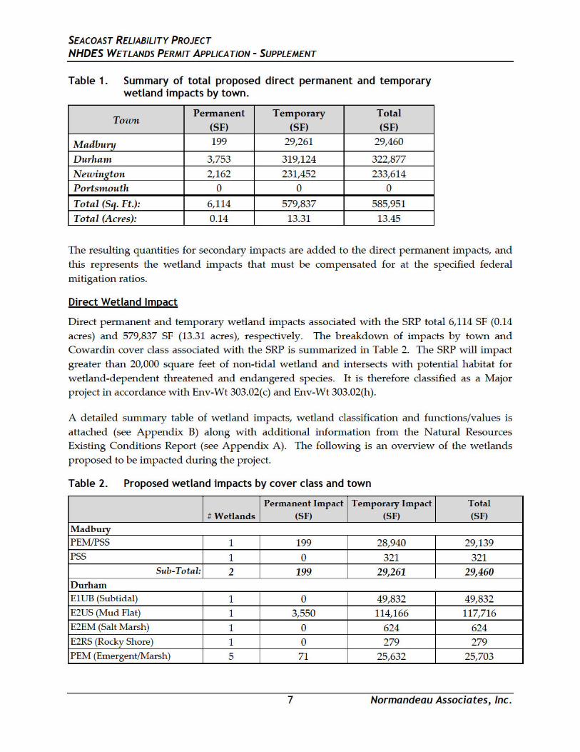
Table 1. Summary of total proposed direct permanent and temporary
wetland impacts by town..................................................................................................... 7
Table 2. Proposed wetland impacts by cover class and town ....................................................... 7
Table 3. Proposed stream impacts by town and flow regime with proposed
crossing type ........................................................................................................................ 10
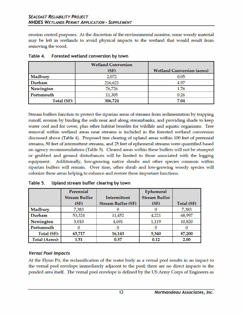
Table 4. Forested wetland conversion by town ............................................................................. 12
Table 5. Upland stream buffer clearing by town ........................................................................... 12
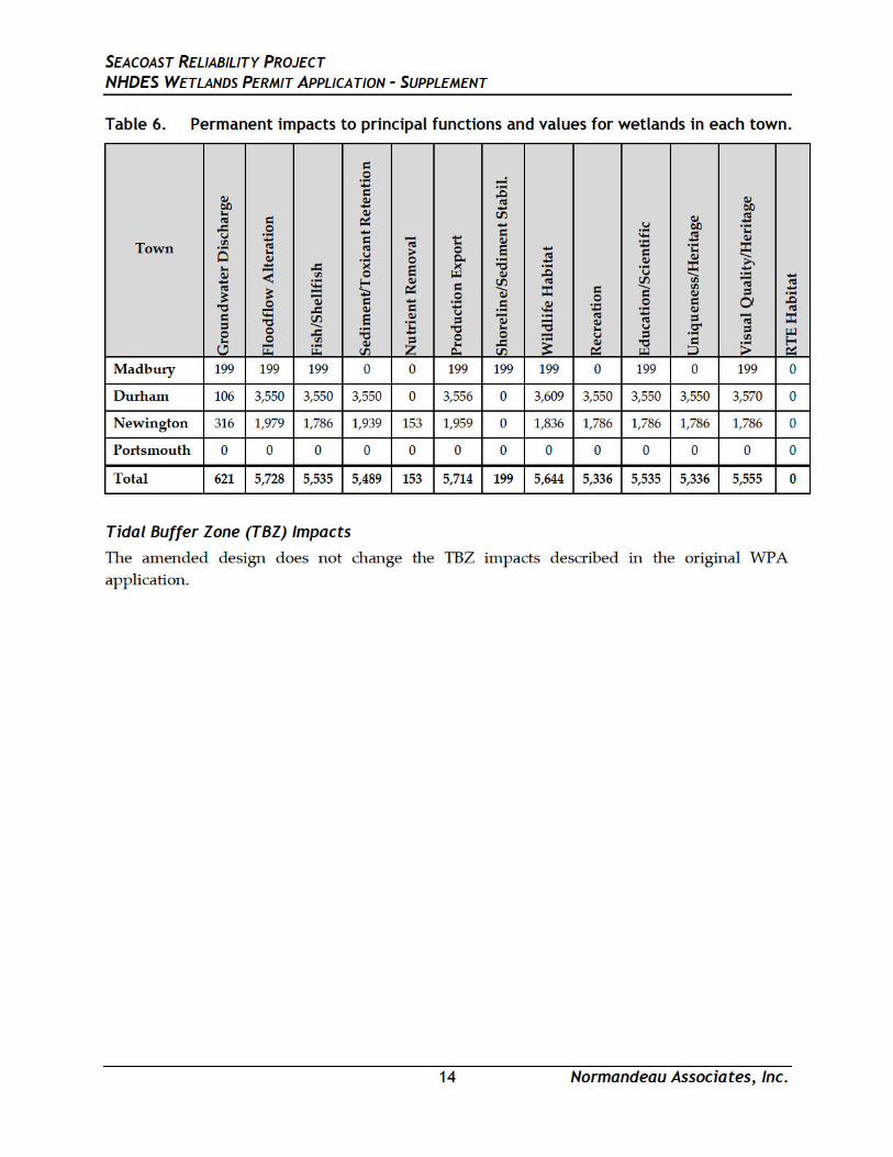
Table 6. Permanent impacts to principal functions and values for wetlands in
each town. ............................................................................................................................ 14
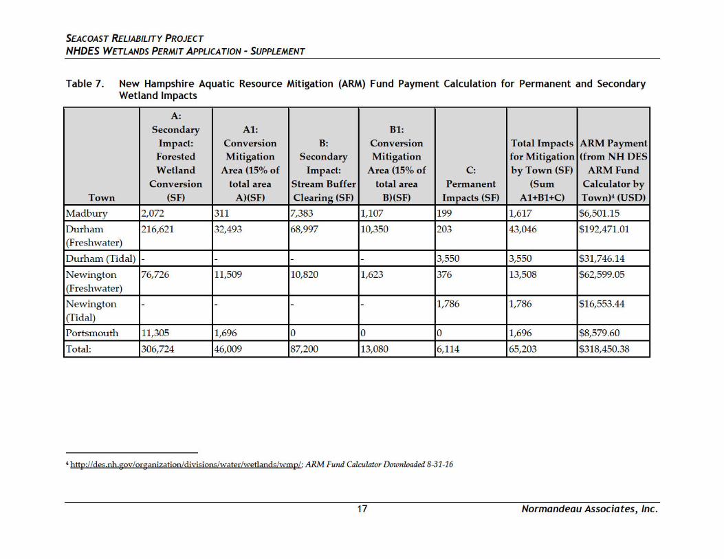
Table 7. New Hampshire Aquatic Resource Mitigation (ARM) Fund Payment
Calculation for Permanent and Secondary Wetland Impacts ...................................... 17
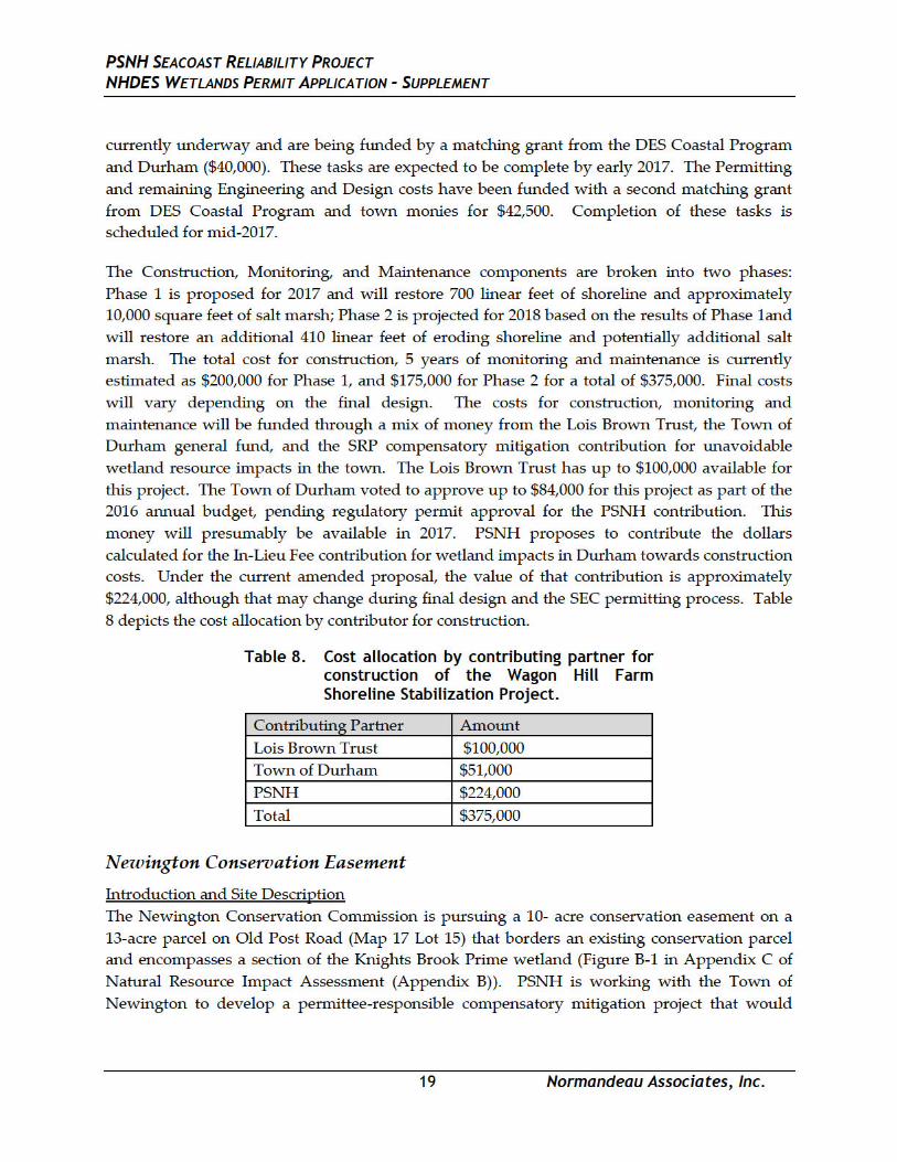
Table 8. Cost allocation by contributing partner for construction of the Wagon
Hill Farm Shoreline Stabilization Project......................................................................... 19
Table 9. Cost allocation by contributing partners for the Newington
Conservation Easement Acquisition. ............................................................................... 22

SEACOAST RELIABILITY PROJECT NHDES WETLANDS PERMIT APPLICATION - SUPPLEMENT
Normandeau Associates, Inc.
Note: Items are numbered according to the NH DES “Wetlands Permit Application Required Information” document Revised 1-20161
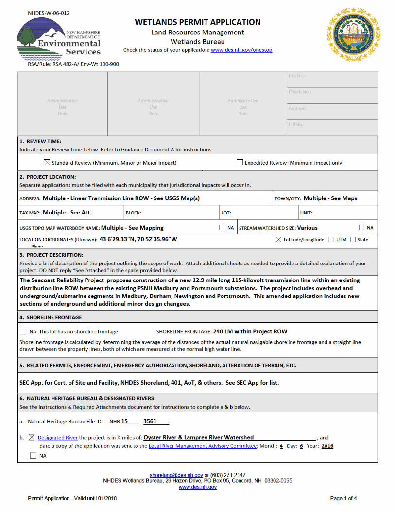
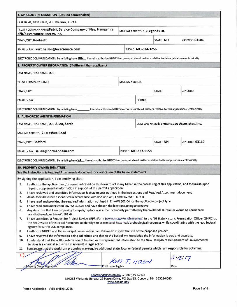
1-3 NH DES Wetlands Permit Application Form
1 http://des.nh.gov/organization/divisions/water/wetlands/categories/forms.htm


SEACOAST RELIABILITY PROJECT NHDES WETLANDS PERMIT APPLICATION - SUPPLEMENT
Normandeau Associates, Inc.
5. Statements in Response to the 20 Questions (Env-Wt 302.04)


SEACOAST RELIABILITY PROJECT NHDES WETLANDS PERMIT APPLICATION - SUPPLEMENT
1 Normandeau Associates, Inc.
6. The Seacoast Reliability Project: Project Description & Existing Conditions Narrative
Primary Project Overview
Based on the design modifications, certain descriptions of the Overhead Transmission Line
must be revised, which are outlined below. In addition, there are now three terrestrial sections
of the new 115 kV line that will be constructed underground with three solid dielectric
insulated cables installed in individual PE conduits. See Appendix 5(a) in the SEC application
for Amended Engineering Design Drawings.
Timber Brook Lane to Durham Point Road: Structures 64 to 94
As part of the amendment, this section as described in the original application now only applies
to Structures 64 to 91. All other details as described in this section remain as described in the
original application.
Durham Point Road Crossing: Structures 94 to 96
Based on the Project design, the description of the Overhead Portion of the Project in this
section now applies from Structures 91 to 96. All other details remain as described in the
original application.
Little Bay Crossing to Little Bay Road: Underground Cable
As part of this amendment, this segment of the Project will be installed as an underground cable
in a buried duct bank consisting of PE and PVC conduits. This segment will begin at a new
precast concrete manhole located in the corridor on the eastern side of Little Bay in Newington
and will proceed approximately 360 feet easterly to Gundalow Landing Circle in Newington.
The underground segment will continue approximately 1,000 feet along Gundalow Landing
Circle within the public ROW and within new easements across private and town property to
three self-supported steel transition structures located approximately 440 feet off Little Bay
Road. The total length of the underground segment is approximately 1,800 feet. The transition
structures will be approximately 65 feet in height and will have the cable terminations and
surge arresters located on davit arms in a horizontal configuration.
The proposed underground transmission line will consist of three solid dielectric insulated
cables installed in individual PE conduits. The nominal trench for the duct bank will be five (5)
feet wide by five (5) to eight (8) feet deep. The duct bank will consist of four 8-inch diameter PE
conduits, two 4-inch diameter PVC conduits for fiber-optic communication to protect the
transmission lines and one 2-inch diameter PVC conduit for a ground cable. The conduits will
be directly buried with a minimum of 30 inches of cover. Due to the more delicate nature of
fiber optic cable the allowable pulling lengths may not match the underground power cable. As
SEACOAST RELIABILITY PROJECT NHDES WETLANDS PERMIT APPLICATION - SUPPLEMENT
2 Normandeau Associates, Inc.
a result handholes, which are approximately 5 feet wide by 7 feet long, may be placed
approximately every 600 feet along the underground route.
Little Bay Road to Fox Point Road: Structures 102 to 115
As part of this Amendment, this section in the original WPA application shall be substituted
with the following description:
a. Little Bay Road to Frink Farm and the Newington Center Historic District: Structures 102 to 109
This section of the Project will be constructed within existing PSNH electric utility easements
and will consist only of the new 115 kV overhead transmission line. The new transmission
centerline will be located in the center of an approximately 100 foot wide corridor. The
structures along this portion of the Project will be direct embedded monopole, tubular self-
weathering steel with some multi-pole horizontal configuration structures. Span lengths will
average approximately 470 feet. The existing 34.5kV line will be removed in this section of the
corridor. Some of the new 115 kV overhead line conductors will be in a delta phasing
configuration on steel davit arms with suspension insulators. Others structures will utilize
multi-pole horizontal configurations with the conductor attached directly to the pole or on a
horizontal crossarm with suspension insulators. Shield wires will be attached directly to the
structures at the poles or on steel davit arms. Structure heights will vary between
approximately 65 feet and 80 feet above grade.
b. Newington Historic District to East Side of Nimble Hill Road and Hannah Lane Neighborhood (Structure 113): Underground Cable
This segment of the Project will be installed as an underground cable in a buried duct bank
consisting of PE and PVC conduits. The underground segment will be constructed within
existing ROW crossing under Nimble Hill Road to three self-supported steel transition
structures located approximately 1,200 feet off Nimble Hill Road. The total length of the
underground segment is approximately 2,680 feet. The transition structures will be
approximately 65 feet in height and will have the cable terminations and surge arresters located
on davit arms in a horizontal configuration. The existing 34.5kV line will be removed in this
section of the corridor.
The proposed underground transmission line will consist of three solid dielectric insulated
cables installed in individual PE conduits. The nominal trench for the duct bank will be five (5)
feet wide by five (5) to eight (8) feet deep. The duct bank will consist of four 8-inch diameter PE
conduits, two 4-inch diameter PVC conduits for fiber-optic communication to protect the
transmission lines and one 2-inch diameter PVC conduit for a ground cable. The conduits will
be directly buried with a minimum of 30 inches of cover. Due to the more delicate nature of
fiber optic cable the allowable pulling lengths cannot match the underground power cable. As a
result handholes, which are approximately 5 feet wide by 7 feet long, may be placed
approximately every 600 feet along the underground route.
SEACOAST RELIABILITY PROJECT NHDES WETLANDS PERMIT APPLICATION - SUPPLEMENT
3 Normandeau Associates, Inc.
c. East Side of Nimble Hill Road to Fox Point Road: Structures 113 to 115
This section of the Project will be constructed within existing PSNH electric utility easements
and will consist only of the new 115 kV overhead transmission line. The new transmission
centerline will be located in the center of an approximately 100 foot wide corridor. The
structures along this portion of the Project will be direct embedded monopole, tubular self-
weathering steel structures. The running angle and dead end structures will require the
installation of guy wires or reinforced concrete drilled pier foundations to support the applied
loads. Span lengths will average approximately 413 feet. The existing 34.5kV line will be
removed in this section of the corridor. Some of the new 115 kV overhead line conductors will
be in a delta phasing configuration on steel davit arms with suspension insulators. Shield wires
will be attached directly to the structures at the poles or on steel davit arms. Structure heights
will vary between approximately 80 feet and 84 feet above grade.
Description of General Environmental Setting
Vernal Pools
Continuing field studies of a water resource in the Newington Town Forest, locally referred to
as the Flynn Pit, resulted in a recommended change in its classification from a permanent pond
to a vernal pool. The findings during the field studies that support the reclassification are
provided below.
The SRP corridor was surveyed for potential vernal pools during wetland delineations. Each
potential vernal pool encountered was visually inspected for egg masses and/or larvae of
amphibian vernal pool indicator species during the spring 2014 vernal pool species breeding
season. A follow-up review of specific areas was also conducted in the spring of 2015 and
throughout 2016. A dip net was also used to survey for amphibian larvae and invertebrates.
Vernal pools were identified in accordance with the NHDES Wetland Rules (Env-Wt) 101.106
and Env-Wt 301.01, and procedures described in Identification and Documentation of Vernal Pools
in New Hampshire, published by the New Hampshire Fish and Game Department (NHFG 2004).
During the initial wetland and stream delineation in the summer and fall of 2013, two potential
vernal pools (PVPs) were identified. A follow-up survey was conducted in the spring of 2014,
during the appropriate season for confirming vernal pool characteristics, to identify any other
active vernal pools and to verify the previously identified PVPs, neither of which met the
definition of vernal pool habitat. Another vernal pool review was conducted in the spring of
2015 found a primary vernal pool indicator (wood frogs, Rana sylvatica) utilizing a portion of the
Flynn Pit, a permanently inundated pond surrounded by a forested wetland (NW 4). It used to
be maintained as a skating pond and still has a small warming hut. The pond did not meet the
definition of a vernal pool because of its permanent hydrology.
In 2016, a wetland scientist for the Town of Newington informed us of his observations of fairy
shrimp (presumably the common fairy shrimp Eubranchipus vernalis) in the Flynn Pit pond.
Fairy shrimp are considered a primary indicator species of vernal pools in NH. He described
SEACOAST RELIABILITY PROJECT NHDES WETLANDS PERMIT APPLICATION - SUPPLEMENT
4 Normandeau Associates, Inc.
them as abundant in the pool, and also described wood frog and spotted salamander
(Ambystoma maculata) egg masses. Normandeau revisited the pond multiple times in 2016. On
April 29, we recorded abundant fairy shrimp and 14 mature blue spotted salamander
(Ambystoma laterale) egg masses. No wood frog egg masses or larvae, or fish were observed.
We also recorded 2 adult green frogs (Rana clamitans) and 2 second-year green frog larvae. By
May 11, the fairy shrimp and the blue spotted salamander egg masses were gone, and we did
not record any blue spotted or other vernal pool larvae during 50 dip nets in a variety of
habitats around the pool. We observed over 100 second-year green frog larvae, as well as
leeches and many log-cabin caddisfly larvae. Water levels in both April and May ranged from
very shallow along the edge to approximately 30 inches in the center. Normandeau has
revisited the pond several more times (June 8, July 8, July 21, August 11 and August 19, 2016),
and found water in the pond through August 11, even in this time of severe drought, as
designated for the NH Seacoast Region by both DES and US Department of Agriculture2. On
the June and early July dates, surface water extended to almost the full pool line. In late July the
water had drawn down to the center (an estimated 18 inches deep) and the perimeter was
exposed, but for a few isolated pools. On August 11, the center pool was very reduced in size
and depth. By August 19, the center pool was dry.
Our conclusion is that the pond has a largely permanent hydrology in the center, given this year
of severe drought and late drying. However, the pond appears to provide sufficient drawdown
in many years along the edges to expose fairy shrimp eggs to drying, which is a necessary part
of their life cycle. Fairy shrimp eggs can persist in the substrate for multiple years, and await
suitable conditions before hatching. The lack of wood frog and blue spotted larvae during
sampling suggest that few survive to metamorphosis. The abundance of second-year green frog
larvae and leeches indicates that permanent water persists in most years in a portion of the
pond. The vegetation of the pond also reflects a range of hydrologic conditions, with
buttonbush (Cephalanthus occidentalis) dominating the edges and narrow-leaf burreed
(Sparganium angustifolium) and duckweed (Lemna minor) surrounding the open water in the
center of the pond. A variety of sedges and grasses occur in the drawdown zone.
This water body appears to function as both a permanent pond and a vernal pool, supporting
primary indicators of vernal pools (fairy shrimp, wood frogs and blue spotted salamanders),
and permanent pond species (green frog larvae and leeches). Fairy shrimp can complete their
life cycle in the early spring, before the typical pond predators are fully active. Although it may
act as an ecological sink for wood frogs and blue-spotted salamanders in most years, sufficient
larvae appear to succeed in metamorphosing to adults to maintain a breeding population.
Because of the presence of three vernal pool indicator species and the lack of fish, Normandeau
is considering the pond a vernal pool for regulatory purposes, but recognizes its dual
2 http://droughtmonitor.unl.edu/Home/StateDroughtMonitor.aspx?NH;
http://des.nh.gov/organization/divisions/water/dam/drought/documents/droughtstatus.pdf

SEACOAST RELIABILITY PROJECT NHDES WETLANDS PERMIT APPLICATION - SUPPLEMENT
5 Normandeau Associates, Inc.
functionality as both a vernal pool and a permanent pond. The functional value of the pond is
only moderate because its vernal pool functions are limited by its mostly permanent hydrology,
and its permanent pond functions are limited because it occasionally dries up.
Potential Project Impacts and Avoidance and Minimization Measures
Impact Avoidance
Within the proposed route, permanent and temporary impacts to water resources were avoided
where possible throughout the design and engineering phases of project development.
Multiple rounds of preliminary design reviews were conducted between project engineering
and environmental specialists. New structures were located outside of wetlands, unless
technical constraints pertaining to project corridor limitations, structure height and maximum
spans dictated that a structure be placed in a wetland resource. In the final design, 26 new
structures, of the 180 proposed new or relocated will be located within or partially within
wetland areas and will result in permanent impacts.
Access routes and temporary work pads for construction were similarly reviewed and wetland
crossings were avoided where possible. The required tree clearing along the edges of the
existing corridor limited the amount of wetland avoidance; however other methods such as
clearing during winter/frozen-ground conditions and hand cutting may be employed to
minimize temporary impacts associated with these activities (see below).
Impact Minimization
Engineering constraints limited the ability to avoid placing 26 new structures within or partially
within wetland areas, thus wetlands have been avoided by approximately 85 percent of the 179
proposed new or relocated structures. Additionally, it should be noted that approximately 51
existing distribution structures will be removed from wetland areas by utilizing double circuit
designs where necessary. The existing distribution line will be co-located on the same new
structures below the new transmission lines. This will result in the net decrease of 25 structures
within wetland areas.
Impact Analysis
Unavoidable direct and secondary impacts to water resources and associated upland buffer
areas were reviewed throughout the Project area. Direct impacts include permanent and
temporary disturbances, as discussed above (See Table 1). Secondary impacts were also
reviewed, including forested wetland conversion and upland clearing within perennial and
intermittent stream buffers. Forested wetland conversion will occur where forested wetland
areas within the SRP corridor are cleared to allow for the safe construction and operation of the
proposed transmission line. Temporary direct impacts from timber matting to allow for
mechanized clearing and construction of the transmission line will be necessary in these areas.
SEACOAST RELIABILITY PROJECT NHDES WETLANDS PERMIT APPLICATION - SUPPLEMENT
6 Normandeau Associates, Inc.
These areas will not be stumped or grubbed and soil disturbance will be minimal. The forested
wetlands will naturally convert to emergent or scrub-shrub resources following the clearing
activities. Upland stream buffer tree removal within 100 feet of perennial streams, 50 feet of
intermittent streams, and 25 feet of ephemeral streams was also quantified.
Expected Impact Types
Direct Permanent Impacts
Direct permanent impacts will result from the placement of new and relocated structures, their
associated foundations, and caissons; and other permanent fill consisting of concrete mattresses
in jurisdictional resource areas within Little Bay.
Direct Temporary Impacts
Direct temporary impacts will result from the placement of temporary construction mats, or
timber mats for access and construction activities, temporary mat bridges and culverts for
stream crossings, and temporary work pads for installing the structures. Direct temporary
impacts will also result where the underground portions of the line are installed in trenches
through jurisdictional natural resources. Conducting work during frozen or dry conditions will
also help to minimize disturbances to wetlands and streams. Where winter construction is not
possible, access across wetlands and streams will employ timber mats or other approved BMPs.
All access roads across wetlands and streams will be temporary and designed to minimize
impacts and surface water disturbance.
Secondary Impacts
Based on pre-application meetings with the federal regulatory agencies, secondary wetland and
stream impacts for the Project will include the conversion of forested wetlands to scrub-shrub
or emergent wetlands through tree clearing and clearing of upland forest within 100 feet of
perennial streams, 50 feet of intermittent streams, 25 feet of ephemeral streams.
For calculating the amount of secondary impacts that must be compensated for in the mitigation
package, the following guidance was provided by the federal agencies:
15% of forested wetland conversion in existing ROW
15% of upland stream buffers in existing ROW
SEACOAST RELIABILITY PROJECT NHDES WETLANDS PERMIT APPLICATION - SUPPLEMENT
9 Normandeau Associates, Inc.
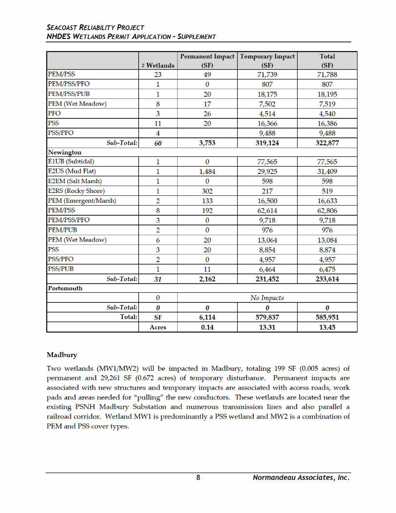
Durham
Sixty (60) wetlands will be impacted in Durham, totaling 3,753 SF (0.09 acres) of permanent and
319,124 SF (7.33 acres) of temporary impacts. Permanent impacts are associated with new
structures and concrete mattresses and temporary impacts are associated with access roads for
construction and tree clearing, trenched areas where the line will be installed underground,
work pads and work areas needed for “pulling” the new conductors. Temporary impacts are
also associated with the intertidal and subtidal areas of Little Bay which will be crossed via
submarine cable. The new transmission line will be installed via trench and jetplow depending
on the location and substrate. These areas will be returned to the original grade following
construction and restored where applicable.
The majority (80%) of the permanently impacted terrestrial wetlands are PEM/PSS wetlands,
wet meadow wetlands (PEM), or scrub-shrub (PSS) wetlands. The remaining wetlands are
other combinations of cover types including small area of forested and unconsolidated bottom
features. The permanent impacts to estuarine wetlands are limited to the potential need to
place concrete mattresses for cable protection in areas of intertidal mudflats (E2US) and a small
amount of intertidal rocky shore (E2RS). Subtidal unconsolidated bottom (E1UB) wetland in
Little Bay will also be temporarily impacted during the installation of the submarine cable along
with small areas of intertidal wetlands, including salt marsh (E2EM), intertidal rocky shore
(E2RS) and areas of intertidal mudflats (E2US).
Newington
Thirty-one (31) wetlands will be impacted in Newington, totaling 2,162 SF (0.05 acres) of
permanent and 231,452 SF (5.31 acres) of temporary impacts. Permanent impacts are associated
with new structures on land and concrete mattresses in Little Bay. Temporary impacts are
associated with access roads for construction and tree clearing, trenched areas where the line
will be installed underground, work pads and areas needed for “pulling” the new conductors.
Temporary impacts are also associated with the intertidal and subtidal areas of Little Bay which
will be crossed via submarine cable (see description, above).
As with Durham, the majority (98%) of the permanently impacted terrestrial wetlands are
PEM/PSS wetlands, wet meadow wetlands (PEM), or scrub-shrub (PSS) wetlands and the
remaining wetlands are combinations of cover types including wetlands with small areas of
forested cover along the edges of the ROW. Subtidal unconsolidated bottom (E1UB) wetlands
in Little Bay will also be temporarily impacted during the installation of the submarine cable.
Additionally, small areas intertidal rocky shore (E2RS) and mudflats (E2US) will also be
permanently and temporarily impacted.
Portsmouth
No permanent impacts are proposed in Portsmouth. Adjustment of the workpads during the
amendment review resulted in the Project avoiding all temporary impacts in Portsmouth.
SEACOAST RELIABILITY PROJECT NHDES WETLANDS PERMIT APPLICATION - SUPPLEMENT
13 Normandeau Associates, Inc.
a 100-foot band immediately adjacent to the high water mark of the pool to provide shade to the
vernal pool and peripheral habitat for amphibians metamorphosing to terrestrial conditions.
The proposed underground cable will result in temporary impacts to 7,377 square feet in the
vernal pool envelope, of which all will be restored and allowed to revegetate with native
species, although a 25-foot wide permanent easement corridor will be periodically mown to
maintain access to the underground cable.
Effects on Wetland Functions and Values
Permanent impacts to wetlands and streams were avoided and minimized wherever possible.
The remaining unavoidable permanent impacts to terrestrial (palustrine) wetlands are relatively
minor in extent (778 SF) and distributed across 26 structures in 24 wetlands. Table 6
summarizes the total proposed permanent impact to each principal wetland function or value in
each town. These data do not include functions or values that a wetland is classified as suitable
for, as the wetland was not observed performing this function or value within or immediately
adjacent to the ROW area. Additionally, because wetlands can have multiple principal
functions or values, proposed permanent impacts to a given function or value will exceed the
total permanent impact to each given wetland. The functions most commonly associated with
the permanently impacted wetlands include groundwater discharge, flood flow alteration,
production export, sediment/toxicant retention and wildlife habitat. The small footprint of the
new transmission line structures is not expected to affect the existing wetland functions or
values. The impacted wetland areas are primarily located within an existing electric corridor
and are already subject to periodic maintenance including clearing and other repair work.
Temporary impacts are anticipated to have minimal adverse effects on the functions and values
associated with the impacted wetland systems. Applicable construction BMPs, on-site
monitoring, and restoration of temporarily impacted areas according to standards and based on
agency recommendations will be employed (Section 4.0).
SEACOAST RELIABILITY PROJECT NHDES WETLANDS PERMIT APPLICATION - SUPPLEMENT
15 Normandeau Associates, Inc.
7. Mitigation Narrative
Permanent and secondary impacts that are unavoidable due to safety, engineering, or
landownership issues or constraints will be mitigated through compensatory mitigation.
The mitigation plan was developed in accordance with the New Hampshire Wetland Rules
(Env-Wt 800) and federal regulatory rules for mitigation in New England under Section 404
of the Clean Water Act (40 CFR Part 230). It incorporates views of state and regional federal
regulators with the NHDES Wetlands Bureau, USACE, the US EPA, NHFG, and USFWS per
pre-application meeting discussions, as recorded in meeting and phone conversation notes.
Compensatory Wetland Mitigation Narrative
Compensatory mitigation is proposed for unavoidable impacts to permanent wetland fill,
and conversion of forested wetlands and stream buffers as a result of tree clearing. The first
steps in mitigating wetland impacts are to avoid and minimize impacts. This has been a key
component of the design for SRP project. The Project design team has worked with
engineers and natural resource scientists to make design changes in order to avoid and
minimize wetland impacts wherever possible.
Permanent direct wetland impacts are below the NHDES threshold for mitigation (10,000 SF
of permanent wetland impact). Secondary impacts due to tree removal are in accordance
with applicable U.S. Army Corps of Engineers (“USACE”) regulations and guidance,
however, compensatory mitigation is proposed for direct and secondary Project impacts to
wetlands and stream buffers.
SRP wetland resource impacts are currently calculated as 5,336 square feet of permanent
estuarine impact, 778 square feet of permanent terrestrial wetland impact, 306,724 square feet
of forested wetland conversion and 87,200 square feet of upland stream buffer clearing.
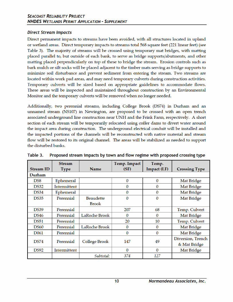
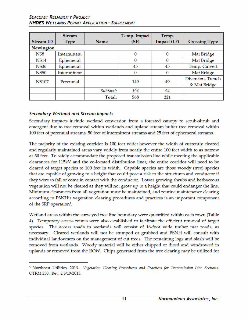
Direct temporary impacts to streams total 568 square feet (221 linear feet). No direct impacts
to vernal pools occur, but temporary impacts (7,377 square feet) will occur within the 100-
foot vernal pool envelope of a vernal pool in Newington. A qualitative assessment of 13
wetland functions and values using the USACE Highway Methodology found that, while
multiple functions were provided to some degree by most wetlands, the principal functions
were the distinguishing features among the wetland types. The most common principal
functions include: Groundwater Recharge/Discharge, Wildlife Habitat, Production Export,
Sediment/Toxicant/Pathogen Retention, Flood flow Alteration and Nutrient Retention.
Because of the linear nature of the Project and its wetland resource impacts, high value
within-project mitigation would be difficult. The Project includes four towns, multiple
watersheds and a variety of freshwater and estuarine resources. During agency pre-
application meetings, NHDES and USACE agreed that in-lieu fee payment into the State’s
Aquatic Resource Mitigation fund was appropriate compensatory mitigation for a linear
SEACOAST RELIABILITY PROJECT NHDES WETLANDS PERMIT APPLICATION - SUPPLEMENT
16 Normandeau Associates, Inc.
project such as the SRP. Mitigation ratios were applied to these anticipated impacts in
accordance with the New England Army Corps of Engineers Mitigation Guidance document and
in coordination with the USACE and NHDES.
Calculations for payment into the In-Lieu Fee program based on the types and extent of
wetland impacts by town are shown in Table 7. The dollar value shown in Table 7 may
change during the review process with NHDES and USACE should design modifications
result in changes in wetland impacts. Note that the calculated ARM Fund Payment has
increased by $8,479.27 over the original Application value to a total of $318,450.38 following
the modifications to the design included in this amended permit application filing.
Although wetland impacts declined overall as a result of the amended design, the updated
values for the 2016 Aquatic Resource Mitigation equalized values increased for most of the
towns and resulted in the increased ARM fund payment.
Since the SRP SEC permit application was submitted on April 12, 2016, the Towns of
Durham and Newington have developed permittee-responsible mitigation projects,
summarized below. Both concepts have merit for compensation for different aspects of
wetland resource impacts by the SRP if the regulatory agencies concur.
Durham - Wagon Hill Farm
Introduction and Site Description
The Town of Durham has proposed a shoreline stabilization project to reduce the amount of
erosion from the Wagon Hill Farm shoreline bordering the Great Bay Estuary and the Oyster
River and restore salt marsh that has already eroded. Wagon Hill Farm is Town-owned
conservation land consisting of 139 acres with 1,100 feet of tidal frontage on the Little Bay,
Oyster River and Smith Creek, and 8.5 acres of tidal and freshwater wetlands. The project
proposes to stabilize a portion of the existing eroded shoreline, which is partially the result of
uncontrolled foot and pet traffic along the shoreline. The erosion been exacerbated by rising
sea level; wind, wave and ice action; and shading from mature trees on the bank. This
erosion is continuing to degrade shoreline and salt marsh habitats and has negative impacts
on wildlife, shellfish, and fish habitats. The erosion reduction plan proposes to stabilize and
restore the shoreline using a living shoreline concept, as well as measures to halt foot traffic
in the sensitive areas by re-designing nearby walking paths to discourage off-path travel,
using fences and viewing platforms on the adjacent upland, and installing clear signage
along the shoreline area.
PSNH SEACOAST RELIABILITY PROJECT NHDES WETLANDS PERMIT APPLICATION - SUPPLEMENT
18 Normandeau Associates, Inc.
Proposed Project
There are two primary objectives for this project: one) design and build a new shoreline that has
both structural and biological elements, a living shoreline, that will minimize erosion, and two)
re-establish the degraded salt marsh to further protect the shoreline. The resulting stabilized
and restored shoreline will help to protect the water quality and aquatic habitats of the Oyster
River and the Great Bay Estuary including the adjacent Salt Marsh and Sparsely Vegetated
Intertidal systems, both of which are Exemplary Natural Communities documented by
NHNHB. Preliminary estimates suggest that approximately 10,000 square feet of salt marsh,
plus approximately 1,100 linear feet of adjacent shoreline could be restored. The Town of
Durham has partnered with University of New Hampshire coastal ecologists (Dr. David
Burdick and Dr. Greg Moore) and coastal engineer (Dr. Tom Ballestero) and DES Coastal
Program staff (Kirsten Howard and Kevin Lucey) to secure funding, collect baseline data, and
design the living shoreline solution. This solution will likely include a combination of
nearshore deflectors and energy dissipaters to protect against wave and ice action, enhancement
of the existing salt marsh, and restoration of salt marsh previously lost to erosion, as well as
protection of an upland area preserved for marsh migration as sea level rises. A 5-year
monitoring program is proposed to study and assess the results of the project. Performance
criteria will be established for evaluating the project with respect to the primary objectives (e.g.,
minimizing erosion and salt marsh development). Erosion and vegetation development criteria
will be based on current erosion rates, salt marsh conditions and the design that is chosen for
the site. The partnership between the town, UNH and DES will bring innovative techniques for
addressing shoreline erosion and protection from human-caused destabilization. A successful
project would serve as an example solution for addressing similar erosion problems elsewhere
in the Great Bay Estuary. The details of the University of New Hampshire proposal are
provided in Appendix B of Natural Resource Impact Assessment (Appendix B).
SRP Mitigation Proposal
The Wagon Hill Farm shoreline stabilization project provides the opportunity for the SRP to
compensate for unavoidable wetland impacts in Durham. These impacts include
approximately 778 square feet of permanent impact caused by SRP structures in freshwater
wetlands, up to 3,550 square feet of permanent impact from concrete mattresses on tidal flats,
and conversion of forested wetlands and stream buffers as a result of tree removal within the
SRP project corridor. The shoreline stabilization project at Wagon Hill Farm will restore
deteriorated or fully eroded salt marsh, and will reduce the loss of shoreline habitats and the
associated sediment loading into critical estuarine habitats. Direct functional benefits to
wetland habitats will include restoration and enhancement of Sediment and Shoreline
Stabilization, Wildlife Habitat, Fish and Shellfish Habitat, and Production Export functions.
The Wagon Hill Farm project has been divided into phases for funding sources and milestones
as shown on the attached schedule: Data Collection, Permitting, Engineering and Design,
Construction, and Monitoring (see Appendix B of Natural Resource Impact Assessment
(Appendix B)). Data collection and conceptual design under Engineering and Design are

PSNH SEACOAST RELIABILITY PROJECT NHDES WETLANDS PERMIT APPLICATION - SUPPLEMENT
20 Normandeau Associates, Inc.
offset the wetland functional impacts of the Seacoast Reliability Project, and meet the town’s
goal of protecting this valuable parcel for wetland and wildlife habitat.
The Knights Brook system has been a top priority for conservation in Newington, and is listed
as such in their 2009 Master Plan. The 10 acres proposed for easement support approximately
3.7 acres of wetland including a 200-foot section of Knights Brook, several springs, forested
wetlands, shrub wetlands, wet meadow, and emergent marsh. The adjacent uplands are a mix
of mowed fields and upland forest. A more detailed description of the habitats on site is
provided in the Knights Brook Watershed Protection ARM Fund Pre-Proposal in Appendix C of
Natural Resource Impact Assessment (Appendix B).
The landowners are retaining 3 acres of upland which contain their house, gardens and most
outbuildings. They want to continue to maintain and use a set of walking paths through the
easement lands. The walking paths are mowed grasses in the fields and a mix of cleared
ground and bark mulch in the woodlands. Several wetland crossings have boardwalks and low
bridges that were permitted in 2008.
A large portion of the parcel is ranked as Tier 1 habitat (Highest Ranked Habitat in NH) under
the 2015 Wildlife Action Plan, with Knights Brook and its wetlands ranked as Supporting
Landscape (Figure B-2). The Tier 1 ranking is assigned to the mowed fields, in recognition of
their habitat value for a number of bird species with declining populations in NH. The
landowners have stated their intention to continue mowing the fields under the conservation
easement.
The parcel is adjacent to, or in close proximity to, existing protected lands along the Knights
Brook corridor totaling approximately 100 acres (Figure B-1). These include a 38-acre parcel
(Map 17, Lot 8) under an agricultural easement that is predominantly hay fields and pasture,
and contains considerable riparian habitat and a tributary to Knights Brook. Abutting the
proposed parcel is a 36-acre conservation easement (Map 16, Lot 8) that contains a mix of
wetland and forested upland and approximately 1,600 linear feet of Knights Brook. North of,
and adjacent to, the 36-acre lot is a 26-acre parcel owned by the Town (Map 10, Lot 14), also
under a conservation easement. This parcel abuts approximately 700 linear feet of Knights
Brook and protects its riparian wetland as well as additional upland buffer. The acquisition of a
conservation easement on the proposed parcel would increase the size of this block of protected
lands, which also increases its value as watershed protection and wildlife habitat.
Project Status
With the help of the Rockingham County Conservation District, the Newington Conservation
Commission (NCC) submitted an ARM Fund pre-proposal on April 22, 2016, to secure
additional funds for the purchase of the conservation easement (Appendix C of Natural
Resource Impact Assessment (Appendix B)). The DES response indicated that the project needs
to develop a functions and values assessment, a stewardship plan that addresses the use of the
existing trails, puts limits on construction of new trails, and creates vegetative buffers to protect
PSNH SEACOAST RELIABILITY PROJECT NHDES WETLANDS PERMIT APPLICATION - SUPPLEMENT
21 Normandeau Associates, Inc.
aquatic habitat. Since that time, the NCC has gotten a formal appraisal of the value of the
easement, a full functions and values assessment, and is currently negotiating the terms of the
easement with the landowners using the DES conservation easement template. This easement
commits the landowners to no new trail construction and limits the use of the existing trails for
their private purposes only.
The DES had originally requested that a natural vegetative buffer be restored along the edges of
all wetlands to protect water quality and wildlife habitat. After reviewing the Tier 1
designation of the mowed fields, DES has agreed that the value of the fields and wet meadow
outweighs the benefits of the natural buffer along most of the wetlands. DES is requesting that
a natural buffer along the wetland edge on the western edge of the mowed fields to protect the
wetlands bordering Knights Brook. The landowners have agreed to allow a 100-foot natural
buffer to regenerate in that area, although their footpath will remain. A Letter of Intent was
signed between the landowner and the NCC, dated September 1, to commit to the purchase of
the conservation easement (Appendix C of Natural Resource Impact Assessment (Appendix B)).
A draft of the easement is also provided in Appendix C of Natural Resource Impact Assessment
(Appendix B). The NCC will be the easement holder and has committed to annual monitoring
to ensure the terms of the easement are maintained.
SPR Mitigation Proposal
The Newington Conservation Easement project provides the opportunity for the SRP to
compensate Newington for unavoidable permanent impacts caused by SRP structures in
freshwater wetlands (approximately 778 square feet), up to 1,800 square feet of permanent
impact from concrete mattresses on tidal flats and rocky shore, and conversion of forested
wetlands and stream buffers as a result of tree removal within the SRP project corridor. Placing
a conservation easement on this parcel will protect a section of Knights Brook and its Prime
Wetland, and will enlarge an existing protected block of habitat in a section of town with
development potential. It will also narrow a gap in protection between two existing
conservation easements. Direct functional benefits to wetland habitats will include protection
and enhancement of Groundwater Discharge, Floodflow Alteration, Shoreline Stabilization,
Sediment/Toxicant Removal, Nutrient Removal, Wildlife Habitat, and Production Export
functions.
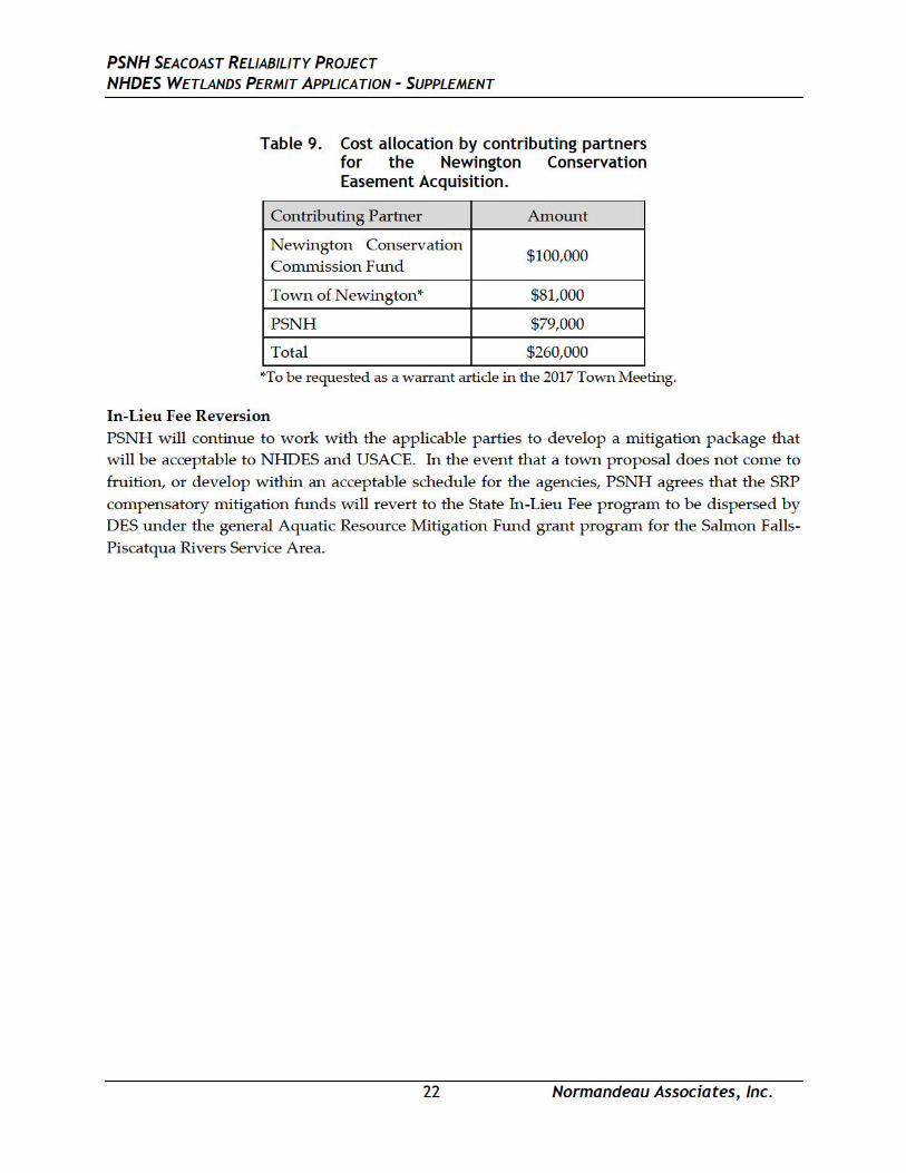
The 2016 appraisal value of the conservation easement is $260,000. PSNH proposes to
contribute the dollars calculated for the In-Lieu Fee contribution for wetland impacts in
Newington towards the purchase of the easement. Under the current amended proposal, the
value of that contribution is approximately $79,000, although that may change during final
design and the SEC permitting process. The NCC has committed $100,000 from their
conservation fund, and will request the remaining monies (estimated as $81,000) to be raised at
through a special warrant article at the 2017 Town Meeting. Table 9 depicts the cost allocation
by contributor for purchase of the easement.
PSNH SEACOAST RELIABILITY PROJECT NHDES WETLANDS PERMIT APPLICATION - SUPPLEMENT
23 Normandeau Associates, Inc.
9. NH Programmatic General Permit (PGP) Requirements
U.S. Army Corps of Engineers New Hampshire PGP Appendix B—Corps Secondary Impacts Checklist
The only change in the Corps Secondary Checklist due to the amendment was updated
information for historic resources (Section 5).
5. Historic/Archaeological Resources
Coordination with NH Division of Historic Resources (NHDHR) has been ongoing throughout
the amendment process. The new underground segments were included in the Phase I-A
archeological survey and the results of that survey apply equally to the redesigned route. Since
that time, a Phase I-B archeological survey has also been completed. The results of the study are
that archeological resources are absent in 26 of the 28 Phase 1-A locations. For those locations,
no further survey is recommended and archeological sensitivity is no longer assigned. For the
remaining two sites, the Project’s archeological consultant has recommended one site be
considered as potentially eligible for listing on the National Register of Historic Places and that
impact to this site should be avoided. The Project will avoid direct impacts to the cellar hole and
employ matting or capping to protect adjacent archeological resources. The Project’s
archeological consultant has also recommended that the second site, also in Durham, be
considered not eligible for listing on the National Register of Historic Places. Therefore, no
further survey is recommended for this second site. The archeologic Phase 1-B report was filed
with NHDHR on September 28, 2016.
Changes to the Project design have further minimized or eliminated the effects of the Project on
two properties: the Newington Center Historic District (“Historic District” or “District”) and the
Pickering-Rowe House. With the new underground design, the transmission line will be sited
underground at the western edge of the Historic District and will run underground for its entire
length. The transition structure to the west will be located in a wooded area at the very edge of
the boundary of the Frink Farm parcel. It will be visible within the District only by looking
down the transmission right-of-way (i.e., west along the existing right-of-way away from the
district) and from the abutting public roadway (Nimble Hill Road). The transition structure to
the east will be located in a wooded area approximately 1,200 feet east of the district.
Furthermore, as part of the Project, PSNH will remove the existing 34.5 kV distribution line that
currently crosses the Newington Center Historic District and travels across the Frink Farm.
This, in combination with the new underground design, virtually eliminates potential visual
impacts to the Historic District, and it means that the Project will not have an adverse effect on
the District. Therefore, no additional mitigation measures are necessary relative to this resource.

PSNH SEACOAST RELIABILITY PROJECT NHDES WETLANDS PERMIT APPLICATION - SUPPLEMENT
24 Normandeau Associates, Inc.
Because of the new underground design at the Historic District, the transmission line will also
not be visible in significant views from the Pickering–Rowe House. The one overhead
transmission structure that was to be located in the view from the Pickering-Rowe House
toward the Newington Center Historic District is no longer part of the design. This will
eliminate any effects to the historic house and no additional mitigation measures will be
necessary.
PSNH SEACOAST RELIABILITY PROJECT NHDES WETLANDS PERMIT APPLICATION - SUPPLEMENT
Normandeau Associates, Inc.
16. Plans (Env-Wt 501.02, Chapter Env-Wt 900) Detailed plans depicting amended wetland impacts are included on the Environmental Maps (see also SEC Appendix 2(a)).
PSNH SEACOAST RELIABILITY PROJECT NHDES WETLANDS PERMIT APPLICATION - SUPPLEMENT
Normandeau Associates, Inc.
17. Appendices
PSNH SEACOAST RELIABILITY PROJECT NHDES WETLANDS PERMIT APPLICATION - SUPPLEMENT
Normandeau Associates, Inc.
Appendix A: Natural Resource Existing Condition Report See Appendix 7 from original SEC Application and Appendix 7(a) of this Amended SEC Application
PSNH SEACOAST RELIABILITY PROJECT NHDES WETLANDS PERMIT APPLICATION - SUPPLEMENT
Normandeau Associates, Inc.
Appendix B: Natural Resource Impact Assessment See Appendix 34 from original SEC Application and Appendix 34(a) of this Amended SEC Application