Embed Size (px)
Citation preview
PSN xx : 2012
MANUAL Banjir Bandang Disaster Management
final draft version
Manual for Preparation of Early Warning and Evacuation System
for Banjir Bandang
MINISTRY OF PUBLIC WORKS


PSN xx : 2012
This manual has been revised by several stakeholders, namely:
1. Ir. Arung Samudro Directorate of River and Coastal
2. Ir. Sudarsono, CES Directorate of Operations and Maintenance
3. Ir. Hariyono Utomo, ST. MM Directorate of River and Coastal
4. Dr. Untung Santoso Balai Sabo
5. Ir. Agus Sumaryono, Dip. HE. Balai Sabo
6. Drs. Sutikno Hardjosuwarno, Dip. HE. Balai Sabo
7. C. Bambang Sukoco Balai Sabo
8. Arif Rahmat Mulyana, ST. Balai Sabo
9. Ir. H. Mulyanto Dip. HE. Practitioner
10. Ir. Subarkah, Dip. HE. Practitioner
11. Ir. Haryono K., Dip. HE. Practitioner
12. A. Lesto P. Kusumo Practitioner

PSN xx : 2012
i
Table of contents
Table of contents .................................................................................................................... i
Foreword ............................................................................................................................... iii
Introduction ........................................................................................................................... iv
1. Scope ........................................................................................................................... 1
2. Normative references.................................................................................................... 1
3. The introduction of banjir bandang ................................................................................ 1
3.1 Banjir bandang description ............................................................................................ 1
3.2 Natural dam .................................................................................................................. 2
3.3 Landslide ....................................................................................................................... 2
4. Terms and definitions.................................................................................................... 3
5. Data and information .................................................................................................... 5
6. Terms and conditions.................................................................................................... 6
6.1 The use of manual ........................................................................................................ 6
6.2 Conditions of implementing the manual ......................................................................... 6
6.3 Basic principles of early warning system ....................................................................... 6
6.4 The information that needs to disseminated to the communities in early warning
system .......................................................................................................................... 6
6.5 Goods that must be taken at the time of evacuation ...................................................... 7
6.6 The objectives of simulation .......................................................................................... 7
6.7 Required equipments in the evacuation simulation ........................................................ 7
7. The implementation steps ............................................................................................. 8
7.1 Establishment of a banjir bandang early warning system .............................................. 8
7.1.1 Forecasting method ................................................................................................. 8
7.1.2 Monitoring and warning service .............................................................................. 10
7.1.3 Dissemination and communication ......................................................................... 10
7.1.4 Preparation and emergency response .................................................................... 10
7.1.5 Establishment of early warning team ...................................................................... 11
7.2 The establishment of banjir bandang evacuation system ............................................ 11
7.2.1 Pre-disaster ............................................................................................................ 11
7.2.2 When disaster occurs ............................................................................................. 13
7.2.3 Post-disaster .......................................................................................................... 13
7.3 Making the SOP .......................................................................................................... 14
Appendix A - Flowchart ........................................................................................................ 15
Appendix B - Figure ............................................................................................................. 23

PSN xx : 2012
ii
Appendix C - Table .............................................................................................................. 28
Appendix D - The steps to determine the standard rainfall value for banjir bandang early
warning ................................................................................................................................ 33
Appendix E - Form for setting the standard rainfall .............................................................. 41
Appendix F - Example of calculation of the standard rainfall value for banjir bandang early
warning ................................................................................................................................ 44
Appendix G - Examples of rain gauge .................................................................................. 54
Appendix H - Steps to make the SOP .................................................................................. 57
Appendix I - Abbreviations ................................................................................................... 64
Bibliography ......................................................................................................................... 65

PSN xx : 2012
iii
Foreword
Manual for Preparation of Early Warning and Evacuation System for Banjir Bandang contains technical instructions about steps to prepare an early warning system and evacuation system for banjir bandang disaster. This manual refers to the results of research and literatures regarding banjir bandang in Japan, but has been adapted to the local situation in Indonesia. These guidelines are intended as guidelines and preliminary information to establish a standard procedure in every region in terms of action during the evacuation of banjir bandang disaster, so the impact of disaster that might occur in the future does not cause loss of property and loss of life. With these manual it is expected that all local governments throughout Indonesia whose territory is prone to banjir bandang, can use this manual independently to prepare an early warning system and evacuation in accordance with their respective regions, as an efforts to control the flood disaster in Indonesia.
PSN xx : 2012
iv
Introduction
Indonesia is a country with very high potency of natural disaster. One of it is banjir bandang (flash floods). To reduce the negative impact of this disaster, it is necessary to plan an early warning system and evacuation system that precise and purposeful. Early warning and evacuation system is one of disaster management action. Early warning system is performed for taking prompt action in order to reduce the risk of disasters and prepare emergency response measures. While the evacuation action is a form of protection against those most vulnerable to disaster, which the effective and efficient evacuation requires cross-sectoral cooperation, and it have to be implemented in accordance with government regulation i.e. Act No. 24 of 2007 of the Republic of Indonesia. Community familiarity with banjir bandang disaster and knowledge or technology that is disseminated at an early age, can facilitate the process of building a generation that always ready and responsive in an emergency when banjir bandang occurs.
PSN xx : 2012
1 from 66
Manual for Preparation of Early Warning and Evacuation System for Banjir Bandang
1. Scope This manual describes procedures for preparation of early warning and evacuation system to area prone to banjir bandang. The objective of this manual is that the central government and BPBD/local governments can prepare early warning and evacuation system independently as an effort in disaster management. This manual should help local government officials and community in managing banjir bandang disaster in their respective regions independently. Banjir bandang can be caused by the rapid concentration of heavy rain, the collapse of natural dams that occurred in the upstream river, as well as the collapse of dam and/or artificial embankment. This manual presents the preparation method of early warning and evacuation system for banjir bandang caused by collapse of natural dam and also banjir bandang caused by rapid concentration of heavy rain as an alternative method. 2. Normative references These manual cannot be implemented without using a reference documents below. PSN 08:2007, Indonesian National Standards Development. PSN 03-1:2007, Adoption of international standards and other international publications to the Indonesian National Standard - Part 1: Adoption of the standard ISO / IEC. ISBN 978-979-8763-09-0, Guideline to operating the Early warning system - a community-based flood debris in the river Jeneberang. ISBN 978-602-96989-1-6, SABO operating instruction - Introduction of the building control sediment. ISBN 978-602-96989-3-0, SABO operating instruction – Planning of the building control sediments. 3. The introduction of banjir bandang 3.1 Banjir bandang description Banjir bandang is a flood that occurs suddenly and powerful. Banjir bandang formed in the range of a few minutes to several hours after a heavy rain in a short time on the watershed or on a narrow river channel on the upstream. The flow the river has a short time of concentration, so that runoff can quickly accumulate in the river channel. Banjir bandang characteristics: - has a peak discharge which jumped suddenly and subsided again quickly; - has a big volume and high flow rate; - has a very big flow transport capacity and erosion power, so can bring the material
erosion toward downstream direction; - the flow that bring debris material can lead to catastrophic sediment in downstream
areas after the apex point.
PSN xx : 2012
2 from 66
The causes of the occurrence of banjir bandang are: - Accumulation of heavy rainfall that fell in a short time duration on river upstream
watershed, where then the volume of water collected in a short time into the river channel, causing a large spike and sudden discharge exceeds the capacity of the flow path downstream.
- The collapse of dam, levee or natural dam that occur because of the accumulation of landslide material on river channel.
3.2 Natural dam The collapse of natural dams is one of the main causes of banjir bandang, therefore the following will be discussed more about the formation process and the cause of collapse of natural dams. The formation process of natural dams: - because of the landslide;
landslide material in the form of soil, rocks, or trees, can fall into the river and immediately form a dam. In other cases, the landslide material can be carried away by the flow and clog the river flow on the bottleneck pattern that will gradually form a dam.
- because of illegal logging in the uplands. logs with irregular size accompanied by the roots and branches of trees that are the result of illegal logging, it can slowly drawn into river upstream, so can block the river flow naturally.
The cause of the collapse of natural dams: - Overtopping; the river water that is blocked by natural dam, slowly increase the water level. When the
water level has reached the upper limit of the dam, the water will begin to spill over the dam as well as grinding dam material until all dam material eroded. This incident caused the river water becomes turbid.
- Piping; air sungai yang terbendung oleh bendungan alam, dapat mengalir ke dalam tanah
menyusur dasar dan dinding bendungan alam. Jika mencapai kecepatan kritis, butiran tanah akan terbawa sehingga terjadi peristiwa piping sehingga akhirnya bendungan alam dapat runtuh. Kejadian ini sering menyebabkan air sungai menjadi keruh.
- Liquefaction; is the phenomenon of loss of soil strength due to soil saturation and (earthquake)
vibration. At the time of vibration, pore water pressure within the layer of soil/sand can be increased, approaching or exceeding the vertical stress so that the force of friction between the sand particles becomes lost. This resulted in soil strength decreases drastically. At this time, a layer of soil/sand can turn into a liquid that cannot sustain the burden of dams in or on top of it. This event often occurs because of heavy rainfall or a discharge that causes a large vibration or rumbling sound which heard as the signs.
3.3 Landslide Natural dam generally formed by landslide material. The characteristics of landslide prone areas and their cause factors will be explained below. In principle, a landslide occurs when the driving force on slopes greater than anchoring force. Anchoring force is generally influenced by the strength of rock and soil density, while the driving force is influenced by the magnitude of the slope angle, water, heavy loads and types of soil/rock. Characteristics of landslide prone areas:
PSN xx : 2012
3 from 66
- Has high rainfall intensity; Long dry season caused the large numbers of evaporation water on the soil surface. This resulted the pores or cavities of land and thus the land surface to crack and fissure. When the rain falls with a high intensity, water will infiltrate into the cracks to make the soil becomes saturated in a short time and can accumulate at the bottom of the slope, so create the lateral movement and landslide occur.
- Classified as a slope area/steep cliffs; Slope or cliffs that would enlarge the driving force can trigger the landslides.
- The content of the soil is less dense and thick; The type of less dense soil is clay with thickness of more than 2.5 m. This soil type is very susceptible to ground movement because it’s easy to become mushy when exposed to water and easily broken when the weather is too hot.
- Have a less strong rock; In most cases the less strong rocks are volcanic rocks and sedimentary rocks which have sizes such as sand and a mixture of gravel, sand, and clay. The rock will easily become the soil when undergoing a process of weathering, thus generally prone to landslides.
- A land use type that prone to landslide; Many landslides occurred in rice fields and cultivation areas. In rice field areas, the roots is less strong to bind the soil grains so the soil becomes soft and saturated with water, therefore on this land use type, landslides will easily happen. Whereas for cultivation areas, the tree roots can not penetrate the deep field of landslide and it’s generally occurs in old landslide area.
- The erosion; Erosion is mostly done by river water towards the cliff. In addition, deforestation around the bend of the river causing a steep cliff and become prone to landslide.
- Is a former area of the old landslide; The former area of the old landslide characterized as follows : • the existence of a long steep cliffs which curved shape of a horseshoe • generally there are springs and trees are relatively thick because the soil loose and
fertile • the existence of small landslides, especially on cliffs of the valley • the cliffs are relatively steep • presence of grooves and found the cracks on the ridge of the valley and small
landslides - Is a discontinuities plane (plane that are not aligned);
This plane is a weak plane and can serve as a glide landslides plane and has the characteristics as follows : • the plane of bedding rock • the contact plane between the ground cover and the bed rock • the contact plane between the cracked rocks and a solid rock • the contact plane between the rocks that can pass water and the rocks that cannot
pass water (waterproof) • the contact plane between the soft soil and a solid soil.
4. Terms and definitions The following are descriptions of the terms used in this manual and its definitions. 4.1 debris flow a type of mass movement flow of debris material with a very large transport content, coarse grained, non-cohesive, composed of small to large grained material such as sand, gravel, cobbles and boulders.
PSN xx : 2012
4 from 66
4.2 apex the location of inflection point steepness riverbed from upstream to downstream which became more gentle. 4.3 flood the event of overflowing river water exceeds the riverbed. 4.4 banjir bandang big flood that occurs suddenly, because of the overflow discharge that exceeds the flow capacity of rivers by the rapid concentration of high-intensity rainfall and often brings debris flow or the collapse of the natural dam, that formed of deep-seated landslide material in the upstream area of the river. 4.5 dam buildings in the form of barrow, stone barrow, concrete, and/or masonry built in addition to detain and hold water, can also be built to hold and accommodate mine waste, or accommodate mud that formed the reservoir. 4.6 bottleneck narrowing of the lane 4.7 causing rainfall rainfall data at the time when banjir bandang occurred. 4.8 watershed an area of land, which is a unity with the river and its tributaries, which serve to accommodate, store, and stream water originating from rainfall to the lake or the sea naturally, where the boundary on land is topographical separators and the boundary at sea until the waters are still affected land activities. 4.9 primary data the data which obtained directly from the object or the result of a direct measurement. 4.10 secondary data the data which obtained indirectly from its object, but through other sources with oral and written or supporting data obtained from some literature studies, maps and publication results. 4.11 emergency evacuation the direct activities and rapid transfer of people away from the threat or actual occurrence from the hazard. 4.12 rainfall index a combination of rainfall intensity and total rainfall. 4.13 landslides a mass transfer process of soil or rock with obliquity from its original position (so apart from a solid mass), because the influence of gravity, the current attack, earthquake, etc., with this type of rotational and translational motions. 4.14 mitigation a series of efforts to reduce disaster risk, through both physical development and enhancement of awareness and ability to face the threat of disaster.
PSN xx : 2012
5 from 66
4.15 non-causing rainfall rainfall data which are not the time when banjir bandang occurred. 4.16 stakeholder all parties concerned with the issues and problems that are being raised. 4.17 refugees a person or group of people who had or were forced out of their homes for a period that cannot be ascertained as the effect of adverse events or natural disasters. 4.18 early warning a series of warning issuance events as soon as possible to the community about the possibility of disaster in a place by the competent institution. 4.19 rehabilitation an effort to repair and restore all aspects of public services to an acceptable level in post-disaster area with the main goal is for the normalization the aspects of government and community life in regions hit by disaster. 4.20 reconstruction rebuilding all infrastructure and facilities in disaster areas, at level of government or society with the primary goal is to cultivate the economic, social and cultural communities, and upholding law and order, and all aspects of social life in post-disaster areas. 4.21 early warning system (EWS) a sequence of deliver information of prediction result of a threat to the public, prior to the occurrence of an event that may cause a risk which aims to provide a warning so that the recipient can immediately alert and act according to the conditions, circumstances and time. The main principle is to provide fast, accurate, effective, accepted, easily understood, credible and sustainable. 4.22 disaster emergency response a series of activities that carried out immediately at the time of disasters to deal with the adverse effects caused, which includes rescue and evacuation of casualties, property, fulfillment of basic needs, protection, management of refugees, rescue, and facilities and infrastructure recovery. 4.23 water level water surface elevation at a cross section of the river to a point a certain elevation. 5. Data and information The data and information that required in this manual are as follows: 1) The primary and secondary of banjir bandang disaster data;
The primary data such as data results of questionnaires and interviews relating to knowledge and community preparedness against banjir bandang disasters, whereas secondary data is data which can be obtained from the recording data of competent institution such as BNPB, PVMB, BMKG, local government, BPBD, and PU, as rainfall area data, population statistical data, infrastructure area data, and etc;
2) The historical data of banjir bandang disaster; Past disaster data obtained from various sources i.e. from the results of monitoring institution/agency authorities, mass media publication, the publication of various study centers, NGOs and universities, and the local community (including the location, scale of the disaster, the loss / damage caused disasters);

PSN xx : 2012
6 from 66
3) Banjir bandang hazardous map; 4) Disaster information that obtained from the government officer or local people. 6. Terms and conditions 6.1 The use of manual This manual can be adopted and adapted, and optimally useful if it fulfills the following rules: 1) Socialization of banjir bandang disaster with the early warning and evacuation system is
conducted prior to banjir bandang disaster, 2) Central and local government give directions to the community, 3) The evacuation implementation procedure should be simple, 4) Fit with the Standard Operation Procedure for evacuation action, 5) It needs an education curriculum-based on disaster, 6) The existence of financial support and time allocation for banjir bandang evacuation
simulation. 6.2 Conditions of implementing the manual Implementation of this manual will work properly if the availability of the following conditions are met: - human resources are smart, responsive, and have attention and concern for banjir
bandang disaster; - data and information according to that stated in chapter 5; - facilities of education, transportation, construction, and other support facilities in all
activities of disaster; - infrastructure to support existing facilities. 6.3 Basic principles of early warning system Some basic principles that must be met in the early warning system are: - Prediction: must be done with accuracy and need experiences; - Interpretation: analyzing observation results; - Response and decision-making: who will responsible for making decisions because this
decision can affect the impact. 6.4 The information that needs to disseminated to the communities in early warning
system Here is the information that must be disseminated to the communities through the established communication network system in emergency or standby conditions as a function of EWS. - Time of announcement; - Target area which forecasted prone (with detail); - The current danger level (beware, warning issuance, or evacuation instruction); - Predicted time of disaster occurrence; - Rainfall condition or water level until present and it forecast for several times later; - Estimated direction of the coming disaster; - Direction of evacuation (if there is an evacuation instruction); - Other information that needs and important to disseminate to all of communities.
Report any developments of the existing conditions in detail, so the communities also understand about the situation and the progress of disaster.
PSN xx : 2012
7 from 66
Any disseminated information is important, therefore the submission of this information should be accompanied with full responsibility from all prevention/disaster management teams as it directly connected with the level of public trust as well as their safety. 6.5 Goods that must be taken at the time of evacuation The following is a list of items that must be prepared of the communities during evacuation: - Clothing: underwear, shirts, jackets, pants, gloves, etc. - Important documents or properties i.e.: money, jewelry, ID card, securities. - Lighting instruments: flashlight with batteries, candles, matches. - Foods/drinks i.e.: bread, rice, snacks, instant noodles, canned food, mineral water. - Hygiene supplies i.e.: toothpaste, toothbrush, soap, shampoo. - Communications equipment i.e.: mobile phones, radio. - Baby supplies (if needed), i.e.: milk, milk bottles, diapers. - Equipments for elderly people (if needed), i.e.: cane, glasses, medicine. - Additional equipment, i.e.: plastic bag, duster. The equipment should always be carried by team evacuation are: - The area map, banjir bandang prone area map, evacuation route map, which are
accompanied by compass; - Rope, which can be used as a tool for crossing if the evacuation have to cross a river; - Raincoats and the like which can be used if an evacuation conducted in rainy conditions; - Flashlight or other lighting equipment that can be used if an evacuation conducted at
night (dark conditions); - A stick. The whole things are standard equipment for emergencies that must be taken for every officer or evacuation teams. 6.6 The objectives of simulation The objectives of simulation are to: - Knowing the ability of simulation participants in rescuing and the procedures of
evacuation that are well coordinated; - Knowing the ability of simulation participants in doing things that are priorities in
emergency situation; - Examine the effectiveness of communication and information flow that is formed among
the authorized officers and local people during the occurrence of banjir bandang evacuation;
- Testing the function of emergency alert facilities and other notification systems during emergency situations;
- Determine what facilities are need to be repaired or completed, including SAR facilities; - Reaffirming the common commitment to reduce the risk of flood disaster. 6.7 Required equipments in the evacuation simulation To support the smooth simulation process and its objectives, the equipment should be prepared for evacuation simulation of banjir bandang i.e.: - All equipments in the early warning system must be ensured in a good condition, e.g.:
school bell, kentongan or traditional sound, early warning alarm in related agencies; - Presentations and briefings equipment, including stationery; - Props (if any) to explain the occurrence of banjir bandang; - Banjir bandang evacuation route map, the same with the map posted in public places
sign board; - Speakers and its accessories;
PSN xx : 2012
8 from 66
- Radio communications and accessories, to help coordination process; - Camera and its accessories, to support simulation activities reporting; - Audio visual recorders (camcorder) and accessories to help evaluate the result of
simulation; - Identifiers and others supplies for the medical team; - Board names to identify the usage area in the evacuation, such as kitchen, warehouse
logistics, health post, information center, etc. - Evacuation equipments: litter, rubber boats and oars, emergency tents.
7. The implementation steps 7.1 Establishment of a banjir bandang early warning system The establishment of banjir bandang early warning system implemented based on the basic principles as listed in Chapter 6.3, as well as key elements as found in Figure B.1 and Table C.1 with the following line in Figure A.1, which is consists of prediction stage based on the particular method , followed by the stage of monitoring and warning service, dissemination and communication stage, and the stage of preparation and emergency response. Early warning systems are made with respect to some parameters or indicators adapted to local conditions of each such as: - landslides occurrence in some areas, especially near the river upstream; - there was rain for several consecutive days (continues rainfall); - the intensity and amount of rainfall has exceeded the normal condition; - the height of the water level has exceeded the normal limits. The system need to be made in such a way with consider the duration/interval of time required when the initial banjir bandang symptoms is detected until the information/evacuation orders received by the community, because of the time interval from the arrival of banjir bandang is detected until the occurrence of banjir bandang can occur in a very short time. Because of that, it required a system, teams, and trained community so the early warning systems can run well and smoothly. 7.1.1 Forecasting method This stage is an early stage in establishing an early warning system. At this stage set a standard banjir bandang disaster warning based on a particular method in accordance with the conditions of local areas such as geographic conditions, preparedness of technology and human resources. Before running the forecasting method, the following things should be done to determine the level of vulnerability of an area against banjir bandang disaster. 1) Identification the prone area based on banjir bandang prone area map (the example can
be seen in Figure B.2); 2) Survey about the risk area’s infrastructure conditions include the following:
- location of residential; - retaining building from banjir bandang; - flood detection infrastructure.
3) Survey about social conditions of the communities, include the following: - total population according to gender, age, illness, occupation, education level, wealth,
family members; - knowledge of causes and process of disaster; - disaster preparedness or communities awareness on disaster.
PSN xx : 2012
9 from 66
(can also be taken from population statistics data which available in government institutions)
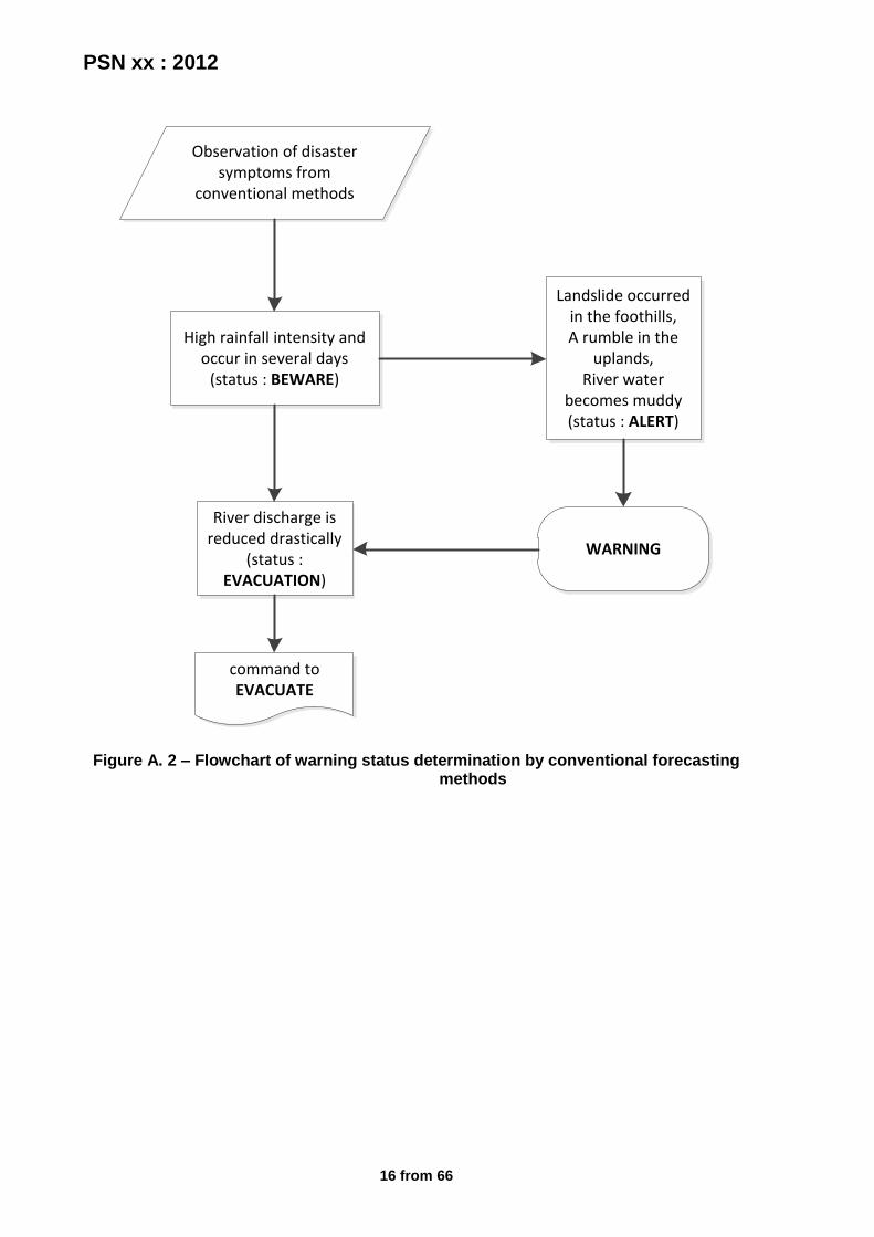
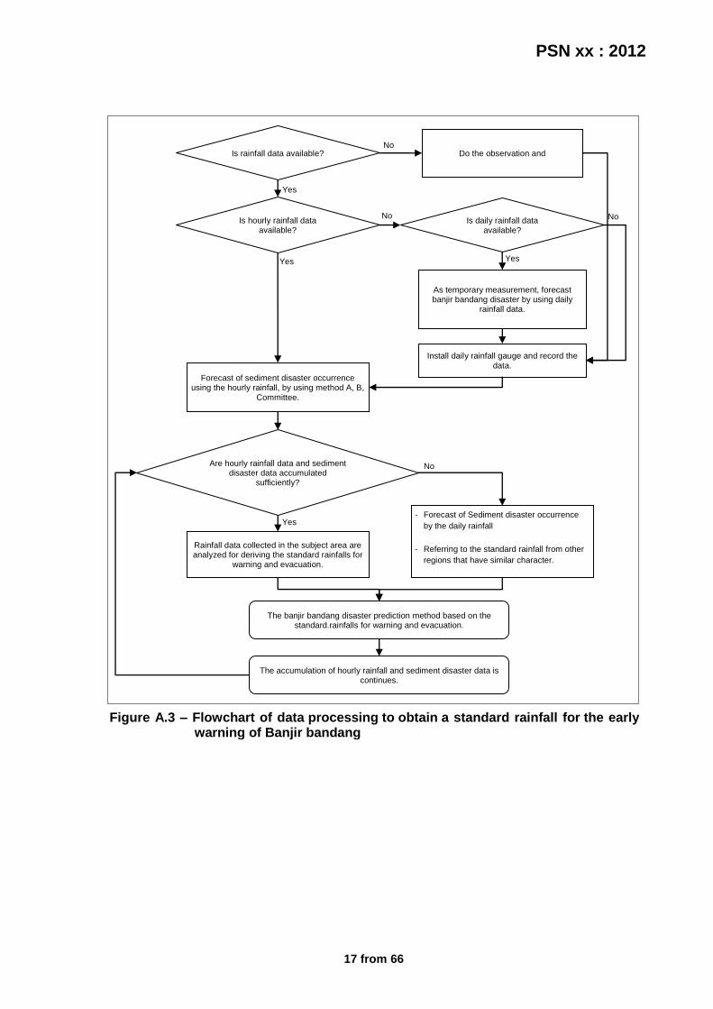
4) Analyze from survey result to determine the vulnerability level of areas; 5) Make a standard warning forecast through the following methods. 7.1.1.1 Conventional forecast method The conventional method is a simple method that is used to make forecasts for banjir bandang disaster caused by the collapse of natural dams. This method can be used in areas that have limitations in providing equipment and technology. This method is implemented by studying the occurrence of disaster banjir bandang and to recognize the symptoms of some natural phenomenon caused as contained in Tables C.2 and C.3. But it should also be remembered that not all the symptoms are indication of the coming of banjir bandang disaster. Therefore need active learning about the development of initial symptoms of banjir bandang disaster. Chronology of determining the level of warnings can be seen in Figure A.2. When the rain falls in few days with high intensity, the community should be warned to beware. If after that there was a roar and the river water becomes muddy, the warning level rises to warning. Furthermore, if the river discharge is reduced drastically in a short time later (hours to days), the warning level rises to evacuation. At this level people need to be prepared by evacuation team to evacuate. Rise and fall of the warning level adjusted with early symptoms of disaster flood that appears. 7.1.1.2 Advanced forecast method Advanced method is the method used to make forecasts for banjir bandang disaster caused by high rainfall intensity. Specific explanation of this method is associated with Figure A.3 to A.6, Table C.4, and Appendix D to Appendix G. The following are steps for advanced forecasting method that uses the tools of observation, data, and survey results: 1) Install the rain gauge, crack gauge, and water level measurements tool (see the sampling
tools at Appendix G) at banjir bandang disaster risk area; 2) Gather as much data as possible in order to get a good forecast (if lack of data, use the
primary and secondary data which contained in chapter 5); 3) Determine the magnitude of the rainfall standard in disasters prone areas and
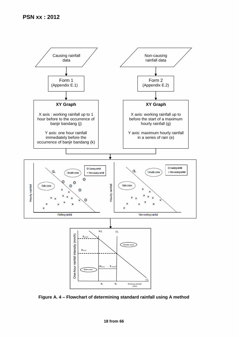
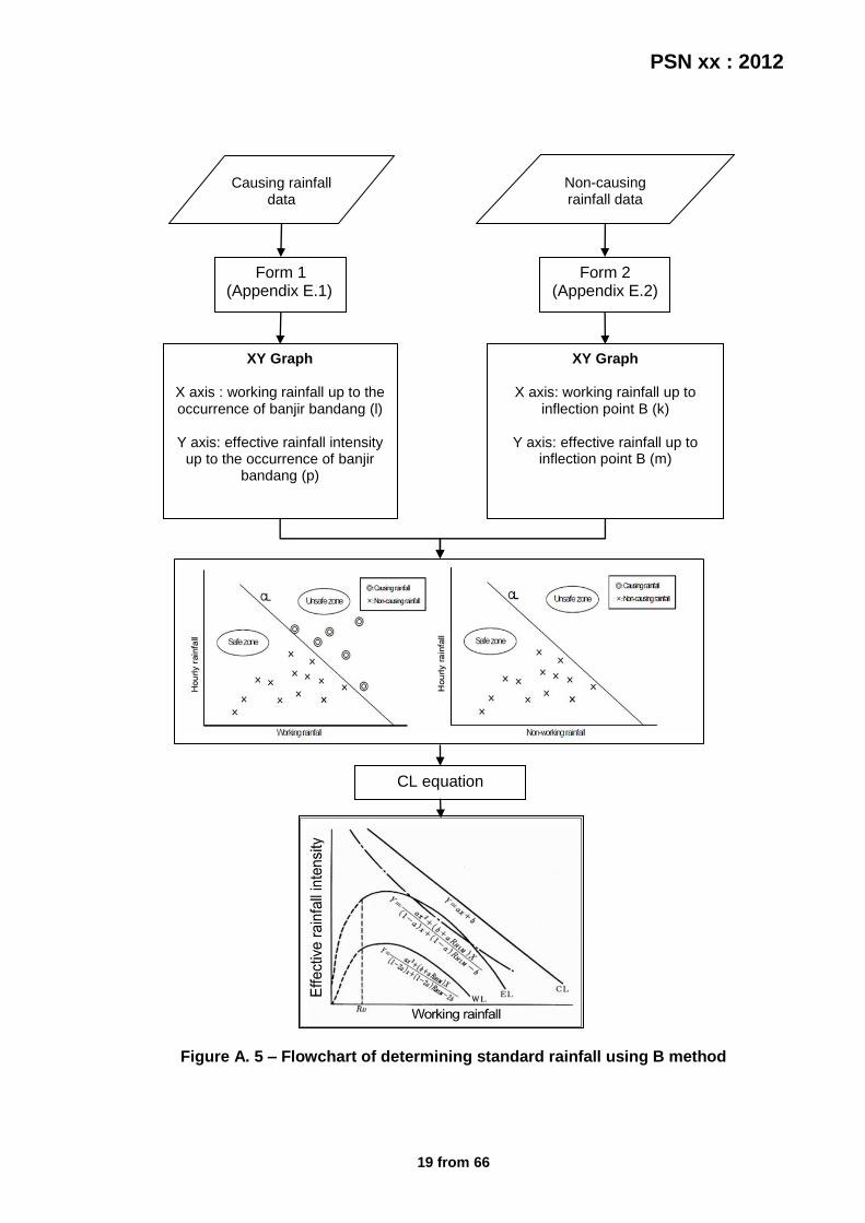
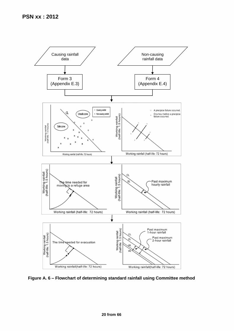
surrounding areas. In this case the rainfall is regarded as one of the trigger banjir bandang are, therefore used as a reference in determining the warning standard. Determination of standard rainfall using methods A, B, or the Committee (see Annex D with the example calculations in Appendix F) based on the characteristics of available data following the line as shown in Figure A.3 with respect to specifications, advantages, and disadvantages of each method as written Table C.4 as a default for determining the standard rainfall for the critical condition (beware), warning (warning), and evacuation conditions (evacuation);
4) Confirm the results of the standard rainfall value with specialize government research institutes such as BMKG/BPPT/LAPAN or the other relevant agencies and select the closest standard rainfall values or the standard value of methods that are suited to the climatic conditions and natural area;
5) Determine the standard value for water level and soil cracks based on analysis of flash flood historical data events that also fitted with observation data. The standard value is used as a supporting value in determining the warning level of disaster.

PSN xx : 2012
10 from 66
7.1.1.3 Combined forecast method In certain cases, the rainfall intensity in the upstream area can lead to landslides. Landslide material in the form of soil, rocks, and trees, move into the flow of rivers streams and can block the flow of rivers which form like bottleneck thus forming a natural dam. Along with the high rainfall intensity that fell and the increased of river discharge volume which are blocked, the natural dam eventually collapsed and causing banjir bandang. From these cases it can be seen that the natural dams factor and rainfall factor is an important factor to be taken into account in forecasting the banjir bandang disaster. Therefore, the combined forecast method account the two important factors, both from the forecasts and in the determination of warning level. 7.1.2 Monitoring and warning service At this stage constructed hazard monitoring and early warning services to the following steps: 1) Based the vulnerability level analyze results, arrange a strategy for implementation of the
early warning system; 2) Monitor the forecasts results and inform the changes/developments of condition; 3) Monitoring the easiest areas to detect disaster indication or some sort of patrol to identify
some precursors as well as oversee the activities of people around that areas (riverbanks, edge area);
4) Conduct discussions between the communities and government officials routinely to discuss the indication of disaster monitoring results.
7.1.3 Dissemination and communication At this stage the warning information from forecasting and monitoring results is communicated with the following steps: 1) Organize and develop an adequate network of communication/information transmission
system for disseminate disaster forecast information and the emergency conditions before the disaster occurred (reports and warnings by referring to chapter 6.3). Note the period of delivery and dissemination of information remembering that disaster will come in a short time, no later than approximately 1-2 hours after detected by the forecasts team. Therefore please deliver the warning as soon as possible;
2) Prepare the media for disseminate the information among the team member and for the community such as mobile phones, home phones, handy talkie, speaker, radio, TV, and the others;
3) Prepare the warning equipment (for reference see Table C.6); 4) Convey the warning information to the public by reference to Section 6.4. Use
equipment/media that have been prepared. 7.1.4 Preparation and emergency response At this stage the community's response capability is built with the following steps: 1) Socialize the communication networks and various warning signals to the public through
the media as a discussion forum so people know the indication of banjir bandang disaster and can contributed to disseminate the information when disasters occur;
2) Prepare the building and some early warning tools especially related with public safety and medical facilities such as buildings, goods supply for emergency conditions, etc;
3) Develop trainings and educational seminars to the public about banjir bandang disaster; 4) Inform the disaster mitigation efforts and the plan to the communities. So that people can
also be more proactive to participant in early-warning activities, improve the level of
PSN xx : 2012
11 from 66
public awareness of against disaster (making the disaster emergency response community) , and increasing the level of awareness among the public;
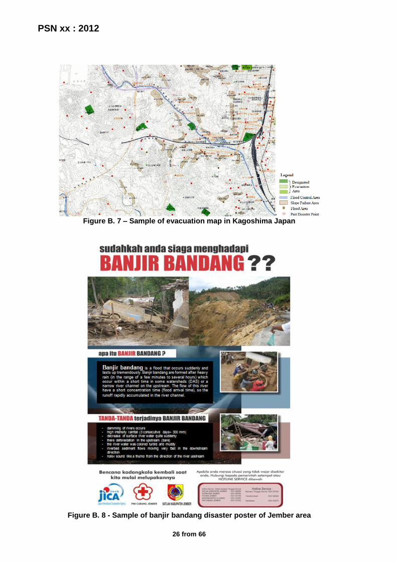
5) Use a variety of media facilities for disseminate the information such as TV, radio, magazines, comics (the example in Figure B.3), posters, billboards, leaflets (example in Figure B.4), and others;
6) Do a simulation of an emergency condition among the early warning team members in order to facilitate the implementation and coordination;
7) Evaluate the simulation results for improvement the overall of system towards a better early warning system.
7.1.5 Establishment of early warning team To facilitate the implementation of activities in early warning systems, a team called Early Warning Team should be established. This team consists of local authorities, local communities, members of related organizations, volunteers, and other parties concerned and wanted to participate in disaster prevention activities. The establishment of early warning team following the steps below: 1) Choose one personnel from local government leaders or related institutions (prefer from
BPBD) as a responsible person of team performance and activities in the early warning system. The selection of this personnel must be known and approved by in charge local authorities;
2) Form an early warning teams consisting with local authorities, local organizations or NGOs, or local community leaders, and volunteers;
3) Choose one personnel whose knowledgeable about the disaster and trusted to take the evacuation command. This person is responsible to local government (the point 1 party), to report any developments conditions occurring in the field;
4) Arrange the job desk of each team member in accordance with each functions and responsibilities in order to anticipate the disaster that will be encountered (e.g. in Table C.5);
5) Perform training for all team members in accordance with the duties and roles of each member. Trained personnel lead this training for implementation of activities in the field can actually run well and smoothly.
7.2 The establishment of banjir bandang evacuation system Broadly speaking, the process of establishing an early warning system implemented in accordance with the flowchart in Figure A.7. 7.2.1 Pre-disaster 7.2.1.1 Evacuation planning In the early stages need to be designed as a pre-disaster planning by following these steps: 1) Studying the banjir bandang prone area map; 2) Determine the safe zone based on the map; 3) Determine some candidate/alternative areas to be used as evacuation centers, shelters
or temporary shelters by exploiting the using of certain buildings such as government offices, schools, places of worship, and others based on that safety, accessibility, and also the environmental problems;
4) Determining the design of shelter that must have the right capacity, logistic supply (such as food/beverage, clothes, medicines and medical equipment, sleeping equipments, cleaning equipments, fuel, etc), and also the availability of public facilities;
5) Determine evacuation routes, which is the quickest and safest route for refugees to the shelter. This route should be in the transverse direction towards banjir bandang, not
PSN xx : 2012
12 from 66
cross the river channels or places with a heavy water flow, planned to be passed by vehicle, could be passed by the handicapped/elderly/young children;
6) Determine an alternate route other than the main route; 7) Check the time needed to reach a shelter; 8) Survey the availability of vehicles that can be used in the evacuation process (position of
the vehicle and the minimum and maximum load); 9) Create a evacuation map based on the results of the survey and design above that
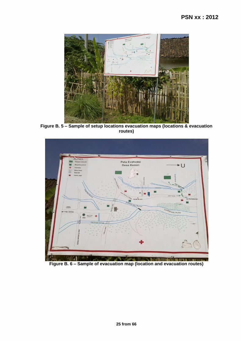
contain evacuation routes, shelter and the time required to achieve that, alternative routes, the locations are safe from disaster, and warning post positions of the evacuation teams (see the example in Figure B.6 and B.7);
10) Do exercise to ensure the evacuation route is safe and reliable; 11) Socialize the emergency evacuation information to intended the community to know their
position on hazards, easily identify and reach a safe place during evacuation by the following manner: - provide posters (the example can see in Figure B.8) and leaflets to local officials in
banjir bandang prone areas; - attach a map of location and evacuation routes in a public place that is easy to see
(the example can see in Figure B.5); - through printed and electronic media; - through existing community organization. - etc.
7.2.1.2 Establishment of evacuation team Form a team in accordance with their coordination and respective functions, in order to make a good implementation and also to minimize the victim of disaster. Role and tasks of the team can be seen in Table C.7. 7.2.1.3 Evacuation simulation The plan that has been made, tested by performing a simulation based on actual disaster conditions through the following steps: 1) Create the simulation scenarios of emergency response. This scenario must base on the
identification and profile of the communities who want to evacuate (the local situation), also in accordance with early warning system and the implemented evacuation plan. Distinguish the scenario according to the type of evacuation such as dry, wet, afternoon, or night, which began since early warning issued, evacuation is done, until the conditions are normal again. Do it regularly based on the estimated interference or confusion that may arise during a disaster;
2) Make a educational disaster materials for the communities in easily understandable and acceptable in accordance with the local customs, which includes : - How to prepare when disaster occurs; - How to deal with disasters; and - How to perform recovery actions after the disaster occurred.
3) Separate the simulation target into two groups, i.e.: - Vulnerable people, it includes the elderly, handicapped, children under five, pregnant
or nursing mother, and - Invulnerable people.
4) Choosing one personnel from local government leaders or related institutions as a responsible person or head of simulation activities who should known and approved by the in charge local authority. This person must to ensure that the activities of the simulation run according to the scenario;
5) The evacuation team serves as the executor of a simulated; 6) Prepare the needed equipments for evacuation simulation (see in chapter 6.7);
PSN xx : 2012
13 from 66
7) Implement briefing ahead of a simulation that contains the division of tasks/responsible team, description and location of the evacuation route, brief description of simulation scenarios, and other explanations required for smooth implementation of the simulation;
8) Implement the simulation that take approximately for about 2 hours. All parties must follow the script and react according to the simulation scenarios.
7.2.1.4 The evaluation of evacuation simulation After the simulation is completed, the next step is evaluation as a system repair materials. This activity is carried out with the following steps: 1) Perform a discussion session to identify the weaknesses of previous evacuation system
and to learn about the improvements needed; 2) Evaluate the simulation results with audiovisual recording equipment (camcorder) as the
detailed initial guide, then discuss about : the excess of evacuation simulation implementation; the lack of evacuation simulation implementation; the constraints during implementation of evacuation simulation; the assessment of all policies in force during the evacuation process. These evaluation points refer to the objective of simulation in Section 6.6;
3) Announce the results of simulation evaluation (technical matters, non-technical, etc.) directly at the local site to be attended by all simulation participants. The results of this evaluation are expected to provide recommendations for improvement of further evacuation simulation activities, as well as predict what actions to take when pre-disaster and post disaster.
7.2.2 When disaster occurs The following are things to consider in the evacuation process when disasters occur: 1) The evacuation team duties and responsibilities of each member according to the
structure that was created before 2) Towards the evacuation the communities must to prepare and brought goods with not too
large or heavy, so it will not interfere the evacuation process (see list in chapter 6.5) 3) At evacuation time, the communities expected to always act calm and not panic 4) Lock your doors and windows. 5) Turn of the fire source and power source to prevent fire. 6) Bring essential items. 7) Wear clothes that easy to wear. 8) Prioritize the vulnerable people like handicapped, elderly, children and pregnant or
nursing mothers. 9) Follow the instructions from the officers and do not act without instruction. 7.2.3 Post-disaster After the disaster occurs, it is necessary to consider the following stages: The evaluation stage of early warning systems and evacuation: 1) Evaluate evacuation activities that have been made include:
- Is the evacuation run according simulation carried out previously; - Have an evacuation team is performing their duties in accordance with their respective
functions and is sufficient to meet the needs and protect the community from the disaster;
- Is the supplies evacuation equipment previously provided is sufficient when a disaster occurs.

PSN xx : 2012
14 from 66
It should be noted that the evaluation benchmark is whether the information can be delivered quickly or in other words, is whether the timing of the information earlier than the time of the banjir bandang.
2) Analysis of the advantages, disadvantages, and constraints that exist when a disaster occurs.
The rehabilitation and reconstruction stage: Perform repair team structure, the process of evacuation, evacuation equipment and facilities, through early warning systems that have been implemented, based on the analysis results in the previous stage towards better mitigation efforts and disaster management.
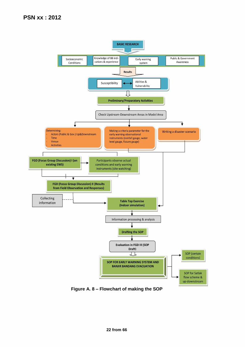
7.3 Making the SOP This stage is carried out to clarify the coordination and the duties and responsibilities each member of the early warning and evacuation team with reference to Figure A.8 and that manufacturing steps in Appendix H.

PSN xx : 2012
15 from 66
Appendix A (normative) Flowchart
Conventional
method
Advanced
method
Data
availability
Map of banjir
bandang prone
area
Verification
Location of residentials, retaining
building from disaster, flood
detection infrastructure, social
conditions of communities
Risk analysis
Banjir bandang
risk map
Observation
Data analysis
Standard warning
value
Monitoring and Services
Dissemination and Communication
Preparation and Emergency Response
yes no
Observations of
river water
conditions (height,
color)
Landslides observation
Large rainfall
intensity with long
duration
Heard a rumble
followed by a
vibration
Combined
method (conventional and
advanced)
Figure A. 1 – Flowchart of early warning system establishment
PSN xx : 2012
16 from 66
Observation of disaster symptoms from
conventional methods
High rainfall intensity and occur in several days
(status : BEWARE)
River discharge is reduced drastically
(status : EVACUATION)
Landslide occurred in the foothills,A rumble in the
uplands,River water
becomes muddy(status : ALERT)
WARNING
command to EVACUATE
Figure A. 2 – Flowchart of warning status determination by conventional forecasting methods
PSN xx : 2012
17 from 66
Is hourly rainfall data available?
Is daily rainfall data available?
Install daily rainfall gauge and record the data.
Forecast of sediment disaster occurrence using the hourly rainfall, by using method A, B,
Committee.
As temporary measurement, forecast banjir bandang disaster by using daily
rainfall data.
Are hourly rainfall data and sediment disaster data accumulated
sufficiently?
Rainfall data collected in the subject area are analyzed for deriving the standard rainfalls for
warning and evacuation.
- Forecast of Sediment disaster occurrence
by the daily rainfall
- Referring to the standard rainfall from other
regions that have similar character.
Is rainfall data available? Do the observation and
The banjir bandang disaster prediction method based on the standard.rainfalls for warning and evacuation.
The accumulation of hourly rainfall and sediment disaster data is continues.
Yes
Yes
No
No No
Yes
Yes
No
Figure A.3 – Flowchart of data processing to obtain a standard rainfall for the early warning of Banjir bandang
PSN xx : 2012
18 from 66
Causing rainfall data
Non-causing rainfall data
Form 1 (Appendix E.1)
Form 2 (Appendix E.2)
XY Graph
X axis : working rainfall up to 1 hour before to the occurrence of
banjir bandang (j)
Y axis: one hour rainfall immediately before the
occurrence of banjir bandang (k)
XY Graph
X axis: working rainfall up to before the start of a maximum
hourly rainfall (g)
Y axis: maximum hourly rainfall in a series of rain (e)
Figure A. 4 – Flowchart of determining standard rainfall using A method
PSN xx : 2012
19 from 66
Causing rainfall data
Non-causing rainfall data
Form 1 (Appendix E.1)
Form 2 (Appendix E.2)
XY Graph
X axis : working rainfall up to the occurrence of banjir bandang (l)
Y axis: effective rainfall intensity
up to the occurrence of banjir bandang (p)
XY Graph
X axis: working rainfall up to inflection point B (k)
Y axis: effective rainfall up to
inflection point B (m)
CL equation
Figure A. 5 – Flowchart of determining standard rainfall using B method
PSN xx : 2012
20 from 66
Causing rainfall data
Non-causing rainfall data
Form 3 (Appendix E.3)
Form 4 (Appendix E.4)
Figure A. 6 – Flowchart of determining standard rainfall using Committee method
PSN xx : 2012
21 from 66
Evacuation planning
Establishment of evacuation team
Evacuation simulation
The evaluation of evacuation simulation
Evacuation route map
Evaluation of early warning system & evacuation
Rehabilitation & Reconstruction
Pre-disaster
When disaster occurs
Post-disaster
Mobilizing the community to the evacuation site
Evacuation team carrying out each duty and responsibilities, and
the communities follow their direction and accordance with
the evacuation simulation that has done
Figure A. 7 – Flowchart of evacuation system establishment
PSN xx : 2012
22 from 66
Figure A. 8 – Flowchart of making the SOP

PSN xx : 2012
23 from 66
Appendix B (informative)
Figure
Figure B. 1 - Four Key Elements of an early warning system in the Community focused
Figure B. 2 – Sample of banjir bandang hazard map for north jember area

PSN xx : 2012
24 from 66
Figure B. 3 – Sample of banjir bandang comic which made by JICA
Figure B. 4 – Sample of leaflet to introduce banjir bandang and landslide disaster
which made by JICA
PSN xx : 2012
25 from 66
Figure B. 5 – Sample of setup locations evacuation maps (locations & evacuation
routes)
Figure B. 6 – Sample of evacuation map (location and evacuation routes)
PSN xx : 2012
26 from 66
Figure B. 7 – Sample of evacuation map in Kagoshima Japan
Figure B. 8 - Sample of banjir bandang disaster poster of Jember area
PSN xx : 2012
27 from 66
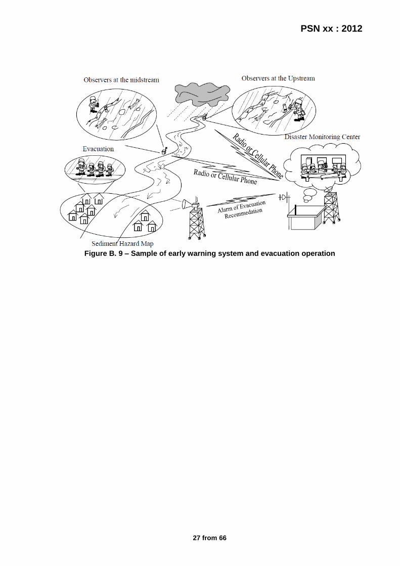
Figure B. 9 – Sample of early warning system and evacuation operation

PSN xx : 2012
28 from 66
Appendix C (informative)
Table
Table C. 1 - Functions and actions based on key elements of the early warning system
Keys Functions Actions
Knowledge of the risk / Observations
Establish a systematic, standardized process to collect and make forecasts
1. Identify natural hazards 2. Analyzing the vulnerability
of the 3. An educated guess of the
risk 4. Information storage and
access
Monitoring and warning service
Establishing hazard monitoring and warning service effective on the basis of adequate scientific and technological system with a particular command
1. Development of monitoring system
2. The establishment of warning systems and teams
Dissemination and communication
Develop communication and dissemination systems to ensure people get early warning in the face of natural disasters and facilitate coordination and exchange of information
1. Installation of communication systems and equipment effectively
2. The introduction and understanding of warning messages
Ability to respond / Emergency Response
Strengthen the ability of communities to respond to natural disasters (emergency response) through better education about the risks of natural disasters, public participation, and disaster preparedness
1. Paying attention to warning
2. Build preparedness in the face of disaster and response plan
3. An educated guess and strengthening of community response capacity
4. Increasing public awareness and education
Table C. 2 - Some initial symptoms of the coming banjir bandang caused by the collapse of natural DAM
No. Natural phenomena
1 damming of rivers occurs
2 high intensity rainfall (3 consecutive days> 300 mm)
3 decrease of surface river water quite suddenly
4 there deforestation in the upstream (bare)
5 the river water was colored turbid and muddy
6 riverbed sediment flows moving very fast in the downstream direction
7 noisy sound like a thump from the direction of the river upstream
PSN xx : 2012
29 from 66
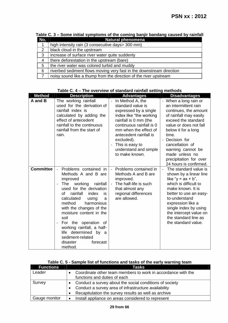
Table C. 3 – Some initial symptoms of the coming banjir bandang caused by rainfall
No. Natural phenomena
1 high intensity rain (3 consecutive days> 300 mm)
2 black cloud in the upstream
3 increase of surface river water quite suddenly
4 there deforestation in the upstream (bare)
5 the river water was colored turbid and muddy
6 riverbed sediment flows moving very fast in the downstream direction
7 noisy sound like a thump from the direction of the river upstream
Table C. 4 – The overview of standard rainfall setting methods
Method Description Advantages Disadvantages
A and B The working rainfall used for the derivation of rainfall index is calculated by adding the effect of antecedent rainfall to the continuous rainfall from the start of rain.
- In Method A, the standard value is expressed by a single index like “the working rainfall is 0 mm (the continuous rainfall is 0 mm when the effect of antecedent rainfall is excluded).
- This is easy to understand and simple to make known.
- When a long rain or an intermittent rain continues, the amount of rainfall may easily exceed the standard value or does not fall below it for a long time.
- Decision for cancellation of warning cannot be made unless no precipitation for over 24 hours is confirmed.
Committee - Problems contained in Methods A and B are improved
- The working rainfall used for the derivation of rainfall index is calculated using a method harmonious with the changes of the moisture content in the soil
- For the operation of working rainfall, a half-life determined by a sediment-related disaster forecast method.
- Problems contained in Methods A and B are improved.
- The half-life is such that almost any regional differences are allowed.
- The standard value is shown by a linear line like “y = ax + b”, which is difficult to make known. It is better to use an easy-to-understand expression like a single index by using the intercept value on the standard line as the standard value.
Table C. 5 - Sample list of functions and tasks of the early warning team
Functions Tasks
Leader Coordinate other team members to work in accordance with the functions and duties of each
Survey Conduct a survey about the social conditions of society
Conduct a survey area of infrastructure availability
Recapitulation the survey results as well as archive
Gauge monitor Install appliance on areas considered to represent

PSN xx : 2012
30 from 66
Record the results of measurements of rainfall data
Record the height measurement result data of river water
Record the measurement result data shifting ground
Archive data measurements are routinely
Calibrate equipment regularly
Maintain and care for tools that always work
Seek additional data from other agencies for comparison and to fill data gaps when the instrument is not functioning properly
Prone areas controller
Conduct monitoring and recording changes in natural phenomena that occur in specific areas such as disaster-prone at the edge of the river or cliff
Overseeing the activities of people around the area
Report progress to the natural conditions of the analysis team
Analyze Analyze maps flood-prone
Analyze survey results
Determining the hazard standard for rainfall, water level elevation, and soil cracking based on data collected
Perform trend analysis of all data collected
Communicate the results of analysis or warnings and any changes that occur to the authorities
Information Provide communication facilities and a good network so that each information can be submitted at any time and in a short time
Establish regular communication channels so that any warning information can be conveyed to all corners of the area with ease and in the shortest possible
Share information with appropriate warnings to the public communication line that has formed
Conduct regular monitoring of communications equipment while ensuring that the tool can function properly in accordance with their respective functions
Socialization Socialization to the community about the early warning system
Prepare media as an intermediary to introduce a variety of information about early warning system
Introduce a variety of warning signs that have been prepared and post-post reporting the warning information
Install posters, baligho, and other media in a place that is easy to see the community
Conduct educational seminars about the flood disaster in the community
Simulation Develop a strategy simulation
Conducting emergency response simulations are routinely
Coordinate other team members to work in accordance with its function in a simulated (made as if in real conditions)
Evaluation Evaluating the simulation of activities that have been done
Analyze the evaluation results
Improving early warning system in accordance with the results of evaluations and analysis carried out
Report the evaluation results and analysis to the entire team for the improvement of early warning system as a whole
PSN xx : 2012
31 from 66
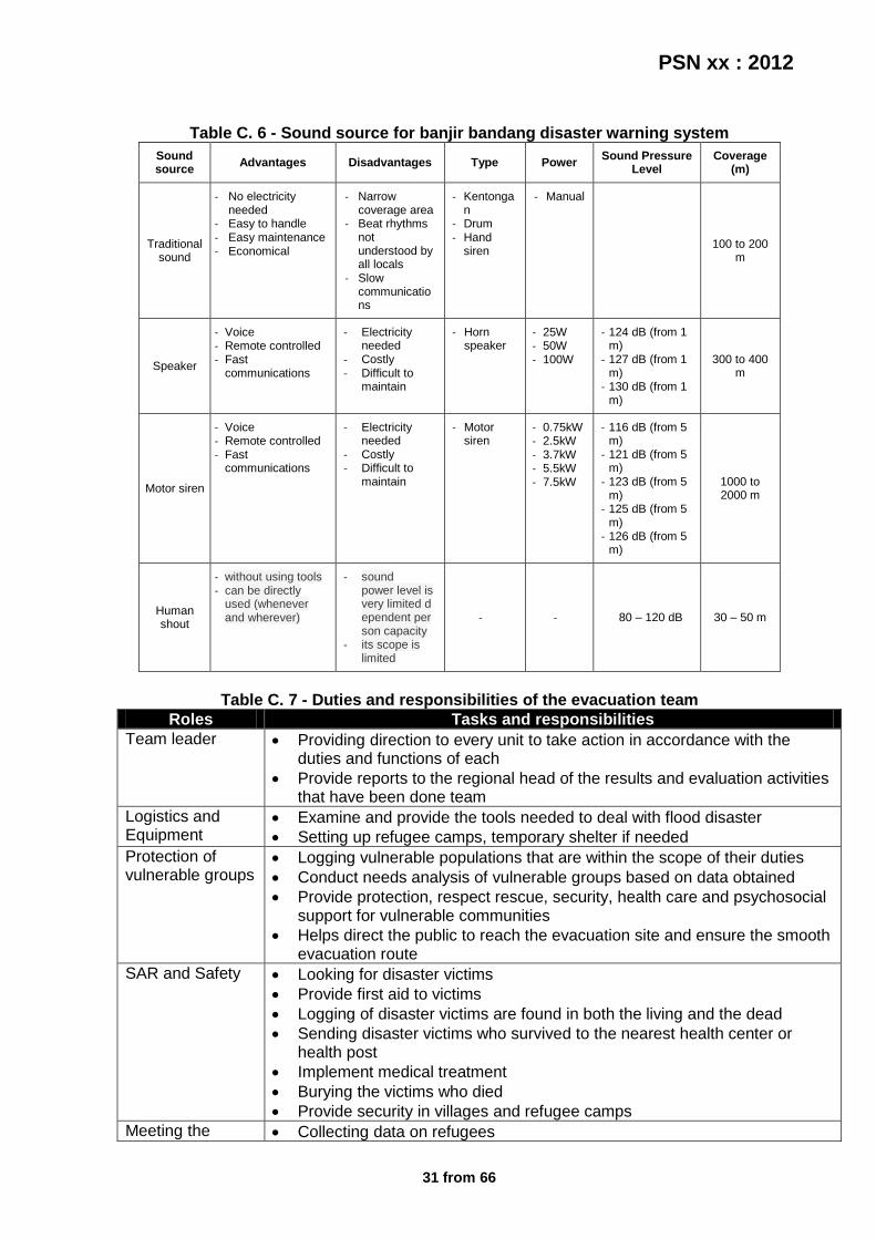
Table C. 6 - Sound source for banjir bandang disaster warning system
Sound source
Advantages Disadvantages Type Power Sound Pressure
Level Coverage
(m)
Traditional sound
- No electricity needed
- Easy to handle - Easy maintenance - Economical
- Narrow coverage area
- Beat rhythms not understood by all locals
- Slow communications
- Kentongan
- Drum - Hand
siren
- Manual
100 to 200 m
Speaker
- Voice - Remote controlled - Fast
communications
- Electricity needed
- Costly - Difficult to
maintain
- Horn speaker
- 25W - 50W - 100W
- 124 dB (from 1 m)
- 127 dB (from 1 m)
- 130 dB (from 1 m)
300 to 400 m
Motor siren
- Voice - Remote controlled - Fast
communications
- Electricity needed
- Costly - Difficult to
maintain
- Motor siren
- 0.75kW - 2.5kW - 3.7kW - 5.5kW - 7.5kW
- 116 dB (from 5 m)
- 121 dB (from 5 m)
- 123 dB (from 5 m)
- 125 dB (from 5 m)
- 126 dB (from 5 m)
1000 to 2000 m
Human shout
- without using tools - can be directly
used (whenever and wherever)
- sound power level is very limited dependent person capacity
- its scope is limited
- - 80 – 120 dB 30 – 50 m
Table C. 7 - Duties and responsibilities of the evacuation team
Roles Tasks and responsibilities
Team leader Providing direction to every unit to take action in accordance with the duties and functions of each
Provide reports to the regional head of the results and evaluation activities that have been done team
Logistics and Equipment
Examine and provide the tools needed to deal with flood disaster
Setting up refugee camps, temporary shelter if needed
Protection of vulnerable groups
Logging vulnerable populations that are within the scope of their duties
Conduct needs analysis of vulnerable groups based on data obtained
Provide protection, respect rescue, security, health care and psychosocial support for vulnerable communities
Helps direct the public to reach the evacuation site and ensure the smooth evacuation route
SAR and Safety Looking for disaster victims
Provide first aid to victims
Logging of disaster victims are found in both the living and the dead
Sending disaster victims who survived to the nearest health center or health post
Implement medical treatment
Burying the victims who died
Provide security in villages and refugee camps
Meeting the Collecting data on refugees

PSN xx : 2012
32 from 66
needs Perform basic needs analysis based on data collection
Providing basic needs, such as clean water, food, clothing, temporary shelter, sanitation, cooking utensils and fuel, as well as health services
Restoration of critical facilities
Logging damage to critical facilities that are within the scope of their duties
Improve critical facilities related to the fulfillment of basic needs of the population
PSN xx : 2012
33 from 66
𝑅𝐶 = 𝐶𝐻
𝑏
𝑎
Appendix D (normative)
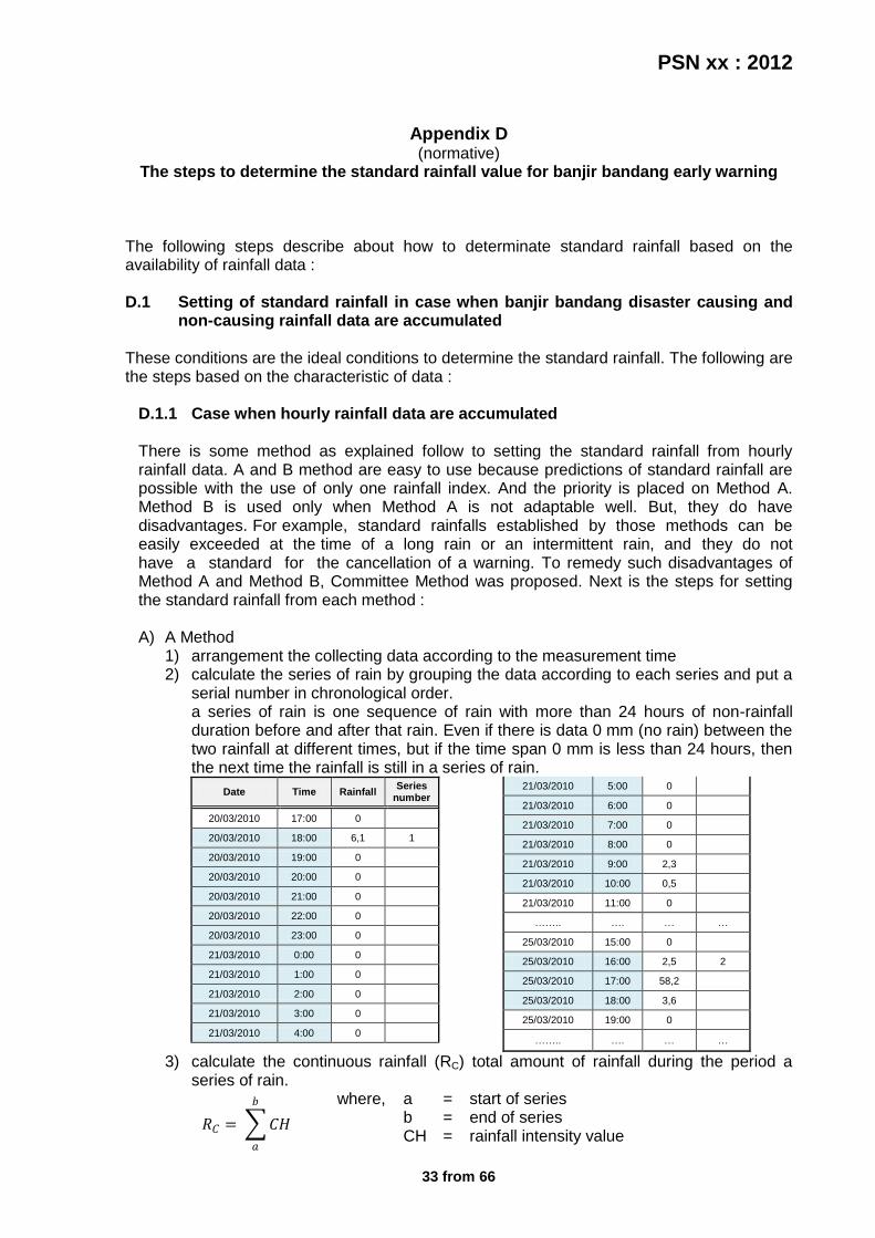
The steps to determine the standard rainfall value for banjir bandang early warning The following steps describe about how to determinate standard rainfall based on the availability of rainfall data : D.1 Setting of standard rainfall in case when banjir bandang disaster causing and
non-causing rainfall data are accumulated These conditions are the ideal conditions to determine the standard rainfall. The following are the steps based on the characteristic of data :
D.1.1 Case when hourly rainfall data are accumulated There is some method as explained follow to setting the standard rainfall from hourly rainfall data. A and B method are easy to use because predictions of standard rainfall are possible with the use of only one rainfall index. And the priority is placed on Method A. Method B is used only when Method A is not adaptable well. But, they do have disadvantages. For example, standard rainfalls established by those methods can be easily exceeded at the time of a long rain or an intermittent rain, and they do not have a standard for the cancellation of a warning. To remedy such disadvantages of Method A and Method B, Committee Method was proposed. Next is the steps for setting the standard rainfall from each method : A) A Method
1) arrangement the collecting data according to the measurement time 2) calculate the series of rain by grouping the data according to each series and put a
serial number in chronological order. a series of rain is one sequence of rain with more than 24 hours of non-rainfall duration before and after that rain. Even if there is data 0 mm (no rain) between the two rainfall at different times, but if the time span 0 mm is less than 24 hours, then the next time the rainfall is still in a series of rain.
Date Time Rainfall Series
number
20/03/2010 17:00 0
20/03/2010 18:00 6,1 1
20/03/2010 19:00 0
20/03/2010 20:00 0
20/03/2010 21:00 0
20/03/2010 22:00 0
20/03/2010 23:00 0
21/03/2010 0:00 0
21/03/2010 1:00 0
21/03/2010 2:00 0
21/03/2010 3:00 0
21/03/2010 4:00 0
21/03/2010 5:00 0
21/03/2010 6:00 0
21/03/2010 7:00 0
21/03/2010 8:00 0
21/03/2010 9:00 2,3
21/03/2010 10:00 0,5
21/03/2010 11:00 0
…….. …. … …
25/03/2010 15:00 0
25/03/2010 16:00 2,5 2
25/03/2010 17:00 58,2
25/03/2010 18:00 3,6
25/03/2010 19:00 0
…….. …. … …
3) calculate the continuous rainfall (RC) total amount of rainfall during the period a series of rain.
where, a = start of series b = end of series CH = rainfall intensity value

PSN xx : 2012
34 from 66
𝑅𝐴 = 𝐶𝐻
14𝑏
𝑑=2
𝑅𝑖 = 𝐶𝐻
𝑐
𝑎
4) calculate the antecedent rainfall (RA) total rainfall during the period of 1 or 2 weeks before the start of a series, which usually starts from 2 days before to 2 weeks before
where, d = time/period in days
5) calculate the antecedent working rainfall (RWA) total amount by multiplying the preliminary precipitation with a coefficient of time (deduction) with use the formula below reference on the following table of deduction coefficient value and half life (usually use the half life 1 day)
𝛼𝑡 = 0,5𝑡
𝑇
𝑅𝑊𝐴 = 𝛼𝑡 ∙ 𝑑𝑡
14
𝑡=1
= 0,5 ∙ 𝑑1 + 0,25 ∙ 𝑑2 + 0,125 ∙ 𝑑3 + …
where, αt = deduction coefficient t = x-day(s) before the start of rainfall T = x-day(s) of half-life dt = the value of RA according with t half-life is half-life time of rainfall used to determine the coefficient of deduction in the calculation of antecedent rainfall.
6) determine the inflection point A and B based on each definitions like the picture below
Inflection Point A is a point when the value in the cumulative rainfall curve of a series of rain begins to increase sharply. It is usually a point when an hourly rainfall of 4 mm or over begins to rain for the first time. Inflection point B is a point when the value in the cumulative rainfall curve of a series of rain begins to stop a sharp increase. It is usually a point when an hourly rainfall of less than 4 mm begins to rain for 3 hours or more.
7) calculate the initial rainfall (Ri) accumulated rainfall from the start of a series of rain
to the point of inflection A. where, c = inflection point A