Embed Size (px)
Citation preview

CARTWRIGHT HOMES
PROPOSED RESIDENTIAL DEVELOPMENT, THE ZOO, PLOUGH HILL ROAD, NUNEATON
Landscape & Visual Assessment
August 2014 5341.LVA.001

COPYRIGHT
The copyright of this document
remains with Aspect Landscape Planning Ltd.
The contents of this document
therefore must not be copied or
reproduced in whole or in part
for any purpose without the
written consent of
Aspect Landscape Planning Ltd.
Aspect Landscape Planning Ltd Hardwick Business Park
Noral Way Banbury
Oxfordshire OX16 2AF
t 01295 276066 f 01295 265072
e [email protected] w www.aspect-landscape.com
CONTENTS
1 INTRODUCTION 1
2 LANDSCAPE RELATED POLICY 2
3 SITE AND SETTING 6
4 DESCRIPTION OF THE PROPOSALS 15
5 ASSESSMENT OF EFFECTS 17
6 SUMMARY & CONCLUSIONS 27
ASPECT PLANS
PLAN ASP1 SITE AND SETTING PLAN
PLAN ASP2 LANDSCAPE ANALYSIS PLAN
PLAN ASP3 INDICATIVE LANDSCAPE MASTERPLAN
APPENDICES
APPENDIX 1 ASPECT LANDSCAPE & VISUAL IMPACT METHODOLOGY
APPENDIX 2 ARBORICULTURAL ASSESSMENT
APPENDIX 3 VISUAL ASSESSMENT

The Zoo, Plough Hill Road, Nuneaton August 2014 Landscape & Visual Assessment 5341.LVA.001
1
1. INTRODUCTION
1.1. Aspect Landscape Planning Ltd has been appointed by Cartwright
Homes to undertake a landscape and visual assessment of the
proposed residential development at The Zoo, Plough Hill Road,
Nuneaton. The location and context of the application site is illustrated
on ASP1 Site and Setting. The site comprises two residential properties
with associated domestic gardens and small land holding currently used
as horse paddock. The site is located west of Plough Hill Road,
adjacent to existing residential properties on Plough Hill Road, within
the urban edge on the north-west side of Nuneaton.
1.2. A detailed appraisal of the surrounding study area has been undertaken
using Ordnance Survey data, historical map data, local policy and
published character assessments. This has informed the on-site field
analysis to identify key viewpoints, analyse the landscape character and
visual environment of the local area, and determine the extent and
significance of any potential landscape and visual effects.
1.3. The assessment of effects has been derived from guidance provided
within GLVIA3 (Guidelines for Landscape and Visual Impact
Assessment 3 Edition) published by the Landscape Institute and the
Institute of Environmental Management and Assessment in April 2013.
The methodology is contained within Appendix 1 of this document.
1.4. This assessment should be read alongside the other supporting material
which accompanies this application.

The Zoo, Plough Hill Road, Nuneaton August 2014 Landscape & Visual Assessment 5341.LVA.001
2
2. LANDSCAPE RELATED POLICY
2.1. The application site is situated on the north-western side of Nuneaton,
adjacent to the boundary between the boroughs of Nuneaton and
Bedworth, and North Warwickshire. The site lies within Nuneaton and
Bedworth Borough is covered by the ‘saved policies’ of Nuneaton and
Bedworth Borough Local Plan (Adopted 2006). Due to its location
adjacent to the boundary with North Warwickshire Borough, local
planning policies covering this area, as set out in the North
Warwickshire Borough Local Plan (Adopted 2006), have also been
reviewed, as they apply to the setting of the site to the north and north-
west.
2.2. The site itself is not subject of any national or local designation which
relates to landscape character or value. Furthermore there are no other
areas of designated landscape within the setting of the site.
2.3. There are some features of cultural heritage value within the wider
setting of the site, including a small number of Listed Buildings and
Scheduled Monuments, which form valued landscape features.
However, due to distance and a lack of intervisibility between these
areas and the site, these features would be unaffected by the proposed
development.
2.4. There are a number of public rights of way (public footpaths) in the
vicinity of the site including one adjacent to the southern boundary. In
addition Centenary Way (a Long Distance Footpath) runs in a
north/south direction, approximately 0.65km west of the site.
National Planning Policy Guidance
National Planning Policy Framework (March 2012)
2.5. The National Planning Policy Framework (NPPF) was published on the
27th March 2012, replacing the existing system of national planning
policy guidance and statements. The document sets out the
Government’s planning policies for England and how these are

The Zoo, Plough Hill Road, Nuneaton August 2014 Landscape & Visual Assessment 5341.LVA.001
3
expected to be applied, and is a material consideration in planning
decisions. The document places an emphasis on the promotion of
sustainable growth whilst also protecting the environment.
2.6. The guidance sets out a number of core land-use planning principles in
paragraph 17, which underpin both plan-making and decision-making.
The core principles embrace good design and seek to protect character,
stating that planning should; “always seek to secure high quality
design and good standard of amenity for all existing and future
occupants of land and buildings;” and “take account of the
different roles and character of different areas, promoting the
vitality of our main urban areas, protecting the Green Belts around
them, recognising the intrinsic character and beauty of the
countryside and supporting thriving rural communities within it”.
2.7. The requirement for good design is further emphasised in paragraph 64
stating that “permission should be refused for development of poor
design that fails to take the opportunities available for improving
the character and quality of an area and the way it functions.”
2.8. NPPF also highlights the requirement for the conservation and
enhancement of the historic environment, with designated heritage
assets being afforded a level of protection and conservation
commensurate with its level of heritage significance. New development
should take into the account the importance of the historic feature, and
paragraph 137 also states that “Local Planning Authorities should
look for opportunities for new development within Conservation
Areas and World Heritage Sites and within the setting of heritage
assets to enhance or better reveal their significance. Proposals
that preserve those elements of the setting that make a positive
contribution to or better reveal the significance of the asset should
be treated favourably.”
2.9. The NPPF has been of material consideration in developing an
appropriate proposal for the development of the application site. Details
of how the proposals would take on board the overall framework
guidance and principles contained within the NPPF are provided in the

The Zoo, Plough Hill Road, Nuneaton August 2014 Landscape & Visual Assessment 5341.LVA.001
4
accompanying Design and Access Statement, and forms the basis of
this assessment.
Local Planning Policy
Nuneaton and Bedworth Borough Local Plan Saved Policies (Adopted
2006)
2.10. The application site is located within the existing built edge of Nuneaton
at Plough Hill, on the west side of Plough Hill Road, within an area
defined as an ‘Area of Restraint’ and ‘Countryside’ within the Adopted
Local Plan (policies ENV 2 and ENV3). In summary, ENV2 seeks to
retain the open character and appearance of the designated area.
ENV3 seeks to protect the character of the countryside through
restricting development to that which would not harm the overall
character and quality of the countryside, and which would be of a high
standard, in keeping with the scale and character of the area.
2.11. Following comments from the planning inspector at the previous local
plan inquiry, policies ENV2 and ENV3 are currently under review as part
of the development of a revised local plan for the borough. Emerging
policy within the Nuneaton and Bedworth Borough Council, Borough
Plan (Preferred Options 2013) suggests that it is proposed to replace
these policies with a landscape character based policy, which would be
based on the revised Landscape Character Assessment (2012), which
itself excludes the site from the countryside area.
2.12. In addition, the only other ‘saved’ policy considered to be of relevance
to the site and its setting, is ENV14 which also relates to the need for a
high standard of design, which responds to scale and character, with
reference to supplementary planning guidance.
North Warwickshire Local Plan (2006)
2.13. The North Warwickshire Local Plan applies to the landscape north and
north-west of the site. It includes the following saved policies which

The Zoo, Plough Hill Road, Nuneaton August 2014 Landscape & Visual Assessment 5341.LVA.001
5
could be considered to be relevant to the setting of the site: ENV 1 –
Protection and Enhancement of Natural Landscape; ENV 4 - Trees and
Hedgerows; ENV 12 – Urban Design.

The Zoo, Plough Hill Road, Nuneaton August 2014 Landscape & Visual Assessment 5341.LVA.001
6
3. SITE AND SETTING
3.1. The site is located on the north-western side of Nuneaton, within the
existing urban edge at Plough Hill, to the west of Plough Hill Road. In
brief, the site consists of two residential properties and associated
grounds, and occupies approximately of 1.3ha of land, enclosed by
established trees and vegetation, including a large proportion of
evergreen species, at the boundaries of the site.
3.2. Internally, the site comprises a large, red brick, detached residential
property in the centre north of the site, set within a well maintained,
formal, domestic garden, containing grasses lawns, a number of
mature, predominantly evergreen trees, a small allotment, and an
ornamental pond. The house is separated from adjacent properties by
an evergreen hedge to the south-eastern and north-eastern boundaries.
The house is accessed from Plough Hill Lane via a tarmac driveway,
which becomes a large parking area adjacent to the house, which is
also served by a triple garage block, set within an area of gravel in the
north east corner of the site. There are a small number of other
buildings/structures including a workshop/stables building, which serves
a horse paddock in the south east part of the site. The site also includes
a second, smaller, detached residential property, with associated front
and rear gardens (containing limited vegetation), which fronts onto
Plough Hill Road and forms part of the streetscape.
3.3. The existing boundaries of the site are all vegetated and trees within
and adjacent to the site have been subject of a tree survey in
accordance with BS5837:2012 (refer appendix 2). In summary, the tree
survey shows that:
there are no high value trees (Cat. A) within the site;
there are a small number of trees which are of some
arboricultural and/or amenity value (Cat. B1) including trees 17
and 19 within the north-western boundary, tree 31 within the
garden, trees 5, 6 and 11 on the north side of the driveway, and
tree 55 within the southern boundary;

The Zoo, Plough Hill Road, Nuneaton August 2014 Landscape & Visual Assessment 5341.LVA.001
7
the majority of trees are located within the boundaries of the site,
including a number of ornamental evergreen species, and are of
lower arboricultural value (Cat. C1) but do provide physical
enclosure to the north, west and south of the site;
the majority of trees within the internal areas are of limited value
and are recommended for removal (Cat. U).
Setting of the Site
3.4. To the north, the site boundary is defined by a line of evergreen trees
which form a tall hedge separating the site from a small area of
workshops and garages off Plough Hill Road, and the wider urban area
including Bretts Hall Estate. The surrounding urban area is
unremarkable in character, mainly comprising two storey, red brick, post
war estate style housing.
3.5. To the east the site is enclosed by residential development along
Plough Hill Road which backs onto the site, and comprises a mix of
house types including semi-detached, detached, two storey and
bungalow, post war properties. The majority are constructed of red
brick, but a number of the semi-detached properties are rendered. An
evergreen hedge provides some separation between the rear of
properties and the majority of the site. A small part of the site extends
as far as Plough Hill Road where it includes the driveway and adjacent
detached property, which is also typical of the built form of the
streetscape. Plough Hill Road is also enclosed on its eastern side by
existing housing development, restricting views in this direction.
3.6. To the south, the site boundary is also defined by a timber, close board
fence which separates the site from a public right of way (footpath) and
is enclosed by a mature field boundary hedgerow, with trees. The
existing vegetation separates the site from a small farmstead, located at
the southern end of development on the west side of Plough Hill Road.
The farm is located close to the top of Plough Hill, which forms part of a
localised ridge which runs north-west towards Bret’s Hall Farm and
Ansley Common, enclosing the landscape to the north (including the
urban edge of Nuneaton) in views from the south.

The Zoo, Plough Hill Road, Nuneaton August 2014 Landscape & Visual Assessment 5341.LVA.001
8
3.7. To the west, the site is enclosed by a mix of mature evergreen and
deciduous trees, for much of its length, and by an existing field
boundary hedgerow for a short length in the south western corner. This
existing vegetation defines the urban edge and the transition between
the urban area at Plough Hill and the surrounding rural landscape to the
west, and the existing urban area at Ansley Common to the north-west.
The landscape west of the site is enclosed by the localised ridgeline of
which Plough Hill forms the eastern extent. It includes two public rights
of way in relatively close proximity to the site and Centenary Way (a
Long Distance Footpath) approximately 0.65km to the west. The
predominantly rural landscape to the west of the site is interspersed with
a recreation ground south of Chapel End which, in combination with the
prominent, existing urban edge, provides a sense of transition between
the urban area and the rural landscape, typical of an urban fringe
location.
Topographic Context and Landscape Pattern
3.8. The site falls from south-west to north-east, as a result of its location on
the northern side of a localised ridge, which runs from Plough Hill in the
east, to Bret’s Hall Wood and Ansley Common in the west (refer Plan
ASP2). The site falls from a high point of around 30m AOD along the
south western boundary, to a level of around 20m AOD in the north-
west corner of the site. The ridge is typical of the wider undulating
topography of the localised landscape context, which is incised by small
watercourses, creating an intimate and enclosed landscape, particularly
to the west of the site. The centre of Nuneaton is situated approximately
4km east of the site and much of the town lies at a lower elevation than
the site, as it sits in the base of the River Anker valley, part of a wider
lowland river influenced landscape.
3.9. Historically, Plough Hill formed a small rural settlement, south of the
railway at Chapel End. First edition OS mapping (1888) shows a cluster
of development around the existing farmstead and the Plough Inn public
house on either side of Plough Hill Road. Over time, linear development
along Plough Hill Road in the late interwar and post war periods

The Zoo, Plough Hill Road, Nuneaton August 2014 Landscape & Visual Assessment 5341.LVA.001
9
eventually linked Plough Hill with the larger, more nucleated settlement
at Chapel End to the north. The rapid growth of housing estates during
that period, and in particular the 1960s and 70s, led to the coalescence
of Plough Hill and Chapel End with Hartshill to the north and Nuneaton
to the east. The expansion of development has diluted the influence the
traditional linear pattern of the townscape, which currently comprises a
mix of built form of different styles, from a range of eras. In its current
form, Plough Hill forms an integrated part of the wider settlement of
Nuneaton, a major settlement, which inevitably has a significant
urbanising influence on the site and its setting.
Landscape Character
Natural England – National Character Assessment
3.10. Natural England are currently updating their countrywide landscape
character assessment which identifies National Character Areas (NCA)
based on defining areas of similar characteristics in terms of landform,
geology, land use and other landscape elements at a national scale.
The assessment focusses on the characteristics of non-urban areas, so
is of only limited assistance in defining the specific character of the site
and its setting. However, the assessment does provide relevant
information on the wider landscape context. The site lies within NCA 97:
Arden, and the key characteristics are identified as:
Well-wooded farmland landscape with rolling landform.
Geologically diverse with rocks ranging from the Precambrian to the
Jurassic and overlain by superficial Quaternary deposits.
Mature oaks, mostly found within hedgerows, together with ancient
woodlands, and plantation woodlands that often date from the time of
enclosure. Woodlands include historic coppice bounded by
woodbanks.
Narrow, meandering clay river valleys with long river meadows; the
River Blythe SSSI lying between the cities of Coventry and
Birmingham is a good example of this.
The Zoo, Plough Hill Road, Nuneaton August 2014 Landscape & Visual Assessment 5341.LVA.001
10
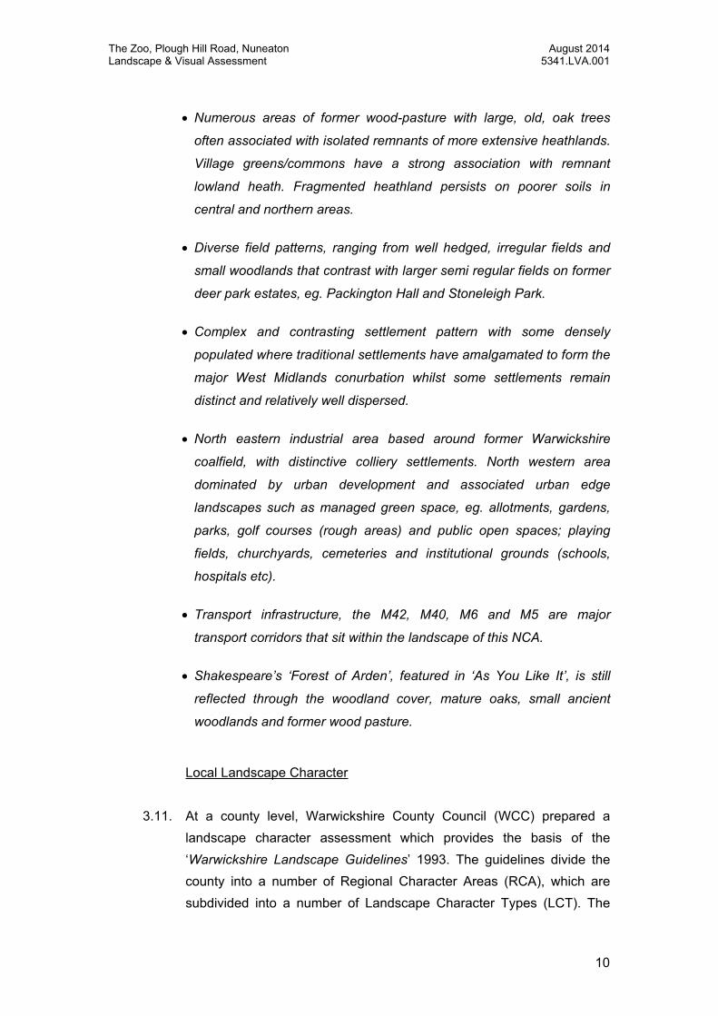
Numerous areas of former wood-pasture with large, old, oak trees
often associated with isolated remnants of more extensive heathlands.
Village greens/commons have a strong association with remnant
lowland heath. Fragmented heathland persists on poorer soils in
central and northern areas.
Diverse field patterns, ranging from well hedged, irregular fields and
small woodlands that contrast with larger semi regular fields on former
deer park estates, eg. Packington Hall and Stoneleigh Park.
Complex and contrasting settlement pattern with some densely
populated where traditional settlements have amalgamated to form the
major West Midlands conurbation whilst some settlements remain
distinct and relatively well dispersed.
North eastern industrial area based around former Warwickshire
coalfield, with distinctive colliery settlements. North western area
dominated by urban development and associated urban edge
landscapes such as managed green space, eg. allotments, gardens,
parks, golf courses (rough areas) and public open spaces; playing
fields, churchyards, cemeteries and institutional grounds (schools,
hospitals etc).
Transport infrastructure, the M42, M40, M6 and M5 are major
transport corridors that sit within the landscape of this NCA.
Shakespeare’s ‘Forest of Arden’, featured in ‘As You Like It’, is still
reflected through the woodland cover, mature oaks, small ancient
woodlands and former wood pasture.
Local Landscape Character
3.11. At a county level, Warwickshire County Council (WCC) prepared a
landscape character assessment which provides the basis of the
‘Warwickshire Landscape Guidelines’ 1993. The guidelines divide the
county into a number of Regional Character Areas (RCA), which are
subdivided into a number of Landscape Character Types (LCT). The

The Zoo, Plough Hill Road, Nuneaton August 2014 Landscape & Visual Assessment 5341.LVA.001
11
site is located within RCA 1: Arden, and the Ancient Arden LCT,
characterised as: ‘A small scale farmed landscape with a varied,
undulating topography, characterised by an irregular pattern of
fields and narrow winding lanes’.
3.12. At a local level, Nuneaton and Bedworth Borough Council (NBBC) has
published a Landscape Character Assessment (August 2012) which
updates and rationalises a number of other partial assessments
previously undertaken within the borough. In the assessment, the site is
identified as part of the existing settlement, or urban area, which was
not subject to detailed assessment, which focusses on the landscape
outside of urban areas.
3.13. The site does however lie adjacent to Landscape Character Area 12:
Galley Common and Valleys, which provides information about the
character of the landscape context immediately west of the site. The key
characteristics of this area, where relevant to the site setting, can be
summarised as follows:
Undulating landform of low rounded hills and incised valleys,
creates variety and a sense of enclosure;
Simple landscape of large, post war, arable fields and smaller
pasture fields close to the urban edge;
Rapid transition from the urban fringes to a remote and rural
landscape;
Fields are bounded by hedgerows which are generally low and
of variable condition; in places hedgerows are no longer evident;
Woodland blocks are prominent on higher ground, and clumps of
woodland at field corners, together with wooded streams and
hedgerow trees, create an impression of higher wooded cover
than actually exists. These woodlands and tree groups often
screen or frame views of properties and urban fringes;
Urban fringes are common, but mature tree planting filters views;
Built development tends to appear as short linear bands of
properties on higher ground and smaller clusters on lower
ground;

The Zoo, Plough Hill Road, Nuneaton August 2014 Landscape & Visual Assessment 5341.LVA.001
12
Buildings are often set just below the highest ground so only
upper storeys are visible helping reduce their scale and
prominence within the landscape;
Built form displays a varied roofline with the horizon often
containing short groups or individual properties surrounded by
trees;
Properties display a range of styles, the majority are post war
and two storeys in height;
Although the urban edge forms part of the wider edge of
Nuneaton, farmland in either side of Plough Hill Road, in
combination with landform, helps to create a sense of separation
between Galley Common and Plough Hill;
Views are generally limited, though there are some more
extensive views from public routes on higher ground;
Main routes, such as Plough Hill Road, have a more urban
character.
3.14. The assessment also includes an appraisal of the landscapes capacity
to accommodate change. It states that: ‘Change in this landscape
which increased the prominence of built form would alter the
strong transition from the urban to rural environment. Any new
development would need to reflect the infrequent clusters of red
brick farmhouse properties within the landscape and ensure it
maintains a positive contribution to retaining distinction between
settlements particularly Plough Hill and Galley Common.’
Landscape Sensitivity
3.15. The national and local landscape character assessments are useful in
providing an overview of the landscape character of the wider setting of
the application site. While Aspect broadly agrees with the outcomes of
these assessments, it is considered that they represent a broad-brush
assessment which does not necessarily reflect the intricacies of the
landscape character of the site and its immediate setting.
3.16. As such Aspect has undertaken a more localised appraisal of the
landscape character of the application site and its immediate setting on

The Zoo, Plough Hill Road, Nuneaton August 2014 Landscape & Visual Assessment 5341.LVA.001
13
the urban edge of Nuneaton. It is considered that there are a number of
factors that both influence and affect the character and sensitivity of the
site and its setting to a change of the type proposed.
3.17. Firstly, the character of the site itself is heavily influenced by a number
of urban and suburban features within the site, associated with its
existing residential use, and former use as a private zoo. Existing sub-
urban features include a large detached residence at the centre of the
site with large driveway, associated garages, outbuildings and large
domestic garden enclosed by extensive evergreen tree planting; an
existing detached property, fronting onto Plough Hill Lane with driveway
and associated rear garden; and a small area of horse paddock.
3.18. Secondly, the character of the site is also heavily influenced by its
location within the existing urban edge of Nuneaton. The site is
bordered by urban development to the east and north, and forms part of
an existing area of sub-urban development, including residential
properties on Plough Hill Lane to the east, and estate housing at Brett’s
Hall Estate to the north.
3.19. Thirdly, the level of visual containment afforded to the site by a
combination of urban form and existing vegetation along and adjacent to
the boundaries of the site, separates it from the wider landscape
context. The level of visual containment means that the site relates
more readily to, and has a stronger relationship with, the existing urban
area on Plough Hill Lane than the rural landscape to the east. This is
recognised in the recently published Nuneaton and Bedworth Borough
Council Landscape Character Assessment which does not include the
site within the assessment; correctly illustrating the site as part of the
existing settlement/urban area. As such it is considered that the site
forms part of the urban edge, an area that is considered to be separate
and distinct from the wider countryside setting to the west.
3.20. It is considered that this area demonstrates capacity to accommodate
sensitively designed and well considered residential development of the
type proposed. It is therefore considered that the application site is of
medium / low landscape sensitivity to a change of the type proposed.

The Zoo, Plough Hill Road, Nuneaton August 2014 Landscape & Visual Assessment 5341.LVA.001
14
3.21. With regard to the wider site context, the enclosed nature of the site
means that that there is very limited intervisibility between the
application site, and the surrounding landscape and townscape setting.
As such the wider setting is considered of low landscape sensitivity to a
change of the type proposed in this location.

The Zoo, Plough Hill Road, Nuneaton August 2014 Landscape & Visual Assessment 5341.LVA.001
15
4. DESCRIPTION OF THE PROPOSALS
4.1. Full details of the proposal are provided within the Design and Access
Statement and supporting material which accompanies this application.
The sketch layout and proposed green infrastructure is illustrated within
its context on ASP3 Illustrative Landscape Masterplan and this has
been informed by the constraints and opportunities illustrated on ASP2.
Design Development
4.2. The proposals have been developed to ensure that a carefully
considered and sensitive development approach is achieved. From the
outset the proposals have sought to respond to, and where possible
enhance, the existing vegetative features of value within the site with
reference to the Tree Condition Survey enclosed within Appendix 2.
Landscape Strategy
4.3. The landscape framework will be designed with two primary functions.
Firstly, the strategic landscape proposals will be designed to improve
the existing local environment together with an integration of the
adjoining land uses. Secondly, the more localised planting within the
site itself will form the immediate setting for the buildings, whilst also
accommodating and creating spaces for recreation, wildlife and the
visual interest for residents and visitors. The landscape proposals will
aim to reinforce the boundaries providing an appropriate edge to the
development, a pleasant environment within the site for residents and a
suitable setting for the proposed built form.
4.4. The following landscape measures have been incorporated into the
masterplan where appropriate to best meet the aims of landscape and
design related national and local planning policy, and the guidelines
within the local landscape character assessment:
Creation of public open space in the northern part of the site,
retaining existing vegetative buffer to the northern boundary;

The Zoo, Plough Hill Road, Nuneaton August 2014 Landscape & Visual Assessment 5341.LVA.001
16
Location of built development outside of the root zones of
existing trees at the site boundary, located within rear gardens to
promote retention of the visual screen and buffer to the rural
landscape to the west;
Layout and orientation of development to retain the most
valuable mature trees, as far as possible;
Retention of mature trees at the site boundaries, supplemented
by proposed native tree and hedge planting to reinforce the
vegetated character of the urban edge;
Tree planting within the residential area to break up the
appearance of urban development, and ensure the presence of
tree planting within the development. The proposed landscaping
will not only assist in integrating the proposed built form, but also
create a high quality environment in which to live; and
Creation of a pedestrian and cycle link to existing routes and
south of the site for the benefit of connectivity and recreation.
4.5. It is considered that the details of the landscaping can be satisfactorily
dealt with via condition, however the proposal illustrated on Plan ASP3
seek to provide some reassurance that the proposed layout has the
ability to retain and supplement the key existing landscape features with
appropriate new planting.

The Zoo, Plough Hill Road, Nuneaton August 2014 Landscape & Visual Assessment 5341.LVA.001
17
5. ASSESSMENT OF EFFECTS
5.1. To assess the nature of the change as a result of the proposals, it is
appropriate to appraise the effect of the proposed development upon
the existing townscape character and visual environment within which
the site is set.
Effect upon Landscape Character
5.2. The character assessment identifies that this site forms part of the
urban edge and relates more readily to the existing urban area than the
wider agricultural landscape to the west of Nuneaton. The site has a
strong landscape structure defining the site boundaries with the
agricultural landscape. As such, it is considered to be of medium / low
sensitivity to a change of the type proposed at a local level.
5.3. The proposed development will not have any effect on the character of
the wider landscape setting, or the wider character of the town, due to
the enclosed nature of the site and the localised nature of the change.
The proposals will reflect the pattern of existing residential development
at the urban edge, and due to the retention and enhancement of
existing vegetation at the boundaries of the site, will not increase the
prominence of the urban edge in relation to the rural area. Equally, due
to the small scale of the development and the previously developed
character of the site, the proposals will not appear to encroach any
further than the existing site into the countryside beyond, or affect its
open character.
5.4. The design of the site also takes account of the sites proximity to the
existing, adjacent residential properties. The proposals have been
designed to ensure sufficient space between existing properties and
new development, whilst maintaining a connection between the site and
the existing urban area. The scale of the proposed development
responds to its context by limiting the height and massing of
development to that of existing residential development within the local
setting. A considered approach to the layout and design of the site,
including the creation of new areas of open green space help maintain

The Zoo, Plough Hill Road, Nuneaton August 2014 Landscape & Visual Assessment 5341.LVA.001
18
existing vegetation and the sense of enclosure, and will also provide an
immediate mature setting for development, further helping to integrate
the proposed development into the townscape setting.
5.5. Although the development has been designed to minimise impacts to
existing vegetation, inevitably for a scheme of this type the proposed
development will require the removal of a small number of existing
trees. However, these trees are of limited arboricultural merit and are
largely internal to the site, thereby ensuring that the vegetated character
of the site’s boundaries is not compromised. Proposed tree planting will
mitigate the trees removed and, once established, the proposals will
have a beneficial effect on tree cover, and as a result, the landscape
character within the site.
5.6. As noted above, it is considered that the immediate landscape context
of the site is of medium / low sensitivity. While the proposals will result
in some vegetation loss, this is internal to the site and will not materially
affect the landscape fabric of the site’s setting. The site is closely
related to the neighbouring urban areas and as such the proposals will
not introduce elements which are significantly at odds with the wider
prevailing character. It is therefore considered that the proposed
development will result in a medium / low magnitude of change. As
such it is considered that the significance of the effect will be moderate
/ minor to minor. This is not considered significant.
5.7. In summary, it is considered that the site already forms part of the urban
area, at the edge of the existing settlement, and a degree of enclosure
created by the established vegetation structure separates the site from
the wider setting to the west. Furthermore, given the need for housing
within the Borough, the application site represents an appropriate and
logical site within the existing settlement that will not compromise the
integrity of the townscape or its setting, or detract from the sense of
openness in views of or from the urban edge. The proposals have
incorporated a landscape led approach, with careful consideration given
to the retention of vegetation within the site, and creation of an
enhanced landscape structure reinforced by native tree planting. These
features ensure that that proposals can be accommodated within this

The Zoo, Plough Hill Road, Nuneaton August 2014 Landscape & Visual Assessment 5341.LVA.001
19
site and setting without detriment to the quality and character of the
receiving environment.
Effect upon the Visual Environment
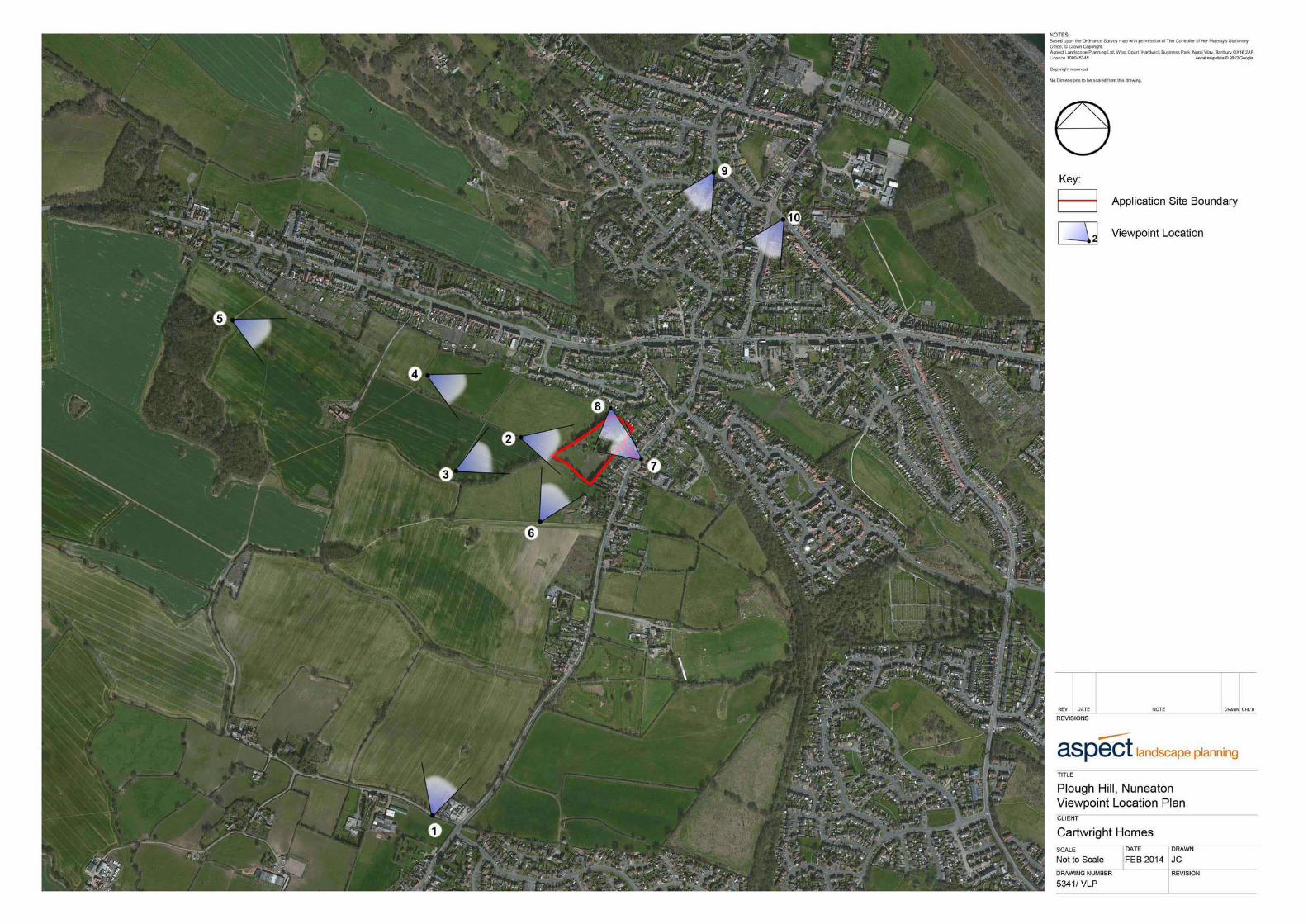
5.8. The visual impact of the proposals has been assessed and a number of
photographs have been taken from key viewpoints to illustrate the site
and its setting (Viewpoints 1-10). The visual analysis and viewpoint
locations are included within Appendix 3. The viewpoints are intended to
form representative views from predominantly publicly accessible
viewpoints, and while not exhaustive are considered to provide an
accurate overview of the site and its setting.
Viewpoint 1
5.9. Viewpoint 1 is taken from School Lane, Galley Common and is
representative of longer distance views towards the site from the south.
The viewpoint illustrates that the localised ridgeline between Galley
Common and the site restricts views to the north. Although the tops of a
small number of evergreen trees within the site are visible in the middle
distance, the site is a barely discernible feature. The site is seen in the
context of the developed, well vegetated skyline at Chapel End to the
north, and the wider view includes views of the urban area within
Nuneaton to the north and north east. From this direction the character
of Plough Hill Road and the landscape beyond is heavily influenced by
the urban setting of Nuneaton.
5.10. The sensitivity of the viewpoint is low as it represents a view from the
local road at Galley Common.
5.11. Views of the proposed development would be limited to a small
proportion of the site, and only rooftops would be visible, seen above
the intervening ridge. Although visible, the development would not be
prominent in the view, and would be seen in the context of wider urban
development associated with Plough Hill Road and Chapel End beyond.
Overall, it is considered that the proposals will result in a change of

The Zoo, Plough Hill Road, Nuneaton August 2014 Landscape & Visual Assessment 5341.LVA.001
20
negligible magnitude upon a low sensitivity receptor, the significance
of which is considered to be negligible.
Viewpoint 2
5.12. Viewpoint 2 is taken from a public right of way (footpath) which runs
parallel to the site, to the west. It illustrates the well vegetated,
evergreen, and suburban character of the western boundary of the site,
and the limited nature of views into the site from this direction as a
result, which are at best heavily filtered. Vegetation within the site
screens views of development on Plough Hill Road, but urban
development within Chapel End is clearly visible to the north of the site,
and forms a strong urban feature in the view.
5.13. The sensitivity of the viewpoint is high as it is representative of views
from a public right of way within the rural landscape, with views of urban
edge.
5.14. The majority of the proposed development would be screened from
view by retained vegetation along the western boundary, though a small
proportion of the development (south-western edge) would be partially
visible, seen through gaps in boundary planting at the southern end of
the site. Although partially visible, the proposed development would not
be prominent and would not change the character of the view, which
already includes numerous urban elements. Overall, it is considered
that the proposals will result in a change of low magnitude upon a high
sensitivity receptor, the significance of which is considered to be
moderate / minor.
Viewpoint 3
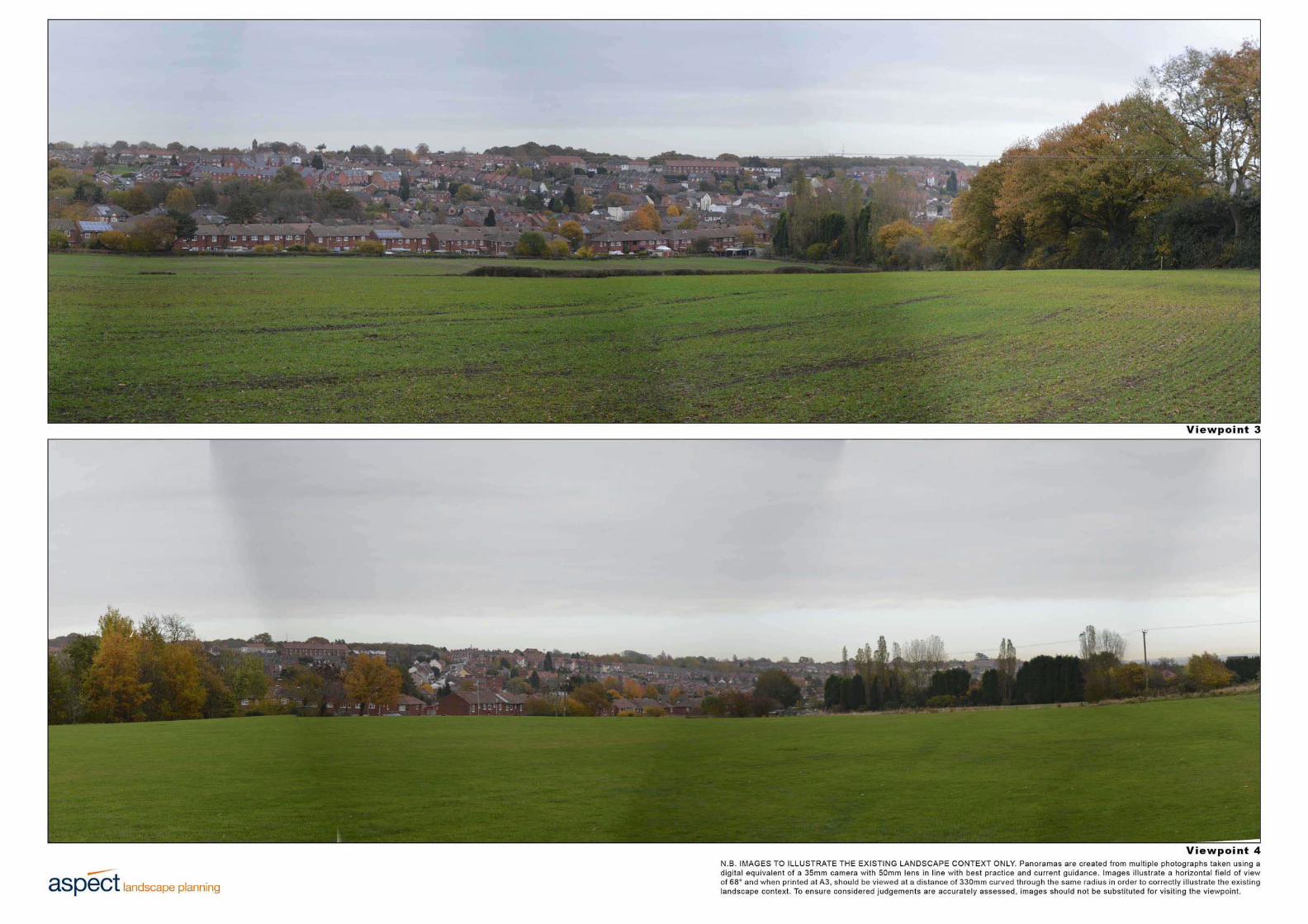
5.15. Viewpoint 3 is taken from a public right of way (footpath) to the south
west of the site and represents an elevated view of the site from the
rural landscape. The site is seen at an oblique angle in the middle
ground, and appears to form an extension to the existing, mature field
boundary hedgerow which runs adjacent to the footpath for much of its
length. The view of the site is limited to views of the mature evergreen
vegetation along the western boundary. The site is seen in the context

The Zoo, Plough Hill Road, Nuneaton August 2014 Landscape & Visual Assessment 5341.LVA.001
21
of an extensive area of existing urban development on rising ground at
Chapel End, which forms the skyline and heavily influences the
character of the view.
5.16. The sensitivity of the viewpoint is high as it is representative of views
from a public right of way within the rural landscape, with views of urban
edge.
5.17. The proposed development would be almost entirely screened from
view by retained vegetation along the western boundary, with only a
small proportion of rooftops visible through gaps in vegetation. Although
partially visible, the proposed development would not be prominent and
would not change the character of the view, which is heavily influenced
by the prominence of the existing urban area. Overall, it is considered
that the proposals will result in a change of low / negligible magnitude
upon a high sensitivity receptor, the significance of which is considered
to be moderate / minor to minor
Viewpoint 4
5.18. Viewpoint 4 is taken from a public right of way (footpath) within the
recreation ground to the west of the site, on the southern edge of
Chapel End. The viewpoint illustrates the well enclosed character of the
site and the vegetated nature of the western boundary which screens
views in to the site and the majority of development on Plough Hill Road
beyond, though rooftops of existing buildings are seen through gaps in
boundary vegetation. The existing urban area at Chapel End is clearly
visible to the left of the view, and beyond the site, seen on elevated
ground, which has an urbanising influence on the character of the
landscape and amenity of the view.
5.19. The sensitivity of the viewpoint is high as it is taken from a public right
of way.
5.20. The majority of the proposed development would be partially or entirely
screened from view by retained vegetation along the western boundary.
Only a small proportion of the development, at the southern end of the
site, would be visible, seen through gaps in existing vegetation. The

The Zoo, Plough Hill Road, Nuneaton August 2014 Landscape & Visual Assessment 5341.LVA.001
22
development would be seen in place of existing rooftops on Plough Hill
Road, though would be slightly closer to the viewpoint. Although
partially visible, the proposed development would be seen amongst
trees and would not be a prominent feature. Neither would the proposed
development change the character of the view, which is heavily
influenced by the prominence of the existing urban area, and the urban
fringe. Overall, it is considered that the proposals will result in a change
of low / negligible magnitude upon a high sensitivity receptor, the
significance of which is considered to be moderate / minor to minor.
Viewpoint 5
5.21. Viewpoint 5 is taken from Centenary Way (Long Distance Footpath),
immediately north of Bret’s Hall Wood and represents a longer distance
view of the site from the rural landscape to the west. The view is similar
to that from viewpoint 4, but due to the increased distance, the site is
even less prominent in the view, and views of it are filtered by
intervening mature trees. The existing urban area is again a prominent
feature, seen to the left of the view, and on rising ground beyond the
site, in the distance.
5.22. The sensitivity of the viewpoint is high as it represents the view from a
well-publicised public right of way, within the rural landscape.
5.23. Although partially visible, the proposed development would be barely
perceptible from this location due to filtering provided by intervening
mature trees, screening by retained trees along the western boundary,
and the distance of the view. Furthermore, the site would be seen in the
context of a wider view of the urban area, and would not be prominent.
Overall, it is considered that the proposals will result in a change of
negligible magnitude upon a high sensitivity receptor, the significance
of which is considered to be minor.
Viewpoint 6
5.24. Viewpoint 6 is taken from a public right of way (footpath), in proximity to
the existing farmstead south of the site. It illustrates the well vegetated

The Zoo, Plough Hill Road, Nuneaton August 2014 Landscape & Visual Assessment 5341.LVA.001
23
character of the southern site boundary, and enclosed nature of the site
in views from this direction. An existing farmstead is visible in the
foreground of the view, and existing urban development within Chapel
End is seen through gaps in existing vegetation, on higher ground,
beyond the site, though is not a prominent feature, due to the well
vegetated character of the view, from this direction.
5.25. The sensitivity of the viewpoint is high as it represents the view from a
public right of way within the rural landscape.
5.26. Views of the proposed development would be limited to glimpses of
rooftops of a small proportion of proposed houses, located on higher
ground at the southern end of the site. Furthermore views would be
heavily filtered by existing, retained vegetation along the southern
boundary, and although partly visible, the development would not be
prominent. Overall, it is considered that the proposals will result in a
change of low magnitude upon a high sensitivity receptor, the
significance of which is considered to be moderate / minor.
Viewpoint 7
5.27. Viewpoint 7 is taken from Plough Hill Road, looking west at the existing
access to the site. It illustrates that views of the site are restricted by
urban development on the west side of Plough Hill Road. Views into the
main body of the site are limited to those along the existing driveway, at
the end of which only the existing residential property is visible. The
character of the streetscape is sub-urban and residential, and the nature
of views are enclosed as a result of existing development. The existing
view offers limited amenity, as the foreground comprises the local road,
and the character of the street is unremarkable and sub-urban in nature.
5.28. The sensitivity of the viewpoint is high due to the residential nature of
receptors on Plough Hill Road.
5.29. The existing house opposite the viewpoint will be replaced with a new,
detached property of similar scale as part of the re-development
proposals. The existing access will be retained and internal parts of the

The Zoo, Plough Hill Road, Nuneaton August 2014 Landscape & Visual Assessment 5341.LVA.001
24
site redeveloped for housing. However, only development at the end of
the driveway will be visible, and views of the remaining site will be
almost entirely screened by intervening built form. It is possible that
occasional rooftops of proposed development may be visible between
buildings, but in essence the character and composition of the view will
not noticeably change as a result of the proposals. Although the form of
the house on the opposite side of the street will change slightly, the
nature and amenity of the view will not.
5.30. Overall, It is considered that the proposals will result in a change of
negligible magnitude upon high sensitivity receptors, the significance
of which is considered to be and minor / negligible.
Viewpoint 8
5.31. Viewpoint 8 is taken from an area of garages immediately north of the
site and illustrates the vegetated character of the northern boundary,
and the limited views into the site from this direction. Amenity is limited
as a result of the run down character of the existing garage blocks
which are prominent in the foreground of the view.
5.32. The sensitivity of the viewpoint is low as it represents a view from an
area of garages, within the urban area west of Plough Hill Road.
5.33. The majority of the proposed development will be screened in views
from this location. Although it is possible that there may be glimpsed,
oblique views of occasional parts of proposed rooftops, seen through
gaps in boundary vegetation, the change would not affect the character
of the view, or existing levels of amenity. Overall, it is considered that
the proposals will result in a change of low / negligible magnitude upon
a low sensitivity receptor, the significance of which is considered to be
minor / negligible to negligible.
Viewpoints 9 and 10
5.34. Viewpoints 9 and 10 are illustrative of elevated views towards the site
from the north. Viewpoint 9 is taken from Hayes Road to the north of the
junction with Moor Road in Snow Hill. Viewpoint 10 is taken from

The Zoo, Plough Hill Road, Nuneaton August 2014 Landscape & Visual Assessment 5341.LVA.001
25
Victoria Road, immediately south-east of the junction with School Hill in
Snow Hill. Both viewpoints illustrate the character of the urban area, the
elevated, restricted nature of existing views to the south, and the limited
prominence of the site in views, which forms a very small part of the
view. Only the existing trees within the site are discernible from the
surrounding urban setting of Snow Hill and Plough Hill.
5.35. The sensitivity of the viewpoints is high as they represent views from
residential areas within Snow Hill, Nuneaton to the north of the site.
5.36. Although rooftops of the development would be visible from these
elevated positions, the proposed development would be a barely
perceptible feature in views, due to the limited nature of views, the small
scale of the change in the composition and character of the view, and
urban context of the site. Overall, it is considered that the proposals will
result in a change of negligible magnitude upon a high sensitivity
receptor, the significance of which is considered to be minor.
5.37. As an overview, he application site is visually well contained due to the
established vegetative structure within and around the boundaries of the
site and the developed nature of its immediate setting, which
substantially limit the visibility of the site to views from the an integrated
part of the existing settlement. Proposed planting to the site boundaries
would where appropriate, reinforce the existing buffer between the site
and its setting to maintain and where possible enhance amenity.
5.38. In sensitive views from the rural landscape, the development would be
well screened, and where there would be glimpsed views through
vegetation, the small proportion of the development visible would be
seen in the context of existing residential development, a prominent
feature of existing views. The retention and enhancement of the existing
treescape to the site’s boundaries will maintain the character of the site
setting, and ensure that the degree of separation and containment
currently afforded to the site is maintained and enhanced where
necessary.
5.39. Overall, it is considered that the development will generally have an
effect of, at worst, moderate / minor significance upon visual amenity.

The Zoo, Plough Hill Road, Nuneaton August 2014 Landscape & Visual Assessment 5341.LVA.001
26
This is not considered significant and it is considered that the perceived
effects of the proposed development will be limited to the immediate
setting of the site.
Effect upon Landscape Related Policy
5.40. As identified within Section 2, whilst the proposals are not subject to any
specific landscape designations, they do lie outside of the settlement
boundary within Countryside and an Area of Restraint. As noted within
the landscape and visual assessments, the proposals are located
adjacent to the existing settlement edge and as a result of the
vegetation cover associated with the receiving environment, where the
proposed built form is perceived it will be in the context of the existing
settlement. The proposals have been designed sensitively and to a
high standard to ensure that the existing urban grain is reflected and the
wider landscape character is respected. It is considered that the site
represents a well-contained area immediately adjacent to the settlement
edge and, as such, it represents an appropriate opportunity to providing
housing land to meet the future needs of the community and the
Borough.
5.41. Both national and local policy guidance seeks to ensure that proposed
development should promote good design which responds to the
character of the setting ensuring that the proposals are integrated within
their context. It is considered that the proposals are fully in line with
policy objectives and can be accommodated within the localised
landscape setting which forms the context of the site.

The Zoo, Plough Hill Road, Nuneaton August 2014 Landscape & Visual Assessment 5341.LVA.001
27
6. SUMMARY & CONCLUSIONS
6.1. Aspect Landscape Planning is instructed by Cartwright Homes to review
the landscape and visual matters arising as a result of the proposed
residential development at The Zoo, Plough Hill Road, Nuneaton.
Having reviewed the local landscape related policy, published character
assessments and visited the site, several landscape related issues were
identified: the effect of the proposals upon the character of the receiving
landscape; the effect of the proposals upon the visual environment; and
the site’s location outside of the settlement boundary.
6.2. It is considered that the application site and receiving environment have
the capacity to accommodate the proposals. The proposals will not
result in significant harm to the landscape character or visual
environment and, as such, it is considered that the proposed
development can be successfully integrated in this location, is
supportable from a landscape and visual perspective, and therefore
meets the landscape requirements of both national and local planning
policy.
6.3. The proposals are located adjacent to the existing settlement edge and
as a result of the vegetation cover associated with the receiving
environment, where the proposed built form is perceived it will be in the
context of the existing settlement. The proposals have been designed
sensitively and to a high standard to ensure that the existing urban grain
is reflected and the wider landscape character is respected. It is
considered that the site represents a well-contained area immediately
adjacent to the settlement edge and, as such, it represents an
appropriate opportunity to providing housing land to meet the future
needs of the community and the Borough.
6.4. As is demonstrated in this assessment, it is considered that the
proposals can be integrated without detriment to the localised and wider
character of the landscape setting and can be accommodated within the
receiving visual environment.

ASPECT PLANS


APPENDIX 1
ASPECT LANDSCAPE AND VISUAL
IMPACT METHODOLOGY

1
LANDSCAPE AND VISUAL IMPACT ASSESSMENT METHODOLOGY
1.1. The Landscape Institute and the Institute of Environmental Management and
Assessment have jointly published Guidelines for Landscape and Visual
Assessment Third Edition (2013) that gives guidance on carrying out a
Landscape and Visual Impact Assessment (LVIA), either as a standalone
appraisal or part of an Environmental Impact Assessment (EIA). This
methodology takes on board the above guidance.
1.2. When assessing character within an urban context, this methodology can be
applied to Townscape Assessments and how the development will affect the
elements that make up the townscape and its distinctive character.
1.3. The main stages of the LVIA process are outlined below. This process will
identify and assess the potential effects of a development on the landscape
resource and the visual environment.
1. Baseline study
Landscape
Define the scope of the assessment.
Outline the planning policy context, including any landscape
designations.
Establish the landscape baseline through a site visit and an assessment
of published Landscape Character Assessments to identify the value of
the landscape resource (receptor), at community, local, national or
international levels where appropriate.
Visual
Define the scope of the assessment.
Identify the extent of visual receptors within the study area, with the use
of Zones of Theoretical Visibility (ZTV) where appropriate, and establish
the number and sensitivity of the representative viewpoint and/or groups
of people (receptors) within the study area whose views may be altered
as a result of the proposals.

2
2. Project description
The baseline study highlights clear opportunities and constraints for the
integration of the proposals into the receiving environment. The aspects of
the scheme at each phase that will potentially give rise to effects on the
landscape and visual amenity will need identifying. At this time, the
proposals can be modified to ensure that further mitigation measures are
incorporated into the design as a response to the local landscape and
visual environment.
3. Description of Effects
The level of effect on both landscape and visual receptors should be
identified in respect of the different components of the proposed
development. In order to assess the significance of the effect on the
receiving environment, it is necessary to consider the magnitude, i.e. the
degree of change, together with the sensitivity of the receptor.
This will identify whether the effects are:
Adverse or Beneficial - beneficial effects would typically occur where a
development could positively contribute to the landscape character or view.
Neutral effects would include changes that neither add nor detract from the
quality and character of an area or view. Adverse effects would typically
occur where there is loss of landscape elements, or the proposal detracts
from the landscape quality and character of an area or view.
Direct or Indirect – A direct effect will be one where a development will
affect a view or the character of an area, either beneficially or adversely.
An indirect effect will occur as a result of associated development i.e. a
development may result in an increase of traffic on a particular route.
Short, Medium or Long Term – this relates to the expected duration and
magnitude of a development. Within this assessment the potential effects
are assessed during the Construction Phase, then at Years 1 and 10,
following completion of the development.
Reversible or Irreversible – can the resulting effect of a development be
mitigated or not, and whether the result of the mitigation is beneficial or
adverse.
4. Significance of Effects (EIA only)

3
A final judgment on whether the effect is likely to be significant, as required
by the Regulations. The summary should draw out the key issues and
outline the scope for reducing any negative/ adverse effects. Mitigation
measures need to be identified that may reduce the final judgement on the
significance of any residual negative effects in the long term.
Assessing the significance of effects
Landscape Sensitivity
1.4. The sensitivity of a particular landscape in relation to new development is
categorised as very high, high, medium, low or negligible. This takes into
account the susceptibility of the receptor to the type of development proposed
and the value attributed to the existing landscape. The following table
explains each threshold and the factors that make up the degree of sensitivity.
Table 1: Landscape Sensitivity Thresholds
Sensitivity Definition
Very High Landscape resource where there is a very high
susceptibility to change. Landscapes would be considered
of high value, have a high degree of intimacy, strong
landscape structure, a high sense of intactness and contain
features worthy of protection. Townscapes may include a
high proportion of historic assets. Typical examples may be
Nationally designated e.g. World Heritage Sites, National
Parks, Heritage Coasts, AONB’s etc.
High Landscape resource where there is a high susceptibility to
change. Landscapes would be considered of high value,
have a high degree of intimacy, strong landscape structure,
relatively intact and contain features worthy of protection.
Townscapes may include a high proportion of historic
assets. Typical examples may be of Regional or County
importance e.g. within the setting of National Parks,
AONB’s, Conservation Areas etc.
Medium Landscape resource where there is a medium susceptibility
to change. Landscapes would be medium scale, good
landscape structure, with some detracting features or
evidence of recent change. Townscapes may include a
proportion of historic assets or of cultural value locally.
Typical examples may be designated for their value at
District level.
Low Landscape resource where there is a low susceptibility to
change. Typical landscapes would be of local landscape
interest, and contain evidence of previous landscape
change.
4
Negligible Landscape resource where there is little or no susceptibility
to change. Typical landscapes are likely to be degraded, of
weak landscape structure, intensive land uses, and require
landscape restoration.
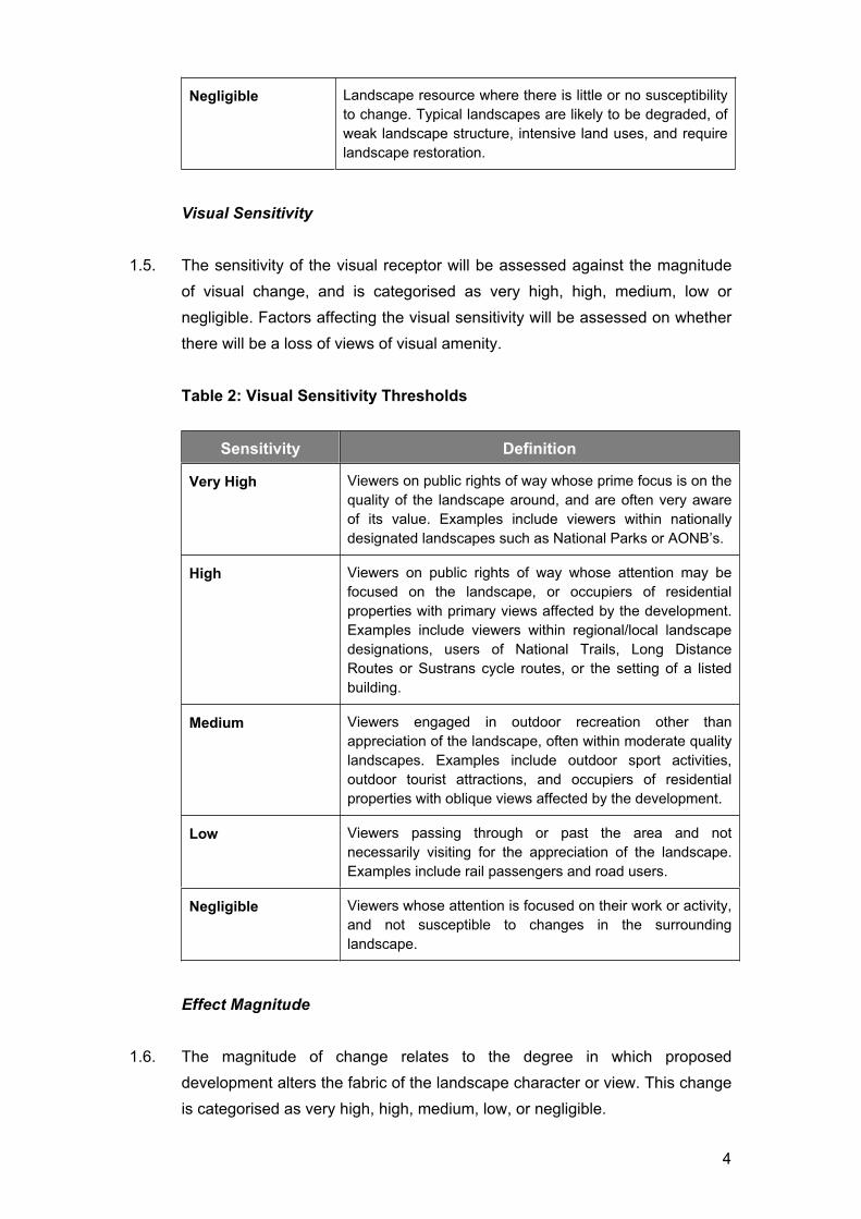
Visual Sensitivity
1.5. The sensitivity of the visual receptor will be assessed against the magnitude
of visual change, and is categorised as very high, high, medium, low or
negligible. Factors affecting the visual sensitivity will be assessed on whether
there will be a loss of views of visual amenity.
Table 2: Visual Sensitivity Thresholds
Sensitivity Definition
Very High Viewers on public rights of way whose prime focus is on the
quality of the landscape around, and are often very aware
of its value. Examples include viewers within nationally
designated landscapes such as National Parks or AONB’s.
High Viewers on public rights of way whose attention may be
focused on the landscape, or occupiers of residential
properties with primary views affected by the development.
Examples include viewers within regional/local landscape
designations, users of National Trails, Long Distance
Routes or Sustrans cycle routes, or the setting of a listed
building.
Medium Viewers engaged in outdoor recreation other than
appreciation of the landscape, often within moderate quality
landscapes. Examples include outdoor sport activities,
outdoor tourist attractions, and occupiers of residential
properties with oblique views affected by the development.
Low Viewers passing through or past the area and not
necessarily visiting for the appreciation of the landscape.
Examples include rail passengers and road users.
Negligible Viewers whose attention is focused on their work or activity,
and not susceptible to changes in the surrounding
landscape.
Effect Magnitude
1.6. The magnitude of change relates to the degree in which proposed
development alters the fabric of the landscape character or view. This change
is categorised as very high, high, medium, low, or negligible.

5
Table 3: Magnitude of Change
Magnitude Effect Definition
Very High Change resulting in a significant degree of deterioration or
improvement, or introduction of dominant new elements that
are considered to make a major alteration to a landscape or
view.
High Change resulting in a high degree of deterioration or
improvement, or introduction of recognisable new
components that may be prominent within a landscape or
view.
Medium Change resulting in a moderate degree of deterioration or
improvement, or constitutes a noticeable change within a
landscape or view.
Low Change resulting in a low degree of deterioration or
improvement to a landscape or view, or constitutes only a
minor component within a landscape or view.
Negligible Change resulting in a barely perceptible degree of
deterioration or improvement to a landscape or view.
No Change It is also possible for a landscape or view to experience no
change due to being totally compatible with the local
character or not visible due to intervening structures or
vegetation.
Significance Threshold
1.7. The magnitude of change is then considered against the sensitivity of the
landscape resource as a receptor or the existing character of the panorama /
view. In formulating the significance of effect, reasoned professional
judgement is required which is explained within the assessment. This is
carried out both in terms of the predicted effects on landscape character or on
visual amenities. The significance thresholds are predicted as Substantial,
Major, Moderate, Minor, Negligible and None, and can be either beneficial or
adverse. Unless otherwise stated, all effects are predicted in the winter
months. The extent of mitigation measures should be clearly stated, and in
the case of planting proposals, the contribution to reducing adverse effects
should be demonstrated at different stages (construction stage, operational
stage year 0, and year 10).
Table 4: Significance of Effect

6
Significance Threshold Definition
Substantial A very high magnitude of change that materially affects a
landscape or view of national / international importance that
has little or no susceptibility to change.
Major A high magnitude of change that materially affects a
landscape or view that has limited susceptibility to change.
Positive effects will typically occur in a damaged landscape
or view.
Moderate A medium magnitude of change that materially affects a
landscape or view that may have the ability to accommodate
change. Positive effects will typically occur in a lower quality
landscape or view.
Minor A low magnitude of change that materially affects a
landscape or view that has the ability to accommodate
change. Positive effects will typically occur in a lower quality
landscape or view.
Negligible A negligible magnitude of change that has little effect on a
landscape or view that has the ability to accommodate
change.
None It is also possible for a magnitude of change to occur that
results in a neutral effect significance due to the change
being compatible with local character or not visible.
1.8. The significance of the effect is measured on the ability of a landscape or
view to accommodate the change. In assessing the significance of effects, the
following matrix will be used to determine the significance thresholds, through
determining the sensitivity of the receptor and the magnitude of change.

7
Table 5: Measuring Significance of Effect
Sensitivity of Receptors
Ma
gn
itu
de
of
Ch
an
ge
Very High High Medium Low Negligible
Very
High Substantial Major
Major/
Moderate Moderate
Moderate/
Minor
High Major
Major/
Moderate Moderate
Moderate/
MinorMinor
Medium Major/
Moderate Moderate
Moderate/
MinorMinor
Minor/
Negligible
Low Moderate
Moderate/
MinorMinor
Minor/
Negligible Negligible
Negligi
ble
Moderate/
MinorMinor
Minor/
Negligible Negligible Negligible
1.9. It should be noted that where there is no perceptible change in terms of the
effect magnitude regardless of the sensitivity of the receptor, the significance
of the effect on a landscape or view will be none.
1.10. Landscape and visual effects that are Substantial, Major or Major/Moderate
are considered to be significant.
1.11. A final written statement summarising the significant effects is provided,
supported by the tables and matrices. This conclusion relies on professional
judgement that is reasonable, based on clear and transparent methods,
suitable training and experience, and a detached and dispassionate view of
the development in the final assessment.
Assessing cumulative effects (EIA only)
1.12. Additional effects caused by a proposed development in conjunction with
other similar developments. This can be cumulative landscape effects on the
physical fabric or character of the landscape, or cumulative visual effects
caused by two or more developments being visible from one viewpoint and/or
sequence of views. The scope of cumulative effects should be agreed at the
outset to establish what schemes are relevant to the assessment, and what
planning stage is appropriate. It is generally considered that existing and
consented developments and those for which planning applications have
been submitted but not yet determined should be included.

APPENDIX 2
ARBORICULTURAL ASSESSMENT


Young
Early Mature
Mature
Over Mature
Veteran
Average / Below Average / Low / Dead
Good / Moderate / Indifferent / Poor / Hazardous

BS5837:2012 Tree Schedule The Zoo, Plough Hill Road, Nuneaton
Tree Survey Schedule: November 2013
N E S W radial
1 Silver Birch 140# 8m 2.5 3 Early Mature Average IndifferentC
121.8
2 Norway Maple 200# 2.5m 1 2 Early Mature Dead Poor Standing Deadwood U N/A
3 Purple Plum 170 7m 2.5 4 2.5 2.5 2.25 Early Mature Average IndifferentC
122.1
4 English Oak 270 10.5m 4.25 3 4.5 4.3 3.5 Early Mature Average IndifferentC
123.3
5 Midland Hawthorn 430 7m 4.5 3.75 3.5 4.25 2 Mature Average Mature
Single bole
Forking at approx. 1.5m
Structure typical for species
Considered to be of moderate arboricultural quality
B
25.1
6 Lime (SL) 470 9m 5.5 5 5.8 5 1.75 Early Mature Average Mature
Single bole
Forking at approx. 2m
Structure typical for species
Considered to be of moderate arboricultural quality
B
25.7
7 Sycamore240
1709m 3 2 Early Mature Average Poor
C
123.6
8 Elder 180 5m 3 2 Early Mature Below Average Poor
Single stem
Structure typical for species
Considered to be of low arboricultural quality
U N/A
9 Lawson 320 8m 2.5 3 Early Mature Average IndifferentC
123.9
10 Yew (Irish)120
2004m 3.75 2.5 Early Mature Average Indifferent
C
122.7
11 Beech 350 12m 6 6 5.5 5 1.75 Early Mature Average Indifferent
Single stem
Forking at approx. 3m
Structure typical for species
Considered to be of moderate arboricultural quality
B
124.2
12 Cherry 260 6m 3 1.75 Early Mature Average IndifferentC
123
13 Cherry 85 4.5m 3 1.5 Young Average PoorC
120.9
14 Cherry 250 5m 4 1.75 Early Mature Average IndifferentC
123
15 Lime 210 7m 3 2.5 3 3 2.5 Early Mature Average IndifferentC
122.4
16 Ash 320# 9.5m 5 3 Early Mature Average IndifferentC
123.9
17 Silver Birch 440 14m 5 5 5 3.5 3 Mature Average Mature
Single stem
Maintains single leader
Structure typical for species
Considered to be of moderate arboricultural quality
B
125.4
18 Cherry 290 9m 3 3.5 5.5 3.75 3 Early Mature Average IndifferentC
123.6
19 Hybrid Black Poplar 700# 24m 6.5 5.8 6 Mature Average Indifferent
Offsite:
Unable to inspect
Large sub dominant arising to west
Decay to northwest
Considered likely to be prominant within views from residential
properties to north
B
28.4
20 Silver Birch 270 oi 7m 3 3.5 3 0 2.25 Young Below Average PoorStructure obscured by Ivy
Considered to be in a state of terminal declineU N/A
21 Hybrid Black Poplar560
49023m 3.25 6.5 6.8 6 2.5 Mature Average Indifferent
C
129
22 Ash 140 6m 0 2.75 3 2.75 1.75 Young Average IndifferentC
121.8
23 Norway Maple 110 6m 0 2 2 2 1.75 Young Average IndifferentC
121.2
Tree
Number
Common Species
NameHeight (m)
Trunk
Diameter
(mm)
Crown Spread (m)BS5837
Category
RPA Radius
(m)
Crown
Clearance (m)Life Stage
Physiological
Condition
Structural
ConditionComments

BS5837:2012 Tree Schedule The Zoo, Plough Hill Road, Nuneaton
Tree Survey Schedule: November 2013
N E S W radial
Tree
Number
Common Species
NameHeight (m)
Trunk
Diameter
(mm)
Crown Spread (m)BS5837
Category
RPA Radius
(m)
Crown
Clearance (m)Life Stage
Physiological
Condition
Structural
ConditionComments
24 Norway Maple 350 8m 1 4.8 1 2 Early Mature Average IndifferentC
124.2
25 Norway Maple 250 8m 0 0 4.5 1 2 Early Mature Average IndifferentC
123
26 Norway Maple 120 6m 1 3.25 2.8 2.5 3 Early Mature Average IndifferentC
121.5
27 Plum 130 4m 3 2 Early Mature Average IndifferentC
121.5
28 Plum 110 5m 1.75 0.50 Early Mature Average IndifferentC
121.2
29 Weeping Silver Birch 170 5m 2.25 1.5 Early Mature Average IndifferentC
122.1
30 Oak 160 4.5m 3.25 1.75 Early Mature Average IndifferentC
121.8
31 Silver Maple 320 11m 4.25 4.75 6.3 5# 2 Early Mature Average Moderate
Single stem
Maintains single leader
Surface roots present to north
1.75m bark canker to south
Considered to be of moderate arboricultural quality
B
123.9
32 Corkscrew Willow 220 7m 1.75 1.75 Early Mature Below Average Poor
Single stem
Lost branches
Considered to be in a state of terminal decline
U N/A
33 White Willow 270 11m 3.25 1.5 Early Mature Average IndifferentC
123.3
34 Corkscrew Willow 280 7m 2.5 1.5 Early Mature Dead PoorSingle stem
Standing deadwoodU N/A
35 Weeping Plum 150 2.5m 2 1.75 Early Mature Average IndifferentC
121.8
36 Corkscrew Willow100
1605.5m
2.75
max1.5 Early Mature Below Average Poor Considered to be in a state of terminal decline U N/A
37 Corkscrew Willow 200 7m 2.5 1.5 Early Mature Average IndifferentC
122.4
38 Weeping Willow 310 7m 5 4.75 6.3 4.5 1 Early Mature Average IndifferentC
123.6
39 Blue Atlas Cedar 240 7m 2.5 2 Young Average Indifferent
Single stem
Maintains single leader
Structure typical for species
Considered to be of moderate arboricultural quality
B
13
40 Alder 150 6.5m 3 1.5 Early Mature Average Poor
Cohesive crown with tree nos. 41 & 42
Active basal decay present
Early loss anticipated
U N/A
41 Alder 90 6.5m 3 1.5 Young Average IndifferentC
121.2
42 Alder 90 6.5m 3 1.5 Young Average IndifferentC
121.2
43 Silver Maple 370 11m 5.5 5.5 5.8 4.5 1.5 Early Mature Average Indifferent
Single stem
Forking at approx. 2m
Structure typical for species
epicormic growth at base
Considered to be of moderate arboricultural quality
B
124.5
44 Silver Maple260
29010m 4.5 6 4.5 4.25 1.5 Early Mature Average Indifferent
C
124.8
45 Lawson 600 9m 2.5 0.5 Early Mature Average IndifferentC
127.2
46 Lawson210
1105m 2.5 0.5 Early Mature Average Indifferent
C
122.7
47 Eucalyptus 470 17m 7 7 8.5 6.5 2.5 Mature Average IndifferentC
125.7

BS5837:2012 Tree Schedule The Zoo, Plough Hill Road, Nuneaton
Tree Survey Schedule: November 2013
N E S W radial
Tree
Number
Common Species
NameHeight (m)
Trunk
Diameter
(mm)
Crown Spread (m)BS5837
Category
RPA Radius
(m)
Crown
Clearance (m)Life Stage
Physiological
Condition
Structural
ConditionComments
48 Italian Alder 250 8m 4 2 Early Mature Average IndifferentC
123
49 Cypress Cultivar 100# 2m 0.5 0.5 Early Mature Below Average PoorOrnamental planting
Considered to be in a state of terminal declineU N/A
50 Cypress Cultivar 100# 2m 0.5 0.5 Early Mature Below Average PoorOrnamental planting
Considered to be in a state of terminal declineU N/A
51 Cypress Cultivar 100# 2m 0.5 0.5 Early Mature Below Average PoorOrnamental planting
Considered to be in a state of terminal declineU N/A
52 Hybrid Black Poplar 980 20m 7 1.75 Mature Average PoorC
1211.7
53 English Oak 500 9.5m 5 2.25 Early Mature Average IndifferentC
126
54 Lime 330 8m 5.25 1 Early Mature Average IndifferentC
123.9
55 Oak650
40012.5m 7.25 2.5 Early Mature Average Indifferent
Offsite:
Unable to inspect
Single bole
Maintains single leader
Large sub dominant arising to southwest at 1m
Structure typical for species
B
29.3
56 Sycamore 270 12m 5.5 2 Early Mature Average IndifferentC
123.3
57 Sycamore 180 7m 4.5 1 Young Average PoorC
122.1
58 Sycamore 350# 9m# 6 1.5 Early Mature Average IndifferentC
124.2
59 Cypress Cultivar 150# 6m# 2 2.5 Young Average PoorC
121.8
60 Yew 200# 5m# 2 2 Young Average IndifferentC
122.4
G1 Lawson Cypress 250 11m 2 0.5-2 Early Mature Average IndifferentC
123
G2
Lawson Cypress
Laurel
Sycamore
600@500
or 4 x 23012m 3.5 0 Early Mature Average Indifferent
C
127.2
G3 Cypress Cultivars 10 x 100 max 4.5m max0.5
max0 Young Average Indifferent
C
121.2
G4 Cypress Cultivars 6 x 100 max 4.5m max0.5
max0 Young Average Indifferent
C
121.2
G5 Cypress Cultivars 18 x 180 max 6m max 2 max 0 Young Average IndifferentC
122.1
G6Lawson Cypress 35 x 250 max 14m max
3 1.5 Early Mature Average IndifferentC
12
3
a) 7.8
G7Lawson Cypress 220 14m max
3 1.5 Early Mature Average IndifferentC
12
2.7
a) 4.8
G8
a)Cherry
b)Silver Birch
c)Silver Birch
d)Silver Birch
e)Cherry
f)Cherry
Hawthorn
Plum
Horse Chestnut
a) 310
b) 90,160
c) 230
d) 200
e) 180
f) 240,160
4-9m max 3.75 0.5-4Young - Early
MatureAverage Indifferent
C
12
a) 3.6
b) 2.1
c) 2.7
d) 2.4
e) 2.1
f) 3.6
G9
Blackthorn
Hawthorn
Elder
Ash
350 max 4-7m 4.5 0.5-1 Mature Average IndifferentC
124.2

BS5837:2012 Tree Schedule The Zoo, Plough Hill Road, Nuneaton
Tree Survey Schedule: November 2013
N E S W radial
Tree
Number
Common Species
NameHeight (m)
Trunk
Diameter
(mm)
Crown Spread (m)BS5837
Category
RPA Radius
(m)
Crown
Clearance (m)Life Stage
Physiological
Condition
Structural
ConditionComments
G10 Lawson Cypress 250 8-12m 2.5 1.5 Early Mature Average IndifferentC
123
G11 Lawson Cypress 250 11m 2 0.5-2 Early Mature Average IndifferentC
123
G12 Lombardy Poplar
a) 550
b) 550
c) 300
d) 550
23m max 3 5Early Mature -
MatureAverage Indifferent
C
12
a) 6.6
b) 6.6
c) 3.6
d) 6.6
G13 Lombardy Poplar 650 max. 23m max 2.5 1 Mature Average IndifferentC
127.8


APPENDIX 3
VISUAL ANALYSIS