Embed Size (px)
Citation preview

January 2015
Prepared by
Proposed
Oregon City Library Expansion
Transportation Impact Analysis and Parking Study
Prepared for
Oregon City Library


Oregon City Library Expansion Transportation Study January 2015 Page i
TABLE OF CONTENTS
LIST OF FIGURES ..................................................................................... ii
LIST OF TABLES ....................................................................................... ii
CHAPTER 1: INTRODUCTION AND SUMMARY ...................................... 1 Existing Intersection Operations ............................................................................................... 4
Project Traffic Impacts .............................................................................................................. 4
Project Parking Impact .............................................................................................................. 6
Project Mitigation Summary ..................................................................................................... 7
CHAPTER 2: EXISTING CONDITIONS ..................................................... 9 Project Site ................................................................................................................................ 9
Study Area Roadway Network .................................................................................................. 9
Existing Traffic Volumes and Operations ................................................................................ 10
Collision Analysis ..................................................................................................................... 14
On and Off-Street Parking ....................................................................................................... 15
Public Transit Service .............................................................................................................. 17
Pedestrians and Bicyclists ....................................................................................................... 18
Planned Improvements ........................................................................................................... 21
CHAPTER 3: PROJECT IMPACTS .......................................................... 23 Proposed Project ..................................................................................................................... 23
Trip Generation ....................................................................................................................... 23
Trip Distribution ...................................................................................................................... 25
Future Traffic Volumes ........................................................................................................... 26
Intersection Operations .......................................................................................................... 29
On-Street Parking Impacts ...................................................................................................... 31
Library Owned Parking Lot Utilization .................................................................................... 33
CHAPTER 4: PROJECT MITIGATION SUMMARY ................................. 34
Appendix ................................................................................................. 36

Oregon City Library Expansion Transportation Study January 2015 Page ii
LIST OF FIGURES Figure 1: Study Area ........................................................................................................................ 2
Figure 2: Existing PM Peak Hour Traffic Volumes ......................................................................... 12
Figure 3: Existing Parking by Block-face Weekday PM Peak Hour ............................................... 16
Figure 4: 2014 Existing PM Peak Hour Pedestrian and Bicycle Volumes ..................................... 19
Figure 5: 7th/John Adams Pedestrian Crossing ............................................................................. 20
Figure 6: Share Curb Ramp at NE corner of John Adams and 6th Street ...................................... 21
Figure 7: Missing Curb Ramp at SW corner of John Adams and 6th Street .................................. 21
Figure 8: Trip Distribution and Future Traffic ............................................................................... 28
Figure 9: Build Parking by Block-face Weekday PM Peak Hour .................................................... 32
LIST OF TABLES Table 1: Key Study Area and Proposed Project Characteristics ...................................................... 3
Table 2: Existing Study Intersection Operations ............................................................................. 4
Table 3: Future Build Study Intersection Operations ..................................................................... 5
Table 4: Future Build On-Street Parking Occupancy (PM Peak Hour) ............................................ 6
Table 5: Study Area Roadway Characteristics ................................................................................ 9
Table 6: Existing Study Intersection Operations ........................................................................... 13
Table 7: Collision History (2009-2013) .......................................................................................... 14
Table 8: Route 32 and 33 Boarding and Alighting Data ................................................................ 17
Table 9: Existing Curb Ramp Inventory on 6th Street .................................................................... 20
Table 10: Mode Split Survey Results ............................................................................................. 24
Table 11: Existing Trip Generation Comparison ........................................................................... 24
Table 12: Proposed Library Expansion Trip Generation ............................................................... 25
Table 13: Assumed Through Volume Growth ............................................................................... 26
Table 14: Added Peak Hour Trips from Approved Developments ............................................... 27
Table 15: Future Study Intersection Operations .......................................................................... 29
Table 16: Peak Hour Left Turn Lane Warrants .............................................................................. 30
Table 17: Future Mitigated Intersection Operations .................................................................... 30

Oregon City Library Expansion Transportation Study January 2015 Page 1
CHAPTER 1: INTRODUCTION AND SUMMARY This study evaluates the transportation impacts of the proposed expansion of the existing Oregon City Library, in Oregon City, Oregon. The proposed expansion would increase the size of the existing library from 7,600 square feet to a maximum of 22,600 square feet. There are currently 24 employees in total, many of whom work part-time. No more than ten people currently work at the Library at the same time. The library is expecting to add approximately one or two more employees with the expansion and expects to have a maximum of twelve employees working at one time.
The existing library is located on John Adams Street, between 7th Street and 6th Street, as shown in Figure 1. The library owns a parking lot on the southeast corner of the 7th Street/Jefferson Street intersection, and uses the lot for employee parking. Library patrons use on-street parking or city-owned public parking lots in the immediate vicinity of the library. The purpose of this study is to determine the transportation impacts of the library expansion in the study area. The report also provides recommendations for accommodation of the additional parking needs generated by the library expansion.
This report documents the evaluation of existing transportation conditions, trip generation and distribution, future conditions, transportation impacts within the study area, and a parking analysis. The study area is shown in Figure 1, including the following study intersections:
• 7th Street/Washington Street • 7th Street/John Adams Street • 7th Street/Jefferson Street • 7th Street/Jackson Street • 7th Street/Molalla Avenue/Taylor Street • Molalla Avenue/Pearl Street • 6th Street/John Adams Street • 6th Street/Jefferson Street • 5th Street/Jackson Street
This chapter provides an introduction to the library expansion and the steps taken to analyze the associated impacts on the transportation network. It highlights important elements from the remaining chapters, including a description of the project site and a summary of the project site evaluation. Table 1 lists important characteristics of the study area and proposed project.

99W
12
3
45
7
6
8
9
No Scale
Study AreaFigure 1LEGEND
- Study Intersection Number #
Will
amette
R
iver43
HIGH ST
CENTER STW
ASHINGTON ST
JOHN A
DAMS ST
JEFFERSON ST
MADIS
ON STM
ONROE ST
6TH ST
5TH ST
3RD ST
2ND ST
1ST ST
SPRING ST
7TH ST
8TH ST
9TH ST
10 TH ST
JOHN Q
UINCY A
DAMS ST
JACKSON ST
HARRISON ST
VAN BUREN ST
TAYLO
R ST
DIVISION ST
WILLAMETTE ST
ROOSEVELT ST
PEARL ST
LOGUS ST
LINN A
V
LibraryCity Park
Library
Singer Creek Park
MO
LALL
A AV
Oregon City Library Expansion Transportation Study January 2015 Page 3
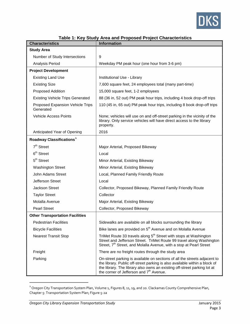
Table 1: Key Study Area and Proposed Project Characteristics Characteristics Information Study Area
Number of Study Intersections 9
Analysis Period Weekday PM peak hour (one hour from 3-6 pm)
Project Development
Existing Land Use Institutional Use - Library
Existing Size 7,600 square feet, 24 employees total (many part-time)
Proposed Addition 15,000 square feet, 1-2 employees
Existing Vehicle Trips Generated 88 (36 in, 52 out) PM peak hour trips, including 4 book drop-off trips
Proposed Expansion Vehicle Trips Generated
110 (45 in, 65 out) PM peak hour trips, including 8 book drop-off trips
Vehicle Access Points None; vehicles will use on and off-street parking in the vicinity of the library. Only service vehicles will have direct access to the library property.
Anticipated Year of Opening 2016
Roadway Classifications1
7th Street Major Arterial, Proposed Bikeway
6th Street Local
5th Street Minor Arterial, Existing Bikeway
Washington Street Minor Arterial, Existing Bikeway
John Adams Street Local, Planned Family Friendly Route
Jefferson Street Local
Jackson Street Collector, Proposed Bikeway, Planned Family Friendly Route
Taylor Street Collector
Molalla Avenue Major Arterial, Existing Bikeway
Pearl Street Collector, Proposed Bikeway
Other Transportation Facilities
Pedestrian Facilities Sidewalks are available on all blocks surrounding the library
Bicycle Facilities Bike lanes are provided on 5th Avenue and on Molalla Avenue
Nearest Transit Stop TriMet Route 33 travels along 5th Street with stops at Washington Street and Jefferson Street. TriMet Route 99 travel along Washington Street, 7th Street, and Molalla Avenue, with a stop at Pearl Street
Freight There are no freight routes through the study area
Parking On-street parking is available on sections of all the streets adjacent to the library. Public off-street parking is also available within a block of the library. The library also owns an existing off-street parking lot at the corner of Jefferson and 7th Avenue.
1 Oregon City Transportation System Plan, Volume 1, Figures 8, 11, 19, and 20. Clackamas County Comprehensive Plan, Chapter 5: Transportation System Plan; Figure 5-2a
Oregon City Library Expansion Transportation Study January 2015 Page 4
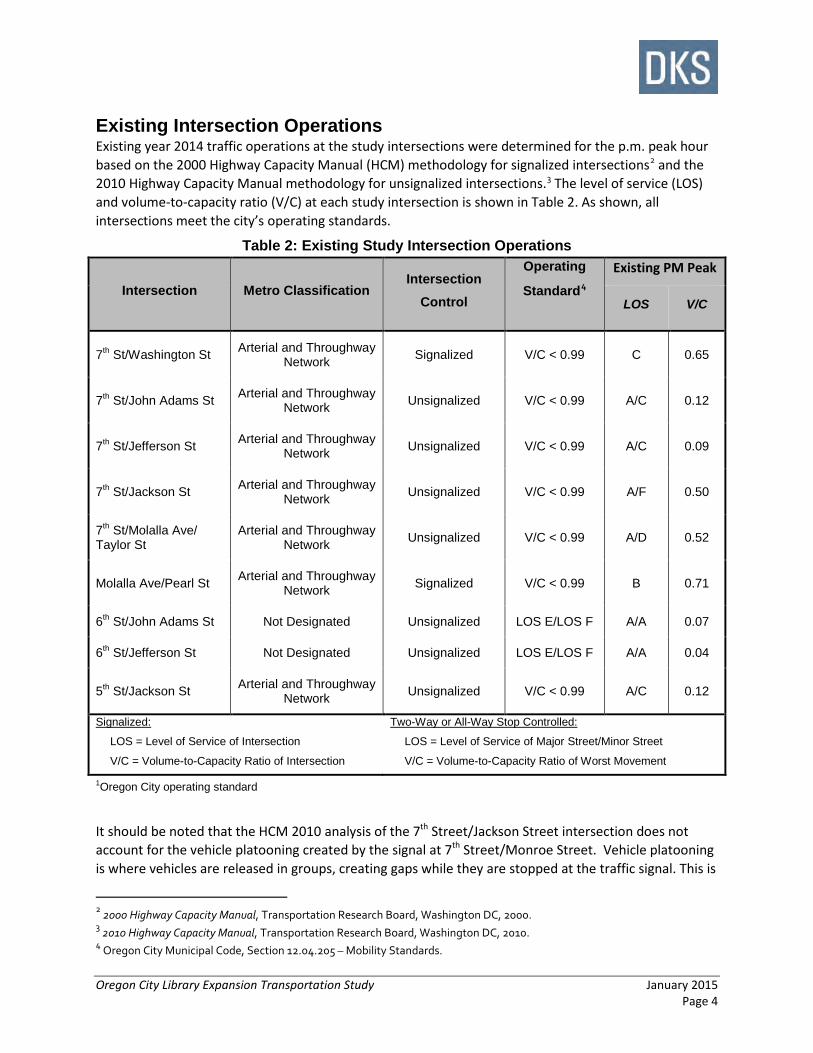
Existing Intersection Operations Existing year 2014 traffic operations at the study intersections were determined for the p.m. peak hour based on the 2000 Highway Capacity Manual (HCM) methodology for signalized intersections2 and the 2010 Highway Capacity Manual methodology for unsignalized intersections.3 The level of service (LOS) and volume-to-capacity ratio (V/C) at each study intersection is shown in Table 2. As shown, all intersections meet the city’s operating standards.
Table 2: Existing Study Intersection Operations
Intersection Metro Classification Intersection
Control
Operating
Standard4
Existing PM Peak
LOS V/C
7th St/Washington St Arterial and Throughway Network Signalized V/C < 0.99 C 0.65
7th St/John Adams St Arterial and Throughway Network Unsignalized V/C < 0.99 A/C 0.12
7th St/Jefferson St Arterial and Throughway Network Unsignalized V/C < 0.99 A/C 0.09
7th St/Jackson St Arterial and Throughway Network Unsignalized V/C < 0.99 A/F 0.50
7th St/Molalla Ave/ Taylor St
Arterial and Throughway Network Unsignalized V/C < 0.99 A/D 0.52
Molalla Ave/Pearl St Arterial and Throughway Network Signalized V/C < 0.99 B 0.71
6th St/John Adams St Not Designated Unsignalized LOS E/LOS F A/A 0.07
6th St/Jefferson St Not Designated Unsignalized LOS E/LOS F A/A 0.04
5th St/Jackson St Arterial and Throughway Network Unsignalized V/C < 0.99 A/C 0.12
Signalized:
LOS = Level of Service of Intersection
V/C = Volume-to-Capacity Ratio of Intersection
Two-Way or All-Way Stop Controlled:
LOS = Level of Service of Major Street/Minor Street
V/C = Volume-to-Capacity Ratio of Worst Movement
1Oregon City operating standard
It should be noted that the HCM 2010 analysis of the 7th Street/Jackson Street intersection does not account for the vehicle platooning created by the signal at 7th Street/Monroe Street. Vehicle platooning is where vehicles are released in groups, creating gaps while they are stopped at the traffic signal. This is
2 2000 Highway Capacity Manual, Transportation Research Board, Washington DC, 2000. 3 2010 Highway Capacity Manual, Transportation Research Board, Washington DC, 2010. 4 Oregon City Municipal Code, Section 12.04.205 – Mobility Standards.

Oregon City Library Expansion Transportation Study January 2015 Page 5
helpful for mainline or side street traffic trying to turn off of or on to the mainline (7th Street). Therefore, the LOS F for the minor movements at the 7th Street/Jackson Street intersection does not accurately portray the traffic operational conditions observed in the field, which were significantly better than LOS F.
Project Traffic Impacts Project traffic impacts were evaluated at the study intersections for the weekday p.m. peak hour for 2016, the estimated year of opening for the library expansion. Additional traffic was added to the roadway network based on trip generation and trip distribution assumptions associated with the floor space added to the site and assumed background traffic growth (assumptions are documented in Chapter 3). Table 3 lists the future traffic operating conditions at the study intersections. As shown, all nine study intersections are expected to meet Oregon City operating standards for the p.m. peak hour for the project build year.
Table 3: Future Build Study Intersection Operations
Intersection Metro Classification
Intersection Control
Operating Standard5
2016 No Build PM Peak
2016 Build PM Peak
LOS V/C LOS V/C 7th St/ Washington St
Arterial and Throughway Network Signalized V/C < 0.99 C 0.68 C 0.69
7th St/ John Adams St
Arterial and Throughway Network Unsignalized V/C < 0.99 A/D 0.13 A/D 0.17
7th St/ Jefferson St
Arterial and Throughway Network Unsignalized V/C < 0.99 A/C 0.10 A/C 0.13
7th St/ Jackson St
Arterial and Throughway Network Unsignalized V/C < 0.99 A/F 0.59 A/F 0.64
7th St/ Molalla Ave/ Taylor St
Arterial and Throughway Network Unsignalized V/C < 0.99 A/E 0.58 A/E 0.60
Molalla Ave/ Pearl St
Arterial and Throughway Network Signalized V/C < 0.99 B 0.74 B 0.76
6th St/ John Adams St
Not Designated Unsignalized LOS E /LOS F
A/A 0.07 A/A 0.09
6th St/ Jefferson St Not Designated Unsignalized
LOS E/ LOS F
A/A 0.04 A/A 0.08
5th St/ Jackson St
Arterial and Throughway Network Unsignalized V/C < 0.99 A/C 0.12 A/C 0.12
Signalized:
LOS = Level of Service of Intersection
V/C = Volume-to-Capacity Ratio of Intersection
Two-Way or All-Way Stop Controlled:
LOS = Level of Service of Major Street/Minor Street
V/C = Volume-to-Capacity Ratio of Worst Movement
1Oregon City operating standard
5 Oregon City Transportation System Plan, Volume 1, Mobility Standards; pg. 38-39

Oregon City Library Expansion Transportation Study January 2015 Page 6
As indicated by the results shown in Table 3, the library expansion does not significantly impact the operations at any of the nine intersections analyzed. No operational mitigations are required. However, some traffic mitigations are recommended to improve access to the library and maintain un-interrupted traffic flow on 7th Street. These mitigations are described later in this chapter.
Project Parking Impact Parking impacts associated with the proposed library expansion were evaluated for on and off-street parking in the surrounding areas. In addition, the library design team requested that the best use of the library owned lot on the southeast corner of the 7th Street/Jefferson Street intersection be considered and evaluated. The library recently purchased the lot and would like to determine whether the lot should be used for employees, patrons or a combination of both. In addition, it was requested that the possibility of leasing several of the spaces be considered.
Table 4: Future Build On-Street Parking Occupancy (PM Peak Hour)
Street (Direction of Traffic)
Block Capacity (vehicles)
Average Occupancy (vehicles)6
Average Vacancy (spaces)
Average Occupancy
(%) From To
7th St (Westbound)
Madison St Jefferson St 7 2 5 29%
Jefferson St John Adams St 7 6 1 86%
6th St (Westbound)
Madison St Jefferson St 11 7 4 64%
Jefferson St John Adams St 6 6 0 100%
6th St (Eastbound)
Washington St John Adams St 9 6 3 67%
John Adams St Jefferson St 9 6 3 67%
Jefferson St Madison St 12 8 4 67%
John Adams St (Southbound)
7th St 6th St 6 4 2 67%
6th St 5th St 5 3 2 60%
John Adams St (Northbound)
5th St 6th St 9 5 4 56%
6th St 7th St 6 5 1 83%
Jefferson St (Southbound)
7th St 6th St 11 10 1 91%
6th St 5th St 12 7 5 58%
Jefferson St (Northbound)
5th St 6th St 12 5 7 42%
6th St 7th St 11 9 2 82%
Total 133 89 44 67%
The traffic analysis indicated that the existing on-street parking does have sufficient capacity to accommodate the added library parking demand. The analysis assumed that the added demand would
6 Based on October 9, 2014 PM peak hour (5:00 PM to 6:00 PM) on-street parking occupancy counts and increased by 10 parked vehicles per hour to account for added school day traffic. See Trip Generation section for more details
Oregon City Library Expansion Transportation Study January 2015 Page 7
only use on-street parking, so the actual capacity of the study area may be higher if library patrons choose to use public lots that are more than one block away from the library. Table 4 summarizes the on-street parking impacts of the library expansion, assuming that patrons will walk no more than one block from a street parking spot to the library site. On average, about two-thirds of the on-street parking spots within one block of the library will be occupied with the proposed expansion in place. The details of the on-street parking analysis are included in Chapter 3.
After reviewing the existing conditions and layout of the library owned parking lot at the southeast corner of the 7th Street/Jefferson Street intersection, it is recommended that at least 10 of the lot parking spaces be reserved for library employees, with additional spaces designated either for long-term daily volunteer parking or for lease to local businesses. Additional improvements to the off-street parking lot were included as recommended project traffic mitigations.
Project Mitigation Summary The following list summarizes the mitigation strategies identified as part of the Oregon City Library Expansion Transportation Impact Study. These projects are recommended based on the operational analysis of the future traffic conditions, and the existing pedestrian, bicycle, and parking conditions in the study area.
Motor Vehicle Improvements • Restripe 7th Street at John Adams Street to include a left-turn lane in the northwest direction.
This project is included in the City’s Transportation System Plan as D29. Although low (<20 vph) left turn volumes allow the intersection operations to meet City standards both under existing and future Build conditions, preliminary left-turn lane warrants indicate a need for a left-turn lane.
• Consider providing library signage on 7th Street, for vehicles traveling in the northwest direction, encouraging vehicles to turn left at Monroe Street, a signalized intersection. This will reduce the left-turn demand on 7th Street at the unsignalized intersections at Jefferson Street and John Adams Street.
Pedestrian and Bicycle Access • Maintain pedestrian and bicycle accessibility to building entrances, providing bicycle parking
near building entrances.
On-Street Parking • Stripe on-street parking stalls adjacent to library parcel on Jefferson Street, 6th Street, and John
Adams Street to maximize parking efficiency. • Allocate three parking stalls to be used specifically for book drop-off. These stalls should be
located on 6th Street, adjacent to the library. Signage adjacent to these stalls should include language similar to “10-minute parking only”.
• Upgrade or add curb ramps to ADA standards at the following intersections to improve access between on-street parking and the library:
o 6th Street/John Adams Street o 6th Street/Jefferson Street

Oregon City Library Expansion Transportation Study January 2015 Page 8
Off-Street Parking • Based on the current parking lot usage and geometry, the following improvements and options
are recommended for the library owned parking lot:
o Remove the existing parking space nearest to 7th Street entrance. This space requires a departing vehicle to complete a blind back-up maneuver onto the sidewalk and possibly onto 7th Street if the parking lot is full.
o Restripe the existing one-way parking lot markings to emphasize the circulation.
o Install a “Do Not Enter” sign facing parking lot traffic at the 7th Street entrance. The sight distance restrictions caused by existing foliage and a retaining wall to the west and a building abutting the sidewalk to the east make exiting onto 7th Street undesirable.
o Redirect traffic exiting the parking lot to turn west on the alley toward Jefferson Street, rather than toward Madison Street, since sight distance is restricted where the alley accesses Madison Street.
o Sign the parking spaces required for staff as “library staff only” (approximately 10 spaces). The remaining spaces may be used for either:
Volunteer staff parking (revise sign to read “library staff and volunteers only”)
Lease to nearby businesses
Overall, the only significant transportation impact of the library expansion is the increase in on-street parking demand, especially during the PM peak hour. However, the current on-street parking facilities in the area surrounding the library provide adequate capacity to meet the predicted future demand. The current network has adequate capacity to absorb the added library traffic, and intersection operations near the library should not be noticeably affected. Most transportation mitigation efforts associated with the library expansion should be focused on encouraging alternative modes of travel to the library with improved pedestrian and bicycle facilities in and around the project site.

Oregon City Library Expansion Transportation Study January 2015 Page 9
CHAPTER 2: EXISTING CONDITIONS This chapter provides documentation of existing study area conditions, including the project site, study area roadway network, parking, pedestrian, bicycle and transit facilities, and existing traffic volumes and operations. Supporting details are provided in the appendix.
Project Site The proposed project involves the expansion of the existing 7,600 square foot library. The proposed expansion occurs on a single, full block parcel in Oregon City, Oregon. The site is the city block bounded by John Adams Street, 7th Street, Jefferson Street and 6th Street. As there is no existing dedicated off-street parking on the site parcel for the proposed development, the direct connections to the surrounding neighborhood only serve non-motorized modes.
Study Area Roadway Network The study area was selected with the intention of capturing transportation impacts related to the proposed project. Table 5 lists the characteristics of key roadways in the study area.
Table 5: Study Area Roadway Characteristics
Roadway Oregon City7 Classification Number of Lanes
Posted Speed Sidewalks Bike
Lanes On-Street Parking
7th St (Center St to Taylor St)
Primary Arterial, TriMet Transit Route, Proposed Bikeway
2/3 25 mph Yes No Yes (one side)
6th St (Washington St to Madison St)
Local 2 25 mph Yes No Yes
5th St/Linn Ave (Washington St to 4th St)
Minor Arterial, TriMet Transit Route, Existing Bikeway
2 25 mph Some Yes Yes
Washington St (5th St to 8th St)
Minor Arterial, TriMet Transit Route, Existing Bikeway
2 25 mph Yes No Yes
John Adams St (5th St to 8th St)
Local, Planned Family Friendly Route
2 25 mph Yes No Yes
Jefferson St (5th St to 8th St)
Local 2 25 mph Yes No Yes
Jackson St (5th St to 8th St)
Collector, Proposed Bikeway, Planned Family Friendly Route
2 25 mph Yes No Yes
Taylor St (7th St to 8th St)
Collector 2 25 mph Yes No Yes
Molalla Ave (Taylor St to Dewey St)
Major Arterial, TriMet Transit Route, Existing Bikeway
3 25 mph Yes Yes No
Pearl St (Myrtle St to Warren St)
Collector, Proposed Bikeway 2 25 mph Yes No Yes
7 Oregon City Transportation System Plan, Volume 1, Figures 8, 11, 19, and 20. Clackamas County Comprehensive Plan, Chapter 5: Transportation System Plan; Figures 5-2a and 5-8a

Oregon City Library Expansion Transportation Study January 2015 Page 10
Existing Traffic Volumes and Operations Existing p.m. peak hour traffic operations were analyzed at the following study intersections, consistent with the City of Oregon City Guidelines for Transportation Impact Analyses8:
• 7th Street/Washington Street • 7th Street/John Adams Street • 7th Street/Jefferson Street • 7th Street/Jackson Street • 7th Street/Taylor Street/Molalla Avenue • Molalla Avenue/Pearl Street • 6th Street/John Adams Street • 6th Street/Jefferson Street • 5th Street/Jackson Street
To perform the intersection analysis, traffic counts were collected during the p.m. (3:00 to 6:00 p.m.) peak period on October 21, 2014. Existing peak hour traffic volumes are shown in Figure 2 with the detailed traffic counts included in the Appendix. The purpose of intersection analysis is to ensure that the transportation network remains within desired performance levels as required by City code. Intersections are the focus of the analysis because they are the controlling bottlenecks of traffic flow and the ability of a roadway system to carry traffic efficiently is nearly always diminished in their vicinity.
Before the analysis results of the study intersections are presented, discussion is provided for two important analysis issues: intersection performance measures (definitions of typical measures) and required operating standards (as specified by the agency with roadway jurisdiction).
Intersection Performance Measures Level of service (LOS) ratings and volume-to-capacity (V/C) ratios are two commonly used performance measures that provide a good picture of intersection operations. In addition, they are often incorporated into agency mobility standards.
• Level of service (LOS): A “report card” rating (A through F) based on the average delay experienced by vehicles at the intersection.9 LOS A, B, and C indicate conditions where traffic moves without significant delays over periods of peak hour travel demand. LOS D and E are progressively worse operating conditions. LOS F represents conditions where average vehicle delay has become excessive and demand has exceeded capacity.
• Volume-to-capacity (V/C) ratio: A decimal representation (typically between 0.00 and 1.00) of the proportion of capacity that is being used at a turn movement, approach leg, or intersection. It is determined by dividing the peak hour traffic volume by the hourly capacity of a given intersection or movement. A lower ratio indicates smooth operations and minimal delays. As the ratio approaches 1.00, congestion increases and performance is reduced. If the ratio is greater than 1.00, the turn movement, approach leg, or intersection is oversaturated and usually results in excessive queues and long delays.
8 City of Oregon City Guidelines for Transportation Impact Analyses, November 2, 2005. 9 A description of Level of Service (LOS) is provided in the appendix and includes a list of the delay values (in seconds) that correspond to each LOS designation.

Oregon City Library Expansion Transportation Study January 2015 Page 11
Required Operating Standards The City of Oregon City’s mobility standards are defined in the Oregon City Municipal Code10, which is included in the Appendix. The relevant standards that apply to the study intersections are as follows:
For intersections outside of the Regional Center but designated on the Arterial and Throughway Network, as defined in the Regional Transportation Plan, the following mobility standards apply:
o During the first hour, a maximum v/c ratio of 0.99 shall be maintained. For signalized intersections, this standard applies to the intersection as a whole. For unsignalized intersections, this standard applies to movements on the major street. There is no performance standard for the minor street approaches.
o During the second hour, a maximum v/c ratio of 0.99 shall be maintained at signalized intersections. For signalized intersections, this standard applies to the intersection as a whole. For unsignalized intersections, this standard applies to movements on the major street. There is no performance standard for the minor street approaches.
For intersections outside the boundaries of the Regional Center and not designated on the Arterial and Throughway Network, as defined in the Regional Transportation Plan, the following mobility standards apply:
o For signalized intersections:
During the first hour, LOS "D" or better will be required for the intersection as a whole and no approach operating at worse than LOS "E" and a v/c ratio not higher than 1.0 for the sum of the critical movements.
During the second hour, LOS "D" or better will be required for the intersection as a whole and no approach operating at worse than LOS "E" and a v/c ratio not higher than 1.0 for the sum of the critical movements.
o For unsignalized intersections outside of the boundaries of the Regional Center:
For unsignalized intersections, during the peak hour, all movements serving more than twenty vehicles shall be maintained at LOS "E" or better. LOS "F" will be tolerated at movements serving no more than twenty vehicles during the peak hour.
For this study, only first hour volumes were analyzed. None of the second hour volumes conditions would apply to any of the study intersections since none of the study intersections are expected to exceed the mobility standards for the first hour during any of the analysis scenarios.
10 Oregon City Municipal Code, Section 12.04.205 – Mobility Standards.

Key Map
No Scale
7th St./Washington St.
7th St./John Adams St.
7th St/Jackson St.7th St./Jefferson St. 6th St./John Adams St. 6th St./Jefferson St.
5th St./Jackson St. 7th St./Molalla St./Taylor St. Molalla St./Pearl St.
6.3. 4. 5.
7. 8. 9.
1.
2.
2014 ExistingPM Peak Hour
Traffic Volumes
Figure 2LEGEND- Study Intersection
- Traffic Signal
- Lane Configuration
- PM Peak Hour Traffic Volumes
- Volume Turn Movement RightThruLeft
LT TH RT
000
- Stop Sign
#
YIELD
LEGEND
- Study Intersection
- Existing Lane Configuration
- Stop Sign
- Volume Turn MovementsRightThruLeftRTTHLT
AM (PM) - Peak Hour Traffic Volumes
- Traffic Signal
- Flashing Beacon- Proposed Access
SPEED
20
LEGEND
- Study Intersection
- Traffic Signal
- Stop Sign YIELD - Yield Sign
0
28235
THRT
229327
1725
427
0
8718
414
441120TH
RTRT
TH
RTTH
LT
LTTH
RT
854316
102
4
42
22
870620 LT
TH
RT
RT
THLT
RTTH
LT
LTTH
RT
1317
7
623
13
510 2
48
7 LT
TH
RT
RT
THLT
RTTH
LT
LTTH
RT
131567
3812
4
TH
RT
RT163109
7 856
3
15 754 18
154
17
LT
TH
RT
RT
TH
LT
RTTHLT
LTTHRT
455221
60
2
41
15
27264 LT
TH
RT
RT
THLT
RTTH
LT
LTTH
RT
115
0
1611
3
47
1
161
3 LT
TH
RT
RT
THLT
RTTH
LT
LTTH
RT
315666
1727
20
321 8
177483 LT
TH
RT
RT
THLT
RTTH
LT
LTTH
RT
LTRT
3426 THLT
28730 THLT
LT
436
12
3
45
7
6
8
9
CENTER STW
ASHINGTON ST
JOHN A
DAMS ST
JEFFERSON ST
MADIS
ON STM
ONROE ST
6TH ST
5TH ST
SPRING ST
7TH ST
JOHN Q
UINCY A
DAMS ST
JACKSON ST
HARRISON ST
VAN BUREN ST
TAYLO
R ST
DIVISION ST
WILLAMETTE ST
ROOSEVELT ST
PEARL ST
LOGUS ST
LINN AV
LibraryCity Park
Library
MO
LALL
A AV

Oregon City Library Expansion Transportation Study January 2015 Page 13
Existing Operating Conditions Existing traffic operations at the study intersections were determined for the p.m. peak hour based on the 2010 Highway Capacity Manual methodologies11 for signalized and unsignalized intersections and compared with the City of Oregon City’s mobility standards. The estimated LOS and V/C ratio of each study intersection are shown in Table 6.
Table 6: Existing Study Intersection Operations
Intersection Metro Classification Intersection
Control
Operating
Standard12
Existing PM Peak
LOS V/C
7th St/Washington St Arterial and Throughway Network Signalized V/C < 0.99 C 0.65
7th St/John Adams St Arterial and Throughway Network Unsignalized V/C < 0.99 A/C 0.12
7th St/Jefferson St Arterial and Throughway Network Unsignalized V/C < 0.99 A/C 0.09
7th St/Jackson St Arterial and Throughway Network Unsignalized V/C < 0.99 A/F 0.50
7th St/Molalla Ave/Taylor St
Arterial and Throughway Network Unsignalized V/C < 0.99 A/D 0.52
Molalla Ave/Pearl St Arterial and Throughway Network Signalized V/C < 0.99 B 0.71
6th St/John Adams St Not Designated Unsignalized LOS E/LOS F A/A 0.07
6th St/Jefferson St Not Designated Unsignalized LOS E/LOS F A/A 0.04
5th St/Jackson St Arterial and Throughway Network Unsignalized V/C < 0.99 A/C 0.12
Signalized:
LOS = Level of Service of Intersection
V/C = Volume-to-Capacity Ratio of Intersection
Two-Way or All-Way Stop Controlled:
LOS = Level of Service of Major Street/Minor Street
V/C = Volume-to-Capacity Ratio of Worst Movement
The results indicate that the southbound movement from the Jackson Street minor approach at the 7th Street/Jackson Street intersection operates at LOS F under existing conditions. There is no mobility
11 2000 Highway Capacity Manual, Transportation Research Board, Washington DC, 2000, for signalized intersections and 2010 Highway Capacity Manual, Transportation Research Board, Washington DC, 2010, for unsignalized intersections. 12 Oregon City Municipal Code, Section 12.04.205 – Mobility Standards. For intersections on the Regional Transportation Plan’s (RTP) designated Arterial and Throughway Network, a v/c ratio < 0.99 shall be maintained for both the first and second hour. There is no performance standard for minor street approaches. For unsignalized intersections not designated in the RTP, all movements serving more than 20 vehicles shall be maintained at LOS “E”. LOS “F” will be tolerated for movements serving no more than 20 vehicles during the peak hour.

Oregon City Library Expansion Transportation Study January 2015 Page 14
standard for this approach since it is a minor street approach on the RTP Arterial and Throughway Network, however, it should be noted that project field observations at the intersection noted traffic platooning on 7th Street, due mainly to the traffic signal at 7th Street/Monroe Street two blocks west of Jackson Street. The HCM 2010 TWSC Analysis methodology does not account for vehicle platooning, resulting in calculated LOS F operations for the minor street movements. Based on field observations, the 7th Street/Jackson Street intersection minor approach operates closer to LOS C due to signal platooning.
Collision Analysis Five years of collision records (2009-2013) for the study area were obtained from the Oregon Department of Transportation (ODOT) collision database. There were 55 total collisions between the nine study intersections over the five year period. As shown in Table 7, none of the intersections had collision rates in excess of 1.0 collisions per million entering vehicles, a common threshold used to identify intersection that require a more detailed safety analysis. Further analysis shows that all of the intersections fall below the statewide critical crash rates.
Table 7: Collision History (2009-2013)
Intersection Collisions (by Year) Collision
Rateb Critical Ratec 2009 2010 2011 2012 2013 Total
7th St/Washington St 2 3 7 1 4 17 0.42 0.67
7th St/John Adams St 0 3 2 0 3 8 0.28 0.31
7th St/Jefferson St 0 1 0 1 0 1 0.04 0.31
7th St/Jackson St 0 1 1 1 0 3 0.10 0.30
7th St/Taylor St/Molalla Ave 1 0 0 0 1 2 0.06 0.48
Molalla Ave/Pearl St 5 1 8 4 3 21 0.55 0.68
6th St/John Adams St 1 0 0 0 0 1 0.41 0.80
6th St/Jefferson St 0 0 0 1 0 1 0.58 0.96
5th St/Jackson St 0 0 1 0 0 1 0.06 0.20
a PDO = Property damage only. b Collision rate for intersections= average annual collisions per million entering vehicles (MEV); MEV
estimates based on p.m. peak-hour traffic count and applicable factors. c Critical Collision rate for intersections= statewide 90th percentile annual collisions per MEV for similar
intersections

Oregon City Library Expansion Transportation Study January 2015 Page 15
On and Off-Street Parking The existing Oregon City Library does not have a dedicated off-street parking lot for patrons. Current library visitors either park on the streets surrounding the library or in nearby off-street public parking lots, typically owned by the City of Oregon City. The project team collected parking occupancy counts during the PM peak hour on October 9, 2014 and adjusted the counts to reflect a typical school day (see Trip Generation Section), to provide a conservative analysis. Figure 3 shows the existing study area parking locations and PM peak hour average occupancies. The on-street parking blocks were selected as part of the study area based on their location relative to drivers approaching the library. Other on-street parking is available on the street blocks surrounding the library, but these spaces were removed from the analysis based on the walking distance from to the library. Figure 3 summarizes the existing on-street parking capacities, PM peak hour occupancies and vacancies within the study area.
Current library visitors use the 10 public parking spaces in the fire station parking lot. However, these spaces are generally occupied during the PM peak hour. The library has also purchased the public parking lot on the southeast corner of the 7th Street/Jefferson Street intersection. Currently, library employees use this parking lot. Figure 3 also shows the existing PM peak hour parking capacity and occupancy for the fire station (Lot P) and library owned (Lot Q) public parking lots.

Existing Parking by Block-face
Weekday PM Peak Hour
Figure 3LEGEND
No Scale
- Average Available Parking Spaces
- No Parking Allowed
- Library Off-Street Parking
- Library On-Street Parking
- Restricted Off-Street Parking
- Future Parking Space
- Average Occupied Parking Spaces
- Average Available Parking Spaces
- Average Occupied Parking Spaces
- Average Added Occupied Parking Spaces
Block-face/Lot - Bar Chart
Block-face/Lot Capacity
AverageOccupied
AverageVacant
77116971255
225413113
5562841142
Block-face/Lot Capacity
AverageOccupied
AverageVacant
Existing Peak Hour Average Parking Occupancies
LOT
LOT
A
B
C
D
E
F
G
H
I
J
K
L
M
N
O
P
Q
Total
9410121281019
153
518256109
68
432107201085
WA
SH
I\NG
TON
ST
JOH
N A
DA
MS
ST
JEF
FE
RS
ON
ST
MA
DIS
ON
S
T
7TH ST
6TH ST
5TH ST
Library
AB
CD
K
H
E F G
J
I
M N
LO
LOTLOTQ
P

Oregon City Library Expansion Transportation Study January 2015 Page 17
Public Transit Service The two transit stops closest to the library are located on 5th Street/Jefferson Street and 5th Street/Washington Street. The boardings and alightings for these two stops are shown in Table 8. Both stops are served by TriMet Route 33 (McLoughlin), which runs with approximately 15 minute daytime headways. TriMet Route 32 (Oatfield) has three stops within 0.25 miles of the library; 9th Street/Washington Street, 9th Street/Jefferson Street, and 9th Street/Monroe Street. The boardings and alightings for these stops are summarized in
Table 8. The Route 32 headways vary throughout the day from 15 minutes during the morning peak, 30 minutes during the evening peak, and 60 minutes at midday. TriMet Route 99 (McLoughlin Express) travels through the study area using Washington Street, 7th Street, and Molalla Avenue. However, Route 99 riders are not likely to walk to the library as the nearest stop is the Oregon City Transit Center, more than one-half mile to the north.
Table 8: Route 32 and 33 Boarding and Alighting Data
Bus Stop Location Route Weekday Daily Average
Monthly Lifts Ons Offs Total
9th St/Washington St (Westbound) 32-Oatfield 1 4 5 1
900 Block Washington St (Southbound) 32-Oatfield 3 2 5 2
9th St/Jefferson St (Westbound) 32-Oatfield 1 2 3 0
9th St/Jefferson St (Eastbound) 32-Oatfield 1 2 3 1
9th St/Monroe St (Westbound) 32-Oatfield 1 1 2 0
9th St/Monroe St (Eastbound) 32-Oatfield 2 2 4 0
5th St/Washington St (Westbound) 33-McLoughlin 6 7 13 15
5th St/Washington St (Eastbound) 33-McLoughlin 8 10 18 13
5th St/Jefferson St (Westbound) 33-McLoughlin 2 6 8 7
5th St/Jefferson St (Eastbound) 33-McLoughlin 6 4 10 4
5th St/Monroe St (Westbound) 33-McLoughlin 10 10 20 1
5th St/Monroe St (Eastbound) 33-McLoughlin 9 13 22 3

Oregon City Library Expansion Transportation Study January 2015 Page 18
Pedestrians and Bicyclists Existing peak hour pedestrian traffic within the study area is summarized in Figure 4. Bicycle activity in the study area is generally low during the peak period, with fewer than five cyclists at each of the study intersections, except Molalla/Pearl, which had seven bicyclists.
Pedestrian activity is highest at Molalla/Pearl and along 7th Street in the immediate vicinity of the library (Washington Street, John Adams Street and Jefferson Street), with about 25-35 pedestrians at these intersections during the PM peak hour.
All of the streets within the study area have continuous sidewalks. The busy peak hour traffic on 7th Street presents the only major barrier to pedestrian movements to and from the library. However, a striped crosswalk with a push button activated pedestrian flasher (RRFB)13 was recently installed at the intersection of John Adams Street and 7th Street (see Figure 5). This crossing improvement was constructed as part of a planned Family Friendly pedestrian and bicycle route along John Adams Street.14
13 Rectangular Rapid Flashing Beacon. 14 Oregon City Transportation System Plan, Volume 1, Mobility Standards; Figure 19.

7th St./Washington St.
7th St./John Adams St.
7th St/Jackson St.7th St./Jefferson St. 6th St./John Adams St. 6th St./Jefferson St.
5th St./Jackson St. 7th St./Molalla St./Taylor St. Molalla St./Pearl St.
6.3. 4. 5.
7. 8. 9.
1.
2.
2014 PM Peak Bicycle & Pedestrian Volumes
Figure 4LEGEND- Study Intersection #- Pedestrian Peak Hour Volume
- Bicycle Peak Hour Volume
00
00
YIELD
LEGEND
- Study Intersection
- Existing Lane Configuration
- Stop Sign
- Volume Turn MovementsRightThruLeftRTTHLT
AM (PM) - Peak Hour Traffic Volumes
- Traffic Signal
- Flashing Beacon- Proposed Access
SPEED
20
LEGEND
- Study Intersection
- Traffic Signal
- Stop Sign YIELD - Yield Sign
0
Key Map
No Scale
AA
AA
AA
AA
AA
AA
AA
AA
4
8
9
11
1
0
1
2
6
6
2
11
0
0
0
0
510
3
8
0
0
0
0 8
3
3
1
0
1
0
1 7
7
2
5
0
1
0
1
2
4
0
3
0
0
0
1
17
3
11
5
4
0
3
0
0
0 62
0
1
0
0 90
1
2
12
3
45
7
6
8
9
CENTER STW
ASHINGTON ST
JOHN A
DAMS ST
JEFFERSON ST
MADIS
ON STM
ONROE ST
6TH ST
5TH ST
SPRING ST
7TH ST
JOHN Q
UINCY A
DAMS ST
JACKSON ST
HARRISON ST
VAN BUREN ST
TAYLO
R ST
DIVISION ST
WILLAMETTE ST
ROOSEVELT ST
PEARL ST
LOGUS ST
LINN AV
LibraryCity Park
Library
MO
LALL
A AV

Oregon City Library Expansion Transportation Study January 2015 Page 20
The 7th Street/Washington Street intersection provides pedestrians with pedestrian signal heads and crosswalks on all approaches. These crosswalks provide pedestrians with a second 7th Street crossing option. Each crossing has wide shared curb ramps.
People walking to the existing library generally use the 6th Street sidewalks between John Adams Street and Jefferson Street. The intersections of 6th Street/John Adams Street and 6th
Street/Jefferson Street are currently all-way stop controlled with full striped crosswalks. However, the intersections do not have full ADA curb ramps at all crosswalk locations (see Figure 6 and Figure 7 for examples). The incomplete curb ramp layout hampers movement for disabled persons attempting to access the library from many of the nearby street parking locations. Table 9 show summarizes existing curb ramp deficiencies at the 6th Street intersections.
Table 9: Existing Curb Ramp Inventory on 6th Street
Intersection Crossing Curb Ramps
6th Street/John Adams Street North John Adams Street Shared ramp at northeast corner, shared
ramp at northwest corner
South John Adams Street Ramp on southeast corner, no ramp on southwest corner
East 6th Street Shared ramp on northeast corner, ramp on southeast corner
West 6th Street Shared ramp on northwest corner, ramp on southwest corner
6th Street/Jefferson Street North Jefferson Street Ramp at northeast corner, no ramp at northwest corner
South Jefferson Street No ramp on southeast corner, ramp on southwest corner
East 6th Street No ramp on northeast corner, ramp on southeast corner
West 6th Street Ramp on northwest corner, Ramp on southwest corner
Figure 5: 7th/John Adams Pedestrian Crossing

Oregon City Library Expansion Transportation Study January 2015 Page 21
The study area is served by limited bicycle facilities. As indicated in Table 5, 5th Street, Washington Street and Molalla Avenue are existing bikeways. However, only 5th Street and Molalla Avenue have striped bike lanes. Jackson Street, Pearl Street and 7th Street are all proposed bikeways, according to the Oregon City Transportation System Plan. The PM peak hour bicycle volumes within the study area are very light, as shown in Figure 4. However, higher bicycle volumes are likely during warmer and drier months. The existing library does provide some bicycle parking with a five space bike rack.
Planned Improvements The Oregon City Transportation System Plan15 indicates that the following transportation related projects are planned in the vicinity of the project site:
• Washington Street Upgrade: Driving Solutions (Years 6 – 10, likely to be funded): Construct Improve Washington Street to a Minor Arterial cross-section from 11th Street to 7th Street. Add curb-ramps at intersections.
• Washington Street Traffic Surveillance: Driving Solutions (Years 10+, not likely to be funded): Install video monitoring cameras and vehicle detection equipment to provide turn movement counts, hourly volumes, travel times, and speed measurements on Washington Street between 7th Street and OR 213.
• Washington Street Speed Warning System: Driving Solutions (Years 10+, not likely to be funded): Install a speed warning system on Washington Street near 9th Street. The system activates when a motorist approaches at a high speed.
• Molalla Avenue/Beavercreek Road Adaptive Signal Timing: Driving Solutions (Year 0-5, likely to be funded): Deploy adaptive signal timing that adjusts signal timings to match real-time traffic conditions on Molalla Avenue/7th Street from Washington Street to Gaffney Lane.
• 7th Street/Molalla Avenue Traffic Surveillance: Driving Solutions (Years 10+, not likely to be funded): Install video monitoring cameras and vehicle detection equipment to provide turn movement counts, hourly volumes, travel times, and speed measurements on 7th Street/Molalla Avenue between Washington Street and OR 213.
15 Oregon City Transportation System Plan, Volume 2, Planned and Financially Constrained Transportation Systems.
Figure 7: Missing Curb Ramp at SW corner of John Adams and 6th Street
Figure 6: Share Curb Ramp at NE corner of John Adams and 6th Street

Oregon City Library Expansion Transportation Study January 2015 Page 22
• OR213/7th Street-Molalla Avenue/Washington Street Integrated Corridor Management: Driving Solutions (Years 10+, not likely to be funded): Integrate traffic surveillance and traffic control equipment with ODOT on Washington Street/7th Street-Molalla Avenue corridor.
• 7th Street Speed Warning System: Driving Solutions (Years 10+, not likely to be funded): Install a speed warning system on 7th Street near Harrison Street. The system activates when a motorist approaches at a high speed.
• John Adams Street/7th Street Restriping: Driving Solutions (Years 10+, not likely to be funded): Restripe 7th Street to include a northbound left-turn pocket from 7th Street to John Adams Street.
• John Adams-Jefferson Street Family Friendly Route: Family Friendly Route Solutions (Years 10+, not likely to be funded): Complete sidewalk gaps and add way finding and shared lane markings on John Adams and Jefferson Street from Water Board Park Road to 15th Street.
• John Adams Street/7th Street Family Friendly Route Crossing: Street Crossing Solutions (already constructed): Install crosswalk and pedestrian activated flasher on 7th Street at John Adams Street.
• Jackson Street/7th Street Family Friendly Route Crossing: Street Crossing Solutions (Years 10+, not likely to be funded): Install crosswalk and pedestrian activated flasher on 7th Street at Jackson Street.

Oregon City Library Expansion Transportation Study January 2015 Page 23
CHAPTER 3: PROJECT IMPACTS This chapter reviews the impacts of the proposed development plans on the study area transportation system. The study area intersections documented in previous sections of this report are the main focus of the analysis. The secondary focus of the analysis is on potential uses for the library leased parking lot on the southeast corner of the 7th Street/Jefferson Street intersection. The current parking lot usage is documented in previous sections of this report.
Proposed Project The proposed project will expand the existing Oregon City Library in Oregon City, Oregon. The existing Carnegie style library building has 7,600 square feet of gross floor area. The proposed expansion would add up to an additional 15,000 square feet of gross floor area to the existing structure, for a maximum total of 22,600 square feet. A site plan is included in the appendix. The existing library currently has 24 staff members (total, many of whom are part-time) and the library expects to add only one to two additional staff with the expansion. A small amount of added off-street parking adjacent to the library site is assumed with the proposed project, gained through the efficiency of striped parking stalls relative to the unstructured on-street parking that occurs today. The library expansion design team proposes to restrict parking along the north side of Jefferson Street, adjacent to the library, to two-hour parking. The expansion is scheduled for completion by the year 2016.
Trip Generation This study focuses on the impacts of the existing and proposed library on the surrounding street network during the adjacent street (7th Street) PM peak hour, which occurs between approximately 4:45 PM and 5:45 PM during a normal weekday. The actual library peak hour occurs earlier in the day. However, traffic conditions on the adjacent street network are less busy earlier in the day. The library currently does not open until after the 7th Street AM peak hour. Therefore, the 7th Street PM peak hour was selected for analysis as the most representative time period for peak library expansion traffic impacts.
The ITE Trip Generation Manual16 contains daily and adjacent street PM peak hour trip rates for libraries calculated based on gross floor area. However, there are a limited number of trip generation studies for libraries of similar size and location to the Oregon City Library. User data was provided by the library, which records visitor entrances and exits throughout each day. In addition, a mode choice survey of library visitors was conducted on October 9, 2014 between 3 PM and 6 PM. The results are shown in Table 10.
Given the urban residential location and parking restrictions of the existing library, a trip generation comparison between the ITE Trip Generation Manual and the existing library usage data was undertaken to determine whether ITE trip rates were appropriate. It was anticipated that the Oregon City Library might generate fewer trips than indicated by ITE due to its proximity to fairly dense residential neighborhoods, where patrons may be more likely to walk or bicycle to the library than in a typical suburban location.
The mode choice survey was collected during a non-school weekday. Door count data indicated approximately 25% more persons during the PM Peak Hour on a school day. To better represent a typical day, the vehicle mode choice data was applied to door counts from a school day the week before 16 Trip Generation, 9th Edition, Institute of Transportation Engineers, 2012, Land use code 590 (Library).

Oregon City Library Expansion Transportation Study January 2015 Page 24
the survey.17 The combined mode choice, entrance, and exit data provided the existing vehicle trip generation for the library. The resulting trip generation was compared to the ITE Trip Generation Manual average trip rate results for a library, as shown in Table 11. The door count data was also used to calculate the entering/exiting trip split during the peak hour of adjacent street traffic (7th Street).
Table 10: Mode Split Survey Results
*Persons observed making book drop-offs without entering the library during the survey
Table 11: Existing Trip Generation Comparison
Calculation Method
Average Daily Rate (trip ends per 1000
GFA)
Gross Floor Area
(GFA)
Existing Daily Vehicle Trip
Ends
Average Daily Rate (trip ends per 1000
GFA)
Existing Adjacent Street PM Peak Hour Vehicle Trip Ends
Total In/Out Total In/Out Split
(%In/%Out)
ITE Rate (Code 590)
56.24 7,600 427 214/213 7.30 55 26/29 47%/53%
Calculated from Survey*
92.63 7,600 704 352/352 11.58 88 36/52 41%/59%
*Using mode split data obtained from October 9, 2014 survey and October 2, 2014 door counts. Includes 8 (4 in/4 out) book drop-off trip ends
As indicated in Table 11, the trips generated by the library were higher than the trips calculated using ITE average trip rates.18 In reviewing the ITE data, it was noted that smaller libraries tend to have higher
17 The Oregon City Library provided door counts throughout the year. October was found to be a fairly typical month in the year and the count date selected was determined to be representative of a typical school day in October. 18 The ITE regression equation has a relatively low r-squared value (0.68) and only 11 data points. The ITE Trip Generation Handbook recommends using the regression equation when data points exceed 20 and the r-squared value is >0.75.
Mode Split Total Survey Responses % of Respondents
Driver 104 58%
Passenger 33 18%
Transit 5 3%
Bike 6 3%
Walk 32 18%
Total 180 100%
Additional Observed Modes
Book Drop-off (vehicle trips)* 10

Oregon City Library Expansion Transportation Study January 2015 Page 25
trip generation rates than larger libraries. Since the observed trip rate was not lower than estimated by ITE, as originally anticipated, and since trip rates tend to decrease with increased library size, the average ITE trip rate was used to estimate the proposed project trip generation. This lower rate is supported by the fact that the library anticipates adding only one to two additional staff with the proposed expansion.
Table 12 summarizes the existing and proposed project daily and peak hour library trips. Since the proposed library expansion is expected to approximately triple the size of the existing library, book drop-off portion of total trip ends is also expected to triple with the expected increased book selection. The added book drop-off trips are shown separately in Table 12, but would be included in the PM peak hour trip generation total (110 trips).
Table 12: Proposed Library Expansion Trip Generation
Land Use
Quantity Units
Daily PM Peak Hour
Rate (trips/unit)
Total Rate (trips/unit)
Trip Generation (In/Out/Total)c
Book Drop-off (In/Out/Total)
Library (ITE Code 590)
15,000 GFA 56.24 844 7.30 45/65/110 8/8/16
c Includes book drop-off trips
Typically, a new development generates two trip types: pass-by and non-pass by. Pass-by trips are already on the network, stopping at the development and then continue on without route modification. Non-pass by trips can be broken down into two further trip types; primary and diverted. Primary trips are added to the network by the new development and enter and leave the study area by the same route. Diverted trips are already on the network but modify a specific route to reach the development.
No pass-by trip reduction was applied to the calculated trips added by the proposed library expansion. The existing library parking availability discourages pass-by trips from 7th Street, which is the only busy street adjacent to the library. Given the small size of the study area, no diverted trip reduction was applied to the generated trips. Therefore, all trips added by the library expansion were assumed to be primary trips.
Trip Distribution The trips generated by the proposed library expansion were distributed based on the existing travel patterns in the study area and the distribution of population and employment in the library’s service area (similar to the Oregon City School District boundary). Most of the distributed trips were assumed to be directionally balanced, with equal percentages of trips entering and leaving the study area. However, a higher percentage of trips were assumed to enter the study area from the north (southbound Washington Street) and the west (eastbound 7th Street) and exit to the south either on Molalla Avenue or Center Street. These un-balanced distributions were selected based on overall peak hour traffic patterns in the study area. The existing traffic patterns indicated that during the peak hour, trips would

Oregon City Library Expansion Transportation Study January 2015 Page 26
enter the study area from eastbound 7th Street and leave heading either southbound to 5th Street or continue eastbound on 7th Street. These trips are most likely commuters stopping by the library on their way home from work. The trip distribution for the library expansion trips is shown in Figure 8.
Future Traffic Volumes
Two future traffic volume scenarios were developed, based on an expected year of opening of 2016:
• 2016 No Build (includes background traffic growth)
• 2016 Build (includes background + proposed project traffic growth)
Background Growth The Oregon City TSP provided existing and year 2035 forecasted traffic volumes on Washington Street, 7th Street and Molalla Avenue. These forecasted volumes were used to calculate the expected through traffic growth along Washington Street, 7th Street, Molalla Avenue and 5th Street by the project year of opening (2016), assuming linear growth. No growth was assumed on the other streets within the network as the area is already developed and does not serve any major through traffic movements. The resulting traffic growth is shown in Table 13. The growth rates were applied to the major (through) movements of the existing 2014 intersection counts.
Table 13: Assumed Through Volume Growth Roadway Direction Total Growth
Washington Street Both 3%
7th Street Both 3%
Molalla Avenue Both 2%
5th Street Both 3%
All other streets Both 0%
The trips added by the future developments summarized below were also included in the future background traffic shown in Figure 8.
Three approved developments within the study area are scheduled for construction in the near future:
• Olson Pharmacy: The existing Olson Pharmacy is located at the corner of 7th Street and Monroe Street. The approved development would replace the existing pharmacy with a two-story mixed-use retail/residential building.
• Mike’s Drive-In: The existing Mike’s Drive-In restaurant is located at the northeast corner of 7th Street and Madison Street. The approved development would expand the existing restaurant from 1,600 SF (square feet) to 3,000 SF and add 2,800 SF of office space.
• 512-514 7th Street Vacant Lot Development: The approved development location is the vacant lot at the southwest corner of 7th Street and Washington Street. The approved development includes 2,540 SF of retail space and 2,000 SF of medical/dental office space.

Oregon City Library Expansion Transportation Study January 2015 Page 27
The three proposed developments will only impact the through trips on 7th Street within the study area. The trips generated by each development were summarized in Traffic Analysis Letters submitted to the City of Oregon City. All primary trips were assumed to stay on 7th Street, and were distributed based on the existing travel patterns in the study area. The added peak hour approved development trips affecting study area intersections are summarized in Table 14.
Table 14: Added Peak Hour Trips from Approved Developments
*Approved development trips are less than the amount generated by the existing land use The trips added by background through traffic growth (Table 13) and the approved developments (Table 14) were added to existing traffic volumes, resulting in the future background traffic shown in Figure 8.
Added Traffic Assignment The 110 PM peak hour additional trips generated by the proposed library expansion (see Table 12) were assigned to the study area using the trip distribution percentages shown in Figure 8. Traffic assignment around the library was based on the availability of on-street parking, discussed in more detail in a later section of the report. The final assigned project trips resulted in the PM peak hour volumes that were added to the existing and background volumes at the study intersections, as shown in Figure 8.
Development Additional Peak Hour Trips
7th Street/ Molalla Avenue Study Area Impacts
Eastbound Westbound Total In Out Pass-by West of site East of site West of site East of site
Olson Pharmacy Re-development * * * * 0 0 0 0
Mike’s Drive In Expansion 24 7 12 5 3 7 5 4
7th Street Vacant Lot Development 80 37 38 5 16 21 17 21

Key Map
No Scale
7th St./Washington St.
7th St./John Adams St.
7th St/Jackson St.
5th St./Jackson St. 7th St./Molalla St./Taylor St. Molalla St./Pearl St.
6.3. 4. 5.
7. 8. 9.
1.
2.
2016 BuildPM Peak Hour
Traffic Volumes
Figure 8LEGEND- Study Intersection
- Traffic Signal
- Lane Configuration
- Project Traffic Volume
- Volume Turn Movement RightThruLeft
LT TH RT
(000)- Stop Sign
# - Background Traffic Volume[000]
12
3
45
7
6
8
9
CENTER STW
ASHINGTON ST
JOHN A
DAMS ST
JEFFERSON ST
MADIS
ON STM
ONROE ST
6TH ST
5TH ST
SPRING ST
7TH ST
JOHN Q
UINCY A
DAMS ST
JACKSON ST
HARRISON ST
VAN BUREN ST
TAYLO
R ST
DIVISION ST
WILLAMETTE ST
ROOSEVELT ST
PEARL ST
LOGUS ST
LINN AV
LibraryCity Park
Library
MO
LALL
A AV
YIELD
LEGEND
- Study Intersection
- Existing Lane Configuration
- Stop Sign
- Volume Turn MovementsRightThruLeftRTTHLT
AM (PM) - Peak Hour Traffic Volumes
- Traffic Signal
- Flashing Beacon- Proposed Access
SPEED
20
LEGEND
- Study Intersection
- Traffic Signal
- Stop Sign YIELD - Yield Sign
0
30 (0)255 [8] (10)
THRT
240 [7] (2)370 [36] (3)
20 [1
] (0)
265
[8] (
0)28
5 [8
] (5)
(0) [
3] 9
0(1
) [6]
195
(3) [
0] 2
0
(5) [37] 485(0) [4] 125
TH
RTRT
TH
RTTH
LT
LTTH
RT
10 (0)590 [42] (5)20 (2)
10 (0
)5
(0)
5 (0
)
(0) 5
(0) 5
(13)
35
(0) 10(3) [45] 755(10) 30 LT
TH
RT
RT
THLT
RTTH
LT
LTTH
RT
20 (7)20 (3)10 (2)
15 (6
)25
(0)
20 (7
)
(2) 1
0(4
) 15
(3) 5
(2) 10(3) 15(0) 10 LT
TH
RT
RT
THLT
RTTH
LT
LTTH
RT
135 (0)625 [39] (18)
40 (2
)13
0 (0
)
TH
RT
RT20 (2)5 (0)110 (0)
10 (
0)93
0 [4
2] (
28)
10 (
3)
(0)
15(1
6) [4
3] 8
15(0
) 20
(0) 15(0) 5
(0) 20
LT
TH
RT
RT
TH
LT
RTTHLT
LTTHRT
5 (0)605 [42] (6)35 (14)
10 (0
)0
(0)
5 (0
)
(0) 5
(0) 5
(9) 2
5
(0) 5
(10) [46] 785(6) 10 LT
TH
RT
RT
THLT
RTTH
LT
LTTH
RT
5 (3)15 (0)0 (0)
25 (9
)20
(8)
10 (4
)
(0) 5
(0) 1
0(0
) 5
(5) 25(3) 5(6) 10 LT
TH
RT
RT
THLT
RTTH
LT
LTTH
RT
35 (0)630 [42] (20)
10 (0)
20 (0
)30
(0)
20 (0
)
(0) 5
(0) 2
5(0
) 10
(0) 20
(34) [50] 835(0) 5 LT
TH
RT
RT
THLT
RTTH
LT
LTTH
RT
LTRT
(0) 5
(13) [13] 455 THLT
(3) 30
(31) [40] 805 THLT
LT
5 (0
)40
(0)
- 2016 Build PM Peak Hour Traffic Volumes000
- Trip Distribution
5%
5%
10%15%
10%
10%
5%
20%
5%
40%
35% 5%
00%
7th St./Jefferson St. 6th St./John Adams St. 6th St./Jefferson St.3. 4. 5.

Oregon City Library Expansion Transportation Study January 2015 Page 29
Intersection Operations The PM peak hour traffic volumes shown in Figure 8 were analyzed both with (Build Scenario) and without (No-Build Scenario) the library expansion trips. The HCM 2000 methodology was used to analyze the signalized intersections, and the HCM 2010 methodology was used for all-way stop control and two-way stop control intersections.19 The resulting No-Build Scenario and Build Scenario study intersection operations are summarized in Table 15.
2016 No-Build Scenario:
Under 2016 No Build traffic conditions, all of the study intersections meet Oregon City operational standards. The Jackson Street approaches at the 7th Street/Jackson Street intersection operates at LOS F. As discussed in Chapter 2 and observed in the field, platooning from the 7th Street/Monroe Street intersection signal creates gaps in the 7th Street traffic, resulting in better operations than reported. Therefore, no future traffic operational needs are identified under No-Build Scenario conditions.
2016 Build Scenario:
The added traffic from the proposed library expansion does not significantly affect the future operations at any of the study intersections. All future No-Build Scenario study intersection Levels of Service are maintained under the future Build Scenario conditions.
Table 15: Future Study Intersection Operations
Intersection Metro Classification Intersection Control
Operating Standard20
No-Build PM Peak
Build PM Peak
LOS V/C LOS V/C
7th St/Washington St Arterial and Throughway Network Signalized V/C < 0.99 C 0.68 C 0.69
7th St/John Adams St Arterial and Throughway Network Unsignalized V/C < 0.99 A/D 0.13 A/D 0.17
7th St/Jefferson St Arterial and Throughway Network Unsignalized V/C < 0.99 A/C 0.10 A/C 0.13
7th St/Jackson St Arterial and Throughway Network Unsignalized V/C < 0.99 A/F 0.59 A/F 0.64
7th St/Molalla Ave/ Taylor St
Arterial and Throughway Network Unsignalized V/C < 0.99 A/E 0.58 A/E 0.60
Molalla Ave/Pearl St Arterial and Throughway Network Signalized V/C < 0.99 B 0.74 B 0.76
6th St/John Adams St Not Designated Unsignalized LOS E/ LOS F A/A 0.07 A/A 0.09
6th St/Jefferson St Not Designated Unsignalized LOS E/ LOS F A/A 0.04 A/A 0.08
5th St/Jackson St Arterial and Throughway Network Unsignalized V/C < 0.99 A/C 0.12 A/C 0.12
Signalized: LOS = Level of Service of Intersection V/C = Volume-to-Capacity Ratio of Intersection
Two-Way or All-Way Stop Controlled: LOS = Level of Service of Major Street/Minor Street V/C = Volume-to-Capacity Ratio of Worst Movement
19 2000 Highway Capacity Manual, Transportation Research Board, Washington DC, 2000. 2010 Highway Capacity Manual, Transportation Research Board, Washington DC, 2010. 20 Oregon City Municipal Code, 12.04.205 – Mobility Standards.

Oregon City Library Expansion Transportation Study January 2015 Page 30
Preliminary Left Turn Lane Warrants All study intersections operate within city mobility standards for the existing, 2016 No-Build Scenario, and 2016 Build Scenario. All intersections along 7th Street currently have striped left-turn lanes except at 7th Street/John Adams Street. Therefore, the need for a left-turn lane in either direction was investigated at 7th Street/John Adams Street. Left-turn lane warrants were calculated using both the Highway Research Board (HRB) and ODOT methods.21 The results are summarized in Table 16.
Table 16: Peak Hour Left Turn Lane Warrants Intersection Direction
2014 (Existing) 2016 (No-Build) 2024 (Build)
HRB ODOT HRB ODOT HRB ODOT 7th Street/John Adams Street EB No No No No No No 7th Street/John Adams Street WB Yes Yes Yes Yes Yes Yes
The westbound 7th Street approach has adequate width to provide a striped left-turn lane, only requiring removal of a small amount on-street parking along westbound 7th Street to accommodate approximately 50’ of left turn storage. Project D29 of the Oregon City 2013 TSP Update identifies a low priority restriping project to incorporate a striped westbound left-turn lane at this location. The 2016 Build Scenario operating conditions for the intersection are summarized in Table 17, both without and with an added 50’ westbound left turn lane. No improvement is apparent when the added left-turn lane is analyzed using HCM methodology, however, a striped left-turn lane would allow westbound 7th Street through traffic to travel unimpeded when a left-turning vehicle is present, thereby reducing overall intersection delay.
Table 17: Future Mitigated Intersection Operations
Intersection Intersection Control
Operating Standard22
Build PM Peak (no left-turn lane)
Mitigated PM Peak (with left-turn lane)
LOS V/C LOS V/C
7th St/John Adams St Unsignalized V/C < 0.99 A/D 0.17 A/D 0.17
Signalized:
LOS = Level of Service of Intersection
V/C = Volume-to-Capacity Ratio of
Intersection
Two-Way or All-Way Stop Controlled:
LOS = Level of Service of Major Street/Minor Street
V/C = Volume-to-Capacity Ratio of Worst Movement
21 Highway Research Record Number 211, Highway Research Board, 1967. ODOT Analysis Procedures Manual, updated November 2014. 22 Oregon City Transportation System Plan, Volume 1, Mobility Standards; pg. 38-39

Oregon City Library Expansion Transportation Study January 2015 Page 31
On-Street Parking Impacts All added project trips were assumed to use on-street parking. A few additional on-street parking stalls were assumed since on-street parking stalls will be striped as part of the library expansion project. The public portion of the fire station lot remains full during the PM peak hour, and current library patrons rarely use the library owned lot on the southeast corner of the 7th Street/Jefferson Street intersection. Other public off-street lots in the area provide additional capacity during the day but require more than one block of walking to reach the library.
One potential site improvement involves restricting parking on three of the westbound 6th Street on-street parking spaces between Jefferson Street and John Adams Street to 10 minute parking. This would restrict the use these parking spaces to book drop-off library patrons only. Three spaces would serve the average future book drop-off demand during the PM peak hour. The library expansion design team proposes to restrict on-street parking on Jefferson Street, adjacent to the library, to two-hour parking. This restriction is reasonable and consistent with the analysis conducted in this study.
To estimate the added parking demand on the existing on-street parking, the average library user’s parking dwell time was calculated using the ITE Parking Generation Rate23 for a library (2.67 spaces per 1,000 SF GFA) and the ITE PM Peak Hour Trip Generation Rate for a library (7.30 total, 3.8 in, 3.5 out trip ends per 1,000 SF GFA). Assuming the peak utilization occurs during the library peak hour, the maximum average peak hour dwell time is 2.67/3.8 hours, or approximately 40-45 minutes. This calculated average dwell time was multiplied by the average hourly vacancy of each on-street parking block to determine how much of the library expansion parking demand could be served. The PM peak hour added trips were assigned to on-street parking based on the calculated parking availability. The resulting on-street parking utilization is shown in Figure 9.
As shown in Figure 9, the existing on-street parking within the study area has adequate capacity to serve the added library demand. Additional library parking could be accommodated in surrounding public lots or farther from the site during special events.
23 ITE Parking Generation, 4th Edition, 2010.

Build Parking by Block-face
Weekday PM Peak Hour
Figure 9LEGEND
No Scale
- Average Available Parking Spaces
- No Parking Allowed
- Library Off-Street Parking
- Library On-Street Parking
- Restricted Off-Street Parking
- Future Parking Space
- Average Existing Occupied Parking Spaces - Average Proposed Expansion Parking Spaces
Block-face/Lot - Bar Chart
Total
Block-face/Lot Capacity
AverageOccupied
AverageVacant
77116991265
225413113
514031422
Block-face/Lot Capacity
AverageOccupied
AverageVacant
96111212111019162
0425030042
41157201052
Build Peak Hour Average Parking Occupancies
LOT
LOT
A
B
C
D
E
F
G
H
I
J
K
L
M
N
O
P
Q
AverageAdded
042255730
AverageAdded
51825610968
WA
SH
I\NG
TON
ST
JOH
N A
DA
MS
ST
JEF
FE
RS
ON
ST
MA
DIS
ON
S
T
7TH ST
6TH ST
5TH ST
LibraryLOT
LOT
AB
CD
K
H
E F G
J
I
M N
L
O
QP
77116971255
Oregon City Library Expansion Transportation Study January 2015 Page 33
Library Owned Parking Lot Utilization As described in Chapter 2, the library currently owns the parking lot on the southeast corner of the 7th Street/Jefferson Street intersection. Access to this parking lot is restricted by steep grade approaches, restricting wheelchair accessibility. The lot is also difficult for a westbound 7th Street vehicle to access during the peak hour, as the left turn lane for Jefferson Street is not yet opened at the driveway. The lot circulation is striped as one-way, with vehicles entering from 7th Street and exiting onto the alley at the southeast corner of the lot. Parking lot traffic is then directed east along the alley, re-entering the local street network at Madison Street.
Currently, the parking lot is used partially by library employees and partially by employees of the surrounding businesses. Since this study has shown that the existing on-street parking within the study area is sufficient for the added demand generated by the library expansion, it is recommended that the parking lot be restricted to library staff, volunteers, and long-term parking for other local businesses. The restricted circulation conditions, operational restrictions with 7th Street, and steep grades of the existing parking lot are not desirable conditions for library patron use.
Due to restricted sight distance from the alley connecting the parking lot to Madison Street, it is recommended that traffic from the parking lot be directed west to Jefferson Street rather than east to Madison Street. While this represents a change in traffic flow, very few vehicles would be affected.
The proposed upgrades and mitigations for the library owned parking lot are summarized in the following chapter, with an overall goal of removing as many long-term library or other business employees from on-street parking as possible.

Oregon City Library Expansion Transportation Study January 2015 Page 34
CHAPTER 4: PROJECT MITIGATION SUMMARY The following list summarizes the mitigation strategies identified as part of the Oregon City Library Expansion Transportation Impact Study. These projects are recommended based on the operational analysis of the future traffic conditions, and the existing pedestrian, bicycle, and parking conditions in the study area.
Motor Vehicle Improvements • Restripe 7th Street at John Adams Street to include a left-turn lane in the northwest direction.
This project is included in the City’s Transportation System Plan as D29. Although low (<20 vph) left turn volumes allow the intersection operations to meet City standards both under existing and future Build conditions, preliminary left-turn lane warrants indicate a need for a left-turn lane.
• Consider providing library signage on 7th Street, for vehicles traveling in the northwest direction, encouraging vehicles to turn left at Monroe Street, a signalized intersection. This will reduce the left-turn demand on 7th Street at the unsignalized intersections at Jefferson Street and John Adams Street.
Pedestrian and Bicycle Access • Maintain pedestrian and bicycle accessibility to building entrances, providing bicycle parking
near building entrances.
On-Street Parking • Stripe on-street parking stalls adjacent to library parcel on Jefferson Street, 6th Street, and John
Adams Street to maximize parking efficiency. • Allocate three parking stalls to be used specifically for book drop-off. These stalls should be
located on 6th Street, adjacent to the library. Signage adjacent to these stalls should include language similar to “10-minute parking only”.
• Upgrade or add curb ramps to ADA standards at the following intersections to improve access between on-street parking and the library:
o 6th Street/John Adams Street o 6th Street/Jefferson Street
Off-Street Parking • Based on the current parking lot usage and geometry, the following improvements and options
are recommended for the library owned parking lot:
o Remove the existing parking space nearest to 7th Street entrance. This space requires a departing vehicle to complete a blind back-up maneuver onto the sidewalk and possibly onto 7th Street if the parking lot is full.
o Restripe the existing one-way parking lot markings to emphasize the circulation.
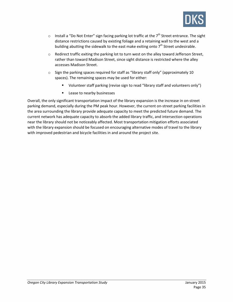
Oregon City Library Expansion Transportation Study January 2015 Page 35
o Install a “Do Not Enter” sign facing parking lot traffic at the 7th Street entrance. The sight distance restrictions caused by existing foliage and a retaining wall to the west and a building abutting the sidewalk to the east make exiting onto 7th Street undesirable.
o Redirect traffic exiting the parking lot to turn west on the alley toward Jefferson Street, rather than toward Madison Street, since sight distance is restricted where the alley accesses Madison Street.
o Sign the parking spaces required for staff as “library staff only” (approximately 10 spaces). The remaining spaces may be used for either:
Volunteer staff parking (revise sign to read “library staff and volunteers only”)
Lease to nearby businesses
Overall, the only significant transportation impact of the library expansion is the increase in on-street parking demand, especially during the PM peak hour. However, the current on-street parking facilities in the area surrounding the library provide adequate capacity to meet the predicted future demand. The current network has adequate capacity to absorb the added library traffic, and intersection operations near the library should not be noticeably affected. Most transportation mitigation efforts associated with the library expansion should be focused on encouraging alternative modes of travel to the library with improved pedestrian and bicycle facilities in and around the project site.