Embed Size (px)
Citation preview

Proposed Dredging at Bravo Jetty, Shellhaven, RiverThames
September 2002
����Address and Registered Office: HR Wallingford Ltd. Howbery Park, Wallingford, OXON OX10 8BATel: +44 (0) 1491 835381 Fax: +44 (0) 1491 832233
Registered in England No. 2562099. HR Wallingford is a wholly owned subsidiary of HR Wallingford Group Ltd.

INTRODUCTIONIt is proposed to carry out, as part of the on-going long-term dredging commitmentprogramme, a Water Injection Dredging campaign at Bravo Jetty (Figure 1), which is locatedon the north side of the Thames Estuary at Shellhaven, Essex. The dredging will be containedwithin the existing established berth box.
This assessment examines the historical changes that have taken place in the vicinity of BravoJetty since 1970. Using this information an evaluation of the potential impact of the proposeddredging programme on the morphology of the bed in the vicinity of the proposed dredgingworks has been carried out. The report also includes a brief review of the morphologicaldevelopment of the entrance to Holehaven Creek, over the same period of time
BACKGROUNDStarting at the western end of Sea Reach Bravo Jetty is the second of more than twentyriverside facilities that service, or have serviced, the oil related industrial complexes locatedon the north side of the river (Figure 1). Most of the jetties have required periodicmaintenance dredging, the frequency and extent of the campaigns being a function of locationand depth required. For the whole of the period covered by this assessment Bravo Jetty hasprovided the deepest water berth of the five Shellhaven Jetties. Bed depths have beenmaintained below –12m CD and on occasions, probably for a short period following adredging campaign, below –14m CD (Figure 2). These depths compare to the averagenavigation channel depth in the area of between –10m and –12m CD. In common with otherberths in the vicinity of the Bravo Jetty, the berth has been regularly dredged throughout theperiod reviewed. For more than the last ten years this has been done primarily by WaterInjection Dredging (WID). Since the introduction of WID trailer suction hopper dredging isonly used when the material primarily comprises the coarse fraction (the fines having beenwashed out by previous WID campaigns) and/or when the material is more consolidated. It isunderstood that dredging campaigns are carried out during ebb tides.
Bed depths generally at and for some distance from the berth have not been subject any large-scale change since 1970. In some cases depths have been maintained by maintenancedredging. There is an exception to this. Parts of the creek system that feeds from and toHolehaven Creek, the entrance of which is situated about 4.5 kilometres seaward of BravoJetty, is presently accreting (pers. comm. EA Anglian Region). This accretion has beenparticularly noticeable over the last twenty years in the upper creeks, a period that started withthe construction of the flood protection barriers in Easthaven and Benfleet Creeks, coupledwith the cessation of barge activity in Holehaven Creek. Because of the sedimentation thathas occurred, especially in the creeks upestuary of Fobbing Barrier, control sluices havebecome buried and areas of saltmarsh within parts of the creek system have converted tograssland. The actual sedimentation processes are not understood but it has been suggested(pers. comm. EA Anglian Region) that the sediment source is from the Thames Estuary, withsediment entering the creeks on the flood tide, falling out of suspension at high water slack,and then not all of this sediment being eroded on the following ebb tide. Whilst this is apossibility it should be noted that increasing use of the upestuary barrier(s) as part of themanagement of the tidal flood control, and changes to land drainage strategies will haveundoubtedly have influenced the movement of sediments within the creek system, especiallyin the landward creeks.
Accretion has also occurred at the entrance to Holehaven Creek. In the last ten years or sothere has been a considerable build-up of sediment in the sub-tidal waters, which in turn hasled to the encroachment of the creek’s low water mark into the main body of the ThamesEstausry. The processes by which this accretion has occurred have not been determined.

Recent work carried out as part of the London Gateway project has demonstrated that theberths along the river frontage between Mucking Flats and Canvey Island are subject to thedeposition of suspended sediments (and bedload) moving along the river from west to eastwith deposition occurring at low water slack.
REVIEW OF PLA BATHYMETRIC DATA (1970-2002)A PLA survey dated 1970 (presented on Figure 2) shows that bed depths at Bravo Jetty werebetween –12m and –14m CD and that there was a “ridge “ between the Jetty and the deeperwaters in the navigation channel where bed depths were in places less than –10m CD. By1980 the “ridge” was no longer present, Figure 3 clearly showing the area where greaterwater depth was available. It is believed that the ridge was removed as part of a generaldeepening of bed depths in the vicinity of Bravo Jetty and the adjacent navigation channel. Itis also noticeable that bed depths on the intertidal foreshore to the west of the Shellhaven jettycomplex had risen by more than 1m between 1970 and 1980 and that there had been a loss ofbed depth behind Bravo Jetty of more than 2m. In the years 1980 to 1998 there was generallylittle overall change to bed depths in the area examined – loss of bed depth being offset byincrease to bed depth (Figures 2 and 3). At Bravo Jetty bed depths fronting the structure werein excess of –14m CD possibly following a dredging campaign. By 2002 whilst there hadbeen a loss of bed depth at the upstream Alpha Jetty bed depth was maintained at Bravo Jetty(Figure 4). Offshore bed depths had changed by +/-2.0m primarily due to areas of deep waterbeing distributed slightly differently. The overall bed depth was similar to those present in1998. Further accretion had occurred on the adjacent upstream intertidal area and morenotably in the upstream subtidal waters.
ASSESSMENT OF THE IMPACT OF DREDGINGIt is evident from the review of the bathymetric information that bed depths in the vicinity ofBravo Jetty and generally in Upper Sea Reach have varied considerably almost everywhere.Dredging campaigns carried out over the years at both the Shellhaven Jetties and in thenavigation channel off Lower Hope Point will have contributed to the changes. Whilst nolong-term change can be identified it can reasonably be concluded that without dredging beddepths at Bravo Jetty and the jetties adjacent to it would not be as deep as they are at present.
OverallThe impact of the proposed dredging campaign will have little impact on the hydrodynamic,morphodynamic or sediment regimes in the vicinity of the proposed works. The requireddredged depth at Bravo Jetty is the same or very similar to that that achieved during previouscampaigns.
THE IMPACT OF THE WORKS ON HOLEHAVEN CREEKIn the subtidal waters fronting, and in the intertidal areas at the entrance, to Holehaven Creekaccretion has been ongoing for more than twenty years. Analysis of the informationpresented in Figure 5 shows that the areas considered for comparison of bed depths above0.0m CD are similar, between 1970 and 1998 (6% increase). The volume of bed sedimentsabove a 0.0m CD plane cannot be similarly described, the volume during the same periodhaving increased from 317,654m3 to 487,207m3 (an increase of 53%). This corresponds to anoverall bed level rise of 0.7m (0.023m/year). Data obtained in 2001, although not directlycomparable provide evidence to suggest that this process is continuing.
It is not anticipated that this accretion process will be changed as a consequence of theproposed dredging works. The risk of any consequential slumping of the seabed in this areais therefore minimal. The integrity of the processes acting on the seabed in the vicinity of theentrance to Holehaven Creek will be unaffected.

The proposed dredging works will have any impact upon the reported bathymetric change thatis occurring at the landward end of Holehaven Creek or within the creeks that flow intoHolehaven Creek. A separate study would be required to identify the present and projectedfuture bathymetry of Holehaven Creek, it’s confluence with the River Thames and it’snetwork of associated channels.
CONCLUSIONSIt is reasonable to conclude from the information presented and assessed that there is neitherevidence of maintenance dredging at the Bravo Jetty causing detrimental erosion of bedsediments in or at the entrance to Holehaven Creek, nor an obvious mechanism by which apattern of widespread erosion could occur.
It is not anticipated that the proposed works will have any impact upon the reportedbathymetric change that is occurring at the landward end of Holehaven Creek or the creeksthat flow into Holehaven Creek. There is no expectation, therefore, that there would be anywidespread ‘slumping’ affecting the seaward end of Holehaven Creek as a consequence of theproposed WID maintenance dredging at Bravo Jetty.
HR Wallingford18 September 2002

Figure 1 Location of Bravo Jetty

Figure 2 Bathymetry from PLA Chart 340
571400571600571800572000572200572400572600572800573000
180600
180800
181000
181200
181400
181600
-30.0
-24.0
-16.0
-12.0
-8.0
-4.0
0.0
1.0
2.0
3.0
5.0
7.0
1970
571400571600571800572000572200572400572600572800573000
180600
180800
181000
181200
181400
1816001980
1998
571400571600571800572000572200572400572600572800573000
180600
180800
181000
181200
181400
1816002002
Dep
th (m
CD
)
571400571600571800572000572200572400572600572800573000
180600
180800
181000
181200
181400
181600

Figure 3 Changes to bed levels (data source PLA Chart 340)
571400 571600 571800 572000 572200 572400 572600 572800 573000
180600
180800
181000
181200
181400
181600
1980 - 1970
1998 -1980
Cha
nge
in D
epth
(mC
D)
571400 571600 571800 572000 572200 572400 572600 572800 573000
180600
180800
181000
181200
181400
181600
-8.00
-4.00
-2.00
-1.00
-0.50
0.00
0.50
1.00
2.00
4.00
8.00
12.00
16.00
20.00

Figure 4 Changes to bed levels (data source PLA Chart 340)
571400 571600 571800 572000 572200 572400 572600 572800 573000
180600
180800
181000
181200
181400
181600
-8.0
-4.0
-2.0
-1.0
-0.5
0.0
0.5
1.0
2.0
4.0
8.0
12.0
16.0
20.0
Cha
nge
in D
epth
(mC
D)
2002 - 1998
571400 571600 571800 572000 572200 572400 572600 572800 573000
180600
180800
181000
181200
181400
181600
2002 - 1980
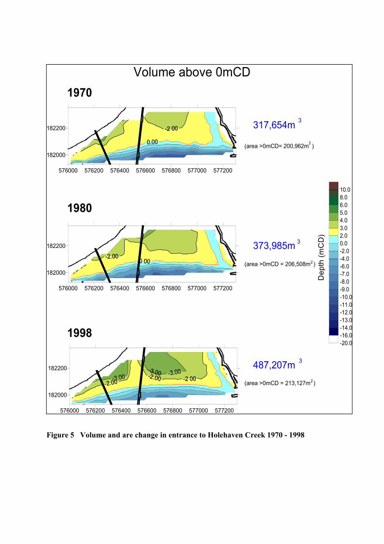
Figure 5 Volume and are change in entrance to Holehaven Creek 1970 - 1998
1998
1980
Volume above 0mCD
576000 576200 576400 576600 576800 577000 577200
182000
182200
(area >0mCD= 200,962m )
317,654m 3
2
576000 576200 576400 576600 576800 577000 577200
182000
182200
(area >0mCD = 206,508m )
373,985m 3
2
576000 576200 576400 576600 576800 577000 577200
182000
182200
(area >0mCD = 213,127m )
487,207m 3
2
1970
Dep
th (m
CD
)
-20.0-16.0-14.0-13.0-12.0-11.0-10.0-9.0-8.0-7.0-6.0-4.0-2.00.02.03.04.05.06.08.010.0