Embed Size (px)
Citation preview
Yonanda Martin
Graham Young
Newtown Landscape Architects
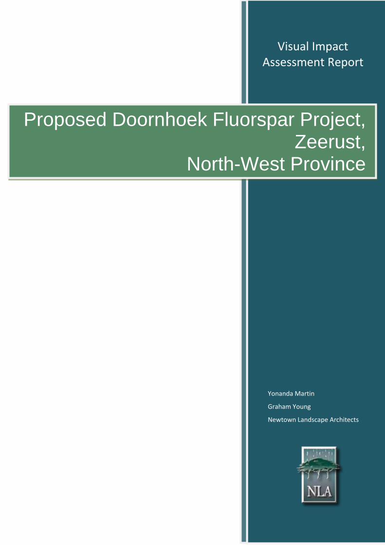
Proposed Doornhoek Fluorspar Project, Zeerust,
North-West Province
Visual Impact Assessment Report
ii Doornhoek Fluorspar Project Visual Impact Assessment Report
November 2016
PROPOSED DOORNHOEK FLUORSPAR PROJECT
ZEERUST, NORTH-WEST PROVINCE
Submitted to:
Exigo Sustainability (Pty) Ltd
Tel: (012) 751 2160
Prepared by:
Newtown Landscape Architects cc
PO Box 36
Fourways
2055
www.newla.co.za
NLA Project No: 1617/V15NW
Report Revision No: Rev 01
Date Issued: 23 November 2016
Prepared By: Yonanda Martin (Pri.Sci.Nat)
Reviewed By: Graham Young (Pr LArch)
Reference: Doornhoek Fluorspar Project
Expertise of Specialists
iii Doornhoek Fluorspar Project Visual Impact Assessment Report
November 2016
EXPERTISE OF SPECIALISTS
Name: Graham A Young
Qualification: Pr LArch
Professional Registration: South African Council for the Landscape Architectural Profession
(SACLAP)
Institute of Landscape Architects of South Africa (ILASA)
Experience in Years: 33 years
Experience Graham is a landscape architect with thirty years’ experience. He has
worked in Southern Africa and Canada and has valuable expertise in the
practice of landscape architecture, urban design and environmental
planning. He is also a senior lecturer, teaching urban design and
landscape architecture at post and under graduate levels at the
University of Pretoria. He specializes in Visual Impact Assessments and
has won an Institute of Landscape Architects Merit Award for his VIA
work.
Name: Yonanda Martin
Qualification: MSc. (Env.)
Professional Registration: Pri. Sci. Nat.
Experience in Years: 10 years
Experience
Yonanda Martin has been doing visual impact assessments for Newtown
Landscape Architects since 2006. She has experience in a wide range of
visual impact assessments which include visual impacts for game lodges,
transmission lines, roads, mines and telecommunication masts. Projects
that she worked on include:
Eskom Ngwedi Substation (PBAI), North West Province
NBC Belfast Project (Exxaro), Mpumalanga
Tamboti Platinum Mine (Metago), Limpopo
De Wittekrans (GCS), Mpumalanga
Dorsfontein West Expansion (GCS (Pty) Ltd), Kriel
Ferreira Coal Mining (GCS (Pty) Ltd), Ermelo
Eskom Honingklip (Kv3 Engineers), Muldersdrift
SANRAL PWV3 (Jeffares & Green), Hartbeespoort
Declaration of Independence
iv Doornhoek Fluorspar Project Visual Impact Assessment Report
November 2016
DECLARATION OF INDEPENDENCE
I, Graham Young, declare that –
I am contracted as the Visual Impact Assessment Specialist for the Doornhoek Fluorpar Project;
I will perform the work relating to the application in an objective manner, even if this results in views
and findings that are not favourable to the applicant;
I declare that there are no circumstances that may compromise my objectivity in performing such
work;
I have expertise in conducting the specialist report relevant to this application, including knowledge
of the National Environmental Management Act (Act 107 of 1998), Environmental Impact
Assessment Regulations 2010 and 2014, and any guidelines that have relevance to the proposed
activity;
I will comply with the Act, regulations and all other applicable legislation;
I will take into account, to the extent possible, the matters listed in Regulation 8;
I have no, and will not engage in, conflicting interests in the undertaking of the activity;
I undertake to disclose to the applicant and the competent authority all material information in my
possession that reasonably has or may have the potential of influencing – any decision to be taken
with respect to the application by the competent authority; and – the objectivity of any report, plan or
document to be prepared by myself for submission to the competent authority;
All the particulars furnished by me in this form are true and correct; and
I realise that a false declaration is an offence in terms of Regulation 71 and is punishable in terms of
section 24F of the Act.
Graham Young
Copyright
v Doornhoek Fluorspar Project Visual Impact Assessment Report
November 2016
COPYRIGHT
Copyright to the text and other matter, including the manner of presentation, is exclusively the property of
Newtown Landscape Architects cc. It is a criminal offense to reproduce and/or use, without written consent,
any matter, technical procedure and/or technique contained in this document. Criminal and civil proceedings
will be taken as a matter of strict routine against any person and/or institution infringing the copyright of the
author and/or proprietors.
Protection of Personal Information Act
vi Doornhoek Fluorspar Project Visual Impact Assessment Report
November 2016
PROTECTION OF PERSONAL INFORMATION ACT
In compliance with the Protection of Personal Information Act, No. 37067 of 26 November 2013, please
ensure the following:
Any personal information provided herein has been provided exclusively for use as part of the public
participation registration process, and may therefore not be utilised for any purpose, other than that
for which it was provided.
No additional copies may be made of documents containing personal information unless permission
has been obtained from the owner of said information.
All documentation containing personal information must be destroyed, as soon as the purpose for
which the information was collected has run out.
Specialist Requirements
vii Doornhoek Fluorspar Project Visual Impact Assessment Report
November 2016
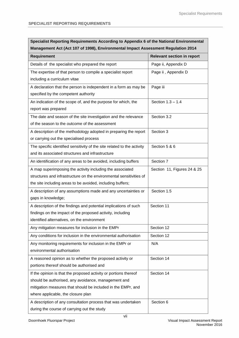
SPECIALIST REPORTING REQUIREMENTS
Specialist Reporting Requirements According to Appendix 6 of the National Environmental
Management Act (Act 107 of 1998), Environmental Impact Assessment Regulation 2014
Requirement Relevant section in report
Details of the specialist who prepared the report Page ii, Appendix D
The expertise of that person to compile a specialist report
including a curriculum vitae
Page ii , Appendix D
A declaration that the person is independent in a form as may be
specified by the competent authority
Page iii
An indication of the scope of, and the purpose for which, the
report was prepared
Section 1.3 – 1.4
The date and season of the site investigation and the relevance
of the season to the outcome of the assessment
Section 3.2
A description of the methodology adopted in preparing the report
or carrying out the specialised process
Section 3
The specific identified sensitivity of the site related to the activity
and its associated structures and infrastructure
Section 5 & 6
An identification of any areas to be avoided, including buffers Section 7
A map superimposing the activity including the associated
structures and infrastructure on the environmental sensitivities of
the site including areas to be avoided, including buffers;
Section 11, Figures 24 & 25
A description of any assumptions made and any uncertainties or
gaps in knowledge;
Section 1.5
A description of the findings and potential implications of such
findings on the impact of the proposed activity, including
identified alternatives, on the environment
Section 11
Any mitigation measures for inclusion in the EMPr Section 12
Any conditions for inclusion in the environmental authorisation Section 12
Any monitoring requirements for inclusion in the EMPr or
environmental authorisation
N/A
A reasoned opinion as to whether the proposed activity or
portions thereof should be authorised and
Section 14
If the opinion is that the proposed activity or portions thereof
should be authorised, any avoidance, management and
mitigation measures that should be included in the EMPr, and
where applicable, the closure plan
Section 14
A description of any consultation process that was undertaken
during the course of carrying out the study
Section 6
Specialist Requirements
viii Doornhoek Fluorspar Project Visual Impact Assessment Report
November 2016
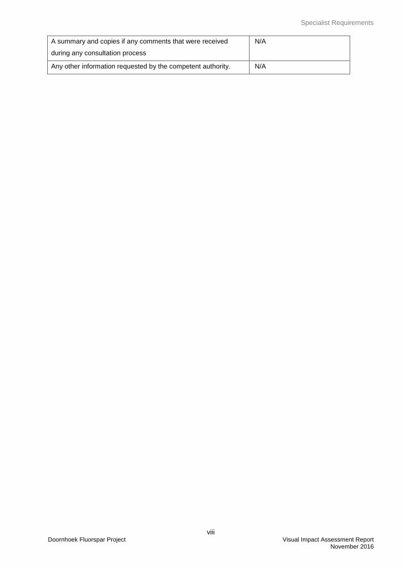
A summary and copies if any comments that were received
during any consultation process
N/A
Any other information requested by the competent authority. N/A
Acronyms, Abbreviations and Glossary
ix Doornhoek Fluorspar Project Visual Impact Assessment Report
November 2016
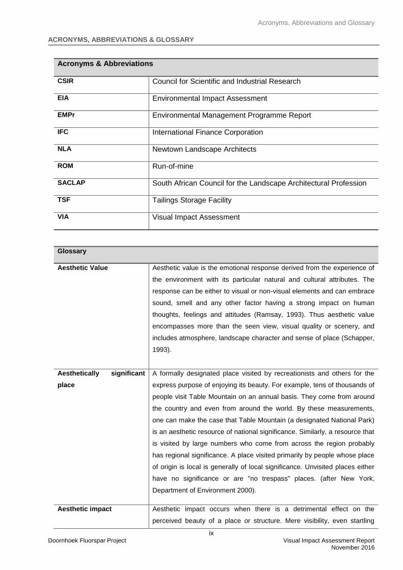
ACRONYMS, ABBREVIATIONS & GLOSSARY
Acronyms & Abbreviations
CSIR Council for Scientific and Industrial Research
EIA Environmental Impact Assessment
EMPr Environmental Management Programme Report
IFC International Finance Corporation
NLA Newtown Landscape Architects
ROM Run-of-mine
SACLAP South African Council for the Landscape Architectural Profession
TSF Tailings Storage Facility
VIA Visual Impact Assessment
Glossary
Aesthetic Value
Aesthetic value is the emotional response derived from the experience of
the environment with its particular natural and cultural attributes. The
response can be either to visual or non-visual elements and can embrace
sound, smell and any other factor having a strong impact on human
thoughts, feelings and attitudes (Ramsay, 1993). Thus aesthetic value
encompasses more than the seen view, visual quality or scenery, and
includes atmosphere, landscape character and sense of place (Schapper,
1993).
Aesthetically significant
place
A formally designated place visited by recreationists and others for the
express purpose of enjoying its beauty. For example, tens of thousands of
people visit Table Mountain on an annual basis. They come from around
the country and even from around the world. By these measurements,
one can make the case that Table Mountain (a designated National Park)
is an aesthetic resource of national significance. Similarly, a resource that
is visited by large numbers who come from across the region probably
has regional significance. A place visited primarily by people whose place
of origin is local is generally of local significance. Unvisited places either
have no significance or are "no trespass" places. (after New York,
Department of Environment 2000).
Aesthetic impact Aesthetic impact occurs when there is a detrimental effect on the
perceived beauty of a place or structure. Mere visibility, even startling
Acronyms, Abbreviations and Glossary
x Doornhoek Fluorspar Project Visual Impact Assessment Report
November 2016
visibility of a project proposal, should not be a threshold for decision
making. Instead a project, by virtue of its visibility, must clearly interfere
with or reduce (i.e. visual impact) the public's enjoyment and/or
appreciation of the appearance of a valued resource e.g. cooling tower
blocks a view from a National Park overlook (after New York, Department
of Environment 2000).
Cumulative Effects
The summation of effects that result from changes caused by a
development in conjunction with the other past, present or reasonably
foreseeable actions.
Landscape Character
The individual elements that make up the landscape, including prominent
or eye-catching features such as hills, valleys, woods, trees, water
bodies, buildings and roads. They are generally quantifiable and can be
easily described.
Landscape Impact
Landscape effects derive from changes in the physical landscape, which
may give rise to changes in its character and how this is experienced
(Institute of Environmental Assessment & The Landscape Institute, 1996).
Study area
For the purposes of this report the Doornhoek Fluorspar Project Study
area refers to the proposed project footprint / project site as well as the
‘zone of potential influence’ (the area defined as the radius about the
centre point of the project beyond which the visual impact of the most
visible features will be insignificant) which is a 10km radius surrounding
the proposed project footprint / site.
Project Footprint / Site
For the purposes of this report the Doornhoek Fluorspar Project site /
footprint refers to the actual layout of the project.
Sense of Place (genius
loci)
Sense of place is the unique value that is allocated to a specific place or
area through the cognitive experience of the user or viewer. Genius loci
literally means ‘spirit of the place’.
Sensitive Receptors
Sensitivity of visual receptors (viewers) to a proposed development.
Viewshed analysis
The two dimensional spatial pattern created by an analysis that defines
areas, which contain all possible observation sites from which an object
would be visible. The basic assumption for preparing a viewshed analysis
is that the observer eye height is 1,8m above ground level.
Acronyms, Abbreviations and Glossary
xi Doornhoek Fluorspar Project Visual Impact Assessment Report
November 2016
Visibility
The area from which project components would potentially be visible.
Visibility depends upon general topography, aspect, tree cover or other
visual obstruction, elevation and distance.
Visual Exposure
Visibility and visual intrusion qualified with a distance rating to indicate the
degree of intrusion and visual acuity, which is also influenced by weather
and light conditions.
Visual Impact
Visual effects relate to the changes that arise in the composition of
available views as a result of changes to the landscape, to people’s
responses to the changes, and to the overall effects with respect to visual
amenity.
Visual Intrusion
The nature of intrusion of an object on the visual quality of the
environment resulting in its compatibility (absorbed into the landscape
elements) or discord (contrasts with the landscape elements) with the
landscape and surrounding land uses.
Worst-case Scenario
Principle applied where the environmental effects may vary, for example,
seasonally to ensure the most severe potential effect is assessed.
Zone of Potential Visual
Influence
By determining the zone of potential visual influence it is possible to
identify the extent of potential visibility and views which could be affected
by the proposed development. Its maximum extent is the radius around
an object beyond which the visual impact of its most visible features will
be insignificant primarily due to distance.
Table of Content
xii Doornhoek Fluorspar Project Visual Impact Assessment Report
November 2016
TABLE OF CONTENT
1. INTRODUCTION 1
1.1 Project Overview and Background 1
1.2 Proposed Study Area 1
1.3 Objective of the Specialist Study 1
1.4 Terms and Reference 1
1.5 Assumption, Uncertainties and Limitations 3
2. LEGAL REQUIREMENTS AND GUIDELINES 4
2.1 National Guidelines 4
2.2 International Guidelines 4
3. APPROACH AND METHODOLOGY 6
3.1 Approach 6
3.1.1 The Visual Resource 6
3.1.2 Sensitivity of Visual Resource 7
3.1.3 Sense of Place 7
3.1.4 Sensitive Viewer Locations 8
3.1.5 Landscape Impact 8
3.1.6 Visual Impact 8
3.1.7 Severity of Visual Impact 9
3.1.8 Significance of Visual Impact 10
3.2 Methodology 10
4. DESCRIPTION OF THE PROJECT 11
5. PROJECT ALTERNATIVES 12
6. VISUAL ISSUES 17
7. THE ENVIRONMENTAL SETTING 18
7.1 The Study Area 18
7.2 Surrounding Land Use 18
7.2.1 Residential 18
7.2.2 Agriculture 18
7.2.3 Tourism 18
7.2.4 Infrastructure, Industries and Mining 18
7.2.5 Transportation systems 18
7.3 Landscape Character 19
8. VISUAL RESOURCE 29
8.1 Visual Resource Value / Scenic Quality 29
8.2 Sense of Place 30
9. VISUAL RECEPTORS 32
9.1 Views 32
9.1.1 Potential Sensitive Viewers 32
10. LANDSCAPE IMPACT 34
Table of Content
xiii Doornhoek Fluorspar Project Visual Impact Assessment Report
November 2016
10.1 Landscape Impact 34
11. VISUAL IMPACT 35
11.1 Potential Receptors 35
11.2 Visibility, Visual Exposure and Visual Intrusion 36
11.2.1.1 Visibility 36
11.2.1.2 Visual Exposure and Sensitivity 37
11.2.1.3 Visual Intrusion 46
11.2.1.4 Severity of Visual Impact 56
12. MITIGATION MEASURES 59
12.1 Project Area Development 59
12.2 Earthworks 59
12.3 Landscaping 59
12.4 Overburden Dump and TSF 59
12.5 Buildings / Structures 61
12.6 Access and Haul Roads 61
12.7 Lighting 61
13. SIGNIFICANCE OF IMPACT 62
14. CONCLUSION 65
15. REFERENCES 67
APPENDIX A: DETERMINING A LANDSCAPE AND THE VALUE OF THE VISUAL
RESOURCE 68
APPENDIX B: METHOD FOR DETERMINING THE SEVERITY OF LANDSCAPE AND
VISUAL IMPACT 73
APPENDIX C: CRITERIA FOR SIGNIFICANCE OF IMPACT ASSESSMENT 81
APPENDIX D: CRITERIA FOR PHOTO / COMPUTER SIMULATION 83
APPENDIX E: CURRICULUM VITAE 84
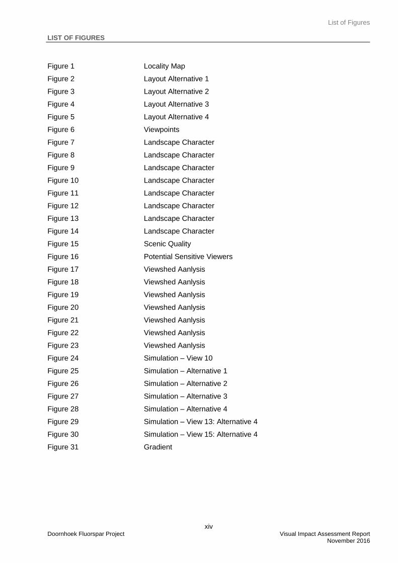
List of Figures
xiv Doornhoek Fluorspar Project Visual Impact Assessment Report
November 2016
LIST OF FIGURES
Figure 1 Locality Map
Figure 2 Layout Alternative 1
Figure 3 Layout Alternative 2
Figure 4 Layout Alternative 3
Figure 5 Layout Alternative 4
Figure 6 Viewpoints
Figure 7 Landscape Character
Figure 8 Landscape Character
Figure 9 Landscape Character
Figure 10 Landscape Character
Figure 11 Landscape Character
Figure 12 Landscape Character
Figure 13 Landscape Character
Figure 14 Landscape Character
Figure 15 Scenic Quality
Figure 16 Potential Sensitive Viewers
Figure 17 Viewshed Aanlysis
Figure 18 Viewshed Aanlysis
Figure 19 Viewshed Aanlysis
Figure 20 Viewshed Aanlysis
Figure 21 Viewshed Aanlysis
Figure 22 Viewshed Aanlysis
Figure 23 Viewshed Aanlysis
Figure 24 Simulation – View 10
Figure 25 Simulation – Alternative 1
Figure 26 Simulation – Alternative 2
Figure 27 Simulation – Alternative 3
Figure 28 Simulation – Alternative 4
Figure 29 Simulation – View 13: Alternative 4
Figure 30 Simulation – View 15: Alternative 4
Figure 31 Gradient
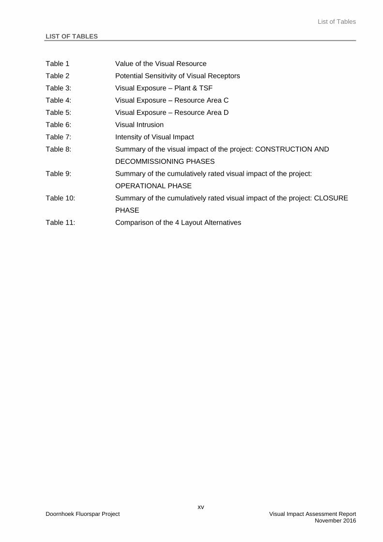
List of Tables
xv Doornhoek Fluorspar Project Visual Impact Assessment Report
November 2016
LIST OF TABLES
Table 1 Value of the Visual Resource
Table 2 Potential Sensitivity of Visual Receptors
Table 3: Visual Exposure – Plant & TSF
Table 4: Visual Exposure – Resource Area C
Table 5: Visual Exposure – Resource Area D
Table 6: Visual Intrusion
Table 7: Intensity of Visual Impact
Table 8: Summary of the visual impact of the project: CONSTRUCTION AND
DECOMMISSIONING PHASES
Table 9: Summary of the cumulatively rated visual impact of the project:
OPERATIONAL PHASE
Table 10: Summary of the cumulatively rated visual impact of the project: CLOSURE
PHASE
Table 11: Comparison of the 4 Layout Alternatives
Introduction
1 Doornhoek Fluorspar Project Visual Impact Assessment Report
November 2016
1. INTRODUCTION
1.1 Project Overview and Background
Newtown Landscape Architects (NLA) was commissioned by Exigo to carry out a Visual Impact Assessment
(VIA) for the proposed Doornhoek Fluorspar Project, North West Province (“the Project”). The Project would
encompass open pit mining with associated top structures and infrastructure. This will include facilities such
as a process plant, topsoil stockpiles, overburden dumps, Tailings Storage Facility (TSF), roads and other
infrastructure.
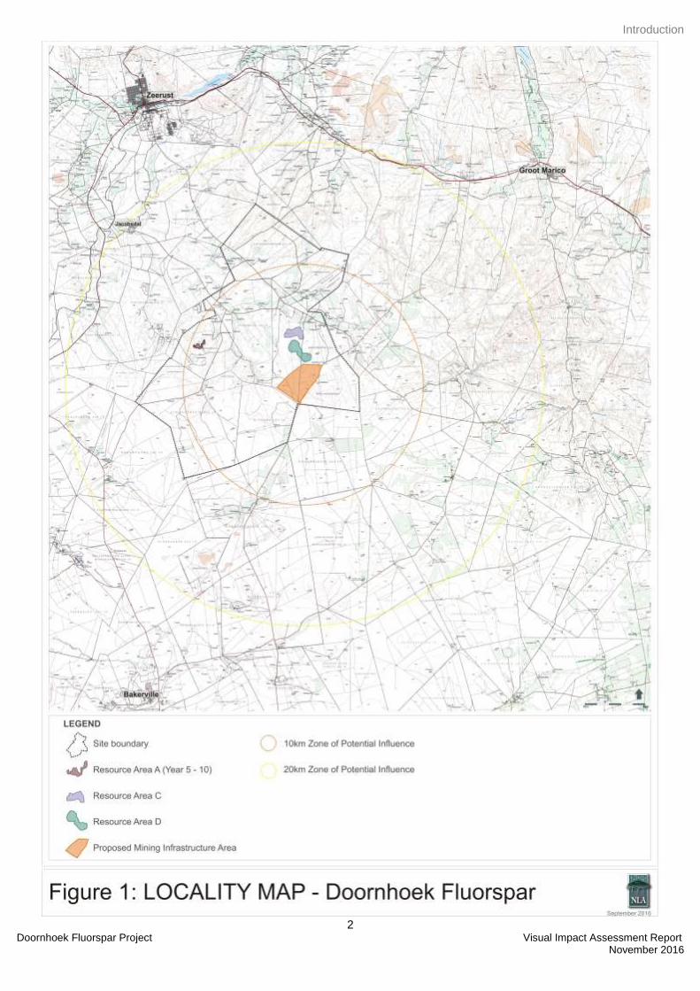
1.2 Proposed Study Area
The proposed Doornhoek Fluorspar Project is located on portions of Rhenosterfontein 304 JP and the Farm
306 JP which is located approximately 22km south-east of Zeerust, North West Province. Refer to Figure 1:
Locality Map
1.3 Objective of the Specialist Study
The main aim of the visual impact specialist study is to ensure that the visual / aesthetic consequences of
the proposed project are understood and adequately considered in the environmental planning process. In
the final assessment phase, detailed mitigation measures that could reduce the impact of the Project, will be
proposed.
1.4 Terms and Reference
A specialist study is required to assess the visual impacts arising from the Project based on the general
requirements for a comprehensive VIA. The following terms of reference was established:
Conduct field surveys of the proposed project area and photograph the area from sensitive viewing
points;
Describe the landscape character of the area;
Describe the sense of place and scenic quality;
Identify potential sensitive viewers;
Identify potential visual impacts;
Describe possible mitigation measures.
Introduction
2 Doornhoek Fluorspar Project Visual Impact Assessment Report
November 2016
Introduction
3 Doornhoek Fluorspar Project Visual Impact Assessment Report November 2016
1.5 Assumption, Uncertainties and Limitations
The following assumptions limitations have been made in the study:
The study uses the worst case scenario in predicting impacts (day time and night time);
The viewshed analyses considered only the topography of the area and did not factor in any features
such as existing trees and other obstacles. This means that the spatial patterns generated in the
analyses are inclined towards the worst case-scenario rather than the actual situation;
The extent of the study area is determined by the zone of potential influence, which in this study
relates to a radius about the project site of 10km. At 10km and beyond the Project would recede into
background views.
The computer model for the 3D depiction of the project components is based on CAD information
provided to NLA by the project engineers / environmental practitioner.
Legal Requirements & Guidelines
4 Doornhoek Fluorspar Project Visual Impact Assessment Report November 2016
2. LEGAL REQUIREMENTS AND GUIDELINES
This report adheres to the following legal requirements and guideline documents.
2.1 National Guidelines
National Environmental Management Act (Act 107 of 1998) EIA Regulations
The specialist report is in accordance to the specification on conducting specialist studies as per
Government Gazette (GN) R 543 of the National Environmental Management Act (NEMA) Act 107 of 1998.
The mitigation measures as stipulated in the specialist report can be used as part of the Environmental
Management Plan (EMP) and will be in support of the Environmental Impact Assessment (EIA).
The NEMA Protected Areas Act (57 of 2003)
The main aim of the Act is to identify and protect natural landscapes. According to the 2010 regulations
there are specific regulations for compilation of specialist report. This VIA report adheres to these
specifications.
The National Heritage Resources Act (25 of 1999)
The Act is applicable to the protection of heritage resources and includes the visual resources such as
cultural landscapes, nature reserves, proclaimed scenic routes and urban conservation areas.
Western Cape Department of Environmental Affairs & Development Planning: Guideline for Involving Visual
and Aesthetic Specialists in EIA Processes Edition 1 (CSIR, 2005)
Although the guidelines were specifically compiled for the Province of the Western Cape it provides guidance
that will be appropriate for any EIA process. The Guideline document also seeks to clarify instances when a
visual specialist should get involved in the EIA process.
2.2 International Guidelines
World Bank’s IFC Standards
The World Bank’s IFC Standards: Environmental, Health and Safety Guidelines for Mining refers to Visual
Impact Assessments by stating that:
“Mining operations, and in particular surface mining activities, may result in negative visual impacts to
resources associated with other landscape uses such as recreation or tourism. Potential contributors to
visual impacts include high walls, erosion, discoloured water, haul roads, waste dumps, slurry ponds,
abandoned mining equipment and structures, garbage and refuse dumps, open pits, and deforestation.
Mining operations should prevent and minimize negative visual impacts through consultation with local
communities about potential post-closure land use, incorporating visual impact assessment into the mine
reclamation process. Reclaimed lands should, to the extent feasible, conform to the visual aspects of the
surrounding landscape. The reclamation design and procedures should take into consideration the proximity
to public viewpoints and the visual impact within the context of the viewing distance. Mitigation measures
Legal Requirements & Guidelines
5 Doornhoek Fluorspar Project Visual Impact Assessment Report
November 2016
may include strategic placement of screening materials including trees and use of appropriate plant species
in the reclamation phase as well as modification in the placement of ancillary facilities and access roads.”
The specialists study is in accordance to the IFC Performance Standards (Performance Standard 1: Social
and Environmental Assessment and Management Systems) for the undertaking of Environmental
Assessments and contributes to the EIA for the proposed Project.
International Guidelines
The guidelines listed below were used as part of the research done for the methodology and mitigation
measures:
Program Policy on Assessing and Mitigating Visual Impacts (Sama 2000).
Guidelines for Landscape and Visual Impact Assessment (Institute of Environmental Assessment &
The Landscape Institute 1996).
Approach and Methodology
6 Doornhoek Fluorspar Project Visual Impact Assessment Report November 2016
3. APPROACH AND METHODOLOGY
3.1 Approach
The assessment of likely effects on a landscape resource and on visual amenity is complex, since it is
determined through a combination of quantitative and qualitative evaluations. (The Landscape Institute with
the Institute of Environmental Management and Assessment, 2002). When assessing visual impact the
worst-case scenario is taken into account. Landscape and visual assessments are separate, although linked,
procedures.
The landscape, its analysis and the assessment of impacts on the landscape all contribute to the baseline for
visual impact assessment studies. The assessment of the potential impact on the landscape is carried out as
an impact on an environmental resource, i.e. the physical landscape. Visual impacts, on the other hand, are
assessed as one of the interrelated effects on people (i.e. the viewers and the impact of an introduced object
into a particular view or scene).
3.1.1 The Visual Resource
Landscape character, landscape quality (Warnock, S. & Brown, N., 1998) and “sense of place” (Lynch, K.,
1992) are used to evaluate the visual resource i.e. the receiving environment. A qualitative evaluation of the
landscape is essentially a subjective matter. In this study the aesthetic evaluation of the study area is
determined by the professional opinion of the author based on site observations and the results of
contemporary research in perceptual psychology.
Aesthetic value is the emotional response derived from the experience of the environment with its particular
natural and cultural attributes. The response is usually to both visual and non-visual elements and can
embrace sound, smell and any other factor having a strong impact on human thoughts, feelings and attitudes
(Ramsay, 1993). Thus aesthetic value is more than the combined factors of the seen view, visual quality or
scenery. It includes atmosphere, landscape character and sense of place (Schapper, 1993). Refer also to
Appendix B for further elaboration.
Studies for perceptual psychology have shown human preference for landscapes with higher visual
complexity, for instance scenes with water or topographic interest. On the basis of contemporary research,
landscape quality increases where:
Topographic ruggedness and relative relief increase;
Water forms are present;
Diverse patterns of grassland and trees occur;
Natural landscape increases and man-made landscape decreases;
Where land use compatibility increases (Crawford, 1994).
Aesthetic appeal (value) is therefore considered high when the following are present (Ramsay, 1993):
Abstract qualities: such as the presence of vivid, distinguished, uncommon or rare features
or abstract attributes;
Approach and Methodology
7 Doornhoek Fluorspar Project Visual Impact Assessment Report
November 2016
Evocative responses: the ability of the landscape to evoke particularly strong responses in
community members or visitors;
Meanings: the existence of a long-standing special meaning to a particular group of people
or the ability of the landscape to convey special meanings to viewers in general;
Landmark quality: a particular feature that stands out and is recognized by the broader
community.
And conversely, it would be low where:
Limited patterns of grasslands and trees occur;
Natural landscape decreases and man-made landscape increases;
And where land use compatibility decreases (after Crawford, 1994).
In determining the quality of the visual resource, both the objective and the subjective or aesthetic factors
associated with the landscape are considered. Many landscapes can be said to have a strong sense of
place, regardless of whether they are considered to be scenically beautiful but where landscape quality,
aesthetic value and a strong sense of place coincide - the visual resource or perceived value of the
landscape is considered to be very high. The criteria given in Appendix B are used to assess landscape
quality, sense of place and ultimately to determine the aesthetic value of the study area.
3.1.2 Sensitivity of Visual Resource
The sensitivity of a landscape or visual resource is the degree to which a particular landscape type or area
can accommodate change arising from a particular development, without detrimental effects on its character.
Its determination is based upon an evaluation of each key element or characteristic of the landscape likely to
be affected. The evaluation will reflect such factors such as its quality, value, contribution to landscape
character, and the degree to which the particular element or characteristic can be replaced or substituted
(Institute of Environmental Assessment & The Landscape Institute, 1996:87).
3.1.3 Sense of Place
Central to the concept of sense of place is that the landscape requires uniqueness and distinctiveness. The
primary informant of these qualities is the spatial form and character of the natural landscape taken together
with the cultural transformations and traditions associated with the historic use and habitation of the area.
According to Lynch (1992), sense of place “is the extent to which a person can recognize or recall a place as
being distinct from other places – as having a vivid, unique, or at least particular, character of its own”.
Sense of place is the unique value that is allocated to a specific place or area through the cognitive
experience of the user or viewer. In some cases these values allocated to the place are similar for a wide
spectrum of users or viewers, giving the place a universally recognized and therefore, strong sense of place.
Because the sense of place of the study area is derived from the emotional, aesthetic and visual response to
the environment, it cannot be experienced in isolation. The landscape context must be considered. With this
in mind, the combination of the natural landscape (mountains, streams and the vegetation) together with the
manmade structures (residential areas, roads, mining activities and power lines) contribute to the sense of
place for the study area. It is these land-uses, which define the area and establish its identity.
Approach and Methodology
8 Doornhoek Fluorspar Project Visual Impact Assessment Report
November 2016
3.1.4 Sensitive Viewer Locations
The sensitivity of visual receptors and views are dependent on the location and context of the viewpoint, the
expectations and occupation or activity of the receptor or the importance of the view. This may be
determined with respect to its popularity or numbers of people affected, its appearance in guidebooks, on
tourist maps, and in the facilities provided for its enjoyment and references to it in literature or art.
The most sensitive receptors may include:
Users of all outdoor recreational facilities including public rights of way, whose intention or
interest may be focused on the landscape;
Communities where development results in changes in the landscape setting or valued
views enjoyed by the community;
Occupiers of residential properties with views affected by the development.
Other receptors include:
People engaged in outdoor sport or recreation (other than appreciation of the landscape, as
in landscapes of acknowledged importance or value);
People traveling through or past the affected landscape in cars or other transport modes;
People at their place of work.
Views from residences and tourist facilities / routes are typically more sensitive, since views from these are
considered to be frequent and of long duration.
3.1.5 Landscape Impact
The landscape impact of a proposed development is measured as the change to the fabric, character and
quality of the landscape caused by the physical presence of the proposed development. Identifying and
describing the nature and intensity (severity) of change in the landscape brought about by the proposed new
mine is based on the professional opinion of the author supported by photographic simulations. It is
imperative to depict the change to the landscape in as realistic a manner as possible (Van Dortmont in
Lange, 1994). In order to do this, photographic panoramas were taken from key viewpoints and altered using
computer simulation techniques to illustrate the physical nature of the proposed project in its final form within
the context of the landscape setting. The resultant change to the landscape is then observable and an
assessment of the anticipated visual intrusion can be made.
3.1.6 Visual Impact
Visual impacts are a subset of landscape impacts. Visual impacts relate to the changes that arise in the
composition of available views as a result of changes to the landscape, to people’s responses to the
changes, and to the overall effect with respect to visual amenity. Visual impact is therefore measured as the
change to the existing visual environment (i.e. views) caused by the intervention and the extent to which that
change compromises (negative impact) or enhances (positive impact) or maintains the visual quality of the
scene as perceived by people visiting, working or living in the area. This approach reflects the layman’s
concerns, which normally are:
Approach and Methodology
9 Doornhoek Fluorspar Project Visual Impact Assessment Report
November 2016
Will I be able to see the new development?
What will it look like?
Will the development affect views in the area and if so how?
Landscape and visual impacts do not necessarily coincide. Landscape impacts can occur with the absence
of visual impacts, for instance where a development is wholly screened from available public views, but
nonetheless results in a loss of landscape elements and landscape character within a localized area (the site
and its immediate surrounds).
3.1.7 Severity of Visual Impact
The severity of visual impact is determined using visual intrusion, visibility and visual exposure criteria (Hull,
R.B. and Bishop, I.E., 1988), qualified by the sensitivity of viewers (visual receptors) towards the proposed
development. The severity of visual impact is therefore concerned with:
The overall impact on the visual amenity, which can range from degradation through to
enhancement;
The direct impacts of the mine upon views of the landscape through intrusion or obstruction;
The reactions of viewers who may be affected.
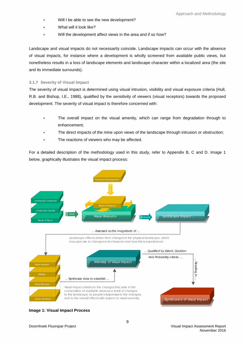
For a detailed description of the methodology used in this study, refer to Appendix B, C and D. Image 1
below, graphically illustrates the visual impact process:
Landscape Character
Landscape Quality
Sense of Place
Proposed Development
Visual Resource
Physica l Presence
Landscape Impact …Outcome
Visual Intrusion
Visibility
Visual Exposure
Value
Cre
ate
s
Intensity of Visual Impact
Significance of Visual ImpactViewer Sensitivity
... Synthesize data to establish ...
Landscape effects derive from changes in the physical landscape, which
may give rise to changes in its character and how this is experienced.
Visual impact relates to the changes that arise in the
composition of available views as a result of changes
to the landscape, to people’s responses to the changes,
and to the overall effects with respect to visual amenity.
... Qualified by Extent, Duration
... Assessed as the of ... magnitude
And criteria ....Probability
... Re
sultin
g in
...
Image 1: Visual Impact Process
Approach and Methodology
10 Doornhoek Fluorspar Project Visual Impact Assessment Report
November 2016
3.1.8 Significance of Visual Impact
A combined quantitative and qualitative methodology, as supplied by the Environmental Practitioner, was
used to describe the impacts for: significance, spatial scale, temporal scale, probability and degree of
certainty. A summary of each of the qualitative descriptions along with the equivalent quantitative rating
scale is given in Annexure C.
3.2 Methodology
The following method was used:
Site visit: A field survey was undertaken and the study area scrutinized to the extent that the
receiving environment could be documented and adequately described. The field survey was
conducted on 7 and 8 June 2016.
Project components: The physical characteristics of the project components were described
and illustrated;
General landscape characterization: The visual resource (i.e. receiving environment) was
mapped using field survey and GIS mapping technology. The description of the landscape
focused on the nature of the land rather than the response of a viewer (refer to Appendix B);
The landscape character of the study area was described. The description of the landscape
focused on the nature and character of the landscape rather than the response of a viewer;
The quality of the landscape was described. Aesthetic appeal was described using
recognized contemporary research in perceptual psychology as the basis;
The sense of place of the study area was described as to the uniqueness and
distinctiveness of the landscape. The primary informant of these qualities was the spatial
form and character of the natural landscape together with the cultural transformations
associated with the historic / current use of the land;
Potential sensitive viewers were identified.
Measures that could mitigate the negative impacts of the proposed project were
recommended.
Description of the Project
11 Doornhoek Fluorspar Project Visual Impact Assessment Report November 2016
4. DESCRIPTION OF THE PROJECT
SA Fluorite (Pty) Limited and Southern Palace 398 (Pty) Limited are exploration and mining companies
which hold prospecting rights over the proposed mining area as shown on Figure 1: Locality Map. The
controlling interest in both these companies is held by the ERG Group which is planning on consolidating the
prospecting rights and applying for a mining right over the consolidated area.
Prospecting activities which were carried out over the past few years indicated that economically viable
concentrations of fluorspar may be found underlying these properties, and hence the reason for applying for
a consolidated mining right.
Due to poor international market conditions it will be necessary to gradually phase in the mining activities,
and to divide the mining activities into two phases. The first phase will take place on portions of
Rhenosterfontein 304 JP, and the second phase will take place on portions of the Farm 306 JP.
The first phase of mining (year 5-10) will take place on portions of the farm Rhenosterfontein 304 JP
(Resource Area A), and the second phase (year 10-30) will take place on portions of the Farm 306 JP
(Resource Areas C &D). The mine surface infrastructure is proposed to be located on the above farm.
Physical mining will only begin in year 5 after the mining license has been granted. Road and plant
construction will take place in the years before this.
Refer to Figure 1: Locality Map and Figures 2 - 5: Project Alternatives for the proposed layouts.
Potential Alternatives
12 Doornhoek Fluorspar Project Visual Impact Assessment Report
November 2016
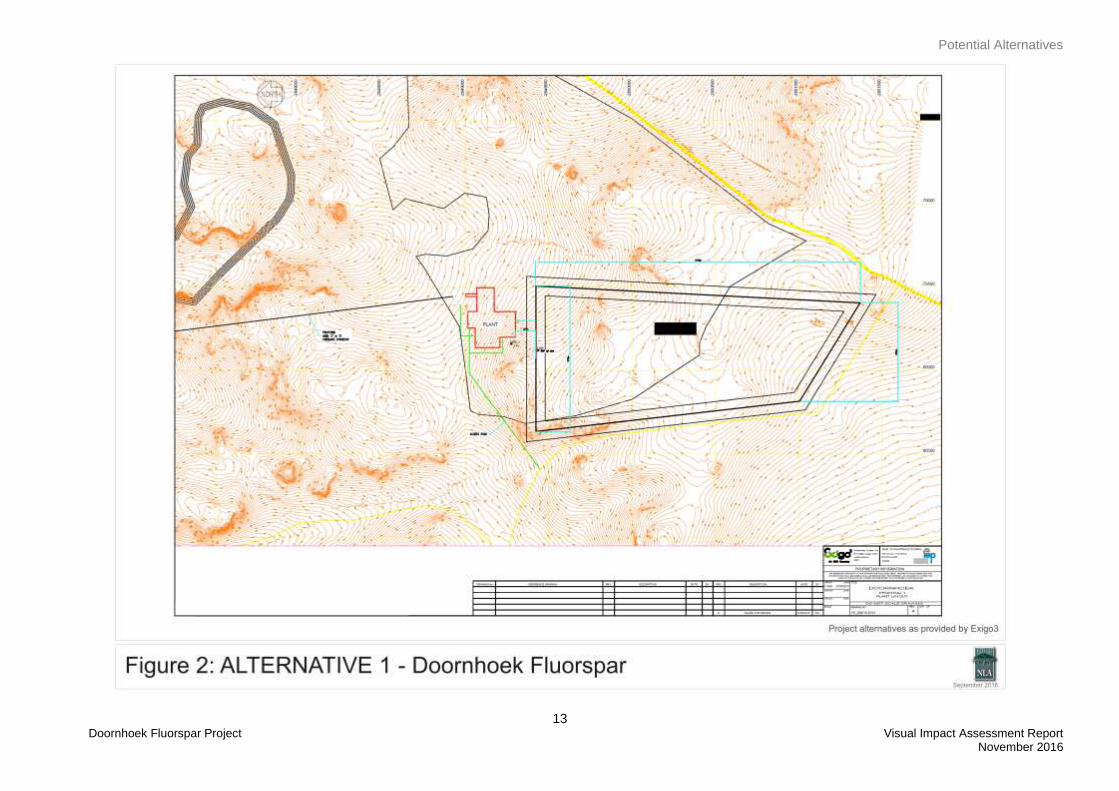
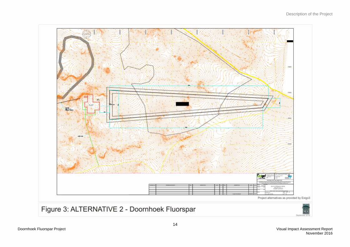
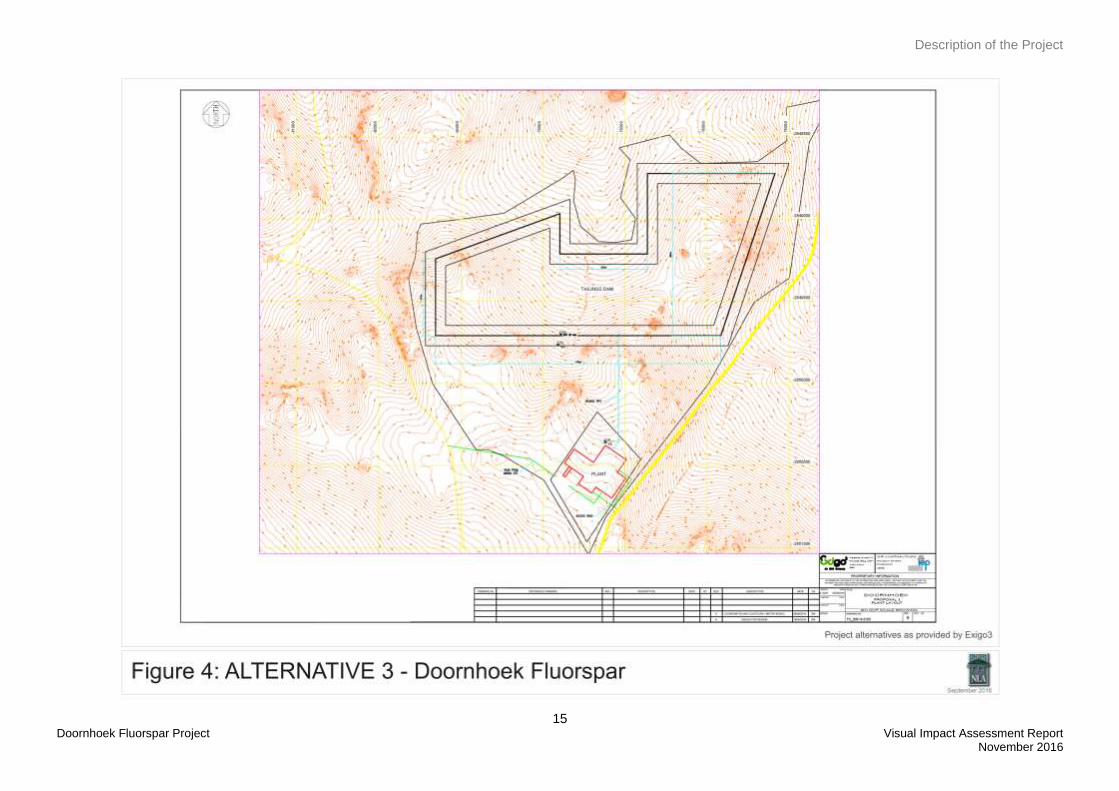
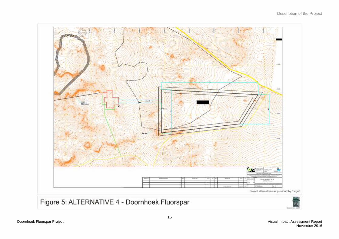
5. PROJECT ALTERNATIVES
There are currently four project alternatives for the location of the plant and the TSF. These alternatives have
been identified during the Scoping Phase and will be assessed during the Impact Assessment Phase of the
project.
The four project alternatives can be viewed on Figures 2 – 5: Project Alternatives.
Potential Alternatives
13 Doornhoek Fluorspar Project Visual Impact Assessment Report
November 2016
Description of the Project
14 Doornhoek Fluorspar Project Visual Impact Assessment Report
November 2016
Description of the Project
15 Doornhoek Fluorspar Project Visual Impact Assessment Report
November 2016
Description of the Project
16 Doornhoek Fluorspar Project Visual Impact Assessment Report
November 2016
Visual Issues
17 Doornhoek Fluorspar Project Visual Impact Assessment Report November 2016
6. VISUAL ISSUES
Typical issues associated with mining projects of this nature are:
Who will be able to see the new development?
What will it look like and will it contrast with the receiving environment?
Will the development affect sensitive views in the area and if so how?
What will be the impact of the development at night?
What will the cumulative impact be?
The public participation process was done by Exigo Sustainability and during this process no visual concerns
were raised.
The Environmental Setting
18 Doornhoek Fluorspar Project Visual Impact Assessment Report November 2016
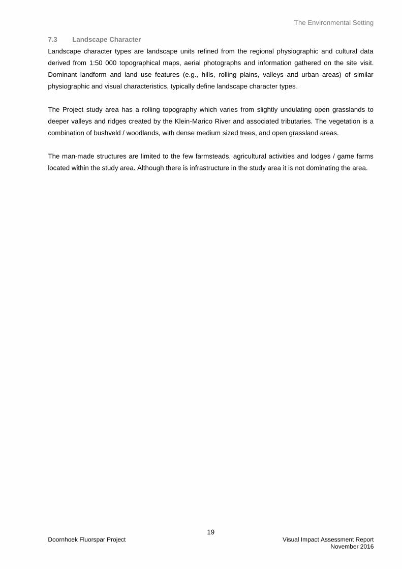
7. THE ENVIRONMENTAL SETTING
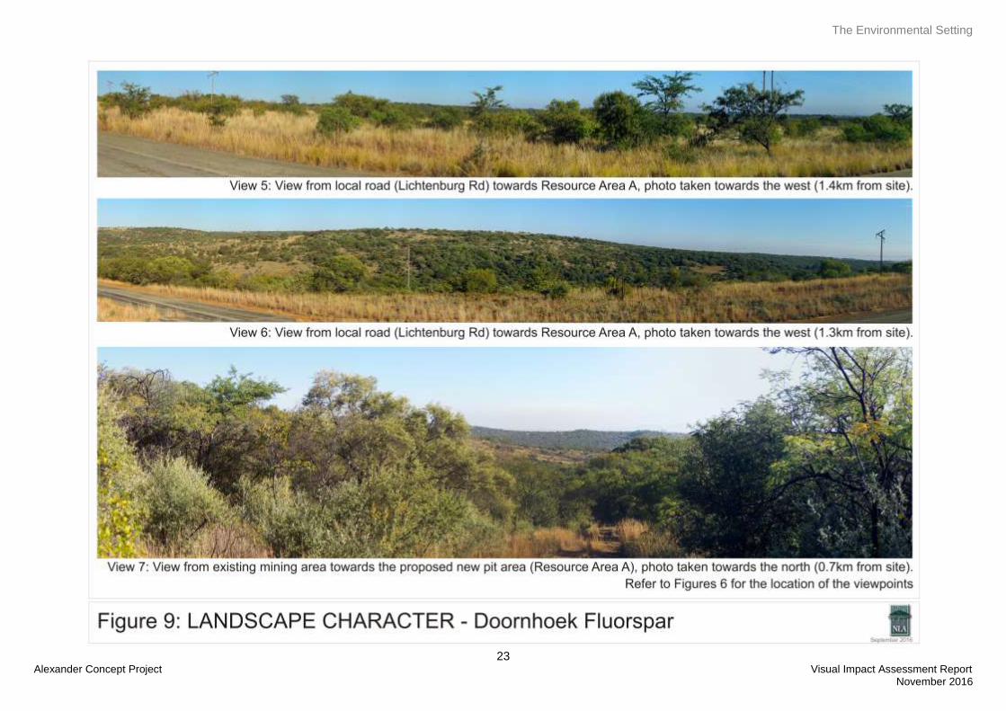
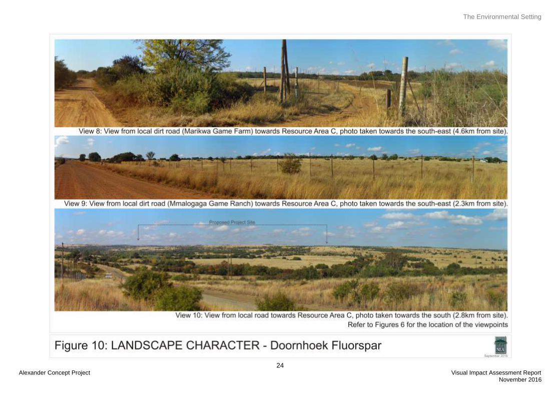
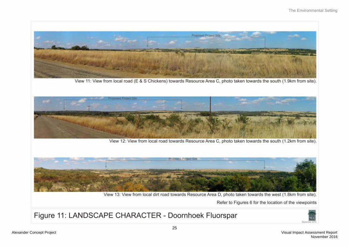
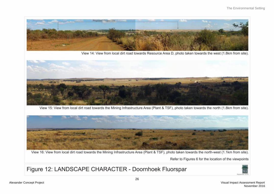
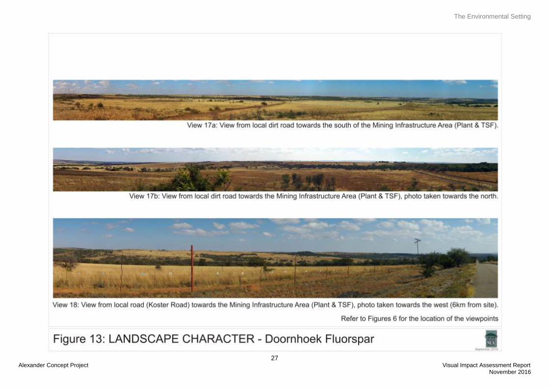
7.1 The Study Area
For the following section, refer to views on Figures 7 to 14. The locations for panorama views are indicated
on Figure 6.
The project is located in the Moot Plains Bushveld vegetation unit. This vegetation unit is characterised by
open to closed, low, often thorny savanna dominated by various species of Acacia in the bottomlands and
plains as well as woodlands of varying height and density on the lower hillsides (Mucina, L. & Rutherford,
M.C. (eds), 2006). The surrounding landscape is a combination of Zeerust Thornveld and Carletonville
Dolomite Grassland which is characterised by valley, ridges and slightly undulating plains with rocky ridges
(Mucina, L. & Rutherford, M.C. (eds), 2006).
7.2 Surrounding Land Use
7.2.1 Residential
The residential component consist of three types of residential areas, farmsteads that are spread out through
the site, workers housing and more formal residential areas associated with towns such as Zeerust.
7.2.2 Agriculture
The dominant vegetation in the area is the open grassland that is used by farmers for grazing of both cattle
and game. There are smaller areas that are used for crop production as well as chicken farms (E&S
Chickens, FMS Vlakvallei Farms).
7.2.3 Tourism
Tourism in the area includes game farms / lodges and camping sites such as the Witdoorn 4x4 Camp Site.
During the site visit the following game farms / lodges were noted; Marikwa Game Farm, Mmalogaga Game
Ranch, Die Rabe’s and Emerald Panther Lodge. Refer to view 8 and 9 on Figure 10.
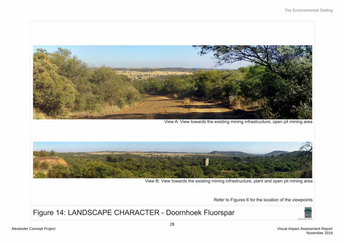
7.2.4 Infrastructure, Industries and Mining
Infrastructure in the study area includes Eskom power lines as well as the Telkom Tower / SANDF Tower.
There is old mining infrastructure located in the area that has been identified for the Resource Area A for
years 5 – 10 of mining operations. Refer to view A and B on Figure 14. There is a small charcoal industry
located in the study area, refer to view 13 on Figure 11.
7.2.5 Transportation systems
Most of the roads in the study area are dirt roads with some tarred roads that lead to towns such as Zeerust,
Groot Marico and Koster. There is no railway line within the study area and access to the N4 will be with one
of the local roads which could either be a tarred or dirt roads. It is however proposed to transport the product
from the mine to a rail siding in proximity of the mine from where it will be railed to the Durban Harbour or
port of choice. The nearest siding is located near Jacobsdal.
The Environmental Setting
19 Doornhoek Fluorspar Project Visual Impact Assessment Report
November 2016
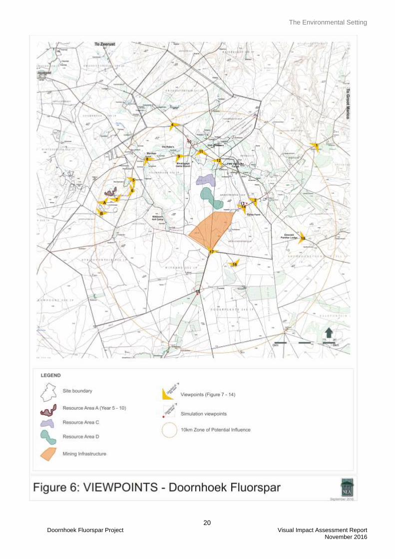
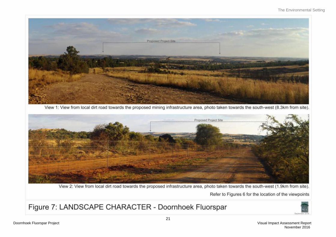
7.3 Landscape Character
Landscape character types are landscape units refined from the regional physiographic and cultural data
derived from 1:50 000 topographical maps, aerial photographs and information gathered on the site visit.
Dominant landform and land use features (e.g., hills, rolling plains, valleys and urban areas) of similar
physiographic and visual characteristics, typically define landscape character types.
The Project study area has a rolling topography which varies from slightly undulating open grasslands to
deeper valleys and ridges created by the Klein-Marico River and associated tributaries. The vegetation is a
combination of bushveld / woodlands, with dense medium sized trees, and open grassland areas.
The man-made structures are limited to the few farmsteads, agricultural activities and lodges / game farms
located within the study area. Although there is infrastructure in the study area it is not dominating the area.
The Environmental Setting
20 Doornhoek Fluorspar Project Visual Impact Assessment Report
November 2016
The Environmental Setting
21 Doornhoek Fluorspar Project Visual Impact Assessment Report November 2016
The Environmental Setting
22 Alexander Concept Project Visual Impact Assessment Report
November 2016
The Environmental Setting
23 Alexander Concept Project Visual Impact Assessment Report
November 2016
The Environmental Setting
24 Alexander Concept Project Visual Impact Assessment Report
November 2016
The Environmental Setting
25 Alexander Concept Project Visual Impact Assessment Report
November 2016
The Environmental Setting
26 Alexander Concept Project Visual Impact Assessment Report
November 2016
The Environmental Setting
27 Alexander Concept Project Visual Impact Assessment Report
November 2016
The Environmental Setting
28 Alexander Concept Project Visual Impact Assessment Report
November 2016
Visual Resource
29 Doornhoek Fluorspar Project Visual Impact Assessment Report November 2016
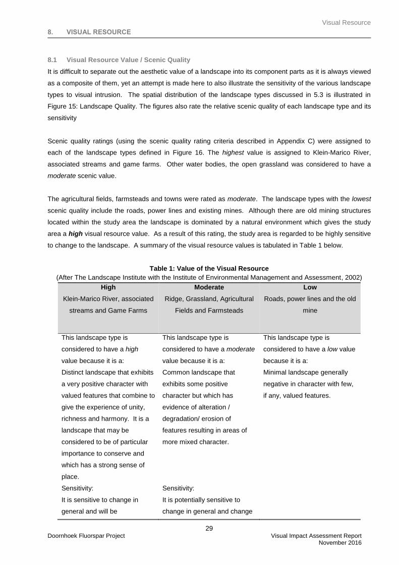
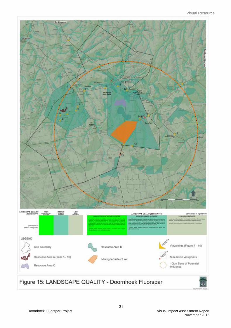
8. VISUAL RESOURCE
8.1 Visual Resource Value / Scenic Quality
It is difficult to separate out the aesthetic value of a landscape into its component parts as it is always viewed
as a composite of them, yet an attempt is made here to also illustrate the sensitivity of the various landscape
types to visual intrusion. The spatial distribution of the landscape types discussed in 5.3 is illustrated in
Figure 15: Landscape Quality. The figures also rate the relative scenic quality of each landscape type and its
sensitivity
Scenic quality ratings (using the scenic quality rating criteria described in Appendix C) were assigned to
each of the landscape types defined in Figure 16. The highest value is assigned to Klein-Marico River,
associated streams and game farms. Other water bodies, the open grassland was considered to have a
moderate scenic value.
The agricultural fields, farmsteads and towns were rated as moderate. The landscape types with the lowest
scenic quality include the roads, power lines and existing mines. Although there are old mining structures
located within the study area the landscape is dominated by a natural environment which gives the study
area a high visual resource value. As a result of this rating, the study area is regarded to be highly sensitive
to change to the landscape. A summary of the visual resource values is tabulated in Table 1 below.
Table 1: Value of the Visual Resource
(After The Landscape Institute with the Institute of Environmental Management and Assessment, 2002)
High
Klein-Marico River, associated
streams and Game Farms
Moderate
Ridge, Grassland, Agricultural
Fields and Farmsteads
Low
Roads, power lines and the old
mine
This landscape type is
considered to have a high
value because it is a:
Distinct landscape that exhibits
a very positive character with
valued features that combine to
give the experience of unity,
richness and harmony. It is a
landscape that may be
considered to be of particular
importance to conserve and
which has a strong sense of
place.
Sensitivity:
It is sensitive to change in
general and will be
This landscape type is
considered to have a moderate
value because it is a:
Common landscape that
exhibits some positive
character but which has
evidence of alteration /
degradation/ erosion of
features resulting in areas of
more mixed character.
Sensitivity:
It is potentially sensitive to
change in general and change
This landscape type is
considered to have a low value
because it is a:
Minimal landscape generally
negative in character with few,
if any, valued features.
Visual Resource
30 Doornhoek Fluorspar Project Visual Impact Assessment Report November 2016
detrimentally affected if change
is inappropriately dealt with.
may be detrimental if
inappropriately dealt with
8.2 Sense of Place
The sense of place for the proposed study area derives from the combination of all landscape types and their
impact on the senses. The ridgeline, rivers / streams, grassland, woodlands, game farms and agricultural
fields give the area a pastoral sense of place. Even though there are old mining infrastructure located within
the study area these structures are hidden away and the mine hasn’t been operational in the last few years.
As a result it can be said that the mining activities are forgotten and therefore the study area has a pastoral
sense of place.
Visual Resource
31 Doornhoek Fluorspar Project Visual Impact Assessment Report November 2016
Visual Receptors
32 Doornhoek Fluorspar Project Visual Impact Assessment Report November 2016
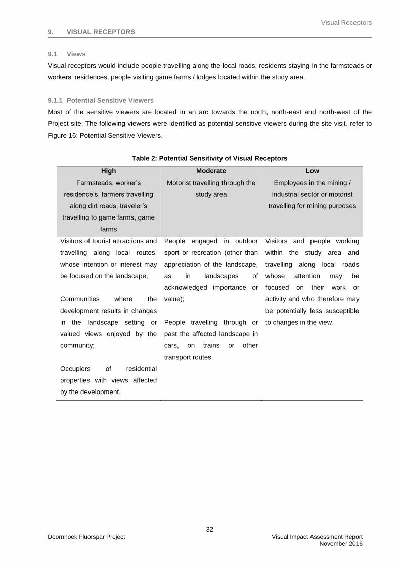
9. VISUAL RECEPTORS
9.1 Views
Visual receptors would include people travelling along the local roads, residents staying in the farmsteads or
workers’ residences, people visiting game farms / lodges located within the study area.
9.1.1 Potential Sensitive Viewers
Most of the sensitive viewers are located in an arc towards the north, north-east and north-west of the
Project site. The following viewers were identified as potential sensitive viewers during the site visit, refer to
Figure 16: Potential Sensitive Viewers.
Table 2: Potential Sensitivity of Visual Receptors
High
Farmsteads, worker’s
residence’s, farmers travelling
along dirt roads, traveler’s
travelling to game farms, game
farms
Moderate
Motorist travelling through the
study area
Low
Employees in the mining /
industrial sector or motorist
travelling for mining purposes
Visitors of tourist attractions and
travelling along local routes,
whose intention or interest may
be focused on the landscape;
Communities where the
development results in changes
in the landscape setting or
valued views enjoyed by the
community;
Occupiers of residential
properties with views affected
by the development.
People engaged in outdoor
sport or recreation (other than
appreciation of the landscape,
as in landscapes of
acknowledged importance or
value);
People travelling through or
past the affected landscape in
cars, on trains or other
transport routes.
Visitors and people working
within the study area and
travelling along local roads
whose attention may be
focused on their work or
activity and who therefore may
be potentially less susceptible
to changes in the view.
Visual Receptors
33 Doornhoek Fluorspar Project Visual Impact Assessment Report November 2016
Visual Receptors
34 Doornhoek Fluorspar Project Visual Impact Assessment Report November 2016
10. LANDSCAPE IMPACT
10.1 Landscape Impact
The landscape impact (i.e. the change to the fabric and character of the landscape caused by the physical
presence of the intervention) of the Doornhoek Fluorspar project is predicted to be high due to effect of the
project’s activities as described in Section 4 on the site. The activities will be extensive and although there
are similar mining infrastructure in the area the existing mining infrastructure is screened due to the
topography of the area. The proposed Doornhoek Fluorspar will therefore be in contrast to the surrounding
land use and will appear ‘out of place’. The proposed project will have a negative landscape impact.
As stated in the approach section, the physical change to the landscape at the project site must be
understood in terms of its visibility (impact on sensitive views) and its effect on the visual aesthetics of the
study area (intensity of impact on the baseline resource). The following sections discuss the effect that the
Doornhoek Fluorspar project could have on the visual and aesthetic environment.
Visual Impact
35 Doornhoek Fluorspar Project Visual Impact Assessment Report November 2016
11. VISUAL IMPACT
Visual impacts will be caused by activities and infrastructure in all project phases i.e. construction,
operational, decommissioning and closure. The activities associated with the plant, will be visible (day and
night), to varying degrees from varying distances around the project site. During construction of
infrastructure within the project site this visibility will be influenced by the increase in activities, removal of
vegetation, exposure of earth and the construction of the tall structures. During
operation/decommissioning/closure phases the visual qualities of the project site will be influenced by the
success and effectiveness of rehabilitation measures.
The intensity of visual impact is determined using visibility, visual intrusion, visual exposure and viewer
sensitivity criteria. When the intensity of impact is qualified with spatial, duration and probability criteria the
significance of the impact can be predicted. Consequence is a function of intensity, spatial extent and
duration and significance is the function of consequence and probability. Refer also to Appendix C and
Figure A.
11.1 Potential Receptors
Areas and sites considered potentially sensitive to project activities in the study area are, tourist facilities,
public roads and settlement areas (residential areas). Figure 16 identifies the these places relative to the
project site and rates receptor sensitivity (worst case scenario) in terms of high, medium and low sensitivity.
Typically, high receptor sensitivity, includes people using outdoor recreational/tourism facilities, public rights
of way and residents of housing areas, whose intention or interest may be focused on the landscape;
medium sensitivity relates to people engaged in outdoor sport or recreation (other than appreciation of the
landscape i.e. hunting); and low sensitivity would be people at their place of work, or engaged in similar
activities, whose attention may be focused on their work or activity and who therefore may be potentially less
susceptible to changes in the view (i.e. office and industrial areas). Refer also to Appendix B.
Most of the sensitive viewers are located in an arc towards the north, north-east and north-west of the
Project site. Most public views to the Doornhoek Fluorspar project would be experienced by people traveling
along the road bordering the eastern boundary of the project site (potential foreground and middleground
views of the project site – refer also to Figures 11, 12 and 13), people visiting the nearby lodges and game
farms (middleground views – Figure 10, 12 and 13) and farmers travelling on the local dirt roads
(middleground views – Figure 10 and 11). Most of the panoramic views were taken at elevated points along
the public routes, due to the rolling topography of the area the proposed project will not be visible for the full
extend that people travel along these public routes.
Private views from nearby farmsteads/homesteads (north west, north and north east of the site) will vary
depending on the orientation of the houses as well as the position (elevation) within the topography. There
are three lodges/game farms located within the study area (Mmalogaga Game Ranch, Game Farm, Witdoorn
4x4 Camp and Emerald Panther Lodge) and visitors to these lodges/game farms might have views towards
the proposed project while driving around or when staying at the lodge/game farms.
Visual Impact
36 Doornhoek Fluorspar Project Visual Impact Assessment Report November 2016
11.2 Visibility, Visual Exposure and Visual Intrusion
The ‘zone of potential influence’ was established at 10km. Over 10km the impact of the proposed
Doornhoek Fluorspar project and associated activities would have reduced due to the diminishing effect of
distance and atmospheric conditions (haze) on visibility. Also, at this distance the project’s features would
recede into the background of views, thus being ‘absorbed’ into the landscape setting. Visual exposure is
determined by qualifying the view with a distance rating to indicate the degree of intrusion and visual acuity.
At night the above would also be true, however, the project’s light sources would stand out against the dark
skies since there are no similar activities within the project site. Most of the light sources are from
farmsteads/homestead or lodges/game farms.
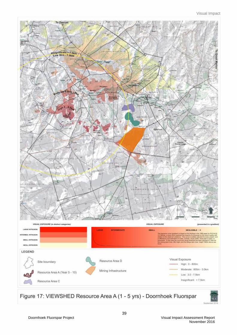
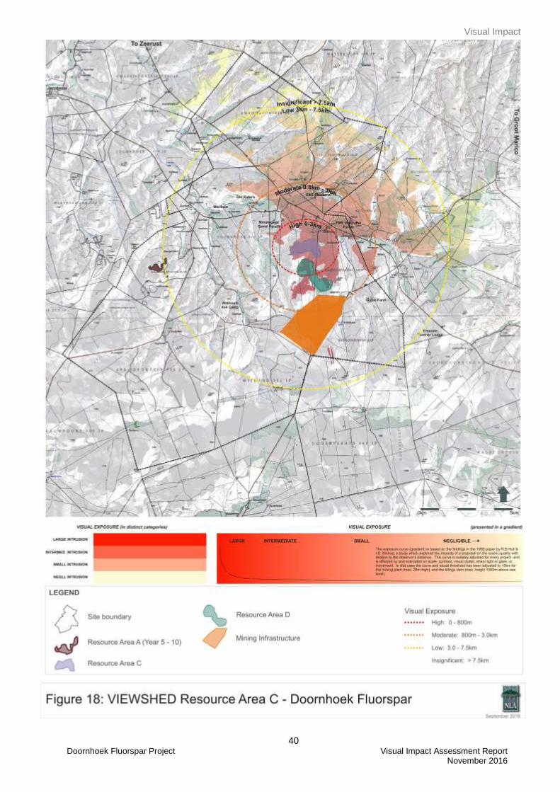
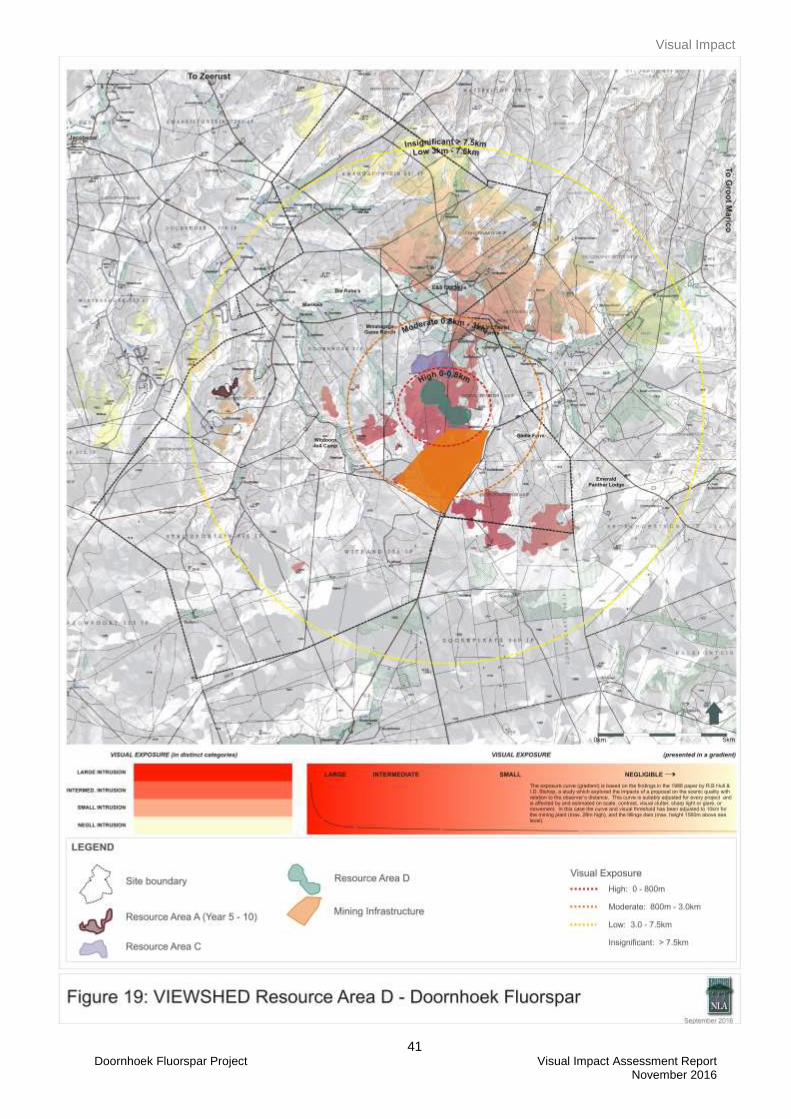
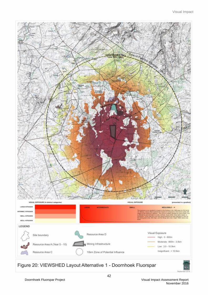
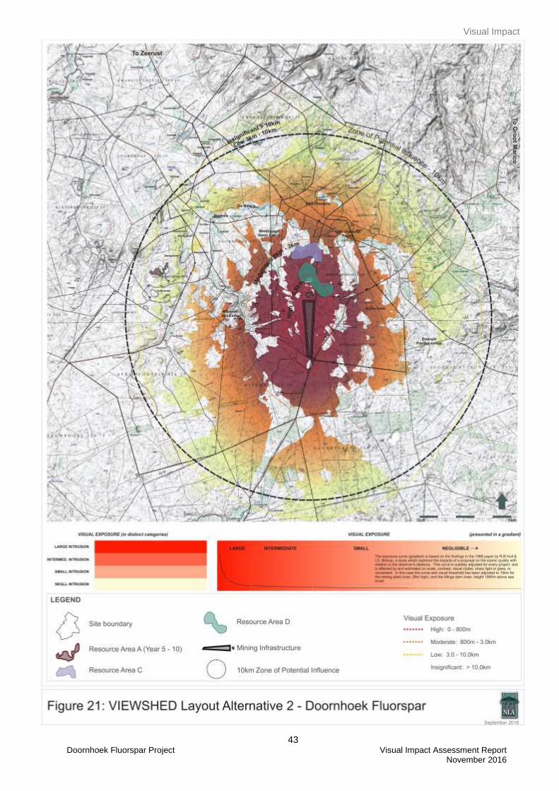
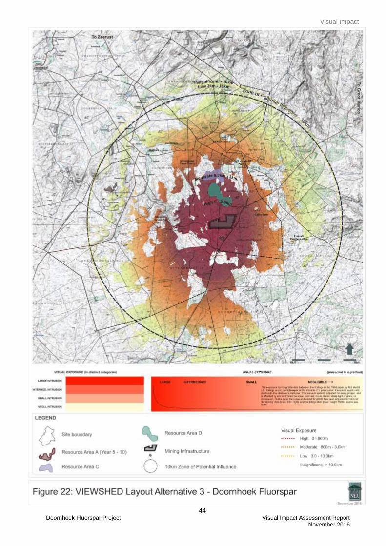
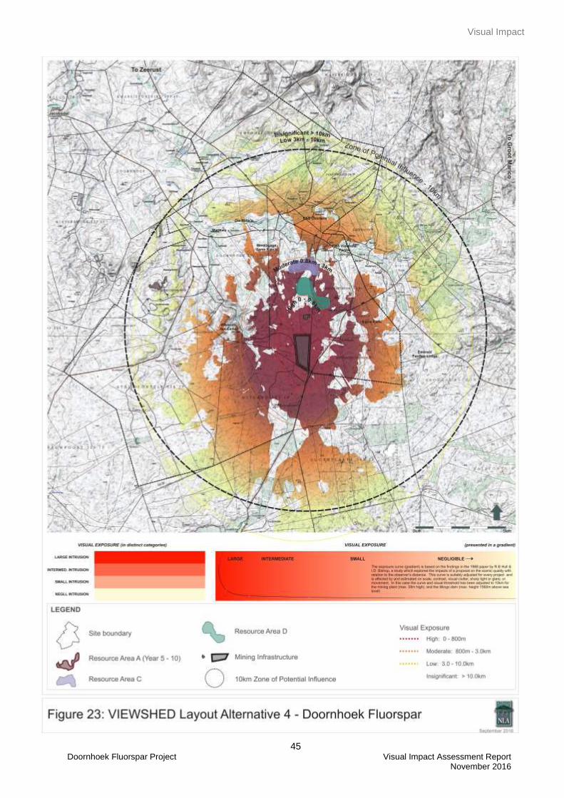
11.2.1.1 Visibility
In determining the visibility of the Doormhoek Fluorspar project the heights of the various project
components were used. Offsets starting at 5m above ground level (i.e. most project components would be
visible) through to 55m (TSF) were used to generate the viewsheds. The offset for the plant was 28m. These
are evident in Figures 17 to 23. It can be seen from the patterns generated by the viewsheds that the
proposed project operations would be highly visible within the study area and that sensitive viewing areas
would be impacted.
It must be understood that these patterns represent potential viewing sites and illustrate the absolute worst
case scenario i.e. the landscape without vegetation. It is imperative that the viewsheds be understood in
terms of the site visit findings as illustrated in the panoramas in Figures 7 to 14, the simulations in Figures 24
and 25 and the fact that the study area has a rolling topography. The project site is located within a
savannah/woodlans landscape which would effectively block some of the views to the site especially if the
viewer/viewpoint is surrounded by vegetation and/or located within a lower lying area (Figures 7 and 10).
Visibility of the project components (Resource Areas C & D, plant and TSF) from sensitive viewing areas was
considered to be high. Resource Area A was considered to have a low visibility since the mining area will be
located within the existing mining site (Figure 9 and 14) and will mostly be screened due to the topography
and vegetation of the area. When comparing the viewsheds of the four layout alternatives it is clear that the
pattern of the viewshed is more or less the same. The viewshed for Layout Alternative 1 indicates that the
proposed plant and TSF will be more visible to the west of the project site when compared to Layout
Alternative 4, which has a similar layout. The difference however is the location of the plant. The plant will be
less visible on Layout Alternative 4 as it is located in a valley. Layout Alternative 3 will be more visible from
the sensitive viewers located in the northern arch when comparing it with the other three alternatives. The
visibility of Layout Alternative 2 will be similar to that of Layout Alternative 1.
Visual Impact
37 Doornhoek Fluorspar Project Visual Impact Assessment Report November 2016
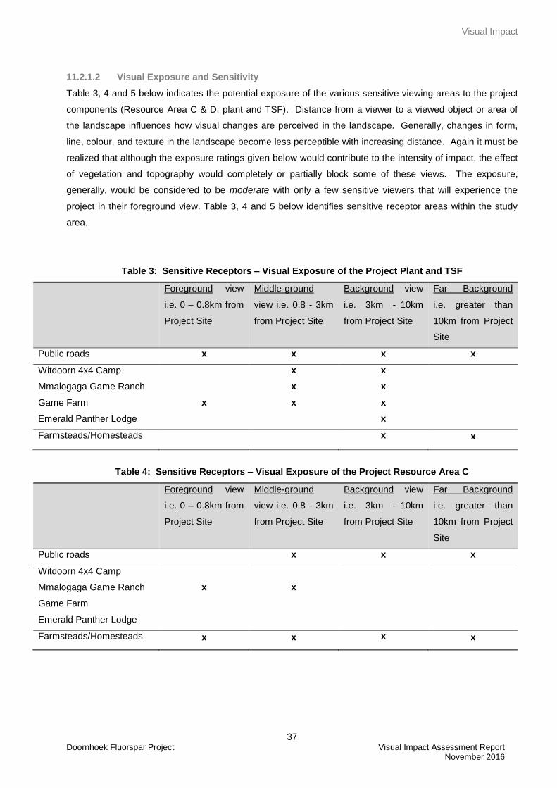
11.2.1.2 Visual Exposure and Sensitivity
Table 3, 4 and 5 below indicates the potential exposure of the various sensitive viewing areas to the project
components (Resource Area C & D, plant and TSF). Distance from a viewer to a viewed object or area of
the landscape influences how visual changes are perceived in the landscape. Generally, changes in form,
line, colour, and texture in the landscape become less perceptible with increasing distance. Again it must be
realized that although the exposure ratings given below would contribute to the intensity of impact, the effect
of vegetation and topography would completely or partially block some of these views. The exposure,
generally, would be considered to be moderate with only a few sensitive viewers that will experience the
project in their foreground view. Table 3, 4 and 5 below identifies sensitive receptor areas within the study
area.
Table 3: Sensitive Receptors – Visual Exposure of the Project Plant and TSF
Foreground view
i.e. 0 – 0.8km from
Project Site
Middle-ground
view i.e. 0.8 - 3km
from Project Site
Background view
i.e. 3km - 10km
from Project Site
Far Background
i.e. greater than
10km from Project
Site
Public roads x x x x
Witdoorn 4x4 Camp x x
Mmalogaga Game Ranch
Game Farm
Emerald Panther Lodge
x
x
x
x
x
x
Farmsteads/Homesteads x x
Table 4: Sensitive Receptors – Visual Exposure of the Project Resource Area C
Foreground view
i.e. 0 – 0.8km from
Project Site
Middle-ground
view i.e. 0.8 - 3km
from Project Site
Background view
i.e. 3km - 10km
from Project Site
Far Background
i.e. greater than
10km from Project
Site
Public roads x x x
Witdoorn 4x4 Camp
Mmalogaga Game Ranch
Game Farm
Emerald Panther Lodge
x
x
Farmsteads/Homesteads x x x x
Visual Impact
38 Doornhoek Fluorspar Project Visual Impact Assessment Report November 2016
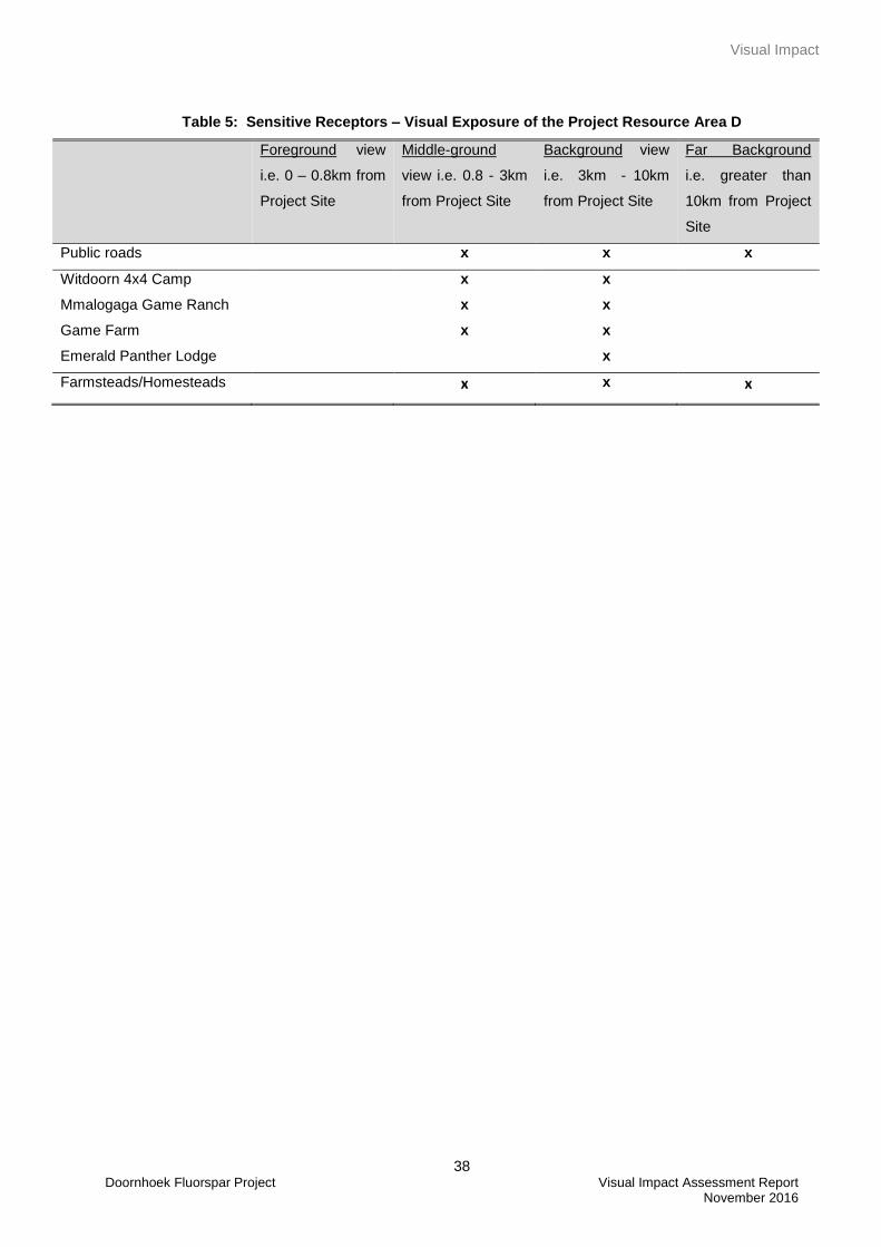
Table 5: Sensitive Receptors – Visual Exposure of the Project Resource Area D
Foreground view
i.e. 0 – 0.8km from
Project Site
Middle-ground
view i.e. 0.8 - 3km
from Project Site
Background view
i.e. 3km - 10km
from Project Site
Far Background
i.e. greater than
10km from Project
Site
Public roads x x x
Witdoorn 4x4 Camp x x
Mmalogaga Game Ranch
Game Farm
Emerald Panther Lodge
x
x
x
x
x
Farmsteads/Homesteads x x x
Visual Impact
39 Doornhoek Fluorspar Project Visual Impact Assessment Report November 2016
Visual Impact
40 Doornhoek Fluorspar Project Visual Impact Assessment Report November 2016
Visual Impact
41 Doornhoek Fluorspar Project Visual Impact Assessment Report November 2016
Visual Impact
42 Doornhoek Fluorspar Project Visual Impact Assessment Report November 2016
Visual Impact
43 Doornhoek Fluorspar Project Visual Impact Assessment Report November 2016
Visual Impact
44 Doornhoek Fluorspar Project Visual Impact Assessment Report November 2016
Visual Impact
45 Doornhoek Fluorspar Project Visual Impact Assessment Report November 2016
Visual Impact
46 Doornhoek Fluorspar Project Visual Impact Assessment Report November 2016
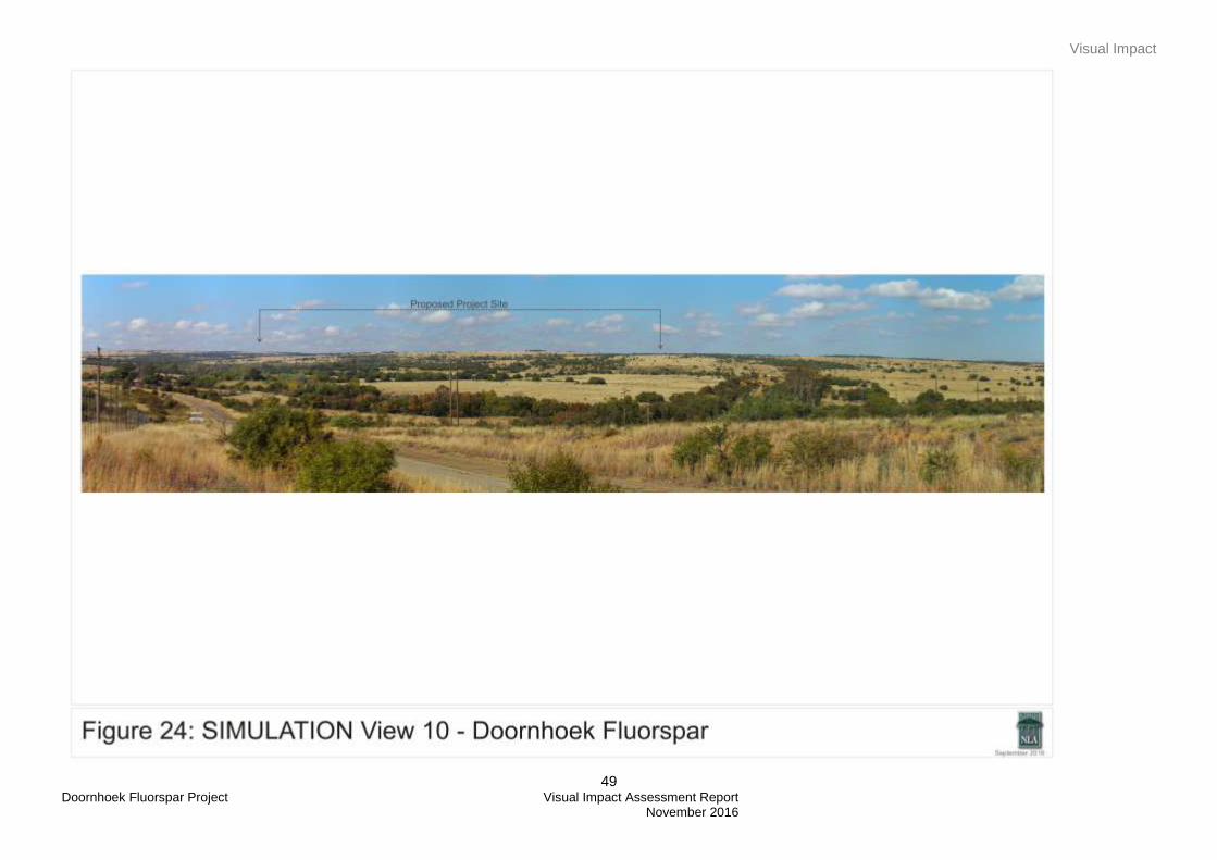
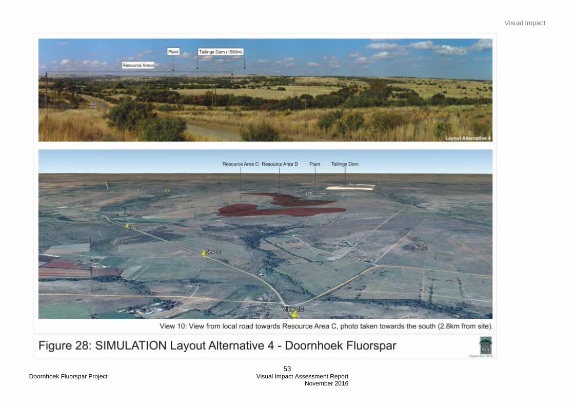
11.2.1.3 Visual Intrusion
Visual intrusion deals with the notion of contextualism i.e. how well does a project component fit with or
disrupt / enhance the ecological and cultural aesthetic of the landscape as a whole?
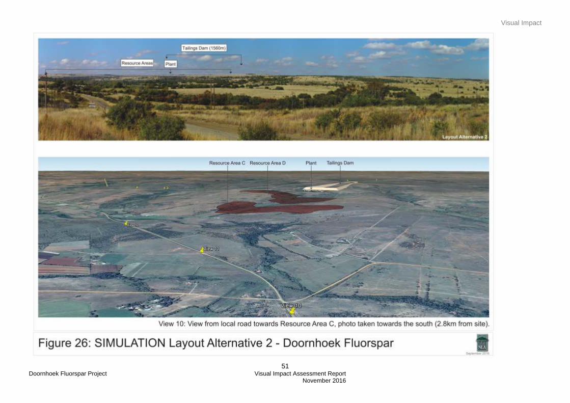
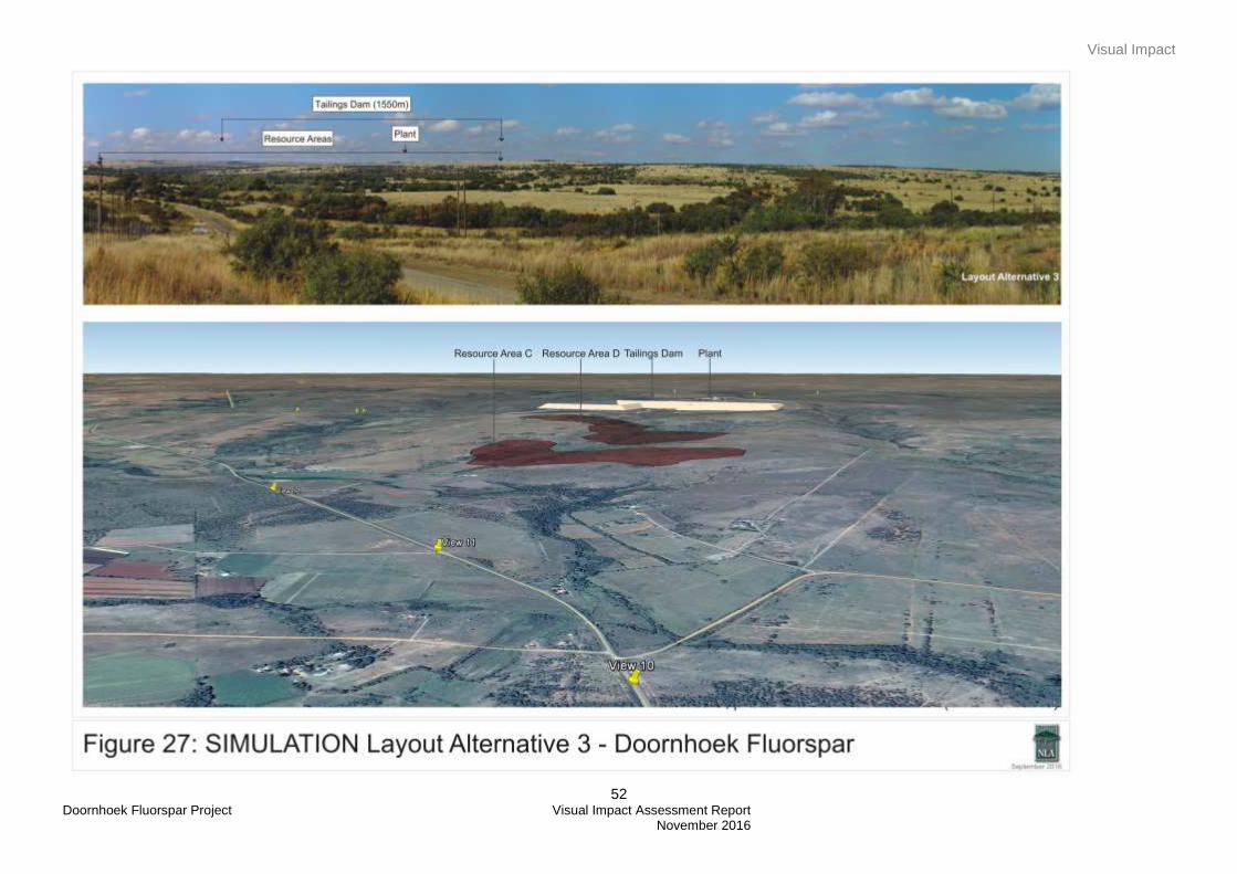
The simulations in Figures 24 - 28 illustrate the effect that the Doornhoek Fluorspar project will have on the
visual landscape within its context and when viewed from a variety of sensitive viewing locations about the
site. The simulations illustrate the project components (Resource Area C & D, Plant and TSF) at their
completed elevations i.e. the worst case scenario. It is evident, when one considers the before (current
situation) and after scenarios, that the project will have a high visual intrusion effect on sensitive viewing
areas. View 10 illustrates a typical view experienced by sensitive viewers located in the arch to the north
west and of the project site as well as people travelling within the study area. This view was used to illustrate
the visual intrusion of the 4 layout alternatives since the northern arch is considered to have more sensitive
viewers. In the view it is clear that most of the project components will be visible. Depending on the layout
alternative the plant will either be hidden behind the TSF or will be in full view of the viewer. The topography
will also aid in screening Resource Area C from some of the sensitive viewing points.
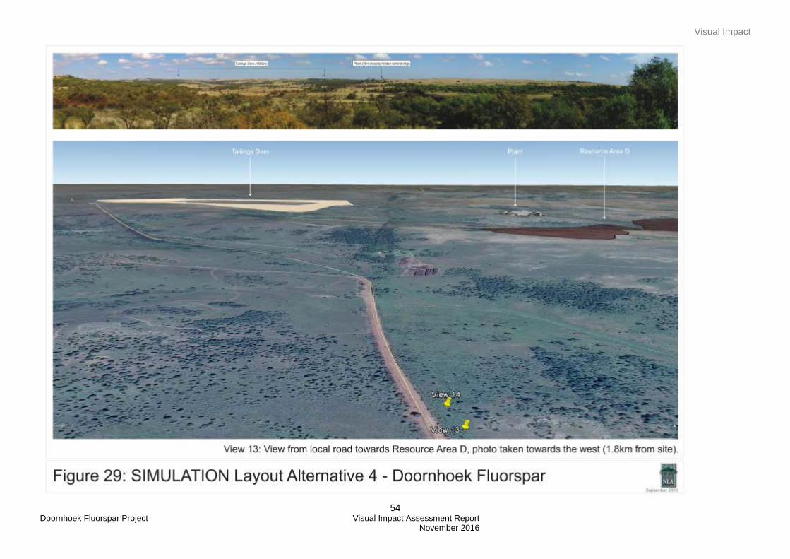
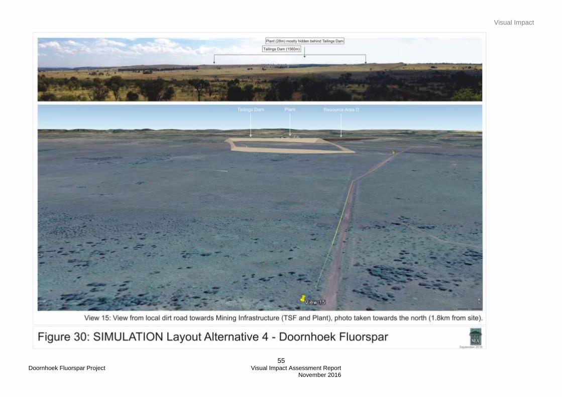
Layout Alternative 4, as the preferred alternative, was further simulated from other viewpoints to the north
east and south. The simulations in Figures 29 and 30 illustrate typical views from the north east, when
travelling along the game farm, and from the south, when travelling along the local road. View 13, as
illustrated in Figure 29, indicates that only the top part of the TSF will be visible, this is mainly due to the
rolling topography of the area. People travelling along the local road or visiting the game farm will therefore
catch glimpses or parts of the project and might be able to see the project components once viewed from an
elevated area. This will be similar for viewers travelling along the local road to the south of the project (View
15, Figure 30). The topography will screen the view towards the project and therefore the project
components will only be visible once the viewer is on an elevated area or driving close to / next to the
project.
Resource Area A wasn’t used or illustrated in a simulation as this section of the project will be screened from
sensitive viewers due to the topography and the dense vegetation cover in the area. This is illustrated in
Figure 9 and 14.
The lights associated with the Doornhoek Fluorspar project would include the lights from the plant as well as
security lighting. The project area is currently exposed to lights from farmsteads, homesteads, lodges and
game farms and the introduction of the lights associated with the project will result in a high visual intrusion
during the night. Table 6 below consolidates and rates (highlighted column) the potential intrusive nature of
the project assuming the worst case scenario (i.e. elevated viewing location and night time views).
Visual Impact
47 Doornhoek Fluorspar Project Visual Impact Assessment Report November 2016
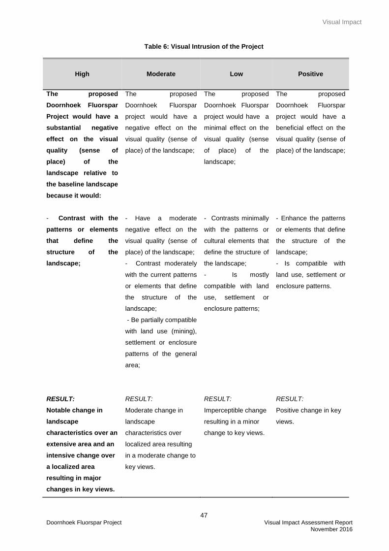
Table 6: Visual Intrusion of the Project
High
Moderate
Low
Positive
The proposed
Doornhoek Fluorspar
Project would have a
substantial negative
effect on the visual
quality (sense of
place) of the
landscape relative to
the baseline landscape
because it would:
- Contrast with the
patterns or elements
that define the
structure of the
landscape;
The proposed
Doornhoek Fluorspar
project would have a
negative effect on the
visual quality (sense of
place) of the landscape;
- Have a moderate
negative effect on the
visual quality (sense of
place) of the landscape;
- Contrast moderately
with the current patterns
or elements that define
the structure of the
landscape;
- Be partially compatible
with land use (mining),
settlement or enclosure
patterns of the general
area;
The proposed
Doornhoek Fluorspar
project would have a
minimal effect on the
visual quality (sense
of place) of the
landscape;
- Contrasts minimally
with the patterns or
cultural elements that
define the structure of
the landscape;
- Is mostly
compatible with land
use, settlement or
enclosure patterns;
The proposed
Doornhoek Fluorspar
project would have a
beneficial effect on the
visual quality (sense of
place) of the landscape;
- Enhance the patterns
or elements that define
the structure of the
landscape;
- Is compatible with
land use, settlement or
enclosure patterns.
RESULT:
Notable change in
landscape
characteristics over an
extensive area and an
intensive change over
a localized area
resulting in major
changes in key views.
RESULT:
Moderate change in
landscape
characteristics over
localized area resulting
in a moderate change to
key views.
RESULT:
Imperceptible change
resulting in a minor
change to key views.
RESULT:
Positive change in key
views.

Visual Impact
48 Doornhoek Fluorspar Project Visual Impact Assessment Report November 2016
Visual Impact
49 Doornhoek Fluorspar Project Visual Impact Assessment Report November 2016

Visual Impact
50 Doornhoek Fluorspar Project Visual Impact Assessment Report November 2016
Visual Impact
51 Doornhoek Fluorspar Project Visual Impact Assessment Report November 2016
Visual Impact
52 Doornhoek Fluorspar Project Visual Impact Assessment Report November 2016
Visual Impact
53 Doornhoek Fluorspar Project Visual Impact Assessment Report November 2016
Visual Impact
54 Doornhoek Fluorspar Project Visual Impact Assessment Report November 2016
Visual Impact
55 Doornhoek Fluorspar Project Visual Impact Assessment Report November 2016
Visual Impact
56 Doornhoek Fluorspar Project Visual Impact Assessment Report November 2016
11.2.1.4 Severity of Visual Impact
Referring to discussions in Section 11 above and using the criteria listed in Table 2, the visual intrusion and
severity of visual impact of the Project, relative to the current situation, is rated in Table 7 below. To assess
the severity of visual impact four main factors are considered.
Visual Intrusion: The nature of intrusion or contrast (physical characteristics) of a project component
on the visual quality of the surrounding environment and its compatibility/discord with the landscape
and surrounding land use.
Visibility: The area / points from which project components will be visible.
Visual exposure: Visibility and visual intrusion qualified with a distance rating to indicate the degree
of intrusion.
Sensitivity: Sensitivity of visual receptors to the proposed development
In synthesising the criteria used to establish the severity of visual impact, a numerical or weighting system is
avoided. Attempting to attach a precise numerical value to qualitative resources is rarely successful, and
should not be used as a substitute for reasoned professional judgement (Institute of Environmental
Assessment & The Landscape Institute (1996).
The intensity of visual impact (highlighted column and based on the worst case scenario) is rated in Table 7
below. Refer also the intensity ranking table in Appendix C.
Table 7: Intensity of Visual Impact – Construction, operation and decommissioning phases
High Moderate Low Negligible
The Doornhoek
Fluorspar Project will
cause a major
alteration to key
elements/features/
characteristics of the
baseline (i.e. current
baseline scenario)
through the
introduction of
elements considered to
be uncharacteristic
when set within the
There will be a partial
loss of or alteration to
key elements/features/
characteristics of the
visual and landscape
baseline.
I.e. The introduction of
project elements that
may be prominent but
may not necessarily be
considered to be
substantially
Minor loss of or alteration
to key elements /
features / characteristics
of the baseline.
I.e. Pre-development
landscape or view and /
or introduction of
elements that may not be
uncharacteristic when
set within the attributes
Very minor loss or
alteration to key
elements / features /
characteristics of the
baseline.
I.e. Pre-development
landscape or view and /
or introduction of
elements that are not
uncharacteristic with the
surrounding landscape –
Visual Impact
57 Doornhoek Fluorspar Project Visual Impact Assessment Report November 2016
attributes of aspects of
the current and future
receiving landscape.
High scenic quality
impacts would result
as well as impacts on
sensitive viewing
areas.
uncharacteristic when
set within the attributes
of the receiving
landscape.
Moderate scenic quality
impacts would result.
of the receiving
landscape.
Low scenic quality
impacts would result.
approximating the ‘no
change’ situation.
Negligible scenic quality
impacts would result.
The intensity of impact is therefore predicted to be high (during the Construction, Operational and
Decommission phases). The Doornhoek Fluorspar Project will:
Have a high negative effect on the visual quality of the landscape. The project is not compatible with
the patterns (rural/farming/game farms) that define the study area’s landscape - the study area’s
visual resource is rated moderate (farmsteads) to high (Klein Marco River and rolling topography).
The aesthetic appeal of the study area will be compromised with the presence of the Doornhoek
Fluorspar project. Although there are previously mined areas these areas are mostly screened due
to its location in the rolling topography. The mining area is also covered by vegetation and shows
signs of rehabilitation (Figure 14).
Have a high effect on key views – From the tourist and residential vantage areas north, north east,
north west and sections to the east of the project site. The proposed project activities would appear
in the middle to background of most views. In some instances (Mmalogaga Game Ranch, Game
Farm, homesteads/farmsteads and public roads), the activities could appear in the foreground of
views.
At closure the intensity is rated moderate although most of the infrastructure will be removed and the site
rehabilitated the TSF will still remain on site.
A cross section of the mining activities (Resource Areas, plant and TSF) was generated in order to establish
what the typical view will be from the viewers located to the north, north east and the north west of the
Project site. This illustration was also used, together with the viewshed analysis, to determine what type of
mitigation could be implemented in order to mitigate the visual impact of the Project.
As can be seen from Figure 30, most of the mining components will be constructed on elevated areas which
make mitigation difficult. The construction of a visual berm (vegetated) along the northern boundary of the
open pit Resource Area C could assist in screening views from sensitive viewers located within the northern
arch towards Resource Area C. It is recommended that a combination of a vegetation screen and berm be
constructed along the eastern and southern boundary of the TSF area in order to screen views from viewers
driving along the road. The plant should be constructed on the lowest point (contour) possible and as little
vegetation as possible should be removed around the plant area. Further mitigation measures are discussed
in Section 12 below.
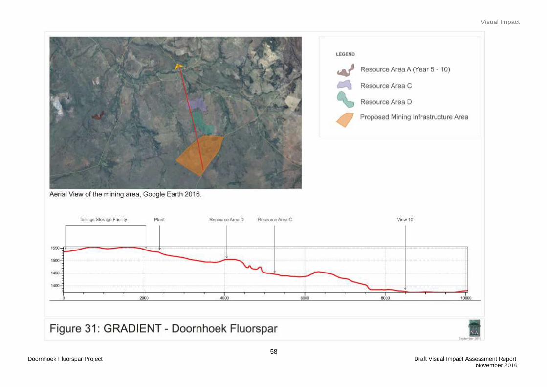
Visual Impact
58 Doornhoek Fluorspar Project Draft Visual Impact Assessment Report November 2016
Mitigation Measures
59 Doornhoek Fluorspar Project Visual Impact Assessment Report November 2016
12. MITIGATION MEASURES
In considering mitigating measures there are three rules that were considered - the measures should be
feasible (economically), effective (how long will it take to implement and what provision is made for
management / maintenance) and acceptable (within the framework of the existing landscape and land use
policies for the area). To address these, the following principles have been considered:
Mitigation measures should be designed to suit the existing landscape character and needs
of the locality. They should respect and build upon landscape distinctiveness.
It should be recognized that many mitigation measures, especially the establishment of
planted screens and rehabilitation, are not immediately effective.
The following mitigation measures are suggested and should be included as part of the Environmental
Management Programme (EMPr).
12.1 Project Area Development
It is proposed that as little vegetation as possible be removed during the construction phase,
especially the area surrounding Resource Area A and the plant.
Ensure, wherever possible, all existing natural vegetation is retained and incorporated into
the project site rehabilitation.
12.2 Earthworks
Dust suppression techniques should be in place at all times during the construction,
operational, and decommissioning / closure phases.
Only the footprint and a small ‘construction buffer zone’ around the proposed Project should
be exposed. In all other areas, the natural vegetation should be retained.
12.3 Landscaping
A registered Professional Landscape Architect must be appointed to assist with the
rehabilitation plan for the proposed project.
Rehabilitate / restore exposed areas as soon as possible after construction activities are
complete.
Only indigenous vegetation should be used for rehabilitation / landscaping purposes.
Berms (vegetated) can be constructed along the northern boundary of Resource Area C, this
will assist in mitigating the visual impact of the open cast mining areas.
12.4 Overburden Dump and TSF
Final shaping and dumping should be engineered such that the sides of the dumps are
articulated in a fashion that create areas of light and shadow interplay;
Harsh, steep engineered slopes should be avoided if at all possible as these could impose
an additional impact on the landscape by contrasting with existing topographic forms.
Maintain the final landform height and slope angles for stockpiles as low as possible.
Where slopes compatible with the surrounding landscape can be achieved, an attempt
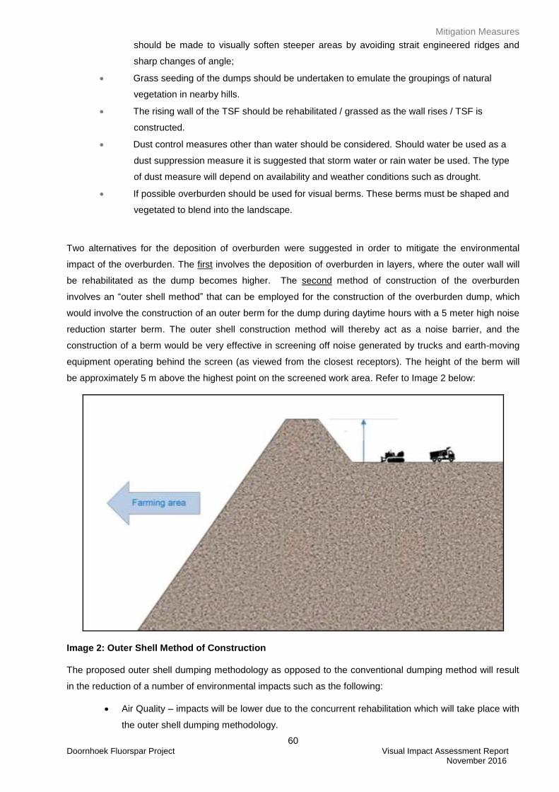
Mitigation Measures
60 Doornhoek Fluorspar Project Visual Impact Assessment Report November 2016
should be made to visually soften steeper areas by avoiding strait engineered ridges and
sharp changes of angle;
Grass seeding of the dumps should be undertaken to emulate the groupings of natural
vegetation in nearby hills.
The rising wall of the TSF should be rehabilitated / grassed as the wall rises / TSF is
constructed.
Dust control measures other than water should be considered. Should water be used as a
dust suppression measure it is suggested that storm water or rain water be used. The type
of dust measure will depend on availability and weather conditions such as drought.
If possible overburden should be used for visual berms. These berms must be shaped and
vegetated to blend into the landscape.
Two alternatives for the deposition of overburden were suggested in order to mitigate the environmental
impact of the overburden. The first involves the deposition of overburden in layers, where the outer wall will
be rehabilitated as the dump becomes higher. The second method of construction of the overburden
involves an “outer shell method” that can be employed for the construction of the overburden dump, which
would involve the construction of an outer berm for the dump during daytime hours with a 5 meter high noise
reduction starter berm. The outer shell construction method will thereby act as a noise barrier, and the
construction of a berm would be very effective in screening off noise generated by trucks and earth-moving
equipment operating behind the screen (as viewed from the closest receptors). The height of the berm will
be approximately 5 m above the highest point on the screened work area. Refer to Image 2 below:
Image 2: Outer Shell Method of Construction
The proposed outer shell dumping methodology as opposed to the conventional dumping method will result
in the reduction of a number of environmental impacts such as the following:
Air Quality – impacts will be lower due to the concurrent rehabilitation which will take place with
the outer shell dumping methodology.
Mitigation Measures
61 Doornhoek Fluorspar Project Visual Impact Assessment Report November 2016
Visual – impacts will be lower due to the concurrent rehabilitation undertaken during the outer
shell dumping methodology.
Noise –impacts will be far lower as the outer shell dumping methodology results in the
screening of noise from the nearby receptors.
Social – Social impacts will be lower due to the lower impacts on noise, air quality and visual.
12.5 Buildings / Structures
The plant should be constructed at the lowest point (contour) possible.
12.6 Access and Haul Roads
During construction, operation, rehabilitation and closure of the Project, access and haul roads will require
an effective dust suppression management programme, such as the use of non-polluting chemicals that will
retain moisture on the road surface.
12.7 Lighting
Even though there are light at night in areas of the study site, light pollution should still be seriously and
carefully considered and kept to a minimum. Security lighting should only be used where absolutely
necessary and carefully directed.
The negative impact of night lighting, glare and spotlight effects, can be mitigated using the following
methods:
Install light fixtures that provide precisely directed illumination to reduce light “spillage”
beyond the immediate surrounds of the substation.
Light public movement areas (pathways and roads) with low level ‘bollard’ type lights and
avoid post top lighting
Avoid high pole top security lighting along the periphery of the substation site and use only
lights that are activated on movement at illegal entry to the site.
Use security lighting at the periphery of the site that is activated by movement and are not
permanently switched on.
Significance of Impact
62 Doornhoek Fluorspar Project Visual Impact Assessment Report November 2016
13. SIGNIFICANCE OF IMPACT
The intensity of impact, rated in Table 7, is further qualified with extent, duration and probability criteria to
determine the significance of the visual impact. Table 8 below summarises the significance of the visual
impact during the Construction and Decommissioning Phases. Table 9 summarises the impact during
operation and Table 10 rates the significance of impact at Closure. These results are based on the worst-
case scenario when the impacts of all aspects of the Doornhoek Fluorspar project are taken together using
the impact criteria in Appendix C.
The unmitigated impact for the Construction and Decommission Phases is rated high significance. This is
when there will be major movement and activities on the site as the structures and infrastructure are being
built or decommissioned. Mitigation will be difficult during this period and the rated impact would not drop
significantly even with management measures.
During the Operation Phase the significance of unmitigated impact is rated high. Due to the rolling
topography most of the project components will be located on elevated areas which make mitigation very
difficult. Even if the mitigation measures are implemented successfully it will only partially screen the project
components and therefore the significance of the Project after mitigation measures are implemented will
remain high.
At Closure, when the plant structures and associated mining infrastructure is removed and the site effectively
managed and rehabilitated, the mitigated would be moderate since the TSF will remain on site. In the
unmitigated scenario, if infrastructure is to remain, the impact would be rated high, as in the Operational
phase.
The significance of the four layout alternatives will be the same and therefore there will only be one
significance rating for the entire Project.
Table 8: Summary of the visual impact per phase of the project
CONSTRUCTION AND DECOMMISSIONING PHASES
Potential Visual Impact
ENVIRONMENTAL SIGNIFICANCE
Probability Duration Scale Intensity Significance Mitigation
effect
Alteration to the visual quality
of the study area due to the
physical presence, scale and
size of the Doornhoek
Fluorspar project and its
associated infrastructure with
a high impact on key views
Mitigation measures are
Definite Medium
term
Site Medium Moderate Can be
avoided,
managed
or mitigated
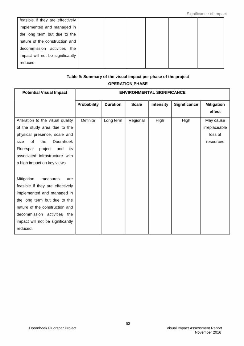
Significance of Impact
63 Doornhoek Fluorspar Project Visual Impact Assessment Report November 2016
feasible if they are effectively
implemented and managed in
the long term but due to the
nature of the construction and
decommission activities the
impact will not be significantly
reduced.
Table 9: Summary of the visual impact per phase of the project
OPERATION PHASE
Potential Visual Impact
ENVIRONMENTAL SIGNIFICANCE
Probability Duration Scale Intensity Significance Mitigation
effect
Alteration to the visual quality
of the study area due to the
physical presence, scale and
size of the Doornhoek
Fluorspar project and its
associated infrastructure with
a high impact on key views
Mitigation measures are
feasible if they are effectively
implemented and managed in
the long term but due to the
nature of the construction and
decommission activities the
impact will not be significantly
reduced.
Definite Long term Regional High High May cause
irreplaceable
loss of
resources
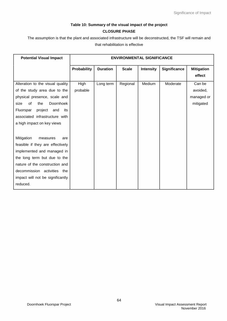
Significance of Impact
64 Doornhoek Fluorspar Project Visual Impact Assessment Report November 2016
Table 10: Summary of the visual impact of the project
CLOSURE PHASE
The assumption is that the plant and associated infrastructure will be deconstructed, the TSF will remain and
that rehabilitation is effective
Potential Visual Impact
ENVIRONMENTAL SIGNIFICANCE
Probability Duration Scale Intensity Significance Mitigation
effect
Alteration to the visual quality
of the study area due to the
physical presence, scale and
size of the Doornhoek
Fluorspar project and its
associated infrastructure with
a high impact on key views
Mitigation measures are
feasible if they are effectively
implemented and managed in
the long term but due to the
nature of the construction and
decommission activities the
impact will not be significantly
reduced.
High
probable
Long term Regional Medium Moderate Can be
avoided,
managed or
mitigated
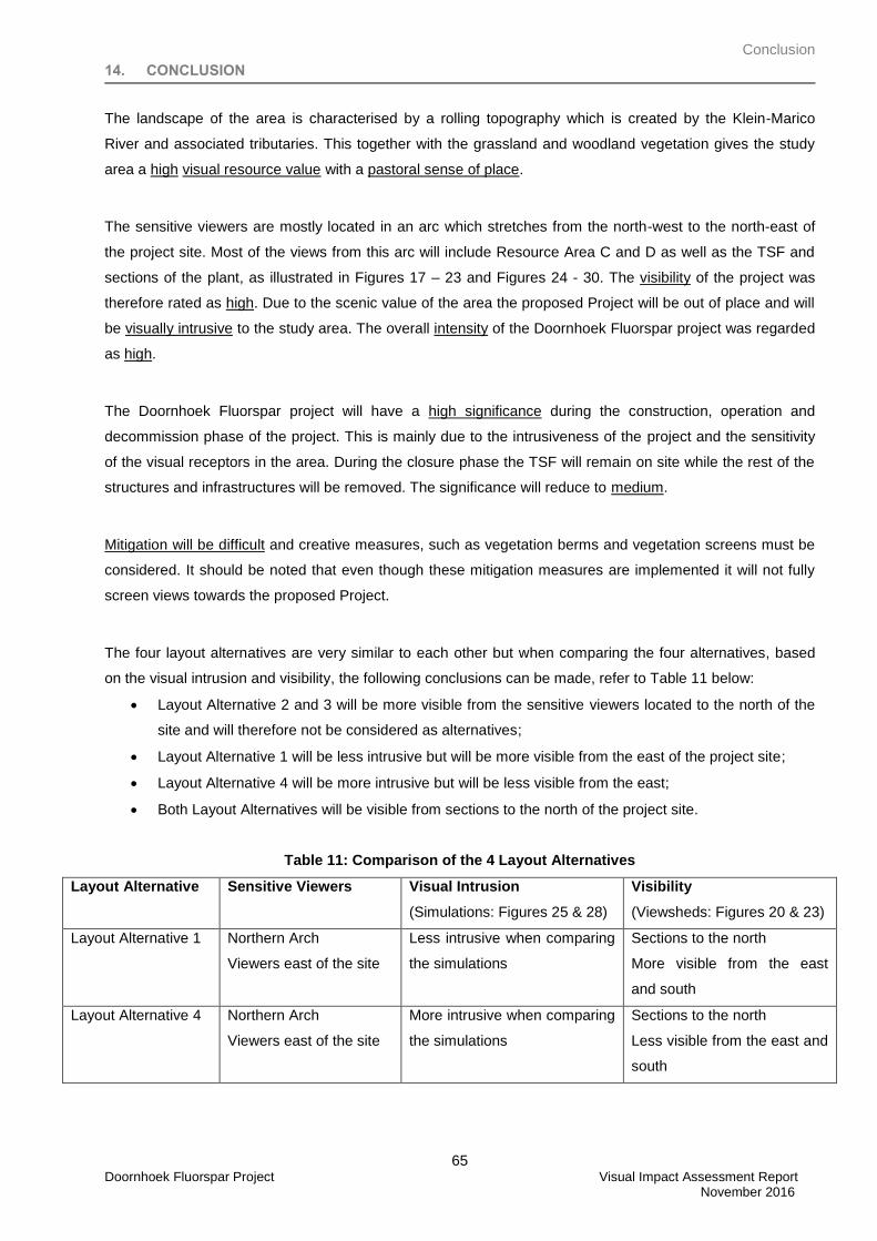
Conclusion
65 Doornhoek Fluorspar Project Visual Impact Assessment Report November 2016
14. CONCLUSION
The landscape of the area is characterised by a rolling topography which is created by the Klein-Marico
River and associated tributaries. This together with the grassland and woodland vegetation gives the study
area a high visual resource value with a pastoral sense of place.
The sensitive viewers are mostly located in an arc which stretches from the north-west to the north-east of
the project site. Most of the views from this arc will include Resource Area C and D as well as the TSF and
sections of the plant, as illustrated in Figures 17 – 23 and Figures 24 - 30. The visibility of the project was
therefore rated as high. Due to the scenic value of the area the proposed Project will be out of place and will
be visually intrusive to the study area. The overall intensity of the Doornhoek Fluorspar project was regarded
as high.
The Doornhoek Fluorspar project will have a high significance during the construction, operation and
decommission phase of the project. This is mainly due to the intrusiveness of the project and the sensitivity
of the visual receptors in the area. During the closure phase the TSF will remain on site while the rest of the
structures and infrastructures will be removed. The significance will reduce to medium.
Mitigation will be difficult and creative measures, such as vegetation berms and vegetation screens must be
considered. It should be noted that even though these mitigation measures are implemented it will not fully
screen views towards the proposed Project.
The four layout alternatives are very similar to each other but when comparing the four alternatives, based
on the visual intrusion and visibility, the following conclusions can be made, refer to Table 11 below:
Layout Alternative 2 and 3 will be more visible from the sensitive viewers located to the north of the
site and will therefore not be considered as alternatives;
Layout Alternative 1 will be less intrusive but will be more visible from the east of the project site;
Layout Alternative 4 will be more intrusive but will be less visible from the east;
Both Layout Alternatives will be visible from sections to the north of the project site.
Table 11: Comparison of the 4 Layout Alternatives
Layout Alternative Sensitive Viewers Visual Intrusion
(Simulations: Figures 25 & 28)
Visibility
(Viewsheds: Figures 20 & 23)
Layout Alternative 1 Northern Arch
Viewers east of the site
Less intrusive when comparing
the simulations
Sections to the north
More visible from the east
and south
Layout Alternative 4 Northern Arch
Viewers east of the site
More intrusive when comparing
the simulations
Sections to the north
Less visible from the east and
south
Conclusion
66 Doornhoek Fluorspar Project Visual Impact Assessment Report November 2016
Based on the above mentioned it can be seen that both Site Alternative 1 and Site Alternative 4 will be
acceptable as the preferred layout alternatives. The difference between the two layout alternatives is the
location of the plant. The plant in Layout Alternative 1 is located close to the TSF whereas Layout Alternative
4 it is located further away from the TSF and in a lower lying area. From a visual point the plant in Layout
Alternative 4 can almost be seen as a separate entity whereas Layout Alternative 1 the plant is located
closer to the TSF and therefore the two components will be seen as one. Based on this it is therefore
suggested that Layout Alternative 1 be used as the preferred alternative.
**NLA**
References
67 Doornhoek Fluorspar Project Visual Impact Assessment Report November 2016
15. REFERENCES
Crawford, D., 1994. Using remotely sensed data in landscape visual quality assessment. Landscape and
Urban Planning. 30: 71-81.
Hull, R.B. & Bishop, I.E., 1988. Scenic Impacts of Electricity Transmission Towers: The Influence of
Landscape Type and Observer Distance. Journal of Environmental Management. 27: 99-108.
Institute of Environmental Assessment & The Landscape Institute, 1996. Guidelines for Landscape and
Visual Impact Assessment, E & FN Spon, London (117)
Ittelson, W.H., Proshansky, H.M., Rivlin, L.g. and Winkel, G.H., 1974. An Introduction to Environmental
Psychology. Holt, Rinehart and Winston, New York.
Lange, E., 1994. Integration of computerized visual simulation and visual assessment in environmental
planning. Landscape and Environmental Planning. 30: 99-112.
Lynch, K., 1992. Good City Form, The MIT Press, London. (131)
Mucina, L. & Rutherford, M.C. (eds) 2006. The vegetation of South Africa, Lesotho and Swaziland. Strelitzia
19. South African National Biodiversity Institute, Pretoria.
Oberholzer, B., 2005. Guideline for involving visual & aesthetic specialists in EIA processes: Edition 1. CSIR
Report No ENV-S-C 2005 053 F. Republic of South Africa, Provincial Government of the Western Cape,
Department of Environmental Affairs & Development Planning, Cape Town.
Ramsay, J. (October 1993), Identification and assessment of aesthetic values in two Victorian forest regions.
More than meets the eye: identifying and assessing aesthetic value. Report of the Aesthetic Value Workshop
held at the University of Melbourne.
Sama, J. (2000), Program Policy, Assessing and Mitigating Visual Impact, Department of Environmental
Conservation. New York.
Schapper, J. (October 1993), The importance of aesthetic value in the assessment of landscape heritage.
More than meets the eye: identifying and assessing aesthetic value. Report of the Aesthetic Value Workshop
held at the University of Melbourne.
Warnock, S. & Brown, N., 1998. Putting Landscape First. Landscape Design. 268: 44-46.
Appendix A
68 Doornhoek Fluorspar Project Visual Impact Assessment Report November 2016
APPENDIX A: DETERMINING A LANDSCAPE AND THE VALUE OF THE VISUAL RESOURCE
In order to reach an understanding of the effect of development on a landscape resource, it is necessary to
consider the different aspects of the landscape as follows:
Landscape Elements and Character
The individual elements that make up the landscape, including prominent or eye-catching features such as
hills, valleys, savannah, trees, water bodies, buildings and roads are generally quantifiable and can be easily
described.
Landscape character is therefore the description of pattern, resulting from particular combinations of natural
(physical and biological) and cultural (land use) factors and how people perceive these. The visual
dimension of the landscape is a reflection of the way in which these factors create repetitive groupings and
interact to create areas that have a specific visual identity. The process of landscape character assessment
can increase appreciation of what makes the landscape distinctive and what is important about an area. The
description of landscape character thus focuses on the nature of the land, rather than the response of a
viewer.
Landscape Value – all encompassing (Aesthetic Value)
Aesthetic value is the emotional response derived from the experience of the environment with its particular
natural and cultural attributes. The response can be either to visual or non-visual elements and can embrace
sound, smell and any other factor having a strong impact on human thoughts, feelings and attitudes
(Ramsay 1993). Thus aesthetic value encompasses more than the seen view, visual quality or scenery, and
includes atmosphere, landscape character and sense of place (Schapper 1993).
Aesthetic appeal (value) is considered high when the following are present (Ramsay 1993):
Abstract qualities: such as the presence of vivid, distinguished, uncommon or rare features or abstract
attributes;
Evocative responses: the ability of the landscape to evoke particularly strong responses in community
members or visitors;
Meanings: the existence of a long-standing special meaning to a particular group of people or the ability
of the landscape to convey special meanings to viewers in general;
Landmark quality: a particular feature that stands out and is recognised by the broader community.
Sense of Place
Central to the concept of a sense of place is that the place requires uniqueness and distinctiveness. The
primary informant of these qualities is the spatial form and character of the natural landscape together with
the cultural transformations and traditions associated with historic use and habitation. According to Lynch
(1992) sense of place "is the extent to which a person can recognize or recall a place as being distinct from
other places - as having a vivid, or unique, or at least particular, character of its own". Sense of place is the
Appendix A
69 Doornhoek Fluorspar Project Visual Impact Assessment Report November 2016
unique value that is allocated to a specific place or area through the cognitive experience of the user or
viewer. In some cases these values allocated to the place are similar for a wide spectrum of users or
viewers, giving the place a universally recognized and therefore, strong sense of place.
Scenic Quality
Assigning values to visual resources is a subjective process. The phrase, “beauty is in the eye of the
beholder,” is often quoted to emphasize the subjectivity in determining scenic values. Yet, researchers have
found consistent levels of agreement among individuals asked to evaluate visual quality.
Studies for perceptual psychology have shown human preference for landscapes with a higher visual
complexity particularly in scenes with water, over homogeneous areas. On the basis of contemporary
research landscape quality increases when:
Topographic ruggedness and relative relief increase;
Where water forms are present;
Where diverse patterns of grasslands and trees occur;
Where natural landscape increases and man-made landscape decreases;
And where land use compatibility increases and land use edge diversity decreases (Crawford 1994).
Scenic Quality - Explanation of Rating Criteria:
(After The Visual Resource Management System, Department of the Interior of the USA Government,
Bureau of Land Management)
Landform: Topography becomes more interesting as it gets steeper or more massive, or more severely or
universally sculptured. Outstanding landforms may be monumental, as the Fish River or Blyde River Canyon,
the Drakensberg or other mountain ranges, or they may be exceedingly artistic and subtle as certain
badlands, pinnacles, arches, and other extraordinary formations.
Vegetation: (Plant communities) Give primary consideration to the variety of patterns, forms, and textures
created by plant life. Consider short-lived displays when they are known to be recurring or spectacular
(wildflower displays in the Karoo regions). Consider also smaller scale vegetational features, which add
striking and intriguing detail elements to the landscape (e.g., gnarled or wind beaten trees, and baobab
trees).
Water: That ingredient which adds movement or serenity to a scene. The degree to which water dominates
the scene is the primary consideration in selecting the rating score.
Colour: Consider the overall colour(s) of the basic components of the landscape (e.g., soil, rock, vegetation,
etc.) as they appear during seasons or periods of high use. Key factors to use when rating "colour" are
variety, contrast, and harmony.
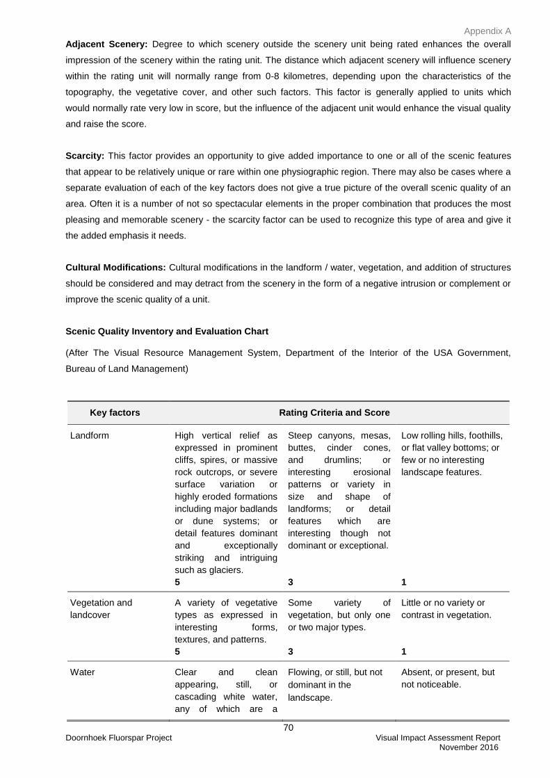
Appendix A
70 Doornhoek Fluorspar Project Visual Impact Assessment Report November 2016
Adjacent Scenery: Degree to which scenery outside the scenery unit being rated enhances the overall
impression of the scenery within the rating unit. The distance which adjacent scenery will influence scenery
within the rating unit will normally range from 0-8 kilometres, depending upon the characteristics of the
topography, the vegetative cover, and other such factors. This factor is generally applied to units which
would normally rate very low in score, but the influence of the adjacent unit would enhance the visual quality
and raise the score.
Scarcity: This factor provides an opportunity to give added importance to one or all of the scenic features
that appear to be relatively unique or rare within one physiographic region. There may also be cases where a
separate evaluation of each of the key factors does not give a true picture of the overall scenic quality of an
area. Often it is a number of not so spectacular elements in the proper combination that produces the most
pleasing and memorable scenery - the scarcity factor can be used to recognize this type of area and give it
the added emphasis it needs.
Cultural Modifications: Cultural modifications in the landform / water, vegetation, and addition of structures
should be considered and may detract from the scenery in the form of a negative intrusion or complement or
improve the scenic quality of a unit.
Scenic Quality Inventory and Evaluation Chart
(After The Visual Resource Management System, Department of the Interior of the USA Government,
Bureau of Land Management)
Key factors Rating Criteria and Score
Landform High vertical relief as
expressed in prominent
cliffs, spires, or massive
rock outcrops, or severe
surface variation or
highly eroded formations
including major badlands
or dune systems; or
detail features dominant
and exceptionally
striking and intriguing
such as glaciers.
5
Steep canyons, mesas,
buttes, cinder cones,
and drumlins; or
interesting erosional
patterns or variety in
size and shape of
landforms; or detail
features which are
interesting though not
dominant or exceptional.
3
Low rolling hills, foothills,
or flat valley bottoms; or
few or no interesting
landscape features.
1
Vegetation and
landcover
A variety of vegetative
types as expressed in
interesting forms,
textures, and patterns.
5
Some variety of
vegetation, but only one
or two major types.
3
Little or no variety or
contrast in vegetation.
1
Water Clear and clean
appearing, still, or
cascading white water,
any of which are a
Flowing, or still, but not
dominant in the
landscape.
Absent, or present, but
not noticeable.
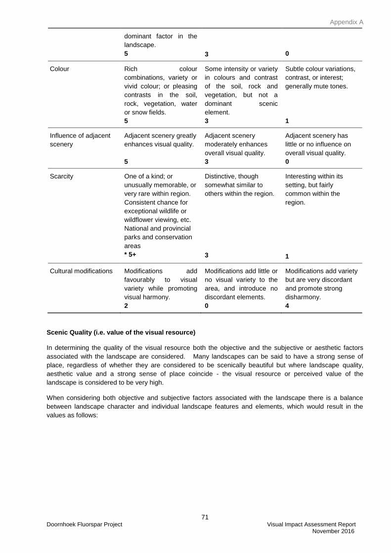
Appendix A
71 Doornhoek Fluorspar Project Visual Impact Assessment Report November 2016
dominant factor in the
landscape.
5
3
0
Colour Rich colour
combinations, variety or
vivid colour; or pleasing
contrasts in the soil,
rock, vegetation, water
or snow fields.
5
Some intensity or variety
in colours and contrast
of the soil, rock and
vegetation, but not a
dominant scenic
element.
3
Subtle colour variations,
contrast, or interest;
generally mute tones.
1
Influence of adjacent
scenery
Adjacent scenery greatly
enhances visual quality.
5
Adjacent scenery
moderately enhances
overall visual quality.
3
Adjacent scenery has
little or no influence on
overall visual quality.
0
Scarcity One of a kind; or
unusually memorable, or
very rare within region.
Consistent chance for
exceptional wildlife or
wildflower viewing, etc.
National and provincial
parks and conservation
areas
* 5+
Distinctive, though
somewhat similar to
others within the region.
3
Interesting within its
setting, but fairly
common within the
region.
1
Cultural modifications Modifications add
favourably to visual
variety while promoting
visual harmony.
2
Modifications add little or
no visual variety to the
area, and introduce no
discordant elements.
0
Modifications add variety
but are very discordant
and promote strong
disharmony.
4
Scenic Quality (i.e. value of the visual resource)
In determining the quality of the visual resource both the objective and the subjective or aesthetic factors
associated with the landscape are considered. Many landscapes can be said to have a strong sense of
place, regardless of whether they are considered to be scenically beautiful but where landscape quality,
aesthetic value and a strong sense of place coincide - the visual resource or perceived value of the
landscape is considered to be very high.
When considering both objective and subjective factors associated with the landscape there is a balance
between landscape character and individual landscape features and elements, which would result in the
values as follows:
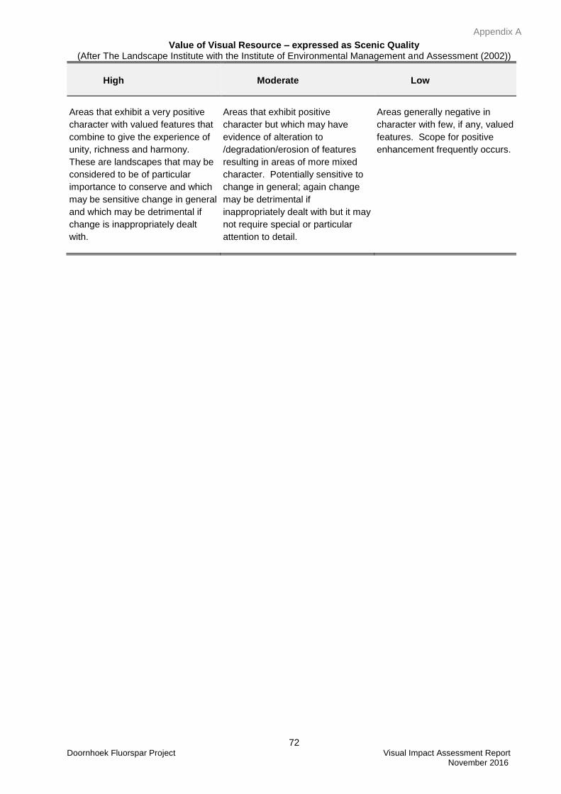
Appendix A
72 Doornhoek Fluorspar Project Visual Impact Assessment Report November 2016
Value of Visual Resource – expressed as Scenic Quality (After The Landscape Institute with the Institute of Environmental Management and Assessment (2002))
High
Moderate
Low
Areas that exhibit a very positive
character with valued features that
combine to give the experience of
unity, richness and harmony.
These are landscapes that may be
considered to be of particular
importance to conserve and which
may be sensitive change in general
and which may be detrimental if
change is inappropriately dealt
with.
Areas that exhibit positive
character but which may have
evidence of alteration to
/degradation/erosion of features
resulting in areas of more mixed
character. Potentially sensitive to
change in general; again change
may be detrimental if
inappropriately dealt with but it may
not require special or particular
attention to detail.
Areas generally negative in
character with few, if any, valued
features. Scope for positive
enhancement frequently occurs.
Appendix B
73 Doornhoek Fluorspar Project Visual Impact Assessment Report November 2016
APPENDIX B: METHOD FOR DETERMINING THE SEVERITY OF LANDSCAPE AND VISUAL IMPACT
A visual impact study analysis addresses the importance of the inherent aesthetics of the landscape, the
public value of viewing the natural landscape, and the contrast or change in the landscape from the project.
For some topics, such as water or air quality, it is possible to use measurable, technical international or
national guidelines or legislative standards, against which potential effects can be assessed. The
assessment of likely effects on a landscape resource and on visual amenity is more complex, since it is
determined through a combination of quantitative and qualitative evaluations. (The Landscape Institute with
the Institute of Environmental Management and Assessment (2002).
Landscape impact assessment includes a combination of objective and subjective judgements, and it is
therefore important that a structured and consistent approach is used. It is necessary to differentiate
between judgements that involve a degree of subjective opinion (as in the assessment of landscape value)
from those that are normally more objective and quantifiable (as in the determination of magnitude of
change). Judgement should always be based on training and experience and be supported by clear
evidence and reasoned argument. Accordingly, suitably qualified and experienced landscape professionals
carry out landscape and visual impact assessments (The Landscape Institute with the Institute of
Environmental Management and Assessment (2002),
Landscape and visual assessments are separate, although linked, procedures. The landscape baseline, its
analysis and the assessment of landscape effects all contribute to the baseline for visual assessment
studies. The assessment of the potential effect on the landscape is carried our as an effect on an
environmental resource, i.e. the landscape. Visual effects are assessed as one of the interrelated effects on
population.
Landscape Impact
Landscape impacts derive from changes in the physical landscape, which may give rise to changes in its
character and from effects to the scenic values of the landscape. This may in turn affect the perceived value
ascribed to the landscape. The description and analysis of effects on a landscape resource relies on the
adoption of certain basic principles about the positive (or beneficial) and negative (or adverse) effects of
change in the landscape. Due to the inherently dynamic nature of the landscape, change arising from a
development may not necessarily be significant (Institute of Environmental Assessment & The Landscape
Institute (2002)).
Visual Impact
Visual impacts relate to the changes that arise in the composition of available views as a result of changes to
the landscape, to people’s responses to the changes, and to the overall effects with respect to visual
amenity. Visual impact is therefore measured as the change to the existing visual environment (caused by
the physical presence of a new development) and the extent to which that change compromises (negative
impact) or enhances (positive impact) or maintains the visual quality of the area.
Appendix B
74 Doornhoek Fluorspar Project Visual Impact Assessment Report November 2016
To assess the magnitude of visual impact four main factors are considered.
Visual Intrusion: The nature of intrusion or contrast (physical characteristics) of a project
component on the visual quality of the surrounding environment and its
compatibility/discord with the landscape and surrounding land use.
Visibility: The area/points from which project components will be visible.
Visual exposure: Visibility and visual intrusion qualified with a distance rating to indicate the
degree of intrusion.
Sensitivity: Sensitivity of visual receptors to the proposed development
Visual Intrusion / contrast
Visual intrusion deals with the notion of contextualism i.e. how well does a project component fit into the
ecological and cultural aesthetic of the landscape as a whole? Or conversely what is its contrast with the
receiving environment. Combining landform / vegetation contrast with structure contrast derives overall
visual intrusion/contrast levels of high, moderate, and low.
Landform / vegetation contrast is the change in vegetation cover and patterns that would result from
construction activities. Landform contrast is the change in landforms, exposure of soils, potential for erosion
scars, slumping, and other physical disturbances that would be noticed as uncharacteristic in the natural
landscape. Structure contrast examines the compatibility of the proposed development with other structures
in the landscape and the existing natural landscape. Structure contrast is typically strongest where there are
no other structures (e.g., buildings, existing utilities) in the landscape setting.
Photographic panoramas from key viewpoints before and after development are presented to illustrate the
nature and change (contrast) to the landscape created by the proposed development. A computer simulation
technique is employed to superimpose a graphic of the development onto the panorama. The extent to
which the component fits or contrasts with the landscape setting can then be assessed using the following
criteria.
Does the physical development concept have a negative, positive or neutral effect on the
quality of the landscape?
Does the development enhance or contrast with the patterns or elements that define the
structure of the landscape?
Does the design of the project enhance and promote cultural continuity or does it disrupt it?
The consequence of the intrusion / contrast can then be measured in terms of the sensitivity of the affected
landscape and visual resource given the criteria listed below. For instance, within an industrial area, a new
sewage treatment works may have an insignificant landscape and visual impact; whereas in a valued
landscape it might be considered to be an intrusive element. (Institute of Environmental Assessment & The
landscape Institute (1996)).
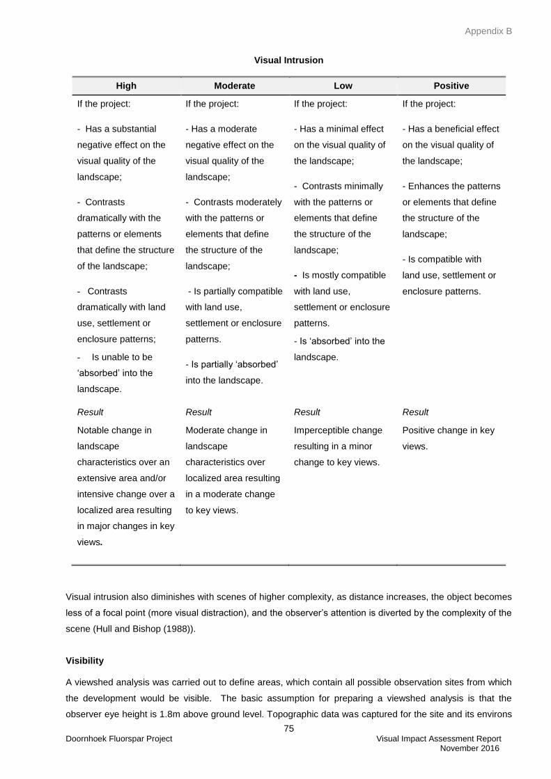
Appendix B
75 Doornhoek Fluorspar Project Visual Impact Assessment Report November 2016
Visual Intrusion
High Moderate Low Positive
If the project:
- Has a substantial
negative effect on the
visual quality of the
landscape;
- Contrasts
dramatically with the
patterns or elements
that define the structure
of the landscape;
- Contrasts
dramatically with land
use, settlement or
enclosure patterns;
- Is unable to be
‘absorbed’ into the
landscape.
If the project:
- Has a moderate
negative effect on the
visual quality of the
landscape;
- Contrasts moderately
with the patterns or
elements that define
the structure of the
landscape;
- Is partially compatible
with land use,
settlement or enclosure
patterns.
- Is partially ‘absorbed’
into the landscape.
If the project:
- Has a minimal effect
on the visual quality of
the landscape;
- Contrasts minimally
with the patterns or
elements that define
the structure of the
landscape;
- Is mostly compatible
with land use,
settlement or enclosure
patterns.
- Is ‘absorbed’ into the
landscape.
If the project:
- Has a beneficial effect
on the visual quality of
the landscape;
- Enhances the patterns
or elements that define
the structure of the
landscape;
- Is compatible with
land use, settlement or
enclosure patterns.
Result
Notable change in
landscape
characteristics over an
extensive area and/or
intensive change over a
localized area resulting
in major changes in key
views.
Result
Moderate change in
landscape
characteristics over
localized area resulting
in a moderate change
to key views.
Result
Imperceptible change
resulting in a minor
change to key views.
Result
Positive change in key
views.
Visual intrusion also diminishes with scenes of higher complexity, as distance increases, the object becomes
less of a focal point (more visual distraction), and the observer’s attention is diverted by the complexity of the
scene (Hull and Bishop (1988)).
Visibility
A viewshed analysis was carried out to define areas, which contain all possible observation sites from which
the development would be visible. The basic assumption for preparing a viewshed analysis is that the
observer eye height is 1.8m above ground level. Topographic data was captured for the site and its environs
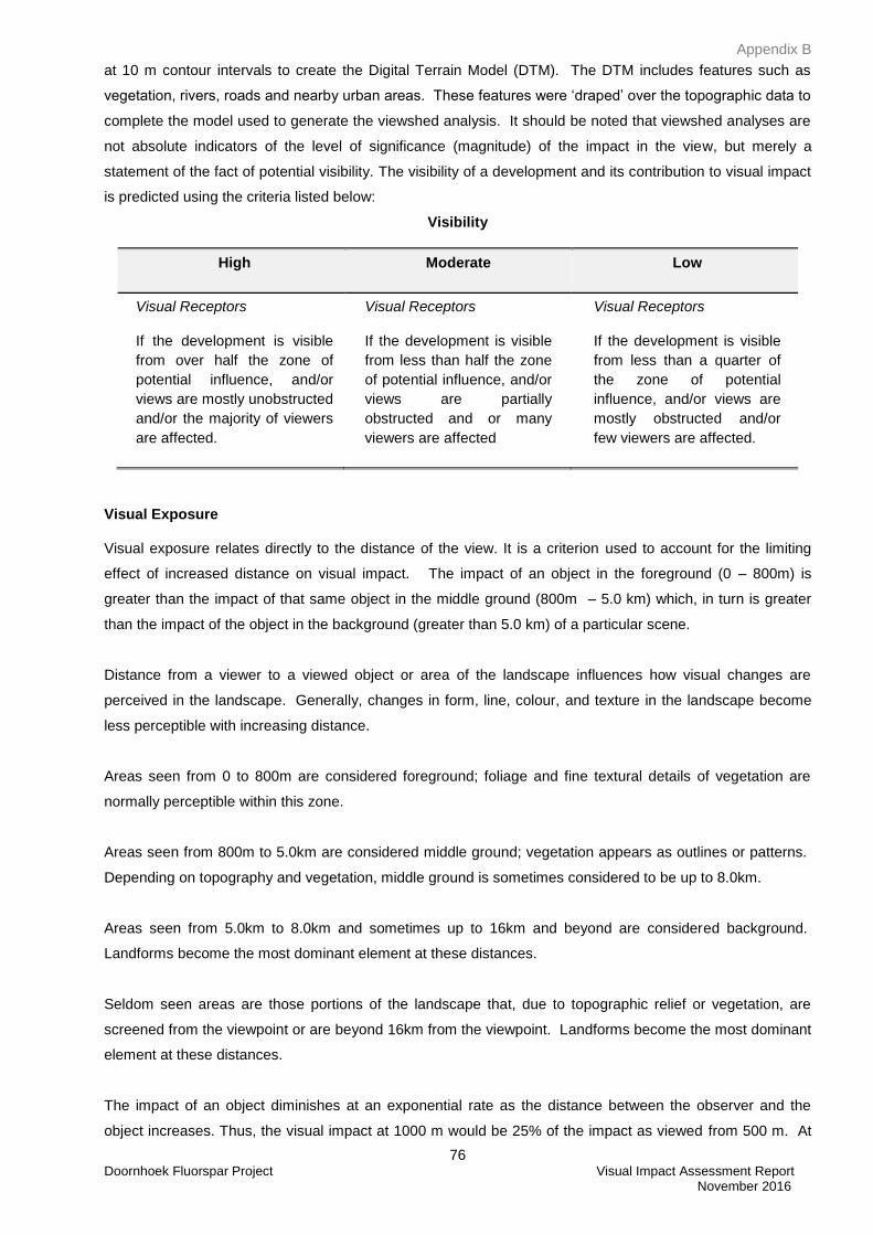
Appendix B
76 Doornhoek Fluorspar Project Visual Impact Assessment Report November 2016
at 10 m contour intervals to create the Digital Terrain Model (DTM). The DTM includes features such as
vegetation, rivers, roads and nearby urban areas. These features were ‘draped’ over the topographic data to
complete the model used to generate the viewshed analysis. It should be noted that viewshed analyses are
not absolute indicators of the level of significance (magnitude) of the impact in the view, but merely a
statement of the fact of potential visibility. The visibility of a development and its contribution to visual impact
is predicted using the criteria listed below:
Visibility
High Moderate Low
Visual Receptors
If the development is visible
from over half the zone of
potential influence, and/or
views are mostly unobstructed
and/or the majority of viewers
are affected.
Visual Receptors
If the development is visible
from less than half the zone
of potential influence, and/or
views are partially
obstructed and or many
viewers are affected
Visual Receptors
If the development is visible
from less than a quarter of
the zone of potential
influence, and/or views are
mostly obstructed and/or
few viewers are affected.
Visual Exposure
Visual exposure relates directly to the distance of the view. It is a criterion used to account for the limiting
effect of increased distance on visual impact. The impact of an object in the foreground (0 – 800m) is
greater than the impact of that same object in the middle ground (800m – 5.0 km) which, in turn is greater
than the impact of the object in the background (greater than 5.0 km) of a particular scene.
Distance from a viewer to a viewed object or area of the landscape influences how visual changes are
perceived in the landscape. Generally, changes in form, line, colour, and texture in the landscape become
less perceptible with increasing distance.
Areas seen from 0 to 800m are considered foreground; foliage and fine textural details of vegetation are
normally perceptible within this zone.
Areas seen from 800m to 5.0km are considered middle ground; vegetation appears as outlines or patterns.
Depending on topography and vegetation, middle ground is sometimes considered to be up to 8.0km.
Areas seen from 5.0km to 8.0km and sometimes up to 16km and beyond are considered background.
Landforms become the most dominant element at these distances.
Seldom seen areas are those portions of the landscape that, due to topographic relief or vegetation, are
screened from the viewpoint or are beyond 16km from the viewpoint. Landforms become the most dominant
element at these distances.
The impact of an object diminishes at an exponential rate as the distance between the observer and the
object increases. Thus, the visual impact at 1000 m would be 25% of the impact as viewed from 500 m. At
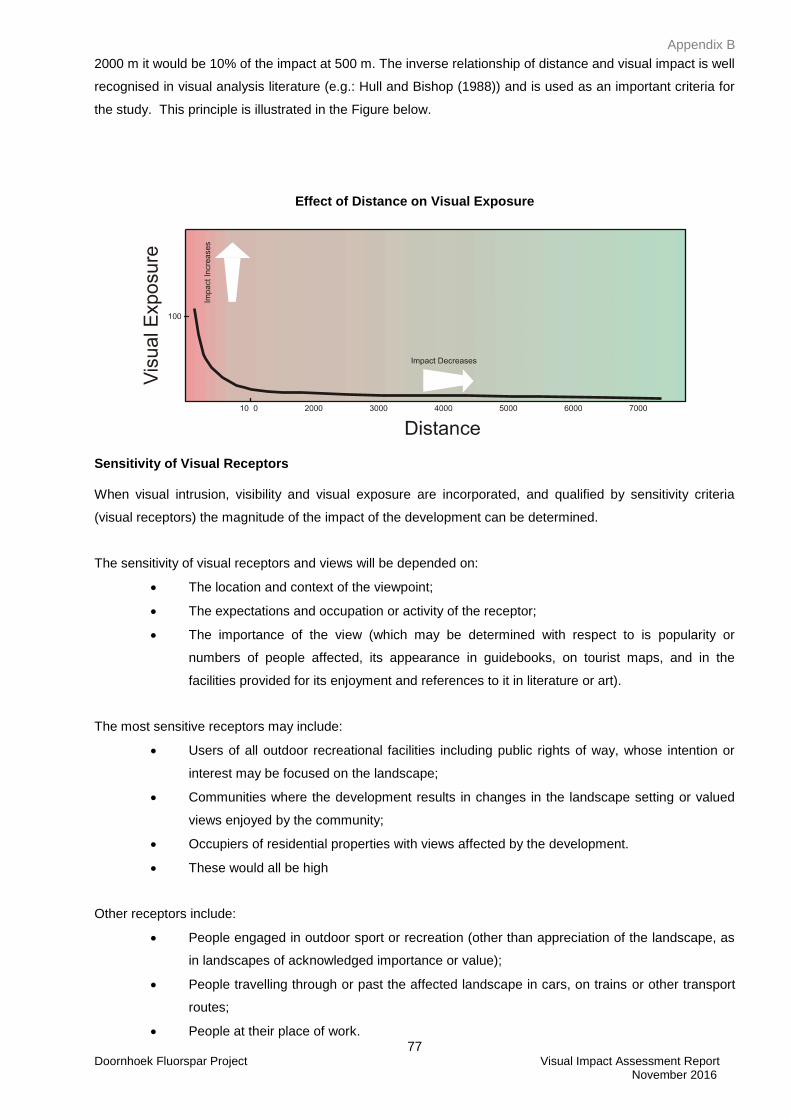
Appendix B
77 Doornhoek Fluorspar Project Visual Impact Assessment Report November 2016
2000 m it would be 10% of the impact at 500 m. The inverse relationship of distance and visual impact is well
recognised in visual analysis literature (e.g.: Hull and Bishop (1988)) and is used as an important criteria for
the study. This principle is illustrated in the Figure below.
Effect of Distance on Visual Exposure
Sensitivity of Visual Receptors
When visual intrusion, visibility and visual exposure are incorporated, and qualified by sensitivity criteria
(visual receptors) the magnitude of the impact of the development can be determined.
The sensitivity of visual receptors and views will be depended on:
The location and context of the viewpoint;
The expectations and occupation or activity of the receptor;
The importance of the view (which may be determined with respect to is popularity or
numbers of people affected, its appearance in guidebooks, on tourist maps, and in the
facilities provided for its enjoyment and references to it in literature or art).
The most sensitive receptors may include:
Users of all outdoor recreational facilities including public rights of way, whose intention or
interest may be focused on the landscape;
Communities where the development results in changes in the landscape setting or valued
views enjoyed by the community;
Occupiers of residential properties with views affected by the development.
These would all be high
Other receptors include:
People engaged in outdoor sport or recreation (other than appreciation of the landscape, as
in landscapes of acknowledged importance or value);
People travelling through or past the affected landscape in cars, on trains or other transport
routes;
People at their place of work.
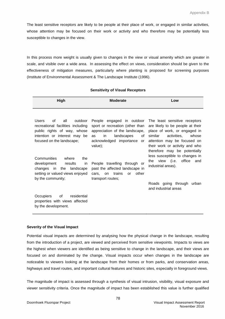
Appendix B
78 Doornhoek Fluorspar Project Visual Impact Assessment Report November 2016
The least sensitive receptors are likely to be people at their place of work, or engaged in similar activities,
whose attention may be focused on their work or activity and who therefore may be potentially less
susceptible to changes in the view.
In this process more weight is usually given to changes in the view or visual amenity which are greater in
scale, and visible over a wide area. In assessing the effect on views, consideration should be given to the
effectiveness of mitigation measures, particularly where planting is proposed for screening purposes
(Institute of Environmental Assessment & The Landscape Institute (1996).
Sensitivity of Visual Receptors
High Moderate Low
Users of all outdoor
recreational facilities including
public rights of way, whose
intention or interest may be
focused on the landscape;
Communities where the
development results in
changes in the landscape
setting or valued views enjoyed
by the community;
Occupiers of residential
properties with views affected
by the development.
People engaged in outdoor
sport or recreation (other than
appreciation of the landscape,
as in landscapes of
acknowledged importance or
value);
People travelling through or
past the affected landscape in
cars, on trains or other
transport routes;
The least sensitive receptors
are likely to be people at their
place of work, or engaged in
similar activities, whose
attention may be focused on
their work or activity and who
therefore may be potentially
less susceptible to changes in
the view (i.e. office and
industrial areas).
Roads going through urban
and industrial areas
Severity of the Visual Impact
Potential visual impacts are determined by analysing how the physical change in the landscape, resulting
from the introduction of a project, are viewed and perceived from sensitive viewpoints. Impacts to views are
the highest when viewers are identified as being sensitive to change in the landscape, and their views are
focused on and dominated by the change. Visual impacts occur when changes in the landscape are
noticeable to viewers looking at the landscape from their homes or from parks, and conservation areas,
highways and travel routes, and important cultural features and historic sites, especially in foreground views.
The magnitude of impact is assessed through a synthesis of visual intrusion, visibility, visual exposure and
viewer sensitivity criteria. Once the magnitude of impact has been established this value is further qualified
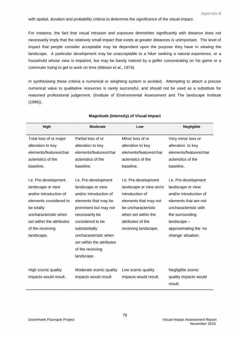
Appendix B
79 Doornhoek Fluorspar Project Visual Impact Assessment Report November 2016
with spatial, duration and probability criteria to determine the significance of the visual impact.
For instance, the fact that visual intrusion and exposure diminishes significantly with distance does not
necessarily imply that the relatively small impact that exists at greater distances is unimportant. The level of
impact that people consider acceptable may be dependent upon the purpose they have in viewing the
landscape. A particular development may be unacceptable to a hiker seeking a natural experience, or a
household whose view is impaired, but may be barely noticed by a golfer concentrating on his game or a
commuter trying to get to work on time (Ittleson et al., 1974).
In synthesising these criteria a numerical or weighting system is avoided. Attempting to attach a precise
numerical value to qualitative resources is rarely successful, and should not be used as a substitute for
reasoned professional judgement. (Institute of Environmental Assessment and The landscape Institute
(1996)).
Magnitude (Intensity) of Visual Impact
High Moderate Low Negligible
Total loss of or major
alteration to key
elements/features/char
acteristics of the
baseline.
I.e. Pre-development
landscape or view
and/or introduction of
elements considered to
be totally
uncharacteristic when
set within the attributes
of the receiving
landscape.
High scenic quality
impacts would result.
Partial loss of or
alteration to key
elements/features/char
acteristics of the
baseline.
I.e. Pre-development
landscape or view
and/or introduction of
elements that may be
prominent but may not
necessarily be
considered to be
substantially
uncharacteristic when
set within the attributes
of the receiving
landscape.
Moderate scenic quality
impacts would result
Minor loss of or
alteration to key
elements/features/char
acteristics of the
baseline.
I.e. Pre-development
landscape or view an/or
introduction of
elements that may not
be uncharacteristic
when set within the
attributes of the
receiving landscape.
Low scenic quality
impacts would result.
Very minor loss or
alteration to key
elements/features/char
acteristics of the
baseline.
I.e. Pre-development
landscape or view
and/or introduction of
elements that are not
uncharacteristic with
the surrounding
landscape –
approximating the ‘no
change’ situation.
Negligible scenic
quality impacts would
result.
Appendix B
80 Doornhoek Fluorspar Project Visual Impact Assessment Report November 2016
Cumulative effects
Cumulative landscape and visual effects (impacts) result from additional changes to the landscape or visual
amenity caused by the proposed development in conjunction with other developments (associated with or
separate to it), or actions that occurred in the past, present or are likely to occur in the foreseeable future.
They may also affect the way in which the landscape is experienced. Cumulative effects may be positive or
negative. Where they comprise a range of benefits, they may be considered to form part of the mitigation
measures.
Cumulative effects can also arise from the intervisibility (visibility) of a range of developments and /or the
combined effects of individual components of the proposed development occurring in different locations or
over a period of time. The separate effects of such individual components or developments may not be
significant, but together they may create an unacceptable degree of adverse effect on visual receptors within
their combined visual envelopes. Intervisibility depends upon general topography, aspect, tree cover or
other visual obstruction, elevation and distance, as this affects visual acuity, which is also influenced by
weather and light conditions. (Institute of Environmental Assessment and The landscape Institute (1996)).
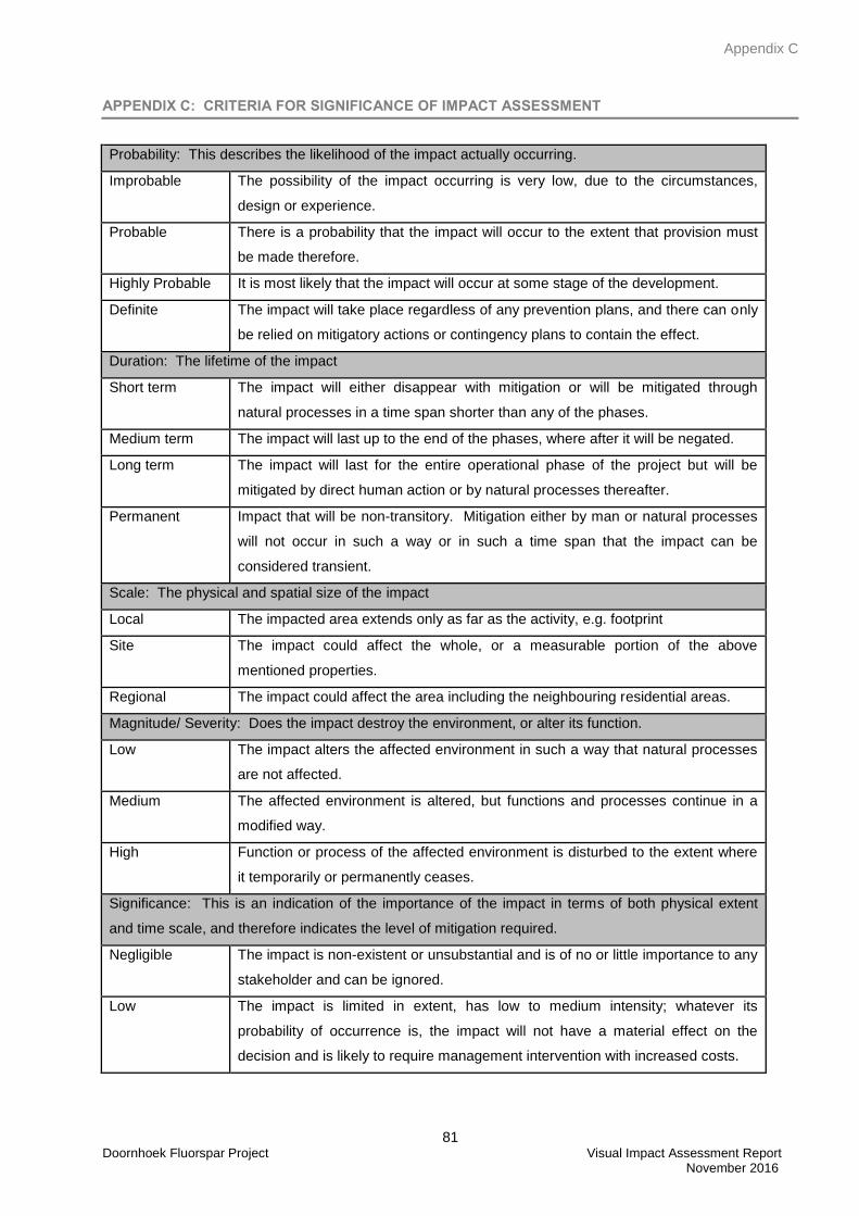
Appendix C
81 Doornhoek Fluorspar Project Visual Impact Assessment Report November 2016
APPENDIX C: CRITERIA FOR SIGNIFICANCE OF IMPACT ASSESSMENT
Probability: This describes the likelihood of the impact actually occurring.
Improbable The possibility of the impact occurring is very low, due to the circumstances,
design or experience.
Probable There is a probability that the impact will occur to the extent that provision must
be made therefore.
Highly Probable It is most likely that the impact will occur at some stage of the development.
Definite The impact will take place regardless of any prevention plans, and there can only
be relied on mitigatory actions or contingency plans to contain the effect.
Duration: The lifetime of the impact
Short term The impact will either disappear with mitigation or will be mitigated through
natural processes in a time span shorter than any of the phases.
Medium term The impact will last up to the end of the phases, where after it will be negated.
Long term The impact will last for the entire operational phase of the project but will be
mitigated by direct human action or by natural processes thereafter.
Permanent Impact that will be non-transitory. Mitigation either by man or natural processes
will not occur in such a way or in such a time span that the impact can be
considered transient.
Scale: The physical and spatial size of the impact
Local The impacted area extends only as far as the activity, e.g. footprint
Site The impact could affect the whole, or a measurable portion of the above
mentioned properties.
Regional The impact could affect the area including the neighbouring residential areas.
Magnitude/ Severity: Does the impact destroy the environment, or alter its function.
Low The impact alters the affected environment in such a way that natural processes
are not affected.
Medium The affected environment is altered, but functions and processes continue in a
modified way.
High Function or process of the affected environment is disturbed to the extent where
it temporarily or permanently ceases.
Significance: This is an indication of the importance of the impact in terms of both physical extent
and time scale, and therefore indicates the level of mitigation required.
Negligible The impact is non-existent or unsubstantial and is of no or little importance to any
stakeholder and can be ignored.
Low The impact is limited in extent, has low to medium intensity; whatever its
probability of occurrence is, the impact will not have a material effect on the
decision and is likely to require management intervention with increased costs.
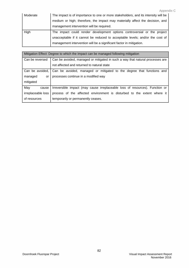
Appendix C
82 Doornhoek Fluorspar Project Visual Impact Assessment Report November 2016
Moderate The impact is of importance to one or more stakeholders, and its intensity will be
medium or high; therefore, the impact may materially affect the decision, and
management intervention will be required.
High The impact could render development options controversial or the project
unacceptable if it cannot be reduced to acceptable levels; and/or the cost of
management intervention will be a significant factor in mitigation.
Mitigation Effect: Degree to which the impact can be managed following mitigation
Can be reversed Can be avoided, managed or mitigated in such a way that natural processes are
not affected and returned to natural state
Can be avoided,
managed or
mitigated
Can be avoided, managed or mitigated to the degree that functions and
processes continue in a modified way
May cause
irreplaceable loss
of resources
Irreversible impact (may cause irreplaceable loss of resources). Function or
process of the affected environment is disturbed to the extent where it
temporarily or permanently ceases.
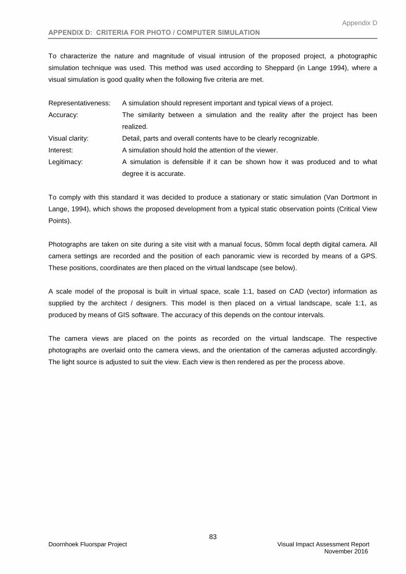
Appendix D
83 Doornhoek Fluorspar Project Visual Impact Assessment Report November 2016
APPENDIX D: CRITERIA FOR PHOTO / COMPUTER SIMULATION
To characterize the nature and magnitude of visual intrusion of the proposed project, a photographic
simulation technique was used. This method was used according to Sheppard (in Lange 1994), where a
visual simulation is good quality when the following five criteria are met.
Representativeness: A simulation should represent important and typical views of a project.
Accuracy: The similarity between a simulation and the reality after the project has been
realized.
Visual clarity: Detail, parts and overall contents have to be clearly recognizable.
Interest: A simulation should hold the attention of the viewer.
Legitimacy: A simulation is defensible if it can be shown how it was produced and to what
degree it is accurate.
To comply with this standard it was decided to produce a stationary or static simulation (Van Dortmont in
Lange, 1994), which shows the proposed development from a typical static observation points (Critical View
Points).
Photographs are taken on site during a site visit with a manual focus, 50mm focal depth digital camera. All
camera settings are recorded and the position of each panoramic view is recorded by means of a GPS.
These positions, coordinates are then placed on the virtual landscape (see below).
A scale model of the proposal is built in virtual space, scale 1:1, based on CAD (vector) information as
supplied by the architect / designers. This model is then placed on a virtual landscape, scale 1:1, as
produced by means of GIS software. The accuracy of this depends on the contour intervals.
The camera views are placed on the points as recorded on the virtual landscape. The respective
photographs are overlaid onto the camera views, and the orientation of the cameras adjusted accordingly.
The light source is adjusted to suit the view. Each view is then rendered as per the process above.
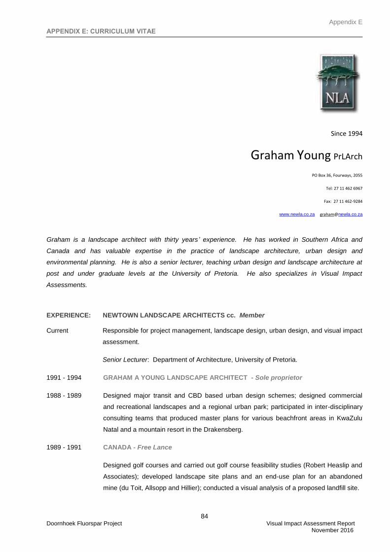
Appendix E
84 Doornhoek Fluorspar Project Visual Impact Assessment Report November 2016
APPENDIX E: CURRICULUM VITAE
Since 1994
Graham Young PrLArch
PO Box 36, Fourways, 2055
Tel: 27 11 462 6967
Fax: 27 11 462-9284
www.newla.co.za [email protected]
Graham is a landscape architect with thirty years’ experience. He has worked in Southern Africa and
Canada and has valuable expertise in the practice of landscape architecture, urban design and
environmental planning. He is also a senior lecturer, teaching urban design and landscape architecture at
post and under graduate levels at the University of Pretoria. He also specializes in Visual Impact
Assessments.
EXPERIENCE: NEWTOWN LANDSCAPE ARCHITECTS cc. Member
Current Responsible for project management, landscape design, urban design, and visual impact
assessment.
Senior Lecturer: Department of Architecture, University of Pretoria.
1991 - 1994 GRAHAM A YOUNG LANDSCAPE ARCHITECT - Sole proprietor
1988 - 1989 Designed major transit and CBD based urban design schemes; designed commercial
and recreational landscapes and a regional urban park; participated in inter-disciplinary
consulting teams that produced master plans for various beachfront areas in KwaZulu
Natal and a mountain resort in the Drakensberg.
1989 - 1991 CANADA - Free Lance
Designed golf courses and carried out golf course feasibility studies (Robert Heaslip and
Associates); developed landscape site plans and an end-use plan for an abandoned
mine (du Toit, Allsopp and Hillier); conducted a visual analysis of a proposed landfill site.
Appendix E
85 Doornhoek Fluorspar Project Visual Impact Assessment Report November 2016
1980 - 1988 KDM (FORMERLY DAMES AND MOORE) - Started as a Senior Landscape Architect
and was appointed Partner in charge of Landscape Architecture and Environmental
Planning in 1984. Designed commercial, corporate and urban landscapes; completed
landscape site plans; developed end-use master plans for urban parks, college and
technikon sites; carried out ecological planning studies for factories, motorways and a
railway line.
1978 - 1980 DAYSON & DE VILLIERS - Staff Landscape Architect
Designed various caravan parks; designed a recreation complex for a public resort;
conducted a visual analysis for the recreation planning of Pilgrims Rest; and designed
and supervised the installation of various private gardens.
EDUCATION:
Bachelor of Landscape Architecture, 1978, (BLArch), University of Toronto, Canada;
Completing a master’s degree in Landscape Architecture, University of Pretoria; Thesis:
Visual Impact Assessment;
Senior Lecturer - Department of Architecture, University of Pretoria.
PROFESSIONAL:
Registered Landscape Architect – South African Council for Landscape Architectural
Profession (2001);
Board of Control for Landscape Architects of South Africa (1987) – Vice Chairman 1988
to 1989;
Professional Member - Institute of Landscape Architects Southern Africa (1982) –
President 1986 - 1988;
Member Planning Professions Board 1987 to 1989;
Member International Association of Impact Assessment;
AWARDS:
Torsanlorenzo International Prize, Landscape design and protection 2nd
Prize Section B:
Urban Green Spaces, for Intermediate Phase Freedom Park (2009)
Phase 1 and Intermediate Phase Freedom Park: Special Mention World Architecture
Festival, Nature Category (2008)
Moroka Park Precinct, Soweto: ILASA Merit Award for Design (2005) and Gold Medal
United Nations Liveable Communities (LivCom) Award (2007)
Isivivane, Freedom Park: ILASA Presidential Award of Excellence Design (2005)
Information Kiosk, Freedom Park: ILASA Merit Award for Design (2005)
Moroka – Mofola Open Space Framework, Soweto: ILASA Merit Award for Planning
(2005)
Mpumalanga Provincial Government Complex: ILASA Presidential Award of Excellence
(with KWP Landscape Architects for Design (2003)
Appendix E
86 Doornhoek Fluorspar Project Visual Impact Assessment Report November 2016
Specialist Impact Report: Visual Environment, Sibaya Resort and Entertainment World:
ILASA Merit Award for Environmental Planning (1999);
Gillooly's Farm, Bedfordview (with Dayson and DeVilliers): ILASA Merit Award for
Design;
COMPETITIONS:
Pan African Parliament International Design competition – with MMA architects (2007)
Finalist
Leeuwpan Regional Wetland Park for the Ekurhuleni Metro Municipality (2004)
Landscape Architectural Consultant on Department of Trade and Industries Building
(2002) – Finalist
Landscape Architecture Consultant on Project Phoenix Architectural Competition,
Pretoria (1999): Winner;
Mpumalanga Legislature Buildings (1998): Commissioned;
Toyota Fountain (1985): First Prize - commissioned;
Bedfordview Bike/Walkway System - Van Buuren Road (1982): First Prize -
commissioned;
Portland Cement Institute Display Park (1982): Second Prize
CONTRIBUTOR:
Joubert, O, 10 Years + 100 Buildings – Architecture in a Democratic South Africa
Bell-Roberts Gallery and Publishing, South Africa (2009)
Freedom Park Phase 1 and Intermediate Phase (NBGM), Pretoria, Gauteng
Galindo, M, Collection Landscape Architecture, Braun, Switzerland (2009)
Freedom Park Phase Intermediate Phase (NBGM), Pretoria, Gauteng
In 1000 X Landscapes, Verlagshaus Braun, Germany (2008)
Freedom Park Phase 1 and Intermediate Phase (NBGM), Pretoria, Gauteng
Riverside Government Complex (NLAKWP), Nelspruit, Mpumalanga;
Moroka Dam Parks Precinct, Soweto, Gauteng.
In Johannesburg: Emerging/Diverging Metropolis, Mendrision Academy Press, Italy
(2007)
Moroka Dam Parks Precinct, Soweto, Gauteng.
Appendix E
87 Doornhoek Fluorspar Project Visual Impact Assessment Report November 2016
Since 1994
Yonanda Martin M.Env.Sci.
PO Box 36, Fourways, 2055
Tel: 27 11 462 6967
Fax: 27 11 462-9284
www.newla.co.za [email protected]
B.Sc Degree in Environmental Science from the University of North West, Potchefstroom Campus
(2003). M.Sc Degree in Ecological Remediation and Sustainable Utilization from the University of
North West, Potchefstroom Campus (2007). She is currently employed by Newtown Landscape
Architects working on the following projects.
EXPERIENCE: Environmentalist: Newtown Landscape Architects
Responsible for the environmental work, which includes Basic Assessments, Environmental Impact
Assessments (Scoping & EIA), Environmental Management Plans (EMP), Environmental Auditing as
well as Visual Impact Assessments.
Current Projects:
Orchards Extension 49-53, Pretoria - Environmental Impact Assessment and Environmental
Management Plan
Tanganani Ext 8, Johannesburg - Environmental Impact Assessment and Environmental
Management Plan
Diepsloot East Development, Diepsloot - Environmental Impact Assessment and Environmental
Management Plan
Klerksoord Ext 25 & 26, Pretoria – Environmental Impact Assessment
Ennerdale Ext 16, Johannesburg - Environmental Impact Assessment and Environmental
Management Plan
Glen Marais Ext 102 & 103, Kempton Park - Basic Assessment and Environmental Management
Plan
Princess Plot 229, Princess - Environmental Assessment (S24G Application)
Uthlanong Drive Upgrade – Mogale City Local Municipalty project in Kagiso, Basic Assessment for
the upgrade of the stormwater and the roads
Luipaardsvlei Landfill Site – Mogale City Local Municipalty project in Krugersdorp, the expansion
of the existing landfill site.
Appendix E
88 Doornhoek Fluorspar Project Visual Impact Assessment Report November 2016
MCLM Waste Water Treatment Works – Mogale City Local Municipalty project in Magaliesburg, the
expansion of the existing facility.
Rand Uranium (Golder Associates Africa (Pty) Ltd), Randfontein – VIA
Dorsfontein West Expansion (GCS (Pty) Ltd), Kriel – VIA
Mine Waste Solutions (GCS (Pty) Ltd), Stilfontein – VIA
Ferreira Coal Mining (GCS (Pty) Ltd), Ermelo – VIA
De Wittekrans Mining (GCS (Pty) Ltd), Hendrina – VIA
EDUCATION:
May 2009 Public Participation Course, International Association for Public Participation, Golder
Midrand
May 2008 Wetland Training Course on Delineation, Legislation and Rehabilitation, University
of Pretoria.
April 2008 Environmental Impact Assessment: NEMA Regulations – A practical approach,
Centre for Environmental Management: University of North West.
Feb 2008 Effective Business Writing Skills, ISIMBI
Oct 2007 Short course in Geographic Information Systems (GIS), Planet GIS
Jan 2004 – April 2007 M.Sc Degree in Ecological Remediation and Sustainable Utilization,
University of North West, Potchefstroom Campus.
Thesis: Tree vitality along the urbanization gradient in Potchefstroom, South
Africa.
Jan 2001 – Dec 2003 B.Sc Degree in Environmental Science, University of Potchefstroom
PROFESSIONAL REGISTRATION:
Sep 2009 Professional National Scientist – 400204/09