Embed Size (px)
Citation preview
1
Project of Strategic Interest NEXTDATA
Deliverable D2.1.3
Report describing the activities related to the first version of the specific portal, data transmission to the General Portal and Data Storage from the
Station of Lampedusa.
WP Coordinator: Maria Teresa Melis EvK2-‐CNR, Italy
Co-‐ authors: F. Dessì, F. Locci
Laboratorio TeleGIS Università di Cagliari
A. G. di Sarra Laboratory for Earth Observations and Analyses (UTMEA-‐TER) -‐ ENEA
2
The specific activities developed during the second year, as required by the project within WP2.1, were: -‐ Completion of the DB with the details of the high-‐altitude stations including all available data, both validated and raw. -‐ Development of a new paleoclimate DB (WDBPALEO) for climatological and environmental non-‐polar ice cores and marine sediments data storage, in collaboration with WP 2.3 and 2.4. -‐ Development of new web interfaces for access to both data and metadata dedicated to information obtained under the Project NextData and in line with the system. -‐ Participation in the project DataCite for the allocation of DOI. -‐ Installation of a new CO2/CH4 analyzer at Lampedusa station, in substitution of old systems (GC for CH4, Siemens Ultramat for CO2). The measurements obtained with the new and old systems were compared, and the new ring down absorption spectrometer (Picarro G2401, acquisition on funds from a different project) was run as the main operational instrument. Tests and comparison between the old and new system, as well as the on-‐line operation of the new analyzer, were carried out within NextData. Calibrations of the radiometers operational at Lampedusa and NCO-‐P were updated. 1 Completion of the population of WDB and query interface The data of available stations were included in WDB and access has been made possible through the development of a dedicated interface described below. 2 Implementation of WDBPALEO The need to load the data belonging to the paleoclimatological activities required the modification of some source files of WDB. These changes have led to the development of the database WDBPALEO, which in effect constitutes the instrument through which cores from non-‐polar and marine cores data will be stored. The database WDBPALEO is now in the testing phase using a set of data acquired by alpine glaciers (University of Milan Bicocca -‐ Laboratory of Environmental Geomatics) and from the archives of NOAA, and the NiCl (European Cold Laboratory Facilities). The structure of WDBPALEO includes two separate databases for the management of paleoclimatic data: SeaCore DATABASE -‐SDB and Icecore DATABASE -‐ IDB (Figure 1).
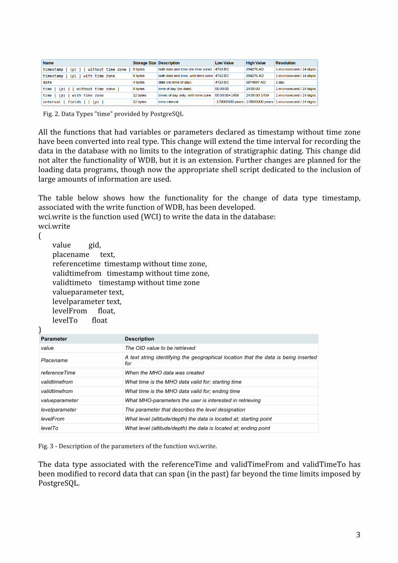
Fig. 1 -‐ Structure of WDBPALEO In fact it is the same database, but IDB and SDB are differently initialized. The flexibility of WDB enables to capture different data by customizing the descriptive fields. Indeed, it was possible to add new fields or tables to the original design of WDB, depending on the needs that have arisen from time to time in this work. The basic change of WDB results on the change of the type of data associated with the SQL functions that take advantage of “timestamp”. PostgreSQL provides as data type "time" for the management of the dates of the following types of data (Figure 2).
WDB IDB
WDB_PALEO
SDB
3
Fig. 2. Data Types "time" provided by PostgreSQL All the functions that had variables or parameters declared as timestamp without time zone have been converted into real type. This change will extend the time interval for recording the data in the database with no limits to the integration of stratigraphic dating. This change did not alter the functionality of WDB, but it is an extension. Further changes are planned for the loading data programs, though now the appropriate shell script dedicated to the inclusion of large amounts of information are used. The table below shows how the functionality for the change of data type timestamp, associated with the write function of WDB, has been developed. wci.write is the function used (WCI) to write the data in the database: wci.write ( value gid, placename text, referencetime timestamp without time zone, validtimefrom timestamp without time zone, validtimeto timestamp without time zone valueparameter text, levelparameter text, levelFrom float, levelTo float ) Parameter Description value The OID value to be retrieved
Placename A text string identifying the geographical location that the data is being inserted for
referenceTime When the MHO data was created
validtimefrom What time is the MHO data valid for; starting time
validtimefrom What time is the MHO data valid for; ending time
valueparameter What MHO-parameters the user is interested in retrieving
levelparameter The parameter that describes the level designation
levelFrom What level (altitude/depth) the data is located at; starting point
levelTo What level (altitude/depth) the data is located at; ending point
Fig. 3 -‐ Description of the parameters of the function wci.write. The data type associated with the referenceTime and validTimeFrom and validTimeTo has been modified to record data that can span (in the past) far beyond the time limits imposed by PostgreSQL.
4
The function wci.write was then rewritten and replaced by wci.writepaleo: wci.writepaleo ( value_ double precision, dataprovidername_ text, icecorename_ text, referencetime_ real, validfrom_ real, validto_ real, valueparametername_ text, levelparametername_ text, levelfrom_ real, levelto_ real, dataversion_ integer, setconfidencecode_ integer ) IDB, as mentioned above, represents the customization of WDB for the data of ice cores. In particular, in order to better adapting to the WDB data from ice cores, the following changes have been made:
-‐ The names of the tables in which the precise geographic information is stored has been changed from "place" to "icecore“.
-‐ Within the table "icecorename" to the field "icecorenamedrilling", the name of the site where the core was extracted, was added so as to improve both the archived information and the research itself.
-‐ Because of this change, parameter "icecoredrilling" was introduced in the "wci.addicecorepoint" to properly populate the tables relating to icecore.
-‐ The primary key of the table "floatvalueitem" has changed, adding the field "value" as new constraints in addition to those already present. In this way, a less restrictive data entry paleo -‐ climate of the cores was made, not always characterized by unique temporal information.
-‐ The function “wci.writepaleo” has been inserted for loading data based on the existing one in WDB.
To date, the IDB contains data for 178 cores from 13 providers. Below are presented some examples of queries using commands of WCI to extract information from the IDB.
5
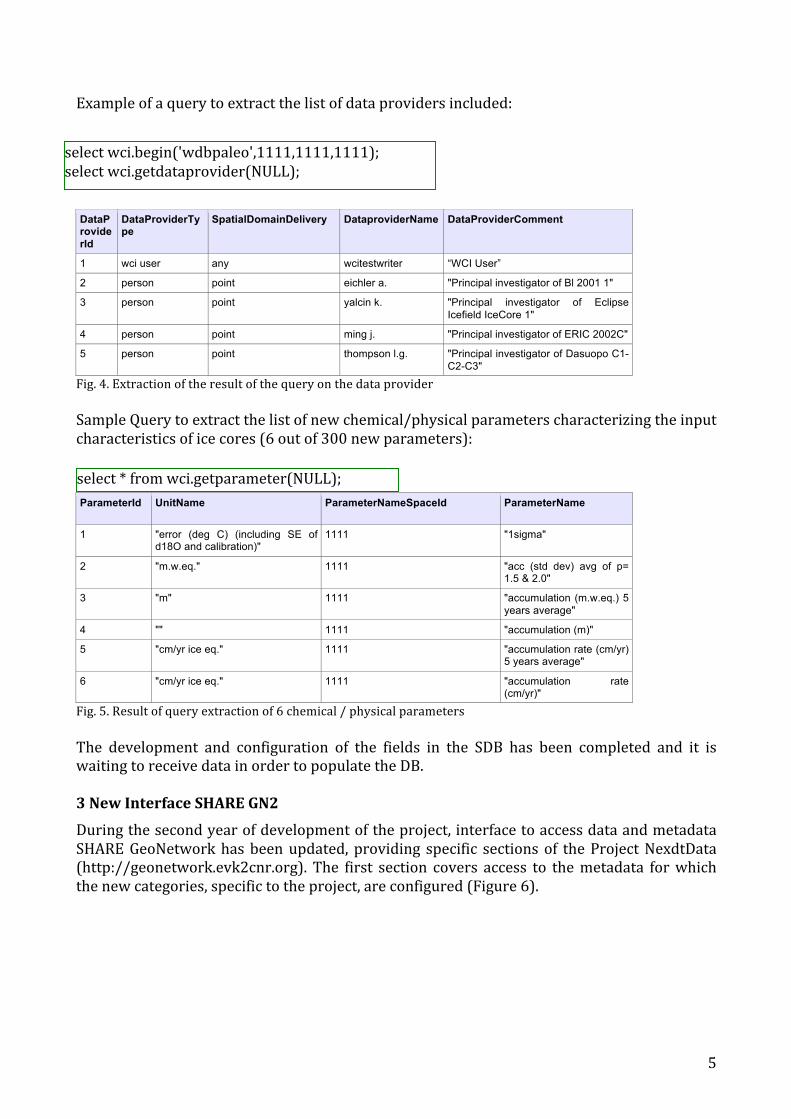
Example of a query to extract the list of data providers included:
DataProviderId
DataProviderType
SpatialDomainDelivery DataproviderName
DataProviderComment
1 wci user any wcitestwriter “WCI User”
2 person point eichler a. "Principal investigator of Bl 2001 1"
3 person point yalcin k. "Principal investigator of Eclipse Icefield IceCore 1"
4 person point ming j. "Principal investigator of ERIC 2002C"
5 person point thompson l.g. "Principal investigator of Dasuopo C1-C2-C3"
Fig. 4. Extraction of the result of the query on the data provider Sample Query to extract the list of new chemical/physical parameters characterizing the input characteristics of ice cores (6 out of 300 new parameters):
ParameterId
UnitName
ParameterNameSpaceId
ParameterName
1 "error (deg C) (including SE of d18O and calibration)"
1111
"1sigma"
2 "m.w.eq." 1111 "acc (std dev) avg of p= 1.5 & 2.0"
3 "m" 1111 "accumulation (m.w.eq.) 5 years average"
4 "" 1111 "accumulation (m)"
5 "cm/yr ice eq." 1111 "accumulation rate (cm/yr) 5 years average"
6 "cm/yr ice eq." 1111 "accumulation rate (cm/yr)"
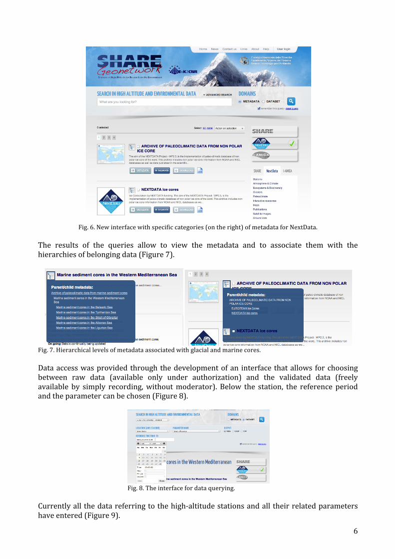
Fig. 5. Result of query extraction of 6 chemical / physical parameters The development and configuration of the fields in the SDB has been completed and it is waiting to receive data in order to populate the DB. 3 New Interface SHARE GN2 During the second year of development of the project, interface to access data and metadata SHARE GeoNetwork has been updated, providing specific sections of the Project NexdtData (http://geonetwork.evk2cnr.org). The first section covers access to the metadata for which the new categories, specific to the project, are configured (Figure 6).
select wci.begin('wdbpaleo',1111,1111,1111); select wci.getdataprovider(NULL);
select * from wci.getparameter(NULL);
6
Fig. 6. New interface with specific categories (on the right) of metadata for NextData.
The results of the queries allow to view the metadata and to associate them with the hierarchies of belonging data (Figure 7).
Fig. 7. Hierarchical levels of metadata associated with glacial and marine cores. Data access was provided through the development of an interface that allows for choosing between raw data (available only under authorization) and the validated data (freely available by simply recording, without moderator). Below the station, the reference period and the parameter can be chosen (Figure 8).
Fig. 8. The interface for data querying. Currently all the data referring to the high-‐altitude stations and all their related parameters have entered (Figure 9).

7
Pyramid Periche Namche Lukla Kala Patthar Changri Nup Colle Sud NCO-‐P Askole Urdukas Concordia
(1994)-‐ongoing
2001-‐ongoing
2001-‐ongoing
2002-‐ongoing
2008-‐ongoing
2009-‐ ongoing 2008-‐2011 2006-‐ongoing
2004-‐ongoing
2004-‐ongoing
2011-‐ongoing
Fig. 9. Stations and parameters
Query results can be displayed as tables and graphs and can be downloaded in csv file format (Figure 10).
Fig. 10. Displaying data in tabular and graphic format.
8
4 DataCite Project A specific activity was carried out under the project DataCite. The International DOI Foundation (IDF) is the registration authority for ISO standard (ISO 26324) for the system DOI and it is the international body that brings together agencies that can manage services for allocation of DOI. DataCite is a non-‐profit organization that manages the accepted agencies for DOI registration system for the dataset in the world. EvK2-‐CNR became independent Data Center for assigning an unlimited number of DOIs through the platform DataCite. It was therefore decided to assign a DOI to each station in terms of metadata, so the DOI can be used as the code to bind the data to allow for a complete description. 5 Activities at the Station for Climate Observations of Lampedusa
The following research activities were carried out during the reference period at the station for Climate Observations of Lampedusa: -‐ GAW activities include, in particular, measurements of greenhouse gases, aerosol optical properties, and meteorological parameters. Collected data, after quality control, were supplied to GAW databases, and were prepared for the submission to the NextData Database. -‐ Measurements of solar and infrared radiation made at the GAW NCO-‐P station were calibrated, quality checked and validated. The data were supplied to the NextData Database. Meetings and conferences attended in 2013 First International Conference on Remote Sensing and Geoinformation of the Environment (RSCy2013). Cyprus, 2013. GIT – Geology & Information Tecnology, Chiavenna (So), Italy, 17-‐19 Giugno 2013. 17 Conferenza Nazionale ASITA, Riva del Garda, Italy, 5–7 novembre 2013,. High Summit: International Conference on Mountains and Climate Change, Lecco 2013, Italy, 23-‐28 October, 2013. European Geophysical Union, Vienna, Austria, 2013. 7th International Workshop on Sand/Duststorms and Associated Dustfall, Frascati (Rome), Italy. 2013. European Aerosol Conference, Prague, 2013.


![DELIVERABLE SUMMARY D2.1.3 System Architecture ... · is part of the expertise area of both Atos and Philips. Where Philips provided the information for [D212], Atos provided the](https://img.pdfslide.us/doc/110x75/5c074e0409d3f23a458b52ae/deliverable-summary-d213-system-architecture-is-part-of-the-expertise.jpg)