Embed Size (px)
Citation preview
1
1
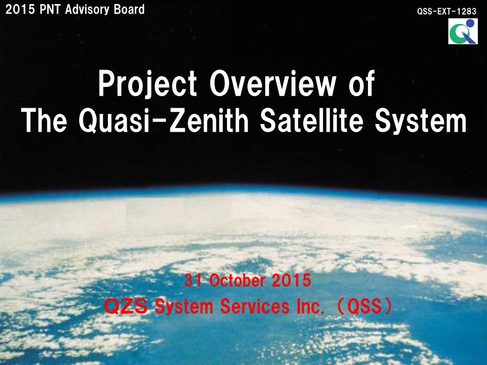
31 October 2015
QZS System Services Inc. (QSS)
QSS-EXT-1283
Project Overview of The Quasi-Zenith Satellite System
2015 PNT Advisory Board
2
1. Project/System Overview and Program Status
2. Mission of the QZSS
3. Demonstration Results of the QZSS
Contents
3
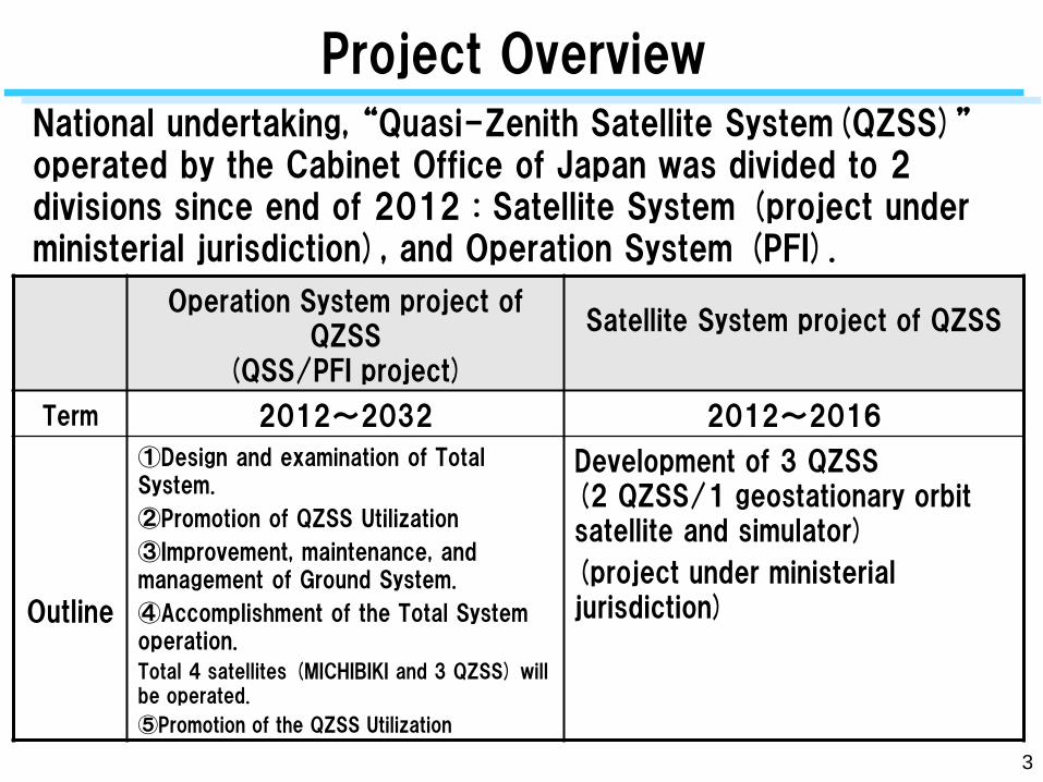
National undertaking, “Quasi-Zenith Satellite System(QZSS)” operated by the Cabinet Office of Japan was divided to 2 divisions since end of 2012 : Satellite System (project under ministerial jurisdiction), and Operation System (PFI).
Operation System project of QZSS
(QSS/PFI project)
Satellite System project of QZSS
Term 2012~2032 2012~2016
Outline
①Design and examination of Total System.
②Promotion of QZSS Utilization
③Improvement, maintenance, and management of Ground System.
④Accomplishment of the Total System operation.
Total 4 satellites (MICHIBIKI and 3 QZSS) will be operated.
⑤Promotion of the QZSS Utilization
Development of 3 QZSS (2 QZSS/1 geostationary orbit satellite and simulator)
(project under ministerial jurisdiction)
Project Overview
3
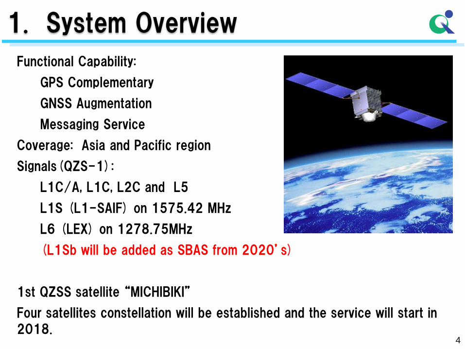
Functional Capability:
GPS Complementary
GNSS Augmentation
Messaging Service
Coverage: Asia and Pacific region
Signals(QZS-1):
L1C/A, L1C, L2C and L5
L1S (L1-SAIF) on 1575.42 MHz
L6 (LEX) on 1278.75MHz
(L1Sb will be added as SBAS from 2020’s)
1st QZSS satellite “MICHIBIKI”
Four satellites constellation will be established and the service will start in
2018.
4
1. System Overview
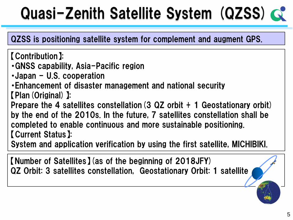
QZSS is positioning satellite system for complement and augment GPS.
【Number of Satellites】(as of the beginning of 2018JFY) QZ Orbit: 3 satellites constellation, Geostationary Orbit: 1 satellite
【Contribution】: ・GNSS capability, Asia-Pacific region ・Japan - U.S. cooperation ・Enhancement of disaster management and national security 【Plan(Original)】: Prepare the 4 satellites constellation(3 QZ orbit + 1 Geostationary orbit) by the end of the 2010s. In the future, 7 satellites constellation shall be completed to enable continuous and more sustainable positioning. 【Current Status】: System and application verification by using the first satellite, MICHIBIKI.
5
Quasi-Zenith Satellite System (QZSS)
6
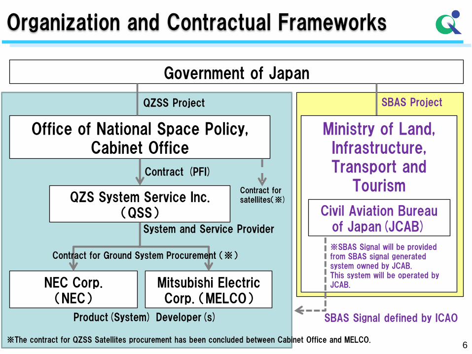
Organization and Contractual Frameworks
Government of Japan
Office of National Space Policy, Cabinet Office
QZS System Service Inc. (QSS)
NEC Corp. (NEC)
Mitsubishi Electric Corp. (MELCO)
QZSS Project
Contract (PFI)
System and Service Provider
Contract for Ground System Procurement (※)
Product(System) Developer(s)
※The contract for QZSS Satellites procurement has been concluded between Cabinet Office and MELCO.
Contract for satellites(※)
SBAS Project
SBAS Signal defined by ICAO
Ministry of Land, Infrastructure, Transport and
Tourism
Civil Aviation Bureau of Japan(JCAB)
※SBAS Signal will be provided from SBAS signal generated system owned by JCAB. This system will be operated by JCAB.
7
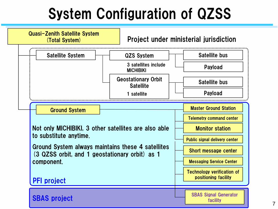
System Configuration of QZSS
Satellite System
Ground System
QZS System
Geostationary Orbit Satellite
Satellite bus
Payload
Satellite bus
Payload
Master Ground Station
Telemetry command center
Monitor station
Public signal delivery center
Short message center
Messaging Service Center
Technology verification of positioning facility
Not only MICHIBIKI, 3 other satellites are also able to substitute anytime.
Ground System always maintains these 4 satellites (3 QZSS orbit, and 1 geostationary orbit) as 1 component.
1 satellite
PFI project
3 satellites include MICHIBIKI
SBAS project SBAS Signal Generator
facility
Quasi-Zenith Satellite System (Total System) Project under ministerial jurisdiction
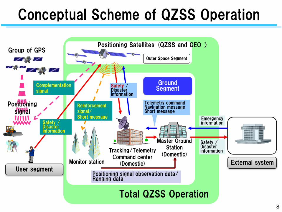
あ
Group of GPS
Master Ground Station
(Domestic) Tracking/Telemetry Command center
(Domestic) Monitor station
Positioning Satellites (QZSS and GEO )
Complementation signal
Positioning signal
Safety / Disaster information
Telemetry command Navigation message Short message
Positioning signal observation data/ Ranging data
Safety / Disaster information
Ground Segment
Outer Space Segment
Reinforcement signal/ Short message Emergency
information
User segment External system
Conceptual Scheme of QZSS Operation
Safety / Disaster information
Total QZSS Operation 8
9
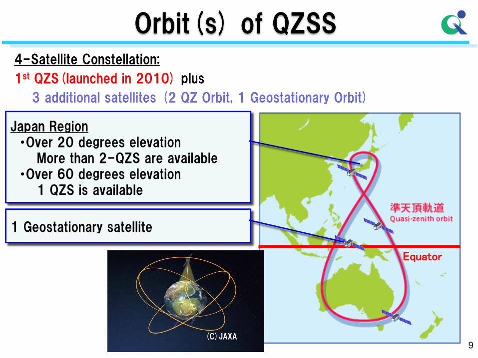
Orbit(s) of QZSS 4-Satellite Constellation;
1st QZS(launched in 2010) plus
3 additional satellites (2 QZ Orbit, 1 Geostationary Orbit)
Equator
1 Geostationary satellite
Japan Region ・Over 20 degrees elevation More than 2-QZS are available ・Over 60 degrees elevation 1 QZS is available
(C)JAXA
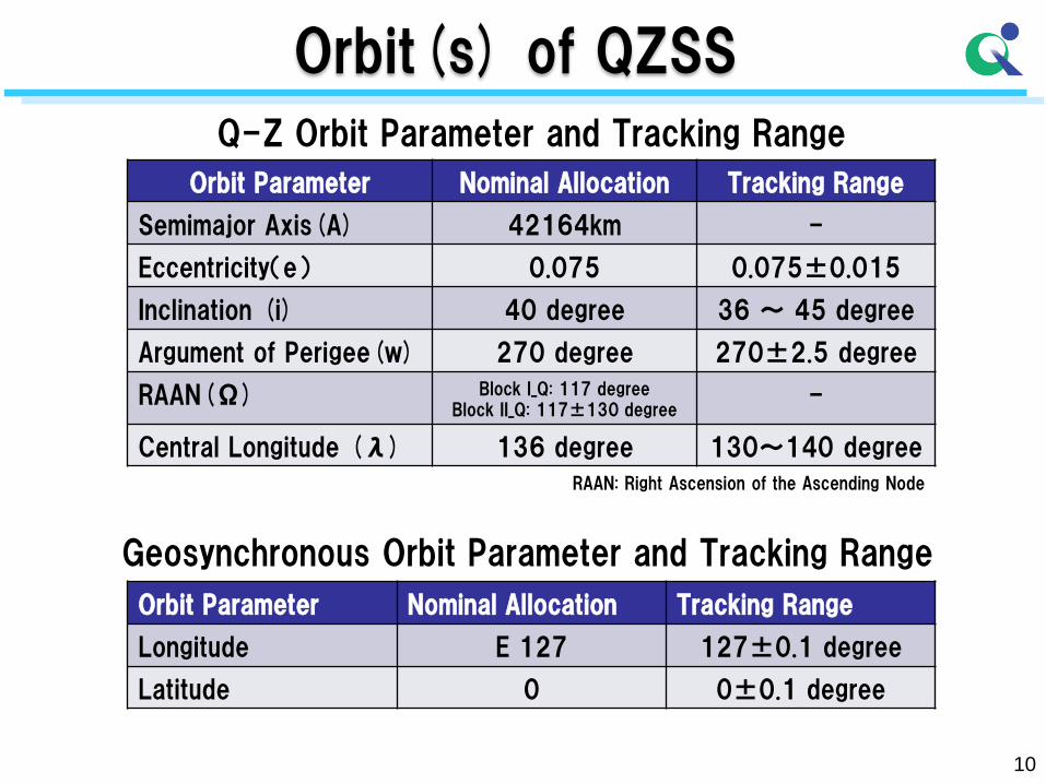
Q-Z Orbit Parameter and Tracking Range
Orbit Parameter Nominal Allocation Tracking Range
Semimajor Axis(A) 42164km -
Eccentricity(e) 0.075 0.075±0.015
Inclination (i) 40 degree 36 ~ 45 degree
Argument of Perigee(w) 270 degree 270±2.5 degree
RAAN(Ω) Block I_Q: 117 degree Block II_Q: 117±130 degree
-
Central Longitude (λ) 136 degree 130~140 degree
Orbit Parameter Nominal Allocation Tracking Range
Longitude E 127 127±0.1 degree
Latitude 0 0±0.1 degree
Geosynchronous Orbit Parameter and Tracking Range
RAAN: Right Ascension of the Ascending Node
10
Orbit(s) of QZSS
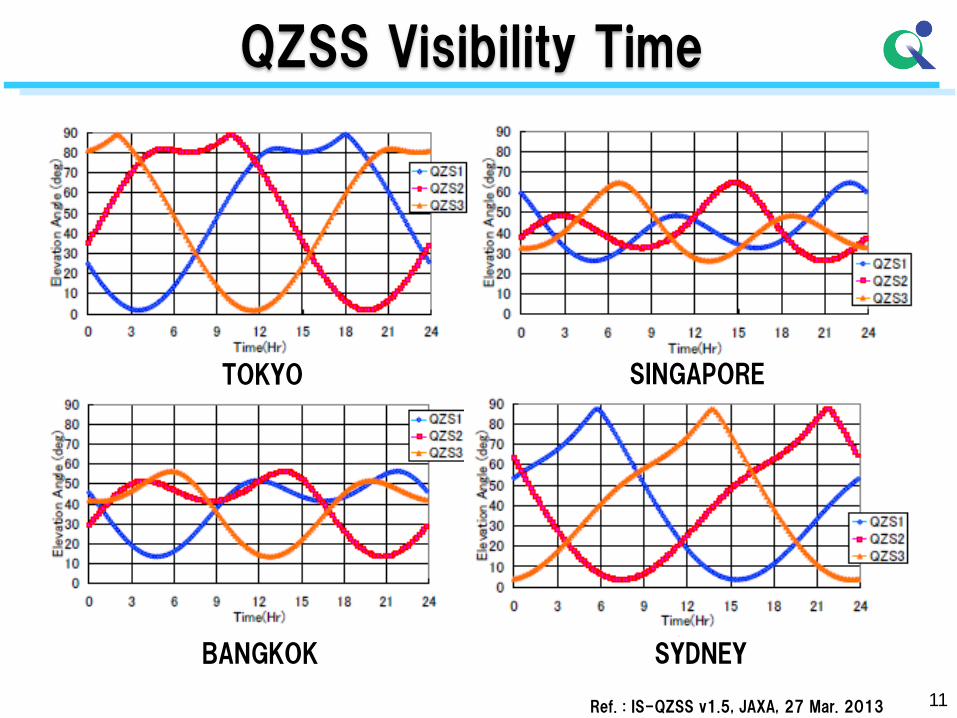
QZSS Visibility Time
TOKYO SINGAPORE
BANGKOK SYDNEY
Ref. : IS-QZSS v1.5, JAXA, 27 Mar. 2013 11
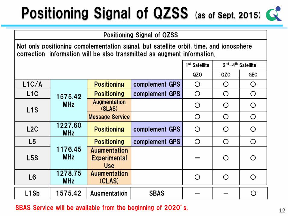
12
Positioning Signal of QZSS (as of Sept. 2015)
SBAS Service will be available from the beginning of 2020’s.
Positioning Signal of QZSS
Not only positioning complementation signal, but satellite orbit, time, and ionosphere correction information will be also transmitted as augment information.
1st Satellite 2nd-4th Satellite
QZO QZO GEO
L1C/A
1575.42 MHz
Positioning complement GPS ○ ○ ○
L1C Positioning complement GPS ○ ○ ○
L1S
Augmentation (SLAS)
○ ○ ○
Message Service ○ ○ ○
L2C 1227.60
MHz Positioning complement GPS ○ ○ ○
L5 1176.45
MHz
Positioning complement GPS ○ ○ ○
L5S Augmentation Experimental
Use ー ○ ○
L6 1278.75
MHz Augmentation
(CLAS) ○ ○ ○
L1Sb 1575.42 Augmentation SBAS - - ○
QZSS Program Status
•Japan – US Cooperation
– Sep 22, 1998 : “Joint Statement regarding cooperation in the use of the GPS” was issued.
– Jan 18, 2012 : Joint Announcement on US-Japan GPS cooperation
•The United States welcomed Japan’s decision to expand and upgrade QZSS into an operational and regional system that, in time, could be composed of as many as seven satellites and acknowledged the important contribution such an expanded and upgraded system will make to the space-based PNT services in the Asia-Pacific region.
13
QZSS Program Status
•Japan – US Cooperation
– July 24, 2013 : Joint Announcement on US-Japan GPS cooperation
•Both Governments reaffirmed that continued close cooperation in the area of GNSS will contribute to the peaceful development of the Asia-Pacific region and promote global economic growth. Both Governments reaffirmed the importance of providing open access to basic GNSS services for peaceful purposes, free of direct user fees.
14
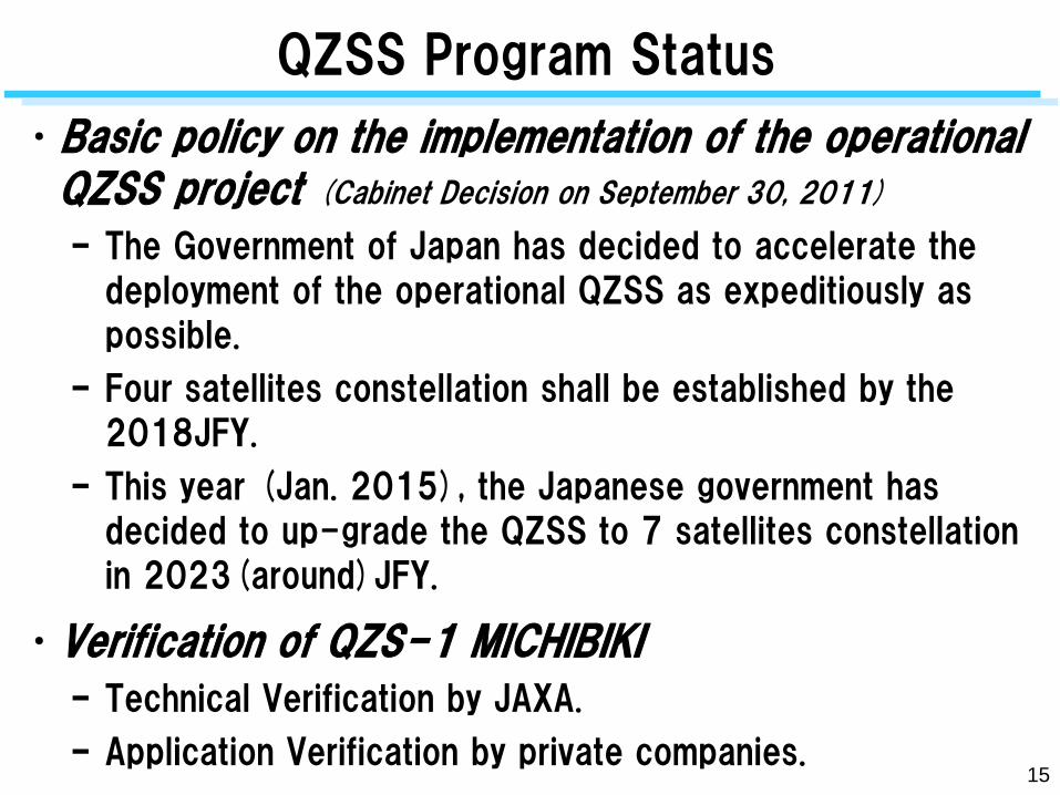
QZSS Program Status
•Basic policy on the implementation of the operational QZSS project (Cabinet Decision on September 30, 2011)
– The Government of Japan has decided to accelerate the
deployment of the operational QZSS as expeditiously as
possible.
– Four satellites constellation shall be established by the
2018JFY.
– This year (Jan. 2015), the Japanese government has
decided to up-grade the QZSS to 7 satellites constellation
in 2023(around)JFY.
•Verification of QZS-1 MICHIBIKI
– Technical Verification by JAXA.
– Application Verification by private companies.
15
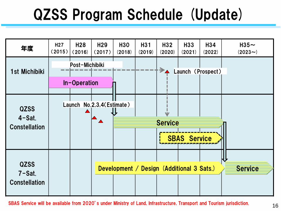
QZSS Program Schedule (Update)
16
年度 H27
(2015)
H28
(2016)
H29
(2017)
H30
(2018)
H31
(2019)
H32
(2020)
H33
(2021)
H34
(2022)
H35~
(2023~)
1st Michibiki
QZSS
4-Sat.
Constellation
QZSS
7-Sat.
Constellation
Service
Development / Design (Additional 3 Sats.) Service
In-Operation
Post-Michibiki Launch (Prospect)
Launch No.2,3,4(Estimate)
SBAS Service
SBAS Service will be available from 2020’s under Ministry of Land, Infrastructure, Transport and Tourism jurisdiction.
17
2. Mission of the QZSS
18
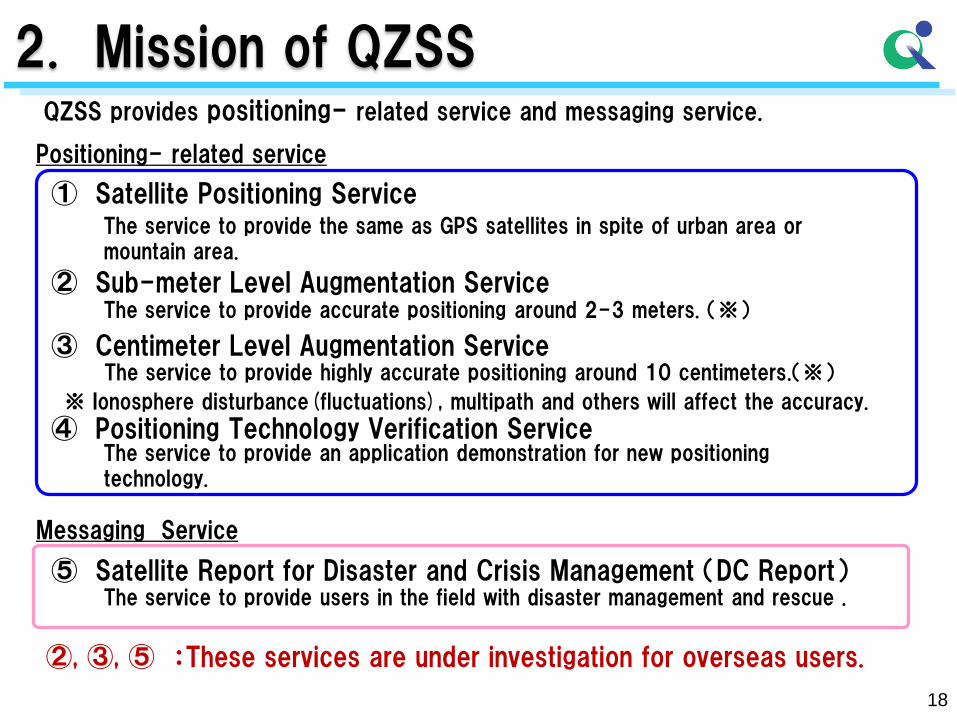
2. Mission of QZSS QZSS provides positioning- related service and messaging service.
Positioning- related service
Messaging Service
⑤ Satellite Report for Disaster and Crisis Management (DC Report) The service to provide users in the field with disaster management and rescue .
②, ③, ⑤ :These services are under investigation for overseas users.
① Satellite Positioning Service The service to provide the same as GPS satellites in spite of urban area or mountain area.
② Sub-meter Level Augmentation Service
③ Centimeter Level Augmentation Service
The service to provide accurate positioning around 2-3 meters. (※)
The service to provide highly accurate positioning around 10 centimeters.(※)
※ Ionosphere disturbance(fluctuations), multipath and others will affect the accuracy.
④ Positioning Technology Verification Service The service to provide an application demonstration for new positioning technology.
19
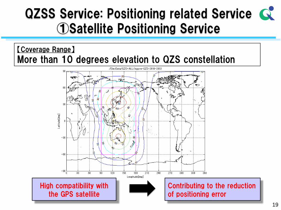
【Coverage Range】
More than 10 degrees elevation to QZS constellation
High compatibility with the GPS satellite
Contributing to the reduction of positioning error
QZSS Service: Positioning related Service ①Satellite Positioning Service
20
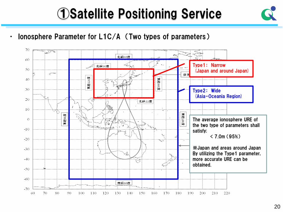
• Ionosphere Parameter for L1C/A (Two types of parameters)
①Satellite Positioning Service
Type1: Narrow (Japan and around Japan)
Type2: Wide (Asia-Oceania Region)
The average ionosphere URE of the two type of parameters shall satisfy; < 7.0m (95%) ※Japan and areas around Japan By utilizing the Type1 parameter, more accurate URE can be obtained.
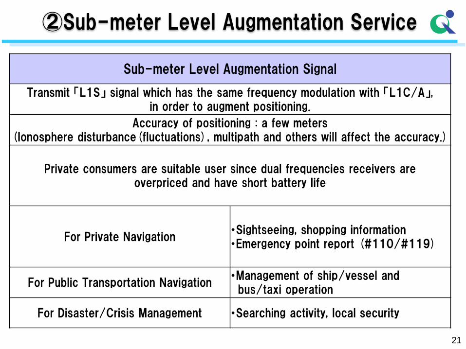
Sub-meter Level Augmentation Signal
Transmit 「L1S」 signal which has the same frequency modulation with 「L1C/A」, in order to augment positioning.
Accuracy of positioning : a few meters (Ionosphere disturbance(fluctuations), multipath and others will affect the accuracy.)
Private consumers are suitable user since dual frequencies receivers are overpriced and have short battery life
For Private Navigation ・Sightseeing, shopping information ・Emergency point report (#110/#119)
For Public Transportation Navigation ・Management of ship/vessel and bus/taxi operation
For Disaster/Crisis Management ・Searching activity, local security
21
②Sub-meter Level Augmentation Service

22
②Sub-meter Level Augmentation Service
【SLAS Service】 DGPS correction data will be provided in L1S signal MSG Type 50(in L1S) : DGPS correction data
【Service Range】
・Japan and around Japan area (at the start of the service, 2018)
23
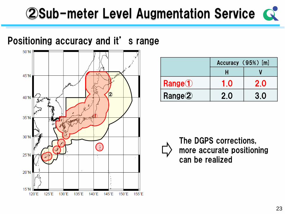
②Sub-meter Level Augmentation Service
Positioning accuracy and it’s range
Accuracy (95%) [m]
H V
Range① 1.0 2.0
Range② 2.0 3.0
The DGPS corrections, more accurate positioning can be realized
①
②
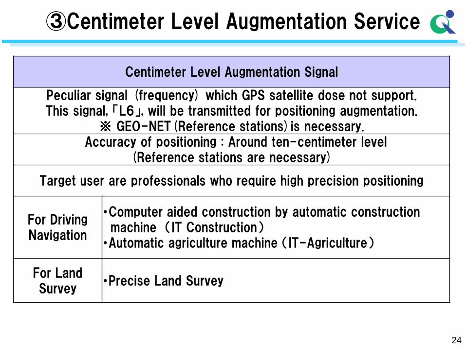
③Centimeter Level Augmentation Service
Centimeter Level Augmentation Signal
Peculiar signal (frequency) which GPS satellite dose not support. This signal, 「L6」, will be transmitted for positioning augmentation.
※ GEO-NET(Reference stations)is necessary. Accuracy of positioning : Around ten-centimeter level
(Reference stations are necessary)
Target user are professionals who require high precision positioning
For Driving Navigation
・Computer aided construction by automatic construction machine (IT Construction) ・Automatic agriculture machine (IT-Agriculture)
For Land Survey
・Precise Land Survey
24
25
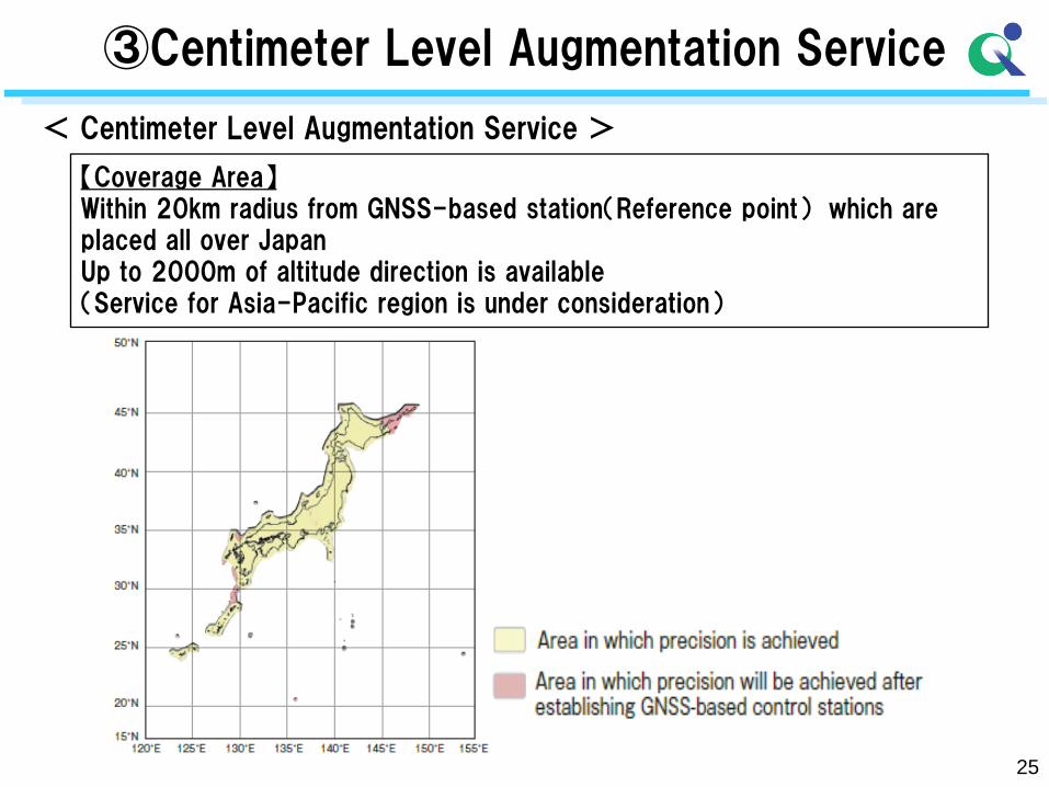
【Coverage Area】 Within 20km radius from GNSS-based station(Reference point) which are placed all over Japan Up to 2000m of altitude direction is available (Service for Asia-Pacific region is under consideration)
< Centimeter Level Augmentation Service >
③Centimeter Level Augmentation Service
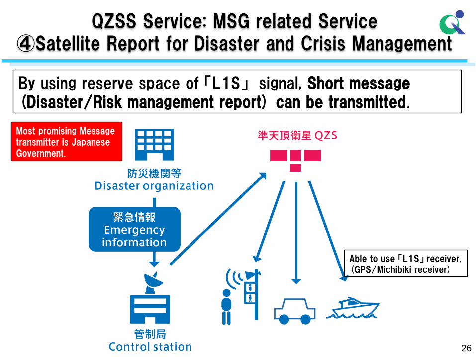
By using reserve space of 「L1S」 signal, Short message (Disaster/Risk management report) can be transmitted.
26
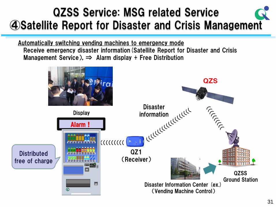
QZSS Service: MSG related Service ④Satellite Report for Disaster and Crisis Management
Most promising Message transmitter is Japanese Government.
Able to use 「L1S」 receiver. (GPS/Michibiki receiver)
27
3. Demonstration results of the QZSS
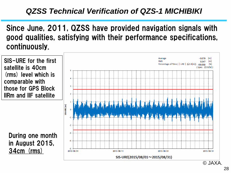
QZSS Technical Verification of QZS-1 MICHIBIKI
© JAXA. 28
5 m
Specification on SIS-URE; less than 2.6m(95%)
Since June, 2011, QZSS have provided navigation signals with good qualities, satisfying with their performance specifications, continuously..
SIS-URE for the first satellite is 40cm (rms) level which is comparable with those for GPS Block IIRm and IIF satellite.
During one month in August 2015, 34cm (rms)
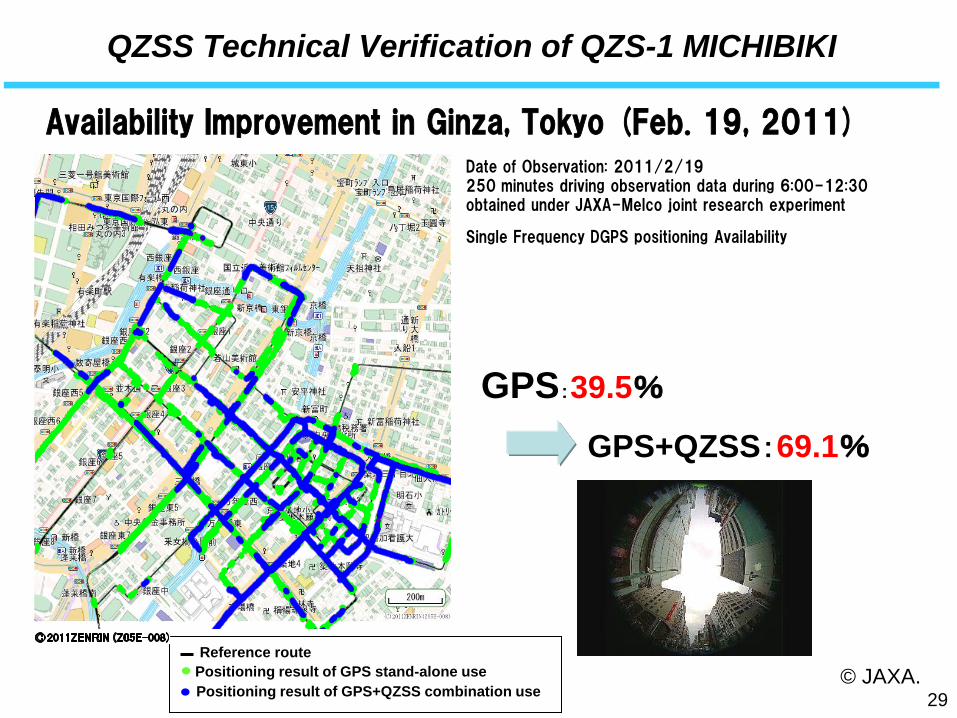
QZSS Technical Verification of QZS-1 MICHIBIKI
Date of Observation: 2011/2/19 250 minutes driving observation data during 6:00-12:30 obtained under JAXA-Melco joint research experiment
Single Frequency DGPS positioning Availability
Reference route
Positioning result of GPS+QZSS combination use
Positioning result of GPS stand-alone use
GPS:39.5%
GPS+QZSS:69.1%
© JAXA.
Availability Improvement in Ginza, Tokyo (Feb. 19, 2011)
29
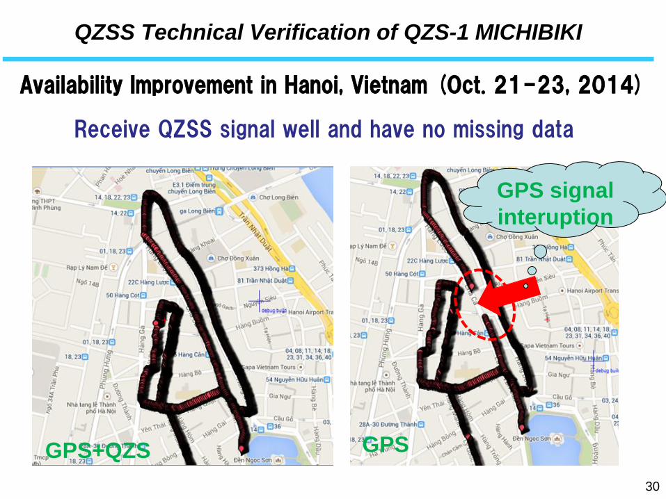
QZSS Technical Verification of QZS-1 MICHIBIKI
Availability Improvement in Hanoi, Vietnam (Oct. 21-23, 2014)
30
GPS
GPS signal
interuption
GPS+QZS
Receive QZSS signal well and have no missing data
31
QZSS Service: MSG related Service ④Satellite Report for Disaster and Crisis Management
Alarm!
Display
QZ1 (Receiver)
Automatically switching vending machines to emergency mode Receive emergency disaster information(Satellite Report for Disaster and Crisis Management Service),⇒ Alarm display + Free Distribution
Distributed free of charge
QZS
QZSS Ground Station
Disaster Information Center (ex.) (Vending Machine Control)
(((((((((
Disaster information
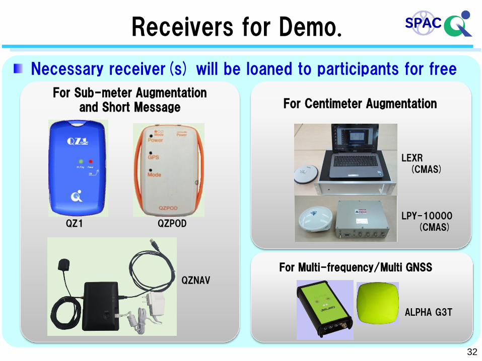
Necessary receiver(s) will be loaned to participants for free
For Sub-meter Augmentation and Short Message For Centimeter Augmentation
QZ1 QZPOD
QZNAV
LEXR
LPY-10000
ALPHA G3T
Receivers for Demo.
For Multi-frequency/Multi GNSS
32
(CMAS)
(CMAS)
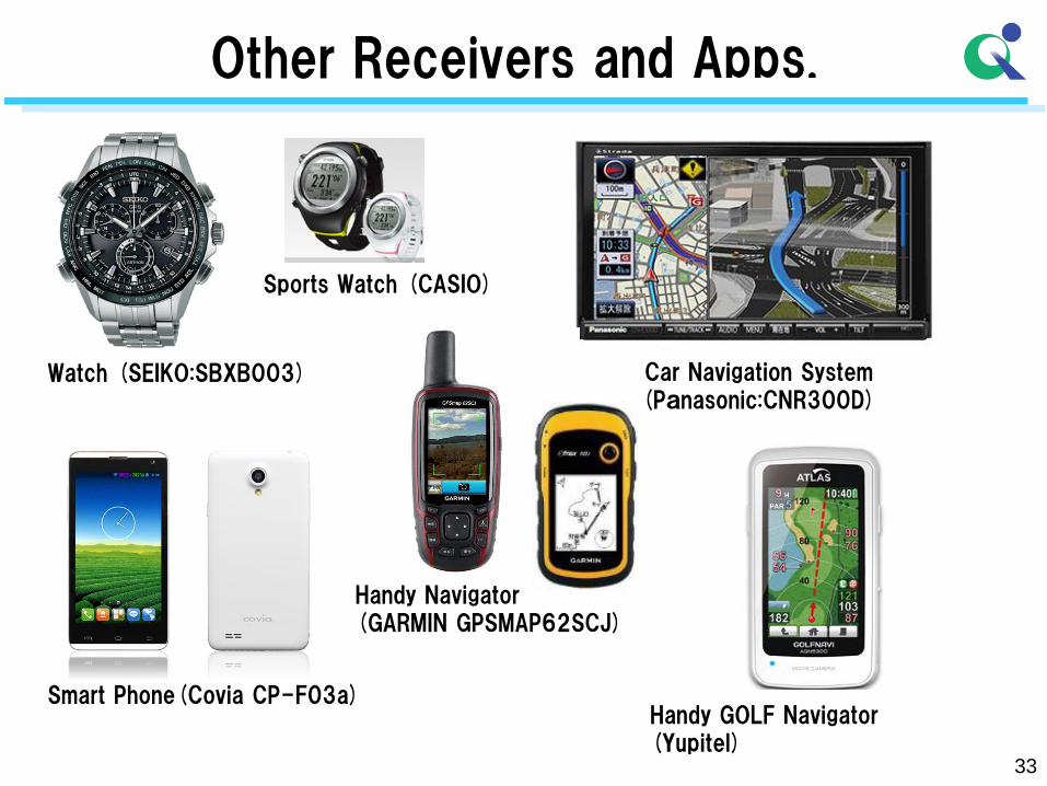
Other Receivers and Apps.
33
Watch (SEIKO:SBXB003) Car Navigation System (Panasonic:CNR300D)
Smart Phone(Covia CP-F03a)
Handy Navigator (GARMIN GPSMAP62SCJ)
Sports Watch (CASIO)
Handy GOLF Navigator (Yupitel)
Summary
34
Based on the decision of the GOJ, the deployment of the operational QZSS is underway.
- 4 satellites constellation shall be established by the 2018JFY. - Necessary equipment (satellite, ground station and others) are currently in development. - GOJ has decided to up-grade the QZSS to 7-satellite constellation in 2020’s. Verification, assessment and many demonstration of the
QZSS have been conducted.
SBAS signal will be provided via QZSS. -SBAS Service will be available from 2020’s under Ministry of Land, Infrastructure, Transport and Tourism jurisdiction.
For more information, please visit our web site
http://qzss.go.jp/en/
35
Thank you for your attention.
36
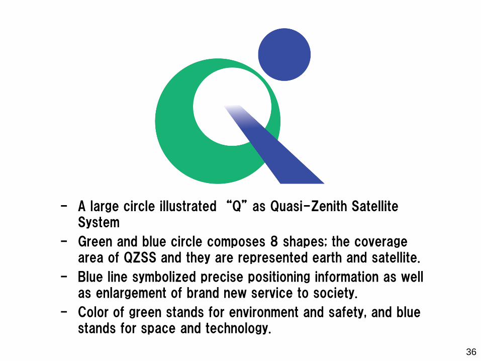
- A large circle illustrated “Q” as Quasi-Zenith Satellite System
- Green and blue circle composes 8 shapes; the coverage area of QZSS and they are represented earth and satellite.
- Blue line symbolized precise positioning information as well as enlargement of brand new service to society.
- Color of green stands for environment and safety, and blue stands for space and technology.