Embed Size (px)
Citation preview

High Precision Navigation Capabilities(L1-SAIF) and ApplicationsUsing
Japanese Quasi-Zenith Satellite System (QZSS)
ICG WG-B Application SG MeetingMunich, Germany
March 12, 2012
Satellite Positioning Research and Application Center(SPAC)
1
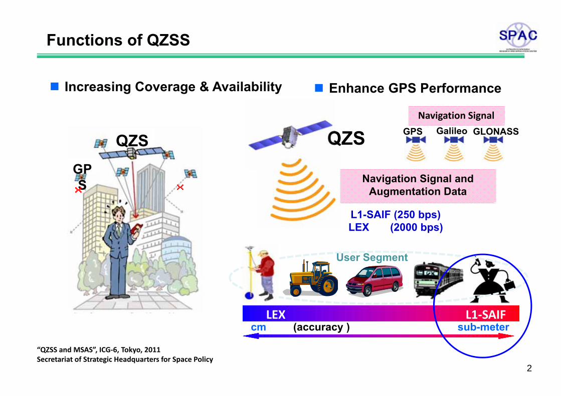
Functions of QZSS
Increasing Coverage & Availability
QZSGPS ××
L1-SAIF (250 bps)LEX (2000 bps)
QZSNavigation Signal
GalileoGPS GLONASS
LEX L1‐SAIFcm (accuracy ) sub-meter
Navigation Signal and Augmentation Data
User Segment
Enhance GPS Performance
“QZSS and MSAS”, ICG‐6, Tokyo, 2011Secretariat of Strategic Headquarters for Space Policy
2
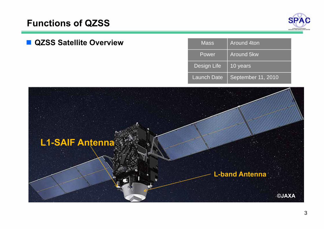
Mass Around 4ton
Power Around 5kw
Design Life 10 years
Launch Date September 11, 2010
Functions of QZSS
©JAXA
L1-SAIF Antenna
L-band Antenna
©JAXA
QZSS Satellite Overview
3
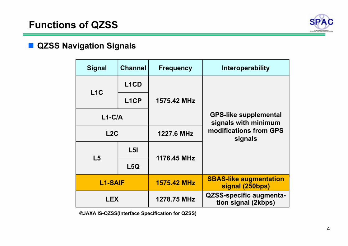
Signal Channel Frequency
L1CL1CD
1575.42 MHzL1CP
L1-C/A
L2C 1227.6 MHz
L5L5I
1176.45 MHzL5Q
LEX 1278.75 MHz
Interoperability
GPS-like supplemental signals with minimum
modifications from GPS signals
QZSS-specific augmenta-tion signal (2kbps)
L1-SAIF SBAS-like augmentation signal (250bps)1575.42 MHz
Functions of QZSS
©JAXA IS-QZSS(Interface Specification for QZSS)
QZSS Navigation Signals
4

QZSS L1-SAIF Signal
L1-SAIF(Submeter-class Augmentation with Integrity Function)Development : by ENRIUtilization and Demonstrated : by SPAC
FunctionsRangingError Correction
- Wide-are differential correction- Target accuracy : 1m(horizontal)
Integrity
Interoperability and compatibilityInteroperable with GPS L1C/AFully compatible with SBASAdditional messages are included in L1-SAIF signal
5
QZSS L1-SAIF Signal
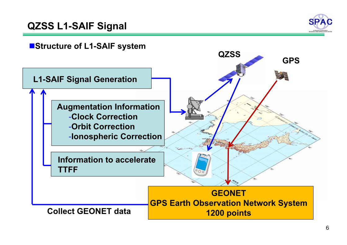
Structure of L1-SAIF system
Collect GEONET data
L1-SAIF Signal Generation
Augmentation Information-Clock Correction-Orbit Correction-Ionospheric Correction
Information to accelerate TTFF
GEONETGPS Earth Observation Network System
1200 points
QZSSGPS
6

Structure of L1-SAIF message
Preamble8 bits
Message Type6 bits
Data Field212 bits
CRC Parity24 bits
1 message = 250 bits broadcast every secondL1-SAIF Message
SBAS compatible messageType ID : 0-7, 10, 18, 24-26, 28, 62-63
SBAS non compatible messageType ID : 52-60
QZSS unique message(for civil utilization demonstration)Type ID : 40-51
QZSS L1-SAIF Signal
7
Structure of L1-SAIF message
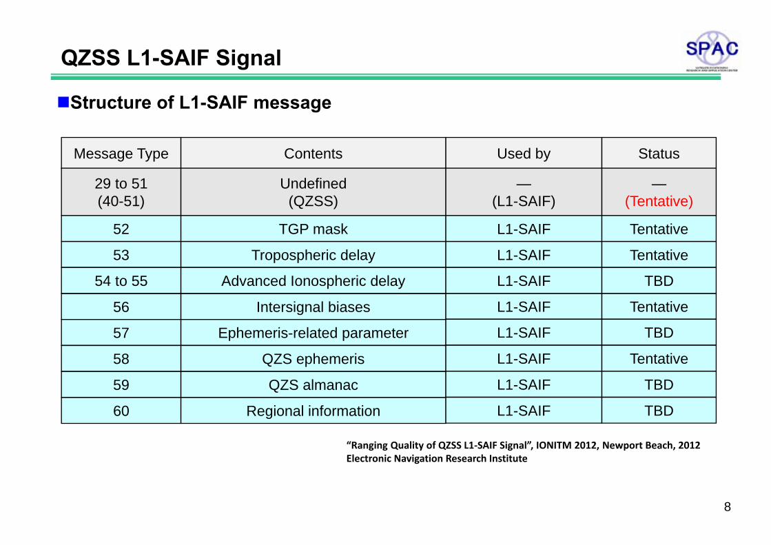
Message Type Contents Used by Status
29 to 51(40-51)
Undefined(QZSS)
—(L1-SAIF)
—(Tentative)
52 TGP mask L1-SAIF Tentative
56 Intersignal biases L1-SAIF Tentative
57 Ephemeris-related parameter L1-SAIF TBD
58 QZS ephemeris L1-SAIF Tentative
59 QZS almanac L1-SAIF TBD
60 Regional information L1-SAIF TBD
53 Tropospheric delay L1-SAIF Tentative
54 to 55 Advanced Ionospheric delay L1-SAIF TBD
QZSS L1-SAIF Signal
“Ranging Quality of QZSS L1‐SAIF Signal”, IONITM 2012, Newport Beach, 2012Electronic Navigation Research Institute
8

Following 14 points have been selected from GEONET to generate L1-SAIF augmentation information
L1-SAIF capability has been evaluated
Demonstration of L1-SAIF Capability
Sout
h-N
orth
dire
ctio
n(m
)
East-West direction(m)
Vertical(GPS only) 1.83(m)Horizontal(GPS only) 1.30(m)Vertical(GPS+L1-SAIF) 0.59(m)Horizontal(GPS+L1-SAIF) 0.38(m)
Horizontal ErrorKawagoe, Japan, 04.07.2011
“Activities for QZS application demonstration in private sector”, SPAC Symposium 2011, Tokyo, 2011, SPAC
9
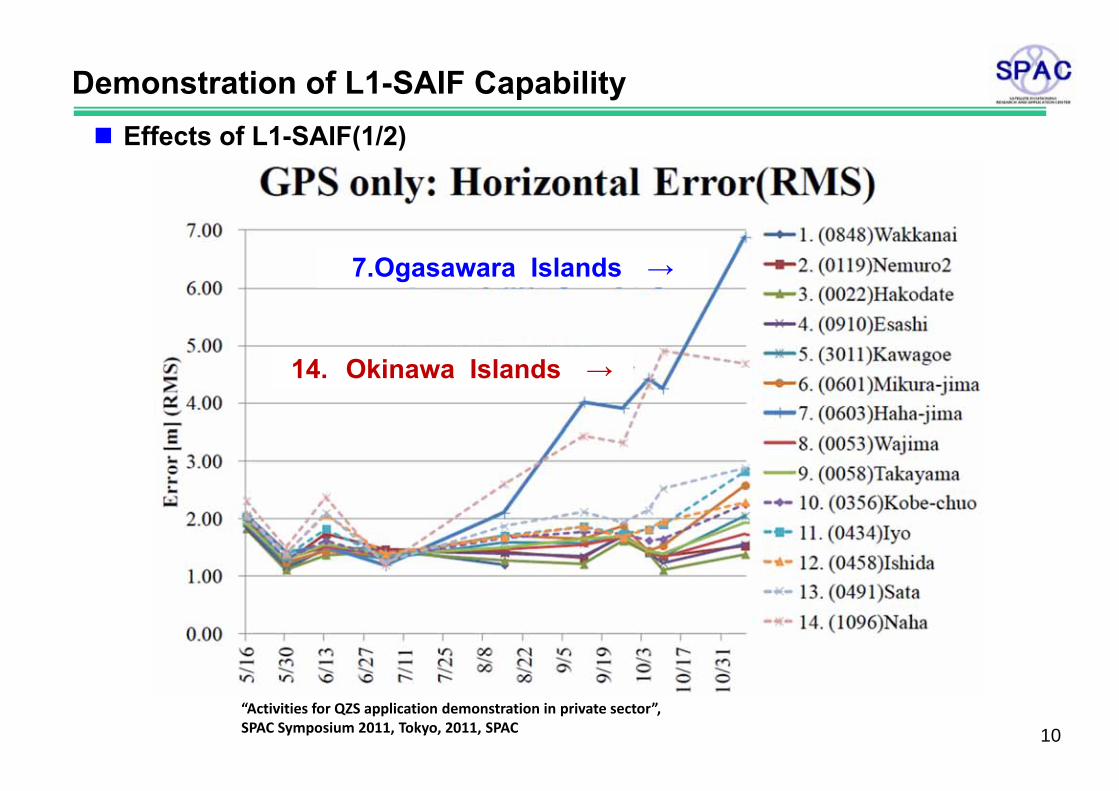
Demonstration of L1-SAIF Capability Effects of L1-SAIF(1/2)
7.Ogasawara Islands →
14. Okinawa Islands →
“Activities for QZS application demonstration in private sector”, SPAC Symposium 2011, Tokyo, 2011, SPAC 10

Overview of L1-SAIF Capability
Effects of L1-SAIF(2/2)
7.Ogasawara Islands →
14. Okinawa Islands →
“Activities for QZS application demonstration in private sector”, SPAC Symposium 2011, Tokyo, 2011, SPAC
11
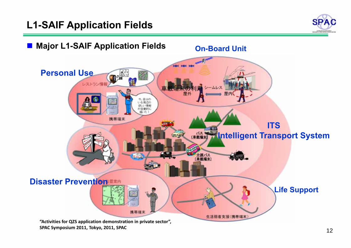
L1-SAIF Application Fields
Major L1-SAIF Application Fields
Disaster Prevention
ITSIntelligent Transport System
Personal Use
Life Support
On-Board Unit
“Activities for QZS application demonstration in private sector”, SPAC Symposium 2011, Tokyo, 2011, SPAC 12
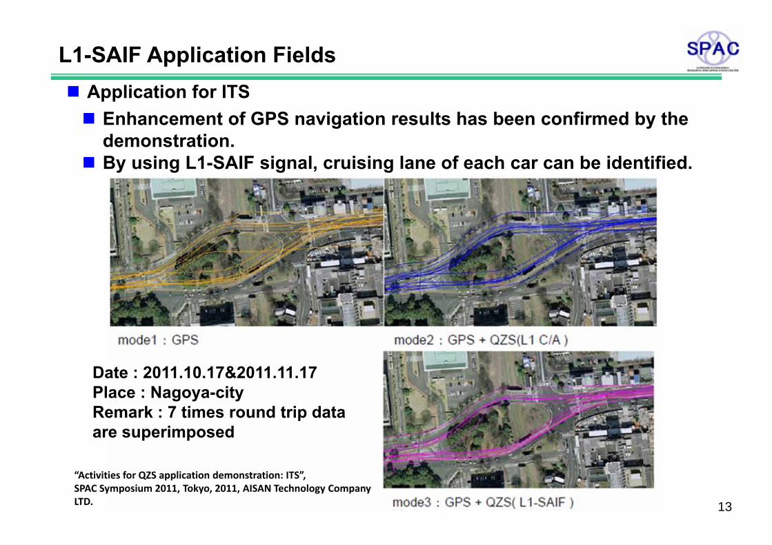
L1-SAIF Application Fields Application for ITS Enhancement of GPS navigation results has been confirmed by the
demonstration. By using L1-SAIF signal, cruising lane of each car can be identified.
Date : 2011.10.17&2011.11.17Place : Nagoya-cityRemark : 7 times round trip data are superimposed
“Activities for QZS application demonstration: ITS”, SPAC Symposium 2011, Tokyo, 2011, AISAN Technology Company LTD. 13
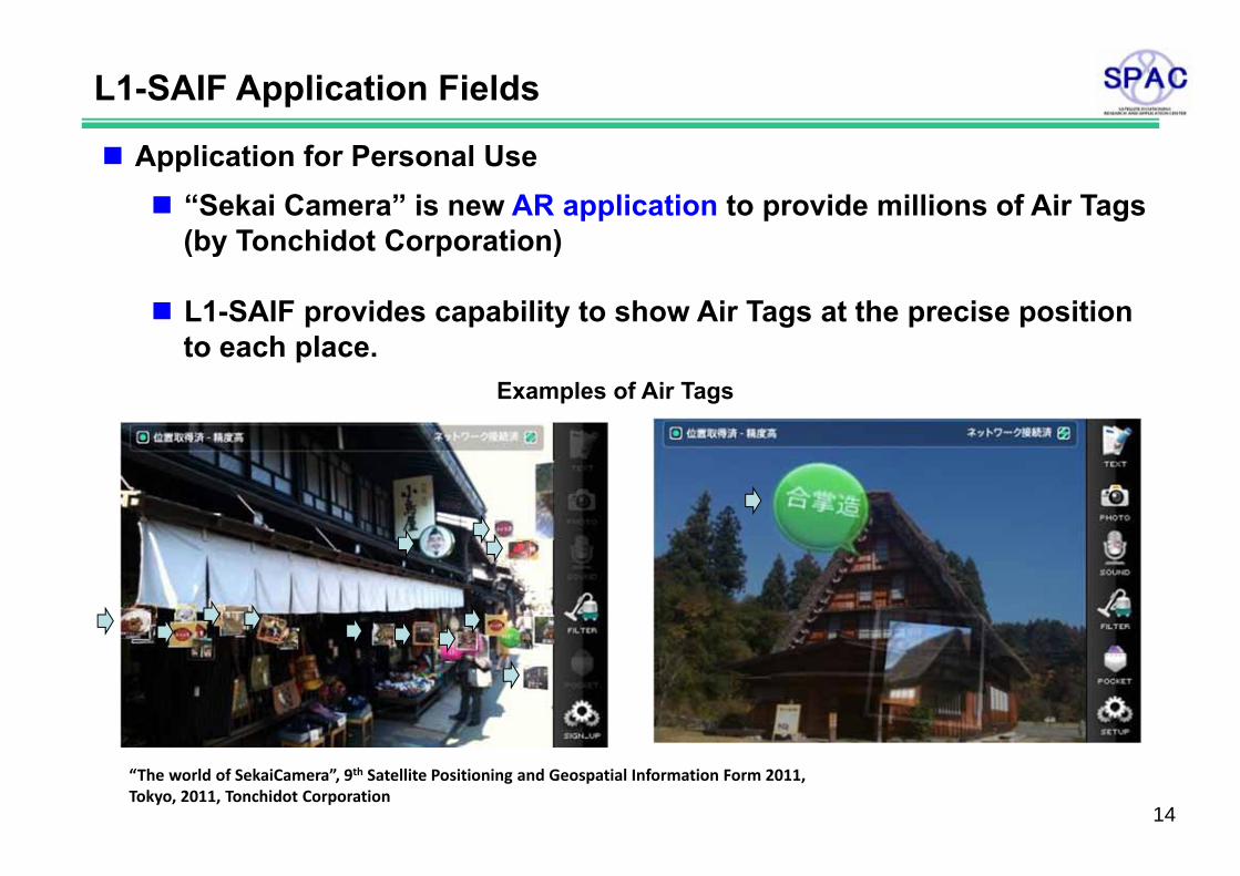
L1-SAIF Application Fields
Application for Personal Use “Sekai Camera” is new AR application to provide millions of Air Tags
(by Tonchidot Corporation)
L1-SAIF provides capability to show Air Tags at the precise positionto each place.
“The world of SekaiCamera”, 9th Satellite Positioning and Geospatial Information Form 2011, Tokyo, 2011, Tonchidot Corporation
Examples of Air Tags
14

L1-SAIF Application Fields
AR application AR : Augmented Reality
Technology to display additional information to the real world by usingcomputer assist
Based on geographical information obtained from L1-SAIF signal, it is possible to provide facility information around the area and recommended route information by overlaying these digital information on the reality space in Map and Camera Screens.
Omotenabi : http://omotenavi.jp/en/about/index.html
15
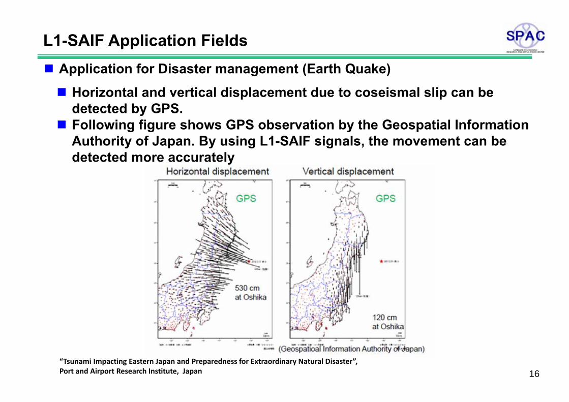
L1-SAIF Application Fields Application for Disaster management (Earth Quake)
Horizontal and vertical displacement due to coseismal slip can be detected by GPS.
Following figure shows GPS observation by the Geospatial Information Authority of Japan. By using L1-SAIF signals, the movement can be detected more accurately
“Tsunami Impacting Eastern Japan and Preparedness for Extraordinary Natural Disaster”, Port and Airport Research Institute, Japan 16
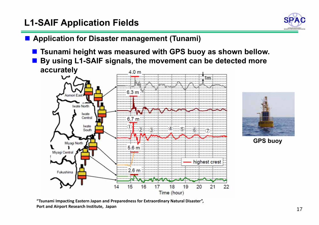
L1-SAIF Application Fields Application for Disaster management (Tunami)
Tsunami height was measured with GPS buoy as shown bellow. By using L1-SAIF signals, the movement can be detected more
accurately
GPS buoy
“Tsunami Impacting Eastern Japan and Preparedness for Extraordinary Natural Disaster”, Port and Airport Research Institute, Japan 17
Summary
“Augmentation” is characteristic feature of the QZSS.
Demonstration of L1-SAIF signal has been conducted by SPAC andimprovement by L1-SAIF augmentation has been confirmed.
Signal characteristics of L1-SAIF has been already issued by IS-QZSShttp://qzss.jaxa.jp/is-qzss/index.htmlIS-QZSS : Interface Specifications for QZSS
L1-SAIF provides efficient augmentation information for “High Precision Navigation Market”
18