Embed Size (px)
Citation preview
PROJECT COMPLETION REPORT
MISSISSIPPI RIVER SEDIMENT DELIVERY SYSTEM
BAYOU DUPONT STATE PROJECT NO. BA-39
JEFFERSON AND ST. BERNARD PARISHES, LOUISIANA
Prepared for
STATE OF LOUISIANA
DEPARTMENT OF NATURAL RESOURCES OFFICE OF COASTAL PROTECTION AND RESTORATION
Prepared by ABMB Engineers, Inc.
500 Main Street Baton Rouge, Louisiana 70801
May 24, 2011

MISSISSIPPI RIVER SEDIMENT DELIVERY SYSTEM BAYOU DUPONT STATE PROJECT NO. BA-39
JEFFERSON AND ST. BERNARD PARISHES, LOUISIANA
PROJECT COMPLETION REPORT
1
PROJECT NAME Bayou Dupont Marsh Creation Project CWPPRA/STATE PROJECT NO. BA-39 Report Date: May 24, 2011 BY: ABMB Engineers, Inc. 500 Main Street
Baton Rouge, Louisiana 70801
1. DNR Project Managers/Engineer/Federal Sponsor/Construction Contractor/Inspection Services:
DNR/OCPR Project Manager Brad Miller Telephone 225-342-4122
DNR/OCPR Construction Project Manager
Peter Hopkins Telephone 504-280-4070
DNR/OCPR Monitoring Manager Bill Boshart Telephone 504-280-4063
Federal Agency Project Manager (CWPPRA)
Paul Kaspar (EPA)
Telephone 214-665-7459
Federal Agency Project Manager (ARRA)
CC Linder (NOAA) Telephone 214-665-7459
DNR/OCPR Construction Management Engineer Debby Sheets (ABMB) Telephone 225-765-7400
DNR/OCPR Construction Inspector
Heath Broussard (ABMB) Telephone 225-765-7400
Great Lakes Dredge and Dock Company, LLC.
Project Sponsor Sam Morrison Telephone 630-805-4099
Great Lakes Dredge and Dock Company, LLC.
Project Manager Roy Woods Telephone 504-908-8854
MISSISSIPPI RIVER SEDIMENT DELIVERY SYSTEM BAYOU DUPONT STATE PROJECT NO. BA-39
JEFFERSON AND ST. BERNARD PARISHES, LOUISIANA
PROJECT COMPLETION REPORT
2
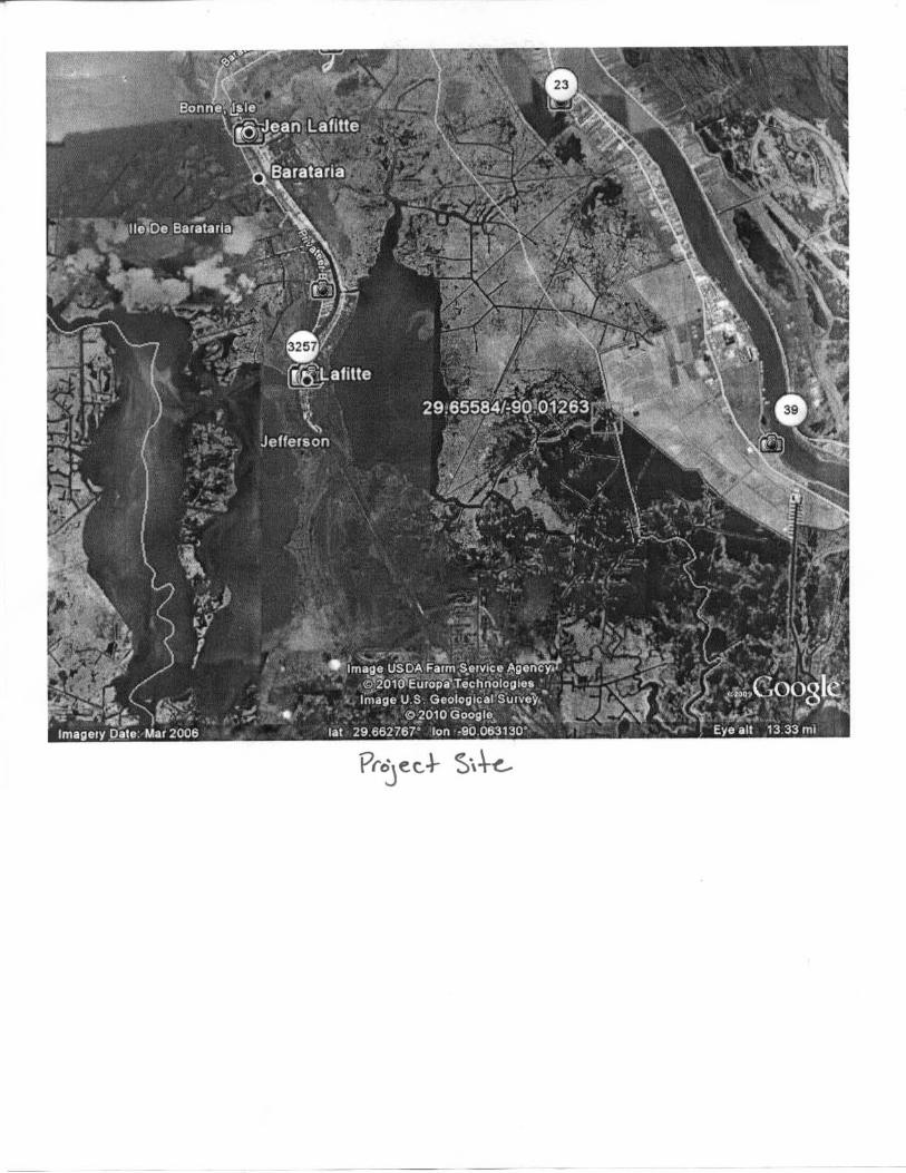
Location and description of project. The Bayou Dupont Marsh Creation Project (BA-39) is located adjacent to Bayou Dupont and southeast of Cheniere Traverse Bayou, approximately 3.7 miles northwest of Myrtle Grove, Louisiana. Project features are located in Plaquemines and Jefferson Parishes. The area lies west of Louisiana Highway 23 and just north of the Myrtle Grove Marina within the Barataria Basin. The borrow site was located in the Mississippi River between miles 63 and 65. Because the borrow area was in the river, this project was located in both Plaquemines and Jefferson Parishes. The project area was accessible by boat only. See Appendix Project Fact Sheet. The Bayou Dupont project represented the first example of pipeline transport of sediment from the river to build marsh as a Coastal Wetlands Planning, Protection, and Restoration Act (CWPPRA) project. The project involved dredging sediment from the Mississippi River for marsh creation and pumping it via pipeline into an area of open water and broken marsh west of the Plaquemines Parish flood protection levee in the rapidly eroding and subsiding section of the Barataria land bridge. This project created marsh using Mississippi River sediment as opposed to hydraulically dredging material from within the Barataria Basin. Over six miles of pipeline ran from the river to the project area. Permanent casing pipes were jacked and bored into place to allow the slurry pipeline to cross beneath the New Orleans and Gulf Coast Railway and LA Highway 23. The dredged material was contained primarily with existing land features. Newly-constructed low containment dikes were necessary along a portion of the project area to create full perimeter containment. The containment dikes were constructed from in-situ soils. The contractor built internal training dikes as necessary to improve containment or dewatering of the fill containment areas. Settlement plates were installed within the fill area. Increment 2 was added by change order to this task and created additional marsh to the west of Marsh Creation Area 1. The original project was federally sponsored by the United States Environmental Protection Agency (EPA) and the local sponsor was Louisiana Department of Natural Resources (LDNR) under the Coastal Wetlands Planning, Protection, and Restoration Act (CWPPRA). It was on Priority Project List number 12. Increment 2 work was sponsored by NOAA, and was funded by The American Recovery and Reinvestment Act (ARRA) through a grant administered by NOAA with additional funding through the CWPPRA grant administered by EPA.
MISSISSIPPI RIVER SEDIMENT DELIVERY SYSTEM BAYOU DUPONT STATE PROJECT NO. BA-39
JEFFERSON AND ST. BERNARD PARISHES, LOUISIANA
PROJECT COMPLETION REPORT
3
2. Final, as-built features, boundaries and resulting acreage (use attachments if necessary).
Approximately 25,935 linear feet of containment dike was used to create approximately 484 acres of sustainable marsh in Marsh Creation Areas 1 and 2. Increment 2 added approximately 84 acres of marsh for a total of 568 acres contained within 6,241 linear feet of containment dikes. The railroad crossing had 95 linear feet of 48-inch casing, and the highway had 194 linear feet of 48-inch permanent casing.
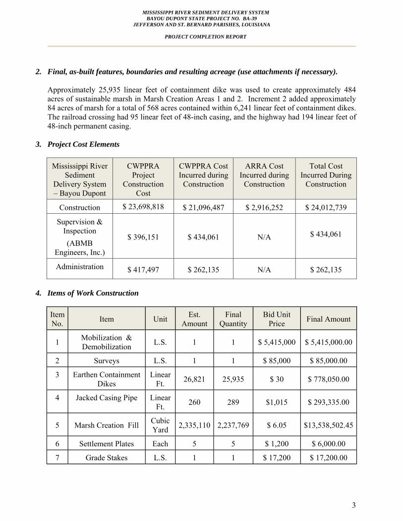
3. Project Cost Elements
Mississippi River Sediment
Delivery System – Bayou Dupont
CWPPRA Project
Construction Cost
CWPPRA Cost Incurred during
Construction
ARRA Cost Incurred during
Construction
Total Cost Incurred During
Construction
Construction $ 23,698,818 $ 21,096,487 $ 2,916,252 $ 24,012,739
Supervision & Inspection (ABMB
Engineers, Inc.)
$ 396,151 $ 434,061 N/A
$ 434,061
Administration $ 417,497 $ 262,135 N/A $ 262,135
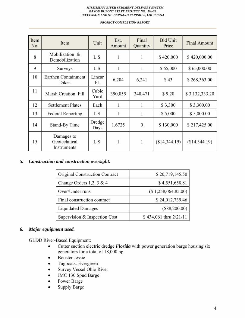
4. Items of Work Construction
Item No. Item Unit Est.
Amount Final
Quantity Bid Unit
Price Final Amount
1 Mobilization & Demobilization L.S. 1 1 $ 5,415,000 $ 5,415,000.00
2 Surveys L.S. 1 1 $ 85,000 $ 85,000.00
3 Earthen Containment Dikes
Linear Ft. 26,821 25,935 $ 30 $ 778,050.00
4 Jacked Casing Pipe Linear Ft. 260 289 $1,015 $ 293,335.00
5 Marsh Creation Fill Cubic Yard 2,335,110 2,237,769 $ 6.05 $13,538,502.45
6 Settlement Plates Each 5 5 $ 1,200 $ 6,000.00
7 Grade Stakes L.S. 1 1 $ 17,200 $ 17,200.00
MISSISSIPPI RIVER SEDIMENT DELIVERY SYSTEM BAYOU DUPONT STATE PROJECT NO. BA-39
JEFFERSON AND ST. BERNARD PARISHES, LOUISIANA
PROJECT COMPLETION REPORT
4
Item No. Item Unit Est.
Amount Final
Quantity Bid Unit
Price Final Amount
8 Mobilization & Demobilization L.S. 1 1 $ 420,000 $ 420,000.00
9 Surveys L.S. 1 1 $ 65,000 $ 65,000.00
10 Earthen Containment Dikes
Linear Ft. 6,204 6,241 $ 43 $ 268,363.00
11 Marsh Creation Fill Cubic Yard 390,055 340,471 $ 9.20 $ 3,132,333.20
12 Settlement Plates Each 1 1 $ 3,300 $ 3,300.00
13 Federal Reporting L.S. 1 1 $ 5,000 $ 5,000.00
14 Stand-By Time Dredge Days 1.6725 0 $ 130,000 $ 217,425.00
15 Damages to
Geotechnical Instruments
L.S. 1 1 ($14,344.19) ($14,344.19)
5. Construction and construction oversight.
Original Construction Contract $ 20,719,145.50
Change Orders 1,2, 3 & 4 $ 4,551,658.81
Over/Under runs ($ 1,258,064.85.00)
Final construction contract $ 24,012,739.46
Liquidated Damages ($88,200.00)
Supervision & Inspection Cost $ 434,061 thru 2/21/11
6. Major equipment used. GLDD River-Based Equipment:
• Cutter suction electric dredge Florida with power generation barge housing six generators for a total of 18,000 hp.
• Booster Jessie • Tugboats: Evergreen • Survey Vessel Ohio River • JMC 130 Spud Barge • Power Barge • Supply Barge
MISSISSIPPI RIVER SEDIMENT DELIVERY SYSTEM BAYOU DUPONT STATE PROJECT NO. BA-39
JEFFERSON AND ST. BERNARD PARISHES, LOUISIANA
PROJECT COMPLETION REPORT
5
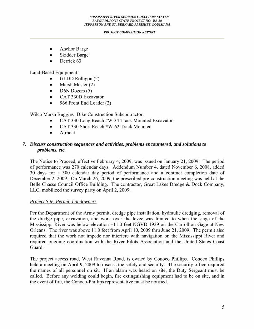
• Anchor Barge • Skidder Barge • Derrick 63
Land-Based Equipment:
• GLDD Rolligon (2) • Marsh Master (2) • D6N Dozers (5) • CAT 330D Excavator • 966 Front End Loader (2)
Wilco Marsh Buggies- Dike Construction Subcontractor:
• CAT 330 Long Reach #W-34 Track Mounted Excavator • CAT 330 Short Reach #W-62 Track Mounted • Airboat
7. Discuss construction sequences and activities, problems encountered, and solutions to
problems, etc.
The Notice to Proceed, effective February 4, 2009, was issued on January 21, 2009. The period of performance was 270 calendar days. Addendum Number 4, dated November 6, 2008, added 30 days for a 300 calendar day period of performance and a contract completion date of December 2, 2009. On March 26, 2009, the prescribed pre-construction meeting was held at the Belle Chasse Council Office Building. The contractor, Great Lakes Dredge & Dock Company, LLC, mobilized the survey party on April 2, 2009. Project Site, Permit, Landowners Per the Department of the Army permit, dredge pipe installation, hydraulic dredging, removal of the dredge pipe, excavation, and work over the levee was limited to when the stage of the Mississippi River was below elevation +11.0 feet NGVD 1929 on the Carrollton Gage at New Orleans. The river was above 11.0 feet from April 10, 2009 thru June 21, 2009. The permit also required that the work not impede nor interfere with navigation on the Mississippi River and required ongoing coordination with the River Pilots Association and the United States Coast Guard. The project access road, West Ravenna Road, is owned by Conoco Phillips. Conoco Phillips held a meeting on April 9, 2009 to discuss the safety and security. The security office required the names of all personnel on sit. If an alarm was heard on site, the Duty Sergeant must be called. Before any welding could begin, fire extinguishing equipment had to be on site, and in the event of fire, the Conoco-Phillips representative must be notified.

MISSISSIPPI RIVER SEDIMENT DELIVERY SYSTEM BAYOU DUPONT STATE PROJECT NO. BA-39
JEFFERSON AND ST. BERNARD PARISHES, LOUISIANA
PROJECT COMPLETION REPORT
6
Access on West Ravenna Road is shared by multiple parties including the owner, parish, local property owners, and lessees. During August 2009, the road was under heavy traffic by GLDD and St. Bernard Parish. The Parish used the road to haul fill material in dump trucks to the back levee; while GLDD used it for equipment transport. The road was in disrepair, and became impassable due to heavy rains and the amount of traffic from multiple contractors. The road was repaired by the Parish and GLDD. In Marsh Creation Area 2, there is a fifteen anode Shell Pipe Line Rectifier Field with above-ground boxes. The anode location is shown on the As-Built Drawings, and the contractor flagged off this area as a “No Work” area. A Shell pipeline monitoring station is located over the 20 inch pipeline near the intersection of West Ravenna Road the flood protection levee. This structure was protected during construction. In addition, the 20 inch Shell Oil pipeline runs parallel to the existing flood protection levee on the fill side of Marsh Creation Area 2. A Shell representative had to be present or give approval when equipment crossed the pipeline; and no excavation was permitted within 50 feet of the pipeline. Plaquemines Parish owns the flood protection levee and excavation was not permitted within 100 feet except at the tie in location. On the eastern enhanced spoil banks in Marsh Creation Two, there are geotechnical instrumentation stations. The cables to the peizometers were damaged by the contractor’s equipment running over the cables which required reparations twice. Pre-Construction Survey On April 2nd, the contractor established survey controls and began layout near the siphon. The contract required the contractor to verify pipeline and waterline locations prior to beginning construction. The existing 10” and 20” water lines adjacent to LA 23 were required to be probed, located, and marked prior to construction. The edge of the casing was to be installed at least two feet below the edge of the water lines. The borrow area magnetometer survey was performed by T. Baker Smith on April 7, 2009. The borrow area limits were approximately 1,000’ L x 6,800’ W, and were located to the west of the Mississippi River navigation channel. The marsh preconstruction survey for transects 1 thru 26 was performed on September 1, 2009 and additional transects 27 thru 37 on August 20, 2009 in August 2009. Permanent Jacked Casing Pipe Crossings The high river stage adversely affected the scheduling of subcontractors to install the casings under the road and railroad. The USACE permit restricted excavation within 1,500 feet of the levee when the Mississippi river was above +11.0 feet at the Carrollton gage. As a result of the anticipation of delay due to the USACE restriction, the contractor experienced difficulties scheduling subcontractors and a time extension was granted in Change Order 3. Directional Road Boring Inc. (DRB) of Metairie subcontracted Giken America Corporation from Orlando, Florida to install the steel sheet piling utilizing the Silent Piler press-in method for the
MISSISSIPPI RIVER SEDIMENT DELIVERY SYSTEM BAYOU DUPONT STATE PROJECT NO. BA-39
JEFFERSON AND ST. BERNARD PARISHES, LOUISIANA
PROJECT COMPLETION REPORT
7
cofferdams. Giken began the sheet pile installation at the railroad tracks on August 12, 2009 and completed it on August 14, 2009. The rectangular railroad jacking pit measured 15 x 36 feet, and the receiving pit 9 x 15 feet. The Highway 23 jacking pit measured 15 x 36 feet, and the receiving pit 9 x 12 feet. The alignment of the highway crossing was revised to avoid an overhead power line pole, see Change Order Number One. The New Orleans & Gulf Coast Railroad and the LADOTD required compliance with standard construction and material specifications and the railroad also required a Right of Entry Agreement. The pipe casings were 48 inch diameter, 0.625 inch wall thickness, and were typically installed in ten-foot sections with full depth welds at each joint. Tomahawk Construction began excavating for the railroad jack and bore pits on August 18, 2009. DRB began the railroad jack and bore on August 22, 2009 and completed it on August 30, 2009. A pilot hole was not utilized on the railroad jack and bore. The alignment was corrected during boring by the installation of a steering tab welded to the leading edge of the casing and the casing entered the edge of the receiving pit. The LA Highway 23 crossing excavation began on August 21, 2009 with the jack and bore beginning on September 3rd. Due to the near miss of the railroad jack and bore and the longer length of the Hwy 23 jack and bore, a pilot hole was utilized. The contractor encountered difficulties with high ground water. The movement of the jacking equipment caused pumping action under the equipment deck and destabilized the bottom of the pit. This affected the alignment of the jacking equipment and caused the casing to rise above the planned grade in spite of the pilot hole. Equipment had to be removed from the pit, and a false bottom installed with a well point system to control the water level. The failure of the contractor designed shoring also caused the loss of the adjacent survey monument and threatened an adjacent Entergy power pole. Entergy officials were called to the site and braced the power pole. The survey monument was replaced at the contractor’s expense by John Chance Land Surveyors Inc. on May 4, 2010. Additionally, the preconstruction survey failed to accurately locate the underground water line which resulted in the 10 inch water line being broken, which in turn caused a void to form near the road shoulder. The contractor pumped sand to fill the void before proceeding. The water line was repaired by the Plaquemines Parish Water Department. During this process, the error in the pre-construction survey of the elevation of this pipe was discovered. The Contractor was able to raise the elevation of the casing and still maintain the required clearance under the waterlines. The casing was withdrawn and reinstalled at the new elevation. The casing installation at the highway crossing was completed on October 27, 2009. Dredge Slurry Pipeline Corridor Great Lakes Dredge & Dock Inc. (GLDD) staged a temporary marine access dock upstream from the Naomi Siphon. The slurry pipeline from the Mississippi River was placed over the Mississippi Flood Protection Levee in accordance with the levee crossing plan. Two different types and sizes of pipe were utilized in the dredge slurry pipeline. From the water’s edge, longer pipe sections up to 160-foot lengths were welded together to form a solid two mile section to compensate for higher pressures experienced by the booster. A subcontractor, SPI/Mobile Works, was used to weld pipe. The remainder of the pipeline was comprised of 40-foot lengths of pipe flanged and bolted together. There were two temporary levee crossings; one on the
MISSISSIPPI RIVER SEDIMENT DELIVERY SYSTEM BAYOU DUPONT STATE PROJECT NO. BA-39
JEFFERSON AND ST. BERNARD PARISHES, LOUISIANA
PROJECT COMPLETION REPORT
8
Mississippi River Flood Protection Levee (MRL), and one over the Plaquemines Parish Flood Protection Levee. The east-west section of the dredge slurry pipeline corridor near the Naomi siphon is owned by the Plaquemines Parish Government. The Parish allowed the contractor to build a 40 car gravel parking lot in this area. From the MRL crossing near the Naomi Siphon, the slurry pipeline went over land to the New Orleans and Gulf Coast Railroad Crossings and through the permanent 48 inch steel casing pipes that were previously installed at the railroad and LA Highway 23 crossing. The dredge slurry pipeline continued westward to the north/south drainage canal through land utilized for cattle grazing. There were three cattle gates and four temporary ramps to facilitate cattle crossings. After crossing the north/south drainage canal, it proceeded south to West Ravenna Road. A gravel crossing was constructed at the junction with West Ravenna Road and at driveways serving the tenants. The pipeline followed the south side of the roadway to the back levee. Slurry pipe delivery began on May 27, 2009. The longer pipe lengths of 30 inch diameter pipe arrived by barge and were lifted over the levee by crane, while the shorter pipe was delivered by truck. The contractor’s staging area was east of LA Highway 23. The first 12,000 linear feet of shore pipeline from the water’s edge was butt welded with a greater wall thickness in order to withstand higher pressure. The remaining 40-foot lengths were flange jointed pipe appropriate for lower pressure. Access to the marsh creation site was initially through a private boat launch owned by River Rest, LLC hunting camp. As the fill material settled, vehicular traffic could travel over the fill site. Containment Dikes Wilco Marsh Buggies Inc. began containment dike construction in Marsh Creation Area 2 on April 20, 2009. The only area lacking an existing spoil bank was on the south side of Marsh Creation Area 2. This area required multiple passes to attain the required 3.0’+/- 0.5’ elevation. A longer reach excavator was needed to accommodate the deeper water levels. A settlement plate was set in the south dike on June 5, 2009. That plate subsequently shifted and is not considered viable. After the contract acceptance period, the containment dikes and enhanced spoil banks were degraded or gapped to the same elevation as the marsh platform in order to allow intertidal flow. Gapping locations were determined by EPA/OCPR field determinations based on the existing topography. Marsh Creation, Crossings The material type was heavy sand and dredge production required more dozers to move the material than anticipated by the contractor. The dozers pushed up the material into dikes at the discharge to direct the flow. Material was pumped to the required over-elevation, and then the

MISSISSIPPI RIVER SEDIMENT DELIVERY SYSTEM BAYOU DUPONT STATE PROJECT NO. BA-39
JEFFERSON AND ST. BERNARD PARISHES, LOUISIANA
PROJECT COMPLETION REPORT
9
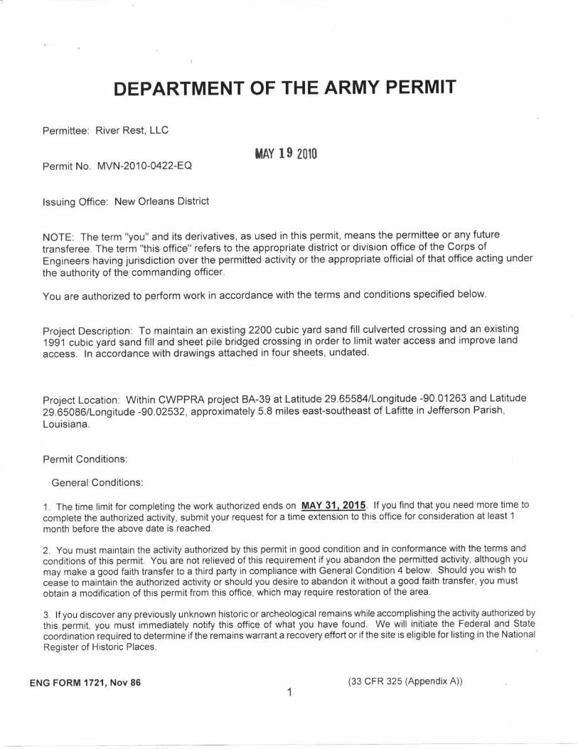
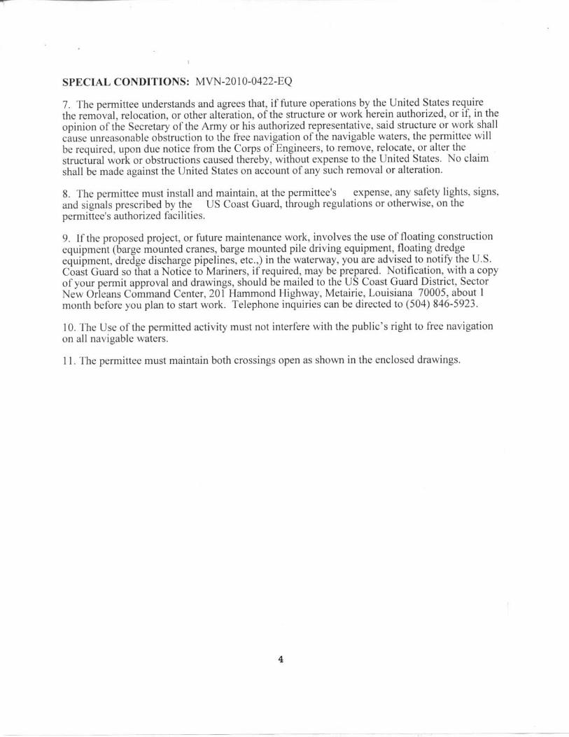
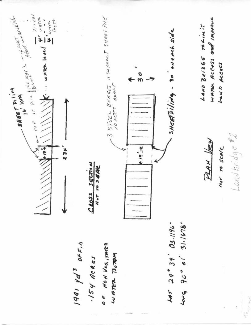
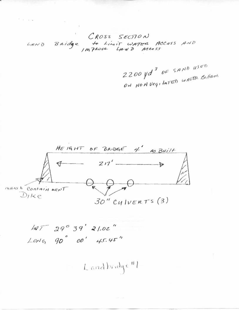
dozers spread the material. The rolligons were used to add or move discharge pipe. The contractor experienced difficulty in pumping material into the existing marsh with vegetation areas. The best practice was to pump around the existing marsh areas and force the soft displaced mud into the voids in the marsh. Sand was then added, as needed, to push up the soft material until it was to grade. The displaced material at times did not support dozers to continue building pipelines. As a result, the operational methods were adapted to isolate the soft spots in pockets surrounded by sand and bypass the marsh areas. The cables to the peizometers in Marsh Creation Two were damaged by the contractor’s equipment running over the cables which required reparations twice. A land bridge was pumped across the canal for access to Marsh Creation Area 1. Three 30 inch CMP culverts were installed to allow tidal flow. River Rest, LLC, a local land owner, submitted a permit requesting that the land bridge be allowed to remain. That permit was granted by Permit No. MVN-2010-0422-EQ (attached for reference). The remaining settlement plates and survey stakes were in place by November 2, 2009. GLDD submitted a settlement plate design that included a detachable upper rod with a longer lower rod for stability. See Appendix for approved settlement plate submittal. The dredge began pumping into Marsh Creation Area 2 on November 11, 2009, and completed December 25, 2009. The marsh creation fill target elevation was 2.0’+/- 0.3’ within the earthen containment dikes. Pumping into Marsh Creation Area 1 began on December 10, 2009 and was completed on March 15, 2010. Dredging, Navigation As the dredge moved northward in the borrow area, submerged line was added. The contractor used precautions for threatened and endangered species such as the West Indian Manatee and Pallid Sturgeon. The dredge pumped through a combination of floating and shore pipelines consisting of 5,000 linear feet of subline; 1,800 feet of pontoon; and over six miles of slurry pipe. Dredge setup was complete, and the dredge began to pump fill material into Marsh Creation Area 2 on November 6, 2009. The borrow area limits were approximately 6,800’ W x 1,000’ L feet, and were located to the west of the Mississippi River navigation channel. The dredge made two cuts approximately 2500’L x 250’W. It would spud over and repeat dredging to a depth of -76 feet to -80 feet. In January 2010, the Crescent River Pilots Association lodged complaints that the proximity of the dredge to the navigation channel was causing one-way traffic and a possible hazard. In order to increase the area available for navigation past the borrow area, Field Order Number 2 was issued to relocate the borrow area approximately 350 feet toward the west bank of the Mississippi River.

MISSISSIPPI RIVER SEDIMENT DELIVERY SYSTEM BAYOU DUPONT STATE PROJECT NO. BA-39
JEFFERSON AND ST. BERNARD PARISHES, LOUISIANA
PROJECT COMPLETION REPORT
10
The dredge encountered unknown obstructions that resulted in failed equipment and lost time. On February 9, 2010, the dredge struck a ship anchor chain which caused the cutter section of the ladder to detach. The Contractor performed a more thorough magnetometer survey on the revised borrow area on February 24, 2010. Progress Surveys, Fill Quantities During construction, process surveys for partial payment and quality control were performed. The survey baseline and transects shown in the plans were used. All surveys were signed and sealed by a licensed land surveyor. The contractor surveyed at points every fifty feet along each transect line. The contract required fill quantities to be calculated by a method approved by the Engineer. GLDD proposed a computer software program to model pre and post construction surfaces. These surfaces would be used for volume calculations. Cross sections, plan views, elevations, quantities and volumes, with surveyed dates on the corresponding cells, were submitted. Cell volumes were verified by average end area calculations and supporting calculations. Survey data points were used by OCPR to perform an independent evaluation of process surveys. The use of grade stakes was discontinued after Marsh Creation Area 2 because the stakes were moved by the fill material and equipment. The contractor utilized electronic surveying equipment daily. Increment 2 A second land bridge was pumped for access to Increment 2 from Marsh Creation Area 1. The USACE permit granted to River Rest, LLC allowed this feature to also remain in place. Wilco Marsh Buggies began Increment 2 containment dike construction on March 3, 2010. Containment dikes were not needed on the north side except at openings in the existing bank. Before the containment dikes were complete, dredge fill operations began. Sand was pumped from March 13, 2010 till March 27, 2010. The target elevation was not attained in an area on the west side of Increment 2 because soft soil conditions. Dike degradation was not necessary in this area. Project Completion The contractor began demobilizing slurry pipe on March 28, 2010. After the slurry pipe was removed, caps were welded to the permanent casing pipe. The casings were filled with water, and two railroad markers were placed. One on either side, fifteen feet from the railroad tracks. The contractor demobilized completely by May 10, 2010. Final inspection was held on May 25, 2010. The initial As-built drawings were submitted on May 21, 2010. The drawings were reviewed, and revisions were necessary. The revised As-built drawings were received on August 23, 1010, and found to be acceptable.
MISSISSIPPI RIVER SEDIMENT DELIVERY SYSTEM BAYOU DUPONT STATE PROJECT NO. BA-39
JEFFERSON AND ST. BERNARD PARISHES, LOUISIANA
PROJECT COMPLETION REPORT
11
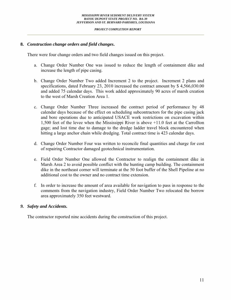
8. Construction change orders and field changes.
There were four change orders and two field changes issued on this project.
a. Change Order Number One was issued to reduce the length of containment dike and increase the length of pipe casing.
b. Change Order Number Two added Increment 2 to the project. Increment 2 plans and
specifications, dated February 23, 2010 increased the contract amount by $ 4,566,030.00 and added 75 calendar days. This work added approximately 90 acres of marsh creation to the west of Marsh Creation Area 1.
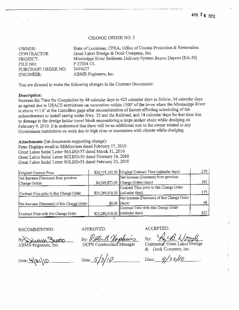
c. Change Order Number Three increased the contract period of performance by 48
calendar days because of the effect on scheduling subcontractors for the pipe casing jack and bore operations due to anticipated USACE work restrictions on excavation within 1,500 feet of the levee when the Mississippi River is above +11.0 feet at the Carrollton gage; and lost time due to damage to the dredge ladder travel block encountered when hitting a large anchor chain while dredging. Total contract time is 423 calendar days.
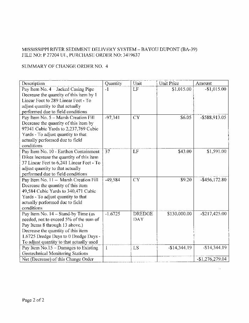
d. Change Order Number Four was written to reconcile final quantities and charge for cost of repairing Contractor damaged geotechnical instrumentation.
e. Field Order Number One allowed the Contractor to realign the containment dike in
Marsh Area 2 to avoid possible conflict with the hunting camp building. The containment dike in the northeast corner will terminate at the 50 foot buffer of the Shell Pipeline at no additional cost to the owner and no contract time extension.
f. In order to increase the amount of area available for navigation to pass in response to the
comments from the navigation industry, Field Order Number Two relocated the borrow area approximately 350 feet westward.
9. Safety and Accidents.
The contractor reported nine accidents during the construction of this project.

MISSISSIPPI RIVER SEDIMENT DELIVERY SYSTEM BAYOU DUPONT STATE PROJECT NO. BA-39
JEFFERSON AND ST. BERNARD PARISHES, LOUISIANA
PROJECT COMPLETION REPORT
12
10. Significant Construction Dates:
Description Date
Bid Opening November 13, 2008
Construction Contract Award January 21, 2009
Preconstruction Conference March 2009
Notice to Proceed February 4, 2009
Mobilization April 2, 2009
Construction Start August 12, 2009
Construction Completion May 10, 2010
Final Inspection May 20, 2010 Letter of Final Inspection &
Acceptance August 16, 2010
11. Additional comments pertaining to construction, completed project, etc.
The following comments were developed from the “Lessons Learned Meeting” held January 5, 2011. A “Lessons Learned” meeting was held on January 5, 2011 at 10:00 a.m. at the DNR Conference Room. From that meeting, the following comments were developed:
a. Good relations that were developed with Landowners and Stakeholders during the planning and development of this project were continued throughout the project during construction and facilitated resolution of construction related issues.
b. The fill site was easily accessed from West Ravenna Road enabling a lot of visitors to
view the site. Conoco-Phillips had very specific requirements and restrictions for all visitors. River Rest LLC required visitors to sign a “Hold Harmless” agreement. Visiting privileges need to be coordinated with the local landowners.
c. The definition for maintaining daily traffic should be specified based on locality. The
Special Provisions should require pre-work video/photographs that can be used for comparison at the project close out.
d. During design, land owners should be consulted to determine the type and locations of
utilities. Multiple departments within a single company, like Shell Oil Refinery, need to be consulted prior during design.

MISSISSIPPI RIVER SEDIMENT DELIVERY SYSTEM BAYOU DUPONT STATE PROJECT NO. BA-39
JEFFERSON AND ST. BERNARD PARISHES, LOUISIANA
PROJECT COMPLETION REPORT
13
e. The deliverables for the Work Plan should be tailored for the project, and become a living document with updates added as appropriate. A schedule for submissions should be included so the appropriate documents are provided at the Pre-construction meeting, with additional submissions as work progresses.
f. The Special Provisions should be modified to mandate that the Pre-Construction
conference follows the Notice-to-Proceed issued by State Purchasing by a certain time period in order to better schedule the work. Also, the definition of “Starting Work” should be added for clarity.
g. The Contractor should be required to submit a copy of all subcontractor certificates of
insurance. The certificates should indemnify the local landowners per the land rights agreements.
h. The specifications should require the Contractor to furnish the State a copy of all side
agreements with landowners that might affect any existing agreements with the State. i. Provide wage determination for compliance with Davis Bacon requirements.
j. If the pay application has to be certified by the Contractor, the legal implications need to
be defined. k. The specifications should require the contractor to provide a breakdown of costs for both
lump sum items and unit price items in order to insure proper payment. l. A Submittal Register that describes and classifies each item required by the specifications
should be included. The classification provides the action required for the item such as “For Information Only”, or “Government Approval” required for shop drawings, certificates, design data, test reports, etc.
m. The designer shall specify grades, reports, certificates, etc. required when citing industry
standards and standard specifications of other entities.
n. For Contractor-provided designs, the scope of work should be defined in the specifications.
o. The railroad permit appendix was missing some requirements. p. The casing pipe detail does not account for the method of sealing and filling the pipe. The
drawing should be updated to include the welding requirements, cutting, and port locations for filling.
q. The USACE has a restriction on work in/near the Mississippi River when the river stage
at the Carrollton gage is 11.0’ or greater. Therefore, work that is dependent on the river

MISSISSIPPI RIVER SEDIMENT DELIVERY SYSTEM BAYOU DUPONT STATE PROJECT NO. BA-39
JEFFERSON AND ST. BERNARD PARISHES, LOUISIANA
PROJECT COMPLETION REPORT
14
should be scheduled to take advantage of historically low-river season or additional time provided in the contract period of performance.
r. The specifications need to account for both river and land-based equipment during a hurricane. Either the specifications need to dictate that the contractor locate and provide a point of refuge, or the plans and specifications need to give a location and time table. In conjunction, the Coast Guard restrictions need to be reviewed regarding the newly constructed surge barrier on the Inner Harbor Navigation Channel (IHNC).
s. Consider spelling out the USACE & USCG regulations and practices regarding high river
stage and how they will be dealt with contractually. t. In periods of high-river, the Coast Guard can mandate that equipment in the river be
moved. This brought up the navigation channel issues. The river pilots customarily have two-way traffic in this area, but were being forced to one-way traffic while the dredge was in the southern edge of the borrow area. The specifications require the contractor to submit a Notice of Intent to Dredge. Because of the proximity of the dredge and the anchor locations, the River Pilot Association expected daily communication.
u. The transects used for survey were set at 500 ft offsets. This was the “Pay Line” used by
the contractor, although he took many more elevation shots. The contract should specify the use of a finer grid for surveys.
v. The method for calculating fill quantities needs to mandate the type of software, the use
of appropriate “breaklines” by the surveyor, and closer spacing of survey pay lines. Breaklines need to be defined. Transect geometry needs to be provided by coordinates or in a table. The designer needs to specify software currently in use by the State for compatibility with the contract requirements.
w. The specifications should mandate that the installation of settlement plates be scheduled
with the surveys. The design of the settlement plates needs to be updated to allow for removal of the upright after installation.
x. Settlement in the fill area should be monitored to establish a historical basis for future
work.
y. Grade states can be replaced with global positioning system (gps) spot checks. z. Magnetometer Survey requirements should be given, and the format for the
magnetometer findings specified so the information may be used for future reference. aa. Some items of work require expertise in that field, and the worker qualifications need to
be specified. For example, welders qualifications for the pipe casing, the technician qualifications for the specified software, surveyors, etc.
MISSISSIPPI RIVER SEDIMENT DELIVERY SYSTEM BAYOU DUPONT STATE PROJECT NO. BA-39
JEFFERSON AND ST. BERNARD PARISHES, LOUISIANA
PROJECT COMPLETION REPORT
15
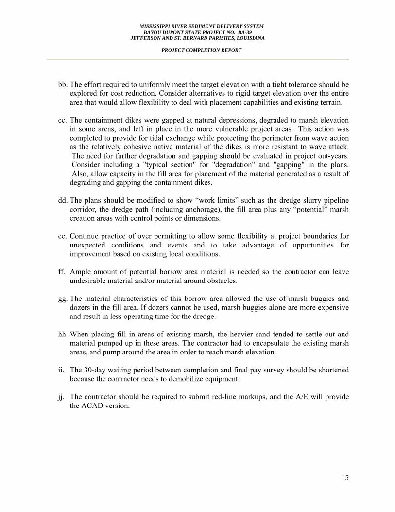
bb. The effort required to uniformly meet the target elevation with a tight tolerance should be
explored for cost reduction. Consider alternatives to rigid target elevation over the entire area that would allow flexibility to deal with placement capabilities and existing terrain.
cc. The containment dikes were gapped at natural depressions, degraded to marsh elevation
in some areas, and left in place in the more vulnerable project areas. This action was completed to provide for tidal exchange while protecting the perimeter from wave action as the relatively cohesive native material of the dikes is more resistant to wave attack. The need for further degradation and gapping should be evaluated in project out-years. Consider including a "typical section" for "degradation" and "gapping" in the plans. Also, allow capacity in the fill area for placement of the material generated as a result of degrading and gapping the containment dikes.
dd. The plans should be modified to show “work limits” such as the dredge slurry pipeline
corridor, the dredge path (including anchorage), the fill area plus any “potential” marsh creation areas with control points or dimensions.
ee. Continue practice of over permitting to allow some flexibility at project boundaries for
unexpected conditions and events and to take advantage of opportunities for improvement based on existing local conditions.
ff. Ample amount of potential borrow area material is needed so the contractor can leave
undesirable material and/or material around obstacles. gg. The material characteristics of this borrow area allowed the use of marsh buggies and
dozers in the fill area. If dozers cannot be used, marsh buggies alone are more expensive and result in less operating time for the dredge.
hh. When placing fill in areas of existing marsh, the heavier sand tended to settle out and
material pumped up in these areas. The contractor had to encapsulate the existing marsh areas, and pump around the area in order to reach marsh elevation.
ii. The 30-day waiting period between completion and final pay survey should be shortened because the contractor needs to demobilize equipment.
jj. The contractor should be required to submit red-line markups, and the A/E will provide
the ACAD version.

MISSISSIPPI RIVER SEDIMENT DELIVERY SYSTEM BAYOU DUPONT STATE PROJECT NO. BA-39
JEFFERSON AND ST. BERNARD PARISHES, LOUISIANA
PROJECT COMPLETION REPORT
APPENDICES
• Project Photos • Project Fact Sheet • Change Orders • Field Orders • As-Built Schedule • Settlement Plate • River Rest COE Permit

MISSISSIPPI RIVER SEDIMENT DELIVERY SYSTEM BAYOU DUPONT STATE PROJECT NO. BA-39
JEFFERSON AND ST. BERNARD PARISHES, LOUISIANA
PROJECT COMPLETION REPORT
Project Photos

MISSISSIPPI RIVER SEDIMENT DELIVERY SYSTEM BAYOU DUPONT STATE PROJECT NO. BA-39
JEFFERSON AND ST. BERNARD PARISHES, LOUISIANA
PROJECT COMPLETION REPORT
PROJECT PHOTOS PG. 1/2
Permanent Jacked Casing Pipe Crossings
Containment Dikes Dredge Slurry Pipeline Corridor

MISSISSIPPI RIVER SEDIMENT DELIVERY SYSTEM BAYOU DUPONT STATE PROJECT NO. BA-39
JEFFERSON AND ST. BERNARD PARISHES, LOUISIANA
PROJECT COMPLETION REPORT
PROJECT PHOTOS
PG. 1/2
Marsh Creation
Marsh Creation Crossing

MISSISSIPPI RIVER SEDIMENT DELIVERY SYSTEM BAYOU DUPONT STATE PROJECT NO. BA-39
JEFFERSON AND ST. BERNARD PARISHES, LOUISIANA
PROJECT COMPLETION REPORT
Project Fact Sheet

Mississippi River Sediment Delivery System - Bayou Dupont (BA-39)
Location
Problems
Restoration Strategy
Progress to Date
Project Status
Federal Sponsor:U.S. Environmental Protection AgencyDallas, TX(214) 665-7459
Local Sponsor:Office of Coastal Protection and RestorationBaton Rouge, LA(225) 342-4122
For more project information, please contact:
The project is located adjacent to Bayou Dupont and southeast of Cheniere Traverse Bayou in the vicinity of Ironton in Plaquemines Parish and Lafitte in Jefferson Parish, Louisiana. The general area lies west of LA Hwy 23 and just north of the Myrtle Grove Marina within the Barataria Basin.
Marshes in the project area have degraded to open water with only scattered clumps of low-lying vegetation remaining. Marsh degradation has resulted from a combination of lack of natural fresh water and sediment input, subsidence and the dredging of oil and gas canals.
The proposed project involves dredging sediment from the Mississippi River for marsh creation and pumping it via pipeline into an area of open water and broken marsh west of the Plaquemines Parish flood protection levee. The material will spread over the project area and be contained primarily with existing land features. Newly-constructed low containment dikes will be necessary only along a limited portion of the project area. Native intertidal marsh vegetation will be planted post construction.
The proximity of the project to the Mississippi River presents a prime opportunity to employ a pipeline delivery system that will utilize the sediment resources from the river to restore and create wetlands. Unlike most marsh creation projects that involve borrowing fill material from adjacent shallow water areas within the landscape, this project will utilize renewable river sediment, thus minimizing disruption of the adjacent water and marsh platform.
The Louisiana Department of Natural Resources (LDNR) Coastal Engineering Division performed the engineering and design services. Construction activities began in April of 2009.
This project is on Priority Project List 12.
This project will help restore the highly degraded marshes of the Barataria Landbridge.
April 2009Cost figures as of: April 2010
The Bayou Dupont project represents the first example of pipeline transport of sediment from the river to build marsh as a CWPPRA project. Results from this project should serve to demonstrate the value and efficacy of greater use of pipeline-conveyed river sediments for coastal restoration.
Task Force Approval Date: 2003Status: Phase 2 ConstructionProject Type: Marsh CreationProject Area: 471 acresTotal Est. Cost: $28.3 M
Louisiana Coastal Wetlands Conservation and Restoration Task Force
www.LaCoast.gov

August 2006 (rev.)
www.LaCoast.gov

MISSISSIPPI RIVER SEDIMENT DELIVERY SYSTEM BAYOU DUPONT STATE PROJECT NO. BA-39
JEFFERSON AND ST. BERNARD PARISHES, LOUISIANA
PROJECT COMPLETION REPORT
Change Orders


MISSISSIPPI RIVER SEDIMENT DELIVERY SYSTEM BAYOU DUPONT STATE PROJECT NO. BA-39
JEFFERSON AND ST. BERNARD PARISHES, LOUISIANA
PROJECT COMPLETION REPORT
Field Orders


MISSISSIPPI RIVER SEDIMENT DELIVERY SYSTEM BAYOU DUPONT STATE PROJECT NO. BA-39
JEFFERSON AND ST. BERNARD PARISHES, LOUISIANA
PROJECT COMPLETION REPORT
As-Built Schedule

MISSISSIPPI RIVER SEDIMENT DELIVERY SYSTEM BAYOU DUPONT STATE PROJECT NO. BA-39
JEFFERSON AND ST. BERNARD PARISHES, LOUISIANA
PROJECT COMPLETION REPORT
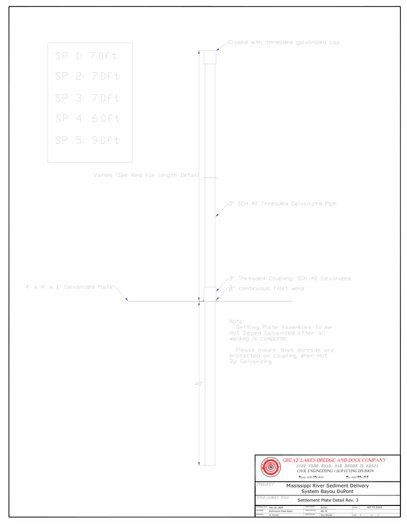
Settlement Plate

June 4, 2009 Sent via Email Serial Letter No. SGLDD-012 Mrs. Debbie Sheets P.E. ABMB Engineers, Inc. 500 Main Street Baton Rouge, LA 70801 Re: Contract No. BA-39, Mississippi River Sediment Delivery System Bayou
DuPont, Jefferson & Plaquemines Parishes, Louisiana Submittal of Settlement Plate Design
Dear Mrs. Sheets: Please find attached a drawing of the proposed settlement plate design for the project to meet the requirements of TS-7 Settlement Plates and Sheet 18 of 24 of the Plans. The upper rod is detachable as requested by the DNR and the lower rod has been extended to provide more stability. The drawing contains a table showing the proposed length for each location specified in the contract. Please review and approve the proposed design and length. If you have any questions please do not hesitate to contact me at (504) 656-0446. Sincerely, Great Lakes Dredge & Dock Company, LLC
Roy B. Woods Contracts Manager

MISSISSIPPI RIVER SEDIMENT DELIVERY SYSTEM BAYOU DUPONT STATE PROJECT NO. BA-39
JEFFERSON AND ST. BERNARD PARISHES, LOUISIANA
PROJECT COMPLETION REPORT
River Rest COE Permit