Embed Size (px)
Citation preview
NOTICE PAPER
Monday 22 July 2013 at 7:00 p.m.
Council Chamber, Prahran Town Hall(enter off Greville Street, Prahran)
RECONCILIATION STATEMENT
We acknowledge that we are meeting on the traditional land of the Boonwurrung and Wurundjeri people and offer our respects to the elders past and present. We recognise and respect the cultural heritage of this land.
PRAYER
Almighty God, we humbly beseech you, to grant your blessing on this Council, direct and prosper its deliberations to the advancement of your glory, and the true welfare of the people of the City of Stonnington. Amen.
NOTE
Council business is conducted in accordance with Part 4 Division 3 of the Meeting Procedure section of Council’s General Local Law 2008 (No 1). Some copies are available with the agenda or you can find a copy on Council’s website www.stonnington.vic.gov.au under local laws.
Page 2
Council MeetingNotice Paper22 July 2013
Order of Business and Indexa) Reading of the Reconciliation Statement and Prayer;b) Apologies;c) Adoption and confirmation of minutes of previous meeting(s) in accordance with Section 63 of
the Act and Clause 423 of General Local Law 2008 (No 1);d) Disclosure by Councillors of any conflicts of interest in accordance with Section 79 of the Act1
e) Questions to Council from Members of the Public;f) Correspondence – (only if related to council business);g) Questions to Council Officers from Councillors;h) Tabling of Petitions and Joint Letters;i) Notices of Motion;j) Reports of Special and Other Committees; - Assembly of Councillorsk) Reports by Delegates;l) General Business;
1. PLANNING APPLICATIONS........................................................................................................................... 61.1. Planning Application 0859/12 – 517 - 519 Orrong Road - King David School , Armadale –
Demolition Of Existing Building, Additions And Alterations And Construction Of A New Building For The Existing Use As An Education Centre.............................................................6
1.2. Planning Application 0878/12 - 1919 - 1933 Malvern Road, Malvern East - Construction and Use of Land for Office (as of right use) and Multi-Dwelling Development in a Commercial 1 Zone and Special Building Overlay.............................................................................................22
2. AMENDMENT C168 – NEIGHBOURHOOD CHARACTER OVERLAYS (NCO’S) - BALDWIN STREET, ARMADALE AND CLARENCE STREET, MALVERN – CONSIDERATION OF SUBMISSIONS............................................................43
3. AMENDMENT C177 – ENVIRONMENTAL SUSTAINABLE DESIGN...................................................................494. METROPOLITAN PLANNING STRATEGY AND PLANNING ZONES – UPDATE....................................................585. 2013/2014 BUDGET – LOAN PROGRAM....................................................................................................616. 2013/2014 COMMUNITY GRANTS PROGRAM...............................................................................................637. INSTRUMENT OF DELEGATION FROM COUNCIL TO ORGANISATIONAL ROLES..................................................678. STREET ART AUDIT.................................................................................................................................... 699. PEEL STREET, WINDSOR – PROPOSAL TO INSTALL PERMIT ZONE RESTRICTIONS.......................................7210. CHAPEL STREET (TOORAK ROAD TO COMMERCIAL ROAD/MALVERN ROAD), SOUTH YARRA –TRAM TRACK
REPLACEMENT WORKS – ROAD CLOSURE APPROVAL...............................................................................7611. FLOOD MANAGEMENT PLAN: CITY OF STONNINGTON AND MELBOURNE WATER.........................................8112. Stonnington Youth Leadership Program.................................................................................................86
1 Note that s.79(1)(a) of the Act requires Councillors to disclose the nature of a conflict of interest immediately before the relevant consideration or discussion.
Page 3
m) Urgent Business; andn) Confidential Business1. Special Rate Business Association Action Plans 2013/2014 …………………………….88
Page 4
ADOPTION AND CONFIRMATION OF MINUTESOF PREVIOUS MEETINGS
22 JULY 2013
RECOMMENDATION
That the Council confirms the Minutes of the Ordinary Meeting of the Stonnington City Council held on 1 July 2013 and Minutes of the Confidential Meeting of the Stonnington City Council held on 1 July 2013 as an accurate record of the proceedings.
Page 5
GENERAL BUSINESS22 JULY 2013
1. PLANNING APPLICATIONS
1.1. Planning Application 0859/12 – 517 - 519 Orrong Road - King David School , Armadale – Demolition Of Existing Building, Additions And Alterations And Construction Of A New Building For The Existing Use As An Education Centre
(Statutory Planning Manager: Alexandra Kastaniotis)(General Manager: Stuart Draffin)
PURPOSE
For Council to consider a planning application for demolition, alterations and additions to an existing building and construction of a new building to be used for the existing use of the site as an education centre at 517 - 519 Orrong Road Armadale.
Executive Summary
Applicant: SJB Planning Ward: South Zone: Residential 1Overlay: Heritage Overlay 085 (Larnook 519 Orrong Road), Incorporated
Plan Overlay Date lodged: 28/11/2012Statutory days: 209 Trigger for referral to Council:
More than 7 objections
Number of objections: 14 Objections Consultative Meeting: Yes – held on 9 May 2013 Officer Recommendation: Notice of Decision to Grant a Planning Permit
BACKGROUND
The Proposal
The plans that form part of the basis of Council's consideration were prepared by Clarke Hopkins Clarke entitled “King David School Project Chai Ve Kayam Magid Campus” Job No 11112, Plan No’s TP301, TP302, TP303, TP304, TP305, TP306, TP307, TP308, TP309, TP310, TP311, TP312, TP313, TP314, TP315, TP316, TP317, TP318 and Council date stamped 27 November 2012.
Key features of the proposal are:
Demolition of the existing two storey brick building fronting Orrong Road in front of the mansion building.
The construction of a three storey replacement building in front of the mansion building containing classrooms and associated offices and amenities. The new building would be of contemporary design with a maximum height of 9.8m finished in a mix of cladding, rendered masonry and block walls. The school logo will be applied to the eastern (front) façade.
Demolition of the structures to the south of the mansion and the construction of a new “Science Hub” building and covered deck area. The new southern addition will have a maximum height of 6m and will have a contemporary design with a high sloping roof finished in panel cladding
Page 6
GENERAL BUSINESS22 JULY 2013
A number of trees on the north east corner of the site are to be removed and replaced with new landscaping.
No changes are proposed to the existing use of the education centre including no changes to hours of operation or number of children or staff.
Plans for Consideration
Following advertising the applicant submitted a set of revised plans to address concerns raised about the accuracy of the information shown in the rear yard of 515 Orrong Road. New survey drawings were undertaken and the application plans were updated to correctly show the correct position of buildings and the private open space area of this property. The plans are again entitled “King David School Project Chai Ve Kayam Magid Campus” but updated as revision “A” and Council date stamped 22 April 2013. The plans were not formally amended but lodged as plans for consideration and therefore were not readvertised. The plans are considered in the below assessment.
Site and Surrounds
The site is the west parcel of the King David School campus on Orrong Road known as Magid Campus. Magid Campus is located on the western side of Orrong Road, 180m north of Dandenong Road. It is made up of several titles, 517 and 519 Orrong Road which is the majority of the site and 1, 3 and 5 Karbarook Avenue which are three traditional residential lots fronting Karbarook Avenue that have been annexed to the school.
Details of the physical aspects of the site are as follows:
The eastern part of the site fronting Orrong Road is developed with a two storey red brick building used for school administration and classrooms.
There is a mansion building located centrally on the site which is used for school purposes. The mansion is known as Larnook which was built in 1881 for William H Miller as one of five substantial mansions constructed between 1880 and 1888 in the block in Orrong Road between High Street and Dandenong Road. Larnook is protected by Heritage Overlay HO85. It is an A1 graded heritage building (though not included on the Victorian register). The building is of state significance for architectural reasons as a good example of an 1880’s mansion house of the pre boom period in Melbourne.
The western and southern parts of the site are developed with sports fields and play areas. The site abuts Stawell Street to the west and has an abuttal to Karbarook Avenue to the
south. A vehicle drop off is provided on site with access and egress provided from Karbarook
Avenue.
The use of the site as an Education Centre is controlled by planning permits. The Magid Campus operates under planning permit 169/84 which includes a condition that restricts the number of students to 350.
The surrounding area is developed for residential purposes. Dwellings are predominantly single or double storey on large lots. Generous and uniform street setbacks are provided and the area as a whole has a strong landscaped character created by the large street trees planted in this section of Orrong Road and the established vegetation planted in the front and rear yards of properties.
The site interfaces with adjoining properties as follows:
The site to the south at 515 Orrong Road is developed with an attic style two storey dwelling setback behind a circular front driveway. The dwelling is setback 2.2 to 2.8 metres from the
Page 7
GENERAL BUSINESS22 JULY 2013
northern boundary it shares with the subject site and it contains several north facing habitable room windows orientated towards the subject site.
The site to the north at 521 Orrong Road is developed with a two storey brick apartment building with a pitched and tilted roof. The building is setback between 2.5 and 4.5m from the southern boundary is shares with the subject site. There are a number of windows orientated towards the subject site.
On the opposite side of Orrong Road at 520 Orrong Road is the eastern part of the King David School campus. The front of this site is developed with a three storey building approved by the Minister for Planning (432/09).
Previous Planning Applications
A search of Council records indicates the following relevant planning applications:
517 – 519 Orrong Road – Magid Campus Planning Permit 169/84 was issued on 7 December 1984 for use of the land at 517-519 and
1-5 Karbarook Avenue as an education establishment. The school currently operates the western parcel in accordance with this permit. This permit was issued at the direction of the Planning Appeals Board. The matter was considered by the former City of Prahran Council on 20 August 1984 and a Notice of Decision to Grant a Permit was issued. An appeal was lodged by the residents of 515 Orrong Road against Council’s decision to grant a permit. The Planning Appeals Board upheld Council’s decision and a permit was issued. The decision required the rewording of conditions relating to secondary consents, only allowing ‘out of school hours activities’ to occur between 8am and 6pm on any school day, requiring meetings outside school hours to occur within the building known as ‘Larnook Mansion’ and requiring the access from the school to Vail Street to be closed at all times except to allow emergency vehicular access if required.
Planning Permit 255/87 for the construction of a school hall in the northwest corner of the site was withdrawn after 61 objections were received. This building had been considered by Council in its meeting on 7 September 1987 and concerns were raised with the buildings scale and height not being compatible with the area.
Planning Permit 483/97 was issued on 13 February 1987 for the development and use of a hall and classrooms. This building was to be single storey and located on the northwest corner of the site. Aerial photographs indicate that this permit has not been acted on as this part of the site is currently occupied with sports grounds.
Planning Permit 75/91 was issued on 9 May 1991 for the construction of a chain mesh fence along the Orrong Road frontage.
Planning Permit 272/91 was issued on 6 June 1991 for the construction of a fence along the rear (western) boundary adjacent to Vail Street.
Planning Permit 773/94 was issued on 6 June 1995 for alterations to the education center. This involved construction of a connection between the Larnook mansion building to the classrooms to the east. It also involved internal alterations to improve the facilities for students. No change to the operation of the education facility was sought as part of this application. Condition 5 of this permit reiterated this fact stating that the school continues to operate under permit 169/84.
Planning Permit 1119/97 was issued on 14 April 1998 for buildings and works including the construction of a general multipurpose resource centre. These works are generally located between Larnook and the building fronting Orrong Road.
Planning Permit 43/98 was issued on 14 April 1998 and allowed a variation to the approval allowed under permit 773/94.
Planning Permit 1174/98 was issued 25 November 1998 for more variations to the built form allowed by permits 773/94 and 43/98.
Page 8
GENERAL BUSINESS22 JULY 2013
Planning Permit 609/96 was issued on 15 September 2006 for demolition of several buildings, earthworks for construction of sports facilities and construction of fencing.
Planning Permit 1018/07 was refused under delegation on 8 May 2008. An application for review was made to VCAT who affirmed Council’s refusal and directed that that no permit be issued.
The permit sought to use the two campuses (517 - 519 Orrong Road and 520 Orrong Road) as an education centre and early learning centre for up to 634 students (up from 350) and 72 staff (up from 46). The proposal included the construction of two three storey buildings; one which included the early learning centre and a 300 seat auditorium at 520 Orrong Road and a replacement school building at 517 - 519 Orrong Road.
The matter as heard by the Victorian Civil and Administrative Tribunal over five days on September and December 2008. The VCAT order for the application is referenced as The King David School v Stonnington CC [2009] VCAT 558 (27 March 2009). In their decision VCAT Deputy President Dwyer and member Naylor directed that a permit should not be issued on the basis that the application did not strike an appropriate balance between the size of the school and its impacts on the surrounding community. The specific reasons why a permit was not granted is summarised in paragraphs 85, 86 and 87 of the order which is included below:
85. There is strong policy support for schools to establish and grow amongst local communities, which includes residential neighbourhoods. The consolidation of this school’s activities around Orrong and Dandenong Roads has benefits for the school and the broader community. However, there needs to be an appropriate balance struck between the size of the school and its impacts upon the surrounding community. We find this proposal has not achieved an appropriate balance.
86. In particular, the proposed building on the Minimbah campus and its facilities/activities in our view have unreasonable detrimental impacts upon the adjoining residential properties and requires redesign. This is the most significant issue requiring resolution in any new proposal for the combined Magid and Minimbah campus sites. However, it may be desirable for the school (in addressing this issue) to review its overall activities across both sites if it is to maximise its aspirations to consolidate school buildings and activities within these two sites whilst respecting the adjacent residential community. It may be that a more fundamental rethink of which activities can best be located within each campus could lead to a more effective use of both. Equally, as we have indicated, there is planning policy support for schools to locate and grow in residential areas, and the local community must expect and accept some augmentation of the school’s activities at these sites over time.
87. As we have also indicated, in achieving any future balance between the size of the school and its impacts upon the surrounding community, we find other matters should also be reviewed. These include the sunlight impact of the new building on Mr Mannix’s house; the adequacy of the ELC parking during peak periods; the arrangements for parking, drop off and pick up of the prep to year 2 students; and a review of the circular drive off Orrong Road.
The order included a specific assessment of the proposed building at the front of the Magid campus at 517 - 519 Orrong Road. The order finds (paragraphs 28 - 32) that a contemporary designed three storey building would be appropriate fronting Orrong Road
Page 9
GENERAL BUSINESS22 JULY 2013
subject to its southern elevation being designed in compliance with Standard B20 North Facing Windows.
Following the refusal of planning application 1018/07 The King David School received Commonwealth funding to construct the building at 520 Orrong Road for art and music classrooms, administration offices and multipurpose hall. This building was exempt from the requirement for a planning permit for buildings and works but a permit was still required for the use and car parking.
Planning Permit 432/09 was issued on 30 September 2010 at the direction of the Minister of Planning. This permit allowed for the use of the land for an education centre and reduction in the statutory car parking requirements.
On 18 October 2010 the school made an application under 87A to amend four conditions of the permit. The conditions related to the use of land for enrolled students (condition 3), number of students and staff (condition 5), after school activities (non students) (condition 13) and after school activities for students (condition 16). VCAT refused the amendment to conditions 13 and 16 but amended conditions 3 and 5. The amended permit allows for a maximum of 350 Students on both the Minimbah (520 Orrong Road) and Magid Campus (517 - 519 Orrong Road) at any one time.
Council is currently assessing an application for The King David School at the Dandenong Road campus. Planning application 858/12 proposes partial demolition (373-375 Dandenong Road only), buildings and works associated with Section 2 uses (Education Centre and Kindergarten), use of the land for a Kindergarten and alteration to access to a road in a Road Zone, Category 1. Specifically the application seeks approval for the demolition of the existing building at 375 Dandenong Road, front forecourt, fencing and vehicular gates and construction of a two storey building at 1 Denbigh Road and for use as a Kindergarten and construction of a new underground car park accommodating 49 spaces for the Education Centre (approved by Planning Permit 358/03) and the Kindergarten.
The Title
The site is made up of five titles. None of these are affected by any covenants or easements.
Planning Controls
The following controls/permit triggers are considerations for this application:
ZoneClause 32.01 - Residential 1Pursuant to Clause 32.01.06 a permit is required for buildings and works associated with a section 2 use (Education Centre)
OverlaysClause 43.01 - Heritage OverlayPursuant to Clause 43.01 a permit is required to demolish a building, construct a building or carry out works.
Clause 43.03 - Incorporated Plan Overlay (Schedule 1) Pursuant to Clause 43.03 a permit must not be granted to use or subdivide land, construct a building or construct or carry out works until an incorporated plan has been incorporated into this scheme.
Page 10
GENERAL BUSINESS22 JULY 2013
This does not apply if a schedule to this Overlay specifically states that a permit may be granted before an incorporated plan has been incorporated into the scheme.
Schedule 1 of the Incorporated Plan Overlay includes a provision that a permit may be granted before an incorporated plan has been incorporated into the scheme.
Relevant Planning Policies
Clause 11.04 Metropolitan MelbourneClause 15.01 Urban EnvironmentClause 15.02 Sustainable DevelopmentClause 19.02 Education Facilities Clause 21 Municipal Strategic StatementClause 22.02 Urban Design PolicyClause 22.06 Residential Character, Amenity and Interface PolicyClause 22.07 Discretionary Uses in Residential Areas PolicyClause 22.16 Institutional Uses Policy
Advertising
The application has been advertised pursuant to Section 52 of the Planning and Environment Act 1987 by sending notices to the owners and occupiers of adjoining land and by placing 1 sign on the site. The public notification of the application has been completed satisfactorily.
The site is located in South Ward and objections from fourteen (14) different properties have been received. The objections can be summarised as follows: Traffic / Congestion with dropping off children Parking Noise There is no master plan for the school Constant number of applications / no certainty of the future Visual bulk Increased intensity The proposed three storey building is not sympathetic to the area Views Overlooking Loss of light Ground stability No visual break provided between buildings Impact on trees Landscaping not provided
A Consultative Meeting was held on 9 May 2013.The meeting was attended by Councillors Ullin and Hibbins, representatives of the applicant, objectors and a Council planning officer. The meeting did not result in any changes to the plans.
Referrals
Urban Design
Council’s Urban Designer has three key concerns about the application. The first concern relates to the absence of any long term development strategy for the school. Council’s Urban Designer has provided comments that ideally this proposal (and all future proposals) would be assessed in the context of a long term development strategy for the campus.
Page 11

GENERAL BUSINESS22 JULY 2013
The second issue relates to the proposed setback of the new building from the southern boundary. Council’s Urban Designer is of the opinion that the setback proposed crowds the residential interface and does not provide for an appropriate landscape buffer with its neighbour.
The third issue is about the loss of the existing two storey building for a new three storey building. Council’s Urban Designer does not consider the design of the new building achieves the distinctive qualities of the existing 2 storey red brick building. The impact of this will be reinforced by the recent construction of the performing arts building on the opposite side of the street.
Heritage
Comments have been provided by Council’s Heritage Advisor that the works raise no heritage concern. The building proposed for demolition is not subject to the heritage overlay control and most of the new building envelope sits outside of the cartilage of HO85. The works inside HO85 are relatively minor and would not detract from the appearance and setting of Larnook’s significant Italianate façade. It is also noted that the heritage impacts do not seem to have been an issue in the VCAT hearing for the previous application.
Infrastructure
No particular concerns have been raised from Council’s Infrastructure Unit. It has been recommended that should a permit be issued a condition be included for a report for the legal point of discharge be obtained from Council and a drainage design for the development be prepared by a suitably qualified engineer. The installation of water tanks for re-cycling and to address WSUD have also been encouraged.
Landscape
Council’s Arborist has noted that the application proposes the removal of several Acmena smithii (Lilly Pillys) but is satisfied that the prospered planting of 13 Pyrus calleryana (Capital Pear) trees that are shown on the submitted Landscape Plan will be a sufficient offset for the loss of these trees. It has been recommended that a Tree Management Plan is required by a condition to ensure the Jacaranda and Sweet Gum tree (located adjacent to the proposed site in the front setback of 515 Orrong Road) maintain their health during construction. Greater detail is required for the two trees to be planted in the raised planters in the southern courtyard.
KEY ISSUES
Education Centre Use
As stated in the history section above, The Magid Campus of the King David School is governed by Planning Permit 169/84. This permit includes conditions that restrict the number of students to 350. This application does not propose any changes to the number of students or staff. The planning report submitted with the application note that the works constitute necessary upgrades to what is a rundown school building. The changes are not proposed to allow for an intensification of the use but rather an upgrade of the facilities for the existing education centre.
A number of objections have been received raising concerns about the possible intensification of the use that this application may allow in the future. This has not been put forward as part of this application and therefore is not considered in the assessment of this application. The school currently operates with strict controls over the number of students permitted as controlled by planning permit 169/84. This application will not change these controls governed by this existing permit. Nevertheless, in line with other planning permits issued after 169/84 (such as 773/94) it is
Page 12
GENERAL BUSINESS22 JULY 2013
recommended that should a permit be issued a condition is included reiterated that the school continues to operate under permit 169/84.
Strategic Justification
State Policy
The most relevant State Planning Policy is Clause 19.02-2 Education facilities. The objective of this Clause is ‘to assist the integration of education facilities with local and regional communities.’ The following strategies are identified in order to deliver the State objective:
Locate primary education facilities to maximise access by walking and cycling Locate secondary and tertiary education facilities in areas which are highly accessible to
public transport Locate tertiary education facilities within or adjacent to activity centres In planning for the location of education facilities, consideration should be given to
demographic trends, the existing and future demand requirements and the integration of facilities into communities
Ensure areas near to education facilities, adjoining streets and access ways are designed to encourage safe bicycle and pedestrian access
Develop libraries as community based learning centres
The proposed seeks to improve the facilities at the existing school to ensure it better responds to the community’s needs. The school is located within close proximity to Dandenong Road a major transport route which has excellent public transport services.
Local Policy
While Local Planning Policy encourages the preparation of master plans for all institutions located in residential areas (Clause 22.16), a planning permit may be granted for buildings and works pursuant to the Incorporated Plan Overlay. As such, this application can be made and assessed on its merits. In addition, Local Planning Policy encourages new buildings and works to maintain and enhance the residential character of the area and offer a high standard of urban design and construction. It is considered that the proposed additions to the school are of a high standard of design that would sit comfortably within the Orrong Road streetscape.
For these reasons, it is considered that the proposal is consistent with the strategic direction outlined by the Stonnington Planning Scheme. The specific built form and amenity impacts are considered in greater detail in the assessment below.
Heritage
The Magid Campus of the King David School (517 - 519 Orrong Road) is protected by a Heritage Overlay. The citation for this Heritage Overlay (HO85 - Larnook 519 Orrong Road) relates to the Larnook mansion building which is an A1 graded building of state significance (though not included in the Victorian Heritage Register). The building is significant for architectural reasons as a good example of an 1880’s mansion house of the pre boom period in Melbourne. The citation relates directly to the mansion building itself and does not directly include the rest of the Magid campus site that surrounds the Larnook mansion. The citation includes specific comments about the key views of the mansion building are from Karbarook Avenue and Stawall Street.
The application was referred to Council’s Heritage Advisor who has provided comments that the works raise no heritage concern. The comments that have been provided note that the building proposed for demolition is not subject to the heritage overlay control and most of the new building
Page 13
GENERAL BUSINESS22 JULY 2013
envelope sits outside of the cartilage of HO85. The referral comments surmise that the works inside HO85 are relatively minor and would not detract from the appearance and setting of Larnook’s significant Italianate façade. It is further noted in the comments that the heritage impacts do not seem to have been an issue in the VCAT hearing for the previous application.
In light of the referral comments from Council’s Heritage Advisor the proposal would not adversely affect the significance of the heritage place.
Built Form
The 2009 VCAT order (The King David School v Stonnington CC [2009] VCAT 558 (27 March 2009)) included specific consideration of the built from impact of the three storey buildings proposed to front Orrong Road. Although ultimately Council’s position of refusal for the 2009 application was upheld by VCAT the order provides general support for the development of a three storey building on the Magid campus. This built form impact is considered in paragraphs 23 - 26 of the order. In summary it was found that the proposed buildings fronting Orrong Road where of a higher quality than the existing building and would make a positive contribution to the built form of the area. Paragraph 26 of the order summarises the consideration of built form.
Mr McGauran described the proposed buildings as ‘talking to each other’ and saw a benefit in a design outcome where the school’s presence is affirmed on both sides of Orrong Road. We agree new buildings on each side of Orrong Road will contribute to coherence in the streetscape. Mr McGauran stated the buildings acknowledge the surrounding context in a contemporary way, particularly given that Orrong Road is not a streetscape of striking coherence. He described the proposal as containing highly transparent, permeable and reflective materials that compliment the neighbourhood character. We agree with Mr McGauran the proposed buildings are of a higher quality than the existing buildings to be demolished on each campus. They are institutional buildings, but we are of the view the front façade design, the setbacks around the front of each building, and the landscaping opportunities with these setbacks are respectful of the existing streetscape character, and will make a positive contribution to the built form of the area.
The new application for the three storey building fronting Orrong Road has a similar form and design to that which was proposed in the 2009 application. The new building is the same scale and of a contemporary design that is similar to the earlier application. The form and design of the proposed building also matches the recently constructed building on the opposite side of the street at the Minimbah campus, the use of which was approved by Planning Permit 432/09.
As detailed in the referral section above, Council’s Urban Designer is of the opinion that the new building does not achieve the distinctive qualities of the existing 2 storey red brick building. However, the built form issue has already been tested at VCAT (for an almost identical building) where it was found that a contemporary styled three storey building similar to that which is now proposed would make a positive contribution to the built form of the area. Moreover, the building at 520 Orrong Road has now been constructed following the planning permit issued at the direction of the Minister of Planning. The building proposed at the Magid campus would reflect the scale of buildings that can be now found in this section of the street and (as highlighted in the previous VCAT order) the two buildings on either side of the street would contribute to coherence in the streetscape. On the basis of the previous VCAT order the proposed three storey building fronting Orrong Road is an appropriate design response that would provide an acceptable fit with the character of the surrounding neighbourhood and the Orrong Road streetscape.
The application also proposes the construction of a single storey addition to the south of the mansion for a new “Science Hub” with a covered deck area. The new southern addition will have a maximum height of 6m and will have a contemporary design with a high sloping roof finished in
Page 14
GENERAL BUSINESS22 JULY 2013
panel cladding. Given the low height of the southern addition and its internal location within the site, this part of the proposal raises no built form concerns. Council’s Urban Designer has not raised any concerns about the “Science Hub” addition.
Amenity Impacts
While clause 55 is not applicable to the assessment of the proposed education centre additions, it provides a useful guide in considering the impact of the proposal upon adjoining residential properties. The below assessment therefore considers the application against the relevant amenity standards of Clause 55.
Visual Bulk and Daylight to Existing Windows
South
The adjacent site to the south at 515 Orrong Road is developed with an attic style two storey dwelling setback behind a circular front driveway. The dwelling is setback 2.2 to 2.8 metres from the northern boundary it shares with the subject site and it contains several north facing habitable room windows orientated towards the subject site.
The 2009 VCAT order provided an assessment of the amenity impacts of a proposed building fronting Orrong Road. It was noted that the proposal would replace an existing building but Deputy President Dwyer and Member Naylor considered a setback in compliance with B20 (North Facing Windows) should be provided between the new building and the 515 Orrong Road residential property. Paragraphs 31 and 32 summarise the finding of VCAT:
31. Mr McGurn pointed out the new building at 517 Orrong Road has been designed to comply with standard B17 rather than B20, which means modifications are required to the top (third) floor as the wall height is about 1.2 metres higher than it should be. Mr McGurn explained this building contains a parapet that is quite high and could be removed to achieve standard B20 compliance without any significant impact upon the proposed building. We find this change is desirable to provide adequate solar access to Mr Mannix’s north facing windows, and should be incorporated into any future proposal.
32. Whilst the proposed building is taller than the existing building [12], we are of the opinion it will provide a good level of amenity to Mr Mannix’s property. There is a larger setback between Mr Mannix’s house and the proposed building, which creates opportunities on both sides of the property boundary for the planting of new vegetation, including canopy trees[13]. The first and second floor windows have obscure glazing or sill heights to 1.7 metres above the floor levels to limit direct overlooking. This accords with the relevant standard in clause 55 and is an improvement upon the existing situation where first floor windows have a direct view of Mr Mannix’s property. The windows and walls facing Mr Mannix’s property are all proposed to be acoustically treated, which is another improvement upon the existing situation. Subject to changing the height of the top floor to provide adequate solar access to Mr Mannix’s north facing windows, we are satisfied the design of the proposed new building at 517 Orrong Road is appropriate.
The new application has been designed with a setback that generally provides a B20 (North Facing window) setback. The section diagram A-A (Plan No TP310) shows the three storey building is setback 4.65m from the boundary which is marginally short of the 5.0m setback required by Standard B20. In this instance the VCAT order is quite clear that a setback in line with B20 should be provided. It is therefore recommended that should a permit be issued a condition is included
Page 15
GENERAL BUSINESS22 JULY 2013
which requires all of the southern walls of the building be setback in line with that suggested by Standard B20.
Council’s Urban Designer raised concerns that the setback of the building from the southern boundary is not satisfactory and would crowd the residential interface to this property. However, the setback proposed has been enlarged from the setback previously provided in the earlier application (1018/07). The earlier application proposed a building fronting Orriong Road with a maximum setback of 1m from the southern boundary with the rear part of the building built directly to the boundary. The VCAT order did not raise any particular concerns with the setback of the lower level but only the requirement for the building to be designed in accordance with Standard B20 (North Facing Windows). The new application has increased the setback from the southern boundary with a minimum 1.69m now to be provided. In light of the precious VCAT order the larger 1.69m setback is considered a sufficient separation of the new building from the residential property at 515 Orrong Road. To help further soften the impact of the proposed building landscaping could be provided within the 1.69m setback. Should a permit be issued it is recommended that the landscape plan be amended to show screen planting along the southern boundary through a condition of the permit.
North
The site to the north at 521 Orrong Road is developed with a two storey brick apartment building with a pitched and tilted roof. The building is setback between 2.5 and 4.5m from the southern boundary it shares with the subject site. There are a number of windows orientated towards the subject site.
The proposed Orrong Road addition has a height of 9.6m setback 5.09m from the boundary. The setback provided complies with the B17 setback which suggests that a 9.6m high wall be setback 4.69m from the boundary. The setback provided also satisfies the B19 (Daylight to Existing Windows) standard. The 9.6m high northern wall of the building is proposed with a minimum 7.6m setback from the closest windows of 521 Orrong Road. B19 suggests that 9.6m high wall should be setback 4.8m from habitable room windows. Compliance with both B17 and B19 would ensure that the northern elevation of the building would not have an unreasonable built form impact on the adjoining residential property at 521 Orrong Road.
Science Hub Addition
The science hub addition is proposed to have a height of 6m setback 9.6m from the eastern boundary - 515 Orrong Road. The setback provided easily complies with the B17 (Side and Rear Setback) standard which suggests a 6m high building be setback 1.72m from the boundary.
Overshadowing
The application plans include a number of shadow diagrams (Plan no’s TP313, TP314 and TP315) illustrating the potential overshadowing impact of the new additions. The shadow diagrams show that there will be some additional overshadowing of the private open space area of 515 Orrong Road particularly in the afternoon. However, the shadow diagrams indicate that overshadowing would comply with standard B21 that is an area in excess of 40sqm would still be able to receive a minimum of 5 hours of sunlight between 9am and 3pm on the 22 September. On this basis the level of overshadowing is considered reasonable.
Overlooking
South
Page 16
GENERAL BUSINESS22 JULY 2013
Windows are proposed on the first and second floor of the new addition. However, the plans generally show that the upper level windows are designed with either sill heights of 1.7m or screening below 1.7m. The provision of sill heights of 1.7m and screening materials below 1.7m would ensure that the adjacent residential property at 515 Orrong Road is protected from unreasonable overlooking. In the middle of the building near the feature panel cladding there appears to be a series of windows that do not include notations that they are to be screened. It is therefore recommended that to ensure all of the southern elevation is designed with appropriate screening, a condition is included on any permit for all windows along the southern elevation have screens or obscure glazing 1.7 m above the finished floor level and with no more than 25 percent transparency.
North
A series of windows are also proposed for the upper levels of the northern elevation. Unlike the southern elevation the windows to the first and second floor do not have sill heights of 1.7m. The windows on both the first and second floor have a horizontal distance less than 9m from habitable room windows of the adjacent residential building at 521 Orrong Road. The plans show that sunshades are to be provided to these windows but these do not appear to be designed to prevent overlooking of the adjacent residential property.
The planning report submitted with the application submits that screening measures are not requiring to the northern elevation as this was not a matter VCAT raised as a concern in the earlier application and that screen planting on the northern boundary protects the adjacent site at 521 Orrong Road from overlooking. The screen planting is not considered a satisfactory measure to ensure the adjacent site is protected from unreasonable overlooking and it is therefore recommended that should a permit be issued a condition is included requiring all north facing windows on the first and second floor that are located less than 9m from habitable room windows of 521 Orrong Road be redesigned with screens or obscure glazing 1.7 m above the finished floor level and with no more than 25 percent transparency.
Landscaping
Council’s Arborist is satisfied that the proposed planting of 13 Pyrus calleryana (Capital Pear) trees (as shown on the submitted Landscape Plan) will be a sufficient offset for the loss of trees associated with the building works. Greater detail has been asked about the two trees to be planted in the raised planters in the southern courtyard. It is therefore recommended that a condition be included requiring the submission of a Landscape plan that is generally in accordance with that which has been submitted with the application but updated to provide greater details about the two trees proposed in the raised planters and details of screen planting along the southern boundary (as detailed in the assessment of amenity impact section above).
Council’s Arborist has also recommended a condition requiring a Tree Management Plan to ensure the Jacaranda and Sweet Gum trees maintain their health during construction. It is recommended this is included should a permit be issued.
Infrastructure
Council’s Infrastructure Unit has recommended the following conditions need to be included should a permit be issued:
A report for the legal point of discharge be obtained from Council A drainage design for the development to be prepared by a suitably qualified engineer.
Page 17
GENERAL BUSINESS22 JULY 2013
It is recommended that these should be included as conditions should a permit be issued.
Objections
In response to the grounds of objection not already discussed in the report, the following comments are made:
Traffic / Congestion / Parking
A number of objections have raised concerns about the traffic and parking impacts that would be created by the proposal. However, as noted above this application does not propose any additional students and therefore would not create any additional traffic or parking impact than that of the existing situation.
Noise
Objections have been received about noise associated with the use of the new buildings. It is noted that the submitted plans show that the new buildings will be acoustically treated and as such will be a significant improvement from the existing situation.
Views
Loss of views is not a relevant planning consideration.
Ground Stability
Construction impacts is a matter that will be considered as part of building and local laws permit requirements and thus are not considered within the planning permit process.
Human Rights Consideration
This application has been assessed in accordance with the requirements of the Planning and Environment Act 1987 (including the Stonnington Planning Scheme), reviewed by the State Government and which complies with the Victorian Charter of Human Rights and Responsibilities Act 2006.
CONCLUSION
Having assessed the application against the relevant planning controls, it is recommended that the proposal be supported for the following reasons: The proposal will improve existing facilities to ensure it better responds to the community’s
needs. The application does not seek any further intensification of the Education Centre Use or any
changes to the operation of the school that is strictly controlled by existing planning permits. The proposed works raise no heritage concern as the works that affect Larnook mansion are
relatively minor and would not detract from the appearance and setting of Larnook’s significant Italianate façade.
The three storey building fronting Orrong Road is an appropriate design response that would provide an acceptable fit with the character of the surrounding neighbourhood and the Orrong Road streetscape.
Subject to the southern elevation of the Orrong Road building being setback in accordance with standard B20 and appropriate screening provided to the upper level widows on the northern elevation, the development would not create any unreasonable amenity impacts on adjoining residential property.
Page 18
GENERAL BUSINESS22 JULY 2013
RECOMMENDATION
That a Notice of Decision to Grant a Planning Permit No 859/12 for the land located at 517 - 519 Orrong Road Armadale be issued under the Stonnington Planning Scheme for demolition, alterations and additions to an existing building and construction of a new building to be used for the existing use of the site as an education centre subject to the following conditions:
1. Before the development starts, three (3) copies of plans drawn to scale and fully dimensioned, must be submitted to and approved by the Responsible Authority. The plans must be generally in accordance with the advertised plans Council date stamped 27 November 2012 but modified to show:
a) The correct details of the adjacent building and private open space area at 515 Orrong Road as depicted on the Revision A plans submitted to Council as plans for consideration, Council date stamped 22 April 2013.
b) The southern elevation of the building fronting Orrong Road redesigned so that all parts of the southern elevation are setback to comply with Standard B20 (North Facing Windows).
c) All north facing windows on the first and second floor of the Orrong Road building designed with fixed screens or obscure glazing 1.7 m above the finished floor level with no more than 25 percent transparency to the satisfaction of the Responsible Authority.
d) All south facing windows on the first and second floor of the Orrong Road building designed with fixed screens or obscure glazing 1.7 m above the finished floor level with no more than 25 percent transparency to the satisfaction of the Responsible Authority.
e) Any changes required by condition 5.
2. The development allowed by this permit and shown on the drawings and/or schedules endorsed to accompany the permit shall not be amended for any reason without the consent of the Responsible Authority.
3. The use of the site as an education centre continues to operate under Planning Permit 169/84.
4. Concurrent with the endorsement of plans, a landscape plan to be prepared by a landscape architect or suitably qualified or experienced landscape designer, must be submitted to and approved by the Responsible Authority. The Landscape Plan must be similar to that which was submitted with the application but modified to show:
Details (including soil volume) of the two trees to be planted in the raised planters in the southern courtyard. Screen planting along the southern boundary between the new Orrong Road building and 515 Orrong Road. 5. Concurrent with the endorsement of development plans a Tree Management Plan
prepared by a suitably qualified arborist must be submitted to and approved by the Responsible Authority. When approved, the Tree Management Plan will form part of this permit and all works must be done in accordance with the tree management plan.
The Tree Management Plan must detail measures to protect and ensure the viability of the Jacaranda mimosifolia (Jacaranda) near the eastern boundary and the Liquidambar styraciflua (Sweet Gum) located adjacent to the proposed site in the front setback of 515 Orrong Road.
Page 19
GENERAL BUSINESS22 JULY 2013
Without limiting the generality of the Tree Management Plan it must have at least three sections as follows:a) Pre-construction – details to include a tree protection zone, height barrier around
the tree protection zone, amount and type of mulch to be placed above the tree protection zone and method of cutting any roots or branches which extend beyond the tree protection zone.
b) Pre-construction works and any root cutting must be inspected and approved by the Parks Unit. Removal of protection works and cessation of the tree management plan must be authorised by the Parks Unit.
c) During-construction – details to include watering regime during construction and method of protection of exposed roots.
d) Post-construction – details to include watering regime and time of final inspection when barrier can be removed and protection works and regime can cease.
6. Prior to occupation, the landscaping works as shown on the endorsed plans must be carried out and completed to the satisfaction of the Responsible Authority. Landscaping must then be maintained to the satisfaction of the Responsible Authority, including that any dead, diseased or damaged plants are to be replaced.
7. All services to the subject land and buildings approved as part of this permit must be provided underground to the satisfaction of the Responsible Authority.
8. Outdoor lighting must be designed, baffled and located to the satisfaction of the Responsible Authority to prevent any adverse effect on adjoining land.
9. All plant and equipment (including air-conditioning units) shall be located or screened so as to minimise visibility from any of the surrounding footpaths and from overhead views and shall be baffled so as to minimise the emission of unreasonable noise to the environment in accordance with Section 48A of the Environment Protection Act 1970 to the satisfaction of the Responsible Authority. Ventilation systems must be designed and installed in accordance with relevant Australian Standards.
10. Prior to occupation, all screening devices designed to limit overlooking herby approved must not have more than 25% openings or they must be of solid translucent panels, permanent, fixed and durable and designed and coloured to blend in with the development to the satisfaction of the Reasonable Authority.
11. A report for the legal point of discharge must be obtained from Council and a drainage design for the development must be prepared by a suitably qualified Engineer in accordance with that report prior to a building permit being issued. The drainage must be constructed in accordance with the Engineer’s design.
12. This permit will expire if one of the following circumstances applies:
a) The development is not started within two years of the date of this permit. b)The development is not completed within four years of the date of this permit.
The Responsible Authority may extend the periods referred to if a request is made in writing before the permit expires or within three months afterwards.
Notes:
Page 20
GENERAL BUSINESS22 JULY 2013
This property is located in a Heritage Overlay and planning permission may be required to demolish or otherwise externally alter any existing structures. External alterations include paint removal and any other form of decoration and works, but does not include re-painting an already painted surface.
This permit does not constitute any authority to carry out any building works or occupy the building or part of the building unless all relevant building permits are obtained.
Page 21
GENERAL BUSINESS22 JULY 2013
1.2. Planning Application 0878/12 - 1919 - 1933 Malvern Road, Malvern East - Construction and Use of Land for Office (as of right use) and Multi-Dwelling Development in a Commercial 1 Zone and Special Building Overlay
(Statutory Planning Manager: Alexandra Kastaniotis)(General Manager: Stuart Draffin)
PURPOSE
For Council to consider a planning application for construction and use of land for office (as of right use) and multi-dwelling development in a Commercial 1 Zone and Special Building Overlay at 1919-1933 Malvern Road, Malvern East.
Executive Summary
Applicant: Hurstmon Pty LtdWard: EastZone: Commercial 1 ZoneOverlay: Special Building OverlayDate lodged: 28/11/2012Statutory days: (as at council meeting date)
77
Trigger for referral to Council:
Councillor Call up
VCAT Hearing Date 5 August 2013Number of objections: 17 objections from 12 different propertiesConsultative Meeting: No Officer Recommendation: Advise VCAT, the applicant, and all objectors that had an appeal
not been lodged, Council would have issued a Refusal to Grant a Planning Permit
BACKGROUND
The Proposal
The plans that form part of the basis of Council's consideration were prepared by Demaine Architects and are known as Drawing No’s: TP00 Rev A – TP701 RevA and are Council date stamped 21 June 2013. These are VCAT amended plans. Specific details of the proposal are as follows:
Construction of a five storey building over two basement levels. The building is technically 6 storeys given that the basement projects more than 1.2 metres above natural ground level in some locations.
The lower basement comprises 48 office car parking spaces and an office storage area. The upper basement comprises 31 office car parking spaces and14 resident spaces. The ground level car parking area comprises 13 resident car parking spaces, 2 disabled car
parking spaces a waste area, a bicycle area accommodating 16 bicycle spaces, apartment storage and a shower and change area.
Access to the ground level car park is proposed via the rear laneway and access to the basement level is proposed via the existing crossover on Hurstmon Street.
The ground level comprises 699sqm of office space, the apartment entry and the ground level car park.
The first floor comprises 1, 578 sqm of office floor space.
Page 22
GENERAL BUSINESS22 JULY 2013
The second floor level comprises 11 apartments, with 8 x 2 bedroom dwellings plus study, 2 x 2 bedroom dwelling and 1 x 3 bedroom dwelling plus study. It is noted that given the size of the studies proposed, they would not be considered additional bedrooms.
The third floor level comprises 10 dwellings, with 2 x 1 bedroom dwelling, 1 x 2 bedroom dwelling, 6 x 2 bedroom dwellings plus study and 1 x 3 bedroom dwelling plus study. One of the 2 bedroom dwellings (with study) and the 3 bedroom dwelling can be considered a three bedroom and four bedroom dwellings respectively given the size of the studies afforded to them.
The fourth level comprises a deck area and open plant area. The proposed building provides a street wall height of between 9.3 metres and 11.7 metres
to Malvern Road and a street wall height of between 9.4 metres and 12.1 metres to Hurstmon Street.
The overall building height is 17.3 metres. The building will have a traditional architectural expression with the use of filtering
colonnades and a landscape edge. A substantial amount of glazing is proposed and finishes of render with a mix of colour finishes is proposed. A flat roof form is proposed.
Site and Surrounds
The site is located on the north-eastern side of Malvern Road in the Darling Village Neighbourhood Activity Centre. The land is zoned Commercial 1 and is located approximately 90m south west of Darling Railway Station. The site has the following significant characteristics:
The land is regular in shape. It has a frontage of approximately 53m, an average depth of approximately 37m and a total site area of approximately 1975sqm.
The land was previously divided into 4 separate titles and occupied by separate buildings. The land is now consolidated into one lot and is largely vacant with the exception of a double storey office building on the north western corner of the site. Vehicle parking is provided within a basement car park that is accessed from an existing crossover on Hurstmon Street.
A laneway runs along the rear of the site and provides access to the rear of the subject site as well as properties fronting Malvern Road and Illowa Street.
Land to the north east is zoned Residential 1 and contains a single storey detached dwelling which fronts Hurstmon Street.
Land opposite the site on the far side of Malvern Road is zoned Commercial 1 and comprises a row of single storey shops/cafes, a double storey building in use as the ‘Australian Breastfeeding Association’ and a four storey building comprising a restaurant at ground level and apartments at the upper levels.
Opposite the site, on the far side of Hurstmon Street, land is zoned Commercial 1 and contains a three storey office building.
To the south, is a two storey building fronting Malvern Road. This building is in use as an office at the front with the rear part of the building in use as a residence. Habitable room windows at the ground and first floor level face the subject site.
Previous Planning Application(s)
A search of Council records indicates that there are no relevant previous planning applications for this site.
The Title
The site is described as Plan of Consolidation PC374150F. No covenants affect the land. The applicant has signed a declaration to this effect. A 1.83 metre wide easement affects the site. No works are proposed over this easement.
Page 23
GENERAL BUSINESS22 JULY 2013
Planning Controls
The following controls/permit triggers are considerations for this application:
Zone
Clause 34.01 Commercial 1 ZonePursuant to Clause 34.01-1 a permit is required to use the land for dwellings and to construct a building or construct or carry out works.
Pursuant to draft Clause 34.01-1 ‘Office’ and ‘Accommodation’ are section 1 uses and do not require a planning permit. ‘Dwelling’ is situated under ‘Accommodation’ in the nesting diagram at Clause 75.
Overlay
Clause 44.05 Special Building OverlayPursuant to Clause 44.05-1 of the Stonnington Planning Scheme, a permit is required to construct a building or construct or carry out works.
Particular Provisions
Clause 52.06 – Car ParkingPursuant to Clause 52.06-2 prior to a new use commencing or a new building being occupied, the car spaces required under Clause 52.06-5 must be provided on the land or as approved under Clause 52.06-3 to the satisfaction of the Responsible Authority.
Pursuant to Clause 52.06-3 a permit may be granted to reduce (including reduce to zero) the requirement to provide the number of car parking spaces required under this clause.
The table at Clause 52.06-5 specifies the following requirements for car parking: 1 car parking space to each one or two bedroom dwelling; 2 car parking spaces to each three or more bedroom dwelling; 1 visitor car space to every five dwellings where there are more than five dwellings on a
lot; and 3.5 spaces to each 100sqm of net floor area of an office.
Based on the requirements of Clause 52.06-5 the combined use requires 107 car parking spaces. That is 24 resident spaces, 4 resident visitor spaces and 79 office spaces. The breakdown is as follows:
Office (2277sqm): 79 car parking spaces 1 x 4 bed: 2 car parking space 2 x 3 bed: 4 car parking spaces 16 x 2 bed: 16 car parking spaces 2 x 1 bed: 2 car parking spaces Resident visitor – 4 spaces
The development proposes 108 car spaces, that is: 79 office spaces in the lower and upper basement
Page 24
GENERAL BUSINESS22 JULY 2013
29 resident parking spaces (including 2 disabled spaces) in the upper basement and ground level car park
It is noted however, that the allocation of apartment car parking and visitor car parking has not been detailed.
Clause 52.34 – Bicycle FacilitiesPursuant to Clause 52.34-1 bicycle facilities should be provided in accordance with the requirements at Clause 52.34-3 and 52.34-4. A permit may be granted to vary reduce or waive these requirements
The table at Clause 52.34-5 specifies the following requirements for the provision of bicycle spaces
In developments of four or more storeys 1 bicycle space for every 5 dwellings (resident space)
In developments of four or more storeys 1 bicycle space for every 10 dwellings (visitor space)
1 space to each 300sqm of leasable floor area for staff and 1 space to each 1000sqm of visitors
The development proposes the provision of 16 bicycle spaces. Based on the requirements of Clause 52.06-5 the combined uses requires 16 bicycle spaces; that is 4 resident spaces, 2 resident visitor spaces, 8 staff spaces and 2 office visitor spaces
Clause 52.35 – Urban Context Report and Design Response for residential development of four or more storeys. Pursuant to Clause 52.35-1 an application for a residential development of four or more storeys must be accompanied by:
An urban context report A design response
This has been provided satisfactorily.
Relevant Planning Policies:
Clause 11.01 Activity CentresClause 11.04 Metropolitan MelbourneClause 15.01 Urban EnvironmentClause 15.02 Sustainable DevelopmentClause 16.01 Residential DevelopmentClause 18.01 Integrated TransportClause 21 Municipal Strategic StatementClause 22.02 Urban Design PolicyClause 22.05 Residential Development in Commercial Areas PolicyClause 22.06 Residential Character, Amenity and Interface PolicyClause 22.09 Retail Centres PolicyClause 22.12 Traffic PolicyClause 22.13 Parking Policy
Amendment C161This is an update to the existing Local Planning Policy Framework, and includes a new Municipal Strategic Statement (MSS), and the deletion of a number of local policies. Of relevance to this application, the Urban Design Policy, Residential Development in Commercial Areas Policy,
Page 25
GENERAL BUSINESS22 JULY 2013
Residential Character, Amenity and Interface Policy, Retail Centres Policy, Traffic Policy and Parking Policy will be deleted. The policy positions of these deleted items will be included within the new MSS.
The amendment has been exhibited, and the panel report has been recently released. The panel were generally supportive of the amendment subject to a number of changes. Those changes have been recently considered by Council who have adopted a modified version of the panel recommendations.
Although the amendment is a major change to the Planning Scheme, it is considered that the principal assessment criteria relating to this application are still largely unchanged given that the site is still situated within a Neighbourhood Activity Centre in the existing and proposed Strategic Framework Plan.
Advertising
The original application was advertised pursuant to Section 52 of the Planning and Environment Act 1987 by sending notices to the owners and occupiers of adjoining land and by placing three signs on the site. The public notification of the application has been completed satisfactorily.
Council has received 17 objections from 12 different properties and they can be summarised as follows:
Overlooking Character Traffic Flooding Bulk Safety Height Narrow laneway Overdevelopment Landscaping Does not comply with Clause 22.02 Does not comply with Clause 22.06 Design of entry Lack of streetscape integration No landscape plan Inappropriate Waste Management Plan Incorrect shadow drawings Damage during building construction Noise Inequitable development rights
The application for review has attracted 2 statements of grounds. One from 1 Hurstmon Street and one from 2/1864 Malvern Road.
Referrals
Infrastructure
Council’s Drainage Engineer assessed the advertised plans (Council date stamped 8 February 2013). The comments received can be summarised as follows:
Page 26
GENERAL BUSINESS22 JULY 2013
It seems that the physical ROW at the rear is partially on the title for this property. The one issue of concern that Infrastructure have with this application is that this physical ROW which is shown on Council’s Road Register as being a Council road, remains a Council road. The basic layout of the development facilitates the above and will not need to be amended.
Could you please place a condition on the permit stating that a report for the legal point of discharge must be obtained from Council and a drainage design for the development must be prepared by a suitably qualified Engineer in accordance with that report prior to a building permit being issued. The drainage must be constructed in accordance with the Engineer’s design. Please do not state drainage design to satisfaction of Council, that is the responsibility of the relevant building surveyor to check and approve.
Could you place a condition that the existing footpath levels at the property line must not be altered in any way (to facilitate the basement ramp).
Could you place a condition requiring that the owner must at their cost remove all vehicular crossings made redundant by the development and must reinstate the footpath, nature strip and kerb under the supervision and to the satisfaction of Council.
Melbourne Water
Melbourne Water assessed and provided comments on the advertised plans (Council date stamped 8 February 2013). The comments received are summarised as follows:
Melbourne Water, pursuant to Section 56 (1) of the Planning and Environment Act 1987, does not object to the proposal, subject to the following conditions and footnotes:
1. No polluted and / or sediment laden runoff is to be discharged directly or indirectly into Melbourne Water's drains or watercourses.
2. The ground floor must be constructed with finished floor levels a minimum of 300mm above the applicable flood level.
3. The entry / exit driveway of the basement car park must incorporate a flood proof apex of a minimum of 300mm above the applicable flood level.
4. All doors, windows, vents and openings to the basement car park must be a minimum of 300mm above the applicable flood level.
5. Any drainage system to the basement car park must be designed such that stormwater is unable to penetrate the basement.
Footnote(s) to be placed on PermitThe applicable flood level for the property is 27.93 metres to Australian Height Datum. If further information is required in relation to Melbourne Water's permit conditions shown above, please contact Melbourne Water on telephone 9679 7517, quoting Melbourne Water's reference 205651.
Arborist
Council’s Arborist assessed and provided comments on the advertised plans (Council date stamped 8 February 2013). The comments received are summarised as follows:
There are 2 significant trees located at this site. The southern tree is a Corymbia citriodora (Lemon Scented Gum). It is in good health, has good structure, and makes a good contribution to the surrounding landscape. A large branch has previously been removed on the lower northern side of the canopy, and the final pruning cut looks to have been located
Page 27
GENERAL BUSINESS22 JULY 2013
a little too close to the main stem, thus removing a section of the branch collar. This practice is not in keeping with Australian pruning standards. Although this has left a large wound in the main stem, it appears to be producing sufficient callous tissue to eventually fully enclose the wound, and would not cause any long term detriment to the tree’s health.
The northern tree is a Quercus robur (English Oak). Once a good contributor to the surrounding landscape, this tree is now dead. A drill hole located on the northern side of the buttress roots may be an indication of how the tree came to an early demise. It is unknown as to when this may have occurred, and this action cannot be necessarily attributed to the current applicant for this proposal.
A significant Cinnamomum camphora (Camphor Laurel) is located adjacent to the proposal, in the rear setback of 2 Hurstmon Street. I do not believe that the excavation for the basement construction will have any detrimental effects on the tree, given that it will be occurring 6.5m from the tree stem. However, if any drainage / sewer works are to be carried out in the right-of-way to the north of this proposal, the planning permit must include non-destructive root excavation works due to the close proximity of the significant Camphor Laurel.
Street tree protection must be conditioned as part of the planning permit.
The current proposal provides no suitable above and below ground space with which to establish mature vegetation to replace the healthy Lemon Scented Gum being removed to facilitate this project.
Small planter boxes have been listed to be installed on the ground floor, but no detail on construction, irrigation, or species to be used has been provided.
Waste
Councils Waste Management Coordinator assessed and provided comments on the advertised plans (Council date stamped 8 February 2013). The comments received are summarised as follows:
Council’s Waste Collection & Disposal Services Policy states that every rateable tenement is liable to pay a garbage charge irrespective of the level of waste collection services provided to the tenement by Council. This Policy principal should be reinforced within the Planning Permit.
A comprehensive Waste Management Plan prepared by Leigh Design Pty Ltd and dated 23 October 2012 accompanied this proposal. This document responded well to the waste management challenges presented in the plans viewed, i.e., those prepared by Demaine Partnership Pty Ltd and date stamped by Council 8 Feb 2103.
Any Planning Permit issued for this development must include a clause specifically requiring the submission and approval of a Waste Management Plan. Once a Planning Permit has been issued for the development, a Waste Management Plan (similar to that previewed here) should be submitted for approval.
Transport
Councils Traffic Engineer assessed and provided comments on the advertised plans (Council date stamped 8 February 2013). The comments received are summarised as follows:
Page 28
GENERAL BUSINESS22 JULY 2013
The development includes 108 parking spaces, of which 27 are allocated to residential use, and 81 are allocated to office use. Included in the 81 office spaces are two (2) spaces for use by people with disabilities. The proposed provision and allocation generally accords with the Planning Scheme requirements, and can be considered satisfactory.
It is noted that the Ground Level is allocated to residential use, but includes the parking bays for people with disabilities. It is unclear how access to these bays will be managed. It is also unclear how the allocation of bays to residents and office use will be managed in the Basement 1 Level.
The Traffic Impact Assessment (TIA) report submitted in support of the application provides an analysis of the traffic generation and distribution through the road network. Using data from previous developments as a guide, it is estimated that the development will generate approximately 130 residential trips per day, or 13 vehicle trips in the peak hour. The office component is expected to generate approximately 41 trips in the peak hour. These assumptions can be generally considered reasonable, in consideration of the methodology adopted.
The TIA report includes a SIDRA analysis of pre- and post- development conditions at the intersection of Malvern Road and Hurstmon Street, which suggests that the impact will be negligible. However, it is noted that no traffic is anticipated to use Illowa Street to exit the site. This is particularly relevant for the Ground Level bays accessed from the Right-of-Way (RoW). It should be noted that this may further reduce the impact on individual intersections by spreading the load, however the impact should be considered.
Existing parking restrictions on Malvern Road opposite Hurstmon Street should reduce the impact of any increase in vehicles turning right into Hurstmon Street blocking through traffic on Malvern Road.
The remaining assumptions, and conclusion that the traffic impact will be negligible, are generally supported. There is unlikely to be any significant impact on the surrounding road network as a result of the development.
The requirements of the Planning Scheme are for 12 bicycle spaces on site for residents/employees, and four (4) parking spaces for visitors. A total of 16 bicycle spaces are proposed in the Ground Level parking area accessed from the RoW. The applicant is to confirm that residents, employees, and the public will have access to this bicycle parking area. Generally it is considered more appropriate to separate the visitor and employee/resident parking, allowing for the employee/resident parking to be in a secure area. However, if the applicant can demonstrate that access can be provided in a reasonable way to the parking, this could be supported.
The bicycle parking proposed can be considered generally satisfactory, however the applicant is to confirm that access to the bicycle parking area can be achieved by visitors.
The TIA report submitted indicates that the parking bays are to be 4.9m x 2.6m with 90 degree orientation, to accord with the Planning Scheme. An aisle width of minimum 6.4m has been provided, as per the Planning Scheme. Where parking bays are located next to walls, the bays have been widened by a minimum of 0.3m, which accords with the requirements of the Australian Standards.
Access to parking bay 77 may be difficult to complete in a reasonable number of movements, based on the unusual alignment. The applicant is to demonstrate that this bay
Page 29
GENERAL BUSINESS22 JULY 2013
can be accessed, noting that it is to be allocated for office use, and therefore may not be used by the same motorist in each case.
The plans submitted for the two basement levels show structural columns in the access aisles at the south-east end of each parking floor. This arrangement cannot be considered satisfactory, due to the high likelihood of the columns being struck. It is noted that there is sufficient width for two-way flow between the lift core and the line of the columns, and as such it is recommended that the applicant protect the columns in some way from being struck by vehicles, and clearly show this on the plan.
Columns are also located at the north-west end of Basement 1 Level near the ramp, and the width of the circulation aisle is reduced to 5.4m. This cannot be considered satisfactory, particularly noting that this occurs in an area where vehicles are turning.
The internal circulation of vehicles between the access ramp from Hurstmon Street and the Basement 1 Level follows a ‘kinked’ route at the base of the ramp. As this area will be subject to two-way flow, the applicant is to demonstrate that conflicts between vehicles will not occur, and that simultaneous two-way flow can be maintained.
The basement may require line marking to assist vehicles in avoiding conflicts at this location. Sight distance may also be limited between vehicles on the ramp and those on the parking floor due to the layout. It is recommended that this also be addressed.
An area on Basement 1 Level directly adjacent to the ramp at the north-west end of the floor appears to be almost wide enough for a car to park, but may have a drop next to it as a result of the ramp down to Basement 2 Level. It is recommended that areas large enough to park which are not intended as parking areas be protected by bollards. In the case of this particular location, where a vehicle may drop onto the ramp, this protection would appear very important.
The applicant has provided two (2) parking bays for use by people with disabilities, designed to the Australian Standards requirements. A bollard is required in the shared area to prevent parking occurring in the space, but otherwise this can be considered satisfactory.
The setback of the columns from the parking aisle has been dimensioned, with columns located in an area between 250mm and 1250mm from the front of the parking bay, for parking bays provided to the requirements of the Planning Scheme. This can be considered satisfactory.
A bollard is located adjacent to the access aisle on Basement 1 Level and Basement 2 Level to protect pedestrians emerging from the lift/stairs. This can be considered satisfactory.
It is recommended that additional bollards be installed in the various locations on the parking floors where cars may attempt to park, but parking bays have not been marked. This includes the area in front of the lift core and stairs on Basement 2 Level, near the rainwater booster and adjacent to the ramp on Basement 1 Level, and near the access to the bicycle storage area on Ground Level.
Wheel stops may be required at the end of parking bays 31-48, 91-93, 94, and 103-105 protect against vehicle intrusion into the pedestrian access areas.
Some storage lockers in the parking levels are accessed directly from parking bays. These lockers must be allocated to the same dwelling as the corresponding parking bay.
Page 30
GENERAL BUSINESS22 JULY 2013
The proposed development includes three (3) ramps: a ramp between Basement 1 Level and Basement 2 Level; a ramp between Hurstmon Street and Basement 1 Level; and a ramp between the RoW and Ground Level. Each will be assessed separately.
Basement 1 to Basement 2.The ramp grades have been assessed, and conform to the requirements of the Planning Scheme. The width of the ramp appears to be reduced below the minimum for two-way flow by columns along the ramp. This cannot be supported. Further, where a ramp is bounded by an obstruction greater than 0.15m high, an additional width of 0.3m is required. As such, to maintain two-way flow, the ramp is to be a minimum 5.8m.
Hurstmon Street to Basement 1. The ramp grades have been assessed, and generally conform to the requirements of the Planning Scheme. The ramp grade is greater than 10% for the first 5m from the property frontage, however as outlined in the TIA report, this is to satisfy flood zone requirements. It is also noted that the grade is down to the property line, and as such the proposed ramp grades can be considered satisfactory. The width of the ramp is dimensioned at 6.006m at the narrowest point, which is slightly less than the required width of 6.1m for a ramp constrained on both sides by solid walls. It is recommended that the applicant revise the ramp to provide the minimum width for two-way traffic, or demonstrate that two-way traffic can safely negotiate the ramp without conflict.
RoW to Ground. The ramp grades have been assessed, and conform to the requirements of the Planning Scheme. The width of the ramp appears to be reduced below the minimum for two-way flow. The proposed ramp is 5.4m wide, which is less than the 5.5m required for two-way flow to accord with the Australian Standards. Further, ramps are to be widened by 0.3m where they abut a wall or other object greater than 0.15m high. As such, to maintain two-way flow, the ramp is to be a minimum 6.1m wide. The applicant is to revise the plans to provide this required ramp width.
The plans indicate that a headroom clearance of 2.2m is to be provided throughout the parking levels. This can be considered satisfactory.
The submitted plans indicate that a sight distance triangle has been provided at the property boundary at Hurstmon Street for the access ramp to the basement. This can be considered satisfactory. However, there is no clear indication what sight distance will be provided for the ramp between the Ground Floor and the RoW. Some setback is proposed, with planter boxes, but the nature of these plantings in unclear. The applicant is to confirm the sight distance proposed at the RoW.
The proposal is to utilise an existing vehicle crossing to Hurstmon Street. If no change to the crossing is proposed, this can be considered satisfactory.
It is unclear how waste collection is proposed to occur. A waste area is marked on the plan in the Ground Floor parking area; however the route from this area to the street frontage is circuitous. The applicant is to submit a waste management plan to Council for assessment, clearly outlining how waste collection is to occur.
Environmental Sustainable Design
Councils Environmental Sustainable Design Officer assessed the advertised plans (Council date stamped 8 February 2013) and the Sustainable Management Plan submitted. The comments received are summarised as follows:
Page 31
GENERAL BUSINESS22 JULY 2013
Since May 2011, all new residential developments must comply the 6 Star Standard required by the Building Commission, Victoria. The Applicant proposes to meet this objective, but has provided no evidence for compliance with the Star rating. It is critical that energy assessment is conducted at planning stage to ensure that the building design will meet permit requirements and reduces the risk of design modification at a later date. Therefore, the Applicant is requested to complete and submit results of NatHERS accredited modelling for a representative sample of dwellings and confirm compliance with BCA Section J for the commercial component. Materials assumptions used for the assessments (including glazing type) must be included.
The Sustainable Management Plan must include a copy of reports or studies referenced within the document including, but not limited to: STORM assessment and any associated rainfall and water demand calculations, permeability calculations, reports from external tools such as STEPS and SDS etc.
Applicant is requested to check consistency in data presented between reports and drawings. For example, the SMP and drawings differ significantly on the size of the rainwater tank proposed.
Please ensure that the SMP includes a Sustainable Design Initiatives Implementation Plan, which summarises key initiatives and includes information on roles, responsibilities and indicative stages of implementation by the project teams.
Use of Passivhaus principles have been mentioned within the Design Report, but are not mentioned within the SMP. If Passivhaus principles are to be used, please confirm targets adopted and specific measures incorporated to meet targets within the SMP. Similarly, if Green Star credits are to be applied, please nominate which level of attainment is being targeted.
Applicant is requested to provide more information on the operation of the waste chute, in particular, with regards to management of recyclable waste.
Applicant is requested to review the design and advise with regards to ease of access from ground floor offices to cycle storage, showers and waste room
Urban Design
Councils Urban Design Officer assessed the advertised plans (Council date stamped 8 February 2013). The comments received are summarised as follows:
The proposed scale, form and design character of the building, as it addresses Malvern Road and Hurstmon Street, fail to achieve satisfactory streetscape integration within this local centre and its abutting residential neighbourhood. The overall scale of the 4-floors of the building, above ground level, approximates 15m; and this is the scale-equivalent of a 5-storey residential apartment building. Whilst supporting the mixed-use office & residential nature of the development, this proposed scale does not achieve a good ‘fit’ within this local centre. The removal of one of the apartment levels may improve this scale relationship with the streetscapes of both Malvern Road and Hurstmon Street. Alternatively, a more substantial recessing of the upper two levels may also be worth exploring.
The proposal presents a frontage of approximately 52m to Malvern Road, and intends to replace 4 existing properties. Whilst the design approach has sought to articulate the form of the building to produce a ‘grain’ to the development, the elevations and the limited hand-drawn images suggest that the building will present a high degree of uniformity to this long
Page 32
GENERAL BUSINESS22 JULY 2013
street frontage – rather than the objective of presenting as an assemblage of finer-grained elements. It is suggested that the ‘design analysis’ reference to the ‘grain’ size of the 3-storey existing building at No.1905-1915 is not helpful in the process of seeking a finer-grained integration of the subject proposal within the centre.
Following on from the above comments, the combination of the scale and form of the building, together with its extremely formal design approach, results in a somewhat ‘monumental’ building which appears to be significantly out of place in this context.
I would suggest that the scale, form and design character of the building be reviewed to achieve a more vibrant design character – i.e. one that is more reflective of its mix of uses, and to achieve a greater degree of integration with the streetscape of this local centre.
The form and scale of the proposal has the effect of crowding the rear lane and residential interface to the north; and presents an unreasonable degree of visual bulk to the adjoining residential neighbours. In my opinion, the use of the Rescode envelope to shape the rear profile of the building does not achieve a satisfactory outcome, as this envelope was not designed to be used as an interface management tool for buildings of this scale. A more recessive interface with the residential properties to the north would produce a better design outcome.
The proposal seeks to rely on the small (3m wide) laneway at the rear for vehicular access to part of the car-park. Widening of the laneway would have contributed to improving the separation distance from the residential neighbours, and would have assisted the functionality of the laneway for coping with increased vehicular traffic.
KEY ISSUES
Strategic Justification
State Policy
A number of State Planning Policies are relevant in regard to the policy setting for assessment of this application. These include Clauses 11.01 (Activity Centres), 11.04 (Metropolitan Melbourne), 15.01 (Urban Environment), 16.01 (Residential Development), 17.01-1 (Business) and 18 (Transport). Specifically to Neighbourhood Activity Centres, Policy at Clause 11.04-2 encourages the following objectives for Neighbourhood Activity Centres:
Have a mix of uses that meet local convenience needs. Are accessible to a viable user population by walking and cycling. Are accessible by local bus services with public transport links to Principal or Major Activity
Centres. Are an important community focal point. Encourage higher density housing in and around Neighbourhood Activity Centres that is
designed to fit the context and enhances the character of the area while providing a variety of housing options for different types of households.
The objectives listed above provide a strong policy context for higher density housing developments within Neighbourhood Activity Centres that are well served by physical and social infrastructure. In particular, the State policy framework includes specific direction to encourage a diversity of housing types in and around activity centers (11.01), encourage development which meet the communities’ needs for retail, entertainment, office and other commercial activities (17.01), increase the supply of housing in urban areas (16.01), and ensure housing stock matches changing demand by widening housing choice (16.01-4).
Page 33
GENERAL BUSINESS22 JULY 2013
When considered against these policy directions, there is strong state policy support for the redevelopment of a site of this size and location within a Neighbourhood Activity Centre for a mixed use development. While the site may be strategically located for higher scale development, the design response must respect and enhance the existing neighbourhood character.
Local Policy
At the local policy level, Clause 21.02-2 (Urban Environment), 21.03 (Housing), Clause 21.04-2 (Activity Centres – Character), Clause 22.02 (Urban Design Policy), Clause 22.05 (Residential Development in Commercial Areas Policy), Clause 22.06 (Residential Character, Amenity and Interface Policy), Clause 22.09 (Retail Centres Policy), encourage innovation, good design and high standards of new buildings, maintain housing diversity, respect amenity of residential areas and establish an identity and community focus for Stonnington’s commercial areas. Policy also seeks to ensure the design and scale of new development makes a positive contribution to the built form of the area.
The subject site has attributes which makes it suited to being redeveloped. The site is situated within a Neighbourhood Activity Centre, is in close proximity to Darling Street Railway Station and fronts a Category 1 Road Zone. In this instance Council’s Urban Design Policy (Clause 22.02) provides clear policy direction to support development greater than two storeys on the subject site. However, it is considered that the overall design and how it presents to the centre would not be in keeping with the character of the area.
The proposed development seeks to remove a dated two storey building and replace this and the rest of the vacant land with a traditional five storey mixed use building. As stated previously, while redevelopment of the site is encouraged, the design response must respond to its context. Details of the specific urban design concerns, amenity impacts, traffic and parking issues will be discussed below.
Use
State and local planning policies encourage residential development within commercial areas that incorporate ground level activity. The proposed use incorporates office space at the ground and first floor levels and dwellings at the upper levels. Dwellings are encouraged within the commercial area. The proposed mix of uses is considered acceptable and supported by strategic policy.
Built Form
The assessment of this application must take into account the Urban Design Guidelines outlined in Clause 15.01, and should take into account the Design Guidelines for Higher Density Residential Development (Department of Sustainability and Environment 2004).
The following is an assessment against the guidelines in Clause 15.01
Context
As discussed above, the site is appropriately located in a strategic context, in a Commercial 1 Zone and within a Neighbourhood (small) Activity Centre for a multi level mixed use building. The site is well serviced by the Principal Public Transport Network (PPTN) with Darling Railway Station to the north east of the subject site and the No. 3, 3a, 5 and 6 Tram services all within reasonable walking distance. Additionally, the use of the ground floor frontage for office space is acceptable in the Malvern Road and Hurstmon Street streetscape.
Page 34
GENERAL BUSINESS22 JULY 2013
The north west side of Malvern Road, opposite the subject site is characterised by narrow, single storey Edwardian-era shops with (originally) as well as a four storey mixed use building, comprising a restaurant at the ground level and apartments at the upper levels. There is also a large three storey office building to the north west of the site, on the opposite side of Hurstmon Street.
While it is acknowledged that the subject site is capable of accommodating a medium density built form, officers agree with the Council’s Urban Designer in that the development will present a high degree of uniformity to this long street frontage rather than an assemblage of finer-grained elements. This results in the appearance of a very large building that would dominate the centre. This, combined with its formal design approach and the lack of breaks in the building volume, results in a development that will be significantly out of place in its context.
The Public Realm
The development provides active ground floor frontages and balconies at upper levels ensuring surveillance of the surrounding area are improved. Although landscaping planters are proposed at the ground level, it is still considered that the development will allow for appropriate interaction with the public realm.
Safety
The proposed development will not detrimentally impact upon the safety of the surrounding public environment. The proposed building has balconies and windows orientated towards Malvern Road, Hurstmon Street and the laneway, which provides passive surveillance and enhances safety.
Landmarks, Views and Vistas
The proposed development is not considered to have a detrimental impact on any landmarks, views or vistas. Pedestrian Spaces
The proposed building creates an acceptable relationship between the building and the footpath. The frontages to Malvern Road and Hurstmon Street are well activated and will enhance the social experience of the pedestrian.
Heritage
The subject land is not affected by a Heritage Overlay.
Consolidation of Site and Empty Sites
The site was previously four separate lots. Development of the site is encouraged and the ground floor use would not be out of keeping with the complexity and rhythm of the existing Malvern Road streetscape.
Light and Shade
Given the orientation of the site, there will be increased morning shadow over the Malvern Road public domain. In the afternoon, shadows will fall over the rear laneway. The extent of the shadow is not considered to be excessive given the zoning of the land.
Page 35
GENERAL BUSINESS22 JULY 2013
Energy and Resource Efficiency
Given the orientation of the site, the development has attempted to maximise the northern aspect. The applicant submitted a Sustainable Management Plan with the application. Council’s Environmental Sustainable Design (ESD) Officer requested that a more detailed response on sustainable design measures be provided, in accordance with Council’s Sustainable Design in the Planning Process (SDAPP) programme. These suggestions can be included as conditions on any permit that is issued.
Architectural Quality
Whilst the architectural quality of the design, in isolation, has its merits, it does not appropriately respond to the context within which it sits. The proposed building, given the traditional design approach coupled with its overall mass, will negatively impact upon the preferred character of the area. It is not considered that the colonnaded facade and the use of columns, cornices and stringcourses will sit comfortably within the centre. It is considered that the development, by virtue of its design, as well as its limited setbacks to the rear residential interface is not in keeping with the character of the area.
Landscape Architecture
The building has 100% site coverage, and this does not allow any meaningful landscaping to be integrated into the design. It is noted that planting is proposed along the boundary at ground floor levels. This proposed level of landscaping is an acceptable outcome for the Commercial 1 Zone context.
Amenity Impacts
The Guidelines for Higher Density Residential Development call for appropriate building separation and visual relief to ensure private amenity is maintained and neighbourhood character is reinforced. Bearing in mind that Clause 55 does not apply for applications of four or more storeys, the standards and objectives of this Clause can provide assistance in assessing these developments.
Visual Bulk
The most sensitive interface is the single storey dwelling to the north east of the site at No. 2 Hurstmon Street. This dwelling fronts Hurstmon Street and contains habitable room windows on the interface facing the subject site. The private open space of this dwelling is also adjacent to the subject site.
Windows and balconies are proposed facing this dwelling and area of private open space. The proposed ground and first floor level are setback off the title boundary for most part by 1.7 metres. The exception is at the first floor level, where the building is setback from the title boundary 4.4 metres adjacent to the neighbouring area of private open space. At the second floor level, the setbacks proposed vary between 5.1 metres and 7.3 metres, with balconies encroaching to within 1.7 metres of the boundary. At the third level the setback from the boundary is 7.9 metres, with balconies encroaching within 5.1 metres of the boundary.
A recently approved four storey development at 12 Illowa Street (Permit No. 669/09) has a similar context with the subject site given that it abuts a residential interface. The approved development provides greater setbacks from its residential interfaces. At the second level, the setbacks approved range from 6 metres to 8.3 metres and at the third level, the setbacks range from 6 metres to 7 metres. The setbacks approved are greater than those proposed for the subject
Page 36
GENERAL BUSINESS22 JULY 2013
development and in addition, the volume of development to the rear is not as substantial as that proposed.
Comments have been provided from Council’s Urban Designer that the proposed building provides a poor transition in scale to this rear residential interface. Although the numerical requirements of the side and rear setback standard is satisfied when taking into consideration the presence of the 3 metre wide laneway, it is considered that the form and scale of the proposal has the effect of ‘crowding’ the rear lane and residential interfaces. This is considered to result in an unreasonable degree of visual bulk to the neighbouring residential neighbour and is essentially a result of overdevelopment. It is considered a more recessive edge with the residential interface would produce a better design outcome.
With regards the amenity of the dwelling at 1937 Malvern Road, it is important to highlight that this site is within a Commercial 1 Zone and therefore cannot hold expectation of the same amenity standards as would a resident of an established residential neighbourhood. Given the presence of a driveway, there is approximately a setback of 6 metres between the building and the subject site. The development proposes minimal setbacks at the upper levels, with walls also proposed on the boundary at all levels. Given the separation with the presence of the driveway and given the context of the dwelling in a Commercial 1 zone, it is not considered that the proposed development will result in an unreasonable level of visual bulk to this dwelling.
Height
The height of the proposed development is not considered excessive. The street wall of the proposed development to Malvern Road is 11.7 metres which is not out of context given the surrounding buildings, particularly to the north west of the site. The proposed development at a maximum height of 17.3 metres provides a difference of around 5 metres in height to the adjacent three storey building to the north west which has a height of approximately 12 metres. The upper levels of the proposed development are appropriately recessed from the Malvern Road frontage, although it is considered a better transition could be achieved to the rear residential interface.
Overlooking
While Clause 55 (Rescode) does not apply to a building of four or more storeys, the overlooking standard can be used as a guide to assess the impact on adjoining properties from potential overlooking.
The proposal comprises balconies and windows that are orientated to all boundaries. Balconies and windows orientated to the north west and south west do not require screening, given they overlook the public realm or adjoining commercial properties. In addition, there are no habitable room windows or areas of private open space within 9 metres.
The most sensitive interface is to the north east at No. 2 Hurstmon Street. This dwelling contains habitable room windows and an area of private open space facing the subject site. The proposed first floor level comprises a mix of louvre screens and balconies with planters adjacent to windows to prevent overlooking from the office use. Section TP10 and TP11 (Plan TP205 Rev A) demonstrates that these measures will restrict overlooking into this neighbouring residential property. It is noted however, that the window adjacent to the most northern courtyard will allow for direct views into a habitable room window within 9 metres. Although there is the presence of vegetation adjacent to this window, it is considered that this window should be screened to restrict views given that the existing vegetation may be deciduous. This can be required by way of permit condition if a permit was to be issued.
Page 37
GENERAL BUSINESS22 JULY 2013
At the second and third floor levels, there are balconies proposed that will be within 9 metres of No.2 Hurstmon Streets. The balconies have been detailed with planter boxes inside the balcony that are 750mm deep which will prevent future tenants standing hard up against the balcony. Section drawing TP205 Rev A clearly details that the presence of the planter boxes and the balustrades will prevent downward views into the neighbouring areas private open space and habitable room windows. Overall, it is considered that this is an appropriate treatment to restrict overlooking.
To the south east, it is not considered the development will allow for unreasonable overlooking to the existing dwelling for most part. It is noted that there are no windows proposed to this interface. The side of balconies to the front and rear of the building will face this interface. It is considered that some form of treatment should be utilised to restrict overlooking into the habitable room windows of this neighbouring dwelling. A condition can be placed on any permit issued requiring this.
Daylight to Existing Windows
Whilst reiterating Clause 55 is not applicable, it can provide a useful guide in assessing potential amenity impacts. For daylight to existing windows, the setback of the building opposite habitable room windows should be 50% of the proposed wall height, pursuant to Standard B19. This has been achieved for the property to the north east for the site.
It is noted, there are some non compliances at the third floor when considering the impact against the dwelling to the south east of the site. However, it is considered there is appropriate separation to the habitable room windows given the context of the Commercial zoning as well as the presence of the existing driveway.
Overshadowing
The Overshadowing Open Space Objective, at Standard B21 states the following:
Where sunlight to the secluded private open space of an existing dwelling is reduced, at least 75 per cent, or 40 square metres with minimum dimension of 3 metres, whichever is the lesser area, of the secluded private open space should receive a minimum of five hours of sunlight between 9 am and 3 pm on 22 September.
If existing sunlight to the secluded private open space of an existing dwelling is less than the requirements of this standard, the amount of sunlight should not be further reduced.
The Objective states: To ensure buildings do not significantly overshadow existing secluded private open space.
The applicant submitted shadow diagrams detailing the level of proposed overshadowing from the proposed development. It is considered that these drawings accurately depict the level of overshadowing despite objector concerns. The proposed development will not unreasonably overshadow any residential secluded area of private open space.
Internal Amenity
The proposed development provides dwelling diversity with a range of sizes and configurations. Dwellings range in size of 65.8m² to 168.1m². Every dwelling has access to a balcony with a minimum area of 8m² that is accessible from a living room. This is considered an acceptable outcome. All habitable rooms will have direct access to natural light.
Page 38
GENERAL BUSINESS22 JULY 2013
Each dwelling is provided with an external storage space located at ground floor level that is considered safe and secure. Bicycle storage and mail boxes are also located at ground floor level and their location is considered to be safe and convenient for residents.
The pedestrian entry point to Malvern Road is considered satisfactory and will provide a sense of address and a safe access point. The development has adequate internal accessibility with lift and stair access.
Overall, the proposed development provides a sufficient level of internal amenity for future residents.
Traffic and Car Parking
Congestion
The application was lodged with a Traffic Impact Report prepared by O’Brien Traffic. The Traffic Impact report indicates that the traffic generation associated with the development is unlikely to create any operational or safety concerns in the surrounding road network. The application was referred to Council’s Transport and Parking Unit and comments have been received that indicate that the findings of the submitted Traffic Impact Report are supported. Council’s Transport and Parking Unit consider that the anticipated 54 trips in the peak hour is not significant and is unlikely to unduly impact the operation of the road network.
It is noted that the SIDRA analysis provided anticipates that no traffic will use Illowa Street to exit the site. All vehicle movements are shown via Hurstmon Street in the analysis. Councils Traffic Engineer considers that given that a majority of vehicles will exit directly onto Hurstmon Street, it is not likely that they will use the laneway and Illowa Street to gain access to Malvern Road. The small number of cars proposed to exit the site via the rear laneway is not considered to have an issue on this intersection.
Car Parking
The application proposes the provision of 108 car spaces for the 21 dwellings and 2277sqm of office space.
Based on the requirements of Clause 52.06-5 the combined use requires 107 car parking spaces. That is 24 resident spaces, 4 resident visitor spaces and 79 office spaces. The breakdown is as follows:
Office (2277sqm): 79 car parking spaces 1 x 4 bed: 2 car parking space 2 x 3 bed: 4 car parking spaces 16 x 2 bed: 16 car parking spaces 2 x 1 bed: 2 car parking spaces Resident visitor – 4 spaces
The development proposes 108 car spaces, that is: 79 office spaces in the lower and upper basement 29 resident parking spaces (including 2 disabled spaces) in the upper basement and
ground level car park
It is noted however, that the allocation of apartment car parking and visitor car parking has not been clearly detailed.
Page 39
GENERAL BUSINESS22 JULY 2013
It is also noted that the Ground Level is allocated to residential use, but includes the parking bays for people with disabilities. It is unclear how access to these bays will be managed. It is also unclear how the allocation of bays to residents and office use will be managed in the Basement 1 Level. It is considered that this can be resolved by way of a car parking management plan. A condition can be placed on any permit requiring this.
Access and Manoeuvring
The parking bays are to be 4.9m x 2.6m with 90 degree orientation, to accord with the Planning Scheme. An aisle width of minimum 6.4m has been provided, as per the Planning Scheme. Councils Traffic Engineer raised concerns with access to parking bay 77. The applicant should demonstrate that this bay can be accessed, noting that it is to be allocated for office use, and therefore may not be used by the same motorist. A condition can be placed on any permit issued requiring this to be demonstrated.
Councils Traffic Engineer raised no concerns with the width of the laneway.
Other matters
Council’s Transport and Parking Unit have also provided comments that they require more information in regard to the following:
Sight distances at property boundary Location of columns Ramp widths Simultaneous movements on the basement ramps Sight distance on the ramps Line marking on the ramps Areas large enough to park which are not intended as parking areas be protected by
bollards Bollard in disabled parking space Inclusion of wheel stops Allocation of storage
The concerns that have been raised are not fundamental to safe, manageable and convenient access for the development and therefore could be addressed through conditions should a permit be issued.
Bicycles
A total of 16 bicycle spaces are proposed in the ground level car park accessed from the laneway. It is not clear whether residents, employees, and the public will all have access to this bicycle parking area. It is considered appropriate to place a condition on any permit issued requiring the applicant to demonstrate that access can be provided in a reasonable way to the bicycle parking area for all users.
Overall, the proposed development is not expected to result in any adverse parking or traffic impacts in the surrounding area and is consistent with the purpose of Clause 52.06 of the Planning Scheme.
Landscaping
Council’s Arborist has requested street tree protection measures for all street trees surrounding the property. This can be required by way of permit condition on any permit issued.
Page 40
GENERAL BUSINESS22 JULY 2013
Small planter boxes have been listed to be installed on the ground floor, but no detail on construction, irrigation, or species to be used have been provided. This can be required by way of permit condition.
Environmental Sustainable Design
As discussed earlier, Council’s Environmental Sensitive Design (ESD) Officer requested that a more detailed response on sustainable design measures needs to be provided in the form of a Sustainable Management Plan (SMP). This plan needs to be in accordance with Council’s Sustainable Design in the Planning Process (SDAPP) programme. The applicant should specifically review the design and the access from ground floor offices to cycle storage, showers and waste room. Should a permit be issued a condition should be included requiring the submission and approval of a Sustainable Management Plan (SMP).
Waste Management
Comments have been received from Council’s Waste Management Coordinator that the submitted Waste Management Plan prepared by Leigh Design dated 23 October 2012 responded reasonably well to the waste management challenges presented in the plans.
Melbourne Water
Melbourne Water has no objection to the proposal subject to conditions that can be placed on any permit issued.
Infrastructure
Council’s Infrastructure Unit advises that conditions to be included on any permit to issue relating to legal point of discharge, removal of vehicular crossings and existing footpath levels are not to be altered.
Water Sensitive Urban Design
The plans detail a 94,560 litre rain water tank within the basement. A STORM report was not submitted nor are there any details on the plans about the tanks connectivity. As such, it cannot be considered that the proposal results in compliance with the best practice performance objective, set out in the Urban Stormwater Best Practice Environmental Management Guidelines, Victoria Stormwater Committee 1999. A condition requiring further information about the tanks connectivity and STORM rating can be included on any permit that is issued.
Objections
In response to the grounds of objection not already discussed in the report, the following comments are made:
Noise
The development is for office and residential dwellings. The proposed use is not expected to be unreasonable. Further these will need to comply with the relative noise controls of EPA Victoria.
Inequitable development rights
Page 41
GENERAL BUSINESS22 JULY 2013
The proposed development is not considered to restrict any future development of any properties surrounding the site.
Damage during building works
Damage that occurs during construction to any property is a situation that will have to be dealt with during the Building Permit process.
Human Rights Consideration
This application has been assessed in accordance with the requirements of the Planning and Environment Act 1987 (including the Stonnington Planning Scheme), reviewed by the State Government and which complies with the Victorian Charter of Human Rights and Responsibilities Act 2006.
CONCLUSION
Having assessed the application against the relevant planning controls, it is recommended that the proposal be refused for the following reasons:
The proposal, by virtue of its design fails to respect the existing neighbourhood character. The proposal, by virtue of the extent of built form that extends toward the north eastern
boundary constitutes an overdevelopment of the site. The proposal will result in an unreasonable level of visual bulk being presented to the
neighbouring residential interface and as a result fails to meet the Objectives and Policy Statements of Clause 22.02, Clause 22.05 and Clause 22.06 of the Stonnington Planning Scheme.
RECOMMENDATION
That Council advise VCAT and other interested parties that had a Failure to Determine Appeal not been lodged, pursuant to Section 79 of the Planning and Environment Act 1987, a Refusal to Grant a Planning Permit No: 878/12 for the land located at 1919 – 1933 Malvern Road, Malvern East for construction and use of land for office (as of right use) and multi-dwelling development in a Commercial 1 Zone and Special Building Overlay subject to the following grounds:
1. The scale and design of the building is out of character with the existing neighbourhood and does not meet the State and Local Planning Policies, including Clause 15.01-1 (Urban Design), Clause 22.02 (Urban Design Policy), Clause 22.05 (Residential Development in Commercial Areas) and Clause 22.06 (Residential Character, Amenity and Interface Policy).
2. The proposal will result in an unreasonable level of visual bulk being presented to the residential interface to the rear and as a result fails to meet the Objectives and Policy Statements of Clause 22.05 (Residential Development in Commercial Areas) and Clause 22.06 (Residential Character, Amenity and Interface Policy) of the Stonnington Planning Scheme.
3. The proposed building, having regard to its extent of built form towards the north eastern boundary, constitutes an overdevelopment of the site and does not respond to or respect the residential interface.
Page 42
GENERAL BUSINESS22 JULY 2013
2. AMENDMENT C168 – NEIGHBOURHOOD CHARACTER OVERLAYS (NCO’S) - BALDWIN STREET, ARMADALE AND CLARENCE STREET, MALVERN – CONSIDERATION OF SUBMISSIONS
Manager: Susan PriceGeneral Manager: Karen Watson
PURPOSE
The purpose of the report is for Council to consider the submissions received on Amendment C168 Baldwin and Clarence Streets Neighbourhood Character Overlays following re-exhibition, and to request a Panel to consider submissions and the amendment.
BACKGROUND
Neighbourhood Character Strategy 2012The purpose of this project is to identify and introduce preferred neighbourhood character statements and design guidelines into the Planning Scheme.
In January 2012, consultants Planisphere were appointed to undertake the following staged neighbourhood character work as part of the Neighbourhood Character Strategy:
The Neighbourhood Character Review and Character Areas Neighbourhood Character Overlay Gap Study Neighbourhood Character Overlay Schedules
Neighbourhood Character Overlay Schedules – Amendment C168### Neighbourhood Character Overlay Schedules for 21 NCO areas are being prepared (see
Attachment 1 for map of NCO areas). Planisphere has prepared Neighbourhood Character Overlay (NCO) and Design and Development Overlay (DDO) Schedules for Baldwin Street and Clarence Street (Attachments 2 and 3), which are subject to Amendment C168. The approximate remaining 19 NCO areas will be subject to future amendments similar to this.
Amendment C168 responds to community concern over the impact of new development and a perception of character being eroded. The NCO identifies areas within the municipality that have a special character that needs to be recognised and protected.
The NCO and DDO will provide greater certainty for the community and the development industry in terms of what development, and development attributes, may be compatible with the character of different areas and neighbourhoods within the municipality.
The proposed NCO and DDO controls for Baldwin Street includes provision for: Consistent front setbacks Recessive second storey additions Garages compatible with the preferred character Set backs from the dwelling facade Front fences no greater than 1.2 metres in height south of the court bowl Front fences no greater than 0.8 metres in height within the court bowl
The proposed NCO and DDO controls for Clarence Street includes provision for: Consistent front setbacks
Page 43
GENERAL BUSINESS22 JULY 2013
Recessive second storey additions Garages compatible with the preferred character Set backs from the dwelling facade Front timber picket fences no greater than 1.2 metres in height Front brick or rendered masonry fences no greater than 0.8 metres in height Minimal hard paving surfaces within front setbacks
Exhibition
Amendment C168 was placed on public exhibition between 13 December 2012 and 4 February 2013 (7 weeks). Four submissions were received during this exhibition period however, as a result of community feedback received during this exhibition period it was considered that there is a need to protect front and side fences under a separate Design and Development Overlay (DDO) control to ensure a trigger for a permit is activated. The introduction of a non-conforming fence would have a substantial impact upon the streetscape and following a Council request, the Minister revised authorisation for the preparation of Amendment C168 to apply this Design and Development Overlay (DDO) control in addition to the NCO control to Baldwin and Clarence Streets.
This revised amendment was re-exhibited from Monday 6 May to Friday 7 June 2013. Notice was sent to owners and occupiers, prescribed authorities and public authorities on 2 May 2013. Council was granted exemption from full notification in Stonnington Leader and Government Gazette. Two submissions including one late submission were received during this re-exhibition period.
Properties subject to the Heritage Overlay (HO)
The NCO covers all dwellings on Clarence Street not currently in a Heritage Overlay. Two properties (37 and 39 Clarence Street) were confirmed in the Heritage Overlay via Amendment C145 Stables and Dairies on 25 October 2012 and were removed from C168 prior to re-exhibition. The Heritage Overlay is the primary tool to direct an appropriate outcome with respect to heritage on these sites.
DISCUSSION
As a result of both exhibition periods, a total of six submissions were received. Three objecting submitters have requested changes to the Amendment. The general issues raised in the submissions relate to the accuracy of the research and analysis, additional costs and unfair restrictions.
# A summary of the submissions, comments and recommendations are included in Attachment 4. The submissions raise the following issues:
Clarification on proposed setbacks (Baldwin and Clarence Streets) Exclusion of properties from the NCO (Clarence Street) Fence heights (Baldwin and Clarence Streets) Development constraints (Baldwin and Clarence Streets)
Clarification on proposed setbacks
Baldwin Street Precinct Setbacks
Two submitters (submissions 1 and 3) request a reconsideration of the setback requirements in Baldwin Street for new buildings or additions within the court bowl.
Page 44
GENERAL BUSINESS22 JULY 2013
The greatest setback of all dwellings within the Baldwin Street court bowl is 12 metres. The average distance for building within the court bowl is 8 metres. It is recommended that the setback requirement for buildings within the court bowl should be amended to ‘equal to the setback of the existing building or 8 metres, whatever is the lesser’. The average setback of buildings within Baldwin Street south of the court bowl is 2 metres. For consistency purposes, it is recommended that the setback requirement for buildings south of the court bowl (numbers 1-6, 8, 10, 12) should be ‘equal to the setback of the existing building or 2 metres, whatever is the lesser’.
Two submitters (submissions 1 and 3) oppose the setback requirement in the Baldwin Street court bowl for a carport or garage of 3 metres behind the front wall of the dwelling. Within the court bowl, application of a 3 metre setback is not considered a necessary requirement to maintain the identified consistency. It is recommended that the NCO is amended to reflect a 1 metre setback for a carport or garage. No changes are proposed for setbacks of a carport or garage outside the court bowl.
Exclusion of properties from the NCO
Clarence Street Precinct
One submitter (submission 2) opposes the inclusion of 2 Clarence Street within the NCO area.
A further assessment of the NCO identifies that the properties at 2 and 4 Clarence Street were considered to be inconsistent with the rest of the NCO area given the style of the existing buildings on the site and the separation that exists between the properties and the other properties within the NCO.
In the absence of the NCO, any development proposals for either of the sites would still be assessed against the neighbourhood character local policy. It is recommended that the properties at 2 and 4 Clarence Street are removed from the NCO and DDO areas.
Fence heights
Baldwin Street court bowl
One submitter (submission 3) considers the fence height limit of 0.8 metres within the court bowl to be overly restrictive.
The predominant low front fencing within this part of the Baldwin Street Precinct was considered an important element of Baldwin Street’s Post-war character. The low scale brick or render fences are a key character element and allow views to the buildings and gardens from the street. No changes are recommended.
Baldwin Street south of the court bowl
One submitter (submission 1) outlined that some picket fences in Baldwin Street are already over 1.2 metres in height and questioned whether repairs to these existing fences would require a permit.
Repair of existing fences is considered ‘maintenance’ under the NCO and DDO and therefore will not require a permit. The height of 1.2 metres for new fences should be
Page 45
GENERAL BUSINESS22 JULY 2013
retained as the preferred height for picket fences for the character of this area. No changes are recommended.
Clarence Street Precinct
One submitter (submissions 4 & 6) questions the fence height limit of 1.2 metres for timber picket fences and asks what the evidence is for this particular height. The submission states the fence height limits appear to be an underhanded way to raise more revenue.
The analysis of existing characteristics within Clarence Street has identified a predominant front fence height of 1.2 metres. The fence height is considered important in retaining the consistency of streetscape character. No changes are recommended.
Development constraints
Baldwin Street Precinct
One submitter (submission 3) requests a change to the NCO provisions to allow for contemporary living requirements and change.
The NCO and DDO have been drafted to preserve what are considered to be the integral elements of the streetscape character. This includes low fencing, a lack of garages in street frontages that allows the original brick dwellings to be the dominant visual elements in the streetscape, consistent front setbacks and minimal hard paving. The requirements of the NCO still provide an opportunity for design innovation and interpretation, in a way that respects the streetscape character. No changes are recommended.
Clarence Street Precinct
One submitter (submissions 4 and 6) opposes any sort of overlay in Clarence Street.
Clarence Street has been identified as a distinctive neighbourhood within the context of the broader residential areas of Stonnington. Several requirements of the NCO and DDO pose an additional level of control in comparison to other residential streets, such as limiting fence height or the location of garages to the front of buildings, however these elements are considered important in ensuring the future built form respects the identified character. No changes are recommended.
Next Steps
Given that there are unresolved submissions Council needs to make a formal request to the Minister for Planning to appoint a Panel, after which Planning Panels Victoria will confirm the hearing dates. On receipt of the Panel report, a further report will be brought to Council to consider the Panel's recommendations.
Ministerial Direction 15 sets out timeframes for completing steps in the planning scheme amendment process. The Ministerial Direction states Council must request the appointment of a Panel within 40 business days of the closing date for submissions. The closing date for submissions was Friday 7 June 2013. In order to comply with the Ministerial Direction, Council must request the appointment of a Panel by 5 August 2013, unless an exemption is sought.
Page 46
GENERAL BUSINESS22 JULY 2013
POLICY IMPLICATIONS
The proposed neighbourhood character controls as part of Amendment C168 are consistent with the following Council Plan (20013-2017) strategy:
Preserve Stonnington’s heritage architecture and balance its existing character with complementary and sustainable development.
It is also consistent with Council’s Municipal Strategic Statement Clause 21.02-2 of the Stonnington Planning Scheme which seeks:
To ensure that the qualities and attributes that define the City's urban environment and character are recognised and enhanced.
FINANCIAL AND RESOURCES IMPLICATIONS
The implementation of neighbourhood character overlays has been included in the budget of Council's Strategic Planning Unit for 2012/2013 and 2013/2014.
Amendment C168 timeline:
Mar 2013 May/June 13 September 13 Nov 2013 Dec 2013
Revised Authorisation
Re-Exhibition Panel Adoption Approval
CONCLUSION
Amendment C168 proposes to introduce Baldwin Street and Clarence Street into two separate Neighbourhood Character Overlay (NCO) and Design and Development Overlay (DDO) controls.
It is recommended that Council formally request that the Minister for Planning appoint a Panel to consider the submissions and the amendment. It is proposed that Council's position to the Panel be based on the response to the submissions in this report and the attachments.
HUMAN RIGHTS CONSIDERATION
This recommendation complies with the Victorian Charter of Human Rights and Responsibilities Act 2006.
RECOMMENDATION
That Council
1. Requests the Minister for Planning to appoint a Panel pursuant to Section 23 of the Planning and Environment Act 1987 to hear all submissions and consider the proposed Amendment C168 for Baldwin Street, Armadale and Clarence Street, Malvern to the Stonnington Planning Scheme.
Page 47
GENERAL BUSINESS22 JULY 2013
2. In its submission to the Panel, Council adopts a position in support ofAmendment C168, generally in accordance with the officer's response to the submissions as contained in this report and attachments.
3. Advises the submitters to proposed Amendment C168 of Council’s decision.
4. Refers all submissions and any late submissions to the Panel appointed to consider proposed Amendment C168.
Page 48
GENERAL BUSINESS22 JULY 2013
3. AMENDMENT C177 – ENVIRONMENTAL SUSTAINABLE DESIGN
Acting Manager: Susan Price General Manager: Karen Watson
PURPOSE
The purpose of this report is for Council to consider:
The submissions received on Amendment C177 – Environmentally Efficient Design Local Policy, following exhibition.
A response to the submissions for the purpose of Council's position at the combined Panel and Advisory Committee.
A recommendation that Council forward all submissions to the combined Panel and Advisory Committee to consider the submissions and the Amendment.
Formally adopting the Stonnington Sustainable Design Assessment in the Planning Process (SDAPP) 10 Key Sustainable Building Categories Fact Sheet Suite.
BACKGROUND
ContextStonnington’s existing Municipal Strategic Statement (MSS) contains two broad strategies that relate to environmental sustainable design (ESD): Promote the concept of sustainability and develop benchmarks to measure progress
(Clause 21.02-01). Encourage high quality and energy efficient design…(Clause 21.02-2).
Council has reviewed and updated its MSS (Amendment C161). When Amendment C161 was exhibited, it was proposed to include more specific strategies and policy guidelines in line with Council’s current ESD practice. However the Panel Report for Amendment C161 stated that:
…The Panel has not supported the inclusion of the proposed new ESD [as part of C161]…we recognise that additional local policy guidance in relation to these issues may be appropriate. However, we consider it would be better to test the ESD provisions through a separate Amendment. If the proposed Stonnington ESD provisions are the same (or very similar to) the provisions proposed by Yarra, Moreland, Whitehorse and Banyule, it would be better to exhibit at the same time to promote consistency.
Council accepted the Panel’s recommendations on ESD. The adopted MSS has no new ESD strategies, only those from the existing MSS. Amendment C161 is now awaiting final approval.
Council’s current practice Council is a Local Government ESD advocate through its membership of the Municipal Association of Victoria’s (MAV) Local Government ESD Advocacy Group. Council also advocates for the inclusion of ESD requirements in planning through participation in the Council Alliance for a Sustainable Built Environment (CASBE).
However in the absence of a planning policy requiring ESD measures for development applications, the City of Stonnington is one of a collection of Councils who have adopted Sustainable Design in the Planning Process (SDAPP). SDAPP is the request of ESD measures as part of a development application and aims to fill the current gap in the
Page 49
GENERAL BUSINESS22 JULY 2013
Planning Scheme through voluntary submissions of sustainable design assessments and management plans at the planning permit stage. This process is implemented with the assistance of a part time ESD officer. It has previously been identified that the part time ESD officer position (2 days per week) is to be extended to fulltime. In the absence of an ESD Officer, Council would not have the resources or the expertise to continue to implement SDAPP.
Amendment C177 – Purpose and BenefitsAmendment C177 proposes to introduce a new Clause 22.22 Environmentally Efficient Design (EED) policy into the Local Planning Policy Framework (LPPF). It also proposes to make changes to Clause 21.02-.01 and Clause 21.02-2 of the existing MSS to introduce specific ESD strategies and reference the local policy as an implementation tool. A minor change to Clause 22 is also required to reference the local policy. The local policy is based on a template provided by the Department of Transport, Planning and Local Infrastructure (DTPLI).
The local policy provides objectives and application requirements for residential, mixed use and non-residential development. It recognises the importance of considering ESD at the planning permit stage so as to maximise sustainable design outcomes and minimise costs associated with retrofit and poor design. The local policy also aims to achieve the following efficiencies and benefits: Easier compliance with building requirements through passive design. Reduction of life cycle of building costs. Improved housing affordability and running costs. Improved amenity and liveability. More environmentally sustainable urban form.
Authorisation of Amendment C177The Cities of Moreland (C71), Whitehorse (C130), Yarra (C133), Banyule (C73) were initially granted authorisation to prepare and exhibit their ESD amendments subject to conditions (in summary): requiring additional notice requirements, simultaneous exhibition for a period of no less than two months and using the template provided by DTPLI (which included changing the name of the policy from Environmentally Sustainable Development to Environmentally Efficient Design).
The City of Port Phillip (C97) was then granted authorisation with the same conditions.
Stonnington sought to join the other Councils in this process. Council resolved to obtain authorisation to prepare and exhibit Amendment C177 at its meeting on 4 March 2013.
Council received authorisation for Amendment C177 on 13 March 2013 subject to the condition that the amendment be exhibited before 11 April 2013 (to allow Stonnington to ‘catch up’ to the process undertaken by the other Councils). Stonnington was not required to exhibit for more than one statutory month.
The authorisation letter stated that ‘should any submissions be received on these amendments, it is envisaged that a single panel would be appointed to hear submissions on all six amendments simultaneously’ and that ‘it may be appropriate to appoint a Ministerial Advisory Committee’.
The six Councils (including Stonnington) are known as the ‘Joint Councils’.
Page 50
GENERAL BUSINESS22 JULY 2013
Exhibition of Amendment C177The five other Councils exhibited their amendments concurrently for two months from 28 February 2013 to 29 April 2013.
Stonnington Amendment C177 was placed on public exhibition for one statutory month between 4 April and 6 May 2013. Notification included:
Full copy of amendment documents available for viewing at Prahran Town Hall, Council’s website, Department of Transport, Planning and Local Infrastructure (DTPLI) website.
Notice of the amendment in the Stonnington Leader (2 April 2013). Notice of the amendment in the Government Gazette (4 April 2013). Advertisement in the Stonnington Leader (9 April 2013) encouraging residents to make
a submission. Letters were sent to:
- Prescribed Authorities - Surrounding Councils- ESD Consultants regularly working in Stonnington- Regular Stonnington Applicants.
The other Councils were required to notify a specific list of stakeholders. Letters have recently been sent to these stakeholders to notify them about Stonnington’s amendment and the next steps in the process. Any late submissions will be referred to the Panel.
An Industry Briefing Session was held on the 15 March 2013 for key industry stakeholders to outline the local policy objectives and requirements. Officers from Stonnington attended and advised the stakeholders that Council was joining the amendment process.
DISCUSSION
Submissions received by StonningtonIn total, Council received eleven submissions. These were from other Councils, individuals, private sector organisations and peak bodies representing built environment stakeholders.
Two submissions are in full support of the Amendment (received from Local Government organisations).
Three submissions object to the amendment (one objects in full and seeks the abandonment of the amendment, the other two raise specific issues/site specific issues).
Four submissions support the intent of the Amendment but seek changes. Two submissions although not specifically indicating support, also seek changes.
Key issues raised in submissions sent to Stonnington Absence of strategic targets. No definition of ‘best practice’. Concerns with some of the application requirements. Quantitative performance measures or benchmarks are unclear. Lack of clarity in relation to acceptable standards for different building uses and scale
of development. The preferred method of incorporating sustainable development is to encourage and
provide incentives to the development. The implications on applications which are solely triggered by an Overlay.
Page 51
GENERAL BUSINESS22 JULY 2013
Cost and time implications of the policy, especially for small and mid-sized developments.
Strongly support the inclusion of ESD applications in the planning scheme, through either the Local Planning Policy Framework or State Planning Policy Framework.
Changes sought in submissions to Stonnington Suggest the policy clearly states that assessment must be lodged with an application
and not be left to a planning permit condition. Clarification on the circumstances where certain sustainability tools are expected to be
used, and under what conditions alternative tools may be used. Provide a modified decision guideline dealing with implementation. Define the specific tools used to determine ‘Best Practice’. The Building Code of Australia’s classification system for buildings could be used. Exempt permit applications where the sole permit trigger is an Overlay. Improve the definition of ‘best practice’ through the application of sustainability
assessment tools and setting performance indicators. Modify the policy thresholds and requirements for different development types.
General response: Defining ‘Best Practice’ would be ideal but poses difficulty. The process of updating
the policy and its content is lengthy relative to changes in the industry and to best practice, such as improved technologies. The SDAPP Fact Sheet Suite and suggested assessment tools provide guidance on ‘Best Practice’ for a range of ESD areas, including industry accepted performance levels. The SDAPP Fact Sheet Suite can be updated as required.
It is not appropriate to mandate the use of particular tools, particularly when the tools are not controlled by Council. The local policy relies on objectives and application requirements rather than prescribing a tool or target. This is appropriate because it provides flexibility to applicants in how information can be provided. It allows the local policy to maintain relevance when/if the example tools and SDAPP Fact Sheet Suite are updated over time as ‘Best Practice’ and industry evolve.
It is inappropriate to include targets in the policy as this will not allow targets to be adjusted to keep pace with industry innovation.
The local policy does not include statutory planning permit triggers but rather, will establish minimum application requirements applicable to particular types of development to ensure consistent, transparent and more efficient assessment of planning permit applications. The local policy ensures that the level of information required is tailored to match the scale of development. Small developments (1-9) dwellings are not expected to provide extensive information or expensive infrastructure. Small developments are required to provide a Sustainable Design Assessment. Large developments (10 or more dwellings) are required to provide a Sustainability Management Plan which requires a more substantial assessment.
The difference in thresholds across the Councils is reflective of the different development types that are present in each Municipality and is therefore deemed appropriate. It is not recommended that Council adjusts its thresholds in response to submissions. It is considered appropriate that the local policy applies to small applications (including applications for single dwellings).
It would be ideal if the local policy applies to all new single dwellings where the planning permit trigger is solely an Overlay. Due to the smaller lot sizes across the municipality, a majority of single dwelling developments will require a planning permit under the Residential 1 Zone. There are only a very small number of situations in Stonnington where a permit would be triggered for a dwelling under a sole Overlay. It is recommended that Council seeks the Panel’s broader views on this matter.
Page 52
GENERAL BUSINESS22 JULY 2013
Specific issues raised in submissions to Stonnington The local policy should not apply to development at Chadstone. At a minimum the
following words (in bold) should be included under ‘Application Requirements’: “It is policy to apply Table 1 in the assessment of applications for residential and non-residential development, unless a specific requirement under another provision applies”.
Note: Chadstone Shopping Centre has its own ESD requirement in the Incorporated Plan Overlay (IPO2) adopted by Amendment C154.
Remove all reference to Green Travel Plans as they are ‘of dubious effectiveness and difficult to verify’.
Remove all references to GBCA and Green Star, or at least plainly describe them in every instance as having no accreditation.
Specific responseThe local policy should apply across Stonnington, without exemptions. It should be noted that the local policy includes more restrictive thresholds (lower) compared to the Incorporated Plan Overlay for Chadstone Shopping Centre (IPO2).
As noted in the Panel Report for C187 to the Melbourne Planning Scheme:
...as developments increase in scale it is reasonable to expect that developers can respond to and satisfy sustainability requirements with a level of sophistication that is proportional to the nature and sensitivity of the development.
It is recommended that a change be made to the local policy to remove the requirement for a Green Travel Plan for residential development.
The Green Star tool is a comprehensive, national, voluntary environmental rating system. The local policy does not mandate the application of a particular assessment tool but provides a number of example assessment tools to assist applicants.
# Refer to Attachment 1 for a detailed summary of each submission received by Stonnington and an officer response and recommendation. It is recommended that this forms Council’s position for the purpose of a Panel.
Submissions not received by Stonnington but sent to the other Councils # The other Councils received additional submissions that were not sent to Stonnington but
which raised general issues that are relevant and need to be considered. A consistent position across the Joint Councils on these matters is recommended. Refer to Attachment 2 for a summary of the issues raised and an officer response and recommendation.
Post exhibition changes to the local policyIn response to submissions, some specific changes are recommended that will clarify the operation of the local policy. These changes are generally consistent across the Joint Councils. Explicit reference to the SDAPP Fact Sheet Suite will be made in ‘Application
Requirements’. This is in response to feedback regarding the need for guidance on ‘best practice’ and to provide a clear link to the material for applicants.
Amendment to the ‘Application Requirements’ to note that other tools or methods can be used “to the satisfaction of the Responsible Authority”.
In Table 1 (row 2), delete reference to Green Travel Plan for residential development. In Table 1 (row 3), delete reference to Green Star.
Page 53
GENERAL BUSINESS22 JULY 2013
Amendment to the Decision Guidelines to replace “Commitment to go beyond compliance throughout the construction period and subsequent operation of the building(s)” with "How sustainability initiatives will be implemented throughout the construction period and operated and maintained on an on-going basis following construction".
In the ‘Policy Basis’, listing an additional benefit of the policy to refer to “community outcomes from an integrated water management approach”.
Further changes are recommended to improve the local policy and to maintain consistency across the Joint Councils: Changing the local policy title from “Environmentally Efficient Design” to
“Environmentally Sustainable Development” and revising the associated wording throughout the policy. This is because the scope and outcomes of the policy relate to both design and development.
Insert reference to minimising the urban heat island effect under Urban Ecology objectives.
Minor change to update reference to the new Council Plan (2013-2017)
# The recommended changes are reflected in the updated version of the local policy in Attachment 3.
The recommended changes do not address all of the requests for changes raised in submissions. Council must forward the amendment and submissions to a Panel.
Post exhibition changes to the existing MSS and Clause 22Amendment C177 includes minor changes to the existing MSS and Clause 22 to reference the local policy. The recommendation to change the name of the local policy will mean a post exhibition update to these sections also.
Stonnington Sustainable Design Assessment in the Planning Process (SDAPP) 10 Key Sustainable Building Categories Fact Sheet Suite An Inner Melbourne Action Plan (IMAP) initiative was to develop fact sheets outlining the 10 Key Sustainable Building Categories to support Council’s SDAPP program.
# The SDAPP Fact Sheet Suite provides an overview of the SDAPP process as well as more detailed information on design measures that can be incorporated to improve the sustainability of all sizes of development (refer to Attachment 4). The SDAPP Fact Sheet Suite contains Council's ‘Best Practice’ standard for each category.
IMAP launched the SDAPP Fact Sheet Suite in May 2012, and Council has utilised it as part of the existing SDAPP programme since that time.
The SDAPP Fact Sheet Suite was included as a reference document in the exhibited local policy. To formalise its status and inclusion in the local policy, it is recommended that Council adopts the SDAPP Fact Sheet Suite. Further changes may be required to the SDAPP Fact Sheet Suite (ie. an update due to changes in best practice). It is therefore requested that Council also supports officers to make changes to the SDAPP Fact Sheet Suite under delegation.
Next steps - Combined Panel and Advisory CommitteeCouncil has received exemption from specific requirements of Ministerial Direction 15.
# On 19 June 2013, Council received notification from DTPLI that the Minister for Planning had decided to appoint a combined Panel and Advisory Committee to consider submissions
Page 54
GENERAL BUSINESS22 JULY 2013
on the six amendments. The Joint Councils received the Environmentally Efficient Design Local Policy Advisory Committee Terms of Reference (ToR) dated 13 June 2013 which outlines the matters to be considered at the hearing (refer to Attachment 5).
A combined Panel and Advisory Committee will consider issues beyond the planning system and make broader recommendations regarding the building system and other relevant legislation, as detailed in the Terms of Reference. Other key aspects of the combined Panel and Advisory Committee Terms of Reference are: A single report will be produced which will be provided to the Minister and the six
Councils as the same time. The Councils will retain their role as Planning Authority. The Committee must provide their findings no later than 8 weeks after the completion of
the hearing. DTPLI will meet an equal share of the Panel and Advisory Committee costs (split
between DTPLI and the six Councils – approximately 14% of the costs). Note: Officers from the Joint Councils had requested that DTPLI meet 50% of the costs of the combined process).
Given that there are unresolvable submissions, Council must refer all submissions to the combined Panel and Advisory Committee for consideration.
The Joint Councils are working together to appoint an Advocate and Expert Witness. The Advocate will present a single submission on behalf of the Joint Councils.
DTPLI has indicated that each Council still needs to request a Panel as per the standard process, but that it will be a combined Panel and Advisory Committee hearing and report. It is anticipated that the hearing will take place in November 2013. A future report will be brought to Council outlining the outcomes and recommendations of the Combined Panel and Advisory Committee.
POLICY IMPLICATIONS
The Amendment is consistent with the environmental elements of the Council Plan 2013-2017 adopted on 3 June 2013 including the following objectives and strategies: Demonstrate waste minimisation and the efficient use of water and energy, through the
implementation of innovative and best practice initiatives. Initiate behavioural change within the community to adopt sustainable practices. Support Council and the community to respond to, mitigate and adapt to climate
change.
It is also consistent with strategies contained in the existing MSS as discussed earlier in this report (Clause 21.02-01 and Clause 21.02-2).
In addition, Council’s Sustainable Environment Strategy 2013-2017 (Draft) recognises the importance of a sustainable approach to development and the amendment will support the Sustainable Environment Strategy’s aims to ensure environmental sustainable design measures are incorporated into all new development within Stonnington.
FINANCIAL AND RESOURCES IMPLICATIONS
The costs associated with the amendment process including exhibition and the combined Panel and Advisory Committee will be covered within the 2013/2014 planning scheme amendment budget for the Strategic Planning Unit.
Page 55
GENERAL BUSINESS22 JULY 2013
The combined Panel and Advisory Committee will be paid for in equal shares between the six Councils and DTPLI.
The Joint Councils will equally share the costs associated with preparing and appearing at the combined Panel and Advisory Committee including Advocate representation and expert witness to appear.
CONCLUSION
Amendment C177 to the Stonnington Planning Scheme proposes to introduce a new Clause 22.22 Environmentally Sustainable Development policy (exhibited as the Environmentally Efficient Design policy) into the Local Planning Policy Framework and updates Clause 21.02-01 and Clause 21.02-2 of the existing MSS to reflect the introduction of the new local policy.
Stonnington is one of six Councils (known as the Joint Councils) progressing ESD amendments.
Amendment C177 has been exhibited and 11 submissions have been received. A number of the submissions received seek changes to the Amendment which cannot be resolved. The Minister for Planning has appointed a combined Panel and Advisory Committee to consider all six amendments. The Terms of Reference outline the matters to be considered at the hearing.
Officers from the Joint Councils are working collaboratively to engage advocate representation and expert witnesses. A single submission will be presented to the combined Panel and Advisory Committee on behalf of the Joint Councils.
It is recommended that Council’s position to the combined Panel and Advisory Committee is based on the response to submissions in this report and attachments.
HUMAN RIGHTS CONSIDERATION
This recommendation complies with the Victorian Charter of Human Rights and Responsibilities Act 2006.
RECOMMENDATION
That Council:
1. Requests the Minister for Planning to appoint a Panel pursuant to Section 23 of the Planning and Environment Act 1987 to hear all submissions and consider the proposed Amendment C177 to the Stonnington Planning Scheme.
2. Notes that the Minister for Planning has appointed a combined Panel and Advisory committee under sections 151 and 153 of the Planning and Environment Act 1987 to consider the ESD Amendments of the Joint Councils.
3. Notes the Environmentally Efficient Design Local Policy Advisory Committee Terms of Reference dated 13 June 2013 as attached.
Page 56
GENERAL BUSINESS22 JULY 2013
4. In its submission to the combined Panel and Advisory Committee, Council adopts a position in support of Amendment C177, generally in accordance with the officer's response to the submissions as contained in this report and attachments.
5. Advises the submitters to proposed Amendment C177 of Council’s decision.
6. Refers all submissions and any late submissions to the combined Panel and Advisory Committee appointed to consider proposed Amendment C177.
7. Adopts the Stonnington Sustainable Design Assessment in the Planning Process (SDAPP) 10 Key Sustainable Building Categories Fact Sheet Suite and notes that it may be subject to change in the future, and allows delegation for those changes to be made by officers.
Page 57
GENERAL BUSINESS22 JULY 2013
4. METROPOLITAN PLANNING STRATEGY AND PLANNING ZONES – UPDATE
Acting Manager: Susan PriceGeneral Manager: Karen Watson
PURPOSE
The purpose of this report is to: Update Council on the Metropolitan Planning Strategy and Residential Planning Zone
reforms. Request the Minister for Local Government to extend the requirement to undertake the
Planning Scheme Review. Outline the process for consultation for the Draft Metropolitan Planning Strategy.
BACKGROUND
On 26 October 2012, the State Government released a discussion document ‘Melbourne, let’s talk about the future’ to inform the development of the draft Metropolitan Planning Strategy. Following feedback from the community, Council adopted its submission to State Government in March 2013. Key features of Council’s submission are as follows:
Areas of revitalisation should be selected based on a common set of criteria around the availability of infrastructure and accessibility to services. Encourage the 20 minute city idea and ensure investment needs reflect this aspiration.
Direct investment into place making for our mainstreets and neighbourhoods, especially in inner Melbourne to improve tourism.
Support for and expansion of Stonnington’s industries including restaurants/food, education, professional businesses and medical precincts as well as creative industries. Innovation should be encouraged and impacts assessed and considered on their merits with net community benefit in mind.
Address services for the ageing population. Stonnington’s high quality of amenity is a significant asset which needs to be fully utilised to improve social outcomes and interactions.
Access to education is fundamental to prosperity and growth and to foster social contact and stability. Stonnington does not have a local public high school to support prosperity.
Provision of ‘affordable housing’ will need a requirement to incorporate a mix of housing (type, size, affordability) which caters for people at all stages of life and government intervention in relation to other regulations and incentives.
Need to consider air, noise and light pollution which will become increasingly relevant as Melbourne’s density increases. Include a stronger focus on promoting sustainability and the use of green corridors/infrastructure in urban areas.
Needs a focus on sustainable and efficient transport modes such as walking and cycling and the provision of public transport to better connect the existing radial network of trams and trains.
# A copy of the full submission is attached to this report (Attachment 1).
DISCUSSION
Page 58
GENERAL BUSINESS22 JULY 2013
The Draft Metropolitan Planning Strategy (MPS) is proposed to be released by State Government at the end of July / early August 2013. State Government has indicated there will be 4-6 weeks consultation period, for Councils to undertake community consultation, to update Councillors and to provide Council’s submission. It is considered that this consultation period should be extended to enable a sufficient time for Council to seek comments from the community and coordinate a thorough, considered response endorsed by Council. The consultation period should recognise the importance of this Strategy across Metropolitan Melbourne. Council has written to the Minister for Planning to seek a longer time frame for the consultation on the draft Metropolitan Planning Strategy. Both Council and the community need to be ready to feed into this process.
To ensure Council has sufficient time to consider the new policy and endorse the submission to State Government, the community will have only two to three weeks to provide any comments to Council if an extension to the consultation period is not given by the Minister for Planning.
The final MPS is scheduled to be released in October 2013. Also proposed to be released at this time is a rewritten draft of the State Planning Policy Framework (Framework) to be consistent with the new MPS. The draft State Planning Policy Framework will be released for the minimum consultation period. It is expected the revised Framework will be included in Planning Schemes in November / December 2013.
Councils are also required to review their Planning Schemes under Section 12B(1) of the Planning and Environment Act within 12 months of Council’s new Council Plan being adopted. In Stonnington, this would be required by 3 June 2014. Undertaking this review prior to the release of the new Framework will result in duplication when the Framework is finally released. One of the key functions of a planning scheme review is to ensure that the planning scheme aligns effectively with State planning policy objectives. To ensure Councils have enough time to realign the Planning Scheme with both the new Metropolitan Strategy and the new Framework during the review it will be necessary for the completion date to be extended until the end of 2014.
MPS and Residential Zones Consultation
Notification of Stage One of the consultation for both the draft MPS and Residential Zones will occur at the same time towards the end of July 2013 (currently being undertaken). When the draft MPS is released by the State Government, Council will commence its own consultation with the community to help inform its submission.
# The MPS Consultation Action Plan is attached to this report (Attachment 2).
Next StepsAn advertisement will be placed in the Stonnington Leader on Tuesday 23 July to advise the community of the upcoming consultations on State Government planning reforms. FINANCIAL AND RESOURCES IMPLICATIONS
Consultation will incur costs associated with advertising and materials. Additional resources have been engaged to assist in the implementation of the Residential Zones and consultation for the draft MPS in the interim. These are currently being covered under the Strategic Planning Operating Budget.
Page 59
GENERAL BUSINESS22 JULY 2013
CONCLUSION
The Draft Metropolitan Planning Strategy is proposed to be released late July / early August by the State Government. The consultation period is short and coincides to some degree with Council’s consultation on the residential zones. Council is concerned about the short time frame for consultation and has sought an extension to ensure adequate consideration of the draft Strategy. Council’s approach is to undertake separate processes for the consultation for the draft MPS and Residential Zones.
HUMAN RIGHTS CONSIDERATION
This recommendation complies with the Victorian Charter of Human Rights and Responsibilities Act 2006.
RECOMMENDATION
That Council:
1. notes the update on the Metropolitan Planning Strategy.
2. notes the consultation approach for the Metropolitan Planning Strategy.
3. write to the Minister for Planning to request an extension to complete Council’s Planning Scheme Review until the end of 2014.
Page 60
GENERAL BUSINESS22 JULY 2013
5. 2013/2014 BUDGET – LOAN PROGRAM
(Author: Geoff Cockram)
INTRODUCTION
Council as part of its 2013/2014 budget decided to borrow an amount of $15.0 million to part fund its $45.5 million capital works program.
MAV LOAN TENDER
Historically, Councils have separately tendered for their own loan fund requirements on an individual basis with mixed results. Generally a limited number of tenders are received, often only from the Councils bankers. While rates offered have generally been competitive tendering on an individual basis has not given sufficient ‘bulk’ to the total amount to generate intense competition between banks.For the first time, in late 2012/2013 the Municipal Association of Victoria called tenders on behalf of the forty two Victorian Councils including Stonnington for loan funds to be taken up in 2013/2014.Loan funds totalling $400 million was tendered and a strong response received from financial institutions.Tenders were evaluated by representatives of the MAV and Ernst and Young with the process overseen by a probity advisor from Crowe Horwath.
SUCCESSFUL TENDER
The successful tender was submitted by the Commonwealth Bank.
The bank has offered the followingTier 1 Council BBSW + 0.65%Tier 2 Council BBSW + 0.70%
The current BBSW (bank bill swap rate) is 2.8725%The City of Stonnington is a Tier 1 Council giving an interest rate of 3.5225%.The loan offer is 364 days interest only with guaranteed roll over at the prevailing interest rate at that time. Repayment of all or any part of the loan at the expiration of 364 days may be made without penalty. Requests for early repayment will attract a penalty. The offer is subject to acceptance by 25 July 2013 and must be fully drawn within 60 days.
Current Council Loans
By contrast, fixed rate loans which Council currently has have interest payable at the following rates.Loan Number Date Borrowed Interest Rate Balance 30/6/13CBA 7400 11/2004 6% $ 524,679WBC 708562 5/2007 6.75% $1,442,429
$1,967,108DISCUSSION
If Council were to choose to do what Councils have historically done and individually and separately call tenders for loan finance it is highly unlikely Council could attract a tender with rates as attractive as those available in the MAV loan tender.
Page 61
GENERAL BUSINESS22 JULY 2013
Traditionally Council have borrowed fixed rate fixed term loans, typically for ten or fifteen years with fixed repayments of principal and interest in yearly, half yearly or quarterly rests.The loan offered is a fixed rate interest only loan for one year with guaranteed roll over at the end of the period and flexibility for whole, part or no repayment of principal at that time. The only risk attached to this type of loan is if there were to be a dramatic increase in interest rates in twelve months time. However, even in the highly unlikely event of this occurring Council will likely still be paying less than a ‘traditional’ fixed rate, fixed term loan. In addition Council would be able, without penalty to make a part or whole repayment of the loan depending on financial circumstances at the time.
FINANCE AND RESOURCE IMPLICATIONS
Council included in its 2013/2014 budget borrowings of $15.0 million.
LEGAL IMPLICATIONS
Sections 144 and 145 of the Local Government Act 1989 give Council the power to borrow.
HUMAN RIGHTS CONSIDERATION
The report has been assessed and recommendations made in keeping with the principles of the Victorian Charter of Human Rights and Responsibilities Act 2006.
CONCLUSION
The decision to ‘bulk tender’ $400 million loan funds for forty two Victorian Councils through the Municipal Association of Victoria has proven highly successful.
A strong response was received from financial institutions and tenders were assessed by the MAV with assistance from Ernst and Young and Crowe Horwath as probity advisors. The Commonwealth Bank was the successful tenderer.
The amount sought by Council is $15.0 million and Council has budgeted accordingly in its 2013/2014 budget.
The loan is a twelve month interest only loan at 3.5225% with guaranteed roll over at the end of twelve months at the bank bill swap rate applying at the time plus a margin of 0.65%.
Penalty free part or whole repayment of principal is available after twelve months.
RECOMMENDATION
1. That Council accepts the loan offer from the Commonwealth Bank for $15.0 million at 3.5225% fixed for twelve months with guaranteed roll over provisions and the Chief Executive Officer be authorised to sign the loan documents.
2. That the Municipal Association of Victoria be complimented on the success of its bulk loan tendering initiative.
Page 62
GENERAL BUSINESS22 JULY 2013
6. 2013/2014 COMMUNITY GRANTS PROGRAM
Author/Manager: Judy Hogan/Fabienne ThewlisGeneral Manager: Geoff Cockram
PURPOSE
The purpose of this report is to assist Council in determining the level of community grants, both cash and in-kind, to a wide range of groups within the Stonnington Community.
BACKGROUND
The Community Grants Program was developed to maximise partnership opportunities with a wide range of community groups to develop activities and provide services which are not available through Federal, State or private funding sources.
The objectives of the Community Grants Program are to:
Maintain a Community Grants Program to assist community organisations in the delivery of services and activities that are not available through Federal, State or
private funding resources.
Work in cooperation with residents and community groups to provide responsive, high quality services and facilities.
Provide community services that minimise social isolation and build community identification.
Ensure Council facilities are utilised by community organisations and that their requirements are met.
Promote equality and well being for all members of the Stonnington community.
In preparing this report, the Committee has taken into account a balance of interests given the variety of community groups requesting Council’s support, the number of Stonnington residents who are members as well as each group’s financial position. Categories of Community grants available in 2013/2014
Community Support Initiatives:
Once off grant for new programs and projects, which benefit high needs groups in Stonnington .
General Programs Financial assistance toward programs and services.Use of Council Facilities -In-Kind:
Subsidised use of Council’s service and facilities: Use of Council Halls/meeting rooms Use of Council bus(s)
Capital Programs Financial assistance towards capital projects up to $3,000
Page 63
GENERAL BUSINESS22 JULY 2013
Service Agreements: This category encompasses key organisations within Stonnington which provide a range of ongoing services, which without regular commitment from Council would make it difficult for the organisations to run their services. In circumstances where an applicant can demonstrate a need to receive ongoing assistance, Council may agree to extend assistance for a total period of up to three (3) years.
DISCUSSION
Applications were initially assessed by Council Officers on the basis of the eligibility and assessment criteria outlined in the “Community Grants Program Guidelines” supplied to each applicant, together with a review of previous funding, before passing recommendations to the Council for further consideration.
Applications were received from 154 community groups/organisations for 282 funding requests.
# A detailed listing of individual applications from Community groups is included in Attachment 1.
FINANCIAL IMPLICATIONS
Officer recommendations for the cash and in-kind grants applications and total funding available under the 2013/14 budget are as follows:
Financial Recommendations for discussion
CashCash $301,807Service Agreement – Cash $165,120Cash Sub Total $466,927 (Adopted Budget $484,856)
Under budget $17,929
In kindIn Kind $293,665Service Agreement – In kind $10,205In kind Sub Total $303,870 (Adopted Budget $343,352)
Under budget $39,482
Total cash and In-kind $770,797
This makes a total proposed allocation of $466,927 (GST exclusive) for cash and $303,870 (GST exclusive) in kind recommended by the Council Officers to the Council for consideration in the 2013/2014 Community Grants Program.
Page 64
GENERAL BUSINESS22 JULY 2013
HUMAN RIGHTS CONSIDERATION
These applications have been assessed and recommendations made that are in keeping with the principles of the Victorian Charter of Human Rights and Responsibilities Act 2006.
RECOMMENDATION
1. That the Council adopt the recommendations from Council Officers for the 2013/2014 Community Grants Program as shown in (Attachment 1) totalling: $ 406,210 Cash (GST exclusive); and $ 300,954 In kind (GST exclusive)which excludes items in which Councillors have declared conflicts of interest.
2. That the Council adopt the recommendations from Council Officers for the 2013/2014 Community Grants Program for the following items in which Councillors have declared conflicts of interest as outlined below and shown in (Attachment 1) totalling: $60,717 Cash (GST exclusive); and $2,916 In kind (GST exclusive).a)
Item No
Group Cash In-Kind
30 Stonnington Toy Library Inc $46,20027 Early Years @ Phoenix Park $3,00028 Early Years @ Phoenix Park $1,92030 Early Years @ Phoenix Park $400
Total $49,200 Total $2,320b)
Item No
Group Cash In-Kind
51 John Mackenzie Kindergarten $2,00052 John Mackenzie Kindergarten $1,00053 John Mackenzie Kindergarten $96
Total $ 3,000 Total $ 96
c)
Item No
Group Cash In-Kind
116 Prahran Mechanics Institute $800117 Prahran Mechanics Institute $150118 Prahran Mechanics Institute $300119 Prahran Mechanics Institute $2,000
Total $3,250
Page 65

GENERAL BUSINESS22 JULY 2013
d)
Item No
Group Cash In-Kind
221 Rotary Club of Chadstone/East Malvern
$5,267
Total$ 5,267
e)
Item No
Group Cash In-Kind
227 Royal Victorian Association of Honorary Justices
$500
Total $500
The total allocation of 2013/2014 Community Grants Program being $466,927 Cash (GST exclusive) and $303,870 In kind (GST exclusive).
Page 66
GENERAL BUSINESS22 JULY 2013
7. INSTRUMENT OF DELEGATION FROM COUNCIL TO ORGANISATIONAL ROLES
(Author / General Manager Corporate Services: Geoff Cockram)
PURPOSE
The purpose of this report is to recommend that Council approve a new Instrument of Delegation from the Council to various positions in the organisation.
BACKGROUND
Section 98 of the Local Government Act 1989 (“the Act”) provides that a council may, by Instrument of Delegation, delegate to a member of staff, any power, duty or function of the Council under the Act or any other Act, other than some powers (such as adoption of the budget), that are reserved for Council decision. The delegations are made to the position rather than to the staff member occupying the position.
Delegations are essential to enable Council staff to carry out operational duties particularly in areas which involve enforcement, such as town planning, local laws, environmental health, animal management and parking control. The current delegation from Council to various positions in the organisation was approved on 4 March 2013.
It is therefore appropriate to adopt a revised Instrument of Delegation to particular organisational roles where the delegation must be direct from Council to the position, rather than as a sub-delegation from the Chief Executive Officer.
The proposed delegation (Refer Attachment 1) is based on a document prepared by Council’s solicitors and is similar to that used by many Victorian municipalities.
The proposed delegation reflects:
a) extensive amendments to the Planning and Environment Act 1987 which come into operation on 28 October 2013 unless proclaimed earlier;
b) minor changes to the conditions and limitations pursuant to the Rail Safety Act 2006;
c) the revocation of the Planning and Environment (Fees) Interim Regulations 2012;
d) introduction of the Planning and Environment (Fees) Interim Regulations 2013;
e) indexation of “fee units” pursuant to the Monetary Units Act 2004;
f) changes to titles of state government departments and agencies etc as a result of recent re-structuring; and
g) minor updating of some staff position titles
Accordingly, it is recommended that Council revoke the existing delegations and approve new delegations to Council staff.
Page 67
GENERAL BUSINESS22 JULY 2013
RECOMMENDATION
That the attached Instrument of Delegation from Council to various positions in the organisational structure be adopted and sealed.
Page 68
GENERAL BUSINESS22 JULY 2013
8. STREET ART AUDIT
Manager: Jan JacklinGeneral Manager Sustainable Future: Karen Watson
PURPOSE
The purpose of this report is to update Council an audit of street art in the western end of the municipality.
BACKGROUND
Since the end of the twentieth century there has been a rise in informal artworks in public space in Melbourne. Street art takes many forms, from stencils and large-scale murals, to small sculptures and elaborate drawings and posters. While graffiti has often been seen as a significant social problem requiring substantial public resources in policing, cleaning and diversionary programs, street art has been associated with more positive values, either in relation to the skills of individual artists or more general attributes of cultural vitality, the beautification of dull or ugly laneways or forms of civic engagement.
The rise in the cultural profile of street art is evident in its appearance in a range of mainstream spaces in recent years. For instance, street art has been the subject of large exhibitions at the National Gallery of Australia and the National Gallery of Victoria and frequently appears in tourism advertising for Melbourne.
The increasing cultural profile of street art can also be seen in the City of Stonnington, where street art by local artists is now supported by a growing network of studios and galleries such as RTist and Artboy galleries in the Greville Street precinct. The addition of street art in the recently named Artists Lane in Prahran is also drawing visitors to the area. Street art has also become highly valued by art galleries and dealers. Metro gallery in High St Armadale has held exhibitions of some of the world’s most famous street artists, while the Leonard Joel auction house in Malvern Rd held a large auction of street art in April 2012.
Last year a tradesman inadvertently damaged some street art by ‘Banksy’ on a private building in Prahran. Banksy is internationally renowned street artist and the damage to the work sparked extensive media coverage (including international coverage) as well as a discussion about the cultural value of street art.
As a result, Council officers commissioned the services of an acknowledged expert to undertake an audit of street art in the western end of the municipality. Dr Lachlan MacDowell from the Centre for Cultural Partnerships at Melbourne University
# conducted the audit. A copy of the audit report is attached.
The area surveyed by Dr MacDowell included the areas bordered by the Yarra River, Punt Road, Dandenong Road and an eastern border consisting of River Street, Surrey Road, Essex Street, Bangs Street and Hornby Street.
Page 69
GENERAL BUSINESS22 JULY 2013
For the purpose of the audit the following definition of street art was used:
Forms of art placed in informal settings in public space, or more formal artwork, including commissioned murals, exhibiting a significant aspect of street art. The category can include any form and media, including writing, painting, drawing or sculpture, as well as modifications to existing structures. (Dr Lachlan MacDowell)
DISCUSSION
The surveyed area contained many examples of street art, particularly commissioned murals and stickers. The area is also distinguished because it contained street art by some of the world’s most well-known and distinguished street artists, including Blek Le Rat (France), Banksy (UK), Invader (France), DFACE (UK), Shepard Fairey (USA) and Lister (Australia).
A second feature of the survey was the extent to which street art was integrated into businesses in the area such as Revolver nightclub and the Cullen Hotel and on commissioned walls of cafes.
The audit identified 30 examples of street art as having historical, social or aesthetic value, including individual pieces and some emerging sites of street art.
Of these, seven were found to be ‘highly significant’ in terms of their aesthetic and/or historical value. These highly significant works include a number of Banksy stencils, artworks on the interiors and exteriors of the Cullen Hotel, a work made of tiles by French artist Invader and two pieces by Australian artists made in the early 1990s and the early 2000s.
The nature of street art is considered to be ephemeral and the ongoing preservation of pieces is a vexed one. The board opinion of respected artists is that works in the public domain may not need to be ‘conserved’ but documented. It would therefore be prudent for Council to record and archive images of the pieces. Such records would include the location of the piece and the name of the artist/s (if known).
The following actions are proposed: Publish the current audit of street art on Council’s website Conduct an annual audit of the western end of the municipality and publish findings on
Council’s website Develop a GIS overlay which identifies properties that re contain significant street art,
based on the audit findings.
The themes and proposed actions within this paper have been discussed with members of the City Works Department and no issues have been identified. The street art register will provide an important reference to ensure significant works are not inadvertently attended to as part of Council’s graffiti management service. The presence of the works enhances the neighbourhood character and brings visitors to the area.
POLICY IMPLICATIONS
The recommendations within this document fit within the key objectives of the Council Plan of Liveability and Community.
Page 70
GENERAL BUSINESS22 JULY 2013
The strategic visions of the Arts and Cultural Strategy are also reflected in this paper.
FINANCIAL AND RESOURCES IMPLICATIONS
It is estimated that such an audit, including photography would cost a maximum of $7,500 per annum.
CONCLUSION
The audit has highlighted the amount of significant work in the area and also provides an insight into the range of issues around street art.
HUMAN RIGHTS CONSIDERATION
This recommendation complies with the Victorian Charter of Human Rights and Responsibilities Act 2006.
RECOMMENDATION
That Council supports:
1. The publication of the audit findings on street art on Council’s website
2. An annual audit of the western end of the Municipality and publication of the findings on Council’s website
3. The development of a GIS overlay which identifies properties that contain significant street art, based on the audit findings.
Page 71
GENERAL BUSINESS22 JULY 2013
9. PEEL STREET, WINDSOR – PROPOSAL TO INSTALL PERMIT ZONE RESTRICTIONS
Author: Jordan AllanActing Manager: Peter KyrkylisGeneral Manager: Simon Thomas
PURPOSE
To seek approval to install ‘Permit Zone’ restrictions on the north side of Peel Street, Windsor between Upton Road and Punt Road, operating from 6pm to Midnight on a trial basis for a period of not less than six (6) months.
Council has previously considered the matter of parking restrictions on Peel Street, directed additional consultation, and resolved to hold a community meeting to address resident concerns. This meeting was held on 22 May 2013, and was attended by the South Ward councillors. As such, it is appropriate to forward this issue to Council for resolution.
BACKGROUND
Peel Street is a local road aligned east-west, with the subject section running from Upton Road in the east to Punt Road in the west. Parking on the south side of Peel Street is subject to ‘1-hour’ restrictions operating from 10am to 6pm Thursday, 9am to 6pm Monday, Tuesday, Wednesday, and Friday, and ‘No Parking’ restrictions from 9am to 10am Thursday for the majority of the kerb length between Punt Road and Upton Road. Some sections are subject to ‘1-hour’ restrictions operating from 10am to 9pm Thursday, 9am to 9pm Monday, Tuesday, Wednesday, and Friday, and ‘No Parking’ restrictions from 9am to 10am Thursday. Parking is provided in a mix of parallel and 90-degree angle spaces. The north side of Peel Street is subject to ‘2-hour’ restrictions operating from 10am to 6pm Wednesday, 9am to 6pm Monday, Tuesday, Thursday, and Friday, and ‘No Parking’ restrictions from 9am to 10am Wednesday. Again, this parking is provided in a mix of parallel and 90-degree angle spaces. The location and layout of Peel Street is shown below.
Page 72
GENERAL BUSINESS22 JULY 2013
# Detailed background information is outlined as Attachment 1 of 1. The following is a dot point summary of the recent history of this issue:
‘Permit Zone’ restriction installed on north side of Peel Street in December 2009; ‘Permit Zone’ restriction removed on 7 December 2009 at direction of Council
following receipt of a petition; Petition received seeking ‘Permit Zone’ evening restrictions in March 2012; Council directed consultation with residents be conducted with regard to the
installation of a ‘Permit Zone’ evening restriction at meeting on 21 May 2012; Circular letter distributed to residents in June 2012 with a proposal to install ‘Permit
Zone’ restrictions on the north side of Peel Street, Windsor between Upton Road and Punt Road, operating from 6pm to Midnight;
A total of 90 properties were distributed the circular, with 32 replies received, equating to a 36% response rate, with 66% in support and 34% opposed;
Counter petition received seeking to abandon the ‘Permit Zone’ restrictions in favour of extending the existing restrictions to end at 9pm instead of the current 6pm end time;
Recommendation submitted to Council to abandon the proposal based on the repeating pattern of events;
Council directed officers consult residents with a modified proposal to extend the existing restrictions to midnight and include weekends at the meeting on 27 August 2012;
Circular letter distributed to residents in October 2012 with a proposal to extend existing restrictions on both sides of Peel Street, Windsor between Upton Road and Punt Road, to operate until midnight, including weekends;
A total of 87 properties were distributed the circular, with 27 replies received, equating to a 31% response rate, with 33% in support and 63% opposed;
Recommendation submitted to Council to abandon the proposal based on the repeating pattern of events; and
Cr Sehr requested that the report not proceed to Council, and instead requested that a meeting be organised with residents of Peel Street to seek a resolution to the ongoing concerns.
Subsequently a meeting was held with residents of Peel Street between Upton Road and Punt Road on 22 May 2013 to discuss the issue and seek resolution.
DISCUSSION
The meeting attendance register was signed by 12 residents/traders of Peel Street. It is noted that in some cases where a couple attended, only one representative signed the attendance register. As such, 12 properties were represented.
All attendees were provided the opportunity to provide an opinion regarding the issues which they experience, and what they would like to see implemented in the future.
As the discussion progressed, it became clear that the majority of attendees would prefer “Permit Zone” restrictions on one side of the street. It was agreed that the side of the street was irrelevant, but that the side providing more parking opportunities for residents would be most appropriate.
Page 73
GENERAL BUSINESS22 JULY 2013
The kerb lengths have been analysed, and the north side of Peel Street provides more parking bays measured to the formal requirements of the Australian Standards.
As such, Cr Sehr recommended that based on the consensus at the meeting that a ‘Permit Zone’ restriction operating between 6pm and Midnight be installed on the side of Peel Street providing the most resident parking opportunities, and that this be trialled for six months.
Residents also requested that Council investigate whether additional parking spaces could be created by allowing greater lengths of angle (in this case 90-degree) parking along Peel Street. A preliminary investigation of the existing conditions suggests that angle parking provided in a consistent format with the existing layout of the street (protected by kerb extensions, with slow points, aligned to promote an indirect snaking travel route down Peel Street) would provide a negligible gain in parking space yield.
However, it is considered that when Peel Street is next reconstructed, there may be an opportunity to remove all existing kerb outstands and management devices and realise significant on-street parking gains by providing angle parking along one side of the street in a consistent format. This would likely require an alternate speed attenuation treatment along the street, subject to community consultation.
Finally, baseline parking surveys completed in the evenings on a weeknight and weekend night should be completed prior to any change in the restriction. Following the six month trial, counts could be completed again to determine what impact the restrictions have had, and allow comparison.
CONCLUSION
It is recommended that ‘Permit Zone’ restrictions be installed across residential properties on the north side of Peel Street, Windsor between Upton Road and Punt Road, operating from 6pm to Midnight on a trial basis for a period of not less than six (6) months. This was the consensus of the attendees at the meeting on 22 May 2013.
HUMAN RIGHTS CONSIDERATION
The above proposal complies with the Victorian Charter of Human Rights and Responsibilities Act 2006.
Page 74
GENERAL BUSINESS22 JULY 2013
RECOMMENDATION
That:
1. ‘Permit Zone’ restrictions be installed across residential properties on the north side of Peel Street, Windsor between Upton Road and Punt Road, operating from 6pm to Midnight on a trial basis for a period of not less than six (6) months.
2. Parking surveys be completed prior to the parking restriction trial, and again in six months, to determine the impact of the restriction.
3. A further report be prepared for Council consideration following the trial.
4. Those previously consulted be notified of the decision.
Page 75
GENERAL BUSINESS22 JULY 2013
10. CHAPEL STREET (TOORAK ROAD TO COMMERCIAL ROAD/MALVERN ROAD), SOUTH YARRA –TRAM TRACK REPLACEMENT WORKS – ROAD CLOSURE APPROVAL
Author: Ian McLauchlan/Rick KwasekGeneral Manager: Simon Thomas
PURPOSE
The purpose of the report is to inform Council of the proposal by Yarra Trams to fully close the full width from kerb to kerb of the Chapel Street carriageway between Toorak Road and Malvern/Commercial Road, for a period of five (5) days, between Monday 2 September to Friday 6 September, inclusive.
As part of the proposal, Yarra Trams may also seek to occupy the parking lane and bicycle lane for four (4) sections Chapel Street for a period of two (2) weeks prior to the works commencing.
It is also intended to undertake resurfacing works between Dandenong Road and Commercial Road at same time to take advantage of the suspension of the tram services.
BACKGROUND
As outlined above, Yarra Trams is proposing to close Chapel Street to all traffic between Toorak Road and Malvern/Commercial Road to perform track renewal works. The nature of the works requires full closure of the Chapel Street carriageway, with fences erected around the works area restricting access to pedestrians only along the footpaths. There will be no access provided for motor vehicles or cyclists along Chapel Street, and no on-street parking will be available during the works. The works are to occur 24-hours a day during the nominated period.
These works now proposed are a continuation of the tram track replacement works undertaken in Chapel Street last year, between Dandenong Road and Malvern Road/Commercial Road, which commenced on a Friday evening and concluded on a Wednesday morning.
In this instance Yarra Trams staff have been working with Council officers and sought the views of Chapel Street traders on the appropriate timing of the works. An additional day has been allowed for in the works program for Council to fully re-seal the asphalt pavement between the tram reservation and the kerb, and hopefully the revised Chapel Street bicycle lane to be funded by the State Government.
The opportunity will also be taken for the asphalt re-seal of the Chapel Street pavement between Dandenong Road and Malvern Road/Commercial Road to be undertaken concurrently with the tram track replacement works while the tram services are suspended. These works will occur in two key sections between Dandenong Road and High Street and High Street to Commercial Road. Council annual supply asphalting contractors will be engaged to undertake these works during the same period.
Details of start times are yet to be finalised, but if similar to works undertaken last year will likely be from midnight on the Sunday 1st September through to around 5am on the following Saturday 7th September. It will be likely parking bays in the subject section of Chapel Street will be progressively occupied from late afternoon on the Sunday.
Page 76
GENERAL BUSINESS22 JULY 2013
As part of the proposal, a detailed detour route scheme will be developed, with traffic to be detoured along parallel arterial roads. It should be noted that this detour scheme is primarily targeted at through traffic, with advanced warning through Variable Message Signs (VMS) to be placed on-street approximately a week prior to works commencing. The scheme is proposed to ensure that traffic on a macro level does not infiltrate the local road network.
At a micro level, a detailed traffic management plan will be prepared for Council approval. The one-way streets which run east-west from Chapel Street will be managed by traffic controllers for the duration of the works.
DISCUSSION
A meeting was held on 14 May 2013 with representatives from Council and Yarra Trams to discuss preliminary matters.
Timing of the WorksCouncil officers initially recommended that the works occur in January, which is understood to be the low period for Chapel Street trade. Yarra Trams indicated that they had pre planned works in January and undertook to seek the views of Chapel Street traders to finalise a time most convenient to them. It is understood the September dates chosen are satisfactory to the Chapel Street traders.
Detour RoutesDetailed detour routes will be developed for use during the full closure of Chapel Street, with vehicles to be diverted via arterial roads where possible. Yarra Trams has committed to providing information regarding the works via VMS for a period at least one week prior to works commencing, to alert drivers to the changed conditions. During the works, the same VMS will provide details of the detour routes.
On the detour routes selected, information is to be provided to drivers, to ensure detouring traffic does not infiltrate into the local road network.
Parking AccessAccess to parking for Chapel Street users is likely to be a concern during the works. The major car parks of the Jam Factory and Elizabeth Street, although relying on Chapel Street access, have alternative access via Balmoral and Grey Streets. The other off-street parking areas are not located on Chapel Street and access may need to be directed via the local street system if possible. Vehicle Access to PropertyThe full closure of Chapel Street will likely affect vehicle access to property for some residents/traders. A detailed notification process will be undertaken, to allow residents/traders to make alternate arrangements where required.
Yarra Trams also indicated that where possible vehicles may be assisted through the closures to gain access to property which would otherwise be inaccessible, however as works progress, this type of access may be limited.
Bicycle Lane As part of the full carriageway width closure during the works stage, the bicycle lanes on both sides of Chapel Street will be closed to through bicycle traffic. Yarra Trams’ has indicated that information will be provided on site on site for cyclists, with appropriate detour routes installed.
Page 77

GENERAL BUSINESS22 JULY 2013
It is hoped the marking of the new Chapel Street bicycle lane arrangement can be undertaken after the works are completed. This is of course subject to agreement being reached on the appropriate treatment to be implemented with VicRoads and various stakeholders.
Pavement Resurfacing
Yarra Trams are planning an additional day’s closure to enable Council to undertake resurfacing works in this section of Chapel Street. Council will be responsible for this component of the works and are negotiating with Yarra Trams to undertake the works on council’s behalf. The costs of the resurfacing through this section will be borne by Council. Council annual supply resurfacing contractors will be engaged to undertake resurfacing works between Dandenong Road and Commercial Road to take advantage of the suspension of tram services. The suspensions of tram services allows for a number of benefits and efficiencies undertaking the works at this time results in cost savings for Council. Traffic management plans will be developed in coordination with the Yarra Trams and appropriate detours will be implemented.
Discussions with contractors have indicated that the works will be undertaken in two consecutive evenings dependent on weather.
Coordinating the council resurfacing works with the Yarra Tram works have been discussed with Chapel Street trader group.
Communication Issues
A critical component of the project will be the notification to the local community, visitors to Chapel Street and through traffic. A comprehensive communication strategy is being developed by Yarra Trams and will be provided to Council for approval. Council will develop a communications plan to inform the community of the associated resurfacing works which will occur in parallel with the Yarra Tram works.
LEGAL ISSUES
Council’s Corporate Counsel’s advice was sought on Council’s powers and ability to control the road occupation proposed by Yarra Trams. He has advised,
“As an infrastructure manager or works manager, Yarra Trams is required, under clause 7 of Schedule 7 of the RMA, to give the relevant coordinating authority notice of any proposed installation of non-road infrastructure. No set period of notice is prescribed.
Considering the significance of the works proposed, you could well argue that anything less than 3 months notice is inadequate as a road authority needs to establish with certainty the extent of works, the time required to implement and prepare, the appropriate extent and duration of consultation with traders, transport issues, etc, etc.
As a road authority, Council is required to ‘manage its road network in cooperation with other road authorities, utilities, providers of public transport, government agencies...’ – clause 38 (2)(b). The thrust therefore is one of cooperation in order to achieve the broad objectives of a safe and efficient road operation.”
Page 78
GENERAL BUSINESS22 JULY 2013
Providing appropriate notice is given as is the case in this instance, as a responsible road authority Council could not unreasonably withhold approval for dates sought.
CONCLUSION
Yarra Trams is proposing to fully close the full width from kerb to kerb of the Chapel Street carriageway between Toorak Road and Malvern/Commercial Road, for a period of five (5) days, between Monday 2 September and Friday 6 September, inclusive.
An additional day in the works program has been allowed for Council to undertake required pavement resurfacing in the closed area and the opportunity will be taken to undertake resurfacing in Chapel Street, south of the closure, while the tram service is suspended.
The timing of the works is satisfactory to the Chapel Street traders.
Council could consent to the closure subject to appropriate conditions including the submission of comprehensive traffic management and communications plans.
HUMAN RIGHTS CONSIDERATION
The above proposal complies with the Victorian Charter of Human Rights and Responsibilities Act 2006.
RECOMMENDATION
That:
1. Council consent to the closure of Chapel Street between Commercial Road/Malvern Road and Toorak Road on 2-6 September inclusive for the purpose of track renewal works, subject to the Yarra Trams:
a. obtaining the agreement of emergency services including police, ambulance and fire services;
b. obtaining the approval/consent of VicRoads for the implementation/alteration/removal of any traffic control devices, or occupation of any pavement on the declared roads under their control;
c. submitting a Works Management Plan outlining any areas of Council roads within or outside the closure area required to be occupied prior to the closure occurring or outside the closure area during the hours of the road closure for approval by Council staff;
d. submitting a comprehensive traffic management plan indicating how motorists and cyclists will be detoured around the site, how the site will be delineated to local traffic and how local community will access property affected by the closure taking place for approval by Council staff; and
e. submitting a comprehensive communication plan indicating how the public will be advised of the work in advance of/ during the closure and what arrangements will be in place for the public affected to query those managing the project on issues arising, for approval by Council staff.
Page 79
GENERAL BUSINESS22 JULY 2013
2. The proposal for Yarra Trams undertake resurfacing works between Commercial Road and Toorak road as part of the scheduled track renewal works on behalf of Council, subject to agreeing to a suitable price be noted.
3. The proposal to undertake resurfacing works between Dandenong Road and Commercial Road concurrently with the Yarra Tram works, subject to agreement with the Traders Association be noted.
4. Yarra Trams and Streets Ahead Promotions be advised of the decision accordingly.
Page 80
GENERAL BUSINESS22 JULY 2013
11. FLOOD MANAGEMENT PLAN: CITY OF STONNINGTON AND MELBOURNE WATER
Author: John Gowan / James EdmondManager: Rick KwasekGeneral Manager: Simon Thomas
PURPOSE
The purpose of this report is to advise Council of the Flood Management Plan prepared by Melbourne Water in consultation with Council and the Victorian State Emergency Services and to seek Council’s endorsement of the plan.
BACKGROUND
Following severe thunderstorms and floods in December 2003 and January 2004 a report was prepared by the Auditor-General, Victoria on “Managing Stormwater Flooding Risks in Melbourne” (July 2005). One of the key recommendations was that Melbourne Water and Council’s explore opportunities for working collaboratively to address the management of flooding risk with a view to optimising the efficient and effective use of their flood mitigation options.
The “Flood Management and Drainage Strategy (Melbourne Water November 2007) lists five objectives, one of which is to set out agreed responsibilities and improve collaboration between flood management agencies. Melbourne Water, as the regional drainage and floodplain management authority for the metropolitan area has undertaken to provide technical and financial assistance for the preparation and review of the flood management plans.
In March 2012, Melbourne Water appointed Halcrow Pacific Pty Ltd to manage the process and prepare a flood management plan for the City of Stonnington. The plan was developed in consultation with Council and the Victoria State Emergency Services (SES). It was completed towards the end of April 2013.
DISCUSSION / FLOOD MANAGEMENT PLAN
The purpose of the Flood Management Plan is to assist Council and Melbourne Water to undertake their flood management responsibilities and ensure that suitable measures have or are being implemented where possible to manage the existing risks associated with flooding. It also aims at fostering preparations for flood events and to respond in an informed and appropriate manner.
The plan was developed by Council and Melbourne Water staff and included input from the S.E.S. The development of the plan included data gathering, use of GIS mapping, meetings, site visits and workshops. A summary of the areas covered and issues raised are discussed as follows:
1. Stonnington Waterways and Drainage System
Within or along Stonnington’s municipal boundary are three major waterways, the Yarra River, Gardiners Creek and Scotchmans Creek. Maintenance of those waterways is a Melbourne Water responsibility.
Page 81
GENERAL BUSINESS22 JULY 2013
# The constructed drainage system consists of the main outfall drains in catchments greater than 60 hectares (generally 1200mm diameter or larger) and a network of drains and channels varying in size from 150mm to 1200mm diameter. (see figure 3, p8) The former are Melbourne Water Main Drains (maintained by Melbourne Water) and the latter are Council drains (maintained by Council). There are also a small number of private drains (100 to 150mm diameter), VicRoads drains, such as on the Monash Freeway and VicTrack drains.
Historically the drainage system was generally designed for a 1 in 5 year level of protection. Council now designs its new drains to provide a 1 in 10 year level of protection within the road reserve and if possible, in areas subject to flood damage, drains are designed for a 1 in 20 year level of protection.
Issues: Council sees the flood Management Plan as an opportunity to improve drainage systems and the processes for regularly updating and improving the data base and ready access of this information within departments and between authorities such as Melbourne Water and the S.E.S. It may be noted that Council and Melbourne Water already share drainage and flood information on a yearly basis. The Council data base is linked to the GIS and includes drain location, pipe size, pits, catchment boundaries and flood overlays.
2. Flood Risk
The history of flooding along the Yarra River dates back to the Great Flood of 1891 when extensive damage occurred along many riverside suburbs. Since then Melbourne Water has carried out extensive remedial works, including widening and redirecting waterways and construction of flood retarding basins.
# Major flooding has also occurred in association with the Melbourne Water Main Drains and the Council drainage system (see figure 10, p27). Over the past 20 years Stonnington has experienced nine (9) storms of at least 1 in 50 year severity, although not necessarily in the same catchment. However the storm in February 2011 exceeded the 1 in 200 year storm intensity and also affected most of the municipality. The peak flood level of Gardiners Creek at Gardiner Recording Station was 5.6 metres, the highest recorded since 1978.
Melbourne Water assesses flood risk on a catchment area basis and considers economic, safety, social and community factors. Catchments are then classified as low, medium, high or extreme. The Murrumbeena Main Drain, Scotchman Creek, Chadstone Main Drain, Prahran Main Drain, Williams Road Diversion Drain and Tooronga Road Main Drain Catchments are all classified as extreme.
# Council is more responsive to social factors in its assessment of flood risk and sites which have a high priority for drainage improvements (see figure 6, p18). Of these, construction has been completed at Ross St, Thanet/Dixon St and Edgar St. Design and plans have been substantially completed for Claremont St, King St/Clifton St and Park Rd. Drainage investigations are either underway or included in the 2013/2014 Capital Works Budget for the Union St Catchment and Lansell Rd/Dalriada area. Dorrington Ave, Vickery St, & Millewa Ave are in the early stages for inclusion in the drainage improvement program.
Issues: This plan highlights three future flood risk issues for Stonnington, higher density development, climate change and emergency management. As Melbourne Water already includes climate change when flood modelling and has established flood warning systems the sharing of information should be helpful in responding to these flood risk issues.
Page 82
GENERAL BUSINESS22 JULY 2013
3. Flood Management and Mitigation
Flood Management is dependent on a reliable drainage maintenance program, on legislative powers for planning controls on areas that are subject to flooding for the 1 in 100 year storm event, and on a Capital Works Program for drainage improvements.
Melbourne Water maintains its drainage assets in accordance with the “Asset Management Guidelines” and “Strategic Asset Management Plans”. Council has a regular drainage maintenance program which has been updated and incorporated in the draft “Asset Management Plan”. Both Melbourne Water and Council carry out extensive drain cleaning and CCTV surveys.
The Stonnington Planning Scheme includes two planning overlays which identify areas subject to flooding in a 1 in 100 year storm event. These overlays enable Melbourne Water and Council to manage development in areas subject to flooding to minimise flood risk to people and flood damage to property. Melbourne Water has identified 4,859 properties at risk of flooding. Council has identified 5,322 properties (4,945 properties in the Special Building Overlay and 377 properties to be included with future Council SBO revisions).
Melbourne Water and Council have a range of capital works to improve the drainage system. Melbourne Water has a five year Water Plan for the Port Phillip and Western Port Region of $209 million. This program included a joint project with Stonnington for construction of a 1350 mm diameter drain as part of the reconstruction of Edgar St. Council has an annual capital works budget of approximately $20 million for such works as road drainage, pit modernisation, drain cleaning and CCTV surveys.
Issues: Some of the flood management issues that have been identified in this plan are: The need to maintain good communication between internal departments (planning,
building, infrastructure) and between organisations (Melbourne Water, Council, SES). Developers, engineers and architects failing to consider flooding issues at the design
stage. The Special Building Overlay being better defined and describing its function as an
overlay showing the flood extent for a 1 in 100 year storm event. Planning to ensure an effective proactive emergency response to flooding. This
involves Council, VIC SES, Police and the Metropolitan Fire Brigade.
4. Roles and Responsibilities
# A clear understanding and common agreement of roles and responsibilities is necessary for effective collaboration between Melbourne Water, Council and VIC SES. These have been set-out in the Flood Management Plan (pg. 40, 41). The following is a summary of Council’s proposed responsibilities:
Maintenance of the Flood Management Plan Facilitate the delivery of prioritised works and activities identified in the Flood
Management Plan. Maintain the Special Building Overlay as an accurate record of the areas subject to
flooding. Support Vic S.E.S in the delivery of programs. Maintain the Flood Emergency Plan with Vic S.E.S.
Page 83
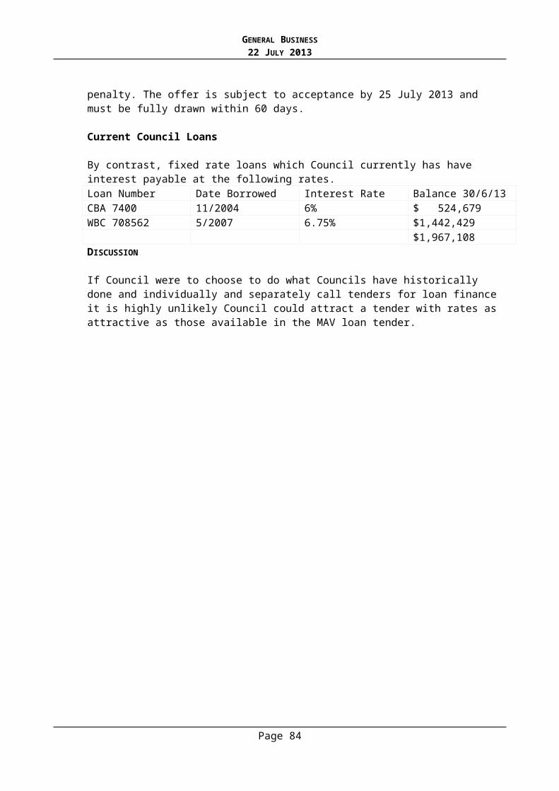
GENERAL BUSINESS22 JULY 2013
5. Improvement Plan
# The Flood Management Plan identifies a list of fifteen (15) actions to improve flood management in Stonnington. Of these, six (6) of the key actions are listed below (see p43 – p58):
Council to update the Council Special Overlay to incorporate revised flood extents. Melbourne Water to review the naming convention of the S.B.O. Melbourne Water and Council to consider an integrated flood study of the Union
Street Catchment. Council to review its asset maintenance program. Vic SES and Council to prepare a Flood Emergency Plan and community flood
education program, and Council to investigate options on storm warning systems.
It is intended that the Plan will be revised at least every five (5) years to reflect achievement of objectives and changes to work program priorities.
POLICY IMPLICATIONS
The Municipal Strategic Statement (M.S.S) of the Stonnington Planning Scheme sets out, in general, key issues, objectives, strategies and implementation works relating to flooding (sec. 21-06-4)
The Flood Management Plan is in accord with the M.S.S. but includes action for Melbourne Water, Council and the S.E.S. to improve communication and explore opportunities for managing flood risk.
FINANCIAL AND RESOURCE IMPLICATIONS
Melbourne Water has financed the consultant’s fee in preparing the Flood Management Plan.
The FMP does not result in any change to Councils current drainage improvement program (Capital Works Expenditure) and supports Councils current program of flood management and drainage improvement.
LEGAL ADVICE AND IMPLICATIONS
Melbourne Water, as the flood management authority for the metropolitan area, has a commitment to prepare flood management plans for the metropolitan councils.
Council has a legal responsibility in participating in the development and adoption of a Stonnington Flood Management Plan.
CONCLUSION
The Stonnington Flood Management Plan outlines the various systems for managing flood risk in Stonnington. Areas where Melbourne Water, Council and the S.E.S. can improve communication and collaboration have been identified.
Page 84
GENERAL BUSINESS22 JULY 2013
The plan was jointly developed by the City of Stonnington and Melbourne Water. It has resulted in specific actions to improve flood management and completes an objective of Melbourne Water’s Flood Management and Drainage Strategy.It is recommended that Council endorse the Flood Management Plan.
RECOMMENDATIONS:
That:
1. The Flood Management Plan prepared the City of Stonnington and Melbourne Water clarifying the roles and responsibilities, agreed actions, and improvements for flood management be endorsed.
2. The infrastructure improvement opportunities identified in the Plan be referred for consideration in conjunction with the preparation of future Capital Budgets.
3. Melbourne Water and Vic S.E.S. be advised of the Council decision accordingly.
Page 85
GENERAL BUSINESS22 JULY 2013
12. STONNINGTON YOUTH LEADERSHIP PROGRAM
Manager (Acting): Cath HarrodGeneral Manager: Connie Gibbons
PURPOSE
To seek Council’s approval to initiate a 12-month Stonnington Youth Leadership Program (SYLP) for participants to develop the knowledge, skills, and understanding young people need to become effective leaders within their community.
BACKGROUND
Stonnington’s Youth Services is a generalist service for young people aged between 10 and 25 years who live, work, study or visit the City of Stonnington on a regular basis.
Together with a range of community partners, Youth Services offers guidance to young people to navigate the complicated passage of youth, and offers support in dealing with the many challenges that they may face along the way.
Stonnington’s Youth Service is committed to the principle of youth participation. Youth participation means involving young people in the decision-making processes and directly involving young people in planning programs and services that Youth Services deliver.
DISCUSSION
The SYLP will provide an opportunity for young people with a forum to develop their skills and to positively contribute to their community. The program will provide meaningful activities where participants can learn about citizenship and achieving positive outcomes for the community through their involvement in this program.
Council Officers invited three external organisations that are considered by the youth sector as highly skilled and experienced in the development and delivery of youth leadership programs to young people.
# The strongest proposal was received from the YMCA Victoria with their program proposal “Stonnington Youth Leadership Program” (see Attachment 1). This program will be delivered in partnership with Council’s Youth Services and the YMCA.
The program will engage up to 20 participants from the City of Stonnington in a 12-month personal and leadership development program that will culminate in a community project that will develop and demonstrate their skills. Examples could include a music and cultural event, a consultation project and/or recreation events. The program will move through distinct phases continually building the skills of the participating young people. The program will include a weekend introduction, monthly development sessions, an overnight camp at the Victorian YMCA Campsite and the development of a community initiative concluding with a project evaluation workshop. The participants will make a presentation to Council at the conclusion of the program about the program and the community project.
Recruitment for this program will ensure that the whole of Stonnington is represented. There is a wide range of backgrounds within the City and the recruitment strategy will
Page 86
GENERAL BUSINESS22 JULY 2013
actively recruit members that represent the diverse community of Stonnington to ensure a variety of viewpoints are represented.
Young people will be invited to apply for the SYLP and will be asked to complete an application form and participate in an interview process.
The criteria for involvement will include: A keen interest in their local community and youth issues A desire to make a positive difference in their local community A demonstrated potential for community leadership Live in the City of Stonnington Aged between 14-19 years of age Available to commit to the SYLP for a12-month period
A communications plan will be developed to advertise the program across media, schools and community groups.
FINANCIAL IMPLICATIONS
As part of Council’s F2013/14 Capital Works budget, Council has allocated $25,000 for the delivery of a Youth Leadership Program for young people in the City of Stonnington for one year.
Cost of the SYLP: $24, 385 (excl. GST)
CONCLUSION
The SYLP will provide a variety of outcomes for young people, specifically creating opportunities for participants to apply the knowledge, skills and understandings gained through the program through meaningful services to the community. Participating in a youth leadership program can lead to enormous skill development and confidence building for the young people involved, resulting in greater independence, self-esteem and confidence to be able to tackle new challenges.
RECOMMENDATION
That Council endorses the implementation of a Stonnington Youth Leadership Program for the 2013/14 financial year.
Page 87
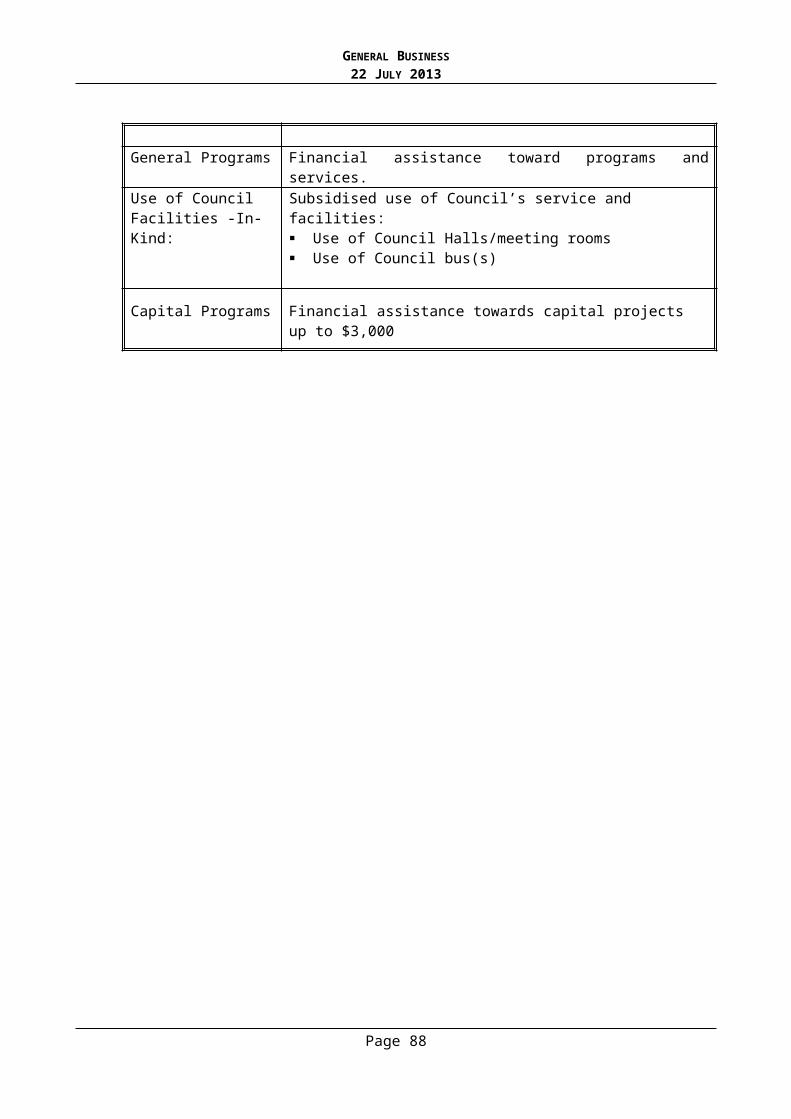
GENERAL BUSINESS22 JULY 2013
n) Confidential Business
1. Special Rate Business Association Action Plans 2013/2014
(Manager: Jan JacklinGeneral Manager: Karen Watson)
Page 88