Embed Size (px)
Citation preview
Prioritizing Meadows for Restoration within the North
Fork Kern River DrainageRiparian Summit, Davis CA
10/18/17
Levi Keszey, [email protected]
Contents• Sierra Nevada Meadows• Project Objectives• Phase I- Selection and refinement of meadows suite• Phase II- Application of AR Rapid Assessment Scorecard• Phase III- Synthesis of data to prioritize meadows for 2017 field
assessments• Phase IV- 2017 meadow condition assessments• Phase V- Identification of restoration needs and next steps• Project implications and Lessons Learned• Questions
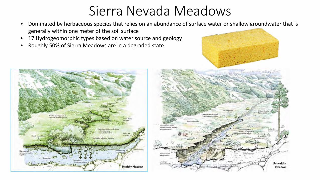
Sierra Nevada Meadows• Dominated by herbaceous species that relies on an abundance of surface water or shallow groundwater that is
generally within one meter of the soil surface• 17 Hydrogeomorphic types based on water source and geology• Roughly 50% of Sierra Meadows are in a degraded state
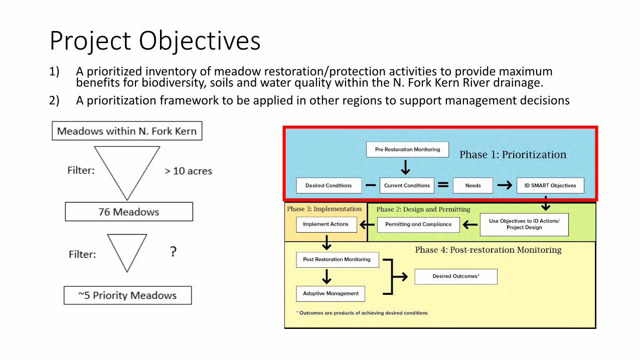
Project Objectives1) A prioritized inventory of meadow restoration/protection activities to provide maximum
benefits for biodiversity, soils and water quality within the N. Fork Kern River drainage. 2) A prioritization framework to be applied in other regions to support management decisions
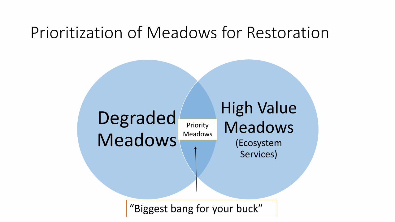
Prioritization of Meadows for Restoration
Degraded Meadows
High Value Meadows
(Ecosystem Services)
Priority Meadows
“Biggest bang for your buck”
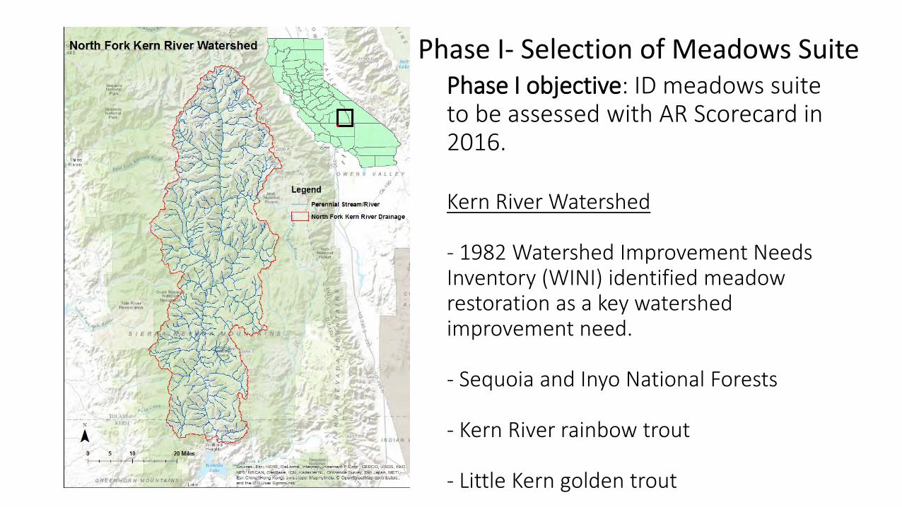
Phase I objective: ID meadows suite to be assessed with AR Scorecard in 2016.
Kern River Watershed
- 1982 Watershed Improvement Needs Inventory (WINI) identified meadow restoration as a key watershed improvement need.
- Sequoia and Inyo National Forests
- Kern River rainbow trout
- Little Kern golden trout
Phase I- Selection of Meadows Suite
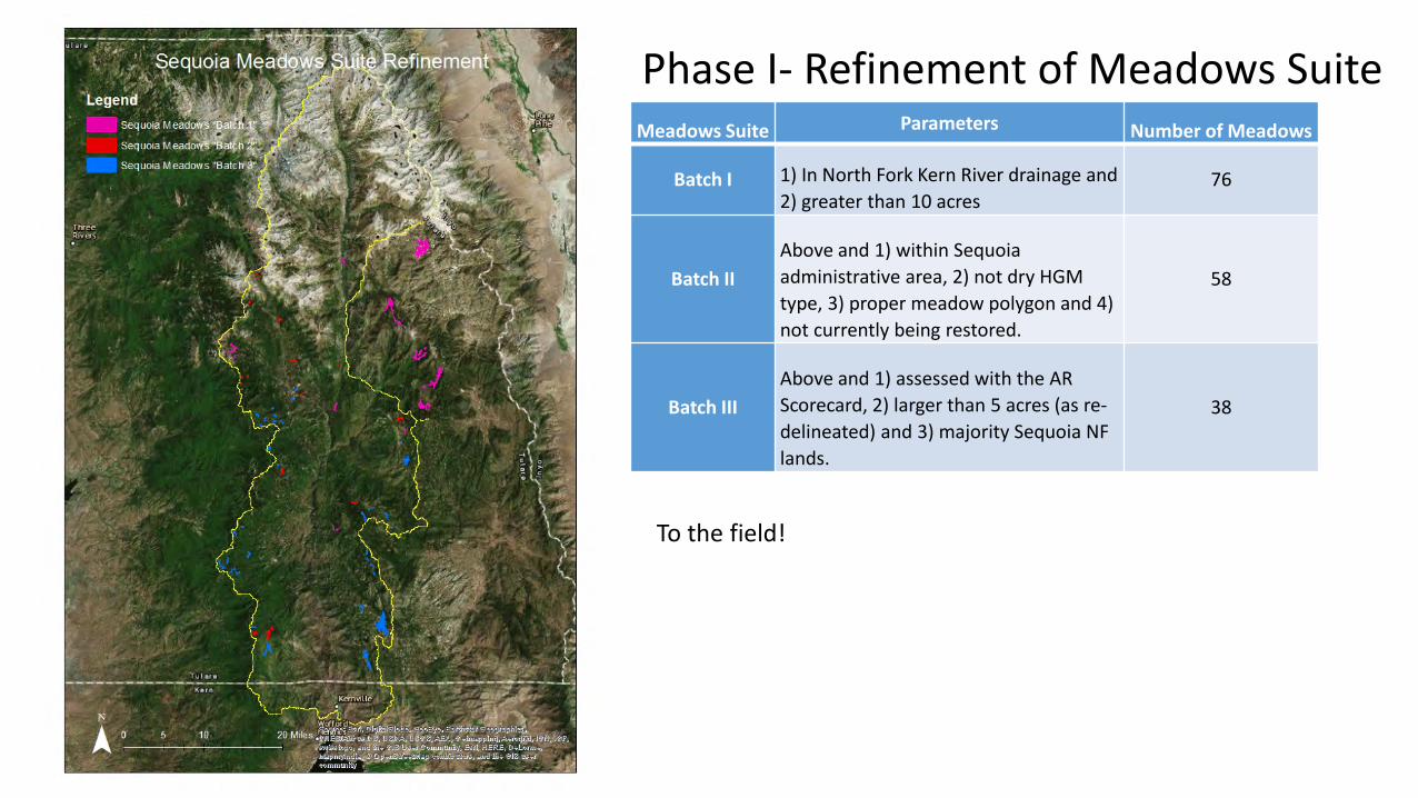
Phase I- Refinement of Meadows SuiteMeadows Suite Parameters Number of Meadows
Batch I 1) In North Fork Kern River drainage and 2) greater than 10 acres
76
Batch IIAbove and 1) within Sequoia administrative area, 2) not dry HGM type, 3) proper meadow polygon and 4) not currently being restored.
58
Batch IIIAbove and 1) assessed with the AR Scorecard, 2) larger than 5 acres (as re-delineated) and 3) majority Sequoia NF lands.
38
To the field!
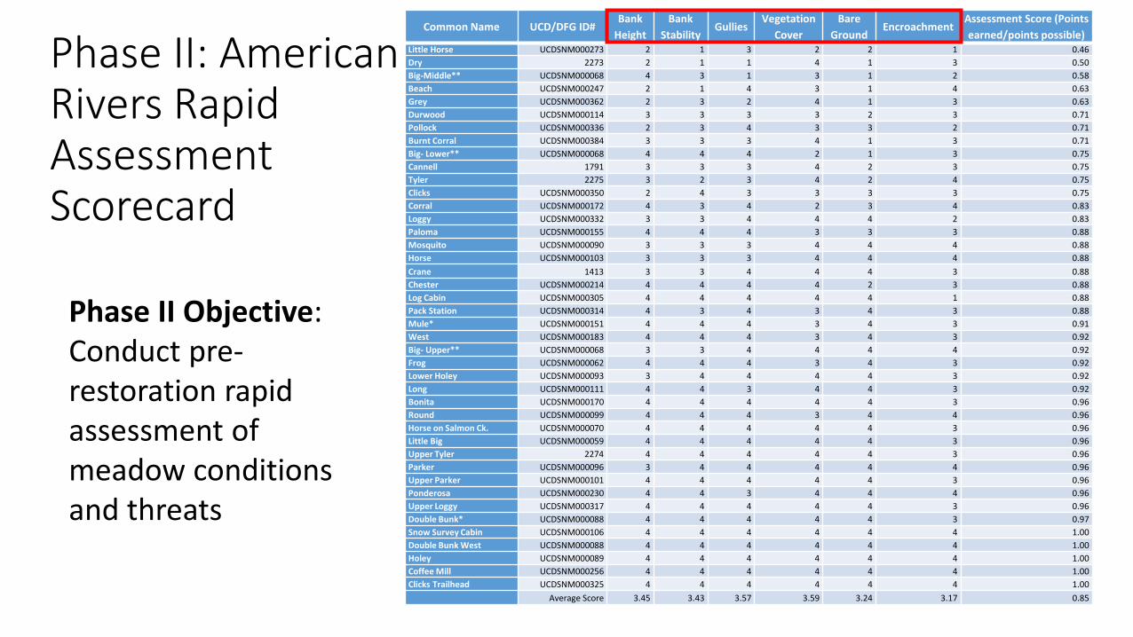
Phase II: American Rivers Rapid Assessment Scorecard
Common Name UCD/DFG ID#Bank
HeightBank
StabilityGullies
Vegetation Cover
Bare Ground
EncroachmentAssessment Score (Points earned/points possible)
Little Horse UCDSNM000273 2 1 3 2 2 1 0.46Dry 2273 2 1 1 4 1 3 0.50Big-Middle** UCDSNM000068 4 3 1 3 1 2 0.58Beach UCDSNM000247 2 1 4 3 1 4 0.63Grey UCDSNM000362 2 3 2 4 1 3 0.63Durwood UCDSNM000114 3 3 3 3 2 3 0.71Pollock UCDSNM000336 2 3 4 3 3 2 0.71Burnt Corral UCDSNM000384 3 3 3 4 1 3 0.71Big- Lower** UCDSNM000068 4 4 4 2 1 3 0.75Cannell 1791 3 3 3 4 2 3 0.75Tyler 2275 3 2 3 4 2 4 0.75Clicks UCDSNM000350 2 4 3 3 3 3 0.75Corral UCDSNM000172 4 3 4 2 3 4 0.83Loggy UCDSNM000332 3 3 4 4 4 2 0.83Paloma UCDSNM000155 4 4 4 3 3 3 0.88Mosquito UCDSNM000090 3 3 3 4 4 4 0.88Horse UCDSNM000103 3 3 3 4 4 4 0.88Crane 1413 3 3 4 4 4 3 0.88Chester UCDSNM000214 4 4 4 4 2 3 0.88Log Cabin UCDSNM000305 4 4 4 4 4 1 0.88Pack Station UCDSNM000314 4 3 4 3 4 3 0.88Mule* UCDSNM000151 4 4 4 3 4 3 0.91West UCDSNM000183 4 4 4 3 4 3 0.92Big- Upper** UCDSNM000068 3 3 4 4 4 4 0.92Frog UCDSNM000062 4 4 4 3 4 3 0.92Lower Holey UCDSNM000093 3 4 4 4 4 3 0.92Long UCDSNM000111 4 4 3 4 4 3 0.92Bonita UCDSNM000170 4 4 4 4 4 3 0.96Round UCDSNM000099 4 4 4 3 4 4 0.96Horse on Salmon Ck. UCDSNM000070 4 4 4 4 4 3 0.96Little Big UCDSNM000059 4 4 4 4 4 3 0.96Upper Tyler 2274 4 4 4 4 4 3 0.96Parker UCDSNM000096 3 4 4 4 4 4 0.96Upper Parker UCDSNM000101 4 4 4 4 4 3 0.96Ponderosa UCDSNM000230 4 4 3 4 4 4 0.96Upper Loggy UCDSNM000317 4 4 4 4 4 3 0.96Double Bunk* UCDSNM000088 4 4 4 4 4 3 0.97Snow Survey Cabin UCDSNM000106 4 4 4 4 4 4 1.00Double Bunk West UCDSNM000088 4 4 4 4 4 4 1.00Holey UCDSNM000089 4 4 4 4 4 4 1.00Coffee Mill UCDSNM000256 4 4 4 4 4 4 1.00Clicks Trailhead UCDSNM000325 4 4 4 4 4 4 1.00
Average Score 3.45 3.43 3.57 3.59 3.24 3.17 0.85
Phase II Objective: Conduct pre-restoration rapid assessment of meadow conditions and threats
Phase II: American Rivers Rapid Assessment Scorecard
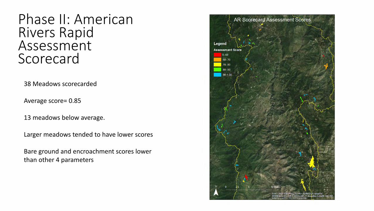
38 Meadows scorecarded
Average score= 0.85
13 meadows below average.
Larger meadows tended to have lower scores
Bare ground and encroachment scores lower than other 4 parameters
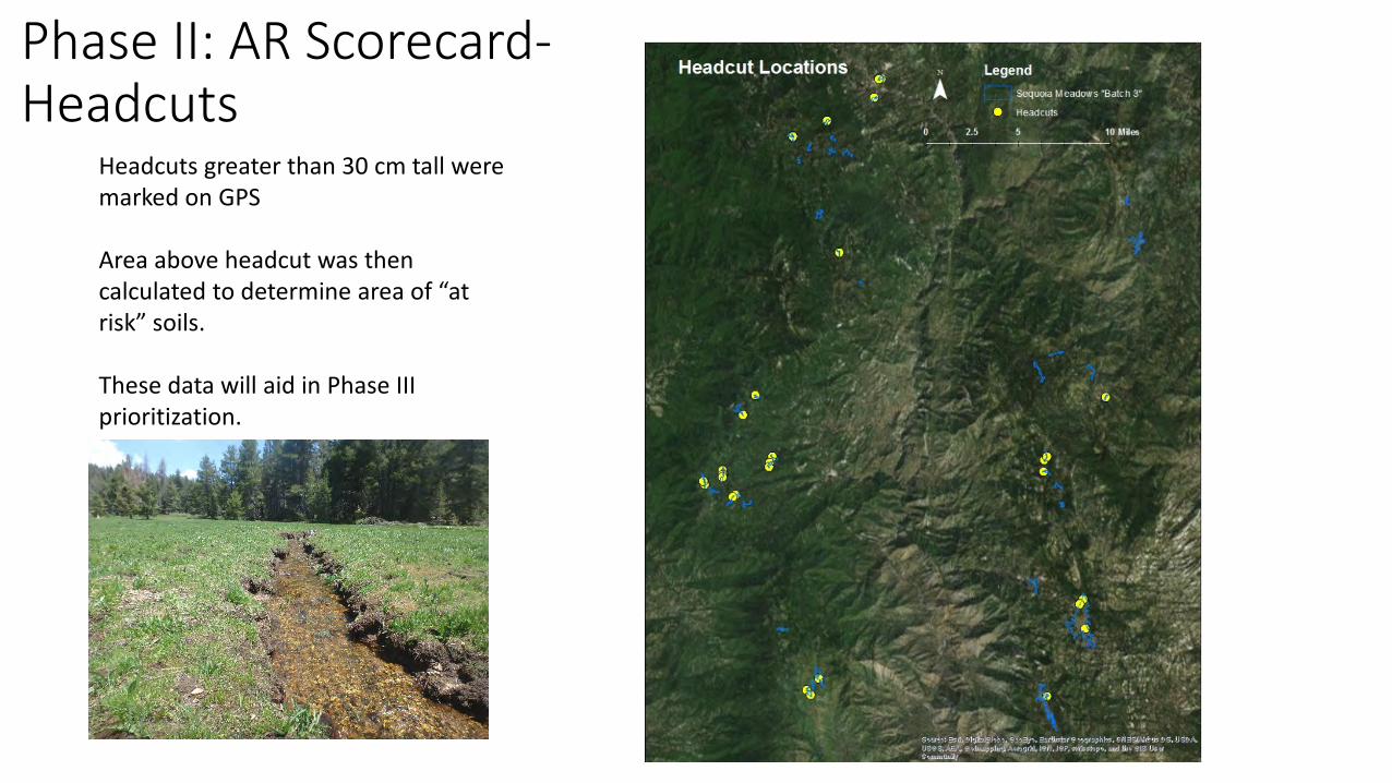
Phase II: AR Scorecard-Headcuts
Headcuts greater than 30 cm tall were marked on GPS
Area above headcut was then calculated to determine area of “at risk” soils.
These data will aid in Phase III prioritization.
Phase III- Selection of meadows for 2017 field assessments • Phase III Objective: Select a subset of priority meadows to be
assessed in 2017.• These meadows should be those that will offer the most benefits if
restored. • Benefits= Ecosystem Services
How do we select for meadows that have the highest potential to offer ecosystem services?
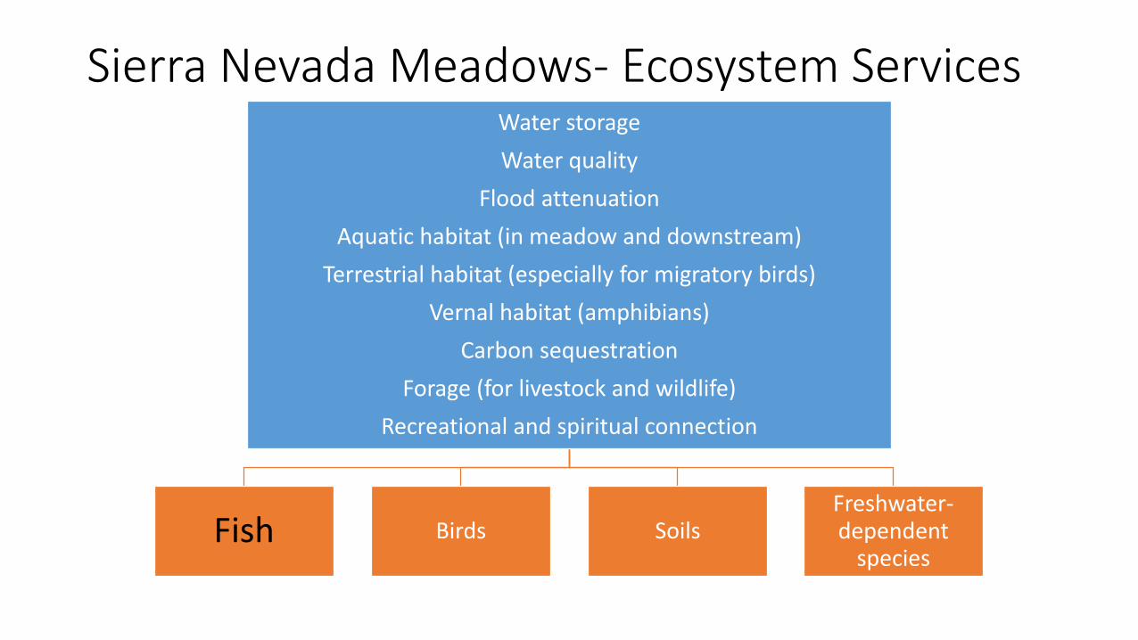
Sierra Nevada Meadows- Ecosystem ServicesWater storageWater quality
Flood attenuationAquatic habitat (in meadow and downstream)
Terrestrial habitat (especially for migratory birds)Vernal habitat (amphibians)
Carbon sequestrationForage (for livestock and wildlife)
Recreational and spiritual connection
Fish Birds SoilsFreshwater-dependent
species
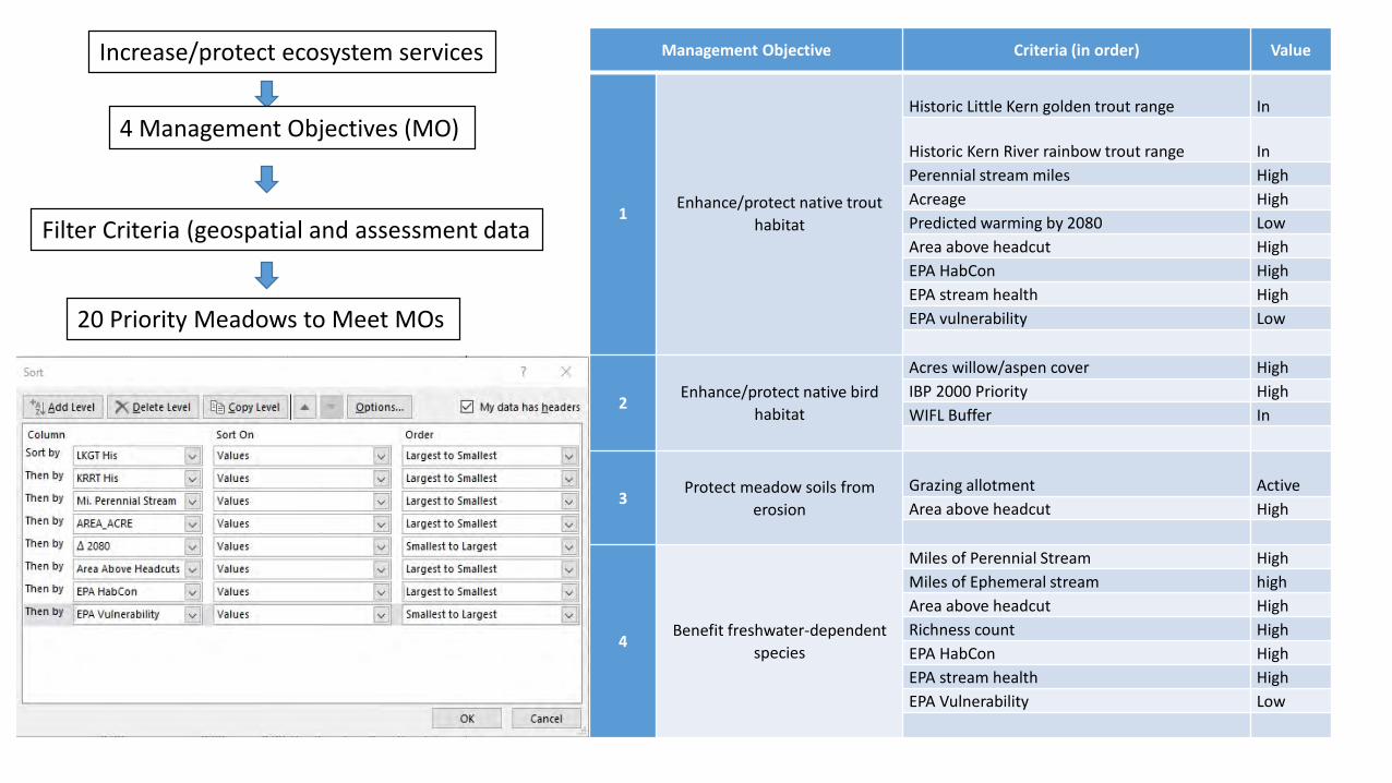
Management Objective Criteria (in order) Value
1Enhance/protect native trout
habitat
Historic Little Kern golden trout range In
Historic Kern River rainbow trout range InPerennial stream miles HighAcreage HighPredicted warming by 2080 LowArea above headcut HighEPA HabCon HighEPA stream health HighEPA vulnerability Low
2Enhance/protect native bird
habitat
Acres willow/aspen cover HighIBP 2000 Priority HighWIFL Buffer In
3Protect meadow soils from
erosionGrazing allotment ActiveArea above headcut High
4Benefit freshwater-dependent
species
Miles of Perennial Stream HighMiles of Ephemeral stream highArea above headcut HighRichness count HighEPA HabCon HighEPA stream health HighEPA Vulnerability Low
Increase/protect ecosystem services
4 Management Objectives (MO)
Filter Criteria (geospatial and assessment data
20 Priority Meadows to Meet MOs
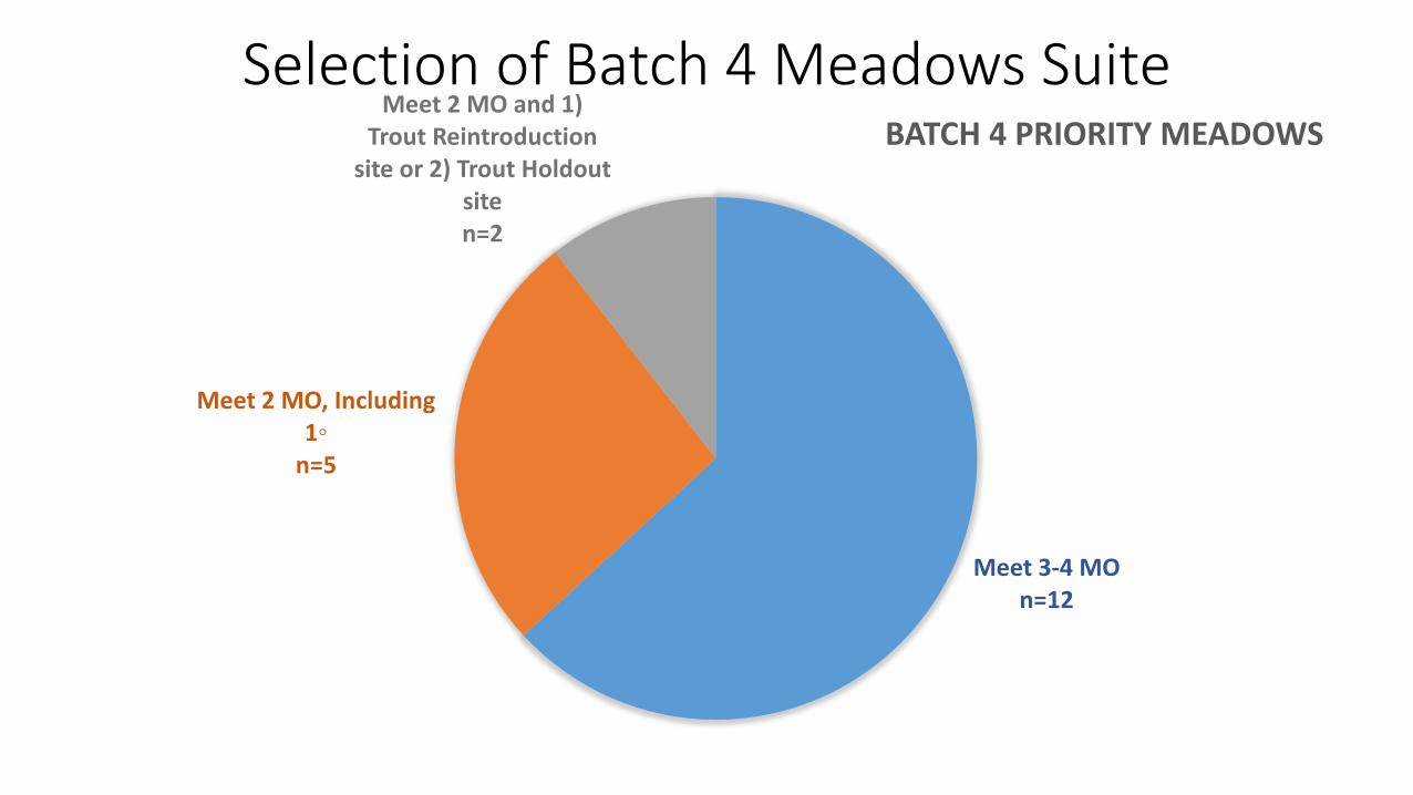
Selection of Batch 4 Meadows Suite
Meet 3 or 4 MOs
Meet 2 MOs including
Benefits to Fish (1◦ MO)
Meet 2 MOS and in either 1)KRRT Reintroduction streams or 2) KRRT Holdout
streamsBatch 4 Meadows Suite
n=12 n=19n=5 n=2
Meet 3-4 MOn=12
Meet 2 MO, Including 1◦
n=5
Meet 2 MO and 1) Trout Reintroduction
site or 2) Trout Holdout siten=2
BATCH 4 PRIORITY MEADOWS
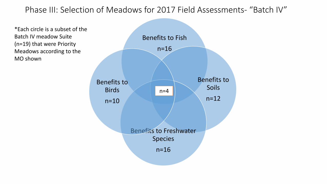
Benefits to Fishn=16
Benefits to Soilsn=12
Benefits to Freshwater Species
n=16
Benefits to Birdsn=10
n=4
Phase III: Selection of Meadows for 2017 Field Assessments- “Batch IV”
*Each circle is a subset of the Batch IV meadow Suite (n=19) that were Priority Meadows according to the MO shown
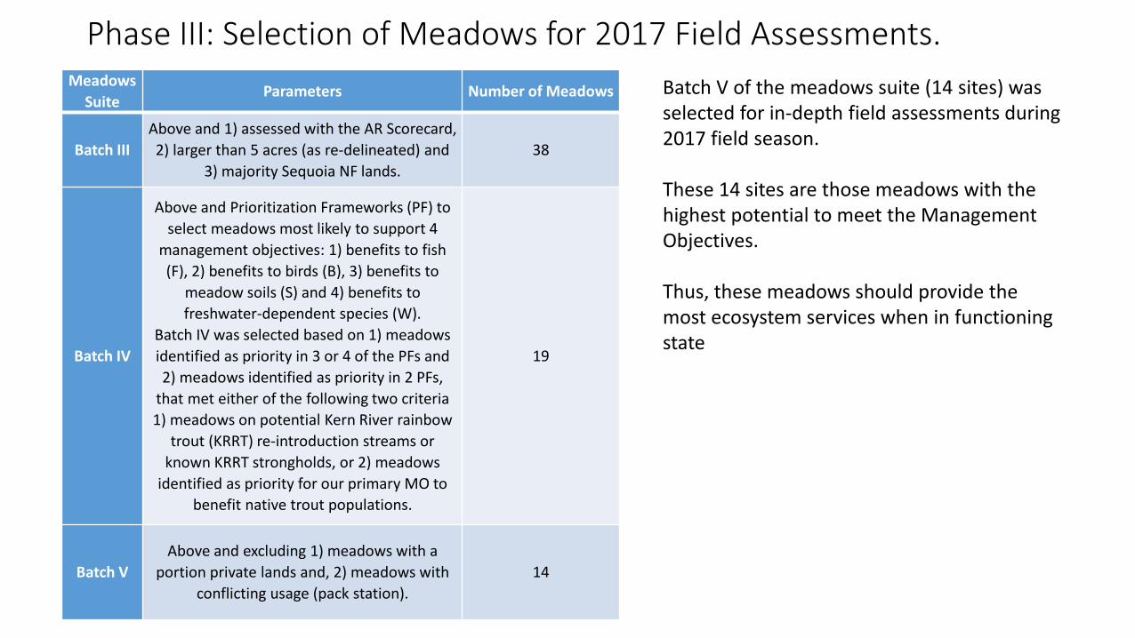
Phase III: Selection of Meadows for 2017 Field Assessments.Meadows
SuiteParameters Number of Meadows
Batch IIIAbove and 1) assessed with the AR Scorecard, 2) larger than 5 acres (as re-delineated) and
3) majority Sequoia NF lands. 38
Batch IV
Above and Prioritization Frameworks (PF) to select meadows most likely to support 4
management objectives: 1) benefits to fish (F), 2) benefits to birds (B), 3) benefits to
meadow soils (S) and 4) benefits to freshwater-dependent species (W).
Batch IV was selected based on 1) meadows identified as priority in 3 or 4 of the PFs and 2) meadows identified as priority in 2 PFs,
that met either of the following two criteria 1) meadows on potential Kern River rainbow
trout (KRRT) re-introduction streams or known KRRT strongholds, or 2) meadows
identified as priority for our primary MO to benefit native trout populations.
19
Batch VAbove and excluding 1) meadows with a
portion private lands and, 2) meadows with conflicting usage (pack station).
14
Batch V of the meadows suite (14 sites) was selected for in-depth field assessments during 2017 field season.
These 14 sites are those meadows with the highest potential to meet the Management Objectives.
Thus, these meadows should provide the most ecosystem services when in functioning state
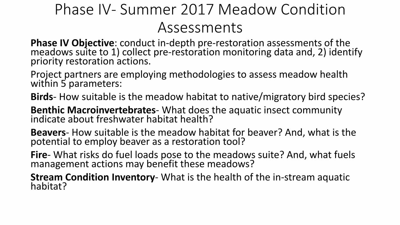
Phase IV- Summer 2017 Meadow Condition Assessments
Phase IV Objective: conduct in-depth pre-restoration assessments of the meadows suite to 1) collect pre-restoration monitoring data and, 2) identify priority restoration actions. Project partners are employing methodologies to assess meadow health within 5 parameters:Birds- How suitable is the meadow habitat to native/migratory bird species?Benthic Macroinvertebrates- What does the aquatic insect community indicate about freshwater habitat health?Beavers- How suitable is the meadow habitat for beaver? And, what is the potential to employ beaver as a restoration tool?Fire- What risks do fuel loads pose to the meadows suite? And, what fuels management actions may benefit these meadows?Stream Condition Inventory- What is the health of the in-stream aquatic habitat?
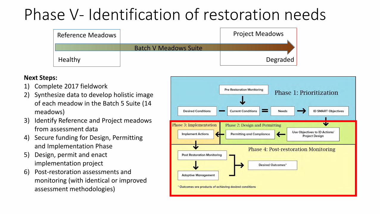
Phase V- Identification of restoration needs
Healthy
Batch V Meadows Suite
Degraded
Reference Meadows Project Meadows
Next Steps:1) Complete 2017 fieldwork2) Synthesize data to develop holistic image
of each meadow in the Batch 5 Suite (14 meadows)
3) Identify Reference and Project meadows from assessment data
4) Secure funding for Design, Permitting and Implementation Phase
5) Design, permit and enact implementation project
6) Post-restoration assessments and monitoring (with identical or improved assessment methodologies)
Project Implications and Lessons Learned• AR Scorecard shortcomings
- Best for Riparian HGM Type- May exaggerate upland encroachment - No 2 meadows are the same
• Condition assessments as pre-restoration monitoring- SM WRAMP
• Remote HGM typing- Remotely typed riparian meadows do not indicate channel structure
• Reference vs. degraded meadows- How do we ID appropriate reference meadows?- Current and historic grazing
• Application to other ecosystem types?• Importance of ground-truthing• Research questions
- How to assess discharge slopes- Replicable at larger landscapes? - Meadows as snowflakes.
Questions?