Embed Size (px)
Citation preview
Presented below are water quality standards that are in effect for Clean Water Act purposes. EPA is posting these standards as a convenience to users and has made a reasonable effort to assure their accuracy. Additionally, EPA has made a reasonable effort to identify parts of the standards that are not approved, disapproved, or are otherwise not in effect for Clean Water Act purposes.
Title 33, Part IX, Subpart 1
March 2015 Environmental Regulatory Code 1
Chapter 11. Surface Water Quality
Standards
§1101. Introduction
A. The purpose of this Chapter is to establish surface
water quality standards which will:
1. provide for the protection and preservation of the
abundant natural resources of Louisiana's many and varied
aquatic ecosystems;
2. protect the public health and welfare that might
otherwise be threatened by degradation of water quality;
3. protect or enhance the quality of public waters for
designated uses; and
4. serve the objectives of the Louisiana Water Control
Law and Federal Clean Water Act (hereafter referred to as
the Clean Water Act).
B. The water quality standards provided in this Chapter
are provisions of Louisiana state regulations and consist of:
1. policy statements pertinent to water quality that are
necessary to achieve the objectives of the standards;
2. designated uses for which waters of the state are to
be protected; and
3. criteria which specify general and numerical
limitations for various water quality parameters that are
required for designated water uses.
C. The water quality standards described in this Chapter
are applicable to surface waters of the state and are utilized
through the wasteload allocation and permit processes, to
develop effluent limitations for point source discharges to
surface waters of the state. They can also form the basis for
implementing the best management practices for control of
nonpoint sources of water pollution.
AUTHORITY NOTE: Promulgated in accordance with R.S.
30:2074(B)(1).
HISTORICAL NOTE: Promulgated by the Department of
Environmental Quality, Office of Water Resources, LR 10:745
(October 1984), amended LR 15:738 (September 1989), LR 20:883
(August 1994), amended by the Office of the Secretary, Legal
Affairs Division, LR 33:826 (May 2007).
§1103. Authorization
A. Pursuant to the specific authorization provided for in
Section 2074.B(1) of the Louisiana Water Control Law (R.S.
30:2071-2078) and in conformity with Section 303(c) of the
Clean Water Act (P.L. 92-500 as amended) and 48 FR 51405,
November 8, 1983, the state of Louisiana has established
these surface water quality standards to prohibit, control, or
abate water pollution in state waters.
AUTHORITY NOTE: Promulgated in accordance with R.S.
30:2074(B)(1).
HISTORICAL NOTE: Promulgated by the Department of
Environmental Quality, Office of Water Resources, LR 10:745
(October 1984), amended LR 15:738 (September 1989).
§1105. Definitions
Acute Toxicity—any lethal or deleterious effect on
representative sensitive organisms that results from a single
dose or exposure of a chemical or mixture of chemicals
within a short period of time, usually less than 96 hours.
Administrative Authority—the Secretary of the
Department of Environmental Quality, or his designee or the
appropriate assistant secretary or his designee.
Ambient Toxicity—the effect measured by a toxicity test
on a sample collected from a water body.
Artificial Heat—heat derived from unnatural sources, such
as power plants and other industrial cooling processes.
Background Condition—a concentration of a substance in
a particular environment that is indicative of minimal
influence by human (anthropogenic) sources.
Biological and Aquatic Community Integrity—the
condition of the aquatic community inhabiting a specified
habitat as measured by community structure and function.
Bottomland Hardwood Swamps—those areas inundated or
saturated by surface water or groundwater of negligible to
very low salinity at a frequency and duration sufficient to
support, and that under normal conditions do support,
bottomland hardwood vegetation. These ecosystems are
commonly found wherever streams or rivers occasionally
cause flooding beyond their channel confines. They are
deciduous forested wetlands, made up of different species of
gum (Nyssa spp.), oak (Quercus spp.), dwarf palmetto
(Sabal minor), and bald cypress (Taxodium distichum), and
other species. These swamps cannot tolerate continuous
flooding; typically areas are flooded two to six months per
year.
Brackish Marshes—those areas inundated or saturated by
surface water or groundwater of moderate salinity at a
frequency and duration sufficient to support, and that under
normal circumstances do support, brackish emergent
vegetation. Typical vegetation includes bulltongue
(Sagittaria spp.), wild millet (Echinochloa walteri),
bullwhip (Scirpus califomicus), sawgrass (Cladium
jamaicense), wiregrass (Spartina patens), three-cornered
grass (Scirpus olneyi), and widgeongrass (Ruppia maritima).
Brackish marshes are also characterized by interstitial water
salinity that normally ranges between 3 and 15 parts per
thousand (ppt) or practical salinity units (psu).
Brackish Water—surface water (creeks, bayous, rivers,
lakes, estuaries) having an average salinity of 2 parts per
thousand or greater and less than 10 parts per thousand; does
not apply to wetland interstitial salinity regime.
Chronic Toxicity—toxicity that, after long-term exposure,
exerts sublethal negative effects on, or is lethal to,
representative, sensitive organisms.
Clean Techniques—an integrated system of sample
collection and laboratory analytical procedures designed to
detect concentrations of trace metals below criteria levels
Section 1105
Title 33, Part IX, Subpart 1
March 2015 Environmental Regulatory Code 2
and eliminate or minimize inadvertent sample contamination
that can occur during traditional sampling practices.
Cypress-Tupelo Swamps—those areas inundated or
saturated by surface water or groundwater of negligible to
very low salinity at a frequency and duration sufficient to
support, and that under normal circumstances do support,
cypress-tupelo vegetation. Typical vegetation includes water
tupelo (Nyssa Sylvatica var. aquatica), bald cypress
(Taxodium distichum), red maple (Acer rubrum), buttonbush
(Cephalanthus occidentalis), and common wax myrtle
(Myrica cerifera). Cypress-tupelo swamps can tolerate
continuously flooded conditions and are divided into two
subtypes: continuously flooded and seasonally flooded.
Continuously flooded swamps are those areas that have
standing water present all year round. They range from
forests with a closed canopy to open canopy conditions with
understory freshwater emergent wetland vegetation.
Seasonally flooded swamps are those areas that are typically
flooded for more than six months per year. They typically
have a closed canopy that limits understory vegetation.
Degradation—a lowering of water quality, as
demonstrated by data analysis, water quality models, or
other scientifically defensible method.
Designated Use—a use of the waters of the state as
established by the water quality standards provided in
LAC 33:IX.1111. These uses include, but are not limited to,
primary and secondary contact recreation, fish and wildlife
propagation, drinking water supply, oyster propagation,
agriculture, and outstanding natural resource waters.
Diffuser—a device or defined technology that provides for
the rapid and efficient mixing of wastewater effluents with
the receiving water so that toxic conditions and other
impacts in the vicinity of the discharge are minimized.
Dissolved Oxygen—the amount of oxygen dissolved in
water, commonly expressed as a concentration in terms of
milligrams per liter (mg/L).
Drinking Water Supply—a surface or underground raw
water source which, after conventional treatment, will
provide safe, clear, potable, and aesthetically pleasing water
for uses which include, but are not limited to, human
consumption, food processing and cooking, and inclusion as
a liquid ingredient in foods and beverages.
Ecoregion—a relatively homogeneous area of similar
ecological characteristics such as climate, land surface form,
soils, potential natural vegetation, land use, hydrology, and
other ecologically relevant variables.
Effluent—wastewater discharged to the waters of the state.
Effluent Limitation—any applicable state or federal
quality or quantity limitation that imposes any restriction or
prohibition on quantities, discharge rates, and concentrations
of pollutants discharged into the waters of the state.
Estuary—an area where freshwater systems and saltwater
systems interact. Such areas can extend from coastal areas
into inland rivers and streams as far as the limit of tidal
influence or as far as the saltwater wedge reaches. Estuarine
salinities are variable and influenced by physical (i.e., tide,
sedimentation, precipitation), chemical (i.e., variable
salinities), and biological (i.e., vegetation, faunal
populations) factors.
Excepted Use—a water body classification reflecting
natural conditions and/or physical limitations that preclude
the water body from meeting its designated use(s). Such
classifications include, but are not limited to, man-made
waters, naturally dystrophic waters, and intermittent streams.
Existing Use—those uses actually attained in the water
body on or after November 28, 1975. They may or may not
be designated uses.
Fecal Coliform—a gram negative, non-spore-forming,
rod-shaped bacteria found in the intestinal tract of
warm-blooded animals.
Forested Wetlands—a category of wetlands that includes
bottomland hardwood swamps, cypress-tupelo swamps, and
oligotrophic seasonally flooded pine forests as defined in
this Section.
Fresh Warmwater Biota—aquatic life species whose
populations typically inhabit waters with warm temperatures
(seasonal averages above 20oC, 68
oF) and low salinities (less
than 2 parts per thousand), including, but not limited to,
black basses and freshwater sunfish and catfish and
characteristic freshwater aquatic invertebrates and wildlife.
Fresh Water—surface water (creeks, bayous, rivers, lakes)
having an average salinity of less than 2 parts per thousand;
does not apply to wetland interstitial salinity regime.
Freshwater Emergent Wetlands (including freshwater
marshes)—those areas inundated or saturated by surface
water or groundwater of negligible to very low salinity at a
frequency and duration sufficient to support, and that under
normal circumstances do support, freshwater emergent
vegetation. Typical vegetation includes cattail (Typha
angustifolia), bulltongue (Sagittaria spp.), maiden cane
(Panicum hemitomon), water hyacinth (Eichomia crassipes),
pickerelweed (Ponterderia cordata), alligatorweed
(Altemanthera philoxeroides), and Hydrocotyl spp.
Freshwater emergent wetlands also are characterized by
interstitial water salinity that is normally less than 2 ppt or
psu. There are two subtypes of freshwater emergent
wetlands: floating and attached. Floating wetlands are those
areas where the wetland surface substrate is detached and is
floating above the underlying deltaic plain (also called
"buoyant" and "flotant"). Attached wetlands are those areas
where the vegetation is attached to the wetland surface and
is contiguous with the underlying wetland substrate and can
be submerged or emergent.
g/L—grams per liter.
Harmonic Mean Flow—a statistical value used to
calculate permit limits where 7Q10 flow is not appropriate.
This calculation is intended for positive numbers and non-
Section 1105
Title 33, Part IX, Subpart 1
March 2015 Environmental Regulatory Code 3
zero values, thereby, precluding the use of negative flow
values. The formula is as follows:
1
H
1
nn
1
xi
n
where:
H = harmonic mean
n = number of samples
x = actual samples
Intermittent Streams—streams that provide water flow
continuously during some seasons of the year but little or no
flow during the drier times of the year.
LC50—the numerical limit or concentration of a test
material that is lethal to 50 percent of the exposed aquatic
organisms within a specified period of time.
Man-Made Water Body—a body of water that has been
anthropogenically created or altered and is used primarily
for drainage, conveyance, or retention of water for purposes
of irrigation, transportation, sanitation, flood relief, water
diversion, or natural resource extraction. The physical and
hydrological characteristics of man-made water bodies are
not conducive to the establishment of a balanced population
of aquatic biota or to the full support of recreational
activities.
Marine Water—of, relating to, or found in surface waters
with average salinities greater than or equal to 10 parts per
thousand; does not apply to wetland interstitial salinity
regime.
μg/L—micrograms per liter.
mg/L—milligrams per liter.
Naturally Dystrophic Waters—waters which are stained
with organic material and which are low in dissolved oxygen
because of natural conditions.
ng/L—nanograms per liter.
Non-Forested Wetlands—a category of wetlands that
includes freshwater emergent wetlands, brackish marshes,
and salt (saline) marshes as defined in this Section.
Nonpoint Source—a diffuse source of water pollution that
does not discharge through a point source, but instead, flows
freely across exposed natural or man-made surfaces such as
agricultural or urban runoff and runoff from construction,
mining, or silviculture activities that are not regulated as
point sources.
Oligotrophic Seasonally Flooded Pine Forests—
palustrine, seasonally saturated pine communities on hydric
soils that may become quite dry for part of the year and
generally occur in flat or nearly flat areas not associated with
a river or stream system. They are usually dominated by
loblolly pine (Pinus taeda). These pine forests are seasonally
flooded and receive very low nutrient inputs. Because of
their oligotrophic nature, these forests are characterized by
unique understory vegetation communities that may include
insectivorous plants.
Person—any individual, municipality, public or private
corporation, partnership, firm, the United States Government
and any agent or subdivision thereof, or any other juridical
person, which shall include, but not be limited to, trusts,
joint stock companies, associations, the state of Louisiana,
political subdivisions of the state, commissions, and
interstate bodies.
Point Source—a discernible, confined, and discrete
conveyance including, but not limited to, any pipe, ditch,
channel, tunnel, conduit, well, discrete fissure, container,
rolling stock, concentrated animal feeding operation, or
vessel or other floating craft from which pollutants are or
may be discharged. This term does not include return flows
from irrigated agriculture.
Primary Contact Recreation—any recreational or other
water contact use involving prolonged or regular full-body
contact with the water and in which the probability of
ingesting appreciable amounts of water is considerable.
Examples of this type of water use include swimming,
skiing, and diving.
Process Heat—heat derived from unnatural sources such
as power plants and other industrial cooling processes.
Receiving Waters—the waters of the state into which an
effluent is, or may be, discharged.
Salt (Saline) Marshes—those areas that are inundated or
saturated by surface water or groundwater of salinity
characteristic of nearshore Gulf of Mexico ambient water at
a frequency and duration sufficient to support, and that under
normal circumstances do support, saline emergent
vegetation. Typical vegetation includes oystergrass (Spartina
alterniflora), glasswort (Salicomia spp.), black rush (Juncus
roemerianus), saltwort (Batis maritima), black mangrove
(Avicennia germinans), and salt grass (Distichlis spicata).
Salt marshes are also characterized by interstitial water
salinity that normally exceeds 16 ppt or psu.
Secondary Contact Recreation—any recreational or other
water contact use in which body contact with the water is
either incidental or accidental and the probability of
ingesting appreciable amounts of water is minimal.
Examples of this type of water use include fishing, wading,
and boating.
7Q10 Flow—the minimum average stream flow for seven
consecutive days with a recurrence interval of once every 10
years.
Surface Water—all lakes, bays, rivers, streams, springs,
ponds, impounding reservoirs, wetlands, swamps, marshes,
water sources, drainage systems, and other surface waters,
natural or artificial, public or private, within the state or
under its jurisdiction that are not a part of a treatment system
allowed by state law, regulation, or permit.
Section 1105
Title 33, Part IX, Subpart 1
March 2015 Environmental Regulatory Code 4
Total Dissolved Solids (TDS)—the amount of solid
material dissolved in water, commonly expressed as a
concentration in terms of mg/L.
Total Suspended Solids (TSS)—the amount of solid
material suspended in water, commonly expressed as a
concentration in terms of mg/L.
Toxic Substances—elements, compounds, or mixtures that
at sufficient exposure levels induce deleterious acute or
chronic physiological effects on an organism.
Use Attainability Analysis (UAA)—a structured scientific
assessment of the factors (chemical, physical, biological, and
economic) affecting the attainment of designated water uses
in a water body. Recommendations for the revision of the
water quality standards may be based upon a use
attainability analysis.
Wastewater—liquid waste resulting from commercial,
municipal, private, or industrial processes. Wastewater
includes, but is not limited to, cooling and condensing
waters, sanitary sewage, industrial waste, and contaminated
rainwater runoff.
Water Body Exception Classification—a water body
classification indicating natural conditions and/or physical
limitations that preclude the water body from meeting water
quality criteria. Classifications include, but are not limited
to, man-made water bodies, naturally dystrophic waters, and
intermittent streams.
Water Pollution—the introduction into the waters of the
state by any means, including dredge-and-fill operations, of
any substance in a concentration that tends to degrade the
chemical, physical, biological, or radiological integrity of
such waters, including, but not limited to, the discharge of
brine from salt domes that are located on the coastline of
Louisiana and the Gulf of Mexico into any waters off said
coastline and extending there from 3 miles into the Gulf of
Mexico.
Water Quality Standard—a definite numerical criterion
value or general criterion statement or policy statement
promulgated by the administrative authority to enhance or
maintain water quality and to provide for, and fully protect,
the designated uses of the waters of the state.
Waters of the State (or State Waters)—all surface and
underground waters and watercourses within the state of
Louisiana, whether natural or man-made, including but not
limited to, all rivers, streams, lakes, wetlands, and
groundwaters, within the confines of the state, and all
bordering waters of the Gulf of Mexico.
Wetlands—those areas that have one or more of the
following attributes: support hydrophytic (water tolerant)
vegetation during most of the year; contain predominately
undrained hydric (water saturated) soils; and/or are
periodically inundated or saturated by surface water or
groundwater.
Whole Effluent Toxicity—the total toxic effect of an
effluent measured directly with a toxicity test.
AUTHORITY NOTE: Promulgated in accordance with R.S.
30:2074(B)(1).
HISTORICAL NOTE: Promulgated by the Department of
Environmental Quality, Office of Water Resources, LR 10:745
(October 1984), amended LR 15:738 (September 1989), LR 17:264
(March 1991), LR 20:883 (August 1994), amended by the Office of
Environmental Assessment, Environmental Planning Division, LR
25:2401 (December 1999), LR 26:2545 (November 2000), LR
29:557 (April 2003), LR 30:1473 (July 2004), amended by the
Office of the Secretary, Legal Affairs Division, LR 33:456 (March
2007), LR 33:827 (May 2007), LR 35:445 (March 2009), amended
by the Office of the Secretary, Legal Division, LR 40:2243
(November 2014).
§1107. Enforcement
A. The standards provided in this Chapter are official
regulations of the state, and any person who discharges
pollutants into the waters of the state in such quantities as to
cause these standards to be violated shall be subject to the
enforcement procedures of the state as specified in R.S.
30:2025.
B. Since aquatic systems receive organic and inorganic
materials from natural and man-made sources and receive
physical inputs from natural and man-made sources, due
allowances will be made for situations where low dissolved
oxygen concentrations or other water quality conditions
attributable to natural sources are at variance with the
standards. To allow for such situations, the numerical criteria
will not be applied below the 7Q10 or other appropriate
critical flow as defined in LAC 33:IX.1115.C.
AUTHORITY NOTE: Promulgated in accordance with R.S.
30:2074(B)(1).
HISTORICAL NOTE: Promulgated by the Department of
Environmental Quality, Office of Water Resources, LR 10:745
(October 1984), amended LR 15:738 (September 1989), LR 20:883
(August 1994).
§1109. Policy
Water quality standards policies concerned with the
protection and enhancement of water quality in the state are
discussed in this Section. Policy statements on
antidegradation, water use, water body exception categories,
compliance schedules and variances, short-term activity
authorization, errors, severability, revisions to standards, and
sample collection and analytical procedures are described.
A. Antidegradation Policy
1. State policy is that all waters of the state, including
interstate, intrastate, and coastal waters, and any portions
thereof, whose existing quality exceeds the specifications of
the approved water quality standards or otherwise supports
an unusual abundance and diversity of fish and wildlife
resources, such as waters of national and state parks and
refuges, will be maintained at their existing high quality.
After completion of appropriate analysis and after
completion of the public participation processes outlined in
the Water Quality Management Plan and the Continuing
Planning Process, the state may choose to allow lower water
quality in waters that exceed the standards to accommodate
justifiable economic and/or social development in the areas
Section 1105
Title 33, Part IX, Subpart 1
March 2015 Environmental Regulatory Code 5
in which the waters are located, but not to the extent of
violating the established water quality standards. No such
changes, however, will be allowed if they impair the existing
water uses. No lowering of water quality will be allowed in
waters where designated water uses are not currently being
attained.
2. Waste discharges shall comply with applicable state
and federal laws for the attainment of water quality goals.
Any new, existing, or expanded point source or nonpoint
source discharging into state waters, including any land
clearing which is the subject of a federal permit application,
shall be required to provide the necessary level of waste
treatment to protect state waters as determined by the
administrative authority. Further, the highest statutory and
regulatory requirements shall be achieved for all existing
point sources and best management practices (BMPs) for
nonpoint sources. Additionally, no degradation shall be
allowed in high-quality waters designated as outstanding
natural resource waters, as defined in LAC 33:IX.1111.A.
Waters included in the Louisiana Natural and Scenic Rivers
System, under the administration of the Louisiana
Department of Wildlife and Fisheries, will be considered by
the department for designation as outstanding natural
resource waters. Those water bodies presently designated as
outstanding natural resource waters are listed in LAC
33:IX.1123. The administrative authority shall not approve
any wastewater discharge or certify any activity for federal
permit that would impair water quality or use of state waters,
including waters in the Natural and Scenic Rivers System
that are waters of the state.
3. An implementation plan for this antidegradation
policy is provided in LAC 33:IX.1119.
B. Water Use
1. It is the policy of the state of Louisiana that all state
waters should be protected for recreational uses and for the
preservation and propagation of desirable species of aquatic
biota and indigenous species of wildlife. Use and value of
water for public water supplies, agriculture, industry, and
other purposes, as well as navigation, shall also be
considered in setting standards. The most stringent criteria
specified for each parameter shall be applicable where
waters are classified for multiple uses.
2. In applying this policy, the terms recreational uses
and desirable species of aquatic biota will be given common
sense applications. Recreational uses will be classified as
either primary contact or secondary contact. Desirable
species of aquatic biota refers to a diverse and naturally
occurring range of aquatic biota and not to species that exist
in the area in question in disproportionate numbers as a
result of wastewater discharges. Desirable species of fish,
shellfish and other invertebrates, wildlife, and other aquatic
biota will be specified as fresh warmwater or marine water
species. All future designations of water uses and their
associated criteria must, at a minimum, adhere to these
classifications, except as provided in
LAC 33:IX.1109.B.3 and C.
3. Designated uses which are not existing uses may be
removed from water bodies if it is demonstrated through a
use attainability analysis and the administrative authority
determines that the designated use is not feasible because of
one or more of the following reasons:
a. naturally occurring pollutant concentrations
prevent the attainment of the use;
b. natural, ephemeral, intermittent, or low flow
conditions or water levels prevent the attainment of the use,
unless these conditions may be compensated for by the
discharge of sufficient volume of effluent discharges without
violating water conservation requirements to enable uses to
be met;
c. human caused conditions or sources of pollution
prevent the attainment of the use and cannot be remedied or
would cause more environmental damage to correct than to
leave in place;
d. dams, diversions, or other types of hydrologic
modifications preclude the attainment of the use, and it is not
feasible to restore the water body to its original condition or
to operate such modification in a way that would result in
the attainment of the use;
e. physical conditions related to the natural features
of the water body, unrelated to water quality, such as the lack
of a proper substrate, cover, flow, depth, pools, riffles, and
the like, preclude attainment of aquatic life protection uses;
or
f. controls more stringent than those required by
Sections 301(b) and 306 of the Clean Water Act would result
in substantial and widespread economic and social impact.
C. Water Body Exception Classification. Some water
bodies may qualify for a water body exception classification.
This classification will be made on a case-by-case basis.
Whenever data indicate that a water body exception
classification is warranted, the department will recommend
the exception to the administrative authority for approval. In
all cases where exceptions are proposed, the concurrence of
the Water Quality Protection Division Director of the EPA
must be obtained and the opportunity for public participation
must be provided during the exceptions review process. The
general criteria of these standards shall apply to all water
bodies classified as a water body exception except where a
particular water body is specifically exempted. A use
attainability analysis may be conducted to gather data
necessary to justify a water body exception classification. If
such a classification is justified, applicable water uses and
water quality criteria will be established. Exceptions are
allowed for the following three categories of water bodies.
1. Intermittent Streams
a. Only those streams which have seasonal no-flow
conditions or water levels that preclude primary contact
recreation and the propagation of desirable species of fish
and wildlife will be considered for classification as
intermittent. The general criteria of these standards shall
Section 1109
Title 33, Part IX, Subpart 1
March 2015 Environmental Regulatory Code 6
apply to all water bodies classified as intermittent streams
except where a particular stream is specifically exempted.
b. An intermittent stream is defined as a water body
in which natural conditions of flow, width, and depth
preclude primary contact recreational water uses and the
propagation of a balanced population of aquatic biota.
Because of one or more of these conditions, such streams
provide only an ephemeral, aquatic habitat which is not
conducive to the establishment of a balanced population of
aquatic biota or to recreational activities. This definition
does not include those water bodies that contain enduring
pools which support recreational uses and desirable species
of aquatic biota, or water bodies which are subject to tidal
effects and may contain standing water with no flow during
periods of slack tide.
c. For a stream to be considered for classification as
intermittent, the stream must lack sufficient drainage area to
maintain a perennial flow. The no-flow condition must be
natural and not a result of human activities. The no-flow
condition of intermittent streams is generally characterized
by dry stream reaches and shallow isolated pools during
summer dry weather conditions; however, the water body
may exhibit flow or contain deeper pools for short periods
after rainfall.
d. No stream may be classified as intermittent
without the approval of both the administrative authority and
the EPA. A use attainability analysis may be conducted to
gather additional water body characterization data necessary
to justify an intermittent stream classification. If such a
classification is justified, seasonal uses and criteria may be
established.
e. A wastewater discharge may be proposed into an
approved, designated intermittent stream only if the
discharge will not by itself or in conjunction with other
discharges cause impairment of the applicable designated
uses nor cause exceedance of any applicable general and
site-specific criteria in the receiving water body, as
determined in the exception approval process, nor cause
exceedance of any applicable general and site-specific
criteria in LAC 33:IX.1113 and 1123 in any water body
which receives water from the intermittent stream.
2. Man-Made Water Bodies
a. A man-made water body is defined as a ditch,
canal or channelized stream created specifically and used
primarily for drainage or conveyance of water. Some natural
streams have been channelized to such an extent that
conveyance of water is the principal use, usually precluding
reasonable primary contact recreation and balanced fish and
wildlife propagation. Such natural, channelized streams may
be considered for classification as man-made water bodies.
The general criteria provided in LAC 33:IX.1113.B shall
apply to all water bodies classified as man-made water
bodies except where a particular water body is specifically
exempted.
b. For a water body to be considered for this
excepted water use classification, its principal use must be
drainage or conveyance of water. In addition, the water body
must not be used as a source of public water supply. Some
man-made water bodies that produce new aquatic habitat
and subsequently are populated by desirable aquatic species
and/or that have some water contact recreational use may, on
a case-by-case basis, be considered under this policy.
However, the physical characteristics of man-made water
bodies that may fall under this exception are not conducive
to the establishment of a balanced population of aquatic
biota or to the full support of recreational activities.
c. No stream may be classified as man-made
without the approval of both the administrative authority and
the EPA. A use attainability analysis may be conducted to
gather data to justify a man-made water body classification.
If the man-made classification is justified, revised water
quality criteria and uses, if applicable, will be established.
d. A wastewater discharge may be proposed into an
approved, designated man-made water body only if the
discharge will not by itself or in conjunction with other
discharges cause impairment of the applicable designated
uses nor cause exceedance of any applicable general and
site-specific criteria in the receiving water body, as
determined in the exception approval process, nor cause
exceedance of any applicable general and site-specific
criteria in LAC 33:IX.1113 and 1123 in any water body
which receives water from the man-made water body.
3. Naturally Dystrophic Waters. Naturally dystrophic
waters are defined in LAC 33:IX.1105. Water bodies shall
be designated as naturally dystrophic waters and assigned
appropriate water quality criteria according to the procedure
in the department’s current Water Quality Management
Plan/Continuing Planning Process.
D. Compliance Schedules and Variances
1. Upon permit issuance, modification, or renewal,
compliance schedules may be incorporated into a permit to
allow a permittee adequate time to make treatment facility
modifications necessary to comply with water quality-based
permit limitations determined to be necessary to implement
new or revised water quality standards. Compliance shall be
achieved at the earliest practicable time. The department will
establish interim conditions which may consist of, but are
not limited to, compliance schedules, monitoring
requirements, temporary limits, and milestone dates so as to
measure progress toward final project completion (e.g.,
design completion, construction start, construction
completion, date of compliance).
2. A variance from statewide criteria may be allowed
in certain cases where the appropriateness of the criteria is
questionable. The variance provides a period of time during
which issues concerning the appropriateness of the criteria
may be resolved. A variance shall be valid for no more than
three years. Any person may request that the department
grant a variance. A variance may be granted only after
appropriate public participation and EPA review and
Section 1109
Title 33, Part IX, Subpart 1
March 2015 Environmental Regulatory Code 7
approval. Variances from criteria will be allowed for
anticipated nonattainment of water quality standards due to
one or more of the reasons listed in LAC 33:IX.1109.B.3.
Other reasons for approval of a variance may be considered
on a case-by-case basis.
E. Short-Term Activity Authorization. The
administrative authority may exempt from water quality
standards certain short-term activities that the state
determines are necessary to accommodate activities,
emergencies, or to protect the public health and welfare.
Such activities shall not cause long-term or permanent
impact on designated water uses. These activities may
include, but are not limited to, mosquito abatement projects,
algae and weed control projects, and fish eradication
projects. No short-term activity authorization shall supersede
any applicable state or federal law or regulation including
permitting process or the terms or conditions of any permit.
F. Errors. Errors resulting from inadequate or erroneous
data and human or clerical errors will be subject to
correction by the state, and the discovery of such errors does
not render the remaining or unaffected standards invalid.
G. Severability. If any provisions of these standards or
the application of any provision of these standards to any
person or circumstance is held invalid, the application of
such provision to other persons or circumstances and the
remainder of the standards shall not be affected thereby.
H. Water Quality Standards Revision Process
1. It is the position of the state of Louisiana that the
standards contained herein are those that are reasonable on
the basis of the actual or potential quality of the state's
waters, present and future water uses, and the best
practicable wastewater treatment under any conditions.
However, standards are not fixed for all time, but are subject
to future revision. The nature of future revisions of these
standards will be strongly influenced by many factors.
Among these are the following.
a. As a downstream or bordering state in all cases
involving interstate streams, Louisiana's standards will be
affected by the quality of water received from its upstream
and neighboring states.
b. Because it is the state farthest downstream,
Louisiana's water quality will be affected by mean low flows
when interstate rivers and tributaries become subject to flow
regulation and diversion projects.
c. Changes in technology or natural conditions, or
the availability of new data, may require a revision of
numerical criteria at any time. Such revisions, however, will
be accomplished only after proper consideration of
designated water uses. Any proposed revision will be
consistent with state and federal regulations.
d. Advances in scientific knowledge concerning the
toxicity, cancer potency, metabolism, or exposure pathways
of toxic pollutants that affect the assumptions on which
existing criteria are based may necessitate a revision of
numerical criteria at any time. Such revisions, however, will
be accomplished only after proper consideration of
designated water uses. Any proposed revision will be
consistent with state and federal regulations.
2. The state shall hold public hearings at least once
every three years to review applicable water quality
standards and, as appropriate, modify and adopt standards.
The revised standards will be reviewed in accordance with
the state Administrative Procedure Act (R.S. 49:950 et seq.)
and appropriate EPA procedures.
I. Sample Collection and Analytical Procedures.
Procedures for collecting and analyzing samples to be used
to determine whether the standards have been attained shall
be subject to the following requirements as well as those
specified in the department’s Quality Assurance (QA) Plan
for water monitoring and analysis.
1. Samples will be obtained at a depth or depths
representative of the average water quality at the sampling
station in question.
2. Samples will be collected from sampling locations
as necessary to assess attainment of standards.
3. Collection and preservation of samples will be in
accordance with accepted practices as specified in the
department’s QA Plan.
4. Numerical values of the various parameters will
typically be determined by analytical procedures as specified
in the QA Plan.
J. Wetlands
1. Wetlands, as defined in LAC 33:IX.1105, are a
valuable resource to the state of Louisiana. Because of the
state’s natural low elevations, extensive riverine and riparian
environments, and the presence of the Mississippi River
delta, Louisiana has a large and diverse amount of wetland
habitat. Specific values of Louisiana wetlands include
commercial, recreational, and cultural uses. In addition,
Louisiana wetlands provide important biological and
physiochemical functions that include, but are not limited to,
buffering against hurricanes and storms, holding excess
floodwaters during high rainfall or high tides, recharging
groundwater aquifers used for drinking water and irrigation,
and improving water quality by filtering pollutants and
taking up nutrients.
2. There are two basic types of Louisiana wetlands:
forested wetlands and non-forested, or marsh, wetlands.
Forested wetlands include bottomland hardwood swamps,
continuously flooded cypress-tupelo swamps, seasonally
flooded cypress-tupelo swamps, and oligotrophic seasonally
flooded pine forests. Non-forested or marsh wetlands
include floating freshwater emergent wetlands, attached
freshwater emergent wetlands, brackish marshes, and salt
(saline) marshes. Each of these wetland types are defined in
LAC 33:IX.1105.
3. Wetlands approved by the administrative authority
for wastewater assimilation projects pursuant to the Water
Section 1109
Title 33, Part IX, Subpart 1
March 2015 Environmental Regulatory Code 8
Quality Management Plan, Volume 3, Section 10, Permitting
Guidance Document for Implementing Louisiana Surface
Water Quality Standards, are assigned the following
designated uses: secondary contact recreation and fish and
wildlife propagation.
4. Applicable Criteria. Wetlands provide several
values and functions that necessitate water quality criteria
protective primarily of vegetative productivity. Additionally,
wetlands can periodically become anoxic or anaerobic, or
lack water altogether. Therefore, the following criteria are
applicable to wetlands approved by the administrative
authority for wastewater assimilation projects pursuant to the
Water Quality Management Plan, Volume 3, Section 10,
Permitting Guidance Document for Implementing Louisiana
Surface Water Quality Standards.
a. A numerical dissolved oxygen criterion is not
necessary to protect the beneficial use of fish and wildlife
propagation.
b. The general criteria found in LAC 33:IX.1113.B,
except for LAC 33:IX.1113.B.3 and 9, apply.
c. Numerical criteria found in LAC 33:IX.1113.C.4,
5.b, and 6 apply.
d. The biological criteria found in
LAC 33:IX.1113.B.12.b apply.
e. Additional or site-specific criteria may be
necessary to protect other existing or beneficial uses
identified by the administrative authority.
5. A wastewater discharge may be proposed for a
wetland of any defined type only if the discharge will not
cause impairment of the wetland or exceedance of applicable
general or site-specific criteria.
6. Discharges to wetlands approved by the
administrative authority for wastewater assimilation projects
will only be permitted following procedures pursuant to the
Water Quality Management Plan, Volume 3, Section 10,
Permitting Guidance Document for Implementing Louisiana
Surface Water Quality Standards.
AUTHORITY NOTE: Promulgated in accordance with R.S.
30:2074(B)(1).
HISTORICAL NOTE: Promulgated by the Department of
Environmental Quality, Office of Water Resources, LR 10:745
(October 1984), amended LR 15:738 (September 1989), LR 17:264
(March 1991), LR 17:966 (October 1991), LR 20:883 (August
1994), amended by the Office of Environmental Assessment,
Environmental Planning Division, LR 26:2546 (November 2000),
LR 29:557 (April 2003), amended by the Office of the Secretary,
Legal Affairs Division, LR 33:457 (March 2007), LR 33:828 (May
2007), amended by the Office of the Secretary, Legal Division, LR
40:2243 (November 2014).
§1111. Water Use Designations
A. There are seven water uses designated for surface
waters in Louisiana: agriculture, drinking water supply, fish
and wildlife propagation, outstanding natural resource
waters, oyster propagation, primary contact recreation, and
secondary contact recreation. Designated uses assigned to a
subsegment apply to all water bodies (listed water body and
tributaries/distributaries of the listed water body) contained
in that subsegment unless unique chemical, physical, and/or
biological conditions preclude such uses. However, the
designated uses of drinking water supply, outstanding
natural resource waters, and/or oyster propagation apply
only to the water bodies specifically so designated in
LAC 33:IX.1123, Table 3, and not to any tributaries or
distributaries to such water bodies. The water use
designations are defined as follows.
Agriculture—the use of water for crop spraying,
irrigation, livestock watering, poultry operations, and other
farm purposes not related to human consumption.
Drinking Water Supply—the use of water for human
consumption and general household use. Surface waters
designated as drinking water supplies are specifically so
designated in LAC 33:IX.1123, Table 3; this designation
does not apply to their tributaries or distributaries unless so
specified.
Fish and Wildlife Propagation—the use of water for
aquatic habitat, food, resting, reproduction, cover, and/or
travel corridors for any indigenous wildlife and aquatic life
species associated with the aquatic environment. This use
also includes the maintenance of water quality at a level that
prevents damage to indigenous wildlife and aquatic life
species associated with the aquatic environment and
contamination of aquatic biota consumed by humans. The
use subcategory of limited aquatic life and wildlife
recognizes the natural variability of aquatic habitats,
community requirements, and local environmental
conditions. Limited aquatic life and wildlife use may be
designated for water bodies having habitat that is uniform in
structure and morphology, with most of the regionally
expected aquatic species absent, low species diversity and
richness, and/or a severely imbalanced trophic structure.
Aquatic life able to survive and/or propagate in such water
bodies includes species tolerant of severe or variable
environmental conditions. Water bodies that might qualify
for the limited aquatic life and wildlife use subcategory
include intermittent streams, and naturally dystrophic and
man-made water bodies with characteristics including, but
not limited to, irreversible hydrologic modification,
anthropogenically and irreversibly degraded water quality,
uniform channel morphology, lack of channel structure,
uniform substrate, lack of riparian structure, and similar
characteristics making the available habitat for aquatic life
and wildlife suboptimal.
Outstanding Natural Resource Waters—water bodies
designated for preservation, protection, reclamation, or
enhancement of wilderness, aesthetic qualities, and
ecological regimes, such as those designated under the
Louisiana Natural and Scenic Rivers System or those
designated by the department as waters of ecological
significance. Characteristics of outstanding natural resource
waters include, but are not limited to, highly diverse or
unique instream and/or riparian habitat, high species
Section 1109
Title 33, Part IX, Subpart 1
March 2015 Environmental Regulatory Code 9
diversity, balanced trophic structure, unique species, or
similar qualities. This use designation shall apply only to
those water bodies specifically so designated in
LAC 33:IX.1123, Table 3 and not to their tributaries or
distributaries unless so specified.
Oyster Propagation—the use of water to maintain
biological systems that support economically important
species of oysters, clams, mussels, or other mollusks so that
their productivity is preserved and the health of human
consumers of these species is protected. This use designation
shall apply only to those water bodies specifically so
designated in LAC 33:IX.1123, Table 3 and not to their
tributaries or distributaries unless so specified.
Primary Contact Recreation—any recreational or other
water contact activity involving prolonged or regular full-
body contact with the water and in which the probability of
ingesting appreciable amounts of water is considerable.
Examples of this type of water use include swimming,
skiing, and diving.
Secondary Contact Recreation—any recreational or
other water contact activity in which prolonged or regular
full-body contact with the water is either incidental or
accidental, and the probability of ingesting appreciable
amounts of water is minimal. Examples of this type of water
use include fishing, wading, and boating.
AUTHORITY NOTE: Promulgated in accordance with R.S.
30:2074(B)(1).
HISTORICAL NOTE: Promulgated by the Department of
Environmental Quality, Office of Water Resources, LR 10:745
(October 1984), amended LR 15:738 (September 1989), LR 20:883
(August 1994), amended by the Office of Environmental
Assessment, Environmental Planning Division LR 25:2401
(December 1999), LR 26:2546 (November 2000), LR 30:1473
(July 2004), amended by the Office of the Secretary, Legal Affairs
Division, LR 33:828 (May 2007).
§1113. Criteria
A. Introduction
1. Criteria are elements of the water quality which set
general and numerical limitations on the permissible
amounts of a substance or other characteristics of state
waters. General and numerical criteria are established to
promote restoration, maintenance, and protection of state
waters. Water quality criteria describe stream uses. A
criterion for a substance represents the permissible levels for
that substance at which water quality will remain sufficient
to support a designated use.
2. Quality criteria for the waters of Louisiana are
based on their present and potential uses and the existing
water quality indicated by data accumulated through
monitoring programs of the department and other state and
federal agencies as well as universities and private sources.
In some cases, available water quality and flow data are not
adequate to establish criteria. Criteria in these cases are
established on the basis of the best information available
from water bodies which are similar in hydrology, water
quality, and physical configuration.
3. General and numerical water quality criteria may be
modified to take into account site-specific, local conditions.
Whenever data acquired from the sources named in
LAC 33:IX.1113.A.2 or other sources indicate that criteria
should be modified, the department will develop and
recommend revised site-specific criteria. The revised criteria
will be submitted to the EPA for approval and promulgated
in accordance with established procedures including, but not
limited to, those in the Louisiana Administrative Procedure
Act, R.S. 49:950 et seq.
B. General Criteria. Except where specifically exempted
elsewhere in these standards, the general criteria shall apply
at all times to the surface waters of the state, including
wetlands, whether they are identified in the standards or not.
General criteria specifically apply to human activities; they
do not apply to naturally occurring conditions.
1. Aesthetics. The waters of the state shall be
maintained in an aesthetically attractive condition and shall
meet the generally accepted aesthetic qualifications. All
waters shall be free from such concentrations of substances
attributable to wastewater or other discharges sufficient to:
a. settle to form objectionable deposits;
b. float as debris, scum, oil, or other matter to form
nuisances or to negatively impact the aesthetics;
c. result in objectionable color, odor, taste, or
turbidity;
d. injure, be toxic, or produce demonstrated adverse
physiological or behavioral responses in humans, animals,
fish, shellfish, wildlife, or plants; or
e. produce undesirable or nuisance aquatic life.
2. Color. Water color shall not be increased to the
extent that it will interfere with present usage or projected
future use of the state's water bodies.
a. Waters shall be free from significant increases
over natural background color levels.
b. A source of drinking water supply shall not
exceed 75 color units on the platinum-cobalt scale.
c. No increases in true or apparent color shall
reduce the level of light penetration below that required by
desirable indigenous species of aquatic life.
3. Floating, Suspended, and Settleable Solids. There
shall be no substances present in concentrations sufficient to
produce distinctly visible solids or scum, nor shall there be
any formation of long-term bottom deposits of slimes or
sludge banks attributable to waste discharges from
municipal, industrial, or other sources including agricultural
practices, mining, dredging, and the exploration for and
production of oil and natural gas. The administrative
authority may exempt certain short-term activities permitted
under Sections 402 or 404 and certified under Section 401 of
the Clean Water Act, such as maintenance dredging of
navigable waterways or other short-term activities
determined by the state as necessary to accommodate
Section 1113

Title 33, Part IX, Subpart 1
March 2015 Environmental Regulatory Code 10
legitimate uses or emergencies or to protect the public health
and welfare.
4. Taste and Odor. Taste- and odor- producing
substances in the waters of the state shall be limited to
concentrations that will not interfere with the production of
potable water by conventional water treatment methods or
impart unpalatable flavor to food fish, shellfish, and wildlife,
or result in offensive odors arising from the waters, or
otherwise interfere with the designated water uses.
5. Toxic Substances. No substances shall be present in
the waters of the state or the sediments underlying said
waters in quantities that alone or in combination will be
toxic to human, plant, or animal life or significantly increase
health risks due to exposure to the substances or
consumption of contaminated fish or other aquatic life. The
numerical criteria (LAC 33:IX.1113.C.6) specify allowable
concentrations in water for several individual toxic
substances to provide protection from the toxic effects of
these substances. Requirements for the protection from the
toxic effects of other toxic substances not included in the
numerical criteria and required under the general criteria are
described in LAC 33:IX.1121.
6. Oil and Grease. Free or floating oil or grease shall
not be present in quantities large enough to interfere with the
designated water uses, nor shall emulsified oils be present in
quantities large enough to interfere with the designated uses.
7. Foaming or Frothing Materials. Foaming or
frothing materials of a persistent nature are not permitted.
8. Nutrients. The naturally occurring range of
nitrogen-phosphorous ratios shall be maintained. This range
shall not apply to designated intermittent streams. To
establish the appropriate range of ratios and compensate for
natural seasonal fluctuations, the administrative authority
will use site-specific studies to establish limits for nutrients.
Nutrient concentrations that produce aquatic growth to the
extent that it creates a public nuisance or interferes with
designated water uses shall not be added to any surface
waters.
9. Turbidity
a. Turbidity other than that of natural origin shall
not cause substantial visual contrast with the natural
appearance of the waters of the state or impair any
designated water use. Turbidity shall not significantly
exceed background; background is defined as the natural
condition of the water. Determination of background will be
on a case-by-case basis.
b. As a guideline, maximum turbidity levels,
expressed as nephelometric turbidity units (NTU), are
established and shall apply for the following named water
bodies and major aquatic habitat types of the state:
i. Red, Mermentau, Atchafalaya, Mississippi, and
Vermilion Rivers and Bayou Teche—150 NTU;
ii. estuarine lakes, bays, bayous, and canals—50
NTU;
iii. Amite, Pearl, Ouachita, Sabine, Calcasieu,
Tangipahoa, Tickfaw, and Tchefuncte rivers—50 NTU;
iv. freshwater lakes, reservoirs, and oxbows—25
NTU;
v. designated scenic streams and outstanding
natural resource waters not specifically listed in Clauses
B.9.b.i-iv of this Section—25 NTU; and
vi. for other state waters not included in Clauses
B.9.b.i-v of this Section, and in water body segments where
natural background turbidity exceeds the values specified in
these clauses, turbidity in NTU caused by any discharges
shall be restricted to the appropriate background value plus
10 percent. This shall not apply to designated intermittent
streams.
c. The administrative authority may exempt for
short periods certain activities permitted under Sections 402
or 404 and certified under Section 401 of the Clean Water
Act, such as maintenance dredging of navigable waterways
or other short-term activities that the state determines are
necessary to accommodate legitimate uses or emergencies or
to protect the public health and welfare.
10. Flow. The natural flow of state waters shall not be
altered to such an extent that the basic character and water
quality of the ecosystem are adversely affected except in
situations where alterations are necessary to protect human
life or property. If alterations to the natural flow are deemed
necessary, all reasonable steps shall be taken to minimize the
adverse impacts of such alterations. Additionally, all
reasonable steps shall be taken to mitigate the adverse
impacts of unavoidable alterations.
11. Radioactive Materials. Radioactive materials in the
surface waters of the state designated for drinking water
supply use shall not exceed levels established pursuant to the
Federal Safe Drinking Water Act (P.L. 93-523 et seq.).
12. Biological and Aquatic Community Integrity
a. The biological and community structure and
function in state waters shall be maintained, protected, and
restored except where not attainable and feasible as defined
in LAC 33:IX.1109. This is the ideal condition of the aquatic
community inhabiting the unimpaired water bodies of a
specified habitat and region as measured by community
structure and function. The biological integrity will be
guided by the fish and wildlife propagation use designated
for that particular water body. Fish and wildlife propagation
uses are defined in LAC 33:IX.1111.C. The condition of
these aquatic communities shall be determined from the
measures of physical, chemical, and biological
characteristics of each surface water body type, according to
its designated use (LAC 33:IX.1123). Reference site
conditions will represent naturally attainable conditions.
These sites should be the least impacted and most
representative of water body types. Such reference sites or
segments of water bodies shall be those observed to support
the greatest variety and abundance of aquatic life in the
region as is expected to be or has been recorded during past
Section 1113
Title 33, Part IX, Subpart 1
March 2015 Environmental Regulatory Code 11
surveys in natural settings essentially undisturbed by human
impacts, development, or discharges. This condition shall be
determined by consistent sampling and reliable measures of
selected, indicative communities of animals (i.e., fish,
invertebrates, etc.) and/or plants as established by the
department and may be used in conjunction with acceptable
chemical, physical, and microbial water quality
measurements and records as deemed appropriate for this
purpose.
b. Assessment of Biological Integrity for Wetlands
Approved for Wastewater Assimilation Projects Pursuant to
the Water Quality Management Plan, Volume 3, Section 10,
Permitting Guidance Document for Implementing Louisiana
Surface Water Quality Standards. Wetland biological
integrity will be guided by above-ground wetland vegetative
productivity with consideration given to floral diversity. Due
to effluent addition, the discharge area of a wetland shall
have no more than a 20 percent reduction in the rate of total
above-ground wetland productivity over a five-year period
as compared to a reference area. The discharge area is the
area of a wetland directly affected by effluent addition. For
each location, the discharge area will be defined by the
volume of discharge. The reference area is the wetland area
that is nearby and similar to the discharge area but that is not
affected by effluent addition. Above-ground productivity is a
key measurement of overall ecosystem health in the
wetlands of south Louisiana. Primary productivity is
dependent on a number of factors, and the methods for
measurement of above-ground productivity and floral
diversity are found in the current Water Quality Management
Plan, Volume 3, Section 10, Permitting Guidance Document
for Implementing Louisiana Surface Water Quality
Standards.
13. Other Substances and Characteristics. General
criteria on other substances and characteristics not specified
in this Subsection will be developed as needed.
C. Numerical Criteria. Numerical criteria identified in
LAC 33:IX.1123, Table 3, apply to the specified water
bodies, and to their tributaries, distributaries, and
interconnected streams and water bodies contained in the
water management subsegment if they are not specifically
named therein, unless unique chemical, physical, and/or
biological conditions preclude the attainment of the criteria.
In those cases, natural background levels of these conditions
may be used to establish site-specific water quality criteria.
Those water bodies officially approved and designated by
the state and EPA as intermittent streams, man-made water
bodies, or naturally dystrophic waters may be excluded from
some or all numerical criteria as stated in LAC 33:IX.1109.
Although naturally occurring variations in water quality may
exceed criteria, water quality conditions attributed to human
activities must not exceed criteria when flows are greater
than or at critical conditions (as defined in
LAC 33:IX.1115.C).
1. pH. The pH shall fall within the range of 6.0 to 9.0
unless natural conditions exceed this range or where
otherwise specified in the table (LAC 33:IX.1123). No
discharge of wastes shall cause the pH of a water body to
vary by more than one pH unit within the specified pH range
for the subsegment where the discharge occurs.
2. Chlorides, Sulfates, and Total Dissolved Solids.
Numerical criteria for these parameters generally represent
the arithmetic mean of existing data from the nearest
sampling location plus three standard deviations. For
estuarine and coastal marine waters subsegments in Table 3
that have no listed criteria (i.e., designated N/A), criteria will
be established on a case-by-case basis using field
determination of ambient conditions and the designated uses.
For water bodies not specifically listed in the Numerical
Criteria and Designated Table, increases over background
levels of chlorides, sulfates, and total dissolved solids may
be permitted. Such increases will be permitted at the
discretion of the department on a case-by-case basis and
shall not cause in-stream concentrations to exceed 250, 250,
and 500 mg/L for chlorides, sulfates, and total dissolved
solids, respectively, except where a use attainability analysis
indicates that higher levels will not affect the designated
uses. In permitting such increases, the department shall
consider their potential effects on resident biota and
downstream water bodies in addition to the background
conditions. Under no circumstances shall an allowed
increase over background conditions cause any numerical
criteria to be exceeded in any listed water body or any other
general or numerical criteria to be exceeded in either listed
or unlisted water bodies.
3. Dissolved Oxygen. The statewide dissolved oxygen
(DO) values represent minimum criteria for the types of
water specified. (That is, a level below the criterion, as
opposed to above the criterion, may indicate potential
impairment.) These DO criteria are designed to protect
indigenous wildlife and aquatic life species associated with
the aquatic environment and shall apply except in those
water bodies that have ecoregional-specific or site-specific
criteria, or where exempted or excluded elsewhere in these
standards. DO criteria for specific state water bodies are
contained in LAC 33:IX.1123. Naturally occurring
variations below the criterion specified may occur for short
periods (for a few hours each day). These variations reflect
such natural phenomena as the reduction in photosynthetic
activity and oxygen production by plants during hours of
darkness. However, no waste discharge or human activity
shall lower the DO concentration below the specified
minimum.
a. Fresh Water. For fresh water, the DO criterion is
5 mg/L. Fresh warmwater biota is defined in
LAC 33:IX.1105.
b. Estuarine Waters. For estuarine waters, the DO
criterion is 4 mg/L.
c. Coastal Marine Waters (Including Nearshore
Gulf of Mexico). For coastal marine waters, the DO criterion
is 5 mg/L.
4. Temperature
Section 1113

Title 33, Part IX, Subpart 1
March 2015 Environmental Regulatory Code 12
a. The temperature criteria enumerated in the tables
in most cases represent maximum values obtained from
existing data. In a few cases, however, a limited number of
unusually high temperatures in the range of 35° to 36°C
(95-97°F) have been deleted because these values are
believed to have been recorded during conditions of
unseasonably high temperatures and/or unusually low flows
or water levels and therefore do not represent normal
maximum temperatures.
b. The criterion consists of two parts, a temperature
differential and a maximum temperature. The temperature
differential represents the maximum permissible increase
above ambient conditions after mixing. No additional
process heat shall be added once the ambient temperature
reaches the maximum temperature specified in the standards,
except under natural conditions such as unusually hot, dry
weather, as provided for in LAC 33:IX.1113.C.4.b.i-ii.
i. Fresh Water. The following temperature
standards apply to fresh water:
(a). maximum of 2.8°C (5°F) rise above ambient
for streams and rivers;
(b). maximum of 1.7°C (3°F) rise above ambient
for lakes and reservoirs; and
(c). maximum temperature of 32.2°C (90°F),
except where otherwise listed in the tables. Maximum
temperature may be varied on a case-by-case basis to allow
for the effects of natural conditions such as unusually hot
and/or dry weather.
ii. Estuarine and Coastal Waters. The following
temperature standards apply to estuarine and coastal waters:
(a). maximum of 2.2°C (4°F) rise above ambient
from October through May;
(b). maximum of 1.1°C (2°F) rise above ambient
from June through September; and
(c). maximum temperature of 35°C (95°F),
except when natural conditions elevate temperature above
this level.
c. These temperature criteria shall not apply to
privately owned reservoirs or to reservoirs constructed solely
for industrial cooling purposes.
5. Bacteria. The applicability of bacterial criteria to a
particular stream subsegment depends upon the use
designation of that individual stream subsegment. Criteria
are established to protect water quality commensurate with
the most stringent designated use assigned to the
subsegment. Applicable bacterial criteria for the most
stringent designated use of each individual Louisiana stream
subsegment are listed in the "BAC" column of Table 3,
LAC 33:IX.1123. For water quality monitoring and
assessment purposes the following criteria shall be used to
determine support for the designated uses.
a. Primary Contact Recreation. No more than 25
percent of the total samples collected on a monthly or near-
monthly basis shall exceed a fecal coliform density of
400/100 mL. This primary contact recreation criterion shall
apply only during the defined recreational period of May 1
through October 31. During the nonrecreational period of
November 1 through April 30, the criteria for secondary
contact recreation shall apply.
b. Secondary Contact Recreation. No more than 25
percent of the total samples collected on a monthly or near-
monthly basis shall exceed a fecal coliform density of
2,000/100 mL. This secondary contact recreation criterion
shall apply year round.
c. Drinking Water Supply. No more than 30 percent
of the total samples collected on a monthly or near-monthly
basis shall exceed a fecal coliform density of 2,000/100 mL.
d. Oyster Propagation. The fecal coliform median
most probable number (MPN) shall not exceed 14 fecal
coliforms per 100 mL, and not more than 10 percent of the
samples shall exceed an MPN of 43 per 100 mL for a five-
tube decimal dilution test in those portions of the area most
probably exposed to fecal contamination during the most
unfavorable hydrographic and pollution conditions.
6. Toxic Substances. Numerical criteria for specific
toxic substances are listed in Table 1.
a. Numerical criteria for specific toxic substances
are mostly derived from the following publications of the
Environmental Protection Agency: Water Quality Criteria,
1972 (commonly referred to as the "Blue Book"; Quality
Criteria for Water, 1976 (commonly referred to as the "Red
Book"; Ambient Water Quality Criteria, 1980 (EPA
440/5-80); Ambient Water Quality Criteria, 1984 (EPA
440/5-84-85); and Quality Criteria for Water, 1986—with
updates (commonly referred to as the "Gold Book"). Natural
background conditions, however, are also considered. These
toxic substances are selected for criteria development
because of their known or suspected occurrence in Louisiana
waters and potential threat to attainment of designated water
uses.
b. The criteria for protection of aquatic life are
based on acute and chronic concentrations in fresh and
marine waters (see LAC 33:IX.1105) as specified in the EPA
criteria documents and are developed primarily for
attainment of the fish and wildlife propagation use. Where a
specific numerical criterion is not derived in EPA criteria
documents, a criterion is developed by applying an
appropriate application factor for acute and chronic effects to
the lowest LC50 value for a representative Louisiana
species. The application of either freshwater toxics criteria
or marine toxics criteria in brackish waters will be
determined by the average salinity of the water body (see
LAC 33:IX.1105). In cases where the average salinity is
2 parts per thousand or greater and less than 10 parts per
thousand, the more stringent criteria will be used unless an
alternative site-specific criterion is developed (as described
in EPA-822-R-02-047, November 2002).
Section 1113
Title 33, Part IX, Subpart 1
March 2015 Environmental Regulatory Code 13
c. Criteria for human health are derived using EPA
guidelines, procedures, and equations for water bodies used
as drinking water supplies and those not used as drinking
water supplies. Criteria applied to water bodies designated as
drinking water supplies are developed to protect that water
supply for human consumption, including protection against
taste and odor effects, to protect it for primary and secondary
contact recreation, and to prevent contamination of fish and
aquatic life consumed by humans. Criteria for water bodies
not designated as drinking water supplies are developed to
protect them for primary and secondary contact recreation
and to prevent contamination of fish and aquatic life
consumed by humans. In some cases, the maximum
contaminant levels (MCLs) from the National Drinking
Water Regulations, when more restrictive, are used as the
criteria. For those toxic substances that are suspected or
proven carcinogens, an incremental cancer risk level of 10-6
(1 in 1,000,000) is used in deriving criteria, with the
exception of 2,3,7,8-Tetrachlorodibenzo-p-dioxin (2,3,7,8-
TCDD) and hexachlorocyclohexane (lindane, gamma BHC),
in which case 10-5
(1 in 100,000) is used to derive the
criteria.
d. Metals criteria are based on dissolved metals
concentrations in ambient waters. Hardness values are
averaged from two-year data compilations contained in the
latest Louisiana Water Quality Data Summary or other
comparable data compilations or reports. Metals criteria
have been developed for both fresh and marine waters, but
not brackish waters. The application of either freshwater
metals criteria or marine metals criteria in brackish waters
will be determined by the average salinity of the water body
(see LAC 33:IX.1105). In cases where the average salinity is
2 parts per thousand or greater and less than 10 parts per
thousand, the more stringent criteria will be used unless an
alternative site-specific criterion is developed (as described
in EPA-822-R-02-047, November 2002).
e. For purposes of criteria assessment, the most
stringent criteria for each toxic substance will apply. For
determination of criteria attainment in ambient water where
the criteria are below the detection limit, then no detectable
concentrations will be allowed. However, for dilution
calculations or water quality modeling used to develop total
maximum daily load and wasteload allocations, the assigned
criteria, even if below the detection limit, will be used.
f. The use of clean techniques may be required to
definitively assess ambient levels of some pollutants (e.g.,
EPA Method 1669 for metals) or to assess such pollutants
when numeric or narrative water quality standards are not
being attained. Clean techniques are defined in
LAC 33:IX.1105.
Section 1113
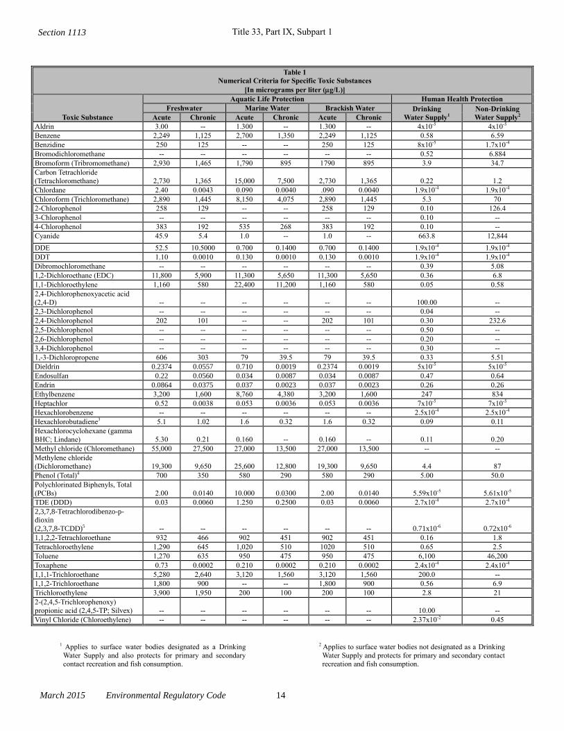
Title 33, Part IX, Subpart 1
March 2015 Environmental Regulatory Code 14
Table 1
Numerical Criteria for Specific Toxic Substances
[In micrograms per liter (g/L)]
Toxic Substance
Aquatic Life Protection Human Health Protection
Freshwater Marine Water Brackish Water Drinking
Water Supply1
Non-Drinking
Water Supply2 Acute Chronic Acute Chronic Acute Chronic
Aldrin 3.00 -- 1.300 -- 1.300 -- 4x10⁻⁵ 4x10⁻⁵
Benzene 2,249 1,125 2,700 1,350 2,249 1,125 0.58 6.59
Benzidine 250 125 -- -- 250 125 8x10⁻⁵ 1.7x10⁻⁴
Bromodichloromethane -- -- -- -- -- -- 0.52 6.884
Bromoform (Tribromomethane) 2,930 1,465 1,790 895 1790 895 3.9 34.7
Carbon Tetrachloride
(Tetrachloromethane) 2,730 1,365 15,000 7,500 2,730 1,365 0.22 1.2
Chlordane 2.40 0.0043 0.090 0.0040 .090 0.0040 1.9x10⁻⁴ 1.9x10⁻⁴
Chloroform (Trichloromethane) 2,890 1,445 8,150 4,075 2,890 1,445 5.3 70
2-Chlorophenol 258 129 -- -- 258 129 0.10 126.4
3-Chlorophenol -- -- -- -- -- -- 0.10 --
4-Chlorophenol 383 192 535 268 383 192 0.10 --
Cyanide 45.9 5.4 1.0 -- 1.0 -- 663.8 12,844
DDE 52.5 10.5000 0.700 0.1400 0.700 0.1400 1.9x10⁻⁴ 1.9x10⁻⁴
DDT 1.10 0.0010 0.130 0.0010 0.130 0.0010 1.9x10⁻⁴ 1.9x10⁻⁴
Dibromochloromethane -- -- -- -- -- -- 0.39 5.08
1,2-Dichloroethane (EDC) 11,800 5,900 11,300 5,650 11,300 5,650 0.36 6.8
1,1-Dichloroethylene 1,160 580 22,400 11,200 1,160 580 0.05 0.58
2,4-Dichlorophenoxyacetic acid
(2,4-D) -- -- -- -- -- -- 100.00 --
2,3-Dichlorophenol -- -- -- -- -- -- 0.04 --
2,4-Dichlorophenol 202 101 -- -- 202 101 0.30 232.6
2,5-Dichlorophenol -- -- -- -- -- -- 0.50 --
2,6-Dichlorophenol -- -- -- -- -- -- 0.20 --
3,4-Dichlorophenol -- -- -- -- -- -- 0.30 --
1,-3-Dichloropropene 606 303 79 39.5 79 39.5 0.33 5.51
Dieldrin 0.2374 0.0557 0.710 0.0019 0.2374 0.0019 5x10⁻⁵ 5x10⁻⁵
Endosulfan 0.22 0.0560 0.034 0.0087 0.034 0.0087 0.47 0.64
Endrin 0.0864 0.0375 0.037 0.0023 0.037 0.0023 0.26 0.26
Ethylbenzene 3,200 1,600 8,760 4,380 3,200 1,600 247 834
Heptachlor 0.52 0.0038 0.053 0.0036 0.053 0.0036 7x10⁻⁵ 7x10⁻⁵
Hexachlorobenzene -- -- -- -- -- -- 2.5x10⁻⁴ 2.5x10⁻⁴
Hexachlorobutadiene3 5.1 1.02 1.6 0.32 1.6 0.32 0.09 0.11
Hexachlorocyclohexane (gamma
BHC; Lindane) 5.30 0.21 0.160 -- 0.160 -- 0.11 0.20
Methyl chloride (Chloromethane) 55,000 27,500 27,000 13,500 27,000 13,500 -- --
Methylene chloride (Dichloromethane) 19,300 9,650 25,600 12,800 19,300 9,650 4.4 87
Phenol (Total)4 700 350 580 290 580 290 5.00 50.0
Polychlorinated Biphenyls, Total
(PCBs) 2.00 0.0140 10.000 0.0300 2.00 0.0140 5.59x10⁻⁵ 5.61x10⁻⁵
TDE (DDD) 0.03 0.0060 1.250 0.2500 0.03 0.0060 2.7x10⁻⁴ 2.7x10⁻⁴
2,3,7,8-Tetrachlorodibenzo-p-dioxin
(2,3,7,8-TCDD)5 -- -- -- -- -- -- 0.71x10⁻⁶ 0.72x10⁻⁶
1,1,2,2-Tetrachloroethane 932 466 902 451 902 451 0.16 1.8
Tetrachloroethylene 1,290 645 1,020 510 1020 510 0.65 2.5
Toluene 1,270 635 950 475 950 475 6,100 46,200
Toxaphene 0.73 0.0002 0.210 0.0002 0.210 0.0002 2.4x10⁻⁴ 2.4x10⁻⁴
1,1,1-Trichloroethane 5,280 2,640 3,120 1,560 3,120 1,560 200.0 --
1,1,2-Trichloroethane 1,800 900 -- -- 1,800 900 0.56 6.9
Trichloroethylene 3,900 1,950 200 100 200 100 2.8 21
2-(2,4,5-Trichlorophenoxy)
propionic acid (2,4,5-TP; Silvex) -- -- -- -- -- -- 10.00 --
Vinyl Chloride (Chloroethylene) -- -- -- -- -- -- 2.37x10⁻² 0.45
1 Applies to surface water bodies designated as a Drinking
Water Supply and also protects for primary and secondary
contact recreation and fish consumption.
2 Applies to surface water bodies not designated as a Drinking
Water Supply and protects for primary and secondary contact
recreation and fish consumption.
Section 1113
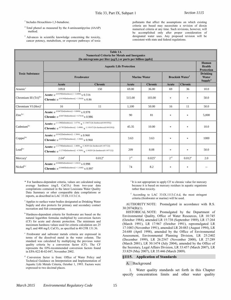
Title 33, Part IX, Subpart 1
March 2015 Environmental Regulatory Code 15
3 Includes Hexachloro-1,3-butadiene.
4 Total phenol as measured by the 4-aminoantipyrine (4AAP) method.
5 Advances in scientific knowledge concerning the toxicity,
cancer potency, metabolism, or exposure pathways of toxic
pollutants that affect the assumptions on which existing
criteria are based may necessitate a revision of dioxin numerical criteria at any time. Such revisions, however, will
be accomplished only after proper consideration of
designated water uses. Any proposed revision will be consistent with state and federal regulations.
Table 1A
Numerical Criteria for Metals and Inorganics
[In micrograms per liter (g/L) or parts per billion (ppb)]
Toxic Substance
Aquatic Life Protection
Human
Health
Protection
Freshwater Marine Water Brackish Waterf
Drinking
Water
Supplya
Acute Chronic Acute Chronic Acute Chronic
Arsenicc 339.8 150 69.00 36.00 69 36 10.0
Chromium III (Tri)b,c Acute: e (0.8190[In(hardness) ] + 3.6880) x 0.316
Chronic: e (0.8190[ln(hardness)] + 1.5610) x 0.86 515.00 103.00 50.0
Chromium VI (Hex)c 16 11 1,100 50.00 16 11 50.0
Zincb,c Acute: e (0.8473[ln(hardness)] + 0.8604) x 0.978
Chronic: e (0.8473[ln(hardness)] + 0.7614) x 0.986 90 81 5,000
Cadmiumb,c Acute: e (1.1280[ln(hardness)] - 1.6774) x (1.136672-[ln (hardness)(0.041838)])
Chronic: e (0.7852[ln(hardness)] - 3.4900) x (1.101672-[ln (hardness)(0.041838)]) 45.35 10.00 10.0
Copperb,c Acute: e (0.9422[ln(hardness)] - 1.3844) x 0.960
Chronic: e (0.8545[ln(hardness)] - 1.3860) x 0.960 3.63 3.63 1000
Leadb,c Acute: e (1.2730[ln(hardness)] - 1.4600) x (1.46203-[ln (hardness)(0.145712)])
Chronic: e (1.2730[ln(hardness)] - 4.7050) x (1.46203-[ln (hardness)(0.145712)]) 209 8.08 50.0
Mercuryc 2.04d 0.012e 2 d 0.025e 2 d 0.012e 2.0
Nickelb,c Acute: e (0.8460[ln(hardness)] + 3.3612) x 0.998
Chronic: e (0.8460[ln(hardness)] + 1.1645) x 0.997 74 8.2 --
* For hardness-dependent criteria, values are calculated using
average hardness (mg/L CaCO3) from two-year data compilations contained in the latest Louisiana Water Quality
Data Summary or other comparable data compilations or
reports, as described in LAC 33:IX.1113.C.6.
a Applies to surface water bodies designated as Drinking Water
Supply and also protects for primary and secondary contact
recreation and fish consumption.
b Hardness-dependent criteria for freshwater are based on the
natural logarithm formulas multiplied by conversion factors
(CF) for acute and chronic protection. The minimum and maximum hardness values used for criteria calculation are 25
mg/L and 400 mg/L CaCO3, as specified in 40 CFR 131.36.
c Freshwater and saltwater metals criteria are expressed in terms of the dissolved metal in the water column. The
standard was calculated by multiplying the previous water
quality criteria by a conversion factor (CF). The CF represents the EPA-recommended conversion factors found
in EPA-822-R-02-047, November 2002.
d Conversion factor is from: Office of Water Policy and Technical Guidance on Interpretation and Implementation of
Aquatic Life Metals Criteria, October 1, 1993. Factors were
expressed to two decimal places.
e It is not appropriate to apply CF to chronic value for mercury
because it is based on mercury residues in aquatic organisms rather than toxicity.
f According to LAC 33:IX.1113.C.6.d, the most stringent
criteria (freshwater or marine) will be used.
AUTHORITY NOTE: Promulgated in accordance with R.S.
30:2074(B)(1).
HISTORICAL NOTE: Promulgated by the Department of
Environmental Quality, Office of Water Resources, LR 10:745
(October 1984), amended LR 15:738 (September 1989), LR 17:264
(March 1991), LR 17:967 (October 1991), repromulgated LR
17:1083 (November 1991), amended LR 20:883 (August 1994), LR
24:688 (April 1998), amended by the Office of Environmental
Assessment, Environmental Planning Division, LR 25:2402
(December 1999), LR 26:2547 (November 2000), LR 27:289
(March 2001), LR 30:1474 (July 2004), amended by the Office of
the Secretary, Legal Affairs Division, LR 33:457 (March 2007), LR
33:829 (May 2007), LR 35:446 (March 2009).
§1115. Application of Standards
A. Background
1. Water quality standards set forth in this Chapter
specify concentration limits and other water quality
Section 1115
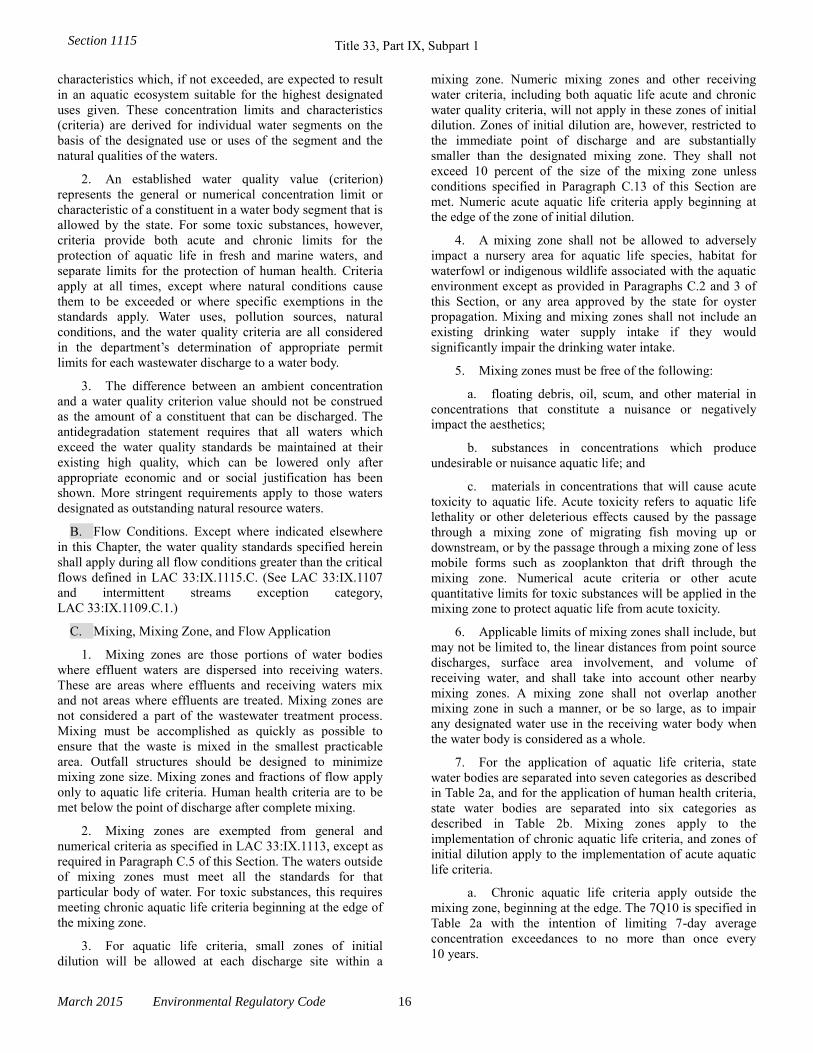
Title 33, Part IX, Subpart 1
March 2015 Environmental Regulatory Code 16
characteristics which, if not exceeded, are expected to result
in an aquatic ecosystem suitable for the highest designated
uses given. These concentration limits and characteristics
(criteria) are derived for individual water segments on the
basis of the designated use or uses of the segment and the
natural qualities of the waters.
2. An established water quality value (criterion)
represents the general or numerical concentration limit or
characteristic of a constituent in a water body segment that is
allowed by the state. For some toxic substances, however,
criteria provide both acute and chronic limits for the
protection of aquatic life in fresh and marine waters, and
separate limits for the protection of human health. Criteria
apply at all times, except where natural conditions cause
them to be exceeded or where specific exemptions in the
standards apply. Water uses, pollution sources, natural
conditions, and the water quality criteria are all considered
in the department’s determination of appropriate permit
limits for each wastewater discharge to a water body.
3. The difference between an ambient concentration
and a water quality criterion value should not be construed
as the amount of a constituent that can be discharged. The
antidegradation statement requires that all waters which
exceed the water quality standards be maintained at their
existing high quality, which can be lowered only after
appropriate economic and or social justification has been
shown. More stringent requirements apply to those waters
designated as outstanding natural resource waters.
B. Flow Conditions. Except where indicated elsewhere
in this Chapter, the water quality standards specified herein
shall apply during all flow conditions greater than the critical
flows defined in LAC 33:IX.1115.C. (See LAC 33:IX.1107
and intermittent streams exception category,
LAC 33:IX.1109.C.1.)
C. Mixing, Mixing Zone, and Flow Application
1. Mixing zones are those portions of water bodies
where effluent waters are dispersed into receiving waters.
These are areas where effluents and receiving waters mix
and not areas where effluents are treated. Mixing zones are
not considered a part of the wastewater treatment process.
Mixing must be accomplished as quickly as possible to
ensure that the waste is mixed in the smallest practicable
area. Outfall structures should be designed to minimize
mixing zone size. Mixing zones and fractions of flow apply
only to aquatic life criteria. Human health criteria are to be
met below the point of discharge after complete mixing.
2. Mixing zones are exempted from general and
numerical criteria as specified in LAC 33:IX.1113, except as
required in Paragraph C.5 of this Section. The waters outside
of mixing zones must meet all the standards for that
particular body of water. For toxic substances, this requires
meeting chronic aquatic life criteria beginning at the edge of
the mixing zone.
3. For aquatic life criteria, small zones of initial
dilution will be allowed at each discharge site within a
mixing zone. Numeric mixing zones and other receiving
water criteria, including both aquatic life acute and chronic
water quality criteria, will not apply in these zones of initial
dilution. Zones of initial dilution are, however, restricted to
the immediate point of discharge and are substantially
smaller than the designated mixing zone. They shall not
exceed 10 percent of the size of the mixing zone unless
conditions specified in Paragraph C.13 of this Section are
met. Numeric acute aquatic life criteria apply beginning at
the edge of the zone of initial dilution.
4. A mixing zone shall not be allowed to adversely
impact a nursery area for aquatic life species, habitat for
waterfowl or indigenous wildlife associated with the aquatic
environment except as provided in Paragraphs C.2 and 3 of
this Section, or any area approved by the state for oyster
propagation. Mixing and mixing zones shall not include an
existing drinking water supply intake if they would
significantly impair the drinking water intake.
5. Mixing zones must be free of the following:
a. floating debris, oil, scum, and other material in
concentrations that constitute a nuisance or negatively
impact the aesthetics;
b. substances in concentrations which produce
undesirable or nuisance aquatic life; and
c. materials in concentrations that will cause acute
toxicity to aquatic life. Acute toxicity refers to aquatic life
lethality or other deleterious effects caused by the passage
through a mixing zone of migrating fish moving up or
downstream, or by the passage through a mixing zone of less
mobile forms such as zooplankton that drift through the
mixing zone. Numerical acute criteria or other acute
quantitative limits for toxic substances will be applied in the
mixing zone to protect aquatic life from acute toxicity.
6. Applicable limits of mixing zones shall include, but
may not be limited to, the linear distances from point source
discharges, surface area involvement, and volume of
receiving water, and shall take into account other nearby
mixing zones. A mixing zone shall not overlap another
mixing zone in such a manner, or be so large, as to impair
any designated water use in the receiving water body when
the water body is considered as a whole.
7. For the application of aquatic life criteria, state
water bodies are separated into seven categories as described
in Table 2a, and for the application of human health criteria,
state water bodies are separated into six categories as
described in Table 2b. Mixing zones apply to the
implementation of chronic aquatic life criteria, and zones of
initial dilution apply to the implementation of acute aquatic
life criteria.
a. Chronic aquatic life criteria apply outside the
mixing zone, beginning at the edge. The 7Q10 is specified in
Table 2a with the intention of limiting 7-day average
concentration exceedances to no more than once every
10 years.
Section 1115
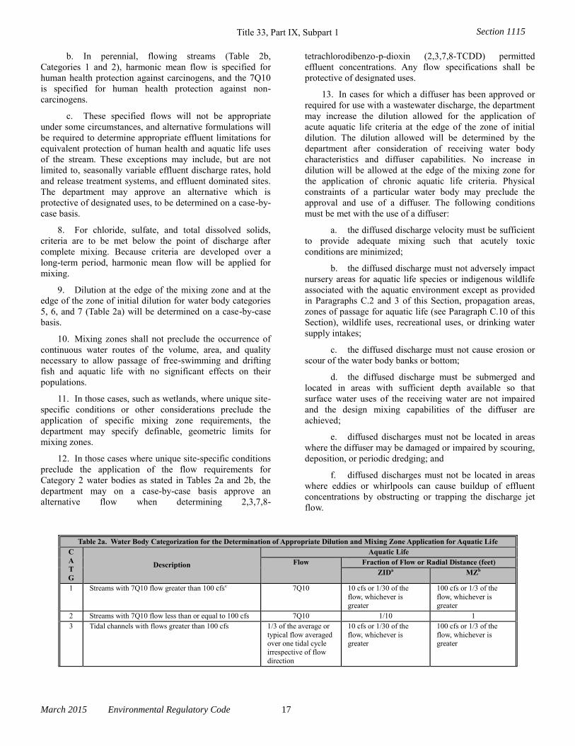
Title 33, Part IX, Subpart 1
March 2015 Environmental Regulatory Code 17
b. In perennial, flowing streams (Table 2b,
Categories 1 and 2), harmonic mean flow is specified for
human health protection against carcinogens, and the 7Q10
is specified for human health protection against non-
carcinogens.
c. These specified flows will not be appropriate
under some circumstances, and alternative formulations will
be required to determine appropriate effluent limitations for
equivalent protection of human health and aquatic life uses
of the stream. These exceptions may include, but are not
limited to, seasonally variable effluent discharge rates, hold
and release treatment systems, and effluent dominated sites.
The department may approve an alternative which is
protective of designated uses, to be determined on a case-by-
case basis.
8. For chloride, sulfate, and total dissolved solids,
criteria are to be met below the point of discharge after
complete mixing. Because criteria are developed over a
long-term period, harmonic mean flow will be applied for
mixing.
9. Dilution at the edge of the mixing zone and at the
edge of the zone of initial dilution for water body categories
5, 6, and 7 (Table 2a) will be determined on a case-by-case
basis.
10. Mixing zones shall not preclude the occurrence of
continuous water routes of the volume, area, and quality
necessary to allow passage of free-swimming and drifting
fish and aquatic life with no significant effects on their
populations.
11. In those cases, such as wetlands, where unique site-
specific conditions or other considerations preclude the
application of specific mixing zone requirements, the
department may specify definable, geometric limits for
mixing zones.
12. In those cases where unique site-specific conditions
preclude the application of the flow requirements for
Category 2 water bodies as stated in Tables 2a and 2b, the
department may on a case-by-case basis approve an
alternative flow when determining 2,3,7,8-
tetrachlorodibenzo-p-dioxin (2,3,7,8-TCDD) permitted
effluent concentrations. Any flow specifications shall be
protective of designated uses.
13. In cases for which a diffuser has been approved or
required for use with a wastewater discharge, the department
may increase the dilution allowed for the application of
acute aquatic life criteria at the edge of the zone of initial
dilution. The dilution allowed will be determined by the
department after consideration of receiving water body
characteristics and diffuser capabilities. No increase in
dilution will be allowed at the edge of the mixing zone for
the application of chronic aquatic life criteria. Physical
constraints of a particular water body may preclude the
approval and use of a diffuser. The following conditions
must be met with the use of a diffuser:
a. the diffused discharge velocity must be sufficient
to provide adequate mixing such that acutely toxic
conditions are minimized;
b. the diffused discharge must not adversely impact
nursery areas for aquatic life species or indigenous wildlife
associated with the aquatic environment except as provided
in Paragraphs C.2 and 3 of this Section, propagation areas,
zones of passage for aquatic life (see Paragraph C.10 of this
Section), wildlife uses, recreational uses, or drinking water
supply intakes;
c. the diffused discharge must not cause erosion or
scour of the water body banks or bottom;
d. the diffused discharge must be submerged and
located in areas with sufficient depth available so that
surface water uses of the receiving water are not impaired
and the design mixing capabilities of the diffuser are
achieved;
e. diffused discharges must not be located in areas
where the diffuser may be damaged or impaired by scouring,
deposition, or periodic dredging; and
f. diffused discharges must not be located in areas
where eddies or whirlpools can cause buildup of effluent
concentrations by obstructing or trapping the discharge jet
flow.
Table 2a. Water Body Categorization for the Determination of Appropriate Dilution and Mixing Zone Application for Aquatic Life
C
A
T
G
Description
Aquatic Life
Flow Fraction of Flow or Radial Distance (feet)
ZIDa MZb
1 Streams with 7Q10 flow greater than 100 cfsc 7Q10 10 cfs or 1/30 of the
flow, whichever is
greater
100 cfs or 1/3 of the
flow, whichever is
greater
2 Streams with 7Q10 flow less than or equal to 100 cfs 7Q10 1/10 1
3 Tidal channels with flows greater than 100 cfs 1/3 of the average or
typical flow averaged over one tidal cycle
irrespective of flow
direction
10 cfs or 1/30 of the
flow, whichever is greater
100 cfs or 1/3 of the
flow, whichever is greater
Section 1115
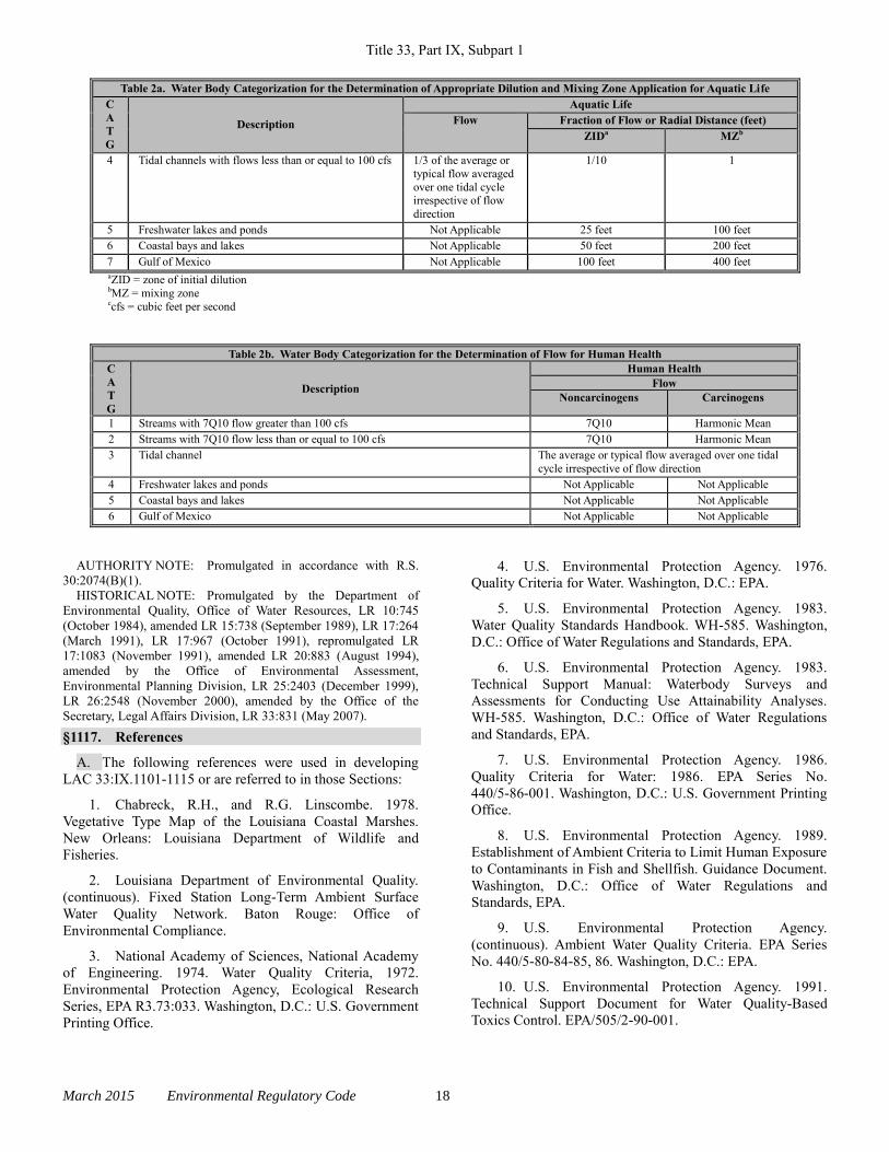
Title 33, Part IX, Subpart 1
March 2015 Environmental Regulatory Code 18
Table 2a. Water Body Categorization for the Determination of Appropriate Dilution and Mixing Zone Application for Aquatic Life
C
A
T
G
Description
Aquatic Life
Flow Fraction of Flow or Radial Distance (feet)
ZIDa MZb
4 Tidal channels with flows less than or equal to 100 cfs 1/3 of the average or
typical flow averaged
over one tidal cycle irrespective of flow
direction
1/10 1
5 Freshwater lakes and ponds Not Applicable 25 feet 100 feet
6 Coastal bays and lakes Not Applicable 50 feet 200 feet
7 Gulf of Mexico Not Applicable 100 feet 400 feet aZID = zone of initial dilution bMZ = mixing zone ccfs = cubic feet per second
Table 2b. Water Body Categorization for the Determination of Flow for Human Health C
A
T
G
Description
Human Health Flow
Noncarcinogens Carcinogens
1 Streams with 7Q10 flow greater than 100 cfs 7Q10 Harmonic Mean
2 Streams with 7Q10 flow less than or equal to 100 cfs 7Q10 Harmonic Mean
3 Tidal channel The average or typical flow averaged over one tidal
cycle irrespective of flow direction
4 Freshwater lakes and ponds Not Applicable Not Applicable
5 Coastal bays and lakes Not Applicable Not Applicable
6 Gulf of Mexico Not Applicable Not Applicable
AUTHORITY NOTE: Promulgated in accordance with R.S.
30:2074(B)(1).
HISTORICAL NOTE: Promulgated by the Department of
Environmental Quality, Office of Water Resources, LR 10:745
(October 1984), amended LR 15:738 (September 1989), LR 17:264
(March 1991), LR 17:967 (October 1991), repromulgated LR
17:1083 (November 1991), amended LR 20:883 (August 1994),
amended by the Office of Environmental Assessment,
Environmental Planning Division, LR 25:2403 (December 1999),
LR 26:2548 (November 2000), amended by the Office of the
Secretary, Legal Affairs Division, LR 33:831 (May 2007).
§1117. References
A. The following references were used in developing
LAC 33:IX.1101-1115 or are referred to in those Sections:
1. Chabreck, R.H., and R.G. Linscombe. 1978.
Vegetative Type Map of the Louisiana Coastal Marshes.
New Orleans: Louisiana Department of Wildlife and
Fisheries.
2. Louisiana Department of Environmental Quality.
(continuous). Fixed Station Long-Term Ambient Surface
Water Quality Network. Baton Rouge: Office of
Environmental Compliance.
3. National Academy of Sciences, National Academy
of Engineering. 1974. Water Quality Criteria, 1972.
Environmental Protection Agency, Ecological Research
Series, EPA R3.73:033. Washington, D.C.: U.S. Government
Printing Office.
4. U.S. Environmental Protection Agency. 1976.
Quality Criteria for Water. Washington, D.C.: EPA.
5. U.S. Environmental Protection Agency. 1983.
Water Quality Standards Handbook. WH-585. Washington,
D.C.: Office of Water Regulations and Standards, EPA.
6. U.S. Environmental Protection Agency. 1983.
Technical Support Manual: Waterbody Surveys and
Assessments for Conducting Use Attainability Analyses.
WH-585. Washington, D.C.: Office of Water Regulations
and Standards, EPA.
7. U.S. Environmental Protection Agency. 1986.
Quality Criteria for Water: 1986. EPA Series No.
440/5-86-001. Washington, D.C.: U.S. Government Printing
Office.
8. U.S. Environmental Protection Agency. 1989.
Establishment of Ambient Criteria to Limit Human Exposure
to Contaminants in Fish and Shellfish. Guidance Document.
Washington, D.C.: Office of Water Regulations and
Standards, EPA.
9. U.S. Environmental Protection Agency.
(continuous). Ambient Water Quality Criteria. EPA Series
No. 440/5-80-84-85, 86. Washington, D.C.: EPA.
10. U.S. Environmental Protection Agency. 1991.
Technical Support Document for Water Quality-Based
Toxics Control. EPA/505/2-90-001.
Title 33, Part IX, Subpart 1
March 2015 Environmental Regulatory Code 19
11. U.S. Environmental Protection Agency. December
22, 1992. Water Quality Standards; Establishment of
Numeric Criteria for Priority Toxic Pollutants; States'
Compliance. Federal Register: Vol. 57, No. 246. WH-FRL-
4543-9. Washington, D.C.: Office of Science and
Technology, EPA.
12. U.S. Environmental Protection Agency. April, 1995.
Method 1669: Sampling Ambient Water for Trace Metals At
EPA Water Quality Criteria Levels. EPA 821-R-95-034.
13. Webster's II New Riverside University Dictionary,
Anne H. Soukhanov, editor. 1988. Houghton Mifflin
Company, Boston, MA.
AUTHORITY NOTE: Promulgated in accordance with R.S.
30:2074(B)(1).
HISTORICAL NOTE: Promulgated by the Department of
Environmental Quality, Office of Water Resources, LR 10:745
(October 1984), amended LR 15:738 (September 1989), LR 17:264
(March 1991), LR 20:883 (August 1994), amended by the Office of
Environmental Assessment, Environmental Planning Division, LR
25:2403 (December 1999), amended by the Office of the Secretary,
Legal Affairs Division, LR 31:2507 (October 2005), LR 33:2163
(October 2007).
§1119. Implementation Plan for Antidegradation Policy
A. Summary and Purpose
1. As stated in LAC 33:IX.1109.A of these
regulations, the Antidegradation Policy provides a legal
framework for the basic maintenance and protection of all
designated water uses. It also outlines methods that the state
uses to protect state waters from water quality degradation
and some of the state and federal rules and regulations that
authorize them.
2. This Section explains the specific procedures used
by the department as the state's designated water quality
management agency to implement the Antidegradation
Policy.
B. Implementation of Louisiana's Water Quality
Management Process
1. Procedures and methods by which the
Antidegradation Policy is implemented are described in this
Section. Additional implementation procedures may be
incorporated into the Water Quality Management Plan after
appropriate public participation and intergovernmental
coordination.
2. WQM is a step-by-step process which involves
several interrelated programs that establish controls on the
discharge of pollutants and maintain existing water quality,
thereby protecting state waters from degradation. That
process is summarized below.
a. The state establishes the water quality standards
specified in this Chapter to reflect the goals for individual
water bodies and provide the legal basis for antidegradation
and for water pollution control. This Chapter also defines
and designates water uses and criteria to protect them.
b. A series of water quality monitoring activities is
conducted annually to provide the physical, chemical and
biological data needed to determine the quality of state
waters, identify pollution sources and help develop and
enforce the water quality standards defined in this Chapter.
Monitoring activities include maintaining monthly water
quality stations, conducting intensive surveys and special
studies, investigating pollution complaints, and assuring
compliance of dischargers.
c. Water quality monitoring data and water body
conditions are continually assessed to identify problem areas
and assist in the development of water quality management
plans and standards. The biennial Louisiana Water Quality
Integrated Report is the state's principal tool in water quality
assessment and identifies areas of water quality degradation.
d. The state's Water Quality Management Plan
(WQMP) utilizes discharger data, various land use
inventories, and the results of the monitoring and assessment
programs to identify priority water quality problems. The
WQMP contains the analyses used and management
decisions made to control specific pollution sources and
recommends control measures to attain the water quality
standards. The plan includes provisions for identifying
priority WQM basins and segments, allocating point source
wasteloads, controlling nonpoint sources, general planning
needs, and public participation.
e. A wastewater discharge permit is required for
any discharge into state waters with the exception of those
noted in LAC 33:IX.301.D and F. Permits based on water
quality are developed to specify the wasteload content of the
discharge that must not be exceeded to attain water quality
standards and protect state waters from degradation. Other
control activities include the development of best
management practices for nonpoint source controls and
water quality certification of federal permits.
f. Enforcement activities of the department help
eliminate or ameliorate water quality degradation caused by
both permitted and unpermitted discharges. Enforcement
actions are directed at dischargers found to be in violation of
the Water Control Law or effluent limits detailed in a
wastewater permit.
g. The state's Continuing Planning Process (CPP)
document describes those administrative, technical, and
programmatic processes used by the state to implement its
water pollution control program. The document contains
detailed descriptions of each phase of implementation, from
the planning of monitoring efforts, to the assessment and
reporting of resulting data, to the decision-making process
for carrying out policy promulgated by the department. To
maintain an annual schedule of water quality needs and
activities, the department also developed the Water Pollution
Control Program Plan consistent with Section 106 of the
Clean Water Act.
C. Specific Implementation Procedures for the
Antidegradation Policy. The antidegradation policy is
implemented by ensuring that for all new or increased
Section 1119
Title 33, Part IX, Subpart 1
March 2015 Environmental Regulatory Code 20
discharges which may impact water quality and are
permitted by the state, or for which there must be a permit
on which the state comments, consideration is given to
requirements of the policy. The basic principle of the policy
is that water quality criteria specified in the standards shall
not be exceeded and that designated uses will not be
adversely impacted.
1. If either the criteria or uses cannot be attained, then
a use attainability analysis will be conducted.
2. If a new or increased activity will impact water
quality by either a point or nonpoint source discharge of
pollutants, the state shall ensure that the activity will not
impair the existing uses. If water quality will be degraded,
the state shall ensure that an analysis consistent with the
antidegradation policy is completed, and the
intergovernmental coordination and public participation
provisions of the state's Continuing Planning Process are
met. In the case of state or federal wastewater discharge
permits, intergovernmental coordination and public
participation may be accomplished through public notice of
the permit. As with any permitted discharge to a water body
not designated as an outstanding natural resource water,
some change in existing water quality may occur; however,
existing uses shall be maintained.
3. If a new or increased wastewater discharge or
activity is proposed for an outstanding natural resource
water body, the administrative authority shall not approve
that discharge or activity if it will cause degradation, as
defined in LAC 33:IX.1105, of the water body. A facility
identified by the administrative authority as having an
unpermitted discharge will be required to apply for an
LPDES permit in accordance with LAC 33:IX.2501.A. The
unpermitted discharge may be permitted if the discharge
existed before the designation as an outstanding natural
resource water body. Additionally, an existing unpermitted
discharge of treated sanitary wastewater may also be
permitted if no reasonable alternative discharge location is
available.
AUTHORITY NOTE: Promulgated in accordance with R.S.
30:2074(B)(1).
HISTORICAL NOTE: Promulgated by the Department of
Environmental Quality, Office of Water Resources, LR 15:738
(September 1989), amended by the Office of Environmental
Assessment, Environmental Planning Division, LR 26:2548
(November 2000), amended by the Office of the Secretary, Legal
Affairs Division, LR 33:831 (May 2007), amended by the Office of
the Secretary, Legal Division, LR 40:2244 (November 2014).
§1121. Regulation of Toxic Substances Based on the
General Criteria
A. Introduction
1. The water quality standards in this Chapter provide
for the protection of human, plant, and animal life from the
deleterious effects of toxic substances. The general criteria
(LAC 33:IX.1113.B.5), in particular, require that state waters
be free from the effects of toxic substances. This
requirement is especially applicable to those toxic
substances for which no numerical criteria are established.
2. The following methods are developed to protect
state waters from the effects of toxic substances as required
under the general criteria and where no numerical criteria
exist. The methods follow the permitting policies of the
Louisiana Water Discharge Permit System (LWDPS). The
resulting permit (effluent) limitations imposed on discharges
prevent toxic in-stream conditions as required under the
general criteria.
B. Effluent Characterization/Toxicity Testing and/or
Instream Assessment
1. When determining the need for limits based on
water quality, the Office of Environmental Services may
identify data needs and request that the permittee submit
additional data along with the application. Permits may be
placed into three categories:
a. discharges for which adequate data exist;
b. discharges for which some data exist; and
c. discharges for which no water-quality-related
data are available.
2. In areas of known ambient toxicity, both specific
chemical data and available whole effluent toxicity data
representative of the facility's discharge into the receiving
water will be reviewed.
3. In general, whole effluent toxicity testing will be
required in the permit for discharges where data are
insufficient to demonstrate that any discharge does not or
will not contribute to ambient toxicity.
a. Tests will be routinely run for the life of the
permit on an established schedule dependent upon on the
variability of the discharge and on whether effluent toxicity
is suspected or unknown.
b. Both acute toxicity and chronic toxicity tests may
be required. Test methods found in the following sources or
their updated versions should be followed: "Methods for
Measuring the Acute Toxicity of Effluents and Receiving
Waters to Freshwater and Marine Organisms," 4th Edition,
EPA/600/4-90/027F, EPA, 1993; "Short-Term Methods for
Estimating the Chronic Toxicity of Effluents And Receiving
Waters To Freshwater Organisms," 3rd Edition, EPA/600/4-
91/002, EPA, 1994; and "Short-Term Methods for
Estimating the Chronic Toxicity of Effluents and Receiving
Waters to Marine and Estuarine Organisms," 2nd Edition,
EPA/600/4-91/003, EPA.
i. Acute toxicity tests will be considered for
"end-of-pipe" effluent. Dilution water will be receiving
water collected at a point upstream of or adequately removed
from the discharge point(s).
ii. For chronic toxicity tests of effluent, dilution
water will also be receiving stream water collected at a point
upstream of or adequately removed from the discharge
point(s). In flowing water bodies, one dilution in the series
Title 33, Part IX, Subpart 1
March 2015 Environmental Regulatory Code 21
required to calculate the no-observed-effect level (NOEL)
will reflect the 7Q10 flow dilution. In some water bodies the
7Q10 flow may not be considered adequate, and a more
appropriate low flow will be used for dilution calculations.
iii. Multiple toxicity tests using more than one
species of test organisms will normally be required. The
following tests and species are considered applicable to and
representative of Louisiana waters. Other applicable tests
and test species may also be used after approval by the
department. In general, some combination of the following
tests and species will be required:
(a). for receiving water bodies with salinities less
than 2 ‰(2 ppt or 2,000 ppm):
(i). 48-hour Ceriodaphnia or Daphnia pulex
acute survival;
(ii). 48- and 96-hour fathead minnow
(Pimephales promelas) static renewal acute survival;
(iii). 7-day Ceriodaphnia chronic reproduction
and survival;
(iv). 7-day fathead minnow chronic survival
and teratogenicity;
(v). 7-day fathead minnow chronic growth
and survival; and
(vi). 4-day Selenastrum chronic growth test;
(b). for receiving water bodies with salinities
equal to or greater than 2 ‰ (2 ppt or 2,000 ppm):
(i). 48-hour mysid shrimp acute survival;
(ii). 48- and 96-hour sheepshead minnow
(Cyprinodon variegatus) static renewal acute survival;
(iii). 48-hour inland silverside (Menidia
beryllina) static renewal acute survival;
(iv). 7-day mysid shrimp survival, growth, and
fecundity;
(v). 7-day sheepshead minnow larval survival
and growth; and
(vi). 7-day inland silverside larval survival and
growth; and
(c). if a control test reveals upstream ambient
water to be toxic, the discharger will redo the toxicity tests
using EPA- and department-approved reconstituted water
with hardness, alkalinity, pH, and conductivity comparable
to the ambient stream for dilution. The department will
evaluate the toxicity data if upstream toxicity is indicated.
4. For water bodies whose designated use is as a
drinking water supply, the department will calculate the in-
stream concentration for all discharged pollutants for which
EPA has promulgated a maximum contaminant level (MCL).
The permittee will be required to submit to the Office of
Environmental Services sufficient effluent characterization
data to make these calculations. Where dilution calculations
indicate that in-stream concentrations may exceed the MCL
requirements at appropriate flow conditions, the permittee
may be required to conduct in-stream chemical monitoring
or monitoring at the water supply.
5. To protect human health by eliminating chronic
exposure to potentially toxic amounts of pollutants from
aquatic species consumed by humans, the department will
calculate the in-stream concentrations of all applicable
pollutants for which EPA has published human health
criteria in the Quality Criteria for Water, 1986, EPA 440/5-
86-001, or subsequent revisions. The permittee will be
required to submit to the Office of Environmental Services
sufficient effluent characterization data to make these
calculations. For operational considerations, if dilution
calculations show that after mixing, a suspected carcinogen
would be present in the receiving water body at a
concentration associated with a 10-6
risk level, in-stream
chemical monitoring may be required of the appropriate
dischargers. The department will list the water body as a
priority water body and develop a wasteload allocation or
make other consideration for it.
C. Options for Implementing Whole Effluent Toxicity
Permit Requirements. The option or combination of options
to be selected by the department from the following will
depend on data availability at the time of permit application
and on whether toxicity is known or suspected.
1. Option 1. Final whole effluent toxicity limits are
included in the permit with an interim schedule for
conducting toxicity reduction that begins upon issuance of
the permit.
2. Option 2. The permittee will conduct whole effluent
toxicity testing with pass/fail criteria that will trigger toxicity
reduction efforts. A clause requiring this will be placed in the
permit to take effect if the pass/fail criteria are exceeded
when any toxic impact exhibited shows a statistically
significant difference between the effluent sample and the
control. If any toxicity test is failed, an opportunity for
retesting will be given. When no toxicity is demonstrated or
no toxicity criteria are exceeded, testing may be reduced for
the remainder of the term of the permit. If any subsequent
testing indicates toxicity, the permittee must revert to the
more frequent monitoring schedule.
3. Option 3. No whole effluent toxicity limits are
included in the permit. Limits based on MCLs and/or on
protecting human health are included, or a schedule for their
inclusion is incorporated into the permit.
4. Option 4. No whole effluent toxicity limits are
included in the permit.
5. Option 5. A combination of the above four options
may be applied.
D. References. The following references were used in
developing or were cited in this Section:
Section 1121
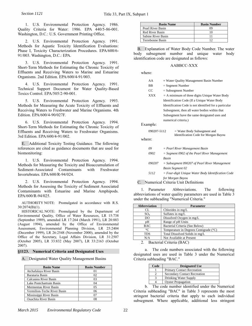
Title 33, Part IX, Subpart 1
March 2015 Environmental Regulatory Code 22
1. U.S. Environmental Protection Agency. 1986.
Quality Criteria for Water: 1986. EPA 440/5-86-001.
Washington, D.C.: U.S. Government Printing Office.
2. U.S. Environmental Protection Agency. 1991.
Methods for Aquatic Toxicity Identification Evaluations:
Phase I, Toxicity Characterization Procedures. EPA/600/6-
91/003. Washington, D.C.: EPA.
3. U.S. Environmental Protection Agency. 1991.
Short-Term Methods for Estimating the Chronic Toxicity of
Effluents and Receiving Waters to Marine and Estuarine
Organisms. 2nd Edition. EPA/600/4-91/003.
4. U.S. Environmental Protection Agency. 1991.
Technical Support Document for Water Quality-Based
Toxics Control. EPA/505/2-90-001.
5. U.S. Environmental Protection Agency. 1993.
Methods for Measuring the Acute Toxicity of Effluents and
Receiving Waters to Freshwater and Marine Organisms. 4th
Edition. EPA/600/4-90/027F.
6. U.S. Environmental Protection Agency. 1994.
Short-Term Methods for Estimating the Chronic Toxicity of
Effluents and Receiving Waters to Freshwater Organisms.
3rd Edition. EPA/600/4-91/002.
E. Additional Toxicity Testing Guidance. The following
references are cited as guidance documents that are used for
biomonitoring:
1. U.S. Environmental Protection Agency. 1994.
Methods for Measuring the Toxicity and Bioaccumulation of
Sediment-Associated Contaminants with Freshwater
Invertebrates. EPA/600/R-94/024.
2. U.S. Environmental Protection Agency. 1994.
Methods for Assessing the Toxicity of Sediment Associated
Contaminants with Estuarine and Marine Amphipods.
EPA/600/R-94/025.
AUTHORITY NOTE: Promulgated in accordance with R.S.
30:2074(B)(1).
HISTORICAL NOTE: Promulgated by the Department of
Environmental Quality, Office of Water Resources, LR 15:738
(September 1989), amended LR 17:264 (March 1991), LR 20:883
(August 1994), amended by the Office of Environmental
Assessment, Environmental Planning Division, LR 25:2404
(December 1999), LR 26:2548 (November 2000), amended by the
Office of the Secretary, Legal Affairs Division, LR 31:2507
(October 2005), LR 33:832 (May 2007), LR 33:2163 (October
2007).
§1123. Numerical Criteria and Designated Uses
A. Designated Water Quality Management Basins
Basin Name Basin Number
Atchafalaya River Basin 01
Barataria Basin 02
Calcasieu River Basin 03
Lake Pontchartrain Basin 04
Mermentau River Basin 05
Vermilion-Teche River Basin 06
Mississippi River Basin 07
Ouachita River Basin 08
Basin Name Basin Number
Pearl River Basin 09
Red River Basin 10
Sabine River Basin 11
Terrebonne Basin 12
B. Explanation of Water Body Code Number. The water
body subsegment number and unique water body
identification code are designated as follows:
AABBCC-XXX
where:
AA = Water Quality Management Basin Number
BB = Segment Number
CC = Subsegment Number
XXX = A minimum of three digits Unique Water Body
Identification Code (If a Unique Water Body
Identification Code is not identified for a particular
Subsegment, then all water bodies within that
Subsegment have the same designated uses and
numerical criteria.)
Example:
090207-5112 = Water Body Subsegment and Identification Code for Morgan Bayou
where:
09 = Pearl River Management Basin
0902 = Segment 0902 of the Pearl River Management
Basin
090207 = Subsegment 090207 of Pearl River Management
Basin Segment 02
5112 = Four-digit Unique Water Body Identification Code
for Morgan Bayou
C. Numerical Criteria Unit Definitions
1. Parameter Abbreviations. The following
abbreviations of water quality parameters are used in Table 3
under the subheading "Numerical Criteria."
Abbreviation Parameter
CL Chlorides in mg/L
SO4 Sulfates in mg/L
DO Dissolved Oxygen in mg/L
pH Range of pH Units
BAC Bacterial Criteria (See Below)
°C Temperature in Degrees Centigrade (°C)
TDS Total Dissolved Solids in mg/L
N/A Not Available at Present
2. Bacterial Criteria (BAC)
a. The code numbers associated with the following
designated uses are used in Table 3 under the Numerical
Criteria subheading "BAC."
Code Designated Use
1 Primary Contact Recreation
2 Secondary Contact Recreation
3 Drinking Water Supply
4 Oyster Propagation
b. The code number identified under the Numerical
Criteria subheading "BAC" in Table 3 represents the most
stringent bacterial criteria that apply to each individual
subsegment. Where applicable, additional less stringent
Section 1121
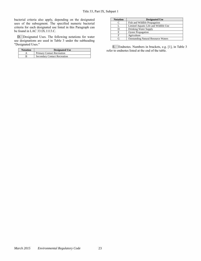
Title 33, Part IX, Subpart 1
March 2015 Environmental Regulatory Code 23
bacterial criteria also apply, depending on the designated
uses of the subsegment. The specified numeric bacterial
criteria for each designated use listed in this Paragraph can
be found in LAC 33:IX.1113.C.
D. Designated Uses. The following notations for water
use designations are used in Table 3 under the subheading
"Designated Uses."
Notation Designated Use
A Primary Contact Recreation
B Secondary Contact Recreation
Notation Designated Use
C Fish and Wildlife Propagation
L Limited Aquatic Life and Wildlife Use
D Drinking Water Supply
E Oyster Propagation
F Agriculture
G Outstanding Natural Resource Waters
E. Endnotes. Numbers in brackets, e.g. [1], in Table 3
refer to endnotes listed at the end of the table.
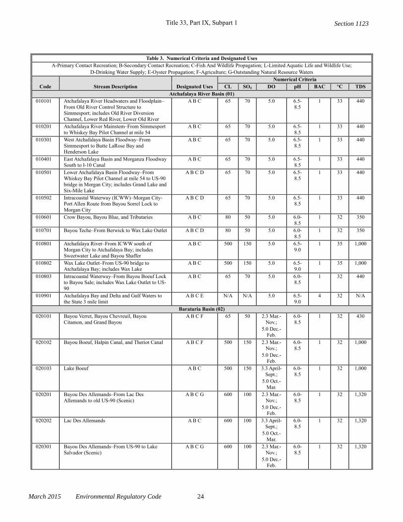
Title 33, Part IX, Subpart 1
March 2015 Environmental Regulatory Code 24
Table 3. Numerical Criteria and Designated Uses
A-Primary Contact Recreation; B-Secondary Contact Recreation; C-Fish And Wildlife Propagation; L-Limited Aquatic Life and Wildlife Use;
D-Drinking Water Supply; E-Oyster Propagation; F-Agriculture; G-Outstanding Natural Resource Waters
Code Stream Description Designated Uses
Numerical Criteria
CL SO4 DO pH BAC °C TDS
Atchafalaya River Basin (01)
010101 Atchafalaya River Headwaters and Floodplain–
From Old River Control Structure to Simmesport; includes Old River Diversion
Channel, Lower Red River, Lower Old River
A B C 65 70 5.0 6.5-
8.5
1 33 440
010201 Atchafalaya River Mainstem–From Simmesport
to Whiskey Bay Pilot Channel at mile 54
A B C 65 70 5.0 6.5-
8.5
1 33 440
010301 West Atchafalaya Basin Floodway–From
Simmesport to Butte LaRose Bay and Henderson Lake
A B C 65 70 5.0 6.5-
8.5
1 33 440
010401 East Atchafalaya Basin and Morganza Floodway South to I-10 Canal
A B C 65 70 5.0 6.5-8.5
1 33 440
010501 Lower Atchafalaya Basin Floodway–From Whiskey Bay Pilot Channel at mile 54 to US-90
bridge in Morgan City; includes Grand Lake and
Six-Mile Lake
A B C D 65 70 5.0 6.5-8.5
1 33 440
010502 Intracoastal Waterway (ICWW)–Morgan City-Port Allen Route from Bayou Sorrel Lock to
Morgan City
A B C D 65 70 5.0 6.5-8.5
1 33 440
010601 Crow Bayou, Bayou Blue, and Tributaries A B C 80 50 5.0 6.0-
8.5
1 32 350
010701 Bayou Teche–From Berwick to Wax Lake Outlet A B C D 80 50 5.0 6.0-
8.5
1 32 350
010801 Atchafalaya River–From ICWW south of
Morgan City to Atchafalaya Bay; includes Sweetwater Lake and Bayou Shaffer
A B C 500 150 5.0 6.5-
9.0
1 35 1,000
010802 Wax Lake Outlet–From US-90 bridge to Atchafalaya Bay; includes Wax Lake
A B C 500 150 5.0 6.5-9.0
1 35 1,000
010803 Intracoastal Waterway–From Bayou Boeuf Lock to Bayou Sale; includes Wax Lake Outlet to US-
90
A B C 65 70 5.0 6.0-8.5
1 32 440
010901 Atchafalaya Bay and Delta and Gulf Waters to
the State 3 mile limit
A B C E N/A N/A 5.0 6.5-
9.0
4 32 N/A
Barataria Basin (02)
020101 Bayou Verret, Bayou Chevreuil, Bayou
Citamon, and Grand Bayou
A B C F 65 50 2.3 Mar.-
Nov.;
5.0 Dec.-
Feb.
6.0-
8.5
1 32 430
020102 Bayou Boeuf, Halpin Canal, and Theriot Canal A B C F 500 150 2.3 Mar.-
Nov.;
5.0 Dec.-Feb.
6.0-
8.5
1 32 1,000
020103 Lake Boeuf A B C 500 150 3.3 April-
Sept.;
5.0 Oct.-
Mar.
6.0-
8.5
1 32 1,000
020201 Bayou Des Allemands–From Lac Des
Allemands to old US-90 (Scenic)
A B C G 600 100 2.3 Mar.-
Nov.;
5.0 Dec.-Feb.
6.0-
8.5
1 32 1,320
020202 Lac Des Allemands A B C 600 100 3.3 April-Sept.;
5.0 Oct.-
Mar.
6.0-8.5
1 32 1,320
020301 Bayou Des Allemands–From US-90 to Lake
Salvador (Scenic)
A B C G 600 100 2.3 Mar.-
Nov.;
5.0 Dec.-Feb.
6.0-
8.5
1 32 1,320
Section 1123
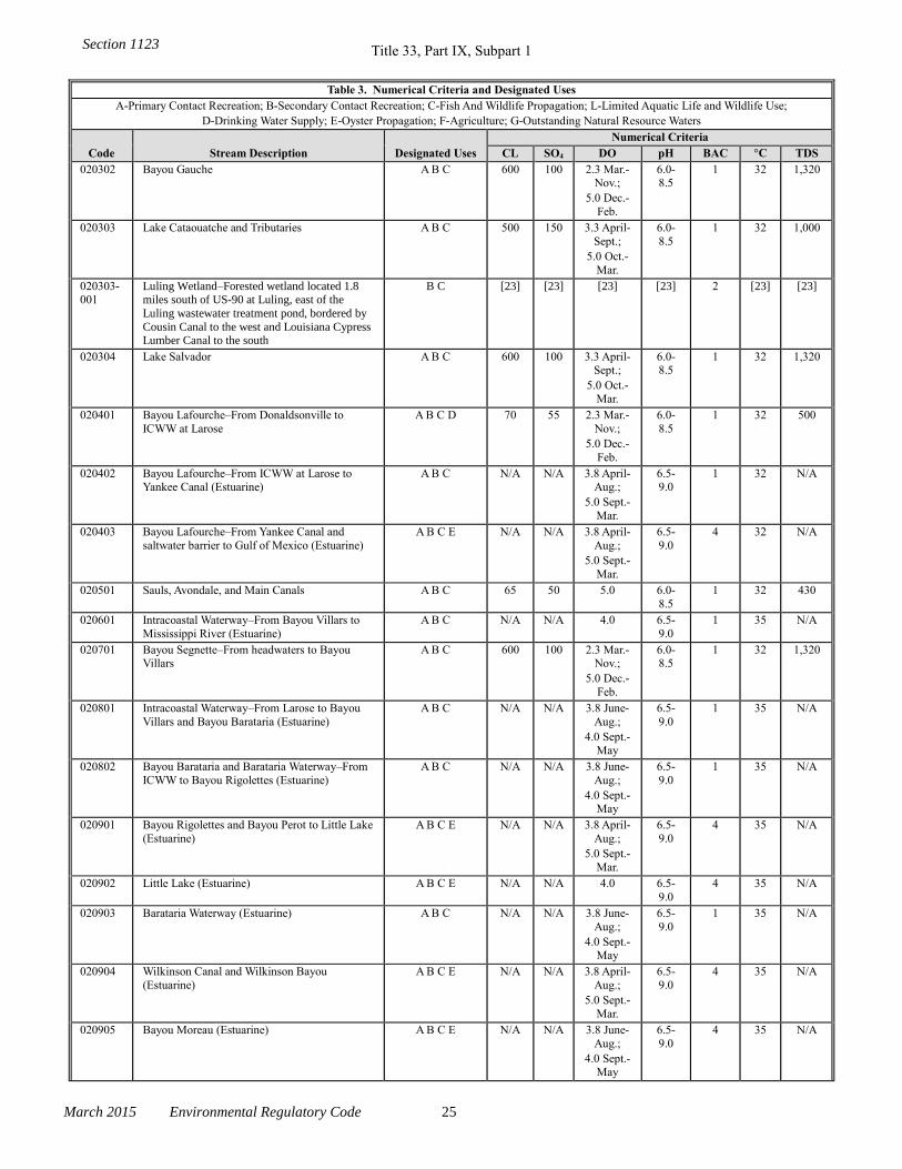
Title 33, Part IX, Subpart 1
March 2015 Environmental Regulatory Code 25
Table 3. Numerical Criteria and Designated Uses
A-Primary Contact Recreation; B-Secondary Contact Recreation; C-Fish And Wildlife Propagation; L-Limited Aquatic Life and Wildlife Use;
D-Drinking Water Supply; E-Oyster Propagation; F-Agriculture; G-Outstanding Natural Resource Waters
Code Stream Description Designated Uses
Numerical Criteria
CL SO4 DO pH BAC °C TDS
020302 Bayou Gauche A B C 600 100 2.3 Mar.-Nov.;
5.0 Dec.-
Feb.
6.0-8.5
1 32 1,320
020303 Lake Cataouatche and Tributaries A B C 500 150 3.3 April-
Sept.;
5.0 Oct.-
Mar.
6.0-
8.5
1 32 1,000
020303-001
Luling Wetland–Forested wetland located 1.8 miles south of US-90 at Luling, east of the
Luling wastewater treatment pond, bordered by
Cousin Canal to the west and Louisiana Cypress Lumber Canal to the south
B C [23] [23] [23] [23] 2 [23] [23]
020304 Lake Salvador A B C 600 100 3.3 April-Sept.;
5.0 Oct.-
Mar.
6.0-8.5
1 32 1,320
020401 Bayou Lafourche–From Donaldsonville to
ICWW at Larose
A B C D 70 55 2.3 Mar.-
Nov.;
5.0 Dec.-
Feb.
6.0-
8.5
1 32 500
020402 Bayou Lafourche–From ICWW at Larose to Yankee Canal (Estuarine)
A B C N/A N/A 3.8 April-Aug.;
5.0 Sept.-
Mar.
6.5-9.0
1 32 N/A
020403 Bayou Lafourche–From Yankee Canal and
saltwater barrier to Gulf of Mexico (Estuarine)
A B C E N/A N/A 3.8 April-
Aug.;
5.0 Sept.-
Mar.
6.5-
9.0
4 32 N/A
020501 Sauls, Avondale, and Main Canals A B C 65 50 5.0 6.0-
8.5
1 32 430
020601 Intracoastal Waterway–From Bayou Villars to
Mississippi River (Estuarine)
A B C N/A N/A 4.0 6.5-
9.0
1 35 N/A
020701 Bayou Segnette–From headwaters to Bayou Villars
A B C 600 100 2.3 Mar.-Nov.;
5.0 Dec.-
Feb.
6.0-8.5
1 32 1,320
020801 Intracoastal Waterway–From Larose to Bayou
Villars and Bayou Barataria (Estuarine)
A B C N/A N/A 3.8 June-
Aug.;
4.0 Sept.-
May
6.5-
9.0
1 35 N/A
020802 Bayou Barataria and Barataria Waterway–From
ICWW to Bayou Rigolettes (Estuarine)
A B C N/A N/A 3.8 June-
Aug.;
4.0 Sept.-May
6.5-
9.0
1 35 N/A
020901 Bayou Rigolettes and Bayou Perot to Little Lake
(Estuarine)
A B C E N/A N/A 3.8 April-
Aug.;
5.0 Sept.-
Mar.
6.5-
9.0
4 35 N/A
020902 Little Lake (Estuarine) A B C E N/A N/A 4.0 6.5-
9.0
4 35 N/A
020903 Barataria Waterway (Estuarine) A B C N/A N/A 3.8 June-
Aug.;
4.0 Sept.-May
6.5-
9.0
1 35 N/A
020904 Wilkinson Canal and Wilkinson Bayou
(Estuarine)
A B C E N/A N/A 3.8 April-
Aug.;
5.0 Sept.-
Mar.
6.5-
9.0
4 35 N/A
020905 Bayou Moreau (Estuarine) A B C E N/A N/A 3.8 June-
Aug.;
4.0 Sept.-May
6.5-
9.0
4 35 N/A
Section 1123
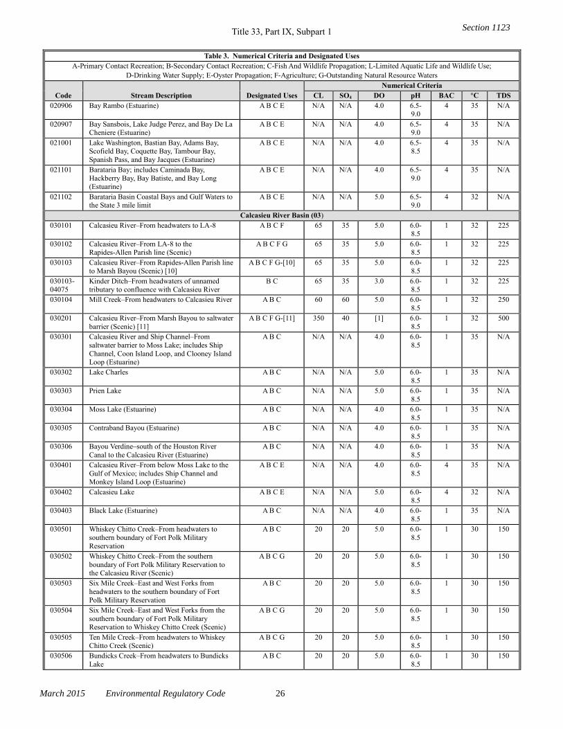
Title 33, Part IX, Subpart 1
March 2015 Environmental Regulatory Code 26
Table 3. Numerical Criteria and Designated Uses
A-Primary Contact Recreation; B-Secondary Contact Recreation; C-Fish And Wildlife Propagation; L-Limited Aquatic Life and Wildlife Use;
D-Drinking Water Supply; E-Oyster Propagation; F-Agriculture; G-Outstanding Natural Resource Waters
Code Stream Description Designated Uses
Numerical Criteria
CL SO4 DO pH BAC °C TDS
020906 Bay Rambo (Estuarine) A B C E N/A N/A 4.0 6.5-9.0
4 35 N/A
020907 Bay Sansbois, Lake Judge Perez, and Bay De La Cheniere (Estuarine)
A B C E N/A N/A 4.0 6.5-9.0
4 35 N/A
021001 Lake Washington, Bastian Bay, Adams Bay, Scofield Bay, Coquette Bay, Tambour Bay,
Spanish Pass, and Bay Jacques (Estuarine)
A B C E N/A N/A 4.0 6.5-8.5
4 35 N/A
021101 Barataria Bay; includes Caminada Bay,
Hackberry Bay, Bay Batiste, and Bay Long (Estuarine)
A B C E N/A N/A 4.0 6.5-
9.0
4 35 N/A
021102 Barataria Basin Coastal Bays and Gulf Waters to the State 3 mile limit
A B C E N/A N/A 5.0 6.5-9.0
4 32 N/A
Calcasieu River Basin (03)
030101 Calcasieu River–From headwaters to LA-8 A B C F 65 35 5.0 6.0-8.5
1 32 225
030102 Calcasieu River–From LA-8 to the Rapides-Allen Parish line (Scenic)
A B C F G 65 35 5.0 6.0-8.5
1 32 225
030103 Calcasieu River–From Rapides-Allen Parish line to Marsh Bayou (Scenic) [10]
A B C F G-[10] 65 35 5.0 6.0-8.5
1 32 225
030103-04075
Kinder Ditch–From headwaters of unnamed tributary to confluence with Calcasieu River
B C 65 35 3.0 6.0-8.5
1 32 225
030104 Mill Creek–From headwaters to Calcasieu River A B C 60 60 5.0 6.0-
8.5
1 32 250
030201 Calcasieu River–From Marsh Bayou to saltwater
barrier (Scenic) [11]
A B C F G-[11] 350 40 [1] 6.0-
8.5
1 32 500
030301 Calcasieu River and Ship Channel–From
saltwater barrier to Moss Lake; includes Ship
Channel, Coon Island Loop, and Clooney Island Loop (Estuarine)
A B C N/A N/A 4.0 6.0-
8.5
1 35 N/A
030302 Lake Charles A B C N/A N/A 5.0 6.0-
8.5
1 35 N/A
030303 Prien Lake A B C N/A N/A 5.0 6.0-
8.5
1 35 N/A
030304 Moss Lake (Estuarine) A B C N/A N/A 4.0 6.0-
8.5
1 35 N/A
030305 Contraband Bayou (Estuarine) A B C N/A N/A 4.0 6.0-
8.5
1 35 N/A
030306 Bayou Verdine–south of the Houston River
Canal to the Calcasieu River (Estuarine)
A B C N/A N/A 4.0 6.0-
8.5
1 35 N/A
030401 Calcasieu River–From below Moss Lake to the
Gulf of Mexico; includes Ship Channel and Monkey Island Loop (Estuarine)
A B C E N/A N/A 4.0 6.0-
8.5
4 35 N/A
030402 Calcasieu Lake A B C E N/A N/A 5.0 6.0-8.5
4 32 N/A
030403 Black Lake (Estuarine) A B C N/A N/A 4.0 6.0-
8.5
1 35 N/A
030501 Whiskey Chitto Creek–From headwaters to
southern boundary of Fort Polk Military
Reservation
A B C 20 20 5.0 6.0-
8.5
1 30 150
030502 Whiskey Chitto Creek–From the southern
boundary of Fort Polk Military Reservation to the Calcasieu River (Scenic)
A B C G 20 20 5.0 6.0-
8.5
1 30 150
030503 Six Mile Creek–East and West Forks from
headwaters to the southern boundary of Fort
Polk Military Reservation
A B C 20 20 5.0 6.0-
8.5
1 30 150
030504 Six Mile Creek–East and West Forks from the
southern boundary of Fort Polk Military Reservation to Whiskey Chitto Creek (Scenic)
A B C G 20 20 5.0 6.0-
8.5
1 30 150
030505 Ten Mile Creek–From headwaters to Whiskey Chitto Creek (Scenic)
A B C G 20 20 5.0 6.0-8.5
1 30 150
030506 Bundicks Creek–From headwaters to Bundicks
Lake
A B C 20 20 5.0 6.0-
8.5
1 30 150
Section 1123
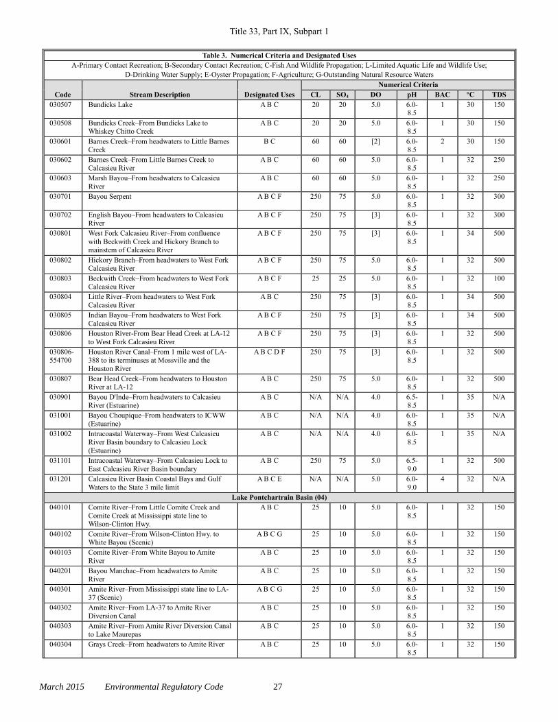
Title 33, Part IX, Subpart 1
March 2015 Environmental Regulatory Code 27
Table 3. Numerical Criteria and Designated Uses
A-Primary Contact Recreation; B-Secondary Contact Recreation; C-Fish And Wildlife Propagation; L-Limited Aquatic Life and Wildlife Use;
D-Drinking Water Supply; E-Oyster Propagation; F-Agriculture; G-Outstanding Natural Resource Waters
Code Stream Description Designated Uses
Numerical Criteria
CL SO4 DO pH BAC °C TDS
030507 Bundicks Lake A B C 20 20 5.0 6.0-8.5
1 30 150
030508 Bundicks Creek–From Bundicks Lake to Whiskey Chitto Creek
A B C 20 20 5.0 6.0-8.5
1 30 150
030601 Barnes Creek–From headwaters to Little Barnes Creek
B C 60 60 [2] 6.0-8.5
2 30 150
030602 Barnes Creek–From Little Barnes Creek to
Calcasieu River
A B C 60 60 5.0 6.0-
8.5
1 32 250
030603 Marsh Bayou–From headwaters to Calcasieu
River
A B C 60 60 5.0 6.0-
8.5
1 32 250
030701 Bayou Serpent A B C F 250 75 5.0 6.0-
8.5
1 32 300
030702 English Bayou–From headwaters to Calcasieu
River
A B C F 250 75 [3] 6.0-
8.5
1 32 300
030801 West Fork Calcasieu River–From confluence
with Beckwith Creek and Hickory Branch to mainstem of Calcasieu River
A B C F 250 75 [3] 6.0-
8.5
1 34 500
030802 Hickory Branch–From headwaters to West Fork Calcasieu River
A B C F 250 75 5.0 6.0-8.5
1 32 500
030803 Beckwith Creek–From headwaters to West Fork Calcasieu River
A B C F 25 25 5.0 6.0-8.5
1 32 100
030804 Little River–From headwaters to West Fork
Calcasieu River
A B C 250 75 [3] 6.0-
8.5
1 34 500
030805 Indian Bayou–From headwaters to West Fork
Calcasieu River
A B C F 250 75 [3] 6.0-
8.5
1 34 500
030806 Houston River-From Bear Head Creek at LA-12
to West Fork Calcasieu River
A B C F 250 75 [3] 6.0-
8.5
1 32 500
030806-
554700
Houston River Canal–From 1 mile west of LA-
388 to its terminuses at Mossville and the Houston River
A B C D F 250 75 [3] 6.0-
8.5
1 32 500
030807 Bear Head Creek–From headwaters to Houston River at LA-12
A B C 250 75 5.0 6.0-8.5
1 32 500
030901 Bayou D'Inde–From headwaters to Calcasieu River (Estuarine)
A B C N/A N/A 4.0 6.5-8.5
1 35 N/A
031001 Bayou Choupique–From headwaters to ICWW
(Estuarine)
A B C N/A N/A 4.0 6.0-
8.5
1 35 N/A
031002 Intracoastal Waterway–From West Calcasieu
River Basin boundary to Calcasieu Lock
(Estuarine)
A B C N/A N/A 4.0 6.0-
8.5
1 35 N/A
031101 Intracoastal Waterway–From Calcasieu Lock to
East Calcasieu River Basin boundary
A B C 250 75 5.0 6.5-
9.0
1 32 500
031201 Calcasieu River Basin Coastal Bays and Gulf
Waters to the State 3 mile limit
A B C E N/A N/A 5.0 6.0-
9.0
4 32 N/A
Lake Pontchartrain Basin (04)
040101 Comite River–From Little Comite Creek and
Comite Creek at Mississippi state line to Wilson-Clinton Hwy.
A B C 25 10 5.0 6.0-
8.5
1 32 150
040102 Comite River–From Wilson-Clinton Hwy. to White Bayou (Scenic)
A B C G 25 10 5.0 6.0-8.5
1 32 150
040103 Comite River–From White Bayou to Amite
River
A B C 25 10 5.0 6.0-
8.5
1 32 150
040201 Bayou Manchac–From headwaters to Amite
River
A B C 25 10 5.0 6.0-
8.5
1 32 150
040301 Amite River–From Mississippi state line to LA-
37 (Scenic)
A B C G 25 10 5.0 6.0-
8.5
1 32 150
040302 Amite River–From LA-37 to Amite River
Diversion Canal
A B C 25 10 5.0 6.0-
8.5
1 32 150
040303 Amite River–From Amite River Diversion Canal
to Lake Maurepas
A B C 25 10 5.0 6.0-
8.5
1 32 150
040304 Grays Creek–From headwaters to Amite River A B C 25 10 5.0 6.0-
8.5
1 32 150
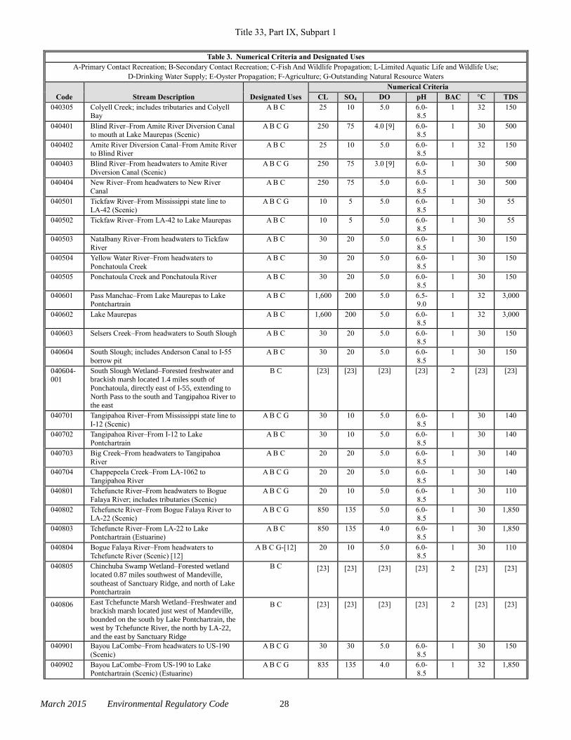
Title 33, Part IX, Subpart 1
March 2015 Environmental Regulatory Code 28
Table 3. Numerical Criteria and Designated Uses
A-Primary Contact Recreation; B-Secondary Contact Recreation; C-Fish And Wildlife Propagation; L-Limited Aquatic Life and Wildlife Use;
D-Drinking Water Supply; E-Oyster Propagation; F-Agriculture; G-Outstanding Natural Resource Waters
Code Stream Description Designated Uses
Numerical Criteria
CL SO4 DO pH BAC °C TDS
040305 Colyell Creek; includes tributaries and Colyell Bay
A B C 25 10 5.0 6.0-8.5
1 32 150
040401 Blind River–From Amite River Diversion Canal to mouth at Lake Maurepas (Scenic)
A B C G 250 75 4.0 [9] 6.0-8.5
1 30 500
040402 Amite River Diversion Canal–From Amite River to Blind River
A B C 25 10 5.0 6.0-8.5
1 32 150
040403 Blind River–From headwaters to Amite River
Diversion Canal (Scenic)
A B C G 250 75 3.0 [9] 6.0-
8.5
1 30 500
040404 New River–From headwaters to New River
Canal
A B C 250 75 5.0 6.0-
8.5
1 30 500
040501 Tickfaw River–From Mississippi state line to
LA-42 (Scenic)
A B C G 10 5 5.0 6.0-
8.5
1 30 55
040502 Tickfaw River–From LA-42 to Lake Maurepas A B C 10 5 5.0 6.0-
8.5
1 30 55
040503 Natalbany River–From headwaters to Tickfaw
River
A B C 30 20 5.0 6.0-
8.5
1 30 150
040504 Yellow Water River–From headwaters to
Ponchatoula Creek
A B C 30 20 5.0 6.0-
8.5
1 30 150
040505 Ponchatoula Creek and Ponchatoula River A B C 30 20 5.0 6.0-
8.5
1 30 150
040601 Pass Manchac–From Lake Maurepas to Lake Pontchartrain
A B C 1,600 200 5.0 6.5-9.0
1 32 3,000
040602 Lake Maurepas A B C 1,600 200 5.0 6.0-8.5
1 32 3,000
040603 Selsers Creek–From headwaters to South Slough A B C 30 20 5.0 6.0-8.5
1 30 150
040604 South Slough; includes Anderson Canal to I-55
borrow pit
A B C 30 20 5.0 6.0-
8.5
1 30 150
040604-
001
South Slough Wetland–Forested freshwater and
brackish marsh located 1.4 miles south of
Ponchatoula, directly east of I-55, extending to North Pass to the south and Tangipahoa River to
the east
B C [23] [23] [23] [23] 2 [23] [23]
040701 Tangipahoa River–From Mississippi state line to
I-12 (Scenic)
A B C G 30 10 5.0 6.0-
8.5
1 30 140
040702 Tangipahoa River–From I-12 to Lake
Pontchartrain
A B C 30 10 5.0 6.0-
8.5
1 30 140
040703 Big Creek–From headwaters to Tangipahoa
River
A B C 20 20 5.0 6.0-
8.5
1 30 140
040704 Chappepeela Creek–From LA-1062 to
Tangipahoa River
A B C G 20 20 5.0 6.0-
8.5
1 30 140
040801 Tchefuncte River–From headwaters to Bogue
Falaya River; includes tributaries (Scenic)
A B C G 20 10 5.0 6.0-
8.5
1 30 110
040802 Tchefuncte River–From Bogue Falaya River to LA-22 (Scenic)
A B C G 850 135 5.0 6.0-8.5
1 30 1,850
040803 Tchefuncte River–From LA-22 to Lake Pontchartrain (Estuarine)
A B C 850 135 4.0 6.0-8.5
1 30 1,850
040804 Bogue Falaya River–From headwaters to Tchefuncte River (Scenic) [12]
A B C G-[12] 20 10 5.0 6.0-8.5
1 30 110
040805 Chinchuba Swamp Wetland–Forested wetland
located 0.87 miles southwest of Mandeville,
southeast of Sanctuary Ridge, and north of Lake Pontchartrain
B C [23] [23] [23] [23] 2 [23] [23]
040806 East Tchefuncte Marsh Wetland–Freshwater and brackish marsh located just west of Mandeville,
bounded on the south by Lake Pontchartrain, the
west by Tchefuncte River, the north by LA-22, and the east by Sanctuary Ridge
B C [23] [23] [23] [23] 2 [23] [23]
040901 Bayou LaCombe–From headwaters to US-190
(Scenic)
A B C G 30 30 5.0 6.0-
8.5
1 30 150
040902 Bayou LaCombe–From US-190 to Lake
Pontchartrain (Scenic) (Estuarine)
A B C G 835 135 4.0 6.0-
8.5
1 32 1,850
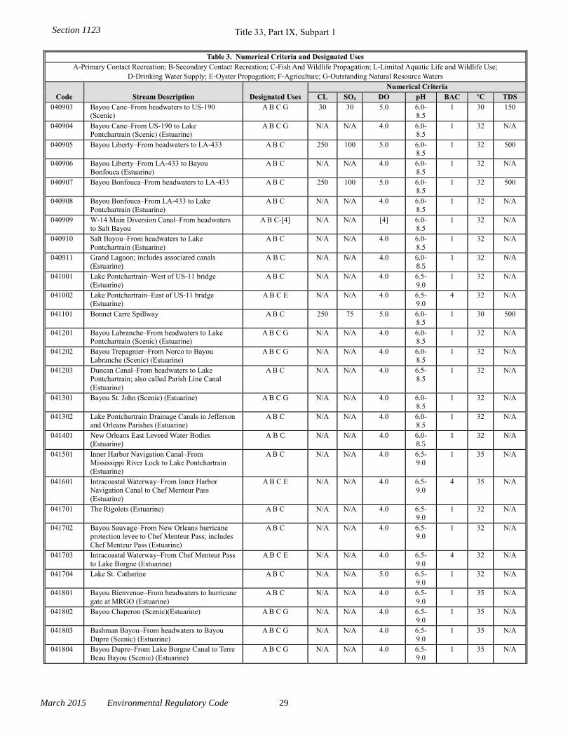
Title 33, Part IX, Subpart 1
March 2015 Environmental Regulatory Code 29
Table 3. Numerical Criteria and Designated Uses
A-Primary Contact Recreation; B-Secondary Contact Recreation; C-Fish And Wildlife Propagation; L-Limited Aquatic Life and Wildlife Use;
D-Drinking Water Supply; E-Oyster Propagation; F-Agriculture; G-Outstanding Natural Resource Waters
Code Stream Description Designated Uses
Numerical Criteria
CL SO4 DO pH BAC °C TDS
040903 Bayou Cane–From headwaters to US-190 (Scenic)
A B C G 30 30 5.0 6.0-8.5
1 30 150
040904 Bayou Cane–From US-190 to Lake Pontchartrain (Scenic) (Estuarine)
A B C G N/A N/A 4.0 6.0-8.5
1 32 N/A
040905 Bayou Liberty–From headwaters to LA-433 A B C 250 100 5.0 6.0-8.5
1 32 500
040906 Bayou Liberty–From LA-433 to Bayou
Bonfouca (Estuarine)
A B C N/A N/A 4.0 6.0-
8.5
1 32 N/A
040907 Bayou Bonfouca–From headwaters to LA-433 A B C 250 100 5.0 6.0-
8.5
1 32 500
040908 Bayou Bonfouca–From LA-433 to Lake
Pontchartrain (Estuarine)
A B C N/A N/A 4.0 6.0-
8.5
1 32 N/A
040909 W-14 Main Diversion Canal–From headwaters
to Salt Bayou
A B C-[4] N/A N/A [4] 6.0-
8.5
1 32 N/A
040910 Salt Bayou–From headwaters to Lake
Pontchartrain (Estuarine)
A B C N/A N/A 4.0 6.0-
8.5
1 32 N/A
040911 Grand Lagoon; includes associated canals
(Estuarine)
A B C N/A N/A 4.0 6.0-
8.5
1 32 N/A
041001 Lake Pontchartrain–West of US-11 bridge
(Estuarine)
A B C N/A N/A 4.0 6.5-
9.0
1 32 N/A
041002 Lake Pontchartrain–East of US-11 bridge (Estuarine)
A B C E N/A N/A 4.0 6.5-9.0
4 32 N/A
041101 Bonnet Carre Spillway A B C 250 75 5.0 6.0-8.5
1 30 500
041201 Bayou Labranche–From headwaters to Lake Pontchartrain (Scenic) (Estuarine)
A B C G N/A N/A 4.0 6.0-8.5
1 32 N/A
041202 Bayou Trepagnier–From Norco to Bayou
Labranche (Scenic) (Estuarine)
A B C G N/A N/A 4.0 6.0-
8.5
1 32 N/A
041203 Duncan Canal–From headwaters to Lake
Pontchartrain; also called Parish Line Canal
(Estuarine)
A B C N/A N/A 4.0 6.5-
8.5
1 32 N/A
041301 Bayou St. John (Scenic) (Estuarine) A B C G N/A N/A 4.0 6.0-
8.5
1 32 N/A
041302 Lake Pontchartrain Drainage Canals in Jefferson and Orleans Parishes (Estuarine)
A B C N/A N/A 4.0 6.0-8.5
1 32 N/A
041401 New Orleans East Leveed Water Bodies (Estuarine)
A B C N/A N/A 4.0 6.0-8.5
1 32 N/A
041501 Inner Harbor Navigation Canal–From Mississippi River Lock to Lake Pontchartrain
(Estuarine)
A B C N/A N/A 4.0 6.5-9.0
1 35 N/A
041601 Intracoastal Waterway–From Inner Harbor
Navigation Canal to Chef Menteur Pass
(Estuarine)
A B C E N/A N/A 4.0 6.5-
9.0
4 35 N/A
041701 The Rigolets (Estuarine) A B C N/A N/A 4.0 6.5-9.0
1 32 N/A
041702 Bayou Sauvage–From New Orleans hurricane protection levee to Chef Menteur Pass; includes
Chef Menteur Pass (Estuarine)
A B C N/A N/A 4.0 6.5-9.0
1 32 N/A
041703 Intracoastal Waterway–From Chef Menteur Pass
to Lake Borgne (Estuarine)
A B C E N/A N/A 4.0 6.5-
9.0
4 32 N/A
041704 Lake St. Catherine A B C N/A N/A 5.0 6.5-
9.0
1 32 N/A
041801 Bayou Bienvenue–From headwaters to hurricane
gate at MRGO (Estuarine)
A B C N/A N/A 4.0 6.5-
9.0
1 35 N/A
041802 Bayou Chaperon (Scenic)(Estuarine) A B C G N/A N/A 4.0 6.5-
9.0
1 35 N/A
041803 Bashman Bayou–From headwaters to Bayou
Dupre (Scenic) (Estuarine)
A B C G N/A N/A 4.0 6.5-
9.0
1 35 N/A
041804 Bayou Dupre–From Lake Borgne Canal to Terre Beau Bayou (Scenic) (Estuarine)
A B C G N/A N/A 4.0 6.5-9.0
1 35 N/A
Section 1123
Title 33, Part IX, Subpart 1
March 2015 Environmental Regulatory Code 30
Table 3. Numerical Criteria and Designated Uses
A-Primary Contact Recreation; B-Secondary Contact Recreation; C-Fish And Wildlife Propagation; L-Limited Aquatic Life and Wildlife Use;
D-Drinking Water Supply; E-Oyster Propagation; F-Agriculture; G-Outstanding Natural Resource Waters
Code Stream Description Designated Uses
Numerical Criteria
CL SO4 DO pH BAC °C TDS
041805 Lake Borgne Canal–From Mississippi River siphon at Violet to Bayou Dupre; also called
Violet Canal (Scenic) (Estuarine)
A B C G N/A N/A 4.0 6.5-9.0
1 35 N/A
041806 Pirogue Bayou–From Bayou Dupre to New
Canal (Scenic) (Estuarine)
A B C G N/A N/A 4.0 6.5-
9.0
1 35 N/A
041807 Terre Beau Bayou–From Bayou Dupre to New
Canal (Scenic) (Estuarine)
A B C G N/A N/A 4.0 6.5-
9.0
1 35 N/A
041808 New Canal (Estuarine) A B C N/A N/A 4.0 6.5-
9.0
1 35 N/A
041809 Poydras-Verret Marsh Wetland–Forested and
marsh wetland located 1.5 miles north of St. Bernard, south of Violet Canal, and northeast of
Forty Arpent Canal
B C [17] [17] [17] [17] 2 [17] [17]
041901 Mississippi River Gulf Outlet (MRGO)–From
ICWW to Breton Sound at MRGO mile 30
A B C E N/A N/A 5.0 6.5-
9.0
4 35 N/A
042001 Lake Borgne A B C E N/A N/A 5.0 6.5-9.0
4 35 N/A
042002 Bayou Bienvenue–From Bayou Villere to Lake Borgne (Scenic) (Estuarine)
A B C E G N/A N/A 4.0 6.5-9.0
4 35 N/A
042003 Bayou La Loutre–From MRGO to Eloi Bay (Estuarine)
A B C E N/A N/A 4.0 6.5-9.0
4 35 N/A
042004 Bayou Bienvenue–From MRGO to Bayou
Villere (Estuarine)
A B C E N/A N/A 4.0 6.5-
9.0
4 35 N/A
042101 Bayou Terre Aux Boeufs (Estuarine) A B C E N/A N/A 4.0 6.5-
9.0
4 35 N/A
042102 River Aux Chenes; also called Oak River
(Estuarine)
A B C E N/A N/A 4.0 6.5-
9.0
4 35 N/A
042103 Bayou Gentilly–From Bayou Terre Aux Boeufs
to Petit Lake (Estuarine)
A B C E N/A N/A 4.0 6.5-
9.0
4 35 N/A
042104 Petit Lake A B C E N/A N/A 5.0 6.5-
9.0
4 35 N/A
042105 Lake Lery A B C E N/A N/A 5.0 6.5-
9.0
4 35 N/A
042201 Chandeleur Sound A B C E N/A N/A 5.0 6.5-
9.0
4 35 N/A
042202 California Bay and Breton Sound A B C E N/A N/A 5.0 6.5-9.0
4 35 N/A
042203 Bay Boudreau A B C E N/A N/A 5.0 6.5-9.0
4 35 N/A
042204 Drum Bay A B C E N/A N/A 5.0 6.5-9.0
4 35 N/A
042205 Morgan Harbor A B C E N/A N/A 5.0 6.5-9.0
4 35 N/A
042206 Eloi Bay A B C E N/A N/A 5.0 6.5-
9.0
4 35 N/A
042207 Lake Fortuna A B C E N/A N/A 5.0 6.5-
9.0
4 35 N/A
042208 Bay Gardene, Black Bay, Lost Bayou, American
Bay, and Bay Crabe
A B C E N/A N/A 5.0 6.5-
9.0
4 35 N/A
042209 Lake Pontchartrain Basin Coastal Bays and Gulf
Waters to the State 3 mile limit
A B C E N/A N/A 5.0 6.5-
9.0
4 32 N/A
Mermentau River Basin (05)
050101 Bayou Des Cannes–From headwaters to
Mermentau River
A B C F 90 30 [16] 6.0-
8.5
1 32 260
050103 Bayou Mallet–From headwaters to Bayou Des
Cannes
A B C F 90 30 [16] 6.0-
8.5
1 32 260
050201 Bayou Plaquemine Brule–From headwaters to
Bayou Des Cannes
A B C F 90 30 [16] 6.0-
8.5
1 32 260
050301 Bayou Nezpique–From headwaters to
Mermentau River; includes intermittent portion of Beaver Creek [2]
A B C F 90 30 [16] 6.0-
8.5
1 32 260
Section 1123
Title 33, Part IX, Subpart 1
March 2015 Environmental Regulatory Code 31
Table 3. Numerical Criteria and Designated Uses
A-Primary Contact Recreation; B-Secondary Contact Recreation; C-Fish And Wildlife Propagation; L-Limited Aquatic Life and Wildlife Use;
D-Drinking Water Supply; E-Oyster Propagation; F-Agriculture; G-Outstanding Natural Resource Waters
Code Stream Description Designated Uses
Numerical Criteria
CL SO4 DO pH BAC °C TDS
050303 Castor Creek–From headwaters to Bayou Nezpique
A B C 90 30 [16] 6.0-8.5
1 32 260
050304 Bayou Blue–From headwaters to Bayou Nezpique
A B C 90 30 [16] 6.0-8.5
1 32 260
050401 Mermentau River–From headwaters to Lake Arthur
A B C F 90 30 [16] 6.0-8.5
1 32 260
050402 Lake Arthur and Lower Mermentau River to
Grand Lake
A B C 90 30 5.0 6.0-
8.5
1 32 260
050501 Bayou Queue de Tortue–From headwaters to
Mermentau River
A B C F 90 30 [16] 6.0-
8.5
1 32 260
050601 Lacassine Bayou–From headwaters to Grand
Lake
A B C F 90 10 [16] 6.0-
8.5
1 32 400
050602 Intracoastal Waterway–From Calcasieu River
Basin Boundary to Mermentau River
A B C F 250 75 5.0 6.5-
9.0
1 32 500
050603 Bayou Chene–From headwaters to Lacassine
Bayou; includes Bayou Grand Marais
A B C F 90 10 5.0 6.5-
9.0
1 32 400
050701 Grand Lake A B C F 250 75 5.0 6.5-
9.0
1 32 500
050702 Intracoastal Waterway–From Mermentau River
to Vermilion Locks
A B C F 250 75 5.0 6.0-
9.0
1 32 500
050703 White Lake A B C F 250 75 5.0 6.5-9.0
1 32 500
050801 Mermentau River–From Catfish Point Control Structure to Gulf of Mexico (Estuarine)
A B C E N/A N/A 4.0 6.5-9.0
4 35 N/A
050802 Big Constance Lake; includes associated water bodies (Estuarine)
A B C N/A N/A 4.0 6.5-9.0
1 35 N/A
050901 Mermentau River Basin Coastal Bays and Gulf
Waters to the State 3 mile limit
A B C E N/A N/A 5.0 6.5-
9.0
4 32 N/A
Vermilion-Teche River Basin (06)
060101 Spring Creek–From headwaters to Cocodrie Lake (Scenic)
A B C G 10 5 5.0 6.0-8.5
1 30 100
060102 Cocodrie Lake A B C 10 5 [19] 6.0-
8.5
1 32 100
060201 Bayou Cocodrie–From US-167 to Bayou Boeuf-
Cocodrie Diversion Canal (Scenic)
A B C G 45 35 [19] 6.0-
8.5
1 32 100
060202 Bayou Cocodrie–From Cocodrie Diversion Canal to Bayou Boeuf
A B C 45 35 5.0 6.0-8.5
1 32 100
060203 Chicot Lake A B C 90 30 5.0 6.0-8.5
1 32 260
060204 Bayou Courtableau–From headwaters to West
Atchafalaya Borrow Pit Canal A B C 65 70
[22] 6.0-
8.5
1 32 440
060206 Indian Creek and Indian Creek Reservoir A B C 10 5 5.0 6.0-
8.5
1 32 100
060207 Bayou des Glaises Diversion Channel/West
Atchafalaya Borrow Pit Canal–From Bayou des Glaises to Bayou Courtableau
A B C 100 75 5.0 6.0-
8.5
1 32 500
060208 Bayou Boeuf–From headwaters to Bayou Courtableau
A B C 45 35 5.0 6.0-8.5
1 32 100
060209 Irish Ditch and Big Bayou–From unnamed ditch
to Irish Ditch No. 1 to Big Bayou to Irish Ditch
No. 2 to Bayou Rapides
B C 45 35 [2] 6.0-
8.5
2 32 100
060210 Bayou Carron A B C 40 30 5.0 6.0-
8.5
1 32 220
060211 West Atchafalaya Borrow Pit Canal–From
Bayou Courtableau to Henderson; includes Bayou Portage
A B C 65 70 5.0 6.0-
8.5
1 32 440
060212 Chatlin Lake Canal and Bayou DuLac–From
Alexandria to Bayou des Glaises Diversion
Canal; includes a portion of Bayou DeGlaises
A B C 45 35 5.0 6.0-
8.5
1 32 100
060301 Bayou Teche–From headwaters at Bayou
Courtableau to Keystone Locks and Dam
A B C 65 70 5.0 6.0-
8.5
1 32 440
Section 1123
Title 33, Part IX, Subpart 1
March 2015 Environmental Regulatory Code 32
Table 3. Numerical Criteria and Designated Uses
A-Primary Contact Recreation; B-Secondary Contact Recreation; C-Fish And Wildlife Propagation; L-Limited Aquatic Life and Wildlife Use;
D-Drinking Water Supply; E-Oyster Propagation; F-Agriculture; G-Outstanding Natural Resource Waters
Code Stream Description Designated Uses
Numerical Criteria
CL SO4 DO pH BAC °C TDS
060401 Bayou Teche–From Keystone Locks and Dam to Charenton Canal
A B C 80 50 5.0 6.0-8.5
1 32 350
060501 Bayou Teche–From Charenton Canal to Wax Lake Outlet
A B C D 80 50 5.0 6.0-8.5
1 32 350
060601 Charenton Canal–From Charenton Floodgate to ICWW; includes Bayou Teche from Charenton
to Baldwin
A B C D 250 75 5.0 6.0-8.5
1 32 500
060701 Tete Bayou A B C 80 50 5.0 6.0-
8.5
1 32 350
060702 Lake Fausse Point and Dauterive Lake A B C 80 50 5.0 6.0-
8.5
1 32 350
060703 Bayou Du Portage A B C 80 50 5.0 6.0-
8.5
1 32 350
060801 Vermilion River–From headwaters to LA-3073 bridge
A B C F 230 70 5.0 6.0-8.5
1 32 440
060801-001
Cote Gelee Wetland–Forested wetland located in Lafayette Parish, 2 miles east of Broussard, 2
miles northeast of US-90, and west of Bayou
Tortue
B C [23] [23] [23] [23] 2 [23] [23]
060802 Vermilion River–From LA-3073 bridge to
ICWW
A B C F 230 70 [6] 6.0-
8.5
1 32 440
060803 Vermilion River Cutoff–From ICWW to Vermilion Bay (Estuarine)
A B C N/A N/A 4.0 6.5-9.0
1 35 N/A
060804 Intracoastal Waterway–From Vermilion Lock to 1/2 mile west of Gum Island Canal (Estuarine)
A B C N/A N/A 4.0 6.5-9.0
1 35 N/A
060805 Breaux Bridge Swamp–Forested wetland in St. Martin Parish, 1/2 mile southwest of Breaux
Bridge, southeast of LA-94, west of Bayou
Teche, east of Vermilion River, and north of Evangeline and Ruth Canals; also called
Cyprière Perdue Swamp
B C [5] [5] [5] [5] 2 [5] [5]
060806 Cypress Island Coulee Wetland–Forested
wetland located in St. Martin Parish, 2 miles
west of St. Martinville, 1/2 mile north of LA-96, west of Bayou Teche, and east of Vermilion
River
B C [23] [23] [23] [23] 2 [23] [23]
060901 Bayou Petite Anse–From headwaters to Bayou
Carlin (Estuarine)
A B C N/A N/A 4.0 6.5-
9.0
1 35 N/A
060902 Bayou Carlin–From Lake Peigneur to Bayou
Petite Anse; also called Delcambre Canal (Estuarine)
A B C N/A N/A 4.0 6.5-
9.0
1 35 N/A
060903 Bayou Tigre–From headwaters to Bayou Petite Anse (Estuarine)
A B C N/A N/A 4.0 6.5-9.0
1 35 N/A
060904 New Iberia Southern Drainage Canal–From
headwaters to ICWW (Estuarine)
A B L-[24] N/A N/A [24] 6.5-
9.0
[24] 35 N/A
060906 Intracoastal Waterway–From New Iberia
Southern Drainage Canal to Bayou Sale
(Estuarine)
A B C N/A N/A 4.0 6.5-
9.0
1 35 N/A
060907 Franklin Canal A B C 250 75 5.0 6.0-
8.5
1 35 500
060908 Spanish Lake A B C 250 75 5.0 6.0-8.5
1 32 500
060909 Lake Peigneur A B C N/A N/A 5.0 6.5-9.0
1 35 N/A
060910 Boston Canal; includes associated canals (Estuarine)
A B C N/A N/A 4.0 6.5-9.0
1 35 N/A
060911 Dugas Canal–By Tiger Lagoon Oil and Gas Field (Estuarine)
A B C N/A N/A 4.0 6.5-9.0
1 35 N/A
061001 West Cote Blanche Bay A B C E N/A N/A 5.0 6.5-
9.0
4 35 N/A
061002 East Cote Blanche Bay A B C E N/A N/A 5.0 6.5-
9.0
4 35 N/A
Section 1123
Title 33, Part IX, Subpart 1
March 2015 Environmental Regulatory Code 33
Table 3. Numerical Criteria and Designated Uses
A-Primary Contact Recreation; B-Secondary Contact Recreation; C-Fish And Wildlife Propagation; L-Limited Aquatic Life and Wildlife Use;
D-Drinking Water Supply; E-Oyster Propagation; F-Agriculture; G-Outstanding Natural Resource Waters
Code Stream Description Designated Uses
Numerical Criteria
CL SO4 DO pH BAC °C TDS
061101 Bayou Petite Anse–From Bayou Carlin at its confluence with Bayou Tigre to ICWW
(Estuarine)
A B C N/A N/A 4.0 6.5-9.0
1 35 N/A
061102 Intracoastal Waterway–From 1/2 mile west of
Gum Island Canal to New Iberia Southern
Drainage Canal (Estuarine)
A B C N/A N/A 4.0 6.5-
9.0
1 35 N/A
061103 Freshwater Bayou Canal–From 1/2 mile below
ICWW to control structure (Estuarine)
A B C N/A N/A 4.0 6.5-
9.0
1 35 N/A
061104 Vermilion Bay A B C E N/A N/A 5.0 6.5-9.0
4 35 N/A
061105 Marsh Island (Estuarine) A B C N/A N/A 4.0 6.5-9.0
4 35 N/A
061201 Vermilion-Teche River Basin Coastal Bays and Gulf Waters to the State 3 mile limit
A B C E N/A N/A 5.0 6.0-9.0
4 32 N/A
Mississippi River Basin (07)
070101 Mississippi River–From Arkansas state line to Old River Control Structure
A B C 75 120 5.0 6.0-9.0
1 32 400
070102 Gassoway Lake A B C 75 120 5.0 6.0-8.5
1 32 400
070103 Marengo Bend–Portion within the Louisiana state line
A B C D 250 75 5.0 6.0-8.5
1 32 500
070201 Mississippi River–From Old River Control
Structure to Monte Sano Bayou
A B C D 75 120 5.0 6.0-
9.0
1 32 400
070202 Raccourci Old River A B C 100 75 5.0 6.0-
8.5
1 32 500
070203 Devil's Swamp Lake and Bayou Baton Rouge A B C 75 120 5.0 6.0-
8.5
1 32 400
070301 Mississippi River–From Monte Sano Bayou to
Head of Passes
A B C D 75 120 5.0 6.0-
9.0
1 32 400
070401 Mississippi River Passes–Head of Passes to
Mouth of Passes; includes all passes in the birdfoot delta (Estuarine)
A B C E N/A N/A 4.0 6.5-
9.0
4 35 N/A
070501 Bayou Sara–From Mississippi state line to Mississippi River
A B C 100 75 5.0 6.0-8.5
1 32 500
070502 Thompson Creek–From Mississippi state line to
Mississippi River
A B C 100 75 5.0 6.0-
8.5
1 32 500
070503 Capitol Lake A B C 75 120 5.0 6.0-
8.5
1 32 400
070504 Monte Sano Bayou–From US-61 to Mississippi
River [7], [8]
B L [7] [7] 3.0 6.0-
9.0
1 35
[8]
[7]
070505 Tunica Bayou–From headwaters to Mississippi
River
A B C 100 75 5.0 6.0-
8.5
1 32 500
070601 Mississippi River Basin Coastal Bays and Gulf
Waters to the State 3 mile limit
A B C E N/A N/A 5.0 6.5-
9.0
4 32 N/A
Ouachita River Basin (08)
080101 Ouachita River–From Arkansas state line to
Columbia Lock and Dam
A B C D 160 35 [15] 6.0-
8.5
1 33 350
080102 Bayou Chauvin–From headwaters to Ouachita
River
A B C 160 35 5.0 6.0-
8.5
1 33 350
080201 Ouachita River–From Columbia Lock and Dam
to Jonesville
A B C 160 50 5.0 6.0-
8.5
1 33 400
080202 Bayou Louis–From headwaters to Ouachita
River
A B C 250 75 5.0 6.0-
8.5
1 32 500
080203 Lake Louis A B C 250 75 5.0 6.0-
8.5
1 32 500
080301 Black River–From Jonesville to Corps of Engineers (USACE) Control Structure at Mile
25
A B C 95 20 5.0 6.0-8.5
1 32 265
080302 Black River–From USACE Control Structure to
Red River
A B C 95 20 5.0 6.0-
8.5
1 32 265
080401 Bayou Bartholomew–From Arkansas state line
to Ouachita River (Scenic to Dead Bayou)
A B C G 55 35 5.0 6.0-
8.5
1 32 420
Section 1123
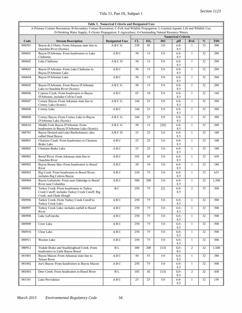
Title 33, Part IX, Subpart 1
March 2015 Environmental Regulatory Code 34
Table 3. Numerical Criteria and Designated Uses
A-Primary Contact Recreation; B-Secondary Contact Recreation; C-Fish And Wildlife Propagation; L-Limited Aquatic Life and Wildlife Use;
D-Drinking Water Supply; E-Oyster Propagation; F-Agriculture; G-Outstanding Natural Resource Waters
Code Stream Description Designated Uses
Numerical Criteria
CL SO4 DO pH BAC °C TDS
080501 Bayou de L'Outre–From Arkansas state line to Ouachita River (Scenic)
A B C G 250 45 5.0 6.0-8.5
1 33 500
080601 Bayou D'Arbonne–From headwaters to Lake Claiborne
A B C 50 15 5.0 6.0-8.5
1 32 200
080602 Lake Claiborne A B C D 50 15 5.0 6.0-8.5
1 32 200
080603 Bayou D'Arbonne–From Lake Claiborne to
Bayou D'Arbonne Lake
A B C 50 15 5.0 6.0-
8.5
1 32 200
080604 Bayou D'Arbonne Lake A B C 50 15 5.0 6.0-
8.5
1 32 200
080605 Bayou D'Arbonne–From Bayou D'Arbonne
Lake to Ouachita River (Scenic)
A B C G 50 15 5.0 6.0-
8.5
1 32 200
080606 Cypress Creek–From headwaters to Bayou
D'Arbonne; includes Colvin Creek
A B C 65 10 5.0 6.0-
8.5
1 32 160
080607 Corney Bayou–From Arkansas state line to
Corney Lake (Scenic)
A B C G 160 25 5.0 6.0-
8.5
1 32 300
080608 Corney Lake A B C 160 25 5.0 6.0-
8.5
1 32 300
080609 Corney Bayou–From Corney Lake to Bayou
D'Arbonne Lake (Scenic)
A B C G 160 25 5.0 6.0-
8.5
1 32 300
080610 Middle Fork Bayou D'Arbonne–From headwaters to Bayou D'Arbonne Lake (Scenic)
A B C G 50 15 [20] 6.0-8.5
1 32 200
080701 Bayou Desiard and Lake Bartholomew; also
called Dead Bayou
A B C D 25 25 5.0 6.0-
8.5
1 32 100
080801 Cheniere Creek–From headwaters to Cheniere
Brake Lake
A B C 25 25 5.0 6.0-
8.5
1 32 100
080802 Cheniere Brake Lake A B C 25 25 5.0 6.0-
8.5
1 32 100
080901 Boeuf River–From Arkansas state line to
Ouachita River
A B C 105 45 5.0 6.0-
8.5
1 32 430
080902 Bayou Bonne Idee–From headwaters to Boeuf
River
A B C 20 10 5.0 6.0-
8.5
1 32 180
080903 Big Creek–From headwaters to Boeuf River;
includes Big Colewa Bayou
A B C 230 75 5.0 6.0-
8.5
1 32 635
080904 Bayou Lafourche–From near Oakridge to Boeuf River near Columbia
A B C 500 200 5.0 6.0-8.5
1 32 1,500
080905 Turkey Creek–From headwaters to Turkey Creek Cutoff; includes Turkey Creek Cutoff, Big
Creek, and Glade Slough
B C 250 75 [2] 6.0-8.5
2 32 500
080906 Turkey Creek–From Turkey Creek Cutoff to
Turkey Creek Lake
A B C 250 75 5.0 6.0-
8.5
1 32 500
080907 Turkey Creek Lake; includes outfall to Boeuf
River
A B C 250 75 5.0 6.0-
8.5
1 32 500
080908 Lake LaFourche A B C 250 75 5.0 6.0-
8.5
1 32 500
080909 Crew Lake A B C 250 75 5.0 6.0-
8.5
1 32 500
080910 Clear Lake A B C 250 75 5.0 6.0-8.5
1 32 500
080911 Woolen Lake A B C 250 75 5.0 6.0-8.5
1 32 500
080912 Tisdale Brake and Staulkinghead Creek–From headwaters to Little Bayou Boeuf
B L 500 200 [13] 6.0-8.5
2 32 1,500
081001 Bayou Macon–From Arkansas state line to Tensas River
A B C 50 55 5.0 6.0-8.5
1 32 380
081002 Joe's Bayou–From headwaters to Bayou Macon A B C 250 75 5.0 6.0-
8.5
1 32 500
081003 Deer Creek–From headwaters to Boeuf River B L 105 45 [13] 6.0-
8.5
2 32 430
081101 Lake Providence A B C 25 25 5.0 6.0-
8.5
1 32 150
Section 1123
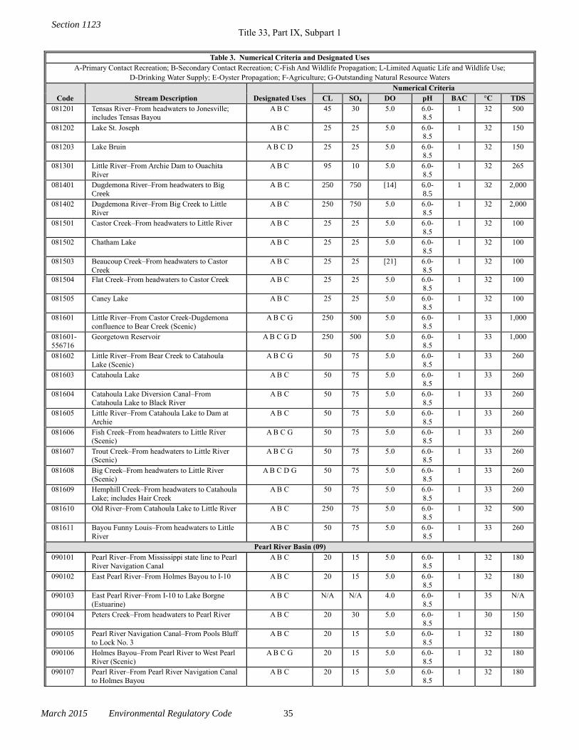
Title 33, Part IX, Subpart 1
March 2015 Environmental Regulatory Code 35
Table 3. Numerical Criteria and Designated Uses
A-Primary Contact Recreation; B-Secondary Contact Recreation; C-Fish And Wildlife Propagation; L-Limited Aquatic Life and Wildlife Use;
D-Drinking Water Supply; E-Oyster Propagation; F-Agriculture; G-Outstanding Natural Resource Waters
Code Stream Description Designated Uses
Numerical Criteria
CL SO4 DO pH BAC °C TDS
081201 Tensas River–From headwaters to Jonesville; includes Tensas Bayou
A B C 45 30 5.0 6.0-8.5
1 32 500
081202 Lake St. Joseph A B C 25 25 5.0 6.0-8.5
1 32 150
081203 Lake Bruin A B C D 25 25 5.0 6.0-8.5
1 32 150
081301 Little River–From Archie Dam to Ouachita
River
A B C 95 10 5.0 6.0-
8.5
1 32 265
081401 Dugdemona River–From headwaters to Big
Creek
A B C 250 750 [14] 6.0-
8.5
1 32 2,000
081402 Dugdemona River–From Big Creek to Little
River
A B C 250 750 5.0 6.0-
8.5
1 32 2,000
081501 Castor Creek–From headwaters to Little River A B C 25 25 5.0 6.0-
8.5
1 32 100
081502 Chatham Lake A B C 25 25 5.0 6.0-
8.5
1 32 100
081503 Beaucoup Creek–From headwaters to Castor
Creek
A B C 25 25 [21] 6.0-
8.5
1 32 100
081504 Flat Creek–From headwaters to Castor Creek A B C 25 25 5.0 6.0-8.5
1 32 100
081505 Caney Lake A B C 25 25 5.0 6.0-
8.5
1 32 100
081601 Little River–From Castor Creek-Dugdemona
confluence to Bear Creek (Scenic)
A B C G 250 500 5.0 6.0-
8.5
1 33 1,000
081601-
556716
Georgetown Reservoir A B C G D 250 500 5.0 6.0-
8.5
1 33 1,000
081602 Little River–From Bear Creek to Catahoula
Lake (Scenic)
A B C G 50 75 5.0 6.0-
8.5
1 33 260
081603 Catahoula Lake A B C 50 75 5.0 6.0-
8.5
1 33 260
081604 Catahoula Lake Diversion Canal–From
Catahoula Lake to Black River
A B C 50 75 5.0 6.0-
8.5
1 33 260
081605 Little River–From Catahoula Lake to Dam at
Archie
A B C 50 75 5.0 6.0-
8.5
1 33 260
081606 Fish Creek–From headwaters to Little River (Scenic)
A B C G 50 75 5.0 6.0-8.5
1 33 260
081607 Trout Creek–From headwaters to Little River (Scenic)
A B C G 50 75 5.0 6.0-8.5
1 33 260
081608 Big Creek–From headwaters to Little River (Scenic)
A B C D G 50 75 5.0 6.0-8.5
1 33 260
081609 Hemphill Creek–From headwaters to Catahoula
Lake; includes Hair Creek
A B C 50 75 5.0 6.0-
8.5
1 33 260
081610 Old River–From Catahoula Lake to Little River A B C 250 75 5.0 6.0-
8.5
1 32 500
081611 Bayou Funny Louis–From headwaters to Little
River
A B C 50 75 5.0 6.0-
8.5
1 33 260
Pearl River Basin (09)
090101 Pearl River–From Mississippi state line to Pearl
River Navigation Canal
A B C 20 15 5.0 6.0-
8.5
1 32 180
090102 East Pearl River–From Holmes Bayou to I-10 A B C 20 15 5.0 6.0-
8.5
1 32 180
090103 East Pearl River–From I-10 to Lake Borgne
(Estuarine)
A B C N/A N/A 4.0 6.0-
8.5
1 35 N/A
090104 Peters Creek–From headwaters to Pearl River A B C 20 30 5.0 6.0-
8.5
1 30 150
090105 Pearl River Navigation Canal–From Pools Bluff
to Lock No. 3
A B C 20 15 5.0 6.0-
8.5
1 32 180
090106 Holmes Bayou–From Pearl River to West Pearl
River (Scenic)
A B C G 20 15 5.0 6.0-
8.5
1 32 180
090107 Pearl River–From Pearl River Navigation Canal
to Holmes Bayou
A B C 20 15 5.0 6.0-
8.5
1 32 180
Section 1123
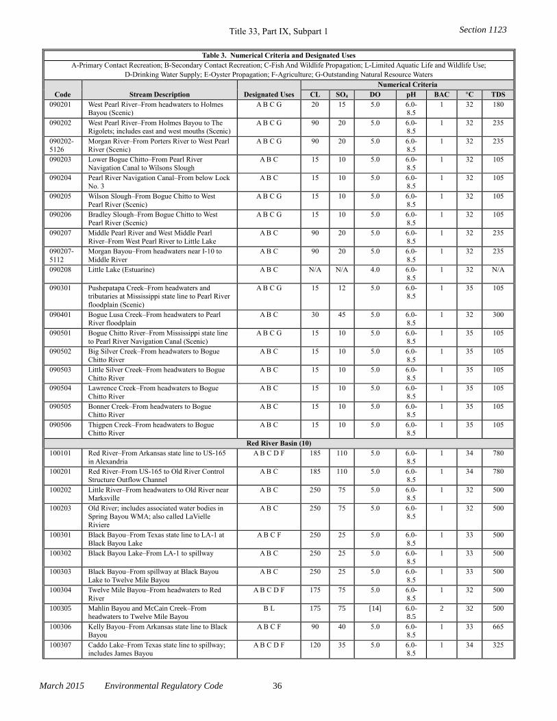
Title 33, Part IX, Subpart 1
March 2015 Environmental Regulatory Code 36
Table 3. Numerical Criteria and Designated Uses
A-Primary Contact Recreation; B-Secondary Contact Recreation; C-Fish And Wildlife Propagation; L-Limited Aquatic Life and Wildlife Use;
D-Drinking Water Supply; E-Oyster Propagation; F-Agriculture; G-Outstanding Natural Resource Waters
Code Stream Description Designated Uses
Numerical Criteria
CL SO4 DO pH BAC °C TDS
090201 West Pearl River–From headwaters to Holmes Bayou (Scenic)
A B C G 20 15 5.0 6.0-8.5
1 32 180
090202 West Pearl River–From Holmes Bayou to The Rigolets; includes east and west mouths (Scenic)
A B C G 90 20 5.0 6.0-8.5
1 32 235
090202-5126
Morgan River–From Porters River to West Pearl River (Scenic)
A B C G 90 20 5.0 6.0-8.5
1 32 235
090203 Lower Bogue Chitto–From Pearl River
Navigation Canal to Wilsons Slough
A B C 15 10 5.0 6.0-
8.5
1 32 105
090204 Pearl River Navigation Canal–From below Lock
No. 3
A B C 15 10 5.0 6.0-
8.5
1 32 105
090205 Wilson Slough–From Bogue Chitto to West
Pearl River (Scenic)
A B C G 15 10 5.0 6.0-
8.5
1 32 105
090206 Bradley Slough–From Bogue Chitto to West
Pearl River (Scenic)
A B C G 15 10 5.0 6.0-
8.5
1 32 105
090207 Middle Pearl River and West Middle Pearl
River–From West Pearl River to Little Lake
A B C 90 20 5.0 6.0-
8.5
1 32 235
090207-
5112
Morgan Bayou–From headwaters near I-10 to
Middle River
A B C 90 20 5.0 6.0-
8.5
1 32 235
090208 Little Lake (Estuarine) A B C N/A N/A 4.0 6.0-
8.5
1 32 N/A
090301 Pushepatapa Creek–From headwaters and tributaries at Mississippi state line to Pearl River
floodplain (Scenic)
A B C G 15 12 5.0 6.0-8.5
1 35 105
090401 Bogue Lusa Creek–From headwaters to Pearl
River floodplain
A B C 30 45 5.0 6.0-
8.5
1 32 300
090501 Bogue Chitto River–From Mississippi state line
to Pearl River Navigation Canal (Scenic)
A B C G 15 10 5.0 6.0-
8.5
1 35 105
090502 Big Silver Creek–From headwaters to Bogue
Chitto River
A B C 15 10 5.0 6.0-
8.5
1 35 105
090503 Little Silver Creek–From headwaters to Bogue
Chitto River
A B C 15 10 5.0 6.0-
8.5
1 35 105
090504 Lawrence Creek–From headwaters to Bogue
Chitto River
A B C 15 10 5.0 6.0-
8.5
1 35 105
090505 Bonner Creek–From headwaters to Bogue Chitto River
A B C 15 10 5.0 6.0-8.5
1 35 105
090506 Thigpen Creek–From headwaters to Bogue Chitto River
A B C 15 10 5.0 6.0-8.5
1 35 105
Red River Basin (10)
100101 Red River–From Arkansas state line to US-165
in Alexandria
A B C D F 185 110 5.0 6.0-
8.5
1 34 780
100201 Red River–From US-165 to Old River Control Structure Outflow Channel
A B C 185 110 5.0 6.0-8.5
1 34 780
100202 Little River–From headwaters to Old River near Marksville
A B C 250 75 5.0 6.0-8.5
1 32 500
100203 Old River; includes associated water bodies in Spring Bayou WMA; also called LaVielle
Riviere
A B C 250 75 5.0 6.0-8.5
1 32 500
100301 Black Bayou–From Texas state line to LA-1 at
Black Bayou Lake
A B C F 250 25 5.0 6.0-
8.5
1 33 500
100302 Black Bayou Lake–From LA-1 to spillway A B C 250 25 5.0 6.0-
8.5
1 33 500
100303 Black Bayou–From spillway at Black Bayou
Lake to Twelve Mile Bayou
A B C 250 25 5.0 6.0-
8.5
1 33 500
100304 Twelve Mile Bayou–From headwaters to Red
River
A B C D F 175 75 5.0 6.0-
8.5
1 32 500
100305 Mahlin Bayou and McCain Creek–From headwaters to Twelve Mile Bayou
B L 175 75 [14] 6.0-8.5
2 32 500
100306 Kelly Bayou–From Arkansas state line to Black Bayou
A B C F 90 40 5.0 6.0-8.5
1 33 665
100307 Caddo Lake–From Texas state line to spillway; includes James Bayou
A B C D F 120 35 5.0 6.0-8.5
1 34 325
Section 1123
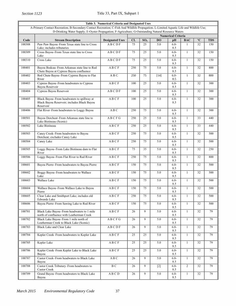
Title 33, Part IX, Subpart 1
March 2015 Environmental Regulatory Code 37
Table 3. Numerical Criteria and Designated Uses
A-Primary Contact Recreation; B-Secondary Contact Recreation; C-Fish And Wildlife Propagation; L-Limited Aquatic Life and Wildlife Use;
D-Drinking Water Supply; E-Oyster Propagation; F-Agriculture; G-Outstanding Natural Resource Waters
Code Stream Description Designated Uses
Numerical Criteria
CL SO4 DO pH BAC °C TDS
100308 Paw Paw Bayou–From Texas state line to Cross Lake; includes tributaries
A B C D F 75 25 5.0 6.0-8.5
1 32 150
100309 Cross Bayou–From Texas state line to Cross Lake
A B C D F 75 25 5.0 6.0-8.5
1 32 150
100310 Cross Lake A B C D F 75 25 5.0 6.0-8.5
1 32 150
100401 Bayou Bodcau–From Arkansas state line to Red
Chute Bayou at Cypress Bayou confluence
A B C F 250 75 5.0 6.0-
8.5
1 32 800
100402 Red Chute Bayou–From Cypress Bayou to Flat
River
A B C 250 75 [14] 6.0-
8.5
1 32 800
100403 Cypress Bayou–From headwaters to Cypress
Bayou Reservoir
A B C F 100 25 5.0 6.0-
8.5
1 32 300
100404 Cypress Bayou Reservoir A B C D F 100 25 5.0 6.0-
8.5
1 32 300
100405 Black Bayou–From headwaters to spillway at
Black Bayou Reservoir; includes Black Bayou Reservoir
A B C F 100 25 5.0 6.0-
8.5
1 32 300
100406 Flat River–From headwaters to Loggy Bayou A B C 250 75 5.0 6.0-8.5
1 32 300
100501 Bayou Dorcheat–From Arkansas state line to Lake Bistineau (Scenic)
A B C F G 250 25 5.0 6.0-8.5
1 33 440
100502 Lake Bistineau A B C F 250 25 5.0 6.0-
8.5
1 33 440
100503 Caney Creek–From headwaters to Bayou
Dorcheat; excludes Caney Lake
A B C F 250 75 5.0 6.0-
8.5
1 32 500
100504 Caney Lake A B C F 250 75 5.0 6.0-
8.5
1 32 500
100505 Loggy Bayou–From Lake Bistineau dam to Flat
River
A B C F 75 35 5.0 6.0-
8.5
1 32 250
100506 Loggy Bayou–From Flat River to Red River A B C F 250 75 5.0 6.0-
8.5
1 32 800
100601 Bayou Pierre–From headwaters to Bayou Pierre A B C F 150 75 5.0 6.0-
8.5
1 32 500
100602 Boggy Bayou–From headwaters to Wallace Lake
A B C F 150 75 5.0 6.0-8.5
1 32 500
100603 Wallace Lake A B C F 150 75 5.0 6.0-8.5
1 32 500
100604 Wallace Bayou–From Wallace Lake to Bayou Pierre
A B C F 150 75 5.0 6.0-8.5
1 32 500
100605 Clear Lake and Smithport Lake; includes old Edwards Lake
A B C F 250 75 5.0 6.0-8.5
1 32 500
100606 Bayou Pierre–From Sawing Lake to Red River A B C F 150 75 5.0 6.0-
8.5
1 32 500
100701 Black Lake Bayou–From headwaters to 1 mile
north of confluence with Leatherman Creek
A B C F 26 9 5.0 6.0-
8.5
1 32 79
100702 Black Lake Bayou–From 1 mile north of
Leatherman Creek to Black Lake (Scenic)
A B C F G 26 9 5.0 6.0-
8.5
1 32 79
100703 Black Lake and Clear Lake A B C D F 26 9 5.0 6.0-
8.5
1 32 79
100704 Kepler Creek–From headwaters to Kepler Lake A B C F 25 25 5.0 6.0-
8.5
1 32 79
100705 Kepler Lake A B C F 25 25 5.0 6.0-
8.5
1 32 79
100706 Kepler Creek–From Kepler Lake to Black Lake
Bayou
A B C F 25 25 5.0 6.0-
8.5
1 32 79
100707 Castor Creek–From headwaters to Black Lake Bayou
A B C 26 9 5.0 6.0-8.5
1 32 79
100708 Castor Creek Tributary–From headwaters to Castor Creek
B C 26 9 [2] 6.0-8.5
2 32 79
100709 Grand Bayou–From headwaters to Black Lake Bayou
A B C D 26 9 5.0 6.0-8.5
1 32 79
Section 1123
Title 33, Part IX, Subpart 1
March 2015 Environmental Regulatory Code 38
Table 3. Numerical Criteria and Designated Uses
A-Primary Contact Recreation; B-Secondary Contact Recreation; C-Fish And Wildlife Propagation; L-Limited Aquatic Life and Wildlife Use;
D-Drinking Water Supply; E-Oyster Propagation; F-Agriculture; G-Outstanding Natural Resource Waters
Code Stream Description Designated Uses
Numerical Criteria
CL SO4 DO pH BAC °C TDS
100710 Grand Bayou Tributary–From headwaters to Grand Bayou
B C 26 9 [2] 6.0-8.5
2 32 79
100801 Saline Bayou–From headwaters near Arcadia to Saline Lake (Scenic)
A B C F G 110 20 5.0 6.0-8.5
1 32 250
100802 Saline Lake A B C F 110 20 5.0 6.0-8.5
1 32 250
100803 Saline Bayou–From Saline Lake to Red River A B C F 110 20 5.0 6.0-
8.5
1 32 250
100804 Saline Bayou Tributary–From headwaters to
Saline Bayou near Arcadia
B C 110 20 [2] 6.0-
8.5
2 32 250
100901 Nantaches Creek–From headwaters to
Nantaches Lake
A B C F 25 25 5.0 6.0-
8.5
1 32 100
100902 Nantaches Lake A B C F 25 25 5.0 6.0-
8.5
1 32 100
100903 Bayou Nantaches–From Nantaches Lake to Red
River
A B C F 25 25 5.0 6.0-
8.5
1 32 100
101001 Sibley Lake A B C D F 25 25 5.0 6.0-
8.5
1 32 100
101101 Cane River–From above Natchitoches to Red
River
A B C F 25 25 5.0 6.0-
8.5
1 32 100
101102 Kisatchie Bayou–From headwaters to Kisatchie National Forest
A B C F 25 25 5.0 6.0-8.5
1 32 100
101103 Kisatchie Bayou–From Kisatchie National Forest to Old River (Scenic)
A B C F G 25 25 5.0 6.0-8.5
1 32 100
101201 Cotile Reservoir A B C 50 25 5.0 6.0-8.5
1 32 200
101301 Rigolette Bayou–From headwaters to Red River A B C F 25 25 5.0 6.0-
8.5
1 32 100
101302 Iatt Lake A B C F 25 25 5.0 6.0-
8.5
1 32 100
101303 Iatt Creek–From headwaters to Iatt Lake A B C F 25 25 5.0 6.0-
8.5
1 32 100
101401 Buhlow Lake near Pineville A B C 100 50 5.0 6.0-
8.5
1 32 250
101501 Big Saline Bayou–From Catahoula Lake to
Saline Lake
A B C 250 75 5.0 6.0-
8.5
1 32 500
101502 Saline Lake A B C 250 75 5.0 6.0-
8.5
1 32 500
101504 Saline Bayou–From Larto Lake to Saline Lake
(Scenic)
A B C G 45 10 5.0 6.0-
8.5
1 32 165
101505 Larto Lake A B C 45 10 5.0 6.0-8.5
1 32 165
101506 Big Creek–From headwaters to Saline Lake A B C 45 10 5.0 6.0-8.5
1 32 165
101601 Bayou Cocodrie–From Little Cross Bayou to Wild Cow Bayou (Scenic)
A B C F G 250 75 5.0 6.0-8.5
1 32 500
101602 Cocodrie Lake A B C 250 75 5.0 6.0-8.5
1 32 500
101603 Lake St. John A B C 250 75 5.0 6.0-
8.5
1 32 500
101604 Lake Concordia A B C 250 75 5.0 6.0-
8.5
1 32 500
101605 Bayou Cocodrie–From Lake Concordia to LA-
15
A B C 250 75 5.0 6.0-
8.5
1 32 500
101606 Bayou Cocodrie–From Wild Cow Bayou to Red
River
A B C 250 75 5.0 6.0-
8.5
1 32 500
101607 Bayou Cocodrie–From LA-15 to Little Cross
Bayou
B L 250 75 [13] 6.0-
8.5
2 32 500
Sabine River Basin (11)
110101 Toledo Bend Reservoir–From Texas-Louisiana
state line to Toledo Bend Dam
A B C D F 120 60 5.0 6.0-
8.5
1 34 500
Section 1123
Title 33, Part IX, Subpart 1
March 2015 Environmental Regulatory Code 39
Table 3. Numerical Criteria and Designated Uses
A-Primary Contact Recreation; B-Secondary Contact Recreation; C-Fish And Wildlife Propagation; L-Limited Aquatic Life and Wildlife Use;
D-Drinking Water Supply; E-Oyster Propagation; F-Agriculture; G-Outstanding Natural Resource Waters
Code Stream Description Designated Uses
Numerical Criteria
CL SO4 DO pH BAC °C TDS
110201 Sabine River–From Toledo Bend Dam to Old River below Sabine Island WMA
A B C 120 60 5.0 6.0-8.5
1 33 500
110202 Pearl Creek–From headwaters to Sabine River (Scenic)
A B C G 120 60 5.0 6.0-8.5
1 33 500
110301 Sabine River–From Old River below Sabine Island WMA to Sabine Lake (Estuarine)
A B C N/A N/A 4.0 6.0-8.5
1 35 N/A
110302 Black Bayou–From Pirogue Ditch to Sabine
Lake (Estuarine)
A B C N/A N/A 4.0 6.0-
8.5
1 32 N/A
110303 Sabine Lake (Estuarine) A B C E N/A N/A 4.0 6.0-
8.5
4 35 N/A
110304 Sabine Pass (Estuarine) A B C E N/A N/A 4.0 6.5-
9.0
4 35 N/A
110401 Bayou Toro–From headwaters to LA-473 A B C 25 25 5.0 6.0-
8.5
1 32 150
110402 Bayou Toro–From LA-473 to Sabine River A B C 25 25 5.0 6.0-
8.5
1 32 150
110501 West Anacoco Creek–From headwaters to
Vernon Lake
A B C 15 10 5.0 6.0-
8.5
1 32 90
110502 East Anacoco Creek–From headwaters to
Vernon Lake
A B C 15 10 5.0 6.0-
8.5
1 32 90
110503 Vernon Lake A B C 15 10 5.0 6.0-8.5
1 32 90
110504 Bayou Anacoco–From Vernon Lake to Anacoco Lake
A B C 15 10 5.0 6.0-8.5
1 32 90
110505 Anacoco Lake A B C 15 10 5.0 6.0-8.5
1 32 90
110506 Bayou Anacoco–From Anacoco Lake to Cypress
Creek
A B C 15 10 5.0 6.0-
8.5
1 32 90
110507 Bayou Anacoco–From Cypress Creek to Sabine
River
A B C 150 300 5.0 6.0-
8.5
1 32 1,000
110601 Vinton Waterway–From Vinton to ICWW
(Estuarine)
A B C N/A N/A 4.0 6.0-
8.5
1 35 N/A
110602 Black Bayou–From ICWW to Pirogue Ditch
(Estuarine)
A B C N/A N/A 4.0 6.0-
8.5
1 35 N/A
110701 Sabine River Basin Coastal Bays and Gulf
Waters to the State 3 mile limit
A B C E N/A N/A 5.0 6.5-
9.0
4 32 N/A
Terrebonne Basin (12)
120102 Bayou Poydras–From headwaters to Bayou
Choctaw
A B C 250 75 2.3 Mar.-
Nov.;
5.0 Dec.-
Feb.
6.0-
8.5
1 32 500
120103 Bayou Choctaw–From Bayou Poydras to Bayou Grosse Tete
A B C 250 75 2.3 Mar.-Nov.;
5.0 Dec.-
Feb.
6.0-8.5
1 32 500
120104 Bayou Grosse Tete–From headwaters to ICWW
near Wilbert Canal
A B C 25 25 2.3 Mar.-
Nov.;
5.0 Dec.-
Feb.
6.0-
8.5
1 32 200
120105 Chamberlin Canal–From Chamberlin to Bayou
Choctaw
A B C 250 75 5.0 6.0-
8.5
1 32 500
120106 Bayou Plaquemine–From Plaquemine Lock to ICWW
A B C 250 75 2.3 Mar.-Nov.;
5.0 Dec.-
Feb.
6.0-8.5
1 32 500
120107 Upper Grand River and Lower Flat River–From
headwaters to ICWW
A B C 250 75 2.3 Mar.-
Nov.;
5.0 Dec.-
Feb.
6.0-
8.5
1 32 500
Section 1123
Section 1123
Title 33, Part IX, Subpart 1
March 2015 Environmental Regulatory Code 40
Table 3. Numerical Criteria and Designated Uses
A-Primary Contact Recreation; B-Secondary Contact Recreation; C-Fish And Wildlife Propagation; L-Limited Aquatic Life and Wildlife Use;
D-Drinking Water Supply; E-Oyster Propagation; F-Agriculture; G-Outstanding Natural Resource Waters
Code Stream Description Designated Uses
Numerical Criteria
CL SO4 DO pH BAC °C TDS
120108 False River A B C 25 25 3.3 April-Sept.;
5.0 Oct.-
Mar.
6.0-8.5
1 32 200
120109 Intracoastal Waterway–From Port Allen Locks
to Bayou Sorrel Locks
A B C D 60 40 2.3 Mar.-
Nov.;
5.0 Dec.-
Feb.
6.0-
8.5
1 32 300
120110 Bayou Cholpe–From headwaters to Bayou Choctaw
A B C 25 25 2.3 Mar.-Nov.;
5.0 Dec.-
Feb.
6.0-8.5
1 32 200
120111 Bayou Maringouin–From headwaters to East
Atchafalaya Basin Levee
A B C 25 25 2.3 Mar.-
Nov.;
5.0 Dec.-
Feb.
6.0-
8.5
1 32 200
120201 Lower Grand River and Belle River–From
Bayou Sorrel Lock to Lake Palourde; includes Bay Natchez, Lake Natchez, Bayou Milhomme,
and Bayou Long
A B C 60 40 2.3 Mar.-
Nov.;
5.0 Dec.-Feb.
6.0-
8.5
1 32 300
120202 Bayou Black–From ICWW to Houma A B C D 85 40 2.3 Mar.-Nov.;
5.0 Dec.-
Feb.
6.0-8.5
1 32 500
120203 Bayou Boeuf–From Lake Palourde to ICWW A B C D 250 75 5.0 6.0-
8.5
1 32 500
120204 Lake Verret and Grassy Lake A B C 100 75 3.3 April-
Sept.;
5.0 Oct.-Mar.
6.0-
8.5
1 32 350
120205 Lake Palourde A B C D 100 75 3.3 April-Sept.;
5.0 Oct.-
Mar.
6.0-8.5
1 32 350
120206 Grand Bayou and Little Grand Bayou–From
headwaters to Lake Verret
A B C 60 40 2.3 Mar.-
Nov.;
5.0 Dec.-Feb.
6.0-
8.5
1 32 300
120207 Thibodaux Swamp–Forested wetland located in Lafourche and Terrebonne Parishes, 6.2 miles
southwest of Thibodaux, east of Terrebonne-
Lafourche Drainage Canal, and north of Southern Pacific Railroad; also called Pointe Au
Chene Swamp
B C [5] [5] [5] [5] 2 [5] [5]
120208 Bayou Ramos Swamp Wetland–Forested
wetland located 1.25 miles north of Amelia in
St. Mary Parish, south of Lake Palourde
B C [18] [18] [18] [18] 2 [18] [18]
120301 Bayou Terrebonne–From Thibodaux to ICWW
in Houma
A B C 540 90 2.3 Mar.-
Nov.;
5.0 Dec.-
Feb.
6.0-
8.5
1 32 1,350
120302 Bayou Folse–From headwaters to Company
Canal
A B C D F 500 150 5.0 6.5-
9.0
1 32 1,000
120303 Bayou L’eau Bleu–From Company Canal to
ICWW
A B C 500 150 2.3 Mar.-
Nov.;
5.0 Dec.-Feb.
6.5-
9.0
1 32 1,000
120304 Intracoastal Waterway–From Houma to Larose A B C D F 250 75 3.8 June-
Aug.;
4.0 Sept.-
May
6.5-
9.0
1 32 500
120401 Bayou Penchant–From Bayou Chene to Lake
Penchant
A B C G 500 150 5.0 6.5-
9.0
1 32 1,000
Section 1123
Title 33, Part IX, Subpart 1
March 2015 Environmental Regulatory Code 41
Table 3. Numerical Criteria and Designated Uses
A-Primary Contact Recreation; B-Secondary Contact Recreation; C-Fish And Wildlife Propagation; L-Limited Aquatic Life and Wildlife Use;
D-Drinking Water Supply; E-Oyster Propagation; F-Agriculture; G-Outstanding Natural Resource Waters
Code Stream Description Designated Uses
Numerical Criteria
CL SO4 DO pH BAC °C TDS
120402 Bayou Chene–From ICWW to Bayou Penchant A B C 250 75 3.8 April-Aug.;
5.0 Sept.-
Mar.
6.5-8.0
1 32 500
120403 Intracoastal Waterway–From Bayou Boeuf
Locks to Bayou Black in Houma; includes
segments of Bayous Boeuf, Black, and Chene
A B C D F 250 75 3.8 June-
Aug.;
4.0 Sept.-
May
6.5-
8.5
1 32 500
120404 Lake Penchant A B C 500 150 5.0 6.5-9.0
1 32 1,000
120405 Lake Hache and Lake Theriot A B C 500 150 5.0 6.0-8.5
1 32 1,000
120406 Lake de Cade A B C E N/A N/A 5.0 6.0-9.0
4 35 N/A
120501 Bayou Grand Caillou–From Houma to Bayou
Pelton
A B C 500 150 3.8 April-
Aug.;
5.0 Sept.-
Mar.
6.0-
8.5
1 32 1,000
120502 Bayou Grand Caillou–From Bayou Pelton to
Houma Navigation Canal (Estuarine)
A B C E N/A N/A 3.8 April-
Aug.;
5.0 Sept.-Mar.
6.5-
9.0
4 35 N/A
120503 Bayou Petit Caillou–From Bayou Terrebonne to LA-24 bridge
A B C E 500 150 3.8 April-Aug.;
5.0 Sept.-
Mar.
6.0-9.0
4 32 1,000
120504 Bayou Petit Caillou–From LA-24 bridge to
Boudreaux Canal (Estuarine)
A B C E N/A N/A 3.8 April-
Aug.;
5.0 Sept.-
Mar.
6.0-
9.0
4 32 N/A
120505 Bayou Du Large–From Houma to Marmande Canal
A B C 500 150 3.8 April-Aug.;
5.0 Sept.-
Mar.
6.5-9.0
1 32 1,000
120506 Bayou Du Large–From Marmande Canal to 1/2
mile north of St. Andrews Mission (Estuarine)
A B C E N/A N/A 3.8 April-
Aug.;
5.0 Sept.-
Mar.
6.0-
9.0
4 35 N/A
120507 Bayou Chauvin–From Ashland Canal to Lake
Boudreaux (Estuarine)
A B C N/A N/A 3.8 June-
Aug.;
4.0 Sept.-May
6.5-
9.0
1 32 N/A
120508 Houma Navigation Canal–From Bayou Pelton to
1 mile south of Bayou Grand Caillou (Estuarine)
A B C E N/A N/A 3.8 June-
Aug.;
4.0 Sept.-
May
6.5-
9.0
4 35 N/A
120509 Houma Navigation Canal–From Houma to
Bayou Pelton
A B C D 500 150 3.8 June-
Aug.;
4.0 Sept.-May
6.0-
8.5
1 32 1,000
120601 Bayou Terrebonne–From Houma to Company Canal (Estuarine)
A B C 445 105 3.8 April-Aug.;
5.0 Sept.-
Mar.
6.0-9.0
1 32 1,230
120602 Bayou Terrebonne–From Company Canal to
Humble Canal (Estuarine)
A B C E 5,055 775 3.8 April-
Aug.;
5.0 Sept.-Mar.
6.5-
9.0
4 32 10,000
120603 Company Canal–From ICWW to Bayou Terrebonne
A B C 500 150 3.8 June-Aug.;
4.0 Sept.-
May
6.5-9.0
1 32 1,000
Section 1123
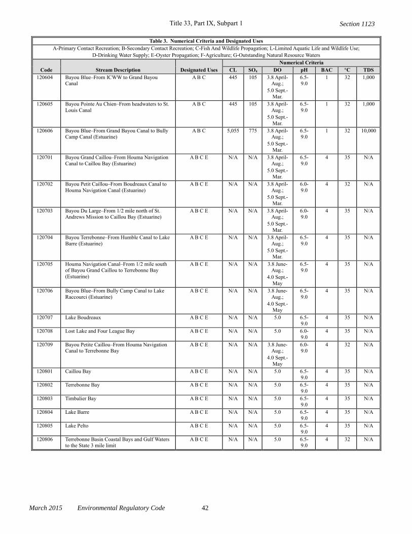
Title 33, Part IX, Subpart 1
March 2015 Environmental Regulatory Code 42
Table 3. Numerical Criteria and Designated Uses
A-Primary Contact Recreation; B-Secondary Contact Recreation; C-Fish And Wildlife Propagation; L-Limited Aquatic Life and Wildlife Use;
D-Drinking Water Supply; E-Oyster Propagation; F-Agriculture; G-Outstanding Natural Resource Waters
Code Stream Description Designated Uses
Numerical Criteria
CL SO4 DO pH BAC °C TDS
120604 Bayou Blue–From ICWW to Grand Bayou Canal
A B C 445 105 3.8 April-Aug.;
5.0 Sept.-
Mar.
6.5-9.0
1 32 1,000
120605 Bayou Pointe Au Chien–From headwaters to St.
Louis Canal
A B C 445 105 3.8 April-
Aug.;
5.0 Sept.-
Mar.
6.5-
9.0
1 32 1,000
120606 Bayou Blue–From Grand Bayou Canal to Bully Camp Canal (Estuarine)
A B C 5,055 775 3.8 April-Aug.;
5.0 Sept.-
Mar.
6.5-9.0
1 32 10,000
120701 Bayou Grand Caillou–From Houma Navigation
Canal to Caillou Bay (Estuarine)
A B C E N/A N/A 3.8 April-
Aug.;
5.0 Sept.-
Mar.
6.5-
9.0
4 35 N/A
120702 Bayou Petit Caillou–From Boudreaux Canal to
Houma Navigation Canal (Estuarine)
A B C E N/A N/A 3.8 April-
Aug.;
5.0 Sept.-Mar.
6.0-
9.0
4 32 N/A
120703 Bayou Du Large–From 1/2 mile north of St. Andrews Mission to Caillou Bay (Estuarine)
A B C E N/A N/A 3.8 April-Aug.;
5.0 Sept.-
Mar.
6.0-9.0
4 35 N/A
120704 Bayou Terrebonne–From Humble Canal to Lake
Barre (Estuarine)
A B C E N/A N/A 3.8 April-
Aug.;
5.0 Sept.-Mar.
6.5-
9.0
4 35 N/A
120705 Houma Navigation Canal–From 1/2 mile south of Bayou Grand Caillou to Terrebonne Bay
(Estuarine)
A B C E N/A N/A 3.8 June-Aug.;
4.0 Sept.-
May
6.5-9.0
4 35 N/A
120706 Bayou Blue–From Bully Camp Canal to Lake
Raccourci (Estuarine)
A B C E N/A N/A 3.8 June-
Aug.;
4.0 Sept.-May
6.5-
9.0
4 35 N/A
120707 Lake Boudreaux A B C E N/A N/A 5.0 6.5-9.0
4 35 N/A
120708 Lost Lake and Four League Bay A B C E N/A N/A 5.0 6.0-9.0
4 35 N/A
120709 Bayou Petite Caillou–From Houma Navigation Canal to Terrebonne Bay
A B C E N/A N/A 3.8 June-Aug.;
4.0 Sept.-
May
6.0-9.0
4 32 N/A
120801 Caillou Bay A B C E N/A N/A 5.0 6.5-
9.0
4 35 N/A
120802 Terrebonne Bay A B C E N/A N/A 5.0 6.5-
9.0
4 35 N/A
120803 Timbalier Bay A B C E N/A N/A 5.0 6.5-
9.0
4 35 N/A
120804 Lake Barre A B C E N/A N/A 5.0 6.5-9.0
4 35 N/A
120805 Lake Pelto A B C E N/A N/A 5.0 6.5-9.0
4 35 N/A
120806 Terrebonne Basin Coastal Bays and Gulf Waters to the State 3 mile limit
A B C E N/A N/A 5.0 6.5-9.0
4 32 N/A
Section 1123
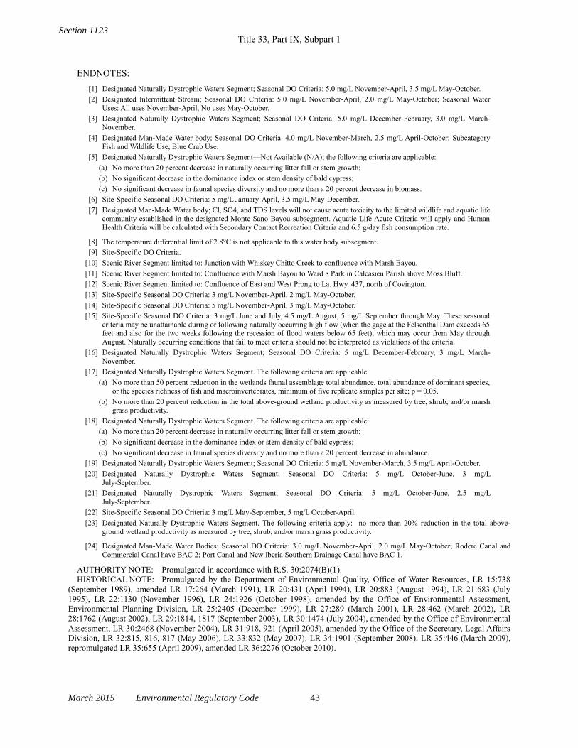
Title 33, Part IX, Subpart 1
March 2015 Environmental Regulatory Code 43
ENDNOTES:
[1] Designated Naturally Dystrophic Waters Segment; Seasonal DO Criteria: 5.0 mg/L November-April, 3.5 mg/L May-October.
[2] Designated Intermittent Stream; Seasonal DO Criteria: 5.0 mg/L November-April, 2.0 mg/L May-October; Seasonal Water
Uses: All uses November-April, No uses May-October.
[3] Designated Naturally Dystrophic Waters Segment; Seasonal DO Criteria: 5.0 mg/L December-February, 3.0 mg/L March-
November.
[4] Designated Man-Made Water body; Seasonal DO Criteria: 4.0 mg/L November-March, 2.5 mg/L April-October; Subcategory
Fish and Wildlife Use, Blue Crab Use.
[5] Designated Naturally Dystrophic Waters Segment—Not Available (N/A); the following criteria are applicable:
(a) No more than 20 percent decrease in naturally occurring litter fall or stem growth;
(b) No significant decrease in the dominance index or stem density of bald cypress;
(c) No significant decrease in faunal species diversity and no more than a 20 percent decrease in biomass.
[6] Site-Specific Seasonal DO Criteria: 5 mg/L January-April, 3.5 mg/L May-December.
[7] Designated Man-Made Water body; Cl, SO4, and TDS levels will not cause acute toxicity to the limited wildlife and aquatic life community established in the designated Monte Sano Bayou subsegment. Aquatic Life Acute Criteria will apply and Human
Health Criteria will be calculated with Secondary Contact Recreation Criteria and 6.5 g/day fish consumption rate.
[8] The temperature differential limit of 2.8°C is not applicable to this water body subsegment.
[9] Site-Specific DO Criteria.
[10] Scenic River Segment limited to: Junction with Whiskey Chitto Creek to confluence with Marsh Bayou.
[11] Scenic River Segment limited to: Confluence with Marsh Bayou to Ward 8 Park in Calcasieu Parish above Moss Bluff.
[12] Scenic River Segment limited to: Confluence of East and West Prong to La. Hwy. 437, north of Covington.
[13] Site-Specific Seasonal DO Criteria: 3 mg/L November-April, 2 mg/L May-October.
[14] Site-Specific Seasonal DO Criteria: 5 mg/L November-April, 3 mg/L May-October.
[15] Site-Specific Seasonal DO Criteria: 3 mg/L June and July, 4.5 mg/L August, 5 mg/L September through May. These seasonal
criteria may be unattainable during or following naturally occurring high flow (when the gage at the Felsenthal Dam exceeds 65 feet and also for the two weeks following the recession of flood waters below 65 feet), which may occur from May through
August. Naturally occurring conditions that fail to meet criteria should not be interpreted as violations of the criteria.
[16] Designated Naturally Dystrophic Waters Segment; Seasonal DO Criteria: 5 mg/L December-February, 3 mg/L March-
November.
[17] Designated Naturally Dystrophic Waters Segment. The following criteria are applicable:
(a) No more than 50 percent reduction in the wetlands faunal assemblage total abundance, total abundance of dominant species, or the species richness of fish and macroinvertebrates, minimum of five replicate samples per site; p = 0.05.
(b) No more than 20 percent reduction in the total above-ground wetland productivity as measured by tree, shrub, and/or marsh
grass productivity.
[18] Designated Naturally Dystrophic Waters Segment. The following criteria are applicable:
(a) No more than 20 percent decrease in naturally occurring litter fall or stem growth;
(b) No significant decrease in the dominance index or stem density of bald cypress;
(c) No significant decrease in faunal species diversity and no more than a 20 percent decrease in abundance.
[19] Designated Naturally Dystrophic Waters Segment; Seasonal DO Criteria: 5 mg/L November-March, 3.5 mg/L April-October.
[20] Designated Naturally Dystrophic Waters Segment; Seasonal DO Criteria: 5 mg/L October-June, 3 mg/L
July-September.
[21] Designated Naturally Dystrophic Waters Segment; Seasonal DO Criteria: 5 mg/L October-June, 2.5 mg/L
July-September.
[22] Site-Specific Seasonal DO Criteria: 3 mg/L May-September, 5 mg/L October-April.
[23] Designated Naturally Dystrophic Waters Segment. The following criteria apply: no more than 20% reduction in the total above-ground wetland productivity as measured by tree, shrub, and/or marsh grass productivity.
[24] Designated Man-Made Water Bodies; Seasonal DO Criteria: 3.0 mg/L November-April, 2.0 mg/L May-October; Rodere Canal and
Commercial Canal have BAC 2; Port Canal and New Iberia Southern Drainage Canal have BAC 1.
AUTHORITY NOTE: Promulgated in accordance with R.S. 30:2074(B)(1).
HISTORICAL NOTE: Promulgated by the Department of Environmental Quality, Office of Water Resources, LR 15:738
(September 1989), amended LR 17:264 (March 1991), LR 20:431 (April 1994), LR 20:883 (August 1994), LR 21:683 (July
1995), LR 22:1130 (November 1996), LR 24:1926 (October 1998), amended by the Office of Environmental Assessment,
Environmental Planning Division, LR 25:2405 (December 1999), LR 27:289 (March 2001), LR 28:462 (March 2002), LR
28:1762 (August 2002), LR 29:1814, 1817 (September 2003), LR 30:1474 (July 2004), amended by the Office of Environmental
Assessment, LR 30:2468 (November 2004), LR 31:918, 921 (April 2005), amended by the Office of the Secretary, Legal Affairs
Division, LR 32:815, 816, 817 (May 2006), LR 33:832 (May 2007), LR 34:1901 (September 2008), LR 35:446 (March 2009),
repromulgated LR 35:655 (April 2009), amended LR 36:2276 (October 2010).
Section 1123