Embed Size (px)
Citation preview

Presented below are water quality standards that are in effect for Clean Water Act purposes. EPA is posting these standards as a convenience to users and has made a reasonable effort to assure their accuracy. Additionally, EPA has made a reasonable effort to identify parts of the standards that are not approved, disapproved, or are otherwise not in effect for Clean Water Act purposes.

3745-1-01 Purpose and applicability.
(A) It is the purpose of these water quality standards, Chapter 3745-1 of the Administrative Code, to establish minimum water quality requirements for all surface waters of the state, thereby protecting public health and welfare; and to enhance, improve and maintain water quality as provided under the laws of the state of Ohio, section 6111.041 of the Revised Code, the federal Clean Water Act, 33 U.S.C. section 1251 et seq., and rules adopted thereunder.
(B) Whenever two or more use designations apply to the same surface water, the more stringent criteria of each use designation will apply.
(C) These water quality standards will apply to all surface waters of the state except as provided in paragraph (D), (E), or (F) of this rule. Compliance schedules may be granted pursuant to rule 3745-33-05 of the Administrative Code.
(D) These water quality standards will not apply to water bodies when the flow is less than the critical low-flow values determined in rule 3745-2-05 of the Administrative Code.
(E) The following exceptions will apply only to the specific water quality criteria involved in each case for a reasonable period of time as determined by the director.
(1) Whenever chemicals are applied for control of aquatic plants or animals, notice must be given to the director before chemicals are applied. The director, upon receiving such notice, may order that chemicals not be applied if he concludes that the proposed application would pose an unreasonable danger to human or aquatic life. The application of pesticides registered under the Federal Insecticide, Fungicide and Rodenticide Act (7 U.S.C. 136 et seq.) are permitted without notification to the director when:
(a) The pesticide is applied consistent with label instructions; and
(i) The application is to a pond with a surface area equal to or less than five acres; and
(ii) The application is not within one mile upstream of a public water supply intake or within one mile of a reservoir public water supply intake; and
(iii) The application is not to any wetland, borrow pit, quarry or water body used for public swimming.
(b) The pesticide is applied under the direction of a local health department or other government agency in a mosquito abatement program.
(2) Whenever dredging or construction activities occur on or near water bodies or during the period of time when the aftereffects of dredging or construction activities degrade water quality and such activities have been authorized by the United States army corps of engineers and/or by a 401 water quality certification or an isolated wetland permit issued

3745-1-01 2
by the Ohio environmental protection agency.
(3) Whenever coal remining permits are issued pursuant to section 301(p) of the act. This exception applies to pH, iron and manganese for the duration of the remining activity. This exception applies only if: there is a demonstrated potential for improved water quality from the remining operation; and no degradation of existing instream conditions occurs.
(F) Temporary variances. The director may grant temporary variances from compliance with water quality criteria applicable by this chapter pursuant to rule 3745-33-07 of the Adminstrative Code.
Effective: 12/30/2002
R.C. Section 119.032 review dates: 3/25/2002 and 12/30/2007
Promulgated under: R.C. Section 119.03Rule authorized by: R.C. Section 6111.041Rule amplifies: R.C. Section 6111.041Prior effective dates: 2/14/1978, 4/4/1985, 5/1/1990, 10/31/1997, 4/17/2001 (Emer.)

3745-1-02 Definitions.
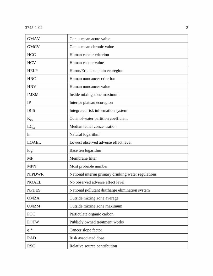
(A) Acronyms and abbreviations used in Chapter 3745-1 of the Administrative Code shall be defined as listed below.
AAC Acute aquatic criterion
AAV Acute aquatic value
ACR Acute-chronic ratio
ADE Acceptable daily exposure
BAF Bioaccumulation factor
BCC Bioaccumulative chemical of concern
BCF Bioconcentration factor
BSAF Biota-sediment accumulation factor
BW Body weight
CAC Chronic aquatic criterion
CAV Chronic aquatic value
CBOD5 Five-day carbonaceous biochemical oxygen demand
CCC Criterion continuous concentration
C.F.R. Code of federal regulations
CMC Criterion maximum concentration
DOC Dissolved organic carbon
ECBP Eastern corn belt plains ecoregion
EC50 Median effective concentration
EOLP Erie/Ontario lake plain ecoregion
EPA Environmental protection agency
FACR Final acute-chronic ratio
FAV Final acute value
FCM Food-chain multiplier
FCV Final chronic value
FPV Final plant value
3745-1-02 2
GMAV Genus mean acute value
GMCV Genus mean chronic value
HCC Human cancer criterion
HCV Human cancer value
HELP Huron/Erie lake plain ecoregion
HNC Human noncancer criterion
HNV Human noncancer value
IMZM Inside mixing zone maximum
IP Interior plateau ecoregion
IRIS Integrated risk information system
Kow Octanol-water partition coefficient
LC50 Median lethal concentration
ln Natural logarithm
LOAEL Lowest observed adverse effect level
log Base ten logarithm
MF Membrane filter
MPN Most probable number
NIPDWR National interim primary drinking water regulations
NOAEL No observed adverse effect level
NPDES National pollutant discharge elimination system
OMZA Outside mixing zone average
OMZM Outside mixing zone maximum
POC Particulate organic carbon
POTW Publicly owned treatment works
q1 * Cancer slope factor
RAD Risk associated dose
RSC Relative source contribution

3745-1-02 3
S Soluble
SACR Secondary acute-chronic ratio
SAF Secondary acute factor
SAR Structure-activity relationship
SAV Secondary acute value
SMAV Species mean acute value
SMCV Species mean chronic value
T Total
TD Test dose
temp Temperature
TL Trophic level
TR Total recoverable
UF Uncertainty factor
U.S.C. United States Code
WAP Western Allegheny plateau ecoregion
WV Wildlife value
(B) Technical words used in Chapter 3745-1 of the Administrative Code shall be defined as listed below.
(1) "Acceptable daily exposure" or "ADE" means an estimate of the maximum daily dose of a substance which is not expected to result in adverse noncancer effects to the general human population, including sensitive subgroups.
(2) "Act" means the federal Water Pollution Control Act, 33 U.S.C. 1251 et seq. (as amended).
(3) "Acute aquatic criterion" or "AAC" means the Ohio EPA estimation of the highest instream concentration of a chemical to which aquatic organisms can be exposed for a brief period of time without causing mortality.
(4) "Acute-chronic ratio" or "ACR" means a standard measure of the acute toxicity of a material divided by an appropriate measure of the chronic toxicity of the same material under comparable conditions.

3745-1-02 4
(5) "Acute toxicity" means adverse effects that result from an acute exposure and occur within any short observation period which begins when the exposure begins, and usually does not constitute a substantial portion of the life span of the organism.
(6) "Adverse effect" means any deleterious effect to organisms due to exposure to a substance. This includes effects which are or may become debilitating, harmful or toxic to the normal functions of the organism, but does not include non-harmful effects such as tissue discoloration alone or the induction of enzymes involved in the metabolism of the substance.
(7) "Ambient water temperature" means the spatial (longitudinal, lateral and vertical) and temporal water temperature measured in the receiving body of water prior to a specific waste heat discharge, and is outside the influence of any thermal mixing zone.
(8) "Average temperature" represents the arithmetic mean of multiple daily average temperatures over a consecutive fifteen- or thirty-day period.
(9) "Baseline BAF" means:
(a) For organic chemicals, a BAF that is based on the concentration of freely dissolved chemical in the ambient water and takes into account the partitioning of the chemical within the organism; and
(b) For inorganic chemicals, a BAF that is based on the wet weight of the tissue.
(10) "Baseline BCF" means:
(a) For organic chemicals, a BCF that is based on the concentration of freely dissolved chemical in the ambient water and takes into account the partitioning of the chemical within the organism; and
(b) For inorganic chemicals, a BCF that is based on the wet weight of the tissue.
(11) "Bioaccumulation" means the net accumulation of a substance by an organism as a result of uptake from all environmental sources.
(12) "Bioaccumulation factor" or "BAF" means the ratio (in l/kg) of a substance’s concentration in the tissue of an aquatic organism to its concentration in the ambient water, in situations where both the organism and its food are exposed and the ratio does not change substantially over time.
(13) "Bioaccumulative chemical of concern" or "BCC" is any chemical that has the potential to cause adverse effects which, upon entering the surface waters, by itself or as its toxic transformation product, accumulates in aquatic organisms by a human health

3745-1-02 5
bioaccumulation factor greater than one thousand, after considering metabolism and other physicochemical properties that might enhance or inhibit bioaccumulation, calculated in accordance with the methodology in rule 3745-1-37 of the Administrative Code. Chemicals with half-lives of less than eight weeks in the water column, sediment, and biota are not BCCs. The minimum BAF information needed to define an organic chemical as a BCC is either a field-measured BAF or a BAF derived using the BSAF methodology. The minimum BAF information needed to define an inorganic chemical, including an organometal, as a BCC is either a field-measured BAF or a laboratory-measured BCF. Bioaccumulative chemicals of concern include, but are not limited to, chlordane, 4,4'-DDD (p,p'-DDD, 4,4'-TDE, p,p'-TDE), 4,4'-DDE (p,p'-DDE), 4,4'-DDT (p,p'-DDT), dieldrin, hexachlorobenzene, hexachlorobutadiene (hexachloro-1,3-butadiene), hexachlorocyclohexanes (BHCs), alpha-hexachlorocyclohexane (alpha-BHC), beta-hexachlorocyclohexane (beta-BHC), delta-hexachlorocyclohexane (delta-BHC), lindane (gamma-hexachlorocyclohexane, gamma-BHC), mercury, mirex, octachlorostyrene, PCBs (polychlorinated biphenyls), pentachlorobenzene, photomirex, 2,3,7,8-TCDD (dioxin), 1,2,3,4-tetrachlorobenzene, 1,2,4,5-tetrachlorobenzene, and toxaphene.
(14) "Bioconcentration" means the net accumulation of a substance by an aquatic organism as a result of uptake directly from the ambient water through gill membranes or other external body surfaces.
(15) "Bioconcentration factor" or "BCF" means the ratio (in l/kg) of a substance’s concentration in the tissue of an aquatic organism to its concentration in the ambient water, in situations where the organism is exposed through the water only and the ratio does not change substantially over time.
(16) "Biota-sediment accumulation factor" or "BSAF" means the ratio (in kg of organic carbon/kg of lipid) of a substance’s lipid-normalized concentration in the tissue of an aquatic organism to its organic carbon-normalized concentration in surface sediment, in situations where the ratio does not change substantially over time, both the organism and its food are exposed, and the surface sediment is representative of average surface sediment in the vicinity of the organism.
(17) "°C" means degree(s) Celsius.
(18) "Carcinogen" means a substance which causes an increased incidence of benign or malignant neoplasms, or substantially decreases the time to develop neoplasms, in animals or humans. The classification of carcinogens is discussed in rule 3745-1-38 of the Administrative Code.
(19) "Chronic aquatic criterion" or “CAC” means the Ohio EPA estimation of the highest instream concentration of a chemical to which aquatic organisms can be exposed indefinitely without causing unacceptable effects (e.g., adverse effects on growth or

3745-1-02 6
reproduction).
(20) "Chronic toxicity" means concurrent and delayed adverse effects that occur only as a result of a chronic exposure. Chronic exposure is exposure of an organism for any long period or for a substantial portion of its life span.
(21) "Coldwater fish" means those species of fish that thrive in relatively cold water. These species include, but are not limited to, salmon and trout (Salmonidae), and may include sculpins (Cottidae), and certain minnow (Cyprinidae) species.
(22) "Confluence" means the point where two or more bodies of water flow together.
(23) "Criteria" mean elements of water quality standards, expressed as constituent concentrations, levels, or narrative statements, representing a quality of water that supports a particular designated use.
(24) "Criterion continuous concentration" or "CCC" means an estimate of the highest concentration of a material in the water column to which an aquatic community can be exposed indefinitely without resulting in an unacceptable effect.
(25) "Criterion maximum concentration" or "CMC" means an estimate of the highest concentration of a material in the water column to which an aquatic community can be exposed briefly without resulting in an unacceptable effect.
(26) "Daily average temperature" means the arithmetic mean of multiple temperature measurements to be taken at least once per hour during a twenty-four-hour day.
(27) "Degradation" means a lowering of the existing water quality in the surface waters of the state.
(28) "Depuration" means the loss of a substance from an organism as a result of any active or passive process.
(29) "Designated use" means a use of the surface waters of the state, established by the water quality standards, Chapter 3745-1 of the Administrative Code.
(30) "Director" means the director of the Ohio environmental protection agency.
(31) "Discharge" means the addition of any pollutant to the waters of the state from a point source.
(32) "E. coli" means a specific bacterial species included in the fecal coliform bacteria group, the presence of which in surface waters has been correlated with gastrointestinal illness in swimmers.
3745-1-02 7
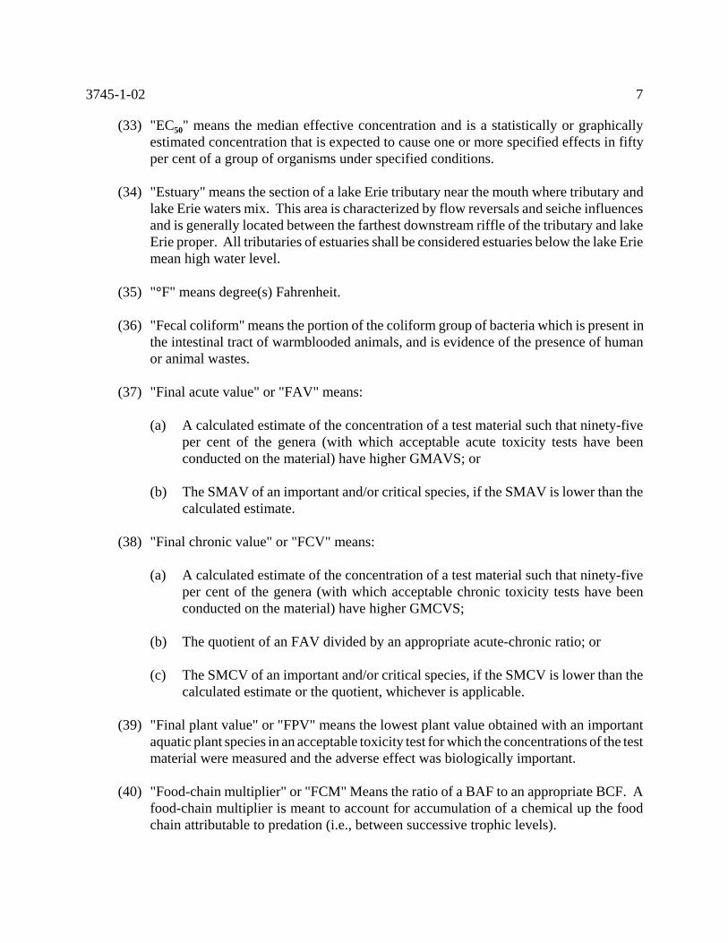
(33) "EC50" means the median effective concentration and is a statistically or graphically estimated concentration that is expected to cause one or more specified effects in fifty per cent of a group of organisms under specified conditions.
(34) "Estuary" means the section of a lake Erie tributary near the mouth where tributary and lake Erie waters mix. This area is characterized by flow reversals and seiche influences and is generally located between the farthest downstream riffle of the tributary and lake Erie proper. All tributaries of estuaries shall be considered estuaries below the lake Erie mean high water level.
(35) "°F" means degree(s) Fahrenheit.
(36) "Fecal coliform" means the portion of the coliform group of bacteria which is present in the intestinal tract of warmblooded animals, and is evidence of the presence of human or animal wastes.
(37) "Final acute value" or "FAV" means:
(a) A calculated estimate of the concentration of a test material such that ninety-five per cent of the genera (with which acceptable acute toxicity tests have been conducted on the material) have higher GMAVS; or
(b) The SMAV of an important and/or critical species, if the SMAV is lower than the calculated estimate.
(38) "Final chronic value" or "FCV" means:
(a) A calculated estimate of the concentration of a test material such that ninety-five per cent of the genera (with which acceptable chronic toxicity tests have been conducted on the material) have higher GMCVS;
(b) The quotient of an FAV divided by an appropriate acute-chronic ratio; or
(c) The SMCV of an important and/or critical species, if the SMCV is lower than the calculated estimate or the quotient, whichever is applicable.
(39) "Final plant value" or "FPV" means the lowest plant value obtained with an important aquatic plant species in an acceptable toxicity test for which the concentrations of the test material were measured and the adverse effect was biologically important.
(40) "Food-chain multiplier" or "FCM" Means the ratio of a BAF to an appropriate BCF. A food-chain multiplier is meant to account for accumulation of a chemical up the food chain attributable to predation (i.e., between successive trophic levels).

3745-1-02 8
(41) "Genus mean acute value" or "GMAV" means the geometric mean of the SMAVs for the genus.
(42) "Genus mean chronic value" or "GMCV" means the geometric mean of the SMCVS for the genus.
(43) "Geometric mean" means the Nth root of the product of N quantities.
(44) "Great Lakes system" means all the streams, rivers, lakes and other bodies of water within the drainage basin of the Great Lakes within the United States.
(45) "Human cancer criterion" or "HCC" is a human cancer value for a pollutant that meets the minimum data requirements for tier I as specified in rule 3745-1-38 of the Administrative Code.
(46) "Human cancer value" or "HCV" is the maximum ambient water concentration of a substance at which a lifetime of exposure from either: drinking the water, consuming fish from the water, and water-related recreation activities; or consuming fish from the water, and water-related recreation activities, will represent a plausible upper-bound risk of contracting cancer of one in one hundred thousand using the exposure assumptions specified in the methodologies for the development of human health criteria and values in rule 3745-1-38 of the Administrative Code.
(47) "Human noncancer criterion" or "HNC" is a human noncancer value for a pollutant that meets the minimum data requirements for tier I as specified in rule 3745-1-38 of the Administrative Code.
(48) "Human noncancer value" or "HNV" is the maximum ambient water concentration of a substance at which adverse noncancer effects are not likely to occur in the human population from lifetime exposure from either: drinking the water, consuming fish from the water, and water-related recreation activities; or consuming fish from the water and water-related recreation activities, using the methodologies for the development of human health criteria and values in rule 3745-1-38 of the Administrative Code.
(49) "Lake Erie drainage basin" means all the streams, rivers, lakes and other bodies of water within the drainage basin of lake Erie and within the United States.
(50) "LC50" means the median lethal concentration and is a statistically or graphically estimated concentration that is expected to be lethal to fifty per cent of a group of organisms under specified conditions.
(51) "Linearized multistage model" means a conservative mathematical model for cancer risk assessment. This model fits linear dose-response curves to low doses. It is consistent with a no-threshold model of carcinogenesis, i.e., exposure to even a very small amount

3745-1-02 9
of the substance is assumed to produce a finite increased risk of cancer.
(52) "Lowest observed adverse effect level" or "LOAEL" means the lowest tested dose or concentration of a substance which results in an observed adverse effect in exposed test organisms when all higher doses or concentrations result in the same or more severe effects.
(53) "Maximum daily temperature" means the highest temperature observed in a twenty-four-hour day.
(54) "Micrograms per liter (ug/l)" means the micrograms of substance per liter of solution, and is equivalent to 10-9 kilograms per liter or parts per billion, assuming unit density.
(55) "Milligrams per kilogram (mg/kg)" means the milligrams of substance per kilogram of weight.
(56) "Milligrams per liter (mg/l)" means the milligrams of substance per liter of solution, and is equivalent to 10-6 kilograms per liter or parts per million, assuming unit density.
(57) "Mine drainage" means surface or groundwater flowing through or from mines and mine sites. It is usually characterized by concentrations of acidity or alkalinity, various heavy metals, sulfates, and dissolved solids.
(58) "Mixing zone" means an area of a water body contiguous to a treated or untreated wastewater discharge. The discharge is in transit and progressively diluted from the source concentration to the receiving system concentration. The mixing zone is a place where wastewater and receiving water mix, not a place where wastes are treated.
(59) "Nanograms per liter (ng/l)" means the nanograms of substance per liter of solution, and is equivalent to 10-12 kilograms per liter or parts per trillion, assuming unit density.
(60) "Natural conditions" mean those conditions that are measured outside the influence of human activities.
(61) "No observed adverse effect level" or "NOAEL" means the highest tested dose or concentration of a substance which results in no observed adverse effect in exposed test organisms where higher doses or concentrations result in an adverse effect.
(62) "Nonpoint source" means any source of pollutants other than those defined as point sources.
(63) "Octanol-water partition coefficient" or "Kow" means the ratio of the concentration of a substance in the N-octanol phase to its concentration in the aqueous phase in an equilibrated two-phase octanol-water system. For log Kow, the log of the octanol-water

3745-1-02 10
partition coefficient is a base ten logarithm.
(64) "Ohio river drainage basin" means all the streams, rivers, lakes and other bodies of water within the drainage basin of the Ohio river.
(65) "pH" means the negative logarithm of the hydrogen ion activity concentrations when expressed as moles per liter or pH = -log (H+).
(66) "Picograms per liter (pg/l)" means the picograms of substance per liter of solution, and is equivalent to 10-15 kilograms per liter or parts per quadrillion, assuming unit density.
(67) "Point source" means any discernible, confined or discrete conveyance from which a pollutant is or may be discharged to the surface waters of the state.
(68) "Pollutant" means sewage, industrial waste or other waste as defined by divisions (B) to (D) of section 6111.01 of the Revised Code.
(69) "Receiving waters" mean the surface waters of the state into which point and nonpoint sources flow.
(70) "Relative source contribution" or "RSC" means the factor (percentage) used in calculating a HNV or HNC to account for all sources of exposure to a contaminant. The RSC reflects the per cent of total exposure which can be attributed to surface water through water intake and fish consumption.
(71) "Representative aquatic species" mean those organisms, either natural or introduced, which presently exist or have existed in the surface waters of the state prior to July 1, 1977, with the exception of those banned species outlined in rule 1501:31-19-01 of the Administrative Code. In addition, it may include any species that are legally introduced into the surface waters of the state. Aquatic species designated as representative shall satisfy one or more of the following:
(a) Species which are particularly vulnerable to the existing or proposed environmental impact in question;
(b) Species which are commercially or recreationally valuable;
(c) Species which are threatened, rare, or endangered;
(d) Species which are critical to the structure and function of the aquatic community;
(e) Species whose presence is causally related to the existing or proposed environmental impact under examination;

3745-1-02 11
(f) Species that are potentially capable of becoming localized nuisance species; or
(g) Species that are representative of the ecological, behavioral, and physiological requirements and characteristics of species determined in paragraphs (B)(71)(a) to(B)(71)(f) of this rule, but which themselves may not be representative.
(72) "Risk associated dose" or "RAD" means a dose of a known or presumed carcinogenic substance in (mg/kg)/day which, over a lifetime of exposure, is estimated to be associated with a plausible upper bound incremental cancer risk equal to one in one hundred thousand.
(73) "Slope factor" or "Q1*" means the incremental rate of cancer development calculated through use of a linearized multistage model or other appropriate model. It is expressed in (mg/kg/day) of exposure to the chemical in question.
(74) "Species mean acute value" or "SMAV" means the geometric mean of the results of all acceptable flow-through acute toxicity tests (for which the concentrations of the test material were measured) with the most sensitive tested life stage of the species. For a species for which no such result is available for the most sensitive tested life stage, the SMAV is the geometric mean of the results of all acceptable acute toxicity tests with the most sensitive tested life stage.
(75) "Species mean chronic value" or "SMCV" means the geometric mean of the results of all acceptable life-cycle and partial life-cycle toxicity tests with the species; for a species of fish for which no such result is available, the SMCV is the geometric mean of all acceptable early life-stage tests.
(76) "Structure-activity relationship" or "SAR" means a mathematical relationship between a property (i.e., biological activity or response) of a chemical and a number of descriptors of the chemical. These descriptors are chemical or physical characteristics obtained experimentally or predicted from the structure of the chemical.
(77) "Surface waters of the state" or “water bodies" mean all streams, lakes, reservoirs, ponds, marshes, wetlands or other waterways which are situated wholly or partially within the boundaries of the state, except those private waters which do not combine or effect a junction with natural surface or underground waters. Waters defined as sewerage system, treatment works or disposal system in section 6111.01 of the Revised Code are not included.
(78) "Thermal mixing zone" means that portion of a water body into which waste heat is discharged and assimilated, and within which the average and maximum daily average temperatures do not apply, except as prescribed by this chapter.
(79) "Threatened or endangered species" mean those species of the state’s biota which are

3745-1-02 12
threatened with statewide extirpation or national extinction, as listed in rule 1501:31-23-01 of the Administrative Code or 50 C.F.R. 17 or that are listed as endangered or threatened under section 4 of the Endangered Species Act, 16 U.S.C. 1531 et seq. (as amended).
(80) "Threshold effect" means an effect of a substance for which there is a theoretical or empirically established dose or concentration below which the effect does not occur.
(81) "Tier I criteria" mean numeric values derived by use of the tier I methodologies specified in rules 3745-1-36, 3745-1-38 and 3745-1-39 of the Administrative Code, that either have been adopted as numeric criteria into a water quality standard or are used to implement narrative water quality criteria.
(82) "Tier II values" mean numeric values derived by use of the tier II methodologies specified in rules 3745-1-36 and 3745-1-38 of the Administrative Code that are used to implement narrative water quality criteria.
(83) "Toxic substances" mean any substances which can cause death, disease, behavioral abnormalities, cancer, genetic mutations, physiological or reproductive malfunction or physical deformities in any organism or its offspring, or which can become poisonous after concentration in the food chain or in combination with other substances.
(84) "Tributary" means a stream flowing into a larger body of water.
(85) "Uncertainty factor" or "UF" means one of several numeric factors used in operationally deriving criteria from experimental data to account for the quality or quantity of the available data.
(86) "Uptake" means acquisition of a substance from the environment by an organism as a result of any active or passive process.
(87) "Use attainability analysis" means a structured scientific assessment of the factors affecting the attainment of the use which may include physical, chemical, biological, and economic factors.
(88) "Warmwater fish" means those species of fish that inhabit relatively warm water. These species include, but are not limited to, bass, crappies and sunfish (Centrarchidae), and catfish (Ictaluridae), and may include certain suckers (Catostomidae), minnows (Cyprinidae), and perch and darter (Percidae) species.
(89) "Water quality standards" means the rules set forth in Chapter 3745-1 of the Administrative Code establishing stream use designations and water quality criteria protective of such uses for the surface waters of the state.

3745-1-02 13
(90) "Wetlands" means those areas that are inundated or saturated by surface or ground water at a frequency and duration that are sufficient to support, and that under normal circumstances do support, a prevalence of vegetation typically adapted for life in saturated soil conditions. “Wetlands” includes swamps, marshes, bogs, and similar areas that are delineated in accordance with the 1987 United States army corps of engineers wetland delineation manual and any other procedures and requirements adopted by the United States army corps of engineers for delineating wetlands.
Effective: 12/30/2002
R.C. Section 119.032 review dates: 3/25/2002 and 12/30/2007
Promulgated under: R.C. Section 119.03Rule authorized by: R.C. Section 6111.041Rule amplifies: R.C. Section 6111.041Prior effective dates: 2/14/1978, 4/4/1985, 8/19/1985, 5/1/1990, 10/31/1997

3745-1-03 Analytical methods and availability of documents. (A) Analytical methods.
(1) All methods of analysis used in applying any of the chemical-specific and bacteriological criteria in this chapter shall be in accordance with those prescribed in 40 C.F.R. 136, "Manual of Ohio EPA Laboratory Standard Operating Procedures, Volumes I, II and III," and "Standard Methods for the Examination of Water and Wastewater," as cited in paragraph (B) of this rule.
(2) All methods of sample collection and preservation used in applying any of the
chemical-specific and bacteriological criteria in this chapter shall be in accordance with "Manual of Ohio EPA Surveillance Methods and Quality Assurance Practices" as cited in paragraph (B) of this rule.
(3) Methods for conducting whole-effluent toxicity tests shall be in accordance with
those prescribed in 40 C.F.R. 136 and "Manual of Ohio EPA Laboratory Standard Operating Procedures, Volume IV," as cited in paragraph (B) of this rule.
(4) Mixing zones for thermal discharges will be determined in accordance with
"Guidelines for the Submittal of Demonstrations Pursuant to Sections 316(a) and 316(b) of the Clean Water Act and Chapter 3745-1 of the Administrative Code," as cited in paragraph (B) of this rule.
(5) Methods, data collection and data analysis requirements for applying the
biological criteria in rule 3745-1-07 of the Administrative Code shall be in accordance with "Biological Criteria for the Protection of Aquatic Life," and "Manual of Ohio EPA Laboratory Standard Operating Procedures, Volumes I, II, III and IV," as cited in paragraph (B) of this rule.
(B) Availability of documents. The following documents are cited in this chapter.
(1) Code of Federal Regulations (CFR) references. The Code of Federal Regulations can generally be found in public libraries, and can be viewed electronically online at http://www.gpoaccess.gov/cfr/index.html and purchased by writing to: "Superintendent of Documents. Attn: New Orders, PO Box 371954, Pittsburgh, PA 15250-7954." The regulations listed in this paragraph are those effective June 1, 2007.
(a) 40 C.F.R. 124.8, "Procedures for Decisionmaking, Subpart A - General
Program Requirements - Fact Sheet."
(b) 40 C.F.R. 124.56, "Procedures for Decisionmaking, Subpart D - Specific Procedures Applicable to NPDES Permits - Fact Sheets."

3745-1-03 2
(c) 40 C.F.R. 131, "Water Quality Standards."
(d) 40 C.F.R. 136, "Guidelines Establishing Test Procedures for the Analysis of
Pollutants."
(e) 40 C.F.R. 230.10, "Section 404(b)(1) Guidelines for Specification of Disposal Sites for Dredged or Fill Material - Restrictions on discharge."
(f) 40 C.F.R. 400 to 471, "Subchapter N - Effluent Guidelines and Standards."
(g) 50 C.F.R. 17, "Endangered and Threatened Wildlife and Plants."
(2) Federal statute references. These laws can generally be found in public libraries,
and can be viewed electronically online at http://www.gpoaccess.gov/uscode/index.html and purchased by writing to: "Superintendent of Documents. Attn: New Orders, PO Box 371954, Pittsburgh, PA 15250-7954." The laws listed in this paragraph are those as amended through June 1, 2007.
(a) "Federal Water Pollution Control Act (commonly referred to as the Clean
Water Act)," 33 U.S.C. 1251 et seq.
(b) "Endangered Species Act," 16 U.S.C. 1531 et seq.
(c) "Federal Insecticide, Fungicide and Rodenticide Act," 7 U.S.C. 136 et seq.
(d) "Safe Drinking Water Act," 42 U.S.C. 300f et seq.
(3) Other references. The availability of these documents is provided with each paragraph.
(a) "Biological Criteria for the Protection of Aquatic Life." These documents
are available on the internet at http://www.epa.state.oh.us/dsw/bioassess/BioCriteriaProtAqLife.html.
(i) "Biological Criteria for the Protection of Aquatic Life: Volume I: The
Role of Biological Data in Water Quality Assessment, Ohio EPA, Ecological Assessment Section, Division of Water Quality Planning & Assessment, July 24, 1987, updated February 15, 1988."
(ii) "Biological Criteria for the Protection of Aquatic Life: Volume II: Users
Manual for Biological Field Assessment of Ohio Surface Waters, Ohio EPA, Ecological Assessment Section, Division of Water Quality Planning & Assessment, October 30, 1987, updated January 1, 1988, amended September 30, 1989, updated November 8, 2006."

3745-1-03 3
(iii) "Biological Criteria for the Protection of Aquatic Life: Volume III:
Standardized Biological Field Sampling and Laboratory Methods for Assessing Fish and Macroinvertebrate Communities, Ohio EPA, Ecological Assessment Section, Division of Water Quality Planning & Assessment, September 30, 1989, updated November 8, 2006."
(iv) "The Qualitative Habitat Evaluation Index [QHEI]: Rationale, Methods,
and Application, Ohio EPA, Ecological Assessment Section, Division of Water Quality Planning & Assessment, November 6, 1989."
(v) Methods for Assessing Habitat in Flowing Waters: Using the Qualitative
Habitat Evaluation Index (QHEI), Ohio EPA Technical Bulletin EAS/2006-06-1, Ohio EPA, Division of Surface Water, June 2006."
(b) "Corps of Engineers Wetlands Delineation Manual, U.S. Army Corps of
Engineers, Wetlands Research Program Technical Report Y-87-1, January 1987." This document is available on the internet at http://www.lrh.usace.army.mil/permits/wetlands/.
(c) "Guidance for Water Quality-based Decisions and the TMDL Process, U.S.
EPA Office of Water, EPA 440/4-91-001, April 1991." This document is available on the internet at http://www.epa.gov/waterscience/pc/watqual.html.
(d) "Guidelines for Carcinogen Risk Assessment, Risk Assessment Forum, U.S.
Environmental Protection Agency, Washington, DC, EPA/630/P-03/001F, March 2005." This document is available on the internet at http://www.epa.gov/iris/backgr-d.htm.
(e) "Guidelines for the Submittal of Demonstrations Pursuant to Sections 316(a)
and 316(b) of the Clean Water Act and Chapter 3745-1 of the Administrative Code, Ohio Environmental Protection Agency, Division of Industrial Wastewater, September 30, 1978." This document is available on the internet at http://www.epa.state.oh.us/dsw/guidance/guidance.html.
(f) "Manual of Ohio EPA Laboratory Standard Operating Procedures, Volumes
I, II, III and IV, 2002." These documents are available from "Ohio EPA, Division of Environmental Services, 8995 East Main Street, Building #22, Reynoldsburg, Ohio 43068."
(g) "Manual of Ohio EPA Surveillance Methods and Quality Assurance
Practices 2006, Ohio EPA, Division of Surface Water, Division of Environmental Services." This document is available on the internet at http://www.epa.state.oh.us/dsw/document_index/docindx.html.

3745-1-03 4
(h) "Methodology for Deriving Ambient Water Quality Criteria for the Protection of Human Health (2000), Office of Science and Technology, Office of Water, U.S. Environmental Protection Agency, Washington, DC, EPA-822-B-00-004, October 2000." This document is available on the internet at http://www.epa.gov/waterscience/criteria/humanhealth/method/index.html.
(i) "Recommendations for and Documentation of Biological Values for Use in
Risk Assessment (U.S. EPA, 1988), EPA/600/6-87/008." This document is available on the internet at http://www.epa.gov/iris/backgr-d.htm.
(j) "Registry of Toxic Effects of Chemical Substances (National Institute for
Occupational Safety and Health, Cincinnati, Ohio, July 1997)." This document is available on the internet at http://0-www.cdc.gov.mill1.sjlibrary.org/niosh/97-119.html.
(k) "Standard Methods for the Examination of Water and Wastewater, 21st
Edition, American Public Health Association, American Water Works Association and Water Environment Federation, 2005." This document is available on the internet at http://www.standardmethods.org/.
(l) "Standard Practice for Conducting Bioconcentration Tests with Fishes and
Saltwater Bivalve Molluscs. Standard E 1022. Molluscs. Designation E 1022 - 84. Pages 606-622. American Society for Testing and Materials, Philadelphia, PA. (1990)." This document is available on the internet at www.astm.org.
(m) "Water Quality Standards Handbook, U.S. EPA Office of Water, EPA-823-
B-94-005, August 1994." This document is available on the internet at http://www.epa.gov/waterscience/standards/policy.htm.
(n) "The Wildlife Exposure Factors Handbook (U.S. EPA, 1993), EPA/600/R-
93/187." This document is available on the internet at http://cfpub.epa.gov/ncea/cfm/recordisplay.cfm?deid=2799.
Effective: 10/05/2007 R.C. 119.032 review date: 10/05/2012 Promulgated Under: R.C. 119.03 Statutory Authority: R.C. 6111.041 Rule Amplifies: R.C. 6111.041 Prior Effective Dates: 2/14/1978, 4/4/1985, 5/1/1990, 7/31/1999

3745-1-04 Criteria applicable to all waters.
The following general water quality criteria shall apply to allsurface waters of the state including mixing zones. To everyextent practical and possible as determined by the director,these waters shall be:
(A) Free from suspended solids or other substances that enterthe waters as a result of human activity and that willsettle to form putrescent or otherwise objectionable sludgedeposits, or that will adversely affect aquatic life;
(B) Free from floating debris, oil, scum and other floatingmaterials entering the waters as a result of human activityin amounts sufficient to be unsightly or cause degradation;
(C) Free from materials entering the waters as a result of humanactivity producing color, odor or other conditions in such adegree as to create a nuisance;
(D) Free from substances entering the waters as a result ofhuman activity in concentrations that are toxic or harmfulto human, animal or aquatic life and/or are rapidly lethalin the mixing zone;
(E) Free from nutrients entering the waters as a result of humanactivity in concentrations that create nuisance growths ofaquatic weeds and algae;
(F) Free from public health nuisances associated with raw orpoorly treated sewage. A public heath nuisance shall bedeemed to exist when the conditions set forth in paragraph(F)(1) of this rule are demonstrated.
(1) An inspection conducted by, or under the supervisionof, Ohio EPA or a sanitarian registered under Chapter4736. of the Revised Code documents odor, color and/orother visual manifestations of raw or poorly treatedsewage; and
(a) Water samples exceed five thousand fecal coliformcounts per one hundred milliliters (either MPN orMF) in two or more samples when five or fewersamples are collected, or in more than twenty percent of the samples when more than five samplesare taken; or
(b) Water samples exceed five hundred seventy-six E.coli counts per one hundred milliliters in two ormore samples when five or fewer samples are

3745-1-04 2
collected, or in more than twenty per cent of thesamples when more than five samples are taken.
(2) Paragraph (F)(1) of this rule may be used by theappropriate authorities to document the existence ofunsanitary conditions as described in section 6117.34of the Revised Code, but does not preclude the use ofother evidence of unsanitary conditions for thepurposes described in section 6117.34 of the RevisedCode.
(G) For the purposes of applying paragraph (F) of this rule thecollection of water samples shall adhere to the followingspecifications:
(1) The samples shall be collected when flow isrepresentative of steady state dry weather conditions,i.e., base flow or delayed flow, and
(2) The samples shall be collected at least two hoursapart, and
(3) The samples shall be collected over a time period notto exceed thirty days.
(H) Nothing in paragraph (F) or (G) of this rule shall limit orotherwise change the applicability of paragraphs (A) to (E)of this rule.
Effective: October 15, 1998 Promulgated under: R.C. Section 119.03Rule authorized by: R.C. Section 6111.041Rule amplifies: R.C. Section 6111.041R.C. Section 119.032 rule review date: 3/1/02Prior effective dates: 2/14/78, 4/4/85

3745-1-05 Antidegradation. [Comment: For dates of non-regulatory government publications, publications of recognized organizations and associations, federal rules and federal statutory provisions referenced in this rule, see rule 3745-1-03 of the Administrative Code.] (A) Definitions.
[Comment: The following definitions are in addition to the definitions contained in rule 3745-1-02 of the Administrative Code.]
(1) "Available pollutant assimilative capacity" means the water body pollutant
assimilative capacity for a substance, as determined in paragraph (A)(28)(a) of this rule, minus the background pollutant load, or the quantity for a substance as calculated in paragraph (A)(28)(b) of this rule.
(2) "Background pollutant load" means the sum of all upstream pollutant loads of a
regulated pollutant and has the same meaning as the background water quality as determined in accordance with paragraph (A)(3) of rule 3745-2-05 of the Administrative Code.
(3) "Best available demonstrated control technology" means a wastewater treatment
capable of meeting the following effluent limitations or design criteria.
(a) For the discharge of sanitary wastewater from facilities using conventional treatment technologies, the effluent limitations in table 5-1 of this rule.
(b) For the discharge of sanitary wastewater from alternative treatment
technologies such as lagoon systems, land application and controlled discharge systems, constructed wetland systems or combined sewer overflow control systems effluent limitations shall be developed on a case-by-case basis.
(c) For industrial direct discharges subject to federal effluent guidelines, the
facility shall be designed to meet the most stringent of the new source performance standards, best conventional pollutant control technology, best available technology economically achievable and best practicable control technology currently available for the appropriate categorical guidelines of 40 C.F.R. 400 to 40 C.F.R. 471.
(d) For categorical industrial indirect dischargers, the facility shall be designed
to meet categorical pretreatment standards for existing sources or categorical pretreatment standards for new sources as contained in Chapter 3745-3 of the Administrative Code.

3745-1-05 2 (e) For non-categorical industrial direct or indirect discharges, effluent
limitations will be developed based upon best engineering or professional judgment.
(f) For wastewater discharges resulting from clean-up of response action sites
contaminated with volatile organic compounds, the facility shall include air-stripping, carbon columns, both, or equivalent treatment capable of achieving final thirty-day average effluent limits of five micrograms per liter or less for each individually regulated volatile organic compound.
(4) "Control document" means any authorization issued by a state or federal agency
to any source of pollutants to waters under its jurisdiction that specifies conditions under which the source is allowed to operate.
(5) "Declining fish species" mean those species listed in table 5-2 of this rule.
Declining fish species are native species that have declined in distribution across Ohio based on collection records since 1978 compared to historical distributions of fish species.
(6) "Designated uses" mean those uses assigned in Chapter 3745-1 of the
Administrative Code for a water body or segment whether or not those uses are being attained. Specific designated uses are defined in rule 3745-1-07 of the Administrative Code.
(7) "Director" means the director of the Ohio environmental protection agency, or
the director of the Ohio department of agriculture for projects or activities governed under Chapter 903. of the Revised Code.
(8) "Existing uses" mean those uses actually attained in the water body on or after
November 28, 1975.
(9) "Existing source" means any treatment works or disposal system, and its associated treatment or production capacity that:
(a) Was built, operational and discharging prior to July 1, 1993; or
(b) Was authorized by a permit to install or national pollutant discharge
elimination system permit issued after July 1, 1993.
An individual or a collection of several household sewage treatment systems does not constitute an existing source.
(10) "High quality waters" mean all surface waters of the state except limited quality
waters. Pursuant to division (A)(2) of section 6111.12 of the Revised Code, four categories of high quality waters are hereby recognized and described in this

3745-1-05 3 paragraph. Categorizations of specific water bodies shall follow the procedures in paragraph (E) of this rule.
(a) "General high quality waters" are wetlands categorized as category 2 or 3 in
accordance with rule 3745-1-54 of the Administrative Code and other surface waters that are not specifically categorized limited quality waters, superior high quality waters, outstanding state waters, or outstanding national resource waters.
(b) "Superior high quality waters" are surface waters that possess exceptional
ecological values and that have been so categorized pursuant to paragraph (E) of this rule. Except as provided below, exceptional ecological values shall be assessed based upon a combination of the presence of threatened or endangered species and a high level of biological integrity. The following factors shall be considered in determining exceptional ecological value: providing habitat for Ohio or federal endangered species; providing habitat for Ohio threatened species; harboring stable populations of a declining fish species that coincide with the presence of suitable habitat for that species, or that coincide with an essential migration path between areas of suitable habitat for that species; and displaying a level of biological integrity equivalent to the exceptional warmwater habitat index of biotic integrity or invertebrate community index criteria values listed in rule 3745-1-07 of the Administrative Code.
Water bodies that exhibit a pattern of biological integrity equivalent to index of biotic integrity and, where applicable, invertebrate community index scores of fifty-six or greater at most sites are characteristic of a near-pristine aquatic habitat. Such waters, as well as other ecologically unique water bodies that have essentially undisturbed native faunas, but for which the biological criteria in rule 3745-1-07 of the Administrative Code do not apply, may be considered as possessing exceptional ecological values without the presence of threatened or endangered species.
(c) "Outstanding state waters" are waters that have special significance for the
state because of their exceptional ecological values or exceptional recreational values, and that have been so categorized pursuant to paragraph (E) of this rule. To qualify on the basis of exceptional ecological values they must meet the qualifications for superior high quality waters and be further distinguished as being demonstratively among the best waters of the state from an ecological perspective. To qualify on the basis of exceptional recreational values they must provide outstanding or unique opportunities for recreational boating, fishing or other personal enjoyment.
(d) "Outstanding national resource waters" are surface waters that have a
national ecological or recreational significance, and that have been so categorized pursuant to paragraph (E) of this rule. National ecological

3745-1-05 4 significance may include providing habitat for populations of federal endangered or threatened species or displaying some unique combination of biological characteristics in addition to those factors listed in paragraph (A)(10)(b) of this rule. National recreational significance may include designation in the national wild and scenic river system.
(11) "Land application and controlled discharge system" means an innovative
technology for the treatment of sewage that balances land application of treated wastewater with controlled discharges of wastewater under conditions that minimize stress on the aquatic environment. The system shall be designed to allow a discharge during winter months and required land application of the wastewater during summer months.
(12) "Limited quality waters" mean wetlands categorized as category 1 in accordance
with rule 3745-1-54 of the Administrative Code and other surface waters of the state specifically designated in rules 3745-1-08 to 3745-1-30 of the Administrative Code as limited resource water, nuisance prevention, limited warmwater habitat, or modified warmwater habitat.
(13) "Mass discharge limit" means for an existing source:
(a) The average thirty-day mass limit specified in the national pollutant
discharge elimination system permit; or
(b) The product of the average concentration limit specified in the permit and the permitted discharge flow, if no average mass limit is specified; or
(c) The product of an average concentration value derived from the maximum
concentration limit specified in the permit using derivation methods established in the total maximum daily load procedures and the permitted discharge flow, if no average concentration or mass limit is specified.
(14) "Minimal degradation alternative" means an alternative, other than the
applicant's preferred alternative, including pollution prevention alternatives, that would result in a lesser lowering of water quality.
(15) "Mitigative technique alternative" means an alternative, other than the
applicant's preferred alternative, or other on-site or off-site control measures designed to offset all or part of the lowering of water quality, preferably within the same watershed.
(16) "Modification of a facility" means:
(a) The addition of new wastewater or sources of pollutants to an existing
source, including the addition of new industrial users; and

3745-1-05 5 (b) Any other physical change at the facility from which the discharge is
generated that increases the capacity of that facility to discharge a pollutant or results in the discharge of a pollutant not previously discharged, excluding the following:
(i) Routine repair, maintenance and replacement of existing equipment;
(ii) Increases in hours or rates of operation and the use of alternative fuels or
raw materials that can be implemented without any physical changes to the facility; and
(iii) Physical changes designed to restore previously existing production or
treatment capacity.
An expansion of the wastewater treatment system is not considered a modification of the facility.
(17) "Net increase" means:
(a) For a new source, any level of a regulated pollutant discharged to waters of
the state as a result of the activity subject to this rule;
(b) For an existing source:
(i) The amount by which the sum of the following exceeds zero:
(a) The increase in the mass discharge limit attributable to the activity subject to this rule; and
(b) All other contemporaneous increases or decreases attributable to
other pollutant sources affecting the surface water segments under consideration and which are stipulated as a condition of the applicant's permit and which shall occur during the term of the applicant's permit; or
(ii) For heat, bacteria and any other regulated pollutant which, though not
measurable as a mass level is nonetheless susceptible to determinations of net increase, the amount by which the sum of the following exceeds zero:
(a) The increase in an authorized discharge level attributable to the
activity subject to this rule; and
(b) All other contemporaneous increases or decreases attributable to other pollutant sources affecting the surface water segments under consideration and which are stipulated as a condition of the

3745-1-05 6 applicant's permit and which shall occur during the term of the applicant's permit.
(18) "New source" means any treatment works or disposal system other than an
existing source, excluding new domestic sewage sources and industrial users tributary to a publicly owned treatment works. A new treatment works built to serve a home or homes with individual systems is considered a new source.
(19) "Non-degradation alternative" means an alternative, other than the applicant's
preferred alternative, including pollution prevention alternatives, that would result in the elimination of the need to lower water quality.
(20) "Permit modification" means an application filed by the permit holder pursuant
to paragraph (D) of rule 3745-33-04 of the Administrative Code.
(21) "Permitted discharge flow" means the discharge flow specified in the national pollutant discharge elimination system permit, or permit to install application if not specified in a national pollutant discharge elimination system permit, and shall be representative of the typical wastewater flow to be discharged by a facility when the wastewater facility is operating at full capacity, and considering, where applicable, discharge flows during wet weather events.
(22) "Pollution prevention alternative" means the use of source reduction techniques
in order to reduce risk to public health, safety, welfare and the environment and, as a second preference, the use of environmentally sound recycling to achieve these same goals. Pollution prevention avoids cross-media transfers of waste or pollutants and is multi-media in scope; it addresses all types of waste and environmental releases to the air, water and land.
(23) "Regulated pollutant" means any parameter for which water quality criteria have
been adopted in, or developed pursuant to, Chapter 3745-1 of the Administrative Code with the exception of biological criteria, and any other parameter that may be limited in a national pollutant discharge elimination system permit as a result of new source performance standards, best conventional pollutant control technology, best available technology economically achievable or best practicable control technology currently available for the appropriate categorical guidelines of 40 C.F.R. 400 to 40 C.F.R. 471. For the purposes of this rule, pH and dissolved oxygen are not considered "regulated pollutants".
(24) "Remaining available pollutant assimilative capacity" means the available
pollutant assimilative capacity for a substance minus the load already allocated to existing national pollutant discharge elimination system permits for dischargers in the water body segment receiving the allocation. This term is not used in the application of antidegradation for lake Erie.
3745-1-05 7 (25) "State resource water" is a designation of high quality waters that is being
replaced by the categories of high quality waters described in paragraph (A)(10) of this rule. All water body segments currently designated state resource waters in rules 3745-1-08 to 3745-1-30 of the Administrative Code are categorized in this rule as general high quality waters, unless they are specifically listed in tables 5-4 to 5-7 of this rule. Waters designated state resource waters in rules 3745-1-08 to 3745-1-30 of the Administrative Code are subject to the considerations of paragraph (C)(5)(d) of this rule.
(26) "Threatened species" mean those species listed in table 5-3 of this rule. A
threatened species is an indigenous species whose survival in Ohio is not in immediate jeopardy, but to which a threat exists. Continued or increased stress will result in its becoming endangered.
(27) "Total maximum daily load procedures" mean the procedures for calculating
wasteload allocations adopted in Chapter 3745-2 of the Administrative Code.
(28) "Water body pollutant assimilative capacity" means the total maximum allowable load of a substance for a specific water body segment and is calculated as:
(a) For a stream, the water quality criteria for a substance multiplied by the total
applicable flow at the end of the segment being studied. The applicable flow is determined using the total maximum daily load procedures; and
(b) For a lake, a value equal to the permitted discharge flow times Y, where Y
equals eleven times the water quality criteria for a substance minus ten times the background concentration for the substance.
Water body pollutant assimilative capacity for a lake can also be determined by any alternative method which the director determines to be appropriate and consistent with the total maximum daily load procedures.
(B) Applicability; responsibilities of the applicant.
Except as provided in paragraphs (B)(2), (D) and (F) of this rule, projects or activities covered under paragraph (B)(1) of this rule shall be subject to an antidegradation review described in paragraph (C) of this rule.
(1) This rule shall apply to the following.
(a) For existing sources, any re-issuance or modification of a national pollutant
discharge elimination system permit that, if approved, would result in:
(i) Any net increase of a regulated pollutant;

3745-1-05 8 (ii) If the national pollutant discharge elimination system permit specifies
no limit for the pollutant, then the imposition of any effluent limit as a result of a modification of the facility; or
(iii) Approval of combined sewer overflow long term control plans and
incorporation of the appropriate conditions into an NPDES permit. Long term control plans shall address planned sewer connections and development tributary to the collection system.
(b) For new sources, any permit to install or national pollutant discharge
elimination system permit application that, if approved, would result in a net increase in the discharge of any regulated pollutant. For these sources, if a national pollutant discharge elimination system permit application is submitted and approved under the provisions of this rule, a subsequent permit to install application proposing the selected alternative will not be subject to review under this rule.
(c) Any section 401 water quality certification application pursuant to Chapter
3745-32 of the Administrative Code.
(d) Any nonpoint source of pollution that results in a net increase in the release of any regulated pollutant, provided the director has separate authority to regulate the activity.
(e) Unless authorized by a section 404 permit and section 401 water quality
certification or a state isolated wetland permit, any permit to install application reviewed pursuant to Chapter 6111. of the Revised Code that would authorize the placement of fill or the construction of any portion of a sewerage system in or near surface waters of the state, if the director determines that aquatic habitat alterations caused by the activity and associated construction disturbances would result in the loss of an existing or designated use as defined in this chapter.
(f) The transfer of all or a portion of the wastewater discharged by a treatment
works to a different receiving water body, or to a different treatment works discharging to a different water body, unless the transfer is to a treatment works with capacity to accept the transferred wastewater within the terms of its existing national pollutant discharge elimination system permit. If a discharge is relocated on the same receiving water body within two miles of the original discharge then there is considered to be no net increase in the discharge.
(g) The issuance by the director of environmental protection, in accordance with
Chapter 3745-38 of the Administrative Code, or by the director of agriculture, in accordance with Chapter 901:10-4 of the Administrative

3745-1-05 9 Code, of a general national pollutant discharge elimination system permit that would result in a net increase.
(h) Any state isolated wetland permit application submitted under section
6111.024 of the Revised Code.
(2) The activities, permits, applications, certifications or other circumstances described in this paragraph are exempt from all provisions of this rule.
(a) Any existing source discharging to waters of the state prior to July 1, 1993,
or modifications of a facility made after July 1, 1993, that is not discharging under the terms of a national pollutant discharge elimination system permit. Only the portion of the flow that the existing source was capable of discharging as of July 1, 1993 shall not be subject to the rule provisions.
(b) Any existing source where the net increase is:
(i) The result of allowing a previously authorized or documented production
or treatment capacity to be achieved; or
(ii) The result of allowing a limit up to that authorized by the immediately preceding, effective national pollutant discharge elimination system permit, which is not the result of a modification of a facility; or
(iii) If no limit was included in the immediately preceding national pollutant
discharge elimination system permit and the pollutant was present or believed present in the discharge when the prior permit was issued, the inclusion of a limit for that pollutant provided there is no increase that is the result of a modification of a facility.
(c) Any permit to install application for a sanitary sewer line extension or a new
or expanding industrial user upstream of combined sewer overflows in a community operating a combined sewer system if:
(i) The application conforms to the conditions related to approved long term
development or planning documents associated with combined sewer overflow control measures incorporated into a national pollutant discharge elimination system permit as referenced in paragraph (B)(1)(a)(iii) of this rule; or
(ii) It can be documented that subsequent overflows from the combined
sewer system will only occur in situations where the wet weather flows within the sanitary sewers exceed six times the average dry weather flows within the sanitary sewers; or

3745-1-05 10 (iii) It can be documented that the combined sewers are and will continue to
be operating at less than the original design dry weather capacity; or
(iv) There is an approved and ongoing flow or pollutant offset or infiltration and inflow reduction program for the collection system.
(d) Any notice of intent filed with the director of environmental protection
requesting coverage under a general national pollutant discharge elimination system permit issued in accordance with Chapter 3745-38 of the Administrative Code or notice of intent filed with the director of agriculture requesting coverage under a general national pollutant discharge elimination system permit issued in accordance with Chapter 901:10-4 of the Administrative Code.
(e) Any discharge that, as the result of the addition of heat associated with the
process or wastewater treatment system, increases the ambient temperature of the receiving water body by less than one degree Fahrenheit or is otherwise covered by the provisions of a section 316(a) variance.
(f) The initial inclusion of whole effluent toxicity limitations in any national
pollutant discharge elimination system permit or other control document, if there has been no change in discharge since July 1, 1993.
(g) The addition or expansion of an industrial user to a publicly owned treatment
works (POTW) collection system that does not trigger a permit limit for the POTW. Local limits shall be established for the POTW pretreatment program, or equivalent, utilizing a ten per cent safety factor when performing the evaluation related to effluent limitations to protect water quality standards.
(h) The addition of domestic sewage sources to the POTW within the design
capacity of the POTW.
(3) Except as provided in paragraphs (B)(2), (B)(4), (D) and (F) of this rule, the applicant covered by paragraph (B)(1) of this rule must submit documentation of the following.
(a) Identification of the substances to be discharged, including the amount of
regulated pollutants to be discharged in terms of mass and concentration, and, if paragraph (B)(1)(c) of this rule applies, the amount of dredged and fill material to be discharged.
(b) A description of any construction work, fill or other structures to occur or be
placed in or near the stream bed.

3745-1-05 11 (c) A description and schematic of the applicant's preferred alternative for
design and operation, including appropriate cost estimates, of the activity.
(d) Description and analyses, including availability, cost effectiveness and technical feasibility, of the utilization of central or regional treatment facilities rather than creating a new point source discharge. This analysis shall include an evaluation of long-range plans outlined in state or local water quality management planning documents and applicable facility planning documents.
(e) Descriptions, schematics and analyses of non-degradation alternatives,
minimal degradation alternatives and mitigative technique alternatives for the design and operation, including appropriate cost estimates, of the activity that the applicant has considered.
(f) An estimate of the important social, economic and environmental benefits to
be realized through the project or activity if the water quality is lowered, including, as appropriate, the number and types of jobs created and the tax revenues generated.
(g) An estimate of important social, economic and environmental benefits to be
lost if water quality is lowered, such as lost or lowered recreational opportunities.
(h) To the extent that such information is known to those in the local community
or is otherwise public, a listing and description of all government or privately sponsored conservation projects that have specifically targeted improved water quality or enhanced recreational opportunities on the water body affected by the activity.
(4) Applications for section 401 water quality certifications are exempt from
paragraph (B)(3) of this rule. Required submissions shall be determined in accordance with section 6111.30 of the Revised Code, Chapter 3745-32 of the Administrative Code and rules 3745-1-50 to 3745-1-54 of the Administrative Code.
(C) Antidegradation review requirements.
(1) Protection of water body uses.
Existing uses, which are determined using the use designations defined in rule 3745-1-07 of the Administrative Code, and the level of water quality necessary to protect existing uses, shall be maintained and protected. There may be no degradation of water quality that results in either a violation of the applicable water quality criteria for the designated uses, unless authorized by a water quality standard variance issued in accordance with rule 3745-33-07 of the

3745-1-05 12 Administrative Code, or the elimination or substantial impairment of existing uses. The director shall, pursuant to paragraph (A)(6) of rule 3745-1-07 of the Administrative Code, prohibit increased concentrations of specific regulated pollutants that are incompatible with the attainment or restoration of the designated use. Existing wetland uses, as defined in rule 3745-1-53 of the Administrative Code, shall be maintained and protected in accordance with rules 3745-1-50 to 3745-1-54 of the Administrative Code.
(2) Required treatment technology, nonpoint source controls.
Except as provided in paragraph (D)(2) of this rule, any net increase in the discharge of a specific regulated pollutant resulting from a modification or new source shall, as a minimum, be controlled through best available demonstrated control technology relative to the specific regulated pollutant. More stringent treatment may be required pursuant to paragraph (C)(8) of this rule, or if needed to meet water quality standards. Feasible management or regulatory programs pursuant to sections 208, 303 and 319 of the act shall be applied to nonpoint sources.
(3) Public involvement.
Except as provided in paragraphs (B)(2) and (D) of this rule, the director shall provide for public participation and intergovernmental coordination prior to taking action on all activities covered by paragraph (B)(1) of this rule using the provisions of this paragraph.
(a) In accordance with Chapter 3745-47 of the Administrative Code, the director
shall publish a public notice within thirty days regarding receipt of any permit application or state isolated wetland permit application covered by paragraph (B)(1) of this rule. The purpose of such notice shall be to allow for inspection and review of the application, to indicate that the project is subject to the provisions of this rule and whether any of the exclusions or waivers described in paragraph (D) of this rule apply, to instruct people to contact the director within thirty days if they want to be on the interested parties mailing list for that application, and, on general high quality waters and limited quality waters, to determine whether there is interest in having a public hearing. Public notice for section 401 water quality certification applications shall be published pursuant to the requirements in section 6111.30 of the Revised Code.
Notices shall be sent by first class mail to all persons on the mailing list created pursuant to paragraph (C)(3)(d) of this rule.
(b) The director shall develop an informational fact sheet for each permit or
activity for which a public notice is issued in accordance with paragraph (C)(3)(a) of this rule, excluding section 401 water quality certification and

3745-1-05 13 state isolated wetland permit activities, within thirty days of receipt of the application. The purpose of such fact sheet shall be to: provide information to potentially affected parties; provide a description of the project; outline the review process and schedule; specify where the application or permits can be viewed; identify the water bodies potentially affected; instruct individuals how to request to be on the interested parties mailing list; provide an opportunity to request a public hearing pursuant to paragraph (C)(3)(f) of this rule; and advertise the date, time and location of a public hearing if one is scheduled pursuant to paragraph (C)(3)(e) of this rule. These fact sheets shall be sent by first class mail, or alternative means as requested, to all persons on the mailing list created pursuant to paragraph (C)(3)(d) of this rule.
(c) All notices of public hearings required by paragraphs (C)(3)(e) and (C)(3)(f)
of this rule shall be published once in a newspaper having general circulation in the county where the source, activity or facility is located. The notice shall be published at least forty-five days before the hearing. Notices of hearings shall also be sent by first class mail, or by alternative means as requested, to all persons on the mailing list created pursuant to paragraph (C)(3)(d) of this rule.
(d) The director shall develop and maintain a list of persons and organizations
who have expressed an interest in or may, by the nature of their purposes, activities or members, be affected by or have an interest in antidegradation reviews. These persons and organizations may request that all fact sheets or public hearing public notices identified by this rule be forwarded to them by means other than first class mail (e.g., by electronic transmission).
(e) Within ninety days of receipt of the application, the director shall hold a
public hearing for any permit application, section 401 water quality certification application or state isolated wetland permit application covered by paragraph (B)(1) of this rule whenever a water body categorized outstanding national resource water, outstanding state water, superior high quality water or category 3 wetland is affected. This public hearing shall be for the purpose of evaluating issues related to lower water quality and shall be prior to and separate from a public hearing on the proposed or draft action on the application. Section 401 water quality certifications impacting lake Erie or its shoreline are exempt from this requirement. Public hearings for section 401 water quality certifications impacting lake Erie or its shoreline will be held at the discretion of the director and according to the timelines contained in section 6111.30 of the Revised Code.
(f) For general high quality waters other than category 3 wetlands and for
limited quality waters, the director shall hold a public hearing for any permit to install application, national pollutant discharge elimination system permit application, section 401 water quality certification application or

3745-1-05 14 state isolated wetland permit application covered by paragraph (B)(1) of this rule whenever the director determines there is significant public interest. A public hearing shall be held for the issuance of any draft general national pollutant discharge elimination system permit.
The director shall hold public hearings relative to issues of lower water quality as a concurrent hearing at the time of the draft or proposed action. However, if the application is not covered by paragraph (D) of this rule, the director may choose to hold a public hearing preceding the draft or proposed action if, at the director's discretion, the project is considered to be controversial or complex. For section 401 water quality certification applications and state isolated wetland permit applications, the public hearing shall precede any action of the director.
(g) A public notice of the director's proposed or draft action regarding the
activity and its potential to lower water quality shall be published following the procedures in Chapter 3745-47 of the Administrative Code. The director shall provide notification by first class mail, or alternative means as requested, to all interested parties identified through the procedures in paragraph (C)(3) of this rule. Additional procedures are described in paragraph (C)(8) of this rule.
(h) The director shall notify the Ohio department of natural resources, the
United States fish and wildlife service, the United States environmental protection agency and any affected local areawide planning agencies of all proposed activities that may lower water quality. In addition, for activities covered under paragraph (B)(1)(a), (B)(1)(b) or (B)(1)(f) of this rule, the director shall notify the Ohio department of development and any affected local governmental units. The director or the other agencies may initiate additional intergovernmental coordination.
(4) Outstanding national resource waters.
The director shall impose the following requirements on all activities covered by paragraph (B)(1) of this rule that discharge to outstanding national resource waters, or that discharge upstream of outstanding national resource waters.
(a) Present ambient water quality in outstanding national resource waters shall
not be degraded for any substance.
(b) The director may re-issue permits for any source discharging to an outstanding national resource water if the source had a national pollutant discharge elimination system permit at the time the water body was categorized an outstanding national resource water as described in paragraph (E) of this rule, provided there is no increase in the permitted discharge concentrations or loads.

3745-1-05 15
(c) New sources may not discharge directly to outstanding national resource waters, and may not discharge at points located upstream from outstanding national resource waters unless it can be demonstrated by the applicant that the chemical and biological quality of the outstanding national resource water will not be adversely affected.
(d) Notwithstanding the provisions stated in paragraphs (C)(4)(a) and (C)(4)(e)
of this rule, activities that result in short-term changes in water quality in outstanding national resource waters may be allowed if the director determines there will be no long-term detrimental impact. Activities resulting in short-term impacts on outstanding national resource waters will be subject to a review of non-degradation alternatives, minimal degradation alternatives, mitigative technique alternatives, economic and social benefits, public participation and intergovernmental coordination.
(e) Notwithstanding the provisions stated in paragraphs (C)(4)(a) and (C)(4)(d)
of this rule discharges of dredged and fill material to outstanding national resource waters that are wetlands, and are owned and managed solely for natural area preservation, public recreation, education or scientific purposes, may be authorized provided the discharges and associated activities result in only a short-term disturbance to water quality and will not adversely affect the ecological quality of the wetland or other surface waters. Authorized discharges and associated activities include boardwalk construction, repair and maintenance of dikes and other hydrological controls, and removal of non-native and invasive plant species. For these discharges and associated activities the director may waive the need for the review outlined in paragraph (C)(4)(d) of this rule.
(5) Other waters.
For waters other than outstanding national resource waters and limited quality waters, the director shall impose the following requirements on all activities covered by paragraph (B)(1) of this rule, except that for section 401 water quality certifications and state isolated wetland permits pursuant to section 6111.024 of the Revised Code for high quality waters that are wetlands, the director shall impose the requirements specified in rules 3745-1-50 to 3745-1-54 of the Administrative Code in lieu of paragraphs (C)(5) and (C)(8) of this rule. In addition, the director may apply the items in paragraphs (C)(5)(a) to (C)(5)(f) and (C)(5)(k) to (C)(5)(m) of this rule, may consider cumulative impacts as defined in paragraph (I) of rule 3745-1-50 of the Administrative Code, and shall consider whether the wetland is scarce regionally or statewide and the feasibility of replacing that wetland type, in making a decision whether to allow the lowering of water quality.

3745-1-05 16 The director may approve activities that lower water quality only if there has been an examination of non-degradation, minimal degradation and mitigative technique alternatives, a review of the social and economic issues related to the activity, a public participation process and appropriate intergovernmental coordination, and the director determines that the lower water quality is necessary to accommodate important social or economic development in the area in which the water body is located.
The director may require the applicant to implement a non-degradation alternative, a minimal degradation alternative or a mitigative technique alternative to offset all or part of the proposed lowering of water quality, if the director determines that the alternative is technically feasible and economically justifiable. Any lowering of water quality shall not exceed the limitations specified in paragraph (C)(6) of this rule.
When making determinations regarding proposed activities that lower water quality the director shall consider the following:
(a) The magnitude of the proposed lowering of water quality;
(b) The anticipated impact of the proposed lowering of water quality on aquatic
life and wildlife, including threatened and endangered species, important commercial or recreational sport fish species, other individual species and the overall aquatic community structure and function;
(c) The anticipated impact of the proposed lowering of water quality on human
health and the overall quality and value of the water resource;
(d) The degree to which water quality may be lowered in waters located within national, state or local parks, preserves or wildlife areas, waters listed as state resource waters in rules 3745-1-08 to 3745-1-30 of the Administrative Code, or waters categorized outstanding national resource waters, outstanding state waters or superior high quality waters;
(e) The effects of lower water quality on the economic value of the water body
for recreation, tourism and other commercial activities, aesthetics, or other use and enjoyment by humans;
(f) The extent to which the resources or characteristics adversely impacted by
the lowered water quality are unique or rare within the locality or state;
(g) The cost of the water pollution controls associated with the proposed activity;
(h) The cost effectiveness and technical feasibility of the non-degradation
alternatives, minimal degradation alternatives or mitigative technique

3745-1-05 17 alternatives and the effluent reduction benefits and water quality benefits associated with such alternatives;
(i) The availability, cost effectiveness, and technical feasibility of central or
regional sewage collection and treatment facilities, including long-range plans outlined in state or local water quality management planning documents and applicable facility planning documents;
(j) The availability, reliability and cost effectiveness of any non-degradation
alternative, minimal degradation alternative or mitigative technique alternative;
(k) The reliability of the preferred alternative including, but not limited to, the
possibility of recurring operational and maintenance difficulties that would lead to increased degradation;
(l) The condition of the local economy, the number and types of new direct and
indirect jobs to be created, state and local tax revenue to be generated, and other economic and social factors as the director deems appropriate; and
(m) Any other information regarding the proposed activities and the affected
water body that the director deems appropriate.
(6) Set asides to limit lower water quality.
In addition to the other provisions of paragraph (C) of this rule, the director shall not allow water quality to be lowered by more than as specified in this paragraph when acting on applications or activities covered by paragraph (B)(1) of this rule.
(a) For outstanding state waters, the director shall reserve seventy per cent of the
remaining available pollutant assimilative capacity for all regulated pollutants for which water quality criteria have been adopted in or developed pursuant to Chapter 3745-1 of the Administrative Code. Except as provided in paragraph (C)(7) of this rule, the reserved portion shall not be allocated to any source unless, and to the extent that, the source demonstrates that a smaller reserve will adequately protect resident or representative species. The requirements of this paragraph shall not apply to any water body categorized as outstanding state water solely because of its exceptional recreational value.
(b) For lake Erie, new and existing sources shall be limited to the water body
pollutant assimilative capacity as defined in paragraph (A)(28)(b) of this rule.

3745-1-05 18 (c) For superior high quality waters, other than lake Erie and those waters
covered by paragraph (C)(6)(e) of this rule, the director shall reserve thirty-five per cent of the remaining available pollutant assimilative capacity for all regulated pollutants for which water quality criteria have been established in Chapter 3745-1 of the Administrative Code. Except as provided in paragraph (C)(7) of this rule, the reserved portion shall not be allocated to any source unless, and to the extent that, the source demonstrates that a smaller reserve will adequately protect resident or representative species. The director may reserve a higher percentage of the remaining available pollutant assimilative capacity if there is scientific evidence that strongly suggests that resident or representative species are more sensitive to a pollutant or class of pollutants and may be inadequately protected using the applicable water quality criteria and the standard set aside provision. The higher set aside shall be established for specific pollutants or classes of pollutants through rule making pursuant to paragraph (E) of this rule.
(d) For general high quality waters and limited quality waters, water quality may
not be lower than the applicable water quality criteria for the water body, unless authorized by a water quality standard variance issued in accordance with appropriate rules.
(e) For outstanding state waters so categorized because of exceptional
recreational value the director shall:
(i) Evaluate, or cause the applicant to evaluate, the impact of the project on bacteriological contamination for any project covered under paragraph (B)(1) of this rule. No permit shall be granted if the director finds that the project or discharge will result in a significant long term increase in the frequency and duration of bacteriological pollution.
(ii) Review all permit actions, covered under paragraph (B)(1) of this rule,
to minimize the introduction of pollutants or floating debris and materials which may affect the aesthetic quality of the receiving waters.
(7) Credit projects.
An applicant for a project covered under paragraph (B)(1) of this rule may request that the director approve a credit project in lieu of the set asides described in paragraphs (C)(6)(a) and (C)(6)(c) of this rule. In order for a credit project to be considered for approval, the proposal must:
(a) Occur in the same water body where the proposed lowering of water quality
is to take place; and

3745-1-05 19 (b) Not necessarily offset the proposed pollutant load being pursued, but address
an existing or potential threat to the water body. This may include providing for water body enhancement or restoration activities.
If the director determines to approve a credit project in lieu of the set asides described in paragraphs (C)(6)(a) and (C)(6)(c), the director may include, at the director's discretion, an alternative lower set aside to accompany the credit project. A lower set aside must be established through rule making and incorporated into tables established in paragraph (E) of this rule.
(8) Procedures.
(a) The director shall assess each proposed activity covered by paragraph (B)(1)
or (F) of this rule on a case-by-case basis. For each proposed activity, the director shall weigh the information acquired relative to the proposal, that was submitted by the applicant or otherwise obtained by the director, and all comments presented during the public review period, including intergovernmental comments, and make a determination to:
(i) Allow the applicant's preferred alternative with appropriate conditions, if
applicable, and the lower water quality as proposed because it has been determined that a discharge or the activity is necessary;
(ii) Deny the applicant's preferred alternative as proposed; or
(iii) Require a cost beneficial, technically feasible and/or available non-
degradation, minimal degradation or mitigative technique alternative that would result in no or a lesser lowering of water quality.
(b) Any action of the director issuing a permit to install or a national pollutant
discharge elimination system permit covered under paragraph (B)(1) or (F) of this rule shall be preceded by a draft action and shall be issued in accordance with Chapter 3745-47 of the Administrative Code.
(c) Any action of the director denying a permit to install or a national pollutant
discharge elimination system permit covered under paragraph (B)(1) or (F) of this rule shall be preceded by a proposed action and shall be issued in accordance with Chapter 3745-47 of the Administrative Code.
(d) Any action of the director on a section 401 water quality certification
covered under paragraph (B)(1) or (F) of this rule shall be taken in accordance with Chapters 3745-32 and 3745-47 of the Administrative Code.
(e) Any action of the director on a state isolated wetland permit application
submitted pursuant to section 6111.024 of the Revised Code and covered

3745-1-05 20 under paragraph (B)(1) or (F) of this rule shall be taken in accordance with Chapter 3745-47 of the Administrative Code.
(D) Exclusions and waivers.
The exclusions and waivers described in paragraphs (D)(1)(a), (D)(1)(b), (D)(1)(d), (D)(1)(e) and (D)(3) of this rule do not apply to bioaccumulative chemicals of concern within the lake Erie basin.
(1) The following situations are excluded from the submittal and review
requirements listed in paragraphs (B)(3)(e) to (B)(3)(h) and (C)(5) of this rule. In determining the applicability of any of the following exclusions, the evaluation shall not only consider potential effects or impacts to the receiving waters, but also to any subsequent waters potentially affected by the discharge or activity.
(a) Any source discharging to limited quality waters.
(b) Any de minimis net increase determined using the following criteria. For the
discharge of primarily sanitary wastewaters, only ammonia-nitrogen will be evaluated to determine the applicability of the appropriate exclusion.
(i) For general high quality waters, any net increase in the discharge of a
regulated pollutant that is less than ten per cent of the wasteload allocation to maintain water quality standards calculated using total maximum daily load procedures, provided the proposed lowering of water quality does not exceed eighty per cent of the wasteload allocation to maintain water quality standards calculated using total maximum daily load procedures.
(ii) For superior high quality waters, other than lake Erie, and outstanding
state waters any net increase in the discharge of a regulated pollutant that results in less than a five per cent change in the ambient water quality concentration of the receiving water as projected to occur using total maximum daily load procedures, provided the proposed lowering of water quality does not exceed the portion of the remaining available assimilative capacity specified by the director pursuant to paragraphs (C)(6)(a) or (C)(6)(c) and (E) of this rule.
(iii) For lake Erie any net increase in the discharge of a regulated pollutant
that is less than ten per cent of the water body pollutant assimilative capacity.
(c) Combined sewer overflow elimination or reduction projects affecting one or
more water bodies where there will be a net decrease in the overall pollutant loadings discharged to surface waters of the state. Treatment byproducts of

3745-1-05 21 combined sewer overflow discharges (e.g., chlorine for disinfection) shall be excluded from review.
(d) Any disposal system built and operated exclusively for the treatment of
contaminated ground water at response action clean-up sites.
(e) Any disposal system built and operated as a land application and controlled discharge system as defined in paragraph (A)(11) of this rule.
(f) Any net increase in the discharge of a regulated pollutant resulting from a
change in fuel used by the discharger, provided the discharger was capable of accommodating the new fuel on the effective date of this rule.
(g) Any imposition of mercury effluent limitations in an NPDES permit for an
existing source where the mercury limitations are based on a variance pursuant to paragraph (D)(10) of rule 3745-33-07 of the Administrative Code.
(h) Any discharge of the following regulated pollutants within the range
indicated:
(i) Total suspended solids at or below sixty-five mg/l; or
(ii) Oil and grease at or below ten mg/l.
(i) Any discharge that, as the result of the addition of heat associated with the process or wastewater treatment system, increases the ambient temperature of the receiving stream greater than or equal to one degree Fahrenheit, as calculated using total maximum daily load procedures, up to that allowed through water quality standards.
(j) Any general permit developed by the director in accordance with the
provisions of Chapter 3745-38 of the Administrative Code.
(2) The director may waive the requirement to install best available demonstrated control technology for new sources discharging sanitary wastewater if:
(a) The modification, new source or national pollutant discharge elimination
system application is for a project designed exclusively to restore, maintain or ensure design capacity and associated pollutant discharge levels already authorized in an effective national pollutant discharge elimination system permit; or
(b) The modification, new source or national pollutant discharge elimination
system application is the direct and sole result of a proposed transfer of pollutant loading from an existing direct discharge of pollution to waters of

3745-1-05 22 the state, and the director has determined that the transfer will result in overall environmental improvement. The director's determination on this matter shall be based upon the antidegradation review process specified in paragraph (C) of this rule, unless otherwise excluded from such review pursuant to paragraph (D) of this rule.
(3) The director may waive the submittal and review requirements listed in
paragraphs (B)(3)(f) to (B)(3)(h) and (C)(5) of this rule if it is determined that:
(a) The proposed net increase in the discharge of a regulated pollutant does not result in an increase in the ambient water quality concentration of the receiving water after mixing as projected to occur under the total maximum daily load procedures;
(b) Any proposed net increase in the discharge of nutrients (such as, but not
limited to, phosphorus and nitrogen) or toxic substances complies with all applicable water quality standards and will not threaten environmentally sensitive areas such as downstream lakes, reservoirs, wetlands, exceptional warmwater habitats, coldwater habitats, outstanding national resource waters, outstanding state waters, or superior high quality waters; and
(c) The requirements of paragraphs (B)(3)(d) and (B)(3)(e) of this rule have
been met and the director determines that none of the non-degradation alternatives, minimal degradation alternatives or mitigative technique alternatives for the design and operation of the activity are technically feasible and economically justifiable.
(4) Nothing in this rule shall prohibit the director from approving activities that
lower water quality on a temporary basis whenever the director determines that an emergency exists requiring immediate action to protect public health and welfare. The director shall issue any such approval in accordance with division (C) of section 6111.06 of the Revised Code and rule 3745-47-29 of the Administrative Code.
(5) The director may waive the submittal and review requirements listed in
paragraphs (B)(3)(f) to (B)(3)(h) and (C)(5) of this rule if the applicant is seeking a revised water quality based effluent limit based upon the results of either a site specific study of the water quality criteria or a change in the water quality criteria found in Chapter 3745-1 of the Administrative Code and the applicant demonstrates that the facility has not complied with the existing water quality based permit limit. The following conditions must be met for this waiver to apply:
(a) Any proposed net increase in the discharge of regulated pollutants complies
with all applicable water quality standards and will not threaten environmentally sensitive areas such as downstream lakes, reservoirs,

3745-1-05 23 wetlands, exceptional warmwater habitats, coldwater habitats, outstanding national resource waters, outstanding state waters, or superior high quality waters; and
(b) The requirements of paragraphs (B)(3)(d) and (B)(3)(e) of this rule have
been met and the director determines that none of the non-degradation alternatives, minimal degradation alternatives or mitigative technique alternatives for the design and operation of the activity are technically feasible and economically justifiable.
(E) Categorization of waters; site-specific revisions.
(1) All surface waters are categorized as general high quality waters except as follows.
(a) Lake Erie is categorized as a superior high quality water.
(b) All surface waters of the state meeting the definition of limited quality
waters are so categorized, unless the water body is the source of drinking water for a public water supply, in which case it shall be considered a general high quality water for the purposes of this rule.
(c) The water bodies listed in table 5-4 of this rule are categorized superior high
quality waters. The reserved set aside percentage established pursuant to paragraph (C)(6)(c) of this rule is thirty-five per cent unless indicated otherwise in table 5-4 of this rule.
(d) The water bodies listed in table 5-5 of this rule are categorized outstanding
state waters due to exceptional ecological values. The reserved set aside percentage established pursuant to paragraph (C)(6)(a) of this rule is seventy per cent of the remaining available pollutant assimilative capacity.
(e) The water bodies listed in table 5-6 of this rule are categorized outstanding
state waters due to exceptional recreational values. The provisions of paragraph (C)(6)(e) of this rule apply.
(f) The water bodies listed in table 5-7 of this rule are categorized outstanding
national resource waters.
(2) At least once every three years, the director, in consultation with the director of the department of natural resources, shall consider available information on water bodies in Ohio and determine appropriate high quality water categorizations. Each determination shall consider attributes of exceptional recreational or ecological value, the national significance of the water body, and other existing and planned uses of the water body. If the director identifies any waters not properly categorized, the director shall public notice the director's

3745-1-05 24 intent to categorize them to the appropriate category upon consideration of public comment. The director shall categorize outstanding national resource waters, outstanding state waters and superior high quality waters in tables 5-4 to 5-7 of this rule.
(3) A person adversely affected by the high quality water categorization of a water
body pursuant to paragraph (E)(1) or (E)(2) of this rule may petition the director to revise that categorization. Any such petition shall detail the basis for the petition and contain, at a minimum, new relevant and factual information, or relevant and factual information not previously available to the director at the time of the categorization described in paragraph (E)(1) or (E)(2) of this rule. The petition must contain sufficient information, or such additional information as the director may request, to justify a decision by the director to either revise or retain the categorization under paragraph (E)(1) or (E)(2) of this rule. Within three months of receiving a petition containing complete and adequate information, or within such longer time as the director and the petitioner may agree, the director shall either approve or propose to deny the petition in accordance with Chapter 119. of the Revised Code. The director shall subsequently make appropriate revisions to the high quality water categorization of the water body in tables 5-4 to 5-7 of this rule, as appropriate, in accordance with Chapter 119. of the Revised Code.
(4) Petitions for revision to set asides.
(a) Any person who is or may be adversely affected by a set aside percentage
established pursuant to paragraph (C)(6)(a) or (C)(6)(c) of this rule may petition the director to revise that set aside percentage. Any such petition shall detail the basis for the petition and contain sufficient information, or such additional information as the director may request, to justify a decision by the director to either retain the set aside percentage, remove the set aside percentage or establish site specific set asides for one or more pollutants.
(b) If the director concludes, based on the information presented in the petition
and such other relevant scientific information as is available to the director, that the existing set aside is more or less stringent than necessary to preserve the attributes that justified designation of the water body as an outstanding state water or superior high quality water, the director shall establish a revised, site-specific set aside for that or those pollutants. The revised site-specific set aside for each pollutant shall be set at the percentage of the remaining available pollutants' assimilative capacity that the director concludes, based on the available scientific evidence, must be preserved to adequately protect the attributes that justified designation of the water body as an outstanding state water or superior high quality water.
(c) Within three months of receiving a petition containing complete and
adequate information, or within such longer time as the director and the

3745-1-05 25 petitioner may agree, the director shall either approve, approve with modifications or propose to deny the petition in accordance with Chapter 119. of the Revised Code. The director shall subsequently make appropriate revision to the high quality water categorization of the water body in tables 5-4 to 5-7 of this rule, as appropriate, in accordance with Chapter 119. of the Revised Code.
(F) Special provisions for bioaccumulative chemicals of concern in the lake Erie drainage
basin.
The following special provisions are applicable to the discharge or release to the environment of any bioaccumulative chemical of concern in the lake Erie drainage basin. Unless otherwise noted, these requirements shall apply in addition to the provisions found in paragraphs (A) to (E) of this rule.
(1) In lieu of the requirements of paragraph (B)(1) of this rule, any significant
lowering of water quality as described in paragraph (F)(2) of this rule shall require the applicant to submit the information required by paragraph (B)(3) of this rule and to complete the demonstration required by paragraph (F)(3) of this rule. The director shall establish conditions in the control document that meet the requirements of paragraph (F)(4) of this rule.
(2) Significant lowering of water quality.
(a) A significant lowering of water quality occurs when there is a new or
increased loading of any bioaccumulative chemical of concern from any regulated existing or new facility, either point source or nonpoint source for which there is a control document or reviewable action, as a result of any activity including, but not limited to:
(i) Construction of a new regulated facility or modification of an existing
regulated facility such that a new or modified control document is required;
(ii) Modification of an existing regulated facility operating under a current
control document such that the production capacity of the facility is increased;
(iii) Addition of a new source of untreated or pretreated effluent containing
or expected to contain any bioaccumulative chemical of concern to an existing wastewater treatment works, whether public or private;
(iv) A request for an increased limit in an applicable control document; and
(v) Other deliberate activities that, based on the information available, could
be reasonably expected to result in an increased loading of any

3745-1-05 26 bioaccumulative chemical of concern to any waters of the Great Lakes system.
(b) Notwithstanding the above, changes in loadings of any bioaccumulative
chemical of concern within the existing capacity and processes that are covered by the existing applicable control document, are not subject to an antidegradation review. These changes include, but are not limited to:
(i) Normal operational variability including, but not limited to, intermittent
increased loadings related to wet weather conditions;
(ii) Changes in intake water pollutants;
(iii) Increasing the production hours of the facility, (e.g., adding a second shift), provided production hours do not exceed those described in, or used to derive, the existing control document;
(iv) Increasing the rate of production, provided production rates do not
exceed those described in, or used to derive, the existing control document;
(v) Discharges of quantities of a bioaccumulative chemical of concern in the
intake water at a facility proposing a new or increased discharge, provided that the new or increased discharge is not expected to result in a net increase in the total load of the bioaccumulative chemical of concern in the receiving water body;
(vi) Increasing the sewered area, connection of new sewers and customers,
or acceptance of trucked-in wastes such as septage and holding tank wastes by a POTW unless, for a bioaccumulative chemical of concern, there is increased loading due to the collection of wastewater from a significant industrial user and, based on the industry's raw materials and processes, the wastewater is expected to have quantifiable concentrations of the bioaccumulative chemical of concern significantly above levels typically associated with domestic wastewater and non-industrial stormwater;
(vii) Increased discharge of a bioaccumulative chemical of concern due to
implementation of controls on wet weather-related flows, including, but not limited to, combined sewer overflows and industrial stormwater; and
(viii) Increased discharges of a bioaccumulative chemical of concern
resulting from a change in fuel used by the discharger, provided that the discharger was capable of accommodating the new fuel on the effective date of this rule.

3745-1-05 27
(c) Also excluded from an antidegradation review are new effluent limits based on improved monitoring data or new water quality criteria or values that are not a result of changes in pollutant loading.
(d) Also excluded from the antidegradation submittal and review requirements
listed in paragraphs (B)(3)(c) to (B)(3)(h) and (C)(5) of this rule is any imposition of mercury effluent limitations in an NPDES permit for an existing source, where the mercury effluent limitations are based on a variance pursuant to paragraph (D)(10) of rule 3745-33-07 of the Administrative Code.
(3) Antidegradation demonstration.
Any entity seeking to significantly lower water quality for a bioaccumulative chemical of concern, as defined in paragraph (F)(2) of this rule, in a limited quality water or high quality water must, in addition to the requirement in paragraph (B)(3) of this rule, submit an antidegradation demonstration for consideration by the director pursuant to the review requirements of this paragraph and paragraph (C) of this rule. The antidegradation demonstration shall include the following:
(a) Pollution prevention alternatives analysis. Identify any cost-effective
pollution prevention alternatives and techniques that are available to the entity, that would eliminate or significantly reduce the loadings of bioaccumulative chemicals of concern; and
(b) Alternative or enhanced treatment analysis. Identify alternative or enhanced
treatment techniques that are available to the entity that would eliminate the lowering of water quality and their costs relative to the cost of treatment necessary to achieve applicable effluent limitations.
(4) For limited quality waters and high quality waters, the director shall ensure that
no action resulting in a lowering of water quality occurs unless an antidegradation demonstration has been completed pursuant to paragraphs (B)(3) and (F)(3) of this rule and the information thus provided is determined by the director pursuant paragraph (C) of this rule to adequately support the lowering of water quality.
(a) The director shall establish conditions in the control document applicable to
the regulated facility that prohibit the regulated facility from undertaking any deliberate action, such that there would be an increase in the rate of mass loading of any bioaccumulative chemical of concern, unless an antidegradation demonstration is provided to the director and approved pursuant to paragraph (C) of this rule prior to commencement of the action. Imposition of limits due to improved monitoring data or new water quality

3745-1-05 28 criteria or values, or changes in loadings of any bioaccumulative chemical of concern within the existing capacity and processes that are covered by the existing applicable control document, are not subject to an antidegradation review.
(b) For bioaccumulative chemicals of concern known or believed to be present
in a discharge, from a point or nonpoint source, a monitoring requirement shall be included in the control document. The control document shall also include a provision requiring the source to notify the director of any increased loadings that would be subject to the provisions of the paragraph (F)(2) of this rule and which have not received approval from the director under the conditions specified in this rule. Upon notification, the director shall require actions as necessary to reduce or eliminate the increased loading if the increase is subject to the provisions of the paragraph (F)(2) of this rule. Requirements to reduce or eliminate the increased loading imposed by the director pursuant to this paragraph shall apply unless or until the director approves the increased loadings under the provisions specified in this rule.
(c) Fact sheets prepared pursuant to 40 C.F.R. 124.8 and 124.56 shall reflect any
conditions developed under paragraph (F) of this rule and included in a permit.
Table 5-1. Best available demonstrated control technology for new sources discharging sanitary wastewater.
Parameter Thirty-day
Limit
Daily or Seven-day
Limit Maximum/Minimum Limit
CBOD5 10 mg/l 15 mg/l n/a Total suspended
solids 12 mg/l 18 mg/l n/a Ammonia (Summer) 1.0 mg/l 1.5 mg/l
n/a (Winter) 3.0 mg/l 4.5 mg/l Dissolved
oxygen n/a n/a 6.0 mg/l (minimum) Total residual
chlorine n/a n/a 0.038 mg/l (maximum) E. coli* 126 / 100 ml 235 / 100 ml n/a
* E. coli is to be considered a design standard only. Effluent limitations will not be incorporated into a control document based solely on this table.

3745-1-05 29 Table 5-2. Declining fish species. Common name Latin name Comment Bigeye chub Notropis amblops Bigeye shiner Notropis boops Blacknose shiner Notropis heterolepis Bluebreast darter Etheostoma camurum Brindled madtom Noturus miurus Brook trout Salvelinus fontinalis Natives only Creek chubsucker Erimyzon oblongus Eastern sand darter Ammocrypta pellucida Goldeye Hiodon alosoides Hornyhead chub Nocomis biguttatus Lake chubsucker Erimyzon sucetta Least brook lamprey Lampetra aepyptera Least darter Etheostoma microperca Mimic shiner Notropis volucellus Mooneye Hiodon tergisus Lake Erie drainage basin Mountain madtom Noturus eleutherus Muskellunge Esox masquinongy Natives only North brook lamprey Ichthyomyzon fossor Northern madtom Noturus stigmosus Popeye shiner Notropis ariommus Pugnose minnow Opsopoeodus emiliae Redside dace Clinostomus elongatus River chub Nocomis micropogon River darter Percina schumardi Lake Erie drainage basin Rosyface shiner Notropis rubellus Silver lamprey Ichthyomyzon unicuspis South redbelly dace Phoxinus erythrogaster Streamline chub Erimystax dissimilis Tonguetied minnow Exoglossum laurae Variegate darter Etheostoma variatum Western banded killifish Fundulus diaphanus
menona

3745-1-05 30 Table 5-3. Threatened species. Common name Latin name Comment Fish Bigmouth shiner Notropis dorsalis Bluebreast darter Etheostoma camurum Lake chubsucker Erimyzon sucetta Paddlefish Polyodon spathula River darter Percina shumardi Rosyside dace Clinostomus funduloides Silver lamprey Ichthyomyzon unicuspis Tippecanoe darter Etheostoma tippencanoe Mollusks Black sandshell Liqumia recta Ebonyshell Fusconaia ebena Fawnsfoot Truncilla donaciformis Pondhorn Uniomerus tetralasmus Snuffbox Epioblasma triquetra Threehorn wartyback Obliquaria reflexa Other Sloan's crayfish Orconectes sloanii
Table 5-4. Superior high quality waters. Water body name Flows into Drainage basin Alum creek - headwaters to West branch (RM 42.8)
Big Walnut creek Scioto
Anderson fork - Grog run (RM 11.02) to the mouth
Caesar creek Little Miami
Archers fork Little Muskingum river Central Ohio tributaries Arney run - Black run (RM 2.2) to the mouth
Clear creek Hocking
Ashtabula river - confluence of East and West fork (RM 27.54) to adjacent East 23rd street (RM 2.00)
Lake Erie Ashtabula
Auglaize river - Kelly road (RM 77.32) to Jennings creek (RM 47.02)
Maumee Maumee
Baughman creek Grand river Grand

3745-1-05 31 Beech fork Salt creek Scioto Bend fork - Joy fork (RM 4.0) to the mouth
Captina creek Central Ohio tributaries
Big run Federal creek Hocking Big Walnut creek - Rocky fork (RM 28.3) to the mouth
Scioto river Scioto
Blue creek Churn creek Scioto Brill run Marietta run Hocking Buskirk creek Deer creek Scioto Caesar creek - Caesar Creek lake (RM 13.92) to the mouth
Little Miami river Little Miami
Cedar fork Clear Fork Mohican river Muskingum Cedar Lick creek Cross creek Central Ohio tributaries Center fork Elkhorn creek Central Ohio tributaries Chapman creek Mad river Great Miami Clear creek Rocky fork Scioto Clear creek - Cattail creek (RM 9.52) to the mouth
Hocking river Hocking
Compton creek North Fork Paint creek Scioto Congo creek Scippo creek Scioto Deer creek - Bradford/Sugar creek confluence (RM 41.22) to Deer creek reservoir (RM 29.40)
Scioto river Scioto
Dismal creek Witten Fork Central Ohio tributaries East Branch Jelloway creek Jelloway creek Muskingum East Fork Little Miami river - East Fork lake (RM 20.5) to the mouth
Little Miami river Little Miami
East Fork Little Miami river - Howard run (RM 45.18) to Tunnel Mill road (RM 30.1)
Little Miami river Little Miami
East Fork Queer creek Queer creek Scioto Elkhorn creek Yellow creek Central Ohio tributaries Federal creek - Hyde fork (RM 16.21) to the mouth
Hocking river Hocking
Fish Creek - headwaters to the Indiana state line (RM 29.37)
St. Joseph river Maumee
Furnace run Cuyahoga river Cuyahoga

3745-1-05 32 Goose run - downstream Winnerline road (RM 3.00) to the mouth
Bantas fork Great Miami
Grace run Cherry fork Southwest Ohio tributaries Great Miami river - Quincy dam (RM 143.4) to Pasco-Montra road (RM 134.8)
Ohio river Great Miami
Great Miami river - Sidney water works dam (RM 130.2) to Loramie creek RM (119.9)
Ohio river Great Miami
Great Miami river - Lost creek (RM 100.0) to the CSX railroad bridge (RM 84.5)
Ohio river Great Miami
Hay run Deer creek Scioto Hellbranch run - Kropp road RM (5.04) to the mouth
Big Darby creek Scioto
Honey creek Great Miami river Great Miami Huron river - East/West branch confluence (RM 14.7) to the Ohio turnpike (RM 9.1)
Lake Erie Huron
Indianfield run Kokosing river Muskingum Jelloway creek Kokosing river Muskingum Joes run Big run Hocking Laurel run Salt creek Scioto Leith run Ohio river Central Ohio tributaries Little Darby creek Big Darby creek Scioto Little Muskingum river - Witten fork (RM 46.44) to Fifteen Mile creek (RM 14.75)
Ohio river Central Ohio tributaries
Lower Twin creek Ohio river Southwest Ohio tributaries Lost creek Great Miami river Great Miami Long run Rocky fork Muskingum Lost run Rocky fork Muskingum Mac-o-chee creek Mad river Great Miami Mad river - headwaters to Mac-o-chee creek (RM 51.75)
Great Miami river Great Miami
Marietta run Federal creek Hocking Massie creek Little Miami river Little Miami McCullough creek Scioto Brush creek Scioto

3745-1-05 33 McKee creek Stony creek Great Miami Middle Fork Laurel run Laurel run Scioto Middle Fork Salt creek Salt creek Scioto Mill creek South Fork Scioto Brush
creek Scioto
Mohican river - Rocky fork (RM 27.60) to an unnamed tributary (RM 16.10)
Walhonding river Muskingum
Morgan fork Sunfish creek Scioto Muskingum river - confluence of Tuscarawas and Walhonding rivers (RM 111.13) to state route 208 (RM 92.0)
Ohio river Muskingum
Muskingum river - Licking river (RM 76.20) to Moxahala creek (RM 73.50)
Ohio river Muskingum
Muskingum river - Salt creek (RM 67.03) to Branch run (RM 52.58)
Ohio river Muskingum
Muskingum river - McConnelsville dam (RM 49.0) to Madison run (RM 34.4)
Ohio river Muskingum
Muskingum river - Beverly dam (RM 24.9) to Cushing run (RM 18.77)
Ohio river Muskingum
Muskingum river - Lowell dam (RM 14.1) to Rainbow creek (RM 7.7)
Ohio river Muskingum
Muskingum river - Devola dam (RM 5.77) to the mouth
Ohio river Muskingum
Nancy run North Fork Yellow creek Central Ohio tributaries Nellis run Big run Hocking North Fork Captina creek - Long run (RM 4.0) to the mouth
Captina creek Central Ohio tributaries
North Fork Yellow creek Yellow creek Cuyahoga Ohio Brush creek - headwaters to Beasley Fork road (RM 6.30)
Ohio river Southwest Ohio tributaries
Opossum creek Ohio river Central Ohio tributaries Painter run Rocky fork Muskingum
3745-1-05 34 Pine creek Salt creek Scioto Pine creek - Hales creek (RM 38.15) to the mouth
Ohio river Southeast Ohio tributaries
Piney fork Sunfish creek Central Ohio tributaries Pretty run Salt creek Scioto Proctor run Treacle creek Scioto Queer creek Salt creek Scioto Randall run Mill creek Scioto Rarden creek Scioto Brush creek Scioto Rocky fork - U.S. route 62 (RM 5.1) to the mouth
Big Walnut creek Scioto
Rocky fork - headwaters to Rocky fork lake (RM 16.88)
Paint creek Scioto
Schenck creek Kokosing river Muskingum Scioto Brush creek - headwaters to McCullough creek (RM 10.2)
Scioto river Scioto
Scioto river - Indian run (RM 145.18) to Olentangy river (RM 132.33)
Ohio river Scioto
Scioto river - Scioto Big run (RM 124.40) to Scippo creek (RM 89.61)
Ohio river Scioto
Scioto river - Paint creek (RM 63.50) to Salt creek (RM 51.18)
Ohio river Scioto
Scioto river - Scioto Brush creek (RM 9.2) to the mouth
Ohio river Scioto
Scippo creek - Old Tarlton pike (RM 14.80) to the mouth
Scioto river Scioto
Sevenmile creek Fourmile creek Great Miami South Fork Captina creek Captina creek Central Ohio tributaries South Fork Eagle creek Eagle creek Mahoning South Fork Scioto Brush creek - Shawnee creek (RM 8.3) to the mouth
Scioto Brush creek Scioto
Spain creek Big Darby creek Scioto Spring fork Little Darby creek Scioto Spring run Federal creek Hocking Stillwater river - Englewood dam (RM 9.0) to the mouth
Great Miami river Great Miami

3745-1-05 35 Strawcamp run Elkhorn creek Central Ohio tributaries Sunfish creek - headwaters to Negro run (RM 1.7)
Ohio river Central Ohio tributaries
Trail run Center fork Central Ohio tributaries Turkey creek Ohio river Southwest Ohio tributaries Turkey run Sugartree fork Muskingum Unnamed tributary to East Branch Black river at RM 41.41
East Branch Black river Black
Upper Twin creek Ohio river Southwest Ohio tributaries West Branch Alum creek - Ashley West Liberty road (RM 5.09) to the mouth
Alum creek Scioto
West Branch Huron river - Slate run (RM 10.52) to the mouth
Huron river Huron
West Branch St. Joseph river - Michigan state line (RM 11.41) to the mouth
St. Joseph river Maumee
West fork - Buck run (RM 9.0) to the mouth
Ohio Brush creek Southwest Ohio tributaries
Whitewater river - Indiana state line (RM 8.26) to the mouth
Great Miami river Great Miami
Wildcat run Big run Hocking Winding fork Wakatomika creek Muskingum Winterstein run South Fork Scioto Brush
creek Scioto
Witten fork Little Muskingum river Central Ohio tributaries Witten run Clear Fork Little
Muskingum river Central Ohio tributaries
Yellow creek Cuyahoga river Cuyahoga Yellow Springs creek Little Miami river Little Miami

3745-1-05 36 Table 5-5. Outstanding state waters based on exceptional ecological values. Water body name Flows into Drainage basin Aurora branch - state route 82 (RM 17.08) to the mouth
Chagrin river Chagrin
Bantas fork Twin creek Great Miami Big Darby creek Scioto river Scioto Captina creek - North/South forks (RM 25.42) to state route 7 (RM 0.70)
Ohio river Central Ohio tributaries
Chagrin river - Woodiebrook road (RM 49.14) to state route 6 (RM 11.1)
Lake Erie Chagrin
Conneaut creek - state line (RM 23.83) to the mouth
Lake Erie Ashtabula
Cuyahoga river - Troy-Burton township line (RM 83.9) to U.S. route 14 (RM 60.75)
Lake Erie Cuyahoga
Deer creek - Deer creek dam (RM 23.89) to the mouth
Scioto river Scioto
East Branch Chagrin river - Heath road (RM 14.49) to the mouth
Chagrin river Chagrin
Fish creek - Indiana state line (RM 5.57) to the mouth
St. Joseph river Maumee
Grand river - state route 322 (RM 67.08) to U.S. route 20 (RM 5.67)
Lake Erie Grand
Greenville creek - Indiana state line (RM 34.48) to the mouth
Stillwater river Great Miami
Kokosing river Walhonding river Muskingum Little Beaver creek Ohio river Little Beaver creek Little Darby creek Big Darby creek Scioto Little Miami river Ohio river Little Miami Middle Fork Little Beaver creek - Middle run (RM 8.57) to the mouth
Little Beaver creek Little Beaver creek

3745-1-05 37 North Branch Kokosing river
Kokosing river Muskingum
North Fork Little Beaver creek - Pennsylvania state line (RM 7.75) to the mouth
Little Beaver creek Little Beaver creek
North Fork Little Miami river
Little Miami river Little Miami
North Fork Paint creek - Compton creek (RM 24.57) to the mouth
Paint creek Scioto
Olentangy river - Delaware dam (RM 32.35) to Old Wilson Bridge road (RM 11.45)
Scioto river Scioto
Paint creek - Rocky fork (RM 37.12) to North fork (RM 3.80)
Scioto river Scioto
Pleasant run Big Darby creek Scioto Rocky fork Licking river Muskingum Salt creek Scioto river Scioto Sandusky river - U.S. route 30 (RM 82.1) to Roger Young Memorial park in Fremont (RM 16.6)
Lake Erie Sandusky
Scioto Brush Creek - McCullough creek (RM 10.20) to the mouth
Scioto river Scioto
South Fork Scioto Brush creek - Shawnee creek (RM 8.30) to the mouth
Scioto Brush creek Scioto
Stillwater river - Riffle road (RM 55.90) to the Englewood dam (RM 9.01)
Great Miami river Great Miami
Twin creek Great Miami river Great Miami Unnamed tributary to East Branch Black river at RM 39.06
East Branch Black river Black
Vermilion river - Southwest branch (RM 47.66) to state route 2 (RM 3.15)
Lake Erie Vermilion
Wakatomika creek Muskingum river Muskingum Walhonding river Tuscarawas river Muskingum

3745-1-05 38 West Fork Little Beaver creek - Brush creek (RM 15.99) to the mouth
Little Beaver creek Little Beaver creek
Table 5-6. Outstanding state waters based on exceptional recreational values. Water body name Flows into Drainage basin Cuyahoga river - Sand run (RM 39.12) to Rockside road (RM 13.13)
Lake Erie Cuyahoga
Maumee river - Indiana state line (RM 108.1) to the U.S. route 25 bridge (RM 15.05)
Maumee Bay Maumee
Table 5-7. Outstanding national resource waters. Water body name Flows into Drainage basin
Effective: 3/01/2011 R.C. Section 119.032 review date: 7/01/2008 Promulgated under: R.C. Section 119.03 Rule authorized by: R.C. Section 6111.041, 6111.12 Rule amplifies: R.C. Section 6111.041, 6111.12 Prior effective dates: 2/14/1978, 4/4/1985, 10/1/1996, 10/31/1997, 5/1/1998, 4/17/2001 (Emer.), 7/1/2003, 3/15/2010

3745-1-06 Mixing zones.
(A) Non-thermal
(1) Pursuant to Chapter 3745-2 of the Administrative Code,where necessary to attain or maintain the usedesignated for a surface water by these water qualitystandards, the director may establish, as a term of adischarge permit issued pursuant to Chapter 3745-33 ofthe Administrative Code or a permit to install issuedpursuant to Chapter 3745-31 of the Administrative Code,a mixing zone applicable to the non-thermalconstituents of the point source discharge authorizedby such permit.
(2) For lakes and reservoirs (except lake Erie) defined asstate resource waters by rule 3745-1-05 of theAdministrative Code, no mixing zone shall be permitted.
(B) Thermal
(1) Pursuant to Chapter 3745-2 of the Administrative Code,the director may establish, as a term of a dischargepermit issued pursuant to Chapter 3745-33 of theAdministrative Code or a permit to install issuedpursuant to Chapter 3745-31 of the Administrative Code,a mixing zone applicable to the thermal component ofthe point source discharge authorized by such permit.
(2) For all watercourses classified as coldwater habitat orexceptional warmwater habitat in rules 3745-1-08 to3745-1-32 of the Administrative Code, thermal mixingzones will not be permitted.
(3) For lakes and reservoirs (except lake Erie), classifiedas state resource waters in rule 3745-1-05 of theAdministrative Code, no thermal mixing zone shall bepermitted.
Effective: October 31, 1997Promulgated under: R.C. Section 119.03Rule authorized by: R.C. Sections 6111.041Rule amplifies: R.C. Sections 6111.041R.C. Section 119.032 rule review date: 3/1/02Prior effective dates: 2/14/78, 4/4/85, 5/1/90

3745-1-07 Water use designations and statewide criteria.
(A) Water quality standards contain two distinct elements: designated uses; and numerical ornarrative criteria designed to protect and measure attainment of the uses.
(1) Each water body in the state is assigned one or more aquatic life habitat use designations.Each water body may be assigned one or more water supply use designations and/or onerecreational use designation. These use designations are defined in paragraph (B) of thisrule. Water bodies are assigned use designations in rules 3745-1-08 to 3745-1-32 of theAdministrative Code. In addition, water bodies are assigned designations as describedin paragraphs (B)(1)(a), (B)(1)(c), (B)(3)(a), (B)(4)(a) and (B)(4)(b) of this rule and inthe antidegradation rule (rule 3745-1-05 of the Administrative Code).
(2) Statewide chemical-specific criteria for the support of use designations are presented inthis rule. Additional chemical-specific criteria applicable within the lake Erie drainagebasin are contained in rules 3745-1-31 and 3745-1-33 of the Administrative Code.Additional chemical-specific criteria applicable within the Ohio river drainage basin arecontained in rules 3745-1-32 and 3745-1-34 of the Administrative Code. Additionalchemical-specific criteria may be derived as described in rules 3745-1-36, 3745-1-37,3745-1-38 and 3745-1-39 of the Administrative Code. The most stringentchemical-specific criteria associated with any one of the use designations assigned to awater body will apply to that water body.
(3) The chemical-specific criteria listed in this rule apply as "Outside Mixing Zone" or"Inside Mixing Zone Maximum." For the purpose of setting water quality based effluentlimits, the criteria which apply "Outside Mixing Zone" shall be met after the effluent andthe receiving water are reasonably well mixed as provided in rules 3745-2-05 and 3745-2-08 of the Administrative Code. The criteria listed as "Inside Mixing Zone Maximum"shall be applicable as end-of-pipe maximum effluent limits or as criteria to be met withina short distance of the effluent pipe except as provided in rule 3745-2-08 of theAdministrative Code. Possible exceptions regarding the application of these criteria mayapply as described in paragraph (A)(6) of this rule.
(4) The water quality criteria adopted in, or developed pursuant to, this rule shall apply asfollows:
(a) The "Inside Mixing Zone Maximum" and "Outside Mixing Zone Maximum" waterquality criteria for the protection of aquatic life, or site-specific modificationsthereof, shall apply to all water bodies. Water quality criteria applicable to specificaquatic life use designations are listed where appropriate. The "Inside MixingZone Maximum" and "Outside Mixing Zone Maximum" water quality criteriaidentified for the warmwater habitat use designation apply to water bodies notassigned an aquatic life use designation.
(b) The "Outside Mixing Zone Average" water quality criteria for the protection ofaquatic life, or site-specific modifications thereof, shall apply to all water bodies

3745-1-07 2
except those water bodies assigned the limited resource water use designation.However, the limited resource water "Outside Mixing Zone Average" water qualitycriteria for dissolved oxygen, pH and temperature apply to water bodies assignedthe limited resource water use designation.
Water quality criteria applicable to specific aquatic life use designations are listedwhere appropriate. The "Outside Mixing Zone Average" water quality criteriaidentified for the warmwater habitat use designation apply to water bodies notassigned an aquatic life use designation.
(c) The water quality criteria for the protection against adverse aesthetic conditions,or site-specific modifications thereof, shall apply as follows:
(i) The "Inside Mixing Zone Maximum" and "Outside Mixing Zone Maximum"water quality criteria, or site-specific modifications thereof, shall apply to allwater bodies.
(ii) The "Drinking" water quality criteria shall apply to all water bodies withinfive hundred yards of drinking water intakes.
(d) The "Outside Mixing Zone Average" water quality criteria for the protection ofagricultural uses, or site-specific modifications thereof, shall apply outside themixing zone to all water bodies assigned the agricultural water supply usedesignation.
(e) The water quality criteria for the protection of recreational uses shall apply outsidethe mixing zone to all water bodies assigned a recreational use designation.
(5) For any pollutant for which it is demonstrated that a methodology or procedure cited inthis chapter is not scientifically defensible, the director may apply an alternativemethodology or procedure acceptable under 40 C.F.R. 131 when developing waterquality criteria.
(6) Biological criteria presented in table 7-15 of this rule provide a direct measure ofattainment of the warmwater habitat, exceptional warmwater habitat and modifiedwarmwater habitat aquatic life uses. Biological criteria and the exceptions tochemical-specific or whole-effluent criteria allowed by this paragraph do not apply toany other use designations.
(a) Demonstrated attainment of the applicable biological criteria in a water body willtake precedence over the application of selected chemical-specific aquatic life orwhole-effluent criteria associated with these uses when the director, uponconsidering appropriately detailed chemical, physical and biological data, findsthat one or more chemical-specific or whole-effluent criteria are inappropriate. In

3745-1-07 3
such cases the options which exist include:
(i) The director may develop, or a discharger may provide for the director'sapproval, a justification for a site-specific water quality criterion accordingto methods described in "Water Quality Standards Handbook, 1983, U.S.EPA Office of Water";
(ii) The director may proceed with establishing water quality based effluentlimits consistent with attainment of the designated use.
(b) Demonstrated nonattainment of the applicable biological criteria in a water bodywith concomitant evidence that the associated chemical-specific aquatic lifecriteria and whole-effluent criteria are met will cause the director to seek andestablish, if possible, the cause of the nonattainment of the designated use. Thedirector shall evaluate the existing designated use and, where not attainable,propose to change the designated use. Where the designated use is attainable andthe cause of the nonattainment has been established, the director shall, wherevernecessary and appropriate, implement regulatory controls or make otherrecommendations regarding water resource management to restore the designateduse. Additional regulatory controls shall not be imposed on point sources that aremeeting all applicable chemical-specific and whole-effluent criteria unless:
(i) The point sources are shown to be the primary contributing cause of thenonattainment;
(ii) The application of additional or alternate treatment or technology canreasonably be expected to lead to attainment of the designated use; and
(iii) The director has given due consideration to the factors specified in division(J) of section 6111.03 of the Revised Code.
(B) Use designations are defined as follows:
(1) Aquatic life habitat
(a) "Warmwater" - these are waters capable of supporting and maintaining a balanced,integrated, adaptive community of warmwater aquatic organisms having a speciescomposition, diversity, and functional organization comparable to the twenty-fifthpercentile of the identified reference sites within each of the following ecoregions:the interior plateau ecoregion, the Erie/Ontario lake plains ecoregion, the westernAllegheny plateau ecoregion and the eastern corn belt plains ecoregion. For theHuron/Erie lake plains ecoregion, the comparable species composition, diversityand functional organization are based upon the ninetieth percentile of all siteswithin the ecoregion. For all ecoregions, the attributes of species composition,

3745-1-07 4
diversity and functional organization will be measured using the index of bioticintegrity, the modified index of well-being and the invertebrate community indexas defined in "Biological Criteria for the Protection of Aquatic Life: Volume II,Users Manual for Biological Field Assessment of Ohio Surface Waters," as citedin paragraph (B) of rule 3745-1-03 of the Administrative Code. In addition tothose water body segments designated in rules 3745-1-08 to 3745-1-32 of theAdministrative Code, all upground storage reservoirs are designated warmwaterhabitats. Attainment of this use designation (except for upground storagereservoirs) is based on the criteria in table 7-15 of this rule. A temporary varianceto the criteria associated with this use designation may be granted as described inparagraph (F) of rule 3745-1-01 of the Administrative Code.
(b) "Limited warmwater" - these are waters that were temporarily designated in the1978 water quality standards as not meeting specific warmwater habitat criteria.Criteria for the support of this use designation are the same as the criteria for thesupport of the use designation warmwater habitat. However, individual criteria arevaried on a case-by-case basis and supersede the criteria for warmwater habitatwhere applicable. Any exceptions from warmwater habitat criteria apply only tospecific criteria during specified time periods and/or flow conditions. The adjustedcriteria and conditions for specified stream segments are denoted as comments inrules 3745-1-08 to 3745-1-30 of the Administrative Code. Stream segmentscurrently designated limited warmwater habitats will undergo use attainabilityanalyses and will be redesignated other aquatic life habitats. No additional streamsegments will be designated limited warmwater habitats.
(c) "Exceptional warmwater" - these are waters capable of supporting and maintainingan exceptional or unusual community of warmwater aquatic organisms having aspecies composition, diversity, and functional organization comparable to theseventy-fifth percentile of the identified reference sites on a statewide basis. Theattributes of species composition, diversity and functional organization will bemeasured using the index of biotic integrity, the modified index of well-being andthe invertebrate community index as defined in "Biological Criteria for theProtection of Aquatic Life: Volume II, Users Manual for Biological FieldAssessment of Ohio Surface Waters," as cited in paragraph (B) of rule 3745-1-03of the Administrative Code. In addition to those water body segments designatedin rules 3745-1-08 to 3745-1-32 of the Administrative Code, all lakes andreservoirs, except upground storage reservoirs, are designated exceptionalwarmwater habitats. Attainment of this use designation (except for lakes andreservoirs) is based on the criteria in table 7-15 of this rule. A temporary varianceto the criteria associated with this use designation may be granted as described inparagraph (F) of rule 3745-1-01 of the Administrative Code.
(d) "Modified warmwater" - these are waters that have been the subject of a useattainability analysis and have been found to be incapable of supporting and

3745-1-07 5
maintaining a balanced, integrated, adaptive community of warmwater organismsdue to irretrievable modifications of the physical habitat. Such modifications areof a long-lasting duration (i.e., twenty years or longer) and may include thefollowing examples: extensive stream channel modification activities permittedunder sections 401 and 404 of the act or Chapter 6131. of the Revised Code,extensive sedimentation resulting from abandoned mine land runoff, and extensivepermanent impoundment of free-flowing water bodies. The attributes of speciescomposition, diversity and functional organization will be measured using theindex of biotic integrity, the modified index of well-being and the invertebratecommunity index as defined in "Biological Criteria for the Protection of AquaticLife: Volume II, Users Manual for Biological Field Assessment of Ohio SurfaceWaters," as cited in paragraph (B) of rule 3745-1-03 of the Administrative Code.Attainment of this use designation is based on the criteria in table 7-15 of this rule.Each water body designated modified warmwater habitat will be listed in theappropriate use designation rule (rules 3745-1-08 to 3745-1-32 of theAdministrative Code) and will be identified by ecoregion and type of physicalhabitat modification as listed in table 7-15 of this rule. The modified warmwaterhabitat designation can be applied only to those waters that do not attain thewarmwater habitat biological criteria in table 7-15 of this rule because ofirretrievable modifications of the physical habitat. All water body segmentsdesignated modified warmwater habitat will be reviewed on a triennial basis (orsooner) to determine whether the use designation should be changed. A temporaryvariance to the criteria associated with this use designation may be granted asdescribed in paragraph (F) of rule 3745-1-01 of the Administrative Code.
(e) "Seasonal salmonid" - these are rivers, streams and embayments capable ofsupporting the passage of salmonids from October to May and are water bodieslarge enough to support recreational fishing. This use will be in effect the monthsof October to May. Another aquatic life habitat use designation will be enforcedthe remainder of the year (June to September). A temporary variance to the criteriaassociated with this use designation may be granted as described in paragraph (F)of rule 3745-1-01 of the Administrative Code.
(f) "Coldwater" - these are waters that meet one or both of the characteristicsdescribed in paragraphs (B)(1)(f)(i) and (B)(1)(f)(ii) of this rule. A temporaryvariance to the criteria associated with this use designation may be granted asdescribed in paragraph (F) of rule 3745-1-01 of the Administrative Code.
(i) "Coldwater habitat, inland trout streams" - these are waters which supporttrout stocking and management under the auspices of the Ohio departmentof natural resources, division of wildlife, excluding waters in lake runstocking programs, lake or reservoir stocking programs, experimental or trialstocking programs, and put and take programs on waters without, or withoutthe potential restoration of, natural coldwater attributes of temperature and

3745-1-07 6
flow. The director shall designate these waters in consultation with thedirector of the Ohio department of natural resources.
(ii) "Coldwater habitat, native fauna" - these are waters capable of supportingpopulations of native coldwater fish and associated vertebrate andinvertebrate organisms and plants on an annual basis. The director shalldesignate these waters based upon results of use attainability analyses.
(g) "Limited resource water" - these are waters that have been the subject of a useattainability analysis and have been found to lack the potential for any resemblanceof any other aquatic life habitat as determined by the biological criteria in table 7-15 of this rule. The use attainability analysis must demonstrate that the extantfauna is substantially degraded and that the potential for recovery of the fauna tothe level characteristic of any other aquatic life habitat is realistically precludeddue to natural background conditions or irretrievable human-induced conditions.For water bodies in the Lake Erie drainage basin, the designation of water bodiesas limited resource waters shall include demonstrations that the “Outside MixingZone Average” water quality criteria and values and chronic whole effluenttoxicity levels are not necessary to protect the designated uses and aquatic lifepursuant to rule 3745-1-35 of the Administrative Code. All water body segmentsdesignated limited resource water will be reviewed on a triennial basis (or sooner)to determine whether the use designation should be changed. Limited resourcewaters are also termed nuisance prevention for some water bodies designated inrules 3745-1-08 to 3745-1-30 of the Administrative Code. A temporary varianceto the criteria associated with this use designation may be granted as described inparagraph (F) of rule 3745-1-01 of the Administrative Code. Waters designatedlimited resource water will be assigned one or more of the following causativefactors. These causative factors will be listed as comments in rules 3745-1-08 to3745-1-30 of the Administrative Code.
(i) "Acid mine drainage" - these are surface waters with sustained pH valuesbelow 4.1 s.u. or with intermittently acidic conditions combined with severestreambed siltation, and have a demonstrated biological performance belowthat of the modified warmwater habitat biological criteria.
(ii) "Small drainageway maintenance" - these are highly modified surface waterdrainageways (usually less than three square miles in drainage area) that donot possess the stream morphology and habitat characteristics necessary tosupport any other aquatic life habitat use. The potential for habitatimprovements must be precluded due to regular stream channel maintenancerequired for drainage purposes.
(iii) Other specified conditions.

3745-1-07 7
(2) Nuisance prevention
This use designation is being replaced by the limited resource water use designationdescribed in paragraph (A)(1)(g) of this rule. All water body segments currentlydesignated nuisance prevention in rules 3745-1-08 to 3745-1-30 of the AdministrativeCode must meet the limited resource water criteria in this rule. All references to thenuisance prevention use designation in rules 3745-1-08 to 3745-1-30 of theAdministrative Code will be phased out over time and replaced with limited resourcewater.
(3) Water supply
(a) "Public" - these are waters that, with conventional treatment, will be suitable forhuman intake and meet federal regulations for drinking water. Criteria associatedwith this use designation apply within five hundred yards of surface water intakes.Although not necessarily included in rules 3745-1-08 to 3745-1-30 of theAdministrative Code, the bodies of water with one or more of the followingcharacteristics are designated public water supply:
(i) All publicly owned lakes and reservoirs, with the exception of Piedmontreservoir;
(ii) All privately owned lakes and reservoirs used as a source of public drinkingwater;
(iii) All surface waters within five hundred yards of an existing public watersupply surface water intake;
(iv) All surface waters used as emergency water supplies.
(b) "Agricultural" - these are waters suitable for irrigation and livestock wateringwithout treatment.
(c) "Industrial" - these are waters suitable for commercial and industrial uses, with orwithout treatment. Criteria for the support of the industrial water supply usedesignation will vary with the type of industry involved.
(4) Recreation
These use designations are in effect only during the recreation season, which is theperiod from May first to October thirty-first. The director may require effluentdisinfection during the months outside the recreation season if necessary to protect anunusually high level of water based recreation activity such as, but not limited to,canoeing, kayaking, scuba diving, or sport fishing during spawning runs and, in the

3745-1-07 8
normal pursuit of the recreation activity, there is a strong likelihood of exposure to waterborne pathogens through ingestion of water or from dermal exposure through fresh cutsor abrasions.
(a) "Bathing waters" - these are waters that, during the recreation season, are heavilyused for swimming. The bathing water use applies to all waters in areas where alifeguard or bathhouse facilities are present, and to any additional water bodiesdesignated bathing waters in rules 3745-1-08 to 3745-1-32 of the AdministrativeCode.
(b) "Primary contact" - these are waters that, during the recreation season, are suitablefor one or more full-body contact recreation activities such as, but not limited to,wading, swimming, boating, water skiing, canoeing, kayaking, and scuba diving.Three classes of primary contact recreation use are defined to reflect differencesin the observed and potential frequency and intensity of usage.
(i) Class A primary contact recreation. These are waters that support, orpotentially support, frequent primary contact recreation activities. Thefollowing water bodies are designated as class A primary contact recreationwaters:
(a) All lakes having publicly or privately improved access points; and
(b) All water bodies listed in table 7-16 of this rule.
[Comment: The streams and rivers listed in table 7-16 of this rule arepopular paddling streams with public access points developed,maintained, and publicized by governmental entities.]
(ii) Class B primary contact recreation. These are waters that support, orpotentially support, occasional primary contact recreation activities. Allsurface waters of the state are designated as class B primary contactrecreation unless otherwise designated as bathing waters, class A primarycontact recreation, class C primary contact recreation or secondary contactrecreation.
(iii) Class C primary contact recreation. These are water bodies that support, orpotentially support, infrequent primary contact recreation activities such as,but not limited to, wading. The following water bodies are designated classC primary contact recreation:
(a) All water body segments with drainage areas less than 3.1 square milesand meeting the definition in 6111.01 of the Revised Code ofhistorically channelized watercourse, unless they are specifically
3745-1-07 9
designated a different recreational use in rules 3745-1-08 to 3745-1-30of the Administrative Code; and
(b) All water bodies specifically designated class C primary contactrecreation in rules 3745-1-08 to 3745-1-30 of the Administrative Code.
(c) "Secondary contact" - these are waters that result in minimal exposure potential towater borne pathogens because the waters are: rarely used for water basedrecreation such as, but not limited to, wading; situated in remote, sparselypopulated areas; have restricted access points; and have insufficient depth toprovide full body immersion, thereby greatly limiting the potential for water basedrecreation activities. Waters designated secondary contact recreation are identifiedin rules 3745-1-08 to 3745-1-30 of the Administrative Code.
(C) Protection of aquatic life - whole-effluent approach.
Whole-effluent toxicity levels shall be applied in accordance with rules 3745-2-09 and 3745-33-07 of the Administrative Code.

3745-1-07 10
Table 7-1. Statewide water quality criteria for the protection of aquatic life.Page 1 of 2______________________________________________________________________________
Chemical Form1 Units2 IMZM3 OMZM3 OMZA3
Ammonia-N (WWH) T mg/l -- Table 7-2 Table 7-5Ammonia-N (EWH) T mg/l -- Table 7-3 Table 7-6Ammonia-N (MWH) T mg/l -- Table 7-2 Table 7-7Ammonia-N (SSH4) T mg/l -- Table 7-4 aAmmonia-N (CWH) T mg/l -- Table 7-4 Table 7-8Ammonia-N (LRW) T mg/l -- Table 7-2 --Arsenic D6 µg/l 680 340 150Arsenic TR7 µg/l 680 340 150Cadmium8
Chlorine (WWH, EWH, MWH, CWH) R µg/l -- 19 11Chlorine (LRW) R µg/l -- 19 --Chlorine (SSH4) R µg/l -- b bChromium8
Chromium VI D µg/l 31 16 11Copper8
Cyanide (Lake Erie drainage basin) free µg/l 44 22 5.2 (Ohio river drainage basin) (WWH, EWH, MWH) free µg/l 92 46 12 (LRW) free µg/l 92 46 -- (SSH4, CWH) free µg/l 45 22 5.2Dieldrin T µg/l 0.47 0.24 0.056Dissolved oxygen5 (WWH) T mg/l -- 4.0 5.0Dissolved oxygen5 (EWH) T mg/l -- 5.0 6.0Dissolved oxygen5 (MWH) T mg/l -- 3.0c 4.0Dissolved oxygen5 (SSH4) T mg/l -- a aDissolved oxygen5 (CWH) T mg/l -- 6.0 7.0Dissolved oxygen5 (LRW) T mg/l -- 2.0 3.0Dissolved solids T mg/l -- -- 1500d
Endrin T µg/l 0.17 0.086 0.036Lead8
Lindane T µg/l 1.9 0.95 --Mercury D6 µg/l 2.9 1.4 0.77Mercury TR7 µg/l 3.4 1.7 0.91Nickel8Parathion T µg/l 0.13 0.065 0.013

3745-1-07 11
Table 7-1. Statewide water quality criteria for the protection of aquatic life.Page 2 of 2______________________________________________________________________________
Chemical Form1 Units2 IMZM3 OMZM3 OMZA3
Pentachlorophenol9pH (WWH, MWH) -- s.u. -- -- 6.5-9.0pH (EWH, CWH) -- s.u. -- -- epH (SSH4) -- s.u. -- -- apH (LRW) -- s.u. -- -- 6.5-9.0f
Selenium D6 µg/l -- -- 4.6Selenium TR7 µg/l -- -- 5.0Temperature (WWH, MWH) -- OF(OC) -- Table 7-14 Table 7-14Temperature (EWH, CWH) -- OF(OC) -- g gTemperature (SSH4) -- OF(OC) -- a aTemperature (LRW) -- OF(OC) -- 98(37) 94(34)Zinc8
______________________________________________________________________________
1 D = dissolved; R = total residual; T = total; TR = total recoverable.2 mg/l = milligrams per liter (parts per million); µg/l = micrograms per liter (parts per billion); s.u. = standard units; OF =
degrees fahrenheit; OC = degrees celsius.3 IMZM = inside mixing zone maximum; OMZM = outside mixing zone maximum; OMZA = outside mixing zone average.4 This aquatic life habitat use designation is in effect only during the months of October to May.5 For dissolved oxygen, OMZM means outside mixing zone minimum and OMZA means outside mixing zone minimum
twenty-four-hour average.6 These criteria are implemented by multiplying them by a translator approved by the director pursuant to rule 3745-2-04
of the Administrative Code.7 These criteria apply in the absence of a translator approved by the director pursuant to rule 3745-2-04 of the
Administrative Code.8 These criteria are water hardness dependent. See table 7-9 of this rule.9 These criteria are water pH dependent. See table 7-10 of this rule.a This criterion is the same as that for the aquatic life use designation in effect June to September. See footnote 4.b No chlorine is to be discharged.c The dissolved oxygen minimum at any time criterion for modified warmwater habitats in the Huron/Erie lake plain
ecoregion, as identified in rules 3745-1-08 to 3745-1-30 of the Administrative Code, is 2.5 mg/l.d Equivalent 25°C specific conductance value is 2400 micromhos/cm.e pH is to be 6.5-9.0, with no change within that range attributable to human-induced conditions.f Acid mine drainage streams over sandstone geotype are exempt from the pH criterion.g At no time shall the water temperature exceed the temperature which would occur if there were no temperature change
attributable to human activities.
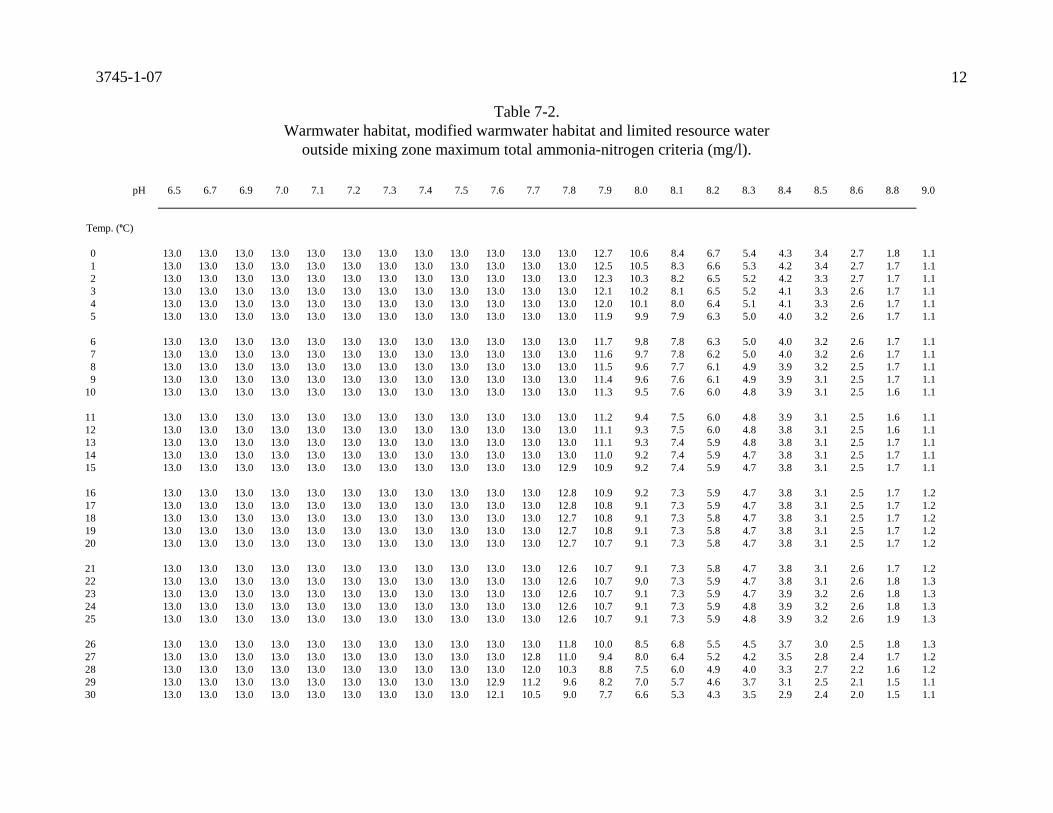
3745-1-07 12
Table 7-2.Warmwater habitat, modified warmwater habitat and limited resource water
outside mixing zone maximum total ammonia-nitrogen criteria (mg/l).
pH 6.5 6.7 6.9 7.0 7.1 7.2 7.3 7.4 7.5 7.6 7.7 7.8 7.9 8.0 8.1 8.2 8.3 8.4 8.5 8.6 8.8 9.0
Temp. (oC)
0 13.0 13.0 13.0 13.0 13.0 13.0 13.0 13.0 13.0 13.0 13.0 13.0 12.7 10.6 8.4 6.7 5.4 4.3 3.4 2.7 1.8 1.11 13.0 13.0 13.0 13.0 13.0 13.0 13.0 13.0 13.0 13.0 13.0 13.0 12.5 10.5 8.3 6.6 5.3 4.2 3.4 2.7 1.7 1.12 13.0 13.0 13.0 13.0 13.0 13.0 13.0 13.0 13.0 13.0 13.0 13.0 12.3 10.3 8.2 6.5 5.2 4.2 3.3 2.7 1.7 1.13 13.0 13.0 13.0 13.0 13.0 13.0 13.0 13.0 13.0 13.0 13.0 13.0 12.1 10.2 8.1 6.5 5.2 4.1 3.3 2.6 1.7 1.14 13.0 13.0 13.0 13.0 13.0 13.0 13.0 13.0 13.0 13.0 13.0 13.0 12.0 10.1 8.0 6.4 5.1 4.1 3.3 2.6 1.7 1.15 13.0 13.0 13.0 13.0 13.0 13.0 13.0 13.0 13.0 13.0 13.0 13.0 11.9 9.9 7.9 6.3 5.0 4.0 3.2 2.6 1.7 1.1
6 13.0 13.0 13.0 13.0 13.0 13.0 13.0 13.0 13.0 13.0 13.0 13.0 11.7 9.8 7.8 6.3 5.0 4.0 3.2 2.6 1.7 1.17 13.0 13.0 13.0 13.0 13.0 13.0 13.0 13.0 13.0 13.0 13.0 13.0 11.6 9.7 7.8 6.2 5.0 4.0 3.2 2.6 1.7 1.18 13.0 13.0 13.0 13.0 13.0 13.0 13.0 13.0 13.0 13.0 13.0 13.0 11.5 9.6 7.7 6.1 4.9 3.9 3.2 2.5 1.7 1.19 13.0 13.0 13.0 13.0 13.0 13.0 13.0 13.0 13.0 13.0 13.0 13.0 11.4 9.6 7.6 6.1 4.9 3.9 3.1 2.5 1.7 1.1
10 13.0 13.0 13.0 13.0 13.0 13.0 13.0 13.0 13.0 13.0 13.0 13.0 11.3 9.5 7.6 6.0 4.8 3.9 3.1 2.5 1.6 1.1
11 13.0 13.0 13.0 13.0 13.0 13.0 13.0 13.0 13.0 13.0 13.0 13.0 11.2 9.4 7.5 6.0 4.8 3.9 3.1 2.5 1.6 1.112 13.0 13.0 13.0 13.0 13.0 13.0 13.0 13.0 13.0 13.0 13.0 13.0 11.1 9.3 7.5 6.0 4.8 3.8 3.1 2.5 1.6 1.113 13.0 13.0 13.0 13.0 13.0 13.0 13.0 13.0 13.0 13.0 13.0 13.0 11.1 9.3 7.4 5.9 4.8 3.8 3.1 2.5 1.7 1.114 13.0 13.0 13.0 13.0 13.0 13.0 13.0 13.0 13.0 13.0 13.0 13.0 11.0 9.2 7.4 5.9 4.7 3.8 3.1 2.5 1.7 1.115 13.0 13.0 13.0 13.0 13.0 13.0 13.0 13.0 13.0 13.0 13.0 12.9 10.9 9.2 7.4 5.9 4.7 3.8 3.1 2.5 1.7 1.1
16 13.0 13.0 13.0 13.0 13.0 13.0 13.0 13.0 13.0 13.0 13.0 12.8 10.9 9.2 7.3 5.9 4.7 3.8 3.1 2.5 1.7 1.217 13.0 13.0 13.0 13.0 13.0 13.0 13.0 13.0 13.0 13.0 13.0 12.8 10.8 9.1 7.3 5.9 4.7 3.8 3.1 2.5 1.7 1.218 13.0 13.0 13.0 13.0 13.0 13.0 13.0 13.0 13.0 13.0 13.0 12.7 10.8 9.1 7.3 5.8 4.7 3.8 3.1 2.5 1.7 1.219 13.0 13.0 13.0 13.0 13.0 13.0 13.0 13.0 13.0 13.0 13.0 12.7 10.8 9.1 7.3 5.8 4.7 3.8 3.1 2.5 1.7 1.220 13.0 13.0 13.0 13.0 13.0 13.0 13.0 13.0 13.0 13.0 13.0 12.7 10.7 9.1 7.3 5.8 4.7 3.8 3.1 2.5 1.7 1.2
21 13.0 13.0 13.0 13.0 13.0 13.0 13.0 13.0 13.0 13.0 13.0 12.6 10.7 9.1 7.3 5.8 4.7 3.8 3.1 2.6 1.7 1.222 13.0 13.0 13.0 13.0 13.0 13.0 13.0 13.0 13.0 13.0 13.0 12.6 10.7 9.0 7.3 5.9 4.7 3.8 3.1 2.6 1.8 1.323 13.0 13.0 13.0 13.0 13.0 13.0 13.0 13.0 13.0 13.0 13.0 12.6 10.7 9.1 7.3 5.9 4.7 3.9 3.2 2.6 1.8 1.324 13.0 13.0 13.0 13.0 13.0 13.0 13.0 13.0 13.0 13.0 13.0 12.6 10.7 9.1 7.3 5.9 4.8 3.9 3.2 2.6 1.8 1.325 13.0 13.0 13.0 13.0 13.0 13.0 13.0 13.0 13.0 13.0 13.0 12.6 10.7 9.1 7.3 5.9 4.8 3.9 3.2 2.6 1.9 1.3
26 13.0 13.0 13.0 13.0 13.0 13.0 13.0 13.0 13.0 13.0 13.0 11.8 10.0 8.5 6.8 5.5 4.5 3.7 3.0 2.5 1.8 1.327 13.0 13.0 13.0 13.0 13.0 13.0 13.0 13.0 13.0 13.0 12.8 11.0 9.4 8.0 6.4 5.2 4.2 3.5 2.8 2.4 1.7 1.228 13.0 13.0 13.0 13.0 13.0 13.0 13.0 13.0 13.0 13.0 12.0 10.3 8.8 7.5 6.0 4.9 4.0 3.3 2.7 2.2 1.6 1.229 13.0 13.0 13.0 13.0 13.0 13.0 13.0 13.0 13.0 12.9 11.2 9.6 8.2 7.0 5.7 4.6 3.7 3.1 2.5 2.1 1.5 1.130 13.0 13.0 13.0 13.0 13.0 13.0 13.0 13.0 13.0 12.1 10.5 9.0 7.7 6.6 5.3 4.3 3.5 2.9 2.4 2.0 1.5 1.1

3745-1-07 13
Table 7-3.Exceptional warmwater habitat
outside mixing zone maximum total ammonia-nitrogen criteria (mg/l).
pH 6.5 6.7 6.9 7.0 7.1 7.2 7.3 7.4 7.5 7.6 7.7 7.8 7.9 8.0 8.1 8.2 8.3 8.4 8.5 8.6 8.8 9.0
Temp. (oC)
0 13.0 13.0 13.0 13.0 13.0 13.0 13.0 13.0 13.0 12.6 10.9 9.3 7.8 6.6 5.2 4.2 3.3 2.6 2.1 1.7 1.1 0.71 13.0 13.0 13.0 13.0 13.0 13.0 13.0 13.0 13.0 12.4 10.7 9.1 7.7 6.5 5.2 4.1 3.3 2.6 2.1 1.7 1.1 0.72 13.0 13.0 13.0 13.0 13.0 13.0 13.0 13.0 13.0 12.2 10.6 9.0 7.6 6.4 5.1 4.1 3.2 2.6 2.1 1.6 1.1 0.73 13.0 13.0 13.0 13.0 13.0 13.0 13.0 13.0 13.0 12.1 10.4 8.9 7.5 6.3 5.0 4.0 3.2 2.5 2.0 1.6 1.1 0.74 13.0 13.0 13.0 13.0 13.0 13.0 13.0 13.0 13.0 11.9 10.3 8.8 7.4 6.2 5.0 4.0 3.2 2.5 2.0 1.6 1.0 0.75 13.0 13.0 13.0 13.0 13.0 13.0 13.0 13.0 13.0 11.8 10.2 8.7 7.3 6.2 4.9 3.9 3.1 2.5 2.0 1.6 1.0 0.7
6 13.0 13.0 13.0 13.0 13.0 13.0 13.0 13.0 13.0 11.6 10.1 8.6 7.3 6.1 4.9 3.9 3.1 2.5 2.0 1.6 1.0 0.77 13.0 13.0 13.0 13.0 13.0 13.0 13.0 13.0 13.0 11.5 9.9 8.5 7.2 6.0 4.8 3.8 3.1 2.5 2.0 1.6 1.0 0.78 13.0 13.0 13.0 13.0 13.0 13.0 13.0 13.0 13.0 11.4 9.8 8.4 7.1 6.0 4.8 3.8 3.0 2.4 2.0 1.6 1.0 0.79 13.0 13.0 13.0 13.0 13.0 13.0 13.0 13.0 12.9 11.3 9.8 8.3 7.1 5.9 4.7 3.8 3.0 2.4 1.9 1.6 1.0 0.7
10 13.0 13.0 13.0 13.0 13.0 13.0 13.0 13.0 12.8 11.2 9.7 8.3 7.0 5.9 4.7 3.7 3.0 2.4 1.9 1.6 1.0 0.7
11 13.0 13.0 13.0 13.0 13.0 13.0 13.0 13.0 12.7 11.1 9.6 8.2 6.9 5.8 4.7 3.7 3.0 2.4 1.9 1.5 1.0 0.712 13.0 13.0 13.0 13.0 13.0 13.0 13.0 13.0 12.6 11.0 9.5 8.1 6.9 5.8 4.6 3.7 3.0 2.4 1.9 1.5 1.0 0.713 13.0 13.0 13.0 13.0 13.0 13.0 13.0 13.0 12.5 10.9 9.4 8.1 6.8 5.8 4.6 3.7 2.9 2.4 1.9 1.5 1.0 0.714 13.0 13.0 13.0 13.0 13.0 13.0 13.0 13.0 12.4 10.8 9.4 8.0 6.8 5.7 4.6 3.7 2.9 2.4 1.9 1.5 1.0 0.715 13.0 13.0 13.0 13.0 13.0 13.0 13.0 13.0 12.3 10.8 9.3 8.0 6.8 5.7 4.6 3.6 2.9 2.4 1.9 1.5 1.0 0.7
16 13.0 13.0 13.0 13.0 13.0 13.0 13.0 13.0 12.2 10.7 9.3 7.9 6.7 5.7 4.5 3.6 2.9 2.4 1.9 1.5 1.0 0.717 13.0 13.0 13.0 13.0 13.0 13.0 13.0 13.0 12.2 10.7 9.2 7.9 6.7 5.6 4.5 3.6 2.9 2.4 1.9 1.5 1.0 0.718 13.0 13.0 13.0 13.0 13.0 13.0 13.0 13.0 12.1 10.6 9.2 7.9 6.7 5.6 4.5 3.6 2.9 2.4 1.9 1.6 1.0 0.719 13.0 13.0 13.0 13.0 13.0 13.0 13.0 13.0 12.1 10.6 9.2 7.9 6.7 5.6 4.5 3.6 2.9 2.4 1.9 1.6 1.1 0.720 13.0 13.0 13.0 13.0 13.0 13.0 13.0 13.0 12.0 10.5 9.2 7.8 6.7 5.6 4.5 3.6 2.9 2.4 1.9 1.6 1.1 0.8
21 13.0 13.0 13.0 13.0 13.0 13.0 13.0 13.0 12.0 10.5 9.1 7.8 6.6 5.6 4.5 3.6 2.9 2.4 1.9 1.6 1.1 0.822 13.0 13.0 13.0 13.0 13.0 13.0 13.0 13.0 12.0 10.5 9.1 7.8 6.6 5.6 4.5 3.6 2.9 2.4 1.9 1.6 1.1 0.823 13.0 13.0 13.0 13.0 13.0 13.0 13.0 13.0 11.9 10.5 9.1 7.8 6.6 5.6 4.5 3.6 2.9 2.4 2.0 1.6 1.1 0.824 13.0 13.0 13.0 13.0 13.0 13.0 13.0 13.0 11.9 10.5 9.1 7.8 6.6 5.6 4.5 3.6 3.0 2.4 2.0 1.6 1.1 0.825 13.0 13.0 13.0 13.0 13.0 13.0 13.0 13.0 11.9 10.5 9.1 7.8 6.6 5.6 4.5 3.7 3.0 2.4 2.0 1.6 1.1 0.8
26 13.0 13.0 13.0 13.0 13.0 13.0 13.0 12.5 11.1 9.8 8.5 7.3 6.2 5.3 4.2 3.4 2.8 2.3 1.9 1.5 1.1 0.827 13.0 13.0 13.0 13.0 13.0 13.0 13.0 11.7 10.4 9.1 7.9 6.8 5.8 4.9 4.0 3.2 2.6 2.1 1.8 1.5 1.0 0.828 13.0 13.0 13.0 13.0 13.0 13.0 12.1 10.9 9.7 8.5 7.4 6.4 5.4 4.6 3.7 3.0 2.5 2.0 1.7 1.4 1.0 0.729 13.0 13.0 13.0 13.0 13.0 12.4 11.3 10.2 9.1 8.0 6.9 6.0 5.1 4.3 3.5 2.8 2.3 1.9 1.6 1.3 0.9 0.730 13.0 13.0 13.0 13.0 12.6 11.6 10.6 9.5 8.5 7.5 6.5 5.6 4.8 4.1 3.3 2.7 2.2 1.8 1.5 1.2 0.9 0.7

3745-1-07 14
Table 7-4.Coldwater habitat and seasonal salmonid habitat
outside mixing zone maximum total ammonia-nitrogen criteria (mg/l).
pH 6.5 6.7 6.9 7.0 7.1 7.2 7.3 7.4 7.5 7.6 7.7 7.8 7.9 8.0 8.1 8.2 8.3 8.4 8.5 8.6 8.8 9.0
Temp. (oC)
0 13.0 13.0 13.0 13.0 13.0 13.0 13.0 13.0 13.0 12.6 10.9 9.3 7.8 6.6 5.2 4.2 3.3 2.6 2.1 1.7 1.1 0.71 13.0 13.0 13.0 13.0 13.0 13.0 13.0 13.0 13.0 12.4 10.7 9.1 7.7 6.5 5.2 4.1 3.3 2.6 2.1 1.7 1.1 0.72 13.0 13.0 13.0 13.0 13.0 13.0 13.0 13.0 13.0 12.2 10.6 9.0 7.6 6.4 5.1 4.1 3.2 2.6 2.1 1.6 1.1 0.73 13.0 13.0 13.0 13.0 13.0 13.0 13.0 13.0 13.0 12.1 10.4 8.9 7.5 6.3 5.0 4.0 3.2 2.5 2.0 1.6 1.1 0.74 13.0 13.0 13.0 13.0 13.0 13.0 13.0 13.0 13.0 11.9 10.3 8.8 7.4 6.2 5.0 4.0 3.2 2.5 2.0 1.6 1.0 0.75 13.0 13.0 13.0 13.0 13.0 13.0 13.0 13.0 13.0 11.8 10.2 8.7 7.3 6.2 4.9 3.9 3.1 2.5 2.0 1.6 1.0 0.7
6 13.0 13.0 13.0 13.0 13.0 13.0 13.0 13.0 13.0 11.6 10.1 8.6 7.3 6.1 4.9 3.9 3.1 2.5 2.0 1.6 1.0 0.77 13.0 13.0 13.0 13.0 13.0 13.0 13.0 13.0 13.0 11.5 9.9 8.5 7.2 6.0 4.8 3.8 3.1 2.5 2.0 1.6 1.0 0.78 13.0 13.0 13.0 13.0 13.0 13.0 13.0 13.0 13.0 11.4 9.8 8.4 7.1 6.0 4.8 3.8 3.0 2.4 2.0 1.6 1.0 0.79 13.0 13.0 13.0 13.0 13.0 13.0 13.0 13.0 12.9 11.3 9.8 8.3 7.1 5.9 4.7 3.8 3.0 2.4 1.9 1.6 1.0 0.7
10 13.0 13.0 13.0 13.0 13.0 13.0 13.0 13.0 12.8 11.2 9.7 8.3 7.0 5.9 4.7 3.7 3.0 2.4 1.9 1.6 1.0 0.7
11 13.0 13.0 13.0 13.0 13.0 13.0 13.0 13.0 12.7 11.1 9.6 8.2 6.9 5.8 4.7 3.7 3.0 2.4 1.9 1.5 1.0 0.712 13.0 13.0 13.0 13.0 13.0 13.0 13.0 13.0 12.6 11.0 9.5 8.1 6.9 5.8 4.6 3.7 3.0 2.4 1.9 1.5 1.0 0.713 13.0 13.0 13.0 13.0 13.0 13.0 13.0 13.0 12.5 10.9 9.4 8.1 6.8 5.8 4.6 3.7 2.9 2.4 1.9 1.5 1.0 0.714 13.0 13.0 13.0 13.0 13.0 13.0 13.0 13.0 12.4 10.8 9.4 8.0 6.8 5.7 4.6 3.7 2.9 2.4 1.9 1.5 1.0 0.715 13.0 13.0 13.0 13.0 13.0 13.0 13.0 13.0 12.3 10.8 9.3 8.0 6.8 5.7 4.6 3.6 2.9 2.4 1.9 1.5 1.0 0.7
16 13.0 13.0 13.0 13.0 13.0 13.0 13.0 13.0 12.2 10.7 9.3 7.9 6.7 5.7 4.5 3.6 2.9 2.4 1.9 1.5 1.0 0.717 13.0 13.0 13.0 13.0 13.0 13.0 13.0 13.0 12.2 10.7 9.2 7.9 6.7 5.6 4.5 3.6 2.9 2.4 1.9 1.5 1.0 0.718 13.0 13.0 13.0 13.0 13.0 13.0 13.0 13.0 12.1 10.6 9.2 7.9 6.7 5.6 4.5 3.6 2.9 2.4 1.9 1.6 1.0 0.719 13.0 13.0 13.0 13.0 13.0 13.0 13.0 13.0 12.1 10.6 9.2 7.9 6.7 5.6 4.5 3.6 2.9 2.4 1.9 1.6 1.1 0.720 13.0 13.0 13.0 13.0 13.0 13.0 13.0 13.0 12.0 10.5 9.1 7.8 6.7 5.6 4.5 3.6 2.9 2.4 1.9 1.6 1.1 0.8
21 13.0 13.0 13.0 13.0 13.0 13.0 13.0 12.6 11.2 9.8 8.5 7.3 6.2 5.2 4.2 3.4 2.7 2.2 1.8 1.5 1.0 0.722 13.0 13.0 13.0 13.0 13.0 13.0 13.0 11.7 10.4 9.1 7.9 6.8 5.8 4.9 3.9 3.2 2.6 2.1 1.7 1.4 1.0 0.723 13.0 13.0 13.0 13.0 13.0 13.0 12.2 10.9 9.7 8.5 7.4 6.3 5.4 4.6 3.7 3.0 2.4 1.9 1.6 1.3 0.9 0.624 13.0 13.0 13.0 13.0 13.0 12.4 11.3 10.2 9.1 7.9 6.9 5.9 5.0 4.3 3.4 2.8 2.2 1.8 1.5 1.2 0.9 0.625 13.0 13.0 13.0 13.0 12.6 11.6 10.6 9.5 8.4 7.4 6.4 5.5 4.7 4.0 3.2 2.6 2.1 1.7 1.4 1.2 0.8 0.6
26 13.0 13.0 13.0 12.6 11.7 10.8 9.9 8.9 7.9 6.9 6.0 5.2 4.4 3.7 3.0 2.4 2.0 1.6 1.3 1.1 0.8 0.627 13.0 13.0 12.4 11.7 10.9 10.1 9.2 8.3 7.4 6.5 5.6 4.8 4.1 3.5 2.8 2.3 1.9 1.5 1.2 1.0 0.7 0.528 13.0 12.7 11.6 10.9 10.2 9.4 8.6 7.7 6.9 6.0 5.2 4.5 3.9 3.3 2.6 2.1 1.7 1.4 1.2 1.0 0.7 0.529 12.6 11.9 10.8 10.2 9.5 8.8 8.0 7.2 6.4 5.6 4.9 4.2 3.6 3.1 2.5 2.0 1.6 1.3 1.1 0.9 0.7 0.530 11.8 11.1 10.1 9.5 8.9 8.2 7.5 6.8 6.0 5.3 4.6 4.0 3.4 2.9 2.3 1.9 1.5 1.3 1.1 0.9 0.6 0.5

3745-1-07 15
Table 7-5.Warmwater habitat
outside mixing zone 30-day average total ammonia-nitrogen criteria (mg/l).
pH 6.5 6.7 6.9 7.0 7.1 7.2 7.3 7.4 7.5 7.6 7.7 7.8 7.9 8.0 8.1 8.2 8.3 8.4 8.5 8.6 8.8 9.0
Temp. (oC)The following criteria apply during the months of December to February:
0-10 13.0 13.0 13.0 12.6 11.7 10.7 9.7 8.6 7.6 6.6 5.6 4.8 4.0 3.3 2.8 2.3 1.9 1.5 1.2 1.0 0.7 0.5
11 13.0 13.0 12.4 11.6 10.8 9.9 8.9 8.0 7.0 6.1 5.2 4.4 3.7 3.1 2.6 2.1 1.7 1.4 1.2 0.9 0.6 0.412 13.0 12.6 11.5 10.8 10.0 9.2 8.3 7.4 6.5 5.6 4.8 4.1 3.4 2.9 2.4 2.0 1.6 1.3 1.1 0.9 0.6 0.413 12.3 11.6 10.6 10.0 9.2 8.5 7.7 6.8 6.0 5.2 4.5 3.8 3.2 2.7 2.2 1.8 1.5 1.2 1.0 0.8 0.6 0.414 11.4 10.8 9.8 9.3 8.6 7.9 7.1 6.3 5.6 4.8 4.2 3.5 3.0 2.5 2.1 1.7 1.4 1.1 0.9 0.8 0.5 0.415 10.6 10.0 9.1 8.6 8.0 7.3 6.6 5.9 5.2 4.5 3.9 3.3 2.8 2.3 1.9 1.6 1.3 1.1 0.9 0.7 0.5 0.3
16 9.8 9.3 8.5 8.0 7.4 6.8 6.1 5.5 4.8 4.2 3.6 3.0 2.6 2.1 1.8 1.5 1.2 1.0 0.8 0.7 0.5 0.317 9.1 8.6 7.8 7.4 6.8 6.3 5.7 5.1 4.5 3.9 3.3 2.8 2.4 2.0 1.7 1.4 1.1 0.9 0.8 0.6 0.4 0.318 8.5 8.0 7.3 6.9 6.4 5.8 5.3 4.7 4.2 3.6 3.1 2.6 2.2 1.8 1.5 1.3 1.1 0.9 0.7 0.6 0.4 0.319 7.9 7.4 6.8 6.4 5.9 5.4 4.9 4.4 3.9 3.3 2.9 2.4 2.1 1.7 1.4 1.2 1.0 0.8 0.7 0.5 0.4 0.320 7.3 6.9 6.3 5.9 5.5 5.0 4.6 4.1 3.6 3.1 2.7 2.3 1.9 1.6 1.3 1.1 0.9 0.8 0.6 0.5 0.4 0.3
The following criteria apply during the months of March to November:10 2.3 2.3 2.3 2.3 2.3 2.3 2.3 2.3 2.3 2.3 2.3 2.0 1.7 1.4 1.1 0.9 0.7 0.6 0.5 0.4 0.2 0.2
11 2.3 2.3 2.3 2.3 2.3 2.3 2.3 2.3 2.3 2.3 2.3 2.0 1.7 1.4 1.1 0.9 0.7 0.6 0.5 0.4 0.2 0.212 2.3 2.3 2.3 2.3 2.3 2.3 2.3 2.3 2.3 2.3 2.3 2.0 1.7 1.4 1.1 0.9 0.7 0.6 0.5 0.4 0.2 0.213 2.3 2.3 2.3 2.3 2.3 2.3 2.3 2.3 2.3 2.3 2.3 1.9 1.6 1.4 1.1 0.9 0.7 0.6 0.5 0.4 0.2 0.214 2.3 2.3 2.3 2.3 2.3 2.3 2.3 2.3 2.3 2.3 2.3 1.9 1.6 1.4 1.1 0.9 0.7 0.6 0.5 0.4 0.2 0.215 2.2 2.2 2.2 2.2 2.2 2.2 2.2 2.2 2.2 2.2 2.2 1.9 1.6 1.4 1.1 0.9 0.7 0.6 0.5 0.4 0.2 0.2
16 2.2 2.2 2.2 2.2 2.2 2.2 2.2 2.2 2.2 2.2 2.2 1.9 1.6 1.4 1.1 0.9 0.7 0.6 0.5 0.4 0.2 0.217 2.2 2.2 2.2 2.2 2.2 2.2 2.2 2.2 2.2 2.2 2.2 1.9 1.6 1.4 1.1 0.9 0.7 0.6 0.5 0.4 0.3 0.218 2.2 2.2 2.2 2.2 2.2 2.2 2.2 2.2 2.2 2.2 2.2 1.9 1.6 1.4 1.1 0.9 0.7 0.6 0.5 0.4 0.3 0.219 2.2 2.2 2.2 2.2 2.2 2.2 2.2 2.2 2.2 2.2 2.2 1.9 1.6 1.4 1.1 0.9 0.7 0.6 0.5 0.4 0.3 0.220 2.2 2.2 2.2 2.2 2.2 2.2 2.2 2.2 2.2 2.2 2.2 1.9 1.6 1.4 1.1 0.9 0.7 0.6 0.5 0.4 0.3 0.2
21 2.1 2.1 2.1 2.1 2.1 2.1 2.1 2.1 2.1 2.1 2.1 1.8 1.5 1.3 1.0 0.8 0.7 0.5 0.4 0.4 0.2 0.222 1.9 1.9 1.9 1.9 1.9 1.9 1.9 1.9 1.9 1.9 1.9 1.6 1.4 1.2 0.9 0.8 0.6 0.5 0.4 0.3 0.2 0.223 1.8 1.8 1.8 1.8 1.8 1.8 1.8 1.8 1.8 1.8 1.8 1.5 1.3 1.1 0.9 0.7 0.6 0.5 0.4 0.3 0.2 0.224 1.7 1.7 1.7 1.7 1.7 1.7 1.7 1.7 1.7 1.7 1.7 1.4 1.2 1.0 0.8 0.7 0.5 0.4 0.4 0.3 0.2 0.125 1.6 1.6 1.6 1.6 1.6 1.6 1.6 1.6 1.6 1.6 1.6 1.3 1.1 1.0 0.8 0.6 0.5 0.4 0.3 0.3 0.2 0.1
26 1.4 1.4 1.4 1.4 1.4 1.4 1.4 1.4 1.4 1.4 1.4 1.2 1.1 0.9 0.7 0.6 0.5 0.4 0.3 0.3 0.2 0.127 1.4 1.4 1.4 1.4 1.4 1.4 1.4 1.4 1.4 1.4 1.4 1.2 1.0 0.8 0.7 0.5 0.4 0.4 0.3 0.2 0.2 0.128 1.3 1.3 1.3 1.3 1.3 1.3 1.3 1.3 1.3 1.3 1.3 1.1 0.9 0.8 0.6 0.5 0.4 0.3 0.3 0.2 0.2 0.129 1.2 1.2 1.2 1.2 1.2 1.2 1.2 1.2 1.2 1.2 1.2 1.0 0.9 0.7 0.6 0.5 0.4 0.3 0.3 0.2 0.2 0.130 1.1 1.1 1.1 1.1 1.1 1.1 1.1 1.1 1.1 1.1 1.1 1.0 0.8 0.7 0.6 0.5 0.4 0.3 0.3 0.2 0.2 0.1
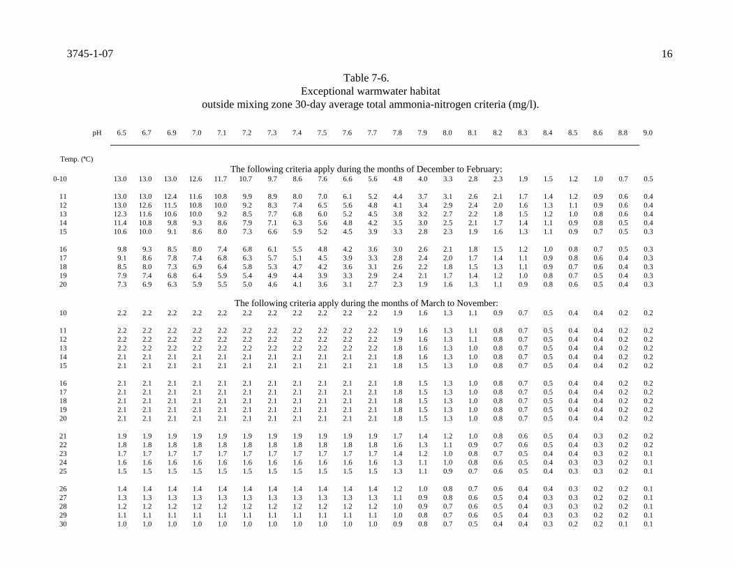
3745-1-07 16
Table 7-6.Exceptional warmwater habitat
outside mixing zone 30-day average total ammonia-nitrogen criteria (mg/l).
pH 6.5 6.7 6.9 7.0 7.1 7.2 7.3 7.4 7.5 7.6 7.7 7.8 7.9 8.0 8.1 8.2 8.3 8.4 8.5 8.6 8.8 9.0
Temp. (oC)The following criteria apply during the months of December to February:
0-10 13.0 13.0 13.0 12.6 11.7 10.7 9.7 8.6 7.6 6.6 5.6 4.8 4.0 3.3 2.8 2.3 1.9 1.5 1.2 1.0 0.7 0.5
11 13.0 13.0 12.4 11.6 10.8 9.9 8.9 8.0 7.0 6.1 5.2 4.4 3.7 3.1 2.6 2.1 1.7 1.4 1.2 0.9 0.6 0.412 13.0 12.6 11.5 10.8 10.0 9.2 8.3 7.4 6.5 5.6 4.8 4.1 3.4 2.9 2.4 2.0 1.6 1.3 1.1 0.9 0.6 0.413 12.3 11.6 10.6 10.0 9.2 8.5 7.7 6.8 6.0 5.2 4.5 3.8 3.2 2.7 2.2 1.8 1.5 1.2 1.0 0.8 0.6 0.414 11.4 10.8 9.8 9.3 8.6 7.9 7.1 6.3 5.6 4.8 4.2 3.5 3.0 2.5 2.1 1.7 1.4 1.1 0.9 0.8 0.5 0.415 10.6 10.0 9.1 8.6 8.0 7.3 6.6 5.9 5.2 4.5 3.9 3.3 2.8 2.3 1.9 1.6 1.3 1.1 0.9 0.7 0.5 0.3
16 9.8 9.3 8.5 8.0 7.4 6.8 6.1 5.5 4.8 4.2 3.6 3.0 2.6 2.1 1.8 1.5 1.2 1.0 0.8 0.7 0.5 0.317 9.1 8.6 7.8 7.4 6.8 6.3 5.7 5.1 4.5 3.9 3.3 2.8 2.4 2.0 1.7 1.4 1.1 0.9 0.8 0.6 0.4 0.318 8.5 8.0 7.3 6.9 6.4 5.8 5.3 4.7 4.2 3.6 3.1 2.6 2.2 1.8 1.5 1.3 1.1 0.9 0.7 0.6 0.4 0.319 7.9 7.4 6.8 6.4 5.9 5.4 4.9 4.4 3.9 3.3 2.9 2.4 2.1 1.7 1.4 1.2 1.0 0.8 0.7 0.5 0.4 0.320 7.3 6.9 6.3 5.9 5.5 5.0 4.6 4.1 3.6 3.1 2.7 2.3 1.9 1.6 1.3 1.1 0.9 0.8 0.6 0.5 0.4 0.3
The following criteria apply during the months of March to November:10 2.2 2.2 2.2 2.2 2.2 2.2 2.2 2.2 2.2 2.2 2.2 1.9 1.6 1.3 1.1 0.9 0.7 0.5 0.4 0.4 0.2 0.2
11 2.2 2.2 2.2 2.2 2.2 2.2 2.2 2.2 2.2 2.2 2.2 1.9 1.6 1.3 1.1 0.8 0.7 0.5 0.4 0.4 0.2 0.212 2.2 2.2 2.2 2.2 2.2 2.2 2.2 2.2 2.2 2.2 2.2 1.9 1.6 1.3 1.1 0.8 0.7 0.5 0.4 0.4 0.2 0.213 2.2 2.2 2.2 2.2 2.2 2.2 2.2 2.2 2.2 2.2 2.2 1.8 1.6 1.3 1.0 0.8 0.7 0.5 0.4 0.4 0.2 0.214 2.1 2.1 2.1 2.1 2.1 2.1 2.1 2.1 2.1 2.1 2.1 1.8 1.6 1.3 1.0 0.8 0.7 0.5 0.4 0.4 0.2 0.215 2.1 2.1 2.1 2.1 2.1 2.1 2.1 2.1 2.1 2.1 2.1 1.8 1.5 1.3 1.0 0.8 0.7 0.5 0.4 0.4 0.2 0.2
16 2.1 2.1 2.1 2.1 2.1 2.1 2.1 2.1 2.1 2.1 2.1 1.8 1.5 1.3 1.0 0.8 0.7 0.5 0.4 0.4 0.2 0.217 2.1 2.1 2.1 2.1 2.1 2.1 2.1 2.1 2.1 2.1 2.1 1.8 1.5 1.3 1.0 0.8 0.7 0.5 0.4 0.4 0.2 0.218 2.1 2.1 2.1 2.1 2.1 2.1 2.1 2.1 2.1 2.1 2.1 1.8 1.5 1.3 1.0 0.8 0.7 0.5 0.4 0.4 0.2 0.219 2.1 2.1 2.1 2.1 2.1 2.1 2.1 2.1 2.1 2.1 2.1 1.8 1.5 1.3 1.0 0.8 0.7 0.5 0.4 0.4 0.2 0.220 2.1 2.1 2.1 2.1 2.1 2.1 2.1 2.1 2.1 2.1 2.1 1.8 1.5 1.3 1.0 0.8 0.7 0.5 0.4 0.4 0.2 0.2
21 1.9 1.9 1.9 1.9 1.9 1.9 1.9 1.9 1.9 1.9 1.9 1.7 1.4 1.2 1.0 0.8 0.6 0.5 0.4 0.3 0.2 0.222 1.8 1.8 1.8 1.8 1.8 1.8 1.8 1.8 1.8 1.8 1.8 1.6 1.3 1.1 0.9 0.7 0.6 0.5 0.4 0.3 0.2 0.223 1.7 1.7 1.7 1.7 1.7 1.7 1.7 1.7 1.7 1.7 1.7 1.4 1.2 1.0 0.8 0.7 0.5 0.4 0.4 0.3 0.2 0.124 1.6 1.6 1.6 1.6 1.6 1.6 1.6 1.6 1.6 1.6 1.6 1.3 1.1 1.0 0.8 0.6 0.5 0.4 0.3 0.3 0.2 0.125 1.5 1.5 1.5 1.5 1.5 1.5 1.5 1.5 1.5 1.5 1.5 1.3 1.1 0.9 0.7 0.6 0.5 0.4 0.3 0.3 0.2 0.1
26 1.4 1.4 1.4 1.4 1.4 1.4 1.4 1.4 1.4 1.4 1.4 1.2 1.0 0.8 0.7 0.6 0.4 0.4 0.3 0.2 0.2 0.127 1.3 1.3 1.3 1.3 1.3 1.3 1.3 1.3 1.3 1.3 1.3 1.1 0.9 0.8 0.6 0.5 0.4 0.3 0.3 0.2 0.2 0.128 1.2 1.2 1.2 1.2 1.2 1.2 1.2 1.2 1.2 1.2 1.2 1.0 0.9 0.7 0.6 0.5 0.4 0.3 0.3 0.2 0.2 0.129 1.1 1.1 1.1 1.1 1.1 1.1 1.1 1.1 1.1 1.1 1.1 1.0 0.8 0.7 0.6 0.5 0.4 0.3 0.3 0.2 0.2 0.130 1.0 1.0 1.0 1.0 1.0 1.0 1.0 1.0 1.0 1.0 1.0 0.9 0.8 0.7 0.5 0.4 0.4 0.3 0.2 0.2 0.1 0.1

3745-1-07 17
Table 7-7.Modified warmwater habitat
outside mixing zone 30-day average total ammonia-nitrogen criteria (mg/l).
pH 6.5 6.7 6.9 7.0 7.1 7.2 7.3 7.4 7.5 7.6 7.7 7.8 7.9 8.0 8.1 8.2 8.3 8.4 8.5 8.6 8.8 9.0
Temp. (oC)The following criteria apply during the months of December to February:
0-10 13.0 13.0 13.0 12.6 11.7 10.7 9.7 8.6 7.6 6.6 5.6 4.8 4.0 3.3 2.8 2.3 1.9 1.5 1.2 1.0 0.7 0.5
11 13.0 13.0 12.4 11.6 10.8 9.9 8.9 8.0 7.0 6.1 5.2 4.4 3.7 3.1 2.6 2.1 1.7 1.4 1.2 0.9 0.6 0.412 13.0 12.6 11.5 10.8 10.0 9.2 8.3 7.4 6.5 5.6 4.8 4.1 3.4 2.9 2.4 2.0 1.6 1.3 1.1 0.9 0.6 0.413 12.3 11.6 10.6 10.0 9.2 8.5 7.7 6.8 6.0 5.2 4.5 3.8 3.2 2.7 2.2 1.8 1.5 1.2 1.0 0.8 0.6 0.414 11.4 10.8 9.8 9.3 8.6 7.9 7.1 6.3 5.6 4.8 4.2 3.5 3.0 2.5 2.1 1.7 1.4 1.1 0.9 0.8 0.5 0.415 10.6 10.0 9.1 8.6 8.0 7.3 6.6 5.9 5.2 4.5 3.9 3.3 2.8 2.3 1.9 1.6 1.3 1.1 0.9 0.7 0.5 0.3
16 9.8 9.3 8.5 8.0 7.4 6.8 6.1 5.5 4.8 4.2 3.6 3.0 2.6 2.1 1.8 1.5 1.2 1.0 0.8 0.7 0.5 0.317 9.1 8.6 7.8 7.4 6.8 6.3 5.7 5.1 4.5 3.9 3.3 2.8 2.4 2.0 1.7 1.4 1.1 0.9 0.8 0.6 0.4 0.318 8.5 8.0 7.3 6.9 6.4 5.8 5.3 4.7 4.2 3.6 3.1 2.6 2.2 1.8 1.5 1.3 1.1 0.9 0.7 0.6 0.4 0.319 7.9 7.4 6.8 6.4 5.9 5.4 4.9 4.4 3.9 3.3 2.9 2.4 2.1 1.7 1.4 1.2 1.0 0.8 0.7 0.5 0.4 0.320 7.3 6.9 6.3 5.9 5.5 5.0 4.6 4.1 3.6 3.1 2.7 2.3 1.9 1.6 1.3 1.1 0.9 0.8 0.6 0.5 0.4 0.3
The following criteria apply during the months of March to November:10 3.4 3.4 3.4 3.4 3.4 3.4 3.4 3.4 3.4 3.4 3.4 2.9 2.5 2.1 1.7 1.3 1.1 0.9 0.7 0.6 0.4 0.2
11 3.4 3.4 3.4 3.4 3.4 3.4 3.4 3.4 3.4 3.4 3.4 2.9 2.5 2.1 1.7 1.3 1.1 0.8 0.7 0.6 0.4 0.212 3.4 3.4 3.4 3.4 3.4 3.4 3.4 3.4 3.4 3.4 3.4 2.9 2.4 2.1 1.6 1.3 1.1 0.8 0.7 0.5 0.4 0.213 3.4 3.4 3.4 3.4 3.4 3.4 3.4 3.4 3.4 3.4 3.4 2.9 2.4 2.0 1.6 1.3 1.0 0.8 0.7 0.5 0.4 0.214 3.3 3.3 3.3 3.3 3.3 3.3 3.3 3.3 3.3 3.3 3.3 2.9 2.4 2.0 1.6 1.3 1.0 0.8 0.7 0.5 0.4 0.215 3.3 3.3 3.3 3.3 3.3 3.3 3.3 3.3 3.3 3.3 3.3 2.8 2.4 2.0 1.6 1.3 1.0 0.8 0.7 0.5 0.4 0.3
16 3.3 3.3 3.3 3.3 3.3 3.3 3.3 3.3 3.3 3.3 3.3 2.8 2.4 2.0 1.6 1.3 1.0 0.8 0.7 0.5 0.4 0.317 3.3 3.3 3.3 3.3 3.3 3.3 3.3 3.3 3.3 3.3 3.3 2.8 2.4 2.0 1.6 1.3 1.0 0.8 0.7 0.5 0.4 0.318 3.3 3.3 3.3 3.3 3.3 3.3 3.3 3.3 3.3 3.3 3.3 2.8 2.4 2.0 1.6 1.3 1.0 0.8 0.7 0.6 0.4 0.319 3.3 3.3 3.3 3.3 3.3 3.3 3.3 3.3 3.3 3.3 3.3 2.8 2.4 2.0 1.6 1.3 1.0 0.8 0.7 0.6 0.4 0.320 3.2 3.2 3.2 3.2 3.2 3.2 3.2 3.2 3.2 3.2 3.2 2.8 2.4 2.0 1.6 1.3 1.0 0.8 0.7 0.6 0.4 0.3
21 3.0 3.0 3.0 3.0 3.0 3.0 3.0 3.0 3.0 3.0 3.0 2.6 2.2 1.9 1.5 1.2 1.0 0.8 0.6 0.5 0.4 0.322 2.8 2.8 2.8 2.8 2.8 2.8 2.8 2.8 2.8 2.8 2.8 2.4 2.1 1.7 1.4 1.1 0.9 0.7 0.6 0.5 0.3 0.223 2.6 2.6 2.6 2.6 2.6 2.6 2.6 2.6 2.6 2.6 2.6 2.3 1.9 1.6 1.3 1.0 0.8 0.7 0.6 0.5 0.3 0.224 2.4 2.4 2.4 2.4 2.4 2.4 2.4 2.4 2.4 2.4 2.4 2.1 1.8 1.5 1.2 1.0 0.8 0.6 0.5 0.4 0.3 0.225 2.3 2.3 2.3 2.3 2.3 2.3 2.3 2.3 2.3 2.3 2.3 2.0 1.7 1.4 1.1 0.9 0.7 0.6 0.5 0.4 0.3 0.2
26 2.1 2.1 2.1 2.1 2.1 2.1 2.1 2.1 2.1 2.1 2.1 1.8 1.6 1.3 1.1 0.9 0.7 0.6 0.5 0.4 0.3 0.227 2.0 2.0 2.0 2.0 2.0 2.0 2.0 2.0 2.0 2.0 2.0 1.7 1.5 1.2 1.0 0.8 0.7 0.5 0.4 0.4 0.3 0.228 1.9 1.9 1.9 1.9 1.9 1.9 1.9 1.9 1.9 1.9 1.9 1.6 1.4 1.2 0.9 0.8 0.6 0.5 0.4 0.3 0.2 0.229 1.7 1.7 1.7 1.7 1.7 1.7 1.7 1.7 1.7 1.7 1.7 1.5 1.3 1.1 0.9 0.7 0.6 0.5 0.4 0.3 0.2 0.230 1.6 1.6 1.6 1.6 1.6 1.6 1.6 1.6 1.6 1.6 1.6 1.4 1.2 1.0 0.8 0.7 0.5 0.5 0.4 0.3 0.2 0.2

3745-1-07 18
Table 7-8.Coldwater habitat
outside mixing zone 30-day average total ammonia-nitrogen criteria (mg/l).
pH 6.5 6.7 6.9 7.0 7.1 7.2 7.3 7.4 7.5 7.6 7.7 7.8 7.9 8.0 8.1 8.2 8.3 8.4 8.5 8.6 8.8 9.0
Temp. (oC)
0 2.5 2.5 2.5 2.5 2.5 2.5 2.5 2.5 2.5 2.5 2.5 2.1 1.8 1.5 1.2 0.9 0.8 0.6 0.5 0.4 0.2 0.21 2.4 2.4 2.4 2.4 2.4 2.4 2.4 2.4 2.4 2.4 2.4 2.1 1.8 1.5 1.2 0.9 0.7 0.6 0.5 0.4 0.2 0.22 2.4 2.4 2.4 2.4 2.4 2.4 2.4 2.4 2.4 2.4 2.4 2.1 1.7 1.5 1.2 0.9 0.7 0.6 0.5 0.4 0.2 0.23 2.4 2.4 2.4 2.4 2.4 2.4 2.4 2.4 2.4 2.4 2.4 2.0 1.7 1.4 1.1 0.9 0.7 0.6 0.5 0.4 0.2 0.24 2.3 2.3 2.3 2.3 2.3 2.3 2.3 2.3 2.3 2.3 2.3 2.0 1.7 1.4 1.1 0.9 0.7 0.6 0.5 0.4 0.2 0.25 2.3 2.3 2.3 2.3 2.3 2.3 2.3 2.3 2.3 2.3 2.3 2.0 1.7 1.4 1.1 0.9 0.7 0.6 0.5 0.4 0.2 0.2
6 2.3 2.3 2.3 2.3 2.3 2.3 2.3 2.3 2.3 2.3 2.3 2.0 1.7 1.4 1.1 0.9 0.7 0.6 0.5 0.4 0.2 0.27 2.3 2.3 2.3 2.3 2.3 2.3 2.3 2.3 2.3 2.3 2.3 1.9 1.6 1.4 1.1 0.9 0.7 0.6 0.4 0.4 0.2 0.28 2.2 2.2 2.2 2.2 2.2 2.2 2.2 2.2 2.2 2.2 2.2 1.9 1.6 1.4 1.1 0.9 0.7 0.6 0.4 0.4 0.2 0.29 2.2 2.2 2.2 2.2 2.2 2.2 2.2 2.2 2.2 2.2 2.2 1.9 1.6 1.3 1.1 0.9 0.7 0.6 0.4 0.4 0.2 0.2
10 2.2 2.2 2.2 2.2 2.2 2.2 2.2 2.2 2.2 2.2 2.2 1.9 1.6 1.3 1.1 0.9 0.7 0.5 0.4 0.4 0.2 0.2
11 2.2 2.2 2.2 2.2 2.2 2.2 2.2 2.2 2.2 2.2 2.2 1.9 1.6 1.3 1.1 0.8 0.7 0.5 0.4 0.4 0.2 0.212 2.2 2.2 2.2 2.2 2.2 2.2 2.2 2.2 2.2 2.2 2.2 1.9 1.6 1.3 1.1 0.8 0.7 0.5 0.4 0.4 0.2 0.213 2.2 2.2 2.2 2.2 2.2 2.2 2.2 2.2 2.2 2.2 2.2 1.8 1.6 1.3 1.0 0.8 0.7 0.5 0.4 0.4 0.2 0.214 2.1 2.1 2.1 2.1 2.1 2.1 2.1 2.1 2.1 2.1 2.1 1.8 1.6 1.3 1.0 0.8 0.7 0.5 0.4 0.4 0.2 0.215 2.1 2.1 2.1 2.1 2.1 2.1 2.1 2.1 2.1 2.1 2.1 1.8 1.5 1.3 1.0 0.8 0.7 0.5 0.4 0.4 0.2 0.2
16 2.0 2.0 2.0 2.0 2.0 2.0 2.0 2.0 2.0 2.0 2.0 1.7 1.4 1.2 1.0 0.8 0.6 0.5 0.4 0.3 0.2 0.217 1.8 1.8 1.8 1.8 1.8 1.8 1.8 1.8 1.8 1.8 1.8 1.6 1.3 1.1 0.9 0.7 0.6 0.5 0.4 0.3 0.2 0.118 1.7 1.7 1.7 1.7 1.7 1.7 1.7 1.7 1.7 1.7 1.7 1.5 1.2 1.0 0.8 0.7 0.5 0.4 0.4 0.3 0.2 0.119 1.6 1.6 1.6 1.6 1.6 1.6 1.6 1.6 1.6 1.6 1.6 1.4 1.2 1.0 0.8 0.6 0.5 0.4 0.3 0.3 0.2 0.120 1.5 1.5 1.5 1.5 1.5 1.5 1.5 1.5 1.5 1.5 1.5 1.3 1.1 0.9 0.7 0.6 0.5 0.4 0.3 0.3 0.2 0.1
21 1.4 1.4 1.4 1.4 1.4 1.4 1.4 1.4 1.4 1.4 1.4 1.2 1.0 0.8 0.7 0.5 0.4 0.4 0.3 0.2 0.2 0.122 1.3 1.3 1.3 1.3 1.3 1.3 1.3 1.3 1.3 1.3 1.3 1.1 0.9 0.8 0.6 0.5 0.4 0.3 0.3 0.2 0.2 0.123 1.2 1.2 1.2 1.2 1.2 1.2 1.2 1.2 1.2 1.2 1.2 1.0 0.9 0.7 0.6 0.5 0.4 0.3 0.3 0.2 0.1 0.124 1.1 1.1 1.1 1.1 1.1 1.1 1.1 1.1 1.1 1.1 1.1 1.0 0.8 0.7 0.6 0.4 0.4 0.3 0.2 0.2 0.1 0.125 1.0 1.0 1.0 1.0 1.0 1.0 1.0 1.0 1.0 1.0 1.0 0.9 0.8 0.6 0.5 0.4 0.3 0.3 0.2 0.2 0.1 0.1
26 1.0 1.0 1.0 1.0 1.0 1.0 1.0 1.0 1.0 1.0 1.0 0.8 0.7 0.6 0.5 0.4 0.3 0.3 0.2 0.2 0.1 0.127 0.9 0.9 0.9 0.9 0.9 0.9 0.9 0.9 0.9 0.9 0.9 0.8 0.7 0.6 0.5 0.4 0.3 0.2 0.2 0.2 0.1 0.128 0.8 0.8 0.8 0.8 0.8 0.8 0.8 0.8 0.8 0.8 0.8 0.7 0.6 0.5 0.4 0.3 0.3 0.2 0.2 0.2 0.1 0.129 0.8 0.8 0.8 0.8 0.8 0.8 0.8 0.8 0.8 0.8 0.8 0.7 0.6 0.5 0.4 0.3 0.3 0.2 0.2 0.1 0.1 0.130 0.7 0.7 0.7 0.7 0.7 0.7 0.7 0.7 0.7 0.7 0.7 0.6 0.5 0.5 0.4 0.3 0.2 0.2 0.2 0.1 0.1 0.1

3745-1-07 19
Table 7-9. Statewide water quality criteria for the protection of aquatic life for water hardnessPage 1 of 2 dependent criteria.________________________________________________________________________________
Criteria6 Chemical Form1 Units2 Equation 100 200 300 400
Cadmium IMZM3 D4 µg/l e(1.128 [ln H] - 3.051) 8.5 19 29 41 OMZM3 D4 µg/l e(1.128 [ln H] - 3.744) 4.3 9.3 15 20 OMZA3 D4 µg/l e(0.7852 [ln H] - 2.810) 2.2 3.9 5.3 6.6Cadmium IMZM3 TR5 µg/l e(1.128 [ln H] - 2.9936) 9.0 20 31 43 OMZM3 TR5 µg/l e(1.128 [ln H] - 3.6867) 4.5 9.9 16 22 OMZA3 TR5 µg/l e(0.7852 [ln H] - 2.715) 2.5 4.2 5.8 7.3Chromium IMZM3 D4 µg/l e(0.819 [ln H] + 3.2667) 1100 2000 2800 3500 OMZM3 D4 µg/l e(0.819 [ln H] + 2.5736) 570 1000 1400 1800 OMZA3 D4 µg/l e(0.819 [ln H] + 0.5340) 74 130 180 230Chromium IMZM3 TR5 µg/l e(0.819 [ln H] + 4.4187) 3600 6400 8900 11000 OMZM3 TR5 µg/l e(0.819 [ln H] + 3.7256) 1800 3200 4400 5600 OMZA3 TR5 µg/l e(0.819 [ln H] + 0.6848) 86 150 210 270Copper IMZM3 D4 µg/l e(0.9422 [ln H] - 1.048) 27 52 76 99 OMZM3 D4 µg/l e(0.9422 [ln H] - 1.741) 13 26 38 50 OMZA3 D4 µg/l e(0.8545 [ln H] - 1.743) 9.0 16 23 29Copper IMZM3 TR5 µg/l e(0.9422 [ln H] - 1.007) 28 54 79 100 OMZM3 TR5 µg/l e(0.9422 [ln H] - 1.700) 14 27 39 52 OMZA3 TR5 µg/l e(0.8545 [ln H] - 1.702) 9.3 17 24 30Lead IMZM3 D4 µg/l e(1.273 [ln H] - 0.5964) 190 470 780 1100 OMZM3 D4 µg/l e(1.273 [ln H] - 1.289) 97 230 390 570 OMZA3 D4 µg/l e(1.273 [ln H] - 4.237) 5.1 12 21 30Lead IMZM3 TR5 µg/l e(1.273 [ln H] - 0.3619) 240 590 990 1400 OMZM3 TR5 µg/l e(1.273 [ln H] - 1.055) 120 300 500 710 OMZA3 TR5 µg/l e(1.273 [ln H] - 4.003) 6.4 16 26 37

3745-1-07 20
Table 7-9. Statewide water quality criteria for the protection of aquatic life for water hardnessPage 2 of 2 dependent criteria.________________________________________________________________________________
Criteria6 Chemical Form1 Units2 Equation 100 200 300 400
Nickel IMZM3 D4 µg/l e(0.846 [ln H] + 2.946) 940 1700 2400 3000 OMZM3 D4 µg/l e(0.846 [ln H] + 2.253) 470 840 1200 1500 OMZA3 D4 µg/l e(0.846 [ln H] + 0.0554) 52 93 130 170Nickel IMZM3 TR5 µg/l e(0.846 [ln H] + 2.948) 940 1700 2400 3000 OMZM3 TR5 µg/l e(0.846 [ln H] + 2.255) 470 840 1200 1500 OMZA3 TR5 µg/l e(0.846 [ln H] + 0.0584) 52 94 130 170Zinc IMZM3 D4 µg/l e(0.8473 [ln H] + 1.555) 230 420 590 760 OMZM3 D4 µg/l e(0.8473 [ln H] + 0.862) 120 210 300 380 OMZA3 D4 µg/l e(0.8473 [ln H] + 0.870) 120 210 300 380Zinc IMZM3 TR5 µg/l e(0.8473 [ln H] + 1.577) 240 430 610 780 OMZM3 TR5 µg/l e(0.8473 [ln H] + 0.884) 120 220 300 390 OMZA3 TR5 µg/l e(0.8473 [ln H] + 0.884) 120 220 300 390________________________________________________________________________________
1 D = dissolved; TR = total recoverable.2 µg/l = micrograms per liter (parts per billion).3 IMZM = inside mixing zone maximum; OMZM = outside mixing zone maximum; OMZA = outside mixing zone
average.4 These criteria are implemented by multiplying them by a translator approved by the director pursuant to rule 3745-2-04
of the Administrative Code.5 These criteria apply in the absence of a translator approved by the director pursuant to rule 3745-2-04 of the
Administrative Code.6 Numeric criteria are presented at example water hardnesses. The equations can be used to calculate numeric criteria at
any water hardness up to 400 mg/l CaCO3. "e" = the base e exponential function. "ln H" = the natural logarithm of thewater hardness. The criteria at a water hardness of 400 mg/l CaCO3 are used for water hardnesses above 400 mg/lCaCO3.

3745-1-07 21
Table 7-10. Statewide water quality criteria for the protection of aquatic life for water pH dependentcriteria.
________________________________________________________________________________
Criteria4 Chemical Form1 Units2 Equation 6.5 7.5 8.0 9.0
Pentachlorophenol IMZM3 T µg/l e(1.005 [pH] - 4.176) 11 29 48 130 OMZM3 T µg/l e(1.005 [pH] - 4.869) 5.3 14 24 65 OMZA3 T µg/l e(1.005 [pH] - 5.134) 4.0 11 18 50________________________________________________________________________________
1 T = total.2 µg/l = micrograms per liter (parts per billion).3 IMZM = inside mixing zone maximum; OMZM = outside mixing zone maximum; OMZA = outside mixing zone
average.4 Numeric criteria are presented at example water pH. The equations can be used to calculate numeric criteria at any water
pH between 6.5 and 9.0. "e" = the base e exponential function.
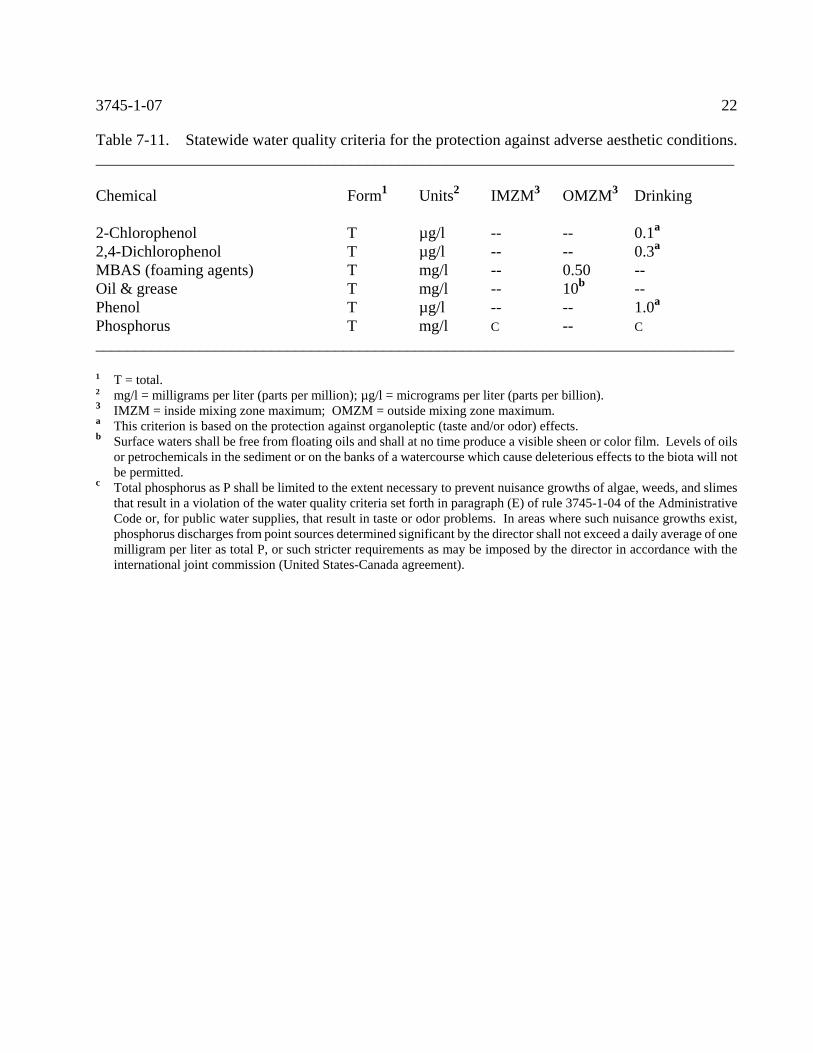
3745-1-07 22
Table 7-11. Statewide water quality criteria for the protection against adverse aesthetic conditions.________________________________________________________________________________
Chemical Form1 Units2 IMZM3 OMZM3 Drinking
2-Chlorophenol T µg/l -- -- 0.1a
2,4-Dichlorophenol T µg/l -- -- 0.3a
MBAS (foaming agents) T mg/l -- 0.50 --Oil & grease T mg/l -- 10b --Phenol T µg/l -- -- 1.0a
Phosphorus T mg/l C -- C________________________________________________________________________________
1 T = total.2 mg/l = milligrams per liter (parts per million); µg/l = micrograms per liter (parts per billion).3 IMZM = inside mixing zone maximum; OMZM = outside mixing zone maximum.a This criterion is based on the protection against organoleptic (taste and/or odor) effects.b Surface waters shall be free from floating oils and shall at no time produce a visible sheen or color film. Levels of oils
or petrochemicals in the sediment or on the banks of a watercourse which cause deleterious effects to the biota will notbe permitted.
c Total phosphorus as P shall be limited to the extent necessary to prevent nuisance growths of algae, weeds, and slimesthat result in a violation of the water quality criteria set forth in paragraph (E) of rule 3745-1-04 of the AdministrativeCode or, for public water supplies, that result in taste or odor problems. In areas where such nuisance growths exist,phosphorus discharges from point sources determined significant by the director shall not exceed a daily average of onemilligram per liter as total P, or such stricter requirements as may be imposed by the director in accordance with theinternational joint commission (United States-Canada agreement).

3745-1-07 23
Table 7-12. Statewide water quality criteria for the protection of agricultural uses.___________________________________________________________________________
Chemical Form1 Units2 OMZA3
Arsenic TR µg/l 100Beryllium TR µg/l 100Cadmium TR µg/l 50Total chromium TR µg/l 100Copper TR µg/l 500Fluoride T µg/l 2,000Iron TR µg/l 5,000Lead TR µg/l 100Mercury TR µg/l 10Nickel TR µg/l 200Nitrates + nitrites T mg/l 100Selenium TR µg/l 50Zinc TR µg/l 25,000___________________________________________________________________________
1 T = total; TR = total recoverable.2 mg/l = milligrams per liter (parts per million); µg/l = micrograms per liter (parts per billion).3 OMZA = outside mixing zone average.
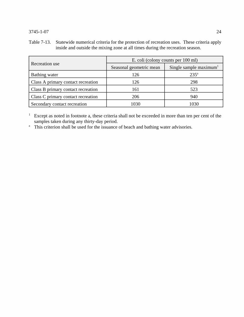
3745-1-07 24
Table 7-13. Statewide numerical criteria for the protection of recreation uses. These criteria applyinside and outside the mixing zone at all times during the recreation season.
Recreation useE. coli (colony counts per 100 ml)
Seasonal geometric mean Single sample maximum1
Bathing water 126 235a
Class A primary contact recreation 126 298Class B primary contact recreation 161 523Class C primary contact recreation 206 940Secondary contact recreation 1030 1030
1 Except as noted in footnote a, these criteria shall not be exceeded in more than ten per cent of thesamples taken during any thirty-day period.
a This criterion shall be used for the issuance of beach and bathing water advisories.

3745-1-07 25
Table 7-14. Temperature criteria.
(A) General Ohio river basin - includes all waters of the state within the boundaries of the Ohio river basin, excludingthe Ohio river and those water bodies or water body segments as designated in paragraphs (B) to (F) of this table. Shown as degrees fahrenheit and (celsius).
Jan. Feb. Mar. Mar. Apr. Apr. May May June1-31 1-29 1-15 16-31 1-15 16-30 1-15 16-31 1-15
Average: 47 47 51 54 59 65 67 70 74(8.3) (8.3) (10.0) (12.2) (15.0) (18.3) (19.4) (21.1) (23.3)
DailyMaximum: 52 52 56 59 65 70 73 76 80
(11.1) (11.1) (13.3) (15.0) (18.3) (21.1) (22.8) (24.4) (26.7)
June July Aug. Sept. Sept. Oct. Oct. Nov. Dec.16-30 1-31 1-31 1-15 16-30 1-15 16-31 1-30 1-31
Average: 82 82 82 82 73 71 65 60 47(27.8) (27.8) (27.8) (27.8) (22.8) (21.7) (18.3) (15.6) (8.3)
DailyMaximum: 85 85 85 85 78 76 70 65 52
(29.4) (29.4) (29.4) (29.4) (25.6) (24.4) (21.1) (18.3) (11.1)
(B) Lower great Miami river - Steele dam in Dayton (river mile 81.3) to the confluence with the Ohio river. Shownas degrees fahrenheit and (celsius).
Jan. Feb. Mar. Mar. Apr. Apr. May May June1-31 1-29 1-15 16-31 1-15 16-30 1-15 16-31 1-15
Average: 49 49 53 56 59 65 67 70 75(9.4) (9.4) (11.9) (13.3) (15.0) (18.3) (19.4) (21.1) (23.9)
DailyMaximum: 54 54 58 61 68 74 77 79 83
(12.2) (12.2) (14.4) (16.1) (20.0) (23.3) (25.0) (26.1) (28.3)
June July Aug. Sept. Sept. Oct. Oct. Nov. Dec.16-30 1-31 1-31 1-15 16-30 1-15 16-31 1-30 1-31
Average: 85 85 85 85 78 71 66 63 49(29.4) (29.4) (29.4) (29.4) (25.6) (21.7) (18.9) (17.2) (9.4)
DailyMaximum: 89 89 89 89 83 76 71 68 54
(31.7) (31.7) (31.7) (31.7) (28.3) (24.4) (21.7) (20.0) (12.2)

3745-1-07 26
(C) Scioto river - Griggs dam in Columbus (river mile 136) to the confluence with the Ohio river. Shown as degreesfahrenheit and (celsius).
Jan. Feb. Mar. Mar. Apr. Apr. May May June1-31 1-29 1-15 16-31 1-15 16-30 1-15 16-31 1-15
Average: 47 47 51 54 59 62 67 72 75(8.3) (8.3) (10.6) (12.2) (15.0) (16.7) (19.4) (22.2) (23.9)
DailyMaximum: 52 52 56 59 65 70 75 79 82
(11.1) (11.1) (13.3) (15.0) (18.3) (21.1) (23.9) (26.1) (27.8)
June July Aug. Sept. Sept. Oct. Oct. Nov. Dec.16-30 1-31 1-31 1-15 16-30 1-15 16-31 1-30 1-31
Average: 83 83 83 83 75 71 65 58 47(28.3) (28.3) (28.3) (28.3) (23.9) (21.7) (18.3) (14.4) (8.3)
DailyMaximum: 87 87 87 87 80 76 70 63 52
(30.6) (30.6) (30.6) (30.6) (26.7) (24.4) (21.1) (17.2) (11.1)
(D) Hocking river - entire mainstem. Shown as degrees fahrenheit and (celsius).
Jan. Feb. Mar. Mar. Apr. Apr. May May June1-31 1-29 1-15 16-31 1-15 16-30 1-15 16-31 1-15
Average: 45 45 51 56 59 65 67 70 74(7.2) (7.2) (10.6) (13.3) (15.0) (18.3) (19.4) (21.1) (23.3)
DailyMaximum: 50 50 56 61 66 70 73 76 80
(10.0) (10.0) (13.3) (16.1) (18.9) (21.1) (22.8) (24.4) (26.7)
June July Aug. Sept. Sept. Oct. Oct. Nov. Dec.16-30 1-31 1-31 1-15 16-30 1-15 16-31 1-30 1-31
Average: 83 83 83 83 77 65 62 58 45(28.3) (28.3) (28.3) (28.3) (25.0) (18.3) (16.7) (14.4) (7.2)
DailyMaximum: 87 87 87 87 82 70 67 63 50
(30.6) (30.6) (30.6) (30.6) (27.8) (21.1) (19.4) (17.2) (10.0)

3745-1-07 27
(E) Muskingum river - entire mainstem. Shown as degrees fahrenheit and (celsius).
Jan. Feb. Mar. Mar. Apr. Apr. May May June1-31 1-29 1-15 16-31 1-15 16-30 1-15 16-31 1-15
Average: 45 45 53 53 58 65 68 72 76(7.2) (7.2) (11.7) (11.7) (14.4) (18.3) (20.0) (22.2) (24.4)
DailyMaximum: 50 50 58 58 63 70 74 77 84
(10.0) (10.0) (14.4) (14.4) (17.2) (21.1) (23.3) (25.0) (28.9)
June July Aug. Sept. Sept. Oct. Oct. Nov. Dec.16-30 1-31 1-31 1-15 16-30 1-15 16-31 1-30 1-31
Average: 85 85 85 85 80 73 67 62 47(29.4) (29.4) (29.4) (29.4) (26.7) (22.8) (19.4) (16.7) (8.3)
DailyMaximum: 89 89 89 89 85 77 72 67 52
(31.7) (31.7) (31.7) (31.7) (29.4) (25.0) (22.2) (19.4) (11.1)
(F) Mahoning river - Leavitt road dam (river mile 46.1) to the Ohio- Pennsylvania state line (river mile 12.6). Shownas degrees fahrenheit and (celsius).
Jan. Feb. Mar. Mar. Apr. Apr. May May June1-31 1-29 1-15 16-31 1-15 16-30 1-15 16-31 1-15
Average: 47 47 50 54 59 65 68 73 77(8.3) (8.3) (10.0) (12.2) (15.0) (18.3) (20.0) (22.8) (25.0)
DailyMaximum: 53 53 57 61 65 70 76 79 84
(11.7) (11.7) (13.9) (16.1) (18.3) (21.1) (24.4) (26.1) (28.9)
June July Aug. Sept. Sept. Oct. Oct. Nov. Dec.16-30 1-31 1-31 1-15 16-30 1-15 16-31 1-30 1-31
Average: 85 85 85 85 78 73 67 60 51(29.4) (29.4) (29.4) (29.4) (25.6) (22.8) (19.4) (15.6) (10.6)
DailyMaximum: 89 89 89 89 83 77 72 66 55
(31.7) (31.7) (31.7) (31.7) (28.3) (25.0) (22.2) (18.9) (12.8)

3745-1-07 28
(G) General lake Erie basin - includes all surface waters of the state within the boundaries of the lake Erie drainagebasin, excluding lake Erie and those water bodies as designated in paragraphs (H) to (L) of this table. Shown asdegrees fahrenheit and (celsius).
Jan. Feb. Mar. Mar. Apr. Apr. May May June1-31 1-29 1-15 16-31 1-15 16-30 1-15 16-31 1-15
Average: 44 44 48 51 54 60 64 66 72(6.7) (6.7) (8.9) (10.6) (12.2) (15.6) (17.8) (18.9) (22.2)
DailyMaximum: 49 49 53 56 61 65 69 72 76
(9.4) (9.4) (11.7) (13.3) (16.1) (18.3) (20.6) (22.2) (24.4)
June July Aug. Sept. Sept. Oct. Oct. Nov. Dec.16-30 1-31 1-31 1-15 16-30 1-15 16-31 1-30 1-31
Average: 82 82 82 82 75 67 61 54 44(27.8) (27.8) (27.8) (27.8) (23.9) (19.4) (16.1) (12.2) (6.7)
DailyMaximum: 85 85 85 85 80 72 66 59 49
(29.4) (29.4) (29.4) (29.4) (26.7) (22.2) (18.9) (15.0) (9.4)
(H) Lake Erie tributary estuaries - includes all lake Erie tributary estuaries within the lake breakwaters and extendingupstream to the lake Erie mean high water level. Shown as degrees fahrenheit and (celsius).
Jan. Feb. Mar. Mar. Apr. Apr. May May June1-31 1-29 1-15 16-31 1-15 16-30 1-15 16-31 1-15
Average: - - - - - - - - -
DailyMaximum: 52 52 55 55 59 63 66 76 82
(11.1) (11.1) (12.8) (12.8) (15.0) (17.2) (18.9) (24.4) (27.8)
June July Aug. Sept. Sept. Oct. Oct. Nov. Dec.16-30 1-31 1-31 1-15 16-30 1-15 16-31 1-30 1-31
Average: 84 84 84 84 - - - - -(28.9) (28.9) (28.9) (28.9)
DailyMaximum: 88 88 88 88 84 75 70 65 55
(31.1) (31.1) (31.1) (31.1) (28.9) (23.9) (21.1) (18.3) (12.8)

3745-1-07 29
(I) Maumee river - Ohio-Indiana state line to Maumee river estuary. Shown as degrees fahrenheit and (celsius).
Jan. Feb. Mar. Mar. Apr. Apr. May May June1-31 1-29 1-15 16-31 1-15 16-30 1-15 16-31 1-15
Average: 45 45 47 53 58 61 67 70 75(7.2) (7.2) (8.3) (11.7) (14.4) (16.1) (19.4) (21.1) (23.9)
DailyMaximum: 50 50 52 58 63 68 72 76 80
(10.0) (10.0) (11.1) (14.4) (17.2) (20.0) (22.2) (24.4) (26.7)
June July Aug. Sept. Sept. Oct. Oct. Nov. Dec.16-30 1-31 1-31 1-15 16-30 1-15 16-31 1-30 1-31
Average: 85 85 85 85 80 71 65 58 45(29.4) (29.4) (29.4) (29.4) (26.7) (21.7) (18.3) (14.4) (7.2)
DailyMaximum: 89 89 89 89 85 76 70 63 50
(31.7) (31.7) (31.7) (31.7) (29.4) (24.4) (21.1) (17.2) (10.0)
(J) Maumee bay - includes all waters of the state known as Maumee bay including the Maumee river estuary and theestuary portions of all tributaries entering Maumee bay to the lake Erie mean high water level. Shown as degreesfahrenheit and (celsius).
Jan. Feb. Mar. Mar. Apr. Apr. May May June1-31 1-29 1-15 16-31 1-15 16-30 1-15 16-31 1-15
Average: 47 47 48 50 52 57 61 65 71(8.3) (8.3) (8.9) (10.0) (11.1) (13.9) (16.1) (18.3) (21.7)
DailyMaximum: 52 52 53 54 59 63 63 76 77
(11.1) (11.1) (11.7) (12.2) (15.0) (17.2) (18.9) (24.4) (25.0)
June July Aug. Sept. Sept. Oct. Oct. Nov. Dec.16-30 1-31 1-31 1-15 16-30 1-15 16-31 1-30 1-31
Average: 83 83 83 83 75 69 64 59 47(29.3) (28.3) (28.3) (28.3) (23.9) (20.6) (17.8) (15.0) (8.3)
DailyMaximum 87 87 87 87 80 74 69 64 52
(30.6) (30.6) (30.6) (30.6) (26.7) (23.3) (20.6) (17.8) (11.1)

3745-1-07 30
(K) Sandusky bay - includes all waters of the state known as Sandusky bay including the Sandusky river estuary andthe estuary portions of all tributaries entering Sandusky bay to the lake Erie mean high water level. Shown asdegrees fahrenheit and (celsius).
Jan. Feb. Mar. Mar. Apr. Apr. May May June1-31 1-29 1-15 16-31 1-15 16-30 1-15 16-31 1-15
Average: 47 47 48 50 52 57 63 68 74(8.3) (8.3) (8.9) (10.0) (11.1) (13.9) (17.2) (20.0) (23.3)
DailyMaximum: 52 52 53 55 57 62 68 73 79
(11.1) (11.1) (11.7) (12.8) (13.9) (16.7) (20.0) (22.8) (26.1)
June July Aug. Sept. Sept. Oct. Oct. Nov. Dec.16-30 1-31 1-31 1-15 16-30 1-15 16-31 1-30 1-31
Average: 83 83 83 83 75 69 64 59 47(28.3) (28.3) (28.3) (28.3) (23.9) (20.6) (17.8) (15.0) (8.3)
DailyMaximum: 87 87 87 87 80 74 69 64 52
(30.6) (30.6) (30.6) (30.6) (26.7) (23.3) (20.6) (17.8) (11.1)
(L) Cuyahoga river - headwaters of the Cuyahoga river gorge dam pool (river mile 46.2) to the Cuyahoga river shipchannel (river mile 5.6). Shown as degrees fahrenheit and (celsius).
Jan. Feb. Mar. Mar. Apr. Apr. May May June1-31 1-29 1-15 16-31 1-15 16-30 1-15 16-31 1-15
Average: 45 45 51 53 55 60 65 71 80(7.2) (7.2) (10.6) (11.7) (12.8) (15.6) (18.3) (21.7) (26.7)
DailyMaximum: 49 49 55 57 62 66 70 78 84
(9.4) (9.4) (12.8) (13.9) (16.7) (18.9) (21.1) (25.6) (28.9)
June July Aug. Sept. Sept. Oct. Oct. Nov. Dec.16-30 1-31 1-31 1-15 16-30 1-15 16-31 1-30 1-31
Average: 84 84 84 84 77 70 63 55 45(28.9) (28.9) (28.9) (28.9) (25.0) (21.1) (17.2) (12.8) (7.2)
DailyMaximum 88 88 88 88 82 75 69 64 52
(31.1) (31.1) (31.1) (31.1) (27.8) (23.9) (20.6) (17.8) (11.1)

3745-1-07 31
Table 7-15 Page 1 of 2.
Biological criteria for warmwater, exceptional warmwater and modified warmwater habitats. Description and derivationof indices and ecoregions are contained in "Biological Criteria for the Protection of Aquatic Life: Volume II, UsersManual for Biological Field Assessment of Ohio Surface Waters" cited in paragraph (B) of rule 3745-1-03 of theAdministrative Code. These criteria do not apply to the Ohio river, lakes or lake Erie river mouths.
________________________________________________________________________________
Index Modified warmwater habitat ExceptionalSampling site Channel Mine Warmwater Warmwater
Ecoregion1 Modif. Affected Impounded Habitat Habitat________________________________________________________________________________
(A) Index of biotic integrity (fish)
(1) Wading sites2
HELP 22 -- -- 32 50IP 24 -- -- 40 50EOLP 24 -- -- 38 50WAP 24 24 -- 44 50ECBP 24 -- -- 40 50
(2) Boat sites2
HELP 20 -- 22 34 48IP 24 -- 30 38 48EOLP 24 -- 30 40 48WAP 24 24 30 40 48ECBP 24 -- 30 42 48
(3) Headwater sites3
HELP 20 -- -- 28 50IP 24 -- -- 40 50EOLP 24 -- -- 40 50WAP 24 24 -- 44 50ECBP 24 -- -- 40 50
(B) Modified index of well-being (fish)4
(1) Wading sites2
HELP 5.6 --- --- 7.3 9.4IP 6.2 --- --- 8.1 9.4EOLP 6.2 --- --- 7.9 9.4WAP 6.2 5.5 --- 8.4 9.4ECBP 6.2 --- --- 8.3 9.4

3745-1-07 32
Table 7-15 Page 2 of 2.
Biological criteria for warmwater, exceptional warmwater and modified warmwater habitats. Description and derivationof indices and ecoregions are contained in "Biological Criteria for the Protection of Aquatic Life: Volume II, UsersManual for Biological Field Assessment of Ohio Surface Waters" cited in paragraph (B) of rule 3745-1-03 of theAdministrative Code. These criteria do not apply to the Ohio river, lakes or lake Erie river mouths.
________________________________________________________________________________
Index Modified Warmwater Habitat ExceptionalSampling site Channel Mine Warmwater Warmwater
Ecoregion1 Modif. Affected Impounded Habitat Habitat________________________________________________________________________________
(2) Boat sites2
HELP 5.7 --- 5.7 8.6 9.6IP 5.8 --- 6.6 8.7 9.6EOLP 5.8 --- 6.6 8.7 9.6WAP 5.8 5.4 6.6 8.6 9.6ECBP 5.8 --- 6.6 8.5 9.6
(C) Invertebrate community index (macroinvertebrates)
(1) Artificial substrate samplers2
HELP 22 -- -- 34 46IP 22 -- -- 30 46EOLP 22 -- -- 34 46WAP 22 30 -- 36 46ECBP 22 -- -- 36 46
________________________________________________________________________________
1 HELP = Huron/Erie lake plain ecoregion. IP = interior plateau ecoregion. EOLP = Erie/Ontario lake plainecoregion. WAP = western Allegheny plateau ecoregion. ECBP = eastern corn belt plains ecoregion.
2 Sampling methods descriptions are found in the "Manual of Ohio EPA Surveillance Methods and Quality AssurancePractices," cited in paragraph (B) of rule 3745-1-03 of the Administrative Code.
3 Modification of the IBI that applies to sites with drainage areas less than twenty square miles.4 Does not apply to sites with drainage areas less than twenty square miles.

3745-1-07 33
Table 7-16. Popular paddling streams with identified public access points designated class Aprimary contact recreation. The class A designation extends from the most upstream identifiedpublic access point to the mouth. (From "Boating On Ohio Streams," Ohio department of naturalresources, division of watercraft. The description of these areas is on the Ohio department ofnatural resources website at http://www.dnr.state.oh.us/watercraft/areas/tabid/2306/default.aspx.)
Water body name Flows into Drainage basinAlum creek Big Walnut creek SciotoAshtabula river Lake Erie AshtabulaAuglaize river Maumee river MaumeeBig Darby creek Scioto river SciotoBig Walnut creek Scioto river SciotoBlack river Lake Erie BlackBlack river, East branch Black river BlackBlack river, West branch Black river BlackBlanchard river Auglaize river MaumeeBuck creek Mad river Great MiamiCaesar creek Little Miami river Little MiamiCaptina creek Ohio river Central Ohio tributariesChagrin river Lake Erie ChagrinConneaut creek Lake Erie AshtabulaConotton creek Tuscarawas river MuskingumCuyahoga river Lake Erie CuyahogaDeer creek Scioto river SciotoDuck creek Ohio river Central Ohio tributariesFour-Mile/Talawanda creek(Fourmile creek)
Great Miami river Great Miami
Grand river Lake Erie GrandGreat Miami river Ohio river Great MiamiGreenville creek Stillwater river Great MiamiHocking river Ohio river HockingHuron river Lake Erie HuronHuron river, East branch Huron river HuronHuron River, West branch Huron river HuronKillbuck creek Walhonding river Muskingum
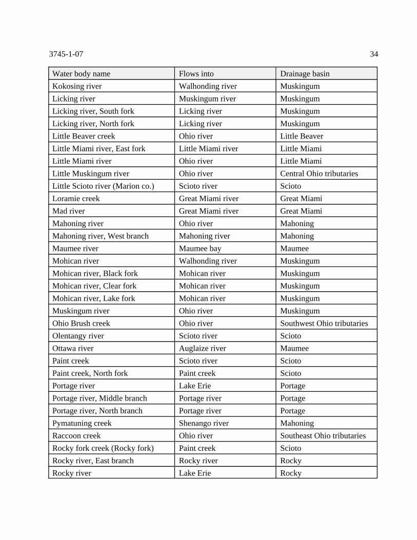
3745-1-07 34
Water body name Flows into Drainage basinKokosing river Walhonding river MuskingumLicking river Muskingum river MuskingumLicking river, South fork Licking river MuskingumLicking river, North fork Licking river MuskingumLittle Beaver creek Ohio river Little BeaverLittle Miami river, East fork Little Miami river Little MiamiLittle Miami river Ohio river Little MiamiLittle Muskingum river Ohio river Central Ohio tributariesLittle Scioto river (Marion co.) Scioto river SciotoLoramie creek Great Miami river Great MiamiMad river Great Miami river Great MiamiMahoning river Ohio river MahoningMahoning river, West branch Mahoning river MahoningMaumee river Maumee bay MaumeeMohican river Walhonding river MuskingumMohican river, Black fork Mohican river MuskingumMohican river, Clear fork Mohican river MuskingumMohican river, Lake fork Mohican river MuskingumMuskingum river Ohio river MuskingumOhio Brush creek Ohio river Southwest Ohio tributariesOlentangy river Scioto river SciotoOttawa river Auglaize river MaumeePaint creek Scioto river SciotoPaint creek, North fork Paint creek SciotoPortage river Lake Erie PortagePortage river, Middle branch Portage river PortagePortage river, North branch Portage river PortagePymatuning creek Shenango river MahoningRaccoon creek Ohio river Southeast Ohio tributariesRocky fork creek (Rocky fork) Paint creek SciotoRocky river, East branch Rocky river RockyRocky river Lake Erie Rocky

3745-1-07 35
Water body name Flows into Drainage basinRocky river, West branch Rocky river RockySalt creek Scioto river SciotoSandusky river Sandusky bay MaumeeSandy creek Tuscarawas river MuskingumScioto Brush creek Scioto river SciotoScioto Brush creek, North fork Scioto brush creek SciotoScioto Brush creek, South fork Scioto brush creek SciotoScioto river Ohio river SciotoSt. Joseph river Maumee river MaumeeSt. Marys river Maumee river MaumeeStillwater river Great Miami river Great MiamiStraight creek Ohio river Southwest Ohio tributariesSugar creek Tuscarawas river MuskingumSunfish creek Ohio river Central Ohio tributariesSymmes creek Muskingum river MuskingumTiffin river Maumee river MaumeeTinkers creek Cuyahoga river CuyahogaTuscarawas river Muskingum river MuskingumTwin creek Great Miami river Great MiamiVermilion river Lake Erie VermilionWalhonding river Muskingum river MuskingumWhite Oak creek (Whiteoak creek) Ohio river Southwest Ohio tributariesWhitewater river Great Miami river Great MiamiWills creek Muskingum river MuskingumWills creek, Seneca fork Wills creek Muskingum

3745-1-07 36
Effective: 3/15/2010
R.C. Section 119.032 review date: 12/30/2007
Promulgated under: R.C. Section 119.03Rule authorized by: R.C. Section 6111.041Rule amplifies: R.C. Section 6111.041Prior effective dates: 2/14/1978, 4/4/1985, 8/19/1985, 4/30/1987, 5/1/1990, 4/26/1997, 10/31/1997,7/31/1998, 7/31/1999, 2/22/2002, 12/30/2002
3745-1-08 Hocking river drainage basin.
(A) The water bodies listed in table 8-1 of this rule are ordered from downstream toupstream. Tributaries of a water body are indented. The aquatic life habitat, watersupply and recreation use designations are defined in rule 3745-1-07 of theAdministrative Code. The state resource water use designation is defined in rule 3745-1-05 of the Administrative Code. The most stringent criteria associated with any one of theuse designations assigned to a water body will apply to that water body.
(B) Figure 1 of the appendix to this rule is a generalized map of Ohio outlining the waterbody drainage basins and listing associated rule numbers in Chapter 3745-1 of theAdministrative Code. Figure 2 of the appendix to this rule is a generalized map of theHocking river drainage basin.
(C) RM, as used in this rule, stands for river mile and refers to the method used by the Ohioenvironmental protection agency to identify locations along a water body. Mileage isdefined as the lineal distance from the downstream terminus (i.e., mouth) and moving inan upstream direction.
(D) The following symbols are used throughout this rule:
* Designated use based on the 1978 water quality standards;
+ Designated use based on the results of a biological field assessment performed bythe Ohio environmental protection agency;
o Designated use based on justification other than the results of a biological fieldassessment performed by the Ohio environmental protection agency; and
L An L in the warmwater habitat column signifies that the water body segment isdesignated limited warmwater habitat.

3745-1-08 2
Table 8-1. Use designations for water bodies in the Hocking river drainage basin.
Water Body Segment
Use Designations
CommentsAquatic Life
HabitatWaterSupply Recreation
SRW
WWH
EWH
MWH
SSH
CWH
LRW
PWS
AWS
IWS
BW
PCR
SCR
| | | | | | | |
Hocking river - Lithopolis rd. (RM 94.9) to Baldwin-Ewing run (RM 89.02) + + + + EOLP ecoregion - channel modification
- bordering Rockbridge nature preserve o + + + +
- all other segments + + + +
McGill run * * * *
Ross run * * * *
Fourmile creek * * * * *
East Fourmile creek * * * * *
Wolfpen creek * * * *
Tar creek * * * *
Skunk run * * * *
Frost run * * * *
Jordan run - headwaters to intersection of twp. rd. 153 and co. rd. 65 (RM 3.59)
* + * * *
- within Marie J. Desonier nature preserve o + * * *
- all other segments + * * *
Jordan run tributaries from the headwaters of Jordan run to theintersection of twp. rd. 153 and co. rd. 65 (RM 3.59)
* * * * *
Lead run * * * *
Rowell run * * * *
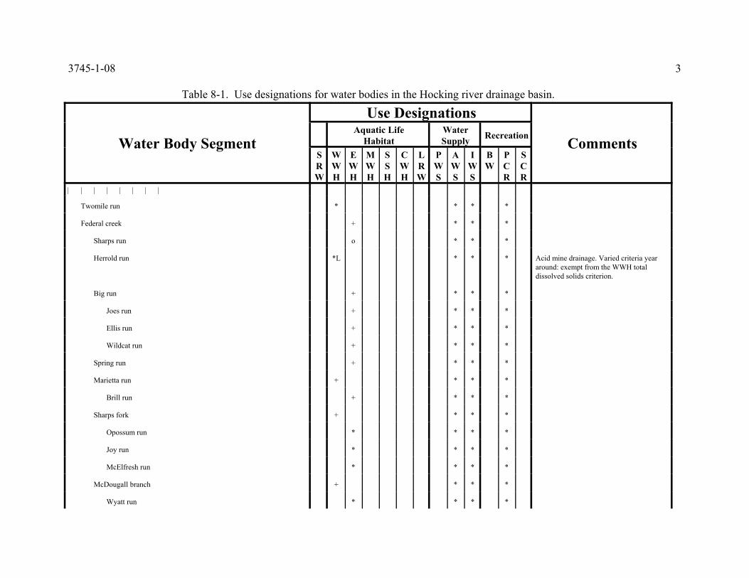
3745-1-08 3
Table 8-1. Use designations for water bodies in the Hocking river drainage basin.
Water Body Segment
Use Designations
CommentsAquatic Life
HabitatWaterSupply Recreation
SRW
WWH
EWH
MWH
SSH
CWH
LRW
PWS
AWS
IWS
BW
PCR
SCR
| | | | | | | |
Twomile run * * * *
Federal creek + * * *
Sharps run o * * *
Herrold run *L * * * Acid mine drainage. Varied criteria yeararound: exempt from the WWH totaldissolved solids criterion.
Big run + * * *
Joes run + * * *
Ellis run + * * *
Wildcat run + * * *
Spring run + * * *
Marietta run + * * *
Brill run + * * *
Sharps fork + * * *
Opossum run * * * *
Joy run * * * *
McElfresh run * * * *
McDougall branch + * * *
Wyatt run * * * *

3745-1-08 4
Table 8-1. Use designations for water bodies in the Hocking river drainage basin.
Water Body Segment
Use Designations
CommentsAquatic Life
HabitatWaterSupply Recreation
SRW
WWH
EWH
MWH
SSH
CWH
LRW
PWS
AWS
IWS
BW
PCR
SCR
| | | | | | | |
Mush run * * * *
Sugar run * * * *
Bryson branch * * * *
Linscott run * * * *
Ewing run * * * *
Hyde fork * * * *
Hyde branch * * * *
Miners fork * * * *
Piper run * * * *
Miller run * * * *
Tiger run * * * *
Green run * * * *
Butts run * * * *
Rocky run * * * *
Willow creek * * * *
Lick run * * * *
Canaanville run * * * *
Stroud run * * * *
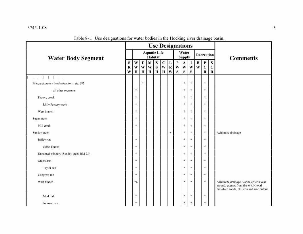
3745-1-08 5
Table 8-1. Use designations for water bodies in the Hocking river drainage basin.
Water Body Segment
Use Designations
CommentsAquatic Life
HabitatWaterSupply Recreation
SRW
WWH
EWH
MWH
SSH
CWH
LRW
PWS
AWS
IWS
BW
PCR
SCR
| | | | | | | |
Margaret creek - headwaters to st. rte. 682 * * * *
- all other segments * * * *
Factory creek * * * *
Little Factory creek * * * *
West branch * * * *
Sugar creek * * * *
Mill creek * * * *
Sunday creek + * * * Acid mine drainage
Bailey run * * * *
North branch * * * *
Unnamed tributary (Sunday creek RM 2.9) + + + +
Greens run * * * *
Taylor run * * * *
Congress run * * * *
West branch *L * * * Acid mine drainage. Varied criteria yeararound: exempt from the WWH totaldissolved solids, pH, iron and zinc criteria.
Mud fork * * * *
Johnson run * * * *

3745-1-08 6
Table 8-1. Use designations for water bodies in the Hocking river drainage basin.
Water Body Segment
Use Designations
CommentsAquatic Life
HabitatWaterSupply Recreation
SRW
WWH
EWH
MWH
SSH
CWH
LRW
PWS
AWS
IWS
BW
PCR
SCR
| | | | | | | |
Indian run * * * *
Pine run * * * *
East branch - headwaters to Burr Oak reservoir * * * *
- at RM 0.23 * o * * *
- all other segments * * * *
Bloody run * * * *
Cedar run * * * *
Dotson creek * * * *
Hamley run * * * *
Monday creek o * * * Acid mine drainage
Snow fork o * * * Acid mine drainage
Brush fork * * * *
Sycamore fork * * * *
Middle fork * * * *
Sand run * * * *
Kitchen run * * * *
Little Monday creek + * * *
Lost run * * * *

3745-1-08 7
Table 8-1. Use designations for water bodies in the Hocking river drainage basin.
Water Body Segment
Use Designations
CommentsAquatic Life
HabitatWaterSupply Recreation
SRW
WWH
EWH
MWH
SSH
CWH
LRW
PWS
AWS
IWS
BW
PCR
SCR
| | | | | | | |
Salt run * * * *
Shawnee creek * * * *
Minkers run * * * *
Dorr run + * * * Acid mine drainage
Fivemile creek * * * *
Threemile creek * * * *
Monkey run * * * *
Oldtown creek + + + +
Scott creek + + + +
Clear fork * * * *
Duck creek * * * *
Dry run * * * *
Harper run * * * *
Buck run * * * *
East branch * * * *
Clear creek + + + +
Arney run - within boundaries of Christmas Rocks Preserve o + + + +
- all other segments + + + +

3745-1-08 8
Table 8-1. Use designations for water bodies in the Hocking river drainage basin.
Water Body Segment
Use Designations
CommentsAquatic Life
HabitatWaterSupply Recreation
SRW
WWH
EWH
MWH
SSH
CWH
LRW
PWS
AWS
IWS
BW
PCR
SCR
| | | | | | | |
Black run * * * *
Muddy Prairie run + + + +
Cattail creek (Clear creek RM 9.52) + + + +
Dunkle run + + + +
Dace ditch (Clear creek RM 13.5) + + + *
Amanda creek (Clear creek RM 14.2) + + + *
Muddy Prairie creek + + + +
Sand run + + + +
Toby creek * * * *
Brushy fork * * * *
Rush creek - headwaters to confluence with little Rush creek (RM 15.7) + + + * Acid mine drainage
- all other segments + + + + WAP ecoregion - mine affected
Durbin run + + + *
Turkey run + + + *
Raccoon run + + + *
Little Rush creek + + + *
Indian creek * * * *
Muddy run * * * *
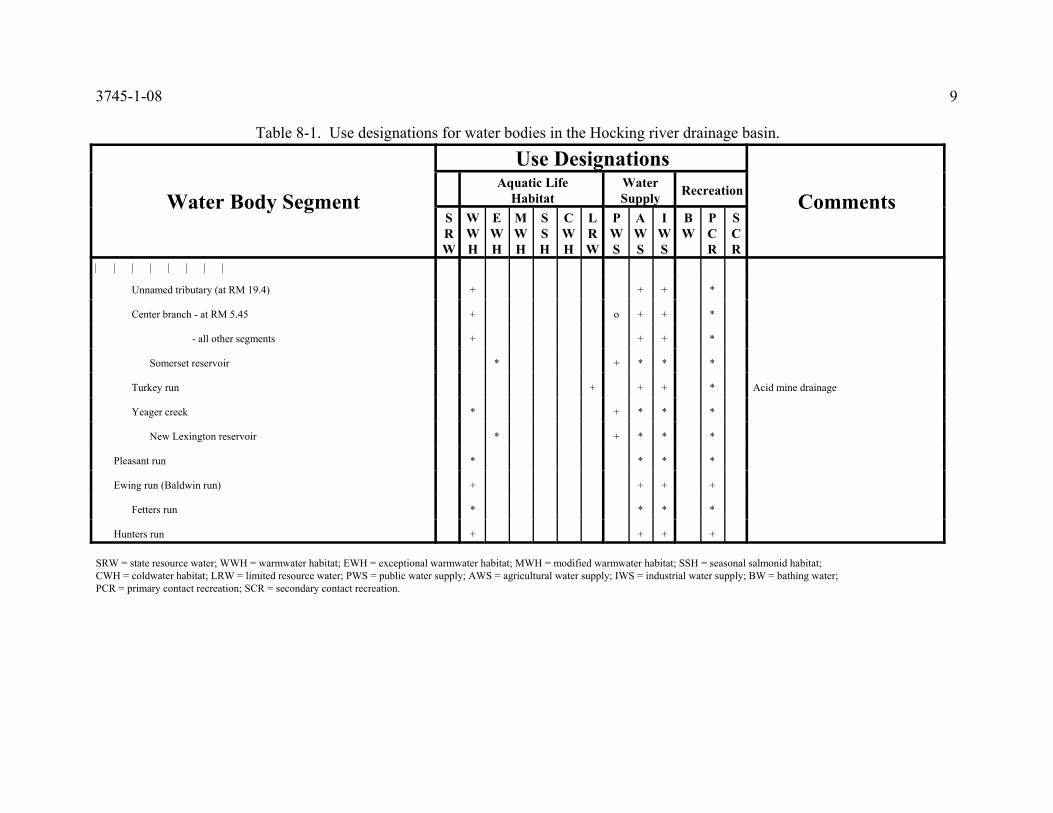
3745-1-08 9
Table 8-1. Use designations for water bodies in the Hocking river drainage basin.
Water Body Segment
Use Designations
CommentsAquatic Life
HabitatWaterSupply Recreation
SRW
WWH
EWH
MWH
SSH
CWH
LRW
PWS
AWS
IWS
BW
PCR
SCR
| | | | | | | |
Unnamed tributary (at RM 19.4) + + + *
Center branch - at RM 5.45 + o + + *
- all other segments + + + *
Somerset reservoir * + * * *
Turkey run + + + * Acid mine drainage
Yeager creek * + * * *
New Lexington reservoir * + * * *
Pleasant run * * * *
Ewing run (Baldwin run) + + + +
Fetters run * * * *
Hunters run + + + +
SRW = state resource water; WWH = warmwater habitat; EWH = exceptional warmwater habitat; MWH = modified warmwater habitat; SSH = seasonal salmonid habitat; CWH = coldwater habitat; LRW = limited resource water; PWS = public water supply; AWS = agricultural water supply; IWS = industrial water supply; BW = bathing water; PCR = primary contact recreation; SCR = secondary contact recreation.
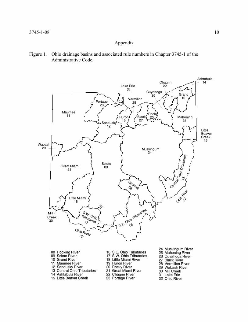
3745-1-08 10
Appendix
Figure 1. Ohio drainage basins and associated rule numbers in Chapter 3745-1 of theAdministrative Code.

3745-1-08 11
Figure 2. Hocking river drainage basin.

3745-1-08 12
Effective: 7/21/02
R.C. Section 119.032 rule review dates: 4/15/98, 9/19/01, 7/21/07
Promulgated under: R.C. Section 119.03Rule authorized by: R.C. Section 6111.041Rule amplifies: R.C. Section 6111.041Prior effective dates: 4/4/85, 8/19/85, 4/21/92, 7/31/98

3745-1-09 Scioto river drainage basin.
(A) The water bodies listed in table 9-1 of this rule are ordered from downstream to upstream.Tributaries of a water body are indented. The aquatic life habitat, water supply andrecreation use designations are defined in rule 3745-1-07 of the Administrative Code. Thestate resource water use designation is defined in rule 3745-1-05 of the Administrative Code.The most stringent criteria associated with any one of the use designations assigned to awater body will apply to that water body.
(B) Figure 1 of the appendix to this rule is a generalized map of the Scioto river drainage basin.A generalized map of Ohio outlining the twenty-three major drainage basins and listingassociated rule numbers in Chapter 3745-1 of the Administrative Code is in figure 1 of theappendix to rule 3745-1-08 of the Administrative Code.
(C) RM, as used in this rule, stands for river mile and refers to the method used by the Ohioenvironmental protection agency to identify locations along a water body. Mileage isdefined as the lineal distance from the downstream terminus (i.e., mouth) and moving in anupstream direction.
(D) The following symbols are used throughout this rule:
* Designated use based on the 1978 water quality standards;
+ Designated use based on the results of a biological field assessment performed by theOhio environmental protection agency;
o Designated use based on justification other than the results of a biological fieldassessment performed by the Ohio environmental protection agency; and
L An L in the warmwater habitat column signifies that the water body segment isdesignated limited warmwater habitat.
ACTION: Final DATE: 07/09/2009 8:50 AM
RB p(44517) pa(80698) d(208720) ra(196011) print date: 07/09/2009 9:04 PM
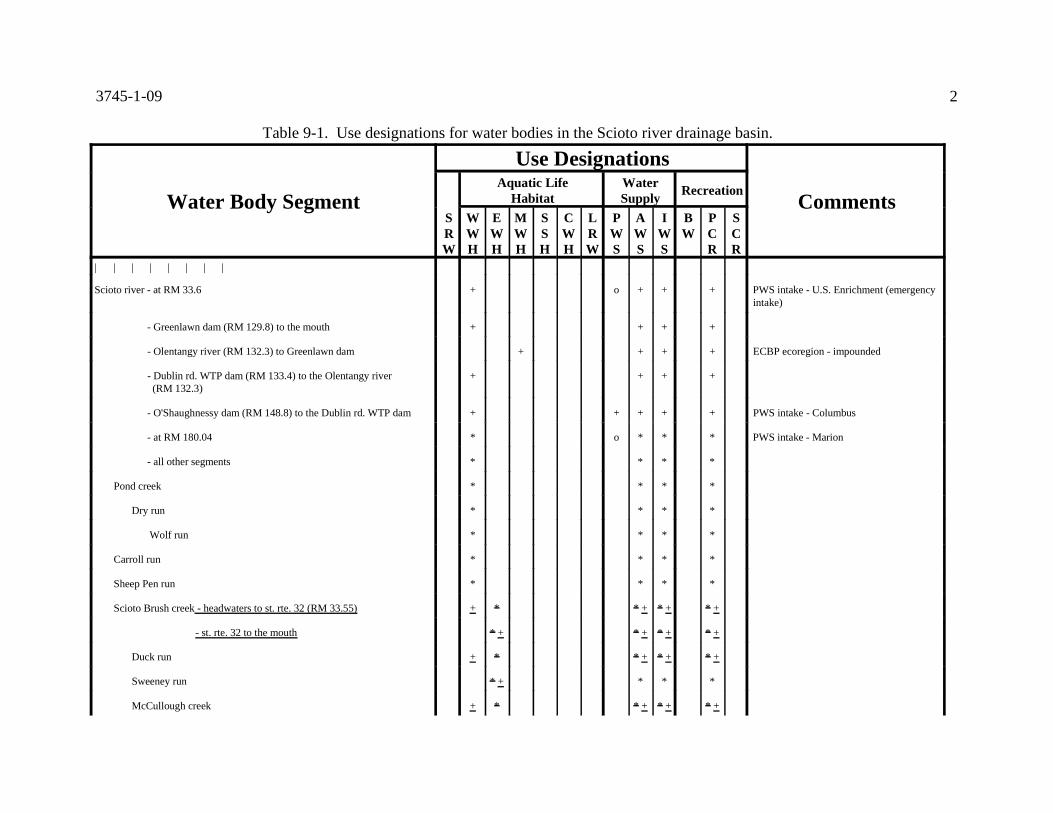
3745-1-09 2
Table 9-1. Use designations for water bodies in the Scioto river drainage basin.
Water Body Segment
Use Designations
CommentsAquatic Life
HabitatWaterSupply Recreation
SRW
WWH
EWH
MWH
SSH
CWH
LRW
PWS
AWS
IWS
BW
PCR
SCR
| | | | | | | |
Scioto river - at RM 33.6 + o + + + PWS intake - U.S. Enrichment (emergencyintake)
- Greenlawn dam (RM 129.8) to the mouth + + + +
- Olentangy river (RM 132.3) to Greenlawn dam + + + + ECBP ecoregion - impounded
- Dublin rd. WTP dam (RM 133.4) to the Olentangy river(RM 132.3)
+ + + +
- O'Shaughnessy dam (RM 148.8) to the Dublin rd. WTP dam + + + + + PWS intake - Columbus
- at RM 180.04 * o * * * PWS intake - Marion
- all other segments * * * *
Pond creek * * * *
Dry run * * * *
Wolf run * * * *
Carroll run * * * *
Sheep Pen run * * * *
Scioto Brush creek - headwaters to st. rte. 32 (RM 33.55) + * * + * + * +
- st. rte. 32 to the mouth * + * + * + * +
Duck run + * * + * + * +
Sweeney run * + * * *
McCullough creek + * * + * + * +

3745-1-09 3
Table 9-1. Use designations for water bodies in the Scioto river drainage basin.
Water Body Segment
Use Designations
CommentsAquatic Life
HabitatWaterSupply Recreation
SRW
WWH
EWH
MWH
SSH
CWH
LRW
PWS
AWS
IWS
BW
PCR
SCR
| | | | | | | |
East branch + * * + * + * +
Unnamed tributary (East branch RM 2.42) + + + +
Unnamed tributary (East branch RM 3.35) + + + +
Unnamed tributary (McCullough creek RM 2.50) + + + +
Bear creek + * * + * + * +
Saw Pit run + * * + * + * +
Watts run * * * *
Long fork + * * * *
Right fork + * * * *
Straight fork + * * * *
Left fork * + * * *
Slate run * * * *
Stony run * * * *
Davis run * * * *
South fork * + * + * + * +
Rocky fork * + * + * + * +
Sugarcamp run * * * *
Spruce run * + * + * + * +

3745-1-09 4
Table 9-1. Use designations for water bodies in the Scioto river drainage basin.
Water Body Segment
Use Designations
CommentsAquatic Life
HabitatWaterSupply Recreation
SRW
WWH
EWH
MWH
SSH
CWH
LRW
PWS
AWS
IWS
BW
PCR
SCR
| | | | | | | |
Little Spruce run * * * *
Big run + * * * *
Canada run * * * *
Beech fork * + * + * + * +
Liston run * * * *
Turkey creek * + * + * + * +
Dry fork * + * + * + * +
Unnamed tributary (Turkey creek RM 5.27) + + + +
Shawnee creek + * * * *
Turkey run + * * + * + * +
Deep run + * * * *
Laurel run * * * *
Rogers run + + + +
Cassel run * + * * *
Walker run * * * *
Winterstein run * + * + * + * +
Mill creek * + * + * + * +
Randall run * * * *

3745-1-09 5
Table 9-1. Use designations for water bodies in the Scioto river drainage basin.
Water Body Segment
Use Designations
CommentsAquatic Life
HabitatWaterSupply Recreation
SRW
WWH
EWH
MWH
SSH
CWH
LRW
PWS
AWS
IWS
BW
PCR
SCR
| | | | | | | |
Middle branch + * * + * + * +
Unnamed tributary (Middle branch RM 0.81) + + + +
Middle fork * * * *
Hickman run + * * * *
Unnamed tributary (Hickman run RM 1.14) + + + +
Ellis run * + * * *
Unnamed tributary (Mill creek RM 3.93) + + + +
Burr run + * * * *
Bailey run * * * *
Churn creek + * * + * + * +
Blue creek + * * + * + * +
Glen run * * * *
Minque run * * * *
Moon run * * * *
Hog run * * * *
Hollow fork (formerly Haw fork) * * * *
Bolander run * * * *
Johnson run * + * * *

3745-1-09 6
Table 9-1. Use designations for water bodies in the Scioto river drainage basin.
Water Body Segment
Use Designations
CommentsAquatic Life
HabitatWaterSupply Recreation
SRW
WWH
EWH
MWH
SSH
CWH
LRW
PWS
AWS
IWS
BW
PCR
SCR
| | | | | | | |
Bolander run * * * *
Slate fork * * * *
Buttermilk fork * * * *
Coffer run * * * *
Carter run * * * *
Unnamed tributary (Churn creek RM 5.80) + + + +
Bloody run * * * *
Chambers run * * * *
Whites run * * * *
Early run * * * *
Laurel run * * * *
Dry run + * * + * + * +
Sugarcamp run * * * *
Staley run * * * *
Salome run * * * *
U P run * * * *
Thompson run + * * * *
Mullen run * * * *
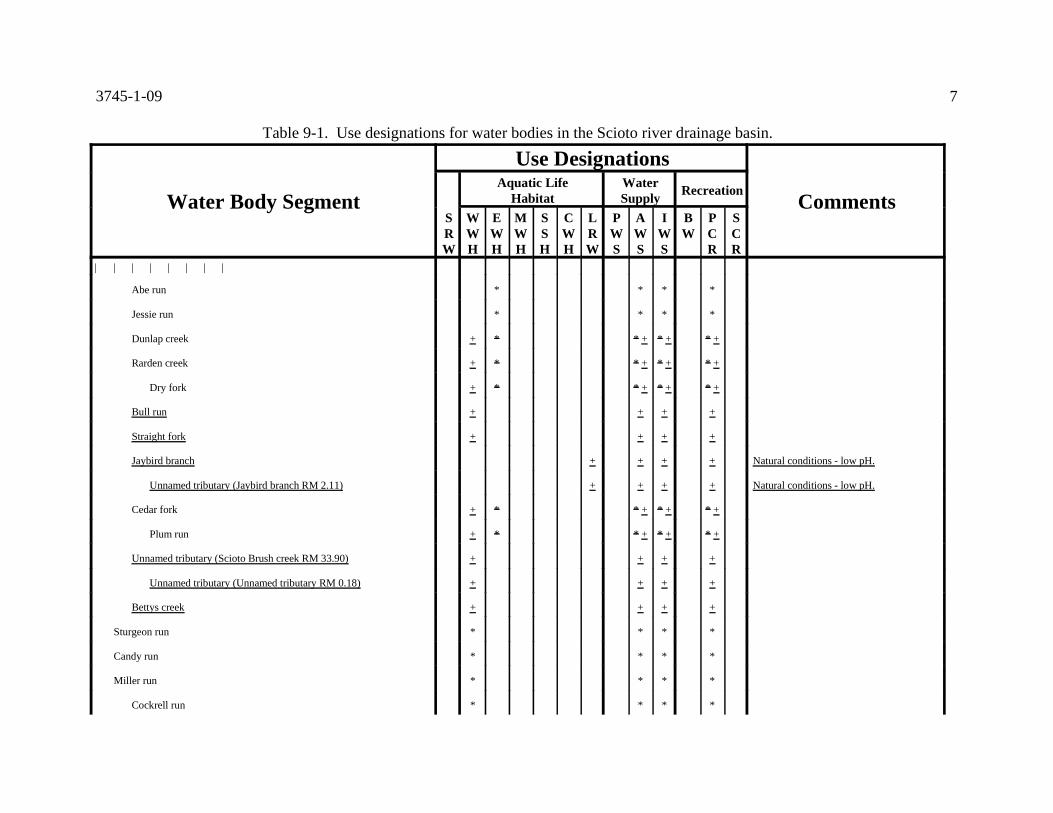
3745-1-09 7
Table 9-1. Use designations for water bodies in the Scioto river drainage basin.
Water Body Segment
Use Designations
CommentsAquatic Life
HabitatWaterSupply Recreation
SRW
WWH
EWH
MWH
SSH
CWH
LRW
PWS
AWS
IWS
BW
PCR
SCR
| | | | | | | |
Abe run * * * *
Jessie run * * * *
Dunlap creek + * * + * + * +
Rarden creek + * * + * + * +
Dry fork + * * + * + * +
Bull run + + + +
Straight fork + + + +
Jaybird branch + + + + Natural conditions - low pH.
Unnamed tributary (Jaybird branch RM 2.11) + + + + Natural conditions - low pH.
Cedar fork + * * + * + * +
Plum run + * * + * + * +
Unnamed tributary (Scioto Brush creek RM 33.90) + + + +
Unnamed tributary (Unnamed tributary RM 0.18) + + + +
Bettys creek + + + +
Sturgeon run * * * *
Candy run * * * *
Miller run * * * *
Cockrell run * * * *

3745-1-09 8
Table 9-1. Use designations for water bodies in the Scioto river drainage basin.
Water Body Segment
Use Designations
CommentsAquatic Life
HabitatWaterSupply Recreation
SRW
WWH
EWH
MWH
SSH
CWH
LRW
PWS
AWS
IWS
BW
PCR
SCR
| | | | | | | |
Devers run * * * *
Big run + + + +
Slate run * * * *
Bear creek * * * *
Camp creek * * * *
Spunk run * * * *
Left fork * * * *
Rock run * * * *
Drake run * * * *
Salt creek * * * *
Ganderhook creek * * * *
Piketon DOE tributary o o o o
West ditch + o o +
Sunfish creek * * * * *
Loys run * * * * *
Chenoweth fork * * * * *
Bull run * * * * *
Carter run * * * * *

3745-1-09 9
Table 9-1. Use designations for water bodies in the Scioto river drainage basin.
Water Body Segment
Use Designations
CommentsAquatic Life
HabitatWaterSupply Recreation
SRW
WWH
EWH
MWH
SSH
CWH
LRW
PWS
AWS
IWS
BW
PCR
SCR
| | | | | | | |
Camp run * * * * *
Georges run * * * * *
Long run * * * * *
Leeth creek * * * * *
Morgan fork * * * *
Left fork * * * * *
Right fork * * * * *
Lick run * * * * *
Sparcy run * * * * *
Grassy fork * * * * *
Kincaid creek * * * * *
Dry Bone creek * * * * *
Beaver creek - headwaters to Piketon * + + + +
- all other segments + + + +
Little Beaver creek * + + + +
Millers run * * * * *
Fourmile creek * * * * *
Fivemile creek * * * * *

3745-1-09 10
Table 9-1. Use designations for water bodies in the Scioto river drainage basin.
Water Body Segment
Use Designations
CommentsAquatic Life
HabitatWaterSupply Recreation
SRW
WWH
EWH
MWH
SSH
CWH
LRW
PWS
AWS
IWS
BW
PCR
SCR
| | | | | | | |
Pecks creek * * * * *
Millstone run * * * * *
Dutch run * * * * *
Swift creek * * * * *
No Name creek * * * *
Long fork * * * *
Sugar run * * * *
Boswell run * * * *
Peepee creek * * * *
Crooked creek * * * *
Left fork * * * *
Honey creek * * * *
Wintergreen run * * * *
Long branch * * * *
Wolf run * * * *
Haw fork * * * *
Turkey run * * * *
Brushy fork * * * *

3745-1-09 11
Table 9-1. Use designations for water bodies in the Scioto river drainage basin.
Water Body Segment
Use Designations
CommentsAquatic Life
HabitatWaterSupply Recreation
SRW
WWH
EWH
MWH
SSH
CWH
LRW
PWS
AWS
IWS
BW
PCR
SCR
| | | | | | | |
Marcus run * * * *
Straight creek * * * *
Meadow run * * * *
Wilson run * * * *
Moore run * * * *
Cars run * * * *
Jackson run * * * *
Bee lick * * * *
Mutton run * * * *
Hickson run * * * *
Sandy Bottom creek * * * *
Salt creek + + + +
Whisky run * * * * *
Salt Lick creek (little Salt creek) - bordering Lake Katherine naturepreserve
* + + + +
- all other segments + + + +
Middle fork Salt creek + + + +
Pigeon creek + + + +
Long branch * + + + +

3745-1-09 12
Table 9-1. Use designations for water bodies in the Scioto river drainage basin.
Water Body Segment
Use Designations
CommentsAquatic Life
HabitatWaterSupply Recreation
SRW
WWH
EWH
MWH
SSH
CWH
LRW
PWS
AWS
IWS
BW
PCR
SCR
| | | | | | | |
Skunk hollow creek (Pigeon creek RM 6.66) + + + +
Unnamed tributary (Pigeon creek RM 7.52) + + + +
Glade run * * * * *
Stevens branch * * * * *
Unnamed tributary (middle fork Salt creek RM 13.00) + + + +
Kelly branch * + + + + +
Riley run * + + + +
Unnamed tributary (middle fork Salt creek RM 20.62) + + + +
Pigeon creek (Salt Lick creek RM 6.35) + + + +
Poplar run * + + + +
Big run * + + + +
Dry run * * * * *
Sour run + + + +
Rock run * * * * *
Buckeye creek * + + + +
Buckeye creek tributaries * * * * *
Unnamed tributary (Salt Lick creek RM 22.55) + + + +
Jisco lake tributaries * * * * *

3745-1-09 13
Table 9-1. Use designations for water bodies in the Scioto river drainage basin.
Water Body Segment
Use Designations
CommentsAquatic Life
HabitatWaterSupply Recreation
SRW
WWH
EWH
MWH
SSH
CWH
LRW
PWS
AWS
IWS
BW
PCR
SCR
| | | | | | | |
Horse creek + + + +
Sugar run + + + +
Fourmile creek * + + + +
Goose creek * * * * *
Mulgee run (Salt creek RM 5.55) + + + +
Poe run * + * * +
Bluelick run * * * * *
Cox run * * * * *
Pike run * + + + +
East fork * + + + +
Pretty run - headwaters to Dry branch (RM 1.88) + + + + +
- Dry branch to the mouth + + + +
Dry branch * * * * *
North branch * + + + +
Queer creek + + + + +
Goose creek * + + + + +
East fork + + + + +
Unnamed tributary (East fork RM 4.24) + + + +

3745-1-09 14
Table 9-1. Use designations for water bodies in the Scioto river drainage basin.
Water Body Segment
Use Designations
CommentsAquatic Life
HabitatWaterSupply Recreation
SRW
WWH
EWH
MWH
SSH
CWH
LRW
PWS
AWS
IWS
BW
PCR
SCR
| | | | | | | |
Blue creek * * * * *
Pine creek + + + +
Little Pine creek - headwaters to Wagner rd. (RM 1.4) * + + + +
- Wagner rd. to the mouth * + + + +
Spruce run * * * * *
Rocky branch * * * * *
Little Blackjack branch * * * * *
Blackjack branch * * * * *
Sams creek * + + + +
California branch * * * * *
Brimstone creek * + + + +
Laurel run - headwaters to Toad hollow (RM 9.0) + + + + +
- Toad hollow to the mouth + + + +
Moccasin creek * + + + +
Dry run * * * * *
Middle fork + + + +
Long run * * * * *
Cola creek * + + + +

3745-1-09 15
Table 9-1. Use designations for water bodies in the Scioto river drainage basin.
Water Body Segment
Use Designations
CommentsAquatic Life
HabitatWaterSupply Recreation
SRW
WWH
EWH
MWH
SSH
CWH
LRW
PWS
AWS
IWS
BW
PCR
SCR
| | | | | | | |
Little Cola creek * * * * *
Beech fork (Salt creek RM 34.1) + + + +
Bull creek (Beech fork RM 1.54) * + + + +
Pikehole creek (Beech fork RM 1.9) * * * * *
Plum run * + + + +
Walnut creek + * * +
Sugar run * * * *
Little Walnut creek * * * *
Spud run * * * *
Piny run * * * *
Stony creek * * * *
Dry run * * * *
Indian creek * * * *
North branch * * * *
Paint creek - at RM 71.4 * + o * + * + * + PWS intake - Washington Court House
- U.S. rte. 35 (RM 67.4) to Paint creek reservoir (RM 46.5) + * * *
- Paint creek reservoir (RM 46.5) U.S. rte. 35 (RM 67.4) tost. rte. 772 (RM 3.8)
+ + + +
- st. rte. 772 (RM 3.8) to the mouth + + + +

3745-1-09 16
Table 9-1. Use designations for water bodies in the Scioto river drainage basin.
Water Body Segment
Use Designations
CommentsAquatic Life
HabitatWaterSupply Recreation
SRW
WWH
EWH
MWH
SSH
CWH
LRW
PWS
AWS
IWS
BW
PCR
SCR
| | | | | | | |
- all other segments * + * + * + * +
North fork + + + +
Biers run * + * + * + * +
Mad run * * * *
Anderson run * * * *
Sulphur lick * * * *
Dry run * * * *
Little creek * + * + * + * +
Dewey creek * * * *
Oldtown run * * * *
McCortney run * * * *
Herrod creek * * * *
Whetstone run * * * *
Compton creek - headwaters to Dews run (RM 11.28) + + + + +
- Dews run to the mouth + + + +
Crooked creek * + * + * + * +
Mud run * + * + * + * +
Thompson creek * + * + * + * +

3745-1-09 17
Table 9-1. Use designations for water bodies in the Scioto river drainage basin.
Water Body Segment
Use Designations
CommentsAquatic Life
HabitatWaterSupply Recreation
SRW
WWH
EWH
MWH
SSH
CWH
LRW
PWS
AWS
IWS
BW
PCR
SCR
| | | | | | | |
Ralston run * * * *
Cattail run * + * + * + * +
Owl creek * + * + * + * +
Plug run * + * + * + * +
Black run - headwaters to Spruce Hill rd. (RM 1.0) * + * + * + * +
- Spruce Hill rd. to the mouth + + + +
Mine run * * * *
Lower Twin creek * + * + * + * +
Upper Twin creek * + * + * + * +
Proud run * * * *
Sulphur lick * * * *
Minnehan run * * * *
Buckskin creek - headwaters to Cliff Run rd. (RM 5.75) * + * + * + * +
- Cliff Run rd. to the mouth + + + +
Slate run * * * *
North fork * * * *
Cove run * * * *
Massie run * * * *

3745-1-09 18
Table 9-1. Use designations for water bodies in the Scioto river drainage basin.
Water Body Segment
Use Designations
CommentsAquatic Life
HabitatWaterSupply Recreation
SRW
WWH
EWH
MWH
SSH
CWH
LRW
PWS
AWS
IWS
BW
PCR
SCR
| | | | | | | |
Rocky fork + + + +
Factory branch * * * * *
Pickett run * * + * + * + * +
Heads branch * * * * *
Puncheon run * * * * *
Franklin branch * * * * *
Plum run * * * * *
Blinco branch * * * * *
Churn creek * * * * *
Smith branch * * * * *
Clear creek - at RM 7.4 + o + + + PWS intake - Hillsboro
- all other segments + + + +
Moberly branch + + + +
Hussey run * * * * *
Little Rock creek + + + +
Fenner tributary (Clear creek RM 8.57) + + + +
South fork * * * * *
Unnamed tributary (Rocky fork RM 17.55) + + + +

3745-1-09 19
Table 9-1. Use designations for water bodies in the Scioto river drainage basin.
Water Body Segment
Use Designations
CommentsAquatic Life
HabitatWaterSupply Recreation
SRW
WWH
EWH
MWH
SSH
CWH
LRW
PWS
AWS
IWS
BW
PCR
SCR
| | | | | | | |
Cliff creek * * * *
Plum run * * * *
Rattlesnake creek + + + +
Cedar run * * * *
Fell creek * * * *
Big branch * + * + * + * +
Hardin creek * + * + * + * +
Bull creek * * * *
Bridgewater creek * * * *
Walnut creek + + + +
Lees creek + + + +
Middle fork + + + +
South fork * + * + * + * +
West branch - headwaters to Pearson rd. (RM 9.8) + + + + + + ECBP ecoregion - channel modification
- Pearson rd. to the mouth + + + +
Grassy branch * * * *
Wilson creek * + * + * + * + ECBP ecoregion - channel modification
Unnamed tributary (Rattlesnake creek RM 40.21) + + + + ECBP ecoregion - channel modification

3745-1-09 20
Table 9-1. Use designations for water bodies in the Scioto river drainage basin.
Water Body Segment
Use Designations
CommentsAquatic Life
HabitatWaterSupply Recreation
SRW
WWH
EWH
MWH
SSH
CWH
LRW
PWS
AWS
IWS
BW
PCR
SCR
| | | | | | | |
Opossum run * * * *
Farmers run * * * *
Duncan run * * * *
Sugar run * * * *
Holliday run * * * *
Stone run * * * *
Buck run * * * *
Indian creek * * * *
Wabash creek * + * + * + * +
Sugar creek - headwaters to Carrs Mill-Jamestown rd. (RM 32.2) + + + + + ECBP ecoregion - channel modification
- Carrs Mill-Jamestown rd. to the mouth + + + +
East fork + + + +
Big run * * * *
Brock ditch * * * *
Vallery ditch (East fork RM 15.91) + + + + ECBP ecoregion - channel modification
County ditch * * * *
Lick run * * * *
Dry run * * * *

3745-1-09 21
Table 9-1. Use designations for water bodies in the Scioto river drainage basin.
Water Body Segment
Use Designations
CommentsAquatic Life
HabitatWaterSupply Recreation
SRW
WWH
EWH
MWH
SSH
CWH
LRW
PWS
AWS
IWS
BW
PCR
SCR
| | | | | | | |
Dry run * * * *
Kinnikinnick creek + * * +
Deer creek - Sugar run (RM 41.22) to the mouth + + + +
- all other segments + + + +
Waugh run + + + +
Hay run + + + +
Stall run * * * *
Dry run * * * *
Buskirk creek - headwaters to RM 2.7 + + + +
- RM 2.7 to the mouth + + + +
Clark run + + + +
Georges run * * * *
Long branch * * * *
Duff's fork * * * *
Opossum run * * * *
Sugar run + + + +
Mud run * * * *
Bradford creek - headwaters to RM 6.1 * * * *

3745-1-09 22
Table 9-1. Use designations for water bodies in the Scioto river drainage basin.
Water Body Segment
Use Designations
CommentsAquatic Life
HabitatWaterSupply Recreation
SRW
WWH
EWH
MWH
SSH
CWH
LRW
PWS
AWS
IWS
BW
PCR
SCR
| | | | | | | |
- RM 6.1 to the mouth + + + +
South fork + + + +
Turtle run * * * *
Turkey run * * * *
Oak run + + + +
Walnut run + + + +
Glade run * * * *
North fork + + + +
Blackwater creek * * * *
Scippo creek - old Tarlton pike (RM 14.8) to the mouth + * * +
- all other segments + * * +
Congo creek (Scippo creek RM 1.64) + * * +
Unnamed tributary (Scippo creek RM 16.31) + * * +
Unnamed tributary (Scippo creek RM 18.87) + * * + Small drainageway maintenance
Yellowbud creek - upstream Ebenhack rd. (RM 3.0) to the mouth + * * +
- all other segments + * * +
Wolf run * * * *
Lick run * * * *

3745-1-09 23
Table 9-1. Use designations for water bodies in the Scioto river drainage basin.
Water Body Segment
Use Designations
CommentsAquatic Life
HabitatWaterSupply Recreation
SRW
WWH
EWH
MWH
SSH
CWH
LRW
PWS
AWS
IWS
BW
PCR
SCR
| | | | | | | |
RCA tributary (Scioto river RM 96.5) + + + + Small drainageway maintenance
Hargus creek * * * *
Hominy creek * * * *
Big Darby creek - twp. rd. 157 (RM 79.23) to the mouth + + + +
- headwaters to twp. rd. 157 + + + + +
Georges run (creek) + + + +
Greenbrier creek + + + *
Unnamed tributary (Big Darby creek RM 18.41) + + + +
Unnamed tributary (Big Darby creek RM 20.2) + + + +
Unnamed tributary (Big Darby creek RM 23.77) + + + +
Springwater run + + + +
Hellbranch run - Kropp rd. (RM 5.04) to the mouth + + + +
- all other segments + + + +
Clover Groff ditch - headwaters to Feder rd. + + + + ECBP ecoregion - channel modification
- Feder rd. (RM 2.5) to the mouth + + + +
Hamilton ditch - headwaters to Feder rd. (RM 2.1) + + + + ECBP ecoregion - channel modification
- Feder rd. to the mouth + + + +
Gay run + + + +

3745-1-09 24
Table 9-1. Use designations for water bodies in the Scioto river drainage basin.
Water Body Segment
Use Designations
CommentsAquatic Life
HabitatWaterSupply Recreation
SRW
WWH
EWH
MWH
SSH
CWH
LRW
PWS
AWS
IWS
BW
PCR
SCR
| | | | | | | |
Smith ditch - unnamed tributary adjacent Lilly Chapel rd. at RM 3.7to the mouth
+ + + +
Unnamed tributary (Smith ditch RM 0.06) + + + +
Little Darby creek - Lake run (RM 36.9) to the mouth + + + +
- headwaters to Lake run + + + + +
Spring fork + + + +
Bales ditch (Spring fork RM 3.64) - downstream st. rte. 29(RM 1.3) to the mouth
+ + + +
Wamp ditch - adjacent Finley-Guy rd. (RM 0.4) to the mouth + + + +
Barron creek - Rosedale-Plain city rd. (RM 2.1) to the mouth + + + + +
- headwaters to Rosedale-Plain city rd. + * + + +
Treacle creek + + + + +
Proctor run + + + + +
Howard run + + + + +
Lake run + * + + +
Jumping run - adjacent Bullard-Rutan rd. (RM 1.5) to themouth
+ + + + +
- headwaters to Bullard-Rutan rd. + * * * *
Clover run + + + + +

3745-1-09 25
Table 9-1. Use designations for water bodies in the Scioto river drainage basin.
Water Body Segment
Use Designations
CommentsAquatic Life
HabitatWaterSupply Recreation
SRW
WWH
EWH
MWH
SSH
CWH
LRW
PWS
AWS
IWS
BW
PCR
SCR
| | | | | | | |
Fitzgerald ditch (Threemile run) - RM 1.65 (terminus of countymaintenance) to the mouth
+ + + +
- headwaters to RM 1.65 * * * *
Yutzy ditch - adjacent Price-Hilliards rd. (RM 1.0) to the mouth + + + +
Ballenger-Jones ditch - U.S. rte. 42 (RM 2.4) to the mouth + + + +
Worthington ditch - upstream Plain city-Georgesville rd. (RM 1.0) tothe mouth
+ + + +
Sugar run - headwaters to Taylor rd. (RM 6.7) + + + + ECBP ecoregion - channel modification
- all other segments + + + +
Sweeney run - Lafayette-Plain city rd. (RM 1.8) to the mouth + + + +
Robinson run + + + +
Sugar run + + + *
Buck run + + + +
Prairie run + + + *
Hay run - upstream Mechanicsburg-Plain city rd. (RM 0.5) to themouth
+ + + +
- headwaters to Mechanicsburg-Plain city rd. * * * *
Unnamed tributary (Big Darby creek RM 69.4) + + + +
Pleasant run + + + +

3745-1-09 26
Table 9-1. Use designations for water bodies in the Scioto river drainage basin.
Water Body Segment
Use Designations
CommentsAquatic Life
HabitatWaterSupply Recreation
SRW
WWH
EWH
MWH
SSH
CWH
LRW
PWS
AWS
IWS
BW
PCR
SCR
| | | | | | | |
Spain creek - headwaters to Erie-Lackawanna railroad crossing(RM 5.0)
+ + + + +
- all other segments + + + + +
Unnamed tributary (Big Darby creek RM 74.91) + + + +
Little Darby creek (Big Darby creek RM 78.34) + + + + +
Flat branch + + + + ECBP ecoregion - channel modification
Dry run * * * *
Griffy run * * * *
Walnut creek (little Walnut creek) + + + +
Little Walnut creek - headwaters to Ringgold northern rd. (RM 4.04) + + + +
- Ringgold northern rd. to Turkey run (RM 3.0) + + + +
- Turkey run to the mouth + + + +
Bull run + + + +
Turkey run - headwaters to Creek rd. (RM 6.53) + + + +
- Creek rd. to Circleville Winchester rd. (RM 0.93) + + + +
- Winchester rd. to the mouth + + + +
Lick run * * * *
Cherry run + + + +
Manns run (Walnut creek RM 9.96) + + + +

3745-1-09 27
Table 9-1. Use designations for water bodies in the Scioto river drainage basin.
Water Body Segment
Use Designations
CommentsAquatic Life
HabitatWaterSupply Recreation
SRW
WWH
EWH
MWH
SSH
CWH
LRW
PWS
AWS
IWS
BW
PCR
SCR
| | | | | | | |
Mud run + + + +
Slate run + + + + +
Rickenbacker tributary (Walnut creek RM 15.54) + + + + ECBP ecoregion - channel modification
Rickenbacker tributary (Walnut creek RM 15.64) + + + +
Big run - headwaters to Elder rd. (RM 3.9) + + + +
- Elder rd. to the mouth + + + +
Georges creek + + + +
East fork (Georges creek RM 2.0) + + + +
Tussing ditch - headwaters to Groveport rd. (RM 0.4) + + + + ECBP ecoregion - channel modification
- all other segments + + + +
Unnamed tributary (Walnut creek RM 23.70) + + + +
Sycamore creek + + + +
Unnamed tributary (Walnut creek RM 29.83) + + + +
Gillette run (Walnut creek RM 32.10) + + + +
Poplar creek + + + +
Pawpaw creek + + + +
Zellerbach tributary (West branch Pawpaw creek) + + + +
Unnamed tributary (Pawpaw creek RM 1.77) + + + +

3745-1-09 28
Table 9-1. Use designations for water bodies in the Scioto river drainage basin.
Water Body Segment
Use Designations
CommentsAquatic Life
HabitatWaterSupply Recreation
SRW
WWH
EWH
MWH
SSH
CWH
LRW
PWS
AWS
IWS
BW
PCR
SCR
| | | | | | | |
Pleasantville-Thurston WWTP tributary + + + +
Van Meter run * * * *
Grove run * * * *
Big Walnut creek - Williams rd. (RM 15.8) to the mouth + + + +
- Hoover reservoir * + + + + PWS intake - Lake of the Woods
- at RM 32.64 + o + + + PWS intake - Columbus
- at RM 51.4 + + + + + PWS intake - Sunbury (formerly)
- headwaters to Hoover reservoir + + + +
- all other segments * * * *
Alum creek - at Rms 26.74 and 21.20 + o + + + PWS intakes - DELCO (RM26.74) andWesterville (RM 21.20
- all other segments + + + +
Bliss run * * * *
American ditch o o o o Small drainageway maintenance
Kilbourne run (Alum creek RM 16.34) + + + +
West Spring run (Alum creek RM 17.15) + + + +
Spring run (Alum creek RM 17.22) + + + +
Unnamed tributary (Alum creek RM 23.47) + + + +
Unnamed tributary (Alum creek RM 25.50) + + + +

3745-1-09 29
Table 9-1. Use designations for water bodies in the Scioto river drainage basin.
Water Body Segment
Use Designations
CommentsAquatic Life
HabitatWaterSupply Recreation
SRW
WWH
EWH
MWH
SSH
CWH
LRW
PWS
AWS
IWS
BW
PCR
SCR
| | | | | | | |
Big run + + + +
Johnson run * * * *
Longwell run * * * *
Slate run * * * *
Bald lick * * * *
Salt Well run * * * *
West branch - at RM 5.57 + o + + + PWS intake - Ashley (formerly)
- all other segments + + + +
Turkey run + + + +
Indigo creek * * * *
Bunker run + + + +
Blacklick creek + + + +
Unnamed tributary (Blacklick creek RM 6.5) + + + +
Unnamed tributary (Blacklick creek RM 10.4) + + + +
Unnamed tributary (Blacklick creek RM 11.3) + + + +
Unnamed tributary (Blacklick creek RM 12.9) + + + +
French run (Blacklick creek RM 13.66) + + + +
North branch (French run RM 0.33) + + + +

3745-1-09 30
Table 9-1. Use designations for water bodies in the Scioto river drainage basin.
Water Body Segment
Use Designations
CommentsAquatic Life
HabitatWaterSupply Recreation
SRW
WWH
EWH
MWH
SSH
CWH
LRW
PWS
AWS
IWS
BW
PCR
SCR
| | | | | | | |
Dysar run (Blacklick creek RM 14.64) + + + +
Unnamed tributary (Dysar run RM 1.67) + + + +
Unnamed tributary (Dysar run RM 2.58) + + + +
Unzinger ditch (Blacklick creek RM 15.88) - headwaters toRM 0.6
+ + + + Small drainageway maintenance
- all other segments + + + +
Swisher creek (Blacklick creek RM 20.94) + + + +
Mason run - headwaters to Fifth ave. (RM 6.1) + + + + Small drainageway maintenance
- Fifth ave. to I-70 (RM 1.9) + + + + ECBP ecoregion - channel modification
- I-70 to the mouth + + + +
Turkey run - headwaters to RM 1.6 + + + + Small drainageway maintenance
- RM 1.6 to the mouth + + + + ECBP ecoregion - channel modification
Unnamed tributary (Big Walnut creek RM 27.29) + + + +
Rocky fork - headwaters to U.S. rte. 62 (RM 5.1) + + + +
- U.S. rte. 62 to the mouth + + + +
Rose run (Rocky fork RM 6.4) + + + +
Sugar run (Rocky fork RM 6.6) + + + +
McKenna creek (Big Walnut creek RM 29.65) + + + +
Unnamed tributary (Big Walnut creek RM 32.60) + + + +
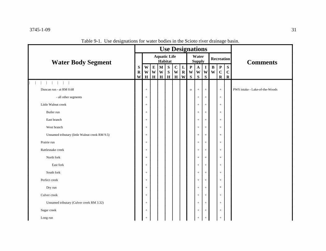
3745-1-09 31
Table 9-1. Use designations for water bodies in the Scioto river drainage basin.
Water Body Segment
Use Designations
CommentsAquatic Life
HabitatWaterSupply Recreation
SRW
WWH
EWH
MWH
SSH
CWH
LRW
PWS
AWS
IWS
BW
PCR
SCR
| | | | | | | |
Duncan run - at RM 0.68 + o + + + PWS intake - Lake-of-the-Woods
- all other segments + + + +
Little Walnut creek + + + +
Butler run + + + +
East branch + + + +
West branch + + + +
Unnamed tributary (little Walnut creek RM 9.5) + + + +
Prairie run + + + +
Rattlesnake creek + + + +
North fork + + + +
East fork + + + +
South fork + + + +
Perfect creek + + + +
Dry run + + + *
Culver creek + + + +
Unnamed tributary (Culver creek RM 3.32) + + + +
Sugar creek + + + +
Long run + + + +

3745-1-09 32
Table 9-1. Use designations for water bodies in the Scioto river drainage basin.
Water Body Segment
Use Designations
CommentsAquatic Life
HabitatWaterSupply Recreation
SRW
WWH
EWH
MWH
SSH
CWH
LRW
PWS
AWS
IWS
BW
PCR
SCR
| | | | | | | |
Reynolds run + + + +
Mill creek + + + +
Light creek + + + *
Castro run + + + +
Hayes ditch + + + *
Plum run * * * *
Grant run * * * *
Republican run (Scioto river RM 122.9) + + + +
South branch + + + + Small drainageway maintenance
Scioto Big run * * * *
Marsh run * * * *
Kian run * * * *
Williams ditch (tributary to quarry along Scioto river at RM 126.7) + + + + Small drainageway maintenance
Renick run * * * *
Olentangy river - at RMs 31.23 and 31.02 + o + + + PWS intakes - Delaware
- Old Winter rd. (RM 20.4) to I-270 (RM 11.6) + + + +
- at RM 18.19 + o + + + PWS intake - DELCO
- Adena brook (RM 5.9) to the Dodridge st. dam(RM 4.0)
+ + + + ECBP ecoregion - impounded

3745-1-09 33
Table 9-1. Use designations for water bodies in the Scioto river drainage basin.
Water Body Segment
Use Designations
CommentsAquatic Life
HabitatWaterSupply Recreation
SRW
WWH
EWH
MWH
SSH
CWH
LRW
PWS
AWS
IWS
BW
PCR
SCR
| | | | | | | |
- adjacent Tuttle park (RM 3.4) to the Fifth ave. dam(RM 1.9)
+ + + + ECBP ecoregion - impounded
- Conrail railroad crossing (RM 0.5) to the mouth + + + + ECBP ecoregion - impounded
- at RM 0.2 + o + + + ECBP ecoregion - impounded;PWS intake - Columbus
- all other segments + + + +
Glen Echo ravine + +
Turkey run (Olentangy river RM 5.82) + + + +
Big run (Adena brook) + + + *
Bill Moose creek (Olentangy river RM 7.82) + + +
Turkey run * * * *
Kempton run (Olentangy river RM 8.59) + + +
Rush run + + + +
Linworth run (Olentangy river RM 9.9) + + +
Bartholomew run + + + +
Deep run + + + +
Unnamed tributary (Olentangy river RM 18.19) + + + +
Unnamed tributary (Olentangy river RM 20.71) + + + +
Weiser run * * * *

3745-1-09 34
Table 9-1. Use designations for water bodies in the Scioto river drainage basin.
Water Body Segment
Use Designations
CommentsAquatic Life
HabitatWaterSupply Recreation
SRW
WWH
EWH
MWH
SSH
CWH
LRW
PWS
AWS
IWS
BW
PCR
SCR
| | | | | | | |
Kingsbury run * * * *
Mill run + + + +
Delaware run + + + +
Sugar run + + + +
Clear run * * * *
Horseshoe run + + + +
Norris run + + + +
Indian run + + + +
Whetstone creek - headwaters to st. rte. 229 (RM 2.6) + + + +
- all other segments + + + +
Claypole run + + + +
Mitchell run + + + +
Shaw creek + + + +
Mud run * * * *
Big run + + + +
Pugh ditch * * * *
Sams creek + + + +
Unnamed tributary (Whetstone creek RM 33.71) + + + + +

3745-1-09 35
Table 9-1. Use designations for water bodies in the Scioto river drainage basin.
Water Body Segment
Use Designations
CommentsAquatic Life
HabitatWaterSupply Recreation
SRW
WWH
EWH
MWH
SSH
CWH
LRW
PWS
AWS
IWS
BW
PCR
SCR
| | | | | | | |
East branch + + + + +
Brondige run + + + +
Norton run * * * *
Qa Qua creek (aka Cauquaw run) - headwaters to RM 3.7 + + + + ECBP ecoregion - channel modification
- all other segments + + + +
Mack ditch (Cauquaw run RM 5.3) + * * + Small drainageway maintenance
Laucher and Berringer ditch (Mack ditch RM 0.86) + * * + Small drainageway maintenance
Grave creek - headwaters to RM 2.4 + + + + ECBP ecoregion - channel modification
- all other segments + + + +
Riffle creek - headwaters to RM 4.0 + + + + ECBP ecoregion - channel modification
- all other segments + + + +
Ulsh ditch + + + + ECBP ecoregion - channel modification
Clendenon ditch + + + + ECBP ecoregion - channel modification
Ruehrmond ditch * * * *
McKibben ditch * * * *
Beaver run * * * *
Muskrat ditch * * * *
Otter creek + + + +

3745-1-09 36
Table 9-1. Use designations for water bodies in the Scioto river drainage basin.
Water Body Segment
Use Designations
CommentsAquatic Life
HabitatWaterSupply Recreation
SRW
WWH
EWH
MWH
SSH
CWH
LRW
PWS
AWS
IWS
BW
PCR
SCR
| | | | | | | |
Mud river * * * *
Flat run + + + +
Thorn run + + + +
Noblet drain * * * *
Mud run * * * *
Mud run + + + + ECBP ecoregion - channel modification
Bee run + + + +
Zimmerman ditch (Olentangy river RM 81.2) + + + + ECBP ecoregion - channel modification
Rocky fork (Olentangy river RM 84.84) - at RM 0.6 + o + + + PWS intake - Galion
- all other segments + + + +
Shoemaker ditch (Olentangy river RM 88.5) + + + + Small drainageway maintenance
Dry run + + + +
Slate run * * * *
Hayden run * * * *
North Fork Indian run * * * *
South Fork Indian run * * * *
Deer run * * * *
Eversole run * * * *

3745-1-09 37
Table 9-1. Use designations for water bodies in the Scioto river drainage basin.
Water Body Segment
Use Designations
CommentsAquatic Life
HabitatWaterSupply Recreation
SRW
WWH
EWH
MWH
SSH
CWH
LRW
PWS
AWS
IWS
BW
PCR
SCR
| | | | | | | |
Mill creek - at RM 19.45 + o + + + PWS intake - Marysville
- all other segments + + + +
Blues creek - headwaters to st. rte. 4 (RM 11.5) + + + + ECBP ecoregion - channel modification
- st. rte. 4 to the mouth + + + +
Ronolds run * * * *
Dry run * * * *
Grassy run * * * *
Dun run * * * *
BMY tributary (Mill creek RM 9.3) + + + + Small drainageway maintenance
Phelps run * * * *
Crosses run + + + +
North branch + + + +
Town run + +
Otter run * * * *
Otter creek + + + +
Moors run * * * *
Prairie run * * * *
Bokes creek - RM 35.51 (0.66 river miles downstream of st. rte.292) toRM 37.30 (1.13 river miles upstream of st. rte. 292)
+ + + + ECBP ecoregion - channel modification

3745-1-09 38
Table 9-1. Use designations for water bodies in the Scioto river drainage basin.
Water Body Segment
Use Designations
CommentsAquatic Life
HabitatWaterSupply Recreation
SRW
WWH
EWH
MWH
SSH
CWH
LRW
PWS
AWS
IWS
BW
PCR
SCR
| | | | | | | |
- all other segments + + + +
Smith run + + + +
Brush run + + + +
Powderlick run - headwaters to RM 3.0 ( 0.35 river milesdownstream of st. rte. 739)
+ + + + Small drainageway maintenance
- all other segments + + + +
Unnamed tributary (Powderlick run RM 2.0) + + + +
North Fork West Mansfield tributary - headwaters to RM 4.51(0.15 river miles upstream of Conrail railroad tracks)
+ + + + ECBP ecoregion - channel modification
- all other segments + + + +
West Fork West Mansfield tributary + + + +
East Fork West Mansfield tributary + + + +
Mayor Painter ditch + + + + Small drainageway maintenance
South branch + + + +
Fulton creek * * * *
Big run * * * *
Richwood tributary (Fulton creek RM 9.4) + + + + Small drainageway maintenance
Utz run * * * *
Kebler run * * * *

3745-1-09 39
Table 9-1. Use designations for water bodies in the Scioto river drainage basin.
Water Body Segment
Use Designations
CommentsAquatic Life
HabitatWaterSupply Recreation
SRW
WWH
EWH
MWH
SSH
CWH
LRW
PWS
AWS
IWS
BW
PCR
SCR
| | | | | | | |
Ottawa creek - headwaters to Mooney rd. (RM 1.6) + * * + Small drainageway maintenance
- Mooney rd. to the mouth * * * *
Battle run * * * *
Patton run * * * *
Beaver run * * * *
Davids run * * * *
Little Scioto river - RM 9.0 (0.2 miles downstream of Hillman Ford rd.)to the mouth
+ + + + ECBP ecoregion - channel modification
- at RM 7.1 + o + + + PWS intake - Marion
- all other segments + + + +
Honey creek + + + +
Rider ditch (Honey creek RM 1.75) + * * + Small drainageway maintenance
Cusic ditch (little Scioto river RM 2.55) + * * +
Rock Swale ditch + + + + Small drainageway maintenance
Columbia ditch - Sawyer lake outlet (RM 2.2) to the mouth + + + + ECBP ecoregion - channel modification
North Rockswale ditch - RM 4.4 to the mouth + + + + ECBP ecoregion - channel modification
- all other segments + + + +
Rock fork + + + +
Long branch * * * *

3745-1-09 40
Table 9-1. Use designations for water bodies in the Scioto river drainage basin.
Water Body Segment
Use Designations
CommentsAquatic Life
HabitatWaterSupply Recreation
SRW
WWH
EWH
MWH
SSH
CWH
LRW
PWS
AWS
IWS
BW
PCR
SCR
| | | | | | | |
Zeig ditch * * * *
Rush creek * * * *
McDonald creek + + + +
Dudley run * * * *
Big swale + * * + Small drainageway maintenance
Rocky fork * * * *
Wildcat creek + + + +
Ash run * * * *
South Wildcat creek * * * *
Panther creek + + + +
Jims creek * * * *
Wolf creek * * * *
Garwood run * * * *
Gander run * * * *
Manlove run * * * *
Taylor creek + + + +
Silver creek + + + +
Jordan run * * * *

3745-1-09 41
Table 9-1. Use designations for water bodies in the Scioto river drainage basin.
Water Body Segment
Use Designations
CommentsAquatic Life
HabitatWaterSupply Recreation
SRW
WWH
EWH
MWH
SSH
CWH
LRW
PWS
AWS
IWS
BW
PCR
SCR
| | | | | | | |
Batchlet run * * * *
Payden run * * * *
McCoy run * * * *
Cooney ditch * * * *
Cottonwood ditch - Hardin county rd. 35 (RM 4.5) to the mouth + + + + ECBP ecoregion - channel modification
- all other segments * * * *
Twin branches * * * *
Dunlap creek * * * *
Elder creek * * * *
Poe ditch * * * *
Wallace fork * * * *
SRW = state resource water; WWH = warmwater habitat; EWH = exceptional warmwater habitat; MWH = modified warmwater habitat; SSH = seasonal salmonid habitat;CWH = coldwater habitat; LRW = limited resource water; PWS = public water supply; AWS = agricultural water supply; IWS = industrial water supply; BW = bathing water;PCR = primary contact recreation; SCR = secondary contact recreation.

Effective: 10/09/2009
R.C. 119.032 review dates: 04/29/2009 and 10/09/2014
CERTIFIED ELECTRONICALLY
Certification
07/09/2009
Date
Promulgated Under: 119.03Statutory Authority: 6111.041Rule Amplifies: 6111.041Prior Effective Dates: 4/4/1985, 8/19/1985, 4/5/1990, 4/21/1992, 9/30/1993,
4/26/1997, 7/31/1998, 7/31/1999, 3/29/2001,7/21/2002, 8/1/2007, 4/23/2008
3745-1-09 42

3745-1-10 Grand river drainage basin. (A) The water bodies listed in table 10-1 of this rule are ordered from downstream to upstream.
Tributaries of a water body are indented. The aquatic life habitat, water supply and recreation use designations are defined in rule 3745-1-07 of the Administrative Code. The state resource water use designation is defined in rule 3745-1-05 of the Administrative Code. The most stringent criteria associated with any one of the use designations assigned to a water body will apply to that water body.
(B) Figure 1 of the appendix to this rule is a generalized map of the Grand river drainage basin.
A generalized map of Ohio outlining the twenty-three major drainage basins and listing associated rule numbers in Chapter 3745-1 of the Administrative Code is in figure 1 of the appendix to rule 3745-1-08 of the Administrative Code.
(C) RM, as used in this rule, stands for river mile and refers to the method used by the Ohio
environmental protection agency to identify locations along a water body. Mileage is defined as the lineal distance from the downstream terminus (i.e., mouth) and moving in an upstream direction.
(D) The following symbols are used throughout this rule:
* Designated use based on the 1978 water quality standards;
+ Designated use based on the results of a biological field assessment performed by the Ohio environmental protection agency;
o Designated use based on justification other than the results of a biological field
assessment performed by the Ohio environmental protection agency; and
L An L in the warmwater habitat column signifies that the water body segment is designated limited warmwater habitat.

3745-1-10
2
Table 10-1. Use designations for water bodies in the Grand river drainage basin.
Water Body Segment
Use Designations
Comments
Aquatic Life
Habitat
Water Supply
Recreation
SRW
WWH
EWH
MWH
S S H
CWH
LRW
P W S
A W S
I WS
BW
P CR
SCR
| | | | | | | |
Marsh creek *
* * *
Mentor creek and Mentor marsh * *
* * *
Black brook *
* * *
Heisley creek *
* * *
Grand river - headwaters to downstream of the U.S. rte. 422 upstream crossing (RM 98.5)
+
* * *
- downstream upper crossing of U.S. rte. 422 (RM 98.5) to lower crossing of U.S. rte. 422 (RM 95.5)
+
* * *
- U.S. rte. 422 to st. rte. 608 (RM 91.8) +
+ + +
- st. rte. 608 to Fobes rd. (RM 44.7) +
+ + +
- at RM 89.12 +
o
+ + + PWS intake - West Farmington
- Fobes rd. to Harpersfield dam (RM 30.9) +
+ + +
- Harpersfield dam to st. rte. 2 (RM 5.5) + o
+ + +
- st. rte. 2 to the mouth * o
* * *
Pebble branch *
* * *
Red creek * o
* * *
Big creek - headwaters to Girdled rd. (RM 7.1) +
+ + +
- Girdled road to the mouth + o
+ + +
Kellogg creek + o
+ + +

3745-1-10
3
Table 10-1. Use designations for water bodies in the Grand river drainage basin.
Water Body Segment
Use Designations
Comments
Aquatic Life
Habitat
Water Supply
Recreation
SRW
WWH
EWH
MWH
S S H
CWH
LRW
P W S
A W S
I WS
BW
P CR
SCR
| | | | | | | |
Ellison creek + o
+ + +
Jordan (Gordon) creek +
+ + +
East creek +
+ + +
Aylworth creek +
+ + +
Jenks creek +
+ + +
Cutts creek +
+ + +
Paine creek - headwaters to Paine falls (RM 2.9) +
+ + +
- Paine falls to the mouth + o
+ + +
Bates creek *
+ + +
Phelps creek + +
+ + +
Unnamed tributary (Paine creek RM 7.2) + +
+ + +
Talcott creek +
+ + +
Griswold creek *
* * *
Mill creek - headwaters to Doty rd. (RM 1.5) o +
+ + +
- Doty rd. to the mouth + o
+ + +
Unnamed tributary (Mill creek RM 4.3) +
+ + +
Coffee creek +
+ + +
Center creek *
* * *

3745-1-10
4
Table 10-1. Use designations for water bodies in the Grand river drainage basin.
Water Body Segment
Use Designations
Comments
Aquatic Life
Habitat
Water Supply
Recreation
SRW
WWH
EWH
MWH
S S H
CWH
LRW
P W S
A W S
I WS
BW
P CR
SCR
| | | | | | | |
Mill creek +
+ + +
Cemetery creek +
+ + +
Griggs creek *
* * *
Askue run +
+ + +
Peters creek +
+ + +
Bronson creek +
+ + +
Trumbull creek - headwaters to Windsor-Mechanicsville rd. (RM 3.4) +
+ + +
- Windsor-Mechanicsville rd. to the mouth +
+ + +
Spring creek +
+ + +
Three Brothers creek +
+ + +
Badger run *
* * *
Rock creek +
+ + +
Plum creek *
* * *
Sugar creek *
* * *
Whetstone creek +
+ + +
Lebanon creek +
+ + +
Shanty creek *
* * *
Snyder ditch (Rock creek RM 15.17) +
+ + + EOLP ecoregion - channel modification

3745-1-10
5
Table 10-1. Use designations for water bodies in the Grand river drainage basin.
Water Body Segment
Use Designations
Comments
Aquatic Life
Habitat
Water Supply
Recreation
SRW
WWH
EWH
MWH
S S H
CWH
LRW
P W S
A W S
I WS
BW
P CR
SCR
| | | | | | | |
Crooked creek - headwaters to Windsor-Mechanicsville rd. (RM 2.5) +
+ + +
- Windsor-Mechanicsville rd. to the mouth +
+ + +
Mud creek *
* * *
Hoskins creek - headwaters to Hurlburt rd. (RM 2.0) +
+ + +
- Hurlburt rd. to the mouth +
+ + +
Indian creek +
+ + +
Montville ditch *
* * *
Phelps creek - North branch / South branch confluence (RM 8.62) to st. rte. 534 (RM 2.1)
+
+ + +
- st. rte. 534 to the mouth +
+ + +
North branch +
+ + +
South branch +
+ + +
Mill creek - South Windsor rd. (RM 4.56) to st. rte. 534 (RM 1.78) +
+ + +
- st. rte. 534 to the mouth +
+ + +
Garden creek +
+ + +
Swine creek - headwaters to Girdle rd. (RM 7.07) +
+ + +
- Girdle rd. to the mouth +
+ + +
Grapevine creek *
* * *
Andrews creek +
+ + +

3745-1-10
6
Table 10-1. Use designations for water bodies in the Grand river drainage basin.
Water Body Segment
Use Designations
Comments
Aquatic Life
Habitat
Water Supply
Recreation
SRW
WWH
EWH
MWH
S S H
CWH
LRW
P W S
A W S
I WS
BW
P CR
SCR
| | | | | | | |
Plum creek +
+ + +
Coffee creek *
* * *
Baughman creek +
+ + +
Center creek +
+ + +
Mud run +
+ + +
Dead branch *
* * *
McKinley creek *
* * *
Big creek *
* * *
SRW = state resource water; WWH = warmwater habitat; EWH = exceptional warmwater habitat; MWH = modified warmwater habitat; SSH = seasonal salmonid habitat; CWH = coldwater habitat; LRW = limited resource water; PWS = public water supply; AWS = agricultural water supply; IWS = industrial water supply; BW = bathing water; PCR = primary contact recreation; SCR = secondary contact recreation.

3745-1-10 7 Appendix Figure 1. Grand river drainage basin.
rmn N D ~:luun
Lakes
Rivers
County Boundaries
Chies

3745-1-10 8 Effective: 6/16/2011 R.C. 119.032 rule review date: 6/16/2016 Promulgated Under: R.C. 119.03 Statutory Authority: R.C. 6111.041 Rule Amplifies: R.C. 6111.041 Prior Effective Dates: 4/4/1985, 8/19/1985, 4/21/1992, 7/31/1998, 3/29/2001, 7/21/2002, 4/23/2008

3745-1-11 Maumee river drainage basin.
(A) The water bodies listed in table 11-1 of this rule are ordered from downstream to upstream.Tributaries of a water body are indented. The aquatic life habitat, water supply andrecreation use designations are defined in rule 3745-1-07 of the Administrative Code. Thestate resource water use designation is defined in rule 3745-1-05 of the Administrative Code.The most stringent criteria associated with any one of the use designations assigned to awater body will apply to that water body.
(B) Figure 1 of the appendix to this rule is a generalized map of the Maumee river drainagebasin. A generalized map of Ohio outlining the twenty-three major drainage basins andlisting associated rule numbers in Chapter 3745-1 of the Administrative Code is in figure 1of the appendix to rule 3745-1-08 of the Administrative Code.
(C) RM, as used in this rule, stands for river mile and refers to the method used by the Ohioenvironmental protection agency to identify locations along a water body. Mileage isdefined as the lineal distance from the downstream terminus (i.e., mouth) and moving in anupstream direction.
(D) The following symbols are used throughout this rule:
* Designated use based on the 1978 water quality standards;
+ Designated use based on the results of a biological field assessment performed by theOhio environmental protection agency;
o Designated use based on justification other than the results of a biological fieldassessment performed by the Ohio environmental protection agency; and
L An L in the warmwater habitat column signifies that the water body segment isdesignated limited warmwater habitat.
ACTION: Final DATE: 07/09/2009 8:50 AM
RB p(44517) pa(80698) d(208723) ra(196010) print date: 07/09/2009 9:03 PM
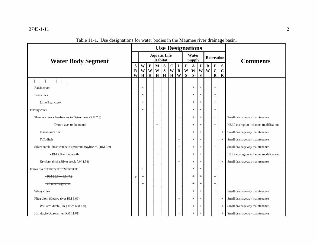
3745-1-11 2
Table 11-1. Use designations for water bodies in the Maumee river drainage basin.
Water Body Segment
Use Designations
CommentsAquatic Life
HabitatWaterSupply Recreation
SRW
WWH
EWH
MWH
SSH
CWH
LRW
PWS
AWS
IWS
BW
PCR
SCR
| | | | | | | |
Raisin creek * * * *
Bear creek * * * *
Little Bear creek * * * *
Halfway creek * * * *
Shantee creek - headwaters to Detroit ave. (RM 2.8) + + + + Small drainageway maintenance
- Detroit ave. to the mouth + + + + HELP ecoregion - channel modification
Eisenbraum ditch + + + + Small drainageway maintenance
Tifft ditch + + + + Small drainageway maintenance
Silver creek - headwaters to upstream Maybee rd. (RM 2.9) + + + + Small drainageway maintenance
- RM 2.9 to the mouth + + + + HELP ecoregion - channel modification
Ketcham ditch (Silver creek RM 4.34) + + + + Small drainageway maintenance
Ottawa river - Cherry st. to Summit st. + * * +
- RM 10.6 to RM 7.9 o + * * +
- all other segments + * * +
Sibley creek + + + + Small drainageway maintenance
Flieg ditch (Ottawa river RM 9.66) + + + + Small drainageway maintenance
Williams ditch (Flieg ditch RM 1.0) + + + + Small drainageway maintenance
Hill ditch (Ottawa river RM 11.81) + + + + Small drainageway maintenance

3745-1-11 3
Table 11-1. Use designations for water bodies in the Maumee river drainage basin.
Water Body Segment
Use Designations
CommentsAquatic Life
HabitatWaterSupply Recreation
SRW
WWH
EWH
MWH
SSH
CWH
LRW
PWS
AWS
IWS
BW
PCR
SCR
| | | | | | | |
Heldman ditch (Hill ditch RM 0.47) + + + + HELP ecoregion - channel modification
Haefner ditch (Hill ditch RM 0.96) + + + + Small drainageway maintenance
Tenmile creek + * * *
North branch + * * *
Ottawa lake outlet * * * *
Clampitt drain * * * *
Big Ravine drain * * * *
Saxton drain * * * *
Bischoff drain * * * *
Prairie ditch * * * *
Unnamed tributary (Tenmile creek RM 16.92) - at RM 1.25 o PWS intake - Metamora
Maumee river - I-75 (RM 7.1) to confluence with Maumee bay o * * *
- at RM 23.16 * o * * * PWS intake - Bowling Green
- RM 54.0 (downstream of Florida) to Grand Rapids dam(RM 32.3)
+ + + + HELP ecoregion - impounded
- at RMs 35.91, 45.88, and 47.13 + o + + + PWS intakes - McClure (RM 35.91),Campbell soup (RM 45.88), and Napoleon(RM 47.13)
- Tiffin river (RM 65.8) to Independence dam (RM 60.0) + + + + HELP ecoregion - impounded

3745-1-11 4
Table 11-1. Use designations for water bodies in the Maumee river drainage basin.
Water Body Segment
Use Designations
CommentsAquatic Life
HabitatWaterSupply Recreation
SRW
WWH
EWH
MWH
SSH
CWH
LRW
PWS
AWS
IWS
BW
PCR
SCR
| | | | | | | |
- at RM 65.84 * o * * * PWS intake - Defiance
- all other segments * * * *
Duck creek + * * *
Swan creek - at RM 30.84 + o * + * + * + PWS intake - Swanton
- all other segments + * + * + * +
Heilman ditch + + + + Small drainageway maintenance
Wolf creek + * + * + * +
Cairl creek (formerly Dry creek) * + * + * + * +
Blystone ditch (Swan creek RM 17.6) + + + +
Blue creek + * + * + * +
Mosquito creek * * * *
Harris ditch (South Swan creek) * + * + * + * +
Gail run * * * *
West fork * * * *
Ai creek (Swan creek RM 30.57) + + + +
Fewless creek (Swan creek RM 33.41) + + + +
Delaware creek * + * + * + * +

3745-1-11 5
Table 11-1. Use designations for water bodies in the Maumee river drainage basin.
Water Body Segment
Use Designations
CommentsAquatic Life
HabitatWaterSupply Recreation
SRW
WWH
EWH
MWH
SSH
CWH
LRW
PWS
AWS
IWS
BW
PCR
SCR
| | | | | | | |
Grassy creek + * + * + * +
Tontogany creek * * * *
Kettle run * * * *
Beaver creek * * * *
Little Beaver creek * * * *
Cutoff ditch * * * *
Brush creek + + + +
Hickey ditch + + + + Small drainageway maintenance
Selhorst ditch + + + + Small drainageway maintenance
Yellow creek + + + + HELP ecoregion - channel modification
West creek * * * *
Little Yellow creek + + + + Small drainageway maintenance
East Beaver creek * * * *
West Beaver creek * * * *
Big creek * * * *
Lick creek * * * *
Bad creek - headwaters to Fulton county line + + + +
- Fulton county line to the mouth + + + +

3745-1-11 6
Table 11-1. Use designations for water bodies in the Maumee river drainage basin.
Water Body Segment
Use Designations
CommentsAquatic Life
HabitatWaterSupply Recreation
SRW
WWH
EWH
MWH
SSH
CWH
LRW
PWS
AWS
IWS
BW
PCR
SCR
| | | | | | | |
- at RM 17 + + + + + PWS intake - Delta
South branch + + + +
Dry creek * * * *
South Turkeyfoot creek * * * *
Turkeyfoot creek * * * *
Lost creek * * * *
Brush creek * * * *
West creek * * * *
Mess ditch * * * *
Gustwiller ditch * * * *
Brinkman ditch * * * *
North Turkeyfoot creek + + + +
Konzen ditch (north Turkeyfoot creek RM 4.65) + + + + HELP ecoregion - channel modification
Unnamed tributary segments immediately adjacent to Wauseonreservoir
* + * * * PWS intake - Wauseon
Unnamed tributary (north Turkeyfoot creek RM 17.3) + + + +
Unnamed tributary (north Turkeyfoot creek RM 18.4) + + + + Small drainageway maintenance
Obernouse creek * * * *
Vannyning creek * * * *

3745-1-11 7
Table 11-1. Use designations for water bodies in the Maumee river drainage basin.
Water Body Segment
Use Designations
CommentsAquatic Life
HabitatWaterSupply Recreation
SRW
WWH
EWH
MWH
SSH
CWH
LRW
PWS
AWS
IWS
BW
PCR
SCR
| | | | | | | |
Garrett creek * * * *
Benien creek * * * *
Brubaker creek * * * *
Barnes creek * * * *
Wade creek * * * *
Huston creek * * * *
Miami and Erie canal (Maumee river RM 53.6) - Independence (RM 6.1)to the mouth
+ * * + HELP ecoregion - channel modification
Preston run * * * *
Auglaize river - headwaters to Blanchard river (RM 26.2) + + + +
- at Agerter rd. (RM 64.58) + + + + + PWS intake - Lima
- all other segments * * * *
Powell creek * * * *
Wagner run * * * *
North Powell creek * * * +
Hogback run * * * *
South Powell creek * * * +
Continental ditch + * * + Small drainageway maintenance
Threemile creek * * * *

3745-1-11 8
Table 11-1. Use designations for water bodies in the Maumee river drainage basin.
Water Body Segment
Use Designations
CommentsAquatic Life
HabitatWaterSupply Recreation
SRW
WWH
EWH
MWH
SSH
CWH
LRW
PWS
AWS
IWS
BW
PCR
SCR
| | | | | | | |
Jackson ditch * * * *
Beetree creek * * * *
Fivemile creek * * * *
Eagle creek * * * *
Sixmile creek * * * *
Bull creek * * * *
Little Flatrock creek * * * *
Flatrock creek - at RM 14.13 + o + + + PWS intake - Paulding
- all other segments + + + +
Wildcat creek * * * *
Blue creek + + + + HELP ecoregion - channel modification
Barcer run * * * *
Dalaet-Broughton ditch (Blue creek RM 8.1) + + + + HELP ecoregion - channel modification
Zielke ditch (aka Webster ditch) + + + + HELP ecoregion - channel modification
Cunningham creek * * * *
Buchanan ditch * * * *
Upper Prairie creek * * * *
Parker ditch * * * *

3745-1-11 9
Table 11-1. Use designations for water bodies in the Maumee river drainage basin.
Water Body Segment
Use Designations
CommentsAquatic Life
HabitatWaterSupply Recreation
SRW
WWH
EWH
MWH
SSH
CWH
LRW
PWS
AWS
IWS
BW
PCR
SCR
| | | | | | | |
Sponseller ditch * * * *
Little Auglaize river - at RM 23.40 + o + + + HELP ecoregion - channel modification;PWS intake - Delphos
- all other segments + + + + HELP ecoregion - channel modification
Prairie creek + + + + HELP ecoregion - channel modification
West branch + + + + HELP ecoregion - channel modification
Hog run + + + + HELP ecoregion - channel modification
Hoaglin creek + + + + HELP ecoregion - channel modification
Monkey run + + + + HELP ecoregion - channel modification
Dog run + + + + HELP ecoregion - channel modification
Hagerman creek + + + + HELP ecoregion - channel modification
Dry creek + + + + HELP ecoregion - channel modification
Middle creek + + + + HELP ecoregion - channel modification
Maddox creek + + + + HELP ecoregion - channel modification
Balyeat ditch + + + + HELP ecoregion - channel modification
Sheets ditch (Maddox creek RM 21.7) + + + + HELP ecoregion - channel modification
Town creek - at RM 18.35 + + + + + HELP ecoregion - channel modification;PWS intake - Van Wert
- all other segments + + + + HELP ecoregion - channel modification

3745-1-11 10
Table 11-1. Use designations for water bodies in the Maumee river drainage basin.
Water Body Segment
Use Designations
CommentsAquatic Life
HabitatWaterSupply Recreation
SRW
WWH
EWH
MWH
SSH
CWH
LRW
PWS
AWS
IWS
BW
PCR
SCR
| | | | | | | |
Roller creek + + + + HELP ecoregion - channel modification
Dog creek + + + + HELP ecoregion - channel modification
Emmit Bell ditch + + + + HELP ecoregion - channel modification
Spice run + + + + HELP ecoregion - channel modification
Brandehoff ditch + + + + HELP ecoregion - channel modification
Dry fork + + + + HELP ecoregion - channel modification
Hermann ditch + + + + HELP ecoregion - channel modification
Benson ditch + + + + HELP ecoregion - channel modification
Evans ditch + + + + Small drainageway maintenance
Wolf ditch + + + + HELP ecoregion - channel modification
Long Prairie creek + + + + HELP ecoregion - channel modification
Kyle Prairie ditch + + + + HELP ecoregion - channel modification
Greens ditch + + + + HELP ecoregion - channel modification
Frisinger ditch + + + + HELP ecoregion - channel modification
Prairie creek * * * *
Blanchard river - at RMs 65.20, 62.43, 58.72, and 28.50 + + + + + PWS intakes - Findlay (RMs 65.20, 62.43and 58.72) and Ottawa (RM 28.50)
- headwaters to Hardin co. rd. 175 (RM 96.2) + + + +
- all other segments + + + +
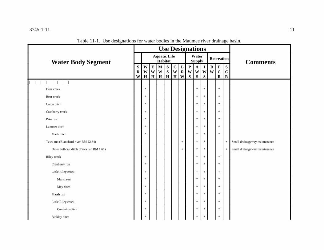
3745-1-11 11
Table 11-1. Use designations for water bodies in the Maumee river drainage basin.
Water Body Segment
Use Designations
CommentsAquatic Life
HabitatWaterSupply Recreation
SRW
WWH
EWH
MWH
SSH
CWH
LRW
PWS
AWS
IWS
BW
PCR
SCR
| | | | | | | |
Deer creek * * * *
Bear creek * * * *
Caton ditch * * * *
Cranberry creek + + + *
Pike run * * * *
Lammer ditch * * * *
Mack ditch * * * *
Tawa run (Blanchard river RM 22.84) + * * + Small drainageway maintenance
Omer Selhorst ditch (Tawa run RM 1.61) + * * + Small drainageway maintenance
Riley creek + + + +
Cranberry run * * * *
Little Riley creek + + + +
Marsh run * * * *
May ditch * * * *
Marsh run * * * *
Little Riley creek * * * *
Cummins ditch * * * *
Binkley ditch * * * *

3745-1-11 12
Table 11-1. Use designations for water bodies in the Maumee river drainage basin.
Water Body Segment
Use Designations
CommentsAquatic Life
HabitatWaterSupply Recreation
SRW
WWH
EWH
MWH
SSH
CWH
LRW
PWS
AWS
IWS
BW
PCR
SCR
| | | | | | | |
Dutch run * * * *
Bassinger ditch * * * *
Dukes run * * * *
Cartwright run * * * *
Homer Green ditch * * * *
Moffitt ditch * * * *
Ottawa creek + + + *
Tiderishi creek * * * *
Burket ditch + + + + Small drainageway maintenance
W.B. Moyer ditch (Ottawa creek RM 9.3) + + + + HELP ecoregion - channel modification
Heininger (Hemminger) ditch + + + + Small drainageway maintenance
Higbie-Redich ditch (Ottawa creek RM 14.4) + + + + HELP ecoregion - channel modification
Oil ditch - headwaters to I-75 (RM 1.7) + + + + Small drainageway maintenance
- I-75 to the mouth + + + *
Eagle creek + + + *
Buck run + + + +
Flat branch * * * *
Woodruff ditch * * * *

3745-1-11 13
Table 11-1. Use designations for water bodies in the Maumee river drainage basin.
Water Body Segment
Use Designations
CommentsAquatic Life
HabitatWaterSupply Recreation
SRW
WWH
EWH
MWH
SSH
CWH
LRW
PWS
AWS
IWS
BW
PCR
SCR
| | | | | | | |
Hydraulic ditch * * * *
Lye creek * * * *
Silver creek * * * *
The outlet * * * *
Brights ditch * * * *
Stahl ditch * * * *
Bacher ditch * * * *
Potato run + + + *
Rickenbach ditch + + + +
Ripley run * * * *
Forest Simpson ditch + + + +
The outlet * * * *
Shallow Run ditch + + + +
Cessna creek * * * *
Fourmile run * * * *
Lapp ditch * * * *
Ottawa river - at RM 43.45 (upstream of low head dam at Metzgerrd.)
+ + + + + PWS intake - Lima
- at Roush rd. (RM 42.60) + + + + + PWS intake - Lima

3745-1-11 14
Table 11-1. Use designations for water bodies in the Maumee river drainage basin.
Water Body Segment
Use Designations
CommentsAquatic Life
HabitatWaterSupply Recreation
SRW
WWH
EWH
MWH
SSH
CWH
LRW
PWS
AWS
IWS
BW
PCR
SCR
| | | | | | | |
- all other segments + + + +
Plum creek + + + +
Sycamore creek * * * *
Sugar creek * * * *
Rattlesnake creek * * * *
Ford tributary (Sugar creek RM 18.8) + * * +
Huber ditch * * * *
Cotner ditch * * * *
Leatherwood ditch * * * *
Pike run + + + + HELP ecoregion - channel modification
Honey run * * * *
Dug run * * * *
Kessler run * * * *
Swalley ditch * * * *
Little Ottawa river + + + +
Zurmehly creek (Ottawa river RM 35.62) + + + +
Lost creek * * * *
Crosley ditch * * * *

3745-1-11 15
Table 11-1. Use designations for water bodies in the Maumee river drainage basin.
Water Body Segment
Use Designations
CommentsAquatic Life
HabitatWaterSupply Recreation
SRW
WWH
EWH
MWH
SSH
CWH
LRW
PWS
AWS
IWS
BW
PCR
SCR
| | | | | | | |
Hog creek - headwaters to Hardin-Allen county line (RM 5.6) + + + + ECBP ecoregion - channel modification
- all other segments + + + +
Grass creek * * * *
No. 28 ditch * * * *
Fitzhugh ditch * * * *
Lord ditch * * * *
Little Hog creek + + + +
Mud run * * * *
Welch run * * * *
Big Run (Auglaize river RM 44.90) + + + +
Jennings creek * * * *
Flat fork * * * *
West Jennings creek (Jennings creek RM 3.57) + + + +
Miami and Erie canal (Jennings creek RM 4.6) + + + + HELP ecoregion - channel modification
Prairie ditch * * * *
Pigeon run (Auglaize river RM 55.51) + + + +
Sixmile creek - headwaters to st. rte. 81 (RM 1.2) + + + + HELP ecoregion - channel modification
- all other segments + + + +

3745-1-11 16
Table 11-1. Use designations for water bodies in the Maumee river drainage basin.
Water Body Segment
Use Designations
CommentsAquatic Life
HabitatWaterSupply Recreation
SRW
WWH
EWH
MWH
SSH
CWH
LRW
PWS
AWS
IWS
BW
PCR
SCR
| | | | | | | |
Buck run * * * *
Twomile creek + + + +
Pusheta creek + + + +
Owl creek * * * *
Unnamed tributary (Pusheta creek RM 2.87) + + + +
Quaker creek + + + +
Dry run + + + +
Blackhoof creek + + + +
Huffman creek + + + +
Virginia creek + + + +
Camp creek * * * *
Wrestle creek + + + +
Unnamed tributary (Auglaize river RM 99.78) + + + +
Unnamed tributary (Auglaize river RM 108.90) + + + +
Tiffin river - bordering Goll Woods preserve o + + + +
Tiffin river - at RM 47.54 + o + + + PWS intake - Archbold
- all other segments + + + +
Dowe ditch * * * *

3745-1-11 17
Table 11-1. Use designations for water bodies in the Maumee river drainage basin.
Water Body Segment
Use Designations
CommentsAquatic Life
HabitatWaterSupply Recreation
SRW
WWH
EWH
MWH
SSH
CWH
LRW
PWS
AWS
IWS
BW
PCR
SCR
| | | | | | | |
Webb run (Tiffin river RM 2.9) + + + +
Tanby ditch * * * *
Mattock ditch * * * *
Buckskin creek * * * *
Mud creek + + + +
Lost creek + + + +
Crooked creek * * * *
Dry creek * * * *
Lick creek + + + +
Prairie creek + + + +
Pigeon run (Prairie creek RM 11.0) + + + + HELP ecoregion - channel modification
Black creek * * * *
Little Lick creek + + + +
Miller creek + + + +
Dotty creek * * * *
Brush creek - at RM 17.64 + o + + + PWS intake - Archbold
- all other segments + + + +
Owl creek * * * *

3745-1-11 18
Table 11-1. Use designations for water bodies in the Maumee river drainage basin.
Water Body Segment
Use Designations
CommentsAquatic Life
HabitatWaterSupply Recreation
SRW
WWH
EWH
MWH
SSH
CWH
LRW
PWS
AWS
IWS
BW
PCR
SCR
| | | | | | | |
Coon creek + + + +
Beaver creek + + + +
Lost creek * * * *
Leatherwood creek + + + +
Flat run * * * *
Walnut run + + + +
Bates creek + + + +
Clear creek + + + +
Mill creek + + + +
West fork * * * *
Bean creek + + + +
Stag run * * * *
Deer creek + + + +
Spring brook * * * *
Spring creek * * * *
Iron creek * * * *
Old Bean creek + + + + HELP ecoregion - channel modification
Stevens ditch * * * *

3745-1-11 19
Table 11-1. Use designations for water bodies in the Maumee river drainage basin.
Water Body Segment
Use Designations
CommentsAquatic Life
HabitatWaterSupply Recreation
SRW
WWH
EWH
MWH
SSH
CWH
LRW
PWS
AWS
IWS
BW
PCR
SCR
| | | | | | | |
Snooks run * * * *
Sulphur creek * * * *
Platter creek * * * *
Gordon creek + + + + HELP ecoregion - channel modification
South fork + + + + HELP ecoregion - channel modification
North fork + + + + HELP ecoregion - channel modification
Middle fork + + + + HELP ecoregion - channel modification
Mill creek + + + + HELP ecoregion - channel modification
Marie DeLarme creek * * * *
North branch * * * *
Hook ditch * * * *
Tustison creek * * * *
South branch * * * *
North creek * * * *
South creek * * * *
Worm ditch * * * *
St. Joseph river + + + +
Willow run * * * *

3745-1-11 20
Table 11-1. Use designations for water bodies in the Maumee river drainage basin.
Water Body Segment
Use Designations
CommentsAquatic Life
HabitatWaterSupply Recreation
SRW
WWH
EWH
MWH
SSH
CWH
LRW
PWS
AWS
IWS
BW
PCR
SCR
| | | | | | | |
Amaden ditch * * * *
Greens ditch * * * *
Big run * * * *
Fish creek - state line (RM 5.6) to co. rte. 3 (RM 2.4) + + + +
- all other segments + + + +
Bluff run * * * *
Ziegler ditch * * * *
Bear creek - headwaters to RM 1.2 + + + + HELP ecoregion - channel modification
- all other segements + + + +
Tamarack ditch * * * *
Eagle creek * * * *
North branch * * * *
Nettle creek * * * *
J. Lattaner ditch + * * + Small drainageway maintenance
West branch + + + +
East branch * * * *
Clear fork * * * *
Silver creek + + + +

3745-1-11 21
Table 11-1. Use designations for water bodies in the Maumee river drainage basin.
Water Body Segment
Use Designations
CommentsAquatic Life
HabitatWaterSupply Recreation
SRW
WWH
EWH
MWH
SSH
CWH
LRW
PWS
AWS
IWS
BW
PCR
SCR
| | | | | | | |
St. Marys river + + + +
Prairie creek * * * *
Duck creek * * * *
Black creek + + + + HELP ecoregion - channel modification
Little Black creek * * * *
Sanift ditch * * * *
Town run * * * *
Ayre ditch * * * *
Yankee run * * * *
Dennison ditch * * * *
Twelvemile creek * * * *
Blierdofer ditch + + + + ECBP ecoregion - channel modification
Green ditch (Blierdofer ditch RM 2.25) * * * *
Waugh ditch (Blierdofer ditch RM 3.0) - headwaters to RM1.8 (0.4 mile downstream of crossing withst. rte. 197)
+ + + + Small drainageway maintenance
- RM 1.8 to the mouth + + + + ECBP ecoregion - channel modification
Eightmile creek * * * *
Hussey creek * * * *

3745-1-11 22
Table 11-1. Use designations for water bodies in the Maumee river drainage basin.
Water Body Segment
Use Designations
CommentsAquatic Life
HabitatWaterSupply Recreation
SRW
WWH
EWH
MWH
SSH
CWH
LRW
PWS
AWS
IWS
BW
PCR
SCR
| | | | | | | |
Sixmile creek * * * *
Fourmile creek * * * *
Unnamed tributary (Fourmile creek RM 3.72) + * * + Small drainageway maintenance
Kopp creek + + + +
Wierth ditch + + + + ECBP ecoregion - channel modification
Unnamed tributary (Kopp creek RM 5.4) * * * *
Clear creek * * * *
Center branch * * * *
Carter creek * * * *
Muddy creek * * * *
Little Chickasaw creek * * * *
Chickasaw creek * * * *
East fork * * * *
SRW = state resource water; WWH = warmwater habitat; EWH = exceptional warmwater habitat; MWH = modified warmwater habitat; SSH = seasonal salmonid habitat;CWH = coldwater habitat; LRW = limited resource water; PWS = public water supply; AWS = agricultural water supply; IWS = industrial water supply; BW = bathing water;PCR = primary contact recreation; SCR = secondary contact recreation.

Effective: 10/09/2009
R.C. 119.032 review dates: 04/29/2009 and 10/09/2014
CERTIFIED ELECTRONICALLY
Certification
07/09/2009
Date
Promulgated Under: 119.03Statutory Authority: 6111.041Rule Amplifies: 6111.041Prior Effective Dates: 4/4/1985, 8/19/1985, 7/28/1986, 9/20/1988, 9/30/1993,
4/26/1997, 7/31/1999, 3/29/2001, 7/21/2002, 4/1/2007
3745-1-11 23

3745-1-12 Sandusky river drainage basin. (A) The water bodies listed in table 12-1 of this rule are ordered from downstream to upstream.
Tributaries of a water body are indented. The aquatic life habitat, water supply and recreation use designations are defined in rule 3745-1-07 of the Administrative Code. The state resource water use designation is defined in rule 3745-1-05 of the Administrative Code. The most stringent criteria associated with any one of the use designations assigned to a water body will apply to that water body.
(B) Figure 1 of the appendix to this rule is a generalized map of the Sandusky river drainage
basin. A generalized map of Ohio outlining the twenty-three major drainage basins and listing associated rule numbers in Chapter 3745-1 of the Administrative Code is in figure 1 of the appendix to rule 3745-1-08 of the Administrative Code.
(C) RM, as used in this rule, stands for river mile and refers to the method used by the Ohio
environmental protection agency to identify locations along a water body. Mileage is defined as the lineal distance from the downstream terminus (i.e., mouth) and moving in an upstream direction.
(D) The following symbols are used throughout this rule:
* Designated use based on the 1978 water quality standards;
+ Designated use based on the results of a biological field assessment performed by the Ohio environmental protection agency;
o Designated use based on justification other than the results of a biological field
assessment performed by the Ohio environmental protection agency; and
L An L in the warmwater habitat column signifies that the water body segment is designated limited warmwater habitat.

3745-1-12
2
Table 12-1. Use designations for water bodies in the Sandusky river drainage basin.
Water Body Segment
Use Designations
Comments
Aquatic Life
Habitat
Water Supply
Recreation
SRW
WWH
EWH
MWH
S S H
CWH
LRW
P W S
A W S
I WS
BW
P CR
SCR
| | | | | | | |
Muddy creek +
+ + +
Little Muddy creek +
+ + +
Fishing creek +
+ + +
Gries ditch +
+ + +
North branch +
* * *
South branch +
* * *
Sandusky river - at RMs 18.02, 41.08, 82.9, 83.15 and 115.45 +
o
+ + + PWS intakes - Fremont (RM 18.02), Tiffin
(RM 41.08), Upper Sandusky (RMs 82.9 and 83.15), and Bucyrus (RM 115.45)
- upstream Roger Young memorial park (RM 16.8) to Muskellunge creek (RM 9.37)
+
+ + +
- Ella st. dam (RM 42.1) to RM 19.0 (upstream from Fremont) +
+ + +
- RM 45.0 to Ella st. dam (RM 42.1) +
+ + + ECBP ecoregion - impounded
- headwaters to RM 45.0 +
+ + +
- all other segments *
* * *
Yellow slough *
* * *
Green creek - confluence with Beaver creek (RM 20.4) to st. rte. 20 (RM 10.1)
+
+ + + Native fauna
- all other segments +
+ + +
Flag run *
* * *
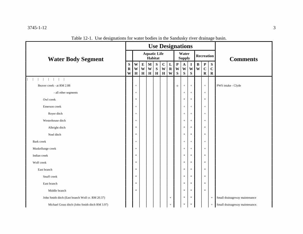
3745-1-12
3
Table 12-1. Use designations for water bodies in the Sandusky river drainage basin.
Water Body Segment
Use Designations
Comments
Aquatic Life
Habitat
Water Supply
Recreation
SRW
WWH
EWH
MWH
S S H
CWH
LRW
P W S
A W S
I WS
BW
P CR
SCR
| | | | | | | |
Beaver creek - at RM 2.88 +
o
+ + + PWS intake - Clyde
- all other segments +
+ + +
Owl creek *
* * *
Emerson creek +
+ + +
Royer ditch +
+ + +
Westerhouse ditch +
+ + +
Albright ditch *
* * *
Noel ditch *
* * *
Bark creek +
+ + +
Muskellunge creek +
+ + +
Indian creek *
* * *
Wolf creek *
* * *
East branch *
* * *
Snuff creek *
* * *
East branch *
* * *
Middle branch *
* * *
John Smith ditch (East branch Wolf cr. RM 20.37) +
* * + Small drainageway maintenance
Michael Gruss ditch (John Smith ditch RM 3.97) +
* * + Small drainageway maintenance.

3745-1-12
4
Table 12-1. Use designations for water bodies in the Sandusky river drainage basin.
Water Body Segment
Use Designations
Comments
Aquatic Life
Habitat
Water Supply
Recreation
SRW
WWH
EWH
MWH
S S H
CWH
LRW
P W S
A W S
I WS
BW
P CR
SCR
| | | | | | | |
Sugar creek *
* * *
Spicer creek *
* * *
Morrison creek *
* * *
Willow creek *
* * *
Unnamed tributary (Willow creek RM 0.88) o
o Small drainageway maintenance.
Rock creek +
+ + +
East branch *
* * *
Armstrong & Beighly ditch *
* * *
Carpenter ditch *
* * *
Gibson creek *
* * *
Bells run *
* * *
Honey creek - at RM 28.35 *
o
* * * PWS intake - Attica
- co. rte. 19 (RM 1.1) to the mouth +
+ + + HELP ecoregion - impounded
- all other segments *
* * *
Buckeye creek +
+ + +
Silver creek *
* * *
Slee ditch (Silver creek RM 0.72) +
+ + +
Eicholtz ditch *
* * *
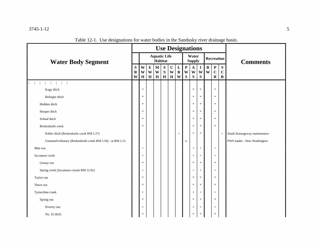
3745-1-12
5
Table 12-1. Use designations for water bodies in the Sandusky river drainage basin.
Water Body Segment
Use Designations
Comments
Aquatic Life
Habitat
Water Supply
Recreation
SRW
WWH
EWH
MWH
S S H
CWH
LRW
P W S
A W S
I WS
BW
P CR
SCR
| | | | | | | |
Kagy ditch *
* * *
Bolinger ditch *
* * *
Hedden ditch *
* * *
Hooper ditch *
* * *
Schaaf ditch *
* * *
Brokenknife creek *
* * *
Kibler ditch (Brokenknife creek RM 5.27) +
* * + Small drainageway maintenance
Unnamed tributary (Brokenknife creek RM 5.50) - at RM 2.15
o
PWS intake - New Washington
Mile run +
+ + +
Sycamore creek +
+ + +
Greasy run *
* * *
Spring creek (Sycamore creeek RM 12.92) +
+ + +
Taylor run *
* * *
Thorn run *
* * *
Tymochtee creek +
+ + +
Spring run *
* * *
Poverty run +
+ + +
No. 32 ditch *
* * *

3745-1-12
6
Table 12-1. Use designations for water bodies in the Sandusky river drainage basin.
Water Body Segment
Use Designations
Comments
Aquatic Life
Habitat
Water Supply
Recreation
SRW
WWH
EWH
MWH
S S H
CWH
LRW
P W S
A W S
I WS
BW
P CR
SCR
| | | | | | | |
Little Tymochtee creek *
* * *
Hart ditch *
* * *
Browns run *
* * *
Veith ditch *
* * *
Lick run *
* * *
Baughman run *
* * *
Blake ditch *
* * *
Perkins run *
* * *
Oak run *
* * *
Sugar run *
* * *
Warpole creek *
* * *
St. James run *
* * *
Unnamed tributary (Tymochtee creek RM 40.30) +
+ + + HELP ecoregion - channel modification.
Little Tymochtee creek *
* * *
Reevhorn run *
* * *
Pawpaw run *
* * *
Pawpaw run +
+ + +
Unnamed tributary (Pawpaw run RM 4.17) +
+ + + HELP ecoregion - channel modification.

3745-1-12
7
Table 12-1. Use designations for water bodies in the Sandusky river drainage basin.
Water Body Segment
Use Designations
Comments
Aquatic Life
Habitat
Water Supply
Recreation
SRW
WWH
EWH
MWH
S S H
CWH
LRW
P W S
A W S
I WS
BW
P CR
SCR
| | | | | | | |
Carroll ditch +
+ + + HELP ecoregion - channel modification.
Enoch creek +
+ + +
Blood run +
+ + +
Prairie run +
+ + +
Thompson ditch +
+ + + HELP ecoregion - channel modification.
Layton ditch *
* * *
Sugar run +
+ + +
Negro run +
+ + +
Spring branch +
+ + +
Kiser run *
* * *
Porcupine creek *
* * *
Cranberry run *
* * *
Rock run +
+ + +
Little Sandusky river +
+ + +
Honey run *
* * *
Unnamed tributary (little Sandusky river RM 8.93) +
+ + + HELP ecoregion - channel modification.
Broken Sword creek +
+ + +
Indian run *
* * *

3745-1-12
8
Table 12-1. Use designations for water bodies in the Sandusky river drainage basin.
Water Body Segment
Use Designations
Comments
Aquatic Life
Habitat
Water Supply
Recreation
SRW
WWH
EWH
MWH
S S H
CWH
LRW
P W S
A W S
I WS
BW
P CR
SCR
| | | | | | | |
Brandywine creek *
* * *
Red run *
* * *
Grass run *
* * *
Gray Eye run +
+ + +
West north Robinson run (Sandusky river RM 121.19) +
+ + +
East north Robinson run (Sandusky river RM 122.09) +
+ + +
Loss creek +
+ + +
South fork +
+ + +
Paramour creek +
+ + +
Crestline STP tributary (Westerly creek / Paramour creek RM 1.92) *
* * *
Crestline tributary (West Crestline tributary / Paramour creek RM 2.88)
*
* * *
PPG tributary (Paramour creek RM 5.13) +
+ + +
Allen run +
+ + +
South creek +
+ + +
Raccoon creek - at RM 13.1 +
+
+ + + PWS intake - Clyde (formerly)
- all other segments +
+ + +
Little Raccoon creek +
+ + +

3745-1-12
9
Table 12-1. Use designations for water bodies in the Sandusky river drainage basin.
Water Body Segment
Use Designations
Comments
Aquatic Life
Habitat
Water Supply
Recreation
SRW
WWH
EWH
MWH
S S H
CWH
LRW
P W S
A W S
I WS
BW
P CR
SCR
| | | | | | | |
Buck creek +
+ + +
Pickerel creek +
+ + +
Strong creek *
* * *
Fuller creek *
* * *
Little Pickerel creek +
+ + + Inland trout stream
Cold creek - Blue Hole (RM 4.28) to confluence with Lake Erie +
+ + + Inland trout stream
- all other segments *
* * *
Cold creek tributaries downstream of Blue Hole *
* * *
Mills creek +
+ + +
Caswell ditch (Mills creek RM 3.95) +
+ + +
Snyders ditch - at RMs 5.0 and 5.5 +
o
+ + + HELP ecoregion - channel modification;
PWS intakes - Bellevue. - all other segments +
+ + + HELP ecoregion - channel modification.
Pipe creek +
+ + +
Plum brook *
* * *
Sawmill creek +
+ + +
SRW = state resource water; WWH = warmwater habitat; EWH = exceptional warmwater habitat; MWH = modified warmwater habitat; SSH = seasonal salmonid habitat; CWH = coldwater habitat; LRW = limited resource water; PWS = public water supply; AWS = agricultural water supply; IWS = industrial water supply; BW = bathing water; PCR = primary contact recreation; SCR = secondary contact recreation.

3745-1-12 10 Appendix Figure 1. Sandusky river drainage basin.
-IV D []]IITJ
Kel leys Island
Huron
Lakes
Rivers
County Boundaries
Cit ies

3745-1-12 11 Effective: 6/16/2011 R.C. 119.032 rule review date: 6/16/2016 Promulgated Under: R.C. 119.03 Statutory Authority: R.C. 6111.041 Rule Amplifies: R.C. 6111.041 Prior Effective Dates: 4/4/1985, 8/19/1985, 7/28/1986, 4/21/1992, 4/26/1997, 7/31/1998, 7/21/2002, 4/1/2007

3745-1-13 Central Ohio tributaries drainage basin.
(A) The water bodies listed in table 13-1 of this rule are ordered from downstream to upstream.Tributaries of a water body are indented. The aquatic life habitat, water supply andrecreation use designations are defined in rule 3745-1-07 of the Administrative Code. Thestate resource water use designation is defined in rule 3745-1-05 of the Administrative Code.The most stringent criteria associated with any one of the use designations assigned to awater body will apply to that water body.
(B) Figure 1 of the appendix to this rule is a generalized map of the central Ohio tributariesdrainage basin.
(C) RM, as used in this rule, stands for river mile and refers to the method used by the Ohioenvironmental protection agency to identify locations along a water body. Mileage isdefined as the lineal distance from the downstream terminus (i.e., mouth) and moving in anupstream direction.
(D) The following symbols are used throughout this rule:
* Designated use based on the 1978 water quality standards;
+ Designated use based on the results of a biological field assessment performed by theOhio environmental protection agency;
o Designated use based on justification other than the results of a biological fieldassessment performed by the Ohio environmental protection agency; and
L An L in the warmwater habitat column signifies that the water body segment isdesignated limited warmwater habitat.

3745-1-13 2
Table 13-1. Use designations for water bodies in the central Ohio tributaries drainage basin.
Water Body Segment
Use Designations
CommentsAquatic Life
HabitatWaterSupply Recreation
SRW
WWH
EWH
MWH
SSH
CWH
LRW
PWS
AWS
IWS
BW
PCR
SCR
| | | | | | | |
Duck creek + + + +
Killwell run * * * *
Burch's run * * * *
Nigger run * * * *
Sugar creek * * * *
Reeds run * * * *
Whipple run * * * *
East fork Duck creek *L * * * Acid mine drainage. Varied criteria yeararound: exempt from the WWH totaldissolved solids, pH, iron and zinc criteria.
Pawpaw creek + + + +
Middle fork Duck creek + + + +
Otterslide run *L * * * Acid mine drainage. Varied criteria yeararound: exempt from the WWH totaldissolved solids, pH, iron and zinc criteria.
Mare run *L * * * Acid mine drainage. Varied criteria yeararound: exempt from the WWH totaldissolved solids, pH, iron and zinc criteria.
Camp run *L * * * Acid mine drainage. Varied criteria yeararound: exempt from the WWH totaldissolved solids, pH, iron and zinc criteria.

3745-1-13 3
Table 13-1. Use designations for water bodies in the central Ohio tributaries drainage basin.
Water Body Segment
Use Designations
CommentsAquatic Life
HabitatWaterSupply Recreation
SRW
WWH
EWH
MWH
SSH
CWH
LRW
PWS
AWS
IWS
BW
PCR
SCR
| | | | | | | |
Rocky run *L * * * Acid mine drainage. Varied criteria yeararound: exempt from the WWH totaldissolved solids, pH, iron and zinc criteria.
Creighton run *L * * * Acid mine drainage. Varied criteria yeararound: exempt from the WWH totaldissolved solids, pH, iron and zinc criteria.
Road fork *L * * * Acid mine drainage. Varied criteria yeararound: exempt from the WWH totaldissolved solids, pH, iron and zinc criteria.
Flag run *L * * * Acid mine drainage. Varied criteria yeararound: exempt from the WWH totaldissolved solids, pH, iron and zinc criteria.
Schwab run *L * * * Acid mine drainage. Varied criteria yeararound: exempt from the WWH totaldissolved solids, pH, iron and zinc criteria.
Elk fork *L * * * Acid mine drainage. Varied criteria yeararound: exempt from the WWH totaldissolved solids, pH, iron and zinc criteria.
Greasy run *L * * * Acid mine drainage. Varied criteria yeararound: exempt from the WWH totaldissolved solids, pH, iron and zinc criteria.
McBride run *L * * * Acid mine drainage. Varied criteria yeararound: exempt from the WWH totaldissolved solids, pH, iron and zinc criteria.
Barnes run *L * * * Acid mine drainage. Varied criteria yeararound: exempt from the WWH totaldissolved solids, pH, iron and zinc criteria.

3745-1-13 4
Table 13-1. Use designations for water bodies in the central Ohio tributaries drainage basin.
Water Body Segment
Use Designations
CommentsAquatic Life
HabitatWaterSupply Recreation
SRW
WWH
EWH
MWH
SSH
CWH
LRW
PWS
AWS
IWS
BW
PCR
SCR
| | | | | | | |
West fork *L * * * Acid mine drainage. Varied criteria yeararound: exempt from the WWH totaldissolved solids, pH, iron and zinc criteria.
Wolfpen run *L * * * Acid mine drainage. Varied criteria yeararound: exempt from the WWH totaldissolved solids, pH, iron and zinc criteria.
West fork Duck creek + + + +
Goose hollow * * * *
Buffalo run o * * * Acid mine drainage.
Warren run *L * * * Acid mine drainage. Varied criteria yeararound: exempt from the WWH totaldissolved solids criterion.
Elk run * * * *
Salt run + + + +
Otter run * * * *
Dog run - at RM 1.35 * o * * *
- all other segments * * * *
Wolf run - at RM 0.7 * o * * *
- all other segments * * * *
Johnny Woods river *L * * * Acid mine drainage. Varied criteria yeararound: exempt from the WWH totaldissolved solids criterion.

3745-1-13 5
Table 13-1. Use designations for water bodies in the central Ohio tributaries drainage basin.
Water Body Segment
Use Designations
CommentsAquatic Life
HabitatWaterSupply Recreation
SRW
WWH
EWH
MWH
SSH
CWH
LRW
PWS
AWS
IWS
BW
PCR
SCR
| | | | | | | |
Lick run * * * *
Little Muskingum river * + + + +
Mill run * * * *
Coal run * * * *
Lick run * * * *
Long run * * * *
Eightmile creek * * * *
Potpie run * * * *
Cow run * * * *
Moss run * * * *
Baker run * * * *
Fifteenmile creek * * * *
Goss fork * * * *
Deans fork * * * *
Sycamore fork * * * *
Bear run * * * *
Hog run * * * *
Archers fork * * * *

3745-1-13 6
Table 13-1. Use designations for water bodies in the central Ohio tributaries drainage basin.
Water Body Segment
Use Designations
CommentsAquatic Life
HabitatWaterSupply Recreation
SRW
WWH
EWH
MWH
SSH
CWH
LRW
PWS
AWS
IWS
BW
PCR
SCR
| | | | | | | |
Ward branch * * * *
Coal run * * * *
Cady run * * * *
Jackson run * * * *
Irish run * * * *
Wingett run * * * *
Haught run * * * *
Sackett run * * * *
Tice run * * * *
Wilson run * * * *
Clear fork * * * *
Witten run + + + +
Rias run * * * *
Indian run * * * *
Robinson run * * * *
Death run * * * *
Devoa run * * * *
Oldcamp run * * * *

3745-1-13 7
Table 13-1. Use designations for water bodies in the central Ohio tributaries drainage basin.
Water Body Segment
Use Designations
CommentsAquatic Life
HabitatWaterSupply Recreation
SRW
WWH
EWH
MWH
SSH
CWH
LRW
PWS
AWS
IWS
BW
PCR
SCR
| | | | | | | |
Straight fork * * * *
Browns run * * * *
Biglick run * * * *
Pigeonroost run * * * *
Rockcamp run * * * *
Laurel run * * * *
Witten fork * * * *
Trail run * * * *
Dogskin run * * * *
Wildcat run * * * *
Dismal creek * * * *
Walnutcamp run * * * *
Alum run * * * *
Millers fork * * * *
Woods run * * * *
Coal run * * * *
Haren run * * * *
Buhrs run * * * *

3745-1-13 8
Table 13-1. Use designations for water bodies in the central Ohio tributaries drainage basin.
Water Body Segment
Use Designations
CommentsAquatic Life
HabitatWaterSupply Recreation
SRW
WWH
EWH
MWH
SSH
CWH
LRW
PWS
AWS
IWS
BW
PCR
SCR
| | | | | | | |
Wolfpen run * * * *
Town fork * * * *
Rich fork * * * *
Left prong * * * *
Brister fork * * * *
Cranenest fork * * * *
Mutton run * * * *
Sheets run * * * *
Allen run * * * *
Bells run * * * *
Newell run * * * *
Northup run * * * *
Kerr run * * * *
Bolivian run * * * *
Danas run * * * *
Reynolds run * * * *
Davis run * * * *
Reas run * * * *

3745-1-13 9
Table 13-1. Use designations for water bodies in the central Ohio tributaries drainage basin.
Water Body Segment
Use Designations
CommentsAquatic Life
HabitatWaterSupply Recreation
SRW
WWH
EWH
MWH
SSH
CWH
LRW
PWS
AWS
IWS
BW
PCR
SCR
| | | | | | | |
Leith run + + + +
Sheets run * * * *
Collins run * * * *
Mill creek * * * *
Jims run * * * *
Miller run * * * *
Deadhorse run * * * *
Parker run * * * *
Barnes run * * * *
Narrows run * * * *
Patton run * * * *
Pool run * * * *
Havely run * * * *
Texas creek * * * *
Bares run * * * *
Fisher run * * * *
Ueltsch run * * * *
Narrows run * * * *

3745-1-13 10
Table 13-1. Use designations for water bodies in the central Ohio tributaries drainage basin.
Water Body Segment
Use Designations
CommentsAquatic Life
HabitatWaterSupply Recreation
SRW
WWH
EWH
MWH
SSH
CWH
LRW
PWS
AWS
IWS
BW
PCR
SCR
| | | | | | | |
Litman run * * * *
Muhleman run * * * *
Opossum creek o * * *
Gilmore run o * * *
Alum run o * * *
Watkins fork o * * *
Pine run o * * *
Oliver run o * * *
Wildcat run o * * *
Bishop creek * * * *
Sunfish creek - Paine run to Nigger run + + + +
- at RM 25 + + + + +
- all other segments + + + +
Nigger run * * * *
Paine run * * * *
Ackerson run * * * *
Piney fork + + + + *
East fork + + + +

3745-1-13 11
Table 13-1. Use designations for water bodies in the central Ohio tributaries drainage basin.
Water Body Segment
Use Designations
CommentsAquatic Life
HabitatWaterSupply Recreation
SRW
WWH
EWH
MWH
SSH
CWH
LRW
PWS
AWS
IWS
BW
PCR
SCR
| | | | | | | |
Standingstone run - RM 0.5 to the mouth + + + +
- all other segments + + + +
Death creek * * * *
Baker fork + + + *
Grassy creek * * * *
Wheeler run * * * *
Gardner run * * * *
Stillhouse run * * * *
Blair run * * * *
Big run + + + *
Captina creek - confluence with North and South forks to st. rte. 7 (RM 0.8) + + + +
- st. rte. 7 to the mouth + + + +
Cat run + + + +
Moore run * * * *
Peavine creek * * * *
Rocky fork * * * *
Anderson run * * * *
Bend fork - headwaters to Joy fork (RM 4.0) + + + +

3745-1-13 12
Table 13-1. Use designations for water bodies in the central Ohio tributaries drainage basin.
Water Body Segment
Use Designations
CommentsAquatic Life
HabitatWaterSupply Recreation
SRW
WWH
EWH
MWH
SSH
CWH
LRW
PWS
AWS
IWS
BW
PCR
SCR
| | | | | | | |
- Joy fork to the mouth + + + +
Millers run * * * *
Joy fork * * * *
Packsaddle run * * * *
Crabapple creek * * * *
Piney creek * * * *
Long run + + + +
Casey run * * * *
Berrys run * * * *
Reeves hollow * * * *
Mikes run * * * *
South fork + + + *
Brushy creek * * * *
Flag run * * * *
Cranenest creek * * * *
Millers run * * * *
Slope creek - at RM 1.85 * o * * *
- all other segments * * * *

3745-1-13 13
Table 13-1. Use designations for water bodies in the central Ohio tributaries drainage basin.
Water Body Segment
Use Designations
CommentsAquatic Life
HabitatWaterSupply Recreation
SRW
WWH
EWH
MWH
SSH
CWH
LRW
PWS
AWS
IWS
BW
PCR
SCR
| | | | | | | |
North fork - headwaters to Long run (RM 4.0) + + + +
- Long run to the mouth + + + +
Jakes run * * * *
Long run + + + *
Little Captina creek * * * *
Pipe creek + + + * Acid mine drainage
Big run - New Nacco mine #3 portal to confluence with Ohio river *L * * * Acid mine drainage. Varied criteria yeararound: exempt from the WWH totaldissolved solids criterion.
- all other segments + + + * Acid mine drainage
Wegee creek + * * * Acid mine drainage
McMahon creek + + + +
Brooks run * * * *
Trough run * * * *
Rock run * * * *
Little McMahon creek - Chambers run (RM 5.8) to the mouth + + + + Acid mine drainage
- at RM 6.6 * + * * *
- all other segments * * * *
Stillhouse run * * * *

3745-1-13 14
Table 13-1. Use designations for water bodies in the central Ohio tributaries drainage basin.
Water Body Segment
Use Designations
CommentsAquatic Life
HabitatWaterSupply Recreation
SRW
WWH
EWH
MWH
SSH
CWH
LRW
PWS
AWS
IWS
BW
PCR
SCR
| | | | | | | |
Kings run + + + + Acid mine drainage
Aults run + + + + Acid mine drainage
Chambers run * * * *
Williams creek + + + +
Welsh run * * * *
Porterfield run * * * *
Hutchison run * * * *
Neffs run * * * *
Anderson run * * * *
Brush run * * * *
Roberts run * * * *
Barkcamp creek * * * *
Indian run * * * *
Whisky run * * * *
Moore run * * * *
Wheeling creek *L * * * Acid mine drainage. Varied criteria yeararound: exempt from the WWH totaldissolved solids criterion.
Frazier run * * * *

3745-1-13 15
Table 13-1. Use designations for water bodies in the central Ohio tributaries drainage basin.
Water Body Segment
Use Designations
CommentsAquatic Life
HabitatWaterSupply Recreation
SRW
WWH
EWH
MWH
SSH
CWH
LRW
PWS
AWS
IWS
BW
PCR
SCR
| | | | | | | |
Slaughterhouse run * * * *
Flat run * * * *
McMonies run * * * *
Steep run * * * *
Town run + + + +
Fall run * * * *
Jug run - at RM 3.18 * o * * *
- all other segments * * * *
Sloan run * * * *
Cox run * * * *
Patton run * * * *
Pogue run * * * *
Loves run * * * *
McCracken run * * * *
Crabapple creek - Campbell creek (RM 1.0) to the mouth + + + + WAP ecoregion - mine affected
- all other segments + + + +
Campbell creek * * * *
Ross run * * * *

3745-1-13 16
Table 13-1. Use designations for water bodies in the central Ohio tributaries drainage basin.
Water Body Segment
Use Designations
CommentsAquatic Life
HabitatWaterSupply Recreation
SRW
WWH
EWH
MWH
SSH
CWH
LRW
PWS
AWS
IWS
BW
PCR
SCR
| | | | | | | |
Glenns run * * * *
Nixon run * * * *
Patton run * * * *
Buckeye run * * * *
Patton run * * * *
Deep run * * * *
Short creek *L * * * Acid mine drainage. Varied criteria yeararound: exempt from the WWH totaldissolved solids criterion.
Williamson run * * * *
Little Short creek *L * * * Acid mine drainage. Varied criteria yeararound: exempt from the WWH totaldissolved solids criterion.
Parkers run * * * *
Coal run *L * * * Acid mine drainage. Varied criteria yeararound: exempt from the WWH totaldissolved solids criterion.
Jug run * * * *
Dry fork * * * *
Piney fork *L * * * Acid mine drainage. Varied criteria yeararound: exempt from the WWH totaldissolved solids criterion.

3745-1-13 17
Table 13-1. Use designations for water bodies in the central Ohio tributaries drainage basin.
Water Body Segment
Use Designations
CommentsAquatic Life
HabitatWaterSupply Recreation
SRW
WWH
EWH
MWH
SSH
CWH
LRW
PWS
AWS
IWS
BW
PCR
SCR
| | | | | | | |
Cabbage fork * * * *
Henderson creek * * * *
Thompson creek * * * *
Little Piney fork * * * *
Harrah run * * * *
Long run * * * *
Perrin run * * * *
Goose run * * * *
North fork * * * *
Coal run * * * *
Flag run * * * *
Skelley creek * * * *
Flag run * * * *
Middle fork + + + + WAP ecoregion - mine affected
Sally Buffalo creek (Middle fork RM 6.33) + + + + WAP ecoregion - mine affected
South fork * * * *
Little Rush run * * * *
Rush run * * * *

3745-1-13 18
Table 13-1. Use designations for water bodies in the central Ohio tributaries drainage basin.
Water Body Segment
Use Designations
CommentsAquatic Life
HabitatWaterSupply Recreation
SRW
WWH
EWH
MWH
SSH
CWH
LRW
PWS
AWS
IWS
BW
PCR
SCR
| | | | | | | |
Blues run * * * *
Salt run * * * *
Blockhouse Hollow run (Ohio river RM 905.3) + * + Irretrievable flow modification
Tarrs run * * * *
Cross creek + + + +
Dry fork - headwaters to unnamed tributary (RM 0.5) + + + +
- unnamed tributary (RM 0.5) to the mouth + + + + Acid mine drainage
Unnamed tributary (Dry fork RM 0.5) + + + + Acid mine drainage
Wintersville "E" tributary (Dry fork RM 4.55) + + + +
McIntyre creek + + + *
Longs run * * * *
Polecat hollow * * * *
Slabcamp creek * * * *
Slab run * * * *
Little McIntyre creek * * * *
Unnamed tributary (Cross creek RM 8.7) + + + + Acid mine drainage
Barber Hollow run + + + +
Cedar Lick run * * * *

3745-1-13 19
Table 13-1. Use designations for water bodies in the central Ohio tributaries drainage basin.
Water Body Segment
Use Designations
CommentsAquatic Life
HabitatWaterSupply Recreation
SRW
WWH
EWH
MWH
SSH
CWH
LRW
PWS
AWS
IWS
BW
PCR
SCR
| | | | | | | |
Cedar Lick creek + + + +
Clay Lick creek * * * *
Salem creek + + + +
Grassy run * * * *
Lea branch * * * *
North branch + + + +
Wells run * * * *
Permars run + + + +
Wills creek + + + + +
Rush run * * * *
Cedar creek * * * *
North fork + + + +
Island creek + + + +
Little Island creek * * * *
Hale run * * * *
Shelley run * * * *
Jeddo run + + + +
Croxton run * * * *

3745-1-13 20
Table 13-1. Use designations for water bodies in the central Ohio tributaries drainage basin.
Water Body Segment
Use Designations
CommentsAquatic Life
HabitatWaterSupply Recreation
SRW
WWH
EWH
MWH
SSH
CWH
LRW
PWS
AWS
IWS
BW
PCR
SCR
| | | | | | | |
Goose run + + + +
Brimstone run * * * *
Yellow creek + + + +
Rocky run * * * *
Hollow Rock run + + + +
Tarburner run * * * *
Carter run * * * *
North fork + + + +
Dry run * * * *
Salt run * + * * *
Unnamed tributary (North fork RM 6.1) + + + +
Salisbury run + + + + Acid mine drainage
Randolph run + + + + Acid mine drainage
Nancy run + + + +
Roses run * * * *
Riley run + + + + *
Brush creek * * * *
Dennis run * * * *

3745-1-13 21
Table 13-1. Use designations for water bodies in the central Ohio tributaries drainage basin.
Water Body Segment
Use Designations
CommentsAquatic Life
HabitatWaterSupply Recreation
SRW
WWH
EWH
MWH
SSH
CWH
LRW
PWS
AWS
IWS
BW
PCR
SCR
| | | | | | | |
Roach run * * * *
Lowery run * * * *
Town fork * * * *
Dry run * * * *
Culp run * * * *
Rippy run * * * *
Long run * * * *
Hildebrand run * * * *
Unnamed tributary (Yellow creek RM 12.0) + + + + Acid mine drainage
Roach run * * * *
Ralston run + + + +
Mathews run * * * *
Upper North fork + + + +
Hump run * * * *
Burgett run * * * *
Carroll run * * * *
Hazel run * * * *
Elkhorn creek + + + +
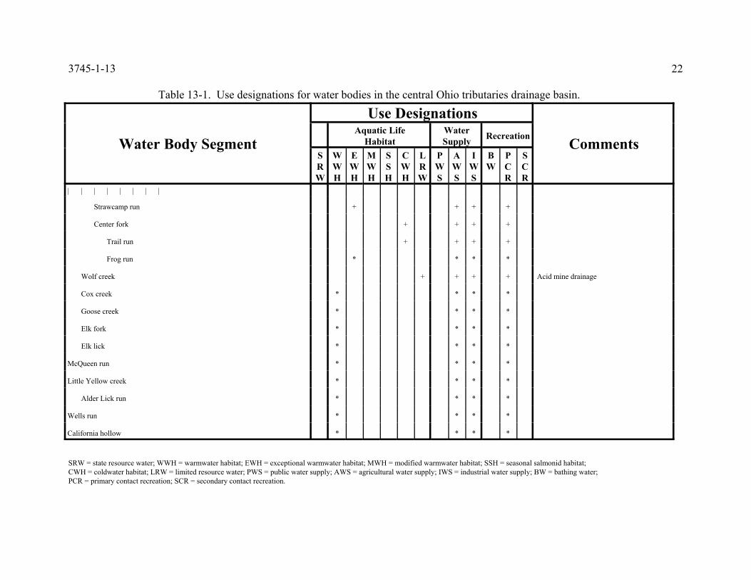
3745-1-13 22
Table 13-1. Use designations for water bodies in the central Ohio tributaries drainage basin.
Water Body Segment
Use Designations
CommentsAquatic Life
HabitatWaterSupply Recreation
SRW
WWH
EWH
MWH
SSH
CWH
LRW
PWS
AWS
IWS
BW
PCR
SCR
| | | | | | | |
Strawcamp run + + + +
Center fork + + + +
Trail run + + + +
Frog run * * * *
Wolf creek + + + + Acid mine drainage
Cox creek * * * *
Goose creek * * * *
Elk fork * * * *
Elk lick * * * *
McQueen run * * * *
Little Yellow creek * * * *
Alder Lick run * * * *
Wells run * * * *
California hollow * * * *
SRW = state resource water; WWH = warmwater habitat; EWH = exceptional warmwater habitat; MWH = modified warmwater habitat; SSH = seasonal salmonid habitat; CWH = coldwater habitat; LRW = limited resource water; PWS = public water supply; AWS = agricultural water supply; IWS = industrial water supply; BW = bathing water; PCR = primary contact recreation; SCR = secondary contact recreation.

3745-1-13 23
Appendix
Figure 1. Central Ohio tributaries drainage basin.

3745-1-13 24
Effective: 7/21/02
R.C. Section 119.032 rule review dates: 4/27/99, 9/19/01, 7/21/07
Promulgated under: R.C. Section 119.03Rule authorized by: R.C. Section 6111.041Rule amplifies: R.C. Section 6111.041Prior effective dates: 4/4/85, 8/19/85, 5/6/93, 4/26/97, 7/31/99

3745-1-14 Ashtabula river drainage basin.
(A) The water bodies listed in table 14-1 of this rule are ordered from downstream to upstream.Tributaries of a water body are indented. The aquatic life habitat, water supply andrecreation use designations are defined in rule 3745-1-07 of the Administrative Code. Thestate resource water use designation is defined in rule 3745-1-05 of the Administrative Code.The most stringent criteria associated with any one of the use designations assigned to awater body will apply to that water body.
(B) Figure 1 of the appendix to this rule is a generalized map of the Ashtabula river drainagebasin.
(C) RM, as used in this rule, stands for river mile and refers to the method used by the Ohioenvironmental protection agency to identify locations along a water body. Mileage isdefined as the lineal distance from the downstream terminus (i.e., mouth) and moving in anupstream direction.
(D) The following symbols are used throughout this rule:
* Designated use based on the 1978 water quality standards;
+ Designated use based on the results of a biological field assessment performed by theOhio environmental protection agency;
o Designated use based on justification other than the results of a biological fieldassessment performed by the Ohio environmental protection agency; and
L An L in the warmwater habitat column signifies that the water body segment isdesignated limited warmwater habitat.
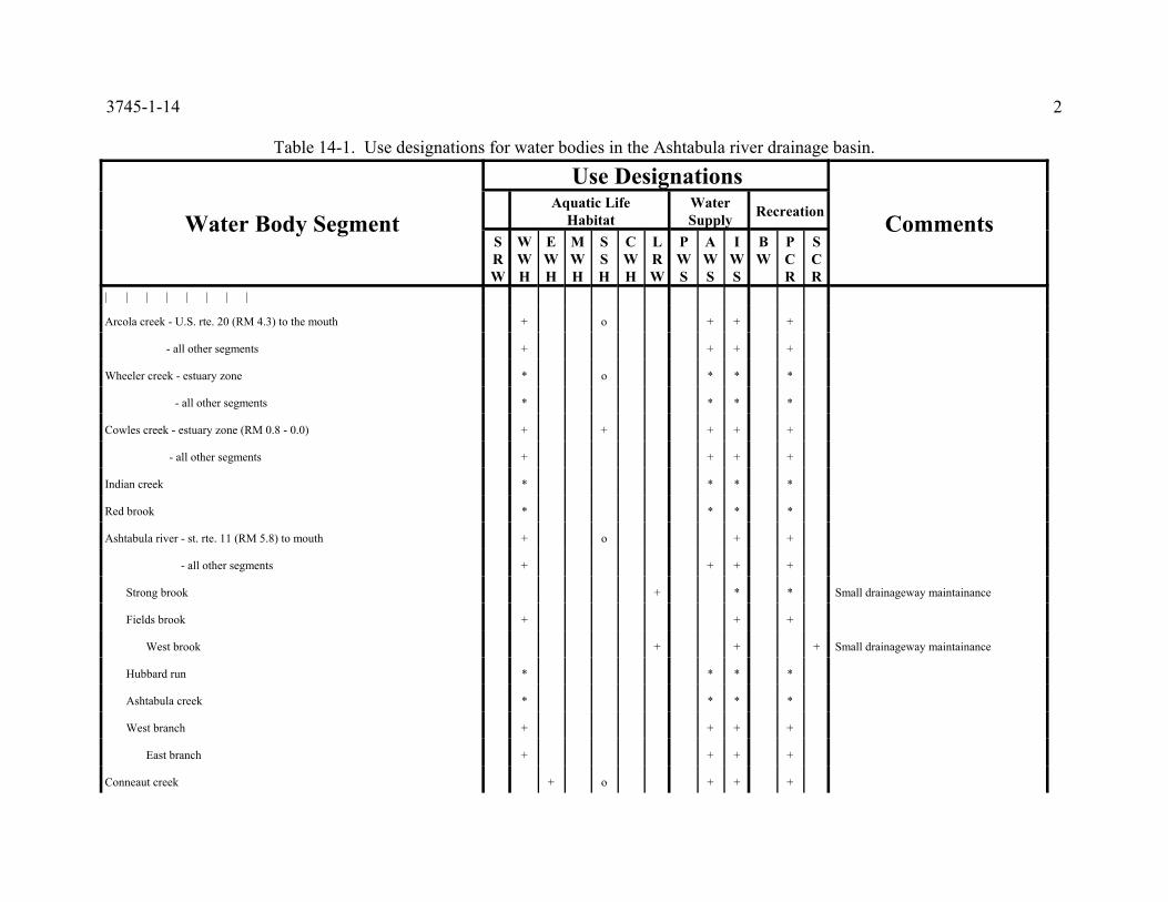
3745-1-14 2
Table 14-1. Use designations for water bodies in the Ashtabula river drainage basin.
Water Body Segment
Use Designations
CommentsAquatic Life
HabitatWaterSupply Recreation
SRW
WWH
EWH
MWH
SSH
CWH
LRW
PWS
AWS
IWS
BW
PCR
SCR
| | | | | | | |
Arcola creek - U.S. rte. 20 (RM 4.3) to the mouth + o + + +
- all other segments + + + +
Wheeler creek - estuary zone * o * * *
- all other segments * * * *
Cowles creek - estuary zone (RM 0.8 - 0.0) + + + + +
- all other segments + + + +
Indian creek * * * *
Red brook * * * *
Ashtabula river - st. rte. 11 (RM 5.8) to mouth + o + +
- all other segments + + + +
Strong brook + * * Small drainageway maintainance
Fields brook + + +
West brook + + + Small drainageway maintainance
Hubbard run * * * *
Ashtabula creek * * * *
West branch + + + +
East branch + + + +
Conneaut creek + o + + +

3745-1-14 3
Table 14-1. Use designations for water bodies in the Ashtabula river drainage basin.
Water Body Segment
Use Designations
CommentsAquatic Life
HabitatWaterSupply Recreation
SRW
WWH
EWH
MWH
SSH
CWH
LRW
PWS
AWS
IWS
BW
PCR
SCR
| | | | | | | |
Smokey run (Conneaut creek RM 3.5) o
Turkey creek o * * * *
SRW = state resource water; WWH = warmwater habitat; EWH = exceptional warmwater habitat; MWH = modified warmwater habitat; SSH = seasonal salmonid habitat; CWH = coldwater habitat; LRW = limited resource water; PWS = public water supply; AWS = agricultural water supply; IWS = industrial water supply; BW = bathing water;PCR = primary contact recreation; SCR = secondary contact recreation.
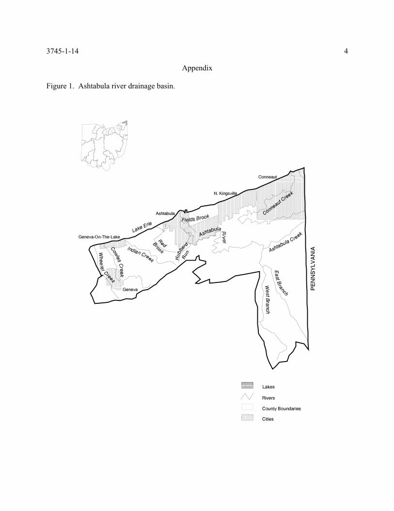
3745-1-14 4
Appendix
Figure 1. Ashtabula river drainage basin.

3745-1-14 5
Effective: 7/21/02
R.C. Section 119.032 rule review dates: 4/15/98, 9/19/01, 7/21/07
Promulgated under: R.C. Section 119.03Rule authorized by: R.C. Section 6111.041Rule amplifies: R.C. Section 6111.041Prior effective dates: 4/4/85, 8/19/85, 4/21/92, 9/23/92, 7/31/98

3745-1-15 Little Beaver creek drainage basin.
(A) The water bodies listed in table 15-1 of this rule are ordered from downstream to upstream.Tributaries of a water body are indented. The aquatic life habitat, water supply andrecreation use designations are defined in rule 3745-1-07 of the Administrative Code. Thestate resource water use designation is defined in rule 3745-1-05 of the Administrative Code.The most stringent criteria associated with any one of the use designations assigned to awater body will apply to that water body.
(B) Figure 1 of the appendix to this rule is a generalized map of the little Beaver creek drainagebasin.
(C) RM, as used in this rule, stands for river mile and refers to the method used by the Ohioenvironmental protection agency to identify locations along a water body. Mileage isdefined as the lineal distance from the downstream terminus (i.e., mouth) and moving in anupstream direction.
(D) The following symbols are used throughout this rule:
* Designated use based on the 1978 water quality standards;
+ Designated use based on the results of a biological field assessment performed by theOhio environmental protection agency;
o Designated use based on justification other than the results of a biological fieldassessment performed by the Ohio environmental protection agency; and
L An L in the warmwater habitat column signifies that the water body segment isdesignated limited warmwater habitat.

3745-1-15 2
Table 15-1. Use designations for water bodies in the little Beaver creek drainage basin.
Water Body Segment
Use Designations
CommentsAquatic Life
HabitatWaterSupply Recreation
SRW
WWH
EWH
MWH
SSH
CWH
LRW
PWS
AWS
IWS
BW
PCR
SCR
| | | | | | | |
Little Beaver creek + + * * +
Island run * * * *
Bieler run * * * *
North fork - Ohio-Pennsylvania state line to confluence with little Beaver creek
+ + * * +
Pine run * * * *
Brush run * * * *
Bull creek + * * +
Leslie run + * * +
Unnamed tributary + * * +
Little Bull creek * * * *
Turkey run * * * *
Stateline creek + * * +
West fork + * * +
East fork + * * +
Coalbank run * * * *
Painters run * * * *
Dilworth run * * * *
McCautry run * * * *

3745-1-15 3
Table 15-1. Use designations for water bodies in the little Beaver creek drainage basin.
Water Body Segment
Use Designations
CommentsAquatic Life
HabitatWaterSupply Recreation
SRW
WWH
EWH
MWH
SSH
CWH
LRW
PWS
AWS
IWS
BW
PCR
SCR
| | | | | | | |
Jordan run * * * *
Madden run * * * *
Beaverdam run * * * *
Honey creek * * * *
Harman run * * * *
Rough run * * * *
Longs run * * * *
Middle fork - spillway at Lisbon (RM 12.5) to Elkton rd. + * * +
- Elkton rd. (twp. rd. 901) to confluence with West fork * + * * +
- all other segments + * * +
Turkeyfoot run * * * *
Pine run * * * *
Elk run * * * *
Middle run * * * *
Stone mill run * * * *
East branch + * * +
Cherry Valley run + * * +
Nease tributary + + + +

3745-1-15 4
Table 15-1. Use designations for water bodies in the little Beaver creek drainage basin.
Water Body Segment
Use Designations
CommentsAquatic Life
HabitatWaterSupply Recreation
SRW
WWH
EWH
MWH
SSH
CWH
LRW
PWS
AWS
IWS
BW
PCR
SCR
| | | | | | | |
West fork - confluence with Brush creek to mouth + + * * +
- all other segments * * * *
Patterson * * * *
Peters run * * * *
Brush run * * * *
McCormick run * * * *
Big creek * * * *
Williard run * * * *
Cold run * * * *
SRW = state resource water; WWH = warmwater habitat; EWH = exceptional warmwater habitat; MWH = modified warmwater habitat; SSH = seasonal salmonid habitat; CWH = coldwater habitat; LRW = limited resource water; PWS = public water supply; AWS = agricultural water supply; IWS = industrial water supply; BW = bathing water;PCR = primary contact recreation; SCR = secondary contact recreation.

3745-1-15 5
Appendix
Figure 1. Little Beaver creek drainage basin.

3745-1-15 6
Effective: 7/21/02
R.C. Section 119.032 rule review dates: 9/19/01, 7/21/07
Promulgated under: R.C. Section 119.03Rule authorized by: R.C. Section 6111.041Rule amplifies: R.C. Section 6111.041Prior effective dates: 4/4/85, 7/28/86, 4/21/92
3745-1-16 Southeast Ohio tributaries drainage basin.
(A) The water bodies listed in table 16-1 of this rule are ordered from downstream to upstream.Tributaries of a water body are indented. The aquatic life habitat, water supply andrecreation use designations are defined in rule 3745-1-07 of the Administrative Code. Thestate resource water use designation is defined in rule 3745-1-05 of the Administrative Code.The most stringent criteria associated with any one of the use designations assigned to awater body will apply to that water body.
(B) Figure 1 of the appendix to this rule is a generalized map of the southeast Ohio tributariesdrainage basin.
(C) RM, as used in this rule, stands for river mile and refers to the method used by the Ohioenvironmental protection agency to identify locations along a water body. Mileage isdefined as the lineal distance from the downstream terminus (i.e., mouth) and moving in anupstream direction.
(D) The following symbols are used throughout this rule:
* Designated use based on the 1978 water quality standards;
+ Designated use based on the results of a biological field assessment performed by theOhio environmental protection agency;
o Designated use based on justification other than the results of a biological fieldassessment performed by the Ohio environmental protection agency; and
L An L in the warmwater habitat column signifies that the water body segment isdesignated limited warmwater habitat.

3745-1-16 2
Table 16-1. Use designations for water bodies in the southeast Ohio tributaries drainage basin.
Water Body Segment
Use Designations
CommentsAquatic Life
HabitatWaterSupply Recreation
SRW
WWH
EWH
MWH
SSH
CWH
LRW
PWS
AWS
IWS
BW
PCR
SCR
| | | | | | | |
Munn run * * * *
Little Scioto river * + + + +
Swauger Valley run + * * *
Bonser run + * * *
Plum fork + * * *
Oven lick + * * *
Dry run + * * *
Frederick creek + * * *
Skull creek + * * *
Falls creek + * * *
Rocky fork * + + + +
Long run + * * *
Harrison Furnace creek + * * *
Tattle creek + * * *
Yankee run + * * *
Sweet run + * * *
Higgins run + * * *
McConnel creek + * * *

3745-1-16 3
Table 16-1. Use designations for water bodies in the southeast Ohio tributaries drainage basin.
Water Body Segment
Use Designations
CommentsAquatic Life
HabitatWaterSupply Recreation
SRW
WWH
EWH
MWH
SSH
CWH
LRW
PWS
AWS
IWS
BW
PCR
SCR
| | | | | | | |
Bull run + * * *
Blue run + * * *
Back run + * * *
Buck run + * * *
Fallen Timber creek + * * *
Hunting run + * * *
Owl creek + * * *
Sand run + * * *
Laurel Lick run + * * *
Blue Ash run + * * *
Bear run * + + + +
Holland fork + * * *
Bucklick creek + * * *
Little Bucklick creek + * * *
Tattle creek + * * *
Scaffold lick + * * *
Laurel fork + * * *
Buckhorn creek + * * *

3745-1-16 4
Table 16-1. Use designations for water bodies in the southeast Ohio tributaries drainage basin.
Water Body Segment
Use Designations
CommentsAquatic Life
HabitatWaterSupply Recreation
SRW
WWH
EWH
MWH
SSH
CWH
LRW
PWS
AWS
IWS
BW
PCR
SCR
| | | | | | | |
Sugarcamp creek + * * *
Jacko run + * * *
Millstone run + * * *
Glade run + * * *
Dry run + * * *
Polecat creek + * * *
McDowell creek + * * *
Brushy fork + * * *
Pine creek * + + + +
Lick run * * * *
Sugar creek * * * *
North fork * * * *
Duck creek * * * *
Poplar fork * * * *
Sperry fork * * * *
Union branch * * * * *
Little Pine creek * * * *
Darby creek * * * * *

3745-1-16 5
Table 16-1. Use designations for water bodies in the southeast Ohio tributaries drainage basin.
Water Body Segment
Use Designations
CommentsAquatic Life
HabitatWaterSupply Recreation
SRW
WWH
EWH
MWH
SSH
CWH
LRW
PWS
AWS
IWS
BW
PCR
SCR
| | | | | | | |
Cannons creek * * * *
Cooney branch * * * * *
Bear run * * * * *
Turkeyfoot run * * * *
Howard run * * * * *
Hales creek * * * * *
Brady run * * * * *
Jackson fork * * * *
Youngs branch * * * * *
Brushy fork * * * * *
Olive creek * * * * *
Nigger creek * * * * *
Painter creek * * * * *
Patton run * * * *
Ginat run * * * *
Gervais run * * * *
Big Thief creek (Ohio river mile 334.2) + + + + Small drainageway maintainance
Winkler run (Ohio river mile 333.6) + + + + Small drainageway maintainance

3745-1-16 6
Table 16-1. Use designations for water bodies in the southeast Ohio tributaries drainage basin.
Water Body Segment
Use Designations
CommentsAquatic Life
HabitatWaterSupply Recreation
SRW
WWH
EWH
MWH
SSH
CWH
LRW
PWS
AWS
IWS
BW
PCR
SCR
| | | | | | | |
Shilling tributary (Winkler run RM 2.15) + + + + Small drainageway maintainance
Norman run * * * *
Osburn run *L * * * Acid mine drainage. Varied criteria yeararound: exempt from the WWH totaldissolved solids, pH, iron and zinc criteria.
Storms creek - headwaters to downstream boundary of Wayne national forest (RM 8.3)
* + + + +
- all other segments + + + +
Little Storms creek * + * * *
Hecla branch + * * *
Paddle fork * + * * *
Ice creek + + + +
Hog run + * * *
Little Ice creek + * * *
Sugar creek + * * *
Turkey fork + * * *
Ned fork + * * *
Dog fork + * * *
Lick creek * * * *

3745-1-16 7
Table 16-1. Use designations for water bodies in the southeast Ohio tributaries drainage basin.
Water Body Segment
Use Designations
CommentsAquatic Life
HabitatWaterSupply Recreation
SRW
WWH
EWH
MWH
SSH
CWH
LRW
PWS
AWS
IWS
BW
PCR
SCR
| | | | | | | |
Salliday creek * * * *
Buffalo creek * * * *
Symmes creek * + + + +
Big creek * * * *
McKinney creek * * * *
Rankin creek * * * *
Leatherwood creek * * * *
Venisonham creek * * * *
Dicks creek * * * *
Yellow creek * * * *
Sharps creek * * * *
Elkins creek * * * * *
Aaron creek * * * *
Long creek * * * *
Buckeye creek * * * *
Buck creek * * * *
Johns creek * * * * *
Buckeye creek * * * * *

3745-1-16 8
Table 16-1. Use designations for water bodies in the southeast Ohio tributaries drainage basin.
Water Body Segment
Use Designations
CommentsAquatic Life
HabitatWaterSupply Recreation
SRW
WWH
EWH
MWH
SSH
CWH
LRW
PWS
AWS
IWS
BW
PCR
SCR
| | | | | | | |
Brushy Buckeye creek * * * * *
Slab fork * * * * *
Pigeon creek * * * *
Buffalo creek * + + + +
Coulley fork * + + + +
Miller creek * * * * *
Little Buffalo creek * * * * *
Indian creek * * * * *
Little Buffalo creek * * * * *
Camp creek * * * * *
Trace creek * * * * *
Sand fork * * * *
Peter Cave creek * * * *
Wolf creek * * * * *
Black fork * * * * *
Dirtyface creek * * * * *
Clear fork * * * * *
Dicks creek * * * *

3745-1-16 9
Table 16-1. Use designations for water bodies in the southeast Ohio tributaries drainage basin.
Water Body Segment
Use Designations
CommentsAquatic Life
HabitatWaterSupply Recreation
SRW
WWH
EWH
MWH
SSH
CWH
LRW
PWS
AWS
IWS
BW
PCR
SCR
| | | | | | | |
Lefthand fork * * * * *
Huntingcamp creek * * * *
Cub run * * * *
Mackley run * * * *
Hewitt run * * * * *
Cherry fork * * * * *
Sugar run * * * * *
Indian Guyan creek + + + +
Bent creek * * * *
Bear creek * * * *
Fourmile creek * * * *
Fivemile creek * * * *
Slate run * * * *
Wolf creek * * * *
Wagner branch * * * *
Little Indian Guyan creek * * * *
Spring branch * * * *
Georges creek * * * *

3745-1-16 10
Table 16-1. Use designations for water bodies in the southeast Ohio tributaries drainage basin.
Water Body Segment
Use Designations
CommentsAquatic Life
HabitatWaterSupply Recreation
SRW
WWH
EWH
MWH
SSH
CWH
LRW
PWS
AWS
IWS
BW
PCR
SCR
| | | | | | | |
Lanes branch * * * *
Rocky fork * * * *
Johns creek * * * *
Drake fork * * * *
Perigen creek * * * *
Paddy creek * * * *
Twomile creek * * * *
Federal creek * * * *
Clean fork * * * *
Dirty fork * * * *
Stillhouse branch * * * *
Swan creek * * * *
Little Swan creek * * * *
Peters branch * * * *
Hildebrand run * * * *
Teens run * * * *
Burrels run * * * *
Raccoon creek - confluence of East and West branches (RM 111.9) to Sandy run
+ + + + Acid mine drainage

3745-1-16 11
Table 16-1. Use designations for water bodies in the southeast Ohio tributaries drainage basin.
Water Body Segment
Use Designations
CommentsAquatic Life
HabitatWaterSupply Recreation
SRW
WWH
EWH
MWH
SSH
CWH
LRW
PWS
AWS
IWS
BW
PCR
SCR
| | | | | | | |
- Sandy run (RM 95.52) to the mouth + + + +
Bear run * * * *
Bullskin creek + + + +
Little Bullskin creek + + + +
Burnt run * * * *
Rocklick creek * * * *
Clear fork + + + +
Claylick run + + + +
Little Claylick run * * * *
Fox branch * * * *
Rocky fork + + + *
Mud creek * * * *
Fork creek * * * *
Polecat run * * * *
Big Beaver creek
Little Beaver creek (Big Beaver creek RM 1.63) + + + +
Ryan run + + + +
Indian creek * * * *

3745-1-16 12
Table 16-1. Use designations for water bodies in the southeast Ohio tributaries drainage basin.
Water Body Segment
Use Designations
CommentsAquatic Life
HabitatWaterSupply Recreation
SRW
WWH
EWH
MWH
SSH
CWH
LRW
PWS
AWS
IWS
BW
PCR
SCR
| | | | | | | |
Little Indian creek + + + +
Plum run + + + *
Barren creek + + + +
Trace run + + + +
Little Raccoon creek - Lake Rupert + * + * * *
- at RM 30 + + + + + *
- all other segments + + + + +
Deer creek * * * * *
Keeton run * * * *
Spring run * * * *
Dickason run - headwaters to Dixon run (RM 1.3) + + + +
- Dixon run (RM 1.3) to the mouth + + + + Acid mine drainage
Kyger run o * * * Acid mine drainage
Tarcamp run + * * * Acid mine drainage
Goose run + + + + Acid mine drainage
Greasy run + + + + Acid mine drainage
Buffer run + + + + Acid mine drainage
Flint run + + + + Acid mine drainage

3745-1-16 13
Table 16-1. Use designations for water bodies in the southeast Ohio tributaries drainage basin.
Water Body Segment
Use Designations
CommentsAquatic Life
HabitatWaterSupply Recreation
SRW
WWH
EWH
MWH
SSH
CWH
LRW
PWS
AWS
IWS
BW
PCR
SCR
| | | | | | | |
Coal run + + + +
Rich run + + + + Acid mine drainage
Mulga run + * * * Acid mine drainage
Meadow run + + + +
Sand run + * * *
Tripp run * * * *
Sugar run + + + +
Johnson run * * * *
McConnel run * * * * *
Robinson run + + + +
Sugar run * * * *
Strongs run * + + + +
Williams run * * * * *
Opossum run + + + +
Flatlick run + + + +
Karr run + + + + Acid mine drainage
Indiancamp run + + + + Acid mine drainage
Rockcamp run + + + + Acid mine drainage
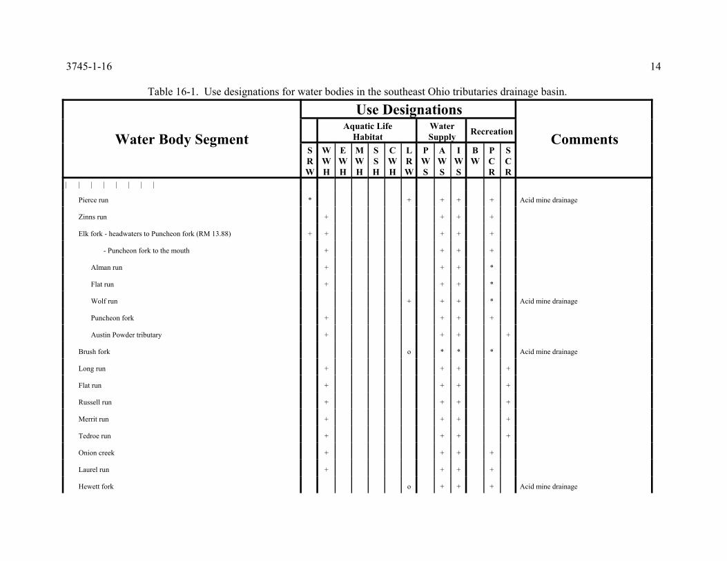
3745-1-16 14
Table 16-1. Use designations for water bodies in the southeast Ohio tributaries drainage basin.
Water Body Segment
Use Designations
CommentsAquatic Life
HabitatWaterSupply Recreation
SRW
WWH
EWH
MWH
SSH
CWH
LRW
PWS
AWS
IWS
BW
PCR
SCR
| | | | | | | |
Pierce run * + + + + Acid mine drainage
Zinns run + + + +
Elk fork - headwaters to Puncheon fork (RM 13.88) + + + + +
- Puncheon fork to the mouth + + + +
Alman run + + + *
Flat run + + + *
Wolf run + + + * Acid mine drainage
Puncheon fork + + + +
Austin Powder tributary + + + +
Brush fork o * * * Acid mine drainage
Long run + + + +
Flat run + + + +
Russell run + + + +
Merrit run + + + +
Tedroe run + + + +
Onion creek + + + +
Laurel run + + + +
Hewett fork o + + + Acid mine drainage

3745-1-16 15
Table 16-1. Use designations for water bodies in the southeast Ohio tributaries drainage basin.
Water Body Segment
Use Designations
CommentsAquatic Life
HabitatWaterSupply Recreation
SRW
WWH
EWH
MWH
SSH
CWH
LRW
PWS
AWS
IWS
BW
PCR
SCR
| | | | | | | |
Rockcamp creek + + + +
Coal run + + + +
Pine run + + + +
Grass run + + + +
Carbondale creek + + + + Acid mine drainage
Sandy run - headwaters to Lake Hope * * * * *
- all other segments * * * *
Little Sandy run * * * * *
Wheelabout creek * + + + +
Brushy fork * + + + +
Dunkle creek + + + +
Siverly creek + + + +
Unnamed tributary (Raccoon creek RM 98.96) + + + +
Rocky branch * * * *
Twomile run + + + +
East branch + + + + Acid mine drainage
West branch + + + +
Honey fork + + + +
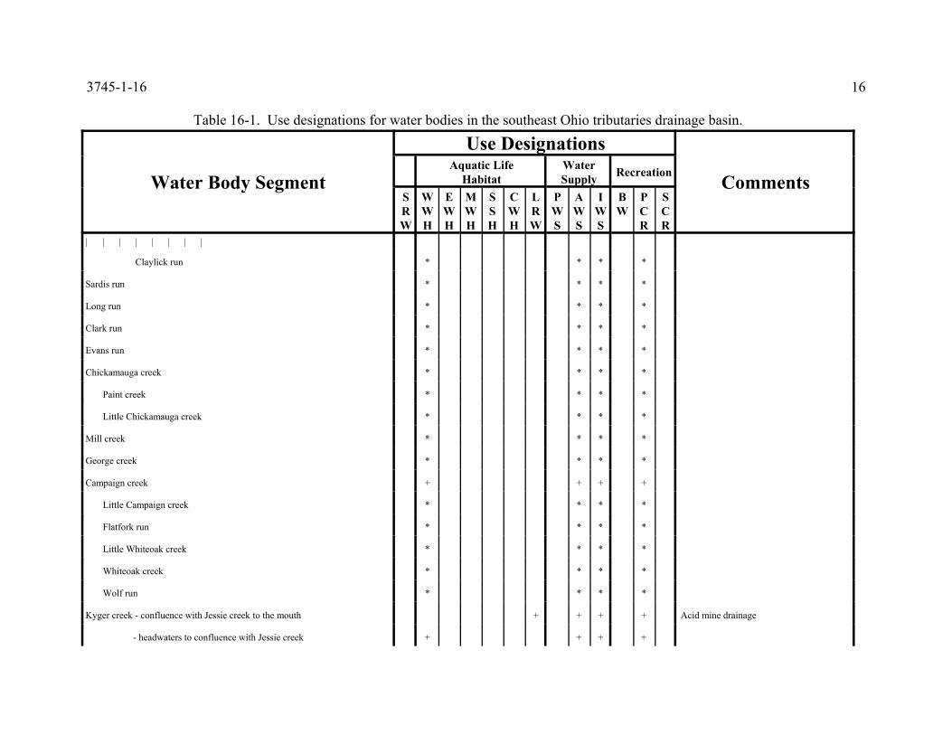
3745-1-16 16
Table 16-1. Use designations for water bodies in the southeast Ohio tributaries drainage basin.
Water Body Segment
Use Designations
CommentsAquatic Life
HabitatWaterSupply Recreation
SRW
WWH
EWH
MWH
SSH
CWH
LRW
PWS
AWS
IWS
BW
PCR
SCR
| | | | | | | |
Claylick run * * * *
Sardis run * * * *
Long run * * * *
Clark run * * * *
Evans run * * * *
Chickamauga creek * * * *
Paint creek * * * *
Little Chickamauga creek * * * *
Mill creek * * * *
George creek * * * *
Campaign creek + + + +
Little Campaign creek * * * *
Flatfork run * * * *
Little Whiteoak creek * * * *
Whiteoak creek * * * *
Wolf run * * * *
Kyger creek - confluence with Jessie creek to the mouth + + + + Acid mine drainage
- headwaters to confluence with Jessie creek + + + +

3745-1-16 17
Table 16-1. Use designations for water bodies in the southeast Ohio tributaries drainage basin.
Water Body Segment
Use Designations
CommentsAquatic Life
HabitatWaterSupply Recreation
SRW
WWH
EWH
MWH
SSH
CWH
LRW
PWS
AWS
IWS
BW
PCR
SCR
| | | | | | | |
Little Kyger creek + + + * Acid mine drainage
Turkey run + + + * Acid mine drainage
Stingy run + + + * Acid mine drainage
Jessie creek + + + * Acid mine drainage
Bell Lick run + * * *
Stores run * * * *
Silver run * * * *
Leading creek + + + + +
Dirt creek * * * *
Hysell run * * * *
Bailey run * * * *
Thomas fork * * * *
Long hollow * * * *
Little Leading creek * * * *
Malloons run * * * *
Parker run * * * *
Muddy fork * * * *
Dexter run * * * *

3745-1-16 18
Table 16-1. Use designations for water bodies in the southeast Ohio tributaries drainage basin.
Water Body Segment
Use Designations
CommentsAquatic Life
HabitatWaterSupply Recreation
SRW
WWH
EWH
MWH
SSH
CWH
LRW
PWS
AWS
IWS
BW
PCR
SCR
| | | | | | | |
Mud fork * * * *
Ogden run * * * *
Sisson run * * * *
Fivemile run * * * *
Forest run * * * *
Kerr run * * * *
Jesse run * * * *
Bowman run * * * *
German fork * * * *
Wolf run * * * *
Dunham run * * * *
Cabin creek * * * *
Jennie Walls run * * * *
Tupper run * * * *
Johns run * * * *
Mill run * * * *
Tanner run * * * *
Toms run * * * *
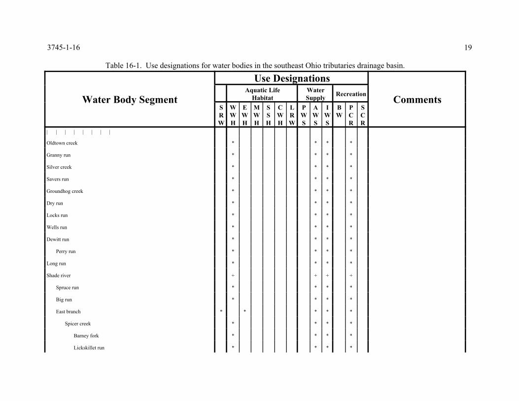
3745-1-16 19
Table 16-1. Use designations for water bodies in the southeast Ohio tributaries drainage basin.
Water Body Segment
Use Designations
CommentsAquatic Life
HabitatWaterSupply Recreation
SRW
WWH
EWH
MWH
SSH
CWH
LRW
PWS
AWS
IWS
BW
PCR
SCR
| | | | | | | |
Oldtown creek * * * *
Granny run * * * *
Silver creek * * * *
Savers run * * * *
Groundhog creek * * * *
Dry run * * * *
Locks run * * * *
Wells run * * * *
Dewitt run * * * *
Perry run * * * *
Long run * * * *
Shade river + + + +
Spruce run * * * *
Big run * * * *
East branch * * * * *
Spicer creek * * * *
Barney fork * * * *
Lickskillet run * * * *

3745-1-16 20
Table 16-1. Use designations for water bodies in the southeast Ohio tributaries drainage basin.
Water Body Segment
Use Designations
CommentsAquatic Life
HabitatWaterSupply Recreation
SRW
WWH
EWH
MWH
SSH
CWH
LRW
PWS
AWS
IWS
BW
PCR
SCR
| | | | | | | |
Big run * * * *
Joes creek * * * *
Meigs creek * * * *
Kappel hollow * * * *
Guthrie creek * * * *
Palk hollow * * * *
Dog hollow * * * *
Sugar run * * * *
Horse Cave creek * * * *
Straight Hollow run * * * *
East Horse Cave creek * * * *
Aumiller creek * * * *
Middle branch * * * * *
Elk run * * * *
Wolfpen run * * * *
Pratts fork * * * *
Long run * * * *
Spring branch * * * *

3745-1-16 21
Table 16-1. Use designations for water bodies in the southeast Ohio tributaries drainage basin.
Water Body Segment
Use Designations
CommentsAquatic Life
HabitatWaterSupply Recreation
SRW
WWH
EWH
MWH
SSH
CWH
LRW
PWS
AWS
IWS
BW
PCR
SCR
| | | | | | | |
West branch * * * *
Walker run * * * *
Oliver run * * * *
Kingsbury creek * * * *
Peach fork * * * *
Guyan run * * * *
Forked run - headwaters to Forked run reservoir * * * * *
- all other segments * * * *
Little Forked run * * * *
Sugarcamp run * * * *
Indian run * * * *
SRW = state resource water; WWH = warmwater habitat; EWH = exceptional warmwater habitat; MWH = modified warmwater habitat; SSH = seasonal salmonid habitat; CWH = coldwater habitat; LRW = limited resource water; PWS = public water supply; AWS = agricultural water supply; IWS = industrial water supply; BW = bathing water;PCR = primary contact recreation; SCR = secondary contact recreation.

3745-1-16 22
Appendix
Figure 1. Southeast Ohio tributaries drainage basin.

3745-1-16 23
Effective: 7/21/02
R.C. Section 119.032 rule review dates: 4/15/98, 9/19/01, 7/21/07
Promulgated under: R.C. Section 119.03Rule authorized by: R.C. Section 6111.041Rule amplifies: R.C. Section 6111.041Prior effective dates: 4/4/85, 8/19/85, 9/20/88, 4/21/92, 7/31/98

3745-1-17 Southwest Ohio tributaries drainage basin.
(A) The water bodies listed in table 17-1 of this rule are ordered from downstream to upstream.Tributaries of a water body are indented. The aquatic life habitat, water supply andrecreation use designations are defined in rule 3745-1-07 of the Administrative Code. Thestate resource water use designation is defined in rule 3745-1-05 of the Administrative Code.The most stringent criteria associated with any one of the use designations assigned to awater body will apply to that water body.
(B) Figure 1 of the appendix to this rule is a generalized map of the southwest Ohio tributariesdrainage basin. A generalized map of Ohio outlining the twenty-three major drainage basinsand listing associated rule numbers in Chapter 3745-1 of the Administrative Code is in figure1 of the appendix to rule 3745-1-08 of the Administrative Code.
(C) RM, as used in this rule, stands for river mile and refers to the method used by the Ohioenvironmental protection agency to identify locations along a water body. Mileage isdefined as the lineal distance from the downstream terminus (i.e., mouth) and moving in anupstream direction.
(D) The following symbols are used throughout this rule:
* Designated use based on the 1978 water quality standards;
+ Designated use based on the results of a biological field assessment performed by theOhio environmental protection agency;
o Designated use based on justification other than the results of a biological fieldassessment performed by the Ohio environmental protection agency; and
L An L in the warmwater habitat column signifies that the water body segment isdesignated limited warmwater habitat.
ACTION: Final DATE: 07/09/2009 8:50 AM
RB p(44517) pa(80698) d(208731) ra(196009) print date: 07/09/2009 9:03 PM

3745-1-17 2
Table 17-1. Use designations for water bodies in the southwest Ohio tributaries drainage basin.
Water Body Segment
Use Designations
CommentsAquatic Life
HabitatWaterSupply Recreation
SRW
WWH
EWH
MWH
SSH
CWH
LRW
PWS
AWS
IWS
BW
PCR
SCR
| | | | | | | |
Fivemile creek * * * *
Eightmile creek * * * *
Ninemile creek + + + +
Tenmile creek + + + +
Pond run * * * *
Twelvemile creek + + + +
Fagin run * * * *
Ferguson run * * * *
Briggs run * * * *
Little Indian creek * * * *
Boat run * * * *
Indian creek + + + +
Dry run * * * *
Colclaser run * * * *
Sugar creek * * * *
North fork * * * *
Stony fork * * * *
Bee run * * * *

3745-1-17 3
Table 17-1. Use designations for water bodies in the southwest Ohio tributaries drainage basin.
Water Body Segment
Use Designations
CommentsAquatic Life
HabitatWaterSupply Recreation
SRW
WWH
EWH
MWH
SSH
CWH
LRW
PWS
AWS
IWS
BW
PCR
SCR
| | | | | | | |
Little Indian creek * * * *
Ray run * * * *
Maple creek * * * *
Vinegar run * * * *
Bear creek + + + +
Crooked run - within Crooked run preserve o * * * *
- all other segments * * * *
Patterson run * * * *
Ryan run * * * *
Bullskin creek - Clermont-Brown county line to the Ohio river * + + + +
- all other segments + + + +
Big run * * * *
Slickaway run * * * *
East branch * * * *
Middle branch * * * *
West branch * * * *
Painter fork * * * *
Moon Hollow run * * * *

3745-1-17 4
Table 17-1. Use designations for water bodies in the southwest Ohio tributaries drainage basin.
Water Body Segment
Use Designations
CommentsAquatic Life
HabitatWaterSupply Recreation
SRW
WWH
EWH
MWH
SSH
CWH
LRW
PWS
AWS
IWS
BW
PCR
SCR
| | | | | | | |
Miranda run * * * *
Hog run * * * *
Whiteoak creek + + + + +
Big run * * * *
Lyon run * * * *
Boat run * * * *
Cochran run * * * *
Ross run * * * *
Opossum run * * * *
Town run + + + + + + Small drainageway maintenance
Walnut creek * + * + * + * +
Indian run * * * * *
Unity creek * * * * *
Miranda run * + * * + * + * +
Shot Pouch run * * * * *
Sterling run - Grant lake wildlife area (RM 5.4 to 3.0) o * * * *
Sterling run - at RM 6.47 + o + + + PWS intake - Mt. Orab
- all other segments + + + +

3745-1-17 5
Table 17-1. Use designations for water bodies in the southwest Ohio tributaries drainage basin.
Water Body Segment
Use Designations
CommentsAquatic Life
HabitatWaterSupply Recreation
SRW
WWH
EWH
MWH
SSH
CWH
LRW
PWS
AWS
IWS
BW
PCR
SCR
| | | | | | | |
Snapping Turtle run + + + +
Plum creek - Grant lake wildlife area (RM 0.53 to 0.0) o * * * *
- all other segments * * * *
Unnamed tributary (Sterling run RM 6.68) + + + +
Goose run * * * *
East fork - Middle run (RM 2.0) to North fork (RM 0.0) * + + + +
- at RM 5.13 + o + + + PWS intake - Village of Sardinia (formerly)
- all other segments + + + +
Turkeyhole run * * * *
Browns run * + * + * + * +
Middle run * * * *
Slabcamp run + + + +
Twin run * * * *
Bells run * + * + * + * +
Plum run * + * + * + * +
Sugar run * * * *
Unnamed tributary (East fork RM 12.38) + + + +
Unnamed tributary (East fork RM 14.35) + + + +

3745-1-17 6
Table 17-1. Use designations for water bodies in the southwest Ohio tributaries drainage basin.
Water Body Segment
Use Designations
CommentsAquatic Life
HabitatWaterSupply Recreation
SRW
WWH
EWH
MWH
SSH
CWH
LRW
PWS
AWS
IWS
BW
PCR
SCR
| | | | | | | |
Unnamed tributary (East fork RM 15.52) + + + +
North fork * + + + +
Flat run * + * * + * + * +
Brush run * * * * *
Yellow run * * * * *
Ruble run * * * * *
Indian run * * * * *
Little North fork * + * * + * + * +
Lick run * * * * *
Stony branch * * * * *
Barr run * * * * *
Straight creek * + + + +
Sink creek * * * * *
Rangle run * * * * *
Sheep run * * * * *
Campbell run * * * * *
Evans run * * * * *
Brady run * * * * *

3745-1-17 7
Table 17-1. Use designations for water bodies in the southwest Ohio tributaries drainage basin.
Water Body Segment
Use Designations
CommentsAquatic Life
HabitatWaterSupply Recreation
SRW
WWH
EWH
MWH
SSH
CWH
LRW
PWS
AWS
IWS
BW
PCR
SCR
| | | | | | | |
Washburn run * * * * *
Bull run * * * * *
Scott run * * * * *
Camp run * * * * *
Myers run * * * * *
Rocky run * * * * *
Honey run * * * * *
West fork * * * * *
Buck run * * * * *
Sycamore run - at RM 0.97 * o * * * PWS intake - Waynoka regional
- all other segments * * * *
Levanna branch * * * * *
Cornick run * * * * *
Myers run * * * * *
Redoak creek * + + + +
West fork * * * * *
Sutherland run * * * * *
Eagle creek - headwaters to Indian lick * + + + +

3745-1-17 8
Table 17-1. Use designations for water bodies in the southwest Ohio tributaries drainage basin.
Water Body Segment
Use Designations
CommentsAquatic Life
HabitatWaterSupply Recreation
SRW
WWH
EWH
MWH
SSH
CWH
LRW
PWS
AWS
IWS
BW
PCR
SCR
| | | | | | | |
- all other segments + + + +
Baylor run * * * * *
Beetle creek * * * * *
Lafferty run * * * * *
Indian lick * * * * *
Brushy fork * * * * *
Suck run * * * * *
Wild Duck branch * * * * *
East fork * + + + +
Town branch * * * * *
Washburn run * * * * *
Ada run * * * * *
Hills fork * * * * *
Lick run * * * * *
Gordon run * * * * *
Hannah run * * * * *
West fork * + + + +
Honey creek (West fork RM 2.34) + + + +

3745-1-17 9
Table 17-1. Use designations for water bodies in the southwest Ohio tributaries drainage basin.
Water Body Segment
Use Designations
CommentsAquatic Life
HabitatWaterSupply Recreation
SRW
WWH
EWH
MWH
SSH
CWH
LRW
PWS
AWS
IWS
BW
PCR
SCR
| | | | | | | |
Unnamed tributary (West fork RM 7.05) + + + +
Rattlesnake creek * * * *
Northwest fork * * * *
Threemile creek * + + + +
Slickaway run * * * * *
Big run * * * * *
Dry run * * * * *
Ellis run * * * * *
Morley run * * * * *
Fishing Gut creek + + + +
Little Threemile creek * * * *
Lickskillet branch * * * *
Buzzardroost creek * * * *
Elk run * * * *
McClelland run * * * *
Bradford run * * * *
Isaacs creek * * * *
Island creek * * * *
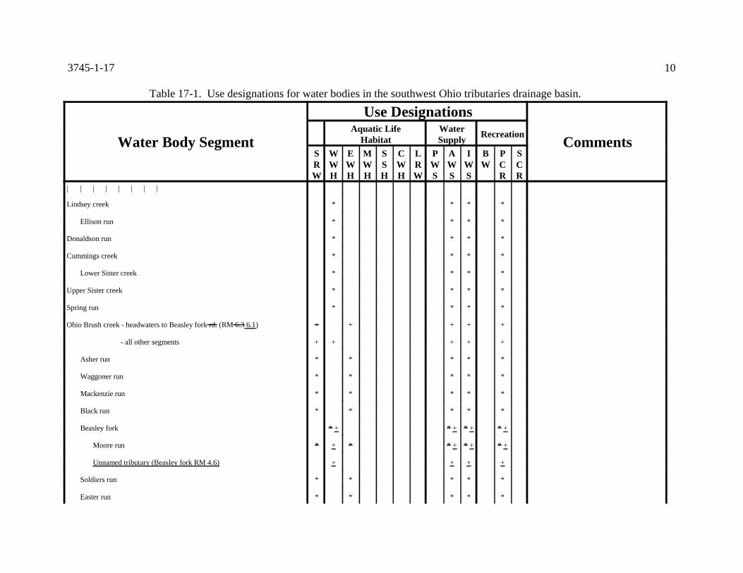
3745-1-17 10
Table 17-1. Use designations for water bodies in the southwest Ohio tributaries drainage basin.
Water Body Segment
Use Designations
CommentsAquatic Life
HabitatWaterSupply Recreation
SRW
WWH
EWH
MWH
SSH
CWH
LRW
PWS
AWS
IWS
BW
PCR
SCR
| | | | | | | |
Lindsey creek * * * *
Ellison run * * * *
Donaldson run * * * *
Cummings creek * * * *
Lower Sister creek * * * *
Upper Sister creek * * * *
Spring run * * * *
Ohio Brush creek - headwaters to Beasley fork rd. (RM 6.3 6.1) + + + + +
- all other segments + + + + +
Asher run * * * * *
Waggoner run * * * * *
Mackenzie run * * * * *
Black run * * * * *
Beasley fork * + * + * + * +
Moore run * + * * + * + * +
Unnamed tributary (Beasley fork RM 4.6) + + + +
Soldiers run * * * * *
Easter run * * * * *

3745-1-17 11
Table 17-1. Use designations for water bodies in the southwest Ohio tributaries drainage basin.
Water Body Segment
Use Designations
CommentsAquatic Life
HabitatWaterSupply Recreation
SRW
WWH
EWH
MWH
SSH
CWH
LRW
PWS
AWS
IWS
BW
PCR
SCR
| | | | | | | |
Cedar run * * + * + * + * +
Semple creek * * * * *
Lick fork (a.k.a. Lick creek) * + * * + * + * +
Treber run * + * * + * + * +
Cave run * + * * + * + * +
Louise tributary * + * * + * + * +
Bundle run * * * * *
West fork - headwaters to unnamed tributary (RM 13.7) * + * * + * + * +
- RM 13.7 to the mouth * + + + +
Spoon river * * * * *
Georges creek * + * * + * + * +
Big run * * * * *
Cherry fork * + * + * + * +
Grace run * + * + * + * +
Martins run * * * *
Gregg run * * * *
Buck run * + * + * + * +
Little West fork * + * + * + * +

3745-1-17 12
Table 17-1. Use designations for water bodies in the southwest Ohio tributaries drainage basin.
Water Body Segment
Use Designations
CommentsAquatic Life
HabitatWaterSupply Recreation
SRW
WWH
EWH
MWH
SSH
CWH
LRW
PWS
AWS
IWS
BW
PCR
SCR
| | | | | | | |
Elk fork * + * + * + * +
Turkey run * * * *
Shimer run * + * + * + * +
Little East fork * + * + * + * +
Wolf creek * * * *
Crooked creek * + * + * + * +
Weasel run * * * *
Baker fork - headwaters to unnamed tributary at RM 10.98 * + * + * + * +
- unnamed tributary at RM 10.98 to the mouth + + + +
Middle fork * + * + * + * +
Cow run * * * *
Setty branch * * * *
Cox branch * * * *
Straight creek * + * + * + * +
Muddy fork * + * + * + * +
Kerr run * * * *
Flat run * * * *
Elm run * + * + * + * +
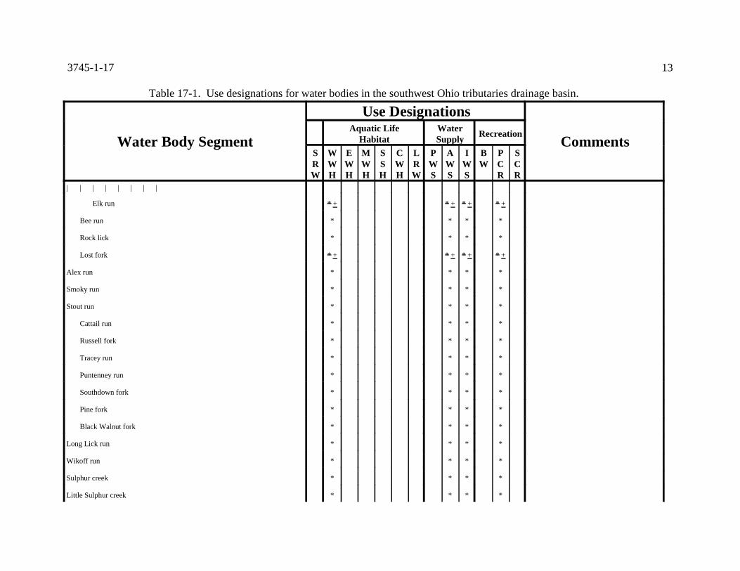
3745-1-17 13
Table 17-1. Use designations for water bodies in the southwest Ohio tributaries drainage basin.
Water Body Segment
Use Designations
CommentsAquatic Life
HabitatWaterSupply Recreation
SRW
WWH
EWH
MWH
SSH
CWH
LRW
PWS
AWS
IWS
BW
PCR
SCR
| | | | | | | |
Elk run * + * + * + * +
Bee run * * * *
Rock lick * * * *
Lost fork * + * + * + * +
Alex run * * * *
Smoky run * * * *
Stout run * * * *
Cattail run * * * *
Russell fork * * * *
Tracey run * * * *
Puntenney run * * * *
Southdown fork * * * *
Pine fork * * * *
Black Walnut fork * * * *
Long Lick run * * * *
Wikoff run * * * *
Sulphur creek * * * *
Little Sulphur creek * * * *

3745-1-17 14
Table 17-1. Use designations for water bodies in the southwest Ohio tributaries drainage basin.
Water Body Segment
Use Designations
CommentsAquatic Life
HabitatWaterSupply Recreation
SRW
WWH
EWH
MWH
SSH
CWH
LRW
PWS
AWS
IWS
BW
PCR
SCR
| | | | | | | |
Gilpen run * * * *
McCall run * * * *
Rock run * * * *
Lower Twin creek + + + +
Sugarcamp run * * * *
Vastine run * * * *
Upper Twin creek * * * *
Boland run * * * *
Dry run * * * *
Tucker run * * * *
East fork * * * *
Jake run * * * *
Bald Knob run * * * *
Brushy fork * * * *
Horner branch * * * *
Moore run * * * *
Spencer run * * * *
McAtee run * * * *

3745-1-17 15
Table 17-1. Use designations for water bodies in the southwest Ohio tributaries drainage basin.
Water Body Segment
Use Designations
CommentsAquatic Life
HabitatWaterSupply Recreation
SRW
WWH
EWH
MWH
SSH
CWH
LRW
PWS
AWS
IWS
BW
PCR
SCR
| | | | | | | |
Old Pond run * * * *
Mundy run * * * *
Pond run * * * *
East fork * * * *
Middle fork * * * *
Grass Lick run * * * *
McBridge run * * * *
Gabe run * * * *
Brushy fork * * * *
Nace run * * * *
Turkey creek - headwaters to Friendship (RM 4.0) * + + + +
- all other segments * + + +
Brouse run * * * *
Vaughters run * * * *
Stony run * * * *
Lower lick * * * *
Upper lick * * * *
Worley run * * * *

3745-1-17 16
Table 17-1. Use designations for water bodies in the southwest Ohio tributaries drainage basin.
Water Body Segment
Use Designations
CommentsAquatic Life
HabitatWaterSupply Recreation
SRW
WWH
EWH
MWH
SSH
CWH
LRW
PWS
AWS
IWS
BW
PCR
SCR
| | | | | | | |
Rabbit run * * * *
Odell creek * * * * *
Pond Lick run * * * * *
Rock lick * * * * *
Brush fork * * * * *
Wes run * * * * *
Barbara run * * * * *
Buck lick (formerly Steep gut) * * * * *
Harber fork * * * * *
Mackletree run * * * * *
Plummer fork * * * * *
Lampblack run * * * * *
Old Lade run * * * * *
Scantling run * * * * *
Rock lick * * * * *
Wolfden run * * * * *
Carey run * * * *
Bellamy run * * * *

3745-1-17 17
Table 17-1. Use designations for water bodies in the southwest Ohio tributaries drainage basin.
Water Body Segment
Use Designations
CommentsAquatic Life
HabitatWaterSupply Recreation
SRW
WWH
EWH
MWH
SSH
CWH
LRW
PWS
AWS
IWS
BW
PCR
SCR
| | | | | | | |
Slab run (formerly Cox run) * * * *
Lousy run * * * *
Hyggen run * * * *
SRW = state resource water; WWH = warmwater habitat; EWH = exceptional warmwater habitat; MWH = modified warmwater habitat; SSH = seasonal salmonid habitat;CWH = coldwater habitat; LRW = limited resource water; PWS = public water supply; AWS = agricultural water supply; IWS = industrial water supply; BW = bathing water;PCR = primary contact recreation; SCR = secondary contact recreation.
Effective: 10/09/2009
R.C. 119.032 review dates: 04/29/2009 and 10/09/2014
CERTIFIED ELECTRONICALLY
Certification
07/09/2009
Date
Promulgated Under: 119.03Statutory Authority: 6111.041Rule Amplifies: 6111.041Prior Effective Dates: 4/4/1985, 1/3/1989, 4/5/1990, 4/21/1992, 3/29/2001,
7/21/2002
3745-1-17 18

3745-1-18 Little Miami river drainage basin.
(A) The water bodies listed in table 18-1 of this rule are ordered from downstream to upstream.Tributaries of a water body are indented. The aquatic life habitat, water supply andrecreation use designations are defined in rule 3745-1-07 of the Administrative Code. Thestate resource water use designation is defined in rule 3745-1-05 of the Administrative Code.The most stringent criteria associated with any one of the use designations assigned to awater body will apply to that water body.
(B) Figure 1 of the appendix to this rule is a generalized map of the little Miami river drainagebasin. A generalized map of Ohio outlining the twenty-three major drainage basins andlisting associated rule numbers in Chapter 3745-1 of the Administrative Code is in figure 1of the appendix to rule 3745-1-08 of the Administrative Code.
(C) RM, as used in this rule, stands for river mile and refers to the method used by the Ohioenvironmental protection agency to identify locations along a water body. Mileage isdefined as the lineal distance from the downstream terminus (i.e., mouth) and moving in anupstream direction.
(D) The following symbols are used throughout this rule:
* Designated use based on the 1978 water quality standards;
+ Designated use based on the results of a biological field assessment performed by theOhio environmental protection agency;
o Designated use based on justification other than the results of a biological fieldassessment performed by the Ohio environmental protection agency; and
L An L in the warmwater habitat column signifies that the water body segment isdesignated limited warmwater habitat.
ACTION: Final DATE: 07/09/2009 8:50 AM
RB p(44517) pa(80698) d(208732) ra(196013) print date: 07/09/2009 9:04 PM

3745-1-18 2
Table 18-1. Use designations for water bodies in the little Miami river drainage basin.
Water Body Segment
Use Designations
CommentsAquatic Life
HabitatWaterSupply Recreation
SRW
WWH
EWH
MWH
SSH
CWH
LRW
PWS
AWS
IWS
BW
PCR
SCR
| | | | | | | |
Little Miami river - North fork (RM 91.64) to RM 3.0 (downstream ofBeechmont ave.) to the mouth
+ + + + + +
- headwaters to North fork (RM 91.64) + + + + +
- all other segments + + + + + +
Cluff creek (Clough creek) * + * + * + * +
McCullough run * * * *
Duck creek - downstream Red Bank road (RM 2.4) to the mouth + * * +
- confluence of East fork and West fork to Red Bank road + * * + Small drainageway maintenance
East fork + * * + Small drainageway maintenance
West fork + * * + Small drainageway maintenance
Dry run * * * *
East fork - RM 75 to W.H. Harsha lake + + + + + *
East fork - headwaters to RM 75 + + + + *
- at RM 22.6 + + + + + PWS intake - Clermont county
- all other segments + + + + + +
Hall run + + + *
Wolfpen run + + + *
Salt run + + + *
Sugarcamp run + + + *

3745-1-18 3
Table 18-1. Use designations for water bodies in the little Miami river drainage basin.
Water Body Segment
Use Designations
CommentsAquatic Life
HabitatWaterSupply Recreation
SRW
WWH
EWH
MWH
SSH
CWH
LRW
PWS
AWS
IWS
BW
PCR
SCR
| | | | | | | |
Shayler run + + + *
Unnamed tributary (Shayler run RM 4.4) + * * +
Dry run + + + *
Stonelick creek - at RM 23.37 + + + + + + PWS intake - Village of Blanchester
- all other segments + + + +
Lick fork + + + *
Brushy fork + + + *
Rocky run + + + *
Paterson run + + + *
Moores fork + + + *
Greenbush creek + + + *
Hunter creek + + + *
Backbone creek + + + *
Lucy run + + + *
Fourmile run + + + *
Back run + + + *
Ulrey run + + + *
Slabcamp run + + + *

3745-1-18 4
Table 18-1. Use designations for water bodies in the little Miami river drainage basin.
Water Body Segment
Use Designations
CommentsAquatic Life
HabitatWaterSupply Recreation
SRW
WWH
EWH
MWH
SSH
CWH
LRW
PWS
AWS
IWS
BW
PCR
SCR
| | | | | | | |
Cloverlick creek - at RM 3.23 + o + + * PWS intake - Village of Bethel (formerly)
- all other segments + + + *
Barnes run + + + *
Poplar creek + + + *
Sugartree creek + + + *
Town run + + + *
Guest run + + + *
Trible run + + + *
Light run + + + *
Snow run + + + *
Polecat run + + + *
Cabin run + + + *
Kain run + + + *
Todd run + + + *
Indian Camp run + + + *
Crane run + + + *
Fourmile creek + + + *
Pleasant run + + + *

3745-1-18 5
Table 18-1. Use designations for water bodies in the little Miami river drainage basin.
Water Body Segment
Use Designations
CommentsAquatic Life
HabitatWaterSupply Recreation
SRW
WWH
EWH
MWH
SSH
CWH
LRW
PWS
AWS
IWS
BW
PCR
SCR
| | | | | | | |
Fivemile creek + + + *
East fork + + + *
Sixmile creek + + + *
Howard run + + + *
Grassy fork + + + *
Glady run + + + *
Saltlick creek + + + *
Indian creek + + + *
Little Indian creek + + + *
Solomon run - at RM 3.33 + + + + * PWS intake (formerly)
- all other segments + + + *
Murray run + + + *
Sycamore creek + + + *
Unnamed tributary (Sycamore creek RM 1.13) + * * + Irretrievable flow modification
West fork - at RM 4.62 + + + + * PWS intake - Village of Westboro(formerly)
- all other segments + + + *
Dodson creek + + + *
Anthony run + + + *

3745-1-18 6
Table 18-1. Use designations for water bodies in the little Miami river drainage basin.
Water Body Segment
Use Designations
CommentsAquatic Life
HabitatWaterSupply Recreation
SRW
WWH
EWH
MWH
SSH
CWH
LRW
PWS
AWS
IWS
BW
PCR
SCR
| | | | | | | |
South fork + + + *
Turtle creek + + + *
Horner run * * * *
Sycamore creek + + + +
North branch * * * *
Polk run + + + +
O'Bannon creek + + + +
Grog run * * * *
Stony run + + + +
Indiancamp creek * * * *
Ertel run * * * *
Salt run * * * *
Hen run * * * *
Simpson creek + + + +
Bear run * * * *
Union run * * * *
Muddy creek + + + +
Turtle creek + + + +

3745-1-18 7
Table 18-1. Use designations for water bodies in the little Miami river drainage basin.
Water Body Segment
Use Designations
CommentsAquatic Life
HabitatWaterSupply Recreation
SRW
WWH
EWH
MWH
SSH
CWH
LRW
PWS
AWS
IWS
BW
PCR
SCR
| | | | | | | |
Dry run - headwaters to RM 1.2 + + + + + +
- RM 1.2 to the mouth + + + +
Little Muddy creek * + * + * + + +
Bigfoot run * * * *
Halls creek * * * *
Todd fork + + + +
First creek * + * + * + * +
Martin run * * * *
Second creek * + * + * + * +
Whitakers run (Second creek RM 10.2) - at RM 1.37 o PWS intake - Village of Blanchester
Lick run * + * * + * + * +
Sugar run * * * *
East fork (little East fork) + + + +
Stony hollow * * * *
Sewell run * * * *
Cowan creek - Cowan lake (RM 6.3) to the mouth * + + + +
Cowan creek - at RM 11.6 11.66 + o + + + PWS intake - City of Wilmington
- all other segments + + + +

3745-1-18 8
Table 18-1. Use designations for water bodies in the little Miami river drainage basin.
Water Body Segment
Use Designations
CommentsAquatic Life
HabitatWaterSupply Recreation
SRW
WWH
EWH
MWH
SSH
CWH
LRW
PWS
AWS
IWS
BW
PCR
SCR
| | | | | | | |
Wilson creek * * * *
Indian run + + + + +
Lytle creek + + + +
Little creek * * * *
Moore branch * * * *
Dutch creek + * * + * + * +
Dry run * * * *
Stony run * * * *
Cowen run * * * *
Randall run * * * *
Olive branch * + + + *
Caesar creek - headwaters to South branch (RM 23.78) + + + +
- at RM 7.77 + + + + + PWS intake - City of Wilmington
- South branch to Anderson fork all other segments + + + +
- Anderson fork to the mouth * + + + +
Flat fork * + + + +
Jonahs run * + + + +
Trace run * + + + +

3745-1-18 9
Table 18-1. Use designations for water bodies in the little Miami river drainage basin.
Water Body Segment
Use Designations
CommentsAquatic Life
HabitatWaterSupply Recreation
SRW
WWH
EWH
MWH
SSH
CWH
LRW
PWS
AWS
IWS
BW
PCR
SCR
| | | | | | | |
Turkey run * * * * *
Buck run * + + + +
Anderson fork - Grog run (RM 11.02) to the mouth * + + + +
- all other segments * + + + +
Painters creek + + + +
Grog run * * * *
Love run * * * *
Grassy run * * * *
South branch - Paintersville-New Jaspar rd. (RM 4.0) to the mouth + + + +
- all other segments + + + +
North branch + + + +
Newman run + + + +
Mill run + + + +
Unnamed tributary (Little Miami river RM 60.50) + + + +
Unnamed tributary (Little Miami river RM 62.01) + + + +
Glady run - Hedges rd. (RM 4.0) to the mouth + + + +
- all other segments + + + +
Glady run swale + * * +

3745-1-18 10
Table 18-1. Use designations for water bodies in the little Miami river drainage basin.
Water Body Segment
Use Designations
CommentsAquatic Life
HabitatWaterSupply Recreation
SRW
WWH
EWH
MWH
SSH
CWH
LRW
PWS
AWS
IWS
BW
PCR
SCR
| | | | | | | |
Sugar creek - within Sugar creek reserve o + + + +
- all other segments + + + +
Little Sugar creek + + + +
Unnamed tributary (Little Miami river RM 69.85) + + + +
Beaver creek + + + +
Little Beaver creek + + + +
Unnamed tributary (RM 6.1) + + + +
Shawnee creek + + + +
Ludlow creek + + + +
Massie creek + + + + + PWS intake - Greene county Cedarville(formerly)
Oldtown creek * + + + +
Clark run + + + +
Unnamed tributary (Massie creek RM 5.3) + + + +
North fork + + + +
South fork + + + +
Conner branch + + + +
Jacoby branch + + + +
Yellow Springs creek * + + + +

3745-1-18 11
Table 18-1. Use designations for water bodies in the little Miami river drainage basin.
Water Body Segment
Use Designations
CommentsAquatic Life
HabitatWaterSupply Recreation
SRW
WWH
EWH
MWH
SSH
CWH
LRW
PWS
AWS
IWS
BW
PCR
SCR
| | | | | | | |
North fork * + + + +
Goose creek + + + +
Lisbon fork + + + +
Gilroy ditch + + + +
SRW = state resource water; WWH = warmwater habitat; EWH = exceptional warmwater habitat; MWH = modified warmwater habitat; SSH = seasonal salmonid habitat;CWH = coldwater habitat; LRW = limited resource water; PWS = public water supply; AWS = agricultural water supply; IWS = industrial water supply; BW = bathing water;PCR = primary contact recreation; SCR = secondary contact recreation.

Effective: 10/09/2009
R.C. 119.032 review dates: 04/29/2009 and 10/09/2014
CERTIFIED ELECTRONICALLY
Certification
07/09/2009
Date
Promulgated Under: 119.03Statutory Authority: 6111.041Rule Amplifies: 6111.041Prior Effective Dates: 4/4/1985, 8/19/1985, 1/3/1989, 4/26/1997, 7/21/2002
3745-1-18 12

3745-1-19 Huron river drainage basin. (A) The water bodies listed in table 19-1 of this rule are ordered from downstream to upstream.
Tributaries of a water body are indented. The aquatic life habitat, water supply and recreation use designations are defined in rule 3745-1-07 of the Administrative Code. The state resource water use designation is defined in rule 3745-1-05 of the Administrative Code. The most stringent criteria associated with any one of the use designations assigned to a water body will apply to that water body.
(B) Figure 1 of the appendix to this rule is a generalized map of the Huron river drainage basin.
A generalized map of Ohio outlining the twenty-three major drainage basins and listing associated rule numbers in Chapter 3745-1 of the Administrative Code is in figure 1 of the appendix to rule 3745-1-08 of the Administrative Code.
(C) RM, as used in this rule, stands for river mile and refers to the method used by the Ohio
environmental protection agency to identify locations along a water body. Mileage is defined as the lineal distance from the downstream terminus (i.e., mouth) and moving in an upstream direction.
(D) The following symbols are used throughout this rule:
* Designated use based on the 1978 water quality standards;
+ Designated use based on the results of a biological field assessment performed by the Ohio environmental protection agency;
o Designated use based on justification other than the results of a biological field
assessment performed by the Ohio environmental protection agency; and
L An L in the warmwater habitat column signifies that the water body segment is designated limited warmwater habitat.

3745-1-19
2
Table 19-1. Use designations for water bodies in the Huron river drainage basin.
Water Body Segment
Use Designations
Comments
Aquatic Life
Habitat
Water Supply
Recreation
SRW
WWH
EWH
MWH
S S H
CWH
LRW
P W S
A W S
I WS
BW
P CR
SCR
| | | | | | | |
Huron river - East branch/West branch confluence to Lake Erie + +
+ + +
Mud creek *
* * *
Village creek +
+ + +
Rattlesnake creek +
+ + +
West branch (Rattlesnake creek RM 0.28) +
+ + +
East branch +
+ + +
Norwalk creek - at RMs 0.11 and 4.02 +
o
+ + + PWS intake - Norwalk
- all other segments +
+ + +
Unnamed tributary (Norwalk creek RM 0.38) +
+ + +
Cole creek +
+ + +
Unnamed tributary (Cole creek RM 2.46) +
+ + +
Unnamed tributary (East branch RM 19.98) +
+ + +
West branch - at RMs 8.52 and 33.8 +
o
+ + + PWS intakes - Monroeville (RM 8.52) and
Willard (RM 33.8) - all other segments +
+ + +
Clayton ditch (West branch RM 0.4) - Higbee rd. (RM 2.85) to the
mouth +
+ + +
Seymour creek +
+ + +
Megginson creek +
+ + +

3745-1-19
3
Table 19-1. Use designations for water bodies in the Huron river drainage basin.
Water Body Segment
Use Designations
Comments
Aquatic Life
Habitat
Water Supply
Recreation
SRW
WWH
EWH
MWH
S S H
CWH
LRW
P W S
A W S
I WS
BW
P CR
SCR
| | | | | | | |
Frink run - at RM 4.83 +
o
+ + + PWS intake - Bellevue
- all other segments +
+ + +
Haas ditch *
* * *
Schoeffel ditch *
* * *
Slate run +
+ + +
Mud run (East branch) +
+ + +
Mud run (West branch) +
+ + +
Shriner run *
* * *
Holiday tributary (West branch RM 23.09) +
+ + +
Unnamed tributary (Holiday tributary RM 2.8) +
+ + +
Jacobs creek +
+ + +
Walnut creek (West branch RM 33.05) +
+ + +
Marsh run +
+ + +
Unnamed tributary (West branch RM 41.50) +
+ + +
Old Woman creek - estuary o +
+ + +
- within boundaries of Old Woman preserve o +
+
- all other segments +
+ + +
Unnamed tributary (Old Woman creek RM 3.70) +
+ + +

3745-1-19
4
Table 19-1. Use designations for water bodies in the Huron river drainage basin.
Water Body Segment
Use Designations
Comments
Aquatic Life
Habitat
Water Supply
Recreation
SRW
WWH
EWH
MWH
S S H
CWH
LRW
P W S
A W S
I WS
BW
P CR
SCR
| | | | | | | |
Unnamed tributary (Old Woman creek RM 8.82) +
+ + +
Cranberry creek *
* * *
Chappel creek +
+ + +
Sugar creek +
+ + +
Darby creek *
* * *
Sherod creek *
* * *
SRW = state resource water; WWH = warmwater habitat; EWH = exceptional warmwater habitat; MWH = modified warmwater habitat; SSH = seasonal salmonid habitat; CWH = coldwater habitat; LRW = limited resource water; PWS = public water supply; AWS = agricultural water supply; IWS = industrial water supply; BW = bathing water; PCR = primary contact recreation; SCR = secondary contact recreation.

3745-1-19 5 Appendix Figure 1. Huron river drainage basin.
~ Lakes
N Rivers
I County Boundaries
CJl C~ies

3745-1-19 6 Effective: 6/16/2011 R.C. 119.032 rule review date: 6/16/2016 Promulgated Under: R.C. 119.03 Statutory Authority: R.C. 6111.041 Rule Amplifies: R.C. 6111.041 Prior Effective Dates: 4/4/1985, 8/19/1985, 7/21/2002, 4/1/2007

3745-1-20 Rocky river drainage basin.
(A) The water bodies listed in table 20-1 of this rule are ordered from downstream to upstream.Tributaries of a water body are indented. The aquatic life habitat, water supply andrecreation use designations are defined in rule 3745-1-07 of the Administrative Code. Thestate resource water use designation is defined in rule 3745-1-05 of the Administrative Code.The most stringent criteria associated with any one of the use designations assigned to awater body will apply to that water body.
(B) Figure 1 of the appendix to this rule is a generalized map of the Rocky river drainage basin.
(C) RM, as used in this rule, stands for river mile and refers to the method used by the Ohioenvironmental protection agency to identify locations along a water body. Mileage isdefined as the lineal distance from the downstream terminus (i.e., mouth) and moving in anupstream direction.
(D) The following symbols are used throughout this rule:
* Designated use based on the 1978 water quality standards;
+ Designated use based on the results of a biological field assessment performed by theOhio environmental protection agency;
o Designated use based on justification other than the results of a biological fieldassessment performed by the Ohio environmental protection agency; and
L An L in the warmwater habitat column signifies that the water body segment isdesignated limited warmwater habitat.

3745-1-20 2
Table 20-1. Use designations for water bodies in the Rocky river drainage basin.
Water Body Segment
Use Designations
CommentsAquatic Life
HabitatWaterSupply Recreation
SRW
WWH
EWH
MWH
SSH
CWH
LRW
PWS
AWS
IWS
BW
PCR
SCR
| | | | | | | |
Porter creek * * * *
Cahoon creek * * * *
Rocky river - st. rte. 10 (RM 6.4) to the mouth + + + + + +
- confluence of East and West branches (RM 12.1) to st. rte. 10 + + + + +
Abram creek + + + +
East branch - upstream boundaries of Rocky river reservation (RM 15.15) to West branch
+ + + + +
- at RM 5.06 + + o + + + PWS intake - Berea
- within the boundaries of Hinckley reservation + + + + +
- headwaters to Hinckley reservation + + + + +
- all other segments + + + +
Baldwin creek - at RM 0.48 + + o + + + PWS intake - Berea
- all other segments + + + + +
Big brook * * * *
North Royalton "A" tributary + + + +
Healy creek + + + +
West branch + + + + + PWS intake - Medina (formerly)
Plum creek + + + +
Strongsville "A" tributary + + + +

3745-1-20 3
Table 20-1. Use designations for water bodies in the Rocky river drainage basin.
Water Body Segment
Use Designations
CommentsAquatic Life
HabitatWaterSupply Recreation
SRW
WWH
EWH
MWH
SSH
CWH
LRW
PWS
AWS
IWS
BW
PCR
SCR
| | | | | | | |
Baker creek + + + +
Cossett creek + + + +
Mallet creek + + + +
North branch + + + +
Plum creek + + + +
Remson creek * * * *
Granger ditch * * * *
SRW = state resource water; WWH = warmwater habitat; EWH = exceptional warmwater habitat; MWH = modified warmwater habitat; SSH = seasonal salmonid habitat; CWH = coldwater habitat; LRW = limited resource water; PWS = public water supply; AWS = agricultural water supply; IWS = industrial water supply; BW = bathing water; PCR = primary contact recreation; SCR = secondary contact recreation.
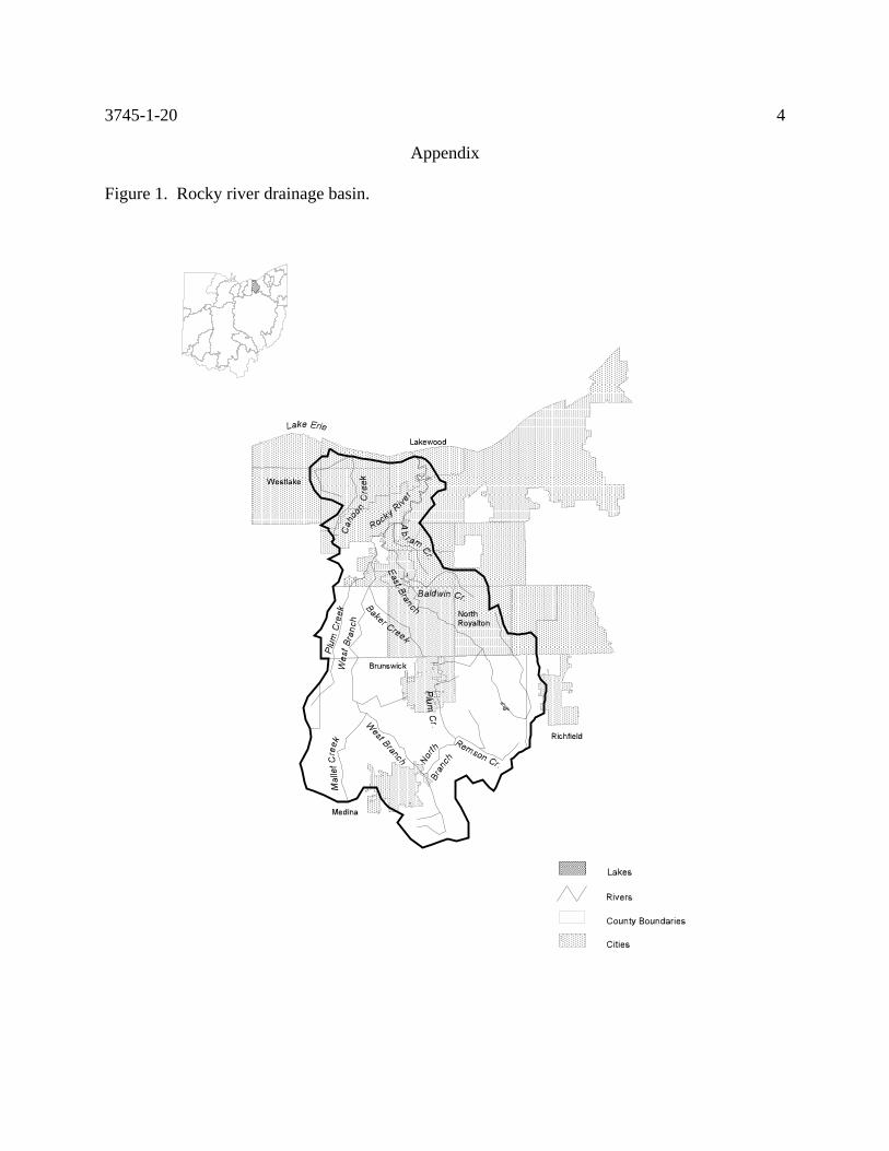
3745-1-20 4
Appendix
Figure 1. Rocky river drainage basin.

3745-1-20 5
Effective: 4/23/2008
R.C. 119.032 rule review date: 4/23/2013
Promulgated Under: R.C. 119.03Statutory Authority: R.C. 6111.041Rule Amplifies: R.C. 6111.041Prior Effective Dates: 4/4/1985, 8/19/1985, 3/29/2001, 7/21/2002

3745-1-21 Great Miami river drainage basin. (A) The water bodies listed in table 21-1 of this rule are ordered from downstream to upstream.
Tributaries of a water body are indented. The aquatic life habitat, water supply and recreation use designations are defined in rule 3745-1-07 of the Administrative Code. The state resource water use designation is defined in rule 3745-1-05 of the Administrative Code. The most stringent criteria associated with any one of the use designations assigned to a water body will apply to that water body.
(B) Figure 1 of the appendix to this rule is a generalized map of the Great Miami river drainage
basin. A generalized map of Ohio outlining the twenty-three major drainage basins and listing associated rule numbers in Chapter 3745-1 of the Administrative Code is in figure 1 of the appendix to rule 3745-1-08 of the Administrative Code.
(C) RM, as used in this rule, stands for river mile and refers to the method used by the Ohio
environmental protection agency to identify locations along a water body. Mileage is defined as the lineal distance from the downstream terminus (i.e., mouth) and moving in an upstream direction.
(D) The following symbols are used throughout this rule:
* Designated use based on the 1978 water quality standards;
+ Designated use based on the results of a biological field assessment performed by the Ohio environmental protection agency;
o Designated use based on justification other than the results of a biological field
assessment performed by the Ohio environmental protection agency; and
L An L in the warmwater habitat column signifies that the water body segment is designated limited warmwater habitat.

3745-1-21
2
Table 21-1. Use designations for water bodies in the Great Miami river drainage basin.
Water Body Segment
Use Designations
Comments
Aquatic Life
Habitat
Water Supply
Recreation
SRW
WWH
EWH
MWH
S S H
CWH
LRW
P W S
A W S
I WS
BW
P CR
SCR
| | | | | | | |
Great Miami river - CSX RR bridge (RM 84.5) to the Troy dam (RM 107.0)
+
+ + +
- at RMs 86.6, 90.3, 118.5 and 130.2 +
+
+ + + PWS intakes - Dayton (RMs 86.6 and
90.3), Piqua (RM 118.5), and Sidney (RM 130.2)
- RM 108.0 to downstream of Piqua dam (RM 114.0) +
+ + +
- st. rte. 66 (RM 116.7) to the Sidney water works dam (RM 130.2)
+
+ + +
- Pasco-Montra rd. (RM 134.8) to the Quincy dam (RM 143.4)
+
+ + +
- all other segments +
+ + +
Doublelick run *
* * *
Whitewater river +
+ + +
Sand run *
* * *
Dry fork - Ohio-Indiana state line (RM 20.66) to RM 19.6 *
* * *
- RM 19.6 to Atherton rd. (RM 10.2) +
+ + +
- Atherton rd. to the mouth +
+ + +
- within Miami Whitewater forest boundaries * +
+ + +
Lee creek *
* * *
Howard creek *
* * *

3745-1-21
3
Table 21-1. Use designations for water bodies in the Great Miami river drainage basin.
Water Body Segment
Use Designations
Comments
Aquatic Life
Habitat
Water Supply
Recreation
SRW
WWH
EWH
MWH
S S H
CWH
LRW
P W S
A W S
I WS
BW
P CR
SCR
| | | | | | | |
Kiata creek +
+ + +
Sater run *
* * *
Phillips creek *
* * *
Jamison creek *
* * *
East fork - headwaters to Little creek (RM 41.7) +
+ + +
- Little creek to state line +
+ + +
Elkhorn creek *
* * *
Mud creek *
* * *
Horn ditch *
* * *
Rocky fork *
* * *
Little creek *
* * *
Brinley fork *
* * *
Jocqueway creek *
* * *
Dry run *
* * *
Jordan creek *
* * *
Unnamed tributary (Great Miami river RM 13.23) +
+ + +
Taylor creek +
+ + +
Wessleman creek +
+ + +

3745-1-21
4
Table 21-1. Use designations for water bodies in the Great Miami river drainage basin.
Water Body Segment
Use Designations
Comments
Aquatic Life
Habitat
Water Supply
Recreation
SRW
WWH
EWH
MWH
S S H
CWH
LRW
P W S
A W S
I WS
BW
P CR
SCR
| | | | | | | |
Briarly creek +
+ + +
Steele creek +
+ + +
Paddy's run +
+ + +
Bluerock creek +
+ + +
Owl creek *
* * *
Dunlap run *
* * *
Dry run *
* * *
Indian creek * +
+ + +
Lick run +
+ + +
Salmon run * +
+ + +
Reserve run +
+ + +
Little Indian creek +
+ + +
Banklick creek *
* * *
Pleasant run *
* * *
Crawford run *
* * *
Two Mile creek *
* * *
Shaffer creek *
* * *
Fourmile creek - headwaters to confluence with Acton lake * +
+ + +

3745-1-21
5
Table 21-1. Use designations for water bodies in the Great Miami river drainage basin.
Water Body Segment
Use Designations
Comments
Aquatic Life
Habitat
Water Supply
Recreation
SRW
WWH
EWH
MWH
S S H
CWH
LRW
P W S
A W S
I WS
BW
P CR
SCR
| | | | | | | |
- Darrtown rd. (RM 13.0) to Sevenmile ave. (RM 0.4) +
+ + +
- all other segments +
+ + +
Sevenmile creek - Paint creek (RM 15.2) to the mouth +
+ + +
- all other segments +
+ + +
Ninemile creek *
* * *
Big Cave run +
+ + +
Rush run +
+ + +
Paint creek * +
+ + +
Opossum run *
* * *
Sugar run *
* * *
Beasley run +
+ + +
Pottenger run +
+ + +
Rocky run +
+ + +
Periwinkle run +
+ + +
Becketts run *
* * *
Stony run +
+ + +
Darrs run +
+ + +
Collins creek +
+ + +

3745-1-21
6
Table 21-1. Use designations for water bodies in the Great Miami river drainage basin.
Water Body Segment
Use Designations
Comments
Aquatic Life
Habitat
Water Supply
Recreation
SRW
WWH
EWH
MWH
S S H
CWH
LRW
P W S
A W S
I WS
BW
P CR
SCR
| | | | | | | |
Bull run *
* * *
Harkers run +
+ + +
Elams run (Tolland creek) (Fourmile creek RM 18.80) +
+ + +
Spring run (Fourmile creek RM 20.19) *
* * *
Morning Sun tributary north (Fourmile creek RM 23.57) +
+ + +
Morning Sun tributary south (Morning Sun tributary north RM 0.25)
+
+ + +
Little Fourmile creek * +
+ + +
Fleisch run +
+ + +
East fork * +
+ + +
Dixon branch (Harris run) * +
+ + +
Brentwood tributary *
* * *
Greencrest tributary *
* * *
Gregory creek *
* * *
Coldwater creek *
* * *
Dicks creek - Cincinnati-Dayton rd. (RM 5.4) to Yankee rd. (RM 2.4) +
+ + + ECBP ecoregion - channel modification
- all other segments +
+ + +
Monroe ditch (Dicks creek RM 2.65) - headwaters to the
Middletown corporate boundary (RM 0.8) +
+ + +

3745-1-21
7
Table 21-1. Use designations for water bodies in the Great Miami river drainage basin.
Water Body Segment
Use Designations
Comments
Aquatic Life
Habitat
Water Supply
Recreation
SRW
WWH
EWH
MWH
S S H
CWH
LRW
P W S
A W S
I WS
BW
P CR
SCR
| | | | | | | |
North branch - headwaters to Breiel blvd. (RM 1.0) +
+ + +
- Breiel blvd. to mouth +
+ + + ECBP ecoregion - channel modification
Shaker creek +
+ + +
Millers creek +
+ + +
Elk creek +
+ + +
Browns run *
* * *
Twin creek +
+ + +
Little Twin creek +
+ + +
Reigle ditch +
+ + +
Toms run +
+ + +
Unnamed tributary (Toms run RM 5.34) +
+ + +
Wysong run *
* * *
Unnamed tributary (Twin Creek RM 18.29) +
+ + +
Aukerman creek +
+ + +
Unnamed tributary (Aukerman creek RM 2.88) +
+ + +
Bantas fork +
+ + +
Goose creek - downstream Winnerline rd. (RM 3.0) to the
mouth +
+ + +
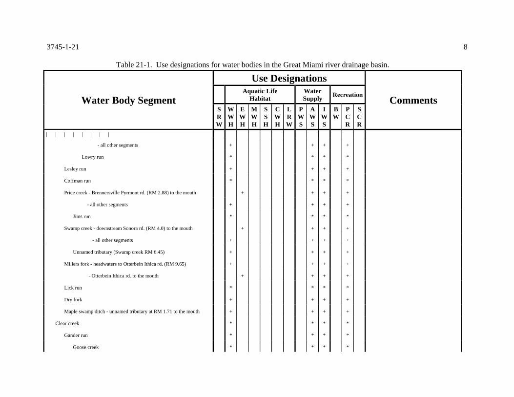
3745-1-21
8
Table 21-1. Use designations for water bodies in the Great Miami river drainage basin.
Water Body Segment
Use Designations
Comments
Aquatic Life
Habitat
Water Supply
Recreation
SRW
WWH
EWH
MWH
S S H
CWH
LRW
P W S
A W S
I WS
BW
P CR
SCR
| | | | | | | |
- all other segments +
+ + +
Lowry run *
* * *
Lesley run +
+ + +
Coffman run *
* * *
Price creek - Brennersville Pyrmont rd. (RM 2.88) to the mouth +
+ + +
- all other segments +
+ + +
Jims run *
* * *
Swamp creek - downstream Sonora rd. (RM 4.0) to the mouth +
+ + +
- all other segments +
+ + +
Unnamed tributary (Swamp creek RM 6.45) +
+ + +
Millers fork - headwaters to Otterbein Ithica rd. (RM 9.65) +
+ + +
- Otterbein Ithica rd. to the mouth +
+ + +
Lick run *
* * *
Dry fork +
+ + +
Maple swamp ditch - unnamed tributary at RM 1.71 to the mouth +
+ + +
Clear creek *
* * *
Gander run *
* * *
Goose creek *
* * *

3745-1-21
9
Table 21-1. Use designations for water bodies in the Great Miami river drainage basin.
Water Body Segment
Use Designations
Comments
Aquatic Life
Habitat
Water Supply
Recreation
SRW
WWH
EWH
MWH
S S H
CWH
LRW
P W S
A W S
I WS
BW
P CR
SCR
| | | | | | | |
Dry run *
* * *
Crains run *
* * *
Mound overflow creek (Great Miami river RM 65.08) +
+ + + ECBP ecoregion - impounded
Bear creek +
+ + +
Little Bear creek *
* * *
Garber run *
* * *
Diehl run *
* * *
Lick run *
* * *
Spring run *
* * *
Owl creek +
+ + + Small drainageway maintenance
Opossum creek * *
* * *
Holes creek +
+ + +
Wolf creek +
+ + +
Dry run +
+ + +
North branch *
* * *
Razor run *
* * *
Poplar run *
* * *
Mad river - headwaters to Buck creek (RM 26.15) +
+ + +

3745-1-21
10
Table 21-1. Use designations for water bodies in the Great Miami river drainage basin.
Water Body Segment
Use Designations
Comments
Aquatic Life
Habitat
Water Supply
Recreation
SRW
WWH
EWH
MWH
S S H
CWH
LRW
P W S
A W S
I WS
BW
P CR
SCR
| | | | | | | |
- at RMs 5.2 and 5.6 +
+
+ + + PWS intakes - Dayton
- Buck creek to the mouth +
+ + +
Hebble run +
+ + ECBP ecoregion - channel modification
Mud run +
+ + +
Clear creek +
+ + +
Unnamed tributary (Mud run RM 9.8) +
+ + +
Mud creek +
+ + +
Dry Lick run +
+ + +
Smith ditch *
* * *
Rubsam ditch (Mad river RM 13.33) *
* * *
Medway creek (Mad river RM 14.29) +
* * +
Jackson creek +
+ + +
Donnels creek +
+ + +
East fork +
+ + +
Rock run +
+ + +
Miller creek +
+ + +
Mill creek +
+ + +

3745-1-21
11
Table 21-1. Use designations for water bodies in the Great Miami river drainage basin.
Water Body Segment
Use Designations
Comments
Aquatic Life
Habitat
Water Supply
Recreation
SRW
WWH
EWH
MWH
S S H
CWH
LRW
P W S
A W S
I WS
BW
P CR
SCR
| | | | | | | |
Buck creek - park boundaries between C.J. Brown reservoir and the
mouth + +
+ + +
- headwaters to C.J. Brown reservoir +
+ + +
- all other segments +
+ + +
Beaver creek +
+ + +
Sinking creek +
+ + +
East fork +
+ + +
Dugan ditch +
+ + +
Pandy creek * +
+ + +
Dry run * +
+ + +
Moore run +
+ + +
Kenton creek +
+ + *
Chapman creek +
+ + +
Panther creek * *
* * *
Deer creek * +
+ + +
Blacksnake creek * +
+ + +
Storms creek * +
+ + +
Cedar run +
+ + +

3745-1-21
12
Table 21-1. Use designations for water bodies in the Great Miami river drainage basin.
Water Body Segment
Use Designations
Comments
Aquatic Life
Habitat
Water Supply
Recreation
SRW
WWH
EWH
MWH
S S H
CWH
LRW
P W S
A W S
I WS
BW
P CR
SCR
| | | | | | | |
East branch +
* * +
West branch +
* * +
Cedar bog * *
* * *
Bogles run * *
* * *
Stony creek * *
+ + +
Bull branch * *
* * *
Nettle creek - RM 8.2 to the mouth +
+ + +
- all other segments +
+ + +
Anderson creek +
+ + +
Russell creek * +
+ + +
Harban creek * +
+ + +
Hog creek * +
+ + +
Owens creek * +
+ + +
St. Paris tributary (Nettle creek RM 8.8) +
+ + +
Dugan run +
+ + +
Muddy creek +
+ + +
Spring run * +
+ + +
Kings creek +
+ + +

3745-1-21
13
Table 21-1. Use designations for water bodies in the Great Miami river drainage basin.
Water Body Segment
Use Designations
Comments
Aquatic Life
Habitat
Water Supply
Recreation
SRW
WWH
EWH
MWH
S S H
CWH
LRW
P W S
A W S
I WS
BW
P CR
SCR
| | | | | | | |
Unnamed tributary (Kings creek RM 0.46) +
+ + +
Unnamed tributary (Kings creek RM 4.97)
Unnamed tributary (unnamed tributary RM 3.18) +
+ + +
Glady creek * +
+ + +
Mac-a-cheek ditch +
+ + +
West Liberty tributary (Mad river RM 51.06) +
+ + +
Mac-o-chee creek +
+ + +
Hefflefinger ditch (Mad river RM 52.23) +
+ + +
Peters ditch (Mad river RM 58.82) +
+ + +
Sugar creek +
+ + +
Stillwater river - at RM 18 +
+
+ + + PWS intake - West Milton (formerly)
- Steffen rd. (RM 52.36) to the mouth +
+ + +
- Woodington run (RM 59.13) to Steffen rd. +
+ + +
- headwaters to Woodington run +
+ + + ECBP ecoregion - channel modification
Unnamed tributary (Stillwater river RM 6.4) +
+ + +
Pigeye creek +
+ + +
Mill creek +
+ + +
Brush creek +
+ + +

3745-1-21
14
Table 21-1. Use designations for water bodies in the Great Miami river drainage basin.
Water Body Segment
Use Designations
Comments
Aquatic Life
Habitat
Water Supply
Recreation
SRW
WWH
EWH
MWH
S S H
CWH
LRW
P W S
A W S
I WS
BW
P CR
SCR
| | | | | | | |
Unnamed tributaries *
* * *
Jones run +
+ + +
Ludlow creek - headwaters to Darke county line (RM 8.0) +
+ + + ECBP ecoregion - channel modification
- all other segments +
+ + +
Brush creek - RM 0.5 to the mouth * +
+ + +
- all other segments +
+ + +
Shank ditch *
* * *
Hog run +
+ + +
Baker ditch +
+ + + Small drainageway maintenance
Feitshams ditch +
+ + + Small drainageway maintenance
Browns ditch +
+ + + Small drainageway maintenance
Unnamed tributary (Ludlow creek RM 11.8) +
+ + + ECBP ecoregion - channel modification
Rocky run *
* * *
Opossum run +
+ + +
Canyon run *
* * *
Painter creek - headwaters to Darke county line (RM 5.5) +
+ + + ECBP ecoregion - channel modification
- Darke county line to the mouth +
+ + +
Little Painter creek +
+ + + ECBP ecoregion - channel modification

3745-1-21
15
Table 21-1. Use designations for water bodies in the Great Miami river drainage basin.
Water Body Segment
Use Designations
Comments
Aquatic Life
Habitat
Water Supply
Recreation
SRW
WWH
EWH
MWH
S S H
CWH
LRW
P W S
A W S
I WS
BW
P CR
SCR
| | | | | | | |
Heller ditch +
+ + + ECBP ecoregion - channel modification
Greenville creek - at RM 22.3 +
+
+ + + PWS intake - Greenville
- Bridge creek (RM 17.8) to Wildcat rd. (RM 24.6) +
+ + +
- all other segments +
+ + +
McQuay ditch +
+ + +
Poplar ditch +
+ + +
Bolton run +
+ + +
Dividing branch +
+ + +
Bridge creek +
+ + +
Mud creek - at RM 0.88 +
+
+ + + PWS intake - Greenville
- all other segments +
+ + +
Bitch run +
+ + +
Lake Branch ditch +
+ + +
Prairie outlet +
+ + +
West branch +
+ + +
Spring branch +
+ + +
Kraut creek +
+ + +
North fork +
+ + +

3745-1-21
16
Table 21-1. Use designations for water bodies in the Great Miami river drainage basin.
Water Body Segment
Use Designations
Comments
Aquatic Life
Habitat
Water Supply
Recreation
SRW
WWH
EWH
MWH
S S H
CWH
LRW
P W S
A W S
I WS
BW
P CR
SCR
| | | | | | | |
Dismal creek +
+ + +
Elson ditch *
* * *
Unnamed tributary (Stillwater river RM 32.6) +
+ + +
Harris run - headwaters to Darke county line (RM 5.2) +
+ + + ECBP ecoregion - channel modification
- all other segments +
+ + +
Ballinger run - headwaters to Darke county line (RM 1.7) +
+ + + ECBP ecoregion - channel modification
- all other segments +
+ + +
Unnamed tributary (Harris run RM 8.05) +
+ + +
Trotters creek +
+ + +
Sigmon ditch +
+ + +
Orr ditch +
+ + +
Bennett ditch +
+ + +
Apple ditch +
+ + +
Rudy ditch +
+ + +
Unnamed tributary (Stillwater river RM 38.3) +
+ + +
Swamp creek - headwaters to Pittsenbanger rd. (RM 6.5) +
+ + + ECBP ecoregion - channel modification
- Pittsenbanger road to the mouth +
+ + +
Indian creek - headwaters to Conover (RM 1.93) +
+ + + ECBP ecoregion - channel modification

3745-1-21
17
Table 21-1. Use designations for water bodies in the Great Miami river drainage basin.
Water Body Segment
Use Designations
Comments
Aquatic Life
Habitat
Water Supply
Recreation
SRW
WWH
EWH
MWH
S S H
CWH
LRW
P W S
A W S
I WS
BW
P CR
SCR
| | | | | | | |
- all other segments +
+ + +
Unnamed tributary (Swamp creek RM 3.54) +
+ + + ECBP ecoregion - channel modification
Grassy Fork creek +
+ + + ECBP ecoregion - channel modification
Unnamed tributary (Stillwater river RM 51.0) +
+ + +
Unnamed tributary (Unnamed tributary RM 2.5) +
+ + +
Boyd creek +
+ + + ECBP ecoregion - channel modification
Unnamed tributary (Boyd creek RM 2.46) +
+ + + ECBP ecoregion - channel modification
Unnamed tributary (Boyd creek RM 2.67) +
+ + + ECBP ecoregion - channel modification
Unnamed tributary (Stillwater river RM 54.45) +
+ + + ECBP ecoregion - channel modification
Unnamed tributary (Stillwater river RM 57.2) +
+ + + ECBP ecoregion - channel modification
North fork +
+ + + ECBP ecoregion - channel modification
Sycamore ditch (North fork RM 0.67) +
+ + + ECBP ecoregion - channel modification
Woodington run +
+ + +
Unnamed tributary (Stillwater river RM 60.2) +
+ + + ECBP ecoregion - channel modification
South fork +
+ + +
Unnamed tributary (South fork RM 0.94) +
+ + + ECBP ecoregion - channel modification
Unnamed tributary (Stillwater river RM 64.9) +
+ + + ECBP ecoregion - channel modification
Poplar creek *
* * *

3745-1-21
18
Table 21-1. Use designations for water bodies in the Great Miami river drainage basin.
Water Body Segment
Use Designations
Comments
Aquatic Life
Habitat
Water Supply
Recreation
SRW
WWH
EWH
MWH
S S H
CWH
LRW
P W S
A W S
I WS
BW
P CR
SCR
| | | | | | | |
North creek - headwaters to Dixie road (RM 2.0) +
+ + + Small drainageway maintenance
- Dixie road to mouth (Great Miami river RM 95.8) +
+ + +
Deer Cliff run +
+ + +
Inland tributary +
+ + + Small drainageway maintenance
Cox Airport tributary +
+ + + Small drainageway maintenance
Honey creek +
+ + +
Indian creek *
* * *
Dry creek *
* * *
West fork *
* * *
East fork *
* * *
Lost creek +
+ + +
East branch *
* * *
Boone creek (Great Miami river RM 103.87)
Peters creek
North branch +
+ + +
B.F. Goodrich ditch +
+ + + Small drainageway maintenance
Spring creek +
+ + +
Garbry creek *
* * *

3745-1-21
19
Table 21-1. Use designations for water bodies in the Great Miami river drainage basin.
Water Body Segment
Use Designations
Comments
Aquatic Life
Habitat
Water Supply
Recreation
SRW
WWH
EWH
MWH
S S H
CWH
LRW
P W S
A W S
I WS
BW
P CR
SCR
| | | | | | | |
Rush creek *
* * *
Shawnee creek *
* * *
McKee branch *
* * *
McIntire run - at RM 0.38 *
o
* * * PWS intake - Piqua
- all other segments *
* * *
Patterson run *
* * *
Levering run *
* * *
Loramie creek +
+ + +
Mill creek *
* * *
Fox creek *
* * *
Turtle creek +
+ + +
East Turtle creek *
* * *
Kiser ditch *
* * *
Ninemile creek - headwaters to co. rte. 14 (RM 4.2) +
+ + + ECBP ecoregion - channel modification
- all other segments +
+ + +
Painter creek *
* * *
East Painter creek *
* * *
Mile creek +
+ + + ECBP ecoregion - channel modification

3745-1-21
20
Table 21-1. Use designations for water bodies in the Great Miami river drainage basin.
Water Body Segment
Use Designations
Comments
Aquatic Life
Habitat
Water Supply
Recreation
SRW
WWH
EWH
MWH
S S H
CWH
LRW
P W S
A W S
I WS
BW
P CR
SCR
| | | | | | | |
Spring creek +
+ + + ECBP ecoregion - channel modification
Honsapple ditch *
* * *
Miami and Erie canal (Loramie creek RM 20.78) +
+ + + ECBP ecoregion - channel modification
Keppler ditch *
* * *
Clay creek (Applegate ditch) +
* * * ECBP ecoregion - channel modification
Hulls creek (Fridley ditch) *
* * *
Mill branch *
* * *
Brush creek *
* * *
Tawawa creek - at RM 0.14 +
+
+ + * PWS intake - Sidney
- all other segments +
+ + *
Mosquito creek *
* * *
Leatherwood creek *
* * *
Plum creek +
+ + +
Manning run *
* * *
Line run *
* * *
Counts run *
* * *
Turkeyfoot creek *
* * *
Little Turkeyfoot creek *
* * *

3745-1-21
21
Table 21-1. Use designations for water bodies in the Great Miami river drainage basin.
Water Body Segment
Use Designations
Comments
Aquatic Life
Habitat
Water Supply
Recreation
SRW
WWH
EWH
MWH
S S H
CWH
LRW
P W S
A W S
I WS
BW
P CR
SCR
| | | | | | | |
Indian creek +
+ + +
Little Indian creek *
* * *
Speece & Lovett ditch *
* * *
Stony creek +
+ + +
Lee creek +
+ + +
Graves creek +
+ + +
McKee creek + +
+ + +
Bokengehalas creek +
+ + +
Bluejacket creek - headwaters to Opossum run (RM 5.8) +
+ + +
- Opossum run to the mouth +
+ + +
Possum run +
+ + +
Rum creek +
+ + +
Hodge ditch *
* * *
Howell ditch *
* * *
Shroyer ditch *
* * *
Indian creek *
* * *
Brandywine creek +
+ + +
Muchinippi creek +
+ + +

3745-1-21
22
Table 21-1. Use designations for water bodies in the Great Miami river drainage basin.
Water Body Segment
Use Designations
Comments
Aquatic Life
Habitat
Water Supply
Recreation
SRW
WWH
EWH
MWH
S S H
CWH
LRW
P W S
A W S
I WS
BW
P CR
SCR
| | | | | | | |
Calico creek *
* * *
Little Muchinippi creek +
+ + +
Wolf creek *
* * *
Baughman ditch *
* * *
Jackson Center creek +
+ + + ECBP ecoregion - channel modification
Willow creek +
+ + +
Rennick creek +
+ + +
Unnamed tributary (Great Miami river RM 157.34) +
+ + + ECBP ecoregion - channel modification
Cherokee Mans run +
+ + +
South fork Great Miami river +
+ + +
New Richland tributary +
+ + +
Slow ditch (Liggitt ditch) +
+ + +
Belle Center tributary +
+ + +
North fork Great Miami river +
+ + +
Blackhawk run +
+ + +
Van Horn creek +
+ + +
SRW = state resource water; WWH = warmwater habitat; EWH = exceptional warmwater habitat; MWH = modified warmwater habitat; SSH = seasonal salmonid habitat; CWH = coldwater habitat; LRW = limited resource water; PWS = public water supply; AWS = agricultural water supply; IWS = industrial water supply; BW = bathing water; PCR = primary contact recreation; SCR = secondary contact recreation.

3745-1-21 23 Appendix Figure 1. Great Miami river drainage basin.
-N CJ Bill]
Lakes
Rivers
County Boundaries
Cities

3745-1-21 24 Effective: 6/16/2011 R.C. 119.032 rule review date: 6/16/2016 Promulgated Under: R.C. 119.03 Statutory Authority: R.C. 6111.041 Rule Amplifies: R.C. 6111.041 Prior Effective Dates: 4/4/1985, 8/19/1985, 4/5/1990, 4/21/1992, 9/30/1993, 4/26/1997, 7/31/1999, 3/29/2001, 7/21/2002, 4/1/2007, 4/23/2008

3745-1-22 Chagrin river drainage basin.
(A) The water bodies listed in table 22-1 of this rule are ordered from downstream to upstream.Tributaries of a water body are indented. The aquatic life habitat, water supply andrecreation use designations are defined in rule 3745-1-07 of the Administrative Code. Thestate resource water use designation is defined in rule 3745-1-05 of the Administrative Code.The most stringent criteria associated with any one of the use designations assigned to awater body will apply to that water body.
(B) Figure 1 of the appendix to this rule is a generalized map of the Chagrin river drainage basin.
(C) RM, as used in this rule, stands for river mile and refers to the method used by the Ohioenvironmental protection agency to identify locations along a water body. Mileage isdefined as the lineal distance from the downstream terminus (i.e., mouth) and moving in anupstream direction.
(D) The following symbols are used throughout this rule:
* Designated use based on the 1978 water quality standards;
+ Designated use based on the results of a biological field assessment performed by theOhio environmental protection agency;
o Designated use based on justification other than the results of a biological fieldassessment performed by the Ohio environmental protection agency; and
L An L in the warmwater habitat column signifies that the water body segment isdesignated limited warmwater habitat.

3745-1-22 2
Table 22-1. Use designations for water bodies in the Chagrin river drainage basin.
Water Body Segment
Use Designations
CommentsAquatic Life
HabitatWaterSupply Recreation
SRW
WWH
EWH
MWH
SSH
CWH
LRW
PWS
AWS
IWS
BW
PCR
SCR
| | | | | | | |
Chagrin river - Chagrin falls (RM 29.65) to the mouth + + + + +
- at RM 4.9 + + + + + PWS intake - Willoughby (formerly)
- all other segments + + + +
Corporation creek (Chagrin river RM 0.27) + + + + +
Ward creek (Chagrin river RM 1.0) + + + + +
East branch and tributaries not identified below + + + +
Quarry creek (East branch RM 1.85) + + + + +
Stoney brook (East branch RM 3.57) + + + +
Pierson creek (East branch RM 6.73) + + + + +
Baldwin creek (East branch RM 7.06) + + + +
Unnamed tributary (East branch RM 10.13) + + + + +
Mt. Glen tributary (unnamed tributary RM 0.87) + + + +
Stebbins gulch (East branch RM 10.60) + + + +
Harris creek (East branch RM 14.62) + + + +
Unnamed tributary (East branch RM 14.80) + + + +
Unnamed tributary (East branch RM 15.35) + + + + +
Unnamed tributary (East branch RM 16.20) + + + + +
Gully brook (Chagrin river RM 5.54) + o + + +

3745-1-22 3
Table 22-1. Use designations for water bodies in the Chagrin river drainage basin.
Water Body Segment
Use Designations
CommentsAquatic Life
HabitatWaterSupply Recreation
SRW
WWH
EWH
MWH
SSH
CWH
LRW
PWS
AWS
IWS
BW
PCR
SCR
| | | | | | | |
Caves creek (Chagrin river RM 11.52) + + + +
Unnamed tributary (Chagrin river RM 14.88) + + + +
Unnamed tributary (Chagrin river RM 15.42) + + + +
Pepper-Luce creek (Chagrin river RM 22.81) + + + +
Unnamed tributary (Pepper-Luce creek RM 2.17) + + + +
Griswold creek * + + + +
Willey creek * + + + +
Sulphur springs brook (Chagrin river RM 26.68) + + + +
Aurora branch - headwaters to Smith creek (RM 8.98) + + + +
- Smith creek to McFarland creek (RM 3.73) + + + +
- McFarland creek to RM 0.38 + + + +
- RM 0.38 to the mouth + o + + +
McFarland creek * + + + +
North Branch + + + +
Linton creek + + + +
Smith creek (Aurora branch RM 8.98) + + + +
Unnamed tributary (Smith creek RM 2.70) + + + +
Sunny lake tributary (Aurora branch RM 14.61) + + + +

3745-1-22 4
Table 22-1. Use designations for water bodies in the Chagrin river drainage basin.
Water Body Segment
Use Designations
CommentsAquatic Life
HabitatWaterSupply Recreation
SRW
WWH
EWH
MWH
SSH
CWH
LRW
PWS
AWS
IWS
BW
PCR
SCR
| | | | | | | |
Silver creek * + + + +
Affelder tributary (Silver creek RM 2.23) + + + +
South branch (Silver creek RM 2.62) + + + +
Pebble brook (Silver creek RM 3.50) o o o o
Hrabak tributary (Silver creek RM 4.54) o o o o
Pettibone tributary (Silver creek RM 4.58) + + + +
Marsh hawk run (Chagrin river RM 38.32) + + + +
Leech tributary (Chagrin river RM 41.53) + + + +
Dewdale creek (Chagrin river RM 42.55) + + + +
Unnamed tributary (Dewdale creek RM 0.31) o o o o
Unnamed tributary (Dewdale creek RM 0.5) o o o o
Ecklund tributary (Chagrin river RM 46.20) + + + +
Beaver creek - U.S. rte. 322 (RM 1.26) to the mouth * o + + +
- all other segments * + + + +
Spring brook (Chagrin river RM 47.65) + + + +
Woodie brook (Chagrin river RM 48.30) + + + +
SRW = state resource water; WWH = warmwater habitat; EWH = exceptional warmwater habitat; MWH = modified warmwater habitat; SSH = seasonal salmonid habitat; CWH = coldwater habitat; LRW = limited resource water; PWS = public water supply; AWS = agricultural water supply; IWS = industrial water supply; BW = bathing water;PCR = primary contact recreation; SCR = secondary contact recreation.

3745-1-22 5
Appendix
Figure 1. Chagrin river drainage basin.
3745-1-22 6
Effective: 4/23/2008
R.C. 119.032 rule review date: 4/23/2013
Promulgated Under: R.C. 119.03Statutory Authority: R.C. 6111.041Rule Amplifies: R.C. 6111.041Prior Effective Dates: 4/4/1985, 8/19/1985, 4/5/1990, 9/30/1993, 7/31/1998, 7/21/2002, 4/1/2007
3745-1-23 Portage river drainage basin. (A) The water bodies listed in table 23-1 of this rule are ordered from downstream to upstream.
Tributaries of a water body are indented. The aquatic life habitat, water supply and recreation use designations are defined in rule 3745-1-07 of the Administrative Code. The state resource water use designation is defined in rule 3745-1-05 of the Administrative Code. The most stringent criteria associated with any one of the use designations assigned to a water body will apply to that water body.
(B) Figure 1 of the appendix to this rule is a generalized map of the Portage river drainage basin.
A generalized map of Ohio outlining the twenty-three major drainage basins and listing associated rule numbers in Chapter 3745-1 of the Administrative Code is in figure 1 of the appendix to rule 3745-1-08 of the Administrative Code.
(C) RM, as used in this rule, stands for river mile and refers to the method used by the Ohio
environmental protection agency to identify locations along a water body. Mileage is defined as the lineal distance from the downstream terminus (i.e., mouth) and moving in an upstream direction.
(D) The following symbols are used throughout this rule:
* Designated use based on the 1978 water quality standards;
+ Designated use based on the results of a biological field assessment performed by the Ohio environmental protection agency;
o Designated use based on justification other than the results of a biological field
assessment performed by the Ohio environmental protection agency; and
L An L in the warmwater habitat column signifies that the water body segment is designated limited warmwater habitat.

3745-1-23
2
Table 23-1. Use designations for water bodies in the Portage river drainage basin.
Water Body Segment
Use Designations
Comments
Aquatic Life
Habitat
Water Supply
Recreation
SRW
WWH
EWH
MWH
S S H
CWH
LRW
P W S
A W S
I WS
BW
P CR
SCR
| | | | | | | |
Otter creek - headwaters to 0.2 miles downstream of E. Broadway (RM 7.0) +
+ + + Small drainageway maintenance
- RM 7.0 to mouth +
+ + + HELP ecoregion - channel modification
Driftmeyer ditch +
+ + + Small drainageway maintenance
Amlosch ditch +
+ + + Small drainageway maintenance
Berger ditch
Wolf ditch +
+ + +
Cedar creek +
+ + +
Williams ditch (Cedar creek RM 0.05) +
+ + +
Wolf creek (Williams ditch RM 3.5) *
* * *
Dry creek +
+ + +
Little Cedar creek *
* * *
Crane creek +
+ + +
Ayers creek *
* * *
Little Crane creek *
* * *
Henry creek +
+ + +
Two Root creek *
* * *
Turtle creek +
+ + +
North branch +
+ + +

3745-1-23
3
Table 23-1. Use designations for water bodies in the Portage river drainage basin.
Water Body Segment
Use Designations
Comments
Aquatic Life
Habitat
Water Supply
Recreation
SRW
WWH
EWH
MWH
S S H
CWH
LRW
P W S
A W S
I WS
BW
P CR
SCR
| | | | | | | |
South branch +
+ + +
Toussaint river +
+ + +
Rushaw creek *
* * *
Toussaint creek +
+ + +
Packer creek +
+ + +
Lacarpe creek - headwaters to Tettau rd. (RM 2.6) +
* * + Small drainageway maintenance
- Tettau rd. to the mouth *
* * *
Portage river +
+ + +
Little Portage river +
+ + +
Ninemile creek +
+ + +
Lacarpe creek *
* * *
Wolf creek +
+ + +
Sugar creek +
+ + +
Coon creek (Sugar creek RM 12.4) +
+ + +
North branch +
+ + +
Poe ditch +
+ + + Small drainageway maintenance
Middle branch +
+ + +
Bull creek +
+ + +

3745-1-23
4
Table 23-1. Use designations for water bodies in the Portage river drainage basin.
Water Body Segment
Use Designations
Comments
Aquatic Life
Habitat
Water Supply
Recreation
SRW
WWH
EWH
MWH
S S H
CWH
LRW
P W S
A W S
I WS
BW
P CR
SCR
| | | | | | | |
Rocky ford - at RMs 10.66 and 11.10 +
+
+ + + PWS intakes - North Baltimore
- all other segments +
+ + +
Fenburg tributary 1 (Rocky ford RM 10.75) +
+ + +
Fenburg tributary 2 (Fenburg tributary 1 RM 1.99) +
+ + +
Needles creek +
+ + +
Rader creek - at RM 13.57 +
o
+ + + PWS intake - McComb
- all other segments +
+ + +
South branch +
+ + +
East branch - at RMs 13.84 and 16.15 +
o
+ + + PWS intakes - Fostoria
- all other segments +
+ + +
SRW = state resource water; WWH = warmwater habitat; EWH = exceptional warmwater habitat; MWH = modified warmwater habitat; SSH = seasonal salmonid habitat; CWH = coldwater habitat; LRW = limited resource water; PWS = public water supply; AWS = agricultural water supply; IWS = industrial water supply; BW = bathing water; PCR = primary contact recreation; SCR = secondary contact recreation.

3745-1-23 5 Appendix Figure 1. Portage river drainage basin.
-IV l !8J[j]
Lakes
Rivers
County Boundaries
Cities

3745-1-23 6 Effective: 6/16/2011 R.C. 119.032 rule review date: 6/16/2016 Promulgated Under: R.C. 119.03 Statutory Authority: R.C. 6111.041 Rule Amplifies: R.C. 6111.041 Prior Effective Dates: 4/4/1985, 4/21/1992, 7/21/2002, 4/23/2008
3745-1-24 Muskingum river drainage basin. (A) The water bodies listed in table 24-1 of this rule are ordered from downstream to upstream.
Tributaries of a water body are indented. The aquatic life habitat, water supply and recreation use designations are defined in rule 3745-1-07 of the Administrative Code. The state resource water use designation is defined in rule 3745-1-05 of the Administrative Code. The most stringent criteria associated with any one of the use designations assigned to a water body will apply to that water body.
(B) Figure 1 of the appendix to this rule is a generalized map of the Muskingum river drainage
basin. A generalized map of Ohio outlining the twenty-three major drainage basins and listing associated rule numbers in Chapter 3745-1 of the Administrative Code is in figure 1 of the appendix to rule 3745-1-08 of the Administrative Code.
(C) RM, as used in this rule, stands for river mile and refers to the method used by the Ohio
environmental protection agency to identify locations along a water body. Mileage is defined as the lineal distance from the downstream terminus (i.e., mouth) and moving in an upstream direction.
(D) The following symbols are used throughout this rule:
* Designated use based on the 1978 water quality standards;
+ Designated use based on the results of a biological field assessment performed by the Ohio environmental protection agency;
o Designated use based on justification other than the results of a biological field
assessment performed by the Ohio environmental protection agency; and
L An L in the warmwater habitat column signifies that the water body segment is designated limited warmwater habitat.

3745-1-24
2
Table 24-1. Use designations for water bodies in the Muskingum river drainage basin.
Water Body Segment
Use Designations
Comments
Aquatic Life
Habitat
Water Supply
Recreation
SRW
WWH
EWH
MWH
S S H
CWH
LRW
P W S
A W S
I WS
BW
P CR
SCR
| | | | | | | |
Swan run *
* * *
Dunfee run *
* * *
Sawyer run *
* * *
Little Hocking river +
+ + +
West branch *
* * *
Laurel run *
* * *
Gilbert run *
* * *
Burnett run *
* * *
Falls creek *
* * *
Little West branch *
* * *
Mill branch *
* * *
East branch *
* * *
Tupper creek *
* * *
Davis creek *
* * *
Congress run *
* * *
Crooked creek *
* * *
Mile run *
* * *
Dodge run *
* * *

3745-1-24
3
Table 24-1. Use designations for water bodies in the Muskingum river drainage basin.
Water Body Segment
Use Designations
Comments
Aquatic Life
Habitat
Water Supply
Recreation
SRW
WWH
EWH
MWH
S S H
CWH
LRW
P W S
A W S
I WS
BW
P CR
SCR
| | | | | | | |
Muskingum river - confluence of Walhonding and Tuscarawas rivers to rte. 83 bridge
o
* * *
- all other segments *
* * *
Indian run *
* * *
Tupper creek *
* * *
Devol run *
* * *
Bucks run *
* * *
Russet run *
* * *
Rainbow creek *
* * *
March run *
* * *
Bear creek *
* * *
Cat creek *
* * *
Right branch *
* * *
Bear run *
* * *
Mason run *
* * *
Big run *
* * *
Straight run *
* * *
Little Cold run *
* * *

3745-1-24
4
Table 24-1. Use designations for water bodies in the Muskingum river drainage basin.
Water Body Segment
Use Designations
Comments
Aquatic Life
Habitat
Water Supply
Recreation
SRW
WWH
EWH
MWH
S S H
CWH
LRW
P W S
A W S
I WS
BW
P CR
SCR
| | | | | | | |
Cushing run and tributaries *L
* * * Acid mine drainage. Varied criteria year
around: exempt from the WWH total dissolved solids, pH, iron and zinc criteria.
Congress run *
* * *
Culver run *
* * *
Sugar run *
* * *
Wolf creek * *
* * *
Hayward run * *
* * *
Duck creek * *
* * *
Bosman run * *
* * *
Flint run * *
* * *
South branch * *
* * *
Painter run * *
* * *
Southwest fork * *
* * *
South fork * *
* * *
Browns run * *
* * *
Turkeyhen run * *
* * *
Horse run * *
* * *
Halfway run * *
* * *

3745-1-24
5
Table 24-1. Use designations for water bodies in the Muskingum river drainage basin.
Water Body Segment
Use Designations
Comments
Aquatic Life
Habitat
Water Supply
Recreation
SRW
WWH
EWH
MWH
S S H
CWH
LRW
P W S
A W S
I WS
BW
P CR
SCR
| | | | | | | |
Chainey run * *
* * *
West branch * *
* * *
Lucas run * *
* * *
Whitewater creek * *
* * *
Laurel run * *
* * *
Coal run * *
* * *
Shrader run * *
* * *
North branch * *
* * *
Buckeye run * *
* * *
Mile run * *
* * *
Aldridge run * *
* * *
Scott run * *
* * *
Lick run * *
* * *
McPherson run * *
* * *
Goshen creek * *
* * *
Browns run * *
* * *
Little Wolf creek * *
* * *
Chaneyville run * *
* * *

3745-1-24
6
Table 24-1. Use designations for water bodies in the Muskingum river drainage basin.
Water Body Segment
Use Designations
Comments
Aquatic Life
Habitat
Water Supply
Recreation
SRW
WWH
EWH
MWH
S S H
CWH
LRW
P W S
A W S
I WS
BW
P CR
SCR
| | | | | | | |
Buck run * *
* * *
Pleasant run * *
* * *
Hedgehog creek * *
* * *
Kickapoo creek * *
* * *
Peeper run * *
* * *
Thompson run *
* * *
Sherman run *
* * *
Olive Green creek * *
* * *
Cow run * *
* * *
Elk run * *
* * *
Little Olive Green creek * *
* * *
Scott run * *
* * *
Allen run * *
* * *
Stony creek * *
* * *
Reasoners run * *
* * *
Keith fork * *
* * *
Limestone run * *
* * *
Sharon fork * *
* * *

3745-1-24
7
Table 24-1. Use designations for water bodies in the Muskingum river drainage basin.
Water Body Segment
Use Designations
Comments
Aquatic Life
Habitat
Water Supply
Recreation
SRW
WWH
EWH
MWH
S S H
CWH
LRW
P W S
A W S
I WS
BW
P CR
SCR
| | | | | | | |
Dinner fork * *
* * *
Andrews run *
* * *
Meigs creek *
* * *
Onion run *
* * *
Luck run *
* * *
Perry run *
* * *
Fourmile run *
* * *
Little Fourmile run *
* * *
Dyes fork *
* * *
Horse run *
* * *
Brannons fork *
* * *
Sugartree run *
* * *
Jewett run *
* * *
Blanchard run *
* * *
Tyson run *
* * *
Mans fork *
* * *
Bear run *
* * *
Guyst fork *
* * *
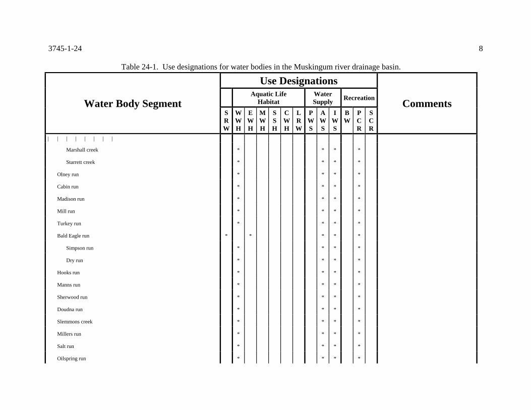
3745-1-24
8
Table 24-1. Use designations for water bodies in the Muskingum river drainage basin.
Water Body Segment
Use Designations
Comments
Aquatic Life
Habitat
Water Supply
Recreation
SRW
WWH
EWH
MWH
S S H
CWH
LRW
P W S
A W S
I WS
BW
P CR
SCR
| | | | | | | |
Marshall creek *
* * *
Starrett creek *
* * *
Olney run *
* * *
Cabin run *
* * *
Madison run *
* * *
Mill run *
* * *
Turkey run *
* * *
Bald Eagle run * *
* * *
Simpson run *
* * *
Dry run *
* * *
Hooks run *
* * *
Manns run *
* * *
Sherwood run *
* * *
Doudna run *
* * *
Slemmons creek *
* * *
Millers run *
* * *
Salt run *
* * *
Oilspring run *
* * *

3745-1-24
9
Table 24-1. Use designations for water bodies in the Muskingum river drainage basin.
Water Body Segment
Use Designations
Comments
Aquatic Life
Habitat
Water Supply
Recreation
SRW
WWH
EWH
MWH
S S H
CWH
LRW
P W S
A W S
I WS
BW
P CR
SCR
| | | | | | | |
North branch *
* * *
Moores run *
* * *
Island run +
+ + +
South branch +
+ + +
Big Bottom run +
+ + +
Cedar run *
* * *
Crow run *
* * *
Bluerock creek + +
+ + +
Little Bluerock creek +
+ + +
Back run *
+ + +
Fox run *
* * *
Dry Riffle run *
+ + +
Duncan run *
+ + +
Little Duncan run +
+ + +
Salt creek +
+ + +
Manns fork - at RM 6.77 +
o
+ + + PWS intake - Blue Rock state park
- all other segments +
+ + +
Kent run +
+ + +

3745-1-24
10
Table 24-1. Use designations for water bodies in the Muskingum river drainage basin.
Water Body Segment
Use Designations
Comments
Aquatic Life
Habitat
Water Supply
Recreation
SRW
WWH
EWH
MWH
S S H
CWH
LRW
P W S
A W S
I WS
BW
P CR
SCR
| | | | | | | |
Boggs creek +
+ + +
Indian run +
+ + +
Buffalo fork +
+ + +
Williams fork +
+ + +
Lepage run *
* * *
White Eyes creek +
+ + +
Pleasant run +
+ + +
Little Salt creek +
+ + +
Frog run +
+ + +
Georges run +
+ + +
Prairie fork *
+ + +
Sycamore hollow run +
+ + +
Brush creek +
+ + +
Baughman run +
+ + +
Turkey run +
+ + +
Goose run +
+ + +
Flat run +
+ + +
Moxahala creek - headwaters to Jonathan creek (RM 4.54) +
+ + + Acid mine drainage.

3745-1-24
11
Table 24-1. Use designations for water bodies in the Muskingum river drainage basin.
Water Body Segment
Use Designations
Comments
Aquatic Life
Habitat
Water Supply
Recreation
SRW
WWH
EWH
MWH
S S H
CWH
LRW
P W S
A W S
I WS
BW
P CR
SCR
| | | | | | | |
- Jonathan creek to the mouth +
+ + +
Shawnee run +
+ + +
Jonathan creek - st. rte. 204 (RM 27.08) to the mouth +
+ + +
- headwaters to st. rte. 204 +
+ + +
Thompson run - headwaters to Coopermill rd. (RM 4.73) +
+ + +
- Coopermill rd. to the mouth +
+ + +
Hibbs run + +
+ + +
Kent run - at RM 1.3 +
o
+ + + PWS intake - Maysville
- all other segments +
+ + +
Salt run +
+ + +
Buckeye fork +
+ + + Acid mine drainage.
Bush creek +
+ + +
Twomile run *L
+ + + Acid mine drainage. Varied criteria year
around: exempt from the WWH total dissolved solids, pH, iron and zinc criteria.
Butcherknife creek +
+ + + Acid mine drainage.
Turkey run +
+ + +
Painter run +
+ + + WAP ecoregion - channel modification
Unnamed tributary (Jonathan creek RM 13.74) +
+ + +

3745-1-24
12
Table 24-1. Use designations for water bodies in the Muskingum river drainage basin.
Water Body Segment
Use Designations
Comments
Aquatic Life
Habitat
Water Supply
Recreation
SRW
WWH
EWH
MWH
S S H
CWH
LRW
P W S
A W S
I WS
BW
P CR
SCR
| | | | | | | |
Painter creek (Jonathan creek RM 16.88) +
+ + +
Unnamed tributary (Jonathan creek RM 19.47) +
+ + +
Valley run * +
+ + +
Berry run * *
* * *
Bowling Green creek +
+ + +
Morrison run o
+ + + Acid mine drainage.
Porter run o
+ + + Acid mine drainage.
Elk run o
+ + + Acid mine drainage.
Riders run o
+ + + Acid mine drainage.
Burley run o
+ + + Acid mine drainage.
Snake run o
+ + + Acid mine drainage.
Black fork - headwaters to south Morgan county line (RM 2.8) +
+ + +
- at RM 4.69 +
o
+ + + PWS intake - Crooksville
- RM 2.8 to mouth +
+ + + Acid mine drainage.
Dry run - at RM 2.23 *L
o
* * * Acid mine drainage. Varied criteria year
around: exempt from the WWH total dissolved solids, pH, iron and zinc criteria. PWS intake - Crooksville.

3745-1-24
13
Table 24-1. Use designations for water bodies in the Muskingum river drainage basin.
Water Body Segment
Use Designations
Comments
Aquatic Life
Habitat
Water Supply
Recreation
SRW
WWH
EWH
MWH
S S H
CWH
LRW
P W S
A W S
I WS
BW
P CR
SCR
| | | | | | | |
- all other segments *L
* * * Acid mine drainage. Varied criteria year
around: exempt from the WWH total dissolved solids, pH, iron and zinc criteria.
Ogg creek - headwaters to former Jones lake outlet (RM 1.4) +
+ + +
- RM 1.4 to mouth +
+ + + WAP ecoregion - mine affected
McLuney creek o
+ + + Acid mine drainage.
Bear creek o
+ + + Acid mine drainage.
Unnamed tributary (Moxahala creek RM 22.56) +
+ + + WAP ecoregion - mine affected
Andrews run (Moxahala creek RM 24.79) +
+ + + Acid mine drainage.
Chaps run *
* * *
Licking river - Dillon lake (RM 12.7 to 6.2) +
+ + +
- all other segments +
+ + +
Timber run +
+ + +
Unnamed tributary (Timber run RM 5.02) +
+ + +
Joes run +
+ + +
Bartlett run +
+ + +
Unnamed tributary (Barlett run RM 2.76) +
+ + +
Big run +
+ + +
Unnamed tributary (Big run RM 1.30) +
+ + +

3745-1-24
14
Table 24-1. Use designations for water bodies in the Muskingum river drainage basin.
Water Body Segment
Use Designations
Comments
Aquatic Life
Habitat
Water Supply
Recreation
SRW
WWH
EWH
MWH
S S H
CWH
LRW
P W S
A W S
I WS
BW
P CR
SCR
| | | | | | | |
Unnamed tributary (Big run RM 2.63) +
+ + +
Poverty run +
+ + +
Stump run +
+ + +
Brushy fork +
+ + +
Rocky fork - East branch to mouth +
+ + +
- all other segments +
+ + +
Lost run +
+ + *
Wilkins run +
+ + *
Smokyrow run +
+ + *
Painter run +
+ + *
Long run +
+ + *
Claylick creek +
+ + +
Little Claylick creek +
+ + +
Bowling Green run +
+ + *
Equality run +
+ + *
Shawnee run +
+ + *
Quarry run *
* * *
South fork +
+ + +

3745-1-24
15
Table 24-1. Use designations for water bodies in the Muskingum river drainage basin.
Water Body Segment
Use Designations
Comments
Aquatic Life
Habitat
Water Supply
Recreation
SRW
WWH
EWH
MWH
S S H
CWH
LRW
P W S
A W S
I WS
BW
P CR
SCR
| | | | | | | |
Raccoon creek +
+ + +
Salt run +
+ + *
Lobdell creek - Crouse-Willison rd. (RM 10.3) to the mouth +
+ + +
- unnamed tributary (Lobdell creek RM 13.79) to Crouse-Willison rd.
+
+ + + EOLP ecoregion - channel modification
- headwaters to RM 13.79 +
+ + + Small drainageway maintenance
Unnamed tributary (Lobdell creek RM 13.79) +
+ + + Small drainageway maintenance
Moots run +
+ + +
Simpson run +
+ + *
Pet run +
+ + *
Kiber run +
+ + *
Unnamed tributary (Raccoon creek RM 27.39)
- headwaters to Hartford township line (RM 2.2) +
+ + + Small drainageway maintenance
- all other segments +
+ + +
Dutch fork +
+ + +
Swamp run *
* * *
Hog run *
* * *
Quarry run *
* * *
Ramp creek +
+ + +

3745-1-24
16
Table 24-1. Use designations for water bodies in the Muskingum river drainage basin.
Water Body Segment
Use Designations
Comments
Aquatic Life
Habitat
Water Supply
Recreation
SRW
WWH
EWH
MWH
S S H
CWH
LRW
P W S
A W S
I WS
BW
P CR
SCR
| | | | | | | |
Beaver run +
+ + +
Wastewier run (South fork RM 12.83) +
+ + + EOLP ecoregion - channel modification
Buckeye lake *
+ + +
Honey creek +
+ + +
Reservoir feeder +
+ + + EOLP ecoregion - channel modification
Bell run +
+ + *
Muddy fork +
+ + +
Mile run *
* * *
North fork - at RM 2.9 +
+
+ + + PWS intake - Newark
- all other segments +
+ + +
Log Pond run +
+ + +
Dry run +
+ + +
Simonds run *
* * *
Brushy fork *
* * *
Cat run *
* * *
Griffin run *
* * *
Clear fork +
+ + +
Cranetown run *
* * *

3745-1-24
17
Table 24-1. Use designations for water bodies in the Muskingum river drainage basin.
Water Body Segment
Use Designations
Comments
Aquatic Life
Habitat
Water Supply
Recreation
SRW
WWH
EWH
MWH
S S H
CWH
LRW
P W S
A W S
I WS
BW
P CR
SCR
| | | | | | | |
Dog Hollow run +
+ + *
Lake fork +
+ + +
Sugar creek *
* * *
Sycamore creek +
+ + +
Tuma run +
+ + +
Vance creek +
+ + +
Chambers creek *
* * *
Goose run *
* * *
Otter fork +
+ + +
Bowl run +
+ + +
Unnamed tributary (Otter fork RM 11.72) +
+ + + Small drainageway maintenance
Webster run +
+ + *
Ford creek +
+ + *
Mill run *
* * *
Blount run *
* * *
Blunt run *
* * *
Shawnee run *
* * *
Beech run *
* * *

3745-1-24
18
Table 24-1. Use designations for water bodies in the Muskingum river drainage basin.
Water Body Segment
Use Designations
Comments
Aquatic Life
Habitat
Water Supply
Recreation
SRW
WWH
EWH
MWH
S S H
CWH
LRW
P W S
A W S
I WS
BW
P CR
SCR
| | | | | | | |
Symmes creek *
* * *
North branch *
* * *
South branch *
* * *
Wakatomika creek - headwaters to Front Royal rd. (RM 41.2) + +
+ + +
- Front Royal rd. to the mouth +
+ + +
Little Wakatomika creek - headwaters to st. rte. 60 (RM 9.5) +
+ + +
- st. rte. 60 to the mouth +
+ + +
Mill fork +
+ + +
Moscow brook - headwaters to twp. rte. 70 off co. rd. 297 (RM 2.63)
+
+ + +
- twp. rte. 70 off co. rd. 297 to the mouth +
+ + +
Sand fork - headwaters to unnamed tributary at RM 4.65 +
+ + +
- unnamed tributary at RM 4.65 to the mouth +
+ + +
Opossum run *
* * *
Dickinson run +
+ + +
Steffee run *
* * *
Black run +
+ + +
Fivemile run - headwaters to twp. rd. 4 (RM 2.08) +
+ + +

3745-1-24
19
Table 24-1. Use designations for water bodies in the Muskingum river drainage basin.
Water Body Segment
Use Designations
Comments
Aquatic Life
Habitat
Water Supply
Recreation
SRW
WWH
EWH
MWH
S S H
CWH
LRW
P W S
A W S
I WS
BW
P CR
SCR
| | | | | | | |
- twp. rd. 4 to the mouth +
+ + +
Nickel Valley run +
+ + +
Brushy fork - headwaters to RM 3.7 +
+ + +
- RM 3.7 to the mouth +
+ + +
Priest run +
+ + +
Pleasant Valley run (Priest run RM 1.62) +
+ + +
Winding fork - headwaters to upstream st. rte. 79 (RM 4.1) + +
+ + +
- RM 4.1 to the mouth +
+ + +
Oxley run *
* * *
Unnamed tributary (Winding fork RM 4.08) - at RM 2.56
o
PWS intake - Echoing Hills
Jug run + +
+ + +
Unnamed tributary (Jug run RM 1.69) + +
+ + +
Anderson run *
* * *
Harrod run +
+ + +
Pumpkin run *
* * *
Unnamed tributary (Wakatomika creek RM 40.93) + +
+ + +
Wills creek - at RM 66.7 +
o
+ + + PWS intake - Cambridge
- all other segments +
+ + +

3745-1-24
20
Table 24-1. Use designations for water bodies in the Muskingum river drainage basin.
Water Body Segment
Use Designations
Comments
Aquatic Life
Habitat
Water Supply
Recreation
SRW
WWH
EWH
MWH
S S H
CWH
LRW
P W S
A W S
I WS
BW
P CR
SCR
| | | | | | | |
Big run *
* * *
Brelsford run *
* * *
White Eyes creek *L
* * * Acid mine drainage. Varied criteria year
around: exempt from the WWH total dissolved solids criterion.
Brush run *L
* * * Acid mine drainage. Varied criteria year
around: exempt from the WWH total dissolved solids criterion.
Bacon run *
* * *
Bone run *
* * *
Center creek *
* * *
Twomile run *
* * *
Birds run *
* * *
Johnson fork *
* * *
Postboy creek *
* * *
Indian Camp run *
* * *
Dry run *
* * *
Wolf run *
* * *
Brush run *
* * *
Salt fork +
+ + +

3745-1-24
21
Table 24-1. Use designations for water bodies in the Muskingum river drainage basin.
Water Body Segment
Use Designations
Comments
Aquatic Life
Habitat
Water Supply
Recreation
SRW
WWH
EWH
MWH
S S H
CWH
LRW
P W S
A W S
I WS
BW
P CR
SCR
| | | | | | | |
Sugartree fork +
+ + +
Rocky fork +
+ + +
Yellow Water creek +
+ + +
Clear fork +
+ + +
Turkey run +
+ + +
Beeham run +
+ + +
Brushy fork +
+ + +
Christian creek +
+ + +
Coon run +
+ + +
Sarchett run *
* * *
Crooked creek +
+ + *
Jackson run *L
* * * Acid mine drainage. Varied criteria year
around: exempt from the WWH total dissolved solids criterion.
Peters creek *L
* * * Acid mine drainage. Varied criteria year
around: exempt from the WWH total dissolved solids criterion.
Bobs run *L
* * * Acid mine drainage. Varied criteria year
around: exempt from the WWH total dissolved solids criterion.

3745-1-24
22
Table 24-1. Use designations for water bodies in the Muskingum river drainage basin.
Water Body Segment
Use Designations
Comments
Aquatic Life
Habitat
Water Supply
Recreation
SRW
WWH
EWH
MWH
S S H
CWH
LRW
P W S
A W S
I WS
BW
P CR
SCR
| | | | | | | |
North Crooked creek - at RM 4.46 *L
o
* * * Acid mine drainage. Varied criteria year
around: exempt from the WWH total dissolved solids criterion. PWS intake - New Concord
- all other segments *L
* * * Acid mine drainage. Varied criteria year
around: exempt from the WWH total dissolved solids criterion.
Fox creek *L
* * * Acid mine drainage. Varied criteria year
around: exempt from the WWH total dissolved solids criterion.
Unnamed tributary (Fox creek RM 5.56)
o
PWS intake - New Concord
Dare run *L
* * * Acid mine drainage. Varied criteria year
around: exempt from the WWH total dissolved solids criterion.
Leatherwood creek - at RM 22.36 +
o
+ + * PWS intake - Quaker city (formerly)
- all other segments +
+ + *
Mud run *
* * *
Hawkins run *
* * *
Infirmary run *
* * *
Shannon run *L
* * * Acid mine drainage. Varied criteria year
around: exempt from the WWH total dissolved solids criterion.
Chapman run +
+ + +

3745-1-24
23
Table 24-1. Use designations for water bodies in the Muskingum river drainage basin.
Water Body Segment
Use Designations
Comments
Aquatic Life
Habitat
Water Supply
Recreation
SRW
WWH
EWH
MWH
S S H
CWH
LRW
P W S
A W S
I WS
BW
P CR
SCR
| | | | | | | |
Trail run *
* * *
Seneca fork *
* * *
Soggy run *
* * *
Opossum run *
* * *
Crooked creek *
* * *
Mud run *
* * *
Depue run *
* * *
Beaver creek *
* * *
Yoker creek *
* * *
Glady run *
* * *
South fork *
* * *
North fork *
* * *
Mud run *
* * *
Bishop run *
* * *
Paynes fork *
* * *
Rock creek *
* * *
Buffalo fork +
* * *
Crane run +
* * *

3745-1-24
24
Table 24-1. Use designations for water bodies in the Muskingum river drainage basin.
Water Body Segment
Use Designations
Comments
Aquatic Life
Habitat
Water Supply
Recreation
SRW
WWH
EWH
MWH
S S H
CWH
LRW
P W S
A W S
I WS
BW
P CR
SCR
| | | | | | | |
Yoker creek +
* * *
Mannon run +
* * *
Flat run +
* * *
McKee run +
* * *
Bee run +
* * *
Sims run +
* * *
Cumberland tributary +
+ + + Small drainageway maintenance
Collins fork +
* * *
Miller creek +
* * *
Mays fork +
* * *
Rannells creek +
* * *
Buffalo creek *L
* * * Acid mine drainage. Varied criteria year
around: exempt from the WWH total dissolved solids criterion.
North fork *L
* * * Acid mine drainage. Varied criteria year
around: exempt from the WWH total dissolved solids criterion.
South fork *L
* * * Acid mine drainage. Varied criteria year
around: exempt from the WWH total dissolved solids criterion.

3745-1-24
25
Table 24-1. Use designations for water bodies in the Muskingum river drainage basin.
Water Body Segment
Use Designations
Comments
Aquatic Life
Habitat
Water Supply
Recreation
SRW
WWH
EWH
MWH
S S H
CWH
LRW
P W S
A W S
I WS
BW
P CR
SCR
| | | | | | | |
Little Buffalo creek *L
* * * Acid mine drainage. Varied criteria year
around: exempt from the WWH total dissolved solids criterion.
Robinson run *
* * *
North creek +
+ + + Small drainageway maintenance
West creek +
+ + + Small drainageway maintenance
Tuscarawas river - State st. in Barberton (RM 112.9) to Chippewa creek
(RM 103.2) +
+ + + EOLP ecoregion - channel modification
- Stillwater creek (RM 47.0) to the mouth +
+ + +
- all other segments +
+ + +
Unnamed tributary (Tuscarawas river mile 3.78) +
+ + +
Morgan run +
+ + +
White Eyes creek +
+ + +
East fork +
+ + +
West fork +
+ + +
Evans creek +
+ + +
Davis run *
* * *
Hoffman run *
* * *
Sweigert run *
* * *

3745-1-24
26
Table 24-1. Use designations for water bodies in the Muskingum river drainage basin.
Water Body Segment
Use Designations
Comments
Aquatic Life
Habitat
Water Supply
Recreation
SRW
WWH
EWH
MWH
S S H
CWH
LRW
P W S
A W S
I WS
BW
P CR
SCR
| | | | | | | |
Blue Ridge run +
+ + +
Rodney run *
* * *
Buckhorn creek +
+ + +
Lick run *
* * *
West fork *
* * *
Indiancamp creek *
* * *
Dunlap creek +
+ + +
Browning run +
+ + +
Stocker run *
* * *
Frys creek +
+ + +
Johnson run *
* * *
Mud run +
+ + +
Stillwater creek - headwaters to confluence with Brushy fork *L
* * * Acid mine drainage. Varied criteria year
around: exempt from the WWH total dissolved solids criterion.
- Uhrichsville dam (RM 5.2) to mouth +
+ + +
- at RM 7.05 *
o
* * * PWS intake - Twin city
- all other segments *
* * *
Little Stillwater creek - confluence with Plum run to Dennison +
+ + *
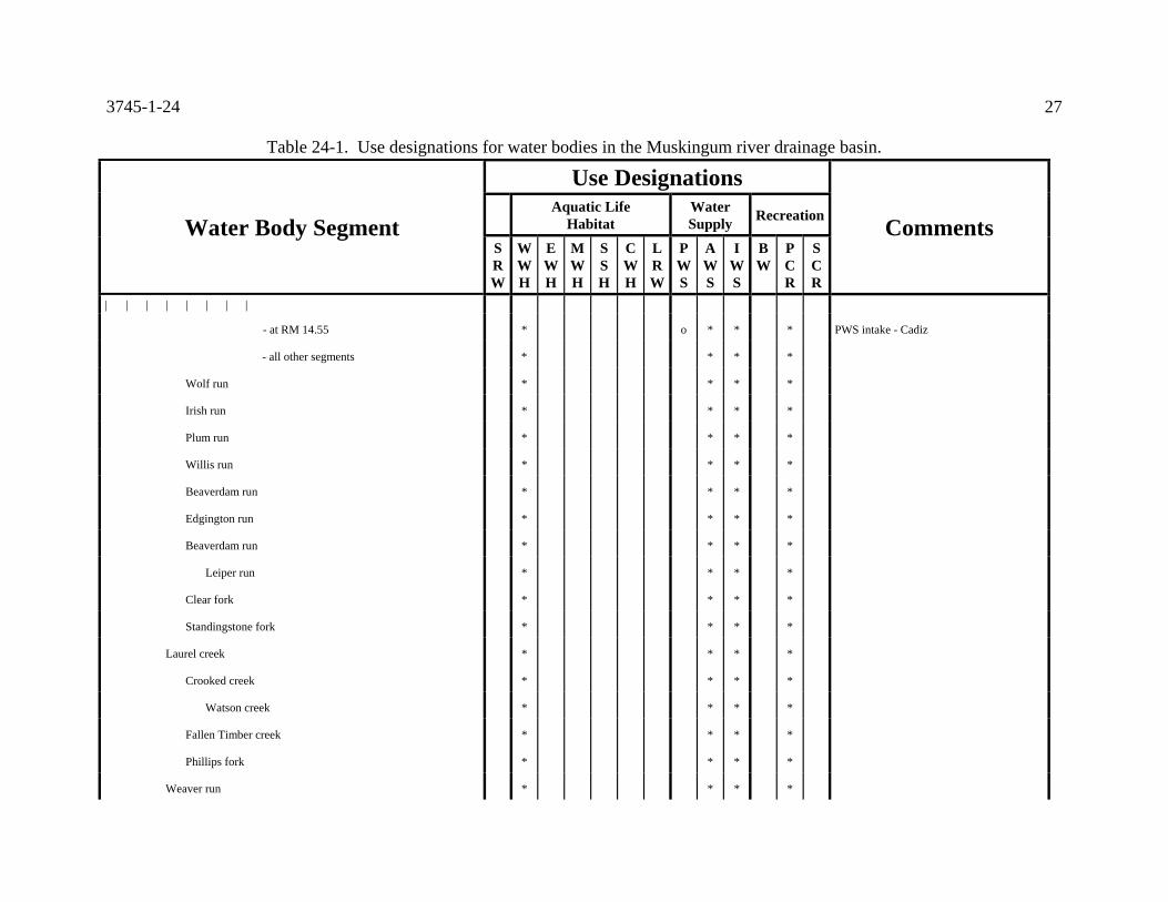
3745-1-24
27
Table 24-1. Use designations for water bodies in the Muskingum river drainage basin.
Water Body Segment
Use Designations
Comments
Aquatic Life
Habitat
Water Supply
Recreation
SRW
WWH
EWH
MWH
S S H
CWH
LRW
P W S
A W S
I WS
BW
P CR
SCR
| | | | | | | |
- at RM 14.55 *
o
* * * PWS intake - Cadiz
- all other segments *
* * *
Wolf run *
* * *
Irish run *
* * *
Plum run *
* * *
Willis run *
* * *
Beaverdam run *
* * *
Edgington run *
* * *
Beaverdam run *
* * *
Leiper run *
* * *
Clear fork *
* * *
Standingstone fork *
* * *
Laurel creek *
* * *
Crooked creek *
* * *
Watson creek *
* * *
Fallen Timber creek *
* * *
Phillips fork *
* * *
Weaver run *
* * *

3745-1-24
28
Table 24-1. Use designations for water bodies in the Muskingum river drainage basin.
Water Body Segment
Use Designations
Comments
Aquatic Life
Habitat
Water Supply
Recreation
SRW
WWH
EWH
MWH
S S H
CWH
LRW
P W S
A W S
I WS
BW
P CR
SCR
| | | | | | | |
Hitchcock run *
* * *
Brushy fork *
* * *
Hefling run *
* * *
Long run *
* * *
Colman run *
* * *
Huff run *
* * *
McFadden run *
* * *
Elk run *
* * *
South fork *
* * *
Atkinson creek *
* * *
Craborchard creek *
* * *
Skull fork *L
* * * Acid mine drainage. Varied criteria year
around: exempt from the WWH total dissolved solids criterion.
Millers fork *L
* * * Acid mine drainage. Varied criteria year
around: exempt from the WWH total dissolved solids criterion.
Piedmont reservoir tributaries *L
* * * Acid mine drainage. Varied criteria year
around: exempt from the WWH total dissolved solids criterion.

3745-1-24
29
Table 24-1. Use designations for water bodies in the Muskingum river drainage basin.
Water Body Segment
Use Designations
Comments
Aquatic Life
Habitat
Water Supply
Recreation
SRW
WWH
EWH
MWH
S S H
CWH
LRW
P W S
A W S
I WS
BW
P CR
SCR
| | | | | | | |
Boggs fork - Holloway to confluence with Stillwater creek *L
* * * Acid mine drainage. Varied criteria year
around: exempt from the WWH total dissolved solids criterion.
- all other segments *
* * *
Plum run *L
* * * Acid mine drainage. Varied criteria year
around: exempt from the WWH total dissolved solids criterion.
Trail run *L
* * * Acid mine drainage. Varied criteria year
around: exempt from the WWH total dissolved solids criterion.
Rush run *L
* * * Acid mine drainage. Varied criteria year
around: exempt from the WWH total dissolved solids criterion.
Jockey Hollow run *
* * *
Indian run *
* * *
Sixmile run *
* * *
Lick run *
* * *
Robinson run *
* * *
Buttermilk creek *
* * *
Coal run *
* * *
Spencer creek *
* * *
Pike run *
* * *

3745-1-24
30
Table 24-1. Use designations for water bodies in the Muskingum river drainage basin.
Water Body Segment
Use Designations
Comments
Aquatic Life
Habitat
Water Supply
Recreation
SRW
WWH
EWH
MWH
S S H
CWH
LRW
P W S
A W S
I WS
BW
P CR
SCR
| | | | | | | |
Pone run *
* * *
Beaverdam creek +
+ + +
Oldtown creek +
+ + +
Stone creek *
* * *
Crooked creek +
+ + +
Unnamed tributary (Stone creek RM 6.0) +
+ + +
Sugar creek - Beach city dam to mouth +
+ + +
- all other segments +
+ + +
Brandywine creek +
+ + +
Goettge run +
+ + +
Broad run +
+ + +
Turkeyfoot run +
+ + +
Cherry run +
+ + +
South fork - headwaters to co. rte. 73 (RM 11.2) +
+ + + EOLP ecoregion - channel modification
- all other segments +
+ + +
Unnamed tributary (South fork RM 1.0) +
+ + +
Walnut creek - headwaters to Indian Trail creek (RM 0.82) +
+ + + EOLP ecoregion - channel modification
- all other segments +
+ + +

3745-1-24
31
Table 24-1. Use designations for water bodies in the Muskingum river drainage basin.
Water Body Segment
Use Designations
Comments
Aquatic Life
Habitat
Water Supply
Recreation
SRW
WWH
EWH
MWH
S S H
CWH
LRW
P W S
A W S
I WS
BW
P CR
SCR
| | | | | | | |
Indian Trail creek +
+ + +
Unnamed tributary (Indian Trail creek RM 6.08) - headwaters to RM 0.9
+
+ + + Small drainageway maintenance
- all other segments +
+ + +
Unnamed tributary (Walnut creek RM 3.92) +
+ + +
Goose creek +
+ + +
Unnamed tributary (South fork RM 11.3) +
+ + +
East branch - co. rte. 52 (RM 5.04) to the mouth +
+ + + EOLP ecoregion - channel modification
- all other segments +
+ + +
Unnamed tributary (East branch RM 2.07) +
+ + +
Pleasant Valley creek +
+ + +
Unnamed tributary (East branch RM 3.6) +
+ + +
Unnamed tributary (South fork RM 14.1) +
+ + +
Unnamed tributary (South fork RM 15.83) +
+ + +
Troyer Valley creek +
+ + +
Brush run +
+ + +
Unnamed tributary (Brush run RM 1.54) +
+ + + Acid mine drainage
Bean creek *
* * *

3745-1-24
32
Table 24-1. Use designations for water bodies in the Muskingum river drainage basin.
Water Body Segment
Use Designations
Comments
Aquatic Life
Habitat
Water Supply
Recreation
SRW
WWH
EWH
MWH
S S H
CWH
LRW
P W S
A W S
I WS
BW
P CR
SCR
| | | | | | | |
Elm run +
+ + +
Middle fork +
+ + +
Unnamed tributary (Middle fork RM 3.25) +
+ + +
Misers run +
+ + +
Unnamed tributary (Middle fork RM 6.0) +
+ + +
Crabapple creek +
+ + +
North fork +
+ + +
Little Sugar creek +
+ + +
Unnamed tributary (Little Sugar creek RM 0.5) +
+ + +
Conotton creek +
+ + *
Huff run *
* * *
Beggar run *
* * *
Dog run *
* * *
Indian fork - at RMs 3.0 and 3.7 *
o
* * * PWS intakes - Atwood park (RM 3.0) and
Atwood resort (RM 3.7) - all other segments *
* * *
Elliot run *
* * *
Dellroy creek *
* * *

3745-1-24
33
Table 24-1. Use designations for water bodies in the Muskingum river drainage basin.
Water Body Segment
Use Designations
Comments
Aquatic Life
Habitat
Water Supply
Recreation
SRW
WWH
EWH
MWH
S S H
CWH
LRW
P W S
A W S
I WS
BW
P CR
SCR
| | | | | | | |
Messer run *
* * *
Pleasant Valley run *
* * *
Cold Spring run *
* * *
Town creek *
* * *
Gant creek *
* * *
Thompson run *
* * *
Holmes run *
* * *
McGuire creek *
* * *
North fork *
* * *
Bear Hole run *
* * *
Scott run *
* * *
Dining fork *
* * *
Kirby run *
* * *
Irish creek +
+ + *
Lick fork *
* * *
Snow creek *
* * *
Unnamed tributary *
* * *
Jefferson creek +
+ + *

3745-1-24
34
Table 24-1. Use designations for water bodies in the Muskingum river drainage basin.
Water Body Segment
Use Designations
Comments
Aquatic Life
Habitat
Water Supply
Recreation
SRW
WWH
EWH
MWH
S S H
CWH
LRW
P W S
A W S
I WS
BW
P CR
SCR
| | | | | | | |
Small Middle run +
+ + +
Middle run +
+ + +
Wolf run *
* * *
Sandy creek +
+ + +
Bear run *
* * *
Sulphur run *
* * *
Limestone creek *
* * *
Nimishillen creek - Canton city limits to confluence with Sandy
creek +
+ + +
- all other segments +
+ + +
Sherrick run - headwaters to Osnaburg ditch (RM 5.2) +
+ + + Small drainageway maintenance
- RM 5.2 to mouth +
+ + +
Osnaburg ditch +
+ + + EOLP ecoregion - channel modification
Hurford run - headwaters (RM 4.95) to and including
confluence with Domer ditch (RM 1.71) +
+ + + Small drainageway maintenance
- downstream edge of confluence with Domer ditch (RM 1.71) to Harrison ave. (RM 0.8)
+
+ + + EOLP ecoregion - channel modification
- Harrison ave. (RM 0.8) to mouth (RM 0.0) +
+ + +
Domer ditch +
+ + +

3745-1-24
35
Table 24-1. Use designations for water bodies in the Muskingum river drainage basin.
Water Body Segment
Use Designations
Comments
Aquatic Life
Habitat
Water Supply
Recreation
SRW
WWH
EWH
MWH
S S H
CWH
LRW
P W S
A W S
I WS
BW
P CR
SCR
| | | | | | | |
West branch +
+ + +
McDowell ditch - headwaters to Zimber ditch (RM 2.3) +
+ + + EOLP ecoregion - channel modification
- RM 2.3 to mouth +
+ + EOLP ecoregion - channel modification
Zimber ditch - headwaters to Rettig Ditch (RM 1.2) +
+ + +
- RM 1.2 to North Canton ditch (RM 0.8) +
+ + + EOLP ecoregion - channel modification
- RM 0.8 to mouth +
+ + EOLP ecoregion - channel modification
North Canton ditch (Hoover ditch) +
+ + Small drainageway maintenance
Middle branch +
+ + +
Swartz ditch +
+ + + EOLP ecoregion - channel modification
Guiley ditch (Hartville ditch) +
+ + + EOLP ecoregion - channel modification
East branch - Louisville (RM 6.0) to Middle Branch
(RM 0.0) +
+ +
- all other segments +
+ + +
Keims run +
+ + Small drainageway maintenance
Unnamed tributary (East branch RM 4.67) +
+ + +
Indian run *
* * *
Little Sandy creek *
* * *
Black run *
* * *

3745-1-24
36
Table 24-1. Use designations for water bodies in the Muskingum river drainage basin.
Water Body Segment
Use Designations
Comments
Aquatic Life
Habitat
Water Supply
Recreation
SRW
WWH
EWH
MWH
S S H
CWH
LRW
P W S
A W S
I WS
BW
P CR
SCR
| | | | | | | |
Middle run *
* * *
Armstrong run *
* * *
Pipe run *
* * *
Hugle run *
* * *
Still fork +
+ + +
Muddy fork *
* * *
Wholebark run *
* * *
Pumpkin run *
* * *
Reeds run *
* * *
Pipes fork *
* * *
Friday creek *
* * *
Middle branch *
* * *
Conser run *
* * *
Unnamed tributary (Tuscarawas river mile 77.96) +
+ + +
Sherman creek (Tuscarawas river mile 79.58) +
+ + +
Fohl creek (Tuscarawas river mile 83.74) +
+ + +
Wolf creek *
* * *
Camp creek *
* * *

3745-1-24
37
Table 24-1. Use designations for water bodies in the Muskingum river drainage basin.
Water Body Segment
Use Designations
Comments
Aquatic Life
Habitat
Water Supply
Recreation
SRW
WWH
EWH
MWH
S S H
CWH
LRW
P W S
A W S
I WS
BW
P CR
SCR
| | | | | | | |
Pigeon run +
+ + +
Sippo creek *
* * *
West Scippo creek (Tuscarawas river mile 91.18) +
+ + +
Newman creek +
+ + +
Orrville ditch (Newark creek) *
* * *
Unnamed tributary (Orrville ditch RM 0.52) +
+ + +
Mudbrook creek *
* * *
Fox run *
* * *
Nimisila creek +
+ + +
Chippewa creek - Chippewa lake outlet (RM 20.4) to mouth +
+ + + EOLP ecoregion - channel modification
- all other segments +
+ + +
Silver creek +
+ + *
Red run +
+ + *
Marshallville tributary (Red run RM 0.66) +
+ + *
Mill creek *
* * *
River Styx - Medina county rd. 16 (RM 3.9) to mouth +
+ + + EOLP ecoregion - channel modification
- all other segments +
+ + *
Holmes brook +
+ + *

3745-1-24
38
Table 24-1. Use designations for water bodies in the Muskingum river drainage basin.
Water Body Segment
Use Designations
Comments
Aquatic Life
Habitat
Water Supply
Recreation
SRW
WWH
EWH
MWH
S S H
CWH
LRW
P W S
A W S
I WS
BW
P CR
SCR
| | | | | | | |
Blockers creek +
+ + +
Little Chippewa creek +
+ + +
Unnamed trib. (Little Chippewa creek RM 6.3) *
* * *
Tommy run +
+ + +
Hubbard creek +
+ + +
Chippewa ditch *
* * *
McCabe creek +
+ + +
The inlet *
* * *
Pancake creek *
* * *
Wolf creek - Akron Wadsworth rd. (RM 4.58) to mouth +
+ + + EOLP ecoregion - channel modification
- at RM 5.12 +
o
+ + + PWS intake - Barberton
- all other segments +
+ + +
Hudson run - Columbia lake outlet (RM 0.4) to the mouth +
+ + + EOLP ecoregion - channel modification
- all other segments +
+ + +
Unnamed tributary (Hudson run RM 3.02) +
+ + +
Van Hyning run +
+ + *
Pigeon creek - Jacoby rd. (RM 5.2) to mouth +
+ + * EOLP ecoregion - channel modification
- all other segments +
+ + *
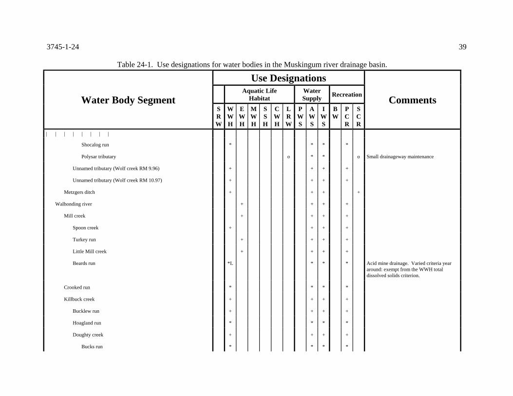
3745-1-24
39
Table 24-1. Use designations for water bodies in the Muskingum river drainage basin.
Water Body Segment
Use Designations
Comments
Aquatic Life
Habitat
Water Supply
Recreation
SRW
WWH
EWH
MWH
S S H
CWH
LRW
P W S
A W S
I WS
BW
P CR
SCR
| | | | | | | |
Shocalog run *
* * *
Polysar tributary o
* * o Small drainageway maintenance
Unnamed tributary (Wolf creek RM 9.96) +
+ + +
Unnamed tributary (Wolf creek RM 10.97) +
+ + +
Metzgers ditch +
+ + +
Walhonding river +
+ + +
Mill creek +
+ + +
Spoon creek +
+ + +
Turkey run +
+ + +
Little Mill creek +
+ + +
Beards run *L
* * * Acid mine drainage. Varied criteria year
around: exempt from the WWH total dissolved solids criterion.
Crooked run *
* * *
Killbuck creek +
+ + +
Bucklew run +
+ + +
Hoagland run *
* * *
Doughty creek +
+ + +
Bucks run *
* * *

3745-1-24
40
Table 24-1. Use designations for water bodies in the Muskingum river drainage basin.
Water Body Segment
Use Designations
Comments
Aquatic Life
Habitat
Water Supply
Recreation
SRW
WWH
EWH
MWH
S S H
CWH
LRW
P W S
A W S
I WS
BW
P CR
SCR
| | | | | | | |
Military run +
+ + +
Mullet run *
* * *
Charm tributary (Doughty creek RM 14.34) +
+ + +
Big run +
+ + +
Laurel creek *
* * *
Lepley run *
* * *
Wolf creek - headwaters to twp. rd. 31 (RM 4.1) + +
+ + +
- twp. rd. 31 to the mouth +
+ + +
Unnamed tributary (Wolf creek RM 6.49) + +
+ + +
Black creek +
+ + +
Unnamed tributary (Black creek RM 7.35) +
+ + +
Shrimplin creek + +
+ + +
Hardy run *
* * *
Sand run +
+ + +
Upper Sand run *
* * *
Sapps run +
+ + +
Uhl run *
* * *
Bear run +
+ + +

3745-1-24
41
Table 24-1. Use designations for water bodies in the Muskingum river drainage basin.
Water Body Segment
Use Designations
Comments
Aquatic Life
Habitat
Water Supply
Recreation
SRW
WWH
EWH
MWH
S S H
CWH
LRW
P W S
A W S
I WS
BW
P CR
SCR
| | | | | | | |
Corns run +
+ + +
Honey run +
+ + +
Colliers run *
* * *
Martins creek +
+ + +
Paint creek +
+ + +
Coffee run *
* * *
Unnamed tributary (Paint creek RM 3.01) + +
+ + +
Salt creek +
+ + +
North branch +
+ + +
Tea run *
* * *
Rush run *
* * *
Savage run *
* * *
Shreve creek +
+ + +
Millbrook tributary (Killbuck creek RM 43.60) +
+ + +
Apple creek +
+ + +
Little Apple creek (Apple creek RM 2.60) +
+ + +
Spring run +
+ + +
Little Apple creek (Apple creek RM 9.79) +
+ + +

3745-1-24
42
Table 24-1. Use designations for water bodies in the Muskingum river drainage basin.
Water Body Segment
Use Designations
Comments
Aquatic Life
Habitat
Water Supply
Recreation
SRW
WWH
EWH
MWH
S S H
CWH
LRW
P W S
A W S
I WS
BW
P CR
SCR
| | | | | | | |
Clear creek + +
+ + +
Little Killbuck creek +
+ + +
Rathburn run +
+ + +
Cedar run +
+ + +
Shade creek +
+ + +
Little Killbuck creek *
* * *
Repp run +
+ + +
Camel creek +
+ + +
Killbuck ditch (Killbuck creek RM 71.7) +
+ + + Small drainageway maintenance
Simmons run *
* * *
Flint run *
* * *
Beaver run +
+ + +
Darling run *
* * *
Mohawk creek *
* * *
Dutch run *
* * *
Honey run *
* * *
Laurel run *
* * *
Kokosing river +
+ + +

3745-1-24
43
Table 24-1. Use designations for water bodies in the Muskingum river drainage basin.
Water Body Segment
Use Designations
Comments
Aquatic Life
Habitat
Water Supply
Recreation
SRW
WWH
EWH
MWH
S S H
CWH
LRW
P W S
A W S
I WS
BW
P CR
SCR
| | | | | | | |
Singer run *
* * *
Brush run +
+ + +
Honey run *
* * *
Jelloway creek - Ireland creek (RM 9.35) to Fredericktown Amity
rd. (RM 5.18) + +
+ + +
- all other segments +
+ + +
Little Jelloway creek + +
+ + +
East branch - headwaters to U.S. rte. 62 (RM 2.4) + +
+ + +
- U.S. rte. 62 to the mouth +
+ + +
Sapps run *
* * *
Dowd creek *
* * *
Shadley Valley creek *
* * *
Ireland creek *
* * *
Barney run *
* * *
Schenck creek + +
+ + +
Coleman branch *
* * *
Little Schenck creek - headwaters to Carson rd. (RM 3.5) + +
+ + +
- Carson rd. to the mouth +
+ + +

3745-1-24
44
Table 24-1. Use designations for water bodies in the Muskingum river drainage basin.
Water Body Segment
Use Designations
Comments
Aquatic Life
Habitat
Water Supply
Recreation
SRW
WWH
EWH
MWH
S S H
CWH
LRW
P W S
A W S
I WS
BW
P CR
SCR
| | | | | | | |
Mud run *
* * *
Indianfield run + +
+ + +
Big run +
+ + +
Elliott run +
+ + +
Wolf run *
* * *
Delano run +
+ + +
Center run + +
+ + +
Dry creek - headwaters to unnamed tributary at RM 4.74 + +
+ + +
- unnamed tributary at RM 4.74 to Dry run (RM 1.05) +
+ + +
- Dry run to the mouth +
+ + +
Dry run *
* * *
Armstrong run + +
+ + +
North branch - headwaters to unnamed tributary at RM 10.8 + +
+ + +
- unnamed tributary at RM 10.8 to East branch (RM 6.32)
+
+ + +
- East branch to the mouth +
+ + +
Job run + +
+ + +
East branch - headwaters Knox lake +
+ + +

3745-1-24
45
Table 24-1. Use designations for water bodies in the Muskingum river drainage basin.
Water Body Segment
Use Designations
Comments
Aquatic Life
Habitat
Water Supply
Recreation
SRW
WWH
EWH
MWH
S S H
CWH
LRW
P W S
A W S
I WS
BW
P CR
SCR
| | | | | | | |
- Knox lake *
+ + +
- Knox lake to the mouth +
+ + +
Isaacs run *
* * *
Markley run *
* * *
Toby run *
* * *
Unnamed tributary (North branch Kokosing river RM 9.9) +
+ + +
Lost run *
* * *
Granny creek + +
+ + +
Mile creek *
* * *
South branch +
+ + +
Sylvester run *
* * *
Mohican river +
+ + +
Flat run *
* * *
Negro run +
+ + +
Sigafoos run *
* * *
Lake fork +
+ + +
Plum run +
+ + +
Unnamed stream (lake Odell outlet) (Lake fork RM 6.56) +
+ + +

3745-1-24
46
Table 24-1. Use designations for water bodies in the Muskingum river drainage basin.
Water Body Segment
Use Designations
Comments
Aquatic Life
Habitat
Water Supply
Recreation
SRW
WWH
EWH
MWH
S S H
CWH
LRW
P W S
A W S
I WS
BW
P CR
SCR
| | | | | | | |
Crab run +
+ + +
Muddy fork - at RM 26.0 +
o
+ + + PWS intake - Cinnamon lake utilities
- all other segments +
+ + +
Kiser ditch (Muddy fork RM 0.92) +
+ + + EOLP ecoregon - channel modification
Fox run *
* * *
Redhaw creek +
+ + +
Wolf run *
* * *
Jerome fork +
+ + +
Glenn run *
* * *
Oldtown run +
+ + +
Quaker Springs run +
+ + +
Scott run *
* * *
Newell run +
+ + +
Kakotawa creek +
+ + +
Lang creek +
+ + +
Jamison creek +
+ + +
Unnamed tributary (RM 0.2) +
+ + +
Town run +
+ + +

3745-1-24
47
Table 24-1. Use designations for water bodies in the Muskingum river drainage basin.
Water Body Segment
Use Designations
Comments
Aquatic Life
Habitat
Water Supply
Recreation
SRW
WWH
EWH
MWH
S S H
CWH
LRW
P W S
A W S
I WS
BW
P CR
SCR
| | | | | | | |
Orange creek +
+ + +
Leidigh Mill creek +
+ + +
Ball Alley run *
* * *
Black fork - at RMs 50.82, 53.88 and 54 +
+
+ + + PWS intakes - Shelby
- all other segments +
+ + +
Big run +
+ + +
Honey creek - headwaters to unnamed tributary at RM 4.19 +
+ + +
- RM 4.19 to the mouth +
+ + +
Rocky fork +
+ + +
Unnamed tributary (Rocky fork RM 10.70) +
+ + +
Fleming Falls creek +
* * +
Unnamed tributary (Fleming Falls creek RM 2.7) +
* * +
Touby run +
+ + +
Unnamed tributary (Black fork RM 25.16) +
+ + +
Seymour run *
* * *
Whetstone creek +
+ + +
Brubaker creek +
+ + +
Friends creek *
* * *

3745-1-24
48
Table 24-1. Use designations for water bodies in the Muskingum river drainage basin.
Water Body Segment
Use Designations
Comments
Aquatic Life
Habitat
Water Supply
Recreation
SRW
WWH
EWH
MWH
S S H
CWH
LRW
P W S
A W S
I WS
BW
P CR
SCR
| | | | | | | |
Shipp creek +
+ + +
Leatherwood creek *
* * *
Bear run +
+ + +
Marsh run +
+ + +
Tuby run +
+ + +
Unnamed tributary (Black fork RM 54.46) +
+ + +
Clear fork - Clear fork reservoir (RM 30.5) to the mouth * +
+ + +
- at RM 30.6 *
o
* * * PWS intake - Mansfield
- all other segments *
* * *
Pine run * +
+ + +
Horsetail run *
* * *
Switzer creek +
+ + +
Opossum run +
+ + +
Slater run +
+ + +
Babble brook *
* * *
Smoky run *
* * *
Pleasant Valley run *
* * *
Honey creek +
+ + +

3745-1-24
49
Table 24-1. Use designations for water bodies in the Muskingum river drainage basin.
Water Body Segment
Use Designations
Comments
Aquatic Life
Habitat
Water Supply
Recreation
SRW
WWH
EWH
MWH
S S H
CWH
LRW
P W S
A W S
I WS
BW
P CR
SCR
| | | | | | | |
Robinson run *
* * *
Cedar fork +
+ + +
Steel run *
* * *
SRW = state resource water; WWH = warmwater habitat; EWH = exceptional warmwater habitat; MWH = modified warmwater habitat; SSH = seasonal salmonid habitat; CWH = coldwater habitat; LRW = limited resource water; PWS = public water supply; AWS = agricultural water supply; IWS = industrial water supply; BW = bathing water; PCR = primary contact recreation; SCR = secondary contact recreation.

3745-1-24 50 Appendix Figure 1. Muskingum river drainage basin.
Medina Akron
Muskingum River
-N D !]]]
Lakes
Rivers
County Boundaries
Cities

3745-1-24 51 Effective: 6/16/2011 R.C. 119.032 rule review date: 6/16/2016 Promulgated Under: R.C. 119.03 Statutory Authority: R.C. 6111.041 Rule Amplifies: R.C. 6111.041 Prior Effective Dates: 4/4/1985, 8/19/1985, 9/20/1988, 5/1/1990, 7/5/1991, 7/1/1992, 4/26/1997, 3/29/2001, 7/21/2002, 4/23/2008

3745-1-25 Mahoning river drainage basin. (A) The water bodies listed in table 25-1 of this rule are ordered from downstream to upstream.
Tributaries of a water body are indented. The aquatic life habitat, water supply and recreation use designations are defined in rule 3745-1-07 of the Administrative Code. The state resource water use designation is defined in rule 3745-1-05 of the Administrative Code. The most stringent criteria associated with any one of the use designations assigned to a water body will apply to that water body.
(B) Figure 1 of the appendix to this rule is a generalized map of the Mahoning river drainage
basin. A generalized map of Ohio outlining the twenty-three major drainage basins and listing associated rule numbers in Chapter 3745-1 of the Administrative Code is in figure 1 of the appendix to rule 3745-1-08 of the Administrative Code.
(C) RM, as used in this rule, stands for river mile and refers to the method used by the Ohio
environmental protection agency to identify locations along a water body. Mileage is defined as the lineal distance from the downstream terminus (i.e., mouth) and moving in an upstream direction.
(D) The following symbols are used throughout this rule:
* Designated use based on the 1978 water quality standards;
+ Designated use based on the results of a biological field assessment performed by the Ohio environmental protection agency;
o Designated use based on justification other than the results of a biological field
assessment performed by the Ohio environmental protection agency; and
L An L in the warmwater habitat column signifies that the water body segment is designated limited warmwater habitat.

3745-1-25
2
Table 25-1. Use designations for water bodies in the Mahoning river drainage basin.
Water Body Segment
Use Designations
Comments
Aquatic Life
Habitat
Water Supply
Recreation
SRW
WWH
EWH
MWH
S S H
CWH
LRW
P W S
A W S
I WS
BW
P CR
SCR
| | | | | | | |
Mahoning river - at RMs 56.47, 69.18, 83.55, and 91.50 +
o
+ + + PWS intakes - Newton Falls (RM 56.47),
Mahoning valley sanitary district (emergency intake, RM 69.18), Alliance (emergency intake, RM 83.55) and Sebring (RM 91.50)
- headwaters to King rd. (RM 102.41) +
+ + +
- all other segments +
+ + +
Hickory creek (formerly Hickory run) *
* * *
Coffee run *
* * *
Grays run *
* * *
Hines run +
+ + +
Godward run *
* * *
Yellow creek - at RMs 2.0 and 8.40 +
o
+ + + PWS intakes - Campbell (RM 2.0) and
Struthers (RM 8.40)
- all other segments +
+ + +
Burgess run - at RM 2.0 *
o
* * * PWS intake - Struthers
- all other segments *
* * *
Pine Hollow creek *
* * *
Dry run - at RM 2.86 +
o
+ + + PWS intake - Campbell
- all other segments +
+ + +

3745-1-25
3
Table 25-1. Use designations for water bodies in the Mahoning river drainage basin.
Water Body Segment
Use Designations
Comments
Aquatic Life
Habitat
Water Supply
Recreation
SRW
WWH
EWH
MWH
S S H
CWH
LRW
P W S
A W S
I WS
BW
P CR
SCR
| | | | | | | |
Crab creek *
* * *
Kimmel brook *
* * *
Mill creek +
+ + +
Bears Den run +
+ + +
Ax Factory run +
+ + +
Andersons run +
+ + +
Cranberry run *
* * *
Indian run +
+ + +
Saw Mill run *
* * *
Turkey creek *
* * *
Fourmile run *
* * *
Little Squaw creek (Mahoning river RM 23.55) +
+ + +
Squaw creek *
* * *
Meander creek - at RM 2.96 +
o
+ + + PWS intake - Mahoning valley sanitary
district
- all other segments +
+ + +
Morrison run *
* * *
Sawmill creek *
* * *

3745-1-25
4
Table 25-1. Use designations for water bodies in the Mahoning river drainage basin.
Water Body Segment
Use Designations
Comments
Aquatic Life
Habitat
Water Supply
Recreation
SRW
WWH
EWH
MWH
S S H
CWH
LRW
P W S
A W S
I WS
BW
P CR
SCR
| | | | | | | |
West branch *
* * *
Mosquito creek - at RM 12.49 +
o
+ + + PWS intake - Warren
- all other segments +
+ + +
Spring run *
* * *
Big run *
* * *
Confusion run *
* * *
Walnut creek *
* * *
Mud creek *
* * *
Smith run *
* * *
Mud creek *
* * *
Red run o
* o Small drainageway maintenance
Duck creek *
* * *
Little Duck creek *
* * *
East branch *
* * *
Chocolate run +
+ + +
Eagle creek +
+ + +
Tinker creek +
+ + +
Nelson ditch +
+ + +

3745-1-25
5
Table 25-1. Use designations for water bodies in the Mahoning river drainage basin.
Water Body Segment
Use Designations
Comments
Aquatic Life
Habitat
Water Supply
Recreation
SRW
WWH
EWH
MWH
S S H
CWH
LRW
P W S
A W S
I WS
BW
P CR
SCR
| | | | | | | |
South fork +
+ + +
Unnamed tributary (South fork RM 6.34) +
+ + +
Sand creek * +
+ + +
Unnamed tributary (Sand creek RM 2.22) +
+ + +
Unnamed tributary (Sand creek RM 3.25) +
+ + +
Unnamed tributary (Sand creek RM 4.84) +
+ + +
Mahoning creek +
+ + +
Camp creek +
+ + +
Silver creek +
+ + +
Hiram tributary +
+ + +
Black creek * *
* * *
West branch - at RM 13.25 +
o
+ + + PWS intake - West branch tower state park
- all other segments +
+ + +
Unnamed tributary (West branch RM 0.01) - RM 3.8 to the mouth +
+ + +
Unnamed tributary (West branch RM 8.28) +
+ + +
Unnamed tributary (West branch RM 9.63)
Unnamed tributary (unnamed tributary RM 0.74) +
+ + +
Silver creek +
+ + +

3745-1-25
6
Table 25-1. Use designations for water bodies in the Mahoning river drainage basin.
Water Body Segment
Use Designations
Comments
Aquatic Life
Habitat
Water Supply
Recreation
SRW
WWH
EWH
MWH
S S H
CWH
LRW
P W S
A W S
I WS
BW
P CR
SCR
| | | | | | | |
Hinkley creek +
+ + +
Bixon creek *
* * *
Barrel run +
+ + +
Harmon brook +
+ + +
Kale creek +
+ + +
Unnamed tributary (Kale creek RM 5.29) +
+ + +
Charley Run creek *
* * *
Mill creek +
+ + +
Turkey Broth creek +
+ + +
Unnamed tributary (Mill creek RM 3.67) +
+ + +
Garfield ditch (Mill creek RM 8.09) +
+ + +
Unnamed tributary (Mahoning river RM 91.21) +
+ + +
Naylor ditch (Mahoning river RM 93.58) +
+ + +
Unnamed tributary (Mahoning river RM 97.11) +
+ + +
Unnamed tributary (Mahoning river RM 98.71) +
+ + +
Island creek +
+ + +
Willow creek +
+ + +
Deer creek - at RM 0.54 +
o
+ + + PWS intake - Alliance

3745-1-25
7
Table 25-1. Use designations for water bodies in the Mahoning river drainage basin.
Water Body Segment
Use Designations
Comments
Aquatic Life
Habitat
Water Supply
Recreation
SRW
WWH
EWH
MWH
S S H
CWH
LRW
P W S
A W S
I WS
BW
P CR
SCR
| | | | | | | |
- all other segments +
+ + +
Beech creek +
+ + +
Little Beech creek +
+ + +
Fish creek +
+ + +
Beaver run +
+ + +
Shenango river - at RM 68.40 +
o
+ + + PWS intake - Pymatuning state park
(formerly) - all other segments +
+ + +
Deer creek *
* * *
Little Yankee creek +
+ + +
Little Deer creek +
+ + +
Mud run - headwater to east Liberty st. (RM 1.12) +
+ + +
- east Liberty st. to the mouth +
+ + +
Yankee creek +
+ + +
South branch +
+ + +
Pymatuning creek +
+ + +
Mill creek *
* * *
Stratton creek +
+ + +

3745-1-25
8
Table 25-1. Use designations for water bodies in the Mahoning river drainage basin.
Water Body Segment
Use Designations
Comments
Aquatic Life
Habitat
Water Supply
Recreation
SRW
WWH
EWH
MWH
S S H
CWH
LRW
P W S
A W S
I WS
BW
P CR
SCR
| | | | | | | |
Maple creek *
* * *
Sugar creek +
+ + +
Berry creek *
* * *
Clear creek *
* * *
McMichael creek +
+ + +
Black creek +
+ + +
Wade creek (Shenango river RM 71.46) +
+ + +
Gravel run +
+ + +
SRW = state resource water; WWH = warmwater habitat; EWH = exceptional warmwater habitat; MWH = modified warmwater habitat; SSH = seasonal salmonid habitat; CWH = coldwater habitat; LRW = limited resource water; PWS = public water supply; AWS = agricultural water supply; IWS = industrial water supply; BW = bathing water; PCR = primary contact recreation; SCR = secondary contact recreation.
3745-1-25 9 Appendix Figure 1. Mahoning river drainage basin.
-N L mm
Lakes
Rivers
County Boundaries
Cities

3745-1-25 10 Effective: 6/16/2011 R.C. 119.032 rule review date: 6/16/2016 Promulgated Under: R.C. 119.03 Statutory Authority: R.C. 6111.041 Rule Amplifies: R.C. 6111.041 Prior Effective Dates: 4/4/1985, 8/19/1985, 5/6/1993, 7/21/2002, 4/23/2008, 10/9/2009

3745-1-26 Cuyahoga river.
(A) The water bodies listed in table 26-2 of this rule are ordered from downstream to upstream.Tributaries of a water body are indented. The aquatic life habitat, water supply andrecreation use designations are defined in rule 3745-1-07 of the Administrative Code. Thestate resource water use designation is defined in rule 3745-1-05 of the Administrative Code.The most stringent criteria associated with any one of the use designations assigned to awater body will apply to that water body.
(B) Figure 1 of the appendix to this rule is a generalized map of the Cuyahoga river drainagebasin.
(C) RM, as used in this rule, stands for river mile and refers to the method used by the Ohioenvironmental protection agency to identify locations along a water body. Mileage isdefined as the lineal distance from the downstream terminus (i.e., mouth) and moving in anupstream direction.
(D) The following symbols are used throughout table 26-2 of this rule:
* Designated use based on the 1978 water quality standards;
+ Designated use based on the results of a biological field assessment performed by theOhio environmental protection agency;
o Designated use based on justification other than the results of a biological fieldassessment performed by the Ohio environmental protection agency; and
L An L in the warmwater habitat column signifies that the stream segment is designatedlimited warmwater habitat.
(E) The following uses, criteria and conditions shall apply to the Cuyahoga river ship channel.
(1) The Cuyahoga river ship channel is a unique segment of the Cuyahoga river. It is afederally maintained navigation channel which originates at the Newburgh and SouthShore railroad bridge (river mile 5.6) and empties into the Cleveland harbor portionof Lake Erie. The maintenance of the channel is important to commerce and theeconomic well being of the Cleveland area. The channel averages two hundredseventy feet in width, is maintained at a uniform depth of twenty-three feet and isvertically sheet piled along the vast majority of its length. The physical configurationof the channel results in a ten-day time of travel for a mass of water entering the shipchannel at critical low flow conditions.
Modeling projections of water quality in the channel have shown that levels of oxygendemanding materials found in natural waters are sufficient to depress dissolved oxygenbelow the warmwater habitat criteria. The modeling simulations also indicate that theexisting loads of oxygen demanding materials could maintain the warmwater habitat

3745-1-26 2
dissolved oxygen criteria if the river depth was decreased to twelve feet. However,this would preclude the use of the channel for commercial navigation.
The physical habitat of the channel and the prevailing background dissolved oxygenregime are insufficient to support any resemblance of the warmwater habitat aquaticlife use designation. A use attainability analysis has been conducted and indicates theextant fauna is substantially degraded and the potential for recovery of the fauna to thelevel characteristic of other Lake Erie river mouths is precluded by irretrievable humaninduced conditions. However, the ship channel is used by fish as a migratory route inthe spring months. This seasonal and stream flow related use shall be recognized andprotected through this rule.
Full body contact recreational uses such as rowing, sculling and jet skiing do occur inthe ship channel. The ship channel is also used as an industrial water supply but hasno potential to support agricultural or public water supply uses.
(2) Use designations for the Cuyahoga river ship channel are as follows:
(a) Aquatic life;
(i) During the months of June through January, and during the remainingmonths of the year whenever the river flow is less than seven hundred andthree cubic feet per second at the United States geological survey gage atIndependence (#04208000), the aquatic life use shall be limited resourcewater - navigation maintenance as defined in rule 3745-1-07 of theAdministrative Code.
(ii) During the months of February through May whenever the river flowequals or exceeds seven hundred and three cubic feet per second at theUnited States geological survey gage at Independence (#04208000), theaquatic life use shall be fish passage. The fish passage use is defined asthose rivers or other water bodies that have been the subject of a useattainability analysis and have been found to be incapable of supportingand maintaining a balanced, integrated, adaptive community of warmwaterorganisms but are capable of supporting the passage of warmwater fishduring migratory periods.
(b) Industrial water supply as defined in rule 3745-1-07 of the Administrative Code;and
(c) Primary contact recreation as defined in rule 3745-1-07 of the AdministrativeCode.
(3) The criteria and other provisions to protect the designated uses of the ship channel

3745-1-26 3
shall be those set forth in rules 3745-1-01 to 3745-1-07 of the Administrative Codewith the following exceptions:
(a) The limited resource water dissolved oxygen criterion shall be 1.5 mg/lminimum. No dissolved oxygen average criteria apply.
(b) The fish passage criteria shall be the same as the warmwater habitat criteria inrule 3745-1-07 of the Administrative Code, with the exception that the biologicalcriteria do not apply.
(4) Pursuant to United States environmental protection agency regulations ("40 CFR Part130.7"), the director shall utilize the phased total maximum daily load approach as ameans of progressing toward attainment of the dissolved oxygen criteria establishedin paragraph (E)(3) of this rule. The phased total maximum daily load approach isgenerally recognized by the United States environmental protection agency as anappropriate methodology for achieving a total load reduction compatible withachieving water quality criteria ("Guidance for Water Quality-based Decisions and theTMDL Process, EPA 440/4-91-001"). In this instance the concept must consider theexpectation of dissolved oxygen enhancement through means other than additionalpoint and nonpoint source load reductions. Based on the background presented inparagraph (E)(1) of this rule and extensive data collection and analysis, the followingtotal maximum daily load components shall be established for oxygen demandingsubstances.
(a) The wasteloads for point sources shall be those presented in table 26-1 of thisrule. Loads for permit 3PA00002 may be established after the steps inparagraphs (E)(4)(b), (E)(4)(c) and (E)(4)(d) of this rule are completed.
(b) The total maximum daily load shall include a component for expected dissolvedoxygen enhancement through such means as, but not limited to, off channel re-aeration, sediment remediation and flow augmentation.
(c) An evaluation of the site-specific technical and cost feasibility aspects ofimplementing off channel re-aeration shall be the first scheduled phase of theCuyahoga river ship channel total maximum daily load. This evaluation shall becompleted no later than two years after the adoption of this rule.
(d) Implementation of off channel re-aeration or other dissolved oxygenenhancement measures, and any wasteload allocation for permit 3PA00002 foroxygen demanding substances, shall occur only after these components of thetotal maximum daily load are incorporated into this rule.
(5) These standards reflect the desire for restoring and maintaining multiple uses of theship channel expressed by the Cuyahoga river remedial action plan coordinating

3745-1-26 4
committee. All parties, private and public, who contribute to the dissolved oxygenproblem may share a responsibility in the study and attainment of these standards. Thedissolved oxygen criteria established in paragraph (E)(3) of this rule are intended tobe the minimum planning targets for the remedial action planning process to use inevaluating beneficial use restoration. The remedial action planning process shouldconsider innovative means of achieving this target such as off channel re-aeration,sediment remediation and flow augmentation, either alone or in combination withadditional point and nonpoint source controls. As with all standards, it will beappropriate to periodically re-assess the dissolved oxygen criteria based uponinformation collected as part of the feasibility study conducted pursuant to paragraph(E)(4)(c) of this rule or any other studies.
(6) These standards shall be reviewed, and revised if appropriate, every three years.Pursuant to Section 118 of the act (the "Great Lakes Critical Programs Act of 1990")the director shall continue to develop the Cuyahoga river remedial action plan - stagetwo report in conjunction with the Cuyahoga river remedial action plan coordinatingcommittee. Studies undertaken as part of the remedial action plan and the feasibilitystudy conducted pursuant to paragraph (E)(4)(c) of this rule shall be importantcomponents of the standards review process.

3745-1-26 5
Table 26-1. Cuyahoga river ship channel point source loads of oxygen demanding substances.
Facility - permit number Outfall Ammonia
average/maximumCBOD5
average/maximum D.O.
NEORSD -3PF00003 001a,g 2.0 mg/l
1324 kg/d3.0 mg/l1986 kg/d
10 mg/l6619 kg/d
15 mg/l9928 kg/d 5 mg/l
NEORSD -3PF00003 001b,g 5.0 mg/l
3309 kg/d7.5 mg/l4964 kg/d
16 mg/l10,590 kg/d
24 mg/l15,885 kg/d 5 mg/l
NEORSD -3PF00003 001c,g 8.0 mg/l
5295 kg/d12 mg/l7942 kg/d
16 mg/l10,590 kg/d
24 mg/l15,885 kg/d 5 mg/l
NEORSD -3PA00002 alld * * * * --
Zaclon -3IE00005 004/601 34 mg/l
36.9 kg/d55 mg/l59.7 kg/d
45 mg/le
48.9 kg/d120 mg/le 130 kg/d --
LTV - 3ID00003 005/604f 21 kg/d 63 kg/d -- -- --LTV - 3ID00003 014/605f 9 kg/d 27 kg/d -- -- --LTV - 3ID00003 009/606 158 kg/d 317 kg/d -- -- --LTV - 3ID00003 027/621f 18.8 kg/d 56.3 kg/d -- -- --
a Applies during the months of May through October. b Applies during the months of March, April and November. c Applies during the months of December, January and February. d Applies to all outfalls to the Cuyahoga river and its tributaries. * Monitoring program required for the combined sewer overflows. e BOD5 values. f A variance to these load limits is allowable unless the pending 301(g) variance request is denied.
If the 301(g) variance request is denied, the established implementation schedule will apply. g Loads calculated based upon design flow of 175 million gallons per day and are applicable to
normal dry weather operation. Load values are not intended to restrict facility operation duringwet weather flows when efforts are made to capture and treat combined sewer overflows.

3745-1-26 6
Table 26-2. Use designations for water bodies in the Cuyahoga river drainage basin.
Water Body Segment
Use Designations
CommentsAquatic Life
HabitatWaterSupply Recreation
SRW
WWH
EWH
MWH
SSH
CWH
LRW
PWS
AWS
IWS
BW
PCR
SCR
| | | | | | | |
Cuyahoga river - entirety of ship channel (Newburgh and South Shore (N&SS) railroad bridge (RM 5.6) to the mouth, including the old river channel)
See paragraph (E) of this rule.
- Bath rd. (RM 37.2) to Rockside rd. (RM 13.1) + + + + +
- Edison dam (RM 44.6) to North Main st. in Akron (RM 43.9)
+ + + + +
- Lake Rockwell (Cuyahoga river RM 62.0 to RM 57.97) + + +
- Troy-Burton township line in Geauga county (RM 83.9) to Lake Rockwell (RM 62.0)
+ + + + +
- all other segments + + + +
Burk branch (Burke brook) - uncovered segment adjacent to I-77 + + + + Channel modification
Big creek - within boundaries of Cleveland metro park * + + + +
- all other segments + + + +
Ford branch (Big creek RM 4.4) + + + + Small drainageway maintenance
West creek (Cuyahoga river RM 11.05) + + + +
Mill creek + + + +
Tinkers creek - Richmond rd. (RM 8.75) to the mouth o + + + +
- within boundaries of the J. Arthur Herrick nature preserve (RM 29.3 to 28.9)
o + + + +
- all other segments + + + +

3745-1-26 7
Table 26-2. Use designations for water bodies in the Cuyahoga river drainage basin.
Water Body Segment
Use Designations
CommentsAquatic Life
HabitatWaterSupply Recreation
SRW
WWH
EWH
MWH
SSH
CWH
LRW
PWS
AWS
IWS
BW
PCR
SCR
| | | | | | | |
Wood creek (Tinkers creek RM 2.44) + + + + High gradient
Deerlick run (Tinkers creek RM 3.7) - RM 0.37 to the mouth + + + + +
- all other segments + + + + + High gradient
Southwest branch (Deerlick run RM 0.40) + + + + + High gradient
South branch (Deerlick run RM 0.46) - Egbert rd. (RM 0.45) to the mouth
+ + + + + High gradient
- all other segments + + + + High gradient
North branch (Deerlick run RM 0.46) + + + + + High gradient
Hukill tributary (North branch RM 0.50) + + + + High gradient
Ferro tributary (North branch RM 0.50) + + + + High gradient
Hawthorne creek (Tinkers creek RM 7.8) + + + +
Beaver Meadow run (Tinkers creek RM 10.6) + + + +
Pond brook (Tinkers creek RM 22.5) + + + + EOLP ecoregion - channel modification
Chippewa creek - st. rte. 82 to the mouth * + + + +
- all other segments + + + +
Brandywine creek - Penn Central railroad tracks (RM 2.2) to the mouth o + + + +
- all other segments + + + +
Stanford run o * * * *
Slipper run * * * *

3745-1-26 8
Table 26-2. Use designations for water bodies in the Cuyahoga river drainage basin.
Water Body Segment
Use Designations
CommentsAquatic Life
HabitatWaterSupply Recreation
SRW
WWH
EWH
MWH
SSH
CWH
LRW
PWS
AWS
IWS
BW
PCR
SCR
| | | | | | | |
Boston run o * * * *
Haskell run o * * * *
Ritchie run o * * * *
Salt run o * * * *
Dickerson run - RM 3.1 to the mouth o * * * *
- all other segments * * * *
Langes run - RM 2.4 to the mouth o * * * *
- all other segments * * * *
Robinson run o * * * *
Furnace run - Cuyahoga-Summit county line (RM 8.8) to the mouth * + + + +
- all other segments + + + +
Yellow creek - RM 1.5 to the mouth o + + + +
- all other segments + + + +
North fork + + + +
Woodward creek - Northampton rd. (RM 3.4) to Bath rd. (RM 2.2) o * * * *
- all other segments * * * *
Sand run + + + +
Mud brook + + + +

3745-1-26 9
Table 26-2. Use designations for water bodies in the Cuyahoga river drainage basin.
Water Body Segment
Use Designations
CommentsAquatic Life
HabitatWaterSupply Recreation
SRW
WWH
EWH
MWH
SSH
CWH
LRW
PWS
AWS
IWS
BW
PCR
SCR
| | | | | | | |
Powers brook + + + *
Little Cuyahoga river + + + +
Ohio canal (little Cuyahoga river RM 2.0) - Summit lake (RM 2.84) to lock 1 (RM 1.25)
+ + + + EOLP ecoregion - channel modification
- lock 1 to end of enclosed segment (RM 0.47) + + Channel modification
- RM 0.47 to the mouth + + + + EOLP ecoregion - channel modification
Camp brook (a.k.a. Chessie tributary) (little Cuyahoga river RM 4.1) + + + +
Springfield lake outlet + + + +
Wingfoot lake outlet + + + +
Union Oil tributary (little Cuyahoga river RM 11.6) + + + +
Fish creek - headwaters to Sunrise dr. (RM 1.3) + + + + EOLP ecoregion - channel modification
- all other segments + + + +
Plum creek * * * *
Breakneck creek + + + +
Wahoo ditch + + + * EOLP ecoregion - channel modification
Hommon avenue ditch + + + + Small drainageway maintenance
Congress lake outlet (Feeder canal) + + + + EOLP ecoregion - channel modification
Potter creek * * * *
Black brook + + + +

3745-1-26 10
Table 26-2. Use designations for water bodies in the Cuyahoga river drainage basin.
Water Body Segment
Use Designations
CommentsAquatic Life
HabitatWaterSupply Recreation
SRW
WWH
EWH
MWH
SSH
CWH
LRW
PWS
AWS
IWS
BW
PCR
SCR
| | | | | | | |
Sawyer brook * * * *
Bridge creek + + + +
West branch + + + +
Butternut creek + + + +
Unnamed tributary (Cuyahoga river RM 88.0) + + + +
Johnson Rubber tributary (unnamed tributary RM 2.3) + + + + Small drainageway maintenance
Tare creek * * * *
Doan brook * * * *
Shaker Lakes national environmental education landmark * * * * *
Ninemile creek * * * *
Euclid creek - Anderson road (RM 5.6) to U.S. rte. 20 (RM 2.4) * * * * *
- all other segments * * * *
East branch (Euclid creek RM 3.2) + + + +
Unnamed tributary (East branch RM 1.55) + + + + Channel modification
SRW = state resource water; WWH = warmwater habitat; EWH = exceptional warmwater habitat; MWH = modified warmwater habitat; SSH = seasonal salmonid habitat; CWH = coldwater habitat; LRW = limited resource water; PWS = public water supply; AWS = agricultural water supply; IWS = industrial water supply; BW = bathing water; PCR = primary contact recreation; SCR = secondary contact recreation.

3745-1-26 11
Appendix
Figure 1. Cuyahoga river drainage basin.
3745-1-26 12
Effective: 7/21/02
R.C. Section 119.032 rule review dates: 4/27/99, 9/19/01, 7/21/07
Promulgated under: R.C. Section 119.03Rule authorized by: R.C. Section 6111.041Rule amplifies: R.C. Section 6111.041Prior effective dates: 4/4/85, 8/19/85, 7/28/86, 4/21/92, 9/30/93, 7/31/99
3745-1-27 Black river drainage basin.
(A) The water bodies listed in table 27-1 of this rule are ordered from downstream to upstream.Tributaries of a water body are indented. The aquatic life habitat, water supply andrecreation use designations are defined in rule 3745-1-07 of the Administrative Code. Thestate resource water use designation is defined in rule 3745-1-05 of the Administrative Code.The most stringent criteria associated with any one of the use designations assigned to awater body will apply to that water body.
(B) Figure 1 of the appendix to this rule is a generalized map of the Black river drainage basin.
(C) RM, as used in this rule, stands for river mile and refers to the method used by the Ohioenvironmental protection agency to identify locations along a water body. Mileage isdefined as the lineal distance from the downstream terminus (i.e., mouth) and moving in anupstream direction.
(D) The following symbols are used throughout this rule:
* Designated use based on the 1978 water quality standards;
+ Designated use based on the results of a biological field assessment performed by theOhio environmental protection agency;
o Designated use based on justification other than the results of a biological fieldassessment performed by the Ohio environmental protection agency; and
L An L in the warmwater habitat column signifies that the water body segment isdesignated limited warmwater habitat.

3745-1-27 2
Table 27-1. Use designations for water bodies in the Black river drainage basin.
Water Body Segment
Use Designations
CommentsAquatic Life
HabitatWaterSupply Recreation
SRW
WWH
EWH
MWH
SSH
CWH
LRW
PWS
AWS
IWS
BW
PCR
SCR
| | | | | | | |
Brownhelm creek * * * *
Quarry creek * * * *
Beaver creek + + + +
Martin run * * * *
Black river + + + + +
French creek - Gulf rd. to mouth + + + + +
- all other segments + + + +
East branch + + + +
Salt creek + + + +
Crow creek + + + +
Coon creek + + + +
East fork + + + +
West fork + + + +
Clear creek + + + +
Willow creek (East branch RM 5.56) + + + +
West branch - U.S. rte. 20 to the Black river + + + +
- Parsons rd. to U.S. rte. 20 * + + + +
- at RM 14.42 * + o + + + PWS intake - Oberlin

3745-1-27 3
Table 27-1. Use designations for water bodies in the Black river drainage basin.
Water Body Segment
Use Designations
CommentsAquatic Life
HabitatWaterSupply Recreation
SRW
WWH
EWH
MWH
SSH
CWH
LRW
PWS
AWS
IWS
BW
PCR
SCR
| | | | | | | |
- all other segments * * * *
Plum creek + + + +
Elk creek * * * *
Wellington creek - Findley state forest boundaries * + + + +
- all other segments + + + +
Charlemont creek - at RM 2.97 + o + + + PWS intake - Wellington
- all other segments + + + +
Buck creek + + + +
SRW = state resource water; WWH = warmwater habitat; EWH = exceptional warmwater habitat; MWH = modified warmwater habitat; SSH = seasonal salmonid habitat; CWH = coldwater habitat; LRW = limited resource water; PWS = public water supply; AWS = agricultural water supply; IWS = industrial water supply; BW = bathing water; PCR = primary contact recreation; SCR = secondary contact recreation.

3745-1-27 4
Appendix
Figure 1. Black river drainage basin.

3745-1-27 5
Effective: 4/23/2008
R.C. 119.032 rule review date: 4/23/2013
Promulgated Under: R.C. 119.03Statutory Authority: R.C. 6111.041Rule Amplifies: R.C. 6111.041Prior Effective Dates: 4/4/1985, 8/19/1985, 3/29/2001, 7/21/2002

3745-1-28 Vermilion river drainage basin.
(A) The water bodies listed in table 28-1 of this rule are ordered from downstream to upstream.Tributaries of a water body are indented. The aquatic life habitat, water supply andrecreation use designations are defined in rule 3745-1-07 of the Administrative Code. Thestate resource water use designation is defined in rule 3745-1-05 of the Aministrative Code.The most stringent criteria associated with any one of the use designations assigned to awater body will apply to that water body.
(B) Figure 1 of the appendix to this rule is a generalized map of the Vermilion river drainagebasin.
(C) RM, as used in this rule, stands for river mile and refers to the method used by the Ohioenvironmental protection agency to identify locations along a water body. Mileage isdefined as the lineal distance from the downstream terminus (i.e., mouth) and moving in anupstream direction.
(D) The following symbols are used throughout this rule:
* Designated use based on the 1978 water quality standards;
+ Designated use based on the results of a biological field assessment performed by theOhio environmental protection agency;
o Designated use based on justification other than the results of a biological fieldassessment performed by the Ohio environmental protection agency; and
L An L in the warmwater habitat column signifies that the water body segment isdesignated limited warmwater habitat.

3745-1-28 2
Table 28-1. Use designations for water bodies in the Vermilion river drainage basin.
Water Body Segment
Use Designations
CommentsAquatic Life
HabitatWaterSupply Recreation
SRW
WWH
EWH
MWH
SSH
CWH
LRW
PWS
AWS
IWS
BW
PCR
SCR
| | | | | | | |
Vermilion river - Erie-Huron county line to estuary * o * * *
- Mill Hollow-Bacon Woods park boundaries * * o * * *
- at RM 52.24 * o * * *
- all other segments * * * *
East fork * * * *
East branch * * * *
Skellinger creek + + + +
Indian creek * * * *
Southwest branch * * * *
Buck creek * * * *
Clear creek * * * *
SRW = state resource water; WWH = warmwater habitat; EWH = exceptional warmwater habitat; MWH = modified warmwater habitat; SSH = seasonal salmonid habitat; CWH = coldwater habitat; LRW = limited resource water; PWS = public water supply; AWS = agricultural water supply; IWS = industrial water supply; BW = bathing water; PCR = primary contact recreation; SCR = secondary contact recreation.

3745-1-28 3
Appendix
Figure 1. Vermilion river drainage basin.

3745-1-28 4
Effective: 3/29/01
R.C. Section 119.032 rule review dates: 7/17/00, 11/15/05
Promulgated under: R.C. Section 119.03Rule authorized by: R.C. Section 6111.041Rule amplifies: R.C. Section 6111.041Prior effective dates: 4/4/85, 8/19/85
3745-1-29 Wabash river drainage basin.
(A) The water bodies listed in table 29-1 of this rule are ordered from downstream to upstream.Tributaries of a water body are indented. The aquatic life habitat, water supply andrecreation use designations are defined in rule 3745-1-07 of the Administrative Code. Thestate resource water use designation is defined in rule 3745-1-05 of the Administrative Code.The most stringent criteria associated with any one of the use designations assigned to awater body will apply to that water body.
(B) Figure 1 of the appendix to this rule is a generalized map of the Wabash river drainage basin.
(C) RM, as used in this rule, stands for river mile and refers to the method used by the Ohioenvironmental protection agency to identify locations along a water body. Mileage isdefined as the lineal distance from the downstream terminus (i.e., mouth) and moving in anupstream direction.
(D) The following symbols are used throughout this rule:
* Designated use based on the 1978 water quality standards;
+ Designated use based on the results of a biological field assessment performed by theOhio environmental protection agency;
o Designated use based on justification other than the results of a biological fieldassessment performed by the Ohio environmental protection agency; and
L An L in the warmwater habitat column signifies that the water body segment isdesignated limited warmwater habitat.

3745-1-29 2
Table 29-1. Use designations for water bodies in the Wabash river drainage basin.
Water Body Segment
Use Designations
CommentsAquatic Life
HabitatWaterSupply Recreation
SRW
WWH
EWH
MWH
SSH
CWH
LRW
PWS
AWS
IWS
BW
PCR
SCR
| | | | | | | |
Wabash river * * * *
Hickory branch * * * *
Scherman ditch * * * *
Beaver creek + + + +
Big run * * * *
Brush run * * * *
Little Beaver creek + + + *
Little Bear creek * * * *
Buck run * * * *
Hardin creek * * * *
Grand Lake St. Marys * + + + +
Coldwater creek * * * *
Burntwood creek * * * *
Beaver creek * * * *
Darlinghaus ditch * * * *
Crab branch * * * *
Toti creek * * * *
Stony creek * * * *

3745-1-29 3
Table 29-1. Use designations for water bodies in the Wabash river drainage basin.
Water Body Segment
Use Designations
CommentsAquatic Life
HabitatWaterSupply Recreation
SRW
WWH
EWH
MWH
SSH
CWH
LRW
PWS
AWS
IWS
BW
PCR
SCR
| | | | | | | |
Twomile creek * * * *
Threemile creek * * * *
Vandenbush ditch * * * *
Ward ditch * * * *
Bear creek * * * *
Mississinewa river - headwaters to Ohio-Indiana state line + * * + ECBP ecoregion - channel modification
Jordan ditch * * * *
Grays branch * * * *
SRW = state resource water; WWH = warmwater habitat; EWH = exceptional warmwater habitat; MWH = modified warmwater habitat; SSH = seasonal salmonid habitat; CWH = coldwater habitat; LRW = limited resource water; PWS = public water supply; AWS = agricultural water supply; IWS = industrial water supply; BW = bathing water;PCR = primary contact recreation; SCR = secondary contact recreation.

3745-1-29 4
Appendix
Figure 1. Wabash river drainage basin.

3745-1-29 5
Effective: 7/21/02
R.C. Section 119.032 rule review dates: 9/19/01, 7/21/07
Promulgated under: R.C. Section 119.03Rule authorized by: R.C. Section 6111.041Rule amplifies: R.C. Section 6111.041Prior effective dates: 4/4/85, 8/19/85, 4/26/97

3745-1-30 Mill creek drainage basin. (A) The water bodies listed in table 30-1 of this rule are ordered from downstream to upstream.
Tributaries of a water body are indented. The aquatic life habitat, water supply and recreation use designations are defined in rule 3745-1-07 of the Administrative Code. The state resource water use designation is defined in rule 3745-1-05 of the Administrative Code. The most stringent criteria associated with any one of the use designations assigned to a water body will apply to that water body.
(B) Figure 1 of the appendix to this rule is a generalized map of the Mill creek drainage basin. A
generalized map of Ohio outlining the twenty-three major drainage basins and listing associated rule numbers in Chapter 3745-1 of the Administrative Code is in figure 1 of the appendix to rule 3745-1-08 of the Administrative Code.
(C) RM, as used in this rule, stands for river mile and refers to the method used by the Ohio
environmental protection agency to identify locations along a water body. Mileage is defined as the lineal distance from the downstream terminus (i.e., mouth) and moving in an upstream direction.
(D) The following symbols are used throughout this rule:
* Designated use based on the 1978 water quality standards;
+ Designated use based on the results of a biological field assessment performed by the Ohio environmental protection agency;
o Designated use based on justification other than the results of a biological field
assessment performed by the Ohio environmental protection agency; and
L An L in the warmwater habitat column signifies that the water body segment is designated limited warmwater habitat.

3745-1-30
2
Table 30-1. Use designations for water bodies in the Mill creek drainage basin.
Water Body Segment
Use Designations
Comments
Aquatic Life
Habitat
Water Supply
Recreation
SRW
WWH
EWH
MWH
S S H
CWH
LRW
P W S
A W S
I WS
BW
P CR
SCR
| | | | | | | |
Muddy creek *
* * *
Rapid run (Ohio river RM 500.74) +
+ + + Irretrievable habitat modification
Wulff run (Rapid run RM 1.65) +
+ + + Irretrievable habitat modification
Mill creek - headwaters to I-275 (RM 17.9) +
+ + +
- I-275 to Center Hill rd. (RM 7.9) +
+ + +
- Center Hill rd. (RM 7.9) to the mouth +
+ + + IP ecoregion - channel modification
West Fork creek (Mill creek RM 3.45) - headwaters to Montana ave.
(RM 2.1) +
+ + +
- Montana ave. to the mouth +
+ + + Small drainageway maintenance
Ross run (Mill creek RM 6.45) +
+ + + Small drainageway maintenance
Winton Ridge tributary (Mill creek RM 6.85) +
+ + +
Bloody run (Mill creek RM 7.63) +
+ + + IP ecoregion - channel modification
West fork - headwaters to Winton lake +
+ + +
- all other segments +
+ + +
Cooper creek (Mill creek RM 14.05) a.k.a. Rossmoyne creek +
+ + +
Sharon creek (Mill creek RM 15.63) +
+ + +
Sharon lake +
+ + +
Town run (Mill creek RM 16.93) +
+ + +
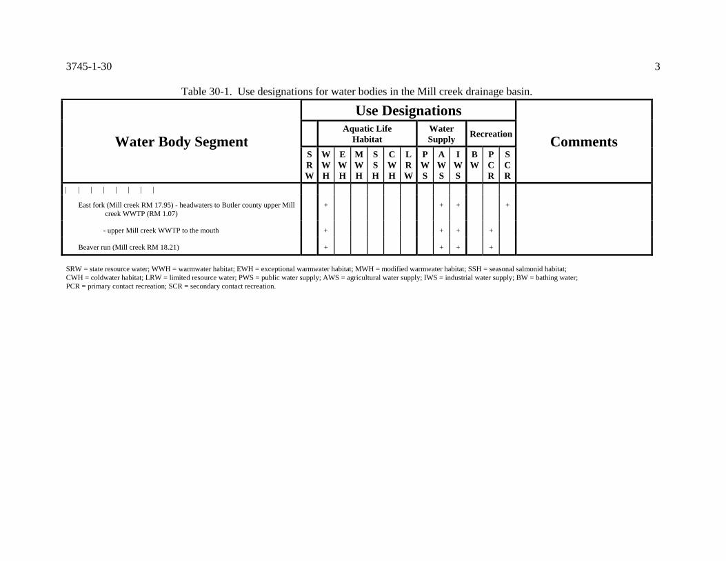
3745-1-30
3
Table 30-1. Use designations for water bodies in the Mill creek drainage basin.
Water Body Segment
Use Designations
Comments
Aquatic Life
Habitat
Water Supply
Recreation
SRW
WWH
EWH
MWH
S S H
CWH
LRW
P W S
A W S
I WS
BW
P CR
SCR
| | | | | | | |
East fork (Mill creek RM 17.95) - headwaters to Butler county upper Mill
creek WWTP (RM 1.07) +
+ + +
- upper Mill creek WWTP to the mouth +
+ + +
Beaver run (Mill creek RM 18.21) +
+ + +
SRW = state resource water; WWH = warmwater habitat; EWH = exceptional warmwater habitat; MWH = modified warmwater habitat; SSH = seasonal salmonid habitat; CWH = coldwater habitat; LRW = limited resource water; PWS = public water supply; AWS = agricultural water supply; IWS = industrial water supply; BW = bathing water; PCR = primary contact recreation; SCR = secondary contact recreation.

3745-1-30 4 Appendix Figure 1. Mill creek drainage basin.
-N I Will]
Lakes
Rivers
county Boundaries
Cities

3745-1-30 5 Effective: 6/16/2011 R.C. 119.032 rule review date: 6/16/2016 Promulgated Under: R.C. 119.03 Statutory Authority: R.C. 6111.041 Rule Amplifies: R.C. 6111.041 Prior Effective Dates: 4/4/1985, 3/29/2001

3745-1-31 Lake Erie standards.
(A) Lake Erie is designated exceptional warmwater habitat,superior high quality water, public water supply,agricultural water supply, industrial water supply andbathing waters, and will meet the criteria set forth in, orderived in accordance with, rules 3745-1-01 to 3745-1-07 ofthe Administrative Code, rule 3745-1-33 of theAdministrative Code, and rules 3745-1-36 to 3745-1-39 of theAdministrative Code. However, criteria set forth in thisrule supersede the above rules where applicable. Thesecriteria apply outside the mixing zone.
(B) Temperature.
(1) There shall be no water temperature changes as a resultof human activity that cause mortality, long-termavoidance or exclusion from habitat, or adversely affectthe reproductive success of representative aquaticspecies.
(2) At no time shall water temperature exceed the average ordaily maximum temperatures indicated in paragraphs (A)and (B) of table 31-1 of this rule.
(3) The temperature of the hypolimnetic waters of lake Erieshall not exceed at any time the daily maximumtemperatures indicated in paragraph (C) of table 31-1 ofthis rule.

745-1-31 2
Table 31-1. Temperature criteria.
(A) Lake Erie western basin - includes the area of lake Erie westof a line drawn from Pelee point, Canada to Scott point onCatawba island. Shown as degrees fahrenheit and (celsius).
Jan. Feb. Mar. Mar. Apr. Apr. May May June1-31 1-29 1-15 16-31 1-15 16-30 1-15 16-31 1-15
Average: - - - - - 53 59 65 75(11.7) (15.0) (18.3) (23.9)
DailyMaximum: 35 38 39 45 51 56 64 72 78
(1.7) (3.3) (3.9) (7.2) (10.6) (13.3) (17.8) (22.2) (25.6)
June July Aug. Sept. Sept. Oct. Oct. Nov. Dec.16-30 1-31 1-31 1-15 16-30 1-15 16-31 1-30 1-31
Average: 80 83 83 78 76 66 60 53 -(26.7) (28.3) (28.3) (25.6) (24.4) (18.9) (15.6) (11.7)
DailyMaximum: 83 85 85 83 81 71 65 58 46
(28.3) (29.4) (29.4) (28.3) (27.2) (21.7) (18.3) (14.4) (7.8)
(B) Lake Erie central basin - includes the area of lake Erie eastof a line drawn from Pelee point, Canada to Scott point onCatawba island to the Pennsylvania-Ohio state line. Shown asdegrees fahrenheit and (celsius).
Jan. Feb. Mar. Mar. Apr. Apr. May May June1-31 1-29 1-15 16-31 1-15 16-30 1-15 16-31 1-15
Average: - - - - 43 53 59 63 75 (6.1) (11.7) (15.0) (17.2) (23.9)
DailyMaximum: 35 38 39 45 48 56 63 72 78
(1.7) (3.3) (3.9) (7.2) (8.9) (13.3) (17.2) (22.2) (25.6)
June July Aug. Sept. Sept. Oct. Oct. Nov. Dec.16-30 1-31 1-31 1-15 16-30 1-15 16-31 1-30 1-31
Average: 80 83 83 76 71 66 58 48 -(26.7) (28.3) (28.3) (24.4) (21.7) (18.9) (14.4) (8.9)
DailyMaximum: 83 85 85 81 76 71 63 53 46
(28.3) (29.4) (29.4) (27.2) (24.4) (21.7) (17.2) (11.7) (7.8)

745-1-31 3
(C) Seasonal daily maximum temperature limitations for thehypolimnetic regions of lake Erie. Shown as degreesfahrenheit and (celsius).
Month Daily Maximum
January 44 (6.7)February 44 (6.7)March 44 (6.7)April 47 (8.3)May 51 (10.6)June 54 (12.2)July 59 (15.0)August 59 (15.0)September 55 (12.8)October 46 (7.8)November 41 (5.0)December 38 (3.3)
Effective: October 31, 1997Promulgated under: R.C. Section 119.03Rule authorized by: R.C. Sections 6111.041 and 6111.12Rule amplifies: R.C. Sections 6111.041 and 6111.12R.C. Section 119.032 rule review date: 3/1/02Prior effective dates: 4/4/85, 5/1/90, 10/1/96

3745-1-32 Ohio river standards.
(A) The Ohio river is designated warmwater habitat, public water supply, agricultural water supply, industrial water supply and bathing waters, and will meet the most stringent criteria set forth in, or derived in accordance with, this rule, rules 3745-1-01 to 3745-1-07 of the Administrative Code, and rules 3745-1-34 to 3745-1-36 of the Administrative Code.

--
----
-- --
3745-1-32 2
Table 32-1. Water quality criteria for the Ohio river. ________________________________________________________________________________
Chemical Form1 Units2 IMZM3 OMZM3 OMZA3
Bacteria (fecal coliform) T b b Cyanide free µg/l 44 22 5.2 Dissolved oxygen4 T mg/l 4.0c 5.0 Radionuclides T d d Temperature oF Table 32-3 Table 32-3 ________________________________________________________________________________
1 T = total. 2 mg/l = milligrams per liter (parts per million); µg/l = micrograms per liter (parts per billion); oF = degrees fahrenheit.3 IMZM = inside mixing zone maximum; OMZM = outside mixing zone maximum; OMZA = outside mixing zone
average.4 For dissolved oxygen, OMZM means outside mixing zone minimum at any time and OMZA means outside mixing
zone minimum daily average. a See rule 3745-1-07 of the Administrative Code. b For the months of May to October, the maximum allowable level of fecal coliform bacteria shall not exceed two
hundred per one hundred ml as a monthly geometric mean based on not less than five samples per month; nor exceed four hundred per one hundred ml in more than ten per cent of all samples taken during the month. For the months of May to October, measurements of Escherichia coli bacteria may be substituted for fecal coliform. Content shall not exceed one hundred thirty per one hundred ml as a monthly geometric mean, based on not less than five samples per month, nor exceed two hundred forty per one hundred ml in any sample. For the months of November to April, the maximum allowable level of fecal coliform bacteria shall not exceed two thousand per one hundred ml as a geometric mean based on not less than five samples per month.
c A minimum of 5.0 mg/l at any time shall be maintained during the April fifteen to June fifteen spawning season.d Gross total alpha particle activity (including radium-226, but excluding radon and uranium) shall not exceed fifteen
picocuries per liter (pci/l) and combined radium-226 and radium-228 shall not exceed four pci/l. The concentration of total gross beta particle activity shall not exceed fifty pci/l. The concentration of total strontium-90 shall not exceed eight pci/l.

--------
------
--
----
--
--------
3745-1-32 3
Table 32-2. Ohio river water quality criteria for the protection of human health.Page 1 of 5___________________________________________________________________________
Chemical
AcenaphtheneAcroleinAcrylonitrile5
AlachlorAldicarb6
Aldicarb sulfone6
Aldicarb sulfoxide6
Aldrin5
AnthraceneAntimonyArsenicAsbestosAtrazineBariumBenzene5
Benzidine5
Benzo(a)anthracene5
Benzo(a)pyrene5
Benzo(b)fluoranthene5
Benzo(k)fluoranthene5
BerylliumBromateBromoform5
Butylbenzyl phthalateCadmiumCarbofuranCarbon tetrachloride5
ChloramineChlordane5
ChloridesChlorineChlorine dioxideChloriteChloroacetic acid7
ChlorobenzeneChlorodibromomethane5
OMZA3
Form1 Units2 Intakes Elsewhere
T µg/l 1,200 1,200T µg/l 320 320T µg/l 0.59 0.59T µg/l 2.0a
T µg/l 7.0a
T µg/l 7.0a
T µg/l 7.0a
T µg/l 0.0013 0.0013T µg/l 9,600 9,600TR µg/l 6.0a 14TR µg/l 10a 50T Mf/l 7.0a
T µg/l 3.0a
TR µg/l 2,000a
T µg/l 5.0a 12T µg/l 0.0012 0.0012T µg/l 0.044 0.044T µg/l 0.044 0.044T µg/l 0.044 0.044T µg/l 0.044 0.044TR µg/l 4.0a 16T µg/l 10a
T µg/l 43 43T µg/l 3,000 3,000TR µg/l 5.0a
T µg/l 40a
T µg/l 2.5 2.5T µg/l 4,000a
T µg/l 0.021 0.021T mg/l 250a 250T µg/l 4,000a
T µg/l 800a
T µg/l 1,000a
T µg/l 60a
T µg/l 100a 680T µg/l 4.1 4.1

--
-- --
--
--
--
--
--
3745-1-32 4
Table 32-2. Ohio river water quality criteria for the protection of human health.Page 2 of 5___________________________________________________________________________
Chemical
Bis(2-Chloroethyl)ether5
Chloroform5
bis(2-Chloroisopropyl)etherbis(2-Chloromethyl)ether5
2-Chloronaphthalene2-ChlorophenolChromiumChrysene5
CopperCyanide2,4-D (2,4-Dichlorophenoxy-acetic acid)
Dalapon4,4'-DDD5
4,4'-DDE5
4,4'-DDT5
Dibenzo(a,h)anthracene5
DibromochloropropaneDi-n-butyl phthalateDichloroacetic acid7
1,2-Dichlorobenzene1,3-Dichlorobenzene1,4-Dichlorobenzene3,3'-Dichlorobenzidine5
Dichlorobromomethane5
1,2-Dichloroethane5
1,1-Dichloroethylene5
cis-1,2-Dichloroethylenetrans-1,2-Dichloroethylene2,4-Dichlorophenol1,2-Dichloropropane5
1,3-DichloropropeneDieldrin5
Di(2-ethylhexyl)adipateDiethyl phthalate2,4-Dimethylphenol
OMZA3
Form1 Units2 Intakes Elsewhere
T µg/l 0.31 0.31T µg/l 57 57T µg/l 1,400 1,400T µg/l 0.0013 0.0013T µg/l 1,700 1,700T µg/l 120 120TR µg/l 100a
T µg/l 0.044 0.044TR µg/lfree µg/l 200a 700
T µg/l 70a 100T µg/l 200a
T µg/l 0.0083 0.0083T µg/l 0.0059 0.0059T µg/l 0.0059 0.0059T µg/l 0.044 0.044T µg/l 0.2a
T µg/l 2,700 2,700T µg/l 60a
T µg/l 600a 2,700T µg/l 400 400T µg/l 75a 400T µg/l 0.40 0.40T µg/l 5.6 5.6T µg/l 3.8 3.8T µg/l 0.57 0.57T µg/l 70a
T µg/l 100a 700T µg/l 93 93T µg/l 5.0a 5.2T µg/l 10 10T µg/l 0.0014 0.0014T µg/l 400a
T µg/l 23,000 23,000T µg/l 540 540

--
----
--
--
--
--
2,4-Dinitrotoluene5
Dinoseb1,2-Diphenylhydrazine5
DiquatDissolved solidsalpha-Endosulfan8
beta-Endosulfan8
Endosulfan sulfate8
EndothallEndrin9
Endrin aldehyde9
EthylbenzeneEthylene dibromide (EDB)bis(2-Ethylhexyl)phthalate5
FluorantheneFluoreneFluorideGlyphosateHeptachlor5
Heptachlor epoxide5
Hexachlorobenzene5
Hexachlorobutadiene5
alpha-Hexachlorocyclohexane5
beta-Hexachlorocyclohexane5
3745-1-32 5
Table 32-2. Ohio river water quality criteria for the protection of human health.Page 3 of 5___________________________________________________________________________
OMZA3
Chemical Form1 Units2 Intakes Elsewhere
Dimethyl phthalate T µg/l 310,000 310,000 4,6-Dinitro-o-cresol (4,6-Dinitro-2-methylphenol)T
Dinitrophenols4 µg/l 13 13 T µg/l 70 70 T µg/l 1.1 1.1 T µg/l 7.0a
T µg/l 0.40 0.40 T T
µg/l mg/l
20a
750/500a,b
T µg/l 110 110 T µg/l 110 110 T µg/l 110 110 T µg/l 100a
T µg/l 0.76 0.76 T µg/l 0.76 0.76 T µg/l 700a 3,100 T µg/l 0.050a
T µg/l 6.0a 18 T µg/l 300 300 T µg/l 1,300 1,300 T µg/l 1,000 1,000 T µg/l 700a
T µg/l 0.0021 0.0021 T µg/l 0.0010 0.0010 T µg/l 0.0075 0.0075 T µg/l 4.4 4.4 T µg/l 0.039 0.039 T µg/l 0.14 0.14
gamma-Hexachlorocyclohexane (Lindane)5 T µg/l 0.19 0.19
Hexachlorocyclohexanetechnical grade5 T µg/l 0.12 0.12
Hexachlorocyclopentadiene T µg/l 50a 240 Hexachloroethane5 T µg/l 19 19 Indeno(1,2,3-c,d)pyrene5 T µg/l 0.044 0.044 Iron S µg/l 300a

--
--
----
3745-1-32 6
Table 32-2. Ohio river water quality criteria for the protection of human health.Page 4 of 5___________________________________________________________________________
Chemical
Isophorone5
MercuryMethoxychlorMethyl bromideMethylene chloride5
NickelNitrate-N + Nitrite-NNitrite-NNitrobenzeneNitrosoamines5
N-Nitrosodibutylamine5
N-Nitrosodiethylamine5
N-Nitrosodimethylamine5
N-Nitrosodi-n-propylamine5
N-Nitrosodiphenylamine5
N-Nitrosodipyrrolidine5
Oxamyl (Vydate)PentachlorobenzenePentachlorophenol5
PhenolPhenolicsPicloramPolychlorinated biphenyls5
PyreneSeleniumSilverSilvex (2,4,5-TP, 2-[2,4,5-Trichlorophenoxy]propionicacid
SimazineStyreneSulfates1,2,4,5-Tetrachlorobenzene2,3,7,8-Tetrachlorodibenzo-p-dioxin5
1,1,2,2-Tetrachloroethane5
OMZA3
Form1 Units2 Intakes Elsewhere
T µg/l 360 360TR µg/l 0.012 0.012T µg/l 40a 100T µg/l 48 48T µg/l 5.0a 47TR µg/l 610 610T µg/l 10,000a 10,000T µg/l 1,000a 1,000T µg/l 17 17T µg/l 0.0080 0.0080T µg/l 0.064 0.064T µg/l 0.0080 0.0080T µg/l 0.0069 0.0069T µg/l 0.050 0.050T µg/l 50 50T µg/l 0.16 0.16T µg/l 200a
T µg/l 3.5 3.5T mg/l 1.0a 82T µg/l 21,000 21,000T µg/l 5.0 5.0T µg/l 500a
T µg/l 0.0017 0.0017T µg/l 960 960TR µg/l 50a 170T µg/l 50 50
T µg/l 10 10T µg/l 4.0a
T µg/l 100a
T mg/l 250a 250T µg/l 2.3 2.3
T pg/l 0.13 0.13 T µg/l 1.7 1.7

--
--
--
3745-1-32 7
Table 32-2. Ohio river water quality criteria for the protection of human health.Page 5 of 5___________________________________________________________________________
Chemical
Tetrachloroethylene5
ThalliumTolueneToxaphene5
Trichloroacetic acid7
1,2,4-Trichlorobenzene1,1,1-Trichloroethane1,1,2-Trichloroethane5
Trichloroethylene5
2,4,5-Trichlorophenol2,4,6-Trichlorophenol5
Vinyl chloride5
XylenesZinc
OMZA3
Form1 Units2 Intakes Elsewhere
T µg/l 5.0a 8.0TR µg/l 1.7 1.7T µg/l 1,000a 6,800T µg/l 0.0073 0.0073T µg/l 60a
T µg/l 70a 260T µg/l 200a
T µg/l 5.0a 6.0T µg/l 5.0a 27T µg/l 2,600 2,600T µg/l 21 21T µg/l 2.0a 20T µg/l 10,000a
T µg/l 9,100 9,100___________________________________________________________________________
1 S = soluble; T = total; TR = total recoverable.2 mg/l = milligrams per liter (parts per million); µg/l = micrograms per liter (parts per billion); ng/l = nanograms per
liter (parts per trillion); pg/l = picograms per liter (parts per quadrillion); Mf/l = million fibers per liter.3 OMZA = outside mixing zone average. Criteria in the “Intakes” column apply within five hundred yards of drinking
water intakes. Criteria in the “Elsewhere” column apply at all other locations.4 The criteria for this chemical apply to the sum of all dinitrophenols.5 Criteria for this chemical are based on a carcinogenic endpoint.6 The criterion for this chemical applies to the sum of aldicarb, aldicarb sulfone and aldicarb sulfoxide. 7 The criterion for this chemical applies to the sum of chloroacetic acid, dichloroacetic acid and trichloroacetic acid.8 The criteria for this chemical apply to the sum of alpha-endosulfan, beta-endosulfan and endosulfan sulfate. 9 The criteria for this chemical apply to the sum of endrin and endrin aldehyde. a This criterion is the maximum contaminant level (MCL) developed under the “Safe Drinking Water Act”. b Equivalent 25°C specific conductance values are 1200 micromhos/cm as a maximum and 800 micromhos/cm as a
thirty-day average.

3745-1-32 8
Table 32-3. Ohio river temperature criteria.
Month/date
January 1-31February 1-29March 1-15March 16-31April 1-15April 16-30May 1-15May 16-31June 1-15June 16-30July 1-31August 1-31September 1-15September 16-30October 1-15October 16-31November 1-30December 1-31
Effective: 12/30/2002
Period Average (°F)
45 45 51 54 58 64 68 75 80 83 84 84 84 82 77 72 67 52
Instantaneous Maximum (°F)
50 50 56 59 64 69 73 80 85 87 89 89 87 86 82 77 72 57
R.C. Section 119.032 review dates: 3/25/2002 and 12/30/2007
Promulgated under: R.C. Section 119.03Rule authorized by: R.C. Section 6111.041Rule amplifies: R.C. Section 6111.041Prior effective dates: 4/4/1985, 8/19/1985, 5/1/1990, 10/31/1997

3745-1-33 Water quality criteria for the lake Erie drainage basin.
(A) This rule applies in addition to the requirements contained in rule 3745-1-07 of the Administrative Code to water bodies within the lake Erie drainage basin. Except as provided in paragraphs (D) and (E) of this rule, the methodologies contained in rules 3745-1-36, 3745-1-37, 3745-1-38 and 3745-1-39 of the Administrative Code shall be used when adopting or revising numeric aquatic life, human health and wildlife water quality criteria and when implementing the narrative water quality criteria contained in rule 3745-1-04 of the Administrative Code for water bodies located in the lake Erie drainage basin.
(B) The chemical-specific criteria listed in this rule apply as "Outside Mixing Zone Averages". For the purpose of setting water quality based effluent limits, these criteria shall be met after the effluent and the receiving water are reasonably well mixed as provided in rules 3745-2-05 and 3745-2-08 of the Administrative Code.
(C) The water quality criteria and values adopted in, or developed pursuant to, this rule shall apply as follows:
(1) The water quality criteria and values for protection of human health, or site-specific modifications thereof, are "Outside Mixing Zone Average" water quality criteria and shall apply as follows:
(a) The "Drinking" water quality criteria and values for the protection of human health shall apply to all water bodies located in the lake Erie drainage basin within five hundred yards of drinking water intakes.
(b) The "Nondrinking" water quality criteria and values for the protection of human health shall apply to all water bodies located in the lake Erie drainage basin other than those specified in paragraph (C)(3)(i) of this rule.
(2) Criteria for protection of wildlife, or site-specific modifications thereof, are "Outside Mixing Zone Average" water quality criteria and shall apply to all water bodies located in the lake Erie drainage basin.
(D) For pollutants listed in table 33-1 of this rule, any methodologies and procedures acceptable under 40 C.F.R. 131 may be used when developing water quality criteria or implementing narrative criteria.
(E) For any pollutant other than those in table 33-1 of this rule for which it is demonstrated that a methodology or procedure cited in this rule is not scientifically defensible, the director may apply an alternative methodology or procedure acceptable under 40 C.F.R. 131 when developing water quality criteria.

3745-1-33 2
Table 33-1. Pollutants subject to any methodologies and procedures acceptable under 40 C.F.R. 131. ____________________________________
AlkalinityAmmoniaBacteriaBiochemical oxygen demand (BOD)ChlorineColorDissolved oxygenDissolved solidspHPhosphorusSalinityTemperatureTotal and suspended solidsTurbidity____________________________________

-- ------
-- ------
------
-- ------
-- ----
---- --
-- --
------
3745-1-33 3
Table 33-2. Lake Erie drainage basin water quality criteria for the protection of human health and wildlife.
______________________________________________________________________________
Chemical
ArsenicBenzene4
Chlordane4
ChloridesChlorobenzeneCyanidesDDT4
Dieldrin4
2,4-Dimethylphenol2,4-DinitrophenolDissolved solidsHexachlorobenzene4
Hexachloroethane4
IronLindaneMercuryMethylene chloride4
Nitrate-N + Nitrite-NPCB4
Sulfates2,3,7,8-TCDD4
TolueneToxaphene4
Trichloroethylene4
Human Health OMZA3 Wildlife Form1 Units2 Drinking Nondrinking OMZA3
TR µg/l 10 T µg/l 12 310 T ng/l 0.25 0.25 T mg/l 250 T µg/l 470 3200 T mg/l 0.60 48 T ng/l 0.15 0.15 0.011a
T ng/l 0.0065 0.0065 T µg/l 450 8700 T µg/l T mg/l
55 2800 750/500b
T ng/l 0.45 0.45 T µg/l 5.3 6.7 S µg/l 300 T µg/l 0.47 0.50 TR µg/l 0.0031 0.0031 0.0013 T µg/l 47 2600 T mg/l 10 T ng/l 0.026 0.026 0.12 T mg/l 250 T pg/l 0.0086 0.0086 0.0031 T µg/l 5600 51000 T ng/l 0.068 0.068 T µg/l 29 370
______________________________________________________________________________
1 S = soluble; T = total; TR = total recoverable.2 mg/l = milligrams per liter (parts per million); µg/l = micrograms per liter (parts per billion); ng/l = nanograms per
liter (parts per trillion); pg/l = picograms per liter (parts per quadrillion).3 OMZA = outside mixing zone average.4 Human health criteria for this chemical are based on a carcinogenic endpoint. a This criterion applies to the sum of DDT and metabolites. b Equivalent 25°C specific conductance values are 1200 micromhos/cm as a maximum and 800 micromhos/cm as a
thirty-day average.

3745-1-33 4
Effective: 12/30/2002
R.C. Section 119.032 review dates: 3/25/2002 and 12/30/2007
Promulgated under: R.C. Section 119.03Rule authorized by: R.C. Section 6111.041Rule amplifies: R.C. Section 6111.041Prior effective dates: 2/14/1978, 4/4/1985, 8/19/1985, 4/30/1987, 5/1/1990, 4/26/1997, 10/31/1997,2/22/2002

3745-1-34 Water quality criteria for the Ohio river drainage basin.
(A) This rule applies in addition to the requirements contained in rule 3745-1-07 of the
Administrative Code to water bodies within the Ohio river drainage basin. Except as
provided in paragraph (D) of this rule, the methodologies contained in rule 3745-1-36 of
the Administrative Code shall be used when adopting or revising numeric aquatic life
water quality criteria and when implementing the narrative aquatic life water quality
criteria contained in rule 3745-1-04 of the Administrative Code for water bodies located
in the Ohio river drainage basin. Any methodologies and procedures acceptable under 40
C.F.R. 131 may be used when developing or revising human health water quality criteria
or implementing narrative criteria contained in rule 3745-1-04 of the Administrative
Code for water bodies located in the Ohio river drainage basin.
(B) The chemical specific criteria listed in this rule apply as "Outside Mixing Zone
Averages". For the purpose of setting water quality based effluent limits, these criteria
shall be met after the effluent and the receiving water are reasonably well mixed as
provided in rules 3745-2-05 and 3745-2-08 of the Administrative Code.
(C) The water quality criteria adopted in, or developed pursuant to, this rule shall apply as
follows:
(1) To protect against adverse reproductive effects on wildlife, "the Outside Mixing
Zone Average" criteria for polychlorinated biphenyls is 1.0 ng/l. In addition, any
whole sample of any representative aquatic organisms shall not exceed 0.64 mg/kg
(wet weight). These criteria, or site-specific modifications thereof, shall apply to all
water bodies of the Ohio river drainage basin.
(2) The water quality criteria for protection of human health, or site-specific
modifications thereof, are "Outside Mixing Zone Average" water quality criteria and
shall apply as follows:
(a) The "Drinking" water quality criteria for the protection of human health shall
apply to all water bodies located in the Ohio river drainage basin within five
hundred yards of drinking water intakes.
(b) The "Nondrinking" water quality criteria for the protection of human health shall
apply to all water bodies located in the Ohio river drainage basin other than
those specified in paragraph (C)(3)(i) of this rule.
(D) For any pollutant for which it is demonstrated that a methodology or procedure cited in
this rule is not scientifically defensible, the director may apply an alternative
methodology or procedure acceptable under 40 C.F.R. 131 when developing water
quality criteria.

3745-1-34 2
Table 34-1. Ohio river drainage basin water quality criteria for the protection of human health.
OMZA3
Chemical Form1 Units
2 Drinking Nondrinking
Acenaphthene T µg/l 1,200 2,700
Acrolein T µg/l 320 780
Acrylonitrile5 T µg/l 0.59 6.6
Alachlor T µg/l 2.0a --
Aldicarb6 T µg/l 7.0
a --
Aldicarb sulfone6 T µg/l 7.0
a --
Aldicarb sulfoxide6 T µg/l 7.0
a --
Aldrin5 T µg/l 0.0013 0.0014
Anthracene T µg/l 9,600 110,000
Antimony TR µg/l 6.0a 4,300
Arsenic TR µg/l 10a --
Asbestos T Mf/l 7.0a --
Atrazine T µg/l 3.0a --
Barium TR µg/l 2,000a --
Benzene5 T µg/l 5.0
a 710
Benzidine5 T µg/l 0.0012 0.0054
Benzo(a)anthracene5 T µg/l 0.044 0.49
Benzo(a)pyrene5 T µg/l 0.044 0.49
Benzo(b)fluoranthene5 T µg/l 0.044 0.49
Benzo(k)fluoranthene5 T µg/l 0.044 0.49
Beryllium TR µg/l 4.0a 280
Bromate T µg/l 10a --
Bromoform5 T µg/l 43 3,600
Butylbenzyl phthalate T µg/l 3,000 5,200
Cadmium TR µg/l 5.0a --
Carbofuran T µg/l 40a --
Carbon tetrachloride5 T µg/l 2.5 44
Chloramine T µg/l 4,000a --
Chlordane5 T µg/l 0.021 0.022
Chlorides T mg/l 250a --
Chlorine T µg/l 4,000a --
Chlorine dioxide T µg/l 800a --
Chlorite T µg/l 1,000a --
Chloroacetic acid7 T µg/l 60
a --
Chlorobenzene T µg/l 100a 21,000
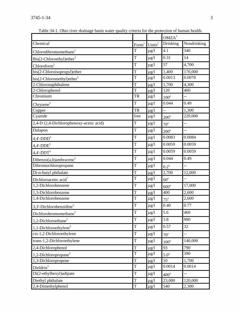
3745-1-34 3
Table 34-1. Ohio river drainage basin water quality criteria for the protection of human health.
OMZA3
Chemical Form1 Units
2 Drinking Nondrinking
Chlorodibromomethane5 T µg/l 4.1 340
Bis(2-Chloroethyl)ether5 T µg/l 0.31 14
Chloroform5 T µg/l 57 4,700
bis(2-Chloroisopropyl)ether T µg/l 1,400 170,000
bis(2-Chloromethyl)ether5 T µg/l 0.0013 0.0078
2-Chloronaphthalene T µg/l 1,700 4,300
2-Chlorophenol T µg/l 120 400
Chromium TR µg/l 100a --
Chrysene5 T µg/l 0.044 0.49
Copper TR µg/l -- 1,300
Cyanide free µg/l 200a 220,000
2,4-D (2,4-Dichlorophenoxy-acetic acid) T µg/l 70a --
Dalapon T µg/l 200a --
4,4'-DDD5 T µg/l 0.0083 0.0084
4,4'-DDE5 T µg/l 0.0059 0.0059
4,4'-DDT5 T µg/l 0.0059 0.0059
Dibenzo(a,h)anthracene5 T µg/l 0.044 0.49
Dibromochloropropane T µg/l 0.2a --
Di-n-butyl phthalate T µg/l 2,700 12,000
Dichloroacetic acid7 T µg/l 60
a --
1,2-Dichlorobenzene T µg/l 600a 17,000
1,3-Dichlorobenzene T µg/l 400 2,600
1,4-Dichlorobenzene T µg/l 75a 2,600
3,3'-Dichlorobenzidine5 T µg/l 0.40 0.77
Dichlorobromomethane5 T µg/l 5.6 460
1,2-Dichloroethane5 T µg/l 3.8 990
1,1-Dichloroethylene5 T µg/l 0.57 32
cis-1,2-Dichloroethylene T µg/l 70a --
trans-1,2-Dichloroethylene T µg/l 100a 140,000
2,4-Dichlorophenol T µg/l 93 790
1,2-Dichloropropane5 T µg/l 5.0
a 390
1,3-Dichloropropene T µg/l 10 1,700
Dieldrin5 T µg/l 0.0014 0.0014
Di(2-ethylhexyl)adipate T µg/l 400a --
Diethyl phthalate T µg/l 23,000 120,000
2,4-Dimethylphenol T µg/l 540 2,300

3745-1-34 4
Table 34-1. Ohio river drainage basin water quality criteria for the protection of human health.
OMZA3
Chemical Form1 Units
2 Drinking Nondrinking
Dimethyl phthalate T µg/l 310,000 2,900,000
4,6-Dinitro-o-cresol (4,6-Dinitro-2-methylphenol) T µg/l 13 770
Dinitrophenols4 T µg/l 70 14,000
2,4-Dinitrotoluene5 T µg/l 1.1 91
Dinoseb T µg/l 7.0a --
1,2-Diphenylhydrazine5 T µg/l 0.40 5.4
Diquat T µg/l 20a --
Dissolved solids T mg/l 750/500a,b
--
alpha-Endosulfan8 T µg/l 110 240
beta-Endosulfan8 T µg/l 110 240
Endosulfan sulfate8 T µg/l 110 240
Endothall T µg/l 100a --
Endrin9 T µg/l 0.76 0.81
Endrin aldehyde9 T µg/l 0.76 0.81
Ethylbenzene T µg/l 700a 29,000
Ethylene dibromide (EDB) T µg/l 0.050a --
bis(2-Ethylhexyl)phthalate5 T µg/l 6.0
a 59
Fluoranthene T µg/l 300 370
Fluorene T µg/l 1,300 14,000
Fluoride T µg/l 4,000a --
Glyphosate T µg/l 700a --
Heptachlor5 T µg/l 0.0021 0.0021
Heptachlor epoxide5 T µg/l 0.0010 0.0011
Hexachlorobenzene5 T µg/l 0.0075 0.0077
Hexachlorobutadiene5 T µg/l 4.4 500
alpha-Hexachlorocyclohexane5 T µg/l 0.039 0.13
beta-Hexachlorocyclohexane5 T µg/l 0.14 0.46
gamma-Hexachlorocyclohexane (Lindane)5 T µg/l 0.19 0.63
Hexachlorocyclohexane - technical grade5 T µg/l 0.12 0.41
Hexachlorocyclopentadiene T µg/l 50a 17,000
Hexachloroethane5 T µg/l 19 89
Indeno(1,2,3-c,d)pyrene5 T µg/l 0.044 0.49
Iron S µg/l 300a --
Isophorone5 T µg/l 360 26,000
Mercury TR µg/l 0.012 0.012

3745-1-34 5
Table 34-1. Ohio river drainage basin water quality criteria for the protection of human health.
OMZA3
Chemical Form1 Units
2 Drinking Nondrinking
Methoxychlor T µg/l 40a --
Methyl bromide T µg/l 48 4,000
Methylene chloride5 T µg/l 5.0
a 16,000
Nickel TR µg/l 610 4,600
Nitrate-N + Nitrite-N T µg/l 10,000a --
Nitrite-N T µg/l 1,000a --
Nitrobenzene T µg/l 17 1,900
Nitrosoamines5 T µg/l 0.0080 12
N-Nitrosodibutylamine5 T µg/l 0.064 5.9
N-Nitrosodiethylamine5 T µg/l 0.0080 12
N-Nitrosodimethylamine5 T µg/l 0.0069 81
N-Nitrosodi-n-propylamine5 T µg/l 0.050 14
N-Nitrosodiphenylamine5 T µg/l 50 160
N-Nitrosodipyrrolidine5 T µg/l 0.16 920
Oxamyl (Vydate) T µg/l 200a --
Pentachlorobenzene T µg/l 3.5 4.1
Pentachlorophenol5 T mg/l 1.0
a 82
Phenol T µg/l 21,000 4,600,000
Picloram T µg/l 500a --
Polychlorinated biphenyls5 T µg/l 0.0017 0.0017
Pyrene T µg/l 960 11,000
Selenium TR µg/l 50a 11,000
Silvex (2,4,5-TP, 2-[2,4,5-Trichlorophenoxy]propionic
acid
T µg/l 10 --
Simazine T µg/l 4.0a --
Styrene T µg/l 100a --
Sulfates T mg/l 250a --
1,2,4,5-Tetrachlorobenzene T µg/l 2.3 2.9
2,3,7,8-Tetrachlorodibenzo-p-dioxin5 T pg/l 0.13 0.14
1,1,2,2-Tetrachloroethane5 T µg/l 1.7 110
Tetrachloroethylene5 T µg/l 5.0
a 89
Thallium TR µg/l 1.7 --
Toluene T µg/l 1,000a 200,000
Toxaphene5 T µg/l 0.0073 0.0075
Trichloroacetic acid7 T µg/l 60
a --
1,2,4-Trichlorobenzene T µg/l 70a 940
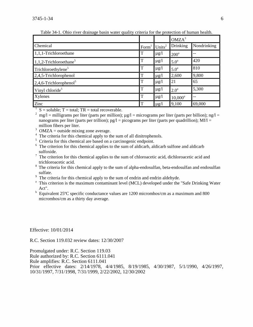
3745-1-34 6
Table 34-1. Ohio river drainage basin water quality criteria for the protection of human health.
OMZA3
Chemical Form1 Units
2 Drinking Nondrinking
1,1,1-Trichloroethane T µg/l 200a --
1,1,2-Trichloroethane5 T µg/l 5.0
a 420
Trichloroethylene5 T µg/l 5.0
a 810
2,4,5-Trichlorophenol T µg/l 2,600 9,800
2,4,6-Trichlorophenol5 T µg/l 21 65
Vinyl chloride5 T µg/l 2.0
a 5,300
Xylenes T µg/l 10,000a --
Zinc T µg/l 9,100 69,000 1 S = soluble; T = total; TR = total recoverable.
2 mg/l = milligrams per liter (parts per million); µg/l = micrograms per liter (parts per billion); ng/l =
nanograms per liter (parts per trillion); pg/l = picograms per liter (parts per quadrillion); Mf/l =
million fibers per liter. 3 OMZA = outside mixing zone average.
4 The criteria for this chemical apply to the sum of all dinitrophenols.
5 Criteria for this chemical are based on a carcinogenic endpoint.
6 The criterion for this chemical applies to the sum of aldicarb, aldicarb sulfone and aldicarb
sulfoxide. 7 The criterion for this chemical applies to the sum of chloroacetic acid, dichloroacetic acid and
trichloroacetic acid. 8 The criteria for this chemical apply to the sum of alpha-endosulfan, beta-endosulfan and endosulfan
sulfate. 9 The criteria for this chemical apply to the sum of endrin and endrin aldehyde.
a This criterion is the maximum contaminant level (MCL) developed under the "Safe Drinking Water
Act". b Equivalent 25ºC specific conductance values are 1200 micromhos/cm as a maximum and 800
micromhos/cm as a thirty day average.
Effective: 10/01/2014 R.C. Section 119.032 review dates: 12/30/2007 Promulgated under: R.C. Section 119.03 Rule authorized by: R.C. Section 6111.041 Rule amplifies: R.C. Section 6111.041 Prior effective dates: 2/14/1978, 4/4/1985, 8/19/1985, 4/30/1987, 5/1/1990, 4/26/1997, 10/31/1997, 7/31/1998, 7/31/1999, 2/22/2002, 12/30/2002
3745-1-35 Site-specific modifications to criteria and values.
(A) Requirements for site-specific modifications to criteria and values. Criteria and values adopted in, or developed pursuant to, this chapter may be modified on a site-specific basis to reflect local environmental conditions in accordance with the following provisions. Any such modifications shall be protective of designated uses and aquatic life, wildlife and human health and be submitted to the U.S. EPA for approval. Any site-specific modifications shall be based on a sound scientific rationale. In addition, any site-specific modifications that result in less stringent criteria shall not be likely to jeopardize the continued existence of threatened or endangered species or result in the destruction or adverse modification of such species' critical habitat. More stringent modifications shall be developed to protect threatened or endangered species, where such modifications are necessary to ensure that water quality is not likely to jeopardize the continued existence of such species or result in the destruction or adverse modification of such species' critical habitat. More stringent modifications may also be developed to protect candidate (C1) species being considered by the United States Fish and Wildlife Service for listing under section 4 of the Endangered Species Act (16 U.S.C. Section 1531 et seq., as amended), where such modifications are necessary to protect such species.
(B) Aquatic life.
(1) Aquatic life criteria or values may be modified on a site-specific basis to provide an additional level of protection where the toxicity or exposure potential is greater than the toxicity or exposure potential assumptions used to derive the criteria or values in question.
(2) Less stringent site-specific modifications to chronic or acute aquatic life criteria or values may be developed when:
(a) The local water quality characteristics (such as, but not limited to, pH, hardness, temperature or color) lessen the biological availability or toxicity of a pollutant; or
(b) The sensitivity of the aquatic organisms species that occur at the site differs from the species actually tested in developing the criteria. The phrase "occur at the site" includes the species, genera, families, orders, classes, and phyla that: are usually present at the site; are present at the site only seasonally due to migration; are present intermittently because they periodically return to or extend their ranges into the site; were present at the site in the past and are not currently present at the site due to degraded conditions but are expected to return to the site when conditions improve; are present in nearby bodies of water and are not currently present at the site due to degraded conditions but are expected to be present at the site when conditions improve. The taxa that "occur at the site" cannot be determined merely by sampling downstream and/or upstream of the site at one point in time. "Occur at the site" does not include taxa that were once present at the site but cannot exist at the site now due to permanent physical alteration of the habitat at the site resulting, for example, from dams.

3745-1-35 2
(3) Less stringent modifications also may be developed to acute and chronic aquatic life criteria or values to reflect local physical and hydrological conditions.
(4) Less stringent modifications to the whole effluent toxicity level for limited resource waters, as specified in rule 3745-2-09 of the Administrative Code, may be applied. Documentation provided by the permittee or independently available to the director shall show that the modification, not to exceed 1.0 acute toxic unit, is protective of the resident aquatic community.
(5) Any modifications to protect threatened or endangered aquatic species required by paragraph (A) of this rule may be accomplished using either of the two following procedures:
(a) If the species mean acute value (SMAV) for a listed or proposed species, or for a surrogate of such species, is lower than the calculated final acute value (FAV), such lower SMAV may be used instead of the calculated FAV in developing site-specific modified criteria; or
(b) The site-specific criteria may be calculated using the recalculation procedure for site-specific modifications described in chapter 3 of the "U.S. EPA Water Quality Standards Handbook, Second Edition - Revised (1994)".
(C) Wildlife.
(1) Wildlife water quality criteria may be modified on a site-specific basis to provide an additional level of protection where the toxicity or exposure potential is greater than the toxicity or exposure potential assumptions used to derive the criteria in question.
(2) Less stringent site-specific modifications to wildlife water quality criteria may be developed provided that:
(a) The modification demonstration addresses both the mobility of prey organisms and wildlife populations in defining the site for which the modification is developed;
(b) The modification reflects a site-specific bioaccumulation factor; and
(c) There is a showing that:
(i) Any increased uptake of the toxicant by prey species utilizing the site will not cause adverse effects in wildlife populations; and
(ii) Wildlife populations utilizing the site or downstream waters will continue to be fully protected.

3745-1-35 3
(3) Any modification to protect threatened or endangered wildlife species required by paragraph (A) of this rule must consider both the mobility of prey organisms and wildlife populations in defining the site for which criteria are developed, and may be accomplished by using the following recommended method:
(a) Use the methodology contained in rule 3745-1-39 of the Administrative Code, substituting appropriate species-specific toxicological, epidemiological, or exposure information, including changes to the BAF;
(b) Use an interspecies uncertainty factor of one where epidemiological data are available for the species in question. If necessary, species-specific exposure parameters can be derived in accordance with rule 3745-1-39 of the Administrative Code;
(c) Apply an intraspecies uncertainty factor (to account for protection of individuals within a wildlife population) in the denominator of the effect part of the wildlife equation contained in rule 3745-1-39 of the Administrative Code in a manner consistent with the other uncertainty factors described in rule 3745-1-39 of the Administrative Code; and
(d) Compare the resulting wildlife value for the species in question to the two class-specific wildlife values which were previously calculated, then select the lowest of the three as the site-specific modification.
(D) Bioaccumulation factors.
(1) BAFs may be modified on a site-specific basis, pursuant to the methodology contained in rule 3745-1-37 of the Administrative Code, to larger values where reliable data show that local bioaccumulation is greater than the basin-wide value.
(2) BAFs may be modified on a site-specific basis, pursuant to the methodology contained in rule 3745-1-37 of the Administrative Code, to lower values if:
(a) The fraction of the total chemical that is freely dissolved in the ambient water is different than that used to derive the system-wide BAFs (i.e., the concentrations of particulate organic carbon and the dissolved organic carbon are different than those used to derive the system-wide BAFs);
(b) Input parameters of the Gobas model, such as the structure of the aquatic food web and the disequilibrium constant, are different at the site than those used to derive the system-wide BAFs;
(c) The per cent lipid of aquatic organisms that are consumed and occur at the site is different than that used to derive the system-wide BAFs; or

3745-1-35 4
(d) Site-specific field-measured BAFs or biota-sediment accumulation factor (BSAFs) are determined.
(3) Any more stringent modifications to protect threatened or endangered species required by paragraph (A) of this rule shall be derived using procedures set forth in the methodology contained in rule 3745-1-37 of the Administrative Code.
(E) Human health.
(1) Human health criteria or values may be modified on a site-specific basis to provide an additional level of protection where the toxicity or exposure potential is greater than the toxicity or exposure potential assumptions used to derive the criteria or values in question. Human health criteria or values shall be modified on a site-specific basis to provide additional protection appropriate for highly exposed subpopulations.
(2) Less stringent site-specific modifications to human health criteria or values may be developed when:
(a) Local fish consumption rates are lower than the rate used to derive human health criteria or values under rule 3745-1-38 of the Administrative Code (this option shall not be available for water bodies subject to a fish consumption advisory); and/or
(b) A site-specific BAF is derived which is lower than that used to derive human health criteria or values under rule 3745-1-38 of the Administrative Code.
(F) Notification requirements. When the director proposes a site-specific modification to a criterion or value as allowed or required in paragraph (A) of this rule, the director shall notify the other Great Lakes states of such a proposal and, for less stringent criteria, supply appropriate justification.
(G) Notwithstanding paragraphs (A) to (F) of this rule, any chemical-specific criterion listed in this chapter or derived pursuant to rule 3745-1-36, 3745-1-37, 3745-1-38 or 3745-1-39 of the Administrative Code may be modified for a particular surface water body or segment if specific information is provided to the director which shows either of the following:
(1) That all, or portions, of the data used to derive the criterion are inapplicable or not relevant to that surface water body or segment; or
(2) That the otherwise applicable criterion is more or less stringent than necessary to protect human health, aquatic life, wildlife or agricultural use.
In such cases, the director may adopt a less or more stringent site-specific criterion if it can be scientifically justified based on new toxicological data or site-specific conditions of water

3745-1-35 5
quality, pollutant bioavailability, resident species, or human exposure.
(H) Within the lake Erie drainage basin, paragraph (G) of this rule applies only when it results in modifications at least as protective as modifications resulting from paragraphs (A) to (F) of this rule.
Effective: 12/30/2002
R.C. Section 119.032 review dates: 3/25/2002 and 12/30/2007
Promulgated under: R.C. Section 119.03Rule authorized by: R.C. Section 6111.041Rule amplifies: R.C. Section 6111.041Prior effective dates: 2/14/1978, 4/4/1985, 8/19/1985, 4/30/1987, 5/1/1990, 4/26/1997, 10/31/1997,7/31/1999
3745-1-36 Methodologies for development of aquatic lifecriteria and values.
All pollutants or combinations of pollutants, for which aquaticlife criteria have not been adopted in rule 3745-1-07 of theAdministrative Code, shall not exceed the water quality criteriaor values derived using the procedures contained in this rule.
(A) Tier I acute aquatic criterion (AAC) and tier II acuteaquatic value (AAV). This criterion and value apply outsidethe mixing zone to all aquatic life habitat usedesignations. This criterion and value shall be expressedas the quantity of chemical per liter of water (e.g., mg/lor ug/l). Paragraphs (A)(1) to (A)(3) of this rule shall beused to calculate the tier I AAC when acute toxicity dataare available for species in at least eight families. Paragraph (A)(4) of this rule shall be used to calculate thetier II AAV when there are not enough toxicity data to usethe procedures in paragraphs (A)(1) to (A)(3) of this rulebut there is at least one EC50 or LC50 value for a species inone of the following three genera of the family Daphnidae: Ceriodaphnia sp., Daphnia sp., or Simocephalus sp.
(1) The procedures in paragraphs (A)(1) to (A)(3) of thisrule shall be used to calculate the tier I AAC whenLC50 or EC50 data for at least one species of freshwateranimal in at least the eight different familiesidentified in paragraphs (A)(1)(a) to (A)(1)(h) of thisrule are included:
(a) The family Salmonidae in the class Osteichthyes;
(b) One other family (preferably a commercially orrecreationally important warmwater species) in theclass Osteichthyes (e.g., bluegill, channelcatfish);
(c) A third family in the phylum Chordata (e.g., fish,amphibian);
(d) A planktonic crustacean (e.g., a cladoceran,copepod);
(e) A benthic crustacean (e.g., ostracod, isopod,amphipod, crayfish);
(f) An insect (e.g., mayfly, dragonfly, damselfly,stonefly, caddisfly, mosquito, midge);
(g) A family in a phylum other than Arthropoda orChordata (e.g., Rotifera, Annelida, Mollusca);
(h) A family in any order of insect or any phylum notalready represented.
(2) When data are not available to show that acute toxicityto two or more species is similarly related to a waterquality characteristic (e.g., hardness, pH or
3745-1-36 2
temperature), the tier I AAC shall be calculated usingthe procedures in paragraphs (A)(2)(a) to (A)(2)(i) ofthis rule.
(a) For each species for which at least one acutevalue is available, the species mean acute value(SMAV) shall be calculated as the geometric meanof the results of all acceptable flow-throughacute toxicity tests in which the concentrationsof test material were measured with the mostsensitive tested life stage of the species. For aspecies for which no such result is available, theSMAV shall be calculated as the geometric mean ofall acceptable acute toxicity tests with the mostsensitive tested life stage, i.e., results offlow-through tests in which the concentrationswere not measured and results of static andrenewal tests based on initial concentrations(nominal concentrations are acceptable for mosttest materials if measured concentrations are notavailable) of test material.
(b) For each genus for which one or more SMAVs areavailable, the genus mean acute value (GMAV) shallbe calculated as the geometric mean of the SMAVsavailable for the genus.
(c) The GMAVs shall be ordered from high to low.
(d) Ranks (R) shall be assigned to the GMAVs from"one" for the lowest to "N" for the highest. Iftwo or more GMAVs are identical, successive ranksare arbitrarily assigned.
(e) The cumulative probability (P), shall becalculated for each GMAV as R /(N + 1).
(f) The four GMAVs shall be selected which havecumulative probabilities closest to 0.05. (Ifthere are fewer than fifty-nine GMAVs, these willalways be the four lowest GMAVs.
(g) Using the four selected GMAVs and Ps, the finalacute value (FAV) shall be calculated as:

3745-1-36 3
(h) If, for a commercially, recreationally orecologically important species, the geometric meanof the acute values from flow-through tests inwhich the concentrations of test material weremeasured is lower than the calculated FAV, thenthat geometric mean shall be used as the FAVinstead of the calculated FAV.
(i) The AAC shall be calculated by dividing the FAV bytwo.
(3) When enough data are available to show that acutetoxicity to two or more species is similarly related toa water quality characteristic (e.g., hardness, pH ortemperature), the tier I FAV shall be calculated usingthe procedures in paragraphs (A)(3)(a) to (A)(3)(l) ofthis rule or using an analysis of covariance. The twomethods are equivalent and produce identical results. If two or more factors affect toxicity, multipleregression analysis shall be used.
(a) For each species for which comparable acutetoxicity values are available at two or moredifferent values of the water qualitycharacteristic, a least squares regression of theacute toxicity values on the corresponding valuesof the water quality characteristic shall beperformed to obtain the slope and its ninety-fiveper cent confidence limits for each species. Because the best documented relationship is thatbetween hardness and acute toxicity of metals anda log-log relationship fits these data, geometricmeans and natural logarithms of both toxicity andwater quality are used in the rest of this method. For relationships based on other water qualitycharacteristics, such as pH or temperature, no

3745-1-36 4
transformation or a different transformation mightfit the data better, and appropriate changes shallbe made as necessary throughout this method.
(b) Data for each species shall be evaluated as towhether or not they are relevant, taking intoaccount the range and number of the tested valuesof the water quality characteristic and the degreeof agreement within and between species. Ifuseful slopes are not available for at least onefish and one invertebrate, or if the availableslopes are too dissimilar, or if too few data areavailable to adequately define the relationshipbetween acute toxicity and the water qualitycharacteristic, the AAC shall be calculated usingthe procedures in paragraph (A)(2) of this rule,using the results of tests conducted underconditions and in waters similar to those commonlyused for toxicity tests with the species.
(c) For each species, the geometric mean of theavailable acute values shall be calculated andthen each of the acute values for a species shallbe divided by the mean for the species. Thiscalculation normalizes the acute values so thatthe geometric mean of the normalized values foreach species individually and for any combinationof species is 1.0.
(d) The values of the water quality characteristicshall be similarly normalized for each speciesindividually using the procedure in paragraph(A)(3)(c) of this rule.
(e) Individually for each species a least squaresregression of the normalized acute values on thewater quality characteristic shall be performed. The resulting slopes and ninety-five per centconfidence limits will be identical to thoseobtained in paragraph (A)(3)(a) of this rule. If,however, the data are actually plotted, the lineof best fit for each individual species will gothrough the point 1,1 in the center of the graph.
(f) All the normalized data shall be treated as ifthey were for the same species and a least squaresregression of all the normalized acute values onthe corresponding normalized values of the waterquality characteristic is performed to obtain thepooled acute slope, V, and its ninety-five percent confidence limits. If all of the normalizeddata are actually plotted, the line of best fitwill go through the point 1,1 in the center of thegraph.
(g) For each species the geometric mean, W, of the

3745-1-36 5
acute toxicity values and the geometric mean, X,of the values of the water quality characteristicshall be calculated. (These were calculated inparagraphs (A)(3)(c) and (A)(3)(d) of this rule.)
(h) For each species the natural logarithm (ln), Y, ofthe SMAV at a selected value, Z, of the waterquality characteristic shall be calculated usingthe equation:
Y = ln W - V(ln X - ln Z).
(i) For each species the SMAV at Z shall be calculatedusing the equation:
YSMAV = e .
(j) The FAV shall be obtained by using the proceduresdescribed in paragraphs (A)(2)(b) to (A)(2)(g) ofthis rule.
(k) If, for a commercially or recreationally importantspecies the geometric mean of the acute values atZ from flow-through tests in which theconcentrations of the test material were measuredis lower than the FAV at Z, then the geometricmean shall be used as the FAV instead of the FAV.
(l) The final acute equation shall be written as:
FAV = e(V[ln(water quality characteristic)] + A - V[ln Z])
,
Where:
V = pooled acute slope, and A = ln(FAV at Z).Because V, A, and Z are known, the FAV can becalculated for any selected value of the waterquality characteristic.
(m) For any value of Z, the AAC shall be calculated bydividing the FAV by two.
(4) Tier II values.
(a) If the required data to derive the tier I AAC inparagraphs (A)(1) to (A)(3) of this rule are notpresent in the acute toxicity data base and atleast one EC50 or LC50 value is available for aspecies in one of the following three genera ofthe family Daphnidae - Ceriodaphnia sp., Daphniasp., or Simocephalus sp., a tier II secondaryacute value (SAV) shall be calculated by dividingthe lowest GMAV in the data base by the secondary

3745-1-36 6
acute factor (SAF) (see table 36-1 of this rule)corresponding to the number of satisfied minimumdata requirements listed in the tier I methodology(see paragraph (A)(1) of this rule).
(b) The tier II AAV equals the SAV divided by two.
(c) If appropriate, the AAV shall be made a functionof a water quality characteristic in a mannersimilar to that described in paragraph (A)(3) ofthis rule.
(B) Tier I chronic aquatic criterion (CAC) and tier II chronicaquatic value (CAV). This criterion and value apply outsidethe mixing zone to all aquatic life habitat use designationsexcept the limited resource water use designation. Thiscriterion and value shall be expressed as the quantity ofchemical per liter of water (e.g., mg/l or ug/l). Paragraphs (B)(1) and (B)(2) of this rule are used tocalculate the tier I CAC. Paragraphs (B)(3) and (B)(4) ofthis rule shall be used to calculate the tier II CAV whenthere are not enough toxicity data to use the method inparagraphs(B)(1) and (B)(2) of this rule.
(1) If chronic values are available for species in eightfamilies as described in paragraph (A)(1) of this rule,a species mean chronic value (SMCV) shall be calculatedfor each species for which at least one chronic valueis available by calculating the geometric mean of theresults of all acceptable life-cycle and partial life-cycle toxicity tests with the species; for a species offish for which no such result is available, the SMCVshall be the geometric mean of all acceptable earlylife-stage tests. Appropriate genus mean chronicvalues (GMCVs) shall also be calculated. A GMCV shallbe the geometric mean of the SMCVs for the genus. TheCAC shall be obtained using the procedure contained inparagraphs (A)(1) to (A)(3) of this rule, substitutingCAC for FAV, SMCV for SMAV and GMCV for GMAV.
(2) If chronic data for a chemical are not available for atleast eight freshwater species meeting the requirementsin paragraph (A)(1) of this rule, the CAC shall becalculated by dividing the FAV by a final acute-chronicratio (FACR).
(a) Acute-chronic ratio (ACRs) are required for atleast one species of aquatic animal in at leastthree different families provided that of thethree species:
(i) At least one is a fish;
(ii) At least one is an invertebrate; and
(iii) At least one species is an acutely

3745-1-36 7
sensitive freshwater species (the other twomay be saltwater species).
(b) For each chronic value for which at least onecorresponding appropriate acute value isavailable, an ACR shall be calculated using thechronic value for the denominator and using thegeometric mean of the results of all acceptableflow-through (except static is acceptable fordaphnids and midges) acute tests in the samedilution water in which the concentrations aremeasured for the numerator. For fish, the acutetest(s) shall be conducted with juveniles. Theacute test(s) should be part of the same study asthe chronic test. If acute tests were notconducted as part of the same study, but wereconducted as part of a different study in the samelaboratory and dilution water, then they may beused. If no such acute tests are available,results of acute tests conducted in the samedilution water in a different laboratory may beused. If no such acute tests are available, anACR shall not be calculated.
(c) For each species, the species mean ACR shall becalculated as the geometric mean of all ACRsavailable for that species. If the minimum ACRdata requirements (as described in paragraph(B)(2)(a) of this rule) are not met withfreshwater data alone, saltwater data may be usedalong with the freshwater data.
(d) For some materials, the ACR seems to be the samefor all species, but for other materials the ratioseems to increase or decrease as the SMAVincreases. Thus the FACR shall be obtained in thefollowing ways.
(i) If the species mean ACR seems to increaseor decrease as the SMAVs increase, the FACRshall be calculated as the geometric meanof the ACRs for species whose SMAVs areclose to the FAV.
(ii) If no major trend is apparent and the ACRsfor all species are within a factor of ten,the FACR shall be calculated as thegeometric mean of all of the species meanACRs.
(iii) If the most appropriate species mean ACRsare less than 2.0, the FACR shall beassumed to be 2.0.
(e) The FCV shall be calculated by dividing the FAV bythe FACR.

3745-1-36 8
(f) If the SMCV of a commercially or recreationallyimportant species is lower than the calculatedCAC, then that SMCV shall be used as the CACinstead of the calculated CAC.
(3) Secondary acute-chronic ratio.
(a) If fewer than three acceptable experimentallydetermined ACRs are available for the chemical,the secondary acute-chronic ratio (SACR) shall bedetermined using enough assumed ACRs of eighteenso that the total number of ACRs equals three. Calculate the SACR as the geometric mean of thethree ACRs. If no experimentally determined ACRsare available, the SACR shall be eighteen.
(4) Tier II chronic aquatic value.
(a) The CAV shall be calculated using one of thefollowing equations:
(i) CAV = FAV ÷ SACR (Use FAV from paragraph(A) of this rule and use SACR fromparagraph (B)(3) of this rule);
(ii) CAV = SAV ÷ FACR (Use SAV from paragraph(A)(4) of this rule and use FACR fromparagraph (B)(2) of this rule); or
(iii) CAV = SAV ÷ SACR (Use SAV from paragraph(A)(4) of this rule and use SACR fromparagraph (B)(3) of this rule).
(b) If appropriate, the CAV shall be made a functionof a water quality characteristic in a mannersimilar to that described in paragraph (A)(3) ofthis rule.
(c) If the SMCV of a commercially or recreationallyimportant species is lower than the calculatedCAV, then that SMCV shall be used as the CAVinstead of the calculated CAV.
(C) Final plant value (FPV). This value applies in place of theCAC or CAV if it is lower than the CAC or CAV. Results ofat least one acceptable test with a freshwater algae orvascular plant is required. If plants are among the aquaticorganisms most sensitive to the material, results of a testwith a plant in another phylum (division) shall also beavailable.
(1) A plant value shall be the result of a ninety-six-hourtest conducted with an alga or a chronic test conductedwith an aquatic vascular plant. A test of the toxicityof a metal to a plant shall not be used if the mediumcontained an excessive amount of a complexing agent,

3745-1-36 9
such as EDTA, that might affect the toxicity of themetal. Concentrations of EDTA above two hundredmicrograms per liter shall be considered excessive.
(2) The FPV shall be obtained by selecting the lowestresult from a test with an important aquatic plantspecies in which the concentrations of test materialare measured and the endpoint is biologicallyimportant.
(D) Application of criteria and values.
(1) The FAV and SAV shall be applied as maximumconcentrations inside the mixing zone.
(2) The AAC and AAV shall be applied as maximumconcentrations outside the mixing zone.
(3) The CAC, CAV, and FPV if available shall be applied asthirty-day average concentrations outside the mixingzone.

3745-1-36 10
Table 36-1.Secondary acute factors
Number of minimumdata requirements satisfied
Secondary acutefactor
1.................................. 21.9
2 and neither requirement includes the family Salmonidae............ 13.0
2 and one requirement includes the family Salmonidae............ 7.9
3.................................. 8.0
4.................................. 7.0
5.................................. 6.1
6.................................. 5.2
7.................................. 4.3
Effective: February 22, 2002Promulgated under: R.C. Section 119.03Rule authorized by: R.C. Section 6111.041Rule amplifies: R.C. Section 6111.041R.C. Section 119.032 rule review dates: 3/25/02, 3/25/07Prior effective dates: 2/14/78, 4/4/85, 8/19/85, 4/30/87,5/1/90, 4/26/97, 10/31/97, 7/31/99

3745-1-37 Methodology for deriving bioaccumulation factors.
(A) The purpose of this rule is to describe procedures forderiving bioaccumulation factors (BAFs) to be used in thecalculation of human health tier I criteria and tier IIvalues and wildlife tier I criteria. A subset of the humanhealth BAFs are also used to identify the chemicals that areconsidered bioaccumulative chemicals of concern (BCCs).
(B) Review and selection of data.
(1) Field-measured BAFs. The following procedural andquality assurance requirements shall be met for field-measured BAFs.
(a) The field studies used shall be limited to thoseconducted in the Great Lakes system with fish introphic levels three and/or four.
(b) The trophic level of the fish species shall bedetermined.
(c) The site of the field study shall not be so uniquesuch that the BAF cannot be extrapolated to otherlocations where the criteria and values willapply.
(d) For organic chemicals, the per cent lipid shall beeither measured or reliably estimated for thetissue used in the determination of the BAF.
(e) The concentration of the chemical in the watershall be measured in a way that can be related toparticulate organic carbon (POC) and/or dissolvedorganic carbon (DOC) and shall be relativelyconstant during the steady-state time period.
(f) For organic chemicals with log K greater thanowfour, the concentrations of POC and DOC in theambient water shall be either measured or reliablyestimated.
(g) For inorganic and organic chemicals, BAFs shall beused only if they are expressed on a wet weightbasis; BAFs reported on a dry weight basis cannotbe converted to wet weight unless a conversionfactor is measured or reliably estimated for thetissue used in the determination of the BAF.
(2) Field-measured biota-sediment accumulation factors

3745-1-37 2
(BSAFs). The following procedural and qualityassurance requirements shall be met for field-measuredBSAFs.
(a) The field studies used shall be limited to thoseconducted in the Great Lakes system with fish introphic levels three and/or four.
(b) Samples of surface sediments shall be fromlocations where there is net deposition of finesediment (zero to one centimeter is ideal) andthat are representative of average surfacesediments in the vicinity of the organism.
(c) The K s used shall be of acceptable quality asowdescribed in paragraph (B)(6) of this rule.
(d) The site of the field study shall not be so uniquesuch that the resulting BAF cannot be extrapolatedto other locations where the criteria and valueswill apply.
(e) The trophic level of the fish species shall bedetermined.
(f) The per cent lipid shall be either measured orreliably estimated for the tissue used in thedetermination of the BAF.
(3) Laboratory-measured BCFs. The following procedural andquality assurance requirements shall be met forlaboratory-measured BCFs.
(a) The test organism shall not be diseased,unhealthy, or adversely affected by theconcentration of the chemical.
(b) The total concentration of the chemical in thewater shall be measured and shall be relativelyconstant during the steady-state time period.
(c) The organisms shall be exposed to the chemicalusing a flow-through or renewal procedure.
(d) For organic chemicals, the per cent lipid shall beeither measured or reliably estimated for thetissue used in the determination of the BCF.
(e) For organic chemicals with log K greater thanow

3745-1-37 3
four, the concentrations of POC and DOC in thetest solution shall be either measured or reliablyestimated.
(f) Laboratory-measured BCFs should be determinedusing fish species, but BCFs determined withmolluscs and other invertebrates may be used ifappropriate.
(g) In a bioconcentration test, if laboratory-measuredBCFs increase or decrease as the concentration ofthe chemical increases in the test solutions, theBCF measured at the lowest test concentration thatis above concentrations existing in the controlwater shall be used (i.e., a BCF shall not becalculated from a control treatment). Theconcentrations of an inorganic chemical in abioconcentration test shall be greater than normalbackground levels and greater than levels requiredfor normal nutrition of the test species if thechemical is a micronutrient, but below levels thatadversely affect the species.
(h) For inorganic and organic chemicals, BCFs shall beused only if they are expressed on a wet weightbasis. BCFs reported on a dry weight basis cannotbe converted to wet weight unless a conversionfactor is measured or reliably estimated for thetissue used in the determination of the BAF.
(i) BCFs for organic chemicals may be based onmeasurement of radioactivity only when the BCF isintended to include metabolites or when there isconfidence that there is no interference due tometabolites.
(j) The calculation of the BCF shall address growthdilution.
(k) Other aspects of the methodology used shall besimilar to those described in “Standard Practicefor Conducting Bioconcentration Tests with Fishesand Saltwater Bivalve Molluscs. Standard E 1022. American Society for Testing and Materials,Philadelphia, PA. (1990)”.
(4) Predicted BCFs. The following procedural and qualityassurance requirements shall be met for predicted BCFs.

3745-1-37 4
(a) The K used shall be of acceptable quality asowdescribed in paragraph (B)(5) of this rule.
(b) The predicted baseline BCF shall be calculatedusing the equation
Predicted baseline BCF = K ow
Where:
K = octanol-water partition coefficient.ow
(5) Octanol-water partition coefficient (K ). ow
(a) The value of K used for an organic chemicalowshall be determined by giving priority to theexperimental and computational techniques used asshown in table 37-1 of this rule.
(b) A value of K that seems to be different from theowothers may be considered an outlier and not used. The value of K used for an organic chemicalowshall be either the geometric mean of theavailable K s with highest priority or theowarithmetic mean of the available log K s with theowhighest priority. Because it is an intermediatevalue in the derivation of a BAF, the values usedfor the K and log K of a chemical shall not beow owrounded to fewer than three significant digitsafter the decimal point.
(C) Baseline BAFs shall be derived using the following fourmethods, which are listed from most preferred to leastpreferred.
(1) A measured baseline BAF for an organic or inorganicchemical derived from a field study of acceptablequality.
(2) A predicted baseline BAF for an organic chemicalderived using field-measured BSAFs of acceptablequality.
(3) A predicted baseline BAF for an organic or inorganicchemical derived from a BCF measured in a laboratorystudy of acceptable quality and a FCM.
(4) A predicted baseline BAF for an organic chemicalderived from a K of acceptable quality and a FCM.ow

CCBf
3745-1-37 5
For comparative purposes, baseline BAFs shall be derived foreach chemical by as many of the four methods as availabledata allow.
(D) Calculation of baseline BAFs for organic chemicals.
(1) Lipid normalization.
(a) It is assumed that BAFs and BCFs for organicchemicals can be extrapolated on the basis of percent lipid from one tissue to another and from oneaquatic species to another in most cases.
(b) Because BAFs and BCFs for organic chemicals arerelated to the per cent lipid, it does not makeany difference whether the tissue sample is wholebody or edible portion, but both the BAF (or BCF)and the per cent lipid must be determined for thesame type of tissue. The per cent lipid of thetissue should be measured during the BAF or BCFstudy, but in some cases it may be reliablyestimated from measurements on tissue from otherorganisms. If per cent lipid is not reported forthe test organisms in the original study, it maybe obtained from the author. In the case of alaboratory study, lipid data for the same or acomparable laboratory population of test organismsthat were used in the original study may be used.
(c) The lipid-normalized concentration (C ) of achemical in tissue is defined using the equation
Where:
C = concentration of the organic chemical in theBtissue of aquatic biota (either wholeorganism or specified tissue) expressed inmicrograms per gram; and
f = fraction of the tissue that is lipid.
(2) Bioavailability. By definition, baseline BAFs and BCFsfor organic chemicals, whether measured or predicted,are based on the concentration of the chemical that isfreely dissolved in the ambient water in order toaccount for bioavailability. For the purposes of thisrule, the relationship between the total concentration

C fdw (ffd)(C
tw )
ffd1
1(DOC)(Kow)
10(POC)(Kow)
3745-1-37 6
of the chemical in the ambient water (i.e., that whichis freely dissolved plus that which is sorbed toparticulate organic carbon or to dissolved organiccarbon) to the freely dissolved concentration of thechemical in the ambient water shall be calculated usingthe equation
Where:
C = freely dissolved concentration of the organicfdw
chemical in the ambient water;C = total concentration of the organic chemicaltw
in the ambient water; andf = fraction of the total chemical in the ambientfd
water that is freely dissolved.
The fraction of the total chemical in the ambient waterthat is freely dissolved (f ), shall be calculatedfdusing the equation
Where:
DOC = concentration of dissolved organic carbon,expressed as kilograms of dissolved organiccarbon per liter of water;
K = octanol-water partition coefficient of theowchemical; and
POC = concentration of particulate organic carbon,expressed as kilograms of particulate organiccarbon per liter of water.
(3) Food-chain multiplier (FCM). In the absence of afield-measured BAF or a predicted BAF derived from aBSAF, a FCM shall be used to calculate the baseline BAFfor trophic levels three and four from a laboratory-measured or predicted BCF. For an organic chemical,the FCM used shall be derived from table 37-2 of thisrule using the chemical's log K and linearowinterpolation. A FCM greater than 1.0 applies to mostorganic chemicals with a log K of four or more. Theowtrophic level used shall take into account the age orsize of the fish species consumed by the human, avianor mammalian predator.

(Baseline BAF)i (Baseline BAF)r(BSAF)i (Kow)i(BSAF)r (Kow)r
Baseline BAFMeasured BAF t
T
ffd1 1
f
3745-1-37 7
(4) Calculation of a baseline BAF from a field-measuredBAF. A baseline BAF shall be calculated from a field-measured BAF using the equation
Where:
BAF = BAF based on total concentration in tissuetT
and water;f = fraction of the tissue that is lipid; andf = fraction of the total chemical that is freelyfd
dissolved in the ambient water.
The trophic level to which the baseline BAF applies isthe same as the trophic level of the organisms used inthe determination of the field-measured BAF. For eachtrophic level, a species mean measured baseline BAFshall be calculated as the geometric mean if more thanone measured baseline BAF is available for a givenspecies. For each trophic level, the geometric mean ofthe species mean measured baseline BAFs shall becalculated. If a baseline BAF based on a measured BAFis available for either trophic level three or four,but not both, a measured baseline BAF for the othertrophic level shall be calculated using the ratio ofthe FCMs that are obtained by linear interpolation fromtable 37-2 of this rule for the chemical.
(5) Calculation of a baseline BAF from a field-measuredBSAF.
(a) A baseline BAF for organic chemical "i" shall becalculated from a field-measured BSAF ofacceptable quality using the equation
Where:
(BSAF) = BSAF for chemical "i";i(BSAF) = BSAF for the reference chemical "r";r(K ) = octanol-water partition coefficient forow i

BSAFCCSOC
CSOCCSfOC
3745-1-37 8
chemical "i"; and(K ) = octanol-water partition coefficient forow r
the reference chemical "r".
(b) A BSAF shall be calculated using the equation
Where:
C = the lipid-normalized concentration ofthe chemical in tissue; and
C = the organic carbon-normalizedSOCconcentration of the chemical insediment.
(c) The organic carbon-normalized concentration of achemical in sediment (C ), shall be calculatedSOCusing the equation
Where:
C = concentration of chemical in sedimentS(expressed as micrograms per gramsediment); and
f = fraction of the sediment that is organicOCcarbon.
(d) Predicting BAFs from BSAFs requires data from asteady-state (or near steady-state) conditionbetween sediment and ambient water for both areference chemical "r" with a field-measured BAFfdand other chemicals "N=i" for which BSAFs are tobe determined.
(e) The trophic level to which the baseline BAFapplies is the same as the trophic level of theorganisms used in the determination of the BSAF. For each trophic level, a species mean baselineBAF shall be calculated as the geometric mean ifmore than one baseline BAF is predicted from BSAFsfor a given species. For each trophic level, thegeometric mean of the species mean baseline BAFsderived using BSAFs shall be calculated.

Baseline BAF (FCM)Measured BCF t
T
ffd1 1
f
3745-1-37 9
(f) If a baseline BAF based on a measured BSAF isavailable for either trophic level three or four,but not both, a baseline BAF for the other trophiclevel shall be calculated using the ratio of theFCMs that are obtained by linear interpolationfrom table 37-2 of this rule for the chemical.
(6) Calculation of a baseline BAF from a laboratory-measured BCF. A baseline BAF for trophic level threeand a baseline BAF for trophic level four shall becalculated from a laboratory-measured BCF of acceptablequality and a FCM using the equation
Where:
BCF = BCF based on total concentration in tissuetT
and water;f = fraction of the tissue that is lipid;f = fraction of the total chemical in the testfd
water that is freely dissolved; andFCM = the food-chain multiplier obtained from table
37-2 of this rule by linear interpolation fortrophic level three or four, as necessary.
For each trophic level, a species mean baseline BAFshall be calculated as the geometric mean if more thanone baseline BAF is predicted from laboratory-measuredBCFs for a given species. For each trophic level, thegeometric mean of the species mean baseline BAFs basedon laboratory-measured BCFs shall be calculated.
(7) Calculation of a baseline BAF from an octanol-waterpartition coefficient. A baseline BAF for trophiclevel three and a baseline BAF for trophic level fourshall be calculated from a K of acceptable qualityowand a FCM using the equation
Baseline BAF = (FCM)(predicted baseline BCF) = (FCM)(K )ow
Where:
FCM = the food-chain multiplier obtained from table37-2 of this rule by linear interpolation for

1
1(DOC)(Kow)
10(POC)(Kow)
1
1(0.000002 kg/L)(Kow)
10(0.00000004 kg/L)(Kow)
11 (0.00000024 kg/L)(Kow)
BAF HHTL3
BAF HHTL4
3745-1-37 10
trophic level three or four, as necessary;and
K = octanol-water partition coefficient.ow
(E) Human health and wildlife BAFs for organic chemicals.
(1) To calculate human health and wildlife BAFs for anorganic chemical, the K of the chemical shall be usedowwith a POC concentration of 0.00000004 kg/l and a DOCconcentration of 0.000002 kg/l to yield the fractionfreely dissolved (f ) using the equationsfd
ffd
.
(2) The human health BAFs for an organic chemical shall becalculated using the equations.
(a) For trophic level three
Human health = [(baseline BAF)(0.0182)+1](f ) fd
And
(b) For trophic level four
Human health = [(baseline BAF)(0.0310)+1](f )fd
Where:
0.0182 and 0.0310 are the standardized fractionlipid values for trophic levels three and four,respectively, that are used to derive human health

BAF WLTL3
BAF WLTL4
3745-1-37 11
criteria and values pursuant to rule 3745-1-38 ofthe Administrative Code.
(3) The wildlife BAFs for an organic chemical shall becalculated using the following equations:
(a) For trophic level three:
Wildlife = [(baseline BAF)(0.0646)+1](f )fd
(b) For trophic level four:
Wildlife = [(baseline BAF)(0.1031)+1](f )fd
Where:
0.0646 and 0.1031 are the standardized fractionlipid values for trophic levels three and four,respectively, that are used to derive wildlifecriteria pursuant to rule 3745-1-39 of theAdministrative Code.
(F) Human health and wildlife BAFs for inorganic chemicals.
(1) For inorganic chemicals, the baseline BAFs for trophiclevels three and four are both assumed to equal the BCFdetermined for the chemical with fish, i.e., the FCM isassumed to be 1.0 for both trophic levels three andfour. However, a FCM greater than 1.0 might beapplicable to some metals, such as mercury, if, forexample, an organometallic form of the metalbiomagnifies.
(2) BAFs for human health criteria and values.
(a) Measured BAFs and BCFs used to determine humanhealth BAFs for inorganic chemicals shall be basedon edible tissue of freshwater fish unless it isdemonstrated that whole-body BAFs or BCFs aresimilar to edible-tissue BAFs or BCFs. BCFs andBAFs based on measurements of aquatic plants andinvertebrates should not be used in the derivationof human health criteria and values.
(b) If one or more field-measured baseline BAFs for an

3745-1-37 12
inorganic chemical are available from studiesconducted in the Great Lakes system with theedible tissue of fish:
(i) For each trophic level, a species meanmeasured baseline BAF shall be calculated asthe geometric mean if more than one measuredBAF is available for a given species; and
(ii) For each trophic level, the geometric mean ofthe species mean measured baseline BAFs shallbe used as the human health BAF for thatchemical.
(c) If an acceptable measured baseline BAF is notavailable for an inorganic chemical and one ormore acceptable edible-portion laboratory-measuredBCFs are available for the chemical, a predictedbaseline BAF shall be calculated by multiplyingthe geometric mean of the BCFs times a FCM. TheFCM shall be 1.0 unless chemical-specificbiomagnification data support using a multiplierother than 1.0. The predicted baseline BAF shallbe used as the human health BAF for that chemical.
(3) BAFs for wildlife criteria.
(a) Measured BAFs and BCFs used to determine wildlifeBAFs for inorganic chemicals shall be based onwhole-body freshwater fish and invertebrate dataunless it is demonstrated that edible-tissue BAFsor BCFs are similar to whole-body BAFs or BCFs.
(b) If one or more field-measured baseline BAFs for aninorganic chemical are available from studiesconducted in the Great Lakes system with wholebody fish or invertebrates:
(i) For each trophic level, a species meanmeasured baseline BAF shall be calculated asthe geometric mean if more than one measuredBAF is available for a given species;
(ii) For each trophic level, the geometric mean ofthe species mean measured baseline BAFs shallbe used as the wildlife BAF for thatchemical; and
(iii) If an acceptable measured baseline BAF is not

3745-1-37 13
available for an inorganic chemical and oneor more acceptable whole-body laboratory-measured BCFs are available for the chemical,a predicted baseline BAF shall be calculatedby multiplying the geometric mean of the BCFstimes a FCM. The FCM shall be 1.0 unlesschemical-specific biomagnification datasupport using a multiplier other than 1.0. The predicted baseline BAF shall be used asthe wildlife BAF for that chemical.
(G) Final review. For both organic and inorganic chemicals,human health and wildlife BAFs for both trophic levels shallbe reviewed for consistency with all available dataconcerning the bioaccumulation, bioconcentration, andmetabolism of the chemical. BAFs derived in accordance withthis methodology shall be modified if changes are justifiedby available data.

3745-1-37 14
Table 37-1. Priorities for K experimental and computationalowtechniques for organic chemicals.
PriorityTechnique
Log K < 4.0 Log K > 4.0ow ow
1 1 Slow-stir
1 1 Generator-column
1 4 Shake-flask
2 2 Reverse-phase liquid chromatographyon C18 chromatography packing withextrapolation to zero per centsolvent
3 3 Reverse-phase liquid chromatographyon C18 chromatography packingwithout extrapolation to zero percent solvent
4 5 Calculated by the CLOGP program (acomputer program available fromPomona college)

3745-1-37 15
Table 37-2. Food-chain multipliers for trophic levels 2, 3 and 4.
Trophic Trophic Trophic Trophic Trophic Trophic1 1
Log K level 2 level 3 level 4 Log K level 2 level 3 level 4ow ow
2.0 1.000 1.005 1.000 6.0 1.000 10.556 15.9962.5 1.000 1.010 1.002 6.1 1.000 11.337 17.7833.0 1.000 1.028 1.007 6.2 1.000 12.064 19.9073.1 1.000 1.034 1.007 6.3 1.000 12.691 21.6773.2 1.000 1.042 1.009 6.4 1.000 13.228 23.2813.3 1.000 1.053 1.012 6.5 1.000 13.662 24.6043.4 1.000 1.067 1.014 6.6 1.000 13.980 25.6453.5 1.000 1.083 1.019 6.7 1.000 14.223 26.3633.6 1.000 1.103 1.023 6.8 1.000 14.355 26.6693.7 1.000 1.128 1.033 6.9 1.000 14.388 26.6693.8 1.000 1.161 1.042 7.0 1.000 14.305 26.2423.9 1.000 1.202 1.054 7.1 1.000 14.142 25.4684.0 1.000 1.253 1.072 7.2 1.000 13.852 24.3224.1 1.000 1.315 1.096 7.3 1.000 13.474 22.8564.2 1.000 1.380 1.130 7.4 1.000 12.987 21.0384.3 1.000 1.491 1.178 7.5 1.000 12.517 18.9674.4 1.000 1.614 1.242 7.6 1.000 11.708 16.7494.5 1.000 1.766 1.334 7.7 1.000 10.914 14.3884.6 1.000 1.950 1.459 7.8 1.000 10.069 12.0504.7 1.000 2.175 1.633 7.9 1.000 9.162 9.8404.8 1.000 2.452 1.871 8.0 1.000 8.222 7.7984.9 1.000 2.780 2.193 8.1 1.000 7.278 6.0125.0 1.000 3.181 2.612 8.2 1.000 6.361 4.5195.1 1.000 3.643 3.162 8.3 1.000 5.489 3.3115.2 1.000 4.188 3.873 8.4 1.000 4.683 2.3715.3 1.000 4.803 4.742 8.5 1.000 3.949 1.6635.4 1.000 5.502 5.821 8.6 1.000 3.296 1.1465.5 1.000 6.266 7.079 8.7 1.000 2.732 0.7785.6 1.000 7.096 8.551 8.8 1.000 2.246 0.5215.7 1.000 7.962 10.209 8.9 1.000 1.837 0.3455.8 1.000 8.841 12.050 9.0 1.000 1.493 0.2265.9 1.000 9.716 13.964
The FCMs for trophic level 3 are the geometric mean of the FCMs for sculpin1
and alewife.

3745-1-37 16
Effective: October 31, 1997Promulgated under: R.C. Section 119.03Rule authorized by: R.C. Section 6111.041Rule amplifies: R.C. Section 6111.041R.C. Section 119.032 rule review date: 3/1/02Prior effective date: None

3745-1-38 Methodologies for development of human health criteria and values for the lake Erie drainage basin.
This rule applies to water bodies located in the lake Erie drainage basin. All pollutants or combinations of pollutants, for which human health criteria have not been adopted in rule 3745-1-07 or 3745-1-33 of the Administrative Code, shall not exceed the water quality criteria or values derived using the procedures contained in this rule. (A) General provisions.
(1) The purpose of this rule is to describe procedures for calculating human health criteria and values that provide protection of humans from unacceptable exposure to toxicants through consumption of contaminated fish and drinking water and from ingesting water as a result of participation in water-oriented recreational activities.
(2) Level of protection. The criteria and values developed shall provide a level of
protection likely to be without appreciable risk of carcinogenic and/or noncarcinogenic effects. Ambient criteria and values for single carcinogens shall not be set at a level representing a lifetime upper-bound incremental risk greater than one in one hundred thousand of developing cancer using the hazard assessment techniques and exposure assumptions described in this rule. Criteria and values affording protection from noncarcinogenic effects shall be established at levels that, taking into account uncertainties, are considered likely to be without an appreciable risk of adverse human health effects (i.e., acute, subchronic and chronic toxicity including reproductive and developmental effects) during a lifetime of exposure, using the risk assessment techniques and exposure assumptions described in this rule.
(3) Two-tiered classification. Chemical concentration levels in surface water
protective of human health shall be derived based on either a tier I or tier II classification. The two tiers are primarily distinguished by the amount of toxicity data available for deriving the concentration levels and the quantity and quality of data on bioaccumulation.
(B) Minimum data requirements. The best available toxicity data on the adverse health
effects of a chemical and the best data on bioaccumulation factors shall be used when developing human health tier I criteria or tier II values. The best available toxicity data shall include data from well-conducted epidemiologic and/or animal studies which provide, in the case of carcinogens, an adequate weight of evidence of potential human carcinogenicity and, in the case of noncarcinogens, a dose-response relationship involving critical effects biologically relevant to humans. Such information shall be obtained from the U.S. EPA integrated risk information system (IRIS) database, scientific literature, and other informational databases, studies and reports containing adverse health effects data of adequate quality for use in this rule,

3745-1-38 2
when available. Strong consideration shall be given to the most currently available guidance provided by IRIS in deriving criteria or values, supplemented with any recent data not incorporated into IRIS. The best available bioaccumulation data shall include data from field studies and well-conducted laboratory studies.
(1) Carcinogens.
(a) Tier I human cancer criteria (HCC) and tier II human cancer values (HCV)
shall be derived using the methodologies described in paragraph (C)(1) of this rule when there is adequate evidence of potential human carcinogenic effects for a chemical. The U.S. EPA classification system for chemical carcinogens, which is described in "Guidelines for Carcinogen Risk Assessment, Risk Assessment Forum, U.S. Environmental Protection Agency, Washington, DC, EPA/630/P-03/001F, March 2005," shall be used in determining whether adequate evidence of potential carcinogenic effects exists. Carcinogens are classified, depending on the weight of evidence, as carcinogenic to humans, likely to be carcinogenic to humans, or having suggestive evidence of carcinogenic potential. The human evidence shall be considered inadequate and therefore the chemical cannot be classified as a human carcinogen, if any of the following conditions exists:
(i) There is little or no pertinent information;
(ii) Some studies provide evidence of carcinogenicity but other studies of
equal quality with animals of the same sex and strain are negative;
(iii) There are negative results that are not sufficiently robust for the descriptor "not likely to be carcinogenic to humans;"
(iv) There is animal evidence that demonstrates lack of carcinogenic effect
in both sexes in well-designed and well-conducted studies in at least two appropriate animal species (in the absence of other animal or human data suggesting a potential for cancer effects);
(v) There is convincing and extensive experimental evidence showing that
the only carcinogenic effects observed in animals are not relevant to humans;
(vi) There is convincing evidence that carcinogenic effects are not likely by
a particular exposure route; or
(vii) There is convincing evidence that carcinogenic effects are not likely below a defined dose range.
(b) Chemicals are described as "carcinogenic to humans" when either: there is
convincing epidemiological evidence of a causal association between

3745-1-38 3
human exposure and cancer; or when all of the following conditions are met:
(i) There is strong evidence of an association between human exposure and
either cancer or the key precursor events of a chemical's mode of action but not enough for a causal association;
(ii) There is extensive evidence of carcinogenicity in animals;
(iii) The mode or modes of carcinogenic action and associated precursor
events have been identified in animals, and
(iv) There is strong evidence that the key precursor events that precede the cancer response in animals are anticipated to occur in humans and progress to tumors, based on biological information.
(c) Chemicals described as "likely to be carcinogenic to humans" include
chemicals for which the weight of evidence is adequate to demonstrate carcinogenic potential to humans but does not reach the weight of evidence for the descriptor "carcinogenic to humans." Chemicals with weight of evidence demonstrating carcinogenic potential to humans can include, but are not limited to:
(i) Chemicals for which a plausible association is demonstrated between
human exposure and cancer, in most cases with some supporting biological, experimental evidence, though not necessarily carcinogenicity data from animal experiments;
(ii) Chemicals that tested positive for carcinogenicity in animal experiments
in more than one species, sex, strain, site, or exposure route, with or without evidence of carcinogenicity in humans;
(iii) Chemicals for which positive tumor study results are demonstrated that
raise additional biological concerns beyond that of a statistically significant result, for example, a high degree of malignancy or an early age of onset;
(iv) Chemicals for which a rare animal tumor response in a single
experiment is demonstrated that is assumed to be relevant to humans; or
(v) Chemicals for which positive tumor study results are demonstrated that
are strengthened by other lines of evidence, for example, either plausible association between human exposure and cancer or evidence that the chemical or an important metabolite causes events generally
3745-1-38 4
known to be associated with tumor formation likely to be related to tumor response in this case.
(d) "Suggestive evidence of carcinogenic potential" is evidence used to describe
chemicals where the weight of evidence is suggestive of carcinogenicity; a concern for potential carcinogenic effects in humans is raised, but the data are judged not sufficient for a stronger conclusion. Chemicals with weight of evidence suggestive of carcinogenicity can include, but are not limited to:
(i) Chemicals with studies that show a small, and possibly not statistically
significant, increase in tumor incidence observed in a single animal or human study that does not reach the weight of evidence for the descriptor "likely to be carcinogenic to humans;"
(ii) Chemicals with studies that show a small increase in a tumor with a
high background rate in that sex and strain, when there is some but insufficient evidence that the observed tumors may be due to intrinsic factors that cause background tumors and not to the chemical being assessed;
(iii) Chemicals with evidence of a positive response in a study whose
power, design, or conduct limits the ability to draw a confident conclusion, but where the carcinogenic potential is strengthened by other lines of evidence; or
(iv) Chemicals with studies that show a statistically significant increase at
one dose only, but no significant response at the other doses and no overall trend.
(e) Tier I. Weight of evidence of potential human carcinogenic effects sufficient
to derive a HCC shall generally include chemicals that are carcinogenic to humans and likely to be carcinogenic to humans and can include, on a case-by-case basis as determined by the director, chemicals with suggestive evidence of carcinogenic potential if studies have been well-conducted when compared to studies used in classifying chemicals that are carcinogenic to humans or likely to be carcinogenic to humans. The decision to use data on a chemical with suggestive evidence of carcinogenic potential for deriving tier I criteria shall be a case-by-case determination. In determining whether to derive a HCC, additional evidence that shall be considered includes but is not limited to available information on mode of action, such as mutagenicity/genotoxicity (determinations of whether the chemical interacts directly with DNA), structure activity, and metabolism.
(f) Tier II. Weight of evidence of chemicals with effects suggestive of
carcinogenic potential sufficient to derive a HCV shall include those
3745-1-38 5
chemicals with suggestive evidence of carcinogenic potential for which there are, at a minimum, data sufficient for quantitative risk assessment, but for which data are inadequate for tier I criterion development due to a tumor response of marginal statistical significance or inability to derive a strong dose-response relationship. In determining whether to derive tier II human cancer values, additional evidence that shall be considered includes but is not limited to available information on mode of action such as mutagenicity/genotoxicity (determinations of whether the chemical interacts directly with DNA), structure activity and metabolism. As with the use of data on chemicals with suggestive evidence of carcinogenic potential in developing tier I criteria, the decision to use data on chemicals with suggestive evidence of carcinogenic potential to derive tier II values shall be made on a case-by-case basis by the director.
(2) Noncarcinogens.
(a) All available toxicity data shall be evaluated considering the full range of
possible health effects of a chemical, i.e., acute/subacute, chronic/subchronic and reproductive/developmental effects, in order to best describe the dose-response relationship of the chemical, and to calculate human noncancer criteria (HNC) and human noncancer values (HNV) which will protect against the most sensitive endpoint(s) of toxicity. Paragraphs (B)(2)(b) and (B)(2)(c) of this rule provide the minimum data sets necessary to calculate HNC and HNV, respectively.
(b) Tier I. The minimum data set sufficient to derive an HNC shall include at
least one well-conducted epidemiologic study or animal study. A well-conducted epidemiologic study for an HNC must quantify exposure level(s) and demonstrate positive association between exposure to a chemical and adverse effect(s) in humans. A well-conducted study in animals must demonstrate a dose response relationship involving one or more critical effect(s) biologically relevant to humans. The duration of a study should span multiple generations of exposed test species or at least a major portion of the lifespan of one generation. By the use of uncertainty adjustments, shorter term studies (such as ninety-day subchronic studies) with evaluation of more limited effect(s) may be used to extrapolate to longer exposures or to account for a variety of adverse effects. For an HNC developed pursuant to this rule, such a limited study must be conducted for at least ninety days in rodents or ten per cent of the lifespan of other appropriate test species and demonstrate a no observable adverse effect level (NOAEL). Chronic studies of one year or longer in rodents or fifty per cent of the lifespan or greater in other appropriate test species that demonstrate a lowest observable adverse effect level (LOAEL) may be sufficient for use in tier I criterion derivation if the effects observed at the LOAEL were relatively mild and reversible as compared to effects at higher doses. This does not preclude the use of a LOAEL from a study (of chronic duration) with only

3745-1-38 6
one or two doses if the effects observed appear minimal when compared to effect levels observed at higher doses in other studies.
(c) Tier II. When the minimum data for deriving tier I criteria are not available
to meet the tier I data requirements, a more limited database may be considered for deriving tier II values. As with tier I criteria, all available data shall be considered and shall address a range of adverse health effects with exposure over a substantial portion of the lifespan (or multiple generations) of the test species. With the use of appropriate uncertainty factors to account for a less extensive database, the minimum data sufficient to derive a tier II value shall include a NOAEL from at least one well-conducted short-term repeated dose study. This study shall be of at least twenty-eight days duration, in animals demonstrating a dose-response, and involving effects biologically relevant to humans. Data from studies of longer duration (greater than twenty-eight days) and LOAELS from such studies (greater than twenty-eight days) may be more appropriate in some cases for derivation of tier II values. Use of a LOAEL shall be based on consideration of the following information: severity of effect, quality of the study and duration of the study.
(3) Bioaccumulation factors (BAFs).
(a) Tier I for carcinogens and noncarcinogens. To be considered a tier I cancer
or noncancer human health criterion, along with satisfying the minimum toxicity data requirements of paragraphs (B)(1) and (B)(2) of this rule, a chemical shall have the following minimum bioaccumulation data. For all organic chemicals either: A field-measured BAF; a BAF derived using the BSAF methodology; or a BAF less than one hundred twenty-five regardless of how the BAF was derived. For all inorganic chemicals, including organometals such as mercury, either: a field-measured BAF; or a laboratory-measured BCF.
(b) Tier II for carcinogens and noncarcinogens: a chemical is considered a tier II
cancer or noncancer human health value if it does not meet either the minimum toxicity data requirements of paragraph (B)(1) or (B)(2) of this rule or the minimum bioaccumulation data requirements of paragraph (B)(3)(a) of this rule.
(C) Principles for development of tier I criteria or tier II values. The fundamental
components of the procedure to calculate tier I criteria or tier II values are the same. However, certain aspects of the procedure designed to account for short-duration studies or other limitations in data are more likely to be relevant in deriving tier II values than tier I criteria.
(1) Carcinogens.

3745-1-38 7
(a) A non-threshold mechanism of carcinogenesis shall be assumed unless biological data adequately demonstrate the existence of a threshold on a chemical-specific basis.
(b) All appropriate human epidemiologic data and animal cancer bioassay data
shall be considered. Data specific to an environmentally appropriate route of exposure shall be used. Oral exposure should be used preferentially over dermal and inhalation since, in most cases, the exposure routes of greatest concern are fish consumption and drinking water/incidental ingestion. The risk associated does shall be set at a level corresponding to an incremental cancer risk of one in one hundred thousand. If acceptable human epidemiologic data are available for a chemical, they shall be used to derive the risk associated dose. If acceptable human epidemiologic data are not available, the risk associated dose shall be derived from available animal bioassay data. Data from a species that is considered most biologically relevant to humans is preferred where all other considerations regarding quality of data are equal. In the absence of data to distinguish the most relevant species, data from the most sensitive species tested, i.e., the species showing a carcinogenic effect at the lowest administered dose, shall be used.
(c) When animal bioassay data are used and a non-threshold mechanism of
carcinogenicity is assumed, the data shall be fitted to a linearized multistage model. The upper-bound ninety-five per cent confidence limit on risk (or, the lower ninety-five per cent confidence limit on dose) at the one in one hundred thousand risk level shall be used to calculate a risk associated dose (RAD). Other models, including modifications or variations of the linear multistage model, which are more appropriate to the available data may be used where scientifically justified.
(d) If the duration of the study is significantly less than the natural lifespan of
the test animal, the slope may be adjusted on a case-by-case basis to compensate for latent tumors which were not expressed. In the absence of alternative approaches which compensate for study durations significantly less than lifetime, the process described in "Methodology for Deriving Ambient Water Quality Criteria for the Protection of Human Health (2000), Office of Science and Technology, Office of Water, U.S. Environmental Protection Agency, Washington, DC, EPA-822-B-00-004, October 2000" shall be used.
(e) A species scaling factor shall be used to account for differences between test
species and humans. It shall be assumed that milligrams per surface area per day is an equivalent dose between species. All doses presented in mg/kg body weight shall be converted to an equivalent surface area dose by raising the mg/kg dose to the two-thirds power. However, if adequate

3745-1-38 8
pharmacokinetic and metabolic studies are available, these data may be factored into the adjustment for species differences.
(f) Additional data selection and adjustment decisions must also be made in the
process of quantifying risk. Consideration shall be given to tumor selection for modeling. All doses shall be adjusted to give an average daily dose over the study duration. Adjustments in the rate of tumor response shall be made for early mortality in test species. The goodness-of-fit of the model to the data shall also be assessed.
(g) When a linear, non-threshold dose response relationship is assumed, the
RAD shall be calculated using the equation
Where:
RAD = risk associated dose in milligrams of toxicant per kilogram body weight per day (mg/kg/day);
0.00001 (1 x 10⁻⁵) = incremental risk of developing cancer equal to one in one hundred thousand; and
q1* = slope factor (mg/kg/day)-1.
(h) If human epidemiologic data and/or other animal biological data indicate that
a chemical causes cancer through a threshold mechanism, the risk associated dose may be calculated using a method which assumes that a threshold mechanism is operative.
(2) Noncarcinogens.
(a) Noncarcinogens shall generally be assumed to have a threshold dose or
concentration below which no adverse effects should be observed. Therefore, the tier I criterion or tier II value shall be the maximum water concentration of a substance at or below which a lifetime exposure from drinking the water, consuming fish caught in the water, and ingesting water as a result of participating in water-related recreation activities is likely to be without appreciable risk of deleterious effects. For some noncarcinogens, there may not be a threshold dose below which no adverse effects are observed. Chemicals acting as genotoxic teratogens and germline mutagens are thought to possibly produce reproductive and/or developmental effects via a genetically linked mechanism which may have no threshold. Other chemicals also may not demonstrate a threshold. Criteria and values for these types of chemicals shall be established on a

3745-1-38 9
case-by-case basis using appropriate assumptions reflecting the likelihood that no threshold exists.
(b) All appropriate human and animal toxicologic data shall be reviewed and
evaluated. To the maximum extent possible, data most specific to the environmentally relevant route of exposure shall be used. Oral exposure data should be used preferentially over dermal and inhalation since, in most cases, the exposure routes of greatest concern are fish consumption and drinking water/incidental ingestion. When acceptable human data are not available (e.g., well-conducted epidemiologic studies), animal data from species most biologically relevant to humans shall be used. In the absence of data to distinguish the most relevant species, data from the most sensitive animal species tested, i.e., the species showing a toxic effect at the lowest administered dose (given a relevant route of exposure), shall be used.
(c) Minimum data requirements are specified in paragraph (B)(2) of this rule.
The experimental exposure level representing the highest level tested at which no adverse effects were demonstrated (NOAEL) from studies satisfying the provisions of paragraph (B)(2) of this rule shall be used for criteria calculations. In the absence of a NOAEL, the LOAEL from studies satisfying the provisions of paragraph (B)(2) of this rule may be used if it is based on mild and reversible effects.
(d) Uncertainty factors shall be used to account for the uncertainties in
predicting acceptable dose levels for the general human population based upon experimental animal data or limited human data.
(i) An uncertainty factor of ten shall be used when extrapolating from valid
experimental results from studies on prolonged exposure to average healthy humans. This ten-fold factor is used to protect sensitive members of the human population.
(ii) An uncertainty factor of one hundred shall be used when extrapolating
from valid results of long-term studies on experimental animals when results of studies of human exposure are not available or are inadequate. In comparison to paragraph (C)(2)(d)(i) of this rule, this represents an additional ten-fold uncertainty factor in extrapolating data from the average animal to the average human.
(iii) An uncertainty factor of up to one thousand shall be used when
extrapolating from animal studies for which the exposure duration is less than chronic, but greater than ninety days length, or when other significant deficiencies in study quality are present, and when useful long-term human data are not available.

3745-1-38 10
(iv) An uncertainty factor of up to three thousand shall be used when extrapolating from animal studies for which the exposure duration is less than twenty-eight days.
(v) An additional uncertainty factor of between one and ten may be used
when deriving a criterion from a LOAEL. The level of additional uncertainty applied shall depend upon the severity and the incidence of the observed adverse effect.
(vi) An additional uncertainty factor of between one and ten may be applied
when there are limited effects data or incomplete sub-acute or chronic toxicity data (e.g., reproductive/developmental data). The level of quality and quantity of the experimental data available as well as structure-activity relationships shall be used to determine the factor selected.
(vii) When deriving an uncertainty factor in developing a tier I criterion or
tier II value, the total uncertainty, as calculated following the guidance of paragraphs (C)(2)(d)(i) to (C)(2)(d)(vi) of this rule, shall not exceed ten thousand for tier I criteria and thirty thousand for tier II values.
(e) All study results shall be converted, as necessary, to the standard unit for
acceptable daily exposure of milligrams of toxicant per kilogram of body weight per day (mg/kg/day). Doses shall be adjusted for continuous exposure.
(3) Criteria and value derivation.
(a) Carcinogens. The tier I HCC and tier II HCV shall be calculated using the
equation
Where:
HCV = human cancer value in milligrams per liter (mg/l);
RAD = risk associated dose in milligrams toxicant per kilogram body weight per day (mg/kg/day) that is associated with a lifetime incremental cancer risk equal to one in one hundred thousand;
BW = weight of an average human (seventy kilograms);
WC = per capita water consumption (two liters/day for surface waters designated as public water supplies and 0.01 liters/day for surface waters not designated as public water supplies);

3745-1-38 11
FCTL3 = mean consumption of trophic level three of regionally caught freshwater fish (0.0036 kilogram/day);
FCTL4 = mean consumption of trophic level four of regionally caught freshwater fish (0.0114 kilogram/day);
BAFHH
TL3 = bioaccumulation factor for trophic level three fish, as derived using the BAF methodology contained in rule 3745-1-37 of the Administrative Code; and
BAFHH
TL4 = bioaccumulation factor for trophic level four fish, as derived using the BAF methodology contained in rule 3745-1-37 of the Administrative Code.
(b) Noncarcinogens. The tier I HNC or tier II HNV shall be calculated using the
equation
Where:
HNV = human noncancer value in milligrams per liter (mg/l);
ADE = acceptable daily exposure in milligrams toxicant per kilogram body weight per day (mg/kg/day);
RSC = relative source contribution factor of 0.8. An RSC derived from actual exposure data may be developed using the methodology outlined in "Methodology for Deriving Ambient Water Quality Criteria for the Protection of Human Health (2000), Office of Science and Technology, Office of Water, U.S. Environmental Protection Agency, Washington, DC, EPA-822-B-00-004, October 2000;"
BW = weight of an average human (seventy kilograms);
WC = per capita water consumption (two liters/day for surface waters designated as public water supplies and 0.01 liters/day for surface waters not designated as public water supplies);
FCTL3= mean consumption of trophic level three fish by regional sport fishers of regionally caught freshwater fish (0.0036 kilogram/day);
FCTL4= mean consumption of trophic level four fish by regional sport fishers of regionally caught freshwater fish (0.0114 kg/day);

3745-1-38 12
BAFHHTL3 = human Health bioaccumulation factor for edible portion of
trophic level three fish, as derived using the BAF methodology contained in rule 3745-1-37 of the Administrative Code; and
BAFHH
TL4 = human health bioaccumulation factor for edible portion of trophic level four fish, as derived using the BAF methodology contained in rule 3745-1-37 of the Administrative Code.
(D) Application of criteria and values. The HCC, HCV, HNC and HNV shall be applied
as thirty-day average concentrations outside the mixing zone. Effective: 10/05/2007 R.C. 119.032 review dates: 03/29/2007 and 10/05/2012 Promulgated Under: R.C. 119.03 Statutory Authority: R.C. 6111.041 Rule Amplifies: R.C. 6111.041 Prior Effective Dates: 10/31/1997
3745-1-39 Methodology for the development of wildlife criteria for the lake Erie drainage basin.
This rule applies to water bodies located in the lake Erie drainage basin. This rule establishes a methodology which is required when developing tier I wildlife criteria for bioaccumulative chemicals of concern (BCCs). (A) General provisions
(1) A tier I wildlife criterion is the concentration of a substance which is likely to, if not exceeded, protect avian and mammalian wildlife populations inhabiting the lake Erie drainage basin from adverse effects resulting from the ingestion of water and aquatic prey taken from surface waters of the lake Erie drainage basin. These criteria are based on existing toxicological studies of the substance of concern and quantitative information about the exposure of wildlife species to the substance through food and water consumption. Separate avian and mammalian values are developed using taxonomic class-specific toxicity data and exposure data for five representative wildlife species. The wildlife species selected are representative of avian and mammalian species resident in the Great Lakes basin which are likely to experience the highest exposures to bioaccumulative contaminants through the aquatic food web; they are the bald eagle, herring gull, belted kingfisher, mink, and river otter.
(2) Rule 3745-1-35 of the Administrative Code describes the procedures for
calculating site-specific wildlife criteria.
(3) The term "wildlife value" (WV) is used to denote the value for each representative species which results from using the equation in this rule, the value obtained from averaging species values within a class, or any value derived from application of the site-specific procedure provided in rule 3745-1-35 of the Administrative Code. The WVs calculated for the representative species are used to calculate taxonomic class-specific WVs. The WV is the concentration of a substance which, if not exceeded, should better protect the taxon in question.
(4) "Tier I wildlife criterion," or "tier I criterion" is used to denote the number
derived from data meeting the tier I minimum database requirements, and which will be protective of the two classes of wildlife.
(B) Calculation of wildlife values for tier I criteria.
(1) Equation for avian and mammalian wildlife values. Tier I wildlife values for BCCs shall be calculated using the equation
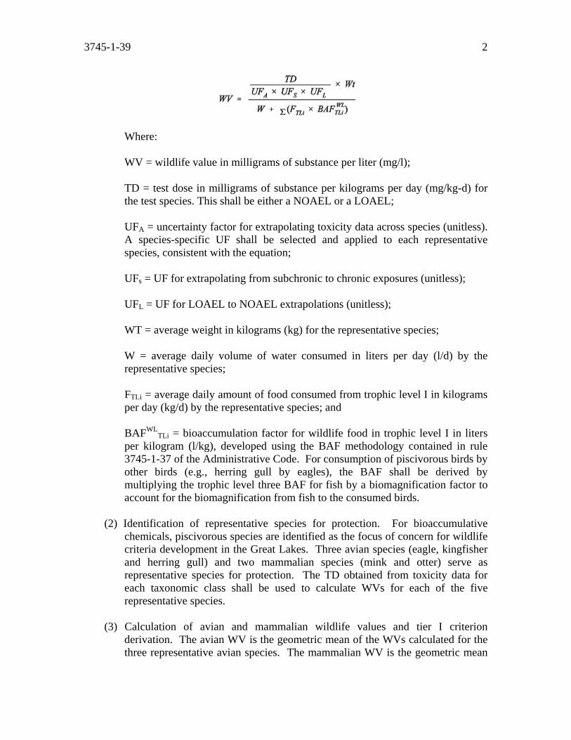
3745-1-39 2
Where:
WV = wildlife value in milligrams of substance per liter (mg/l);
TD = test dose in milligrams of substance per kilograms per day (mg/kg-d) for the test species. This shall be either a NOAEL or a LOAEL;
UFA = uncertainty factor for extrapolating toxicity data across species (unitless). A species-specific UF shall be selected and applied to each representative species, consistent with the equation;
UFs = UF for extrapolating from subchronic to chronic exposures (unitless);
UFL = UF for LOAEL to NOAEL extrapolations (unitless);
WT = average weight in kilograms (kg) for the representative species;
W = average daily volume of water consumed in liters per day (l/d) by the representative species;
FTLi = average daily amount of food consumed from trophic level I in kilograms per day (kg/d) by the representative species; and
BAFWL
TLi = bioaccumulation factor for wildlife food in trophic level I in liters per kilogram (l/kg), developed using the BAF methodology contained in rule 3745-1-37 of the Administrative Code. For consumption of piscivorous birds by other birds (e.g., herring gull by eagles), the BAF shall be derived by multiplying the trophic level three BAF for fish by a biomagnification factor to account for the biomagnification from fish to the consumed birds.
(2) Identification of representative species for protection. For bioaccumulative
chemicals, piscivorous species are identified as the focus of concern for wildlife criteria development in the Great Lakes. Three avian species (eagle, kingfisher and herring gull) and two mammalian species (mink and otter) serve as representative species for protection. The TD obtained from toxicity data for each taxonomic class shall be used to calculate WVs for each of the five representative species.
(3) Calculation of avian and mammalian wildlife values and tier I criterion
derivation. The avian WV is the geometric mean of the WVs calculated for the three representative avian species. The mammalian WV is the geometric mean

3745-1-39 3
of the WVs calculated for the two representative mammalian species. The lower of the mammalian and avian WVs shall be selected as the tier I criterion.
(C) Parameters of the effect component of the wildlife criteria methodology.
(1) Definitions. The following definitions provide additional specificity and guidance in the evaluation of toxicity data and the application of this rule.
(a) Acceptable endpoints. For the purpose of wildlife criteria derivation,
acceptable subchronic and chronic endpoints are those which affect reproductive or developmental success, organismal viability or growth, or any other endpoint which is, or is directly related to, parameters that influence population dynamics.
(b) Chronic effect. An adverse effect that is measured by assessing an
acceptable endpoint and results from continual exposure over several generations, or at least over a significant part of the test species' projected life span or life stage.
(c) Subchronic effect. An adverse effect, measured by assessing an acceptable
endpoint, resulting from continual exposure for a period of time less than that deemed necessary for a chronic test.
(2) Minimum toxicity database for tier I criteria development. A TD value is
required for criterion calculation. To derive a tier I criterion for wildlife, the data set shall provide enough data to generate a subchronic or chronic dose-response curve for any given substance for both mammalian and avian species. In reviewing the toxicity data available which meet the minimum data requirements for each taxonomic class, the following order of preference shall be applied to select the appropriate TD to be used for calculation of individual WVs. Data from peer-reviewed field studies of wildlife species take precedence over other types of studies, where such studies are of adequate quality. An acceptable field study shall be of subchronic or chronic duration, provide a defensible, chemical-specific dose-response curve in which cause and effect are clearly established, and assess acceptable endpoints as defined in this document. When acceptable wildlife field studies are not available, or determined to be of inadequate quality, the needed toxicity information may come from peer-reviewed laboratory studies. When laboratory studies are used, preference shall be given to laboratory studies with wildlife species over traditional laboratory animals to reduce uncertainties in making interspecies extrapolations. All available laboratory data and field studies shall be reviewed to corroborate the final tier I criterion, to assess the reasonableness of the toxicity value used, and to assess the appropriateness of any UFs which are applied. When evaluating the studies from which a test dose is derived in general, the following requirements shall be met.

3745-1-39 4
(a) The mammalian data shall come from at least one well-conducted study of ninety days or greater designed to observe subchronic or chronic effects as defined in this document.
(b) The avian data shall come from at least one well-conducted study of seventy
days or greater designed to observe subchronic or chronic effects as defined in this rule.
(c) In reviewing the studies from which a TD is derived for use in calculating a
WV, studies involving exposure routes other than oral may be considered only when an equivalent oral daily dose can be estimated and technically justified because the criteria calculations are based on an oral route of exposure.
(d) In assessing the studies which meet the minimum data requirements,
preference shall be given to studies which assess effects on developmental or reproductive endpoints.
(3) Selection of TD data. In selecting data to be used in the derivation of WVs, the
evaluation of acceptable endpoints, as defined in paragraph (C)(1) of this rule, shall be the primary selection criterion. All data not part of the selected subset may be used to assess the reasonableness of the toxicity value and the appropriateness of the UFs which are applied.
(a) If more than one TD value is available within a taxonomic class, based on
different endpoints of toxicity, that TD which is likely to reflect best potential impacts to wildlife populations through resultant changes in mortality or fecundity rates shall be used for the calculation of WVs.
(b) If more than one TD is available within a taxonomic class, based on the same
endpoint of toxicity, the TD from the most sensitive species shall be used.
(c) If more than one TD based on the same endpoint of toxicity is available for a given species, the TD for that species shall be calculated using the geometric mean of those TDs.
(4) In those cases in which a TD is available in units other than milligrams of
substance per kilograms per day (mg/kg/d), the following procedures shall be used to convert the TD to the appropriate units prior to calculating a WV.
(a) If the TD is given in milligrams of toxicant per liter of water consumed by
the test animals (mg/l), the TD shall be multiplied by the daily average volume of water consumed by the test animals in liters per day (l/d) and divided by the average weight of the test animals in kilograms (kg).
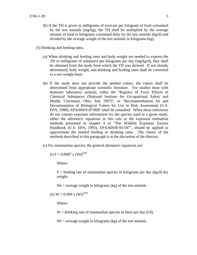
3745-1-39 5
(b) If the TD is given in milligrams of toxicant per kilogram of food consumed by the test animals (mg/kg), the TD shall be multiplied by the average amount of food in kilograms consumed daily by the test animals (kg/d) and divided by the average weight of the test animals in kilograms (kg).
(5) Drinking and feeding rates.
(a) When drinking and feeding rates and body weight are needed to express the
TD in milligrams of substance per kilograms per day (mg/kg/d), they shall be obtained from the study from which the TD was derived. If not already determined, body weight, and drinking and feeding rates shall be converted to a wet weight basis.
(b) If the study does not provide the needed values, the values shall be
determined from appropriate scientific literature. For studies done with domestic laboratory animals, either the "Registry of Toxic Effects of Chemical Substances (National Institute for Occupational Safety and Health, Cincinnati, Ohio, July 1997)", or "Recommendations for and Documentation of Biological Values for Use in Risk Assessment (U.S. EPA, 1988), EPA/600/6-87/008" shall be consulted. When these references do not contain exposure information for the species used in a given study, either the allometric equations in this rule or the exposure estimation methods presented in chapter 4 of "The Wildlife Exposure Factors Handbook (U.S. EPA, 1993), EPA/600/R-93/187", should be applied to approximate the needed feeding or drinking rates. The choice of the methods described in this paragraph is at the discretion of the director.
(c) For mammalian species, the general allometric equations are:
(i) F = 0.0687 x (Wt)0.82
Where:
F = feeding rate of mammalian species in kilograms per day (kg/d) dry weight.
Wt = average weight in kilograms (kg) of the test animals.
(ii) W = 0.099 x (Wt)0.90
Where:
W = drinking rate of mammalian species in liters per day (l/d).
Wt = average weight in kilograms (kg) of the test animals.

3745-1-39 6
(d) For avian species, the general allometric equations are:
(i) F = 0.0582 (Wt)0.65
Where:
F = feeding rate of avian species in kilograms per day (kg/d) dry weight.
Wt = average weight in kilograms (kg) of the test animals.
(ii) W = 0.059 x (Wt)0.67
Where:
W = drinking rate of avian species in liters per day (l/d).
Wt = average weight in kilograms (kg) of the test animals.
(6) LOAEL to NOAEL extrapolations (UFL). In those cases in which a NOAEL is
unavailable as the TD and a LOAEL is available, the LOAEL may be used to estimate the NOAEL. If used, the LOAEL shall be divided by an UF to estimate a NOAEL for use in deriving WVs. The value of the UF shall not be less than one and shall not exceed ten, depending on the dose-response curve and any other available data, and is represented by UFL) in the equation expressed in paragraph (B)(1) of this rule.
(7) Subchronic to chronic extrapolations (UFs). In instances where only subchronic
data are available, the TD may be derived from subchronic data. In such cases, the TD shall be divided by an UF to extrapolate from subchronic to chronic levels. The value of the UF shall not be less than one and shall not exceed ten, and is represented by UFs in the equation expressed in paragraph (B)(1) of this rule. This factor shall be used when assessing highly bioaccumulative substances where toxicokinetic considerations suggest that a bioassay of limited length underestimates chronic effects.
(8) Interspecies extrapolations (UFA).
(a) The selection of the UFA shall be based on the available toxicological data
and on available data concerning the physicochemical, toxicokinetic, and toxicodynamic properties of the substance in question and the amount and quality of available data. This value is a UF that is intended to account for differences in toxicological sensitivity among species.
(b) For the derivation of tier I criteria, a UFAshall not be less than one and shall
not exceed one hundred, and shall be applied to each of the five

3745-1-39 7
representative species, based on existing data and the director's best professional judgement. The value of UFAmay differ for each of the representative species.
(c) For tier I wildlife criteria, the UFAshall be used only for extrapolating
toxicity data across species within a taxonomic class, except as provided in this paragraph. The tier I UFA is not intended for interclass extrapolations because of the poorly defined comparative toxicokinetic and toxicodynamic parameters between mammals and birds. However, an interclass extrapolation employing a UFA may be used for a given chemical if it can be supported by a validated biologically-based dose-response model or by an analysis of interclass toxicological data, considering acceptable endpoints, for a chemical analog that acts under the same mode of toxic action.
(D) Parameters of the exposure component of the wildlife criteria methodology
(1) Drinking and feeding rates of representative species. The body weights (Wt), feeding rates (FTLi), drinking rates (W), and trophic level dietary composition (as food ingestion rate and per cent in diet) for each of the five representative species are presented in table 39-1 of this rule.
(2) BAFs. The methodology for development of bioaccumulation factors is in rule
3745-1-37 of the Administrative Code. Trophic level three and four BAFs are used to derive WVs because these are the trophic levels at which the representative species feed.
(E) Application of criteria. The wildlife criterion shall be applied as a thirty-day average
concentration outside the mixing zone.

3745-1-39 8
Table 39-1. Exposure parameters for the five representative species identified for protection.
Effective: 10/05/2007 R.C. 119.032 review dates: 03/29/2007 and 10/05/2012 Promulgated Under: R.C. 119.03 Statutory Authority: R.C. 6111.041 Rule Amplifies: R.C. 6111.041 Prior Effective Dates: 10/31/1997, 7/31/1999

3745-1-40 Methodologies for development of aquatic life criteria for the Ohio river drainage basin.
This rule applies to water bodies located in the Ohio riverdrainage basin. All pollutants or combinations of pollutants,for which aquatic life criteria have not been adopted in rule3745-1-07 or 3745-1-34 of the Administrative Code, shall notexceed the water quality criteria derived using the procedurescontained in this rule.
(A) Acute aquatic criterion (AAC). This criterion appliesoutside the mixing zone to all aquatic life habitat usedesignations. This criterion shall be calculated by one ofthe following two methods and shall be expressed as thequantity of chemical per liter of water (e.g., mg/l orug/l). Paragraphs (A)(1) to (A)(3) of this rule shall beused when acute toxicity data are available for species inat least six families. Paragraph (A)(4) of this rule shallbe used when there are not enough toxicity data to use theprocedures in paragraphs (A)(1) to (A)(3) of this rule butthere are at least one EC value for a species in the50family Daphnidae and one LC value for either fathead50minnow, bluegill or rainbow trout.
(1) The procedures in paragraphs (A)(1) to (A)(3) of thisrule shall be used to calculate the AAC when LC or50EC data for at least one species of freshwater animal50in at least the six different families identified inparagraphs (A)(1)(a) to (A)(1)(f) of this rule areincluded. Resident species data are preferred for thedata base. However, if such data are not available,data for nonresident species may be used. Thesenonresident species shall serve as representatives ofresident species for which data are unavailable:
(a) The family Salmonidae (salmon and trout) or, forwarmwater habitats, a sensitive warmwater fishspecies;
(b) The family Cyprinidae (minnows) or Centrarchidae(sunfishes);
(c) A third family in the class Osteichthyes (bonyfishes) not already represented;
(d) The family Daphnidae (water fleas);
(e) A benthic macroinvertebrate;
(f) A third invertebrate family not already
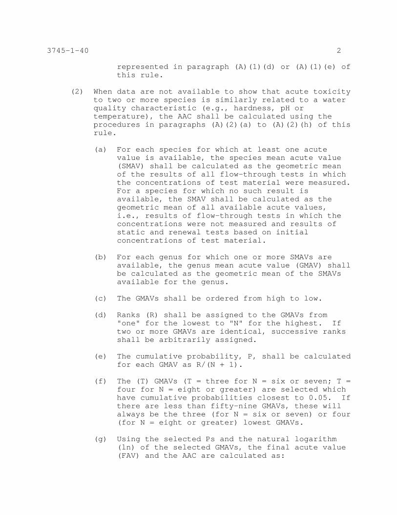
3745-1-40 2
represented in paragraph (A)(1)(d) or (A)(1)(e) ofthis rule.
(2) When data are not available to show that acute toxicityto two or more species is similarly related to a waterquality characteristic (e.g., hardness, pH ortemperature), the AAC shall be calculated using theprocedures in paragraphs (A)(2)(a) to (A)(2)(h) of thisrule.
(a) For each species for which at least one acutevalue is available, the species mean acute value(SMAV) shall be calculated as the geometric meanof the results of all flow-through tests in whichthe concentrations of test material were measured. For a species for which no such result isavailable, the SMAV shall be calculated as thegeometric mean of all available acute values,i.e., results of flow-through tests in which theconcentrations were not measured and results ofstatic and renewal tests based on initialconcentrations of test material.
(b) For each genus for which one or more SMAVs areavailable, the genus mean acute value (GMAV) shallbe calculated as the geometric mean of the SMAVsavailable for the genus.
(c) The GMAVs shall be ordered from high to low.
(d) Ranks (R) shall be assigned to the GMAVs from"one" for the lowest to "N" for the highest. Iftwo or more GMAVs are identical, successive ranksshall be arbitrarily assigned.
(e) The cumulative probability, P, shall be calculatedfor each GMAV as R/(N + 1).
(f) The (T) GMAVs (T = three for N = six or seven; T =four for N = eight or greater) are selected whichhave cumulative probabilities closest to 0.05. Ifthere are less than fifty-nine GMAVs, these willalways be the three (for N = six or seven) or four(for N = eight or greater) lowest GMAVs.
(g) Using the selected Ps and the natural logarithm(ln) of the selected GMAVs, the final acute value(FAV) and the AAC are calculated as:

S 2((ln GMAV)2) ( (ln GMAV))2
T
(P) ( ( P))2
T
L (ln GMAV) S( ( P))T
A S( 0.05) L
FAV e A
3745-1-40 3
AAC = FAV/2.
(h) If, for a commercially, recreationally orecologically important species, the geometric meanof the acute values from flow-through tests inwhich the concentrations of test material weremeasured is lower than the calculated FAV, thenthat geometric mean shall be used as the FAVinstead of the calculated FAV.
(3) When enough data are available to show that acutetoxicity to two or more species is similarly related toa water quality characteristic (e.g., hardness, pH ortemperature), the AAC shall be calculated using theprocedures in paragraphs (A)(3)(a) to (A)(3)(k) of thisrule.
(a) For each species for which comparable acutetoxicity values are available at two or moredifferent values of the water qualitycharacteristic, a least squares regression of theacute toxicity values on the corresponding valuesof the water quality characteristic shall beperformed to obtain the slope. Because the bestdocumented relationship is that between hardnessand acute toxicity of metals and a log-logrelationship fits these data, geometric means andnatural logarithms of both toxicity and waterquality shall be used in the rest of this method. For relationships based on other water qualitycharacteristics, such as pH or temperature, notransformation or a different transformation might

3745-1-40 4
fit the data better, and appropriate changes shallbe made as necessary throughout this method.
(b) Each acute slope shall be evaluated as to whetheror not it is meaningful, taking into account therange and number of the tested values of the waterquality characteristic and the degree of agreementwithin and between species. If meaningful slopesare not available for at least one fish and oneinvertebrate, or if the available slopes are toodissimilar, or if too few data are available toadequately define the relationship between acutetoxicity and the water quality characteristic, theAAC shall be calculated using the procedures inparagraph (A)(2) of this rule.
(c) Individually, for each species, the geometric meanof the available acute values shall be calculatedand then each of the acute values for a speciesshall be divided by the mean for the species. This normalizes the acute values so that thegeometric mean of the normalized values for eachspecies individually and for any combination ofspecies is 1.0.
(d) The values of the water quality characteristicshall be similarly normalized for each speciesindividually.
(e) All the normalized data shall be treated as ifthey were for the same species and a least squaresregression of all the normalized acute values onthe corresponding normalized values of the waterquality characteristic is performed to obtain thepooled acute slope, V.
(f) For each species the geometric mean, W, of theacute toxicity values and the geometric mean, X,of the values of the water quality characteristicshall be calculated. (These were calculated inparagraphs (A)(3)(c) and (A)(3)(d) of this rule.)
(g) For each species the natural logarithm (ln), V, ofthe species mean acute value (SMAV) at a selectedvalue, Z, of the water quality characteristicshall be calculated using the equation:
Y = ln W - v(ln X - ln Z).

3745-1-40 5
(h) For each species the SMAV at Z shall be calculatedusing the equation:
YSMAV = e .
(i) The AAC shall be obtained by using the proceduresdescribed in paragraphs (A)(2)(b) to (A)(2)(h) ofthis rule.
(j) The acute aquatic intercept (AAI) shall becalculated using the equation:
[ln AAC - V(ln Z)]AAI = e .
(k) The AAC equation shall be written as:
[V ln(water quality characteristic) + ln AAI]AAC = e .
(4) If the required data to derive the AAC in paragraphs (A)(1) to (A)(3) of this rule are not present in theacute toxicity data base and at least one LC or EC50 50value is available for a species in the familyDaphnidae and either fathead minnow, bluegill orrainbow trout, a FAV shall be calculated by dividingthe lowest SMAV among the daphnid species, fatheadminnow, bluegill and rainbow trout by five if rainbowtrout are represented or ten if rainbow trout are notrepresented. The AAC equals the FAV divided by two. If appropriate, the AAC shall be made a function of awater quality characteristic in a manner similar tothat described in paragraph (A)(3) of this rule.
(B) Chronic aquatic criterion (CAC). This criterion appliesoutside the mixing zone to all aquatic life habitat usedesignations except the limited resource water usedesignation. This criterion shall be calculated by one ofthe following two methods and shall be expressed as thequantity of chemical per liter of water (e.g., mg/l orug/l). Paragraph (B)(1) of this rule shall be used whenchronic toxicity data are available for species in at leastsix families as specified in paragraph (A)(1) of this rule. Paragraph (B)(2) of this rule shall be used when there arenot enough toxicity data to use the method in paragraph(B)(1) of this rule.
(1) The CAC shall be derived in the same manner as the FAVin paragraphs (A)(1) to (A)(3) of this rule bysubstituting CAC for FAV, chronic for acute, MATC

3745-1-40 6
(maximum acceptable toxicant concentration) for LC or50EC , SMCV (species mean chronic value) for SMAV, and50GMCV (genus mean chronic value) for GMAV.
(2) If chronic data for a chemical are not available for atleast six freshwater species meeting the requirementsin paragraph (A)(1) of this rule, the CAC shall becalculated by dividing the FAV by an acute-chronicratio (or geometric mean if more than one is available)for at least one North American freshwater species. Ifno acute-chronic ratio is available, the CAC shall becalculated by dividing the FAV by forty-five. If, fora commercially, recreationally or ecologicallyimportant species, the geometric mean of the chronicvalues is lower than the calculated CAC, then thatgeometric mean shall be used as the CAC instead of thecalculated CAC.
(C) Application of criteria and values.
(1) The FAV shall be applied as a maximum concentrationinside the mixing zone.
(2) The AAC shall be applied as a maximum concentrationoutside the mixing zone.
(3) The CAC shall be applied as a thirty-day averageconcentration outside the mixing zone.
Replaces: Part of 3745-1-07
Effective: October 31, 1997Promulgated under: R.C. Section 119.03Rule authorized by: R.C. Section 6111.041Rule amplifies: R.C. Section 6111.041R.C. Section 119.032 rule review date: 3/1/02Prior effective dates: 2/14/78, 4/4/85, 8/19/85, 4/30/87, 5/1/90, 4/26/97