Embed Size (px)
Citation preview

This document contains information proprietary to ASI or to a third party to which ASI may have a legal obligation to protect such information from unauthorized disclosure, use or duplication. Any disclosure, use or duplication of this document or of any of the information contained herein for other than the specific purpose for which it was disclosed is expressly prohibited, except as ASI may otherwise agree to in writing (specific purpose COSMO-SkyMed).
Slide 1
COSMO-SkyMedProducts and User Services
E. LopintoASI - Italian Space Agency

This document contains information proprietary to ASI or to a third party to which ASI may have a legal obligation to protect such information from unauthorized disclosure, use or duplication. Any disclosure, use or duplication of this document or of any of the information contained herein for other than the specific purpose for which it was disclosed is expressly prohibited, except as ASI may otherwise agree to in writing (specific purpose COSMO-SkyMed).
Slide 2
To take appropriate decisions on strategic and operative context in a global environment
To build and maintain an accurate image archive with worldwide coverage and implementing many options in terms of:
resolutionsizetemporal sampling (revisit time)
Why COSMO-SkyMed?

This document contains information proprietary to ASI or to a third party to which ASI may have a legal obligation to protect such information from unauthorized disclosure, use or duplication. Any disclosure, use or duplication of this document or of any of the information contained herein for other than the specific purpose for which it was disclosed is expressly prohibited, except as ASI may otherwise agree to in writing (specific purpose COSMO-SkyMed).
Slide 3
Application areas vs. revisit time & spatial resolution
Spatial Resolution
Rev
isit
Tim
e
year
month
day
hour
Cartography for final user
Cartography (telecom, utilities)
Agriculture,Forestry, Geology,
Environment
Defense & Security, Risk Management,
Land use monitoring
Marine/Coastal,Cartography (cadastral)
high medium low

This document contains information proprietary to ASI or to a third party to which ASI may have a legal obligation to protect such information from unauthorized disclosure, use or duplication. Any disclosure, use or duplication of this document or of any of the information contained herein for other than the specific purpose for which it was disclosed is expressly prohibited, except as ASI may otherwise agree to in writing (specific purpose COSMO-SkyMed).
Slide 4
CivilianSeveral Disciplines:Agriculture, Forest, Geology, Environment,Cartography
Open and Accessible System
DefensePriorities ManagementConfidentiality and IntegrityProtected System
High ReactivityResponse / Revisit Time
CommonWide information collection (Database)Flexibility
Multi-mode operation (variety of sizes and resolutions)Agility (reconfiguration and multiple acquisitions on a theater)
Availability & Sustainability of Services
Dual Use Needs
DUALSYSTEM

This document contains information proprietary to ASI or to a third party to which ASI may have a legal obligation to protect such information from unauthorized disclosure, use or duplication. Any disclosure, use or duplication of this document or of any of the information contained herein for other than the specific purpose for which it was disclosed is expressly prohibited, except as ASI may otherwise agree to in writing (specific purpose COSMO-SkyMed).
Slide 5
The COSMO-SkyMed missionGlobal CoverageSAR Night/Day, All Weather Observations;Revisit Time of few hours;Response Time very short (on daily basis);High volume of daily acquired Images with High Resolution, Image Quality and Geo-location accuracy on different sizes, polarizations and points of view;Management of different classes of Users and of Priority; High level of Satellite and payloads agility to acquire multiple images on the same theatre;Staggered deployment and “graceful degradation”;Compatibility with Interferometric operations;Time Frame: 2006-2013.
Global CoverageSAR Night/Day, All Weather Observations;Revisit Time of few hours;Response Time very short (on daily basis);High volume of daily acquired Images with High Resolution, Image Quality and Geo-location accuracy on different sizes, polarizations and points of view;Management of different classes of Users and of Priority; High level of Satellite and payloads agility to acquire multiple images on the same theatre;Staggered deployment and “graceful degradation”;Compatibility with Interferometric operations;Time Frame: 2006-2013.

This document contains information proprietary to ASI or to a third party to which ASI may have a legal obligation to protect such information from unauthorized disclosure, use or duplication. Any disclosure, use or duplication of this document or of any of the information contained herein for other than the specific purpose for which it was disclosed is expressly prohibited, except as ASI may otherwise agree to in writing (specific purpose COSMO-SkyMed).
Slide 6
Performances
1800 Images/day1500 Wide Field (Stripmap)
300 Narrow Field
Planning 1/day
Planning 2/day
Planning:Asynch.
Interferometric Campaigns
Tandem – like Tandem

This document contains information proprietary to ASI or to a third party to which ASI may have a legal obligation to protect such information from unauthorized disclosure, use or duplication. Any disclosure, use or duplication of this document or of any of the information contained herein for other than the specific purpose for which it was disclosed is expressly prohibited, except as ASI may otherwise agree to in writing (specific purpose COSMO-SkyMed).
Slide 7
Acquisition modes

This document contains information proprietary to ASI or to a third party to which ASI may have a legal obligation to protect such information from unauthorized disclosure, use or duplication. Any disclosure, use or duplication of this document or of any of the information contained herein for other than the specific purpose for which it was disclosed is expressly prohibited, except as ASI may otherwise agree to in writing (specific purpose COSMO-SkyMed).
Slide 8
..

This document contains information proprietary to ASI or to a third party to which ASI may have a legal obligation to protect such information from unauthorized disclosure, use or duplication. Any disclosure, use or duplication of this document or of any of the information contained herein for other than the specific purpose for which it was disclosed is expressly prohibited, except as ASI may otherwise agree to in writing (specific purpose COSMO-SkyMed).
Slide 9
The satellite during manifacturing

This document contains information proprietary to ASI or to a third party to which ASI may have a legal obligation to protect such information from unauthorized disclosure, use or duplication. Any disclosure, use or duplication of this document or of any of the information contained herein for other than the specific purpose for which it was disclosed is expressly prohibited, except as ASI may otherwise agree to in writing (specific purpose COSMO-SkyMed).
Slide 10
CivilianCustomers
InternationalDefensePartners
InteroperableEO systems
• X-band Downlink data
Mission Exploitation Operations
(Civilian)
Mission Exploitation Operations
(Civilian)
Constellation Control &
Monitoring Function
Constellation Control &
Monitoring Function
Dual Mission Planning Function
Dual Mission Planning Function
Programming Request
Elaboration Function (Defense)
Programming Request
Elaboration Function (Defense)
Programming Request
Elaboration Function (Civilian)
Programming Request
Elaboration Function (Civilian)
National Defense
Customers
• Queries (search / order)
• SAR Products• Query results • Exch Image
Products• Exchanged
Cataloguing Data
• High priority PR list
• Negotiation Data• Harmonis
data• ACQ Plan
• Internat. priority Plan• Routine PRs
• Routine PRs• PP List
• High Priority PR (from Institutional Civil Users)
• S-band Uplink• S-band Downlink
Space Segment Function
Space Segment Function
•ICR
Mission Exploitation
Function(Defense)
Mission Exploitation
Function(Defense)
• X-band Downlink data
• Mission Plan • Mission Plan follow-up
• ACQ Plan• ACQ Plan
• X-band Downlink data
• Queries (search / order)
Ground Segment
Operational chains
Space Segment
Operational chains
• SAR Products• Query results
InternationalCivilianPartners
• PP PRs• Negotiation
Data
• Harmonisdata
• ACQ Plan•ICR
The overall architecture

This document contains information proprietary to ASI or to a third party to which ASI may have a legal obligation to protect such information from unauthorized disclosure, use or duplication. Any disclosure, use or duplication of this document or of any of the information contained herein for other than the specific purpose for which it was disclosed is expressly prohibited, except as ASI may otherwise agree to in writing (specific purpose COSMO-SkyMed).
Slide 11
Ground Infrastructure geographically distributed and inter-connected (fixed / mobile stations and comm.network);Dual Use implementation: Security standards application, Integrity, Priority management, Plan Approval, Plan and data confidentiality;Reception/Elaboration/Distribution of theObserved data;GPS fiducial network;Calibration sites;Interoperability and Expandability with other Systems (optics, RADAR in other bands, on other platform, etc…);Multisensor capabilities (common operational environment for various sensors);Functional and Physical Redundancy;Integrated Logistics and Operative Support.
CGS
CPCM
Fucino Space Center
IC-UGS
Matera
ID-UGS
Pratica di Mare
CMAP(mobile)
DMAP
AdditionalStationAdditionalSt
ation
FD-UGS
Creil
Ground Segment

This document contains information proprietary to ASI or to a third party to which ASI may have a legal obligation to protect such information from unauthorized disclosure, use or duplication. Any disclosure, use or duplication of this document or of any of the information contained herein for other than the specific purpose for which it was disclosed is expressly prohibited, except as ASI may otherwise agree to in writing (specific purpose COSMO-SkyMed).
Slide 12
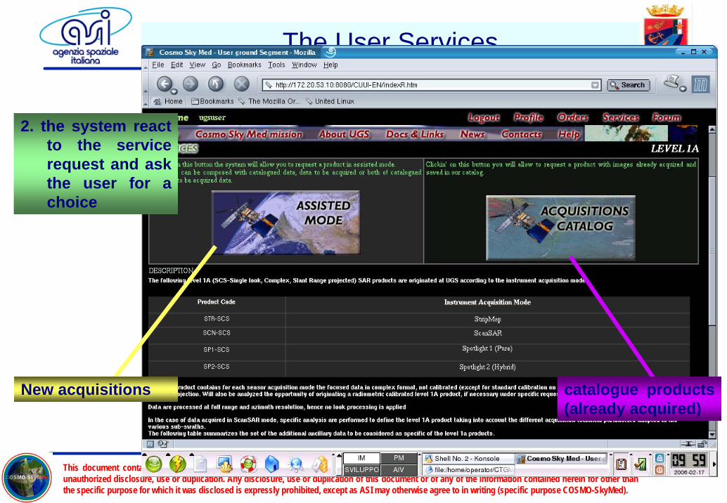
The User Services
The primary objective of COSMO system is the provision of services capable to fulfill the Customer’s needs. The basic functions for the Civilian User, are those related to a specific sequence.
0. the civilian user logs into the system and gets general info about the mission and the allowed services
1. the civilian user query the system for a Service Query
Products List
Services Info
This document contains information proprietary to ASI or to a third party to which ASI may have a legal obligation to protect such information from unauthorized disclosure, use or duplication. Any disclosure, use or duplication of this document or of any of the information contained herein for other than the specific purpose for which it was disclosed is expressly prohibited, except as ASI may otherwise agree to in writing (specific purpose COSMO-SkyMed).
Slide 13
The User Services
2. the system react to the service request and ask the user for a choice
catalogue products (already acquired)
New acquisitions

This document contains information proprietary to ASI or to a third party to which ASI may have a legal obligation to protect such information from unauthorized disclosure, use or duplication. Any disclosure, use or duplication of this document or of any of the information contained herein for other than the specific purpose for which it was disclosed is expressly prohibited, except as ASI may otherwise agree to in writing (specific purpose COSMO-SkyMed).
Slide 14
3. the system asks for user request parameters
The User Services
3. In case of a new acquisition, the user specifies the related parameters
Wizard based sequence
Definition of area of interest

This document contains information proprietary to ASI or to a third party to which ASI may have a legal obligation to protect such information from unauthorized disclosure, use or duplication. Any disclosure, use or duplication of this document or of any of the information contained herein for other than the specific purpose for which it was disclosed is expressly prohibited, except as ASI may otherwise agree to in writing (specific purpose COSMO-SkyMed).
Slide 15
Definition of time period of interest
Periodic acquisitions are allowed for time series applications
Definition of delivery type
Definition of product format
Definition of sensor acquisition parameters
The User Services
4. The system ask for further sensor acquisition parameters and finalize
Status of order and expected delivery time

This document contains information proprietary to ASI or to a third party to which ASI may have a legal obligation to protect such information from unauthorized disclosure, use or duplication. Any disclosure, use or duplication of this document or of any of the information contained herein for other than the specific purpose for which it was disclosed is expressly prohibited, except as ASI may otherwise agree to in writing (specific purpose COSMO-SkyMed).
Slide 16
The User Services
AdditionalUser Services
Access control
Guide
Bulletin Board
Problem Solving
System documentation & information
This document contains information proprietary to ASI or to a third party to which ASI may have a legal obligation to protect such information from unauthorized disclosure, use or duplication. Any disclosure, use or duplication of this document or of any of the information contained herein for other than the specific purpose for which it was disclosed is expressly prohibited, except as ASI may otherwise agree to in writing (specific purpose COSMO-SkyMed).
Slide 17
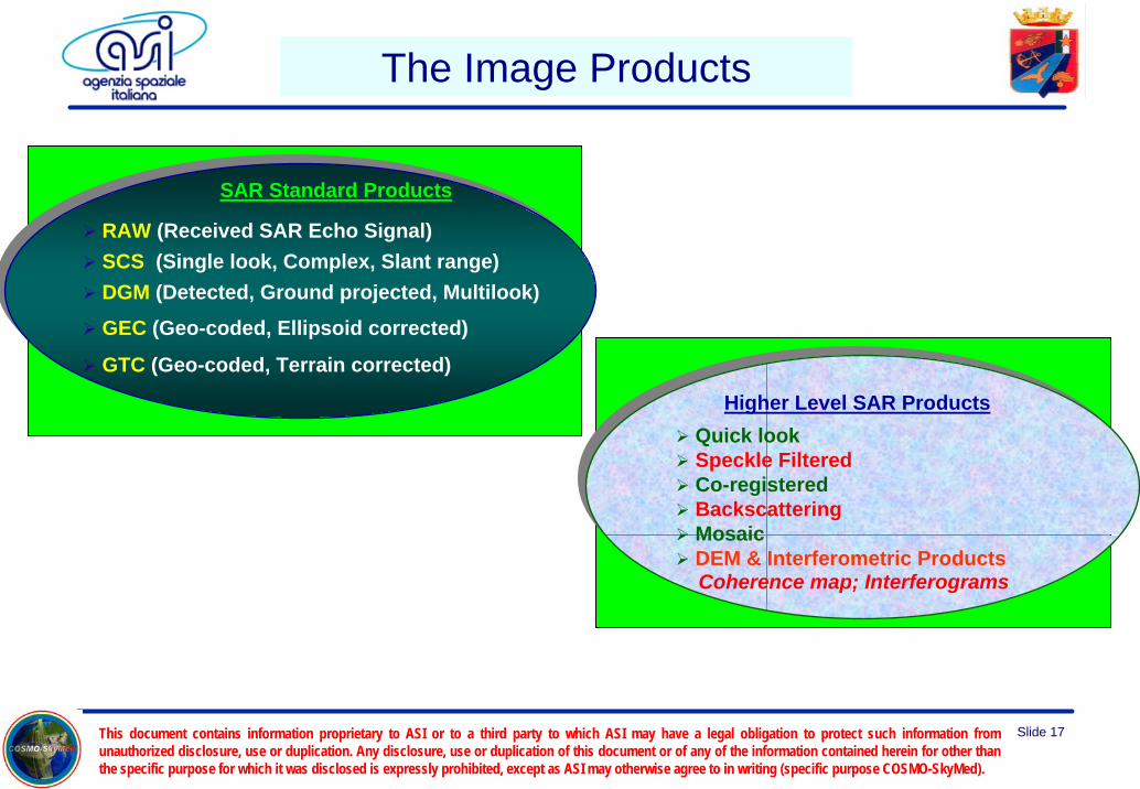
SAR Standard Products
RAW (Received SAR Echo Signal)SCS (Single look, Complex, Slant range)DGM (Detected, Ground projected, Multilook)GEC (Geo-coded, Ellipsoid corrected)
GTC (Geo-coded, Terrain corrected)Higher Level SAR Products
Quick lookSpeckle FilteredCo-registeredBackscatteringMosaicDEM & Interferometric ProductsCoherence map; Interferograms
Higher Level SAR ProductsQuick lookSpeckle FilteredCo-registeredBackscatteringMosaicDEM & Interferometric ProductsCoherence map; Interferograms
The Image Products

This document contains information proprietary to ASI or to a third party to which ASI may have a legal obligation to protect such information from unauthorized disclosure, use or duplication. Any disclosure, use or duplication of this document or of any of the information contained herein for other than the specific purpose for which it was disclosed is expressly prohibited, except as ASI may otherwise agree to in writing (specific purpose COSMO-SkyMed).
Slide 18
Modulus Phase
Etna RAW Product
Standard Products Typologies

This document contains information proprietary to ASI or to a third party to which ASI may have a legal obligation to protect such information from unauthorized disclosure, use or duplication. Any disclosure, use or duplication of this document or of any of the information contained herein for other than the specific purpose for which it was disclosed is expressly prohibited, except as ASI may otherwise agree to in writing (specific purpose COSMO-SkyMed).
Slide 19
In both images the grid is composed by lines at same latitude and same longitude (iso-lat, iso-lon)
Etna as seen in a slant range image (SCSproduct modulus): note the magnitude of the the geometric distortions
Etna as seen in ground range image (DGM product): note the reduction of the side looking distortions but the presence of a rotation with respect to North direction
Standard Products Typologies

This document contains information proprietary to ASI or to a third party to which ASI may have a legal obligation to protect such information from unauthorized disclosure, use or duplication. Any disclosure, use or duplication of this document or of any of the information contained herein for other than the specific purpose for which it was disclosed is expressly prohibited, except as ASI may otherwise agree to in writing (specific purpose COSMO-SkyMed).
Slide 20
GEC productVesuvio in a GEC image. Image isaligned with a cartographic map butdistortions due to terrain height is still in place (see the compression of the right side of volcano)East
No
rth
Standard Products Typologies

This document contains information proprietary to ASI or to a third party to which ASI may have a legal obligation to protect such information from unauthorized disclosure, use or duplication. Any disclosure, use or duplication of this document or of any of the information contained herein for other than the specific purpose for which it was disclosed is expressly prohibited, except as ASI may otherwise agree to in writing (specific purpose COSMO-SkyMed).
Slide 21
GTC productVesuvio. in a GTC image. Distortions due to terrain height are now compensated (see the right proportion of both sides of volcano)
East
No
rth
Standard Products Typologies

This document contains information proprietary to ASI or to a third party to which ASI may have a legal obligation to protect such information from unauthorized disclosure, use or duplication. Any disclosure, use or duplication of this document or of any of the information contained herein for other than the specific purpose for which it was disclosed is expressly prohibited, except as ASI may otherwise agree to in writing (specific purpose COSMO-SkyMed).
Slide 22
ENIVISAT ASAR alternating polarization (100km x 100km) - FlevolandENIVISAT ASAR ScanSAR (400km x 800km) - Netherland
Quicklookgenerated with low resolution focusing of SAR RAW data or by spatial averaging the full resolution products, even non SARhas a lat,lon grid overlaid for easy retrieval of geo location info, radiometry stretched to 8 bit
Higher Level Products Typologies

This document contains information proprietary to ASI or to a third party to which ASI may have a legal obligation to protect such information from unauthorized disclosure, use or duplication. Any disclosure, use or duplication of this document or of any of the information contained herein for other than the specific purpose for which it was disclosed is expressly prohibited, except as ASI may otherwise agree to in writing (specific purpose COSMO-SkyMed).
Slide 23
CoregisteredTwo or more images of the same earth zone are automatically distorted in order to make possible to geometrically superimpose themThe corresponding product is a multilayer set of images useful for change detection, classification studies, false color representation
Vesuvio as seen in a false color DGM coregisteredproduct, composed by 3 images acquired in different seasons
Higher Level Products Typologies

This document contains information proprietary to ASI or to a third party to which ASI may have a legal obligation to protect such information from unauthorized disclosure, use or duplication. Any disclosure, use or duplication of this document or of any of the information contained herein for other than the specific purpose for which it was disclosed is expressly prohibited, except as ASI may otherwise agree to in writing (specific purpose COSMO-SkyMed).
Slide 24
Original Moving Window filter Gamma Map filter
Speckle filteredradar reflectance data but with a lower level of speckle noisemany algorithms available, from Moving Window (improves the noise at expense of geometric resolution) up to sophisticated Gamma Map (image features contours and strong scatters are preserved by adaptive filtering)
Higher Level Products Typologies

This document contains information proprietary to ASI or to a third party to which ASI may have a legal obligation to protect such information from unauthorized disclosure, use or duplication. Any disclosure, use or duplication of this document or of any of the information contained herein for other than the specific purpose for which it was disclosed is expressly prohibited, except as ASI may otherwise agree to in writing (specific purpose COSMO-SkyMed).
Slide 25
DEMGenerated by interferometric techniques: an earth zone is imaged twice within a very short time delay, the phase information of the complex SCS product gives the target to satellites distance, using some geometry the extraction of the height information is then possibleProcessing chain includes the generation of two Interferometric products: wrapped flattened phase and terrain corrected coherence A Virtual Flight in a DEM generated with interferometry: color is
associated with interferometric fringes, saturation with coherence
Higher Level Products Typologies

This document contains information proprietary to ASI or to a third party to which ASI may have a legal obligation to protect such information from unauthorized disclosure, use or duplication. Any disclosure, use or duplication of this document or of any of the information contained herein for other than the specific purpose for which it was disclosed is expressly prohibited, except as ASI may otherwise agree to in writing (specific purpose COSMO-SkyMed).
Slide 26
Mosaikedgenerated joining a set of separate images acquired in the same geometry, in order to obtain a larger coverageautomatic processing with compensation of the radiometric discontinuities at edges
Example of mosaiked product: note as even with a very small overlap, the processor correctly joins the components with a small discontinuity in radiometry
Higher Level Products Typologies

This document contains information proprietary to ASI or to a third party to which ASI may have a legal obligation to protect such information from unauthorized disclosure, use or duplication. Any disclosure, use or duplication of this document or of any of the information contained herein for other than the specific purpose for which it was disclosed is expressly prohibited, except as ASI may otherwise agree to in writing (specific purpose COSMO-SkyMed).
Slide 27
Examples of Value Added Products(Data collected with ERS SAR – ENVISAR / ASAR from 1986 to 2002 - East Coast)
Antarctica Ice Evolution

This document contains information proprietary to ASI or to a third party to which ASI may have a legal obligation to protect such information from unauthorized disclosure, use or duplication. Any disclosure, use or duplication of this document or of any of the information contained herein for other than the specific purpose for which it was disclosed is expressly prohibited, except as ASI may otherwise agree to in writing (specific purpose COSMO-SkyMed).
Slide 28
COSMO for Marine applications
The following COSMO characteristics are particularly suited for Marine Applications like Oil Spill and Sea Ship Detection:
Short revisit time (few hours) allowing the gathering of the SAR images with an adequate time sampling. In Oil Slick applications this feature, in conjunction with suitable models, allows the forecasting of the slick position/velocity and hence the determination of the point and time of arrival of the oil in coasts or beaches
Short response time (daily in routine mode) allowing the acquisition of scenes containing slow moving targets with an high probability of success
Large swath (200km) with a medium spatial resolution (100m) allowing the monitoring of extended coverages, particularly suited for semi- or fully-automatic target detection algorithms (like ships)