Embed Size (px)
Citation preview

1
Indian Remote Sensing Satellites
-Current & Future Missions -
Presented by:Timothy J. Puckorius
Chairman & CEOEOTec
Resourcesat-1 Cartosat-1

2
Presentation Topics
• India’s Earth Observation Heritage
• Current IRS Satellite Missions
– Resourcesat-1 (IRS-P6)• Multispectral broad area coverage
– Cartosat-1 (IRS-P5)• Real-time Stereo mapping
– Cartosat-2 (IRS-P7)• High-Resolution imaging at 0.81m
• Future IRS Satellite Missions
– Current Status on Resourcesat-2
• Conclusions

CARTOSATCARTOSAT -- 11PANPAN -- 2.5M, 30 KM,2.5M, 30 KM,
F/AF/A
RESOURCESATRESOURCESAT--11LISS3LISS3 -- 23 M; 4 XS23 M; 4 XSLISS4LISS4 -- 5.8 M; 35.8 M; 3--
XSXSAWIFSAWIFS -- 70 M; 470 M; 4--
XSXS
CARTOSATCARTOSAT--22PANPAN -- 1M1M
MEGHAMEGHA--TROPIQUESTROPIQUES
SAPHIRSAPHIRSCARAB &SCARAB &MADRASMADRAS
20032003
20052005
20072007
IRS-1C/1D LISS-3 (23/70M,
STEERABLE PAN (5.8 M);
WiFS (188M)
INSAT-2E CCD
(1KM RESOLUTION;
EVERY 30 MNUTESS)
INDIAN IMAGINGSYSTEMS
INDIAN IMAGINGSYSTEMS
IMAGING IMPROVEMENTS
1KM TO 0.81 M RESOLUTION
GLOBAL COVERAGE
APPLICATION-SPECIFIC
19991999
IRS-P2
LISS-2
IRS-P3WiFS MOSX-Ray
IRS-P4
OCEANSAT OCM, MSMR
IRS-1A/1B LISS-1&2 (72/36M,
4 BANDS; VIS & NIR)
BHASKARA
RS-D1
19791979
19821982
1988/911988/91
19941994
19961996
1995/19971995/1997
19991999

4
Indian Earth Observation Satellites
‘96 ‘97 ‘99 ‘00‘98 ‘01 ‘02 ‘03 ‘05‘04 ‘07‘06 ‘08 ‘09 ‘10 ‘11 ‘12 ‘13
P7 OceanSat-2Ku-Scatterometer, Ku-Altimeter,MW-Radiometer, TIR
RISAT-1Multi-Freq. SAR, 50m/240km, …3-6m/30km, 1-3m/10km
ResourceSat-2 same as IRS-P6
ResourceSat-3
Hyperspectral Imager
RISAT-2
OceanSat-3
Hi Res Leo 0.2m
Megha-Tropiquestropical meteorologicalprocesses
P3 MOS-A/B/C; WiFS 188m, 3 bands
1C PAN 5.8m; LISS-III 23/70m, 4 bands; WiFS 188 m, 2 bands
1D PAN 5.8m; LISS-III 23/70m, 4 bands; WiFS 188 m, 2 bands
OCM 9-Band Ocean Colour Monitor;MSMR Microwave Radiometer
P4 OceanSat-1 OCM 300 m, 8 bands; MSMR
TES PAN high res.
P6 ResourceSat-1LISS-IV 5.8m, 3 bands; LISS-III23m, 4 bands; AWiFS 56 m, 4 bands
2A CartoSat-2PAN <1m, pointable,9.6 km swath,10 bit
P5 CartoSat-1PAN 2.5m, in-flight stereo 27.5 km swath,monoscopic 55 km swath, 10 bit

5
Current IRS Missions
Resourcesat-1Cartosat-1Cartosat-2

6
Resourcesat-1
(IRS-P6)

7
Resourcesat-1 Features
Resourcesat-1 launched on 10-17-03Resourcesat-2 scheduled for Q2 2009
Launch Dates :
5-7 yearsMission Life :
Solar Array generating 1250 W (at EOL), Two24 Ah Ni-Cd batteries
Power :
3-axis body stabilized using Reaction Wheels,Magnetic Torquers and Hydrazine Thrusters
Attitude and Orbit Control :
1,360 kgLift-off Mass :
5 daysRevisit (AWiFS) :
24 days (341 orbits)Repetivity (LISS-3) :
10.30 a.m.Local Time of Equator crossing :
14Number of Orbits per day :
101.35 minOrbit period :
98.76°Orbit inclination :
821 kmOrbit height :
Circular Polar Sun SynchronousOrbit :

8
Resourcesat-1 Payload

9
R-1 Acquisition Modes

10
Data Collection Rates
~ 2,344,320 km2~ 293,040 km2~ 4,884 km2AWiFS
~ 446,688 km2~ 55,836 km2~ 931 km2LISS-3
~ 221,760 km2~ 27,720 km2~ 462 km2LISS-4Resourcesat-1
Scenes/Day
(@ 8 mins/day)
Km2
Per Minute
Km2
Per SecondSensorSatellite
11
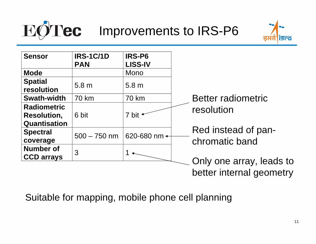
Improvements to IRS-P6
Sensor IRS-1C/1DPAN
IRS-P6LISS-IV
Mode MonoSpatialresolution
5.8 m 5.8 m
Swath-width 70 km 70 kmRadiometricResolution,Quantisation
6 bit 7 bit
Spectralcoverage
500 – 750 nm 620-680 nm
Number ofCCD arrays
3 1
Suitable for mapping, mobile phone cell planning
Only one array, leads tobetter internal geometry
Red instead of pan-chromatic band
Better radiometricresolution

12
Resourcesat-1 Fact Sheet
Sensor LISS-IV LISS-III AWiFSMode Mono MXSpatialresolution
B2B3B4B5
greenredNIRSWIR
5.8 m5.8 m5.8 m5.8 m
23.5 m23.5 m23.5 m23.5 m
56 m .. 70 m56 m .. 70 m56 m .. 70 m56 m .. 70 m
Swath-width 70 km 23.9 km 140 km 740 km
RadiometricResolution,Quantisation
all Bands 7 bit 7 bit 7 bit 10 bit
Spectralcoverage
B2B3B4B5
greenredNIRSWIR
620-680 nm520-590 nm620-680 nm770-860 nm
520-590 nm620-680 nm770-860 nm1550-1700 nm
520-590 nm620-680 nm770-860 nm1550-1700 nm
CCD arrays(number ofarrays * No.of elements)
B2B3B4B5
greenredNIRSWIR
1 * 120001 * 120001 * 120001 * 12000
1 * 60001 * 60001 * 60001 * 6000
2 * 60002 * 60002 * 60002 * 6000
• The LISS-IV camera can be operated either in monochromatic ormulti spectral mode.

13
Possible Applications
• Agriculture– Crop monitoring and condition
assessment
– Crop canopy water stress
– Crop yield estimates
– Damage assessment
• Forestry– Inventory and updating
– Encroachment
– Habitat analysis
– Fire damage
• Environmental Monitoring– Land use
– Soil contamination
– Desertification analysis
– Oil Spills and disaster monitoring
– Environmental impact assessments
• Geology and Exploration– Rock type mapping
– Mining pollution assessments
– Coal fire analysis
– Landslide vulnerability / risk
• Infrastructure and Utilities– Road networks
– 3D city models
– Structural and hydrological inventory
– Utility corridor mapping
– Change detection
• Cartography / Mapping
• National Security

Milan, ItalyMilan, Italy
IRS-P6 LISS-IV Mono Mode5.8m / 7 bit / 70km / Red band
IRS-P6 LISS-IV Mono Mode5.8m / 7 bit / 70km / Red band

Palm Island, DubaiPalm Island, Dubai
IRS-P6 LISS-IV5.8m / 7 bit / 70km
IRS-P6 LISS-IV5.8m / 7 bit / 70km

Manasarovar Lake, TibetManasarovar Lake, Tibet
IRS-P6 AWiFS

Part of Myanmar coastPart of Myanmar coast
IRS-P6 LISS-IIIIRS-P6 LISS-III
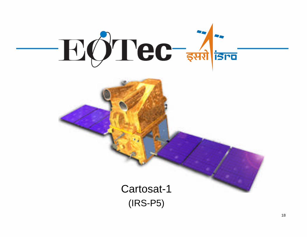
18
Cartosat-1
(IRS-P5)

19
Cartosat-1 Features
5 – 7 years (launched 05/05/05)Mission Life :
5 sq m Solar Array generating 1100W (End Of Life)Two 24 Ah Ni-Cd batteries
Power :
3-axis body stabilized using Reaction Wheels,Magnetic Torquers and Hydrazine Thrusters
Attitude and Orbit Control :
1,560 kgLift-off Mass :
120GBSolid state storage:
105 Mb/sData Rate :
5 daysMax. Wait Time for Revisit :
11 daysNominal Wait Time to Acquire
Adjacent Path :
126 daysOrbital Repetivity Cycle :
10.30 a.m.Local Time of Equator crossing :
15Number of Orbits per day :
97 minOrbit period :
98.87°Orbit inclination :
~618 kmOrbit height :
Circular Polar Sun SynchronousOrbit :

20
Cartosat-1 Payload

21
• Cartosat-1 has two (2) panchromatic cameras for in flight stereo viewing
• Stereo data is provide to ground stations in Real-Time
• Revisit capability is 5 days (by rolling on axis ± 23º)
NOTE: See the accuracy assessment study of DEMs produced from Cartosat-1 Data done by the USGS(The International Archives of the Photogrammetry, Remote Sensing and Spatial Information Sciences,Vol. 34, Part XXX)
Cartosat-1 Additional Specs
Sensor PAN Fore PAN AftTilt Along Track +26 -5Spatial Resolution 2.5 m 2.5 mSwath-width 30 km 27 kmRadiometric Resolution,Quantisation
10 bit 10 bit
Spectral coverage 500-850 nm 500-850 nmCCD arrays(number of arrays * No. ofelements)
1 * 12000 1 * 12000

22
Data Collection Rates
~ 91,080 km2~ 11,385 km2~ 190 km2PAN Camera(Aft)
~ 91,080 km2~ 11,385 km2~ 190 km2PAN Camera(Fore)
Cartosat-1
Scenes/Day
(@ 8 mins/day)
Km2
Per Minute
Km2
Per SecondSensorSatellite

23
IRS-P5 Stereo Collection Mode
27 km
30 km 358 km
• Swath at 27.5 km• DEMs of ~ 4 m elevation accuracy• 52sec between cameras ~ 358 km• Nominal B/H ratio 0.62
Pan ForeCamera
Pan Aft Camera
StereoStereoStereoStereo

Denver, CODenver, CO
IRS-P5 / PAN-A / 2.5m / 10 bitIRS-P5 / PAN-A / 2.5m / 10 bit


26
Cartosat-2

27
Cartosat-2 at a Glance
Launched 1/10/07
: 0.81m

28
Cartosat-2 Baseline
Resolution/Swath:
Panchromatic: 0.80m at 9.6km
Solid Stage Recorder:
64 GB; 138 Images of 9.6km X 9.6km
10 Bit Detector Dynamic Range
Max Data Rate:
105 MBPS / X-Band Downlink
Maximum Area Imaged per 12 min Pass:
0.82m GSD (Mono): 8832 km2
Revisit Time: 4/5 days at equator
Orbit: 630km / 97.922o Sun Synchronous at9.30 A.M Local time
Launch Mass: 680 Kgs
Launched Date: January 10, 2007
Design Life: Minimum 5 years

29
Cartosat-2 Field of Regard
10°
15°26°
PATH111km
@ 0.82m
168km @ 0.85m
250km @ 1.0m
630km

30
C2 Sample Imagery (Bangalore)

31
C2 Sample Imagery (Bangalore)

32
C2 Global Coverage
Catalog Updates available at www.nrsa.org.in

33
FutureIRS Missions
Resourcesat-2 thru n
Cartosat-3 thru n
Radar
HSI

34
Future IRS Missions
• Resourcesat-2– Virtually identical to Resourcesat-1 (with a few sensor
enhancements)
– Assures data continuity through 2015
– Resourcesat-2 Enhancements include:• Miniaturization of some structures and payload electronics
• 10 Bit quantization for all data sets/sensors
• OBSSR enlarged to 400 GB
– Current status:• All mainframe systems in advance stages of completion
• AWiFS and LISS-3 optics fabrication in process
• LISS-4 electronics and telescope mirror delivered
– Launch scheduled for Q3-2009

35
Resourcesat-2 Enhancements
10 10

36
Future Missions (continued)
• Resourcesat-3 series– Increased resolution and more spectral bands:
• AWiFS (A & B) at 25m resolution, 600km swath
• Liss-III at 23.5m resolution and 2 additional bands– Thermal at 70m resolution under consideration
• Liss-IV at 5.8m with 1 additional band, 25km swath
– Addition of new sensors with 25km swath:• Liss-V (PAN) at 2.5m resolution
• Hyperspectral at 25m resolution (~200 Bands)
• 5 day revisit cycle
• Resourcesat-4 series– Addition of new sensors with 12.5km swath based on 500mm
optics:• Liss-IVn at 2.5m, 3-4 bands, 5 day revisit
• Liss-Vn at 1.25m PAN, 5 day revisit
• HSIn at 12.5m, 200 bands, 5 day revisit

37
Future Missions (continued)
• Cartosat Series:– Increased resolution and more spectral bands:
• PAN at 0.5m resolution
• MSI at 2-4m, 4 bands
• HSI at 8m, ~200 bands
– Swath at 8-10km
• RISAT – First IRS SAR system– C-Band SAR
– 10km swath in Spot mode, 240km swath in Scan mode
– Resolution at 1m to 50m
– Single/Dual polarization

38
Conclusions
• ISRO and Antrix are dedicated to providing IRS datathrough 2018– Current systems will be operational thru 2012
– Next generation systems will carry into 2018
– Data continuity is assured
• Resourcesat-2 assures data continuity and improvedcollection rates while R-1 remains operational– Tandem collection potential is under evaluation
• Cartosat-1 provides high-resolution stereo data in realtime– Competitors do not downlink their stereo data to any ground
stations
– Economically provides millions of km2 of data per day
• Follow on systems are already under development

39
Data User’s Handbooks
Available at NRSA’s web site: www.nrsa.org.in

40
Thank you!
Timothy J. PuckoriusChairman & CEOEOTec2123 LeRoy Place NWWashington, DC 20008 - USATEL/FAX: 1-301-365-6148Email: [email protected]
Devi Prasad KarnikCounsellor (Space)ISRO Technical Liaison Unit,Embassy of India2536 Massachusetts Ave., NWWashington, DC 20008TEL: 202-939-9811Email: [email protected]
CONTACT INFO: