Embed Size (px)
Citation preview
Prepared under the auspices of the U.S. Agency for International Development
Assessing the Coal Resources of Afghanistan
Afghanistan has moderate to potentially abundant coal resources. Much of the coal is relatively deep or currently inac-cessible, however, and the scale of development has been limited. Indigenous coal has been used in Afghanistan for small industry (notably in the manufacturing of cement and textiles, and in food processing), and as a primary source of household fuel in both raw and briquetted forms. Electrical generation from coal has occurred only on a temporary basis when coal was used as a substitute fuel for generation by natural gas. The main factors limiting the more widespread use of coal in the past appear to have been the rugged terrain of the country, the lack of a transportation network to deliver coal, and the absence of an industrial infrastructure to utilize the coal. In addition, the geology of Afghan coal is poorly understood, and much of the known coal occurs in structurally deformed areas where exploitation can be difficult.
The U.S. Geological Survey (USGS) is conducting a coopera-tive coal resource assessment of Afghanistan with the Afghan Ministry of Mines and Industries (MMI). The assessment is one component of a much larger program that the USGS is conducting in Afghanistan under the auspices of the U.S. Agency for Inter-national Development (USAID). The various agencies of MMI involved in this cooperative effort include the Afghan Geological Survey (AGS), the North Coal Department (NCD), and the Coal Mines Section of the Mining Affairs Department. The objectives of the assessment are to determine the quality, quantity, and distribu-tion of coal throughout Afghanistan, and to develop the indigenous capability for refining the assessment on a sustainable basis. The assessment will determine the stratigraphic and areal extent of coal in Afghanistan, and quantify the coal resource on a regional and national level. The coal will be classified for its characteristics as a fuel or other beneficial uses, as well as for the attributes that could affect the natural environment, either in situ or from utilization. Special attention will be paid to determining the prospects for shal-lower and less structurally deformed coals than to those that have been mined to date. The potential for the commercial recovery of methane from coal mines and coal beds will also be assessed.
Although the primary focus of the assessment will be to work with MMI to quantify and characterize the coal resources in place, the work will be conducted in close cooperation with other govern-mental and nongovernmental stakeholders to assure that the Afghan coal mining sector can be developed on a safe and sustainable basis that is environmentally sound and economically rational.
Coal in Afghanistan Most of the coal currently being mined in Afghanistan occurs in
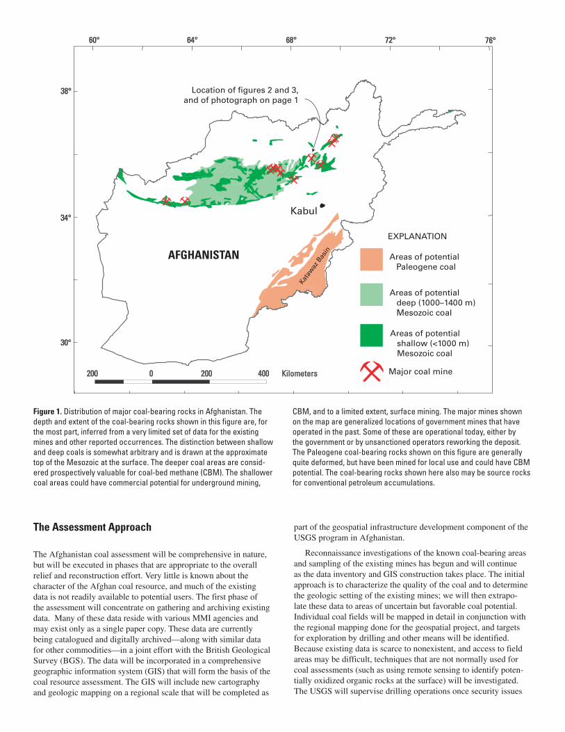
Jurassic rocks of the central Afghan platform (fig. 1). Triassic coal has been reported in several places, but the extent of their develop-ment is unclear. Paleogene coal also occurs in Afghanistan, but it is generally restricted to the Katawaz Basin (fig. 1) and associated areas of eastern Afghanistan. The Mesozoic and Paleogene coal basins are separated by continental-scale faults that mark current
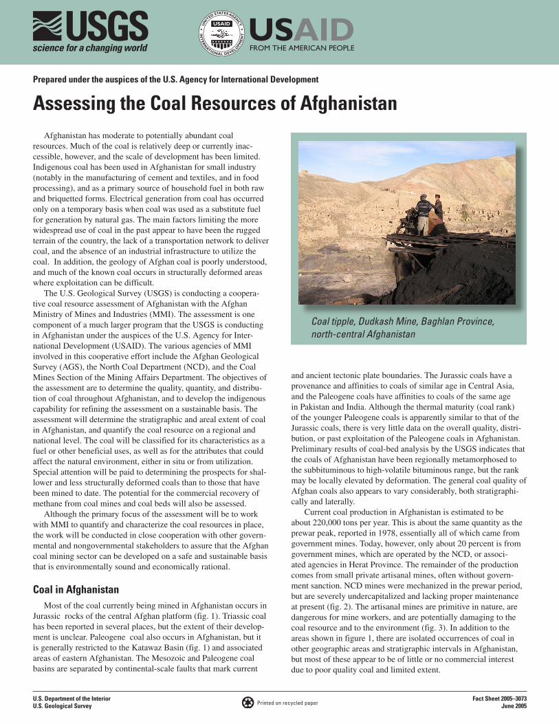
Coal tipple, Dudkash Mine, Baghlan Province, north-central Afghanistan
and ancient tectonic plate boundaries. The Jurassic coals have a provenance and affinities to coals of similar age in Central Asia, and the Paleogene coals have affinities to coals of the same age in Pakistan and India. Although the thermal maturity (coal rank) of the younger Paleogene coals is apparently similar to that of the Jurassic coals, there is very little data on the overall quality, distri-bution, or past exploitation of the Paleogene coals in Afghanistan. Preliminary results of coal-bed analysis by the USGS indicates that the coals of Afghanistan have been regionally metamorphosed to the subbituminous to high-volatile bituminous range, but the rank may be locally elevated by deformation. The general coal quality of Afghan coals also appears to vary considerably, both stratigraphi-cally and laterally.
Current coal production in Afghanistan is estimated to be about 220,000 tons per year. This is about the same quantity as the prewar peak, reported in 1978, essentially all of which came from government mines. Today, however, only about 20 percent is from government mines, which are operated by the NCD, or associ-ated agencies in Herat Province. The remainder of the production comes from small private artisanal mines, often without govern-ment sanction. NCD mines were mechanized in the prewar period, but are severely undercapitalized and lacking proper maintenance at present (fig. 2). The artisanal mines are primitive in nature, are dangerous for mine workers, and are potentially damaging to the coal resource and to the environment (fig. 3). In addition to the areas shown in figure 1, there are isolated occurrences of coal in other geographic areas and stratigraphic intervals in Afghanistan, but most of these appear to be of little or no commercial interest due to poor quality coal and limited extent.
U.S. Department of the Interior Fact Sheet 2005–3073 Printed on recycled paper June 2005 U.S. Geological Survey
34°
60° 64° 68° 72° 76°
38°
0 200 400200 Kilometers j
Kata
waz
Basi
n
Kabul
Areas of potential Paleogene coal
Areas of potential deep (1000–1400 m) Mesozoic coal
Areas of potential shallow (<1000 m) Mesozoic coal
Ma or coal mine
Location of figures 2 and 3, and of photograph on page 1
AFGHANISTAN
EXPLANATION
30°
Figure 1. Distribution of major coal-bearing rocks in Afghanistan. The depth and extent of the coal-bearing rocks shown in this figure are, for the most part, inferred from a very limited set of data for the existing mines and other reported occurrences. The distinction between shallow and deep coals is somewhat arbitrary and is drawn at the approximate top of the Mesozoic at the surface. The deeper coal areas are consid-ered prospectively valuable for coal-bed methane (CBM). The shallower coal areas could have commercial potential for underground mining,
The Assessment Approach
The Afghanistan coal assessment will be comprehensive in nature, but will be executed in phases that are appropriate to the overall relief and reconstruction effort. Very little is known about the character of the Afghan coal resource, and much of the existing data is not readily available to potential users. The first phase of the assessment will concentrate on gathering and archiving existing data. Many of these data reside with various MMI agencies and may exist only as a single paper copy. These data are currently being catalogued and digitally archived—along with similar data for other commodities—in a joint effort with the British Geological Survey (BGS). The data will be incorporated in a comprehensive geographic information system (GIS) that will form the basis of the coal resource assessment. The GIS will include new cartography and geologic mapping on a regional scale that will be completed as
CBM, and to a limited extent, surface mining. The major mines shown on the map are generalized locations of government mines that have operated in the past. Some of these are operational today, either by the government or by unsanctioned operators reworking the deposit. The Paleogene coal-bearing rocks shown on this figure are generally quite deformed, but have been mined for local use and could have CBM potential. The coal-bearing rocks shown here also may be source rocks for conventional petroleum accumulations.
part of the geospatial infrastructure development component of the USGS program in Afghanistan.
Reconnaissance investigations of the known coal-bearing areas and sampling of the existing mines has begun and will continue as the data inventory and GIS construction takes place. The initial approach is to characterize the quality of the coal and to determine the geologic setting of the existing mines; we will then extrapo-late these data to areas of uncertain but favorable coal potential. Individual coal fields will be mapped in detail in conjunction with the regional mapping done for the geospatial project, and targets for exploration by drilling and other means will be identified. Because existing data is scarce to nonexistent, and access to field areas may be difficult, techniques that are not normally used for coal assessments (such as using remote sensing to identify poten-tially oxidized organic rocks at the surface) will be investigated. The USGS will supervise drilling operations once security issues
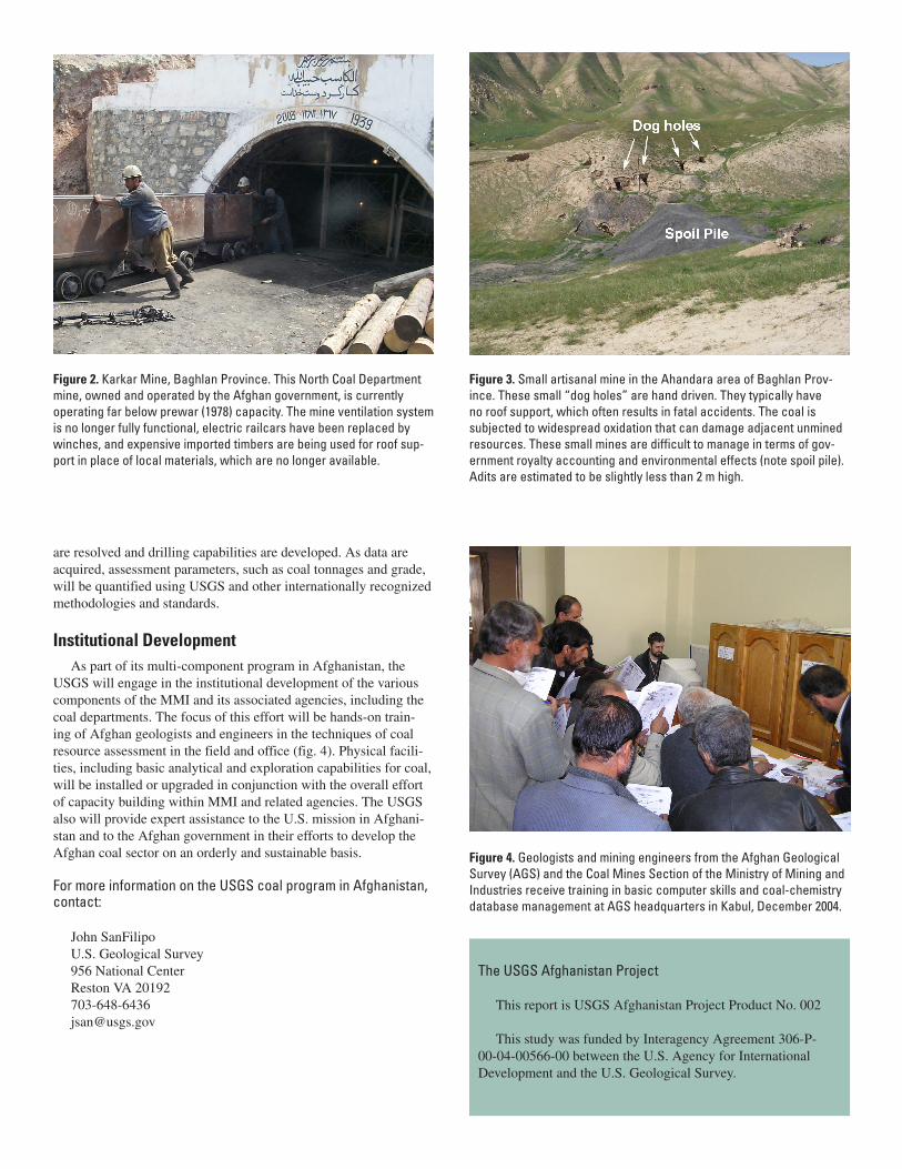
Figure 2. Karkar Mine, Baghlan Province. This North Coal Department mine, owned and operated by the Afghan government, is currently operating far below prewar (1978) capacity. The mine ventilation system is no longer fully functional, electric railcars have been replaced by winches, and expensive imported timbers are being used for roof sup-port in place of local materials, which are no longer available.
are resolved and drilling capabilities are developed. As data are acquired, assessment parameters, such as coal tonnages and grade, will be quantified using USGS and other internationally recognized methodologies and standards.
Institutional Development As part of its multi-component program in Afghanistan, the
USGS will engage in the institutional development of the various components of the MMI and its associated agencies, including the coal departments. The focus of this effort will be hands-on train-ing of Afghan geologists and engineers in the techniques of coal resource assessment in the field and office (fig. 4). Physical facili-ties, including basic analytical and exploration capabilities for coal, will be installed or upgraded in conjunction with the overall effort of capacity building within MMI and related agencies. The USGS also will provide expert assistance to the U.S. mission in Afghani-stan and to the Afghan government in their efforts to develop the Afghan coal sector on an orderly and sustainable basis.
For more information on the USGS coal program in Afghanistan, contact:
John SanFilipo U.S. Geological Survey956 National CenterReston VA [email protected]
Figure 3. Small artisanal mine in the Ahandara area of Baghlan Prov-ince. These small “dog holes” are hand driven. They typically have no roof support, which often results in fatal accidents. The coal is subjected to widespread oxidation that can damage adjacent unmined resources. These small mines are difficult to manage in terms of gov-ernment royalty accounting and environmental effects (note spoil pile). Adits are estimated to be slightly less than 2 m high.
Figure 4. Geologists and mining engineers from the Afghan Geological Survey (AGS) and the Coal Mines Section of the Ministry of Mining and Industries receive training in basic computer skills and coal-chemistry database management at AGS headquarters in Kabul, December 2004.
The USGS Afghanistan Project
This report is USGS Afghanistan Project Product No. 002
This study was funded by Interagency Agreement 306-P-00-04-00566-00 between the U.S. Agency for International Development and the U.S. Geological Survey.