Embed Size (px)
Citation preview
The Red Hill Valley Project Land Use Assessment Report Prepared for: The City of Hamilton Prepared by: Dillon Consulting Limited 235 Yorkland Boulevard Suite 800 Toronto, Ontario M2J 4Y8 Tel: 416-229-4646 Fax: 416-229-4692 Personnel: Ann Joyner, Project Manager Karla Kolli, Environmental Planner Date: March 2003
i
Land Use Assessment Report - Red Hill Valley Project - March 2003 - Dillon Consulting Limited
Table of Contents
Executive Summary ................................................................................................................iii 1. Introduction ..............................................................................1
Background on Red Hill Creek Expressway Environmental Assessment Work...................1 Purpose of the Land Use Assessment Report ..................................................................................2 Land Use Assessment Study Area ........................................................................................................2 Information Sources .................................................................................................................................3
2. Overall Land Use Planning/Policy.........................................................4 Historical Official Plans/Transportation Plans................................................................................4 Vision 2020..................................................................................................................................................5 New City of Hamilton Official Plan ....................................................................................................5 City of Hamilton Parks, Culture and Recreation Master Plan .....................................................6 Red Hill Creek Watershed Plan.............................................................................................................6 Environmental Health and Safety Integrated Management System ..........................................7
3. Review Of Existing And Future Land Use ..................................8 Primary Study Area -Red Hill Creek Expressway Corridor..........................................................8 Lower Section .............................................................................................................................................9 Middle Section .........................................................................................................................................14 Upper Section ..........................................................................................................................................15 Secondary Study Area - Red Hill Creek Watershed .....................................................................17 Mountain East Section of the Watershed .......................................................................................17 Mountain West Section of the Watershed ......................................................................................24
4. Impact Assessment and Mitigation..................................................... 26 Red Hill Valley Project ..........................................................................................................................26 Effects from Development in the Watershed................................................................................34
ii
Land Use Assessment Report - Red Hill Valley Project - March 2003 - Dillon Consulting Limited
Tables ...........................................................................................................................................................
Table 1: Existing and Future Land Use - Primary Study Area................................................ 10 Table 2: Existing and Future Land Use - Secondary Study Area ........................................... 19 Table 3:Potential Land Use Impacts of the Red Hill Creek Expressway and Proposed Mitigation ....................................................................................................... 27
APPENDIX A Contacts made for the Red Hill Creek Expressway
Land Use Assessment

iii
Land Use Assessment Report - Red Hill Valley Project - March 2003 - Dillon Consulting Limited
Executive Summary The purpose of this report is to fulfill the requirements of the Red Hill Creek Expressway North-South Declaration Order. The Land Use Assessment for the Red Hill Valley Project reviews existing and future land uses within the Red Hill Creek Watershed and specifically along the Red Hill Valley Expressway corridor. It summarizes potential impacts of the Red Hill Valley Project on these land uses and mitigation measures to minimize the potential effects. The Red Valley Project includes the revised Red Hill Creek Expressway design as well as stormwater management facilities, a combined sewer overflow pipe and realignment of the Red Hill Creek using natural channel design. The land use assessment considers land use development (including existing residential development), recreation and infrastructure. Many of the potential effects of the Red Hill Valley Project and associated mitigation are documented in more detail in other Red Hill Valley Project assessment reports. The following highlights the key findings in the Land Use Assessment: • The Red Hill Creek Expressway has the potential to result in noise and air quality
impacts as well as visual and aesthetic impacts on existing residents in the area. The Air Quality Assessment, Noise Assessment, Escarpment Crossing Visual Assessment and the Draft Landscape and Recreation Master Plan address these issues in more detail.
• New development in proximity to the Valley will be required to include noise barriers in
development plans. • Some students may have to cross the Expressway to attend schools. However, the City
will ensure that all key cross streets for students have appropriate sidewalks. • The closure of sections of Mount Albion Road will result in a decrease in the high levels
of traffic currently using this road. • A minimal amount of property may still be required. The City will discuss any property
needs with individual property owners and will provide fair compensation. • Although the Expressway will result in the removal of some of the rehabilitated
floodplain associated with the Rennie Street and Brampton Street Erosion Control and Leachate Management project, the net result of the Red Hill Valley Project will be a healthier aquatic ecosystem.
• The Project will result in the need to relocate a number of recreation features including
the Red Hill Valley Trail and pedestrian bridges, sections of the Bruce Trail, some features in the Kings Forest Golf Course and baseball fields in Rosedale Park. Access to the valley and the trail will be significantly limited during the 2003 to 2007 construction period. The City will ensure the community is kept informed of trail closures and will continue to liaise with the Rosedale Community and Golf Course staff and membership.

iv
Land Use Assessment Report - Red Hill Valley Project - March 2003 - Dillon Consulting Limited
Further details on potential impacts to recreational features are found in the Draft Landscape and Recreation Master Plan and the Golf Course Impact Assessment Study.
• Traffic volume on Greenhill Ave. will likely increase as a result of the Greenhill Ave.
Interchange. This traffic will result in noise and air quality effects as well as other disruption effects such as increased waiting times for access in and out of driveways. The increase in traffic also poses a potential safety concern for children crossing the road to get to school. To mitigate this potential impact, the City, in consultation with local schools and school boards, will develop a streetscaping plan for the extension of Greenhill Ave. that will include separated sidewalks and appropriate road crossings for school children. The new interchange design at Greenhill Ave. will also result in slower traffic speed on the road when compared to the original 1985 design.
• The Red Hill Valley Expressway will result in reduced access to the valley for cyclists and
pedestrians coming from the east. Access to the valley will be provided at the Greenhill Ave. Interchange and through a viaduct at the Escarpment.

Page 1
Land Use Assessment Report - Red Hill Valley Project - March 2003 - Dillon Consulting Limited
1. Introduction In May 2002, Dillon was retained by the City of Hamilton to complete a Land Use Assessment to fulfill the requirements of the Red Hill Creek (RHC) Expressway North-South Section Declaration Order (at the time of the request by the Region, this was called an Exemption Order1.) This document is based on the consultant terms of reference found in Appendix E of the May 1996 Exemption Order request documentation prepared by the Region of Hamilton-Wentworth (the Region), Special Projects Office. As per these Terms of Reference, the focus of the Land Use Assessment is on a review of existing conditions and the identification of potential impacts of the revised expressway design. The Land Use Assessment summarizes the potential for impacts on residential, commercial and industrial land uses as well as recreation and infrastructure. In many cases, the Land Use Assessment serves as an overview with more detail on potential impacts and proposed mitigation included in other assessment reports. In particular, this report should be read in conjunction with the following other reports:
- Impact Assessment Summary Report - Air Quality Assessment - Traffic Noise Impact Assessment - Escarpment Crossing Visual Impact Assessment - Golf Course Impact Assessment Study - Landscape and Recreation Master Plan - A Stream Network Inventory, Fluvial Geomorphic Assessment, and
Preliminary Natural Channel Design of Red Hill Creek For the purpose of this report, the Red Hill Valley Project includes the Red Hill Creek Expressway, an 8 km, four-lane controlled access freeway with a truck-climbing lane between Greenhill Avenue, Mud Street Interchanges, as well as stormwater management facilities, a combined sewer overflow pipe and realignment of the Red Hill Creek crossing using natural channel design. Background on Red Hill Creek Expressway Environmental Assessment Work Environmental Assessment Act Approval for the RHC Expressway was granted by a Joint Ontario Municipal Board and Environmental Assessment Board in 1985 and later endorsed by Cabinet in 1987.
1 The Environmental Assessment Act changed in 1996 and the term “exemption order” was changed to “declaration order”.
Page 2
Land Use Assessment Report - Red Hill Valley Project - March 2003 - Dillon Consulting Limited
In the north-south valley section, construction on two interchanges (King Street and Queenston Road) was partially completed and the complete TH&B railway crossing was constructed. In 1990/1991 Provincial funding was withdrawn and, in late 1990, construction switched to the east-west section of the Expressway. In 1991, the Region initiated design and construction on the east-west portion of the Expressway. This work was completed from Highway 403 to Dartnall Road in 1998. In the early 1990’s the Region reviewed alternative alignments for the north-south section and identified modifications to the approved alignment that reduced the potential for environmental impacts. When Provincial funding was reinstated in 1995 the Region applied to the Ministry of the Environment for an exemption from the EA Act for design modifications to the north-south alignment to reduce overall environmental impacts. As part of the exemption order submission, the Region proposed a process to assess the impacts of the modified alignment including a program for public consultation. The process was approved by the Minister of Environment and Energy in March 1997 as a Declaration Order.
Purpose of the Land Use Assessment Report This Land Use Assessment is one of several reports commissioned by the City of Hamilton (formerly the Region of Hamilton-Wentworth) to complete the impact assessment submission. The purpose of this report is to: • Document existing2 and future land use conditions within the RHC Watershed and
specifically along the Expressway corridor; • Identify potential impacts the Red Hill Valley Project will have on existing and future
land use and identify mitigation where necessary; and • Provide input into the overall impact assessment of the alignment modifications.
Land Use Assessment Study Area The primary study area for the Land Use Assessment is the RHC Expressway Corridor. The secondary study area is the RHC Watershed. In the secondary study area, the focus was on land use changes since the RHC Expressway Impact Assessment and Design Process undertaken in 1997/1998 and the State of the Watershed report was prepared in 1997. Both study areas are shown on Figure 1.
2 For the purpose of this assessment existing land use includes built development as well as approved and draft approved development. Land use has also been defined to include recreation, open space and infrastructure.

Page 3
Land Use Assessment Report - Red Hill Valley Project - March 2003 - Dillon Consulting Limited
Information Sources Information on existing and proposed land uses was obtained from the following secondary sources: • State of the Watershed Report, October 1997 • Watershed Action Plan, October 1998 • Red Hill Creek Impact Assessment Draft Summary Reports Volumes 1 and 2,
1997/1998 • Hamilton-Wentworth Official Plan, December 2000 • City of Stoney Creek Official Plan, November 1999 • City of Hamilton Official Plan, July 1999 • The Corporation of the Township of Glanbrook Official Plan, December 1998 • Chippawa Rail Trail Master Plan Hamilton to Caledonia, Hamilton Region Conservation
Authority, January 1998 • Mount Albion Conservation Area Master Development Plan, Hamilton Region
Conservation Authority, October 16, 2000 • Confederation Park Master Plan, October 1997 • Shifting Gears (Hamilton-Wentworth Cycling Plan Pamphlet), 1999 • Various secondary and neighbourhood plans • Regional Transportation Review, Final Report, April 1996 • Red Hill Creek Expressway North-South Section, Exemption Order, May 1996 • Mapping from the City of Stoney Creek Multi-Use Pathway, Pedestrian and Cycling
Route Master Plan Study, June 1995. In addition, meetings and phone discussions were held with staff at the City of Hamilton, the district and separate school boards, and the Hamilton Conservation Authority. A full list of all contacts made with City staff and others is provided in Appendix A. Affidavits from the federal court case held in 1999 were also referred to for background on the role of the Red Hill Creek Expressway in Official Plan documents.
Page 4
Land Use Assessment Report - Red Hill Valley Project - March 2003 - Dillon Consulting Limited
2. Overall Land Use Planning/Policy There are a number of planning policy initiatives either in place or being developed that apply to the RHC Watershed as described below.
Historical Official Plans/Transportation Plans The RHC Expressway has been proposed since the early 1960’s as a transportation corridor to connect Highway 403 to the QEW in the eastern part of Hamilton to serve future development on the mountain and provide transportation capacity across the escarpment. Transportation plans in 1960, 1963 and 1973 refer to the need for the expressway. Since 1967, the RHC Expressway has been designated in Official Plans for the City of Hamilton and Region of Hamilton-Wentworth. Several Official Plan Amendments (OPA) have been approved expanding the developable area on the west mountain of the former City of Stoney Creek. Thus, reinforcing the need for additional transportation capacity across the escarpment into the lower city. The following summarizes the planning history of the expressway: • City of Hamilton OPA 228 added 9000 acres of land for development on the top of the
mountain south of Mohawk Road in 1967. At this time, the Hamilton Area Transportation Plan also identified the need for the Red Hill Creek Freeway.
• City of Stoney Creek OPA 70 added 2070 acres of land for development in Stoney Creek in 1973. This OPA was based on improvements to the road system which included the RHC Expressway. The expressway was to become the west boundary of the west mountain area of the former City of Stoney Creek. The west mountain planning district was to be staged based on the development of the expressway.
• In 1973, the City of Hamilton decided to take specific actions with respect to the freeway including acquisition of property and seeking approval for the project and funding.
• Between 1973 and 1977, the City of Hamilton prepared development standards to control the effect of freeway noise at residential properties adjacent to the proposed expressway.
• In 1979, the Region required local municipalities to amend their Official Plans to protect lands required for future expressway interchanges.
• In 1980 Regional Council adopted a new Official Plan which clearly indicated the RHC Expressway in the regional development pattern.
• The 1996 City of Stoney Creek Municipal Housing Statement identified that in order to meet the City of Stoney Creek’s municipal housing policy, full development on the west mountain was required. This development could only proceed to full build out with the completion of the RHC expressway.
• The 1996 Hamilton-Wentworth Regional Transportation Review incorporates the North-South section of the RHC Expressway as part of the overall transportation network. “This new facility, previously approved, will provide truck and vehicular access to new business and commercial developments, provide the essential additional capacity across the eastern escarpment screenline, facilitate the diversion of vehicular traffic away from the Central Area and adjacent roads, and provide connections to Highway 403 and
Page 5
Land Use Assessment Report - Red Hill Valley Project - March 2003 - Dillon Consulting Limited
the QEW. It is an important link in the major Regional Roadway system and relieves potentially congested conditions along the eastern escarpment crossings.”3
• The Hamilton-Wentworth Official Plan (December 2000) and the City of Hamilton Official Plan (July 1999) both show the Red Hill Creek Expressway in their transportation schedules. These Official Plans are still being used by the City of Hamilton until a new Official Plan is prepared.
Vision 2020 “Vision 2020 – The Sustainable Region” was adopted by Regional Council in 1992 as a basis for regional decision-making in the former Hamilton-Wentworth. The vision statement is an image of a better community. The vision is based on the following principles taken from the Vision 2020 Overview: • fulfillment of human needs for peace, clean air and water, food, shelter, education, and
useful and satisfying employment; • maintenance of ecological integrity through careful stewardship, rehabilitation, reduction
in wastes and protection of diverse and important natural species and systems; • provision for self-determination through public involvement in the definition and
development of local solutions to environmental and development problems; and, • achievement of equity with the fairest possible sharing of limited resources among
contemporaries and between our generation and that of our descendants. “Vision 2020 - A Vision of a More Sustainable Future” also discusses the future vision for transportation which includes the vision that “major roads have minimal noise and pollution impacts on adjacent lands, and follow routes that cause little damage to the natural and human environment”. Future development in the city (and study areas) is to be conducted in a manner that is consistent with the goals of Vision 2020. New City of Hamilton Official Plan In 2001, the municipalities in the former Region of Hamilton-Wentworth were amalgamated into the City of Hamilton. The process for creating a new Official Plan for the City of Hamilton is underway although the timeline for completion has not been determined. The City is currently using the Official Plans from the former municipalities. For the Red Hill Valley Project Land Use Assessment, this includes the following OPs: • Hamilton-Wentworth Official Plan, December 2000 • City of Stoney Creek Official Plan, November 1999 • City of Hamilton Official Plan, July 1999 • The Corporation of the Township of Glanbrook Official Plan, December 1998
3 1996 Hamilton-Wentworth Regional Transportation Review, P. 32.

Page 6
Land Use Assessment Report - Red Hill Valley Project - March 2003 - Dillon Consulting Limited
City of Hamilton Parks, Culture and Recreation Master Plan A process to develop a Parks, Culture & Recreation Master Plan is currently underway. The Plan will provide the vision and scope of Parks, Culture & Recreation services in the City of Hamilton for the next 10 years. The Master Plan is not expected to go to the level of detail of identifying new parks or recreation facilities. Rather, it will set standards for how decisions are made on what new facilities are needed and where they should be located. The Master Plan is formulated around the following high level strategic directions: • Rationalize policies • Reconcile the approach to financing services • Enhance management of information systems • Enhance community capacity and effectiveness • Shift from direct delivery to a community development approach • Increase community capacity through alternative service delivery • Public opportunities take precedence over opportunities for organized groups • Celebrate our natural and historic assets • Focus on active living for 6-18 year olds • Focus on cultural tourism and eco-tourism • Reinvest in existing parks and recreation infrastructure over building new infrastructure • Fewer but larger facilities • Expanding community services in culture and recreation facilities Red Hill Creek Watershed Plan In 1997, the former Region of Hamilton-Wentworth completed the State of the Watershed Report for the Red Hill Creek Watershed. This report documented key baseline information about the Red Hill Creek Watershed including: soils and geology, groundwater, surface water, streams, fisheries, terrestrial resources, water quality, contaminants, air quality, land use, trails/open space and recreation and cultural heritage. This document was followed up in 1998 with the Red Hill Creek Watershed Action Plan. The RHC Watershed Action Plan did not address specific development within the watershed, rather it established the issues that need to be addressed and goals and objectives in six theme areas. Specific actions that could be taken by stakeholders to address these issues were then identified. Both these documents provide the basis for understanding the potential impacts of the RHC Expressway and other projects at a watershed level. The City is currently undertaking a subwatershed plan for Davis Creek - one of the Red Hill Creek tributaries. Phase 1 of this study is complete and involved a baseline inventory and the characterization of the subwatershed. Future work over the next year or two is expected to take a more detailed took at subwatershed issues.

Page 7
Land Use Assessment Report - Red Hill Valley Project - March 2003 - Dillon Consulting Limited
Environmental Health and Safety Integrated Management System The City is currently developing an Environmental Health and Safety Integrated Management System with the goal of corporate registration under ISO 14000 and ISO 18000. This is a leading edge initiative as no other municipality has integrated environmental and health and safety on a corporate-wide level. A corporate environmental policy statement was approved in December of 2001. The first phase of the project will be to develop an integrated management system framework for the Transportation, Operations and Environment Department. The result of these efforts will be to raise the awareness of environmental and health and safety issues within the municipality. This will improve overall environmental performance at the corporate level and at the project level. An Environmental Management Plan specific to the Red Hill Valley Project will be developed to guide design, construction, maintenance, operations and monitoring of the project.
Page 8
Land Use Assessment Report - Red Hill Valley Project - March 2003 - Dillon Consulting Limited
3. Review of Existing And Future Land
Uses The following provides a summary of existing land uses, including built, approved and draft approved developments, as well as future land uses as reflected through current official plans and discussions with City of Hamilton Planning staff. This land use review was undertaken for the primary and secondary study areas shown in Figure 1. Within each of these study areas, the land use review is organized on the basis of the following geographic limits: Primary Study Area – Red Hill Creek Expressway Corridor • Lower Section - Along the RHC Expressway corridor from the mouth of Red Hill Creek to
Barton Street East • Middle Section - Along the RHC Expressway corridor from Barton Street to King Street
East • Upper Section - Along the RHC Expressway corridor from King Street East to the Lincoln
Alexander Parkway/Mud Street Secondary Study Area – Red Hill Creek Watershed • Lower Section – (Incorporates the primary study area above) • Mountain Section East • Mountain Section West The focus of the assessment was on lands in the vicinity of the north-south uncompleted portion of the RHC Expressway (primary study area). However, both existing and future land use in the larger RHC watershed was also examined as per the requirements of the EA Declaration Order. Figure 2 provides a detailed presentation of land uses (existing and future) for lands in the primary study area adjacent to the RHC Valley and Expressway. Figure 3 illustrates existing and future land uses within the RHC watershed. Both Figures 2 and 3 were based on the existing land use conditions documented in the State of the Watershed Report (1997) and supplemented with more up-to-date information from City Staff. For much of the watershed, the existing land use information from the 1997 report has not significantly changed. Existing and future urban land use, as well as recreation features and infrastructure for both the primary and secondary study areas is described in the following sections of this report. Primary Study Area - Red Hill Creek Expressway Corridor The following provides an overview description of existing and future land uses, infrastructure and recreation features within the primary study area. These land uses are
Page 9
Land Use Assessment Report - Red Hill Valley Project - March 2003 - Dillon Consulting Limited
shown in Figure 2. Table 1 provides the status of approved, but not yet built, and future (i.e. not yet approved) residential and commercial/industrial development in the primary study area4. Lower Section Urban Land Use The lower reaches of the RHC Valley contain largely industrial and commercial land uses as well as major transportation facilities such as the QEW. There is a small residential development (Parkview East) located west of the valley and north of Barton St. East. No urban development projects were identified in this section through discussions with City staff. In the year 2001, the City of Hamilton initiated the Environmental Remediation and Site Enhancement (ERASE) Community Improvement Project. This project is a comprehensive set of programs designed to encourage and promote brownfield redevelopment in the older industrial area of the City. A portion of the ERASE Community Improvement Project Area is within the Red Hill Creek Watershed. Under the 10 year ERASE program the City provides grants, as well as other services, to property owners who undertake brownfield redevelopment. As of Spring 2002, there was one application for ERASE funding within the primary study area, west of Red Hill Valley. This application involves the redevelopment of 3 acres of property South of Barton Street East, west of Woodward Ave. from industrial to industrial/commercial. According to the Brownfield Development Coordinator at the City of Hamilton Economic Development Department, it is expected that the majority of the redevelopment will be from industrial lands to industrial/commercial lands and that there will be no residential applications within the lower section of the Red Hill Creek Watershed. Infrastructure Existing infrastructure in this lower section of the primary study area includes: the sanitary sewer along the valley terminating at the Woodward Avenue Treatment Plant; a hydro line along Brampton Street; a hydro line north of the QEW in the vicinity of the proposed interchange; and the main water intake for the City that crosses the QEW.
4 Information on development and status is current to Spring 2002.

Page 10
Land Use Assessment Report - Red Hill Valley Project - March 2003 - Dillon Consulting Limited
Table 1: Existing and Future Land Use
Primary Study Area – Red Hill Creek Expressway Corridor (North-South Section) 1
Figure 2 Reference
Development Name
Nature of Development Status Comments/Related Issues
Approved Development
1 Jackson’s Landing
Type: Townhouses; long term care facility
Draft Approved Site plan application has been submitted for long term care facility. Townhouses under construction
2 Nash Orchard Lands
Type: primarily single family residential
Draft Plan approved. Ready for construction.
3 Albion Mills Estates
Type: single family residential on large lots
Currently being constructed or constructed
4 Red Hill Vista Type: medium density residential
Draft Approved Timing is tied to timing of Red Hill Creek Expressway
Future Development
A Silvestri Type: mix of single family residential and street townhouses
Draft Plan and zoning expected in the near future
Currently up for sale
1 Information is current to Spring 2002 .

Page 11
Land Use Assessment Report - Red Hill Valley Project - March 2003 - Dillon Consulting Limited
Table 1: Existing and Future Land Use
Primary Study Area – Red Hill Creek Expressway Corridor (North-South Section) 1
Figure 2 Reference
Development Name
Nature of Development Status Comments/Related Issues
B Type: primarily single family residential Designated in the neighbourhood plan but no development applications
C Heritage Green – Downtown Core
Type: mix of commercial, industrial, high density residential. Part of area is identified as a Special Policy Area in the Neighborhood Plan.
No development applications submitted Timing is tied to timing of Red Hill Creek Expressway Secondary Plan required because of Specific Policy Area C
Lands are owned by Ontario Realty Corporation and are currently for sale.

Page 12
Land Use Assessment Report - Red Hill Valley Project - March 2003 - Dillon Consulting Limited
The following changes to existing infrastructure and utilities will be made as a result of the Expressway: • the Brampton Street hydro line will be raised; • some hydro towers will require relocation along the QEW hydro line; • a temporary diversion of the CNR rail line at Bancroft Street on the west side of the
valley will be constructed to facilitate construction of the new railway structure; • sections of the sanitary sewer in the vicinity of Barton Ave. will be relocated; • Nash Road just south of Brampton Street will be relocated and will terminate at
Brampton Street; and • stormwater management ponds will be put in place for the Expressway as required. There are a number of other City lead infrastructure related proposals in the lower section of the primary study area as follows: • Woodward Avenue Sewage Treatment Plant Upgrades – The Woodward Avenue Sewage
Treatment Plant treats combined flows and discharges into Red Hill Creek. There have been numerous upgrades to the Treatment Plant over the last few years to improve the efficiency of the treatment system and the quality of the effluent. Currently, there is an expansion underway to the primary treatment system at the plant that would ensure a minimum of primary treatment in the event of a bypass due to high storm flows.
The City has also initiated a Wastewater Investment, Needs and Strategies Program (WINS). This is a major Master Plan initiative that will review the sewage collection and wet weather treatment strategies in the City to identify the most appropriate infrastructure improvements to meet Hamilton Harbour Remedial Action Plan guidelines. It is anticipated that the Master Plan exercise, and related consultation, will occur over the next 1-2 years. Implementation of the projects recommended by the Master Plan is likely to occur over a minimum of 10 years depending on the availability of financing.
• Rennie/Brampton Street Landfill Remediation – The closed Rennie and Brampton Street landfills are located on the west side of the valley just south of Barton Street. Dumping at the Rennie Street Landfill appears to have started in the 1950’s and the site contains approximately 400,000 cubic metres of waste. The Brampton Street Landfill was operated by the City in the 1950’s and 60’s for the disposal of municipal and industrial solid waste. It was closed in 1974 and contains approximately 1,000,000 cubic metres of waste. The eastern slopes of these landfills form the west bank of Red Hill Creek.
In response to concerns related to erosion of the valley sides (which contain landfilled waste), failure of the landfill side slopes and resultant creek contamination, an environmental assessment for erosion control and leachate management was undertaken by the City. As a result of this work, which included significant consultation with the local community, plans were developed to install leachate interceptor pipes to collect and dispose of the leachate that seeps through the banks, and to prevent erosion by re-defining the floodplain of the creek and relocating the creek in the area of the landfills. This work is currently in the implementation phase and was completed for the Rennie Street Landfill in October 2002 and is expected to be completed for the Brampton Street Landfill in mid-2003. The Expressway construction will overlap with some of the works
Page 13
Land Use Assessment Report - Red Hill Valley Project - March 2003 - Dillon Consulting Limited
already done at the Rennie Street landfill and will require excavation of waste and off-site disposal at another landfill.
• Red Hill Creek Sewer Trunk Line Capacity Review –The Red Hill Trunk Sewer currently
extends up the valley from the Woodard Avenue Wastewater Treatment Plant to approximately Mud Street. This trunk sewer services almost all of the developed lands in the watershed. Through discussions with the City’s Infrastructure and Environmental Planning Group, it was identified that there may be a need to expand the capacity of the trunk sewer to service future new development. The need for additional capacity is currently being reviewed. If additional capacity is required, an environmental assessment will have to be completed. The environmental assessment will evaluate different ways to provide additional capacities, including different locations.
Recreation/Open Space Globe Park, VanWagners Beach and Confederation Park Conservation Area are the key existing parks in this section. There is also a small locally significant city park, called Leaside Park, southeast of the Burlington Street/QEW interchange. The former City of Hamilton Official Plan identifies the area at the mouth of Red Hill Creek as the Red Hill Creek Marsh, Van Wagners Marsh Environmentally Significant Area. These are also provincially significant wetlands. This area, along with the rest of the valley, is designated as “Open Space” in the former City of Hamilton Official Plan. In 1997, the Hamilton Conservation Authority completed a Master Plan for Confederation Park Conservation Area. The Master Plan looked at all aspects of park development and improvement including recreation, economics and ecosystem. The Plan, which focused on the development of goals and objectives rather than specific projects, was carried out with the knowledge of the proposed Red Hill Creek Expressway construction. Within the park is the Breezeway which is part of the Waterfront Trail. In addition, there is a side trail that travels along Van Wagners Marsh. The approximate location of both trails are shown on Figure 2. The Cycling Plan for the former Region of Hamilton-Wentworth, approved in 1999 shows a future on-street bike path, to be implemented by 2008, along Woodward Avenue from Melvin Avenue north to the waterfront. There is also an existing multi-use trail within the valley which crosses the Creek at approximately Brampton Street. Access to this trail is currently limited due to the works associated with the Erosion Control and Leachate Management Project for the Rennie Street and Brampton Street Landfills. It should be noted that the City is currently in the process of revisiting their major cycling projects to confirm their feasibility, appropriateness within the cycling network, and timing. In the year 2000, City Council approved the designation of Windemere Basin as predominately “Open Space” and “Open Water” in the Official Plan and recognized the Basin as an important brownfield restoration initiative. A design workshop of landscape architects, urban planners, architects, ecologists, local community leaders, business representatives and elected officials was convened to generate ideas for the restoration of the basin. Implementation of the design and construction phase of this project is tied to SuperBuild funding.

Page 14
Land Use Assessment Report - Red Hill Valley Project - March 2003 - Dillon Consulting Limited
From north of the CNR tracks south to the Niagara Escarpment, the Red Hill Creek will be realigned. The rationale for realigning the creek is documented in the fluvial geomorphology report. For the most part, the realigned creek will be west of the Expressway with the exception of a small section between the CNR tracks and Barton Street. The creek will be reconstruction using natural channel design. The work will be scheduled to avoid sensitive fish spawning seasons and to coincide with the construction of the Expressway to minimize impacts in the valley. Middle Section Urban Land Use From Barton Street to King Street, lands adjacent to the RHC Valley are largely residential with open space lands within the valley. There are four schools on the west side of the valley within the primary study area and six schools to the east. Capture areas for three of these schools (Glen Echo Elementary School, Hillsdale Elementary School and Hillcrest Middle School) cross the Red Hill Creek Expressway corridor. Barton Street East, Melvin Avenue and Queenston Road are the likely streets students currently use to cross over the Red Hill Valley. For the most part, these lands are built-up with little or no potential for significant new land development opportunities. City planning staff (Development Planning Section – East) were not aware of any pending development applications for this area. Infrastructure Existing infrastructure in this location includes the previously mentioned sanitary trunk sewer along the Valley. No change to the alignment of the sewer in this section is anticipated. As with the lower section, stormwater management ponds for the Expressway will be constructed as required in this section. A CSO overflow pipe is proposed from just south of the CNR tracks to just south of King Street (see Figure 2). This pipe will collect combined sewer overflows from four combined sewers outletting to the Red Hill Creek. The pipe will connect with the existing sanitary sewer just immediately south of the CN rail line. An EA for this project was completed and the design for this pipe has been fully integrated into the design for the RHC Expressway. Construction will be initiated to coincide with Expressway construction. The construction of this pipe will reduce the number of times CSO pollution reaches the Red Hill Creek from 20-27 to approximately 2 times per year5. Roadway changes in this section as a result of the RHC Expressway include: • Closure of Melvin Avenue at Talbot Road west of the valley. • Closure of Talbot Road to Barton Street. • Closure of Pottruff Road just south of Barton Street.
5 Red Hill Creek Expressway North-South Section, Impact Assessment & Design Process Draft Summary Report, Volume 2, July 1998, pg. 4 of Executive Summary.
Page 15
Land Use Assessment Report - Red Hill Valley Project - March 2003 - Dillon Consulting Limited
Recreation/Open Space Throughout this section the former City of Hamilton Official Plan identifies the valley as the Red Hill Valley Environmentally Significant Area. The Red Hill Valley Trail is an existing multi-purpose trail that runs along the valley throughout this section (see Figure 2). For the most part it runs along the west side of the creek. The trail was reconstructed about four years ago with the knowledge that some sections would require relocation once the RHC Expressway was constructed. In addition, trail relocation will be required in areas of creek realignment. The trail relocation is being undertaken as part of the RHC Expressway project. In terms of future recreation features, the 1999 Cycling Plan identifies an on-street bicycle path on King Street East to complete the continuous Dundas-Lower Hamilton-Stoney Creek Route. No design or construction schedule for this on-street bike path has been developed, but its development will likely be timed to coincide with other works on King Street East. The partial construction of the King Street East/RHC Expressway interchange was designed to accommodate a wider shared lane for the bike path. The landscape plan for the RHC Expressway will also identify a streetscaping plan for King Street East within the interchange. As with the lower section, the Red Hill Creek will be realigned between Barton and King Streets. Upper Section Urban Land Use The upper section of the Valley extends from King Street to the Mud Street Interchange. Lands at the top of the valley in this section are residential with the eastern side being much closer to the proposed Expressway than the west side. As with previous sections, these residential lands are largely built-out with limited potential for new residential development. There are three schools close to the valley edge on the east side. One of these schools, Bishop Ryan Catholic High School has a large student capture zone that includes areas on the west side of the valley. Students may use any number of streets to cross the valley including King Street, Queenston Road and Barton Street. Within this area, City Planning Staff identified seven small development parcels as shown on Figure 2 and listed in Table 1. Four of these parcels are adjacent to the Expressway. • Albion Mills Estate - a 52 lot single-family residential development currently being
constructed (#3 on Figure 2). • Red Hill Vista - a medium density 126-unit townhouse development which has received
draft approval (#4 on Figure 3). • Silvestri - a proposed development with a mix of single-family residential and townhouse
units. A draft plan for this area is still pending (A on Figure 3). • Area designated for single-family residential on the approved neighbourhood plan (B on
Figure 3).
Page 16
Land Use Assessment Report - Red Hill Valley Project - March 2003 - Dillon Consulting Limited
• Heritage Green Downtown Core - This area, at the Mud Street interchange, is planned to include a mix of commercial, industrial and high density residential. No development applications for this area have been submitted (C on Figure 3).
The timing of both Red Hill Vista and the Heritage Green downtown core is tied to construction of the RHC Expressway. Infrastructure Existing infrastructure in this section includes the previously mentioned sanitary sewer which runs up the valley and a hydro line and a TransNorthern Pipeline which run up the valley between approximately Greenhill Ave. and the Lincoln Alexander Parkway. As a result of the completion of the RHC Expressway, one section of the Trans Northern pipeline (where the Expressway crosses the pipeline) will have to be diverted. The pipeline will be lowered at two locations and one Hydro tower will have to be relocated. A section of the Trans Northern pipeline will also have to be lowered to cross under the Red Hill Creek. This work will take place before the realigned creek is established. On the west side of the valley, immediately north of Greenhill Avenue is an existing combined sewer overflow (CSO) tank (see Figure 2). The addition of a second CSO tank at Greenhill Avenue has been approved through the Class EA process and is scheduled for construction in 2002/2003. The new tank, to be located immediately south of the existing tank, will have approximately the same capacity as the existing tank but will have a larger footprint due to its design. In 1997, the Montgomery Creek Class EA was completed. The Class EA recommended a stormwater management facility and stabilization of the Creek within the Glendale Golf and Country Club. Construction of these works was complete in May 2002. As with the other sections, stormwater management ponds for the Expressway will be constructed as required in this section. A stormwater overflow area just north of Greenhill Ave. on the west side of the valley will also be constructed. Roadway changes in the upper section of the primary study area as a result of the RHC Expressway include: • Closure of Mount Albion Road just south of the Glendale Golf and County Club access. • Closure of Mud Street on the west side of the valley. • Closure of Mud Street on the east side of the valley (except for pedestrian/cyclist access
to valley trails). Recreation/Open Space As shown on Figure 2 lands adjacent to the Valley in this section are largely open space including a number of parks (Rosedale Park, King’s Forest Park, Glencastle Park), the Kings Forest Golf Course and the Glendale Golf and Country Club. The former City of Hamilton Official Plan identifies the valley in this area as Red Hill Creek Environmentally Significant Area. The Red Hill Valley Trail, a multi-purpose trail, extends along the valley and connects in with a number of trails, including the Bruce Trail, on top of the escarpment. The

Page 17
Land Use Assessment Report - Red Hill Valley Project - March 2003 - Dillon Consulting Limited
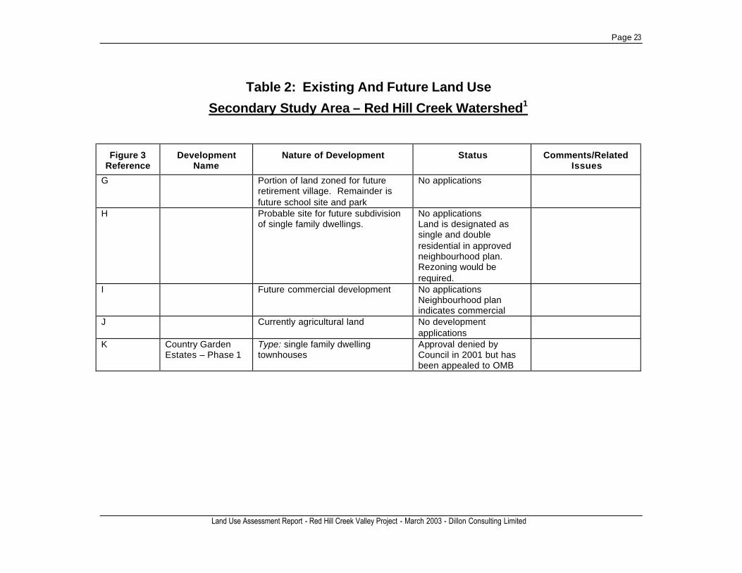
Escarpment Rail Trail/Chippawa Rail Trail goes along the west side of the valley and continues south of the Lincoln Alexander Parkway. There are four existing baseball diamonds in Rosedale Park on the west side of the valley, north of Greenhill Avenue (see Figure 2). These diamonds will need to be removed to accommodate the realignment of Red Hill Creek and the Red Hill Valley Trail as well as the stormwater management overflow area mention above. There were three soccer fields in the valley to the east of the creek in Glencastle Park (south of Greenhill Avenue). These have been relocated to nearby schools to accommodate stormwater management facilities for the Expressway. In addition to potential recreation effects from the RHC Expressway project, three ball diamonds on the west side of the valley, south of Greenhill Ave. and 4-6 underused tennis courts will be affected by the construction of the Greenhill CSO tanks. Some of these recreation features will be replaced as part of the CSO project. Red Hill Creek will be realigned in this section to a point just north of the existing Bruce Trail where it will return to its current alignment. Secondary Study Area - Red Hill Creek Watershed The following provides a description of existing and future land uses, infrastructure and recreation features in the larger watershed. The watershed has been divided into three sections: Lower, Mountain East and Mountain West. The Lower section of the watershed essentially covers the same geographic area that is included in the primary study area. Existing and future land uses in this area are discussed in Section 3 of this report and therefore are not repeated here. The following subsections describe the Mountain East and Mountain West areas. For the purposes of this report, the division between the Mountain East and Mountain West sections approximates the former municipal boundaries. Mountain West, encompasses watershed lands within the former City of Hamilton; Mountain East encompasses watershed lands within the former municipalities of Stoney Creek and Glanbrook. Table 2 lists the existing (approved) future land use developments in the Secondary Study Area (Mountain East and West sections only)6. This information is cross-referenced to Figure 3. Mountain East Section of the Watershed Urban Land Use The Mountain East section7 of the watershed contains a variety of existing land uses including residential subdivisions, commercial, some open space, vacant lands and some industrial uses such as the Taro Quarry that is currently used for the landfilling of industrial, commercial and institutional wastes.
6 Information is current to Spring 2002. 7 The former City of Stoney Creek Official Plan refers to this area as the West Mountain Planning District.
Page 18
Land Use Assessment Report - Red Hill Valley Project - March 2003 - Dillon Consulting Limited
This area of the watershed provides the greatest opportunity for new development as there exists tracts of vacant land located within the urban boundary that have been designated for development in the Official Plan. Figure 3 provides information on the location, character and status of the approved and future development in this section of the watershed. Table 2 corresponds to the figure and provides the status of approved (but not yet built) and future (i.e. not yet approved) residential and commercial/industrial development. Most of the lands in this area are part of the Heritage Green Secondary Plan Neighbourhood. Within the Heritage Green Secondary Plan there are six neighbourhoods and for each neighbourhood the City has prepared a neighbourhood plan documenting the type of development that is to occur in these areas. No development applications have been submitted for the largest neighbourhoods (Nash, Felker and Trinity Neighbourhoods, A, B and C on Figure 3). It is noted that much of the land in the Heritage Green area is owned by the Ontario Realty Corporation. The timing of further development in the Heritage Green Secondary Plan area is dependent on the construction of the RHC Expressway. As an example, there is currently a cap of 21,500 residents within the Heritage Green Secondary Plan for which the current population is about 18,000 residents. This cap will remain in place until the Expressway is constructed. The ultimate population for this area is estimated to be in approximately 31,000. The Nash Neighbourhood includes the Taro Quarry. The portion of the quarry lands west of 1st Road West is designated for recreation/open space development. Development of this area is pending the completion of a closure plan for the quarry lands. The most recent proposal for this area was a golf course, but plans fell through. The quarry lands between 1st Road, west of Highway 20, are being used for the landfilling of industrial, commercial and institutional wastes. This landfill, approved in the mid to late 1990s, is licensed for 10 million tonnes of waste. The area identified as Regional Official Plan Amendment (ROPA) #9 (Area E on Figure 3), requires the expansion of the urban area to the south of Rymal Road East. Approximately half of this land parcel sits within the headwaters of the RHC watershed. The Secondary Plan for this area was recently approved by the OMB and a draft development plan has been submitted. It is anticipated that the earliest timing for construction in the ROPA # 9 lands is 2004. Development of the lands is contingent on servicing and development beyond 500 units is contingent on transportation capacity provided by construction of the Red Hill Creek Expressway and the widening of Rymal Road, the extension of Trinity Church Road and other transportation initiatives. The ultimate population of this area is estimated at 9,600 residents. Further to the west of the ROPA #9 area is the North Glanbrook Business Park. Although this area is currently used for agricultural purposes, it has been designated for future industrial and commercial uses. The area’s designation is under review.

Page 19
Land Use Assessment Report - Red Hill Creek Valley Project - March 2003 - Dillon Consulting Limited
Table 2: Existing And Future Land Use
Secondary Study Area – Red Hill Creek Watershed1
Figure 3 Reference
Development Name
Nature of Development Status Comments/Related Issues
Approved Development
1
Albion 2 Type: mix of single family residential and medium to medium-high density
Draft Approved Construction timing is tied to timing of Red Hill Creek Expressway
Land is owned by Ontario Realty Corporation
2
Templemead Vista Type: single family residential
Draft Approved 2002
3
The Gardens of Rymal 25T88037)
Type: Mix of single family residential and medium density
Some built. Phase 6 received final approval 2002.
New school also proposed
4
Falconstone Estates/Rose Gardens (25T89032, 25T94001, 25T89029)
Type: Mix of single family residential and medium-high density
Falconstone Estates received final approval in 1999, Rose Gardens Phase 3 draft approved 1990, Timothy Survey final approval 1998
James Mount Gardens/ Dicenzo Gardens (25T86008, 25T94001, 25T89029
Type: Primarily single family residential
Dicenzo Gardens Subdivision agreement 1987. Other phases still active. 25T91007 received draft approval in 1998.
1 Information is current to Spring 2002.

Page 20
Land Use Assessment Report - Red Hill Creek Valley Project - March 2003 - Dillon Consulting Limited
Table 2: Existing And Future Land Use
Secondary Study Area – Red Hill Creek Watershed1
Figure 3 Reference
Development Name
Nature of Development Status Comments/Related Issues
5 Miles Estates Type: single family dwelling
Draft Approved 2000
6
Effort Gardens/Wellington Meadows 25T88035, 25T88036, 25T97004
Type: single family residential
Final plan of subdivision approved in 1999 (Effort Gardens)
7
Blossom Estates (25T88028)
Type: single family residential
Draft Approved 1989
8
Westview Estates Type: single family residential
Final Approval 1998
9
Fontana Gardens (25T88016, 25T94012)
Type: single family residential
Draft Plan Approved 1992
10 Parkway Manor Type: single family residential
Draft Approved 1999
11 Chappel Estates Type: single family dwelling
Going to Council for draft approval – June 2002
Chappel East Estates – Phase 1
Type: single family dwelling
Draft Approved 1999
12 Sandrina Gardens Type: single family
N/A

Page 21
Land Use Assessment Report - Red Hill Creek Valley Project - March 2003 - Dillon Consulting Limited
Table 2: Existing And Future Land Use
Secondary Study Area – Red Hill Creek Watershed1
Figure 3 Reference
Development Name
Nature of Development Status Comments/Related Issues
Future Development
A Nash Neighbourhood
Type: primarily single family residential with some medium/high density, commercial and large parkland/open space. Taro Quarry is identified as a special policy area in the Neighbourhood Plan.
Secondary Plan completed not approved No development applications submitted
Any development is on hold until future of quarry is determined
B Felker Neighbourhood
Type: primarily single family residential with some medium density. Estimated population of 3,793.
No development applications submitted Timing is tied to timing of Red Hill Creek Expressway
1/3 of Lands are owned by Ontario Realty Corporation
C Trinity Neighbourhood
Type: Mix of land uses. Estimate population increase of 5,598.
No development applications submitted Neighbourhood Plan will require changes as a result of identified Karst features Timing is tied to timing of Red Hill Creek Expressway
Lands are owned by Ontario Realty Corporation

Page 22
Land Use Assessment Report - Red Hill Creek Valley Project - March 2003 - Dillon Consulting Limited
Table 2: Existing And Future Land Use
Secondary Study Area – Red Hill Creek Watershed1
Figure 3 Reference
Development Name
Nature of Development Status Comments/Related Issues
D NA Type: primarily serviced commercial (in the former municipality of Stoney Creek) and industrial (in the former municipality of Hamilton)
No development applications submitted Timing is tied to timing of Red Hill Creek Expressway
Lands are owned by Ontario Realty Corporation Lands cross former City of Hamilton – Stoney Creek boundary
E ROPA #9 Type: primarily single family residential and low-medium density residential with some commercial along Rymal Road. Estimated population of 9,660.
Secondary plan recently approved by OMB Draft plan recently submitted If draft plan is approved construction could begin in 2004
This development area represents an expansion to the urban boundary. A new trunk sewer along Rymal road and 4 stormwater manage-ment facilities will be required to service this development. Timing beyond 500 units is dependent on the RHC Expressway and other transportation initiatives.
F North Glanbrook Business Park
Portions of this business park along Nebo Road are already built the remainder has not yet been developed
Lands are designated as a business park in the Glanbrook Official Plan (Draft approved)
Page 23
Land Use Assessment Report - Red Hill Creek Valley Project - March 2003 - Dillon Consulting Limited
Table 2: Existing And Future Land Use
Secondary Study Area – Red Hill Creek Watershed1
Figure 3 Reference
Development Name
Nature of Development Status Comments/Related Issues
G
Portion of land zoned for future retirement village. Remainder is future school site and park
No applications
H
Probable site for future subdivision of single family dwellings.
No applications Land is designated as single and double residential in approved neighbourhood plan. Rezoning would be required.
I
Future commercial development No applications Neighbourhood plan indicates commercial
J Currently agricultural land No development applications
K Country Garden Estates – Phase 1
Type: single family dwelling townhouses
Approval denied by Council in 2001 but has been appealed to OMB
Page 24
Land Use Assessment Report - Red Hill Valley Project - March 2003 - Dillon Consulting Limited
Infrastructure Infrastructure projects in this section relate primarily to the Expressway and ROPA #9 and include: • The construction of a sanitary trunk sewer along Rymal Road East to connect the ROPA
#9 area with the RHC sewer trunk. • The extension of Trinity Church Road (four lanes), which defines the western boundary
of ROPA #9, from Rymal Road East to north of the RHC Expressway terminus. Tied to this would be the closing of Pritchard Road, located to the west of the proposed Trinity Church Road extension. This roadway extension has been included in the Heritage Green Secondary Plan.
• The widening of Rymal Road to four lanes from Upper Centennial Parkway to Trinity Church Road.
• Upgrading of upper Mount Albion Road from Paramount Drive to Rymal Road. The need for these improvements is tied to the development of ROPA #9. Environmental Assessment approvals are required for all of the above projects. Recreation/Open Space In March 2001 the City completed a report titled “Evaluation of The Eramosa Karst in Stoney Creek, Ontario as a Candidate for an ESA and ANSI”. This report documents that lands bounded by Highland Road, Second Road West, Rymal Road and Upper Mount Albion Road contain numerous diverse Karst features several of which are provincially significant. The Karst type and the various provincially significant features identified in the Eramosa Karst are not currently represented anywhere else in Ontario. As such, the report recommends the designation of the area as an Environmentally Significant Area (ESA) and an Area of Natural and Scientific Interest (ANSI). The report recommends boundaries for the ESA and ANSI based on protecting the core area where the majority of the Karst features are located, the feeder area where the watersheds drain into the Karst features and two significant springs in the developed area on the north side of Highland Road. Figure 3 shows the proposed boundaries of the Karst at the time this report was prepared. The Ministry of Natural Resources is undertaking a process to designate the Eramosa Karst as an ANSI and hopes to complete the designation in 2002. City staff indicated that the City will initiate the process of designating the area as an ESA in the Official Plan after the Ministry of Natural Resources ANSI designation process is complete. The boundaries of the Karst are likely to be revised as a result of consultation conducted as part of the ESA designation process. Once this area is designated, the Trinity Neighbourhood Plan as well as the Secondary Plan for ROPA #9 may have to be revised to accommodate the ESA designation. Mountain West Section of the Watershed Urban Land Use The Mountain West section of the watershed is much more developed than the Mountain East section. The area is primarily built-out residential lands with small shopping plazas and commercial areas (including the Limeridge Mall), community parks and recreation features,
Page 25
Land Use Assessment Report - Red Hill Valley Project - March 2003 - Dillon Consulting Limited
schools and Mohawk College. Also within the Mountain West section of the watershed is the Mountain Business Park (see Figure 3 for location). There are some vacant commercial/industrial parcels of land within this business park. For the most part, lands with opportunity for future development are located south of the Lincoln Alexander Parkway. As shown on Figure 3, vacant land parcels in this area are much smaller than in the Mountain East section. Much of the available land for development has been approved. Infrastructure There are two infrastructure projects in this area that have, or will have, a positive impact on the Red Hill Creek. In 1999, the City completed a leachate collection system and associated slope stabilization works at the Upper Ottawa Street Landfill that abuts Red Hill Creek at approximately Dartnall Road. This project involved the construction of a retaining wall/slope stabilization along approximately 800 – 850 metres of the creek. A Class EA has been initiated for stormwater management at Albion Falls. Construction of stormwater management works, resulting from this Class EA, is scheduled for 2003. No other major infrastructure initiatives within this section of the watershed were identified that would act cumulatively with the RHC Expressway. Recreation/Open Space The Chippawa Rail Trail is a continuation of the Escarpment Rail Trail (shown on Figure 3) It goes from approximately Stone Church Rd at Dartnall Road south to the community of Caledonia. Just south of the RHC Expressway is the Mount Albion Conservation Area (see Figure 3). A Master Development Plan has been prepared for this 41 ha parcel of land. As outlined in this plan, a network of walking trails have been proposed that extend up to the south side of the Lincoln Alexander Parkway. The timing of the development of these trails hinges on the availability of funding. The Hamilton Region Conservation Authority is also in the process of trying to identify a site for an outdoor education centre in the east end of their jurisdiction. The Red Hill Valley has been identified as the most preferred location. The Mount Albion Conservation Area is also being considered as an alternate location. The education centre is to be in place by Fall 2003 however, its timing is dependent on receiving sufficient funding.
Page 26
Land Use Assessment Report - Red Hill Valley Project - March 2003 - Dillon Consulting Limited
4. Impact Assessment and Mitigation The land use assessment report examined two types of potential impact: • direct and indirect effects of the Red Hill Valley Project construction and operation on
existing and future land uses in the primary study area – the Red Hill Creek Valley; • other developments within the watershed that have the potential to result in watershed
impacts (either on their own or cumulatively with the effects from the Red Hill Valley Project).
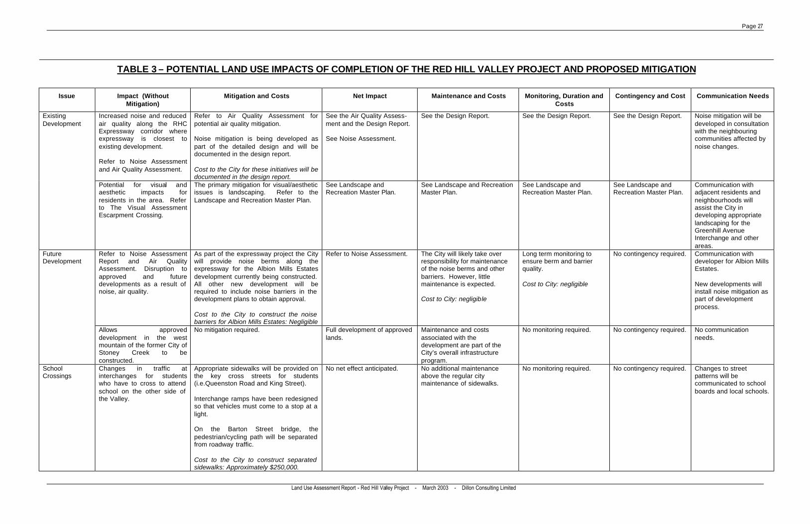
The potential direct and indirect effects of the Red Hill Valley Project construction and operation on existing and future land uses are summarized in Table 3. Mitigation is proposed for each of the potential impacts identified. Table 3 also documents the approximate cost for mitigating the potential land use impacts where estimates can be made at this time. Updated costs will be provided in the future design report. The following text summarizes these potential impacts and mitigation and discusses other developments within the watershed that may on their own or cumulatively with the Expressway impact the Red Hill Creek watershed. It should be noted that to understand the full potential impact of the Red Hill Valley Project, this report should be read in conjunction with the other assessment reports being prepared. In many cases, these other assessment reports provide more detail on potential impacts and proposed mitigation. Red Hill Valley Project For the most part, completion of Expressway construction itself will not result in displacement of urban areas, with the exception of the need to purchase some industrial lands at the north end of the valley. Other components of the Red Hill Valley Project (i.e. the realignment of the Red Hill Creek and the Red Hill Valley Trail) however, may necessitate the purchase of additional land by the City. The need for any additional lands will be determined during detailed design and landowners will be fairly compensated. Some recreational features within the valley will be displaced or disrupted. The Red Hill Valley Trail requires realignment for much of its length mostly due to the Red Hill Creek realignment. The ultimate location of the Red Hill Valley Trail, including access points, will be determined as part of the Landscape and Recreation Master Plan. The ultimate design of the Red Hill Valley Trail must also consider the removal of existing trail sections that will no longer be used. A new location for the Bruce Trail is being proposed. The Bruce Trail is proposed to cross under the expressway viaduct at the base of the escarpment. The trail will also be relocated in the Kings Forest Area at the base of the escarpment. Valley trails will be temporarily unavailable during construction (from 2003 to 2007). The construction of the expressway at the south end should also consider any potential for impact to the Chippewa Trail at Stone Church Road.
Page 27
Land Use Assessment Report - Red Hill Valley Project - March 2003 - Dillon Consulting Limited
TABLE 3 – POTENTIAL LAND USE IMPACTS OF COMPLETION OF THE RED HILL VALLEY PROJECT AND PROPOSED MITIGATION
Issue Impact (Without Mitigation)
Mitigation and Costs Net Impact Maintenance and Costs Monitoring, Duration and Costs
Contingency and Cost Communication Needs
Existing Development
Increased noise and reduced air quality along the RHC Expressway corridor where expressway is closest to existing development. Refer to Noise Assessment and Air Quality Assessment.
Refer to Air Quality Assessment for potential air quality mitigation. Noise mitigation is being developed as part of the detailed design and will be documented in the design report. Cost to the City for these initiatives will be documented in the design report.
See the Air Quality Assess-ment and the Design Report. See Noise Assessment.
See the Design Report. See the Design Report. See the Design Report. Noise mitigation will be developed in consultation with the neighbouring communities affected by noise changes.
Potential for visual and aesthetic impacts for residents in the area. Refer to The Visual Assessment Escarpment Crossing.
The primary mitigation for visual/aesthetic issues is landscaping. Refer to the Landscape and Recreation Master Plan.
See Landscape and Recreation Master Plan.
See Landscape and Recreation Master Plan.
See Landscape and Recreation Master Plan.
See Landscape and Recreation Master Plan.
Communication with adjacent residents and neighbourhoods will assist the City in developing appropriate landscaping for the Greenhill Avenue Interchange and other areas.
Future Development
Refer to Noise Assessment Report and Air Quality Assessment. Disruption to approved and future developments as a result of noise, air quality.
As part of the expressway project the City will provide noise berms along the expressway for the Albion Mills Estates development currently being constructed. All other new development will be required to include noise barriers in the development plans to obtain approval. Cost to the City to construct the noise barriers for Albion Mills Estates: Negligible
Refer to Noise Assessment. The City will likely take over responsibility for maintenance of the noise berms and other barriers. However, little maintenance is expected. Cost to City: negligible
Long term monitoring to ensure berm and barrier quality. Cost to City: negligible
No contingency required. Communication with developer for Albion Mills Estates. New developments will install noise mitigation as part of development process.
Allows approved development in the west mountain of the former City of Stoney Creek to be constructed.
No mitigation required. Full development of approved lands.
Maintenance and costs associated with the development are part of the City’s overall infrastructure program.
No monitoring required. No contingency required. No communication needs.
School Crossings
Changes in traffic at interchanges for students who have to cross to attend school on the other side of the Valley.
Appropriate sidewalks will be provided on the key cross streets for students (i.e.Queenston Road and King Street). Interchange ramps have been redesigned so that vehicles must come to a stop at a light. On the Barton Street bridge, the pedestrian/cycling path will be separated from roadway traffic. Cost to the City to construct separated sidewalks: Approximately $250,000.
No net effect anticipated. No additional maintenance above the regular city maintenance of sidewalks.
No monitoring required. No contingency required. Changes to street patterns will be communicated to school boards and local schools.

Page 28
Land Use Assessment Report - Red Hill Valley Project - March 2003 - Dillon Consulting Limited
TABLE 3 – POTENTIAL LAND USE IMPACTS OF COMPLETION OF THE RED HILL VALLEY PROJECT AND PROPOSED MITIGATION
Issue Impact (Without Mitigation)
Mitigation and Costs Net Impact Maintenance and Costs Monitoring, Duration and Costs
Contingency and Cost Communication Needs
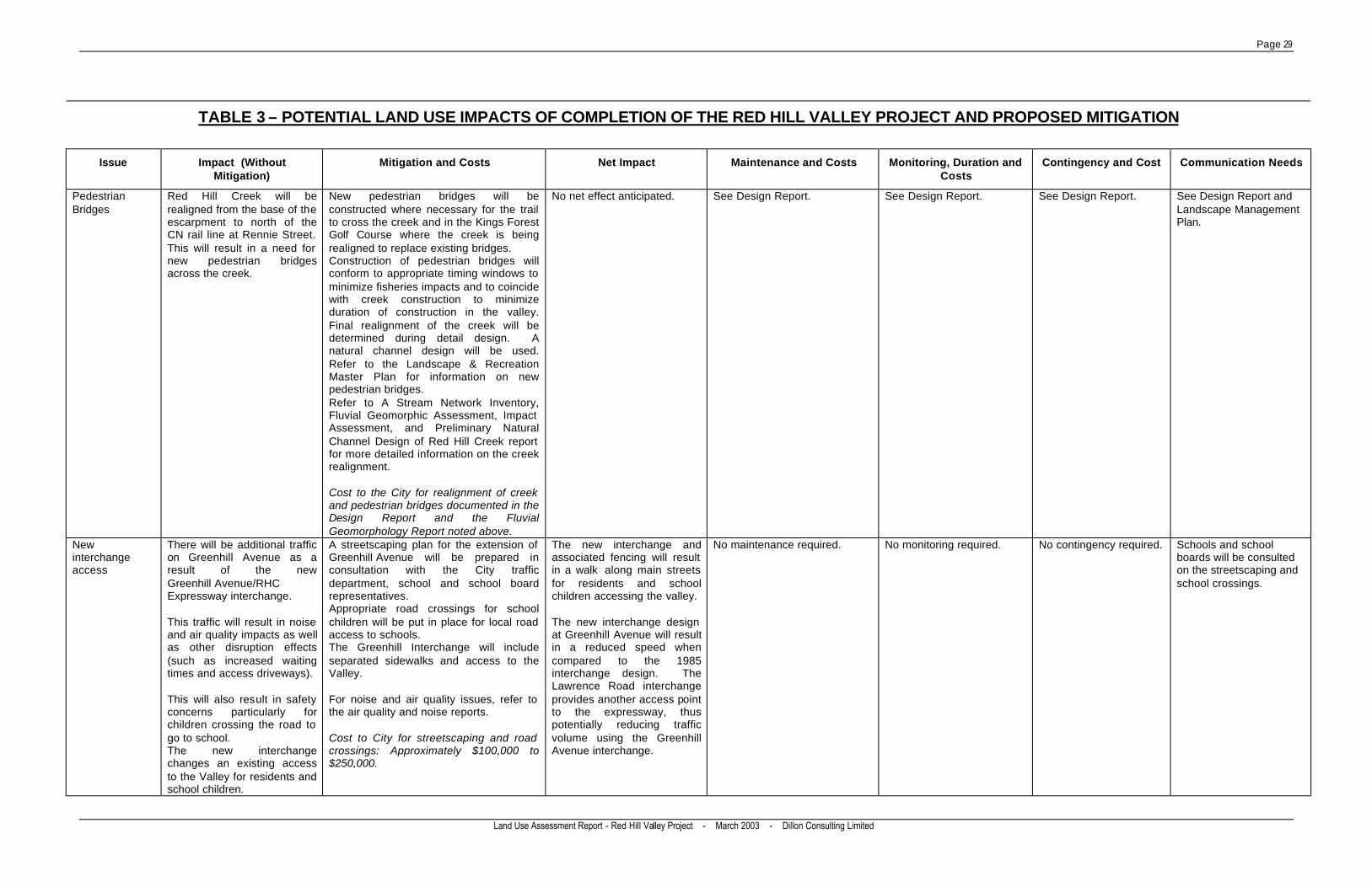
Street Closures Potential for disruption to travel patterns for those traveling from the east to Hillsdale or Hillcrest schools due to the closure of Melvin Avenue and Talbot Street.
No mitigation required. The new Barton Street Bridge will replace the existing Melvin and Barton Street bridges. Cost to City: No additional capital cost.
No net effect anticipated. No maintenance required. No monitoring required. No contingency required The City will meet with the schools/school boards to make them aware of the closures and to ensure school transportation is addressed.
Mount Albion Road will be closed at the current end of the four lane section of Mount Albion Road. Mud Street will be closed on either side of the expressway corridor.
Appropriate notification of road closures will be given. Mount Albion Road will remain open during construction using a temporary detour road. However, Mud Street will remain closed through construction and afterwards. Cost to City: minimal cost for road closure notification.
Mount Albion Road will not experience the high levels of traffic that currently travel from the mountain to the lower area of the city. The abandoned Mount Albion Road portion that is outside the Expressway Corridor will be a trail access. Vehicles can still access either side of the Expressway corridor through local roads and the Pritchard Road overpass bridge.
No maintenance required. No monitoring required. No contingency required. Notification of road closures and alternate routes will be provided to local residents.
Property Acquisition
Most property required for the Expressway has already been obtained. However, some industrial and residential property may be required for the construction of the expressway, the relocation of the Creek and parts of the trail, and for noise walls/berms.
The amount of property required will be minimized to the extent possible during detailed design. Specific property impacts will be identified through detail design and negotiations initiated with property owners. The City will provide appropriate compensation. Cost to City: to be determined based on final property requirements.
See Business Impact Assessment of the Red Hill Creek Expressway/QEW Interchange report for specific property acquisition impacts to businesses. The net property acquisition will be determined in detail design.
No maintenance required. No monitoring required. No contingency required. Continued communication with potentially effected property owners.
Rennie Street Leachate Collection System
Approximately 150 m of the total 1276 m of the Rennie Street landfill leachate collection system will be relocated. The floodplain vegetation will also be removed. Approximately 70,000 m3 of waste will be excavated (5% of the site) to provide for the expressway.
The leachate collection system will be replaced and landfill waste removed will be disposed of at a licensed facility. A health and safety plan will be prepared for these works. Refer to the Contaminated Sites Impact Assessment for further details. Cost to the City for landfilling of waste and replacement of leachate collection system: Approximately $5 to $8 million.
As documented in the Fisheries and the Red Hill Creek Realignment Study, the expressway construction will have major impacts on the aquatic ecosystem of the valley, but the net result of the work associated with the Red Hill Valley Project, will be a healthier aquatic ecosystem. Part of the landfill waste at the Rennie Street Landfill will be removed.
No addition maintenance required above that already planned for the new leachate collection system.
No additional monitoring required above that already planned for the new leachate collection system.
No additional contingency required above that already planned for the new leachate collection system.
Communication between the City and the Rennie and Brampton Street Landfill CLC or CLC equivalent.
Page 29
Land Use Assessment Report - Red Hill Valley Project - March 2003 - Dillon Consulting Limited
TABLE 3 – POTENTIAL LAND USE IMPACTS OF COMPLETION OF THE RED HILL VALLEY PROJECT AND PROPOSED MITIGATION
Issue Impact (Without Mitigation)
Mitigation and Costs Net Impact Maintenance and Costs Monitoring, Duration and Costs
Contingency and Cost Communication Needs
Pedestrian Bridges
Red Hill Creek will be realigned from the base of the escarpment to north of the CN rail line at Rennie Street. This will result in a need for new pedestrian bridges across the creek.
New pedestrian bridges will be constructed where necessary for the trail to cross the creek and in the Kings Forest Golf Course where the creek is being realigned to replace existing bridges. Construction of pedestrian bridges will conform to appropriate timing windows to minimize fisheries impacts and to coincide with creek construction to minimize duration of construction in the valley. Final realignment of the creek will be determined during detail design. A natural channel design will be used. Refer to the Landscape & Recreation Master Plan for information on new pedestrian bridges. Refer to A Stream Network Inventory, Fluvial Geomorphic Assessment, Impact Assessment, and Preliminary Natural Channel Design of Red Hill Creek report for more detailed information on the creek realignment. Cost to the City for realignment of creek and pedestrian bridges documented in the Design Report and the Fluvial Geomorphology Report noted above.
No net effect anticipated. See Design Report. See Design Report. See Design Report. See Design Report and Landscape Management Plan.
New interchange access
There will be additional traffic on Greenhill Avenue as a result of the new Greenhill Avenue/RHC Expressway interchange. This traffic will result in noise and air quality impacts as well as other disruption effects (such as increased waiting times and access driveways). This will also result in safety concerns particularly for children crossing the road to go to school. The new interchange changes an existing access to the Valley for residents and school children.
A streetscaping plan for the extension of Greenhill Avenue will be prepared in consultation with the City traffic department, school and school board representatives. Appropriate road crossings for school children will be put in place for local road access to schools. The Greenhill Interchange will include separated sidewalks and access to the Valley. For noise and air quality issues, refer to the air quality and noise reports. Cost to City for streetscaping and road crossings: Approximately $100,000 to $250,000.
The new interchange and associated fencing will result in a walk along main streets for residents and school children accessing the valley. The new interchange design at Greenhill Avenue will result in a reduced speed when compared to the 1985 interchange design. The Lawrence Road interchange provides another access point to the expressway, thus potentially reducing traffic volume using the Greenhill Avenue interchange.
No maintenance required. No monitoring required. No contingency required. Schools and school boards will be consulted on the streetscaping and school crossings.
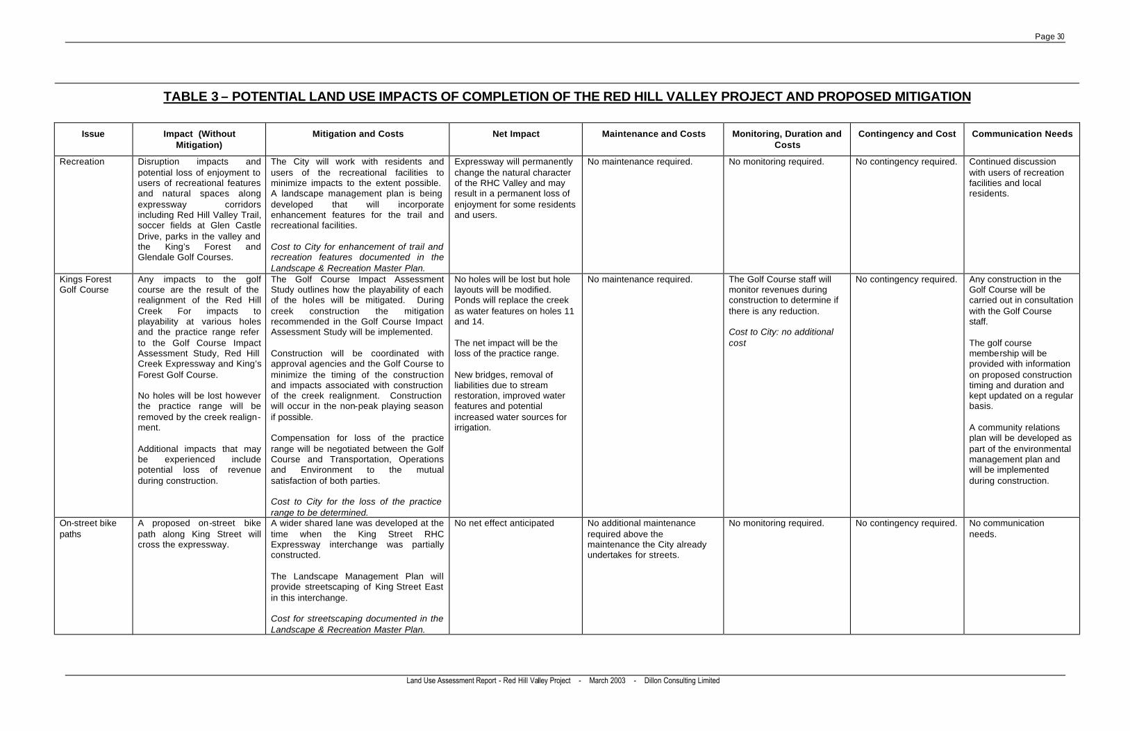
Page 30
Land Use Assessment Report - Red Hill Valley Project - March 2003 - Dillon Consulting Limited
TABLE 3 – POTENTIAL LAND USE IMPACTS OF COMPLETION OF THE RED HILL VALLEY PROJECT AND PROPOSED MITIGATION
Issue Impact (Without Mitigation)
Mitigation and Costs Net Impact Maintenance and Costs Monitoring, Duration and Costs
Contingency and Cost Communication Needs
Recreation Disruption impacts and potential loss of enjoyment to users of recreational features and natural spaces along expressway corridors including Red Hill Valley Trail, soccer fields at Glen Castle Drive, parks in the valley and the King’s Forest and Glendale Golf Courses.
The City will work with residents and users of the recreational facilities to minimize impacts to the extent possible. A landscape management plan is being developed that will incorporate enhancement features for the trail and recreational facilities. Cost to City for enhancement of trail and recreation features documented in the Landscape & Recreation Master Plan.
Expressway will permanently change the natural character of the RHC Valley and may result in a permanent loss of enjoyment for some residents and users.
No maintenance required. No monitoring required. No contingency required. Continued discussion with users of recreation facilities and local residents.
Kings Forest Golf Course
Any impacts to the golf course are the result of the realignment of the Red Hill Creek For impacts to playability at various holes and the practice range refer to the Golf Course Impact Assessment Study, Red Hill Creek Expressway and King’s Forest Golf Course. No holes will be lost however the practice range will be removed by the creek realign-ment. Additional impacts that may be experienced include potential loss of revenue during construction.
The Golf Course Impact Assessment Study outlines how the playability of each of the holes will be mitigated. During creek construction the mitigation recommended in the Golf Course Impact Assessment Study will be implemented. Construction will be coordinated with approval agencies and the Golf Course to minimize the timing of the construction and impacts associated with construction of the creek realignment. Construction will occur in the non-peak playing season if possible. Compensation for loss of the practice range will be negotiated between the Golf Course and Transportation, Operations and Environment to the mutual satisfaction of both parties. Cost to City for the loss of the practice range to be determined.
No holes will be lost but hole layouts will be modified. Ponds will replace the creek as water features on holes 11 and 14. The net impact will be the loss of the practice range. New bridges, removal of liabilities due to stream restoration, improved water features and potential increased water sources for irrigation.
No maintenance required. The Golf Course staff will monitor revenues during construction to determine if there is any reduction. Cost to City: no additional cost
No contingency required. Any construction in the Golf Course will be carried out in consultation with the Golf Course staff. The golf course membership will be provided with information on proposed construction timing and duration and kept updated on a regular basis. A community relations plan will be developed as part of the environmental management plan and will be implemented during construction.
On-street bike paths
A proposed on-street bike path along King Street will cross the expressway.
A wider shared lane was developed at the time when the King Street RHC Expressway interchange was partially constructed. The Landscape Management Plan will provide streetscaping of King Street East in this interchange. Cost for streetscaping documented in the Landscape & Recreation Master Plan.
No net effect anticipated No additional maintenance required above the maintenance the City already undertakes for streets.
No monitoring required. No contingency required. No communication needs.
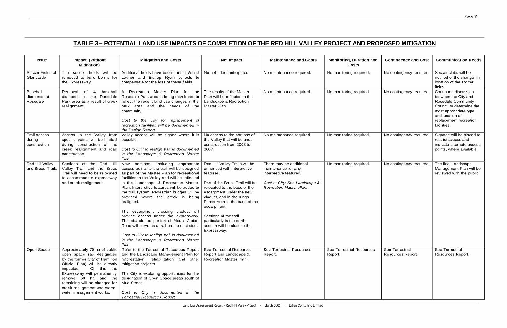
Page 31
Land Use Assessment Report - Red Hill Valley Project - March 2003 - Dillon Consulting Limited
TABLE 3 – POTENTIAL LAND USE IMPACTS OF COMPLETION OF THE RED HILL VALLEY PROJECT AND PROPOSED MITIGATION
Issue Impact (Without Mitigation)
Mitigation and Costs Net Impact Maintenance and Costs Monitoring, Duration and Costs
Contingency and Cost Communication Needs
Soccer Fields at Glencastle
The soccer fields will be removed to build berms for the Expressway.
Additional fields have been built at Wilfrid Laurier and Bishop Ryan schools to compensate for the loss of these fields.
No net effect anticipated. No maintenance required. No monitoring required. No contingency required. Soccer clubs will be notified of the change in location of the soccer fields.
Baseball diamonds at Rosedale
Removal of 4 baseball diamonds in the Rosedale Park area as a result of creek realignment.
A Recreation Master Plan for the Rosedale Park area is being developed to reflect the recent land use changes in the park area and the needs of the community. Cost to the City for replacement of recreation facilities will be documented in the Design Report.
The results of the Master Plan will be reflected in the Landscape & Recreation Master Plan.
No maintenance required. No monitoring required. No contingency required. Continued discussion between the City and Rosedale Community Council to determine the most appropriate type and location of replacement recreation facilities.
Trail access during construction
Access to the Valley from specific points will be limited during construction of the creek realignment and road construction.
Valley access will be signed where it is possible. Cost to City to realign trail is documented in the Landscape & Recreation Master Plan.
No access to the portions of the Valley that will be under construction from 2003 to 2007.
No maintenance required. No monitoring required. No contingency required. Signage will be placed to restrict access and indicate alternate access points, where available.
Red Hill Valley and Bruce Trails
Sections of the Red Hill Valley Trail and the Bruce Trail will need to be relocated to accommodate expressway and creek realignment.
New sections, including appropriate access points to the trail will be designed as part of the Master Plan for recreational facilities in the Valley and will be reflected in the Landscape & Recreation Master Plan. Interpretive features will be added to the trail system. Pedestrian bridges will be provided where the creek is being realigned. The escarpment crossing viaduct will provide access under the expressway. The abandoned portion of Mount Albion Road will serve as a trail on the east side. Cost to City to realign trail is documented in the Landscape & Recreation Master Plan.
Red Hill Valley Trails will be enhanced with interpretive features. Part of the Bruce Trail will be relocated to the base of the escarpment under the new viaduct, and in the Kings Forest Area at the base of the escarpment. Sections of the trail particularly in the north section will be close to the Expressway.
There may be additional maintenance for any interpretive features. Cost to City: See Landscape & Recreation Master Plan.
No monitoring required. No contingency required. The final Landscape Management Plan will be reviewed with the public
Open Space Approximately 70 ha of public open space (as designated by the former City of Hamilton Official Plan) will be directly impacted. Of this the Expressway will permanently remove 60 ha and the remaining will be changed for creek realignment and storm-water management works.
Refer to the Terrestrial Resources Report and the Landscape Management Plan for reforestation, rehabilitation and other mitigation projects. The City is exploring opportunities for the designation of Open Space areas south of Mud Street. Cost to City is documented in the Terrestrial Resources Report.
See Terrestrial Resources Report and Landscape & Recreation Master Plan.
See Terrestrial Resources Report.
See Terrestrial Resources Report.
See Terrestrial Resources Report.
See Terrestrial Resources Report.
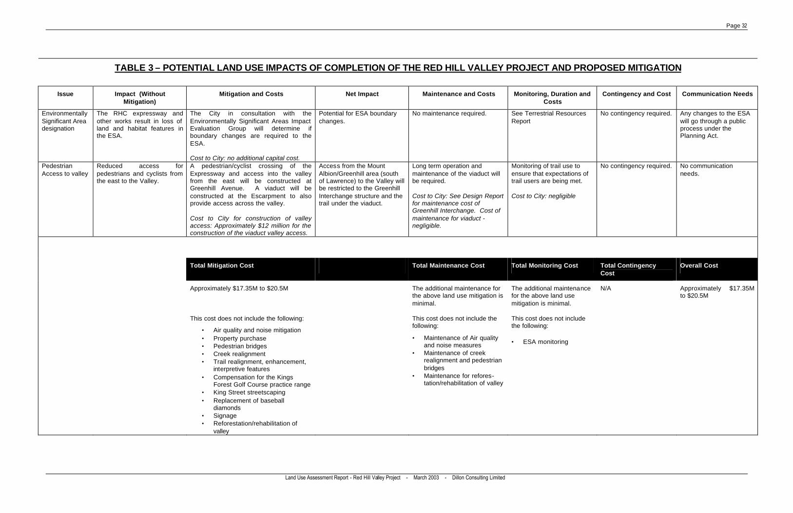
Page 32
Land Use Assessment Report - Red Hill Valley Project - March 2003 - Dillon Consulting Limited
TABLE 3 – POTENTIAL LAND USE IMPACTS OF COMPLETION OF THE RED HILL VALLEY PROJECT AND PROPOSED MITIGATION
Issue Impact (Without Mitigation)
Mitigation and Costs Net Impact Maintenance and Costs Monitoring, Duration and Costs
Contingency and Cost Communication Needs
Environmentally Significant Area designation
The RHC expressway and other works result in loss of land and habitat features in the ESA.
The City in consultation with the Environmentally Significant Areas Impact Evaluation Group will determine if boundary changes are required to the ESA. Cost to City: no additional capital cost.
Potential for ESA boundary changes.
No maintenance required. See Terrestrial Resources Report
No contingency required. Any changes to the ESA will go through a public process under the Planning Act.
Pedestrian Access to valley
Reduced access for pedestrians and cyclists from the east to the Valley.
A pedestrian/cyclist crossing of the Expressway and access into the valley from the east will be constructed at Greenhill Avenue. A viaduct will be constructed at the Escarpment to also provide access across the valley. Cost to City for construction of valley access: Approximately $12 million for the construction of the viaduct valley access.
Access from the Mount Albion/Greenhill area (south of Lawrence) to the Valley will be restricted to the Greenhill Interchange structure and the trail under the viaduct.
Long term operation and maintenance of the viaduct will be required. Cost to City: See Design Report for maintenance cost of Greenhill Interchange. Cost of maintenance for viaduct - negligible.
Monitoring of trail use to ensure that expectations of trail users are being met. Cost to City: negligible
No contingency required. No communication needs.
Total Mitigation Cost Total Maintenance Cost Total Monitoring Cost Total Contingency Cost
Overall Cost
Approximately $17.35M to $20.5M The additional maintenance for the above land use mitigation is minimal.
The additional maintenance for the above land use mitigation is minimal.
N/A Approximately $17.35M to $20.5M
This cost does not include the following:
• Air quality and noise mitigation • Property purchase • Pedestrian bridges • Creek realignment • Trail realignment, enhancement,
interpretive features • Compensation for the Kings
Forest Golf Course practice range • King Street streetscaping • Replacement of baseball
diamonds • Signage • Reforestation/rehabilitation of
valley
This cost does not include the following:
• Maintenance of Air quality and noise measures
• Maintenance of creek realignment and pedestrian bridges
• Maintenance for refores-tation/rehabilitation of valley
This cost does not include the following:
• ESA monitoring
Page 33
Land Use Assessment Report - Red Hill Valley Project - March 2003 - Dillon Consulting Limited
The expressway will reduce the number of access points to the valley for pedestrians and cyclists coming from the east. To minimize this impact a pedestrian/cycling crossing of the expressway and access to the valley will be provided at Greenhill Avenue. The viaduct will also facilitate access to the valley. Part of the abandon portion of Mount Albion Road will be maintained as a trail which will be extended south to Mud Street. This trail will also connect to the Bruce Trail on the east side of the expressway. Baseball diamonds on the west side of the valley at Greenhill Avenue will be displaced for the realignment of the creek (4 diamonds north of Greenhill). Three soccer fields at Glen Castle Drive have been relocated to local schools. In addition to these impacts from the RHC Expressway project, three ball diamonds and some underused tennis courts are also being removed south of Greenhill to accommodate the new CSO tank. A recreation master plan for this area is currently being developed to reflect the CSO tank and creek realignment and the needs of the community. Potential impacts to the Kings Forest Golf Course are anticipated as a result of creek realignment only and include the need to remove a practice range, changes to the layout of some golf course holes, replacement of bridges over the creek and the potential for loss of revenue during construction. The City will continue to work with golf course staff to minimize the potential effects. The development of the RHC Expressway will result in a loss of land and habitat features in the Red Hill Valley ESA. The City will review the boundaries of the ESA in consultation with the Environmentally Significant Areas Impact Evaluation Group. The proposed new Greenhill Avenue Interchange will result in an increase in traffic along Greenhill Avenue. This additional traffic will result in air quality and noise impacts as well as other disruption effects (such as increased waiting times to access driveways). It also has the potential to result in safety concerns particularly for children crossing the road to Red Hill Park, Red Hill or St. Luke Schools. The City will meet with the schools and school boards to determine appropriate crossing points. A streetscape plan will also be prepared for Greenhill Avenue leading up to the interchange. It should be noted that the new Greenhill Avenue interchange will result in a reduced traffic speed when compared to the 1985 interchange design. Also, with an interchange at Lawrence Road, two access points to the expressway from the neighbourhood are provided potentially reducing the volume of traffic on Greenhill Avenue. Noise and air quality impacts from the proposed Expressway have the potential to result in disruption to existing land use and enjoyment of the valley for existing residential development along the corridor as well as the recreational features within the valley. Noise mitigation such as noise barriers will be placed to minimize noise to residents in existing built up areas where there is available space and where it is feasible to do so. Through consultation with local residents, other mitigation options will be determined for areas where noise berms are not feasible. Potential noise and air quality impacts and proposed mitigation are discussed further in the noise and air quality assessment reports. Developers for Red Hill Vista (# 4 on Figure 2) have included noise barriers in their development plan. The City will provide noise berms for the already approved Albion Mills Estates development. Any future development along the corridor (such as the Heritage Green Downtown Core (C on Figure 2) will have to include noise mitigation in their plans to obtain approval.
Page 34
Land Use Assessment Report - Red Hill Valley Project - March 2003 - Dillon Consulting Limited
Residents in the vicinity of the expressway may also experience visual/aesthetic impacts during expressway construction and operation. Details on visual/aesthetic impacts and proposed mitigation are provided in the reports Escarpment Crossing Visual Assessment and the Landscape and Recreation Master Plan. In terms of infrastructure, much of the infrastructure development proposed is directly as a result of the Expressway (e.g. hydro tower and pipeline relocations) or is timed to coincide with the Expressway development to minimize impacts on the valley (e.g. CSO pipeline). Erosion control and leachate management work on the Rennie Street and Brampton Street landfill site and the associated creek realignment is anticipated to be completed prior to construction of the north-south section of the RHC Expressway. The Expressway will, however, result in the removal of approximately 70,000 m3 of waste material from the Rennie Street Landfill as well as the relocation of approximately 150 m of the total 1276 m of the landfill leachate collection system. The Expressway will also result in the removal of some of the rehabilitated and revegetated enhanced floodplain created by the Rennie Street project. As noted in the Fisheries and the Red Hill Creek Realignment Study, the expressway will have major impacts on the aquatic ecosystem of the Red Hill Creek Watershed. However, with careful planning and design and the incorporation of works to mitigate historical impacts, the result will be a healthier aquatic ecosystem overall than the one that currently exists. There is also the potential for cumulative effects (i.e. effects overlapping in time or space) from the Expressway and the CSO pipe however, these are minimized due to the coordination in design and construction timing for the projects. There may be other projects in the future that could have impacts on the valley such as projects emerging from the WINS plan. The potential for impacts from these projects is unknown at this time so it is not possible to include them in an assessment of cumulative effects. As these projects are developed they will need to consider the effect they may have on the Red Hill Valley. In most cases, the impacts of the expressway were taken into consideration in the original environmental assessment. For example, recreational impacts resulting from construction of the north-south section of the RHC Expressway are addressed in the condition of approval requiring the City to maintain all remaining valley lands for recreational purposes. Development standards were also prepared to mitigate noise for development adjacent to the expressway. Effects from Development in the Watershed This report has identified that there is potential for the development of many large vacant land parcels within the watershed. Most of these are concentrated in the Mountain East section of the watershed and include the Heritage Green Secondary Plan Area, ROPA #9 and the Glanbrook Industrial lands. The development of these land parcels, as well as smaller parcels in the Mountain West section of the watershed, will likely result in changes to the area, including increased impermeable area and resulting surface water flows to Red Hill Creek. As noted previously, the extent of development in the Heritage Green and ROPA #9 areas is influenced by the Expressway and much of the development will not occur until after Expressway construction. The proposed area for the Karst ESA/ANSI which covers much of the Trinity Neighbourhood (see Figure 3), will also affect this area in terms of what lands will be available for development.

Page 35
Land Use Assessment Report - Red Hill Valley Project - March 2003 - Dillon Consulting Limited
Impacts of future development on the Red Hill Creek Watershed will be minimized to the extent possible through the development review and approval process. Approval of future development within the watershed should give consideration to City initiatives such as the Red Hill Creek Watershed Plan, the Davis Creek Subwatershed Plan (ongoing), the City’s Environmental Health and Safety Integrated Management System and Vision 2020. Within the watershed, there have been and continue to be a number of projects that have resulted in improvements to water quality in Red Hill Creek. In particular, projects such as the leachate collection and bank stabilization at the Upper Ottawa Street Landfill, erosion control at Glendale Golf Course, stormwater works at Albion Falls (ongoing), the Greenhill Avenue CSO tanks, the proposed CSO pipeline, continual upgrades to the Woodward Avenue Sewage Treatment Plant, the WINS Program, the Red Hill Creek Watershed Plan, the Davis Creek Subwatershed Plan, the realignment of Red Hill Creek and the Rennie Street/Brampton Street Landfill leachate collection and creek realignment all contribute to improving the quality and quantity of Red Hill Creek. The most significant infrastructure works proposed in the Red Hill Creek Watershed relate directly to the Expressway construction and ROPA #9. As previously noted, construction of the Expressway-related infrastructure being developed in the valley is being co-ordinated to the extent possible to minimize the length of construction impact. The trunk sewer required for ROPA #9 will require a Class Environmental Assessment to determine its location and potential impacts. No other significant planned infrastructure works have been identified (outside the RHC Valley) that could either result in significant effects on the valley system or act in a cumulative manner with effects from the Expressway itself.
APPENDIX A CONTACTS MADE FOR THE RED HILL VALLEY PROJECT
LAND USE ASSESSMENT

Page A-1
Land Use Assessment Report - Red Hill Valley Project - March 2003 - Dillon Consulting Limited
Appendix A: Contacts Made For The Red Hill Valley Project Land Use Assessment Name Organization Information Provided City of Hamilton Staff Christine Adams Transportation, Operations & Environment, Water &
Wastewater • CSO initiatives
Mark Bainbridge Water Quality • Waste Water Investment Needs Strategies (WINS) program
Dan Chauvin Senior Project Manager Water Quality • Ongoing Woodward Ave. treatment plant upgrades
Al Fletcher Planning and Development Department, Long Range Planning and Design Division, Official Plan and Zoning By-Law Reform
• Development applications for central division
Harold Groen Infrastructure and Environmental Planning • Planned roads Don Gunn Asset management • Greenhill Ave. CSO Tanks Trever Horzelenberg
Transportation, Operations & Environment, Roads & Traffic
• Cycling initiatives
Phil Jensen Transportation, Operations & Environment, Waste Management
• Improvement works at Upper Ottawa Landfill
Belinda Kobik Environmental Planning and Management Section • Integrated Environmental, Health and Safety Management System
Al Little GIS Manager, City • Microstation file of study area Gary Moore Transportation • Mapping, infrastructure initiatives Gil Moore Transportation Dept. • Mapping Luciano Piccioni Brownfield Program Coordinator, Economic
Development Dept • ERASE Community Improvement Project
Cathy Plosz Natural Heritage Planner • Eramosa Karst Steve Robichaud Greg Macdonaldd
Planning and Development Department, Development Division, Development Planning Section (Central)
• Development applications for central division
Rob Shamess Infrastructure and Environmental Planning • Planned roads, stormwater

Page A-2
Land Use Assessment Report - Red Hill Valley Project - March 2003 - Dillon Consulting Limited
Appendix A: Contacts Made For The Red Hill Valley Project Land Use Assessment Name Organization Information Provided Lorissa Skrypnick Planning and Development Department,
Development Division, Development Planning Section (East)
• Development applications in east division
Jill Steven Infrastructure and Environmental Planning • Information on subwatershed planning and stormwater works
Patti Tombs Policy & Research Planner Culture and Recreation • Information on recreation, culture and parks master plan
Dale Wood Manager, Community Development and Strategic Planning
• Information on recreation facilities
Hamilton Region Conservation Authority Bruce Duncan Janet Wong
Hamilton Region CA • Conservation Authority initiatives
Scott Konkle Hamilton Conservation Authority • Confirmation Park Others Joad Durst Ministry of Natural Resources • Eramosa Karst Laura Kirkus Catholic Education Centre • School locations and capture areas Dan McKerrall Hamilton-Wentworth District School Board • School locations and capture areas