Embed Size (px)
Citation preview
UPDATED
Oil and Gas Exploration & Development Activity Forecast
Canadian Beaufort Sea 2013 – 2028
Prepared for
Aboriginal Affairs and Northern Development Canada
Prepared by:
Lin Callow, LTLC Consulting in association with
Salmo Consulting Inc.
March 2013

BREA Exploration and Development Activity Forecast
LTLC Consulting and Salmo Consulting Inc. i
TABLE OF CONTENTS
1. Introduction ...................................................................................................................................... 1 2. History of the Oil and Gas Industry in the Mackenzie Beaufort Region .................... 2
2.1 Drilling Platforms .................................................................................................................... 6 2.1.1 Artificial Islands .............................................................................................................. 6 2.1.2 Caisson Structures .......................................................................................................... 6 2.1.3 Floating Drillships ....................................................................................................... 11 2.1.4 Conical Floating Drilling Platform ......................................................................... 11
2.2 Spray Ice Islands ................................................................................................................... 13 2.3 Exploration Results ............................................................................................................. 13 2.4 Arctic Exploration and World Events ........................................................................... 13 2.5 Arctic Oil and Gas Production ......................................................................................... 14
3. The Cycle of Offshore Industry Activity .............................................................................. 14 3.1 Geological and Geophysical Programs ......................................................................... 16 3.2 Drilling Programs ................................................................................................................. 17 3.3 Significant Discovery and Commercial Discovery Applications ........................ 17 3.4 Development Plans and Operation Authorizations ................................................ 18 3.5 Commercial Discovery Development Timeline ........................................................ 18 3.6 Operations Authorizations for Decommissioning and Abandonment ............ 20 3.7 Potential Future Oil and Gas Exploration and Development Activities .......... 20
4. Predicted Beaufort Sea Oil and Gas Activity ..................................................................... 24 4.1 Assumptions ........................................................................................................................... 25
4.1.1 Factors in Development of Assumptions ............................................................ 25 4.1.2 Base Assumptions...................................................................................................... 277
4.2 Predicted Industry Activity ............................................................................................ 288 4.2.1 Seismic Surveys ............................................................................................................ 32 4.2.2 Deep Shelf and Slope Beaufort Sea Wells ........................................................... 32 4.2.3 Shallow Beaufort Shelf Wells .................................................................................. 34 4.2.4 Short- to Medium-Term Oil and Gas Activity Forecast ................................. 37 4.2.5 Longer Term Oil and Gas Activity .......................................................................... 37
5. Mackenzie Delta - Beaufort Sea Hydrocarbon Resource Potential .......................... 40 6. REFERENCES ................................................................................................................................. 42
BREA Exploration and Development Activity Forecast
LTLC Consulting and Salmo Consulting Inc. ii
TABLES
Table 1. Drilling Activity in the Beaufort Sea ........................................................................... 4 Table 2. Activities and Estimated Time Schedule for a Generalized Beaufort Sea
Offshore Development Project ................................................................................... 19 Table 3. Potential Future Oil and Gas Exploration and Development Activities
(from BSStRPA 2008) .................................................................................................... 22 Table 4. Current Beaufort Sea Exploration Licences .......................................................... 31 Table 5. Summary of Offshore Oil and Gas Activity 2012-2027..................................... 37 Table 6. Mackenzie Delta and Beaufort Sea Oil and Gas Resource Potential ............ 40
FIGURES
Figure 1. BREA Study Area (source Joint Secretariat 2001) ............................................. 1 Figure 2. Concrete Caisson (Tarsuit Caisson)(source G.W. Timco) ................................ 7 Figure 3. Single Steel Drilling Caisson (SSDC/SDC)(source G.W. Timco) .................... 8 Figure 4. Caisson-Retained Island (CRI)(source A. Barker) .............................................. 9 Figure 5. Mobile Arctic Caisson (MAC)(source Gulf Canada Resources) .................. 10 Figure 6. Canmar Explorer 1 with an Icebreaker Being Forced off Station by Ice
October 1978 (source Gulf Canada Resources) ................................................ 11 Figure 7. Conical Floating Drilling Platform (Kulluk)(source Gulf Canada
Resources) ...................................................................................................................... 12 Figure 8. National Energy Board Exploration and Production Approval Phases
(revised from Dixit 2009) ......................................................................................... 15 Figure 9. Northern Oil and Gas Rights Management Process (revised from NOGB
of AANDC 2012) ............................................................................................................ 15 Figure 10. Mackenzie Delta and Beaufort Sea Basin Geology ........................................ 28 Figure 11. Current Exploration Licences and Significant Discovery Areas Map
(from AANDC 2011) ................................................................................................. 30 Figure 12. Stena Drill-Max Ice Drillship (source Det Norske Veritas) ....................... 33 Figure 13. Scenario Assumptions for Years of Production per Field for the
Mackenzie Delta (from MGP 2005) .................................................................... 36 Figure 14. Scenario Assumptions for Years of Production per Field for Beaufort
Sea (from MGP 2005) .............................................................................................. 36 Figure 15. Typical Drilling Platforms in the Beaufort Sea (from Imperial Oil in
CAPP 2011) .................................................................................................................. 38 Figure 16. Hypothetical Development Scenario Year 2030 (from MGP 2005) ...... 39 Figure 17. Location Map Showing Study Area, Play Group Boundaries and
Exploratory Wells in the Mackenzie/Beaufort Geological Province (from Chen et al. 2007) ........................................................................................... 41
BREA Exploration and Development Activity Forecast
LTLC Consulting and Salmo Consulting Inc. 1
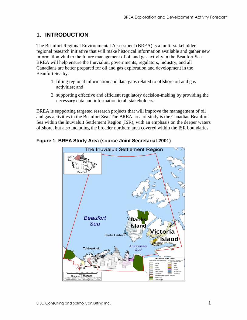
1. INTRODUCTION
The Beaufort Regional Environmental Assessment (BREA) is a multi-stakeholder
regional research initiative that will make historical information available and gather new
information vital to the future management of oil and gas activity in the Beaufort Sea.
BREA will help ensure the Inuvialuit, governments, regulators, industry, and all
Canadians are better prepared for oil and gas exploration and development in the
Beaufort Sea by:
1. filling regional information and data gaps related to offshore oil and gas
activities; and
2. supporting effective and efficient regulatory decision-making by providing the
necessary data and information to all stakeholders.
BREA is supporting targeted research projects that will improve the management of oil
and gas activities in the Beaufort Sea. The BREA area of study is the Canadian Beaufort
Sea within the Inuvialuit Settlement Region (ISR), with an emphasis on the deeper waters
offshore, but also including the broader northern area covered within the ISR boundaries.
Figure 1. BREA Study Area (source Joint Secretariat 2001)
BREA Exploration and Development Activity Forecast
LTLC Consulting and Salmo Consulting Inc. 2
A number of factors affecting potential oil and gas exploration and development activities
in the Beaufort Sea have changed since the 2012 BREA Activity Forecast was prepared.
This report is intended to provide an updated general description of potential oil and gas
exploration and development activities in the Beaufort Sea over the next fifteen years
(2013 to 2028). It is to provide the BREA Steering Committee, its working groups and
arctic researchers with a current forecast of industry activity they can use when assessing
the priorities, scope, and timing of Beaufort Sea research. It is also intended to help with
understanding the implications of BREA research findings.
The forecasts and opinions expressed in this report are the responsibility of LTLC
Consulting and Salmo Consulting Inc. and do not represent the official position or views
of Aboriginal Affairs and Northern Development Canada.
2. HISTORY OF THE OIL AND GAS INDUSTRY IN THE MACKENZIE BEAUFORT REGION
This section builds on the 2009 report “Beaufort Regional Environmental Reports
Summary” prepared by LTLC Consulting and Salmo Consulting Inc. for the Canadian
Association of Petroleum Producers (CAPP). Where recent information has been added it
is referenced.
Oil and gas development in the Mackenzie Valley began with the discovery of oil at
Norman Wells by Imperial Oil Limited (Imperial) in 1919 and the subsequent
construction of a topping plant in 1921. Hydrocarbon development continued to be
focused on Norman Wells until the 1950s.
Exploration activity in the Mackenzie Delta/Beaufort Sea region began onshore in 1957
with early reconnaissance-level ground and air studies by the British American Oil
Company (BA), Chevron Canada Limited (Chevron), Dome Petroleum Limited (Dome),
Imperial, Shell Canada Limited (Shell) and others.
In 1961, the British American Oil Company Limited (BA), which later became Gulf
Canada Limited (Gulf) completed the first exploratory drilling in the Mackenzie Delta.
This was followed by onshore drilling for oil and gas at the Reindeer site on Richards
Island by a consortium comprised of BA, Shell and Imperial. With the discovery of oil
and gas at Prudhoe Bay Alaska in 1968, exploration activity intensified throughout the
Western Arctic, particularly in the Mackenzie Delta and Canadian Beaufort Sea. In 1970,
Imperial reported the first discovery of oil in the Mackenzie Delta at Atkinson Point. The
discovery of major gas fields by Imperial at Taglu (1971), Gulf at Parsons Lake (1972)
and Shell at Niglintgak (1973) resulted in the first proposed Mackenzie Valley Pipeline in
1974 and increased exploration and investment offshore.
BREA Exploration and Development Activity Forecast
LTLC Consulting and Salmo Consulting Inc. 3
The settlement of native land claims had a major influence on hydrocarbon development
in the Canadian Beaufort Region during the 1970s and 1980s. Through the actions of the
Committee on Original Peoples Entitlement (COPE), the Inuvialuit Land Rights
Settlement Agreement in Principle was signed in 1978. This agreement led to completion
of the Western Arctic Claim Settlement and the Report of the Task Force on Northern
Conservation in 1984. These agreements culminated in the signing of the Inuvialuit Final
Agreement (IFA) in 1984. The IFA set aside a 906,430 square kilometre area, including
much of the Canadian Beaufort Sea, referred to as the Inuvialuit Settlement Region
(ISR), which would be managed under the terms of the IFA.
Canadian offshore drilling in the Beaufort Sea began in the early 1970s. The National
Energy Board (NEB) records show 142 Canadian Arctic offshore wells have been drilled,
with 92 of these wells drilled in the Beaufort Sea region. Historical well records show
that the industry operated in an extremely harsh environment, where drillships were often
forced off station by heavy ice. Records also show that numerous well kicks and
wellhead gas and water flows were encountered and controlled. Yet there have been no
significant oil spill incidents and the industry has a track record of technical innovation
(CAPP 2011). Numerous innovative drilling platforms and techniques were developed
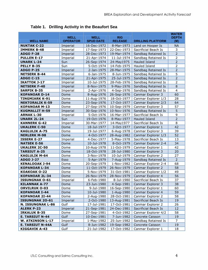
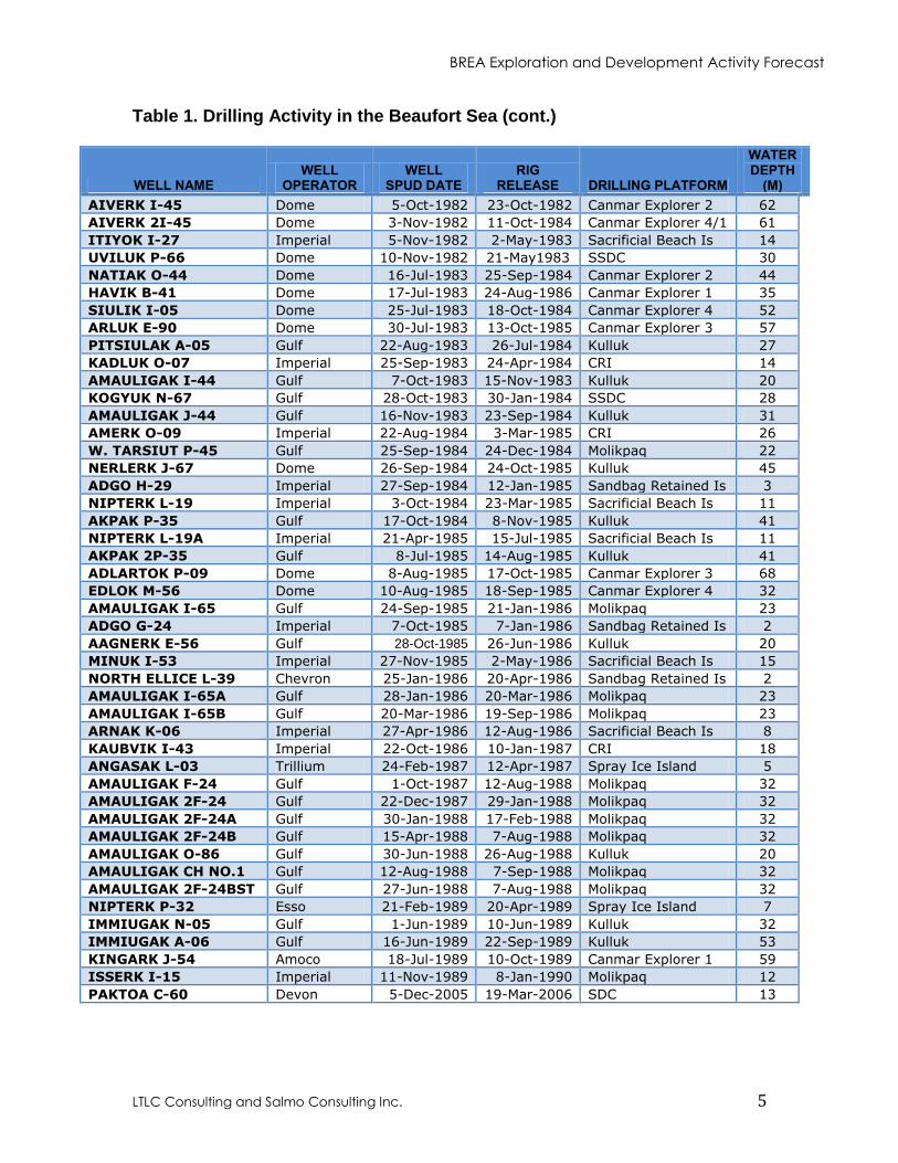
and proven to operate successfully in the Canadian Beaufort Sea. Table 1 summarizes the
Beaufort Sea offshore drilling activity since 1972, it was developed using data provide by
the NEB and by reviewing historical Well Reports downloaded from the North West
Territories Geoscience Office database.
BREA Exploration and Development Activity Forecast
LTLC Consulting and Salmo Consulting Inc. 4
Table 1. Drilling Activity in the Beaufort Sea
WELL NAME WELL
OPERATOR WELL
SPUD DATE RIG
RELEASE DRILLING PLATFORM
WATER DEPTH
(M)
NUKTAK C-22 Imperial 16-Dec-1972 8-Mar-1973 Land on Hooper Is NA
IMMERK B-48 Imperial 17-Sep-1973 22-Dec-1973 Sacrificial Beach Is 3
ADGO F-28 Imperial 28-Dec-1973 19-Mar-1974 Sandbag Retained Is 2
PULLEN E-17 Imperial 21-Apr-1974 11-Jul-1974 Sandbag Retained Is 2
UNARK L-24 Sun 26-Sep-1974 24-May1975 Hauled Island 2
PELLY B-35 Sun 5-Oct-1974 14-Feb-1975 Hauled Island 2
ADGO P-25 Imperial 2-Jan-1975 28-Mar-1975 Sandbag Retained Is 2
NETSERK B-44 Imperial 6-Jan-1975 8-Jun-1975 Sandbag Retained Is 5
ADGO C-15 Imperial 21-Apr-1975 25-Jul-1975 Sandbag Retained Is 2
IKATTOK J-17 Imperial 10-Jul-1975 28-Feb-1976 Sandbag Retained Is 2
NETSERK F-40 Imperial 8-Nov-1975 9-May-1976 Sandbag Retained Is 8
SARPIK B-35 Imperial 2-Apr-1976 4-Sep-1976 Sandbag Retained Is 4
KOPANOAR D-14 Dome 8-Aug-1976 26-Sep-1976 Canmar Explorer 3 60
TINGMIARK K-91 Dome 11-Aug-1976 18-Oct-1977 Canmar Explorer 1/3 28
NEKTORALIK K-59 Dome 23-Sep-1976 17-Oct-1977 Canmar Explorer 2/3 64
KOPANOAR M-13 Dome 27-Sep-1976 10-Sep-1979 Canmar Explorer 3 57
KUGMALLIT H-59 Imperial 30-Sep-1976 10-Nov-1976 Sandbag Retained Is 5
ARNAK L-30 Imperial 5-Oct-1976 16-Mar-1977 Sacrificial Beach Is 9
UNARK 2L-24 Sun 19-Oct-1976 8-May-1977 Hauled Island 2
KANNERK G-42 Imperial 30-Mar-1977 14-May1977 Sacrificial Beach Is 8
UKALERK C-50 Dome 18-Jul-1977 3-Oct-1977 Canmar Explorer 1 42
KAGLULIK A-75 Dome 19-Jul-1977 6-Aug-1978 Canmar Explorer 3 39
NERLERK M-98 Dome 4-Oct-1977 28-Aug-1982 Canmar Explorer 1/3 52
ISSERK E-27 Imperial 4-Dec-1977 5-May-1978 Sacrificial Beach Is 13
NATSEK E-56 Dome 10-Jul-1978 8-Oct-1979 Canmar Explorer 2-4 34
UKALERK 2C-50 Dome 10-Aug-1978 11-Oct-1979 Canmar Explorer 1 42
TARSIUT A-25 Dome 18-Oct-1978 28-Jul-1980 Canmar Explorer 3 20
KAGLULIK M-64 Dome 3-Nov-1978 10-Jul-1979 Canmar Explorer 2 27
ADGO J-27 Esso 5-Apr-1979 7-Aug-1979 Sandbag Retained Is 2
KENALOOAK J-94 Dome 20-Sep-1979 1-Nov-1982 Canmar Explorer 2-4 68
KOPANOAR L-34 Dome 11-Oct-1979 26-Nov-1979 Canmar Explorer 2 58
KOAKOAK O-22 Dome 5-Nov-1979 31-Oct-1981 Canmar Explorer 1/2 49
KOPANOAR 2L-34 Dome 26-Nov-1979 28-Nov-1979 Canmar Explorer 4 56
ISSUNGNAK O-61 Imperial 6-Feb-1980 8-Jul-1980 Sacrificial Beach Is 37
KILANNAK A-77 Dome 23-Jun-1980 4-Sep-1981 Canmar Explorer 3 38
ORVILRUK O-03 Dome 9-Jul-1980 16-Sep-1980 Canmar Explorer 1 60
KOPANOAR I-44 Dome 10-Jul-1980 1-Aug-1980 Canmar Explorer 4 59
KOPANOAR 2I-44 Dome 2-Aug-1980 28-Oct-1981 Canmar Explorer 2 58
ISSUNGNAK 2O-61 Imperial 2-Oct-1980 13-Aug-1981 Sacrificial Beach Is 19
N. ISSUNGNAK L-86 Gulf 17-Jul-1981 17-Oct-1981 Canmar Explorer 2 26
ALERK P-23 Imperial 21-Sep-1981 24-Dec-1981 Sacrificial Beach Is 12
IRKALUK B-35 Dome 27-Sep-1981 4-Oct-1982 Canmar Explorer 4/2 58
E. TARSIUT N-44 Gulf 10-Dec-1981 7-Jun-1982 Concrete Caisson 19
W. ATKINSON L-17 Imperial 1-May-1982 25-Jun-1982 Sandbag Retained Is 7
E. TARSIUT N-44A Gulf 8-Jun-1982 19-Sep-1982 Concrete Caisson 19
KIGGAVIK A-43 Gulf 21-Jul-1982 17-Oct-1982 Canmar Explorer 1 18
BREA Exploration and Development Activity Forecast
LTLC Consulting and Salmo Consulting Inc. 5
Table 1. Drilling Activity in the Beaufort Sea (cont.)
WELL NAME WELL
OPERATOR WELL
SPUD DATE RIG
RELEASE DRILLING PLATFORM
WATER DEPTH
(M)
AIVERK I-45 Dome 5-Oct-1982 23-Oct-1982 Canmar Explorer 2 62
AIVERK 2I-45 Dome 3-Nov-1982 11-Oct-1984 Canmar Explorer 4/1 61
ITIYOK I-27 Imperial 5-Nov-1982 2-May-1983 Sacrificial Beach Is 14
UVILUK P-66 Dome 10-Nov-1982 21-May1983 SSDC 30
NATIAK O-44 Dome 16-Jul-1983 25-Sep-1984 Canmar Explorer 2 44
HAVIK B-41 Dome 17-Jul-1983 24-Aug-1986 Canmar Explorer 1 35
SIULIK I-05 Dome 25-Jul-1983 18-Oct-1984 Canmar Explorer 4 52
ARLUK E-90 Dome 30-Jul-1983 13-Oct-1985 Canmar Explorer 3 57
PITSIULAK A-05 Gulf 22-Aug-1983 26-Jul-1984 Kulluk 27
KADLUK O-07 Imperial 25-Sep-1983 24-Apr-1984 CRI 14
AMAULIGAK I-44 Gulf 7-Oct-1983 15-Nov-1983 Kulluk 20
KOGYUK N-67 Gulf 28-Oct-1983 30-Jan-1984 SSDC 28
AMAULIGAK J-44 Gulf 16-Nov-1983 23-Sep-1984 Kulluk 31
AMERK O-09 Imperial 22-Aug-1984 3-Mar-1985 CRI 26
W. TARSIUT P-45 Gulf 25-Sep-1984 24-Dec-1984 Molikpaq 22
NERLERK J-67 Dome 26-Sep-1984 24-Oct-1985 Kulluk 45
ADGO H-29 Imperial 27-Sep-1984 12-Jan-1985 Sandbag Retained Is 3
NIPTERK L-19 Imperial 3-Oct-1984 23-Mar-1985 Sacrificial Beach Is 11
AKPAK P-35 Gulf 17-Oct-1984 8-Nov-1985 Kulluk 41
NIPTERK L-19A Imperial 21-Apr-1985 15-Jul-1985 Sacrificial Beach Is 11
AKPAK 2P-35 Gulf 8-Jul-1985 14-Aug-1985 Kulluk 41
ADLARTOK P-09 Dome 8-Aug-1985 17-Oct-1985 Canmar Explorer 3 68
EDLOK M-56 Dome 10-Aug-1985 18-Sep-1985 Canmar Explorer 4 32
AMAULIGAK I-65 Gulf 24-Sep-1985 21-Jan-1986 Molikpaq 23
ADGO G-24 Imperial 7-Oct-1985 7-Jan-1986 Sandbag Retained Is 2
AAGNERK E-56 Gulf 28-Oct-1985 26-Jun-1986 Kulluk 20
MINUK I-53 Imperial 27-Nov-1985 2-May-1986 Sacrificial Beach Is 15
NORTH ELLICE L-39 Chevron 25-Jan-1986 20-Apr-1986 Sandbag Retained Is 2
AMAULIGAK I-65A Gulf 28-Jan-1986 20-Mar-1986 Molikpaq 23
AMAULIGAK I-65B Gulf 20-Mar-1986 19-Sep-1986 Molikpaq 23
ARNAK K-06 Imperial 27-Apr-1986 12-Aug-1986 Sacrificial Beach Is 8
KAUBVIK I-43 Imperial 22-Oct-1986 10-Jan-1987 CRI 18
ANGASAK L-03 Trillium 24-Feb-1987 12-Apr-1987 Spray Ice Island 5
AMAULIGAK F-24 Gulf 1-Oct-1987 12-Aug-1988 Molikpaq 32
AMAULIGAK 2F-24 Gulf 22-Dec-1987 29-Jan-1988 Molikpaq 32
AMAULIGAK 2F-24A Gulf 30-Jan-1988 17-Feb-1988 Molikpaq 32
AMAULIGAK 2F-24B Gulf 15-Apr-1988 7-Aug-1988 Molikpaq 32
AMAULIGAK O-86 Gulf 30-Jun-1988 26-Aug-1988 Kulluk 20
AMAULIGAK CH NO.1 Gulf 12-Aug-1988 7-Sep-1988 Molikpaq 32
AMAULIGAK 2F-24BST Gulf 27-Jun-1988 7-Aug-1988 Molikpaq 32
NIPTERK P-32 Esso 21-Feb-1989 20-Apr-1989 Spray Ice Island 7
IMMIUGAK N-05 Gulf 1-Jun-1989 10-Jun-1989 Kulluk 32
IMMIUGAK A-06 Gulf 16-Jun-1989 22-Sep-1989 Kulluk 53
KINGARK J-54 Amoco 18-Jul-1989 10-Oct-1989 Canmar Explorer 1 59
ISSERK I-15 Imperial 11-Nov-1989 8-Jan-1990 Molikpaq 12
PAKTOA C-60 Devon 5-Dec-2005 19-Mar-2006 SDC 13
BREA Exploration and Development Activity Forecast
LTLC Consulting and Salmo Consulting Inc. 6
2.1 DRILLING PLATFORMS
The following information on the various types of drilling platforms used in the Canadian
Beaufort Sea is summarized from Timco et al. (2009).
2.1.1 Artificial Islands
The first offshore man-made drilling island was constructed in 1973 by Imperial for the
Immerk B-48 well. Although, Imperial drilled the Nuktak C-22 well in the Beaufort Sea
region a year earlier, records show that it was a conventionally drilled well on Hooper
Island. Artificial offshore islands were constructed by either dredging the local sea
bottom and building-up an island (referred to as a sacrificial beach or sandbag-retained
island, or by trucking gravel from the shore and depositing it to form an island (referred
to as a hauled island. The latter approach was carried out during winter months across ice
roads. Table 1 shows that these artificial islands were constructed in shallow water. Most
were located in the landfast ice zone, where first-year ice has little movement during the
winter months. Although, artificial islands allowed for year round drilling, they were
subject to wave action and in 1985 a rig on the Minuk I-53 sacrificial beach island was
lost during a severe storm (Dixit pers. comm. 2012).
2.1.2 Caisson Structures
In the early 1980's, special caisson structures were designed and built to allow year-
round drilling and exploration of regions further offshore in deeper water and harsher ice
conditions. The following four types of caisson retained drilling platforms were used in
the Canadian Beaufort:
Concrete Caisson (Tarsuit Caisson)
Single-Steel Drilling Caisson (SSDC/SDC)
Caisson-Retained Island (CRI)
Molikpak Mobile Arctic Caisson (MAC)
BREA Exploration and Development Activity Forecast
LTLC Consulting and Salmo Consulting Inc. 7
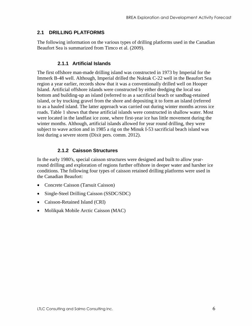
Figure 2. Concrete Caisson (Tarsuit Caisson)(source G.W. Timco)
The concrete caisson island was developed by Gulf and deployed at Tarsuit N-44 in
1981. The structure consisted of four concrete caissons that were floated to the drilling
site and ballasted down with sand to form a square over an underwater berm that was
within 6m of the water surface. The inner core was filled with dredged sand. This
structure was not considered a "mobile" structure due to the difficulty of resetting and
connecting the four caissons. It had no issues with wave loads, but wave action undercut
the footings of the caissons necessitating remedial action. Wave splash was also a
problem, due to its low freeboard and flat sides. Later caisson structures were designed
with wave deflection collars. The concrete (Tarsuit) caisson structure was only used for
drilling at the Tarsuit N-44 location.
BREA Exploration and Development Activity Forecast
LTLC Consulting and Salmo Consulting Inc. 8
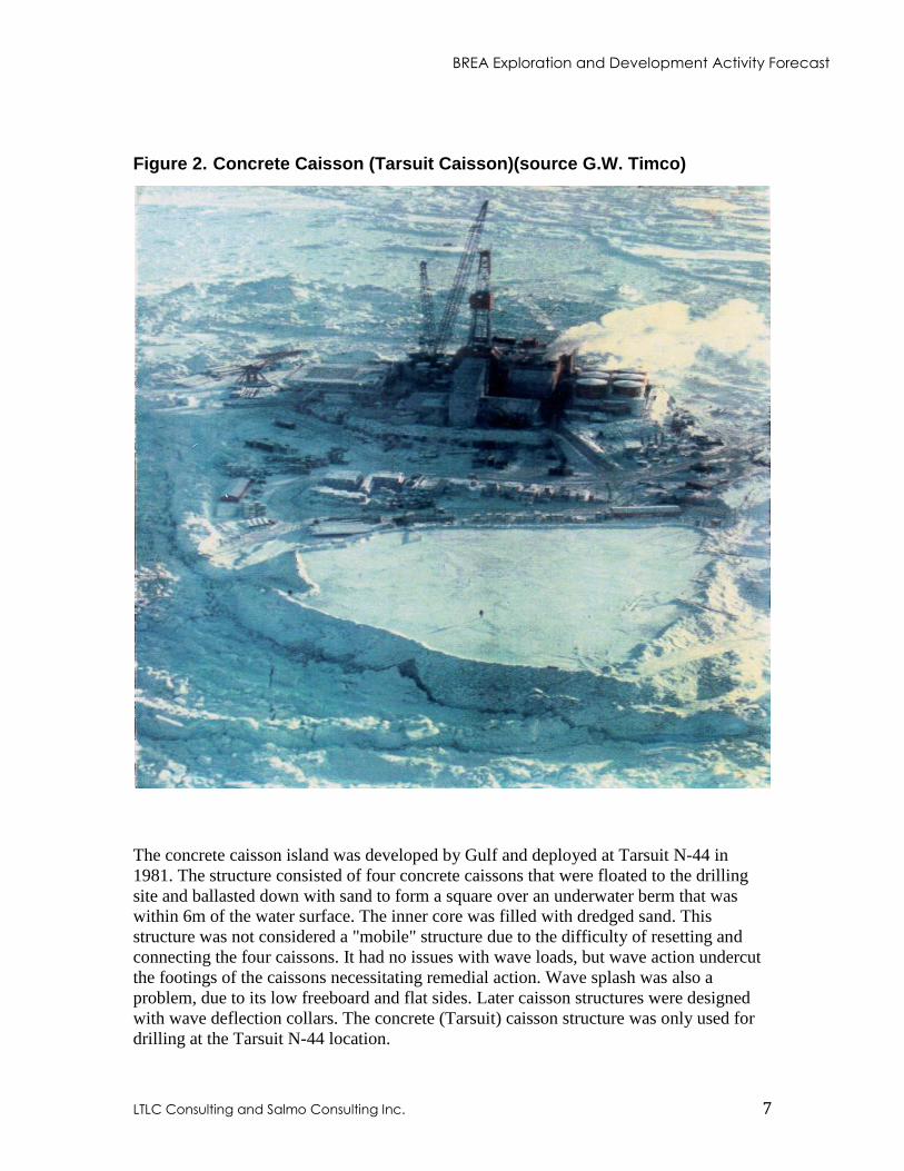
Figure 3. Single Steel Drilling Caisson (SSDC/SDC)(source G.W. Timco)
The Single-Steel Drilling Caisson (SSDC) was operated by Canadian Marine Drilling
Limited (Canmar) a subsidiary of Dome. It was constructed from a former tanker and
brought to the Beaufort Sea in 1982. In the winters of 1982/83 and 1983/84, it drilled at
two different locations in approximately 30m of water. In 1985/86, a new steel base, the
MAT, was designed, built and deployed. This removed a limitation of the SSDC that had
required construction of a subsurface sand berm for locations deeper than 9m. The SSDC
combined with the MAT was capable of operating year round in water depths of 7 to 24m
without a berm, in a wide variety of bottom conditions. It was renamed the SDC and used
in the winter of 2005/06 by Devon Canada Corporation (Devon) to drill the Paktoa C-60
well in 13m of water.
BREA Exploration and Development Activity Forecast
LTLC Consulting and Salmo Consulting Inc. 9
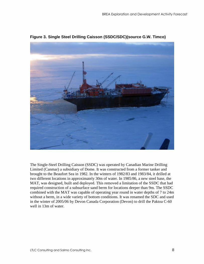
Figure 4. Caisson-Retained Island (CRI)(source A. Barker)
The Caisson Retained Island (CRI) was originally built by Imperial. It was developed in
1977, as a means of reducing dredge quantities, needed for the construction of traditional
sand islands. It was first deployed in the Canadian Beaufort Sea in the summer of 1983.
The CRI consisted of 8 individual caissons forming a ring held together with two pre-
stressed bands of steel wire cable. It was therefore named the stressed Caisson Retained
Island and overall it had an octagonal-shape with an inclined outer face. The central core
was filled with sand.
BREA Exploration and Development Activity Forecast
LTLC Consulting and Salmo Consulting Inc. 10
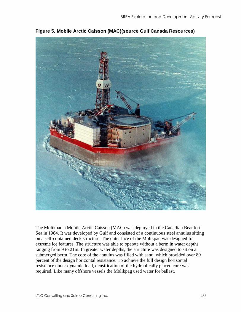
Figure 5. Mobile Arctic Caisson (MAC)(source Gulf Canada Resources)
The Molikpaq a Mobile Arctic Caisson (MAC) was deployed in the Canadian Beaufort
Sea in 1984. It was developed by Gulf and consisted of a continuous steel annulus sitting
on a self-contained deck structure. The outer face of the Molikpaq was designed for
extreme ice features. The structure was able to operate without a berm in water depths
ranging from 9 to 21m. In greater water depths, the structure was designed to sit on a
submerged berm. The core of the annulus was filled with sand, which provided over 80
percent of the design horizontal resistance. To achieve the full design horizontal
resistance under dynamic load, densification of the hydraulically placed core was
required. Like many offshore vessels the Molikpag used water for ballast.
BREA Exploration and Development Activity Forecast
LTLC Consulting and Salmo Consulting Inc. 11
2.1.3 Floating Drillships
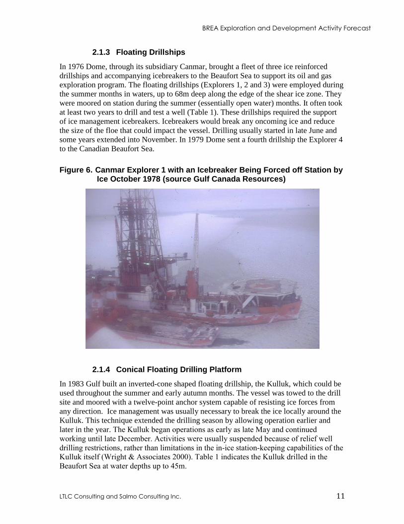
In 1976 Dome, through its subsidiary Canmar, brought a fleet of three ice reinforced
drillships and accompanying icebreakers to the Beaufort Sea to support its oil and gas
exploration program. The floating drillships (Explorers 1, 2 and 3) were employed during
the summer months in waters, up to 68m deep along the edge of the shear ice zone. They
were moored on station during the summer (essentially open water) months. It often took
at least two years to drill and test a well (Table 1). These drillships required the support
of ice management icebreakers. Icebreakers would break any oncoming ice and reduce
the size of the floe that could impact the vessel. Drilling usually started in late June and
some years extended into November. In 1979 Dome sent a fourth drillship the Explorer 4
to the Canadian Beaufort Sea.
Figure 6. Canmar Explorer 1 with an Icebreaker Being Forced off Station by Ice October 1978 (source Gulf Canada Resources)
2.1.4 Conical Floating Drilling Platform
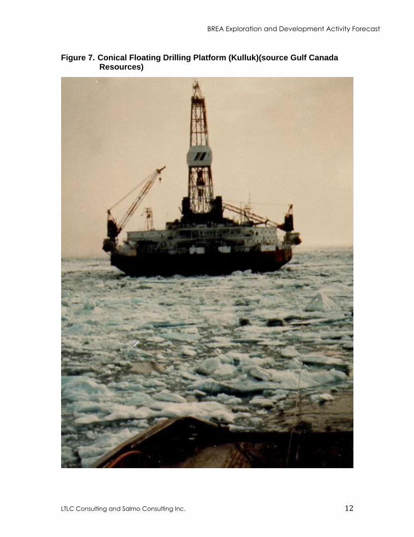
In 1983 Gulf built an inverted-cone shaped floating drillship, the Kulluk, which could be
used throughout the summer and early autumn months. The vessel was towed to the drill
site and moored with a twelve-point anchor system capable of resisting ice forces from
any direction. Ice management was usually necessary to break the ice locally around the
Kulluk. This technique extended the drilling season by allowing operation earlier and
later in the year. The Kulluk began operations as early as late May and continued
working until late December. Activities were usually suspended because of relief well
drilling restrictions, rather than limitations in the in-ice station-keeping capabilities of the
Kulluk itself (Wright & Associates 2000). Table 1 indicates the Kulluk drilled in the
Beaufort Sea at water depths up to 45m.
BREA Exploration and Development Activity Forecast
LTLC Consulting and Salmo Consulting Inc. 12
Figure 7. Conical Floating Drilling Platform (Kulluk)(source Gulf Canada Resources)
BREA Exploration and Development Activity Forecast
LTLC Consulting and Salmo Consulting Inc. 13
2.2 SPRAY ICE ISLANDS
In the late 1980s, spray ice islands were used as pads for drilling a couple of wells in the
Canadian Beaufort Sea. These were deployed in the landfast ice zone, in water depths of
less than 8m. The ice pads were built by spraying seawater using large pumps and
nozzles to locally increase the ice thickness. This spraying normally continued until the
pad rested on the seabed with sufficient freeboard and enough weight to resist the ice
loads that it would incur during the drilling season. The cost of spray islands was reported
to be approximately one-half the cost of gravel islands.
2.3 EXPLORATION RESULTS
By the mid 1980s, a number of oil and gas discoveries had been made in the Beaufort
Sea. The most significant discovery was that of the Amauligak oil and gas field by Gulf.
The oil and gas discoveries made in the region are described in more detail in Section 5
of this report. Despite these discoveries, by this time it had become apparent that the
high expectations for the region had not been met. Unlike the Alaskan North Slope,
where a small number of large prolific fields exist, the Mackenzie Delta/Beaufort Sea
region was characterized by a large number of smaller widely scattered reserves, due to
highly structured and fractured sedimentary strata.
2.4 ARCTIC EXPLORATION AND WORLD EVENTS
In the mid 1980s, world oil prices and oil demand began to decline rapidly, thereby
affecting the impetus and available financing to undertake hydrocarbon exploration in the
Canadian Arctic. In March 1989, the Exxon Valdez ran aground in Prince William
Sound, Alaska. Worldwide publicity of the spill's impacts had repercussions for
hydrocarbon exploration, development and transportation throughout North America,
particularly in the Beaufort Sea region.
In 1989, Imperial was granted approval to drill the Isserk I-15 well. However, in 1990 the
Environmental Impact Review Board (EIRB), created under the IFA, found a lack of
preparedness of the government and Gulf to deal with a major oil blowout in the Beaufort
Sea. The EIRB recommended the Minister of Indian and Northern Affairs not approve
Gulf’s proposed Kulluk drilling program. Following the denial of the Kulluk drilling
program, there was little exploration activity in the Mackenzie Delta or Beaufort Sea for
the next decade. In 1999-2000 increasing North American gas prices led to a renewal of
seismic exploration in the Mackenzie Valley/Beaufort Sea and the drilling of several
exploration wells in the Mackenzie Delta. However, Devon’s Paktoa C-60 well drilled in
2005-06, which targeted natural gas and discovered a reported 240 million barrels
(mmbbl)(38 106m
3) of recoverable oil, has been the only Beaufort Sea offshore well
drilled in the last 22 years.
BREA Exploration and Development Activity Forecast
LTLC Consulting and Salmo Consulting Inc. 14
2.5 ARCTIC OIL AND GAS PRODUCTION
Despite the billions invested in oil and gas exploration in the Canadian High Arctic, there
has been no significant commercial production. In 1985 Panarctic Arctic Oils Limited
(Panarctic) began to tanker oil from the Bent Horn oil field (discovered in 1974 at Bent
Horn N-72 on Cameron Island) to Montreal. One to three tankers of oil were shipped
every summer from 1985 to 1996, with a total production from the field of 2.8mmbbl
(Drummond 2005). The only oil production from the Mackenzie Delta and Beaufort Sea
occurred in 1986, when Gulf shipped a demonstration tanker load of 317,000 barrels
(bbl)(50 103m
3) of oil from the Amauligak field to Japan (Drummond 2005). The first
natural gas production from the Mackenzie Delta was in July 1999 from the Ikhil gas
field (discovered by Gulf), which provides local production to the town of Inuvik. The
small Ikhil gas reserves were expected to provide a community gas supply for a few years
and were to be replaced by gas from MGP. Unfortunately, production from the Ikhil field
is currently declining and since MGP is not economic, the town is now faced with having
to find a new fuel supply. It appears that this new fuel will initially be more expensive
propane trucked from Alberta.
3. THE CYCLE OF OFFSHORE INDUSTRY ACTIVITY
The search for hydrocarbons in the Beaufort Sea is highly complex and costly due to the
extreme environment, a multi-jurisdictional regulatory system and multiple technical
challenges. The extreme climate, ice conditions, long periods of darkness, and
remoteness each contribute to the complexity of planning and costs of exploring for
hydrocarbons in the Beaufort offshore (Erlandson et al. 2002). Stories have recently
appeared in the press predicting increases in oil and gas activity in the Canadian Arctic
due to the influence of Climate Change. Although, Climate Change now allows for
routine vessel transit of the Northwest Passage and appears likely to extend summer
drilling seasons and reduce drilling risks from multi year ice flows, it may also increase
the frequency and severity of storms. On balance, it appears unlikely that Climate Change
will significantly reduce industry operating costs in the Beaufort Sea during the
timeframe of this forecast.
The document titled “Oil and Gas Approvals in the Beaufort Sea” by Erlandson et al.
(2002) is part of the regulatory road map series of documents prepared for Indian Affairs
and Northern Development Canada and CAPP. The road map provides a detailed outline
of the regulatory framework for reviewing and authorizing oil and gas activities in the
Beaufort Sea at the time of its publication.
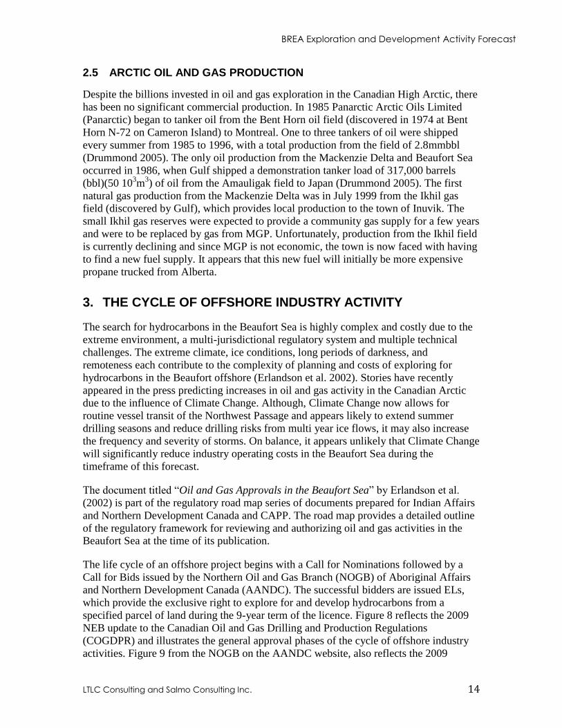
The life cycle of an offshore project begins with a Call for Nominations followed by a
Call for Bids issued by the Northern Oil and Gas Branch (NOGB) of Aboriginal Affairs
and Northern Development Canada (AANDC). The successful bidders are issued ELs,
which provide the exclusive right to explore for and develop hydrocarbons from a
specified parcel of land during the 9-year term of the licence. Figure 8 reflects the 2009
NEB update to the Canadian Oil and Gas Drilling and Production Regulations
(COGDPR) and illustrates the general approval phases of the cycle of offshore industry
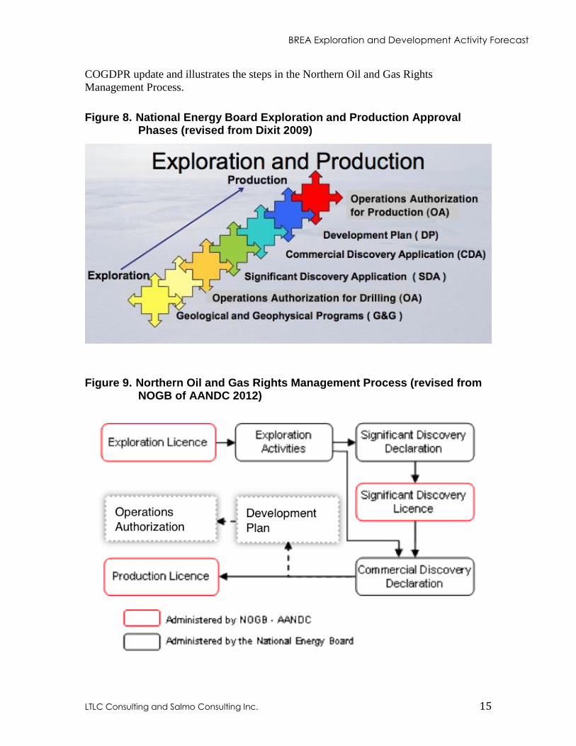
activities. Figure 9 from the NOGB on the AANDC website, also reflects the 2009
BREA Exploration and Development Activity Forecast
LTLC Consulting and Salmo Consulting Inc. 15
COGDPR update and illustrates the steps in the Northern Oil and Gas Rights
Management Process.
Figure 8. National Energy Board Exploration and Production Approval Phases (revised from Dixit 2009)
Figure 9. Northern Oil and Gas Rights Management Process (revised from NOGB of AANDC 2012)
BREA Exploration and Development Activity Forecast
LTLC Consulting and Salmo Consulting Inc. 16
3.1 GEOLOGICAL AND GEOPHYSICAL PROGRAMS
Seismic surveys are generally the first active exploration activity undertaken on new EL
areas. They are used to gain an understanding of the regional geologic structure and to
identify drilling targets. Companies wishing to conduct seismic programs must apply to
the NEB for Geological/Geophysical Operation Authorizations (GOA). Consultation with
local communities and other agencies having regulatory authority is critical to the
approval process for all types of seismic programs. In the past several different types of
seismic surveys have been conducted in the near shore areas of the Beaufort Sea. These
include the use of vibroseis vehicles on the ice, drilled shotholes, airguns, geophones
drilled through or placed on the ice, and ocean bottom cables with mini airguns used in
open water.
In the deep-water areas of the Beaufort Sea Two Dimensional (2D) and Three
Dimensional (3D) surveys are conducted by seismic vessels in generally open water
conditions. The following description of deep-water seismic surveys is summarized from
the report “Marine Seismic Operations” by the International Association of Geophysical
Contractors (IAGC) 2002. In 2D seismic surveying, a single seismic cable or streamer is
towed behind the seismic vessel, together with a single source. The reflections from the
subsurface are assumed to lie directly below the 'sail line' that the seismic vessel
traverses, hence the name 2D. The processing of 2D data is less sophisticated than that
employed for 3D surveys. 2D lines are typically acquired several kilometers apart, on a
broad grid of lines, over a large area. The method is generally used in frontier exploration
areas (before 3D seismic or drilling is undertaken), to produce a general understanding of
the regional geological structure. The size of a 2D survey is usually expressed in
kilometres of line surveyed.
A 3D survey covers a specific area, generally with known geological targets generated by
previous 2D exploration, and is usually undertaken in an EL area to better identify
potential reservoirs and drilling locations. Prior to the survey, careful planning is
undertaken to ensure the survey area is precisely defined. The result of the detailed
planning is a map defining the survey boundaries and the direction of the survey lines.
Specific acquisition parameters such as energy source, firing and receiver station
intervals, together with seismic listening time, are also defined. In 3D surveying, groups
of sail lines (or swathes) are acquired with the same orientation.
3D seismic sail line separation is normally on the order of 200 to 400m. By utilizing
more than one source and many parallel streamers towed by the seismic vessel, the
acquisition of many closely spaced sub-surface 2D lines, typically between 25 and 50m
apart, can be achieved by a single sail line. A 3D survey is therefore much more efficient
in that many times more data is generated than in a 2D survey. The size of a 3D survey is
usually referred to in square kilometers. With the number of sail line kilometers involved,
3D surveys can take several months to complete.
BREA Exploration and Development Activity Forecast
LTLC Consulting and Salmo Consulting Inc. 17
High resolution seismic site surveys are carried out before a well is drilled, as there is a
legal and operational need to have detailed information on the area immediately
surrounding the well location and the geological layers immediately below the
subsurface. The information on the nature of the seabed is needed to identify any physical
hazards on the surface of the seabed and the information on the shallow subsurface is
used to identify other unforeseen hazards, such as buried channels, shallow gas pockets,
gas hydrates and permafrost that could cause problems if penetrated by the drill.
KAVIKAXYS (2008) provided a hypothetical shortest duration Beaufort Sea offshore
development timeline based on a review of regulatory approval processes, hypothetical
development scenarios, and input from industry experts. They estimate the licencing and
seismic exploration phase of an offshore development to take a minimum of 3 years.
3.2 DRILLING PROGRAMS
While seismic surveys can identify targets of interest, drilling is required to confirm the
presence or absence of hydrocarbons. An NEB Operations Authorization (OA) is
required to undertake drilling operations for petroleum resources in the offshore area as
required by the Canada Oil and Gas Operations Act (COGOA). In addition, individual
well approvals from the NEB are required to drill a well (ADW) or to alter the condition
of a well (ACW). Prior to the NEB issuing an OA, environmental screening must be
completed under the IFA, and the requirements of the Canadian Environmental
Assessment Act, 2012 (CEAA 2012) and COGOA must be met. Further, the Applicant
would need to demonstrate financial responsibility to the satisfaction of the NEB, and the
NEB needs to have notification that a Benefits Plan prepared by the Applicant has been
approved by AANDC or the requirement for it waived.
KAVIK-AXYS (2008) estimated the exploration and delineation-drilling phase of a
Beaufort Sea offshore development to take a minimum of 3 years. However, since a
single offshore deep-water well may take 3 years to drill, this phase of an offshore
development may be considerably longer.
3.3 SIGNIFICANT DISCOVERY AND COMMERCIAL DISCOVERY APPLICATIONS
If an exploration well results in the discovery of hydrocarbons the Operator can make an
application to the NEB for a Significant Discovery Declaration (SDD). The NEB may, by
order, make a SDD in relation to those frontier lands in respect of which, there are
reasonable grounds to believe the Significant Discovery may extend.
The Applicant can then seek a Significant Discovery Licence (SDL) from the NOGB of
AANDC, which would extend the Applicant’s rights to areas identified in the SDD
without any time limit.
BREA Exploration and Development Activity Forecast
LTLC Consulting and Salmo Consulting Inc. 18
Additional delineation wells and 3D seismic may be needed to determine if a discovered
hydrocarbon resource is sufficiently large to warrant production. An Operator that can
demonstrate to the NEB that the sought area contains petroleum reserves that justify the
investment of capital and effort to bring the discovery to production can submit an
application for a Commercial Discovery Declaration (CDD). The NEB may, by order,
make a CDD in relation to those frontier lands in respect of which there are reasonable
grounds to believe the Commercial Discovery may extend.
3.4 DEVELOPMENT PLANS AND OPERATION AUTHORIZATIONS
An SDL does not expire, it can be held for many years, before conditions are favorable
enough to justify the costs and risks involved in attempting to produce hydrocarbons. To
date, other than the three limited examples described in Section 2.5 there has been no
commercial production of hydrocarbons from the Mackenzie Delta, Beaufort Sea and/or
Canada’s Arctic Islands. It is difficult to predict the timing and amount of work involved
in progressing a project through to production. Although, the specific timing of each
activity will vary depending on the type and scale of individual projects, it is expected
that at a minimum the activities listed in Table 2 would be required in order for the NEB
to consider a Development Plan Approval (DPA) application and issue a DPA. The DPA
is subject to Governor-in-Council consent, and Operations Authorizations (OA) for
activities included in the DPA. Finally, once a CDD has been made by the NEB, the
NOGB of AANDC may issue a Production Licence that would enable the Operator to sell
the produced oil and gas, make royalty payments, and profits.
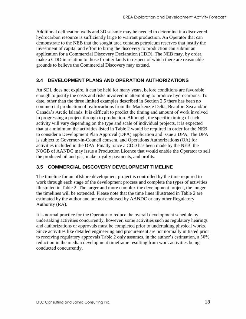
3.5 COMMERCIAL DISCOVERY DEVELOPMENT TIMELINE
The timeline for an offshore development project is controlled by the time required to
work through each stage of the development process and complete the types of activities
illustrated in Table 2. The larger and more complex the development project, the longer
the timelines will be extended. Please note that the time lines illustrated in Table 2 are
estimated by the author and are not endorsed by AANDC or any other Regulatory
Authority (RA).
It is normal practice for the Operator to reduce the overall development schedule by
undertaking activities concurrently, however, some activities such as regulatory hearings
and authorizations or approvals must be completed prior to undertaking physical works.
Since activities like detailed engineering and procurement are not normally initiated prior
to receiving regulatory approvals Table 2 only assumes, in the author’s estimation, a 30%
reduction in the median development timeframe resulting from work activities being
conducted concurrently.
BREA Exploration and Development Activity Forecast
LTLC Consulting and Salmo Consulting Inc. 19
Table 2. Activities and Estimated Time Schedule for a Generalized Beaufort Sea Offshore Development Project
Activity Estimated Timing Reserves Assessment Market Assessment Conceptual Engineering Economic Modeling Budgeting Assessment of Regulatory Environment Feasibility Study
0.5 - 1.5 years
Reservoir Engineering Drilling and Completions Engineering Cost and Schedule Engineering Public and Regulatory Consultation
0.5 - 1.5 years
Environmental Fieldwork Engineering Fieldwork
1 - 3 years
Construction Engineering Design Business and Economics Analysis Development Plan Environmental Impact Assessment Socio-economic Impact Assessment Decommissioning and Abandonment Plan
1 - 2 years
Public Regulatory Review Processes Regulatory Approvals Permitting
2 - 5 years
Detailed Design Procurement and Construction of Infrastructure Development Drilling Procurement and Construction of Facilities Facility Start-up/Commissioning
5 - 7 years
TOTAL Median Estimated Development Timeframe
14 years
TOTAL Estimated Development Timeframe Reduced 30% for Concurrent Work
10 years
BREA Exploration and Development Activity Forecast
LTLC Consulting and Salmo Consulting Inc. 20
3.6 OPERATIONS AUTHORIZATIONS FOR DECOMMISSIONING AND ABANDONMENT
The final phase of the project life cycle is decommissioning and abandonment. As
indicated in Table 2, an initial Decommissioning and Abandonment Plan is required
before regulatory approvals to construct are issued. This plan includes decommissioning
of installations, abandonment of fields and abandonment of wells. Specific facility and
well abandonments may be undertaken several times during the operating life of an oil or
gas development. At the end of a project life cycle, once the requirements of all other
Regulatory Authorities (RAs) have been met, an Operator can apply to the NEB for a
final OA for decommissioning and abandonment. However, the Operator continues to be
accountable and responsible for a well, even after abandonment, and may be required to
carry out remediation work should a well later be discovered to be leaking or require
other maintenance.
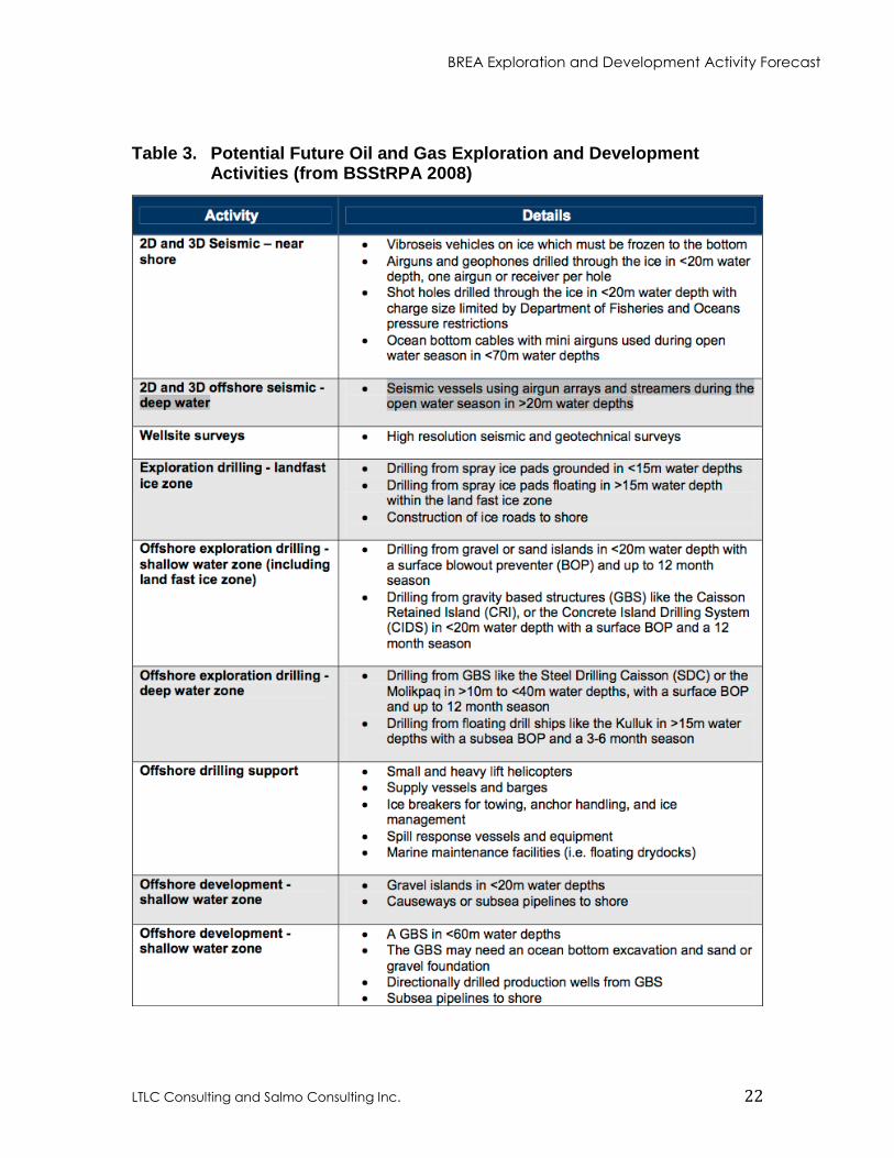
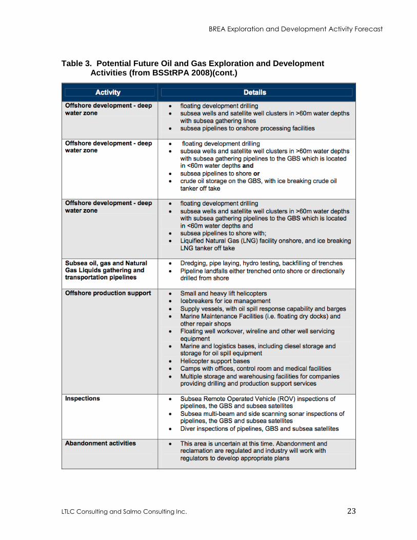
3.7 POTENTIAL FUTURE OIL AND GAS EXPLORATION AND DEVELOPMENT ACTIVITIES
Table 3 was prepared by CAPP, for the Beaufort Sea Strategic Regional Plan of Action
(BSStRPA) 2008 report; it identifies potential future oil and gas exploration and
development activities in the Canadian Beaufort Sea. It is the most recent comprehensive
description of potential oil and gas activities available. However, in December 2012
Imperial Oil Resources Ventures Limited (IORVL) filed a Preliminary Information
Package (PIP) on behalf of the Beaufort Sea Exploration Joint Venture. The PIP contains
information on the range of exploration activities that IORVL is considering for EL 476
(Ajurak) and EL 477 (Pokak). The PIP states these ELs are in the Canadian Beaufort Sea
about 125 km north-northwest of Tuktoyaktuk in water depths ranging from 60 to 1500m.
IORVL indicates that a typical well drilled on these leases might be drilled over 3 or
more summer drilling seasons.
The PIP indicates that the major components of the drilling operation may include:
a drilling rig and related equipment similar to the drillings system described in
section 4.2.2 of this report.
marine support vessels, including ice-class supply vessels, icebreaking support
vessels, and ice escort vessels
a shore-based facility and a warebarge or ware ship
emergency and spill response vessels and equipment
some fuel supply will be loaded onboard the drilling rig and marine vessels during
the spring transit into the Beaufort Sea. To meet fuel requirements for the entire
drilling season, a double hulled ice-class fuel tanker is expected to be necessary.
The fuel tanker may make refueling trips from a western port to the drill site
during the summer drilling seasons
An example of the types and numbers of drilling and support vessels that may be used is
also provided in the PIP. The example provided is largely consistent with the following
list provided in the 2012 version of this report:
BREA Exploration and Development Activity Forecast
LTLC Consulting and Salmo Consulting Inc. 21
2 or 3 icebreakers would stay on location at the drillsite
2 or 3 supply vessels would make trips back and forth to a shore base,
1 possible wareship would stay on location, replacing 1 supply vessel
1 fuel tanker would be on location during the drilling operation
The PIP states that various facilities and services are being considered to support the
offshore operation, including:
a shore-based facility possibly at Tuktoyaktuk
an onshore camp for upwards of 200 people (PIP estimate of 125 now believed to
be low)
staging sites and storage areas
a docking area which may require some dredging
land transportation services primarily between the shore-base and airstrip, but
some materials and supplies could be transported over land or ice roads to
Tuktoyaktuk
air transportation services including two or more helicopters averaging one flight
per day to the drill site
storage of emergency equipment such as oil spill response equipment and other
emergency equipment would likely be at the shore-based facility
potable water supply would be required at the shore-based facility and the onshore
camp
waste management services would include transporting wastes on the supply
vessels back to the shore-based facility, for disposal onshore or for storage prior
to shipment out of the region
Figure 1-3 in the PIP provides an example of a possible exploration program schedule.
The schedule indicates that a “Screening – Project Description and Environmental Impact
Statement” might be filed later in 2013. These documents are expected to provide further
details on the exploration equipment and activities required for drilling a deep water
exploration well in the Beaufort Sea.
BREA researchers should consider the drilling system described above along with the
industry activities described in Table 3, when attempting to identify and fill regional
information and data gaps related to offshore oil and gas exploration and development
activities.
BREA Exploration and Development Activity Forecast
LTLC Consulting and Salmo Consulting Inc. 22
Table 3. Potential Future Oil and Gas Exploration and Development Activities (from BSStRPA 2008)
BREA Exploration and Development Activity Forecast
LTLC Consulting and Salmo Consulting Inc. 23
Table 3. Potential Future Oil and Gas Exploration and Development
Activities (from BSStRPA 2008)(cont.)
BREA Exploration and Development Activity Forecast
LTLC Consulting and Salmo Consulting Inc. 24
4. PREDICTED BEAUFORT SEA OIL AND GAS ACTIVITY
Several attempts have been made historically to predict the type, scale and timing of
future Beaufort Sea oil and gas exploration and development. These include: Beaufort
Environmental Monitoring Project (1988); Beaufort Region Environmental Assessment
and Monitoring Program (1995); Gilbert, Laustsen, Jung Associated Ltd. (2004); the
Mackenzie Gas Project (2005); and the Breakwater Group (2006) which all provide
hypothetical development scenarios. In addition, the Beaufort Sea Strategic Regional
Plan of Action (BSStRPA 2008) appendices contain a potential oil and gas development
scenario largely drawn from the work by Morrell (2005, 2007). The INAC (2007)
submission to the Joint Review Panel for the Mackenzie Gas Project (MGP) titled
“Towards a View of Future Oil and Gas Development in the Mackenzie Valley, Delta and
the Beaufort Sea” expands on Morrell’s earlier work. Finally, CAPP provided a
presentation titled “Potential Oil and Gas Activities in the Beaufort Sea to the National
Energy Board Offshore Drilling Review”, Inuvik Roundtable Sept. 12-16, 2011. This
report is an update to the “Oil and Gas Exploration & Development Activity Forecast,
Canadian Beaufort Sea 2012-2013”, prepared by the author in April 2012.
Peterson et al. 2003 describes forecasts as a "best estimate of future conditions from a
particular model, method, or individual.” He goes on to state the “public and decision
makers generally understand that a forecast may or may not turn out to be true." Given
that changing future conditions are a near certainty, this oil and gas activity forecast, is
intended to describe a plausible future based on current assumptions. However, it is
important to recognize that there are numerous ever-changing factors, which may
significantly alter the forecast at any time.
In an attempt to try and develop plausible current forecasts of potential oil and gas
activity in the Beaufort Sea, company representatives working on exploration and
development projects in the area were interviewed in 2012 and again in 2013. Those
companies known to be considering or currently undertaking exploration and/or
development planning in the Beaufort Sea were asked to describe their current plans for
activity. The author used this information to develop an industry-wide overview of
potential oil and gas exploration and development activities for the 15 years. The report
also provides a description of the oil and gas exploration and development activity cycle,
which will apply to industry activities expected to occur over the long term. That is, the
expected life cycle of those activities initiated during the next 15 years, is described to
provide an indication of how these developments may build out to full scale and
eventually be decommissioned. Any prediction of oil and gas exploration and
development activities in Beaufort Sea over a 15 years period, will necessarily have a
large margin for error. Therefore, the longer-term project life cycle predictions included
in the report are only general and based on industry experience.
BREA Exploration and Development Activity Forecast
LTLC Consulting and Salmo Consulting Inc. 25
4.1 ASSUMPTIONS
4.1.1 Factors in Development of Assumptions
There are numerous regulatory, technical and economic factors, which may have a
significant impact on the type and level of oil and gas activities that will occur in the
Canadian Beaufort Sea over the next 15 years. BREA industry committee members
identified the following key factors:
The NEB report and filing requirements, resulting from the Public Review of Arctic
Offshore Drilling have the potential to affect the type and level of oil and gas industry
activity in the Beaufort Sea. Industry representatives expressed concern that the NEB
Same Season Relief Well Policy could significantly impair exploration of the deeper
waters of the Beaufort Sea. The same-season relief well capability requirements have
been in place since the 1970s and the NEB in re-affirming the policy, provided the
context and intent of the policy, and articulated the policy in its report and companion
Filing Requirements. However, the NEB’s requirement that any company applying
for an offshore drilling authorization, “demonstrate how they would meet or exceed
the intended outcome of our policy” (NEB 2011a,b), is expected to create regulatory
and financial uncertainty as industry attempts to address the policy. IORVL in the PIP
states, “A decision to proceed with an exploration drilling operation in the Beaufort
Sea would require a significant financial commitment by the joint venture partners.
Many factors would have to be considered in making a decision, including regulatory
approvals and resolution of issues such as the NEB’s equivalency to same season
relief well capability”.
EL holders delayed filing offshore drilling applications, while they participated in the
NEB Public Review of Arctic Offshore Drilling, and awaited guidance to be issued
by the Board pursuant to its review. Such delays were expected in the 2012 forecast
to result in current offshore EL holders seeking extensions to the timelines for their
exploration work commitments. In September 2012 replacement ELs were issued to
current EL holders in the Beaufort Sea to equitably restore the license term which was
adversely affected due the NEB Arctic Offshore Drilling Review, during which
operations were effectively suspended. The new ELs were issued in relation to the
same frontier lands and all other terms and conditions of the new licences remain the
same as the original licences.
Industry representatives indicate that one or more built-for-purpose or retrofitted
Arctic class drillships will need to be commissioned for drilling offshore in the
Beaufort Sea deep slope areas. IORVL in its submission to the NEB titled
“Submission Regarding the Relief Well Policy for Offshore Drilling in the Arctic,
March 2010” states that existing floating drilling rigs are unsuitable for operating in
the deep ice-infested waters of the Beaufort Sea. Their preliminary plans included the
construction of a new purpose built Det Norske Veritas Polar Class 4 drillship. The
PIP states that, “The unique conditions of the Arctic environment might require the
construction of new and specialized equipment.” The ordering of an Arctic class
BREA Exploration and Development Activity Forecast
LTLC Consulting and Salmo Consulting Inc. 26
drillship is unlikely to occur until the NEB has issued an OA for drilling. Based on
industry experience, the actual design, construction and commissioning of a purpose
built drillship will take 3 to 4 years, which is consistent with the timing in Figure 1-3
in the PIP for design and construction of a new-build deepwater drilling rig and new-
build icebreakers. The Stena Drill-Max Ice reported to be the world’s first Arctic ice
class, dual mast, ultra deepwater drillship was ordered in 2008 and commissioned in
2012.
Increases in North American shale gas production have caused natural gas unit prices
to tumble from more than US $8 per mcf in 2008 to about US $4 in 2011, with
current spot prices even lower at between US $2 and $3. The 2012 forecast
recognized that natural gas prices remaining at current levels would likely render
Arctic gas production uneconomic. The MGP update presented at the June 2012
Inuvik Petroleum Show confirmed that the project is “not a commercial opportunity
at this time” because the “natural gas market has changed significantly”. The MGP
update contained a North American supply/demand forecast indicating that a market
for Mackenzie Delta gas may develop around 2023 and project activities could ramp
up should market conditions improve. The 2012 forecast recognized that in the
absence of MGP, industry exploration and development activities in the Beaufort Sea
will focus more on oil than natural gas.
The 2012 forecast indicated that existing offshore significant discoveries, located in
less than 100m water depths, represent the best near term development opportunities
in the Beaufort Sea. ConocoPhillips which is currently in the second year of a three
year study of the Amauligak development concept feasibility, is the only company
known to be actively evaluating a Beaufort Sea development.
Although, current oil prices remain near historical highs, global economic instability
is resulting in significant swings in world oil prices. This combined with high costs
and industry uncertainty, as to how equivalency to the NEB Same Season Relief Well
Policy can be achieved, may result in shifts in corporate exploration and development
expenditures away from the Beaufort Sea. However, a sustained global economic
recovery with accompanying increases in oil prices would encourage exploration and
development.
Although the above list of factors is not exhaustive, in the author’s opinion it does appear
that negative factors continue to dominate positive factors for natural gas exploration and
development activity in the Beaufort Sea. The outlook for oil exploration and
development is somewhat more positive at this time, with Franklin planning seismic,
IORVL filing the PIP and ConocoPhillips continuing to pursue the Amauligak feasibility
study. However, history has clearly shown that factors affecting the outlook for oil and
gas activity in the Beaufort Sea can change dramatically over relatively short timeframes.
Therefore, if this forecast is to be relied upon for future planning, it should be revisited on
a regular basis to ensure the underlying assumptions remain valid.
BREA Exploration and Development Activity Forecast
LTLC Consulting and Salmo Consulting Inc. 27
4.1.2 Base Assumptions
Regarding the above factors identified as potentially affecting oil and gas activity in the
Beaufort Sea, this report assumes the following:
Holders of existing deepwater Exploration Licences have indicated their intention to
pursue drilling applications based on pre-engineered drilling systems with
demonstrated equivalency to the NEB Same Season Relief Well Policy. It now
appears that IORVL is likely to be the first Applicant to attempt to demonstrate
equivalency to this policy. The possible program schedule contained in the PIP shows
the filing of a Project Description and Environmental Impact Statement for screening
in the third quarter of this year. IORVL indicates their “target” timeline for obtaining
key regulatory approvals for drilling on EL’s 476/477 is over the next 3 years, after
which a decision on drilling will be made. The PIP shows a possible NEB Well
Approval in 2019, which is one year later than the author predicted in the previous
forecast of industry activity.
One or more purpose-built or retrofitted Arctic class drillships are expected to be
commissioned to drill deep shelf and deep slope wells in the Beaufort Sea. The
possible program schedule in the PIP is consistent with the 2012 forecast assumption
that it will take 3 to 4 years to design and construct a purpose built drillship. The
timeline for retrofitting an existing drillship to meet Arctic drilling requirements is
still unknown, and assumed to be similar to that for constructing a new drillship.
MGP will not proceed as scheduled, however; if the North American supply/demand
forecast MGP present at the 2012 Inuvik Petroleum Show proves to be accurate the
project could ramp up to begin production around 2023.
The Amauligak field is now assumed to provide the most likely near term
development opportunity in the Beaufort Sea, as it is the only potential Beaufort Sea
development known to be under evaluation. ConocoPhillips and the other Amauligak
interest owners are currently in the second year of a three year study to identify a
potentially feasible development concept for the field. .
The 2012 forecast predicted that low natural gas prices, and regulatory uncertainty
would reduce the number of industry nominations and bids for Beaufort Sea ELs over
the 15-year timeframe of the forecast. However, Franklin Petroleum a newcomer to
the Canadian Beaufort Sea took advantage of the recent lack of interest by other
petroleum operators in Beaufort Sea and acquired 8 ELs covering 1,117,095 hectares
for a total work bid of only $9,506,528. Franklin is proposing to conduct 3D seismic
in the summer of 2013 or in subsequent years, with the hope of identifying one or
more drilling locations. Since the timing, complexity and cost of drilling increases
with water depth and they cannot predict the water depth of any prospective drilling
location, they are unable to forecast when drilling might occur. They company has
indicated, however, that it does not expect to be drilling prior to 2015.
BREA Exploration and Development Activity Forecast
LTLC Consulting and Salmo Consulting Inc. 28
4.2 PREDICTED INDUSTRY ACTIVITY
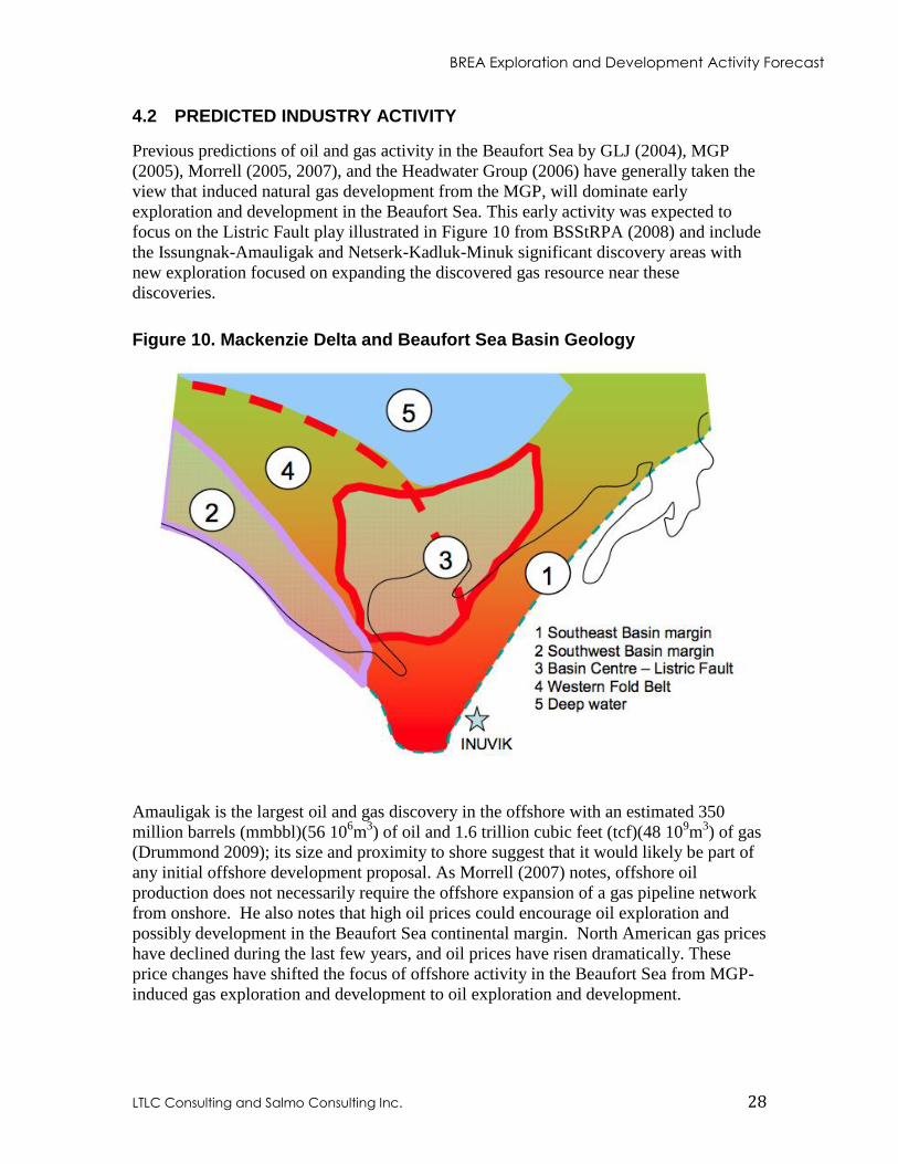
Previous predictions of oil and gas activity in the Beaufort Sea by GLJ (2004), MGP
(2005), Morrell (2005, 2007), and the Headwater Group (2006) have generally taken the
view that induced natural gas development from the MGP, will dominate early
exploration and development in the Beaufort Sea. This early activity was expected to
focus on the Listric Fault play illustrated in Figure 10 from BSStRPA (2008) and include
the Issungnak-Amauligak and Netserk-Kadluk-Minuk significant discovery areas with
new exploration focused on expanding the discovered gas resource near these
discoveries.
Figure 10. Mackenzie Delta and Beaufort Sea Basin Geology
Amauligak is the largest oil and gas discovery in the offshore with an estimated 350
million barrels (mmbbl)(56 106m
3) of oil and 1.6 trillion cubic feet (tcf)(48 10
9m
3) of gas
(Drummond 2009); its size and proximity to shore suggest that it would likely be part of
any initial offshore development proposal. As Morrell (2007) notes, offshore oil
production does not necessarily require the offshore expansion of a gas pipeline network
from onshore. He also notes that high oil prices could encourage oil exploration and
possibly development in the Beaufort Sea continental margin. North American gas prices
have declined during the last few years, and oil prices have risen dramatically. These
price changes have shifted the focus of offshore activity in the Beaufort Sea from MGP-
induced gas exploration and development to oil exploration and development.
BREA Exploration and Development Activity Forecast
LTLC Consulting and Salmo Consulting Inc. 29
Morrell (2007) also recognized that there are large offshore areas of the Beaufort, which
are sparsely explored and have the potential for major oil and gas discoveries. Since most
of the large near shore structures have experienced some exploration, any new major
discoveries will likely be in deeper water offshore. Morrell also foresaw the possibility
that large international companies could become interested in exploring the deeper
offshore Beaufort Sea, through their continual evaluation of opportunities in their
worldwide portfolios. The awarding of high value ELs for deep slope areas of the
Beaufort Sea has proven Morrell’s predictions to be accurate.
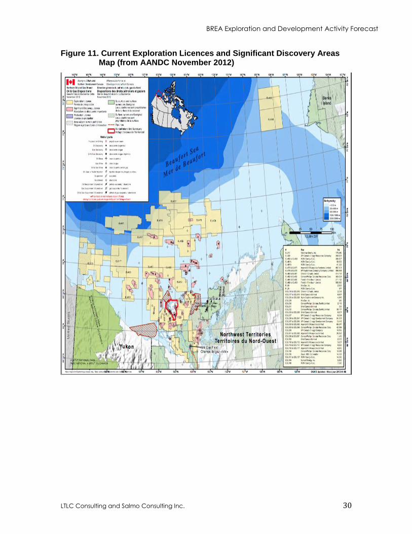
One indicator of future exploration activity in the Beaufort Sea is the number of current
ELs and the financial and well drilling commitments they contain. Figure 11 from
AANDC (2011), shows the locations of ELs, SDLs and other features in the Mackenzie
Delta and Beaufort Sea. Table 4 shows the effective dates of the current Beaufort Sea
ELs, the work bid amounts, the dates wells are to be drilling, and the year each EL
expires, if a well is not drilled and work commitments not met.
BREA Exploration and Development Activity Forecast
LTLC Consulting and Salmo Consulting Inc. 30
Figure 11. Current Exploration Licences and Significant Discovery Areas Map (from AANDC November 2012)
BREA Exploration and Development Activity Forecast
LTLC Consulting and Salmo Consulting Inc. 31
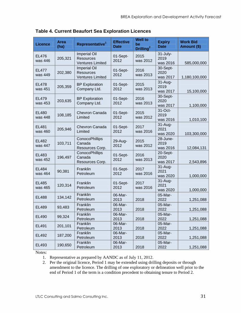
Table 4. Current Beaufort Sea Exploration Licences
Licence Area (ha)
Representative1
Effective Date
Well to be Drilling
2
Expiry Date
Work Bid Amount ($)
EL476 was 446
205,321 Imperial Oil Resources Ventures Limited
01-Sept-2012
2015 was 2012
31-July-2019 was 2016
585,000,000
EL477 was 449
202,380 Imperial Oil Resources Ventures Limited
01-Sept-2012
2016 was 2013
30-Sept-2020 was 2017
1,180,100,000
EL478 was 451
205,359 BP Exploration Company Ltd.
01-Sept-2012
2015 was 2013
31-Aug-2019 was 2017
15,100,000
EL479 was 453
203,635 BP Exploration Company Ltd.
01-Sept-2012
2016 was 2013
30-Sept-2020 was 2017
1,100,000
EL480 was 448
108,185 Chevron Canada Limited
01-Sept-2012
2015 was 2012
31-Oct-2019 was 2016
1,010,100
EL481 was 460
205,946 Chevron Canada Limited
01-Sept-2012
2017 was 2016
31-Aug-2021 was 2020
103,300,000
EL482 was 447
103,711 ConocoPhillips Canada Resources Corp.
29-Aug-2012
2015 was 2012
28-June-2019 was 2016
12,084,131
EL483 was 452
196,497 ConocoPhillips Canada Resources Corp.
01-Sept-2012
2016 was 2013
20-Sept-2020 was 2017
2,543,896
EL484 was 464
90,381 Franklin Petroleum
01-Sept-2012
2017 was 2016
31-Aug- 2021 was 2020
1,000,000
EL485 was 465
120,314 Franklin Petroleum
01-Sept-2012
2017 was 2016
31-Aug- 2021 was 2020
1,000,000
EL488 134,142 Franklin Petroleum
06-Mar-2013
2018
05-Mar-2022
1,251,088
EL489 93,483 Franklin Petroleum
06-Mar- 2013
2018
05-Mar-2022
1,251,088
EL490 99,324 Franklin Petroleum
06-Mar-2013
2018
05-Mar-2022
1,251,088
EL491 201,101 Franklin Petroleum
06-Mar-2013
2018
05-Mar-2022
1,251,088
EL492 187,200 Franklin Petroleum
06-Mar-2013
2018
05-Mar-2022
1,251,088
EL493 190,650 Franklin Petroleum
06-Mar-2013
2018
05-Mar-2022
1,251,088
Notes:
1. Representative as prepared by AANDC as of July 11, 2012.
2. Per the original licence, Period 1 may be extended using drilling deposits or through
amendment to the licence. The drilling of one exploratory or delineation well prior to the
end of Period 1 of the term is a condition precedent to obtaining tenure to Period 2.
BREA Exploration and Development Activity Forecast
LTLC Consulting and Salmo Consulting Inc. 32
4.2.1 Seismic Surveys
Since 2006, one or two large 2D seismic surveys have been conducted each year in the
Beaufort Sea. Third party seismic companies that conduct both speculative and
contracted seismic surveys normally carry out these large surveys. Recent surveys have
focused on the Beaufort deep slope areas, the central Beaufort Sea, the areas West of
Banks Island, and the Tuktoyaktuk Peninsula, and to a lesser extent the Western Beaufort
Sea. In addition, 3D seismic surveys were carried out in 2008 by IORVL on EL446, in
2009 by BP on EL449 and in 2012 by Chevron Canada on ELs 480 and 481.
Industry geologists evaluate the prospectivity of new exploration regions and decide
where to carry out seismic surveys using, a combination of available information,
analogues from similar basins, geological models and professional judgment. Without
having access to these confidential industry assessments of regions in the Beaufort Sea,
future seismic exploration is very difficult to predict. Since several large 2D surveys have
been conducted in the Beaufort Sea in the last few years, the size and frequency of these
surveys over the next 15 years is likely to decrease. History has shown that in any
specific year one or two 2D seismic surveys of varying sizes may be conducted in the
Beaufort Sea.
Franklin indicates they are applying to conduct a marine 3D and contingent 2D seismic
program in the Canadian Beaufort Sea during the open-water period of 2013 or
subsequent years of Franklin Petroleum’s lease term. The primary objective of their
program is to acquire 3D seismic data over ELs 485 and 488-491. However, if
environmental conditions prohibit the acquisition of these data, Franklin Petroleum is
proposing to acquire contingent 2D seismic data in ELs 492 and 493 offshore Banks
Island. Their program entails the acquisition of up to 4000km2 of 3D seismic data and
potentially up to 1000km of 2D data. The 3D survey area is located between 50 and
100km northeast of Herschel Island and is bounded by 139°W on the west, 135°W on the
east, and extends northward to 70°40’N. Water depths range from 15-1000m within the
proposed 3D survey area. The 2D survey area is located 80km west of Banks Island, in
water depths of 100-400m.
Additional 2D seismic surveys are likely to be conducted in other unexplored areas as
well. The number of future 3D surveys can be expected to closely track the number of
offshore wells drilled. Due to the high cost of offshore wells, 3D surveys are now
routinely conducted on each EL a few years prior to drilling. High-resolution wellsite
seismic surveys will also be conducted to map the sea bottom surface and near subsurface
prior to spudding all offshore wells.
4.2.2 Deep Shelf and Slope Beaufort Sea Wells
As predicted in the 2012 forecast replacement ELs were issued in 2012 to compensate
operators for the time they spent participating in the NEB Public Review of Arctic
Offshore Drilling. The current ELs call for 8 wells to be drilled in the deeper offshore
Beaufort Sea between 2015 and 2018, which is unlikely.
BREA Exploration and Development Activity Forecast
LTLC Consulting and Salmo Consulting Inc. 33
As indicated earlier, industry expects that only one or two built-for-purpose or retrofitted
Arctic class drillships will be acquired to drill deep slope wells (>100m water depth) in
the Beaufort Sea. It now appears that IORVL is likely to be the first Applicant to apply
for an Operations Authorization to drill a deep water Beaufort Sea well. The possible
program schedule contained in the PIP indicates drilling to start in 2020, which is
consistent with the 2012 forecast, that it would be unlikely for the first deep water well to
be spudded before 2018.
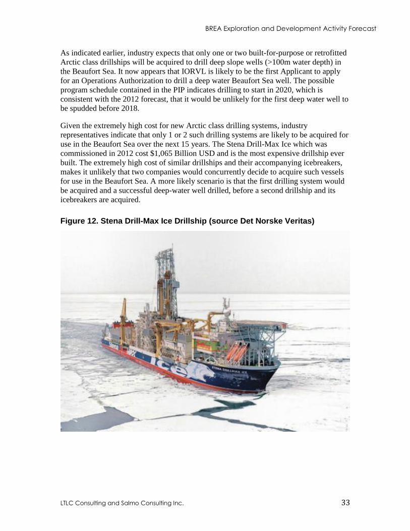
Given the extremely high cost for new Arctic class drilling systems, industry
representatives indicate that only 1 or 2 such drilling systems are likely to be acquired for
use in the Beaufort Sea over the next 15 years. The Stena Drill-Max Ice which was
commissioned in 2012 cost $1,065 Billion USD and is the most expensive drillship ever
built. The extremely high cost of similar drillships and their accompanying icebreakers,
makes it unlikely that two companies would concurrently decide to acquire such vessels
for use in the Beaufort Sea. A more likely scenario is that the first drilling system would
be acquired and a successful deep-water well drilled, before a second drillship and its
icebreakers are acquired.
Figure 12. Stena Drill-Max Ice Drillship (source Det Norske Veritas)
BREA Exploration and Development Activity Forecast
LTLC Consulting and Salmo Consulting Inc. 34
The PIP indicates that it will likely take 3 drilling seasons to drill and test a deep-water
well on EL447. Therefore, if as the possible program schedule in the PIP indicates, the
first deep slope Beaufort Sea well is completed in 2022, a second drillship and its
icebreakers may be acquired and ready to start deep-water drilling by about 2025.
However, the timeframe for a second deep-water drillship to start drilling in the Beaufort
may be significantly extended should the first well fail to discover significant oil
reserves.
Arctic exploration in deep water is technically challenging and extremely expensive.
Crooks D. et. al. (2012) in an article titled “Energy: Drills, chills and spills” described
several deep water Arctic developments which have in recent years been delayed or
abandoned in Alaska, Norway and Russia due to high costs. The article pointed out that
even the development of one of the worlds largest Arctic offshore gas fields, the
Shtokman field with an estimated 130 trillion cubic feet (tcf)(3.8 1012
m3) of gas, 600 km
north of Russia was put on hold in August 2012 for an indefinite time due to high costs
and low gas prices. In the same article a senior Arctic consultant for ExxonMobil stated
that the company expects to spend three summers drilling a single exploration well in the
Canadian Beaufort Sea, making it potentially “the most expensive well ever drilled”. He
went on to state that due to a lack of infrastructure and logistic challenges an offshore
Arctic reservoir would have to contain 500 million to 1 billion barrels (bbl)(80 106m
3) to
160 106m
3) of recoverable oil to be economically viable.
Royal Dutch Shell plc (Shell plc) recently encountered extreme offshore weather
conditions in Alaska, which resulted in the grounding of the Kulluk while it was being
towed south at the end of the 2012 drilling season. This incident resulted in Shell plc
pausing its Alaska drilling program for 2013, and towing the Kulluk and a second drill
rig, the Nobile Discoverer, to Asia for maintenance and repairs.
Further, on April 10, 2013 ConocoPhillips Alaska announced that it had cancelled its
plans to drill in the deep waters of the Chukchi Sea off Alaska’s northwest shore in 2014.
ConocoPhillips pointed to uncertainties in the evolving federal regulatory requirements as
the reason and stated that it would not be prudent to commit the financial resources at this
time. The company cited a recent Interior Department report, which said industry and
government should work together to create an Arctic-specific model for petroleum
exploration. Following the ConocoPhillips announcement Alaskan senator L. Murkowski
issued a statement saying, “Companies can't be expected to invest billions of dollars
without some assurance that federal regulators are not going to change the rules on them
almost continuously”. She went on to state that; “The administration has created an
unacceptable level of uncertainty when it comes to the rules for offshore exploration”.
4.2.3 Shallow Beaufort Shelf Wells
Table 4 indicates that ELs 480, 482, 483, 484, 485, 488, 489, 490, and 491, which have
water depths less than 100m, are to have wells drilled between 2015 and 2018. This
timeline also appears unlikely.
BREA Exploration and Development Activity Forecast
LTLC Consulting and Salmo Consulting Inc. 35
There are currently no suitable drilling platforms for these shallow wells located in the
Canadian Beaufort Sea. Thus either an existing Arctic drilling platform will have to be
brought into the Beaufort Sea from another jurisdiction, or a new shallow water Arctic
drilling platform will have to be commissioned. Due to the scarcity and high cost of such
Arctic drilling platforms, it is again expected that only 1 or 2 will be used in the Beaufort
Sea during the timeframe of this report. If a suitable Arctic drilling platform can be
located and transported to the Beaufort Sea, this could be accomplished faster than
commissioning a new one. Therefore, it is predicted that the first shallow water drilling
platform will commence operations by 2016, with a second commencing drilling a couple
of years later. A first well date of 2016 is consistent with the 3D seismic schedule
proposed by Franklin, which holds the largest number of Beaufort Sea ELs in shallow
water.
As history has shown, shallow water Beaufort Sea wells could be drilled from artificial
islands, caisson structures or spray ice islands. However, the timeframe for drilling a well
using one of these drilling platforms, is unlikely to be much before 2016 as industry
indicates that no AO applications to do so are currently being considered.
Historical forecasts expected the impetus for drilling shallow water wells in the Beaufort
would be induced natural gas exploration due to MGP, which has been found to be
uneconomic at this time. Figures 13 and 14 from the MGP “Environmental Impact
Statement Additional Information Report, March 2005” show a possible sequence of tie-
ins for Mackenzie Delta/Beaufort Sea existing significant discoveries and potential new
discoveries. Although this is a simplistic scenario, it indicates that 11 onshore and 10
offshore existing significant discoveries could potentially be tied in, before any new
offshore discoveries are added to the system. Figure 14 shows the first new offshore
discovery being tied in approximately 17 years after MGP start-up. Therefore, allowing 3
years for drilling and tie-ins, there will be no incentive for MGP induced gas exploration
to occur during the timeframe of this forecast. This simply reflects the lack of economic
incentives to increase gas reserves in the vicinity of existing discovered fields.
One potential driver for shallow Beaufort Sea exploration is ongoing high oil prices,
which may provide sufficient incentive for oil exploration and possibly production
drilling during the next 15 years. This drilling would rely on the same types of shallow
water (<100m) arctic drilling platforms discussed earlier. Therefore, even though little
incentive to drill Listric Fault or Basin Margin gas wells is anticipated during the report
period, the potential exists for shallow water oil exploration to begin when appropriate
drilling platforms become available. As indicated earlier suitable drilling platforms could
be available in the Canadian Beaufort Sea by 2016. Therefore, it is reasonable to assume
that 1 or 2 shallow water drilling platforms will be operational in the Beaufort Sea from
2016 on.
As discussed earlier, the Amauligak development is assumed to provide the most likely
near term development opportunity in the Beaufort Sea. If the project proceeds
successfully through the project planning process and all required regulatory processes,
ConocoPhillips has indicated construction and development drilling could begin
sometime around 2020, with first production potentially around 2025.

BREA Exploration and Development Activity Forecast
LTLC Consulting and Salmo Consulting Inc. 36
Figure 13. Scenario Assumptions for Years of Production per Field for the Mackenzie Delta (from MGP 2005)
Figure 14. Scenario Assumptions for Years of Production per Field for Beaufort Sea (from MGP 2005)
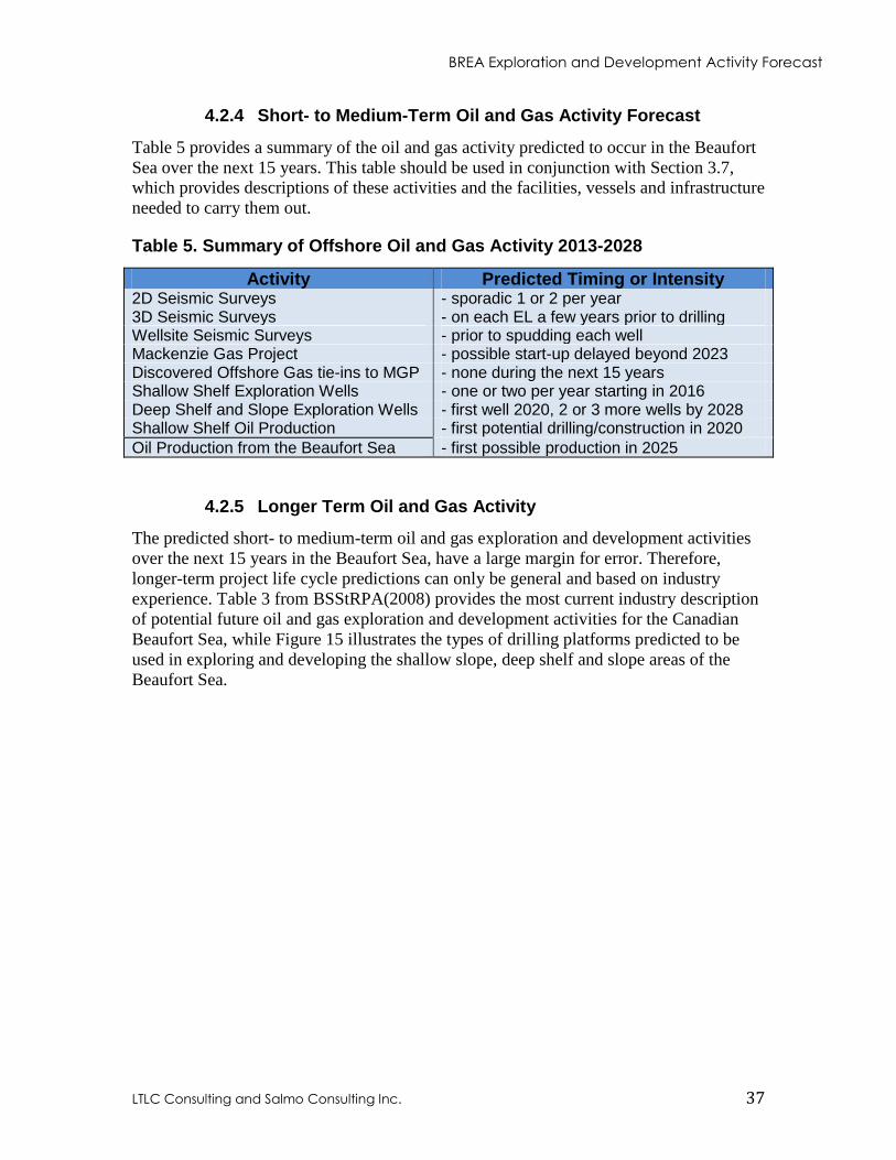
BREA Exploration and Development Activity Forecast
LTLC Consulting and Salmo Consulting Inc. 37
4.2.4 Short- to Medium-Term Oil and Gas Activity Forecast
Table 5 provides a summary of the oil and gas activity predicted to occur in the Beaufort
Sea over the next 15 years. This table should be used in conjunction with Section 3.7,
which provides descriptions of these activities and the facilities, vessels and infrastructure
needed to carry them out.
Table 5. Summary of Offshore Oil and Gas Activity 2013-2028
Activity Predicted Timing or Intensity 2D Seismic Surveys - sporadic 1 or 2 per year 3D Seismic Surveys - on each EL a few years prior to drilling Wellsite Seismic Surveys - prior to spudding each well Mackenzie Gas Project - possible start-up delayed beyond 2023 Discovered Offshore Gas tie-ins to MGP - none during the next 15 years Shallow Shelf Exploration Wells - one or two per year starting in 2016 Deep Shelf and Slope Exploration Wells - first well 2020, 2 or 3 more wells by 2028 Shallow Shelf Oil Production - first potential drilling/construction in 2020
Oil Production from the Beaufort Sea - first possible production in 2025
4.2.5 Longer Term Oil and Gas Activity
The predicted short- to medium-term oil and gas exploration and development activities
over the next 15 years in the Beaufort Sea, have a large margin for error. Therefore,
longer-term project life cycle predictions can only be general and based on industry
experience. Table 3 from BSStRPA(2008) provides the most current industry description
of potential future oil and gas exploration and development activities for the Canadian
Beaufort Sea, while Figure 15 illustrates the types of drilling platforms predicted to be
used in exploring and developing the shallow slope, deep shelf and slope areas of the
Beaufort Sea.
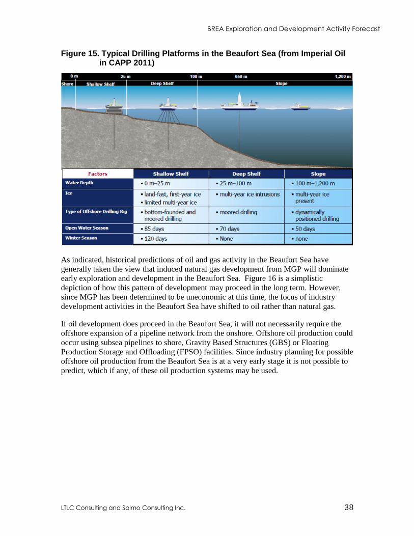
BREA Exploration and Development Activity Forecast
LTLC Consulting and Salmo Consulting Inc. 38
Figure 15. Typical Drilling Platforms in the Beaufort Sea (from Imperial Oil in CAPP 2011)
As indicated, historical predictions of oil and gas activity in the Beaufort Sea have
generally taken the view that induced natural gas development from MGP will dominate
early exploration and development in the Beaufort Sea. Figure 16 is a simplistic
depiction of how this pattern of development may proceed in the long term. However,
since MGP has been determined to be uneconomic at this time, the focus of industry
development activities in the Beaufort Sea have shifted to oil rather than natural gas.
If oil development does proceed in the Beaufort Sea, it will not necessarily require the
offshore expansion of a pipeline network from the onshore. Offshore oil production could
occur using subsea pipelines to shore, Gravity Based Structures (GBS) or Floating
Production Storage and Offloading (FPSO) facilities. Since industry planning for possible
offshore oil production from the Beaufort Sea is at a very early stage it is not possible to
predict, which if any, of these oil production systems may be used.
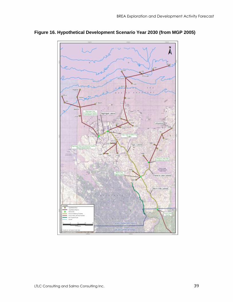
BREA Exploration and Development Activity Forecast
LTLC Consulting and Salmo Consulting Inc. 39
Figure 16. Hypothetical Development Scenario Year 2030 (from MGP 2005)
BREA Exploration and Development Activity Forecast
LTLC Consulting and Salmo Consulting Inc. 40
5. MACKENZIE DELTA - BEAUFORT SEA HYDROCARBON RESOURCE POTENTIAL
The literature contains a number of estimates of discovered and potential oil and gas
resources in the Mackenzie Delta and the Beaufort Sea. These include:
NEB (1998) a probabilistic estimate of discovered recoverable oil and marketable gas
for each field in the Mackenzie Delta/Beaufort Sea
Canadian Gas Potential Committee (CGPC) (2005) an estimate of discovered and
undiscovered gas resources in the combined Beaufort Sea/Mackenzie Delta
Chen et al. (2007) an estimate of future oil discovery potential of the
Mackenzie/Beaufort Geological Province
Drummond (2009) an estimate of distribution of ultimate oil and gas resources in the
onshore and offshore areas of the Mackenzie/Beaufort Basin.
The discovered recoverable oil resource in the combined Mackenzie Delta/Beaufort Sea
is between 1bbl (159 106m
3)(NEB 1998) and 1.2bbl (183 10
6m
3)(Chen et al. 2007) and
the total recoverable oil resource may be as high as 10.6bbl (1691 106m
3)(Chen et al.
2007). The majority of the discovered oil reserves are located in the Beaufort Sea
offshore.
The estimated discovered marketable gas resource in the Mackenzie Delta and Beaufort
Sea is between 9tcf (254.8 109m
3)(CPGC 2005) and 10.4tcf (294.5 10
9m
3)(Drummond
2009) and the ultimate marketable gas resource may be as high as 56.9tcf (1611.2
109m
3)(Drummond 2009). Discovered gas reserves are relatively evenly distributed
between the Mackenzie Delta and the Beaufort Sea. Table 6 provides a summary of the
regions currently estimated oil and gas potential.
Table 4. Mackenzie Delta and Beaufort Sea Oil and Gas Resource Potential
Resource Current Estimate
Discovered Recoverable Oil Resource - 1 to 1.2bbl (159 to 183 106m
3)
Total Recoverable Oil Resource - 10.6bbl (1691 106m
3)
Discovered Marketable Gas Resource - 9 to 10.4tcf (254.8 to 294.5 109m
3)
Ultimate Marketable Gas Resource - 56.9tcf (1611.2 109m
3)
It is important to note that the Mackenzie Delta/Beaufort Sea Geological Province is still
in an early stage of exploration. Chen et al. (2007) states, “It is expected that there will be
both increased data and understanding that will lead to new large discoveries in the more
remote areas and deeper parts of the sedimentary succession as the scope of exploration
expands both geographically and technologically”. As can be seen in Figure 17 the deep
slope region of the Beaufort Sea has not been explored or assessed. The issuance of ELs
with high value work commitments there (Figure 11 and Table 4) is a strong indication
that industry believes this area has the potential to hold large accumulations of
hydrocarbons.
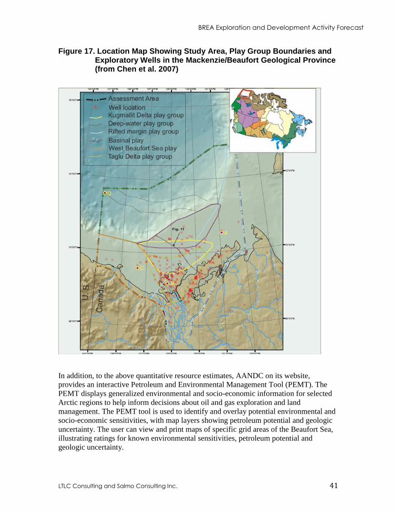
BREA Exploration and Development Activity Forecast
LTLC Consulting and Salmo Consulting Inc. 41
Figure 17. Location Map Showing Study Area, Play Group Boundaries and Exploratory Wells in the Mackenzie/Beaufort Geological Province (from Chen et al. 2007)
In addition, to the above quantitative resource estimates, AANDC on its website,
provides an interactive Petroleum and Environmental Management Tool (PEMT). The
PEMT displays generalized environmental and socio-economic information for selected
Arctic regions to help inform decisions about oil and gas exploration and land
management. The PEMT tool is used to identify and overlay potential environmental and
socio-economic sensitivities, with map layers showing petroleum potential and geologic
uncertainty. The user can view and print maps of specific grid areas of the Beaufort Sea,
illustrating ratings for known environmental sensitivities, petroleum potential and
geologic uncertainty.
BREA Exploration and Development Activity Forecast
LTLC Consulting and Salmo Consulting Inc. 42
6. REFERENCES
AANDC (Aboriginal Affairs and Northern Development Canada). 2010. Northern Oil and
Gas Annual Report 2010. QS‐8509‐110‐EE‐A1.
AANDC (Aboriginal Affairs and Northern Development Canada). 2011. Map of Oil & Gas
Dispositions Beaufort Sea & Mackenzie Delta. Northern Oil and Gas Branch.
September 2011.
Axys Environmental Consulting. 1995. Beaufort Region Environmental Assessment and
Monitoring Program draft report for 1993/1994. Prepared for Indian Affairs and
Northern Development Canada and Dept. of Fisheries and Oceans Canada.
ESL Environmental Sciences Limited and Seakem Oceanography Ltd. 1988. Beaufort
Environmental Monitoring Project 1987-1988 final report. Prepared for Dept. of
Indian Affairs and Northern Development and Environment Canada. R71-19/60-
1989E
BSStRPA 2008 Beaufort Sea Strategic Regional Plan of Action. April 2008.
CAPP (Canadian Association of Petroleum Producers). 2009. Beaufort Regional
Environmental Reports Summary. Prepared by LTLC Consulting in association with
Salmo Consulting Inc. December 2009. Report 2009-0032.
CAPP (Canadian Association of Petroleum Producers). 2011. Potential Oil and Gas
Activities in the Beaufort. Presentation to NEB Arctic Offshore Drilling Review
Sept. 12-16, 2011.
Chen Z., Osadetz K.G., Dixon J., Morrell G., and J.R. Dietrich 2007 Geological Survey of
Canada. Oil and Gas Management Directorate. Northern Oil and Gas Branch. Indian
and Northern Affairs Canada. Natural Resources Canada. Poster of The Future Oil
Discovery Potential of the Mackenzie/Beaufort Province 2007.
CPGC (Canadian Potential Gas Committee). 2006. Natural Gas Potential in Canada Volume
1. 2005. ISBN 0-9682125-3-0.
Crooks D. and G. Chazan. 2012. Energy: Drills, chills and spills. Financial Times.
September 4, 2012.
Dixit B. 2009. Regulation of Oil and Gas Activities in the Canadian Beaufort Sea.
Presentation to the MMS Arctic Technologies Workshop October 13, 2009
Anchorage, Alaska, U.S.A.
Drummond K.J. 2009. Northern Canada Distribution of Ultimate Oil and Gas Resources.
Prepared for Northern Oil and Gas Branch. Indian and Northern Affairs Canada
March 2009.
BREA Exploration and Development Activity Forecast
LTLC Consulting and Salmo Consulting Inc. 43
Erlandson and Associates with Jessie Sloan. 2002. Oil and Gas Approvals in the Beaufort
Sea. Regulatory Road Maps Project. Prepared for Indian Affairs and Northern
Development Canada and the Canadian Association of Petroleum Producers. June
2002.
GLJ (Gilbert, Laustsen, Jung Associates Ltd.). 2004. Mackenzie Gas Project. Gas Resource
and Supply Study. Prepared for Imperial Oil Resources Ventures Limited. Effective
May 1, 2004. 1035917.
KAVIK-AXYS Inc. and FMA Heritage Resources Consultants Inc. 2008. Biophysical
Research Requirements for Beaufort Sea Hydrocarbon Development. Prepared for
Environmental Studies Research Fund. August 2008. Report No. 163.
Headwater Group. 2006. Oil and Gas Exploration & Development Activity Forecast
Northwest Territories 2007-2016. Prepared for Indian and Northern Affairs Canada
IAGC (International Association of Geophysical Contractors). 2002. Marine Seismic
Operations. An Overview March 2002.
INAC (Indian and Northern Affairs Canada). 2007. Draft #5 Towards a View of Future Oil
and Gas Development in the Mackenzie Valley, Delta and the Beaufort Sea. Revised
September 7, 2007. Submitted to the Joint Review Panel for the Mackenzie Gas
Project in INAC Response to Undertaking J-U-00225.
IORVL (Imperial Oil Resources Ventures Limited). 2005. Mackenzie Gas Project.
Environmental Impact Statement Additional Information. Submitted to the Joint
Review Panel. March 2005. IPROCC.PR.2005.02.
IORVL (Imperial Oil Resources Ventures Limited). 2010. Beaufort Exploration Licence
446 (Ajurak) Submission Regarding the Relief Well Policy for Offshore Drilling in
Arctic Waters. Submitted to the National Energy Board March 2010.
IPRCC.PR.2010.06.
IORVL (Imperial Oil Resources Ventures Limited). 2012. Beaufort Sea Exploration Joint
Venture. Preliminary Information Package. December 2012. IPRCC.PR.2012.01
Morrell G. 2005. Beaufort Sea Oil and Gas Development. Presentation to the Beaufort Sea
Strategic Regional Plan Workshop for Northern Oil and Gas Branch, INAC. March
2005
Morrell G. 2007. Input to Discussion on Beaufort Sea Development Scenarios. Prepared by
G. Morrell, INAC/Northern Oil and Gas. In the Beaufort Sea Strategic Regional
Plan of Action Appendix IV: Industry Activity Scenario. June 27, 2007
NEB (National Energy Board). 1998. Probabilistic Estimate of Hydrocarbon Volumes in the
Mackenzie Delta and Beaufort Sea Discoveries. January 1998. Cat. No. NE23-
78/1998E.
BREA Exploration and Development Activity Forecast
LTLC Consulting and Salmo Consulting Inc. 44
NEB (National Energy Board). 2011a. The Past is Always Present, Review of Offshore
Drilling in the Canadian Arctic Preparing for the Future. December 2011. Cat. No.
NE23-167/2011E
NEB (National Energy Board). 2011b. National Energy Board. Filing Requirements for
Offshore Drilling in the Canadian Arctic. December 2011. Cat. No. NE23-167/1-
2011E
Peterson G.D., G.S. Cumming., and S.R. Carpenter. 2003. Scenario Planning: a Tool for
Conservation in an Uncertain World. Conservation Biology. 17: 358-366.
Timco G.W. and M.E. Johnston. 2002. Caisson Structures in the Beaufort Sea 1982-1990
Characteristics, Instrumentation and Ice Loads. Canadian Hydraulics Centre.
National Research Council of Canada. Technical Report November 2002. CHC-TR-
003.
Timco G.W. and R. Frederking. 2009. Overview of Historical Canadian Beaufort Sea
Information. NRC Canadian Hydraulic Centre Technical Report February 2009.
CHC-TR-057.
Wright & Associates Ltd. 2000. Full Scale Experience with Kulluk Stationkeeping
Operations in Pack Ice. Prepared for the National Research Council of Canada July
2000. PERD/CHC Report 25-44.