Embed Size (px)
Citation preview

www.IASbaba.com Page 1
PRELIMS EXCLUSIVE PROGRAMME (PEP)-2020

www.IASbaba.com Page 2
PRELIMS EXCLUSIVE PROGRAMME (PEP)-2020
GEOGRAPHY
TOPICS - Drainage System (River System), Indian climate (Monsoons, ElNino, La-Nina, Indian Ocean Dipole), Distribution of rainfall
BASIC CONCEPTS
• Drainage - The flow of water through well-defined channels is known as ‘drainage’.
• Drainage system - The network of such channels is called a ‘drainage system’.
• Catchment area - A river drains the water collected from a specific area, which is called its ‘catchment area’.
• Drainage basin – Anareadrainedbyariveranditstributariesis called a drainage basin.
• Watershed - The boundary line separating one drainage basin from the other is known as the watershed.
• The catchments of large rivers - river basins while those of small rivulets and rills are often referred to as watersheds.
• There is, however, a slight difference between a river basin and a watershed. Watersheds are small in area while the basins cover larger areas. But both are marked by unity
TYPES OF DRAINAGE PATTERN
• Dendritic patterns - develop in areas where the rock (or unconsolidated material) beneath the stream has no particular fabric or structure and can be eroded equally easily in all directions.
• Trellis drainage patterns - typically develop where sedimentary rocks have been folded or tilted and then eroded to varying degrees depending on their strength.
• Rectangular patterns - develop in areas that have very little topography and a system of bedding planes, fractures, or faults that form a rectangular network.
• Parallel drainage system - pattern of rivers caused by steep slopes with some relief. Because of the steep slopes, the streams are swift and straight, with very few tributaries, and all flow in the same direction.

www.IASbaba.com Page 3
PRELIMS EXCLUSIVE PROGRAMME (PEP)-2020
• Radial drainage system - the streams radiate outwards from a central high point. Volcanoes usually display excellent radial drainage.
• Centripetal drainage system - Similar to the radial drainage system, with the only exception that radial drainage flows out versus centripetal drainage flows in
• Deranged drainage system - drainage system in drainage basins where there is no coherent pattern to the rivers and lakes. It happens in areas where there has been much geological disruption.
• Angular drainage patterns - form where bedrock joints and faults intersect at more acute angles than rectangular drainage patterns. Angles are both more and less than 90 degrees
ABOUT INDIAN DRAINAGE SYSTEM On the basis of discharge of water. And these are divided by Delhi ridge, Aravalli and Western Ghat.
• Arabian Sea drainage (23% drainage) – Indus, Narmada, Tapi, Sabarmati, west flowing small rivers.
• Bay of Bengal drainage (77% drainage) – all major east flowing rivers On the basis of the size of the watershed
• Major river basins with more than 20000sq.km. –it includes 14 major rivers
• Medium river basins with 2000 to 20000sq.km. – includes 44 rivers
• Minor river basins with less than 2000 sq.km On the basis of mode of origin
• Himalayan drainage
• Peninsular drainage

www.IASbaba.com Page 4
PRELIMS EXCLUSIVE PROGRAMME (PEP)-2020
HIMALAYAN DRAINAGE SSYTEM Evolution of the Himalayan drainage
• Belief that there was a mighty river known as Shiwalik or Indo– Brahma traversed the entire longitudinal extent of the Himalaya from Assam to Punjab and onwards to Sind, and finally discharged into the Gulf of Sind near lower Punjab during the Miocene period some 5-24 million years ago.
• Later on, this got divided into three river systems of Ganges, Indus and Brahmaputra.
Two factors responsible for the break
• Upheaval in western Himalayas including upliftment of Potwar plateau leading to separation of Ganges and Indus
• Downtrusting of Malda gap area between Rajmahal hills and Meghalaya plateau leading to flow towards Bay of Bengal

www.IASbaba.com Page 5
PRELIMS EXCLUSIVE PROGRAMME (PEP)-2020
The River Systems of the Himalayan drainage
Indus River System - Area 11,65,000 sq.km. (In India – 321,289 sq.km.)
Indus • Length – 2880 km (in India -1114 km)
• Origin – Bokhar Chu glacier (31°15' N latitude and 81°40' E longitude), in Kailas range in Tibet at 4164 mtrs altitude
• Known as Singi Khmban
• also known as the Sindhu
• the westernmost of the Himalayan rivers in India.
• After flowing in the northwest direction between the Ladakh and Zaskar ranges, it passes through Ladakh and Baltistan.
• It cuts across the Ladakh range, forming a spectacular gorge near Gilgit in Jammu and Kashmir.
www.IASbaba.com Page 6
PRELIMS EXCLUSIVE PROGRAMME (PEP)-2020
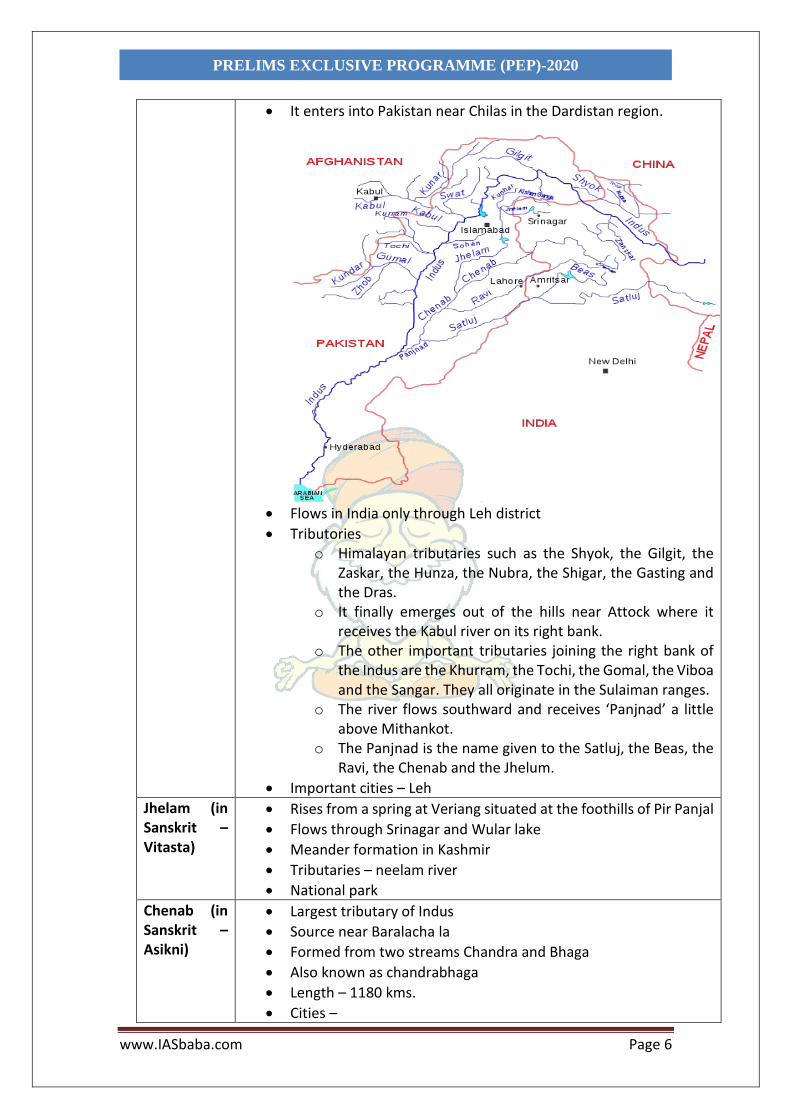
• It enters into Pakistan near Chilas in the Dardistan region.
• Flows in India only through Leh district
• Tributories o Himalayan tributaries such as the Shyok, the Gilgit, the
Zaskar, the Hunza, the Nubra, the Shigar, the Gasting and the Dras.
o It finally emerges out of the hills near Attock where it receives the Kabul river on its right bank.
o The other important tributaries joining the right bank of the Indus are the Khurram, the Tochi, the Gomal, the Viboa and the Sangar. They all originate in the Sulaiman ranges.
o The river flows southward and receives ‘Panjnad’ a little above Mithankot.
o The Panjnad is the name given to the Satluj, the Beas, the Ravi, the Chenab and the Jhelum.
• Important cities – Leh
Jhelam (in Sanskrit –Vitasta)
• Rises from a spring at Veriang situated at the foothills of Pir Panjal
• Flows through Srinagar and Wular lake
• Meander formation in Kashmir
• Tributaries – neelam river
• National park
Chenab (in Sanskrit –Asikni)
• Largest tributary of Indus
• Source near Baralacha la
• Formed from two streams Chandra and Bhaga
• Also known as chandrabhaga
• Length – 1180 kms.
• Cities –

www.IASbaba.com Page 7
PRELIMS EXCLUSIVE PROGRAMME (PEP)-2020
• Dams –baglihar, Ratle
Ravi (Sanskrit -Parushni)
• Rises from west of the Rohtang pass inthe Kullu hills of Himachal Pradesh and flows through the Chamba valley of the state.
• Tributaries – Budhil,nai, Seul, tantgiri
• Dams on Ravi – Ranjit sagar dam
• Religious places - Manimahesh kailash peak and Manimahesh lake
Beas • Originating from the Beas Kund near the Rohtang Pass at an elevation of 4,000 m above the mean sea level.
• Flows through the Kullu valley and forms gorges at Kati and Largi in the Dhaoladhar range.
• It enters the Punjab plains where it meets the Satluj near Harike.
• Dams – pong
Sutlej • Originates in the ‘Raksastal’ near Mansarovar at an altitude of 4,555 m in Tibet where it is known as Langchen Khambab.
• It flows almost parallel to the Indus for about 400 km before entering India, and comes out of a gorge at Rupar.
• It passes through the Shipki La on the Himalayan ranges and enters the Punjab plains. It is an antecedent river. It is a very important tributary as it feeds the canal system of the Bhakra Nangal project.
• Dams – Bhakra Nangal
• Ecosystem related – Roper wetland
Ganges River System o It is shared by Uttarakhand (110 km) and Uttar Pradesh (1,450 km), Bihar (445
km) and West Bengal (520 km). o Basin covers about 8.6 lakh sq. km area in India alone. o The largest in India having a number of perennial and non-perennial rivers
originating in the Himalayas in the north and the Peninsula in the south, respectively.
Ganges • Its length - 2,525 km
• It rises in the Gangotri glacier near Gaumukh (3,900 m) in the Uttarkashi district of Uttarakhand. Here, it is known as the Bhagirathi.
• At Devprayag, the Bhagirathi meets the Alaknanda; hereafter, it is known as the Ganga.
• The Alaknanda has its source in the Satopanth glacier above Badrinath. The Alaknanda consists of the Dhauli and the Vishnu Ganga which meet at Joshimath or Vishnu Prayag.
• The other tributaries of Alaknanda such as the Pindar joins it at Karna Prayag while Mandakini or Kali Ganga meets it at Rudra Prayag.
• Five Prayags of Ganga o A shortcut J(K)RD based on the name of JRD Tata to identify
prayags

www.IASbaba.com Page 8
PRELIMS EXCLUSIVE PROGRAMME (PEP)-2020
o J – joshimath/vishnuprayag, K – karnprayag, R – Rudraprayag , D – Devprayag
• Enters the plains at Haridwar.
• Gets divided into two distributaries Padma (enters into Bangladesh) and Bhagirathi
• Tributaries
o Right bank tributories – Yamuna, Son, Damodar o Left bank tributories–Ramganga, Gomati, Ghaghra,
Gandak, Kosi, Mahananda
• The river finally discharges itself into the Bay of Bengal near the Sagar Island.
• Dams–Tehri on Bhagirathi, Farakka barrage
Yamuna
• Western most and longest tributary of Ganga
• has its source in the Yamunotri glacier on the western slopes of Banderpunch range (6,316 km).
• It joins the Ganga at Prayag (Allahabad).
• Right bank tributaries - Chambal, the Sind, the Betwa and the Ken on its right bank which originates from the Peninsular plateau
• Left bank tribuories - the Hindan, the Rind, the Sengar, the Varuna, etc. join it on its left bank.

www.IASbaba.com Page 9
PRELIMS EXCLUSIVE PROGRAMME (PEP)-2020
Chambal • Rises near Mhow in the Malwa plateau of Madhya Pradesh
• Flows northwards through a gorge up wards of Kota in Rajasthan, where the Gandhisagar dam has been constructed.
• From Kota, it traverses down to Bundi, Sawai Madhopur and Dholpur, and finally joins the Yamuna.
• The Chambal is famous for its badland topography called the Chambal ravines.
Gandak • comprises two streams, namely Kaligandak and Trishulganga.
• rises in the Nepal Himalayas between the Dhaulagiri and Mount Everest and drains the central part of Nepal.
• It enters the Ganga plain in Champaran district of Bihar and joins the Ganga at Sonpur near Patna.

www.IASbaba.com Page 10
PRELIMS EXCLUSIVE PROGRAMME (PEP)-2020
Ghagara • Originates in the glaciers of Mapchachungo.
• After collecting the waters of its tributaries – Tila, Seti and Beri, it comes out of the mountain, cutting a deep gorge at Shishapani.
• The river Sarda (Kali or Kali Ganga) joins it in the plain before it finally meets the Ganga at Chhapra.
Kosi • The Kosi is an antecedent river with its source to the north of Mount Everest in Tibet, where its main stream Arun rises.
• it is joined by the Son Kosi from the West and the Tamur Kosi from the east.
• It forms Sapt Kosi after uniting with the river Arun.
Ramganga • Rises in the Garhwal hills near Gairsain.
• It changes its course to the southwest direction after crossing the Shiwalik

www.IASbaba.com Page 11
PRELIMS EXCLUSIVE PROGRAMME (PEP)-2020
• Finally, it joins the Ganga near Kannauj.
Damodar • Damodar occupies the eastern margins of the Chotanagpur Plateau
• it flows through a rift valley and finally joins the Hugli.
• The Barakar is its main tributary.
• Once known as the ‘sorrow of Bengal’.
Sarda / sharyu
• The Sarda or Saryu river rises in the Milam glacier in the Nepal Himalayas where it is known as the Goriganga.
• Along the Indo-Nepal border, it is called Kali or Chauk, where it joins the Ghaghara.
Mahananda • rises in the Darjiling hills.
• It joins the Ganga as its last left bank tributary in West Bengal.
Son • The Son is a large south bank tributary of the Ganga,
• originates in the Amarkantak plateau.
• After forming a series of waterfalls at the edge of the plateau, it reaches Arrah, west of Patna, to join the Ganga
Brahmaputra Drainage System
Brahmaputra • Origin in the Chemayungdung glacier of the Kailash range near the Mansarovar lake.
• From here, it traverses eastward longitudinally for a distance of nearly 1,200 km in a dry and flat region of southern Tibet, where it is known as the Tsangpo, which means ‘the purifier.’
• The Rango Tsangpo is the major right bank tributary of this river in Tibet.
• It emerges as a turbulent and dynamic river after carving out a deep gorge in the Central Himalayas near NamchaBarwa (7,755 m).
• The river emerges from the foothills under the name of Siang or Dihang. It enters India west of Sadiya town in Arunachal Pradesh. Flowing southwest, it receives its main left bank tributaries, viz., Dibang or Sikang and Lohit; thereafter, it is known as the Brahmaputra.
• Its major left bank tributaries are the Burhi Dihing and Dhansari (South)
• Important right bank tributaries are the Subansiri, Kameng, Manas and Sankosh.
• The Subansiri which has its origin in Tibet, is an antecedent river.
• The Brahmaputra enters into Bangladesh near Dhubri and flows southward.
• In Bangladesh, the Tista joins it on its right bank from where the river is known as the Jamuna.

www.IASbaba.com Page 12
PRELIMS EXCLUSIVE PROGRAMME (PEP)-2020
• It finally merges with the river Padma.
PENINSULAR RIVER DRAINAGE
• The Peninsular drainage system is older than the Himalayan one, which is
evident from the broad, largely-graded shallow valleys, and the maturity of the
rivers.
• The Western Ghats act as the water divide between the major Peninsular
rivers, discharging their water in the Bay of Bengal and as small rivulets joining
the Arabian Sea.
• Most of the major Peninsular rivers except Narmada and Tapi flow from west
to east.
• The Chambal, the Sind, the Betwa, the Ken, the Son, belong to the Ganga river
system.
• Characterised by fixed course, absence of meanders and non- perennial flow
of water.
www.IASbaba.com Page 13
PRELIMS EXCLUSIVE PROGRAMME (PEP)-2020
Evolution of the Peninsular Drainage System Three major geological events important:
Subsidence of the western flank of the Peninsula
o leading to its submergence below the sea during the early tertiary period.
o Disturbance of the symmetrical plan of the river on either side of the original watershed
Upheaval of the Himalayas
o When the northern flank of the Peninsular block was subjected to subsidence and the consequent trough faulting.
o The Narmada and The Tapi flow in trough faults and fill the original cracks with their detritus materials. Hence, there is a lack of alluvial and deltaic deposits in these rivers.
Slight tilting of the Peninsular block
o From northwest to the southeastern direction gave orientation to the entire drainage system towards the Bay of Bengal during the same period.
River Systems of the Peninsular Drainage
Mahanadi o Rises near Sihawa in Raipur district of Chhattisgarh and runs through Odisha
o It is 851 km long and its catchment area spreads over 1.42 lakh sq. km.
o Some navigation is carried on in the lower course of this river.
o Fifty-three per cent of the drainage basin of this river lies in Madhya Pradesh and Chhattisgarh, while 47 per cent lies in Odisha.
Godavari o The largest Peninsular river system. o Also called the Dakshin Ganga. o It rises near Trambakeshwarin the Nasik district of
Maharashtra o Discharges its water into the Bay of Bengal. Its tributaries
run through the states of Maharashtra, Madhya Pradesh, Chhattisgarh, Odisha and Andhra Pradesh.
o It is 1,465 km long with a catchment area spreading over 3.13lakh sq. km 49 per cent of this, lies in Maharashtra, 20 per cent in Madhya Pradesh and Chhattisgarh, and the rest inTelangana and Andhra Pradesh.
o Tributaries - The Penganga, the Indravati, the Pranhita, and the Manjra,Purna , wainganga, Wardha
o Subjected to heavy floods in its lower reaches to the south of Polavaram, where it forms a picturesque gorge.
o Navigable only in the deltaic stretch.

www.IASbaba.com Page 14
PRELIMS EXCLUSIVE PROGRAMME (PEP)-2020
o The river after Rajamundri splits into several branches forming a large delta.
Krishna o The second largest east- flowing Peninsular river which rises near Mahabaleshwar in Sahyadri.
o Its total length is 1,401 km. o The Koyna, the Tungbhadra, Ghataprabha and the Bhima
are its major tributaries. o Of the total catchment area of the Krishna, 27 per cent lies
in Maharashtra, 44 per cent in Karnataka and 29 per cent in Andhra Pradesh and Telangana.
Kaveri o Rises in Brahmagiri hills (1,341m) of Kogadu district in Karnataka.
o Its length is 800 km and it drains an area of 81,155 sq. km. o It has water throughout the year as the upper catchment
area receives rainfall during the southwest monsoon season (summer) and the lower part during the northeast monsoon season (winter)
o About 3 per cent of the Kaveri basin falls in Kerala, 41 per cent in Karnataka and 56 per cent in Tamil Nadu.
o Tributaries -Kabini, the Bhavani, Hemavati and the Amravati.
Narmada o Originates on the western flank of the Amarkantak plateau at a height of about 1,057 m.
o Flowing in a rift valley between the Satpura in the south and the Vindhyan range in the north, it forms a picturesque gorge in marble rocks and Dhuandhar waterfall near Jabalpur.
o After flowing a distance of about 1,312 km, it meets the Arabian sea south of Bharuch, forming a broad 27 km long estuary.
o Its catchment area is about 98,796 sq. km. o The Sardar Sarovar Project has been constructed on this
river.
Tapi o Another important westward flowing river. o It originates from Multai in the Betul district of Madhya
Pradesh. o It is 724 km long and drains an area of 65,145 sq. km. o Nearly 79 per cent of its basin lies in Maharashtra, 15 per
cent in Madhya Pradesh and the remaining 6 per cent in Gujarat.
o
Luni o Largest river system of Rajasthan, west of Aravali. o Originates near Pushkar in two branches, i.e. the
Saraswati and the Sabarmati, which join with each other at Govindgarh.

www.IASbaba.com Page 15
PRELIMS EXCLUSIVE PROGRAMME (PEP)-2020
o From here, the river comes out of Aravali and is known as Luni.
o The entire river system is ephemeral.
Smaller Rivers flowing to the West
• The rivers flowing towards the Arabian sea have short courses.
• The Shetruniji rises near Dalkahwa in Amreli district of Gujrat.
• The Bhadra originates near Aniali village in Rajkot district of Gujrat.
• The Dhadhar rises near Ghantar village in Panchmahal district of Gujrat.
• Sabarmati and Mahi are the two famous rivers of Gujarat.
• The Vaitarna rises from the Trimbak hills in Nasik district of Maharashtra at an
elevation of 670 m.
• The Kalinadi rises from Belgaum district of Karnataka and falls in the Karwar
Bay.
• The source ofBedti river lies in Hubli Dharwarof Karnataka and traverses a
course of 161 km.
• The Sharavati is another important river in Karnataka flowing towards the
west. The Sharavati originates in Shimoga district of Karnataka and drains a
catchment area of 2,209 sq. km.
• Goa has two important rivers which can be mentioned here. One is Mandovi
and the other is Juari.
• The longest river of Kerala, Bharathapuzha rises near Annamalai hills. It is also
known as Ponnani. It drains an area of 5,397 sq. km.
• The Periyar is the second largest river of Kerala. Its catchment area is 5,243 sq.
km. Another river of Kerala is the Pamba river which falls in the Vemobanad
lake after traversing a course of 177 km.
Small Rivers Flowing towards the East
• Subarnrekha -The Subarnarekha River (also called the Swarnarekha River)
flows through the Indian states of Jharkhand, West Bengal and Odisha.
• Baitarni - A major portion of the river basin lies within the state of Odisha,
while a small patch of the upper reach lies in Jharkhand state.
• Brahmani - Major river in the Odisha. Formed by the confluence of the Sankh
and South Koel rivers. Together with the river Baitarani, it forms a large delta
before emptying into the Bay of Bengal at Dhamra.
• Vamsadhara –Also known as river Banshadhara is an important east flowing
river between Rushikulya and Godavari, in Odisha and Andhra Pradesh states
in India.

www.IASbaba.com Page 16
PRELIMS EXCLUSIVE PROGRAMME (PEP)-2020
• Penner - The Penna rises in Nandi Hills in Chikballapur District of Karnataka
state, and runs north and east through the states of Karnataka and Andhra
Pradesh to empty into the Bay of Bengal.
• Palar - It rises in the Nandi Hills in Chikkaballapura district of Karnataka
state,[1] and flows 93 kilometres (58 mi) in Karnataka, 33 kilometres (21 mi) in
Andhra Pradesh and 222 kilometres (138 mi) in Tamil Nadu before reaching its
confluence into the Bay of Bengal
• Vaigai - The Vaigai is a river in the Tamil Nadu state of southern India; it passes
through the towns of Theni, Andipatti and Madura
River Regime
• The pattern of flow of water in a river channel over a year is known as its
regime.
• Regime of the rivers of South India is controlled by rainfall
• North Indian rivers are perennial in nature
Comparison of Himalayan and Peninsular Rivers

www.IASbaba.com Page 17
PRELIMS EXCLUSIVE PROGRAMME (PEP)-2020
FACTORS DETERMINING THE CLIMATE OF INDIA India’s climate is controlled by a number of factors which can be broadly divided into two groups Factors related to Location and Relief
Latitude • The Tropic of Cancer passes through the central part of India in east-west direction.
• Northern part of the India lies in sub-tropical and temperate zone and the part lying south of the Tropic of Cancer falls in the tropical zone.
• The tropical zone being nearer to the equator, experiences high temperatures throughout the year with small daily and annual range. Area north of the Tropic of Cancer being away from the equator, experiences extreme climate with high daily and annual range of temperature.
The Himalayan Mountains
• Act as an effective climatic divide.
• Provides an invincible shield to protect the subcontinent from the cold northern winds.
• The Himalayas also trap the monsoon winds, forcing them to shed their moisture within the subcontinent.
Distribution of Land and Water
• India is flanked by the Indian Ocean on three sides in the south and girdled by a high and continuous mountain-wall in the north.
• As compared to the landmass, water heats up or cools down slowly.
• This differential heating of land and sea creates different air pressure zones in different seasons in and around the Indian subcontinent.
• Difference in air pressure causes reversal in the direction of monsoon winds.
Distance from the Sea
• With a long coastline, large coastal areas have an equable climate.
• Areas in the interior of India are far away from the moderating influence of the sea. Such areas have extremes of climate.
• For example, the people of Mumbai and the Konkan coast have hardly any idea of extremes of temperature and the seasonal rhythm of weather. On the other hand, the seasonal contrasts in weather at places in the interior of the country such as Delhi, Kanpur and Amritsar affect the entire sphere of life.

www.IASbaba.com Page 18
PRELIMS EXCLUSIVE PROGRAMME (PEP)-2020
Altitude • Temperature decreases with height. For example, Agra and Darjiling are located on the same latitude, but temperature of January in Agra is 16°C whereas it is only 4°C in Darjiling.
Relief • The physiography or relief of India also affects the temperature, air pressure, direction and speed of wind and the amount and distribution of rainfall. The windward sides of Western Ghats and Assam receive high rainfall during June-September whereas the southern plateau remains dry due to its leeward situation along the Western Ghats.
Factors Related to Air Pressure and Wind To understand the differences in local climates of India, we need to understand the mechanism of the following three factors:
Distribution of air pressure and winds on the surface of the earth.
Upper air circulation caused by factors controlling global weather and the inflow of different air masses and jet streams.
Inflow of western cyclones generally known as disturbances during the winter season and tropical depressions during the south-west monsoon period into India, creating weather conditions favourable to rainfall.
The mechanism of these three factors can be understood with reference to winter and summer seasons of the year separately. Mechanism of Weather in the Winter Season
Winter mechanism (winter months Summer mechanism (summer months)
Surface Pressure and Winds
• This mechanism takes place at surface level
• Influenced by the distribution of pressure in Central and Western Asia.
• A high-pressure centre in the region lying to the north of the Himalayas develops
• This centre gives rise to the flow of air at the low level from the north towards the Indian subcontinent, south of the mountain range.
• The surface winds blowing out of the high-pressure centre over Central Asia
• As the summer sets in and the sun shifts northwards, the wind circulation over the subcontinent undergoes a complete reversal at both, the lower as well as the upper levels.
• By the middle of July, the low-pressure belt nearer the surface [termed as Inter Tropical Convergence Zone (ITCZ)] shifts northwards, roughly parallel to the Himalayas between 20° N and 25° N.

www.IASbaba.com Page 19
PRELIMS EXCLUSIVE PROGRAMME (PEP)-2020
reach India in the form of a dry continental air mass.
• These continental winds come in contact
• with trade winds over northwestern India. The position of this contact zone is not, however, stable.
• By this time, the westerly jet stream withdraws from the Indian region.
• In fact, meteorologists have found an interrelationship between the northward shift of the equatorial trough (ITCZ) and the withdrawal of the westerly jet stream from over the North Indian Plain.
• The ITCZ attracts inflow of winds from different directions.
• The maritime tropical airmass (mT) from the southern hemisphere, after crossing the equator, rushes to the low-pressure area in the general southwesterly direction. It is this moist air current which is popularly known as the southwest monsoon.
Jet Stream and Upper Air Circulation
• Higher up in the lower troposphere, about three km above the surface of the earth, a different pattern of air circulation is observed.
• The variations in the atmospheric pressure closer to the surface of the earth have no role to play in the making of upper air circulation.
• All of Western and Central Asia remains under the influence of westerly winds along the altitude of 9-13 km from west to east.
• These winds blow across the Asian continent at latitudes north of the Himalayas roughly parallel to the Tibetan highlands
• These are known as jet streams.
• An easterly jet stream flows over the southern part of the Peninsula in June, and has a maximum speed of 90 km per hour.
• In August, it is confined to 15-degree north latitude, and in September up to 22-degree North latitudes.
• The easterlies normally do not extend to the north of 30-degree N latitude in the upper atmosphere

www.IASbaba.com Page 20
PRELIMS EXCLUSIVE PROGRAMME (PEP)-2020
• Tibetan highlands act as a barrier in the path of these jet streams leading to bifurcation.
• One of its branches blows to the north of the Tibetan highlands, while the southern branch blows in an eastward direction, south of the Himalayas.
• It has its mean position at 25°N in February at 200-300 mb level.
• Southern branch of the jet stream exercises an important influence on the winter weather in India
Western Cyclonic Disturbance and Tropical Cyclones (for winter wind mechanism) Easterly Jet Stream and Tropical Cyclones (for summer wind mechanism)
• The western cyclonic disturbances enter the Indian subcontinent from the west and the northwest during the winter months
• Originate over the Mediterranean Sea and are brought into India by the westerly jet stream.
• An increase in the prevailing night temperature generally indicates an advance in the arrival of these cyclones disturbances.
• Tropical cyclones originate over the Bay of Bengal and the Indian ocean.
• Have very high wind velocity and heavy rainfall and hit the Tamil Nadu, Andhra Pradesh and Orissa coast.
• very destructive due to high wind velocity and torrential rain that accompanies it.
• The easterly jet stream steers the tropical depressions into India.
• These depressions play a significant role in the distribution of monsoon rainfall over the Indian subcontinent.
• The tracks of these depressions are the areas of highest rainfall in India.
• The frequency at which these depressions visit India, their direction and intensity, all go a long way in determining the rainfall pattern during the southwest monsoon period.

www.IASbaba.com Page 21
PRELIMS EXCLUSIVE PROGRAMME (PEP)-2020
www.IASbaba.com Page 22
PRELIMS EXCLUSIVE PROGRAMME (PEP)-2020
About Inter Tropical Convergence Zone (ITCZ)
• It is a low-pressure zone located at the equator where trade winds converge, and so, it is a zone where air tends to ascend.
• In July, the ITCZ is located around 20°N-25°N latitudes (over the Gangetic plain), sometimes called the monsoon trough.
• This monsoon trough encourages the development of thermal low over north and northwest India.
• Due to the shift of ITCZ, the trade winds of the southern hemisphere cross the equator between 40° and 60°E longitudes and start blowing from southwest to northeast due to the Coriolis force. It becomes southwest monsoon.
• In winter, the ITCZ moves southward, and so the reversal of winds from northeast to south and southwest, takes place. They are called northeast monsoons.
THE NATURE OF INDIAN MONSOON Systematic studies of the causes of rainfall in the South Asian region help to understand the causes and salient features of the monsoon, particularly some of its important aspects, such as: The onset of the monsoon.
• Towards the end of the nineteenth century, it was believed that the differential
heating of land and sea during the summer months is the mechanism which sets
the stage for the monsoon winds to drift towards the subcontinent.
• During April and May when the sun shines vertically over the Tropic of Cancer, the
large landmass in the north of Indian ocean gets intensely heated. This causes the
formation of an intense low pressure in the north-western part of the
subcontinent.
• Since the pressure in the Indian Ocean is high as water gets heated slowly, the low-
pressure cell attracts the southeast trades across the Equator.
• These conditions help in the northward shift in the position of the ITCZ.
• The southwest monsoon is seen as a continuation of the southeast trades
deflected towards the Indian subcontinent after crossing the Equator. These winds
cross the Equator between 40°E and 60°E longitudes.
• The shift in the position of the ITCZ is also related to the phenomenon of the
withdrawal of the westerly jet stream from its position over the north Indian plain,
south of the Himalayas.
• The easterly jet stream sets in along 15°N latitude only after the western jet stream
has withdrawn itself from the region.
• This easterly jet stream is held responsible for the burst of the monsoon in India.

www.IASbaba.com Page 23
PRELIMS EXCLUSIVE PROGRAMME (PEP)-2020
• Entry of Monsoon into India: The southwest monsoon sets in over the Kerala coast
by 1st June and moves swiftly to reach Mumbai and Kolkata between 10th and
13th June. By mid- July, southwest monsoon engulfs the entire subcontinent
• Rain-bearing systems (e.g. tropical cyclones) and the relationship between their
frequency and distribution of monsoon rainfall.
• There seem to be two rain-bearing systems in India. First originate in the Bay of
Bengal causing rainfall
Bay of Bengal Arabian Sea current of southwest monsoon
• The frequency of the tropical depressions originating from the Bay of Bengal varies from year to year.
• Their paths over India are mainly determined by the position of ITCZ.
• As the axis of the monsoon trough oscillates, there are fluctuations in the track and direction of these depressions, and the intensity and the amount of rainfall vary from year to year.
• The rain comes in spells, displays a declining trend from west to east over the west coast, and from the southeast towards the northwest over the North Indian Plain and the northern part of the Peninsula.
• Orographic rainfall along western ghat as the moist air has to climb the hills
• The intensity of rainfall over the west coast of India is related to two factors
o The offshore meteorological conditions.
o The position of the equatorial jet stream along the eastern coast of Africa.
Break in the Monsoon
• During the south-west monsoon period after having rains for a few days, if rain
fails to occur for one or more weeks, it is known as break in the monsoon.
• These breaks in the different regions are due to different reasons:
o In northern India rains are likely to fail if the rain-bearing storms are
not very frequent along the monsoon trough or the ITCZ over this
region.
o Over the west coast the dry spells are associated with days when winds
blow parallel to the coast.

www.IASbaba.com Page 24
PRELIMS EXCLUSIVE PROGRAMME (PEP)-2020
THE RHYTHM OF SEASONS The climatic conditions of India can best be described in terms of an annual cycle of seasons. The meteorologists recognise the following four seasons: (i) the cold weather season. (ii) the hot weather season. (iii) the southwest monsoon season. (iv) the retreating monsoon season.
(i) The cold weather season (ii) The hot weather season
Temperature • Usually, the cold weather season sets in by mid-November in northern India.
• December and January are the coldest months in the northern plain.
• The mean daily temperature remains below 21°C over most parts of northern India.
• The night temperature may be quite low, sometimes going below freezing point in Punjab and Rajasthan.
• There are three main reasons for the excessive cold in north India during this season :
o States like Punjab, Haryana and Rajasthan being far away from the moderating influence of sea experience continental climate.
o The snowfall in the nearby Himalayan ranges creates cold wave situation; and
o Around February, the cold winds coming from the Caspian Sea and Turkmenistan
• With the apparent northward movement of the sun towards the Tropic of Cancer in March, temperatures start rising in north India.
• April, May and June are the months of summer in north India.
• In most parts of India, temperatures recorded are between 30°-32°C.
• In March - about 38°C occurs in the Deccan Plateau while in April - between 38°C and 43°C in Gujarat and Madhya Pradesh. In May - north, and in the north-western part of India, around 48°C
• The hot weather season in south India is mild and not so intense as found in north India.
• The Peninsular situation of south India with moderating effect of the oceans keeps the temperatures lower than that prevailing in north India.
• Due to altitude, the temperatures in the hills of Western Ghats remain below 25°C.
• In the coastal regions, temperature does not decrease from north to south rather it increases from the coast to the interior.
• The mean daily minimum temperature during the summer

www.IASbaba.com Page 25
PRELIMS EXCLUSIVE PROGRAMME (PEP)-2020
bring cold wave along with frost and fog over the northwestern parts of India.
• The Peninsular region does not have any well-defined cold weather season.
• There is hardly any seasonal change in the distribution pattern of the temperature in coastal areas because of moderating influence of the sea and the proximity to equator.
• Temperatures at the hills of Western Ghats remain comparatively low
months also remains quite high and rarely goes below 26°C.
Pressure and Winds
• By the end of December (22nd December), the sun shines vertically over the Tropic of Capricorn in the southern hemisphere.
• The weather in this season is characterised by feeble high-pressure conditions over the northern plain.
• In south India, the air pressure is slightly lower.
• As a result, winds start blowing from northwestern high pressure zone to the low air pressure zone over the Indian Ocean in the south.
• Due to low pressure gradient, the light winds with a low velocity of about 3-5 km per hour begin to blow outwards.
• The topography of the region influences the wind direction.
• Period of excessive heat and falling air pressure in the northern half of the country.
• Because of the heating of the subcontinent, the ITCZ moves northwards occupying a position centred at 25°N in July.
• Roughly, this elongated low-pressure monsoon trough extends over the Thar desert to Patna and Chotanagpur plateau.
• ITCZ attracts a surface circulation of the winds which are southwesterly on the west coast as well as along the coast of West Bengal and Bangladesh. They are easterly or south- easterly over north Bengal and Bihar.
• These currents of southwesterly monsoon are in reality ‘displaced’ equatorial westerlies.
• In the heart of the ITCZ in the northwest, the dry and hot winds known as ‘Loo’, blow in

www.IASbaba.com Page 26
PRELIMS EXCLUSIVE PROGRAMME (PEP)-2020
• They are westerly or northwesterly down the Ganga Valley.
• They become northerly in the Ganga-Brahmaputra delta.
• northeasterly over the Bay of Bengal.
• The weather in India is pleasant.
• The pleasant weather conditions get disturbed by shallow cyclonic depressions originating over the east Mediterranean Sea and travelling eastwards across West Asia, Iran, Afghanistan and Pakistan before they reach the northwestern parts of India.
• On their way, the moisture content gets augmented from the Caspian Sea in the north and the Persian Gulf in the south.
the afternoon, and very often, they continue to well into midnight.
• Dust storms in the evening are common during May in Punjab, Haryana, Eastern Rajasthan and Uttar Pradesh.
• These temporary storms bring a respite from the oppressing heat since they bring with them light rains and a pleasant cool breeze.
• Occasionally, the moisture-laden winds are attracted towards the periphery of the trough.
• A sudden contact between dry and moist air masses gives rise to local storms of great intensity. These local storms are associated with violent winds, torrential rains and even hailstorms.
Some Famous Local Storms of Hot Weather Season
• Mango Shower: Towards the end of summer, there are pre-monsoon showers in Kerala and coastal areas of Karnataka. They are known as mango showers since they help in the early ripening of mangoes.
• Blossom Shower: Coffee flowers blossom in Kerala and nearby areas.
• Nor Westers: o Dreaded evening
thunderstorms in Bengal and Assam.
o Locally known as ‘Kalbaisakhi’, a calamity of the month of Baisakh.
o Are useful for tea, jute and rice cultivation.
Rainfall • Winter monsoons do not cause rainfall as they move from land to the sea. It is because firstly, they have little humidity; and secondly, due to anti cyclonic circulation on land.
• However, there are some exceptions to it
• Western disturbances in north western India, some weak temperate cyclones from the Mediterranean Sea cause rainfall in Punjab, Haryana, Delhi and western Uttar Pradesh. This rainfall is also known as mahavat

www.IASbaba.com Page 27
PRELIMS EXCLUSIVE PROGRAMME (PEP)-2020
o It is highly beneficial for rabi crops.
o The precipitation is in the form of snowfall in the lower Himalayas which sustains the flow of water in the Himalayan rivers during the summer months.
o The precipitation goes on decreasing from west to east in the plains and from north to south in the mountains.
• Central parts of India and northern parts of southern Peninsula also get winter rainfall occasionally.
• Arunachal Pradesh and Assam in the northeastern parts of India also have rains between 25 mm and 50 mm during these winter months.
• During October and November, northeast monsoon causes torrential rainfall over the Tamil Nadu coast, southern Andhra Pradesh, southeast Karnataka and southeast Kerala.
o In Assam, these storms are known as “BardoliChheerha”.
• Loo: Hot, dry and oppressing winds blowing in the Northern plains from Punjab to Bihar with higher intensity between Delhi and Patna.

www.IASbaba.com Page 28
PRELIMS EXCLUSIVE PROGRAMME (PEP)-2020
The southwest monsoon seasons
• Rapid increase of temperature in May over the northwestern plains leads to the intensification of low-pressure conditions over there.
• By early June, low pressure areas attract the trade winds of Southern Hemisphere coming from the Indian Ocean.
• These southeast trade winds cross the equator and enter the Bay of Bengal and the Arabian Sea, only to be caught up in the air circulation over India.
• Passing over the equatorial warm currents, they bring with them moisture in abundance.
• After crossing the equator, they follow a southwesterly direction. That is why they are known as southwest monsoons.
• The rain begins rather abruptly. It brings down the temperature substantially. This sudden onset of the moisture-laden winds associated with violent thunder and lightening, is often termed as the “break” or “burst” of the monsoons.
• The monsoon may burst in the first week of June in the coastal areas of Kerala, Karnataka, Goa and Maharashtra.
• In the interior parts of the country, it may be delayed to the first week of July.
• As these winds approach the land, their southwesterly direction is modified by the relief and thermal low pressure over the northwest India.
• The monsoon approaches the landmass in two branches: (i) The Arabian Sea branch (ii) The Bay of Bengal branch.
The Arabian Sea branch The Bay of Bengal branch.
Split into three branches:
• Its one branch is obstructed by the Western Ghats(B1).
o These winds climb the slopes of the Western Ghats from 900-1200 m.
o Soon, they become cool, and as a result, the windward side of the Sahyadris and Western Coastal Plain receive very heavy rainfall ranging between 250 cm and 400 cm.
o After crossing the Western Ghats, these winds descend and get heated up leading to reduction in humidity in the winds.
o These winds cause little rainfall east of the Western Ghats. This region of low rainfall is
• Strikes the coast of Myanmar and part of southeast Bangladesh.
• But the Arakan Hills along the coast of Myanmar deflect a big portion of this branch towards the Indian subcontinent.
• The monsoon, enters West Bengal and Bangladesh from south and southeast instead of from the south-westerly direction.
• From here, this branch splits into two under the influence of the Himalayas and the thermal low is northwest India.
• Its one branch moves westward along the Ganga plains reaching as far as the Punjab plains.
• The other branch moves up the Brahmaputra valley in the north and the northeast, causing widespread rains.
• Its sub-branch strikes the Garo and Khasi hills of Meghalaya. Mawsynram, located on the crest of

www.IASbaba.com Page 29
PRELIMS EXCLUSIVE PROGRAMME (PEP)-2020
known as the rain-shadow area.
• Another branch strikes the coast north of Mumbai(B2).
o Moving along the Narmada and Tapi river valleys, these winds cause rainfall in extensive areas of central India.
o Thereafter, they enter the Ganga plains and mingle with the Bay of Bengal branch.
• A third branch strikes the Saurashtra Peninsula and the Kachchh (B3).
o It then passes over west Rajasthan and along the Aravalli’s, causing only a scanty rainfall. In Punjab and Haryana,
o it too joins the Bay of Bengal branch.
o These two branches, reinforced by each other, cause rains in the western Himalayas,
Khasi hills, receives the highest average annual rainfall in the world.
• The Tamil Nadu coast remains dry during this season. There are two factors responsible for it:
1. The Tamil Nadu coast is situated parallel to the Bay of Bengal branch of southwest monsoon.
2. It lies in the rainshadow area of the Arabian Sea branch of the south-west monsoon.

www.IASbaba.com Page 30
PRELIMS EXCLUSIVE PROGRAMME (PEP)-2020

www.IASbaba.com Page 31
PRELIMS EXCLUSIVE PROGRAMME (PEP)-2020
Characteristics of Monsoonal Rainfall (i) Rainfall received from the southwest monsoons is seasonal in
character, which occurs between June and September. (ii) Largely governed by relief or topography. (iii) Declining trend with increasing distance from the sea. Kolkata receives
119 cm during the southwest monsoon period, Patna 105 cm, Allahabad 76 cm and Delhi 56 cm.
(iv) Occur in wet spells of few days’ duration at a time. The wet spells are interspersed with rainless interval known as ‘breaks’. These breaks are related to the cyclonic depressions mainly formed at the head of the Bay of Bengal, and their crossing into the mainland.
(v) The summer rainfall comes in a heavy downpour leading to considerable run off and soil erosion.
(vi) Monsoons play a pivotal role in the agrarian economy of India because over three-fourths of the total rain in the country is received during the south- west monsoon season.
(vii) Its spatial distribution is also uneven which ranges from 12 cm to more than 250 cm.
(viii) The beginning of the rains sometimes is considerably delayed over the whole or a part of the country.
(ix) The rains sometimes end considerably earlier than usual, causing great damage to standing crops and making the sowing of winter crops difficult.
(iv) Season of Retreating Monsoon
• The months of October and November are known for retreating monsoons.
• By the end of September, the southwest monsoon becomes weak as the low-pressure trough of the Ganga plain starts moving southward in response to the southward march of the sun.
• Retreats from the western Rajasthan by the first week of September.
• Withdraws from Rajasthan, Gujarat, Western Ganga plain and the Central Highlands by the end of september.
• By the beginning of October, the low pressure covers northern parts of the Bay of Bengal and by early November, it moves over Karnataka and Tamil Nadu.
• By the middle of December, the centre of low pressure is completely removed from the Peninsula.
• This season is marked by clear skies and rise in temperature. The land is still moist.
• Owing to the conditions of high temperature and humidity, the weather becomes rather oppressive. This is commonly known as the ‘October heat’.
• In the second half of October, the mercury begins to fall rapidly, particularly in northern India.
• The weather in this season is dry in north India but it is associated with rain in the eastern part of the Peninsula. Here, October and November are the rainiest months of the year.

www.IASbaba.com Page 32
PRELIMS EXCLUSIVE PROGRAMME (PEP)-2020
• The widespread rain in this season is associated with the passage of cyclonic depressions which originate over the Andaman Sea and manage to cross the eastern coast of the southern Peninsula.
• Such cyclonic storms are less frequent in the Arabian Sea. Distribution of Rainfall
• The average annual rainfall in India is about 125 cm, but it has great spatial variations
• Snowfall is restricted to the Himalayan region.
Areas of High Rainfall (more than 200 cm)
Areas of Medium Rainfall (between 100-200 cm)
Areas of Low Rainfall (50 to 100 cm)
Areas of Inadequate Rainfall (less than 50 cm)
• Along the west coast
• On the Western Ghats
• On the sub-Himalayan areas is the northeast and the hills of Meghalaya.
• In some parts of Khasi and Jaintia hills, the rainfall exceeds 1,000 cm.
• In the southern parts of Gujarat
• East Tamil Nadu
• Northeastern Peninsula covering Odisha, Jharkhand, Bihar, eastern Madhya Pradesh, northern Ganga plain
• sub-Himalayas and the Cachar Valley and Manipur.
• Western Uttar Pradesh
• Delhi
• Haryana
• Punjab
• Jammu and Kashmir
• eastern Rajasthan, Gujarat and Deccan Plateau.
• Parts of the Peninsula, especially in Andhra Pradesh, Karnataka and Maharashtra
• Ladakh
• most of western Rajasthan

www.IASbaba.com Page 33
PRELIMS EXCLUSIVE PROGRAMME (PEP)-2020
Variability of Rainfall The values of coefficient of variation show the change from the mean values of rainfall. The values of coefficient of variation show variability of rainfall in India.
• A variability of less than 25 per cent exists on the western coasts, Western Ghats, northeastern Peninsula, eastern plains of the Ganga, north- eastern India, Uttarakhand and Himachal Pradesh and south-western part of Jammu and Kashmir. These areas have an annual rainfall of over 100 cm.
• A variability of over 50 per cent exists in the western part of Rajasthan, northern part of Jammu and Kashmir and interior parts of the Deccan plateau. These areas have an annual rainfall of less than 50 cm.
• Rest of India have a variability of 25-50 per cent and these areas receive an annual rainfall between 50 -100 cm

www.IASbaba.com Page 34
PRELIMS EXCLUSIVE PROGRAMME (PEP)-2020
Climatic regions in India according to Koeppan’s classification

www.IASbaba.com Page 35
PRELIMS EXCLUSIVE PROGRAMME (PEP)-2020
EI-Nino and the Indian Monsoon
• EI-Nino is a complex weather system that appears once every three to seven years, bringing drought, floods and other weather extremes to different parts of the world.
• The system involves oceanic and atmospheric phenomena with the appearance of warm currents off the coast of Peru in the Eastern Pacific and affects weather in many places including India.
• EI-Nino is merely an extension of the warm equatorial current which gets replaced temporarily by cold Peruvian current or Humbolt current.
• This current increases the temperature of water on the Peruvian coast by 10°C. This results in:
o the distortion of equatorial atmospheric circulation; o irregularities in the evaporation of sea water; o reduction in the amount of planktons which further reduces the
number of fish in the sea.
• The word EI-Nino means ‘Child Christ’ because this current appears around Christmas in December. December is a summer month in Peru (Southern Hemisphere).

www.IASbaba.com Page 36
PRELIMS EXCLUSIVE PROGRAMME (PEP)-2020
La Niña La Niña is a climate pattern that describes the cooling of surface ocean waters along the tropical west coast of South America. La Nina is considered to be the counterpart to El Nino, which is characterized by unusually warm ocean temperatures in the equatorial region of the Pacific Ocean. Rainfall associated with the summer monsoon in Southeast Asia tends to be greater than normal, especially in northwest India and Bangladesh. This generally benefits the Indian economy, which depends on the monsoon for agriculture and industry. El Niño Southern oscillations Niño and the Southern Oscillation, also known as ENSO is a periodic fluctuation in sea surface temperature (El Niño) and the air pressure of the overlying atmosphere (Southern Oscillation) across the equatorial Pacific Ocean.

www.IASbaba.com Page 37
PRELIMS EXCLUSIVE PROGRAMME (PEP)-2020
Indian Ocean Dipole Sustained changes in the difference between sea surface temperatures of the tropical western and eastern Indian Ocean are known as the Indian Ocean Dipole or IOD. The IOD has three phases: neutral, positive and negative. Events usually start around May or June, peak between August and October and then rapidly decay when the monsoon arrives in the southern hemisphere around the end of spring.
• Neutral IOD phase – o Water from the Pacific flows between the islands of Indonesia, keeping
seas to Australia's northwest warm. Air rises above this area and falls over the western half of the Indian Ocean basin, blowing westerly winds along the equator.
o Temperatures are close to normal across the tropical Indian Ocean
• Positive IOD phase o the eastern equatorial Indian Ocean off Sumatra in Indonesia becomes
colder than normal while the western tropical part of the Indian Ocean near the African coast becomes unusually warm.

www.IASbaba.com Page 38
PRELIMS EXCLUSIVE PROGRAMME (PEP)-2020
o Such an event has been found to be beneficial for the monsoon.
• Negative IOD phase
o In this case the opposite of the above-mentioned case occurs. The eastern equatorial Indian Ocean off Sumatra in Indonesia becomes abnormally warm while the western tropical part of the ocean near the African coast becomes relatively colder.
o This effect obstructs the progression of monsoon over India.
Copyright © by IASbaba
All rights are reserved. No part of this document may be reproduced, stored in a
retrieval system or transmitted in any form or by any means, electronic, mechanical,
photocopying, recording or otherwise, without prior permission of IASbaba.