Embed Size (px)
Citation preview

Summary of Field Work and Other Activities, 2018, Ontario Geological Survey, Open File Report 6350, p.40-1 to 40-8.
© Queen’s Printer for Ontario, 2018 40-1
40. Preliminary Results fromDetailed Geological Mapping of theStratigraphic and StructuralFramework of the Hearst Assemblage,and the Nature of the Lincoln–Nipissing Shear Zone, SkeadTownship, Northeastern OntarioK.E. Rubingh1, S. Brace1 and R.L. Sherlock1
1Metal Earth, Mineral Exploration Research Centre, Harquail School of Earth Sciences, Laurentian University, Sudbury, Ontario P3E 2C6
INTRODUCTION
This report summarizes the first summer of field work conducted by the senior author, as part of Metal Earth’s Ben Nevis–Larder Lake transect. Metal Earth is a multi-year, multi-disciplinary research program at Mineral Exploration Research Centre (MERC), Laurentian University, Sudbury, with the overall objective to understand the geological factors that control metal endowment in greenstone belts, such as the Abitibi greenstone belt. The research program uses a multi-disciplinary approach, combining targeted geological mapping along “transects” in conjunction with several geophysical techniques (seismic, aeromagnetic, magnetotelluric and gravity surveys). Each transect line was planned to target the major lithospheric crustal breaks or volcanic centres in greenstone belts with varying metal endowment.
The Ben Nevis–Larder Lake transect is approximately 45 km in length and is located within the Abitibi Subprovince of the Superior Province. One aspect of the transect research is to examine the nature of the crustal-scale faults, such as the Larder–Cadillac deformation zone (LCDZ) and the Lincoln–Nipissing shear zone (LNSZ), a potential splay of the LCDZ. Future work will compare these faults in terms of structure, alteration and mineralization, which will assist in defining the early deformational history of these faults. The main LCDZ has considerable metal endowment and is associated with major orogenic gold deposits, such as the Kerr–Addison Mine, whereas the LNSZ is a less endowed system and mineralization is associated with a series of alkalic intrusions.
This contribution examines the preliminary results of structural and stratigraphic mapping of the Hearst assemblage in the southern portion of the transect, and the nature of the Lincoln–Nipissing shear zone, which bounds the Hearst assemblage to the south.
REGIONAL GEOLOGY The southern Abitibi Subprovince is a metavolcanic belt composed of 6 major volcanic assemblages,
referred to, from oldest to youngest, as the Pacaud (2750–2735 Ma), Deloro (2730–2724 Ma), Stoughton–Roquemaure (2723–2720 Ma), Kidd–Munro (2719–2711 Ma), Tisdale (2710–2704 Ma), and Blake River (2704–2696 Ma) assemblages (Ayer et al. 2005). These volcanic assemblages were intruded by calc-alkalic to alkalic composite stocks, which were contemporaneous with the deposition of the 2 successor

Metal Earth (40) K.E. Rubingh et al.
40-2
basins in the area. These successor basins are the Timiskaming-type coarse clastic basin (2679–2669 Ma) and the Porcupine-type fine-grained turbidite–dominated basin (2690–2685 Ma). The regional significance of these basins is their spatial association with the major trans-lithospheric crustal structures, notably the LCDZ and the Porcupine–Destor deformation zone (PDDZ; Frieman et al. 2017).
LOCAL GEOLOGY The study focussed on Hearst and Skead townships, south of the LCDZ (Figure 40.1), which have
been mapped at a regional scale by Hewitt (1949, 1951), and later by Jackson and Fyon (1991) and Jackson (1994, 1995). More recent, targeted mapping under the Metal Earth research program was carried out by Brace and Sherlock (2017), St-Jean, Hunt and Sherlock (2017) and Brace et al. (this volume, Article 39). Regionally metamorphosed, greenschist-facies volcanic rocks of felsic, mafic and ultramafic composition, which lie south of the LCDZ (see Figure 40.1), have been assigned to the Larder Lake group (circa 2705 Ma; 2710–2704 Ma; Ayer et al. 2005) and are correlative with the Tisdale assemblage. This
Figure 40.1. Lithological map showing locations of the Ben Nevis–Larder Lake transect seismic line, the Larder–Cadillac deformation zone (LCDZ), the Lincoln–Nipissing shear zone (LNSZ) and of photos shown in Photos 40.1 and 40.2. Universal Transverse Mercator (UTM) co-ordinates are in North American Datum 1983 (NAD83), Zone 17.

Metal Earth (40) K.E. Rubingh et al.
40-3
volcanic assemblage is unconformably overlain by younger clastic sedimentary successions that have been variously classified as Timiskaming assemblage (Thomson 1943, 1946; Hewitt 1949, 1951, 1963; Ridler 1975; Hyde 1980), a sedimentary sequence within the Larder Lake group (Jensen 1978), and Hearst assemblage (Jackson and Fyon 1991; Jackson 1994, 1995; Jackson, Fyon and Corfu 1994). Jackson and Fyon (1991) introduced the term “Hearst assemblage” to distinguish the sedimentary successions to the south (Hearst assemblage) versus north (Timiskaming assemblage) of the LCDZ. The Hearst assemblage contains mainly turbiditic rocks and matrix-supported conglomerates (Hyde 1980), and has no association with alkalic metavolcanic rocks. An additional distinction is the absence of red chert (jasper) clasts and alkalic metavolcanic clasts in the Hearst assemblage (Jackson and Fyon 1991; Jackson 1995), which has been interpreted to indicate a different provenance compared to the Timiskaming assemblage sediments. Detrital zircon geochronology work by Ayer et al. (2003) defined the depositional age of the Hearst assemblage as older than 2695.6±3.0 Ma, based on the identification of the youngest detrital zircon age at 2695.6±3.0 Ma, and a group of older detrital zircons at 2703 Ma, 2708 Ma, 2715 Ma and 2718 Ma. The Hearst assemblage is thus considered part of the Porcupine assemblage, but it is distinct in that it is devoid of any detrital zircons closer to the age of deposition of the Porcupine assemblage, which would be younger than 2690 Ma (Ayer et al. 2005).
The LNSZ (see Figure 40.1) is a west-northwesterly trending structure through the north-central part of Skead Township that marks the structural boundary between the Larder Lake group and the McElroy assemblage (Hewitt 1951; Jackson and Fyon 1991; Jackson 1994). To the south of the LNSZ is a succession comprising 4 assemblages that form a consistent northwest-striking, northeast-younging volcanic succession. From oldest to youngest, these are 1) the Pacaud assemblage (circa 2750 Ma) (Corfu et al. 1989), which consists of a highly strained heterogeneous assemblage of ultramafic to felsic rocks comprising metabasalts and gabbro (Jackson 1994); 2) the Catharine assemblage, which is a continuous northwest-trending, northeast-younging succession of pillowed basalts and komatiitic volcanic rocks with minor felsic volcanic rocks; 3) the Skead group (circa 2700 Ma; Corfu et al. 1989), which is dominated by felsic fragmental rocks; and 4) the McElroy assemblage, which comprises mainly massive mafic volcanic rocks and lesser felsic volcanic rocks and minor komatiite (Jackson 1994). An age has not yet been determined for the latter assemblage, but appears conformable with the underlying Skead group (Ayer et al. 2005). To the north of the LNSZ, rocks of the older Larder Lake group (circa 2705 Ma; Corfu et al. 1989) are unconformably overlain by the clastic sedimentary rocks of the Hearst (>2695.6±3.0 Ma; Ayer et al. 2003) and potentially Timiskaming (2677–2670 Ma) assemblages (Hewitt 1949, 1951; Jackson 1995; Thurston et al. 2008). In addition to the juxtaposition of volcanic and sedimentary strata of different ages, the style of deformation north of the shear zone exhibits complex fold geometries that are not recognized south of the shear zone. This change in stratigraphy and structural style at the Lincoln–Nipissing shear zone was discussed by Hewitt (1951), but it is not well understood and, therefore, has been the focus of detailed work in 2018.
FIELD WORK AND OBSERVATIONS
Hearst Assemblage Detailed mapping was performed along the shoreline of Larder Lake in Hearst and Skead townships
(see Figure 40.1) to characterize the sedimentary assemblages south of the LCDZ. The sedimentary successions south of the LCDZ are dominated by greywackes, arenites and local conglomerates, which are similar to the Timiskaming-type sediments. In Skead Township, in close proximity to the LNSZ, the sedimentary sequence is dominated by greywackes and siltstones to mudstones, with local arenites and interbedded conglomerates. These polymictic conglomerates were described by St-Jean, Hunt and Sherlock (2017) as matrix supported with rounded to subangular gabbroic, syenitic, granitic, basalt, quartz vein, sedimentary and sulphidized clasts. Preliminary observations from the 2018 field season

Metal Earth (40) K.E. Rubingh et al.
40-4
identified primary bedding and 2 overprinting cleavages, one of which is locally a strong flattening foliation. Oriented samples were collected in both Skead and Hearst townships for petrographic study and detrital geochronology analysis.
The Larder Lake Group in Skead Township Mapping in Skead Township during the 2017 field season by St-Jean, Hunt and Sherlock (2017)
identified the contact between a Larder Lake group komatiite with serpentinized polyhedral jointing, and a Hearst assemblage coarse basal conglomerate with cobbles of spinifex-textured ultramafic volcanic rocks and boulders of granitoids of variable composition. The conglomerate grades away from the contact over several metres into a polymictic conglomerate. The unconformity between the volcanic rocks and the sedimentary package was previously mapped and described by Hewitt (1951, 1963). Additional outcrops of komatiite with well-developed spinifex textures (Photos 40.1A and 40.1B) were identified during the
Photo 40.1. Typical features of the volcaniclastic units of the Larder Lake group (location of photos are shown on Figure 40.1). All photos are in plan view. A) Well-bedded felsic lapilli tuff cut by mafic dikes, showing late dextral offset. Yellow box highlights the location of close-up image shown in B. B) Well-bedded felsic lapilli tuff. C) Crystal-rich felsic lapilli tuff (feldspar crystals with minor quartz crystals) and rare mafic and ultramafic clasts. D) Felsic lapilli tuff to lapillistone, with felsic lapilli tuff fragments that are similar to those in Photo 40.1A, and quartz veinlets. Scale in all photos is denoted by pen magnet (total length is 14 cm).

Metal Earth (40) K.E. Rubingh et al.
40-5
2018 field season (Brace et al., this volume, Article 39). These outcrops display a transition from polygonal jointing to a rubble zone of komatiite containing polymictic clasts of quartz and feldspar porphyry (see Photo 40.1B) within less than 1 m from the contact with locally strongly flattened conglomerates. The well-preserved contact relationship between the basal conglomerate and komatiite is not exposed elsewhere, however.
Recent work to determine the age of deposition of the Hearst assemblage basal conglomerate using U/Pb thermal ionization mass spectrometry (TIMS) on samples of the granitoid boulders within the conglomerate has yielded an age of 2709.5±1.1 Ma (M.A. Hamilton, Jack Satterly Geochronology Laboratory, personal communication, 2018). The previous interpretation (Ayer et al. 2003) was that deposition of the Hearst assemblage occurred at least at 2695.6±3.0 Ma. This latest analysis by Hamilton (M.A. Hamilton, Jack Satterly Geochronology Laboratory, personal communication, 2018) shows that the age of deposition of the Hearst assemblage lies within that for the group of older detrital zircons detected between 2703 Ma and 2718 Ma by Ayer et al. (2003), and implies that the maximum age of deposition for the Hearst assemblage was at least <2709.5±1.1 Ma (M.A. Hamilton, Jack Satterly Geochronology Laboratory, personal communication, 2018). The detrital age from samples collected during the 2017 field season determined a maximum depositional age of 2697±9 Ma (R. Haugaard, MERC, personal communication, 2018). This is based on the weighted mean of the youngest 5 zircons, and includes a single zircon at 2681 Ma. The detrital zircon geochronology is consistent with Ayer et al. (2003); however, the presence of the single zircon at 2681 Ma, which is possibly older Timiskaming or a young Porcupine assemblage zircon, implies that the age of the Hearst assemblage sedimentation is not definitive. Samples collected during the 2018 field season will further constrain the depositional age of these sediments.
The contact between the komatiite and the basal conglomerate represents a basal unconformity, based on observations at the outcrop, and its preservation is significant, as evidence of unconformities within the volcanic strata of Archean greenstone belts of the Superior craton are very rare (Thurston 2015).
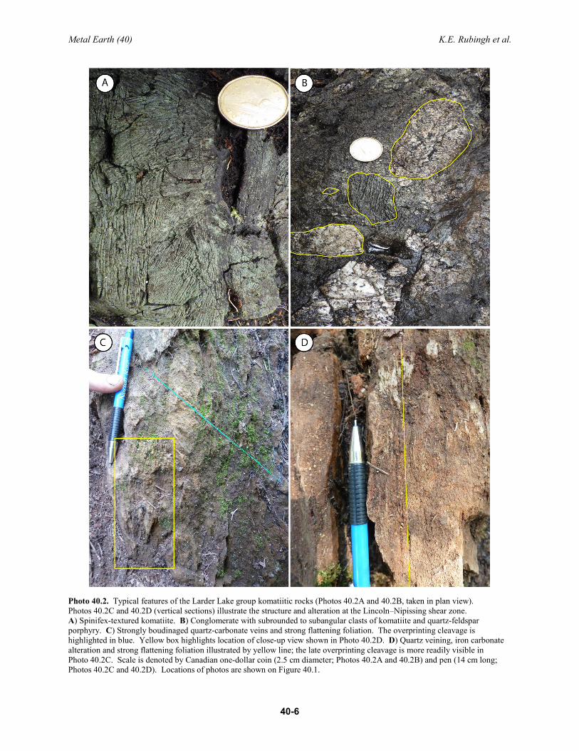
In the Larder Lake group in Skead Township, a higher proportion of felsic volcanic and volcaniclastic rocks were documented (Brace et al., this volume, Article 39) than previously mapped by Hewitt (1951). At the location of the previously interpreted Manley O’Reilly intrusion (see Figure 40.1, location for Photo 40.1), felsic volcaniclastic rocks were observed during the 2018 field season, as illustrated by Photos 40.2A to 40.2D. These photos show the variation in the felsic volcaniclastic units, from felsic lapilli tuff beds with 3 to 5% plagioclase crystals (see Photos 40.1A and 40.1B) to felsic lapillistone (see Photos 40.1C and 40.1D) that contains rare mafic and ultramafic clasts.
Lincoln–Nipissing Shear Zone A series of traverses were performed during the 2018 field season across the poorly exposed
Lincoln–Nipissing shear zone (LNSZ) to map the alteration, structure and degree of strain intensity in proximity to the shear zone. Preliminary field observations identified 2 dominant foliations in the study area: a regional foliation parallel to the LNSZ, and an overprinting north-south– to north-northeast–trending foliation parallel to an interpreted fault that bounds the Huronian Supergroup sediments to the east (see Photos 40.2C and 40.2D). Because of the lack of outcrop in proximity to the shear zone, the strain intensity cannot be mapped consistently; however, the intensity of the LNSZ fabric, which is expressed as a strong flattening foliation and a down-dip lineation, is only well developed within 1 to 3 m of the shear zone. The shear zone is associated with intense iron-carbonate alteration, quartz- and quartz-carbonate veins (see Photos 40.2C and 40.2D), and locally observed potassic alteration (fuchsite and sericite). The LNSZ has similar characteristics to the LCDZ in terms of structure and alteration, and there is an association of both shear zones with Timiskaming-like sedimentation, alkalic magmatism and
Metal Earth (40) K.E. Rubingh et al.
40-6
Photo 40.2. Typical features of the Larder Lake group komatiitic rocks (Photos 40.2A and 40.2B, taken in plan view). Photos 40.2C and 40.2D (vertical sections) illustrate the structure and alteration at the Lincoln–Nipissing shear zone. A) Spinifex-textured komatiite. B) Conglomerate with subrounded to subangular clasts of komatiite and quartz-feldspar porphyry. C) Strongly boudinaged quartz-carbonate veins and strong flattening foliation. The overprinting cleavage is highlighted in blue. Yellow box highlights location of close-up view shown in Photo 40.2D. D) Quartz veining, iron carbonate alteration and strong flattening foliation illustrated by yellow line; the late overprinting cleavage is more readily visible in Photo 40.2C. Scale is denoted by Canadian one-dollar coin (2.5 cm diameter; Photos 40.2A and 40.2B) and pen (14 cm long; Photos 40.2C and 40.2D). Locations of photos are shown on Figure 40.1.

Metal Earth (40) K.E. Rubingh et al.
40-7
lamprophyre dikes. These interpretations will be further refined during the 2019 field season and follow-up work will be performed on the small-volume intrusions that stitch the LNSZ and have associated gold prospects.
FUTURE WORK Samples were collected from greywackes of the Hearst assemblage for detrital geochronology study.
Additional samples for U/Pb geochronology study were collected from a monomictic felsic lapilli tuff unit within the Larder Lake group, to provide an age of deposition for the Larder Lake group. A felsic dike that intrudes the Webster felsic intrusion and was deformed during the D3 event was also sampled for geochronology, which will provide the maximum age of D2 deformation and the minimum age of mineralization. Oriented samples were collected along the LNSZ for petrographic study, to characterize the nature of the shear zone in terms of alteration and structure. Oriented samples were also collected from the Hearst assemblage to define the alteration assemblage forming the fabrics. The preliminary work conducted in 2018 will be expanded in 2019 to further examine the nature of the LNSZ and investigate the structural and stratigraphic setting of the Hearst assemblage.
RELEVANCE The occurrence of significant clastic sedimentation south of the Larder–Cadillac deformation zone
(LCDZ) is restricted to the area north of the LNSZ, predominantly in Skead and Hearst townships. The objective of the senior author’s research is to understand the structural and stratigraphic framework of this area, which will potentially bring further insight into the depositional environment of the basin at the time of sedimentation, and may have implications for the development of the LNSZ and the LCDZ.
ACKNOWLEDGMENTS The principal author would like to thank Master of Science students Sean Brace and Nadia St-Jean,
and field assistants Leslie Hunt, Siobhan Keane, Ayoub Mhina, Mac Vaillant, Michael Zamroutian and Xuyang Zhou for making this field work possible. The author would also like to thank Drs. Benoît Dubé, Mike Hamilton, Catherine Farrow, Bruno Lafrance and Lucie Mathieu for useful discussions and advice in the field area; the team at Transition Metals Ltd. for providing access to their newly trenched properties and ongoing support; and the Gold Candle Team, with particular thanks to Tim Stubley. This is MERC–Metal Earth publication number MERC-ME-2018-059.
REFERENCES Ayer, J.A., Barr, E., Bleeker, W., Creaser, R.A., Hall, G., Ketchum, J.W.F., Powers, D., Salier, B., Still, A. and
Trowell, N.F. 2003. Discover Abitibi. New geochronological results from the Timmins area: Implications for the timing of late-tectonic stratigraphy, magmatism and gold mineralization; in Summary of Field Work and Other Activities, 2003, Ontario Geological Survey, Open File Report 6120, p.33-1 to 33-11.
Ayer, J.A., Thurston, P.C., Bateman, R., Dubé, B., Gibson, H.L., Hamilton, M.A., Hathway, B., Hocker, S.M., Houlé, M., Hudak, G.J., Ispolatov, V., Lafrance, B., Lesher, C.M., Macdonald, P.J., Péloquin, A.S., Piercey, S.J., Reed, L.E. and Thompson, P.H. 2005. Overview of results from the Greenstone Architecture Project: Discover Abitibi Initiative; Ontario Geological Survey, Open File Report 6154, 125p.
Brace, S. and Sherlock, R.L. 2017. Preliminary results from detailed geological mapping of syenite-associated gold mineralization associated with the Lincoln–Nipissing fault, Larder Lake, Ontario; in Summary of Field Work and Other Activities, 2017, Ontario Geological Survey, Open File Report 6333, p.36-1 to 36-6.

Metal Earth (40) K.E. Rubingh et al.
40-8
Corfu, F., Krogh, T.E., Kwok, Y.Y. and Jensen, L.S. 1989. U–Pb zircon geochronology in the southwestern Abitibi greenstone belt, Superior Province; Canadian Journal of Earth Sciences, v.26, p.1747-1763.
Frieman, B.M., Kuiper, Y.D., Kelly, N.M., Monecke, T. and Kylander-Clark, A. 2017. Constraints on the geodynamic evolution of the southern Superior Province: U/Pb LA-ICP-MS analysis of detrital zircon in successor basins of the Archean Abitibi and Pontiac subprovinces of Ontario and Quebec, Canada; Precambrian Research, v.292, p.398-416.
Hewitt, D.F. 1949. Township of Skead, District of Timiskaming, Ontario; Ontario Department of Mines, Annual Report Map 1949-3, scale 1:12 000.
——— 1951. Geology of Skead Township, Larder Lake area; Ontario Department of Mines, Annual Report, 1949, v.58, pt.6, 43p.
——— 1963. The Timiskaming Series of the Kirkland Lake area; The Canadian Mineralogist, v.7, p.497-522.
Hyde, R.S. 1980. Sedimentary facies in the Archean Timiskaming Group and their tectonic implications, Abitibi greenstone belt, northeastern Ontario, Canada; Precambrian Research, v.12, p.161‐195.
Jackson, S.L. 1994. The Precambrian geology of Pacaud and Catharine townships and portions of adjacent townships, District of Timiskaming, Ontario; Ontario Geological Survey, Open File Report 5884, 86p.
——— 1995. Precambrian geology, Larder Lake area; Ontario Geological Survey, Map 2628, scale 1:50 000.
Jackson, S.L. and Fyon, J.A. 1991. The western Abitibi Subprovince in Ontario; in Geology of Ontario, Ontario Geological Survey, Special Volume 4, Part 1, p.405-484.
Jackson, S.L., Fyon, J.A. and Corfu, F. 1994. Review of Archean supracrustal assemblages of the southern Abitibi greenstone belt in Ontario, Canada: Products of micro-plate interactions within a large-scale plate-tectonic setting; Precambrian Research, v.65, p.183-205.
Jensen, L.S. 1978. Archean komatiitic, tholeiitic, calc‐alkalic and alkalic volcanic sequences in the Kirkland Lake area; in Toronto ’78 Field Trip Guidebook, Geological Association of Canada–Mineralogical Association of Canada–Geological Society of America, Joint Annual Meeting, Toronto, 1978, p.237‐259.
Ridler, R.H. 1975. Regional metallogeny and volcanic stratigraphy of the Superior Province; in Report of Activities Part A, Geological Survey of Canada, Paper 75-1A, p.353-358.
St-Jean, N., Hunt, L. and Sherlock, R.L. 2017. Preliminary results from mapping a new exposure of the basal unconformity between the Hearst and Larder Lake assemblages, Skead Township, northeastern Ontario; in Summary of Field Work and Other Activities, 2017, Ontario Geological Survey, Open File Report 6333, p.37-1 to 37-7.
Thomson, J.E. 1943. Geology of McGarry and McVittie townships, Larder Lake area; Ontario Department of Mines, Annual Report, 1941, v.50, pt.7, 99p.
——— 1946. The Keewatin-Timiskaming unconformity in the Kirkland Lake district; Royal Society of Canada, Transactions, 3rd series, v.40, p.113-122.
Thurston, P.C. 2015. Igneous rock associations 19. Greenstone belts and granite-greenstone terranes: Constraints on the nature of the Archean world; Geoscience Canada, v.42, p.437-484.
Thurston, P.C., Ayer, J.A., Goutier, J. and Hamilton, M.A. 2008. Depositional gaps in Abitibi greenstone belt stratigraphy: A key to exploration for syngenetic mineralization; Economic Geology, v.103, p.1097-1134.

ISSN 1916-6117 (online) ISSN 0826-9580 (print) ISBN 978-1-4868-2715-2 (PDF) ISBN 978-1-4868-2714-5 (print) (for entire OFR 6350) (for entire OFR 6350)
THESE TERMS GOVERN YOUR USE OF THIS DOCUMENT
Your use of this Ontario Geological Survey document (the “Content”) is governed by the terms set out on this page (“Terms of Use”). By downloading this Content, you (the
“User”) have accepted, and have agreed to be bound by, the Terms of Use.
Content: This Content is offered by the Province of Ontario’s Ministry of Energy, Northern Development and Mines (ENDM) as a public service, on an “as-is” basis. Recommendations and statements of opinion expressed in the Content are those of the author or authors and are not to be construed as statement of government policy. You are solely responsible for your use of the Content. You should not rely on the Content for legal advice nor as authoritative in your particular circumstances. Users should verify the accuracy and applicability of any Content before acting on it. ENDM does not guarantee, or make any warranty express or implied, that the Content is current, accurate, complete or reliable. ENDM is not responsible for any damage however caused, which results, directly or indirectly, from your use of the Content. ENDM assumes no legal liability or responsibility for the Content whatsoever.
Links to Other Web Sites: This Content may contain links, to Web sites that are not operated by ENDM. Linked Web sites may not be available in French. ENDM neither endorses nor assumes any responsibility for the safety, accuracy or availability of linked Web sites or the information contained on them. The linked Web sites, their operation and content are the responsibility of the person or entity for which they were created or maintained (the “Owner”). Both your use of a linked Web site, and your right to use or reproduce information or materials from a linked Web site, are subject to the terms of use governing that particular Web site. Any comments or inquiries regarding a linked Web site must be directed to its Owner.
Copyright: Canadian and international intellectual property laws protect the Content. Unless otherwise indicated, copyright is held by the Queen’s Printer for Ontario.
It is recommended that reference to the Content be made in the following form:
Rubingh, K.E., Brace, S. and Sherlock, R.L. 2018. Preliminary results from detailed geological mapping of the stratigraphic and structural framework of the Hearst assemblage, and the nature of the Lincoln–Nipissing shear zone, Skead Township, northeastern Ontario; in Summary of Field Work and Other Activities, 2018, Ontario Geological Survey, Open File Report 6350, p.40-1 to 40-8.
Use and Reproduction of Content: The Content may be used and reproduced only in accordance with applicable intellectual property laws. Non-commercial use of unsubstantial excerpts of the Content is permitted provided that appropriate credit is given and Crown copyright is acknowledged. Any substantial reproduction of the Content or any commercial use of all or part of the Content is prohibited without the prior written permission of ENDM. Substantial reproduction includes the reproduction of any illustration or figure, such as, but not limited to graphs, charts and maps. Commercial use includes commercial distribution of the Content, the reproduction of multiple copies of the Content for any purpose whether or not commercial, use of the Content in commercial publications, and the creation of value-added products using the Content.
Contact:
FOR FURTHER INFORMATION ON PLEASE CONTACT: BY TELEPHONE: BY E-MAIL:
The Reproduction of the EIP or Content
ENDM Publication Services
Local: (705) 670-5691 Toll-Free: 1-888-415-9845, ext. 5691
(inside Canada, United States) [email protected]
The Purchase of ENDM Publications
ENDM Publication Sales
Local: (705) 670-5691 Toll-Free: 1-888-415-9845, ext. 5691
(inside Canada, United States) [email protected]
Crown Copyright Queen’s Printer Local: (416) 326-2678 Toll-Free: 1-800-668-9938
(inside Canada, United States) [email protected]

![Associative feature modeling for concurrent engineering ...yongshen/index_files/[Ma Y S 2003 CiI].pdf · Associative feature modeling for concurrent engineering ... detailed structure](https://img.pdfslide.us/doc/110x75/5b2fd5f87f8b9ad1238c8d5c/associative-feature-modeling-for-concurrent-engineering-yongshenindexfilesma.jpg)