Embed Size (px)
Citation preview
U.S. Department of the Interior U.S. Geological Survey
Preliminary Geologic Mapping of Cretaceous and Tertiary Formations in the Eastern Part of the Little Snake River Coal Field, Carbon County, Wyoming
By Jon E. Haacke, C.S. Venable Barclay, and Robert D. Hettinger
Open-File Report 2016–1170
ii
U.S. Department of the Interior SALLY JEWELL, Secretary
U.S. Geological Survey Suzette M. Kimball, Director
U.S. Geological Survey, Reston, Virginia: 2016
For more information on the USGS—the Federal source for science about the Earth, its natural and living resources, natural hazards, and the environment—visit http://www.usgs.gov/ or call 1–888–ASK–USGS (1–888–275–8747).
For an overview of USGS information products, including maps, imagery, and publications, visit http://store.usgs.gov/.
Any use of trade, firm, or product names is for descriptive purposes only and does not imply endorsement by the U.S. Government.
Although this information product, for the most part, is in the public domain, it also may contain copyrighted materials as noted in the text. Permission to reproduce copyrighted items must be secured from the copyright owner.
Suggested citation: Haacke, J.E., Barclay, C.S.V., and Hettinger, R.D., 2016, Preliminary geologic mapping of Cretaceous and Tertiary formations in the eastern part of the Little Snake River coal field, Carbon County, Wyoming: U.S. Geological Survey Open-File Report 2016–1170, 9 p., http://dx.doi.org/10.3133/ofr20161170.
ISSN 2331-1258 (online)
Cover. Photograph of surface geology in the Little Snake River Coal Field, Carbon County, Wyoming (photo by Jon E. Haacke).
iii
Contents Abstract ......................................................................................................................................................... 1 Overview of Barclay Studies .......................................................................................................................... 1 The Little Snake River Coal Field Map Data .................................................................................................. 4
Map Data ................................................................................................................................................... 6 Barclay’s Field Notes ................................................................................................................................. 7 Previously Published and Unpublished Maps ............................................................................................ 7
Summary ....................................................................................................................................................... 8 Acknowledgments ......................................................................................................................................... 8 References Cited ........................................................................................................................................... 8
Figures 1. U.S. Geological Survey (USGS) quadrangles mapped by C.S. Venable Barclay in the Little
Snake River coal field in the Greater Green River Basin, Carbon County, Wyoming. ...................... 2 2. Map showing U.S. Geological Survey (USGS) 7.5-minute quadrangles mapped by C.S.
Venable Barclay outlined in yellow. The original 15-minute quadrangles are outlined in gray. ......... 3 3. C.S. Venable Barclay pointing to a cast of a dinosaur footprint in the Almond Formation
of the Mesaverde Group in Carbon County, Wyoming. .................................................................... 4
Table 1. 7½-minute quadrangle index listing the number of maps (with the original
part of the 15-minute quadrangle), field-note file names, and sample prefixes................................. 5
Conversion Factors U.S. customary units to International System of Units
Multiply By To obtain Length
inch (in.) 2.54 centimeter (cm) inch (in.) 25.4 millimeter (mm) foot (ft) 0.3048 meter (m) mile (mi) 1.609 kilometer (km)
Area square mile (mi2) 2.590 square kilometer (km2)
Datum Coordinate information is referenced to the World Geodetic System (WGS84).
1
Preliminary Geologic Mapping of Cretaceous and Tertiary Formations in the Eastern Part of the Little Snake River Coal Field, Carbon County, Wyoming
By Jon E. Haacke, C.S. Venable Barclay, and Robert D. Hettinger
Abstract In the 1970s and 1980s, C.S. Venable Barclay carried out geologic mapping of areas
primarily underlain by Cretaceous coals in the eastern part of the Little Snake River coal field (LSR) in Carbon County, southwest Wyoming. With some exceptions, most of the mapping data were never published. Subsequently, after his retirement from the U.S. Geological Survey (USGS), his field maps and field notebooks were archived in the USGS Field Records. Due to a pending USGS coal assessment of the Little Snake River coal field area and planned geological mapping to be conducted by the Wyoming State Geological Survey, Barclay’s mapping data needed to be published to support these efforts. Subsequently, geologic maps were scanned and georeferenced into a geographic information system, and project and field notes were scanned into Portable Document Format (PDF) files. Data for seventeen 7½-minute quadrangles are presented in this report. This publication is solely intended to compile the mapping data as they were last worked on by Barclay and provides no interpretation or modification of his work.
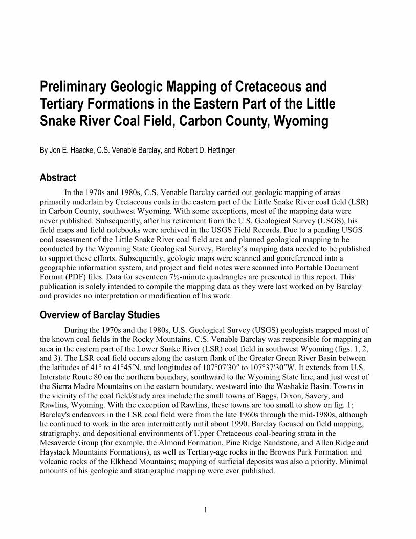
Overview of Barclay Studies During the 1970s and the 1980s, U.S. Geological Survey (USGS) geologists mapped most of
the known coal fields in the Rocky Mountains. C.S. Venable Barclay was responsible for mapping an area in the eastern part of the Lower Snake River (LSR) coal field in southwest Wyoming (figs. 1, 2, and 3). The LSR coal field occurs along the eastern flank of the Greater Green River Basin between the latitudes of 41° to 41°45ʹN. and longitudes of 107°07ʹ30″ to 107°37ʹ30″W. It extends from U.S. Interstate Route 80 on the northern boundary, southward to the Wyoming State line, and just west of the Sierra Madre Mountains on the eastern boundary, westward into the Washakie Basin. Towns in the vicinity of the coal field/study area include the small towns of Baggs, Dixon, Savery, and Rawlins, Wyoming. With the exception of Rawlins, these towns are too small to show on fig. 1; Barclay's endeavors in the LSR coal field were from the late 1960s through the mid-1980s, although he continued to work in the area intermittently until about 1990. Barclay focused on field mapping, stratigraphy, and depositional environments of Upper Cretaceous coal-bearing strata in the Mesaverde Group (for example, the Almond Formation, Pine Ridge Sandstone, and Allen Ridge and Haystack Mountains Formations), as well as Tertiary-age rocks in the Browns Park Formation and volcanic rocks of the Elkhead Mountains; mapping of surficial deposits was also a priority. Minimal amounts of his geologic and stratigraphic mapping were ever published.
2
After Barclay died in 2008, his maps and field records were archived in the USGS Field Records located in Lakewood, Colorado. The data are stored in 8 file boxes and 13 large flat folios. The data in the boxes are mostly organized alphabetically by 7.5- or 15-minute quadrangle. The boxes contain (1) field notes in bound books and as loose sheets, (2) maps, (3) aerial photographs, (4) photographs of outcrops, and (5) thin sections. The folios, each labeled by quadrangle name, contain paper and Mylar maps.
Barclay also carried out numerous coal-drilling projects to ascertain coal bed stratigraphy of the Almond Formation. Core from the drilling projects are stored at the USGS Core Research Laboratory located in Lakewood, Colorado. Geophysical logs and coal correlations were published in Barclay (1979a, b; 1980a, b), Barclay and Shoaff (1977, 1978), and Barclay and Zimmermann (1976). Numerous outcrop samples and fossils were also collected during Barclay's studies. Thin sections and X-ray diffractograms were made from many of these samples and are stored at the USGS Library in Lakewood, Colorado. Approximately 100 boxes of rock samples are stored at the USGS Core Research Lab. The boxes contain (1) outcrop samples, drill-hole cuttings, and tonsteins from the Upper Cretaceous Mesaverde Group; (2) dinosaur tracks from the Almond Formation; (3) Late Cretaceous rocks processed for fossils and microfossils; and (4) samples of rock, volcanic ash, clay, mineral separates, and thin sectioned rocks from the Tertiary Browns Park Formation.
Figure 1. U.S. Geological Survey (USGS) quadrangles mapped by C.S. Venable Barclay in the Little Snake River coal field in the Greater Green River Basin, Carbon County, Wyoming.
3
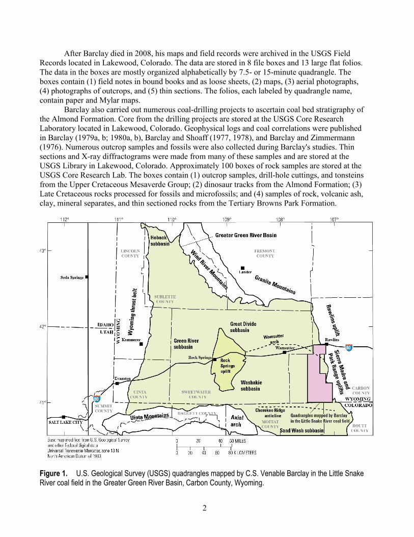
Figure 2. Map showing U.S. Geological Survey (USGS) 7.5-minute quadrangles mapped by C.S. Venable Barclay outlined in yellow. The original 15-minute quadrangles are outlined in gray.
4
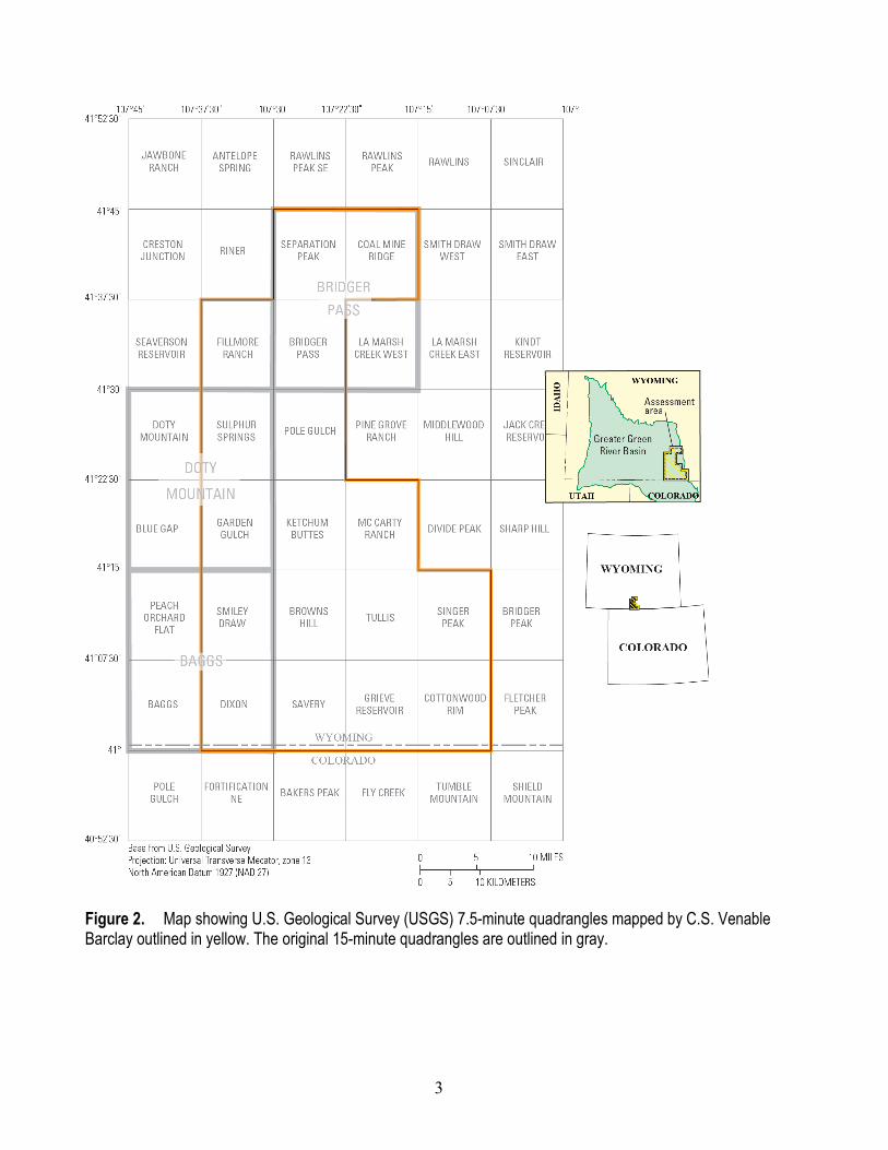
Figure 3. C.S. Venable Barclay pointing to a cast of a dinosaur footprint in the Almond Formation of the Mesaverde Group in Carbon County, Wyoming.
The Little Snake River Coal Field Map Data At the time of Barclay’s mapping, some of the LSR area had only been topographically
mapped as 15-minute quadrangles. In the years that followed, each of the 15-minute quadrangles were divided and remapped as four 7½-minute quadrangles. These include the Baggs, Bridger Pass, and Doty Mountain 15-minute quadrangles. In those areas, Barclay's field notes have now been cross-referenced to the quarter section parts of those 15-minute quadrangles with the newer 7½-minute quadrangles noted. The names of these 7½-minute quadrangles are provided as follows:
1. The NW¼, NE¼, SE¼, and SW¼ of the Baggs 15-minute quadrangle were renamed Peach Orchard Flat, Smiley Draw, Dixon, and Baggs, respectively.
2. The NW¼, NE¼, SE¼, and SW¼ of the Bridger Pass 15-minute quadrangle were renamed Separation Peak, Coal Mine Ridge, La Marsh Creek West, and Bridger Pass, respectively.
3. The NW¼, NE¼, SE¼, and SW¼ of the Doty Mountain 15-minute quadrangle were renamed Doty Mountain, Sulphur Springs, Garden Gulch, and Blue Gap, respectively. In this report, data are compiled for the seventeen 7½-minute quadrangles (or equivalents)
mapped by Barclay. Quadrangle names are listed below, in figure 2, and in table 1. Included in parentheses are those parts of the original 15-minute quadrangle referenced in Barclay's field notes:
• Bridger Pass (SW¼ Bridger Pass 15' quadrangle) • Browns Hill
5
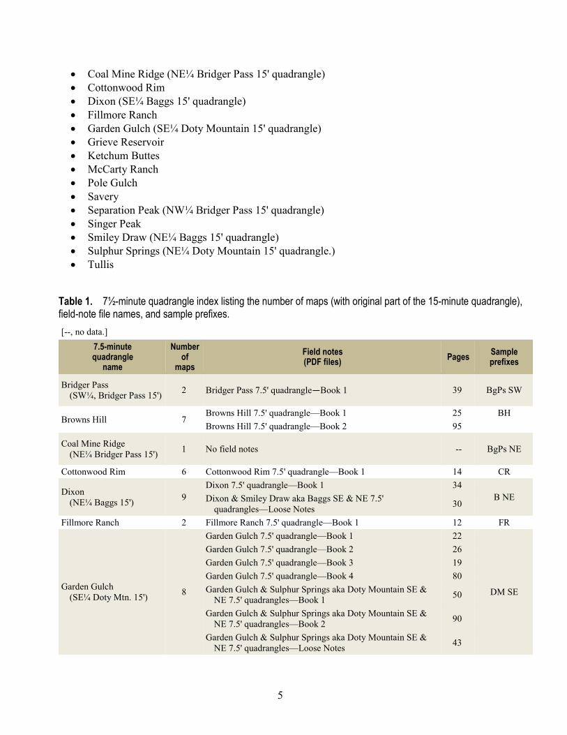
• Coal Mine Ridge (NE¼ Bridger Pass 15' quadrangle) • Cottonwood Rim • Dixon (SE¼ Baggs 15' quadrangle) • Fillmore Ranch • Garden Gulch (SE¼ Doty Mountain 15' quadrangle) • Grieve Reservoir • Ketchum Buttes • McCarty Ranch • Pole Gulch • Savery • Separation Peak (NW¼ Bridger Pass 15' quadrangle) • Singer Peak • Smiley Draw (NE¼ Baggs 15' quadrangle) • Sulphur Springs (NE¼ Doty Mountain 15' quadrangle.) • Tullis
Table 1. 7½-minute quadrangle index listing the number of maps (with original part of the 15-minute quadrangle), field-note file names, and sample prefixes. [--, no data.]
7.5-minute quadrangle
name
Number of
maps Field notes (PDF files) Pages Sample
prefixes
Bridger Pass (SW¼, Bridger Pass 15') 2 Bridger Pass 7.5' quadrangle—Book 1 39 BgPs SW
Browns Hill 7 Browns Hill 7.5' quadrangle—Book 1 25 BH Browns Hill 7.5' quadrangle—Book 2 95
Coal Mine Ridge (NE¼ Bridger Pass 15') 1 No field notes -- BgPs NE
Cottonwood Rim 6 Cottonwood Rim 7.5' quadrangle—Book 1 14 CR
Dixon (NE¼ Baggs 15') 9
Dixon 7.5' quadrangle—Book 1 34 B NE Dixon & Smiley Draw aka Baggs SE & NE 7.5'
quadrangles—Loose Notes 30
Fillmore Ranch 2 Fillmore Ranch 7.5' quadrangle—Book 1 12 FR
Garden Gulch (SE¼ Doty Mtn. 15') 8
Garden Gulch 7.5' quadrangle—Book 1 22
DM SE
Garden Gulch 7.5' quadrangle—Book 2 26 Garden Gulch 7.5' quadrangle—Book 3 19 Garden Gulch 7.5' quadrangle—Book 4 80 Garden Gulch & Sulphur Springs aka Doty Mountain SE &
NE 7.5' quadrangles—Book 1 50
Garden Gulch & Sulphur Springs aka Doty Mountain SE & NE 7.5' quadrangles—Book 2 90
Garden Gulch & Sulphur Springs aka Doty Mountain SE & NE 7.5' quadrangles—Loose Notes 43
6
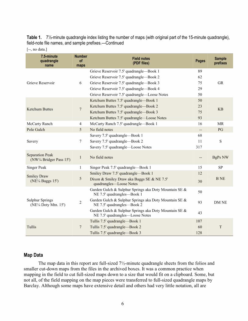
Table 1. 7½-minute quadrangle index listing the number of maps (with original part of the 15-minute quadrangle), field-note file names, and sample prefixes.—Continued [--, no data.]
7.5-minute quadrangle
name
Number of
maps Field notes (PDF files) Pages Sample
prefixes
Grieve Reservoir 6
Grieve Reservoir 7.5' quadrangle—Book 1 89
GR Grieve Reservoir 7.5' quadrangle—Book 2 62 Grieve Reservoir 7.5' quadrangle—Book 3 75 Grieve Reservoir 7.5' quadrangle—Book 4 29 Grieve Reservoir 7.5' quadrangle—Loose Notes 50
Ketchum Buttes 7
Ketchum Buttes 7.5' quadrangle—Book 1 50
KB Ketchum Buttes 7.5' quadrangle—Book 2 23 Ketchum Buttes 7.5' quadrangle—Book 3 75 Ketchum Buttes 7.5' quadrangle—Loose Notes 93
McCarty Ranch 4 McCarty Ranch 7.5' quadrangle—Book 1 16 MR Pole Gulch 5 No field notes -- PG
Savery 7 Savery 7.5' quadrangle—Book 1 68
S Savery 7.5' quadrangle—Book 2 11 Savery 7.5' quadrangle—Loose Notes 317
Separation Peak (NW¼ Bridger Pass 15') 1 No field notes -- BgPs NW
Singer Peak 1 Singer Peak 7.5' quadrangle—Book 1 15 SP
Smiley Draw (NE¼ Baggs 15') 5
Smiley Draw 7.5' quadrangle—Book 1 12 B NE Dixon & Smiley Draw aka Baggs SE & NE 7.5'
quadrangles—Loose Notes 30
Sulphur Springs (NE¼ Doty Mtn. 15') 2
Garden Gulch & Sulphur Springs aka Doty Mountain SE & NE 7.5' quadrangles—Book 1 50
DM NE Garden Gulch & Sulphur Springs aka Doty Mountain SE & NE 7.5' quadrangles—Book 2 93
Garden Gulch & Sulphur Springs aka Doty Mountain SE & NE 7.5' quadrangles—Loose Notes 43
Tullis 7 Tullis 7.5' quadrangle—Book 1 107
T Tullis 7.5' quadrangle—Book 2 60 Tullis 7.5' quadrangle—Book 3 128
Map Data The map data in this report are full-sized 7½-minute quadrangle sheets from the folios and
smaller cut-down maps from the files in the archived boxes. It was a common practice when mapping in the field to cut full-sized maps down to a size that would fit on a clipboard. Some, but not all, of the field mapping on the map pieces were transferred to full-sized quadrangle maps by Barclay. Although some maps have extensive detail and others had very little notation, all are
7
included to show the entire area of interest. Where formation lines were not labeled on his unpublished mapping, the line-work can be deciphered by observing where it has been labeled on adjacent field maps.
For this report, the maps were scanned to Tag Image File Format (TIF) files at 200 dots per inch (dpi) resolution. The borders or “collars” were then clipped in Adobe Photoshop leaving just the actual map area to allow the user to view the tiled maps without the borders overlying adjacent maps. Each clipped map was then imported into Esri’s Geographic Information System (GIS) ArcMap and georeferenced into the World Geodetic System 1984 (WGS84) projection system using section corners on the scanned maps (Esri, 2013). The map positioning does not take into account coordinate shifts from old surveys. Although the individual scanned maps do not have coordinate annotations, viewing and printing in ArcMap should result in fairly accurate coordinate reference.
The resulting GIS project has 80 maps representing the 17 different quadrangles. In the GIS project, the full-sized quadrangle maps are named first by the base map types: topographic (paper), Mylar topographic, or planimetric (paper). The names are further qualified as geologic contacts, field notes, or colored geologic. The cut-up (clipboard size) maps are labeled as a field map.
For positional reference, the GIS project has shapefiles for the outline of the 7½-minute quadrangles, counties, and the Public Land Survey System (PLSS) townships and sections all from the USGS National Boundary Dataset (NBD) for Wyoming (U.S. Geological Survey, 2016). Also included is the USGS National Map coverage (2016).
The numerous aerial photographs were not scanned for this report, although many of them contained notations made in the field. Those notations were made using the “pin-hole” method. This method involves pushing a thin pin at a location on the photograph and then writing notes on the back of the photograph at the pin hole. This means that the notation sides of the photos are in a mirror-image of the normal locations. This method makes it very difficult to scan and organize in a meaningful way. Based on a review of the photos, not all of the notes on the photos were transferred to the maps.
Barclay’s Field Notes Barclay’s field notes are either in bound field books or as a collection of related loose pages.
The field notes were scanned page-by-page on a document scanner at 300 dpi resolution. Each field book or loose collection was saved as an individual pdf file. Barclay numbered his samples using an alpha-numeric numbering system. The first character(s) refer(s) to the quadrangle where the sample was collected. The number following the first hyphen refers to the order in which the sample was collected. The number following the second hyphen refers to the year the sample was collected. For example, T-1-69 was the first sample collected in the Tullis 7½-minute quadrangle in 1969. Abbreviations for quadrangle names are shown in table 1. Barclay then plotted the locations of the samples on the appropriate topographic base maps using designated numbers (SW-1, NW-2, and so forth), which he assigned in his field notes (table 1). The relation between Barclay's sample numbers and his map numbers are provided in his field books.
Previously Published and Unpublished Maps Some of Barclay’s mapping was published or otherwise released:
• A preliminary geologic map of the Tullis 7½-minute quadrangle (Barclay, 1976). • A study of the proposed Sandstone Reservoir (Naftz and Barclay, 1991) covered portions of
the Browns Hill, Tullis, Grieve Reservoir, and Savery 7½-minute quadrangles.
8
• An internal Administrative report, done in 1978, that was not publicly released for the Conservation Division of the USGS on the Rawlins-Little Snake River Known Recoverable Coal Resource Area (KRCRA). Two of the four 15-minute maps in that report were based on Barclay’s mapping. These maps are included in the GIS project.
• Barclay’s mapping contributed to the Geologic Map of Wyoming (Love and Christiansen, 1985). In addition to the above, portions of eight of the westernmost quadrangles mapped by Barclay
were included in a geologic map of the western part of the Little Snake River by Hettinger and others (2008).
Summary This publication serves to provide public domain access to years of field mapping data by
C.S. Venable Barclay. As noted before, however, this publication only represents the Barclay field data contained in the USGS Field Records that are within the area covered by the 17 quadrangle study area. These data may be used to assist any future mapping efforts.
Acknowledgments This report was produced through the efforts and cooperation of several people. Keith E.
Olson, Metropolitan State University of Denver, carried out all the scanning and the georeferencing of the maps. David C. Scott of the USGS created the figures and assisted with the tables and formatting. Thanks also to Scott A. Kinney and David A. Ferderer of the USGS and Christopher J. Carroll of the Wyoming State Geological Survey who provided in-depth technical reviews of the report.
References Cited Barclay, C.S.V., 1976, Preliminary geologic map of the Tullis quadrangle, Carbon County,
Wyoming, U.S. Geological Survey Open-File Report 76–794, 3 pl., scale 1:24,000. [Also available at https://pubs.er.usgs.gov/publication/ofr76794.]
Barclay, C.S.V., 1979a, Geophysical logs and coal sections of holes drilled during 1977 and 1978 in the Browns Hills quadrangle, Carbon County, Wyoming: U.S. Geological Survey Open-File Report 79–1528, 13 p., 79 pl. [Also available at https://pubs.er.usgs.gov/publication/ofr791528.]
Barclay, C.S.V., 1979b, Geophysical logs and coal sections of holes drilled during 1977 and 1978 in the northeastern part of the Baggs Quadrangle, Carbon County, Wyoming: U.S. Geological Survey Open-File Report 79-1628, 9 p., 67 pls. [Also available at https://pubs.er.usgs.gov/publication/ofr791628.]
Barclay, C.S.V., 1980a, Geophysical logs and coal sections of holes drilled during 1977 and 1978 in T. 15 N., Rs. 90 and 91 W., Ketchum Buttes and Doty Mountain quadrangles, Carbon County, Wyoming: U.S. Geological Survey Open-File Report 80–488, 16 p., 115 pl. [Also available at https://pubs.er.usgs.gov/publication/ofr80488.]
Barclay, C.S.V., 1980b, Geophysical logs and coal sections of holes drilled during 1977 and 1978 in T. 16 N., Rs. 90 and 91 W., Ketchum Buttes and Doty Mountain quadrangles, Carbon County, Wyoming: U.S. Geological Survey Open-File Report 80–643, 10 p., 122 pl. [Also available at https://pubs.er.usgs.gov/publication/ofr80643.]
9
Barclay, C.S.V., and Shoaff, L.A., 1977, Lithologic and geophysical logs of holes drilled in the Doty Mountain, Browns Hill, and Baggs quadrangles, Carbon County, Wyoming, during 1976: U.S. Geological Survey Open-File Report 77–171, 77 p., 65 pl. [Also available at https://pubs.er.usgs.gov/publication/ofr77171.]
Barclay, C.S.V., and Shoaff, L.A., 1978, Lithologic and geophysical logs of holes drilled during 1977 in the Savery quadrangle and southeastern part of the Baggs quadrangle, Carbon County, Wyoming: U.S. Geological Survey Open-File Report 78–660, 50 p., 58 pl. [Also available at https://pubs.er.usgs.gov/publication/ofr78660.]
Barclay, C.S.V., and Zimmermann, S.C., 1976, Lithologic and geophysical logs of holes drilled in the eastern part of the Doty Mountain quadrangle, Carbon County, Wyoming, by the U.S. Geological Survey during 1975: U.S. Geological Survey Open-File Report 76–510, 108 p., 41 pl. [Also available at https://pubs.er.usgs.gov/publication/ofr76510.]
Hettinger, R.D., Honey, J.G., Ellis, M.S., Barclay, C.S.V., and East, J.A., 2008, Geologic map of Upper Cretaceous and Tertiary strata and coal stratigraphy of the Paleocene Fort Union Formation, Rawlins-Little Snake River area, south-central Wyoming: U.S. Geological Survey Scientific Investigations Map 3053, 3 sheets, scale 1:100,000. [Also available at https://pubs.er.usgs.gov/publication/sim3053.]
Love, J.D., and Christiansen, A.C., 1985, Geologic map of Wyoming: U.S. Geological Survey, scale 1:500,000. [Also available at https://pubs.er.usgs.gov/publication/70046739.]
Naftz, D.L., and Barclay, C.S.V., 1991, Selenium and associated trace elements in soil, rock, water, and streambed sediment of the proposed Sandstone Reservoir, south-central Wyoming: U.S. Geological Survey Water-Resources Investigations Report 91–4000, 69 p., 1 pl., scale 1:24,000. [Also available at https://pubs.er.usgs.gov/publication/wri914000.]
Environmental Systems Research Institute, Inc. (Esri), 2013, ArcGIS: Redlands, Calif., Environmental Sciences Research Institute, accessed in 2013 at http://www.esri.com/.
U.S. Geological Survey, 2016, The National Map: U.S. Geological Survey, accessed in 2016 at http://viewer.nationalmap.gov/basic/?basemap=b1&category=histtopo,ustopo&title=Map%20View#startUp.
U.S. Geological Survey, USGS National Boundary Dataset (NBD) for Wyoming 20160315 State or Territory File GDB 10.1: U.S. Geological Survey, ScienceBase Catalog, accessed in 2016 at https://www.sciencebase.gov/catalog/item/533c33b6e4b0f4f326e383c9.
ISSN 2331-1258 (online) http://dx.doi.org/10.3133/ofr20161170.