Embed Size (px)
Citation preview
Geologic Map of the La Joya Quadrangle,
Socorro County, New Mexico
By
Maarten de Moor, Austin Sinsser, Karl Karlstrom, Richard Chamberlin, Sean Connell, Adam Read
May, 2005
New Mexico Bureau of Geology and Mineral Resources
Open-file Digital Geologic Map OF-GM 102
Scale 1:24,000
This work was supported by the U.S. Geological Survey, National Cooperative Geologic Mapping Program (STATEMAP) under USGS Cooperative Agreement 06HQPA0003
and the New Mexico Bureau of Geology and Mineral Resources.
New Mexico Bureau of Geology and Mineral Resources 801 Leroy Place, Socorro, New Mexico, 87801-4796
The views and conclusions contained in this document are those of the author and should not be interpreted as necessarily representing the official policies,
either expressed or implied, of the U.S. Government or the State of New Mexico.
La Joya 7.5’ Quadrangle OF-GM 102
New Mexico Bureau of Geology and Mineral Resources A division of New Mexico Institute of Mining and Technology 801 Leroy Place Socorro, NM 87801-4796
GEOLOGY OF LA JOYA 7.5-MINUTE QUADRANGLE, SOCORRO COUNTY,
NEW MEXICO
by Maarten de Moor, Austin Zinsser, Karl Karlstrom, Richard Chamberlin, Sean Connell, Adam Read.
Geologic mapping by
Richard Chamberlain, Sean Connell, Austin Zinsser, Maarten de Moor, Karl Karlstrom, and Adam Read With previous mapping by Ward Arendt, Ernest Spradlin, and William Beck.
New Mexico Bureau of Mines and Mineral Resources
Open-File Report OF-GM-102 May, 2005
3
CONTENTS
INTRODUCTION ......................................................................................................................................................4 Comments to map users ..............................................................................................................................5 Accessibility .................................................................................................................................................6 Geologic and Physiographic Setting .........................................................................................................7 STRATIGRAPHY .......................................................................................................................................................7 Alluvial Deposits .........................................................................................................................................7 Tertiary Volcanic Rocks ............................................................................................................................10 Paleozoic Rocks ..........................................................................................................................................11 Proterozoic Rocks ......................................................................................................................................12 STRUCTURAL GEOLOGY ....................................................................................................................................12 Paleozoic and Younger Structures ..........................................................................................................12 Proterozoic Structures................................................................................................................................14 REFERENCES ...........................................................................................................................................................14 Description of map units ........................................................................................................................................ 16 Correlation of map units..........................................................................................................................................31 Explanation of map symbols ..................................................................................................................................34 Correlation of map units with previous work .....................................................................................................35
4
Statemap Report
INTRODUCTION
The La Joya 7.5-minute quadrangle covers an area of about 160 km2 (60 mi2) within the
Sevilleta National Wildlife Refuge in Socorro County, New Mexico (Fig. 1). The southern end
of the mapped area is about 8 km northeast of Socorro, New Mexico, and lies in the transition
zone between the Albuquerque and Socorro basins of the Rio Grande rift. In this vicinity the
polarity of the dominant rift bounding faults changes. Most of the displacement occurs on the
east side of the rift in the Albuquerque basin while displacement in the Socorro basin and
adjacent rift basins (La Jencia and Abbe Springs basins) occurs primarily on normal faults
bounding the western flanks of the basins (Chapin and Cather, 1994). The geologic history of
the area is further complicated by previous deformation during the late Paleozoic uplift of the
Ancestral Rocky Mountains and Eocene Laramide tectonism.
Previous research and mapping in the La Joya quadrangle includes Arendt (1968),
Spradlin (1976), and Beck (1993). These studies provide the framework and foundation for the
current geologic map, presented in Plate I, which is the result of continuing detailed field
mapping, and compilation, integration, and reinterpretation of these previous works. Mapping
was conducted on 1:12,000 and 1:24,000 7.5-minute topographic base maps published by the
United States Geological Survey, and was supplemented by reference to air photos provided by
the U.S. Forest Service and the Sevilleta Wildlife Refuge.
Significant revisions and contributions presented here include reinterpretation of
geometry and style of Tertiary normal faulting. Our interpretation shows a series of east dipping
faults within west-dipping sedimentary rocks that are restorable with moderate (100-meter-scale)
5
displacement on domino style normal faults. This interpretation is preferred to that of the low
angle detachment fault interpretation of Beck (1993) because it is more compatible with surface
fault dips and is more readily restorable. Restoration of the cross section suggests that this area
was an east-facing Laramide monoclinal uplift prior to extension, with a thinned section of
Tertiary Spears Formation unconformable deposited on Triassic rocks in the western blocks, and
a thicker section of Spear unconformably resting on Cretaceous rocks in the eastern blocks.
Detailed mapping also produced refined differentiation of the Tertiary volcanic stratigraphy, and
delineated Quaternary and Pliocene deposits.
COMMENTS TO MAP USERS
This quadrangle map has been Open-Filed in order to make it available to the public.
The map has not been reviewed according to New Mexico Bureau of Geology and Mineral
Resources standards, and due to the ongoing nature of work in the area, revision of this map is
likely. As such, dates of revision are listed in the upper right corner of the map and on the
accompanying report. The contents of the report and map should not be considered final and
complete until it is published by the New Mexico Bureau of Geology and Mineral Resources.
A geologic map graphically displays information on the distribution, nature, orientation,
and age relationships of rock and surficial units and the occurrence of structural features such as
faults and folds. Geologic contacts are irregular surfaces that form boundaries between different
types or ages of units. Data depicted on this geologic map are based on field geologic mapping,
compilation of published and unpublished work, and photogeologic interpretation. Locations of
6
contacts are not surveyed, but are plotted by interpretation of the position of a given contact onto
a topographic base map; therefore, the accuracy of contact locations depends on the scale of
mapping and the interpretation of the geologist. Significant portions of the study area may have
been mapped at scales smaller than the final map; therefore, the user should be aware of
potentially significant variations in map detail. Site-specific conditions should be verified by
detailed surface mapping or subsurface exploration. Topographic and cultural changes associated
with recent development may not be shown everywhere.
The cross-sections in this report are constructed based on exposed geology, and where
available, subsurface and geophysical data. The cross sections are interpretive and should be
used as an aid to understand the geologic framework and not used as the sole source of data in
locating or designing wells, buildings, roads, or other structures.
The views and conclusions contained in this document are those of the authors and
should not be interpreted as necessarily representing the official policies, either expressed or
implied, of the U.S. Government.
Accessibility
The map area falls within the Sevilleta National Wildlife Refuge (SNWR), which
requires a research permit for access. Access to the northwestern quadrant of the map is
provided by state Route 304, which ends in the town of La Joya. Access to the southern part of
the area is gained by a gated (SNWR), unpaved and unmaintained road that heads northeast from
the bridge over the Rio Grande at Escondida lake. Access to the northern part of the quadrangle
is obtained by County Road 105 (maintained gravel, gated at SNWR boundary) off US Route 60
east of Black Butte.
7
Geologic and Physiographic Setting
The La Joya quadrangle lies within the Rio Grande rift, in the apparent constriction in rift
basin width between the Albuquerque Basin to the north and the Socorro Basin to the south. The
Joyita Hills are situated south of the rift polarity transition where rift graben tilting geometry
changes from east tilted to the north to west tilted to the south (Chapin and Cather, 1994). The
Colorado Plateau creates a rigid physiographic province to the northwest, while the Mogollon-
Datil volcanic field, associated with the Mid-Tertiary ignimbrite flare-up, and the Basin and
Range extensional province lie to the southwest. The Great Plains lie to the east beyond the Los
Pinos Mountains, which mark the more obvious eastern boundary of the Rio Grande rift. The
bedrock exposures of the La Joya quadrangle include Proterozoic granitic augen gneiss, a
relatively complete Paleozoic and Mesozoic stratigraphy, and Mid-Tertiary ash flow tuffs, lavas
and epiclastic deposits. Five deformational events have been recognized: Mazatzal orogeny,
1.43 Ga shear zones, Ancestral Rocky Mountain normal faulting (Beck, 1993), Laramide
contraction, and Rio Grande extension.
STRATIGRAPHY
Alluvial deposits and basin fill
Neogene deposits of the La Joya 7.5-minute quadrangle contain variable proportions of
gravel, sand and silt, deposited by intermittent and ephemeral streams; mass-movement deposits
typically occur on hill slopes. These deposits record long-term landscape incision after
aggradation of the Santa Fe Group basin fill in early or middle Pleistocene time. Map-unit
differentiation is based on stratigraphic position (inset or depositional relations), surface
8
morphology, degree of soil-profile development (see Gile et al., 1981), and sedimentary
character. Deposits are a mixture of poorly sorted, poorly to moderately stratified, clast- and
matrix-supported alluvium, having predominantly gravelly to sandy textures; silt-clay textures
are locally common. Alluvial deposits unconformably overlie the Santa Fe Group and interfinger
with local stream alluvium derived from the margins of the Rio Grande Valley. Gravel contains
abundant, rounded to subrounded, orthoquartzite and volcanic pebbles and cobbles, and minor
granitic and metamorphic rock types. Clast constituents typically reflect bedrock composition of
local upland drainage systems associated with the western flank of the Los Pinos Mountains.
Alluvial deposits are 12- to 21-m thick and unconformably overlie older rocks. Alluvial deposits
are divided into three major classes: 1) valley-fill alluvium, 2) piedmont-slope alluvium, and 3)
colluvium and spring deposits.
Tributary stream-valley alluvium graded to modern and former levels of the Rio Grande.
Contains poorly to well sorted, poorly to well stratified, clast- and matrix-supported deposits
associated with modern and late Pleistocene entrenched arroyos across the map area. Deposit
composition reflects rock types exposed in local upland tributary drainages. Stream-terrace
deposits typically have an elongate planform shape and are associated with major tributaries to
the Rio Grande. Alluvium west of the Rio Grande contains poorly to moderately sorted,
moderately stratified, and clast and matrix-supported deposits derived from drainages, such as
the ancestral Rio Salado and Rio Puerco and areas underlain by the Ceja Formation. Much of the
unit descriptions have been provided by Treadwell (1996). Treadwell (1996) described 8
geomorphic surfaces, but only mapped the constructional surfaces of these deposits. This
mapping differs from Treadwell in that entire deposits have been delineated. Gravel composition
reflects lithology of upland drainages. Deposits associated with northern tributaries located east
9
of the Rio Grande are dominated by limestone, sandstone with minor basalt and metamorphic
rock types. The proportions of volcanic and sandstone rock types increase to the south. Alluvium
west of the Rio Grande tends to be sandier and contains a greater proportion of rounded chert
than alluvium east of the Rio Grande.
The Santa Fe Group is the sedimentary and volcanic basin fill of the Rio Grande rift
(Chapin and Cather, 1994). The Rio Grande rift began forming during late Oligocene time as
broad fault-bounded closed basins ((Bachman and Mehnert, 1978; Connell, 2004). Detrital
composition of the Santa Fe Group reflects the composition of upland drainages, and varies from
sedimentary to Cenozoic volcanic, and Proterozoic plutonic and metamorphic rocks. The lower
Santa Fe Group records deposition within internally drained basins (bolsons) where streams
derived from emerging basin-margin uplifts terminated onto broad alluvial plains or ephemeral
or intermittent playa lakes and alluvial flats (Chapin and Cather, 1994). As these internally
drained basins filled with sediment they became topographically linked and allowed the ancestral
Rio Grande system to flow through the basin and into southern New Mexico (see Connell et al.,
2004).
Strata of the upper Plio-Pleistocene upper Santa Fe Group are slightly deformed and
unconformably overlie moderately tilted and faulted subjacent rocks with slight angularity.
Deposits of the upper Santa Fe Group have been divided into three compositional subunits: 1)
locally derived sandstone, conglomerate and minor mudstone derived from local upland
drainages in the Joyita Hills and Los Pinos Mountains; 2) extrabasinal deposits associated with a
throughgoing axial river, the ancestral Rio Grande; and 3) extrabasinal and intrabasinal deposits
associated with large tributaries to the ancestral Rio Grande, such as the Rio Salado and Rio
Puerco. The former two units were defined as the Sierra Ladrones Formation by Machette
10
(1978). The later unit was assigned to the Arroyo Ojito Formation by Connell (2004), but has
been provisionally assigned to the Pliocene Ceja Formation.
Deposition of the upper Santa Fe Group ended with incision of the ancestral Rio Grande
and its tributaries (Spiegel and Baldwin, 1963). These deposits overlie the moderately tilted
Miocene Popotosa Formation (lower Santa Fe Group) a volcaniclastic-bearing basin fill
conglomerate, deposited during a previous phase of rifting. The Popotosa Formation is not
exposed in the map area, but is exposed on the adjacent Mesa del Yeso quadrangle (Cather,
1996).
Tertiary volcanics
The Eocene – Oligocene andesitic to rhyolitic volcanic rocks are associated with
subduction and minor contraction in Eocene time followed by extension and crustal thinning of
the region in Oligocene time. A variety of deposition mechanisms are displayed in these units,
from densely welded rheomorphic rhyolitic ash-flow tuffs, to olivine bearing basaltic andesite
lava flows, as well as dikes and plugs/vents. The Lemitar Tuff and the La Jencia Tuff are
densely welded and associated with caldera forming eruptions in the Magdalena Mountains,
namely the Hardy Ridge Caldera and the Sawmill Canyon Caldera respectively (Chamberlin et
al., 2004; Osburn and Chapin, 1983). The Vicks Peak Tuff erupted from a caldera in the southern
San Mateo Mountains (Osburn and Chapin, 1983), while the crystal rich Hell’s Mesa Tuff was
erupted during the collapse of the Socorro caldera at 31.90 ± 0.17 Ma, as based on new single-
crystal 40Ar/39Ar age determinations from sanidine separates (Chamberlain et al., 2004). The La
Jara Peak basaltic andesite lavas commonly contain sparse fine-grained olivine (altered to
11
iddingsite) and some were apparently erupted from nearby fissure vents. One flow unit (Tlp1)
was erupted from a dike east of Ojo del Padre.
The Spears Formation is epiclastic conglomerate, sandstone and siltstone derived from
intermediate (andesitic to dacitic, plagioclase+hornblende/pyroxene±biotite) composition
volcanic highlands located to the southwest. The matrix supported nature of subrounded to
subangular clasts in many of the beds indicates deposition as debris flows or hyper-concentrated
mudflows. The transition from the underlying Baca Formation sediments, which are locally
derived from Laramide uplifts, to the Spears Formation is conformable and intertonguing. The
Spears Formation is about ten times thicker east of the Los Alamos Springs and East Joyita faults
than it is to the west. This is interpreted to reflect the Eocene paleotopographic high formed by a
Laramide monocline (La Joyita Hills monocline) that was buried by the Spears Formation. A
basaltic conglomerate unit (Tbcp; previously assigned to the upper Spears Formation) was
locally derived from erosion of the locally underlying alkali basalt lava; it may represent the
initiation of extensional faulting along the Rio Grande rift in the Socorro region. This
conglomerate unit is preserved only on the hangingwall of the Los Alamos Spring fault and
"Ernie's fault;” the latter clearly predates eruption of the Hells Mesa Tuff at 31.9
Mesozoic and Paleozoic sediments
The Cretaceous and Triassic units in the mapped area underly the Baca Formation in a
sequence of marine and non-marine, sometimes fossiliferous and coal-bearing sediments. The
Permian strata include the Yeso, Abo, and Bursum formations. The Bursum Formation is
texturally immature and was interpreted by Beck (1993) to be syntectonic and thickened on the
hanging wall block of a local Ancestral Rocky Mountain fault. The Pennsylvanian Madera and
12
Sandia formations are thought to have been deposited in restricted basins associated with
Pennsylvanian Ancestral Rocky Mountain uplifts, the closest of which is the Pedernal uplift to
the east. The Pennsylvanian strata are lie unconformably on Proterozoic augen gneiss.
STRUCTURAL GEOLOGY
The Tertiary volcanic strata are offset and tilted to the west on east dipping
predominantly dip-slip faults. These faults typically cut bedding at about 70º and are interpreted
to have tilted with the fault bounded horst and graben blocks. While Beck (1993) interpreted
some of these relatively shallowly dipping (~50º E at the surface) faults to shoal at shallow
depths into subhorizontal detachment faults, we reinterpret these to be less exotic, block
bounding normal faults that have been rotated during “domino” block tilting to the west
associated with crustal extension along the Rio Grande rift. Mafic and rhyolitic dikes have
intruded along some of these extensional features (Beck, 1993).
The majority of extension in the quadrangle is accommodated along major northeast to
north-northeast trending, east dipping normal faults. In the southern part of the map area, The
north-northeast trending, moderately dipping East Joyita Fault places Tertiary volcanics against
Precambrian granite with a minimum of 2000 feet of dip-slip offset. To the north, this fault bends
(or bifurcates) into a northwest trending, moderately northeast dipping structure that places
hanging wall Tertiary volcanic rocks against Permian strata in the vicinity of Bernardo Arroyo.
The Los Alamos Springs fault is a major structure in the northern section of the map area and is
interpreted as the eastern splay of the East Joyita Fault. In the vicinity of Los Alamos Springs,
the fault has two splays, with a cumulative dip-slip displacement of approximately 2500 feet
(cross section A-A’). The north to northeast trending, westerly dipping West Joyita Fault is
13
observed in the southern part of the map area and places Santa Fe Group basin fill against older
volcanic and sedimentary units. Mappable zones of well indurated fault breccia (Tertiary
Melange of Beck (1993)) occur along many segments of these major structures and incorporate
clasts of varying lithology. Numerous minor faults, with throws of tens to hundreds of meters,
occur throughout the map area. These structures generally trend north to northeast or northwest
and are steeply to moderately dipping. In the southern part of the quadrangle, the East Joyita
fault is offset by multiple northwest trending, southwest dipping minor normal faults.
While extension and normal faulting have been the dominant mode of deformation since
the Eocene, NNE to NNW striking reverse/thrust faults associated with the Laramide orogeny
were active during the Paleocene and early Eocene. The newly named NNE plunging Joyita
Hills monocline was formed during contractional reactivation of a steep basement fault (see
cross section A-A’). This monocline is best observed south of Los Alamos Spring where the
Triassic Chinle formation defines a NNE plunging anticline, interpreted as the anticlinal hinge of
the Joyita Hills monocline. It is also seen as a fold of Pennsylvanian strata cored by granite that
is truncated by the East Joyita normal fault. The Baca Formation is interpreted to be derived
from the denudation of highlands like this and similar Laramide structures. The Spears
Formation buried the monocline and is significantly thicker on the downthrown (footwall) block.
The Hells Mesa Tuff is assumed to have been deposited on a horizontal surface of low relief,
allowing restoration of the monocline to Early Oligocene time (see inset in cross section A-A’).
Faulting was also active in the Pennsylvanian and early Permain along north to northwest
striking normal faults, according to fault restoration models proposed by Beck and Chapin
(1991). Sedimentological arguments including isopach, paleocurrent, and biostratigraphic data
also support active tectonism during the Permian and Pennsylvanian (Beck, 1993).
14
Proterozoic deformational fabrics in the granitic gneisses consist of a high temperature
foliation/lineation that is pervasive throughout the outcrop area. The fabric is locally dominated
by L-tectonite with subvertical lineations. Feldspar ductilitiy in these fabrics suggest
temperatures of deformation in excess of 500° C and we interpret this deformation to be a
southwestern extension of shearing related to the Monte Largo thrust of the Manzano Peak
quadrangle. There is also a more discrete, mylonite fabric that occurs in narrow shear zones.
These are interpreted to represent 1.4 Ga deformations.
REFERENCES
Arendt, W.W., 1968. The Geology of the La Joyita Hills, Socorro Co., N.M. M.S. Thesis, University of New Mexico, Albuquerque, 75 pp.
Bachman, G.O., and Mehnert, H.H., 1978. New K-ar dates and the late Pliocene to Holocene geomorphic history of the central Rio Grande Region, New Mexico. Geological Society of America Bulletin 89, 283-392.
Baker, B.W., 1981. Geology and depositional environments of upper Cretaceous rocks, Sevilleta Grant, Socorro County, New Mexico, New Mexico Institute of Mining and Technology, Socorro, NM, 159 pp.
Beck, W.C., 1993. Structural Evolution of the Joyita Hills, Socorro County, New Mexico. PhD Thesis, New Mexico Institute of Mining and Technology, Socorro, 187 pp.
Beck, W.C., and Chapin, C.E., 1991. Structural data from the Joyita uplift: Implications for ancestral Rocky Mountain deformation within central and southern New Mexico. New Mexico Geological Guidebook 42, 183-190.
Cather, S.M., 1989. Post-Laramide tectonic and volcanic tranisition in west-central New Mexico. New Mexico Geological Society Guidebook 43, 109-122.
Cather, S.M., 1996. Geologic maps of upper Cenozoic deposits of the Loma de las Cañas and Mesa del Yeso 7.5-minute quadrangles, New Mexico. New Mexico Bureau of Geology and Mineral Resources Open-file report 417, 32 p., 2 pl.
Chapin, C.E., and Cather, S.M., 1994. Tectonic setting of the axial basins of the northern and central Rio Grande rift. Geological Society Special Paper Special Paper 291, 5-25.
Chamberlin, R.M., McIntosh W.C., and Eggleston T.L., 2004, 40Ar/39Ar Geochronology and Eruptive History of the Eastern Sector of the Oligocene Socorro Caldera, Central Rio Grande Rift, New Mexico: in Tectonics, Geochronology and Volcanism in the Southern Rocky Mountains and Rio Grande Rift; S.M. Cather, W.C. McIntosh and S.A. Kelly, (eds.), New Mexico Bureau of Mines and Mineral Resources Bulletin 160, p. 251-279.
15
Connell, S.D., 1996, Quaternary geology and geomorphology of the Sandia Mountains piedmont, Bernalillo and Sandoval Counties, central New Mexico: New Mexico Bureau of Mines and Mineral Resources Open-File Report 425, 414 p., 3 plates.
Connell, S.D., 2004, Geology of the Albuquerque Basin and tectonic development of the Rio Grande rift, north-central New Mexico, in Mack, G.H., and Giles, K.J., eds., The Geology of New Mexico, A geologic history: New Mexico: New Mexico Geological Society, Special Publication 11, p. 359-388.
DeBrine, B., Spiegel, Z., and William, D., 1963. Cenozoic sedimentary rocks in Socorro valley, New Mexico. new Mexico Geological Society Guidebook 14, 123-131.
Hawley, J.W., and Whitworth, T.M., 1996. Hydrogeology of petential recharde areas for the basin- and valley-fill aquifer systems, and hydrogeochemical modeling of proposed artificial recharge of the upper Santa Fe aquifer, northern Albuquerque Basin.
Machette, M.N., 1978a, Geologic map of the San Acacia Quadrangle, Socorro County, New Mexico: U.S. Geological Survey, Geologic Quadrangle Map GQ-1415, scale 1:24,000. McIntosh, W.C., Chapin, C.E., Ratte, J.C., and Sutter, J.F., 1992. Time-stratigraphic framework
for the Eocene-Oligocene Mogollon-Datil volcanic field, southwest New Mexico. Geological Society of America Bulletin 104, 851-871.
Osburn, G.R., and Chapin, C.E., 1983. Nomenclature for Cenozoic rocks of northeast Mogollon-Datil volcanic field, New Mexico. New Mexico Bureau of Mines and Mineral Resources Stratigraphic Chart 1, 71 sheet.
Pearce, J.T., and Kelson, K.I., 2004. Surficial Geologic map of the middle Rio Grande Valley floodplain, Isleta Diversion to San Acacia Diversion dam. New Mexico Bureau of Geology and Mineral Resources Open-file report 480, scale 1:24,000, CD-ROM.
Ratte, J.C., Brooks, W.E., and Bove, D.J., 1994. Preliminary geologic map of the Big Lue Mountains 15-minute quadrangle, Greenlee County Arizona, and Catron County, New Mexico. U.S. Geological Survey Circular Report: C 1103-A, 84-87.
Sealey, P.L.M., G.S., Lucas, S.G., Connell, S.D., Love, D.W., and Jackson-Paul, P.B., 2001. The medial Blancan (upper Pliocene) Arroyo de la Parida local fauna, Socorro County, New Mexico. Geological Society of America, Abstracts with Programs, Joint Rocky Mountain and Central Section Meeting, Albuquerque, New Mexico 33, (5), A-56.
Spiegel, Z., and Baldwin, B., 1963, Geology and water resources of the Santa Fe area, New Mexico: U.S. Geological Survey, Water-Supply Paper 1525, 258 p, 7 pls.
Spradlin, E.J., 1976. Stratigraphy of the Tertiary Volcanic Rocks. Joyita Hills area, Socorro County, New Mexico. M.S. Thesis, University of New Mexico, Albuquerque, 73 pp.
Treadwell, C.J., 1996. Late Cenozoic landscape evolution, and soil geomorphic and geochemical factors influencing the storage and loss of carbon within a semi-arid extensional landscape: Palo Duro Wash, Rio Grande rift, central New Mexico. PhD Thesis, University of New Mexico, Albuquerque, 261 pp.
Winter, J.C., 1982. The excavation of the Sevilleta Shelter LA20896, Report to the Sevilleta Wildlife Refuge, cited in Treadwell (1996).
16
DESCRIPTION OF MAP UNITS
NEOGENE
Alluvium of the Rio Grande Qrp Rio Grande alluvium, undivided (upper Holocene to historic) — Unconsolidated to poorly
consolidated coarse-grained sand and gravel with lensoidal interbeds of fine-grained sand, silt, and clay. Forms the lowest inset fluvial deposit of the inner valley and floodplain of the Rio Grande. Locally divided into channel (Qrpc) facies from available aerial photography. Base not exposed but lithologic data from a drill-hole about 8 km southwest of the map area (Section 36, T1S, RW, Lemitar 7.5-minute quadrangle) indicates about 24 m of sand and gravel (Borehole DW-2-1(b), (Hawley and Whitworth, 1996)). The Rio Grande floodplain alluvium is divided into four subunits based on aerial photographic work of Pearce and Kelson (2004)) using 1935-vintage aerial photographs, and aerial photographic analysis using 1996-vintage photographs in this study.
Qrpc Modern channel facies (Historic) —Unconsolidated sand and gravel within the
active channel of the Rio Grande. Generally corresponds to unit W35 of Pearce and Kelson (2004).
Qrpb Instream-bar deposits (Historic) — Sand and gravely sand forming instream
depositional bars and islands. Corresponds to unit Rib of Pearce and Kelson (2004).
Qrpm Meander-bend deposits (Historic) — Deposits preserved along abandoned and
active meander bends. Corresponds to unit Rcs of Pearce and Kelson (2004). Qrps Scroll-bar deposits (Historic) — Sand and gravelly sand forming depositional
bars. Corresponds to unit Rsb of Pearce and Kelson (2004).
Qry Rio Grande alluvium, young terrace deposits (late Pleistocene) — Very pale-brown (10YR 7/3), poorly consolidated, medium- to very coarse-grained sand with scattered pebbly sand beds. Inset against older Rio Grande terrace deposits and represents lowest preserved terrace deposit. Forms discontinuous low-lying terrace along margin of modern Rio Grande Valley. Unit is commonly overlain by younger and intermediate stream-valley alluvium. Base is not exposed, but unit is at least 6 m thick.
Intermediate terrace deposits
Qrig Rio Grande alluvium, intermediate terrace gravel (middle Pleistocene) — White to pale-brown (10YR 8/2-8/3), poorly consolidated, moderately sorted, pebbly to cobbly sand. Unconformably overlies slightly tilted conglomerate of unit QTsp. Contains abundant rounded orthoquartzite and polished chert pebbles and cobbles with very sparse rounded obsidian pebbles. Also contains well cemented elongate concretions exposed in Palo Duro Wash (and Salas Arroyo). Top of deposits are less than 35 m
17
above the Rio Grande channel. Forms the most laterally extensive terrace deposit in the map area.
Qris Rio Grande alluvium, intermediate sandy fluvial deposits (late or middle Pleistocene)
— Very pale-brown to light-gray (10YR 7/3-7/1), poorly to moderately consolidated, locally well cemented, moderately sorted, medium to thick bedded, medium- to very coarse-grained, trough-cross bedded sandstone with scattered medium-bedded pebble conglomerate and mudstone (rip-up) intraclasts. Gravels contain abundant rounded orthoquartzite and minor rounded polished chert and subrounded granite. Overlies slightly tilted conglomerate and conglomeratic sandstone of the Sierra Ladrones Formation. Probably represent thick aggradational succession of sand laid down during aggradation of the ancestral Rio Grande. Overlain by gravelly terrace deposit of unit Qrig, which likely deposited coevally with this unit. Locally overlies Deposit thickness is variable, and ranges from 3 m to over 20 m.
Qrise Rio Grande alluvium, eolian sand of intermediate fluvial deposits (late
Pleistocene) — Yellowish-red (5YR 4/6), moderately consolidated, well sorted, fine- to medium-grained clean sand lying beneath sand and gravel of unit Qris exposed just northwest of La Joya cemetery along north side of Salas Arroyo. Base not exposed, but unit is at least 2 m thick.
Qro Rio Grande alluvium, undivided oldest terrace deposits (middle Pleistocene) — Brown
(7.5YR 5/4), poorly consolidated, pebbly to cobbly sand. Unconformably overlies slightly tilted conglomerate of the Sierra Ladrones Formation. Gravels are generally smaller than 3 cm diameter, but a few clasts are up to 15 cm in diameter. Gravel count (n=269) on terrace exposed on hill just north of Cañada Ancha yielded 43% quartz and rounded orthoquartizte, 29% polished chert, 20% volcanic rocks, 3% black and white chalcedony and chert that resembles the Oligo-Miocene Pedernal Member of Abiquiu Formation (see Connell, 2004), 3% granite, 2% limestone rock types. Very sparse rounded pebbles of black obsidian are also found near this gravel-count locality. Deposits site between 30 and 90 m above the floor of the Rio Grande. Deposits are approximately 5 to 22 m thick.
Qro2 Rio Grande alluvium, younger subunit (middle Pleistocene) — Poorly consolidated,
pebbly to cobbly sand. Deposits sit approximately 30 to 65 m above the Rio Grande channel.
Qro1 Rio Grande alluvium, older subunit (middle Pleistocene) — Poorly consolidated, pebbly to cobbly sand. Deposits sit between 58-100 m above the Rio Grande channel.
Tributary stream-valley alluvium
Qa Stream alluvium, undivided (upper Holocene to historic) — Poorly to moderately sorted, poorly consolidated pebble- to cobble conglomerate and fine-to coarse-grained sand with local accumulations of cobbles and small boulders. Underlies narrow to broad streams and is inset against low terrace deposits. Includes active alluvium of the Rio Salado and Rio Puerco. Corresponds to unit Qt7 of Treadwell (1996) and portions of units Hch and
18
Hcl of Pearce and Kelson (2004). Deposits are generally thin and range from less than 1 m thick to over 2 m in thickness.
Qay Stream alluvium, undivided young deposits (uppermost Pleistocene to Holocene) —
Light reddish-brown (5YR 6/4), poorly to moderately sorted, poorly consolidated light-brown and light reddish-brown to gray-brown pebble and cobble conglomerate and sand with minor accumulations of boulders. Deposit surfaces are less than 5 m above local base level near mouths of tributary drainages, but sit less than 0.5 m above local base level upstream. Soils are weakly developed. Locally divided into two subunits based on inset relationships within major tributary drainages, such as Palo Duro Wash (Salas Arroyo).
Qayy Stream alluvium, younger subunit (uppermost Pleistocene to Holocene) — Light
reddish-brown (5YR 6/4) silty sand and gravel. Corresponds to unit Qt6 of Treadwell (1996). Treadwell (1996) reports that a similar deposit at an archaeological site yielded a radiocarbon date of 1635±60 yrs. BP (Winter (1982) cited in Treadwell, 1996). Deposit is about 3 m thick.
Qayo Stream alluvium, older subunit (uppermost Pleistocene to Holocene) — Silty sand
and gravel. Inset against older terrace deposit of the ancestral Rio Grande. Deposit surface contains weakly developed soil with Stage II pedogenic carbonate morphology. Deposit sits about 9 m above local base level. Corresponds to unit Qt5 of Treadwell (1996) and correlates to unit Q8 of Connell (1996). Deposit is about 2 m in thickness.
Qam Stream alluvium, undivided intermediate deposits (upper to middle Pleistocene) —
Weakly consolidated sand and gravel associated with first inset drainages east of Rio Grande. Inset against older stream alluvium and locally divided into three subunits.
Qam3 Stream alluvium, younger subunit (upper Pleistocene) — Brown (7.5YR 5/4),
weakly consolidated, poorly exposed, sand and pebbly sand associated with inset drainages east of Rio Grande. Soils are weakly developed and exhibit Stage I+ pedogenic carbonate morphology. South of Palo Duro Canyon, these deposits locally overlies well developed soil formed on older stream alluvium (Qao) and intermediate Rio Grande terrace deposits (Qrig, Qris).
Qam2 Stream alluvium, intermediate subunit (upper Pleistocene) — Weakly consolidated
sand and gravel associated with first inset drainages east of Rio Grande. Soils are moderately developed and exhibit Stage III pedogenic carbonate morphology. Corresponds to unit Qt4 of Treadwell (1996). Treadwell (1996) divided this deposit into three subunits. Deposits range from 17-23 m in thickness.
Qam1 Stream alluvium, older subunit (middle Pleistocene) — Light reddish-brown (5YR
6/4), moderately consolidated sand and gravel. Gravels consist of limestone, granitic and metamorphic, and red sandstone rock types. Deposit surface exhibits well developed soils with Stage III+ pedogenic carbonate morphology. Corresponds to
19
unit Qt3 of Treadwell (1996). Deposits are approximately 2 m thick and sit about 29 m above local base level.
Qao Stream alluvium, undivided older deposits(middle Pleistocene) — Moderately
consolidated sand and gravel associated with a valley border fan that buries paleo-bluffs formed by initial incision and early development of the ancestral Rio Grande Valley. Gravels are subangular to subrounded pebbles and cobbles of limestone, sandstone, granitic, metamorphic and sparse volcanic rock types indicating derivation from drainages derived from uplands to the east. Inset against the Sierra Ladrones formation. Locally divided into three subunits based on inset relationships. Undivided alluvium is delineated in Pascual Arroyo pending future work on adjacent Abeytas quadrangle.
Qao3 Stream alluvium, younger subunit (middle Pleistocene) — Pink to reddish-yellow
(7.5YR 6/4-7/4), moderately consolidated, poorly stratified sand and pebbly sand. Deposit surface is locally stripped and soils exhibit Stage III+ pedogenic carbonate morphology. Overlies intermediate terrace deposit of the ancestral Rio Grande (Qris) and is locally overlain by intermediate stream alluvium. Inset against unit Qf2 of Treadwell (1996) and overlies older ancestral Rio Grande alluvium. Deposit is 3 to 10 m thick.
Qao2 Stream alluvium, intermediate subunit (middle Pleistocene) — Reddish-yellow to
brown (5YR 4/6-5/6 and 7.5YR 5/3-7/4), moderately consolidated, poorly stratified sand and gravel with red (2.5YR 5/6) mud. Deposits are associated with a valley border fan that buries a paleo-bluff formed by a terrace deposit of the ancestral Rio Grande. Contains lenses of white (10YR 8/2) moderately sorted sand and pebbly sand of ancestral Rio Grande terrace deposits. Soil developed on deposit surface is partly stripped, but plugged by carbonate, suggesting the presence of Stage III+ or IV pedogenic carbonate morphology. Deposit sits about 38 m above local base level. Well exposed in Palo Duro Wash where it is inset against the oldest inset terrace of the ancestral Rio Grande (Qao). Corresponds to unit Qf2 of Treadwell (1996). Thickness is variable and ranges between 17-33 m. This thickness variation is probably the result of burial of incised paleotopography.
Qao1 Stream alluvium, older subunit (middle Pleistocene) —Weakly consolidated sand and
gravel associated with first inset drainages east of Rio Grande. Poorly exposed. Deposit surface is partially stripped and soils exhibit Stage III+ pedogenic carbonate morphology. Forms highest preserved inset tributary stream deposit east of the Rio Grande Valley. Corresponds to unit Qt1 of Treadwell (1996). Deposit ranges from 5 to more than 15 m thick.
Colluvial, landslide, eolian, spring, and anthropogenic deposits
af Artificial fill (historic) — Dumped fill and areas affected by human disturbances. Mapped where deposits are areally extensive and commonly includes levees and small earth-fill dams.
20
Qe Eolian sand and stream alluvium, undivided (Holocene – uppermost Pleistocene) — Unconsolidated to very poorly consolidated, moderately to well sorted, light brown sand. Forms extensive sheets and low dunes. Common north of Rio Salado and west of Rio Grande. Deposits range from less than 1 m to more than 3 m in thickness.
Qae Eolian sand and stream alluvium, undivided (Holocene to uppermost Pleistocene) —
Unconsolidated to very poorly consolidated, moderately to well sorted, light reddish-brown to light-brown, fine- to medium-grained sand and silty sand with scattered pebbles that commonly forms a relatively thin, discontinuous mantle over broad upland areas.
Qca Colluvium and alluvium, undivided (Holocene to upper Pleistocene) — Poorly
consolidated, poorly sorted and stratified, fine- to coarse-grained, clast- and matrix-supported deposits derived from a variety of mass-movement hill-slope processes, including debris flow, shallow slump and creep. Clasts are typically angular and composition generally reflects local provenance. Colluvium is common on hillslopes, but is only differentiated where areally extensive.
Santa Fe Group QTsp Sierra Ladrones Formation (Machette, 1978), undivided piedmont deposits (upper Santa
Fe Group, lower Pleistocene-Pliocene) — Pink to reddish-yellow (7.5YR 6/6-7/3), well consolidated and moderately well cemented, poorly to moderately sorted conglomerate and conglomeratic sandstone. Bedding is subhorizontal to gently dipping and deposits form a westward-thickening wedge that overlies moderately tilted volcanic rocks. Geologic mapping on the adjacent Mesa del Yeso quadrangle to the south (Cather, 1996) indicates that these gently dipping deposits overlie moderately dipping beds of the Miocene Popotosa Formation (Cather et al., 1994). Deposit surface is commonly mantled by thick (less than 0.5 to more than 1 m thick) poorly consolidated colluvium, alluvium, and eolian deposits. No fossils have been reported, however, similar strata mapped to the south in Valle de la Parida yielded Pliocene-aged mammal fossils (Sealey et al., 2001). Interfingers with fluvial deposits of the ancestral Rio Grande (QTsa), which contain very sparse rounded obsidian, suggesting a late Pliocene or early Pleistocene age. Deposit surface is preserved along the eastern margin of the map area, where a strongly developed soil is exposed. This soil exhibits Stage III+ to possibly Stage IV pedogenic carbonate morphology and represents a local depositional top to the Santa Fe Group basin fill. Treadwell (1996) reported soil-profile development of Stage V to VI on the Pino surface, relict piedmont-slope surfaces locally preserved on the adjacent Becker SW quadrangle. Gravels are dominated by sandstone, limestone, granitic, and volcanic rock types indicating derivation from the Joyita Hills and southern Los Pinos Mountains. Paleocurrent data, measured from pebble imbrications, channel margins, and cross beds, indicate a generally northwesterly to westerly paleoflow direction, which supports derivation from the east. No direct age control is presently known for deposits on this quadrangle, however, similar deposits exposed south near Valle de la Parida (DeBrine et al., 1963; Cather, 1996) contain Pliocene fossils (Sealey et al., 2001). An obsidian pebble was recovered from these deposits in Pascual Arroyo, suggesting either a Pliocene or early Pleistocene maximum age. Corresponds to unit Qp of Treadwell (1996). Treadwell
21
(1996) considered the upper several meters of this unit to represent a younger inset unit, however, mapping indicates that the uppermost gravels that underlie the broad, west-sloping surfaces along the northwestern margin of the map area are part of the aggradational succession of the Santa Fe Group basin fill. Unit thickens to the west and ranges from about 10 m to well over 300 m in exposed thickness. Divided into three textural facies using the approach of Cather (1997): a proximal, and typically upper, conglomeratic unit (QTspc), a conglomerate and sandstone unit (QTspcs), and a sandstone-dominated unit (QTsps).
QTspc Sierra Ladrones Formation, conglomeratic piedmont deposits — Pink to reddish-
yellow (7.5YR 6/6-7/3), well consolidated and moderately well cemented, poorly sorted conglomerate with minor, thin to medium bedded sandstone interbeds.
QTspcs Sierra Ladrones Formation, conglomerate-sandstone piedmont deposits — Pink to
reddish-yellow (7.5YR 6/6-7/3), well consolidated and moderately well cemented, poorly sorted conglomerate with minor, thin to medium bedded sandstone interbeds. Contains thin to medium bedded sandstone beds that are commonly capped by pale-colored paleosols. Sandstone beds tend to comprise 30-50% of the unit.
QTsps Sierra Ladrones Formation, sandstone-dominated piedmont deposits —Reddish-
yellow (5YR 6/6), moderately consolidated and cemented, moderately sorted tabular sandstone with scattered, minor pebbly sandstone and conglomeratic sandstone lenses. Beds commonly form upward-fining sequences with a basal conglomerate that fines upward into sandstone that is commonly capped by calcic paleosols and thin rhizoconrectionary beds. Gravel beds comprise about 10-30% of exposures. The proportion of gravel to sandstone increases upsection and to the east. Unit includes parts of the transitional axial-piedmont facies of Cather (1996). Exposed thickness is greater than 5 m. Unit is exposed just east of the axial-fluvial facies of unit QTsa.
QTsa Sierra Ladrones Formation, axial-fluvial deposits (upper Santa Fe Group, lower
Pleistocene) —Gravels contain abundant volcanic (~40%), granite (25%), rounded orthoquartzite (20%) and polished rounded chert (15%) and differ in composition from the more angular, volcanic and sedimentary dominated clasts found in the piedmont facies. May include deposits of unit Qris exposed east of the Rio Grande Valley, near the northern part of the map. Base not exposed, but unit is at least 5 m thick.
Tc Ceja Formation (upper Santa Fe Group, Pliocene) — Pinkish-gray to light-brown (7.5YR
6/4-7/3), moderately consolidated, moderately to well sorted sandstone with interbedded mudstone, ledge-forming, well cemented sandstone beds and cobbly sandstone and conglomerate interbeds. Paleocurrent observations from cross bedding and gravel imbrications indicate a southerly to southwesterly flow direction. Gravels contain abundant volcanic rock types with lesser amounts of granite and sparse chert, sandstone, and limestone. The predominance of volcanic rock types suggests a source from the paleo-Rio Salado, which heads into volcanic terrain. Connell et al. (2001) interpreted these deposits to have been deposited by east-flowing streams, rather than by west-
22
flowing streams draining the Joyita Hills and Los Pinos Mountains as suggested by Machette (1978). Unit is provisionally correlated to the Ceja Formation.
Tp Popotosa Formation (lower Santa Fe Group, Miocene-upper Oligocene, 27-7 Ma) —
Unit is shown on cross section only. Moderately tilted, volcanic-bearing conglomerate and sandstone. Includes Broken Tank and Bear Canyon basalts. The contact between the Popotosa and Sierra Ladrones formations is an unconformity that ranges in angularity from a few degrees to as much as 30° (Cather, 1996a). Unit is not exposed in the map area, but is exposed to the south. The Popotosa Formation is more than 2000 m thick west of the map area (see discussion by Connell, 2004).
TERTIARY VOLCANIC STRATA (Mogollon-Datil volcanic pile)
Tlp5 La Jara Peak Basaltic Andesite, tongue 5 (late Oligocene)— Mostly medium gray to purplish gray, massive and platy to vesicular basaltic andesite lavas characterized by moderately abundant (5–10%) fine- to medium-grained phenocrysts of olivine, usually altered to reddish brown iddingsite. Phenocrystic plagioclase is typically absent. Thin flows (3-6m) commonly exhibit vesicular tops and reddish basal breccia zones. Tlp5 is older than South Canyon Tuff and younger than the Lemitar Tuff. Maximum thickness 210 m. (Note: Tlp4, between Tl and Tvp, is locally absent in the La Joya quad)
Tl Lemitar Tuff, upper member (late Oligocene) — Densely welded, red to grayish red, phenocryst-rich (30–45%), dacitic to rhyolitic ignimbrite. Contains sparse to abundant, medium-grained (1-4 mm) phenocrysts of quartz, sanidine, plagioclase, and biotite with traces of augite and sphene. Lower third of upper member is relatively quartz poor (<5%) compared to upper two thirds, which is quartz rich (10–15%). Sparse, phenocryst-rich pumice and small (<1 cm) grayish red “magma clots” of dacite/andesite porphyry are common near top. Erupted from the Hardy Ridge caldera in the west-central Magdalena Mountains (G. R. Osburn oral commun. 1997, Chamberlin et al, 2004). Mean 40Ar/39Ar age of bulk sanidine separate is 28.00 ± 0.08 Ma; paleomagnetic polarity is normal (McIntosh and others, 1991). Thickness 0-30m; wedges out against paleotopographic high formed by footwall of East Joyita fault.
Tvp Vicks Peak Tuff (late Oligocene) — Cliff-forming, brown to light brownish gray and light gray, phenocryst poor, pumiceous, densely welded rhyolite ignimbrite. Distinctive aspects include craggy cliff-forming character, pervasive well developed compaction foliation, and large “sandy” (vapor phase) pumice lapilli up to 30 cm long. Contains 1–5 percent phenocrysts of sanidine and sparse quartz. Erupted from the Nogal Canyon caldera in the southern San Mateo Mountains (Osburn and Chapin, 1983). Mean 40Ar/39Ar age is 28.56 ± 0.06 Ma; paleomagnetic polarity is reverse (McIntosh and others, 1991). Correlation based on lithology and relative stratigraphic
23
position. Thickness, 0-60m, wedges out against paleotopographic high formed by Laramide compression (“Los Alamos” monocline) near the East Joyita fault.
Tlp3 La Jara Peak Basaltic Andesite, tongue 3 (late Oligocene) —Medium gray to purplish gray, basaltic andesite lavas characterized by sparse small reddish brown phenocrysts of “iddingsite” (oxidized and hydrated olivine). Locally represents stacked flows. Tlp3 is older than the Vicks Peak Tuff and younger than the La Jencia Tuff. Thickness is about 20-30m; locally draped (appears folded) against the paleotopographic high of the La Joyita Hills monocline.
Tlj La Jencia Tuff (late Oligocene) —Light gray, pale red and grayish red, phenocryst poor, rhyolite ignimbrite, characterized by gray massive basal zone and a medial zone of densely welded rheomorphic (flow banded) ignimbrite. Flow-banded core grades to eutaxitic ignimbrite near base and top. Flow banded zone is absent north of Ojo del Padre. Contains sparse (3–5%) phenocrysts of sanidine and quartz with rare plagioclase and biotite. Locally includes thin tuffaceous sandstone beds at top of unit. Erupted from Sawmill Canyon caldera in the west-central and eastern Magdalena Mountains (Osburn and Chapin, 1983). Mean 40Ar/39Ar age from bulk sanidine separate is 28.85 ± 0.04 Ma; paleomagnetic polarity is reverse (McIntosh et al., 1992). Thickness is 120-150m. Locally appears draped against the early rift La Joyita Hills monocline.
Tzt Tuff of Luis Lopez Formation (late Oligocene) — Light brownish gray to light gray, nonwelded to poorly welded, pumiceous, lithic-rich to lithic-poor, rhyolitic ignimbrite. Contains moderately abundant pumice (mostly aphyric), and sparse to moderately abundant small lithic fragments in crystal-poor rhyolitic matrix. Lithic fragments consist primarily of andesite porphyries and rare crystal-rich Hells Mesa Tuff clasts. Erupted from a small collapse structure in the northern Chupadera Mountains (Chamberlin et al., 2004). Samples from Chupadera Mountains yield mean single-crystal sanidine 40Ar/ 39Ar age of 30.04± 0.16 Ma. Thickest (30m) near arroyo Rosa del Castillo. Generally absent north of Canada Ancha drainage, except for 10m thick exposure north of Ojo del Padre.
Tlp2 La Jara Peak Basaltic Andesite, tongue 2 (late Oligocene)— Medium gray to purplish gray, basaltic andesite lavas characterized by sparse small reddish brown phenocrysts of “iddingsite”. Tlp2 is older than the Tuff of Luis Lopez Formation and younger than the Hells Mesa Tuff. Restricted to area near Ojo del Padre; thickness about 10-30m. Absent near Los Alamos Spring and Arroyo Rosa del Castillo. Although stratigraphically lower, this unit is lithologically equivalent to tongues of basaltic andesite lava previously assigned to the La Jara Peak Basaltic Andesite (Osburn and Chapin, 1983).
24
Thm Hells Mesa Tuff (early Oligocene) — Pale reddish gray to light gray, mostly densely welded, phenocryst-rich (40–50%), quartz-rich, rhyolite ignimbrite. Typically contains abundant medium grained (1–3 mm) phenocrysts of sanidine, plagioclase, quartz and minor biotite. Quartz is minor component (1-2%) in thin basal zone, which is locally vitrophyric. Mean 40Ar/ 39Ar age (bulk sanidine) is 32.06 ± 0.1 Ma; paleomagnetic polarity is reverse (McIntosh et al. 1991). Erupted from Socorro caldera (Chamberlin et. al, 2004; McIntosh et. al., 1991). Thickness ranges from 120 to150 m. A nonwelded upper zone (unconsolidated, clayey crystal-rich ash), approximately 30 m thick, is anomalously preserved on the north side of Ojo del Padre.
Tbcp Basaltic conglomerate beds at Ojo del Padre [new name, informal] (early Oligocene) —Cobble to boulder conglomerates and debris-flow deposits characterized by abundant basaltic andesite clasts, similar to Tlp1, and minor clasts of andesite porphyry, similar to Tav. Debris-flow beds are characterized by red clayey matrix. Thickness ranges from 0-30m. Restricted to the area north and south of Ojo del Padre; abruptly disappears northwest of the Los Alamos Spring fault and southwest of "Ernie's fault "(UTM: 0333680 E, 3793050 N). Map relationships require Ernie's fault to predate the 32 Ma Hells Mesa Tuff. Previously assigned to the regional volcaniclastic apron of the Spears Formation ("Tsp-ac" of Spradlin, 1976; "Tsp" of Beck, 1993). Coarse grain size, clast lithologies similar to immediately underlying lavas, abrupt truncation by the Los Alamos Spring fault and restricted extent imply this unit was locally derived from the “Los Alamos” monocline. Thus it is here tentatively reassigned to the Santa Fe Group. Alternatively, Tbcp could be classified as Upper Spears Group, but this would be contrary to its observed local extent and inferred fault block source, since the Upper Spears Group is defined as a regional unit of formation status (Cather, 1989).
Tlp1 La Jara Peak Basaltic Andesite, tongue 1 (early Oligocene) — Medium gray to purplish gray, massive and platy to vesicular basaltic andesite lavas characterized by moderately abundant (5–10%) fine- to medium-grained phenocrysts of olivine, usually altered to reddish brown iddingsite. Phenocrystic plagioclase is typically absent. Chemically this unit is a slightly alkaline trachybasalt or basaltic trachyandesite that contains 50-52% SiO2 and 4-8 % MgO (R. M. Chamberlin, unpublished data). Thin flows (3-6m thick) commonly exhibit vesicular tops and basal flow breccias. Tlp1 is older than Hells Mesa Tuff and younger than the Blue Canyon Tuff. Locally erupted from a NE-striking basaltic andesite feeder dike east of Ojo del Padre (UTM: 0385380E, 3794900 N). A 10m-wide segment of a narrow (1-4m wide) ENE-trending basaltic andesite dike southeast of Arroyo Rosa del Castillo also probably represents a vent for this unit (UTM: 0334050E, 3791280N). Tlp1 is 0-120m thick and thickens southward from the feeder dike at Ojo del Padre. Tlp1 is absent north of this feeder dike. Tlp1 is stratigraphically older than tongues of basaltic andesite lava previously assigned to the La Jara Peak Basaltic Andesite (Osburn and Chapin, 1983).
25
Tlpt1 La Jara Peak Basaltic Andesite, tongue 1--tephra facies (early Oligocene) — Poorly consolidated, crudely bedded, dark to medium gray, basaltic andesite tephras. Includes large spheroidal bombs of iddingsite-bearing basaltic andesite in a gray to yellowish-brown aphanitic matrix. Pyroclasts range chemically from 52-55 SiO2 (basaltic trachyandesite to trachyandesite), suggesting initial eruption was compositionally zoned (R.M. Chamberlin unpublished data). Thickness is 0-20m; only present immediately north of feeder dike near Ojo del Padre. Occupies same stratigraphic position as Tlp1.
Tbc Blue Canyon Tuff (early Oligocene) —Light gray, partially to densely welded, moderately phenocryst-rich (10-15%), rhyolite ignimbrite. Contains medium-grained phenocrysts (1-3mm) of sanidine, plagioclase, biotite and minor quartz. Also contains 1-2% medium-gray dacitic (plagioclase-biotite phyric) pumice fiamme' and minor andesitic lithic fragments. Locally includes thin beds of pale red tuffaceous sandstone. Correlation based on relative stratigraphic position and lithologic similarity. Possibly erupted from a largely covered caldera southwest of Datil (Ratte et al., 1994). Thickness ranges from 0-15m; absent north of Ojo del Padre. Bulk sanidine 40Ar/39Ar age is 33.66 ± 0.03 Ma and magnetic polarity is reverse (McIntosh et.al, 1991).
Trh Rock House Canyon Tuff and associated tuffaceous sandstones (late Eocene) —Light gray poorly welded to nonwelded, moderately pumiceous, phenocryst-poor, rhyolitic ignimbrite and slightly younger tuffaceous sandstones (pumiceous tuff redistributed by streams). Tuff contains sparse (1-2%), small phenocrysts of sanidine, plagioclase, biotite and traces of quartz. Lenticular tuff (0-5m thick) fills shallow paleovalleys in upper Spears Formation. Overlying tuffaceous sandstones are more laterally continuous and form a distinctive light gray marker bed in the upper Spears Formation. Source unknown; more proximal outflow sheet near Datil yields mean 40Ar/ 39Ar age of 34.42 ± 0.12 Ma, magnetic polarity is reverse (McIntosh et al. 1991). Correlation based on lithology and relative stratigraphic position. 0-10m thick.
Tav Andesite flow at El Valle de La Joya [new name, informal] (late Eocene) —Purplish gray to medium gray, massive to vesicular (amygdaloidal), coarsely porphyritic, andesite lava flow. Contains moderately abundant (20-25 %) coarse (2-5mm) phenocrysts of plagioclase and black pyroxene. Unit represents a single lava flow as much as 20m thick. Interbedded in the upper Spears Formation; appears to be slightly older than the Rock House Canyon Tuff. Source is unknown; mafic dikes in the area are aphyric and lack the phenocrystic plagioclase distinctive of this unit. Chemically, the porphyritic lava is a slightly alkaline trachyandesite that contains 55-56% SiO2 and about 2% MgO (R.M. Chamberlin, unpublished data). Thickness ranges from 0-20m. Distal margin wedges out to south near east end of Ojo del Padre. Unit appears to terminate abruptly against the footwall of the Los Alamos Spring fault at its northern extent.
26
Tsp Spears Formation (late Eocene) — Light gray and light brownish gray volcaniclastic conglomerates, sandstones, siltstones and reddish mudstones derived from intermediate composition volcanic highlands, primarily to southwest of Joyita Hills. Subrounded to subangular dacite and andestite porphyry clasts range from boulders to pebbles; they are common in lenticular to tabular 1-3m thick conglomeratic beds. Dacitic clasts are characterized by sparse to abundant phenocrysts of plagioclase, hornblende and biotite; andesitic clasts are typically plagioclase-pyroxene porphyries. Matrix supported clasts are common and indicate deposition as debris flows or hyper-concentrated mud flows. Sparse cobbles and pebbles of gray limestone and red siltstone locally occur in basal conglomerates (lowest 30m). Calcite and pinkish clays are dominant cements. Spears beds are locally silicified and contact metamorphosed adjacent to flared-out segments of basaltic andesite dikes (e.g. UTM: 0334050 E, 3791280 N). Age range from K/Ar dates of volcanic clasts and interbedded tuffs is approximately 39-33 Ma (Osburn and Chapin, 1983). Basal contact with the Baca Formation is conformable and gradational, or inter-tonguing. A south dipping andesitic mudflow bed, 2-3m thick, occurs within non-volcanic Baca conglomerates near the head of Arroyo los Alamos (UTM: 0336200 E, 3792250 N). East of the East Joyita fault (hanging wall block) the Spears Formation is approximately 700-800 m thick, whereas west of the East Joyita fault (footwall block) it is 30-90m thick. Immediately south of the La Joya quad, Cather et. al, 2004, have divided volcaniclastic sedimentary intervals below the Hells Mesa Tuff into an Upper Spears Group and a Lower Spears Group, based on dominant clast lithology. Such subdivision does not appear to be possible in the La Joya quadrangle; thus the term Spears Formation is used here.
Tb Baca Formation (middle to late Eocene) — Reddish gray to light brown conglomerates, sandstones and mudstones of fluvial origin; locally derived from Laramide uplifts. Conglomerates contain pebbles to boulders of limestone and sandstone derived primarily from Paleozoic formations with minor clasts of Mesozoic affinity. Andesitic porphyries locally comprise 5-10 % of clasts in the uppermost Baca conglomerates SW of Arroyo los Alamos. Proterozoic-type clasts are generally rare to absent. Cobbly conglomerates are poorly indurated and commonly form gravel lags on moderate to gentle slopes. East of the East Joyita fault, the Baca Formation is 45-90m thick and unconformably overlies Upper Cretaceous formations; paleocurrents here are generally to the east. West of the East Joyita fault, the Baca Formation is 0-20m thick and disconformably overlies Triassic to Permian strata. Near Arroyo los Alamos (eastern sector), the Baca Formation lies in slight angular unconformity or erosional unconformity on the Upper Cretaceous Crevasse Canyon Formation At the east edge of the quadrangle (UTM: 0338890 E, 3793550 N), a well indurated pebble conglomerate bed of the basal Baca Formation lies in angular unconformity on the top of the Upper Cretaceous Dakota Sandstone. Lag gravels derived from poorly indurated Baca conglomerates also mantle the Dakota Sandstone at this locality.
TERTIARY INTRUSIVE ROCKS:
27
Tir Intrusive rhyolite (late Oligocene) — Light gray to pale reddish gray, moderately phenocryst-rich (5-15%), flow banded, rhyolite dikes and plugs. NNE-trending dikes south of Los Alamos Spring are 20-100m wide. Flow folds and lineations indicate vertical to subhorizontal flow paths along dike margins. Rhyolite dikes preferentially intrude preexisting faults such as the East Joyita fault. Hydrothermal alteration is pervasive, except near margins of the dikes. Coarse-grained feldspars (4-6mm) are commonly altered to soft clay; large euhedral holes are typical of rain washed surfaces on the altered rhyolite. Biotite in the argillized rhyolite is notably fresh. Potassium metasomatized rocks in the Socorro region typically contain fresh biotite and argillized plagioclase. Unaltered dike margins contain fine- to medium-grained (1-4mm) phenocrysts of plagioclase, sanidine, biotite and quartz. The youngest formation cut by a rhyolite dike is the Hells Mesa Tuff. Aldrich et al. (1986), report a K-Ar age of 31.3 ± 1.2 Ma for the kilometer long dike south of Los Alamos Spring.
Tib Basaltic andesite dikes (early Oligocene) — Medium to dark gray, basaltic andesite dikes; commonly aphyric (lack phenocrysts) or contain sparse (2-5%) micro phenocrysts (< 1mm) of greenish olivine. Olivine is often altered to reddish-brown iddingsite. Some mafic dikes contain sparse small crystals of black pyroxene and traces of plagioclase. Small calcite-filled vesicles are occasionally present. Basaltic andesite dikes are usually 1 to 4 m wide and locally display curb-like chilled margins against a weathered core zone. Most basaltic dikes strike NE or ENE; NNE-striking dikes are less common and ESE-striking dikes are least common. Most mafic dikes are nearly vertical (dips > 80º). NNE-striking dikes typically exhibit easterly dips of 50-70º, indicating they have been tilted to the west along with the host strata. Where dikes intersect, the more easterly striking (or southeasterly striking) dike typically cuts the more northerly striking dike (note: dilational offset of one dike by another is exaggerated on the map). A NE-striking dike near Ojo del Padre (UTM: 0385380 E, 3794900 N) represents a feeder dike for the adjacent basaltic-andesite lava (Tlp 1) and a cogenetic basaltic tephra unit (Tlpt1). This feeder dike flares out rapidly upwards toward the vent (thickens from 1 -5 m, up section within the west-tilted Spears beds). A similar flared out portion of an ENE-trending dike (~10 m wide) near Arroyo del Castillo (UTM: 0334050 E, 3791280 N) is interpreted as a vent for basaltic andesite lavas (Tlp1) that occur about 160 meters stratigraphically above the inferred conduit, as presently exposed. A resistant knob of contact metamorphosed Spears beds, adjacent to the flare out, indicates greater magma flux along this segment of the basaltic andesite dike. Chemically, the feeder dike at Ojo del Padre is a slightly alkaline basaltic trachyandesite containing about 52% SiO2 and 7% MgO (R.M. Chamberlin, unpublished data). Stratigraphic relationships with regional tuffs indicate the two feeder dikes (described above) are younger than 33.7 Ma and older than 31.9 Ma. Within the La Joya quadrangle, no mafic dikes have been observed in, or above, the 31.9 Ma Hells Mesa Tuff. Tib includes a small mafic plug SE of Los Alamos Spring; this plug and nearby radiating dikes may represent a vent, but additional study is needed here.
28
Tims Mafic sill (Oligocene) — Medium gray, locally mottled to light gray, mafic sill (UTM: 0338420 E, 3793550 N). Contains ~ 5% fine-grained (0.5-1 mm) black pyroxene in a felted matrix of plagioclase microlites with sparse interstitial grains (1-2mm) of water clear analcite. White fibrous natrolite (in radial sheaves) and clear analcite fill large vesicles and cavities near the center of the sill. Tentatively classified as a fine-grained pyroxene diorite or gabbro. Sill is about 0-2m thick. Silicified and bleached beds of the Mancos shale locally define its gently southwest dipping upper contact; base is not exposed. Similar mafic sills occur in the lower Mancos shale to the southeast of this locality (Becker SW 7.5' quadrangle)
UPPER CRETACEOUS
Kcc Crevasse Canyon Formation (Coniacian-Santonian?)––Non-marine and minor brackish-water sandstone, shale, and coal-bearing unit. Basal contact is sharp and upper contact is an erosional unconformity. Thickness is uncertain due to faulting and erosion; thickness estimated from the cross section of Cather et al. (2004) is 60-120 m. Crassostrea soleniscus (Meek) and Ostrea elegantula (White) occur as coquinas in a 1–2 m sandstone bed about 30 m above the Gallup and 10 m above the coal on the Becker SW 7.5' quadrangle. See Darton (1928, p.75) and Baker (1981, p. 48) for details.) Crassostrea soleniscus (Meek) probably also occurs in brackish water bed near the middle of the formation. The uppermost 30-40 m of Crevasse Canyon beds east of Arroyo los Alamos are distinctly reddened. Baker (1981) erroneously mapped these hematitic sandstones and interbedded purplish gray to yellow brown mottled mudstones of the upper Crevasse Canyon Formation as the Baca Formation. Large silicified logs are present in the hematitic zone. White sandstone beds exposed below gravel-capped mesa in SE corner of the quadrangle are of uncertain correlation (Kcc?).
Kg Gallup Sandstone (Lower Coniacian)––Fine grained, marine, regressive, coastal barrier sandstone normally about 4-10 m thick. Light gray to yellowish gray and poorly indurated where relatively thick. Thinner sections form ledges and are often concretionary or fossiliferous. Lower contact is gradational and upper contact is sharp. Concretionary sandstones commonly yield Ostrea elegantula (White) and Pleuriocardia (Dochmocardia) curtum (Meek and Hayden). Cremnoceramus erectus (Meek) was collected near the SE corner of the La Joya quadrangle (S.H. Hook, oral commun.).
Kmd D-Cross Tongue of the Mancos Shale (Upper Middle Turonian–Lower Coniacian) –– Noncalcareous, medium gray, marine shale unit. Contains two thin calarenites about 3–6 m above the Tres Hermanos Formation. Also contains a medial hummocky sandstone about 1.5 m thick (Kmds), and fossiliferous concretions near the top. This slope-forming unit, about 110 m thick, exhibits a sharp basal contact and a gradational upper contact. Basal calcarenites contain
29
Prioncyclus wyomingensis (Meek) and Scaphites warreni Meek and Hayden. Concretions sometimes yield Prioncyclus novimexicanus (Marcou). Medial sandstone (Kmds) contains Forresteria sp., Lopha sannionis (White), and sparse Ostrea elegantula (White).
Kth_ Tres Hermanos Formation (Middle Turonian)––Sandstone and shale unit about 76-82 m thick. Forms a regressive-transgressive wedge of nearshore marine and non-marine deposits. Basal contact is gradational and top contact is sharp. Consists of three members, listed here in descending order:
Fite Ranch Sandstone Member [Kthf] (upper Middle Turonian) ––Intensely bioturbated, coastal barrier sandstone; coarsens upward from very fine grained to lower fine grained. Sandstones are light gray, but normally weather light to dark brown. Uppermost sandstones are usually dark brown. Member typically forms a 10–13 m thick ridge cap with sharp top and gradational base. Contains Lopha bellaplicata novamexicanum Kauffman. Near the SE corner of the quadrangle (UTM: 0337380 E, 3792400 N), a red hematitic zone locally cuts across the Fite Ranch cuesta.
Carthage Member [Kthc] (middle Middle Turonian) ––Marine, marginal marine, and non-marine sandstone and shale slope-forming unit ranging from 58–64 m thick. Contains thin, fine-grained sandstone beds (paludal-lacustrine or crevasse splay) and lenticular cross-bedded channel sandstones in lower 2/3 of unit. Upper third is marine shale with fossiliferous concretions and Prionocyclus hyatti (Stanton).
Atarque Sandstone Member [Ktha] (lower Middle Turonian)––Regressive coastal barrier sandstones, commonly weather light gray to dark brown or buff. Lower sandstones are transitional with underlying shale and constitute a 5–7 m thick, ridge-forming unit that has very fossiliferous lenses and concretionary sandstone bodies with Pleuriocardia (Dochmocardia) pauperculum (Meek) and Gyrodes spp. Uppermost bed is commonly a brackish water coquina of Crassostrea soleniscus (Meek).
Kml Mancos Shale, lower (Middle Cenomanian-Lower Turonian) –– Calcareous and noncalcareous, gray, marine, slope-forming shale. Poorly exposed in the La Joya quadrangle. Uppermost 10 m of lower Mancos Shale is locally well exposed east of Arroyo los Alamos (UTM:0337200 E, 379 3100 N). Thin sandstone beds occur near base and top. Where well exposed, unit displays a sharp basal contact a gradational upper contact, numerous thin bentonite beds and a calcareous shale in upper part that weathers to a lighter gray. Upper shale contains abundant Pycnodonte newberryi (Stanton). Thin sandstones in basal 15 m contain common Ostrea beloiti Logan. In the Mesa del Yeso quadrangle, Baker (1981, p. 16) reported Conlinoceras tarrantense (Adkins) (as Calycoceras gilberti Cobban and Scott) from 25 cm above the base.
30
Kd Dakota Sandstone (Middle Cenomanian)–– Upper 8 m is a ridge-forming, fine-grained, bioturbated, gray sandstone that weathers brownish gray. A basal sandstone, about 2 m thick, contains pebbly lenses. Pebbly beds are separated from the upper sandstone by about 5 m of medium gray, silty shale. Only trace body fossils have been found in the Dakota in the La Joya quadrangle.
TRIASSIC
Ђd Dockum Formation (Upper Triassic) – Maroon, crossbedded siltstone and shale in upper beds. Middle beds are red, crossbedded, fine-grained sandstone that forms ledges. The lower beds are greyish-red to red siltstone and fine-grained sandstone. Locally exposed in mapped area, thickness ranges from 70 to 260 ft.
PERMIAN
Ps San Andres Limestone (Lower Permian) – Upper beds are reddish-brown siltstone and fine-grained sandstone, may be gypsiferous near the top. The bulk of the San Andres is light-gray, brown-gray to pale orange fetid limestone, with sandy lower beds. Pinkish-gray to grayish orange well sorted fine- to medium-grained quartz sandstone near middle (modified from Myers et al., 1986). Unconformable overlain by Triassic Dockum Formation. Unit thickness ranges from 235 to 520 ft.
Pg Glorieta Sandstone (Lower Permian) – Cliff forming reddish-brown, grayish-orange, and yellowish-orange, fine- to medium-grained, well-sorted quartz sandstone (modified from Myers et al., 1986). Thickness is between 250 and 500 ft.
Yeso Formation (Lower Permian) – Formation consists of orange sandstone and siltstone; white gypsum; and yellowish-gray gypsiferous limestone and sandstone.
Pyjc Joyita Sandstone and Cañas Gypsum Members – Red to grayish-orange mudstones, siltstones, and fine-grained sandstones. Lower beds of the Joyita Sandstone are gypsiferous and the lower contact is gradational into the Cañas Gypsum member (modified from Myers et al., 1986; Arendt, 1968), which is poorly exposed, absent in parts of the area, and less than 10 ft thick. The Cañas member is therefore mapped with the Joyita Sandstone as a single unit. The Joyita Sandstone is between 100 and 180 ft thick.
Pyt Torres Member – Interbedded reddish-brown to buff siltstone and claystone, pinkish-brown to yellowish-orange gypsiferous siltstone and fine-grained sandstone, and grayish-orange to yellowish brown ridge forming gypsiferous limestone. Siltstone is more abundant at the base, while limestone is predominant at the top of the unit (Wilpot et al., 1946; Myers et al., 1986; Arendt, 1968). About 350 - 400 ft thick.
31
Pym Meseta Blanca Sandstone Member – Pinkish red, to pale orange siltstone and fine-to medium- grained cliff- and ledge- forming ripple-marked and cross-bedded sandstone. Conformably and gradationally overlies the Abo Formation (modified from Myers et al., 1986). Unit is between 250 and 350 ft thick.
Pa Abo Formation (Lower Permian) – Upper beds are interbedded pinkish and pinkish orange siltstones and greenish-gray fine-grained sandstones. Middle and lower beds are pinkish-red to reddish-gray lenticular and cross-bedded siltstones and fine-grained sandstones (modified from Myers et al., 1986). The unit is 345 to 363 ft thick.
Pb Bursum formation (Lower Permian) – Interstratified red and greenish gray arkosic shales, mudstones and breccias, with lesser, discontinuous limestone horizons. Immature, proximal deposits derived underlying Pennsylvanian and Proterozoic rocks shed from local uplift (Beck, 1993). Unit is thickened and coarse grained west of the Precambrian exposures. Unit is about 30 ft thick.
PENNSYLVANIAN
lPm Madera Formation (Middle to Upper Pennsylvanian) – Cliff forming cherty, block, and fossiliferous bedded limestones and subordinate fine-grained sediments. Lower sequence dominated by massive limestones, while the upper sequence contains interbedded argillaceous limestones, calcareous, fossiliferous shales and micrites, and red, arkosic shales and mudstones (Beck, 1993). Unit is 0 to 250 ft thick.
lPs Sandia Formation (Middle Pennsylvanian) – Cliff- to steep slope forming pale brown to orangish fine- to coarse- grained fossiliferous arkosic crossbedded sandstone and conglomerate. Subordinate slope forming beds of yellowish gray fine-grained sandstone and siltstone. Minor beds of medium gray calcarenite and yellowish-brown sandy calcarenite. Contains orthoquartzitic quartz-pebble basal conglomerate up to 18 ft thick (modified after Myers et al., 1986). Unit is 0-160 ft thick.
PROTEROZOIC
pC Augen gneiss — reddish-orange quartz + K-feldspar ± biotite gneiss with up to 2-cm microcline porphyroclasts; includes zone of 1-30 m thick amphibolite and less common pegmatite and aplite dikes.
32
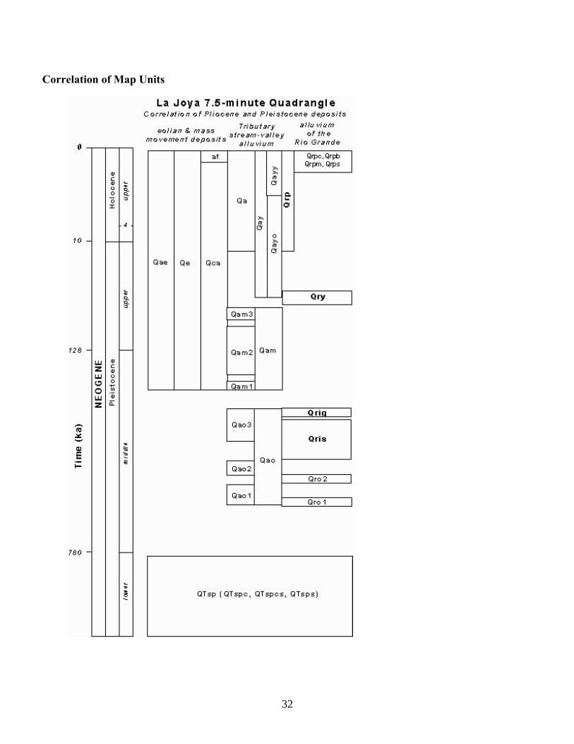
Correlation of Map Units
33
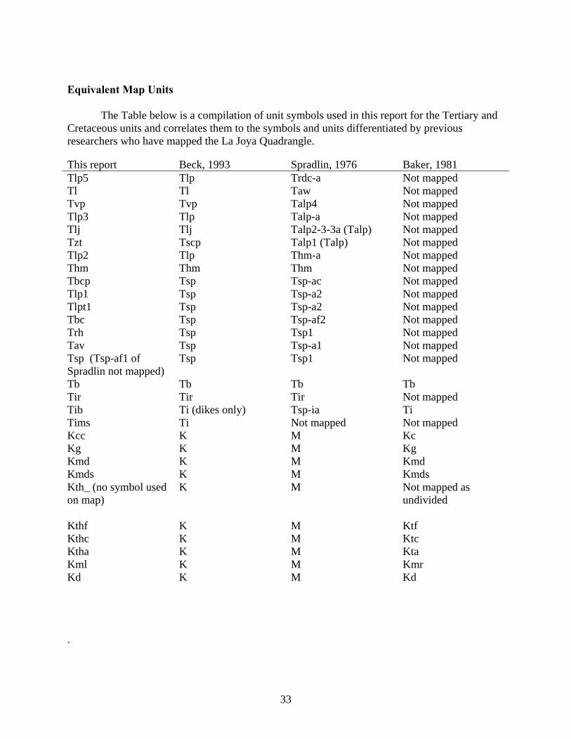
Equivalent Map Units The Table below is a compilation of unit symbols used in this report for the Tertiary and Cretaceous units and correlates them to the symbols and units differentiated by previous researchers who have mapped the La Joya Quadrangle. This report Beck, 1993 Spradlin, 1976 Baker, 1981
Tlp5 Tlp Trdc-a Not mapped
Tl Tl Taw Not mapped
Tvp Tvp Talp4 Not mapped
Tlp3 Tlp Talp-a Not mapped
Tlj Tlj Talp2-3-3a (Talp) Not mapped
Tzt Tscp Talp1 (Talp) Not mapped
Tlp2 Tlp Thm-a Not mapped
Thm Thm Thm Not mapped
Tbcp Tsp Tsp-ac Not mapped
Tlp1 Tsp Tsp-a2 Not mapped
Tlpt1 Tsp Tsp-a2 Not mapped
Tbc Tsp Tsp-af2 Not mapped
Trh Tsp Tsp1 Not mapped
Tav Tsp Tsp-a1 Not mapped
Tsp (Tsp-af1 of Spradlin not mapped)
Tsp Tsp1 Not mapped
Tb Tb Tb Tb
Tir Tir Tir Not mapped
Tib Ti (dikes only) Tsp-ia Ti
Tims Ti Not mapped Not mapped
Kcc K M Kc
Kg K M Kg
Kmd K M Kmd
Kmds K M Kmds
Kth_ (no symbol used on map)
K M Not mapped as undivided
Kthf K M Ktf
Kthc K M Ktc
Ktha K M Kta
Kml K M Kmr
Kd K M Kd .
34
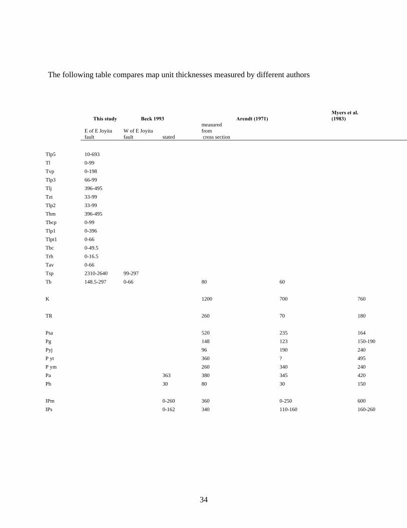
The following table compares map unit thicknesses measured by different authors
This study Beck 1993 Arendt (1971) Myers et al. (1983)
E of E Joyita fault
W of E Joyita fault stated
measured from cross section
Tlp5 10-693
Tl 0-99
Tvp 0-198
Tlp3 66-99
Tlj 396-495
Tzt 33-99
Tlp2 33-99
Thm 396-495
Tbcp 0-99
Tlp1 0-396
Tlpt1 0-66
Tbc 0-49.5
Trh 0-16.5
Tav 0-66
Tsp 2310-2640 99-297
Tb 148.5-297 0-66 80 60
K 1200 700 760
TR 260 70 180
Psa 520 235 164
Pg 148 123 150-190
Pyj 96 190 240
P yt 360 ? 495
P ym 260 340 240
Pa 363 380 345 420
Pb 30 80 30 150
IPm 0-260 360 0-250 600
IPs 0-162 340 110-160 160-260
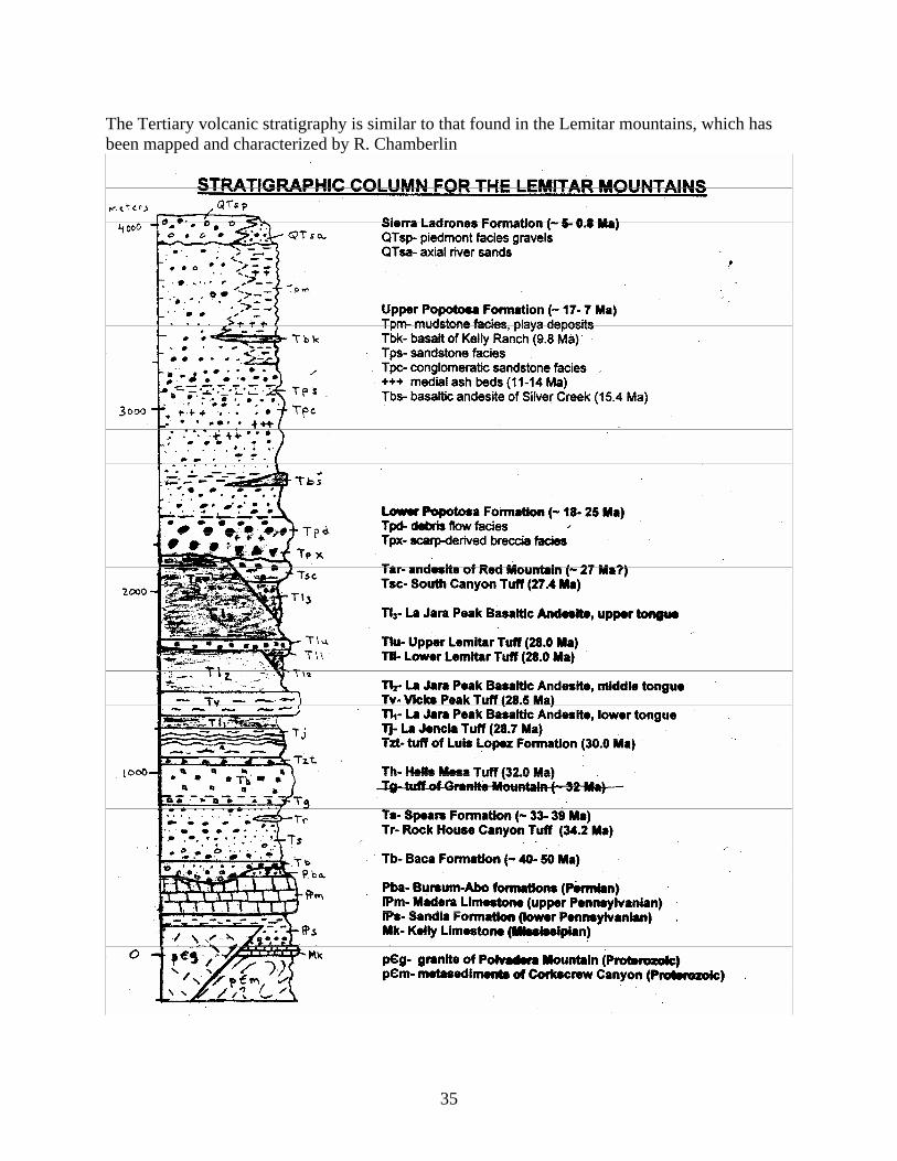
35
The Tertiary volcanic stratigraphy is similar to that found in the Lemitar mountains, which has been mapped and characterized by R. Chamberlin