Embed Size (px)
Citation preview
Survey Reportof the
City & County of San Francisco 2013 High Precision Network Survey
Prepared byMcGee Surveying Consulting and F3 & Associates, Inc.
February 28, 2014, Revised Dec. 18, 2015
INDEXPage Subject-
2 PROJECT OVERVIEW
3 PROJECT DATUMS, REFERENCE SYSTEM
4 GEOMETRIC COORDINATES OF CONTROLLING STATIONS (CORS & CGPS)
4 NETWORK DESCRIPTION
6 ADJUSTMENTS & ANALYSIS: IGS08 (2005) Epoch 2013.54, NAD83 (2011) Epoch 2013.54, NAD83 (2011) Epoch 2010.00 and Geoid Model Analysis
10 DATA COLLECTION, PROCESSING and EQUIPMENT
11 ACCURACY: LOCAL & NETWORK
13 TRANSFORMATIONS: 1999 NAD83 (1992) 1991.35 SPCS to NAD83 (2011) 2010.00 SPCS 1999 NAD83 (1992) 1991.35 SPCS to NAD83 (2011) 2010.00 CCSF-CS14 RECOMMENDATIONS
APPENDIX
15 Glossary16 Geodetic Coordinate List: NAD83 (2011) and IGS08 (2005)17 Plane Coordinate List: NAD83 SPCS & CCSF Coordinate System (Low Distortion Projection)18 Map: CCSF 2013 Regional GNSS Network 19 Map: CCSF 2013 HPN GNSS Network20 CORS Reference Data: Coordinates, HTDP Solutions, NGS Data Sheets and Short-Term Time Series
1

Survey Reportof the
City & County of San Francisco 2013 High Precision Network Survey
Prepared byMcGee Surveying Consulting and F3 & Associates, Inc.
February 28, 2014, Revised Dec. 18, 2015 (minor editing)
OVERVIEW
Project: City and County of San Francisco High Precision Network Survey (CCSF-HPN)Surveyed by: City and County of San Francisco supported by McGee Surveying Consulting, F3 & Associates, Inc. and Frederick T. Seher & Associates, Inc.
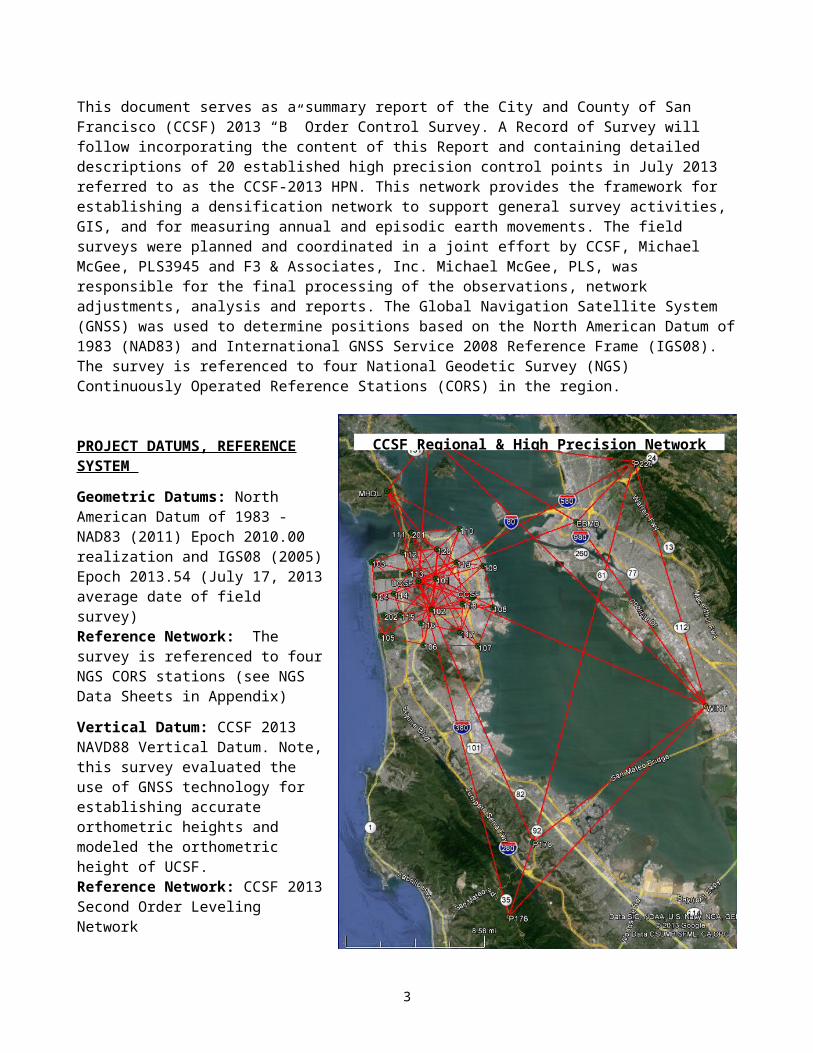
This document serves as a summary report of the City and County of San Francisco (CCSF) 2013 “B” Order Control Survey. A Record of Survey will follow incorporating the content of this Report and containing detailed descriptions of 20 established high precision control points in July 2013 referred to as the CCSF-2013 HPN. This network provides the framework for establishing a densification network to support general survey activities, GIS, and for measuring annual and episodic earth movements. The field surveys were planned and coordinated in a joint effort by CCSF, Michael McGee, PLS3945 and F3 & Associates, Inc. Michael McGee, PLS, was responsible for the final processing of the observations, network adjustments, analysis and reports. The Global Navigation Satellite System (GNSS) was used to determine positions based on the North American Datum of 1983 (NAD83) and International GNSS Service 2008 Reference Frame (IGS08). The survey is referenced to four National Geodetic Survey (NGS) Continuously Operated Reference Stations (CORS) in the region.
2
PROJECT DATUMS, REFERENCE SYSTEM
Geometric Datums: North American Datum of 1983 - NAD83 (2011) Epoch 2010.00 realization and IGS08 (2005) Epoch 2013.54 (July 17, 2013 average date of field survey)Reference Network: The survey is referenced to four NGS CORS stations (see NGS Data Sheets in Appendix)
Vertical Datum: CCSF 2013 NAVD88 Vertical Datum. Note, this survey evaluated the use of GNSS technology for establishing accurate orthometric heights and modeled the orthometric height of UCSF. Reference Network: CCSF 2013 Second Order Leveling Network
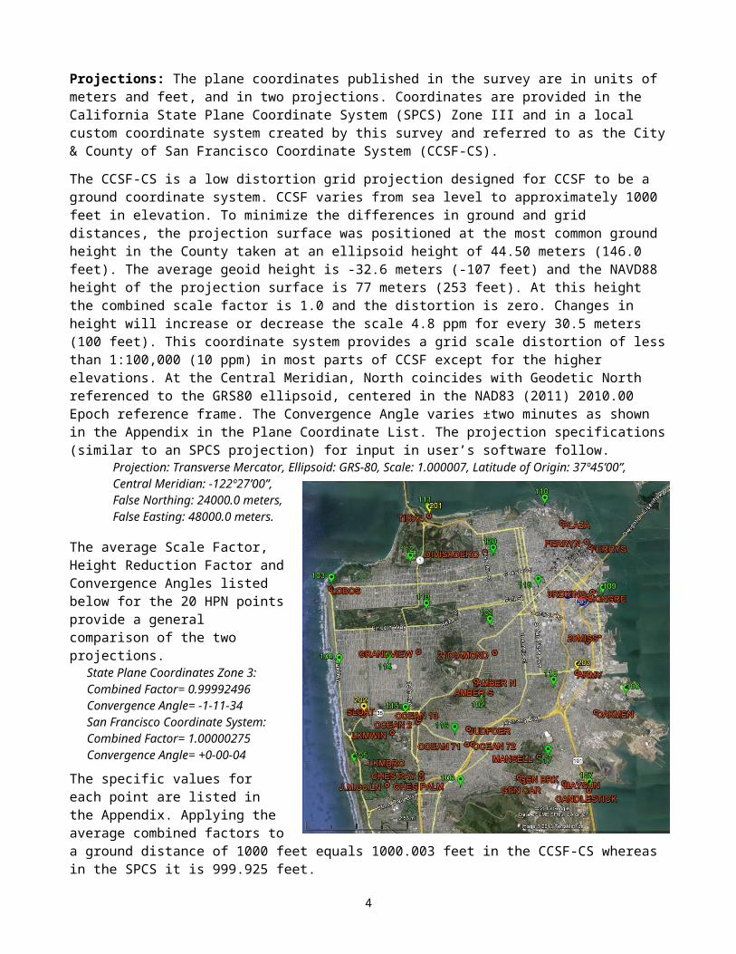
Projections: The plane coordinates published in the survey are in units of meters and feet, and in two projections. Coordinates are provided in the California State Plane Coordinate System (SPCS) Zone III and in a local custom coordinate system created by this survey and referred to as the City & County of San Francisco Coordinate System (CCSF-CS).
The CCSF-CS is a low distortion grid projection designed for CCSF to be a ground coordinate system. CCSF varies from sea level to approximately 1000 feet in elevation. To minimize the differences in ground and grid distances, the projection surface was positioned at the most common ground height in the County taken at an ellipsoid height of 44.50 meters (146.0 feet). The average geoid height is -32.6 meters (-107 feet) and the NAVD88 height of the projection surface is 77 meters (253 feet). At this height the combined scale factor is 1.0 and the distortion is zero. Changes in height will increase or decrease the scale 4.8 ppm for every 30.5 meters (100 feet). This coordinate system provides a grid scale distortion of less than 1:100,000 (10 ppm) in most parts of CCSF except for the higher elevations. At the Central Meridian, North coincides with Geodetic North referenced to the GRS80 ellipsoid, centered in the NAD83 (2011) 2010.00 Epoch reference frame. The Convergence Angle varies ±two minutes as shown in the Appendix in the Plane Coordinate List. The projection specifications (similar to an SPCS projection) for input in user’s software follow.
Projection: Transverse Mercator, Ellipsoid: GRS-80, Scale: 1.000007, Latitude of Origin: 37º45’00”, Central Meridian: -122º27’00”, False Northing: 24000.0 meters, False Easting: 48000.0 meters.
The average Scale Factor, Height Reduction Factor and Convergence Angles listed below for the 20 HPN points provide a general comparison of the two projections.
State Plane Coordinates Zone 3: Combined Factor= 0.99992496 Convergence Angle= -1-11-34 San Francisco Coordinate System: Combined Factor= 1.00000275Convergence Angle= +0-00-04
The specific values for each point are listed in the Appendix. Applying the average combined factors to a ground distance of 1000 feet equals 1000.003 feet in the CCSF-CS whereas in the SPCS it is 999.925 feet.
CCSF Regional & High Precision Network
3
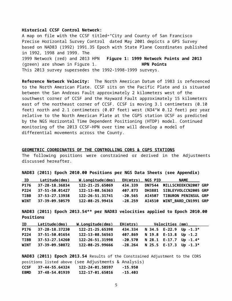
Historical CCSF Control Network: A map on file with the CCSF titled “City and County of San Francisco Precise Horizontal Survey Control” dated May 2001 depicts a GPS Survey based on NAD83 (1992) 1991.35 Epoch with State Plane Coordinates published in 1992, 1998 and 1999. The 1999 Network (red) and 2013 HPN (green) are shown in Figure 1. This 2013 survey supersedes the 1992-1998-1999 surveys.
Reference Network Velocity: The North American Datum of 1983 is referenced to the North American Plate. CCSF sits on the Pacific Plate and is situated between the San Andreas Fault approximately 2 kilometers west of the southwest corner of CCSF and the Hayward Fault approximately 15 kilometers east of the northeast corner of CCSF. CCSF is moving 3.1 centimeters (0.10 feet) north and 2.1 centimeters (0.07 feet) west (N34°W 0.12 feet) per year relative to the North American Plate at the CGPS station UCSF as predicted by the NGS Horizontal Time Dependent Positioning (HTDP) model. Continued monitoring of the 2013 CCSF-HPN over time will develop a model of differential movements across the County.
GEOMETRIC COORDINATES OF THE CONTROLLING CORS & CGPS STATIONSThe following positions were constrained or derived in the Adjustments discussed hereafter.
NAD83 (2011) Epoch 2010.00 Positions per NGS Data Sheets (see Appendix) ID Latitude(dms) W.Longitude(dms) EH(mtrs)_ NGS PID NAME_____P176 37-28-18.36834 122-21-25.65069 434.339 DN7544 MILLSCREEKCN2007 GRPP224 37-51-50.01427 122-13-08.56363 407.873 DH3881 SIBLEYVOLCCN2005 GRPTIBB 37-53-27.13938 122-26-51.31741 -20.565 AI4507 TIBURON PENINSUL GRPWINT 37-39-09.50579 122-08-25.99416 -28.259 AI4510 WINT_BARD_CN1991 GRP
NAD83 (2011) Epoch 2013.54** per NAD83 velocities applied to Epoch 2010.00 PositionsID Latitude(dms) W.Longitude(dms) EH(mtrs) Velocities (mm)____ P176 37-28-18.37230 122-21-25.65398 434.334 N 34.5 E-22.9 Up -1.3*P224 37-51-50.01654 122-13-08.56563 407.869 N 19.8 E-13.8 Up -1.2TIBB 37-53-27.14260 122-26-51.31998 -20.570 N 28.1 E-17.7 Up -1.4*WINT 37-39-09.50872 122-08-25.99666 -28.264 N 25.5 E-17.3 Up -1.3*
NAD83 (2011) Epoch 2013.54 Results of the Constrained Adjustment to the CORS positions listed above (see Adjustments & Analysis)CCSF 37-44-55.64324 122-24-01.58597 -15.950 EBMD 37-48-54.01939 122-17-01.65016 -15.403MHDL 37-50-32.35159 122-29-39.55028 66.403P178 37-32-04.25894 122-19-56.46131 129.572UCSF 37-45-46.67553 122-27-29.29178 155.123
IGS08 (2005) Epoch 2013.54 per IGS08 velocities applied to Epoch 2005 Positions ID Latitude(dms) W.Longitude(dms) EH(mtrs) Velocities (mm)___ P176 37-28-18.38315 122-21-25.71047 433.810 N 21.3 E-36.2 Up 0.0*P224 37-51-50.02759 122-13-08.62234 407.349 N 6.8 E-27.5 Up 0.1TIBB 37-53-27.15354 122-26-51.37682 -21.084 N 14.8 E-31.4 Up 0.0*WINT 37-39-09.51974 122-08-26.05320 -28.790 N 12.5 E-31.0 Up 0.0*
*HTDP v3.2.3 velocities applied to CORS with less than 2.5 years of data**Epoch of Survey
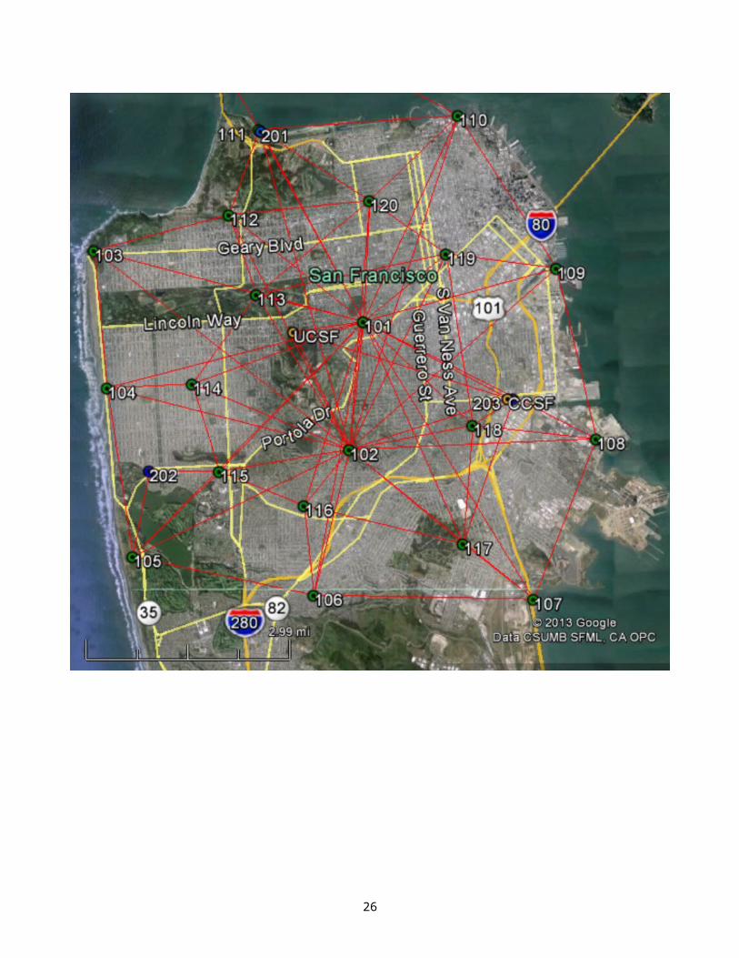
NETWORK DESCRIPTION
Figure 1: 1999 Network Points and 2013 HPN Points
4
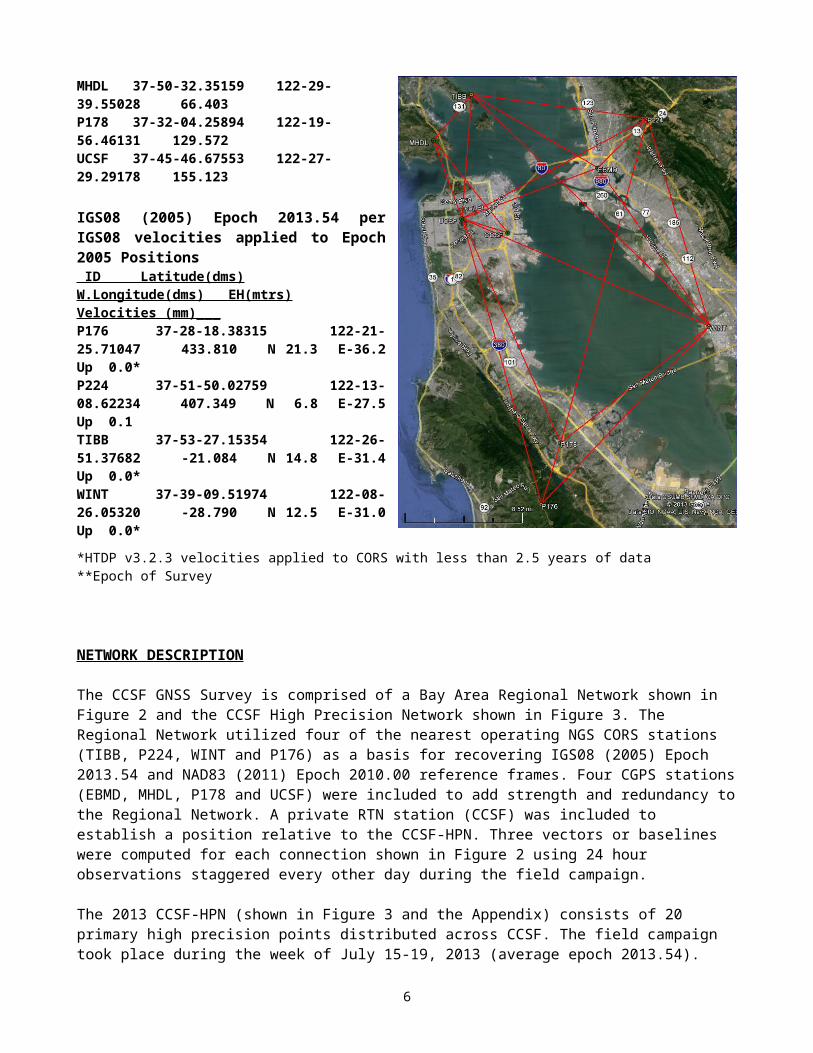
The CCSF GNSS Survey is comprised of a Bay Area Regional Network shown in Figure 2 and the CCSF High Precision Network shown in Figure 3. The Regional Network utilized four of the nearest operating NGS CORS stations (TIBB, P224, WINT and P176) as a basis for recovering IGS08 (2005) Epoch 2013.54 and NAD83 (2011) Epoch 2010.00 reference frames. Four CGPS stations (EBMD, MHDL, P178 and UCSF) were included to add strength and redundancy to the Regional Network. A private RTN station (CCSF) was included to establish a position relative to the CCSF-HPN. Three vectors or baselines were computed for each connection shown in Figure 2 using 24 hour observations staggered every other day during the field campaign.
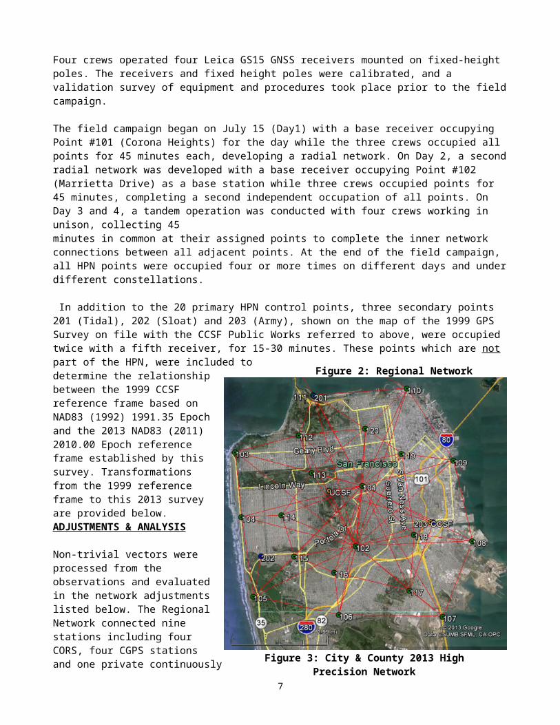
The 2013 CCSF-HPN (shown in Figure 3 and the Appendix) consists of 20 primary high precision points distributed across CCSF. The field campaign took place during the week of July 15-19, 2013 (average epoch 2013.54). Four crews operated four Leica GS15 GNSS receivers mounted on fixed-height poles. The receivers and fixed height poles were calibrated, and a validation survey of equipment and procedures took place prior to the field campaign.
The field campaign began on July 15 (Day1) with a base receiver occupying Point #101 (Corona Heights) for the day while the three crews occupied all points for 45 minutes each, developing a radial network. On Day 2, a second radial network was developed with a base receiver occupying Point #102 (Marrietta Drive) as a base station while three crews occupied points for 45 minutes, completing a second independent occupation of all points. On Day 3 and 4, a tandem operation was conducted with four crews working in unison, collecting 45 minutes in common at their assigned points to complete the inner network connections between all adjacent points. At the end of the field campaign, all HPN points were occupied four or more times on different days and under different constellations.
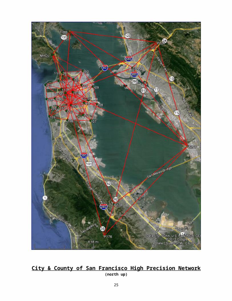
In addition to the 20 primary HPN control points, three secondary points 201 Figure 3: City & County 2013 High Precision Network
Figure 2: Regional Network
5
(Tidal), 202 (Sloat) and 203 (Army), shown on the map of the 1999 GPS Survey on file with the CCSF Public Works referred to above, were occupied twice with a fifth receiver, for 15-30 minutes. These points which are not part of the HPN, were included to determine the relationship between the 1999 CCSF reference frame based on NAD83 (1992) 1991.35 Epoch and the 2013 NAD83 (2011) 2010.00 Epoch reference frame established by this survey. Transformations from the 1999 reference frame to this 2013 survey are provided below. ADJUSTMENTS & ANALYSIS
Non-trivial vectors were processed from the observations and evaluated in the network adjustments listed below. The Regional Network connected nine stations including four CORS, four CGPS stations and one private continuously operated RTN station. The Regional Network contains 57 vectors averaging 20 kilometers in length with a maximum of 38 kilometers. The two-dimensional residuals averaged 0.002 meters with a standard deviation of 0.002 meters and a maximum of 0.010 meters. The absolute value of the vertical residuals averaged 0.002 meters with a standard deviation of 0.002 meters and a range of -0.007 to +0.008 meters. The 2013 CCSF-HPN connected 20 points, three secondary points, two CGPS stations and the private RTN station. The network contains 83 vectors averaging 4.3 kilometers in length with a maximum of 8.3 kilometers. The two-dimensional residuals averaged 0.003 meters with a standard deviation of 0.002 meters and a maximum of 0.010 meters. The absolute value of the vertical residuals averaged 0.003 meters with a standard deviation of 0.003 meters and a range of -0.009 to +0.016 meters.
Six network adjustments were processed to develop the geodetic and plane coordinates in two reference frames at different epochs. An overview of the adjustments follow with details thereafter.
Adjustment #1 and #2: Developed IGS08 (2005) Epoch 2013.54 positions for referencing future secular and episodic movements of the region and CCSF. The IGS08 (2005) positions of the four CORS were obtained from the NGS and moved to Epoch 2013.54 (epoch of this survey) using the NGS HTDP v3.2.3 velocity model. Adjustment #1 fixed WINT to evaluate the vector residuals and closures on the remaining three CORS. Adjustment #2 constrained the network to all four CORS to develop IGS08 (2005) Epoch 2013.54 positions.
Adjustment #3 and #4: Developed NAD83 (2011) Epoch 2013.54 positions for referencing the Regional Network. The NAD83 (2011) Epoch 2010.00 positions of the four CORS were obtained from the NGS and moved to Epoch 2013.54 (epoch of this survey) using the HTDP v3.2.3 velocity model. Adjustment #3 fixed WINT to evaluate the closures on the remaining three CORS. Adjustment #4 constrained the network to all four CORS to develop NAD83 (2011) Epoch 2013.54 positions on the four CGPS stations.
Adjustment #5: Developed NAD83 (2011) Epoch2010.00 positions for CCSF-HPN. The NAD83 (2011) Epoch 2013.54 positions of stations UCSF, MHDL and CCSF, determined in Adjustment #4, were moved to Epoch 2010.00 using the HTDP v3.2.3 velocity model. Adjustment #5 fixed the CGPS station UCSF at the Epoch 2010.00 position to evaluate the closures on MHDL and CCSF, and to develop positions on the 2013 CCSF-HPN.
Adjustment #6: Analyzed the Geoid 2012A Model utilizing a seven parameter conformal transformation with the scale parameter fixed at 1.0 to best fit the GNSS measurements to the NAVD88 Heights of the HPN points determined in the CCSF 2013 Second Order Leveling Network Survey (Report on file with CCSF). The adjustment demonstrates the application and expected results of using GNSS survey technology to develop orthometric heights in CCSF.
IGS08 (2005) Epoch 2013.54 Adjustments
Adjustment 1: 3D Minimally Constrained Adjustment The four nearest operating CORS form the basis for recovery of the IGS08 reference frame for this survey. IGS08 (2005) Epoch positions and velocities were obtained from the NGS website for the CORS. The HTDP
6
v3.2.3 model was used to update the CORS positions to the 2013.54 Epoch of this survey. Four CGPS stations and a private RTN station CCSF were included in the adjustments.
Station WINT was fixed in a Minimally Constrained Adjustment to determine preliminary latitude, longitude, and ellipsoid heights at other stations and to compute closures. The results follow with the coordinate differences (closures) from the IGS08 positions to the computed positions listed in meters below. The position for UCSF was determined from the mean of three 24 hours observations submitted to OPUS and used as a check on the results of this adjustment as shown.
Coordinate Differences: IGS08 to Computed Station dN dE dZ_P176 0.007 -0.004 0.006P224 0.012 0.003 0.002TIBB 0.003 -0.001 -0.015WINT 0.000 0.000 0.000 Fixed UCSF 0.004 0.000 -0.018 OPUS IGS08 position to computed position
Note: The differences between the published and computed positions range 0.000 to 0.012 meters in north, -0.001 to +0.003 meters in east and -0.015 to +0.006 meters in the up direction. Network loop closures were less than a centimeter. The horizontal check on the OPUS position of UCSF is 0.004 meters.
Adjustment 2A: 3D Adjustment Solving for Transformation Parameters from WGS84 to IGS08WGS84 is based on the IGS08 reference frame. In this adjustment the rotations and scale were solved to verify the consistency of the measured network in WGS84 and the IGS08 reference frame as represented by the positions of the CORS. The expectations are zero and the negligible results confirm the consistency of the two frames. WGS84 to IGS08 (2005) Datum Transformation Scale Factor 1.000000068467 = -0.068 PPM (1:14,700,000) Rotation Around North Axis = -0.071 Sec Rotation Around East Axis = -0.055 Sec Rotation Around Vert. Axis = -0.015 Sec
Adjustment 2B: 3D Constrained Adjustment All four CORS were constrained for latitude, longitude and ellipsoid heights to develop IGS08 (2005) 2013.54 Epoch positions on the network. The horizontal difference of 0.001 meters with the UCSF position obtained from the CORS Network utilizing the NGS OPUS Tool confirms the processes used in this survey. Coordinate Differences: IGS08 (2005) 2013.54 Epoch to Computed Station dN dE dZ_UCSF -0.001 0.001 -0.014 OPUS IGS08 position
Note: This Adjustment includes the CCSF-HPN. The results are listed in the Appendix Coordinate List.
NAD83 (2011) Epoch 2013.54 Adjustments
Adjustment 3: 3D Minimally Constrained Adjustment The four nearest operating CORS form the basis for recovery of the NAD83 reference frame for this survey. NAD83 (2011) 2010.00 Epoch positions and velocities were obtained from the NGS website for the CORS. The HTDP v3.2.3 model was used to update the CORS to 2013.54 Epoch of this survey for this adjustment. Four CGPS stations and a private RTN station CCSF were included in the adjustment.
CORS station WINT was fixed in a Minimally Constrained Adjustment to determine preliminary latitude, longitude, and ellipsoid heights at the three other CORS and compute closures. The results follow with the coordinate differences (closures) in meters from the NAD83 (2011) 2013.54 Epoch to the computed positions listed below. The position for UCSF was determined by the SOPAC SECTOR utility for the epoch of this survey and used as a check on the results of this adjustment as shown below.
7
Coordinate Differences: NAD83 (2011) 2013.54 Epoch to Computed Station dN dE dZ_P176 0.006 -0.004 0.005P224 0.012 0.004 0.006TIBB 0.004 -0.001 -0.010WINT 0.000 0.000 0.000 FixedUCSF 0.009 -0.001 -0.004 Difference from SOPAC SECTOR position to computed
Note: The differences between the published and computed positions range 0.000 to 0.012 meters in north, -0.001 to +0.004 meters in east and -0.010 to +0.006 meters up direction. The position of UCSF as determined by SECTOR is referenced to the NAD83 (2007) Adjustment Epoch 2013.54 whereas this adjustment is referenced to NAD83 (2011) Adjustment Epoch 2013.54. The horizontal difference of 0.009 meters is indicative of the similarities of the two national adjustments.
Adjustment 4: 3D/Ellipsoid Heights – Constrained Adjustment All four CORS were constrained for latitude, longitude, and ellipsoid heights to develop NAD83 (2011) Epoch 2013.54 positions. Notwithstanding the 2007 versus the 2011 Adjustments, the horizontal difference of 0.004 meters at UCSF indicates the compatibility of these results with those obtained from the SECTOR utility. Coordinate Differences: NAD83 (2011) 2013.54 Epoch to Computed Station dN dE dZ_UCSF 0.004 -0.001 -0.004 Difference from SOPAC SECTOR position to computed
NAD83 (2011) Epoch 2010.00 Adjustments
Adjustment 5: 3D Minimally Constrained Adjustment of the CCSF-HPNThe NAD83 (2011) 2010.00 Epoch positions at CCSF, MHDL and UCSF were derived by applying HTDP v3.2.3 velocities to the 2013.54 Epoch positions resulting from Adjustment #4. UCSF was fixed in a minimally constrained adjustment to determine latitude, longitude, and ellipsoid heights at other stations and to compute closures. The results follow with the coordinate differences (closures) in meters from the record positions to the computed positions listed below. The source for the record positions of 107, 201 and 202 are the NGS Data Sheets for the listed PID’s. Coordinate Differences: Record to Computed Station dN dE dZ_ NAD83 Epoch Source107 -0.034 0.007 -0.040 2010.00 NGS PID AB7679 = HPGND CA04GF201 -0.029 0.002 -0.045 2010.00 NGS PID AE5209 = N TIDAL202 -0.053 0.017 -0.031 2010.00 NGS PID AB7677 = HPGND CA04GE203 0.537 -0.362 - 1991.35 1999 CCSF Control Survey-NAD83(1992)CCSF -0.005 0.002 0.007 2010.00 HTDP Applied to Adj#4 PositionMHDL -0.003 0.003 -0.006 2010.00 HTDP Applied to Adj#4 PositionUCSF -0.000 -0.000 -0.000 2010.00 Fixed HTDP Applied to Adj#4 PositionUCSF -0.001 -0.001 2010.00 Mean of 3 OPUS Solutions
Note: The differences at 203 reflect the difference between the 1991.35 and 2010.00 Epochs. The closures on the HTDP derived positions for CCSF and MHDL range from 0.000 to -0.005 meters north, +0.002 to +0.003 meters east and -0.006 to +0.007 meters in the up direction and are at the noise level of the HTDP model; therefore, rather than distort the measured vectors in a constrained adjustment, the results of this adjustment were accepted to establish NAD83 (2011) 2010.00 Epoch for the CCSF-HPN. Note: The Adjustment results are listed in the Appendix Coordinate List.
Geoid Model Analysis: Adjustment of Ellipsoid Heights incorporating Geoid Heights to Determine NAVD88 Orthometric Heights:
Two methods for determining NAVD88 Heights in a GPS/GNSS survey are discussed here. The first method approximates NAVD88 Heights by applying geoid heights to the measured ellipsoid heights using the equation H=h-N (Orthometric Height = Ellipsoid Height - Geoid Height). The accuracy of this method when applying the
8
NGS Geoid 2012A to NAD83 (2011) 2010.00 Epoch ellipsoid heights in San Francisco is approximately 0.06 meters as demonstrated below.
The second method takes advantage of the relative precision of modeled geoid heights. The Geoid 2012A Model was incorporated in a seven-parameter conformal transformation with the scale parameter fixed at 1.0 to best fit the NAVD88 Heights established on 20 HPN points determined by precise differential leveling (see the “Report on the City & County of San Francisco 2013 Second Order Leveling Network Survey and the 2013 NAVD88 Vertical Datum” on file with the County Surveyor). The NAD83 (2011) 2010.00 Epoch Ellipsoid Height differences were combined with the Geoid 2012A Heights shown below in Column E and best fit to the leveled heights at the HPN points shown in Column B. This has the effect of best fitting the Geoid 2012A surface through the NAVD88 Heights at all 20 points. The results shown in Column A are the differences in meters from the leveled heights to the computed heights based on GNSS measurements. This is a best fit (least squares) solution; therefore, the mean of the differences is zero. The Standard Deviation of the differences is 0.004 meters (0.01’) and the range is -0.007 to +0.007 meters (+/-0.02’). The solved rotations are +0.213 seconds around the north and +0.243 seconds around the east axis. The rotations represent the tilts applied to the Geoid 2012A model to best fit the HPN orthometric heights which represent a measured geoid surface. The maximum effect of this tilt if unaccounted for is 1.6 mm per kilometer (0.008’ per mile) and is absorbed in a constrained adjustment. The orthometric height of UCSF was modeled in this adjustment.
As an additional check on the differential leveling to the highest HPN points 101 and 102, a constrained adjustment was processed fixing HPN points with orthometric heights less than 8 meters around the north and east shoreline. As a result, points 101 and 102 were found at -0.005 and +0.001 meters respectively. A one way shortest distance from the north shoreline would allow 0.006 meters for First Order Class I.
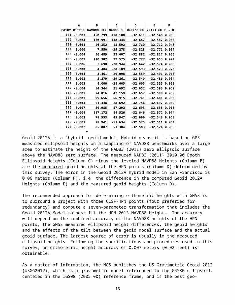
A B C D E FPoint Diff's NAVD88 Hts NAD83 EH Meas'd GH 2012A GH E - D
101 -0.003 150.799 118.188 -32.611 -32.548 0.063102 0.004 170.991 138.344 -32.647 -32.587 0.060103 0.004 46.352 13.592 -32.760 -32.712 0.048104 0.000 7.550 -25.278 -32.828 -32.771 0.057105 -0.004 56.489 23.607 -32.882 -32.817 0.065106 -0.007 110.302 77.575 -32.727 -32.653 0.074107 0.006 3.698 -28.944 -32.642 -32.574 0.068108 0.000 4.484 -28.109 -32.593 -32.523 0.070109 -0.004 3.461 -29.098 -32.559 -32.491 0.068110 0.003 3.279 -29.261 -32.540 -32.486 0.054111 0.003 4.000 -28.605 -32.605 -32.555 0.050112 -0.004 54.344 21.692 -32.652 -32.593 0.059113 -0.001 74.816 42.159 -32.657 -32.598 0.059114 -0.001 99.656 66.915 -32.741 -32.681 0.060115 0.003 61.448 28.692 -32.756 -32.697 0.059116 0.007 89.985 57.292 -32.693 -32.635 0.058117 -0.004 117.172 84.526 -32.646 -32.572 0.074118 0.003 78.553 45.947 -32.606 -32.543 0.063119 -0.003 18.941 -13.634 -32.575 -32.511 0.064120 -0.002 85.887 53.304 -32.583 -32.524 0.059
Geoid 2012A is a “hybrid” geoid model. Hybrid means it is based on GPS measured ellipsoid heights on a sampling of NAVD88 benchmarks over a large area to estimate the height of the NAD83 (2011) zero ellipsoid surface above the NAVD88 zero surface. The measured NAD83 (2011) 2010.00 Epoch Ellipsoid Heights (Column C) minus the leveled NAVD88 Heights (Column B) are the measured geoid heights at the HPN points (Column D) determined by this survey. The error in the Geoid 2012A hybrid model in San Francisco is 0.06
9
meters (Column F), i.e. the difference in the computed Geoid 2012A Heights (Column E) and the measured geoid heights (Column D).
The recommended approach for determining orthometric heights with GNSS is to surround a project with three CCSF-HPN points (four preferred for redundancy) and compute a seven-parameter transformation that includes the Geoid 2012A Model to best fit the HPN 2013 NAVD88 Heights. The accuracy will depend on the combined accuracy of the NAVD88 heights of the HPN points, the GNSS measured ellipsoid height differences, the geoid heights and the effects of the tilt between the geoid model surface and the actual geoid surface. The largest source of error is usually in the measured ellipsoid heights. Following the specifications and procedures used in this survey, an orthometric height accuracy of 0.007 meters (0.02 feet) is obtainable.
As a matter of information, the NGS publishes the US Gravimetric Geoid 2012 (USGG2012), which is a gravimetric model referenced to the GRS80 ellipsoid, centered in the IGS08 (2005.00) reference frame, and is the best geo-potential surface that approximates Mean Sea Level (MSL). USGG2012 is applied to WGS84 = IGS08 Ellipsoid Heights to obtain estimated heights referenced to global mean sea level (geoid). Utilizing the USGG2012 Model in a transformation to best fit the NAVD88 heights of the HPN points (described above) returned essentially the same results as the hybrid model; however, the rotations were +0.138 and +0.120 seconds around the north and east axis respectively, representing a negligible improvement. A new North American Vertical Datum is expected to be introduced in less than ten years. The origin or zero height is expected to be the geo-potential surface described above, which is approximately 0.9 meters lower than the NAVD88 Datum and approximates the NGVD29 Datum.
DATA COLLECTION, PROCESSING and EQUIPMENT Five Leica GS15 geodetic GNSS receivers/antennas listed below were mounted on fixed height poles to collect and store satellite signal data. The GS15 receivers tracked Navstar GPS and GLONASS satellites. Prior to initiating the field observations, a calibration of the fixed height poles was conducted with a theodolite to verify their heights and plumb. The top of the poles were found to be plumb within 1 millimeter of the point. There were no equipment failures during the survey.
Date of Field Surveys: July 15 to July 19, 2013 (Average Date 2013.54)GNSS Survey Parameters:Observations: Static occupations collected GPS and GLONASS signal data at a 15 second epoch rate for 45 minutes at all points with 8 hours at the base station setups for the radial observations on the first two days of the field campaign. Observations at the CORS and CGPS stations were GPS only for 24 hours at a 15 second epoch rate and downloaded from the Internet. Constellation: 32 healthy US Navstar GPS satellites; 24 healthy Russian GLONASS satellites. Satellite Observations: 12-21 satellites observed with a minimum of 6 GPS and 6 GLONASS at any time; GDOP < 2; Elevation Mask for Data Collection set at 10° and post-processed at 15°.Observables: GPS L1 & L2 Carrier wave, GLONASS L1 & L2. Ephemeris: Precise GPS and GLONASS for static post-processing. Weather Conditions: Generally overcast marine layer and mild temperatures. Space Weather: Boulder K Index = 1-3 (gauges ionospheric activity on a scale of 0-9, <5 preferred). The K Index was 1-2 on all days except on July 15 where it was 3. Equipment:
GNSS Base Receiver Unit No.: B, Operator: JTM, RA; Receiver Make & Model: Leica GS15; Antenna Make & Model: Leica GS15Antenna Mount: Fixed Ht. Pole B; Antenna Height: 1.800m
GNSS Base Receiver Unit No.: C, Operator: DPL; Receiver Make & Model: Leica GS15; Antenna Make & Model: Leica GS15Antenna Mount: Fixed Ht. Pole C; Antenna Height: 1.800m
GNSS Base Receiver Unit No.: D, Operator: GP;
10
Receiver Make & Model: Leica GS15; Antenna Make & Model: Leica GS15Antenna Mount: Fixed Ht. Pole D; Antenna Height: 1.800m
GNSS Base Receiver Unit No.: E, Operator: AV; Receiver Make & Model: Leica GS15; Antenna Make & Model: Leica GS15Antenna Mount: Fixed Ht. Pole E; Antenna Height: 1.800m
GNSS Base Receiver Unit No.: F, Operator: MM, PC;Receiver Make & Model: Leica GS15; Antenna Make & Model: Leica GS15Antenna Mount: Fixed Ht. Pole F; Antenna Height: 1.800m
CORS & CGPS National Geodetic Survey Antennas Note, the absolute antenna models were used in the baseline processing and measurements were referenced to the monument not the antenna reference point (ARP). Stat. Antenna RadomeCCSF AX1202 GG NONEEBMD LEIAR10 NONEMHDL ASH700936C_M SNOWP176 TRM29659.00 SCIT P224 TRM29659.00 SCITP178 TRM29659.00 SCITTIBB ASH701945B_M SCITUCSF ASH701945B_M SCITWINT ASH700936D_M CAFG <no model available, substituted “ASH700936D_M NONE”>
Rinex Data, Antenna Models, Precise Ephemeris and Processing Software : Rinex files for the CORS and CGPS were imported from the NGS and SOPAC. Absolute antenna models were imported from the NGS and the Precise Ephemeris was imported from the NGS for the GPS and IGS for the GLONASS constellations. The Precise Ephemeris was used for all static post-processing in IGS08. The Baseline Processing was performed in Leica Geomatics Office (LGO) v8.1. The Network Adjustments were performed in Starnet v7.2.
ACCURACY: LOCAL & NETWORK
This survey conforms to the requirements of Public Resources Code Section 8801 through 8819 and 8850 through 8880. This survey conforms to the intent of the FGCC “Geometric Geodetic Accuracy Standards and Specifications for Using GPS Positioning Techniques” (1989), the California Geodetic Control Committee (CGCC) “Specifications for High-Production GPS Surveying Techniques” (1993), and NOAA Technical Memorandum NOS NGS 58 "Guidelines for Establishing GPS-Derived Ellipsoid Heights”.
Vector Residuals: The number of vectors, two-dimensional vector residuals, and the absolute value of the vertical residuals resulting from the minimally constrained adjustment are listed below in meters. Two Dimensional Residuals Vertical Residuals (absolute values) No. Average Std.Dev. Maximum Average Std.Dev. Range CCSF HPN 83 0.003 0.002 0.010 0.003 0.003 -0.009 to +0.016Regional CORS 57 0.002 0.002 0.010 0.002 0.002 -0.007 to +0.008
Local Accuracy: The local vector lengths, precisions, relative distance accuracy and relative vertical accuracy resulting from the minimally constrained adjustment at the 95% Level of Confidence are listed below in meters. Lengths PPM Precisions Relative Distance Error Rel.Vert. Error Network Vary Average Vary Average Average Maximum Precision Average MaximumCCSF HPN 1675-8291 4267 0.4-2.3 1.1 ppm 0.004 0.005 1:1,067,000 0.003 0.004Regional 5322-37896 20224 0.1-0.6 0.2 ppm 0.003 0.003 1:6,741,000 0.003 0.004
Following the criteria of the former FGCC classification system described in “Geometric Geodetic Accuracy Standards and Specifications for Using GPS Positioning Techniques” (1989), the maximum allowable relative error at the 95% confidence level is defined as s=√(e²+(0.1pd)²) where e is the base error, p is the ppm and d is
11
the distance in kilometers. For the CCSF-HPN, B-Order is equivalent to √(.8²+(0.1·1·4.3)²) = 0.9 centimeters and A-Order is equivalent to √(.5²+(0.1·0.1·4.3)²) = 0.5 centimeters. Loop closures for the HPN vary between 1 ppm and 5 ppm. In conclusion, this survey exceeds a B-Order classification (1:1,000,000) under the former system and the Regional Network exceeds an A-Order classification (1:10,000,000).
Network Accuracy: The Standard Deviations (68% Level of Confidence) of the latitude, longitude and ellipsoid heights and the 95% Level of Confidence of the Horizontal Positions and Ellipsoid Heights for the Regional Network and the HPN are listed below in meters. This table allows users to calculate the propagated error for future surveys based on the HPN positions.
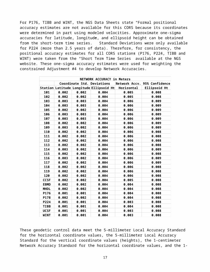
For P176, TIBB and WINT, the NGS Data Sheets state “Formal positional accuracy estimates are not available for this CORS because its coordinates were determined in part using modeled velocities. Approximate one-sigma accuracies for latitude, longitude, and ellipsoid height can be obtained from the short-term time series.” Standard Deviations were only available for P224 (more than 2.5 years of data). Therefore, for consistency, the positional accuracy estimates for all CORS stations (P176, P224, TIBB and WINT) were taken from the “Short Term Time Series” available at the NGS website. These one-sigma accuracy estimates were used for weighting the constrained Adjustment #4 to develop Network Accuracies.
Station Latitude Longitude Ellipsoid Ht Horizontal Ellipsoid Ht101 0.002 0.002 0.004 0.005 0.008102 0.002 0.002 0.004 0.005 0.008103 0.003 0.003 0.004 0.006 0.009104 0.003 0.003 0.004 0.006 0.009105 0.002 0.002 0.004 0.006 0.009106 0.003 0.003 0.004 0.006 0.009107 0.003 0.003 0.004 0.006 0.009108 0.002 0.002 0.004 0.006 0.009109 0.003 0.002 0.004 0.006 0.009110 0.002 0.002 0.004 0.006 0.008111 0.002 0.002 0.004 0.006 0.008112 0.002 0.002 0.004 0.006 0.008113 0.002 0.002 0.004 0.006 0.008114 0.003 0.002 0.004 0.006 0.009115 0.002 0.002 0.004 0.006 0.008116 0.003 0.002 0.004 0.006 0.009117 0.002 0.002 0.004 0.006 0.009118 0.002 0.002 0.004 0.006 0.008119 0.002 0.002 0.004 0.006 0.008120 0.002 0.002 0.004 0.006 0.008CCSF 0.002 0.002 0.004 0.005 0.008EBMD 0.002 0.002 0.004 0.004 0.008MHDL 0.002 0.002 0.004 0.004 0.008P176 0.001 0.001 0.004 0.004 0.008P178 0.002 0.002 0.004 0.004 0.008P224 0.001 0.001 0.004 0.003 0.008TIBB 0.001 0.001 0.004 0.004 0.008UCSF 0.001 0.001 0.004 0.003 0.008WINT 0.001 0.001 0.004 0.003 0.008
Coordinate Std. Deviations Network Accy. 95% ConfidenceNETWORK ACCURACY in Meters
12
These geodetic control data meet the 5-millimeter Local Accuracy Standard for the horizontal coordinate values, the 5-millimeter Local Accuracy Standard for the vertical coordinate values (heights), the 1-centimeter Network Accuracy Standard for the horizontal coordinate values, and the 1- centimeter Network Accuracy Standard for the vertical coordinate values (heights) at the 95-percent confidence level according to the reporting standard published by FGDC in "Geospatial Positioning Accuracy Standard, Part 2, Geodetic Control Networks", FGDC-Std-007, 2-1998.
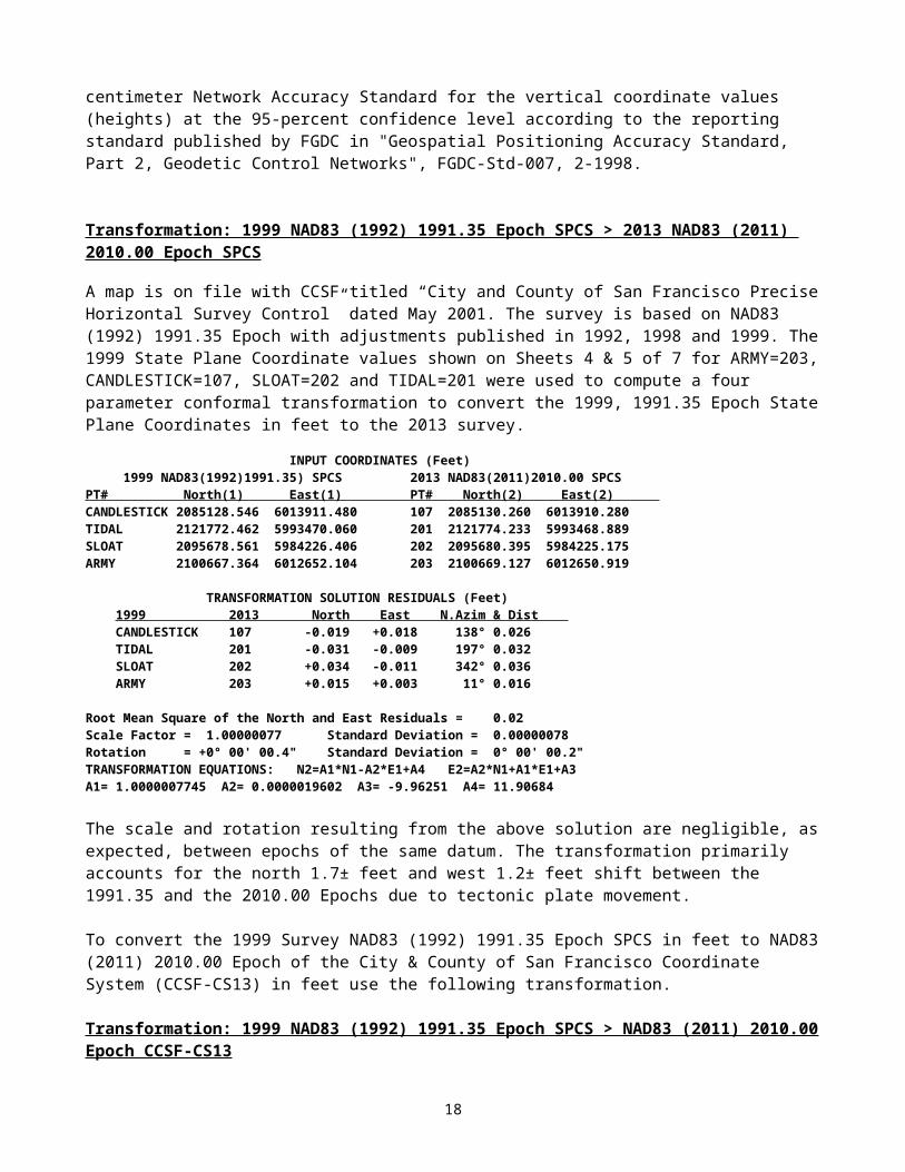
Transformation: 1999 NAD83 (1992) 1991.35 Epoch SPCS > 2013 NAD83 (2011) 2010.00 Epoch SPCS
A map is on file with CCSF titled “City and County of San Francisco Precise Horizontal Survey Control” dated May 2001. The survey is based on NAD83 (1992) 1991.35 Epoch with adjustments published in 1992, 1998 and 1999. The 1999 State Plane Coordinate values shown on Sheets 4 & 5 of 7 for ARMY=203, CANDLESTICK=107, SLOAT=202 and TIDAL=201 were used to compute a four parameter conformal transformation to convert the 1999, 1991.35 Epoch State Plane Coordinates in feet to the 2013 survey.
INPUT COORDINATES (Feet) 1999 NAD83(1992)1991.35) SPCS 2013 NAD83(2011)2010.00 SPCSPT# North(1) East(1) PT# North(2) East(2) CANDLESTICK 2085128.546 6013911.480 107 2085130.260 6013910.280 TIDAL 2121772.462 5993470.060 201 2121774.233 5993468.889 SLOAT 2095678.561 5984226.406 202 2095680.395 5984225.175 ARMY 2100667.364 6012652.104 203 2100669.127 6012650.919
TRANSFORMATION SOLUTION RESIDUALS (Feet) 1999 2013 North East N.Azim & Dist CANDLESTICK 107 -0.019 +0.018 138° 0.026 TIDAL 201 -0.031 -0.009 197° 0.032 SLOAT 202 +0.034 -0.011 342° 0.036 ARMY 203 +0.015 +0.003 11° 0.016
Root Mean Square of the North and East Residuals = 0.02Scale Factor = 1.00000077 Standard Deviation = 0.00000078Rotation = +0° 00' 00.4" Standard Deviation = 0° 00' 00.2"TRANSFORMATION EQUATIONS: N2=A1*N1-A2*E1+A4 E2=A2*N1+A1*E1+A3A1= 1.0000007745 A2= 0.0000019602 A3= -9.96251 A4= 11.90684
The scale and rotation resulting from the above solution are negligible, as expected, between epochs of the same datum. The transformation primarily accounts for the north 1.7± feet and west 1.2± feet shift between the 1991.35 and the 2010.00 Epochs due to tectonic plate movement.
To convert the 1999 Survey NAD83 (1992) 1991.35 Epoch SPCS in feet to NAD83 (2011) 2010.00 Epoch of the City & County of San Francisco Coordinate System (CCSF-CS13) in feet use the following transformation.
Transformation: 1999 NAD83 (1992) 1991.35 Epoch SPCS > NAD83 (2011) 2010.00 Epoch CCSF-CS13
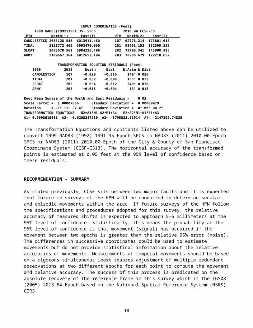
INPUT COORDINATES (Feet) 1999 NAD83(1992)1991.35) SPCS 2010.00 CCSF-CS PT# North(1) East(1) PT# North(2) East(2) CANDLESTICK 2085128.546 6013911.480 107 62778.214 173801.613 TIDAL 2121772.462 5993470.060 201 98991.152 152599.533 SLOAT 2095678.561 5984226.406 202 72708.341 143900.815 ARMY 2100667.364 6012652.104 203 78288.679 172218.652
TRANSFORMATION SOLUTION RESIDUALS (Feet) 1999 2013 North East N.Azim & Dist CANDLESTICK 107 -0.020 +0.016 140° 0.026 TIDAL 201 -0.032 -0.009 195° 0.033 SLOAT 202 +0.034 -0.012 340° 0.036 ARMY 203 +0.018 +0.004 13° 0.018
Root Mean Square of the North and East Residuals = 0.02Scale Factor = 1.00007856 Standard Deviation = 0.00000079
13
Rotation = -1° 11' 37.4" Standard Deviation = 0° 00' 00.2"TRANSFORMATION EQUATIONS N2=A1*N1-A2*E1+A4 E2=A2*N1+A1*E1+A3A1= 0.9998615081 A2= -0.0208347280 A3= -5795833.91914 A4= -2147359.74825
The Transformation Equations and constants listed above can be utilized to convert 1999 NAD83 (1992) 1991.35 Epoch SPCS to NAD83 (2011) 2010.00 Epoch SPCS or NAD83 (2011) 2010.00 Epoch of the City & County of San Francisco Coordinate System (CCSF-CS13). The horizontal accuracy of the transformed points is estimated at 0.05 feet at the 95% level of confidence based on these residuals.
RECOMMENDATION - SUMMARY
As stated previously, CCSF sits between two major faults and it is expected that future re-surveys of the HPN will be conducted to determine secular and episodic movements within the area. If future surveys of the HPN follow the specifications and procedures adopted for this survey, the relative accuracy of measured shifts is expected to approach 5-6 millimeters at the 95% level of confidence. Statistically, this means the probability at the 95% level of confidence is that movement (signal) has occurred if the movement between two epochs is greater than the relative 95% error (noise). The differences in successive coordinates could be used to estimate movements but do not provide statistical information about the relative accuracies of movements. Measurements of temporal movements should be based on a rigorous simultaneous least squares adjustment of multiple redundant observations at two different epochs for each point to compute the movement and relative accuracy. The success of this process is predicated on the absolute recovery of the reference frame in this survey which is the IGS08 (2005) 2013.54 Epoch based on the National Spatial Reference System (NSRS) CORS.
14
APPENDIX
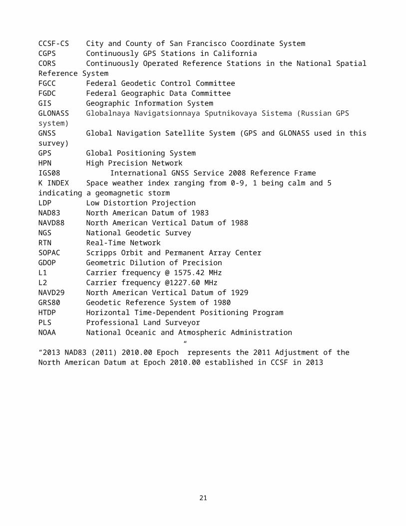
GLOSSARY
CCSF City and County of San Francisco CCSF-CS City and County of San Francisco Coordinate System CGPS Continuously GPS Stations in CaliforniaCORS Continuously Operated Reference Stations in the National Spatial Reference SystemFGCC Federal Geodetic Control CommitteeFGDC Federal Geographic Data CommitteeGIS Geographic Information SystemGLONASS Globalnaya Navigatsionnaya Sputnikovaya Sistema (Russian GPS system)GNSS Global Navigation Satellite System (GPS and GLONASS used in this survey)GPS Global Positioning SystemHPN High Precision Network IGS08 International GNSS Service 2008 Reference FrameK INDEX Space weather index ranging from 0-9, 1 being calm and 5 indicating a geomagnetic stormLDP Low Distortion ProjectionNAD83 North American Datum of 1983NAVD88 North American Vertical Datum of 1988NGS National Geodetic SurveyRTN Real-Time NetworkSOPAC Scripps Orbit and Permanent Array CenterGDOP Geometric Dilution of Precision L1 Carrier frequency @ 1575.42 MHz L2 Carrier frequency @1227.60 MHz NAVD29 North American Vertical Datum of 1929GRS80 Geodetic Reference System of 1980HTDP Horizontal Time-Dependent Positioning ProgramPLS Professional Land Surveyor NOAA National Oceanic and Atmospheric Administration
“2013 NAD83 (2011) 2010.00 Epoch” represents the 2011 Adjustment of the North American Datum at Epoch 2010.00 established in CCSF in 2013
15
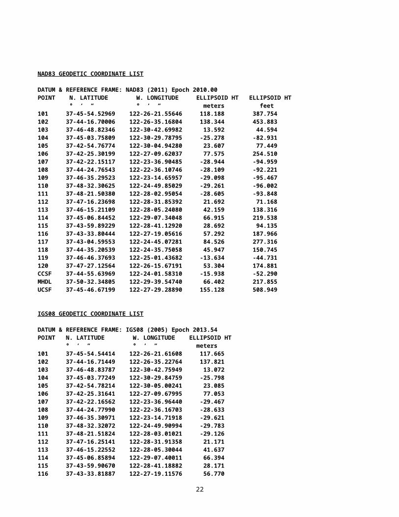
NAD83 GEODETIC COORDINATE LIST
DATUM & REFERENCE FRAME: NAD83 (2011) Epoch 2010.00 POINT N. LATITUDE W. LONGITUDE ELLIPSOID HT ELLIPSOID HT ° ‘ “ ° ‘ “ meters feet101 37-45-54.52969 122-26-21.55646 118.188 387.754102 37-44-16.70006 122-26-35.16804 138.344 453.883103 37-46-48.82346 122-30-42.69982 13.592 44.594104 37-45-03.75809 122-30-29.78795 -25.278 -82.931105 37-42-54.76774 122-30-04.94280 23.607 77.449106 37-42-25.30199 122-27-09.62037 77.575 254.510107 37-42-22.15117 122-23-36.90485 -28.944 -94.959108 37-44-24.76543 122-22-36.10746 -28.109 -92.221109 37-46-35.29523 122-23-14.65957 -29.098 -95.467110 37-48-32.30625 122-24-49.85029 -29.261 -96.002111 37-48-21.50380 122-28-02.95054 -28.605 -93.848112 37-47-16.23698 122-28-31.85392 21.692 71.168113 37-46-15.21109 122-28-05.24080 42.159 138.316114 37-45-06.84452 122-29-07.34048 66.915 219.538115 37-43-59.89229 122-28-41.12920 28.692 94.135116 37-43-33.80444 122-27-19.05616 57.292 187.966117 37-43-04.59553 122-24-45.07281 84.526 277.316118 37-44-35.20539 122-24-35.75058 45.947 150.745119 37-46-46.37693 122-25-01.43682 -13.634 -44.731120 37-47-27.12564 122-26-15.67191 53.304 174.881CCSF 37-44-55.63969 122-24-01.58310 -15.938 -52.290MHDL 37-50-32.34805 122-29-39.54740 66.402 217.855UCSF 37-45-46.67199 122-27-29.28890 155.128 508.949
IGS08 GEODETIC COORDINATE LIST
DATUM & REFERENCE FRAME: IGS08 (2005) Epoch 2013.54 POINT N. LATITUDE W. LONGITUDE ELLIPSOID HT ° ‘ “ ° ‘ “ meters101 37-45-54.54414 122-26-21.61608 117.665102 37-44-16.71449 122-26-35.22764 137.821103 37-46-48.83787 122-30-42.75949 13.072104 37-45-03.77249 122-30-29.84759 -25.798105 37-42-54.78214 122-30-05.00241 23.085106 37-42-25.31641 122-27-09.67995 77.053107 37-42-22.16562 122-23-36.96440 -29.467108 37-44-24.77990 122-22-36.16703 -28.633109 37-46-35.30971 122-23-14.71918 -29.621110 37-48-32.32072 122-24-49.90994 -29.783111 37-48-21.51824 122-28-03.01021 -29.126112 37-47-16.25141 122-28-31.91358 21.171113 37-46-15.22552 122-28-05.30044 41.637114 37-45-06.85894 122-29-07.40011 66.394115 37-43-59.90670 122-28-41.18882 28.171116 37-43-33.81887 122-27-19.11576 56.770117 37-43-04.60998 122-24-45.13238 84.003118 37-44-35.21984 122-24-35.81017 45.424119 37-46-46.39139 122-25-01.49644 -14.157120 37-47-27.14010 122-26-15.73155 52.782CCSF 37-44-55.65415 122-24-01.64269 -16.461
16
EBMD 37-48-54.03039 122-17-01.70688 -15.922MHDL 37-50-32.36248 122-29-39.60710 65.888P176 37-28-18.38315 122-21-25.71047 433.810P178 37-32-04.26983 122-19-56.51784 129.049P224 37-51-50.02759 122-13-08.62234 407.349TIBB 37-53-27.15354 122-26-51.37682 -21.084UCSF 37-45-46.68643 122-27-29.34853 154.606WINT 37-39-09.51974 122-08-26.05320 -28.790
PLANE COORDINATE LIST
California State Plane Coordinates Zone 3: NAD83 (2011) 2010.00 Epoch and NAVD88 Heights per CCSF 2013 2nd Order Leveling Survey
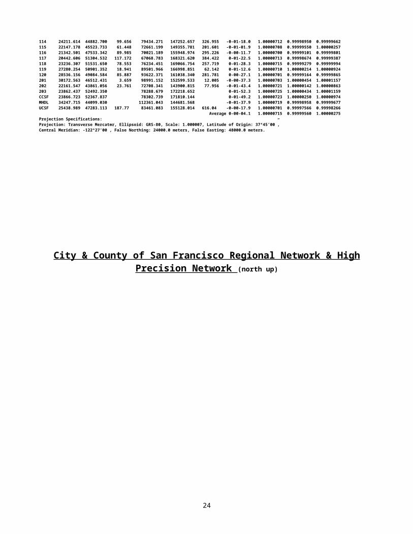
POINT# STATE PLANE COORD. NAVD88 STATE PLANE COORD. NAVD88 Convergence ----- Factors ----- NORTH(m) EAST(m) HEIGHT(m) NORTH(ft) EAST(ft) HEIGHT(ft) Angle Scale x Ellipsoid = Combined101 642177.520 1829147.188 150.799 2106877.414 6001127.064 494.746 -1-11-14.3 0.99992921 0.99998145 0.99991066102 639169.103 1828751.516 170.991 2097007.299 5999828.933 560.993 -1-11-22.7 0.99992920 0.99997829 0.99990750103 643985.863 1822793.428 46.352 2112810.286 5980281.439 152.073 -1-13-54.2 0.99992931 0.99999787 0.99992718104 640740.769 1823039.791 7.550 2102163.674 5981089.714 24.770 -1-13-46.3 0.99992918 1.00000397 0.99993315105 636752.037 1823562.786 56.489 2089077.308 5982805.572 185.331 -1-13-31.1 0.99992937 0.99999630 0.99992567106 635753.146 1827836.561 110.302 2085800.113 5996827.116 361.882 -1-11-43.8 0.99992947 0.99998783 0.99991730107 635548.974 1833043.520 3.698 2085130.260 6013910.280 12.133 -1-09-33.5 0.99992948 1.00000454 0.99993403108 639298.261 1834608.138 4.484 2097431.045 6019043.533 14.711 -1-08-56.3 0.99992920 1.00000441 0.99993361109 643340.513 1833745.648 3.461 2110693.000 6016213.847 11.355 -1-09-19.9 0.99992928 1.00000457 0.99993384110 646994.405 1831490.574 3.279 2122680.811 6008815.324 10.758 -1-10-18.2 0.99992969 1.00000459 0.99993428111 646759.384 1826761.484 4.000 2121909.745 5993299.969 13.123 -1-12-16.4 0.99992964 1.00000449 0.99993412112 644762.606 1826012.184 54.344 2115358.651 5990841.639 178.294 -1-12-34.1 0.99992938 0.99999660 0.99992598113 642867.936 1826623.601 74.816 2109142.554 5992847.597 245.459 -1-12-17.8 0.99992924 0.99999338 0.99992262114 640792.840 1825059.534 99.656 2102334.511 5987716.154 326.955 -1-12-55.8 0.99992918 0.99998950 0.99991868115 638715.658 1825657.369 61.448 2095519.621 5989677.550 201.601 -1-12-39.8 0.99992923 0.99999550 0.99992472116 637869.351 1827649.621 89.985 2092743.029 5996213.798 295.226 -1-11-49.5 0.99992927 0.99999101 0.99992028117 636891.154 1831400.952 117.172 2089533.729 6008521.289 384.422 -1-10-15.3 0.99992935 0.99998674 0.99991608118 639679.300 1831686.204 78.553 2098681.170 6009457.154 257.719 -1-10-09.5 0.99992919 0.99999279 0.99992198119 643735.185 1831140.342 18.941 2111987.853 6007666.271 62.142 -1-10-25.3 0.99992930 1.00000214 0.99993144120 645028.567 1829350.275 85.887 2116231.223 6001793.361 281.781 -1-11-10.7 0.99992942 0.99999164 0.99992106201 646718.080 1826812.971 3.659 2121774.233 5993468.889 12.005 -1-12-15.1 0.99992963 1.00000454 0.99993417202 638764.662 1823995.481 23.761 2095680.395 5984225.175 77.956 -1-13-21.4 0.99992923 1.00000142 0.99993065203 640285.230 1832659.665 2100669.127 6012650.919 -1-09-45.5 0.99992918 1.00000434 0.99993352CCSF 640292.109 1832535.278 2100691.693 6012242.824 -1-09-48.6 0.99992918 1.00000250 0.99993168MHDL 650842.310 1824485.178 2135305.146 5985831.789 -1-13-15.5 0.99993044 0.99998958 0.99992002UCSF 641969.844 1827484.810 187.77 2106196.063 5995673.081 616.04 -1-11-55.8 0.99992920 0.99997566 0.99990486 Average -1-11-33.7 0.99992936 0.99999560 0.99992496
CCSF Plane Coordinates: NAD83 (2011) 2010.00 Epoch and NAVD88 Heights per CCSF 2013 2nd Order Leveling Survey
POINT# CCSF PLANE COORD. NAVD88 CCSF PLANE COORD. NAVD88 Convergence ----- Factors ----- NORTH(m) EAST(m) HEIGHT(m) NORTH(ft) EAST(ft) HEIGHT(ft) Angle Scale x Ellipsoid = Combined101 25681.275 48940.932 150.799 84255.983 160567.041 494.746 0-00-23.5 1.00000701 0.99998145 0.99998847102 22665.032 48608.002 170.991 74360.193 159474.752 560.993 0-00-15.2 1.00000700 0.99997829 0.99998530103 27356.975 42550.378 46.352 89753.676 139600.697 152.073 -0-02-16.4 1.00000737 0.99999787 1.00000523104 24117.466 42864.322 7.550 79125.385 140630.698 24.770 -0-02-08.4 1.00000732 1.00000397 1.00001129105 20140.186 43470.358 56.489 66076.592 142618.999 185.331 -0-01-53.1 1.00000725 0.99999630 1.00000355106 19230.486 47764.351 110.302 63092.021 156706.874 361.882 -0-00-05.9 1.00000700 0.99998783 0.99999483107 19134.838 52974.838 3.698 62778.214 173801.613 12.133 0-02-04.2 1.00000730 1.00000454 1.00001185108 22916.205 54461.117 4.484 75184.248 178677.849 14.711 0-02-41.5 1.00000751 1.00000441 1.00001192109 26939.924 53514.519 3.461 88385.400 175572.218 11.355 0-02-18.0 1.00000737 1.00000457 1.00001194110 30546.317 51183.622 3.279 100217.376 167924.933 10.758 0-01-19.8 1.00000712 1.00000459 1.00001172111 30212.789 46460.090 4.000 99123.126 152427.813 13.123 -0-00-38.6 1.00000703 1.00000449 1.00001152112 28200.678 45752.500 54.344 92521.723 150106.327 178.294 -0-00-56.3 1.00000706 0.99999660 1.00000366113 26319.011 46403.311 74.816 86348.290 152241.529 245.459 -0-00-40.0 1.00000703 0.99999338 1.00000042114 24211.614 44882.700 99.656 79434.271 147252.657 326.955 -0-01-18.0 1.00000712 0.99998950 0.99999662115 22147.178 45523.733 61.448 72661.199 149355.781 201.601 -0-01-01.9 1.00000708 0.99999550 1.00000257116 21342.501 47533.342 89.985 70021.189 155948.974 295.226 -0-00-11.7 1.00000700 0.99999101 0.99999801117 20442.606 51304.532 117.172 67068.783 168321.620 384.422 0-01-22.5 1.00000713 0.99998674 0.99999387118 23236.307 51531.650 78.553 76234.451 169066.754 257.719 0-01-28.3 1.00000715 0.99999279 0.99999994119 27280.254 50901.352 18.941 89501.966 166998.851 62.142 0-01-12.6 1.00000710 1.00000214 1.00000924120 28536.156 49084.584 85.887 93622.371 161038.340 281.781 0-00-27.1 1.00000701 0.99999164 0.99999865201 30172.563 46512.431 3.659 98991.152 152599.533 12.005 -0-00-37.3 1.00000703 1.00000454 1.00001157202 22161.547 43861.056 23.761 72708.341 143900.815 77.956 -0-01-43.4 1.00000721 1.00000142 1.00000863203 23862.437 52492.350 78288.679 172218.652 0-01-52.3 1.00000725 1.00000434 1.00001159CCSF 23866.723 52367.837 78302.739 171810.144 0-01-49.2 1.00000723 1.00000250 1.00000974MHDL 34247.715 44099.030 112361.043 144681.568 -0-01-37.9 1.00000719 0.99998958 0.99999677UCSF 25438.989 47283.113 187.77 83461.083 155128.014 616.04 -0-00-17.9 1.00000701 0.99997566 0.99998266 Average 0-00-04.1 1.00000715 0.99999560 1.00000275Projection Specifications: Projection: Transverse Mercator, Ellipsoid: GRS-80, Scale: 1.000007, Latitude of Origin: 37º45’00”, Central Meridian: -122º27’00”, False Northing: 24000.0 meters, False Easting: 48000.0 meters.
17
City & County of San Francisco Regional Network & High Precision Network (north up)
18
City & County of San Francisco High Precision Network(north up)
19
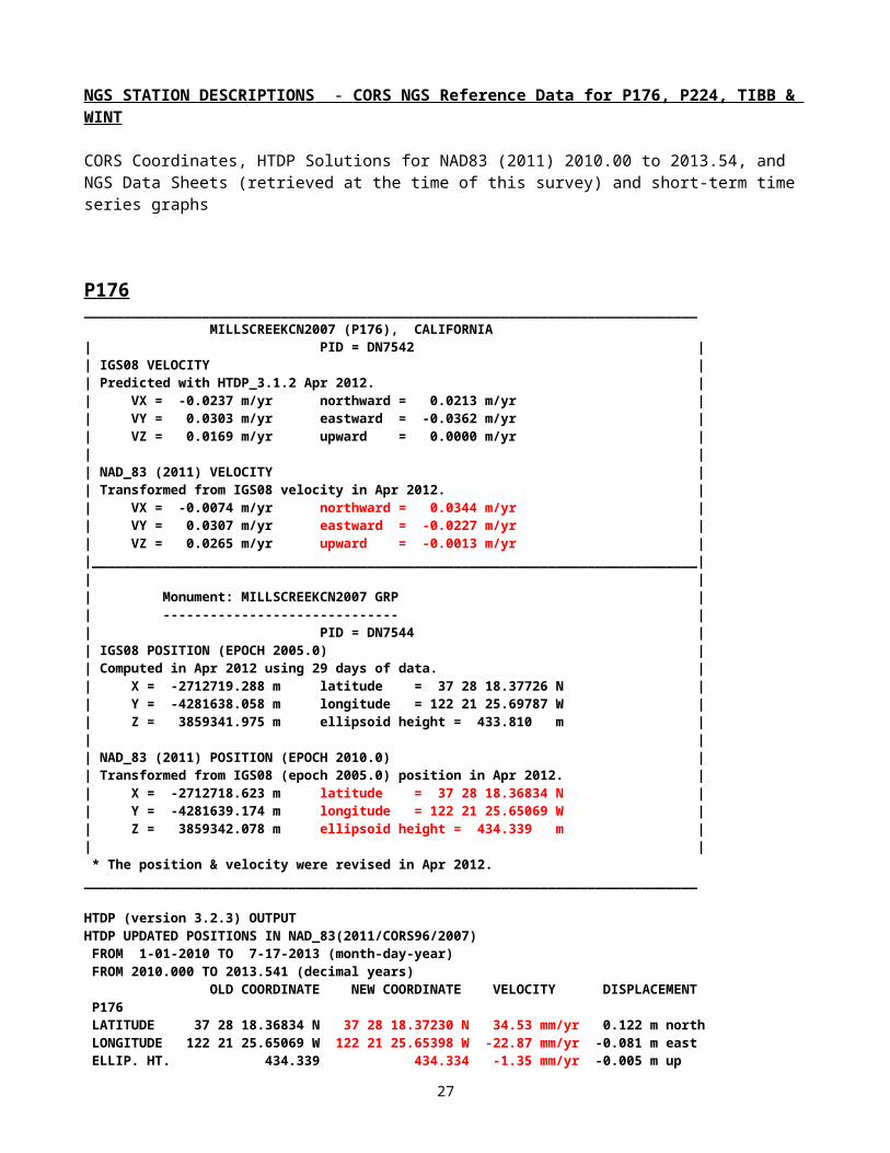
NGS STATION DESCRIPTIONS - CORS NGS Reference Data for P176, P224, TIBB & WINT
CORS Coordinates, HTDP Solutions for NAD83 (2011) 2010.00 to 2013.54, and NGS Data Sheets (retrieved at the time of this survey) and short-term time series graphs
20
P176______________________________________________________________________________ MILLSCREEKCN2007 (P176), CALIFORNIA| PID = DN7542 || IGS08 VELOCITY || Predicted with HTDP_3.1.2 Apr 2012. || VX = -0.0237 m/yr northward = 0.0213 m/yr || VY = 0.0303 m/yr eastward = -0.0362 m/yr || VZ = 0.0169 m/yr upward = 0.0000 m/yr || || NAD_83 (2011) VELOCITY || Transformed from IGS08 velocity in Apr 2012. || VX = -0.0074 m/yr northward = 0.0344 m/yr || VY = 0.0307 m/yr eastward = -0.0227 m/yr || VZ = 0.0265 m/yr upward = -0.0013 m/yr ||_____________________________________________________________________________|| || Monument: MILLSCREEKCN2007 GRP || ------------------------------ || PID = DN7544 || IGS08 POSITION (EPOCH 2005.0) || Computed in Apr 2012 using 29 days of data. || X = -2712719.288 m latitude = 37 28 18.37726 N || Y = -4281638.058 m longitude = 122 21 25.69787 W || Z = 3859341.975 m ellipsoid height = 433.810 m || || NAD_83 (2011) POSITION (EPOCH 2010.0) || Transformed from IGS08 (epoch 2005.0) position in Apr 2012. || X = -2712718.623 m latitude = 37 28 18.36834 N || Y = -4281639.174 m longitude = 122 21 25.65069 W || Z = 3859342.078 m ellipsoid height = 434.339 m || | * The position & velocity were revised in Apr 2012.______________________________________________________________________________
HTDP (version 3.2.3) OUTPUTHTDP UPDATED POSITIONS IN NAD_83(2011/CORS96/2007) FROM 1-01-2010 TO 7-17-2013 (month-day-year) FROM 2010.000 TO 2013.541 (decimal years) OLD COORDINATE NEW COORDINATE VELOCITY DISPLACEMENT P176 LATITUDE 37 28 18.36834 N 37 28 18.37230 N 34.53 mm/yr 0.122 m north LONGITUDE 122 21 25.65069 W 122 21 25.65398 W -22.87 mm/yr -0.081 m east ELLIP. HT. 434.339 434.334 -1.35 mm/yr -0.005 m up X -2712718.623 -2712718.650 -7.50 mm/yr -0.027 m Y -4281639.174 -4281639.065 30.89 mm/yr 0.109 m Z 3859342.078 3859342.172 26.58 mm/yr 0.094 m______________________________________________________________________________ DN7544 NGS Data Sheet ******************************************************************* DN7544 CORS - This is a GPS Continuously Operating Reference Station. DN7544 DESIGNATION - MILLSCREEKCN2007 GRP DN7544 CORS_ID - P176 DN7544 PID - DN7544 DN7544 STATE/COUNTY- CA/SAN MATEO DN7544 COUNTRY - US DN7544 USGS QUAD - WOODSIDE (1997) DN7544 *CURRENT SURVEY CONTROL DN7544 ______________________________________________________________________ DN7544* NAD 83(2011) POSITION- 37 28 18.36834(N) 122 21 25.65069(W) ADJUSTED DN7544* NAD 83(2011) ELLIP HT- 434.339 (meters) (04/??/12) ADJUSTED DN7544* NAD 83(2011) EPOCH - 2010.00
21
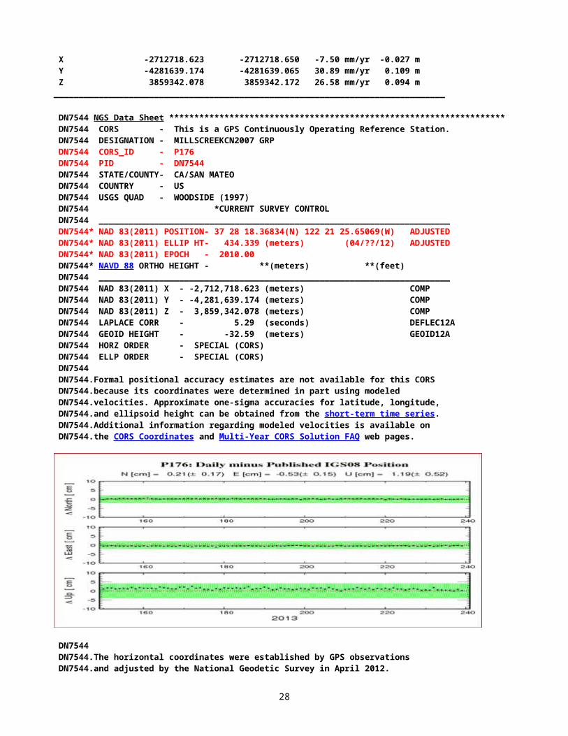
DN7544* NAVD 88 ORTHO HEIGHT - **(meters) **(feet) DN7544 ______________________________________________________________________ DN7544 NAD 83(2011) X - -2,712,718.623 (meters) COMP DN7544 NAD 83(2011) Y - -4,281,639.174 (meters) COMP DN7544 NAD 83(2011) Z - 3,859,342.078 (meters) COMP DN7544 LAPLACE CORR - 5.29 (seconds) DEFLEC12A DN7544 GEOID HEIGHT - -32.59 (meters) GEOID12A DN7544 HORZ ORDER - SPECIAL (CORS) DN7544 ELLP ORDER - SPECIAL (CORS) DN7544 DN7544.Formal positional accuracy estimates are not available for this CORS DN7544.because its coordinates were determined in part using modeled DN7544.velocities. Approximate one-sigma accuracies for latitude, longitude, DN7544.and ellipsoid height can be obtained from the short-term time series. DN7544.Additional information regarding modeled velocities is available on DN7544.the CORS Coordinates and Multi-Year CORS Solution FAQ web pages.
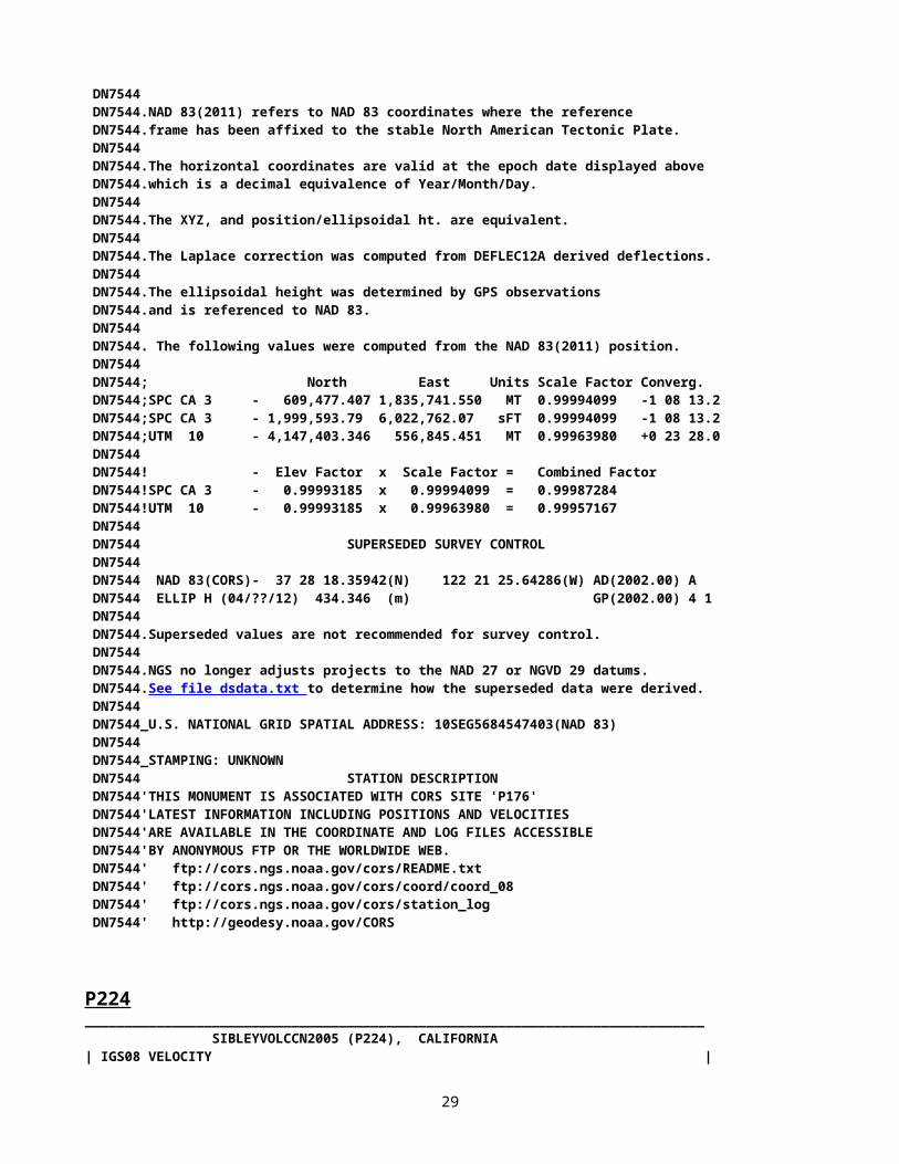
DN7544 DN7544.The horizontal coordinates were established by GPS observations DN7544.and adjusted by the National Geodetic Survey in April 2012. DN7544 DN7544.NAD 83(2011) refers to NAD 83 coordinates where the reference DN7544.frame has been affixed to the stable North American Tectonic Plate. DN7544 DN7544.The horizontal coordinates are valid at the epoch date displayed above DN7544.which is a decimal equivalence of Year/Month/Day. DN7544 DN7544.The XYZ, and position/ellipsoidal ht. are equivalent. DN7544 DN7544.The Laplace correction was computed from DEFLEC12A derived deflections. DN7544 DN7544.The ellipsoidal height was determined by GPS observations DN7544.and is referenced to NAD 83. DN7544 DN7544. The following values were computed from the NAD 83(2011) position. DN7544 DN7544; North East Units Scale Factor Converg. DN7544;SPC CA 3 - 609,477.407 1,835,741.550 MT 0.99994099 -1 08 13.2 DN7544;SPC CA 3 - 1,999,593.79 6,022,762.07 sFT 0.99994099 -1 08 13.2 DN7544;UTM 10 - 4,147,403.346 556,845.451 MT 0.99963980 +0 23 28.0 DN7544 DN7544! - Elev Factor x Scale Factor = Combined Factor DN7544!SPC CA 3 - 0.99993185 x 0.99994099 = 0.99987284 DN7544!UTM 10 - 0.99993185 x 0.99963980 = 0.99957167 DN7544 DN7544 SUPERSEDED SURVEY CONTROL
22

DN7544 DN7544 NAD 83(CORS)- 37 28 18.35942(N) 122 21 25.64286(W) AD(2002.00) A DN7544 ELLIP H (04/??/12) 434.346 (m) GP(2002.00) 4 1 DN7544 DN7544.Superseded values are not recommended for survey control. DN7544 DN7544.NGS no longer adjusts projects to the NAD 27 or NGVD 29 datums. DN7544.See file dsdata.txt to determine how the superseded data were derived. DN7544 DN7544_U.S. NATIONAL GRID SPATIAL ADDRESS: 10SEG5684547403(NAD 83) DN7544 DN7544_STAMPING: UNKNOWN DN7544 STATION DESCRIPTION DN7544'THIS MONUMENT IS ASSOCIATED WITH CORS SITE 'P176' DN7544'LATEST INFORMATION INCLUDING POSITIONS AND VELOCITIES DN7544'ARE AVAILABLE IN THE COORDINATE AND LOG FILES ACCESSIBLE DN7544'BY ANONYMOUS FTP OR THE WORLDWIDE WEB. DN7544' ftp://cors.ngs.noaa.gov/cors/README.txt DN7544' ftp://cors.ngs.noaa.gov/cors/coord/coord_08 DN7544' ftp://cors.ngs.noaa.gov/cors/station_log DN7544' http://geodesy.noaa.gov/CORS
P224______________________________________________________________________________ SIBLEYVOLCCN2005 (P224), CALIFORNIA| IGS08 VELOCITY || Computed in Aug 2011 using data through gpswk 1631. || VX = -0.0211 m/yr northward = 0.0068 m/yr || VY = 0.0181 m/yr eastward = -0.0275 m/yr || VZ = 0.0054 m/yr upward = 0.0001 m/yr |
| NAD_83 (2011) VELOCITY || Transformed from IGS08 velocity in Aug 2011. || VX = -0.0047 m/yr northward = 0.0198 m/yr || VY = 0.0185 m/yr eastward = -0.0138 m/yr || VZ = 0.0149 m/yr upward = -0.0012 m/yr ||_____________________________________________________________________________|| Monument: SIBLEYVOLCCN2005 GRP || ------------------------------ || IGS08 POSITION (EPOCH 2005.0) || Computed in Aug 2011 using data through gpswk 1631. || X = -2688201.251 m latitude = 37 51 50.02572 N || Y = -4265643.690 m longitude = 122 13 08.61274 W || Z = 3893778.570 m ellipsoid height = 407.348 m || || NAD_83 (2011) POSITION (EPOCH 2010.0) || Transformed from IGS08 (epoch 2005.0) position in Aug 2011. || X = -2688200.572 m latitude = 37 51 50.01427 N || Y = -4265644.864 m longitude = 122 13 08.56363 W || Z = 3893778.614 m ellipsoid height = 407.873 m |* The position & velocity were revised in Aug 2011.______________________________________________________________________________
HTDP (version 3.2.3) OUTPUTUPDATED POSITIONS IN NAD_83(2011/CORS96/2007) FROM 1-01-2010 TO 7-17-2013 (month-day-year) FROM 2010.000 TO 2013.541 (decimal years)
OLD COORDINATE NEW COORDINATE VELOCITY DISPLACEMENTP224 LATITUDE 37 51 50.01427 N 37 51 50.01666 N 20.82 mm/yr 0.074 m north LONGITUDE 122 13 8.56363 W 122 13 8.56557 W -13.38 mm/yr -0.047 m east
23
ELLIP. HT. 407.873 407.868 -1.36 mm/yr -0.005 m up X -2688200.572 -2688200.586 -3.94 mm/yr -0.014 m Y -4265644.864 -4265644.797 18.85 mm/yr 0.067 m Z 3893778.613 3893778.669 15.60 mm/yr 0.055 m
Used HTDP and the CORS velocities to compute the 2013.54 Epoch below OLD COORDINATE NEW COORDINATE VELOCITY DISPLACEMENT P224 LATITUDE 37 51 50.01427 N 37 51 50.01654 N 19.80 mm/yr 0.070 m north LONGITUDE 122 13 8.56363 W 122 13 8.56563 W -13.80 mm/yr -0.049 m east ELLIP. HT. 407.873 407.869 -1.20 mm/yr -0.004 m up X -2688200.572 -2688200.589 -4.69 mm/yr -0.017 m Y -4265644.864 -4265644.799 18.44 mm/yr 0.065 m Z 3893778.613 3893778.666 14.89 mm/yr 0.053 m______________________________________________________________________________
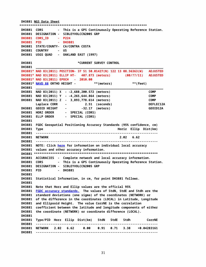
DH3881 NGS Data Sheet ********************************************************************** DH3881 CORS - This is a GPS Continuously Operating Reference Station. DH3881 DESIGNATION - SIBLEYVOLCCN2005 GRP DH3881 CORS_ID - P224 DH3881 PID - DH3881 DH3881 STATE/COUNTY- CA/CONTRA COSTA DH3881 COUNTRY - US DH3881 USGS QUAD - OAKLAND EAST (1997)
DH3881 *CURRENT SURVEY CONTROL DH3881 ______________________________________________________________________ DH3881* NAD 83(2011) POSITION- 37 51 50.01427(N) 122 13 08.56363(W) ADJUSTED DH3881* NAD 83(2011) ELLIP HT- 407.873 (meters) (08/??/11) ADJUSTED DH3881* NAD 83(2011) EPOCH - 2010.00 DH3881* NAVD 88 ORTHO HEIGHT - **(meters) **(feet) DH3881 ______________________________________________________________________ DH3881 NAD 83(2011) X - -2,688,200.572 (meters) COMP DH3881 NAD 83(2011) Y - -4,265,644.864 (meters) COMP DH3881 NAD 83(2011) Z - 3,893,778.614 (meters) COMP Laplace CORR - 2.51 (seconds) DEFLEC12A DH3881 GEOID HEIGHT - -32.17 (meters) GEOID12A DH3881 HORZ ORDER - SPECIAL (CORS) DH3881 ELLP ORDER - SPECIAL (CORS) DH3881 DH3881 FGDC Geospatial Positioning Accuracy Standards (95% confidence, cm) DH3881 Type Horiz Ellip Dist(km) DH3881 ------------------------------------------------------------------- DH3881 NETWORK 2.02 6.62 DH3881 ------------------------------------------------------------------- DH3881 NOTE: Click here for information on individual local accuracy DH3881 values and other accuracy information. DH3881 ******************************************************************** DH3881 ACCURACIES - Complete network and local accuracy information. DH3881 CORS - This is a GPS Continuously Operating Reference Station. DH3881 DESIGNATION - SIBLEYVOLCCN2005 GRP DH3881 PID - DH3881 DH3881 DH3881 Statistical Information, in cm, for point DH3881 follows. DH3881 DH3881 Note that Horz and Ellip values are the official 95% DH3881 FGDC accuracy standards. The values of StdN, StdE and Stdh are the DH3881 standard deviations (one sigma) of the coordinates (NETWORK) or DH3881 of the difference in the coordinates (LOCAL) in Latitude, Longitude DH3881 and Ellipsoid Height. The value CorrNE is the correlation DH3881 coefficient between the latitude and longitude components of either DH3881 the coordinate (NETWORK) or coordinate difference (LOCAL). DH3881 DH3881 Type/PID Horz Ellip Dist(km) StdN StdE Stdh CorrNE DH3881 -------------------------------------------------------------------
24
DH3881 NETWORK 2.02 6.62 0.00 0.91 0.71 3.38 +0.04283161 DH3881 -------------------------------------------------------------------
DH3881 DH3881.The horizontal coordinates were established by GPS observations DH3881.and adjusted by the National Geodetic Survey in August 2011. DH3881 DH3881.NAD 83(2011) refers to NAD 83 coordinates where the reference DH3881.frame has been affixed to the stable North American Tectonic Plate. DH3881 DH3881.The horizontal coordinates are valid at the epoch date displayed above DH3881.which is a decimal equivalence of Year/Month/Day. DH3881 DH3881.The XYZ, and position/ellipsoidal ht. are equivalent. DH3881 DH3881.The Laplace correction was computed from DEFLEC12A derived deflections. DH3881 DH3881.The ellipsoidal height was determined by GPS observations DH3881.and is referenced to NAD 83. DH3881 DH3881. The following values were computed from the NAD 83(2011) position. DH3881 DH3881; North East Units Scale Factor Converg. DH3881;SPC CA 3 - 652,755.675 1,848,752.302 MT 0.99993111 -1 03 08.8 DH3881;SPC CA 3 - 2,141,582.58 6,065,448.18 sFT 0.99993111 -1 03 08.8 DH3881;UTM 10 - 4,191,001.178 568,692.783 MT 0.99965812 +0 28 45.7 DH3881 DH3881! - Elev Factor x Scale Factor = Combined Factor DH3881!SPC CA 3 - 0.99993600 x 0.99993111 = 0.99986712 DH3881!UTM 10 - 0.99993600 x 0.99965812 = 0.99959414 DH3881 DH3881 SUPERSEDED SURVEY CONTROL DH3881 DH3881 NAD 83(CORS)- 37 51 50.00906(N) 122 13 08.55850(W) AD(2002.00) A DH3881 ELLIP H (06/??/05) 407.864 (m) GP(2002.00) 4 1 DH3881 DH3881.Superseded values are not recommended for survey control. DH3881 DH3881.NGS no longer adjusts projects to the NAD 27 or NGVD 29 datums. DH3881.See file dsdata.txt to determine how the superseded data were derived. DH3881 DH3881_U.S. NATIONAL GRID SPATIAL ADDRESS: 10SEG6869291001(NAD 83) DH3881
25
DH3881_STAMPING: UNKNOWN DH3881 DH3881 STATION DESCRIPTION DH3881 DH3881'THIS MONUMENT IS ASSOCIATED WITH CORS SITE 'P224' DH3881'LATEST INFORMATION INCLUDING POSITIONS AND VELOCITIES DH3881'ARE AVAILABLE IN THE COORDINATE AND LOG FILES ACCESSIBLE DH3881'BY ANONYMOUS FTP OR THE WORLDWIDE WEB. DH3881' ftp://cors.ngs.noaa.gov/cors/README.txt DH3881' ftp://cors.ngs.noaa.gov/cors/coord/coord_08 DH3881' ftp://cors.ngs.noaa.gov/cors/station_log DH3881' http://geodesy.noaa.gov/CORS
TIBB______________________________________________________________________________ TIBURON PENINSUL (TIBB), CALIFORNIA| IGS08 VELOCITY || Predicted with HTDP_3.2.3 Dec 2012. || VX = -0.0216 m/yr northward = 0.0148 m/yr || VY = 0.0245 m/yr eastward = -0.0314 m/yr || VZ = 0.0117 m/yr upward = 0.0000 m/yr || || NAD_83 (2011) VELOCITY || Transformed from IGS08 velocity in Dec 2012. || VX = -0.0052 m/yr northward = 0.0280 m/yr || VY = 0.0249 m/yr eastward = -0.0177 m/yr || VZ = 0.0213 m/yr upward = -0.0013 m/yr ||_____________________________________________________________________________|| Monument: TIBURON PENINSUL GRP || ------------------------------ || PID = AI4507 || IGS08 POSITION (EPOCH 2005.0) || Computed in Dec 2012 using 13 days of data. || X = -2704026.807 m latitude = 37 53 27.14944 N || Y = -4253050.099 m longitude = 122 26 51.36586 W || Z = 3895879.226 m ellipsoid height = -21.084 m || || NAD_83 (2011) POSITION (EPOCH 2010.0) || Transformed from IGS08 (epoch 2005.0) position in Dec 2012. || X = -2704026.130 m latitude = 37 53 27.13938 N || Y = -4253051.240 m longitude = 122 26 51.31741 W || Z = 3895879.300 m ellipsoid height = -20.565 m || |______________________________________________________________________________
HTDP (version 3.2.3) OUTPUTUPDATED POSITIONS IN NAD_83(2011/CORS96/2007) FROM 1-01-2010 TO 7-17-2013 (month-day-year) FROM 2010.000 TO 2013.541 (decimal years) OLD COORDINATE NEW COORDINATE VELOCITY DISPLACEMENTTIBB LATITUDE 37 53 27.13938 N 37 53 27.14260 N 28.06 mm/yr 0.099 m north LONGITUDE 122 26 51.31741 W 122 26 51.31998 W -17.72 mm/yr -0.063 m east ELLIP. HT. -20.565 -20.570 -1.36 mm/yr -0.005 m up X -2704026.130 -2704026.148 -5.13 mm/yr -0.018 m Y -4253051.240 -4253051.152 24.96 mm/yr 0.088 m Z 3895879.300 3895879.376 21.31 mm/yr 0.075 m______________________________________________________________________________
AI4507 NGS Data Sheet ******************************************************************* AI4507 CORS - This is a GPS Continuously Operating Reference Station. AI4507 DESIGNATION - TIBURON PENINSUL GRP AI4507 CORS_ID - TIBB
26
AI4507 PID - AI4507 AI4507 STATE/COUNTY- CA/MARIN AI4507 COUNTRY - US AI4507 USGS QUAD - SAN QUENTIN (1995) AI4507 *CURRENT SURVEY CONTROL AI4507 ______________________________________________________________________ AI4507* NAD 83(2011) POSITION- 37 53 27.13938(N) 122 26 51.31741(W) ADJUSTED AI4507* NAD 83(2011) ELLIP HT- -20.565 (meters) (12/??/12) ADJUSTED AI4507* NAD 83(2011) EPOCH - 2010.00 AI4507* NAVD 88 ORTHO HEIGHT - 11.8 (meters) 39. (feet) GPS OBS AI4507 ______________________________________________________________________ AI4507 NAD 83(2011) X - -2,704,026.130 (meters) COMP AI4507 NAD 83(2011) Y - -4,253,051.240 (meters) COMP AI4507 NAD 83(2011) Z - 3,895,879.300 (meters) COMP AI4507 LAPLACE CORR - 0.01 (seconds) DEFLEC12A AI4507 GEOID HEIGHT - -32.38 (meters) GEOID12A AI4507 HORZ ORDER - SPECIAL (CORS) AI4507 ELLP ORDER - SPECIAL (CORS) AI4507 AI4507.Formal positional accuracy estimates are not available for this CORS AI4507.because its coordinates were determined in part using modeled AI4507.velocities. Approximate one-sigma accuracies for latitude, longitude, AI4507.and ellipsoid height can be obtained from the short-term time series. AI4507.Additional information regarding modeled velocities is available on AI4507.the CORS Coordinates and Multi-Year CORS Solution FAQ web pages.
AI4507 AI4507.The horizontal coordinates were established by GPS observations AI4507.and adjusted by the National Geodetic Survey in December 2012. AI4507 AI4507.NAD 83(2011) refers to NAD 83 coordinates where the reference AI4507.frame has been affixed to the stable North American Tectonic Plate. AI4507 AI4507.The horizontal coordinates are valid at the epoch date displayed above AI4507.which is a decimal equivalence of Year/Month/Day. AI4507 AI4507.The orthometric height was determined by GPS observations and a AI4507.high-resolution geoid model. AI4507 AI4507.The XYZ, and position/ellipsoidal ht. are equivalent. AI4507 AI4507.The Laplace correction was computed from DEFLEC12A derived deflections. AI4507 AI4507.The ellipsoidal height was determined by GPS observations
27
AI4507.and is referenced to NAD 83. AI4507 AI4507. The following values were computed from the NAD 83(2011) position. AI4507 AI4507; North East Units Scale Factor Converg. AI4507;SPC CA 6 - 1,151,818.729 1,453,439.357 MT 1.00316890 -3 24 20.5 AI4507;SPC CA 6 - 3,778,925.28 4,768,492.29 sFT 1.00316890 -3 24 20.5 AI4507;UTM 10 - 4,193,850.969 548,572.252 MT 0.99962906 +0 20 21.4 AI4507 AI4507! - Elev Factor x Scale Factor = Combined Factor AI4507!SPC CA 6 - 1.00000323 x 1.00316890 = 1.00317214 AI4507!UTM 10 - 1.00000323 x 0.99962906 = 0.99963229 AI4507 AI4507 SUPERSEDED SURVEY CONTROL AI4507 AI4507 NAVD 88 (04/06/00) 11.7 (m) GEOID99 model used GPS OBS AI4507 AI4507.Superseded values are not recommended for survey control. AI4507 AI4507.NGS no longer adjusts projects to the NAD 27 or NGVD 29 datums. AI4507.See file dsdata.txt to determine how the superseded data were derived. AI4507 AI4507_U.S. NATIONAL GRID SPATIAL ADDRESS: 10SEG4857293850(NAD 83) AI4507 AI4507_MARKER: Z = SEE DESCRIPTION AI4507_SETTING: 0 = UNSPECIFIED SETTING AI4507_STAMPING: UNKNOWN AI4507_MARK LOGO: NONE AI4507_MAGNETIC: N = NO MAGNETIC MATERIAL AI4507_STABILITY: A = MOST RELIABLE AND EXPECTED TO HOLD AI4507+STABILITY: POSITION/ELEVATION WELL AI4507_SATELLITE: THE SITE LOCATION WAS REPORTED AS SUITABLE FOR AI4507+SATELLITE: SATELLITE OBSERVATIONS - 1998 AI4507 AI4507 HISTORY - Date Condition Report By AI4507 HISTORY - 1998 MONUMENTED NGS AI4507 AI4507 STATION DESCRIPTION AI4507'DESCRIBED BY NATIONAL GEODETIC SURVEY 1998 AI4507'THIS MONUMENT IS ASSOCIATED WITH CORS SITE 'TIBB' AI4507'LATEST INFORMATION INCLUDING POSITIONS AND VELOCITIES AI4507'ARE AVAILABLE IN THE COORDINATE AND LOG FILES ACCESSIBLE AI4507'BY ANONYMOUS FTP OR THE WORLDWIDE WEB. AI4507' ftp://cors.ngs.noaa.gov/cors/README.txt AI4507' ftp://cors.ngs.noaa.gov/cors/coord/coord_08 AI4507' ftp://cors.ngs.noaa.gov/cors/station_log AI4507' http://geodesy.noaa.gov/CORS
WINT______________________________________________________________________________
WINT_BARD_CN1991 (WINT), CALIFORNIA| IGS08 VELOCITY || Predicted with HTDP_3.2.3 Dec 2012. || VX = -0.0222 m/yr northward = 0.0125 m/yr || VY = 0.0229 m/yr eastward = -0.0310 m/yr || VZ = 0.0099 m/yr upward = 0.0000 m/yr |
| NAD_83 (2011) VELOCITY || Transformed from IGS08 velocity in Dec 2012. |
28
| VX = -0.0058 m/yr northward = 0.0255 m/yr || VY = 0.0233 m/yr eastward = -0.0173 m/yr || VZ = 0.0194 m/yr upward = -0.0013 m/yr || || Monument: WINT_BARD_CN1991 GRP || ------------------------------ || PID = AI4510 || IGS08 POSITION (EPOCH 2005.0) || Computed in Dec 2012 using 16 days of data. || X = -2689810.025 m latitude = 37 39 09.51629 N || Y = -4281187.927 m longitude = 122 08 26.04241 W || Z = 3874973.479 m ellipsoid height = -28.791 m || || NAD_83 (2011) POSITION (EPOCH 2010.0) || Transformed from IGS08 (epoch 2005.0) position in Dec 2012. || X = -2689809.352 m latitude = 37 39 09.50579 N || Y = -4281189.079 m longitude = 122 08 25.99416 W || Z = 3874973.548 m ellipsoid height = -28.259 m |______________________________________________________________________________
HTDP (version 3.2.3) OUTPUTUPDATED POSITIONS IN NAD_83(2011/CORS96/2007) FROM 1-01-2010 TO 7-17-2013 (month-day-year) FROM 2010.000 TO 2013.541 (decimal years) OLD COORDINATE NEW COORDINATE VELOCITY DISPLACEMENTWINT LATITUDE 37 39 9.50579 N 37 39 9.50872 N 25.54 mm/yr 0.090 m north LONGITUDE 122 08 25.99416 W 122 08 25.99666 W -17.33 mm/yr -0.061 m east ELLIP. HT. -28.259 -28.264 -1.35 mm/yr -0.005 m up X -2689809.352 -2689809.373 -5.80 mm/yr -0.021 m Y -4281189.080 -4281188.997 23.34 mm/yr 0.083 m Z 3874973.548 3874973.617 19.40 mm/yr 0.069 m______________________________________________________________________________
AI4510 NGS Data Sheet ******************************************************************* AI4510 HT_MOD - This is a Height Modernization Survey Station. AI4510 CORS - This is a GPS Continuously Operating Reference Station. AI4510 DESIGNATION - WINT_BARD_CN1991 GRP AI4510 CORS_ID - WINT AI4510 PID - AI4510 AI4510 STATE/COUNTY- CA/ALAMEDA AI4510 COUNTRY - US AI4510 USGS QUAD - SAN LEANDRO (1993) AI4510 *CURRENT SURVEY CONTROL AI4510 ______________________________________________________________________ AI4510* NAD 83(2011) POSITION- 37 39 09.50579(N) 122 08 25.99416(W) ADJUSTED AI4510* NAD 83(2011) ELLIP HT- -28.259 (meters) (12/??/12) ADJUSTED AI4510* NAD 83(2011) EPOCH - 2010.00 AI4510* NAVD 88 ORTHO HEIGHT - 4.30 (meters) 14.1 (feet) GPS OBS AI4510 ______________________________________________________________________ AI4510 NAVD 88 orthometric height was determined with geoid model GEOID03 AI4510 GEOID HEIGHT - -32.47 (meters) GEOID03 AI4510 GEOID HEIGHT - -32.52 (meters) GEOID12A AI4510 NAD 83(2011) X - -2,689,809.352 (meters) COMP AI4510 NAD 83(2011) Y - -4,281,189.079 (meters) COMP AI4510 NAD 83(2011) Z - 3,874,973.548 (meters) COMP AI4510 LAPLACE CORR - 2.63 (seconds) DEFLEC12A AI4510 HORZ ORDER - SPECIAL (CORS) AI4510 ELLP ORDER - SPECIAL (CORS) AI4510 AI4510.Formal positional accuracy estimates are not available for this CORS AI4510.because its coordinates were determined in part using modeled AI4510.velocities. Approximate one-sigma accuracies for latitude, longitude, AI4510.and ellipsoid height can be obtained from the short-term time series. AI4510.Additional information regarding modeled velocities is available on AI4510.the CORS Coordinates and Multi-Year CORS Solution FAQ web pages.
29

AI4510.The horizontal coordinates were established by GPS observations AI4510.and adjusted by the National Geodetic Survey in December 2012. AI4510 AI4510.NAD 83(2011) refers to NAD 83 coordinates where the reference AI4510.frame has been affixed to the stable North American Tectonic Plate. AI4510 AI4510.The horizontal coordinates are valid at the epoch date displayed above AI4510.which is a decimal equivalence of Year/Month/Day. AI4510 AI4510.The orthometric height was determined by GPS observations and a AI4510.high-resolution geoid model using precise GPS observation and AI4510.processing techniques. AI4510 AI4510.The XYZ, and position/ellipsoidal ht. are equivalent. AI4510 AI4510.The Laplace correction was computed from DEFLEC12A derived deflections. AI4510 AI4510.The ellipsoidal height was determined by GPS observations AI4510.and is referenced to NAD 83. AI4510 AI4510. The following values were computed from the NAD 83(2011) position. AI4510 AI4510; North East Units Scale Factor Converg. AI4510;SPC CA 6 - 1,123,770.181 1,478,989.373 MT 1.00283790 -3 14 13.1 AI4510;SPC CA 6 - 3,686,902.67 4,852,317.63 sFT 1.00283790 -3 14 13.1 AI4510;UTM 10 - 4,167,623.257 575,812.323 MT 0.99967079 +0 31 30.1 AI4510 AI4510! - Elev Factor x Scale Factor = Combined Factor AI4510!SPC CA 6 - 1.00000443 x 1.00283790 = 1.00284235 AI4510!UTM 10 - 1.00000443 x 0.99967079 = 0.99967522 AI4510 AI4510 SUPERSEDED SURVEY CONTROL AI4510 NAVD 88 (04/03/01) 4.2 (m) UNKNOWN model used GPS OBS AI4510 NAVD 88 (04/06/00) 4.3 (m) GEOID99 model used GPS OBS AI4510 AI4510.Superseded values are not recommended for survey control. AI4510 AI4510.NGS no longer adjusts projects to the NAD 27 or NGVD 29 datums. AI4510.See file dsdata.txt to determine how the superseded data were derived. AI4510 AI4510_U.S. NATIONAL GRID SPATIAL ADDRESS: 10SEG7581267623(NAD 83) AI4510_MARKER: Z = SEE DESCRIPTION
30
AI4510_SETTING: 0 = UNSPECIFIED SETTING AI4510_STAMPING: UNKNOWN AI4510_MARK LOGO: NONE AI4510_MAGNETIC: N = NO MAGNETIC MATERIAL AI4510_STABILITY: A = MOST RELIABLE AND EXPECTED TO HOLD AI4510+STABILITY: POSITION/ELEVATION WELL AI4510_SATELLITE: THE SITE LOCATION WAS REPORTED AS SUITABLE FOR AI4510+SATELLITE: SATELLITE OBSERVATIONS - 1998 AI4510 AI4510 HISTORY - Date Condition Report By AI4510 HISTORY - 1998 MONUMENTED NGS AI4510 STATION DESCRIPTION AI4510'DESCRIBED BY NATIONAL GEODETIC SURVEY 1998 AI4510'THIS MONUMENT IS ASSOCIATED WITH CORS SITE 'WINT' AI4510'LATEST INFORMATION INCLUDING POSITIONS AND VELOCITIES AI4510'ARE AVAILABLE IN THE COORDINATE AND LOG FILES ACCESSIBLE AI4510'BY ANONYMOUS FTP OR THE WORLDWIDE WEB. AI4510' ftp://cors.ngs.noaa.gov/cors/README.txt AI4510' ftp://cors.ngs.noaa.gov/cors/coord/coord_08 AI4510' ftp://cors.ngs.noaa.gov/cors/station_log AI4510' http://geodesy.noaa.gov/CORS______________________________________________________________________________
31