Embed Size (px)
Citation preview

Consultancy Services for preparation of DPR for Developmentof Economic Corridors, Inter Corridors, Feeder Routes andCoastal Roads to improve the efficiency of freight movementCoastal Roads to improve the efficiency of freight movementin India (Lot-3/Odisha & Jharkhand/Package-2)
Application for Environmental Clearance (EC)of Andhra Pradesh State,Length-99.791 Km
Pre-feasibility Report (PFR)
YONGMA Engineering Co. Ltd. JV With Arkitechno Consultants(I) Pvt.Ltd.
Pre-feasibility Report (PFR)October 2019
YONGMA Engineering Co. Ltd. JV With Arkitechno Consultants(I) Pvt.Ltd.301-302 Times Centre, Golf Course Road,Sector-54 Gurgaon, Haryana
Phone:0124-4746202, Fax: 0124-4742955, Mob: 9818186242,email: [email protected],email:[email protected]
Web:www.ymeng.in,www.arkitechno.com

Pre-feasibility Report
Yongma Engineering in JV with ARKITECHNO 1
CCHHAAPPTTEERR--11 EEXXEECCUUTTIIVVEE SSUUMMMMAARRYY
1. EXECUTIVE SUMMARY:
I. PROJECT DESCRIPTION: Road projects are meant for improving the quality of life of people and developing the country’s economy. Along with all positive impacts of the road projects, there may also be some significant detrimental impact on nearby communities and environment. To account for adverse impacts, environmental impact assessment is utmost necessary. These concerns for environmental issue in road projects have also become a part of legal requirements and requirements for obtaining financial support. Therefore Environmental Assessment is of prime importance in road projects.
The National Highways Authority of India (NHAI) has been entrusted with the assignment of Development of Economic Corridors, Inter-corridors and feeder routes and Coastal road primarily to improve the efficiency of freight movement in India under Bharatmala Pariyojna Lot-3/Odisha & Jharkhand/Package-2 having length of proposed alignment 463.465 km (which is totally green field) which starts from near Abhanpur (ch. 0.000)/ch. 61.600 of proposed Raipur-Durg Bypass and ends at Vishakhapatnam bypass (ch.463.465) of Existing section of SH-38.
The whole length of road is divided into 3 phases, i.e., phase-1 for Chhattisgarh State, phase-2 for Odisha State and phase-3 for Andhra Pradesh State.
This Pre-feasibility report is for phase-3 i.e. from Ch. 363.320 to Ch. 463.111, Length – 99.791 Km in Andhra Pradesh State.
The phase-3 of this proposed project shall connect Salur village in Vizianagaram district to Pinagadi village in Visakhapatnam district & various other parts of Andhra Pradesh.
NHAI as the employer and the executing agency has commissioned the services of M/s. YONGMA Engineering Co. Ltd. JV With Arkitechno Consultants (I) Pvt. Ltd. with its Office at Gurgaon in Haryana State for carrying out the work of Consultancy Services for preparation of DPR for development of Economic Corridors, Inter Corridors, Feeder Routes and Coastal Roads to improve the efficiency of freight movement in India (Lot-3/Odisha & Jharkhand/Package-2).
II. STATUTORY CLEARNCES:
FOREST CLEARANCES: Since 55.88 ha of forest land (Reserve & Revenue Forest) are involved in construction of this corridor so Forest Clearance is a must and to be obtained from MoEF&CC.
R&R CLEARANCE: The road is passing through a 194 nos. of villages. The R&R plan according to LARR Act 2013 will be prepared after completion of Social Impact assessment (SIA) study. These plans will be approved by respective state governments.
Pre-feasibility Report
Yongma Engineering in JV with ARKITECHNO 2
FINANCE CONCURRANCE: The central Government will consider budgetary support after completions of the statutory requirements.
ENVIRONMENTAL CLEARANCE: As per MoEF&CC EIA notification, 2006, the proposed project is covered under category 7 ‘f’. As per the statutory requirements, the competent authority adheres to submit the Environmental Impact Assessment Report to MoEF&CC, Delhi in order to obtain Environmental Clearance.
III. PROJECT COST AND BENEFITS:
PROJECT COST: The estimated cost of the project is about INR 2542.67 Crores. Detailed cost break-up and Project schedule shall be discussed in the EIA report.
PROJECT BENEFITS: The benefits of the Project are multi-fold. It will substantially reduce the travel time and the other remote areas falling on the alignment. In addition to the improved connectivity, it will also provide a boost to the economic status of the villages / towns falling in the dedicated Project area.
Overall improvement will be expected in local area in terms of:
Better connectivity to economic, social and political hubs of Andhra Pradesh.
Fast and safe connectivity resulting in savings in fuel, travel time and total transportation cost.
Better approach to medical & educational services.
Faster transportation of perishable goods like fruits, vegetables, dairy products and marketing of agricultural products.
Development of local agriculture and handicrafts.
Opening up of opportunities for new occupations and trade on the route.
Indirect and direct employment opportunity to people from all skilled, semi-skilled and unskilled streams.
Pre-feasibility Report
Yongma Engineering in JV with ARKITECHNO 3
CCHHAAPPTTEERR--22 IINNTTRROODDUUCCTTIIOONN OOFF PPRROOJJEECCTT //BBAACCKKGGRROOUUNNDD
IINNFFOORRMMAATTIIOONN 2.1 IDENTIFICATION OF THE PROJECT AND PROJECTPROPONENT:
IDENTIFICATION OF THE PROJECT: The proposed project pertains to Development of Economic Corridors, Inter-corridors and feeder routes and Coastal road primarily to improve the efficiency of freight movement in India under Bharatmala Pariyojna Lot-3/Odisha & Jharkhand/Package-2 having length of proposed alignment 463.265 km (which is totally green field) which starts from near Abhanpur (ch. 0.000)/ch. 61.600 of proposed Raipur-Durg Bypass and ends at Visakhapatnam bypass (ch. 463.265 km) of Existing section of SH-38.
The Phase 3 of the proposed project shall connect Salur village in Vizianagaram district to Pinagadi village in Visakhapatnam district and various other parts of Andhra Pradesh. As per MoEF&CC EIA notification, 2006, the proposed project is covered under category 7 ‘f’.
PROJECT PROPONENT: National Highways Authority of India (NHAI), an autonomous agency of the Government of India, is responsible for management of a network of national highways across the country. It is a nodal agency of the Ministry of Road Transport and Highways (MoRT&H), Government of India. Its vision is to meet the nation’s need for the provision and maintenance of national highways network to global standards and to meet user expectations in the most time-bound and cost-effective manner, within the strategic policy framework set by the Government of India and thus promoting economic well- being and quality of life of the people. NHAI shall be the nodal authority/proponent for the development of this Project.
2.2 BRIEF DESCRIPTION OF NATURE OF THEPROJECT: The Phase 3 of the proposed economic corridor passes through Vizianagaram & Visakhapatnam district. Salient features of the Project are as follows.
Table No. C2-1: Project Salient Features
Sl. No.
Particular Details
1.
Project Name
Phase-3 of Development of Economic corridors, Inter-Corridors, Feeder routes and coastal road primarily to improve freight movement in the country, Lot-3 /Odisha & Jharkhand/Package-2. Length – 99.791 Km.
2. Nature of Project Highway Project
Pre-feasibility Report
Yongma Engineering in JV with ARKITECHNO 4
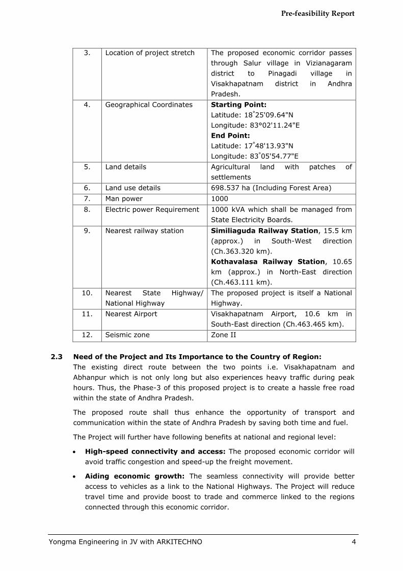
3. Location of project stretch The proposed economic corridor passes through Salur village in Vizianagaram district to Pinagadi village in Visakhapatnam district in Andhra Pradesh.
4. Geographical Coordinates Starting Point: Latitude: 18°25'09.64"N Longitude: 83°02'11.24"E End Point: Latitude: 17°48'13.93"N Longitude: 83°05'54.77"E
5. Land details Agricultural land with patches of settlements
6. Land use details 698.537 ha (Including Forest Area) 7. Man power 1000 8. Electric power Requirement 1000 kVA which shall be managed from
State Electricity Boards. 9. Nearest railway station Similiaguda Railway Station, 15.5 km
(approx.) in South-West direction (Ch.363.320 km). Kothavalasa Railway Station, 10.65 km (approx.) in North-East direction (Ch.463.111 km).
10. Nearest State Highway/ National Highway
The proposed project is itself a National Highway.
11. Nearest Airport Visakhapatnam Airport, 10.6 km in South-East direction (Ch.463.465 km).
12. Seismic zone Zone II
2.3 Need of the Project and Its Importance to the Country of Region:
The existing direct route between the two points i.e. Visakhapatnam and Abhanpur which is not only long but also experiences heavy traffic during peak hours. Thus, the Phase-3 of this proposed project is to create a hassle free road within the state of Andhra Pradesh.
The proposed route shall thus enhance the opportunity of transport and communication within the state of Andhra Pradesh by saving both time and fuel.
The Project will further have following benefits at national and regional level:
High-speed connectivity and access: The proposed economic corridor will avoid traffic congestion and speed-up the freight movement.
Aiding economic growth: The seamless connectivity will provide better access to vehicles as a link to the National Highways. The Project will reduce travel time and provide boost to trade and commerce linked to the regions connected through this economic corridor.
Pre-feasibility Report
Yongma Engineering in JV with ARKITECHNO 5
Growth of backward areas: The biggest strength of the alignment is that it plans to cover backward districts of Andhra Pradesh. As a result of connectivity and access to other parts of the country, these backward areas will be aided to integrate with rest of the world. Further, freight and passenger traffic on the economic corridor will help promoting ancillary economy of these regions.
Decongestion of existing National and State Highways: The proposed phase will take away traffic pressures from existing SH and NH passing through various cities thereby leaving the NH and SH for regional and local usage.
Improved safety: Due to access control, the Roadway & Travel Safety of the traffic connecting the cities will be enhanced as there will be minimum distractions & conflict zones.
Support to industry: Different types of industries like Manufacturing, Tourism etc. along the proposed corridor will be facilitated in their business operation and reach ability.
2.4 Employment Generation (Direct and Indirect) The proposed project shall generate a direct employment opportunity to about 1000 persons. It shall also generate additional employment opportunities in form of transportation of construction materials, greenbelt development and implementation of EMP.
During operations phase, the Project will largely have indirect employment benefits in form of highway amenities and through economic & social hubs developed around the Economic Corridor. Efficient reach and connectivity to distant markets will further enhance economy of the districts and create employment opportunities.

Pre-feasibility Report
Yongma Engineering in JV with ARKITECHNO 6
CCHHAAPPTTEERR--33 PPRROOJJEECCTT DDEESSCCRRIIPPTTIIOONN
3.1 Type of the Project including Interlinked and Interdependent Projects, if
any
Out of 44 economic corridors 9 economic corridors planned under the Union government’s ambitious Bharatmala scheme will be linked through expressways. The alignments of economic corridors “Raipur-Vishakhapatnam” are completely access control and will considerably intends to facilitate seamless trade by reducing the distance between connecting cities, saving cost, time, fuel and carbon emissions.
The MoRT&H & NHAI has decided the proposed economic corridor alignment shall be as Crow fly line from Raipur to Visakhapatnam. The obligatory point of the section is Sunabeda due to major industries NALCO & HAL. In many disciplines a Greenfield project is one that lacks constraints imposed by prior work. The analogy is to that of construction on Greenfield land where there is no need to work within the constraints of existing buildings or infrastructure.
Economic corridors are meant to attract investment and generate economic activities within a contiguous region, on the foundation of an efficient transportation system. The Existing travel time from Raipur-Visakhapatnam is 14.00 hours via Dhamtari, Kondagaon, Jagdalpur, Borigumma, Jeypore, Koraput, Sunabeda, Salur & Vizianagaram (Avg. riding speed 40 kmph), Length-593 Km. Proposed alignment (Option-3, design Speed 100 Kmph for Plain/Rolling & Hilly terrain) of Economic corridor travel time will be 7.0 hours via Kundei, Raighar, Umerkote, Nawrangpur, Borigumma, Koraput, Sunabeda in Odisha state (Avg. riding speed 70 kmph), Length - 463 Km Savings in length 130 km and in travel time is 7 hours. Vehicle operation cost (fuel, drivers, maintenance etc.) will efficiently improved due to smooth and signal free alignment. Safety of vehicles operating on EC will be improved due to advanced traffic management system, lighting arrangements and other safety arrangement. The PROW is taken as 70 m in Plain & Rolling Terrain of this corridor.
3.2 Project Location The length proposed for the phase-3 stretch measures 99.791 Km and start at Salur village in Vizianagaram district to Pinagadi village in Visakhapatnam district in the state of Andhra Pradesh.
Table No. C3-1: Project Coordinates
Sl. No. Coordinates Starting point Latitude: 18°25'09.64"N
Longitude: 83°02'11.24"E End Point Latitude: 17°48'13.93"N
Longitude: 83°05'54.77"E

Pre-feasibility Report
Yongma Engineering in JV with ARKITECHNO 7
3.3 Details of Alternative Sites to be considered and basis of selection of proposed site
Four alignment options were considered in order to finalize the proposed alignment. Both the alignments were compared and the final alignment has been selected after prior analysis on basis of minimum tree felling, minimum exorbitant cost, comparatively lower land degradation and lesser environmental impacts. The detailed alternative analysis is enclosed as Annexure-2.
The Project areas were studied in details and the existing road networks were analyzed to identify possible alternate alignments between the start and end points. Four different alignments have been identified in the project which also includes the alignment proposed earlier. The alternative alignments are given in Table No. C3-2:
Option-1 (Green Field): Length - 106.213 Km
In Andhra Pradesh (AP) state, the alignment crosses the villages/town Salur, Ramvadrapuram, Gajapatingaram, Viziangaram & ends near Sabbavaram following existing road with provision of by pass for urban/village area considering design speed 100 Kmph. The option-1 has not been recommended due to length is more.
Option-2 (Green Field): Length - 94.049 Km In AP state, the alignment follows Bangarugudi, Garella Valasa, Mathumuru, Mulachelagam, Chandapuram, Jakkuva, Kotha Palem, Penta Srirampuram & ends near Sabbavaram with tunnel provision of length-3.9 Km, design speed 100 Kmph & permissible hill cutting. The option-2 has not been recommended due to the project cost is more.
Option-3 (Green Field): Length - 99.791 Km In Andhra Pradesh state, the alignment follows Bangarugudi, Garella Valasa, Mathumuru, Mulachelagam, Chandapuram, Jakkuva, Kotha Palem, Penta Srirampuram & ends near Sabbavaram. The design speed 100 Kmph with smooth gradient in hilly terrain & permissible hill cutting. The option-3B has been recommended due to less length.

Pre-feasibility Report
Yongma Engineering in JV with ARKITECHNO 8
Table No. C3-2: Detailed Alternative Analysis Comparison of three Alternatives of Andhra Pradesh
Sl. No Description
Option-1 Option-2 Option-3 Remarks
Odisha-AP Border to Sabbavaram 1 Crow Fly line Length 65.464 Km 2 Total Design Length 106.213 Km 94.049 Km 99.791 Km 3 Existing Road to be
widened 4L+PS 0.000 Km 0.000 Km 0.000 Km
4 Realignment 0.000 Km 0.000 Km 0.000 Km 5 Green Field 106.213 Km 94.049 Km 99.791 Km 6 Reserve Forest/PF 19.000 Km 22.000 Km 15.000 Km 7 Wildlife Sanctuaries 0.000 Km 0.000 Km 0.000 Km 8 Route Alignment Green Field Green Field Green Field
9 Starting and Following Locations
The Starting Point of Proposed Alignment of
Economic Corridor Location is
Kuntambadevalasa near the Odisha-Andhra
Pradesh border
The Starting Point of Proposed Alignment of
Economic Corridor Location is
Kuntambadevalasa near the Odisha-
Andhra Pradesh border
The Starting Point of Proposed Alignment of
Economic Corridor Location is
Kuntambadevalasa near the Odisha-
Andhra Pradesh border
10 Ending Sabbavaram Sabbavaram Sabbavaram 11 Proposed
Improvement as per Bhartmala circular
6 Lane carriageway with Paved shoulders
6 Lane carriageway with Paved shoulders
6 Lane carriageway with Paved shoulders
12 Terrain Plain, Rolling & Hilly Plain, Rolling & Hilly Plain, Rolling & Hilly 13 Speed 100 kmph for
Plain/Rolling terrain & 80-100 Kmph for Hilly
terrain
100 kmph for Plain/Rolling terrain & 80-100 Kmph for Hilly
terrain
100 kmph for Plain/Rolling terrain & 80-100 Kmph for Hilly
terrain
Pre-feasibility Report
Yongma Engineering in JV with ARKITECHNO 9
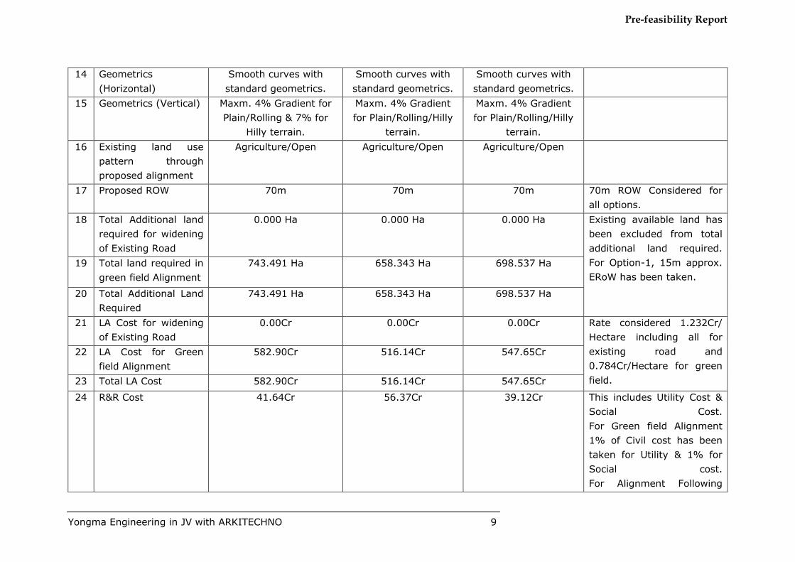
14 Geometrics (Horizontal)
Smooth curves with standard geometrics.
Smooth curves with standard geometrics.
Smooth curves with standard geometrics.
15 Geometrics (Vertical) Maxm. 4% Gradient for Plain/Rolling & 7% for
Hilly terrain.
Maxm. 4% Gradient for Plain/Rolling/Hilly
terrain.
Maxm. 4% Gradient for Plain/Rolling/Hilly
terrain.
16 Existing land use pattern through proposed alignment
Agriculture/Open Agriculture/Open Agriculture/Open
17 Proposed ROW 70m 70m 70m 70m ROW Considered for all options.
18 Total Additional land required for widening of Existing Road
0.000 Ha 0.000 Ha 0.000 Ha Existing available land has been excluded from total additional land required. For Option-1, 15m approx. ERoW has been taken.
19 Total land required in green field Alignment
743.491 Ha 658.343 Ha 698.537 Ha
20 Total Additional Land Required
743.491 Ha 658.343 Ha 698.537 Ha
21 LA Cost for widening of Existing Road
0.00Cr 0.00Cr 0.00Cr Rate considered 1.232Cr/ Hectare including all for existing road and 0.784Cr/Hectare for green field.
22 LA Cost for Green field Alignment
582.90Cr 516.14Cr 547.65Cr
23 Total LA Cost 582.90Cr 516.14Cr 547.65Cr
24 R&R Cost 41.64Cr 56.37Cr 39.12Cr This includes Utility Cost & Social Cost. For Green field Alignment 1% of Civil cost has been taken for Utility & 1% for Social cost. For Alignment Following

Pre-feasibility Report
Yongma Engineering in JV with ARKITECHNO 10
Existing road 3% of Civil cost has been taken for Utility & 5% for Social cost.
25 Construction Civil Cost Cost of Tunnel for 6lane has been considered 250Cr/Km Length of Tunnel in Option-2 is 3.900Km.
Tunnel - 975.00Cr -
26 Total Civil Cost without Tunnel
2081.77Cr 1843.36Cr 1955.90Cr
27 Per Km Cost without Tunnel
19.60Cr 19.60Cr 19.60Cr
28 Total Civil Cost with Tunnel
2081.77Cr 2818.36Cr 1955.90Cr
29 Per Km Cost with Tunnel
19.60Cr 29.97Cr 19.60Cr
30 Total Project Cost including all
2706.31Cr 3390.87Cr 2542.67Cr
31 Per Km Cost including all
25.48Cr 36.05Cr 25.48Cr
32 Recommendation Not Recommended Not Recommended Recommended
Pre-feasibility Report
Yongma Engineering in JV with ARKITECHNO 11
3.4 Size and Magnitude of Operation
The total length of the proposed Phase-3 road is 99.791 Kms.
Total Project Area is 698.537 ha
3.5 Project Description The Phase-3 of the proposed project pertains to Development of Economic corridors, Inter-Corridors, Feeder routes and coastal road primarily to improve freight movement in the country, Lot-3/Odisha & Jharkhand/Package-2.
3.6 Starting and Ending Location The Starting Point of Phase-3 of the Proposed Alignment of Economic Corridor is Salur village in Vizianagaram district to Pinagadi village in Visakhapatnam district of Andhra Pradesh State. The total length of Phase-2 of this economic corridor is 99.791 Km.
3.7 Details of Major Town/Village/Built-Up Area along Phase-2 section of the Economic Corridor Road:
The Alignment Passes through Vizianagaram & Visakhapatnam District in Andhra Pradesh.
3.8 Details of District & State of Phase-3 of the Proposed Economic Corridor Road:
The Alignment passes through the state of Andhra Pradesh.
In Andhara Pradesh State alignment passes through two Districts Vizianagaram & Visakhapatnam.
Table No. C3-3: Abstract of Project Road:
3.9 Raw Materials, mode of transportation of raw materials and finished product The Project entails development of an economic corridor and will require road construction materials. Construction material like aggregates, sand, stone, etc. shall be procured from nearby approved quarries. Separate environmental approval shall be sought for any new quarry.
3.10 Resource Optimization / Recycling and Reuse Measures shall be taken to use the materials saved from other projects of NHAI. Also the soil excavated for the project shall be used for backfilling, site leveling and greenbelt development. Sewage shall be treated either in the bio-toilets or recycling chambers attached with septic tanks. Used oil generated from DG sets shall be properly stored in HDPE drums and shall be sold to the government approved recycling agencies.
The Project will reuse the soil and other material in the following ways:-
Sl. No. State Length (Km) 1 Andhra Pradesh 99.791
Total 99.791
Pre-feasibility Report
Yongma Engineering in JV with ARKITECHNO 12
• Topsoil from the agriculture land shall be stored separately for utilization in avenue and median plantation. The earth material excavated from the high-rise area shall be used for backfilling of low laying area and embankment.
• Sewage shall be routed through portable STP or diverted into the soak pit. Treated water from STP will be used for sprinkling or gardening.
• Oil generated from Diesel Generator (DG) sets shall be properly stored in HDPE drums and to be sold to State Pollution Control Board (PCB) approved recycling vendor.
3.11 Water and Energy- Source and Availability In addition to the Sub-Clause 111.8.3 of MoRTH Specifications, The Contractor shall source the requirement of water preferably from surface water bodies, rivers, canals and tanks in the project area. Only at locations where surface water sources are not available, the Contractor can contemplate extraction of ground water, after intimation and consent from the CGWB. To avoid disruption/disturbance to other water users, the Contractor shall extract water from fixed locations and consult the local people before finalizing the locations. The Contractor shall comply with the requirements of Ground Water Department and seek their approval for extraction of groundwater.
Bore wells installed and used for the project shall be left in good operating condition for the use of local communities. The Contractor shall prevent any interference with the supply to or abstraction from, and prevent any pollution of, water resources as a result of the execution of the Works.
The total water demand of the project is 3338116 KL, which is inclusive of
3299479 KL for Construction purpose
16173 KL for domestic consumption and utilities requirement
11232 KL for gardening/ green belt development
11232 KL for Dust Suppression
The water requirement for the construction phase will be met by water tankers from approved vendors. Bore-well, if required, will be operated after approval from the competent authority.
Power, during construction, will be sourced from local distribution company. DG sets as alternative arrangement will also be arranged in construction camp.
3.12 Quantity of wastes to be generated and scheme for their management and disposal
Waste management shall be done as per Solid Waste Management Rules, 2016 and Construction and demolition waste Management Rules 2016.
The waste generated from the project shall be mostly food and construction waste which shall be generated by the workers.
The approximate quantity of wastes to be generated from the project is 1000 Kg per day. As per CPHEEO Norms, 500 grams of solid wastes are generated per unit employee/worker.
Pre-feasibility Report
Yongma Engineering in JV with ARKITECHNO 13
CCHHAAPPTTEERR--44
SSIITTEE AANNAALLYYSSIISS 4.1 Site Connectivity:
The proposed road shall connect different parts of Andhra Pradesh. The proposed stretch is directly connected to various important roads and railway stations.
The length proposed for the stretch measures 99.791 Kms and the Starting Point of phase-3 of Proposed Alignment of Economic Corridor is Salur village at ch. 363.320 km.
Similiaguda Railway Station, 15.5 km (approx.) in South-West direction (Ch.363.320 km).
Kothavalasa Railway Station, 10.65 km (approx.) in North-East direction (Ch.463.265 km).
Visakhapatnam Airport, 10.6 km in South-East direction (Ch.463.265 km). Hence the site is well connected to other parts of the country.
4.2 Land Form, Use & Ownership The landform or the topography of the project stretch is undulating plain with varying elevations. The landuse of the proposed stretch is agricultural with patches of settlements. Majority of the land is owned by local farmers and other private stakeholders. However, there are patches which are owned by government as well.

Pre-feasibility Report
Yongma Engineering in JV with ARKITECHNO 14
Table No. C4-1: Details of Village wise Area Details
District Taluk Police Station Name of Village Vizianagaram Salur Salur Town Salur
Salur Rural Neliparti Dugdasagaram
Pachipenta Pachipenta Karrivalasa Peddavalasa Padmapuram Pachipenta Garlavalasa Mirthivalasa Kotikipenta Mallapurajupeta Panchali Mosuru Guruvinaidupeta Mathumuru Mulakkayavalasa Garellavalasa Aluru Kesali Kuntambadevalasa Parthapuram Adaripadu Vetaganivalasa Kudumuru Kondataduru Taduru Saraivalasa Nanda Katarikota Pudi Kondamosuru Kerangi Panukuvalasa Moduga Turaipadu
Ramabhadrapuram Ramabhadrapuram Ramabhadrapuram Tarapuram Jannivalasa Mulachelagam Pedachelagam Lollarapadu Enubaruvu

Pre-feasibility Report
Yongma Engineering in JV with ARKITECHNO 15
Chintalavalasa Chandrapuram Kondakenguva Mamidivalasa Busayavalasa Marrivalasa Kotasirlam Duppalapudi Patarega Arikatota Rompallivalasa
Mentada Mentada Thimuruvalasa Poramlova Puligummi Kuntinavalasa Chinamedapalle Pedamedapalle Poram Butchirajupeta Seelavalasa Konda Lingala Valasa Gajamguddivalasa Jayathi Ippalavalasa Jakkuva Gurramma Valasa Pedachamalapalle Badevalasa Iddanavalasa Challapeta Khailam Amarayavalasa Mentada Chintalavalasa Gurlatammarajupeta Kuneru Uddangi Pittada Aguru
Gajapathinagaram Gajapathinagaram Gajapathinagaram Bhudevipeta Gudivada Pathabaggam Salipeta

Pre-feasibility Report
Yongma Engineering in JV with ARKITECHNO 16
Kothabaggam Chittayyavalasa Konisa Patruvada Puritipenta Gangachollapenta Davalapeta
Bondapalle Bondapalle Devupalle Gittupalle Chinatamarapalle Grahapati Agraharam
Veduruveda
Gumadam
Kothapalem
Maruvada
Maruvada Kothavalasa
Budatanapalle Rajeru
Gantyada Gantyada Gantyada
Kothavelagada
Ramabhadrapuram
Mokalapadu
Donkada
Vasadi
Kondathamarapalli
Pedamajjipalem
Ginjeru
Buradapadu
Regubilli
Penta Srirampuram
Pollanki
Korlam
Yarakannamdora S.R.Puram
Godiyada
Kirtubarti
Lakhidam
Vasantha

Pre-feasibility Report
Yongma Engineering in JV with ARKITECHNO 17
Chandrampeta
Murapaka
Siripuram
Srungavarapukota Srungavarapukota Kottam
Kothakota
Lakkavarapukota Lakkavarapukota Veerabhadrapeta
Kotyada Venkannapalem Lakkavarapukota Talari Ganivada Bheemali Nidigattu Gajapathinagaram Gangubudi
Jami Jami Pavada Thandrangi Vizinigiri Jannivalasa Venne Sasanapalle Bheemasingi Somayajulapalem Jamiagraharam Jami Lakshmipuram Ramabhadrapuram Kalagada Mamidipalle Sirikipalem Kirla Jaddetivalasa Godikommu Lotlapalle Alamanda
Kothavalasa Kothavalasa
Uttarapalle Chinnipalem Chinnaraopalle Pedaraopalle Katakapalle Kantakapalle Dathi Narapam Devada
Pre-feasibility Report
Yongma Engineering in JV with ARKITECHNO 18
Ramalingapuram Cheedivalasa Sundarayyapeta Veerabhadrapuram Nimmalapalem Balighattam Ardhanapalem Tummikapalle Cheepuruvalasa Gulivindada Denderu Santhapalem Mindivalasa Ramachandra Kothavalasa Relli Rayapurajupeta Ganisettipalem
Visakhapatnam Sabbavaram Sabbavaram Sabbavaram Sabbavaram Agraharm Antakapalle Elluppi Bodavalasa Gullepalle Mogalipuram Gollalapalem
Pendurthi Pendurthi Gorapalle Mudapaka Rampuram Pinagadi

Pre-feasibility Report
Yongma Engineering in JV with ARKITECHNO 19
4.3 Existing Land-use Pattern The land use of the proposed stretch is mostly agricultural with patches of settlements.
4.4 Existing Infrastructure About 194 villages are falling in the proposed stretch. The details shall be provided in the EIA report.
4.5 Details of Major Town/Village/Built-Up Area along Economic Corridor Road: The Alignment Passes through Vizianagaram & Visakhapatnam district.
4.6 Details of District in phase-3 of Proposed Economic Corridor Road:
The Phase-3 Alignment passes through state of Andhra Pradesh.
In Andhra Pradesh State alignment passes through four Districts Vizianagaram & Visakhapatnam.
Table No. C4-2: Abstract of Project Road in the State:
Sl. No. State Length (Km) 1 Andhra Pradesh 99.791
Total 99.791 4.7 Soil Classification
Soils of Andhra Pradesh have been divided into 6 major Soil Groups, i.e. Red Soils (Alfisols) 65%, Balck Soils (Vertisols) 25%, Alluvial Soils (Entisols & Vertisols) 5%, Coastal Sands (Entisols) 3%, Laterite and Lateritic Soils (Oxisols) 1% and Alfisols & Inceptisols 1% including saline, saline-alkali and non-saline-alkali soils.
4.8 Climatic Data from Secondary Sources: The climate of area around the proposed alignment is tropical. Winters are pleasant with low temperatures and less humidity. The climate of Andhra Pradesh varies considerably, depending on the geographical region. Summers last from March to June. In the coastal plain, the summer temperatures are generally higher than the rest of the state, with temperature ranging between 14.3 °C and 38.1 °C. July to September is the season for tropical rains. About one third of the total rainfall is brought by the northeast monsoon. October and November see low-pressure systems and tropical cyclones form in the Bay of Bengal which, along with the northeast monsoon, bring rains to the southern and coastal regions of the state.
Table No. C4-3: Climate Data
State Temperature Humidity Rainfall (mm)
Wind Speed (kmph) Max. Min. Max. Min.
Andhra Pradesh
38.1 14.3 85 68 1027.4 15.4
Pre-feasibility Report
Yongma Engineering in JV with ARKITECHNO 20
4.9 Available Social Infrastructure There are a 194 number of villages falling in the proposed stretch. The details shall be provided in the EIA report.
4.10 Forest & Wildlife Area The proposed stretch doesn’t pass through any eco-sensitive zone of Wildlife sanctuary or national park.

Pre-feasibility Report
Yongma Engineering in JV with ARKITECHNO 21
CCHHAAPPTTEERR--55 PPLLAANNNNIINNGG BBRRIIEEFF
5.1 Planning Brief The proposed project is in the feasibility study stage. After the completion of feasibility studies and grant of ToR the Detailed Project Report shall be completed which shall comprise of the complete planning brief of the project. The highlights of the same shall be provided in the EIA report.

Pre-feasibility Report
Yongma Engineering in JV with ARKITECHNO 22
CCHHAAPPTTEERR--66 PPRROOPPOOSSEEDD IINNFFRRAASSTTRRUUCCTTUURREE
6.1 Industrial Area
Not applicable
6.2 Residential Area
Not applicable
6.3 Green Belt Avenue plantation on both sides of the highway for improvement of landscape and aesthetic view of the area as per IRC:SP:21. It shall be made sure that the species to be chosen shall be local and no alien species shall be introduced. The area to be earmarked for greenbelt development shall be provided in the EIA report.
6.4 Social Infrastructure Bus & truck lay Bye and rest areas with toilet facilities shall be developed along the proposed Project. Location of these facilities will be finalized after consultation with stake holders.
6.5 Connectivity The phase-3 of the proposed project is itself a National Highway.
6.6 Drinking Water Management Drinking water shall be arranged from Tanker Supply and thus no permanent installation shall be required for the labourers. It is estimated that a total of approximately 16173 KL water will be required for consumption of construction workers.
6.7 Sewerage System Portable bio-toilets or septic tanks shall be provided for construction and operational workers.
6.8 Industrial Waste Management Defunct machineries or parts of the mixing plants shall be stored at designated place before selling the scrap to an approved vendor.
6.9 Solid Waste Management The solid waste generated by the workers shall be only municipal solid waste which shall be segregated at site itself by provision of coloured bins. The wastes shall be collected from there and dumped in government designated sites. Waste management shall be done as per Solid Waste Management Rules, 2016 & and Construction and demolition waste Management Rules 2016.
In addition to the Sub-Clause 111.4 of MoRTH Specifications, The Contractor shall adopt the following Mitigation Measures.
Control of Soil Erosion and sedimentation (Clause306.3)
Control of Water Pollution

Pre-feasibility Report
Yongma Engineering in JV with ARKITECHNO 23
The Contractor shall avoid construction works close to the streams or water bodies during monsoon. All precautionary measures shall be taken to prevent the wastewater that is generated during construction from entering into streams, water bodies or the irrigation channels. Oil interceptors shall be provided for vehicle parking, wash down and refuelling areas.
The Contractor shall adopt the following rules and regulations for effective Control of Solid and Liquid water Management
Schedule VI - General Standards for Discharge of Environmental Pollutants, CPCB
The Environment (Protection) Rules, 1986 and Water Act, 1974.
Petroleum Act, 1934 and subsequent amendments
Rules and Environment (Protection) Rules, 1986 (Standards for Emission or Discharge of Environmental Pollutants Schedule-I)
Annexure ‘A’ to Clause 501 (Protection of Environment) of MoRTH Specification.
Construction and Demolition Waste Management Rule 2016
Municipal Solid Waste Management Rule 2016
The Contractor is to ensure that there is good drainage at all construction areas, to avoid creation of stagnant water bodies especially in urban/industrial areas, including water in old types.
6.10 Power Requirement-Supply & Source The power required for the project shall be 1000 kVA per day.
Required power will be sourced through the local distribution company of the State Electricity Board and DG sets will also be installed as power backup source.

Pre-feasibility Report
Yongma Engineering in JV with ARKITECHNO 24
CCHHAAPPTTEERR--77 RREEHHAABBIILLIITTAATTIIOONN && RREESSEETTTTLLEEMMEENNTT ((RR && RR)) PPLLAANN
7.1 Rehabilitation and Resettlement Plan
Most of the land coming under the Project area is agricultural and built-up land. Along with this, the alignment of corridor passes through forest land, barren land, and water body area. The land required for the construction of economic corridor will be acquired by NHAI before the commencement of construction work.
The identification of the private and government structures are in progress and the drafting of Rehabilitation and resettlement plan shall be commenced after the identification of structures and consultation with stakeholders.
Land acquisition shall be undertaken as per the provision of National Highway Acts, 1956 & subsequent amendments but determination of compensation will be done as per RFCTLARR Act, 2013 in close accordance with respective state R&R Rules. Rehabilitation and resettlement plan will be prepared after detailed census survey during EIA Study and will be submitted in EIA Report.

Pre-feasibility Report
Yongma Engineering in JV with ARKITECHNO 25
CCHHAAPPTTEERR--88 PPRROOJJEECCTT SSCCHHEEDDUULLEE && CCOOSSTT EESSTTIIMMAATTEESS
8.1 Project Schedule and Cost Estimates The Project shall start its construction work after fulfillment of the following activities:
Finalization and approval of Detailed Project Report. Receipt of Environmental clearance from MoEF&CC.
Selection and on-boarding of Contractor for implementation works the completion period of the construction is estimated to be about 36 months.
The tentative total estimated cost of the project is about INR 2542.67 Crores. However the detailed project cost shall be submitted after preparation of detailed project report.
Pre-feasibility Report
Yongma Engineering in JV with ARKITECHNO 26
CCHHAAPPTTEERR--99 AANNAALLYYSSIISS OOFF PPRROOPPOOSSAALL ((FFIINNAALL RREECCOOMMMMEENNDDAATTIIOONNSS))
9.1 Analysis of Proposal
The benefits of the Project are multi-fold. It will substantially reduce the travel time and the other remote areas falling on the alignment. In addition to the improved connectivity, it will also provide a boost to the economic status of the villages / towns falling in the dedicated Project area.
Overall improvement will be expected in local area in terms of:
Better connectivity to economic, social and political hubs of Andhra Pradesh.
Faster growth and outreach to better and improved facilities
Fast and safe connectivity resulting in savings in fuel, travel time and total transportation cost
Reduction in accidents.
Better approach to medical & educational services
Faster transportation of perishable goods like fruits, vegetables, and dairy products
Better opportunities for transporting, processing and marketing of agricultural products
Development of local agriculture and handicrafts
Development of tourism and pilgrimage
Opening up of opportunities for new occupations and trade on the route
Indirect and direct employment opportunity to people from all skilled, semi-skilled and unskilled streams
Improved quality of life for people and soon
Development of backward areas through rapid industrialization and access to distant markets
Creation of ancillary ecosystem through highway amenities, support services and industrial / manufacturing areas
The project shall benefit the commuters travelling between Vishakhapatnam and Raipur. Thus, the project shall save fuel and time of commuters. The areas through which the proposed road passes is highly remote and thus the implementation of the project shall enhance connectivity of the villagers to the highly developed cities of the Andhra Pradesh.
The felling of trees and structures to be affected are minimal.
Thus, as per the preliminary analysis and secondary data collected, the proposed project is financially, socially and environmentally feasible.