Embed Size (px)
Citation preview
Chapter – 3
PROFILE OF THE STUDY AREA –
KODAGU DISTRICT
70
CHPATER - III
PROFILE OF THE STUDY AREA
- KODAGU DISTRICT 3.0. Introduction
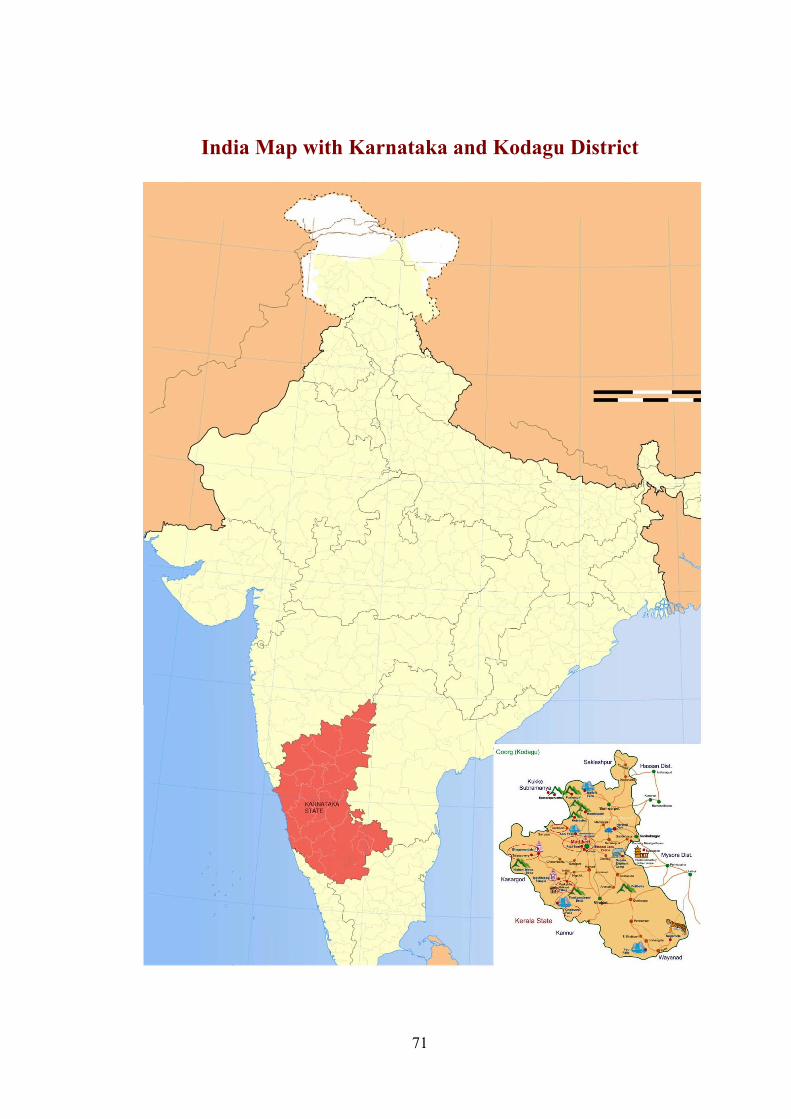
Kodagu is a district of Karnataka State in southern India. It is also
known by its anglicized name of Coorg. It occupies about 4,100 km2 (1,580
miles) of land in the Western Ghats of southwestern Karnataka. Captivating
mountainous landscape with lush vegetation and picturesque deep valleys has
brought fame to Kodagu District. Tourists flock to have glimpses of this
beautiful district. Though geographically limited in area, it is one of the famous
districts of the country. There are many reasons for this:
- it is the centre of natural beauty consisting of tall hill ranges, deep
valleys and shining water falls;
- it has rich economic resources;
- one of the legendary and sacred river of India, the Cauvery takes her
birth and flows amidst beautiful surroundings;
- many historical and pilgrimage centers are located in the district; and
- the unique warrior race, 'Kodavas' of Kodagu are its inhabitants, known
for their distinct way of life
Many eminent men and women including foreigners who have visited
Kodagu have left behind excellent description of the land. The district is a
nature lovers' paradise; high rising Western Ghats, series of hill ranges, green
paddy fields in the valleys amidst hillocks, ever-green forests, and coffee,
orange and cardamom plantations have made Kodagu a picturesque highland
district. It is but natural that city people, tired of its din and polluted
atmosphere find solace in the fresh air they breathe and the cool calm
atmosphere they enjoy here.
71
India Map with Karnataka and Kodagu District
72
Despite all its natural wealth, Kodagu is still among one of the backward
districts of the State as it is not yet linked with the rest of the country by either
air or rail but it has a wide network of roads. It is also famous for its products
of coffee and orange. Kodagu honey has the medicinal properties as that from
Kashmir, but no major industry exists in the district as it is a land-locked
district, stretching itself on the southern part of the Sahyadris and is on the
southern borders of the State. Yet, the district has retained its historical and
cultural identity.
3.1 History
Organized administration was prevalent here since the time of the Ganga
dynasty. In the pre-historic period we come across stone-age sites related to the
tribal people; and before the Christian era, one fails to draw a clear-cut picture
of the economic, social and religious life of the few hundred or thousand
people who lived entirely depending on hunting and agriculture.
Kodagu was ruled by the Gangas, Cholas, Hoysala, Kongalvas,
Changalvas and the Odeyars of Kodagu. Over 100 inscriptions belonging to the
rulers of these dynasties have been discovered and the same have been
published in Epigraphia Carnatica (Vol. 1, 3rd edition). There are enough
records on the history of Kodagu in the State Achieves of Bangalore , Madras
and Bombay. Kodagu before the 10th century was not only a land of hills, but
of very dense forests and was an inaccessible region. It was inhabited by the
hilly (Betta) Kurubas, Jenu Kurubas, Yeravas, Kudiyas and other Tribals, and
more or less in the same period when a group called as the Kodavas or the
Coorgis and the Gowda people settled there. The population of Kodagu perhaps
was not more than 20 to 25 thousand during the time of the Ganga and the
Chola rule.
73
After Vijayanagar period a well organized political system was
established. The population must have increased probably not exceeding one
lakh by the 18th century. The dethronement of the Kodagu Rajas saw the
growth of coffee plantations, attracting labourers from outside. In due course,
population increased, and towns multiplied. During the British rule, expansion
of education and transportation facilities and improvement of roads ended the
geographical isolation of Kodagu.
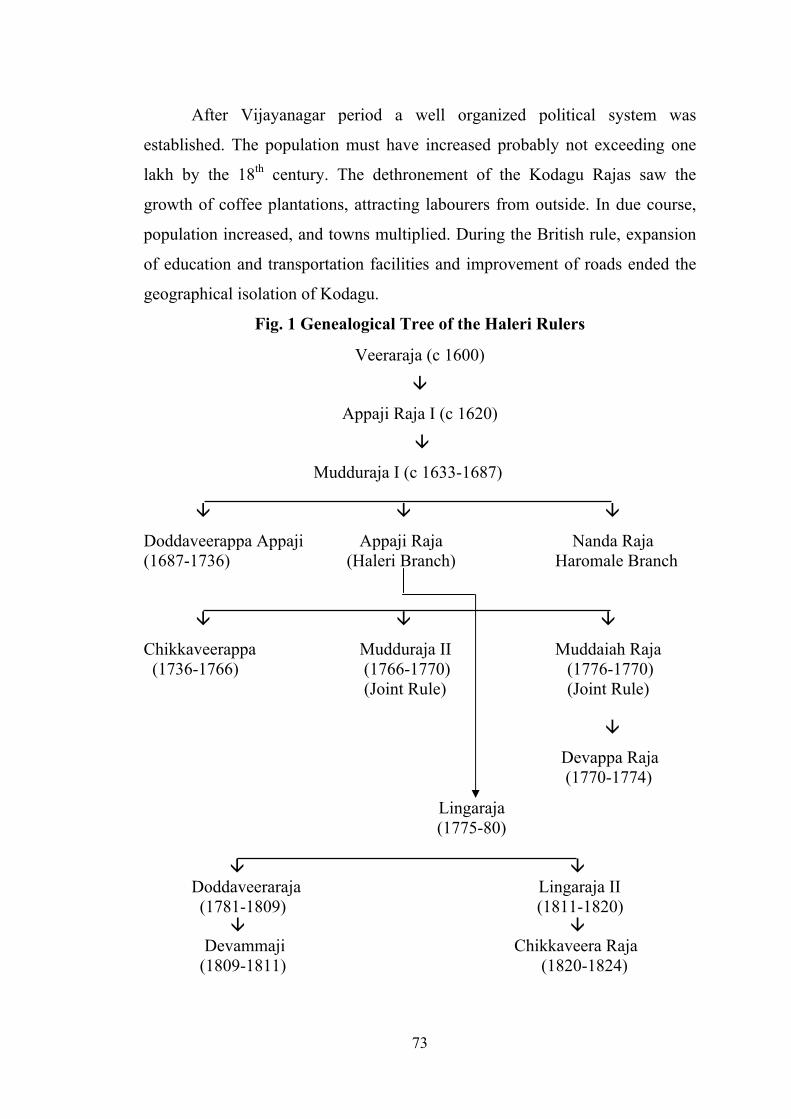
Fig. 1 Genealogical Tree of the Haleri Rulers
Veeraraja (c 1600)
Appaji Raja I (c 1620)
Mudduraja I (c 1633-1687)
Doddaveerappa Appaji Appaji Raja Nanda Raja (1687-1736) (Haleri Branch) Haromale Branch
Chikkaveerappa Mudduraja II Muddaiah Raja (1736-1766) (1766-1770) (1776-1770) (Joint Rule) (Joint Rule)
Devappa Raja (1770-1774)
Lingaraja (1775-80)
Doddaveeraraja Lingaraja II (1781-1809) (1811-1820)
Devammaji Chikkaveera Raja (1809-1811) (1820-1824)
74
3.2 Origin of the name of the Kodagu
While admitting that it is difficult to trace the origin of the term
‘Kodagu’, it is said to have been derived from ‘Kudumalendadu’, a similar
term used in ancient Tamil literature, (‘Kudumalenadu’ or ‘kudakam’) have
been mentioned with ‘Kodimalenad’ meaning a dense forest land on steep hills
and this is taken as the meaning of Kodagu, as “kodi” means a summit or peak.
In spoken language of the Kodavas, the term ‘Kodayee’ means hunting ground
and it is also supposed that from this word the name of the district might have
been derived. In inscription No. 347 of Chamarajanagar taluk, the area has
been referred to as ‘Kudugurunadu’. In the puranas it has been called as
‘Matsyadesha’, ‘Brahmadesha’ and also ‘Krodhadesha’. The first name came
because a king called Chandravarma hailing from Matsyadesha is believed to
have ruled over the district for some time. God Brahma is believed to have
worshipped Lord Vishnu from the present Brahmagiri. It is also argued that the
term Kodagu is derived from the third name.
3.3 Location and Boundaries
Kodagu district lies on the summits and the eastern and western slopes
of the Western Ghats, on the south-western border of Karnataka State in
between northern latitudes 11056’ and 12052’ and eastern longitudes 72022’ and
76012’. The greatest length of the district from the Hemavati river in the north
to the Brahmagiri range in the south is about 96 km, and its greatest breadth
from Sampaje in the west to Kushalnagar in the east is about 60 km. the district
is surrounded by Hassan district in the north, Mysore district in the east,
Dakshina Kannada on the west and Kerala State to the south.
3.4 Area and Population
Kodagu district has an area of 4,102 sq.km., equivalent to 2.14 % of the
State’s total area of 1,91,791 sq. km., and is one of the smallest district, next
only to Bangalore (Urban) district in the State. According to the Census of
75
India 2011, the total population of the district is 5,54,519 comprising of
2,74,608 males and 2,79,911 females. The district has a population density of
135 inhabitants per square kilometers (350/sq. m). Its population growth rate
over the decade, 2001-2011 it was 1.3 percent. The sex ratio in Kodagu district
is one of the best at 1019 females for every 1000 males and literacy rate of
82.52 percent according to 2011 census.
3.5 Rivers
The major rivers of the Deccan originate in Western Ghats and drain
eastwards but there are mountain torrents of the western declivities of the Ghats
which flow westwards. The largest river in the district is the Cauvery, which
with its principal tributaries, the Hemavathi, the Lakshmanathirtha, the
Kekkabbe and the Suvarnavati flows in an easterly direction and the Barapole
is the only river worth the name that flows towards west.
(i) The Cauvery
The river Cauvery rises at Talakaveri, a place located in the Brahmagiri
Hill, from a height of 1,356 meters (4,447 ft). Known as the ‘Ganges of the
South’, the river has innumerable holy spots on its either banks including many
in Kodagu district. The Cauvery follow a tortuous route. Her banks are covered
with luxurious vegetation and her bed is rocky. The river forms a natural
boundary between Kodagu and Mysore districts beyond Kushalnagar, covering
a length of 80 km in Kodagu from Talakaveri.
(ii) The Hemavati
The Hemavati river or Yenne-hole has her source near Javali in the
Mudigere taluk of Chikmagalur district and is one of the chief tributaries of the
Cauvery. After passing through Sakleshpur taluk of Hassan District, she forms
the boundary of Kodagu for a few km and joins the Cauvery in
76
Krishnarajanagar taluk of Mysore district. The Aiguru and the Kattehall
rivulets from Kodagu join the Hemavati.
(iii) The Lakshmanatirtha
The Lakshmanatirtha, a tributary of the Cauvery, rises in the Munikadu
forest on the plateau of Devasi Hills of the Brahmagiri of the Western Ghats.
The Lakshmanatirtha, together with Ramatirtha and Kerehole drains nearly the
whole of the south-eastern part of Virajpet taluk. In its descent over an almost
perpendicular mountain wall it forms a celebrated cataract (the Irpu falls)
which has been invested with cleaning virtue, and is consequently visited
during the Irpu jatre by thousands of devotees.
(iv) The Barapole
Barapole is the most important river that flows to the west. The name
Barapole is derived from the word “bara” meaning “steep” and pole is river. It
rises in the Brahmagiri hills and is soon joined by Kenganhole and the
Kakkattuhole tributaries. Later the Sarathhole also joins and forms 134 meters
deep water falls, known as the Sarath Abbi, located at Bittangala village. The
river forms other waterfalls near Kerala border. The river flows for 64 km in
Kodagu and then for 10 km, it forms the common border between Kerala and
Karnataka.
(v) The Kumaradhara
The Kumaradhara originates at the Subramanya mountain range,
becomes boundary between Kodagu and Hassan district and enters into the
western portion of the Manjarabad (Sakleshpur) taluk of Hassan district.
Further it enters into Dakshina Kannada through the Bisle Ghat region, and unit
with the Netravati river at Uppinangadi in Dakshina Kannada. The holy place
Subramanya, is located not far away from its bank. The combined river the

77
Netravati passes over a rocky bed with many rapids up to Bantwal and then
through richly wooded banks and joins the Arabian sea near Mangalore.
The Cauvery basin constitutes 63.4% of water resources of the district.
Remaining 36.6% is contributed by west flowing rivers. The Kolli reservoir in
Virajpet and the Harangi reservoir in Somwarpet taluk are the other major
sources of water.
3.6 Fauna
The fauna of Kodagu is a rich haven for both herbivorous and
carnivorous animals. Kodagu is rich with animal feeds and is equipped with a
national park and three wildlife sanctuaries – the Rajiv Gandhi National Park
(formally, Nagarhole National Park), Talakeveri, Pushpagiri and Brahmagiri
Wildlife Sanctuaries. The elephants, prefer to live in areas covered with tall
forests, where ground is hilly or undulating and where bamboo grows in
profusion. That is why elephants are common sight at Pushpagiri, Subramanya,
Sampaje, Brahmagiri, Makutta, Bhagamandala, Nagarhole, Titimathi, and
Kallahalla and Murkal areas of Kodagu district.
The predatory carnivorous animals like the tiger, Panther Tigris (huli),
panther, Panther pardus (Chiratey), are seen more frequently in the dry
deciduous forest of the district. The Indian Bison, Bibos gaurus (kademme),
symbolizes both vigour and strength. Sambar, Rusa unicolor (kadave) is the
largest Indian deer possessing very beautiful horns. The spotted deer, Axis
(chukke jinke), is beautiful to look at. Its favorite resort is bushes and trees,
near water-courses or bamboo jungles. Kodagu has a rich stock of these
animals. The Niligiri langur, the Hanuman langur and the bonnet monkey or
macaque are the three species of monkeys found in abundance in the forest of
Kodagu.
78
Reptiles are well represented in the district and occupy a multiplicity of
niches on land and in water. The ‘Flying Dragon’, Draco dussumieri (haruva
halli), possesses an extraordinary structure called ‘parachute’, an expansion of
lateral skin folds, which enables the animals to glide to some distance. Toe
tortoises are represented by the soft shelled species Triomyx leithii (niru ame).
They live in the grassy forest at foothills. The marsh crocodile, Crocodiles
palustris (mosale) was once quite common all along the Cauvery river basin.
The Amphibians of Kodagu are unique in their variety. In rainy season
common frog, Rana tigerina (neerkappe) could be seen in abundance. The
burrowing frog, Rana breviceps (nelakappe), the tree frog, Rhacophorus
maculates (marakappe), the Indian toad, Bufo melanostictus (irula kappe) are
the other species. The availability of a large supply of insects and plant food in
the forests, supports rich bird life. Summer is the time to look for birds with so
many forest trees in flowers and fruits.
3.7 Flora
The first mention of the vegetation of Kodagu district was by Hooker
and Thomson in 1885 when Kodagu was described as part of Malabar
province. The district is endowed with rich vegetation that natural vegetation
of the district is broadly classified into the following categories that intermix
with one another and hence it is difficult to delimit them rigidly.
i. The scrub type that occurs in patches is seen around Hunisekatte and
Kallahalla of Nagarhole range, where rainfall is sparse. The trees are
stunted and do not grow more than twelve meters and vegetation chiefly
consists of thorny elements with a few stranded, crooked and malformed
trees.
ii. The climax moist deciduous forest occur at the higher slopes of the
mountains located in Murkal, Nagarhole, Ponnampet, Somvarsanthe,
lower parts of Karike and Sampaje hills. The plants form a more
compact canopy and the interval between leaf fall and leaf flush is
79
relatively short. The Secondary moist deciduous forests are better
preserved towards the foot-hill of Western Ghats.
3.7.1 Evergreen and semi – evergreen types
This Excellent example of tropical evergreen forest could be noticed at
the lower slopes and valleys of the Western Ghats. The evergreen rain forest on
the wind-ward side of the Western Ghats is the richest type of vegetation that
could be observed in Kodagu. Giant trees with buttressed bases and trunks that
are un-branched for over 20-30 meters fan out to meet the contiguous tree tops
high above the ground. The crowns of adjacent trees merge to form a verdant
roof, hampering the effect of the rain and standing up to the fury of the wind
from June to September. During the rest of the year the canopy basks in the
bright tropical sunshine filtering only a part of the daylight to the plants
beneath.
3.7.2 Sholas and grassland types
The shoals are compact, low and non-stratified type of forests that are
watered by mountain streams that run through them. The shoals fit into a
mountain depression and have a low profile that blend with the contours of the
hills. The trees especially near the ridges tend to be stunted. This type of
vegetation is seen at an altitude of 1,200 meters above sea level. They are
located at mountains of Brahmagiri, Madikeri, Pushpagiri, Tadiyandamol and
Talakaveri.
3.7.3 Rheophytes and Hydrophytes
The vegetations along the streams and rivulets exhibit a specialized
ecosystem, they control the rapid mountain streams. The important species are
Bambusa arundinacea (mulla bidiru), Calophyllum apetalum (surahonne),
Hopea parviflora (kiralbhogi), Lophopetalum wightianum (bili hebbaisu),
Madhuca nerifolia (sanna hippemara) Salyx tetrasperma (niravanji), etc.
80
3.8. Climate
Two centuries ago, teeming with forests and as a result Kodagu was like
a cold storage, during major part of the year. An official of Tipu Sultan’s
regime writes:- “A description of the cold here makes the pen, before it begins
to write, stiff as if it were plunged into the frozen sea, and the tongue of truth at
describing the temperature is with fear and astonishment congealed like rice,
notwithstanding it is covered with the Posteen (fur cloak) of the lips, what can
it say therefore?..... this, however, is the description of the summer. God protect
us from the winter and rainy seasons”. Kodagu district has very moist rainy
monsoon climate. Of the 14 heavy rainfall station in India, with annual rainfall
of more than 5,000 mm, four are in Karnataka. Of these, except Agumbe in
Shimoga district, the remaining three places viz., Bhagamandala (6,032 mm),
Pullingoth (5,941 mm) and Makutta (5,054 mm) are in the district. The
Western Ghats, which run almost north-south at right angles to the path of the
south-west monsoon current, cause heavy rainfall in the district.
3.9. Rainfall
Kodagu district receives major part of rainfall from South-West and
North-East monsoons. The western half of the Kodagu district (Bhagamandala
–Pullingoth-Makutta-Karike area) receives the annual rainfall of more than
5,000 mm, the highest rainfall in the area being 6,032 mm at Bhagamandala,
which is very near the location where the Cauvery river originates. Rainfall in
Kodagu also decreases rapidly as one passes from the hilly region to the plains;
for example while Bhagamandala has 6,032 mm Kushalnagar, about 48 km
east of it, has 1,120 mm, which works out to a rainfall gradient of 102 mm per
km of Horizontal distance. The South-West and North-East Monsoon pass
through this district and hence bring more rains.
81
3.10 Temperature
The records of Madikeri meteorological observatory may be taken as
broadly representative of the conditions in the district in general. The low
temperature of January begins to increase from mid-February and reaches
climax in April and May. With the onset of the south-west monsoon by the
beginning of June, temperatures decrease and weather becomes pleasant. The
relative humidity is generally high throughout the year. In general, surface
winds flow over the district from west or south-west in the south-west monsoon
season.
3.11. Forest Wealth
Kodagu district stands fifth in the state in respect of forest area, and has
20 per cent of the total forest area of the State. Of the total geographical area
of 4,102 sq.km. forest constitutes 1,259.52 sq.km. forming 30.43 per cent of the
area of the district. This works out to 0.96 hectare of land area out of which
0.29 hectare is forest land. The reserved forests account for 1,136.46 sq.km;
protected forest 27.14 sq.km. and 95.92 sq.km. unclassified forest. Kodagu is
one of nine forest circles which have been further subdivided into four division
for the purpose of administrative convenience. Of this the Madikeri division
has 858.16 sq.km. of the districts forest and remaining falls in the Hunsur
division.
Devara Kadu
The rulers of Kodagu used to grant land to a deity or a temple which was
designated as ‘Devara Kadu’. The temple authorities were allowed to use the
produce of these forests for up-keep of the temple, for use during the annual car
festival and special festivals and for the daily pooja of the deity. The
neighbouring villagers were allowed to use water from these forests and use the
area as passages. In 1969, such forest constituted 7,895 acres. There are about
346 such forests belonging to different communities and are known as, ‘Basadi
82
Kadu’, ‘Mathadakadu’, ‘Kaimadakadu’, ‘Devara Paisari Kadu’, ‘Holedevera
Kadu’, ‘Suggidevara Kadu’ and ‘Palli Kadu’, Devara Kadu could be easily
distinguished from the other forests on the basis of presence of symbols of the
deity or the temple. Such representation may be in the form of an icon, statue,
mask, pillars or trisulal (triedent). Some of the forest wealth trees of the district
include
i. Sandal Tree, Santalum album L. (shrigandha), is an ectoparasite and
attains a height of 8-15 meters. it is grown from seeds and the tree is
harvested commercially after 30 years. It wood has very attractive grain
and hence utilized by artisans like Gudigars for wood carving. The
sandal wood-oil has a very pleasant fragrance and hence there is a great
demand in the country and abroad for it.
ii. Teak-Tree, Tectona grandis L. (tegada mara), is immune to insect attack
and is water resistant. Hence it is in great demand the world over. It is
tall, deciduous, magnificent tree with long and rough surfaced leaves.
The teakwood, which darkens on exposure, is hard but easily worked; it
is used for ship building, agricultural implements and for railway
sleepers and coaches.
iii. Rose wood Tree, Dalbergia latifolia (bite mara) is the valuable species
of the district. Its ornamental heartwood having fragrance and purple-
black colour has been used whole or in veneers or for boxes and
furniture. Its seedlings are grown in the nurseries and transplanted in the
forest.
iv. Aniaris toxicaria (ajjanpete), is a tall tree and the trees are in abundance
in Kodagu. Its seeds are toxic as it contains a bitter chemical, ‘antaiatin’.
Jute is extracted from its soft and white stem and used in manufacture of
mats, bags, and ropes. Lagerstroemia lanceolata (nandi mara) is in great
demand for building construction, as its wood is very strong and
durable.
83
v. Match-wood and Plywood : A number of forest-based industries are
allotted soft-wood to be harvested from the forest. Plywood, matches
and packing industries are benefited by this new policy of the State
Government. Fifty per cent of the lops and tops of the soft-wood
extracted by the industries is permitted to be removed by them.
3.11.1 Minor Forest Produce
The Forest Department disposes several minor forest products under
three-year lease, taking taluk as a unit. The most important item are myrobalan
(alale-kayee) which is used for tanning the leather. The other products are :
tamarind, felonthis, ramphal, sitaphal, honey, wax, soapnut (seegekai), resin
(dhupa), cinnamon bark, fruits of Emblica officinalis (nellikayi), nuts of
Sapindus laurifolius (antavalakayi), seeds of Azadirachta indica (bevinakayi),
nuts of Madhuca longifolia (hippebija) and leaves of Butea monosperma
(mutagada ele). Several fruits used for colouring, and medicinal plants and
horns are included in this category.
3.11.2 Pressure on the Forests
The forests are disappearing rapidly due to the pressure of increasing
population. Shift cultivation, over grazing, converting forest into agricultural
land, collection of fire wood and forest fires have contributed greatly in
reducing the forest area. Prior to 1850, the British were interested in the
protection of teakwood plantations only. This resulted in local people misusing
the forest wealth. Frequent uncontrolled forest fires reduced ever-green forests
into barren or grass lands. Only those forests reserved for hunting and the
‘Pavitra Vanas’, (Devara kadu) were well protected. In order to overcome this
state of affairs, the ‘Progressive Science Association’ of England, introduced a
legislation in 1850 intended to protect forest lands in India. This helped to pass
‘Reserve Forest Act’ of 1865 which resulted in reducing the pressure on the
forest. At the end of the nineteenth century, Kodagu Forest Division had
84
3,25,419 acres of reserved forest and another 4,72,309 acres were released for
the benefit of the local populate.
3.11.3 Social Forestry
Under the Social Forestry Scheme, extensive planting has been
undertaken on the available open lands like the waste lands, gomal lands,
barren forest area, fore-shores of tanks and reservoirs, either sides of roads and
canals, fallow and marginal agricultural lands and open area in industrial
estates. This programme is aimed at solving increasing demand for fire-wood
and fodder. The objective is to finance individual farmers who are interested in
planting trees where they can get benefit after fifteen to sixteen years. They
have to take care of the trees which they planted and they have to refund the
amount in installments to the Government.
Under the Integrated Development of Western Ghats plan scheme,
people are encouraged to raise and maintain bamboo plantation, matchwood
and plywood plantation and cultivation of medicinal plants.
3.12. Agriculture
In Kodagu most of the economy is based on agriculture, plantations and
social forestry . Rice and other crops are cultivated in the villages. Coffee
plantations are situated on hill sides too steep for growing rice. Today coffee is
a major cash crop. Coffee processing is also becoming a major economic
contributor, currently Kodagu is the richest district not only Karnataka but in
India also apart from coffee the other plantation include cardamom, orange,
cashew, rubber, tea etc.
3.13. Irrigation
The district is blessed with rivers that can supply substantial amount of
water. However, the river water flows along steep topographies of the
85
mountains of high altitudes, their flows are available for very limited use to
agriculture. As the river banks are at higher elevations and the undulating lands
restrict the flow of water, as a result the district resorted to provision of
irrigation facilities such as the Harangi and Chiklihole irrigation projects in
Somwarpet. Other important sources of irrigation are tanks and nalas.
3.14. Caste and Tribe
Kodagu is chiefly populated by its native ethic group Kodavas. Besides ,
other communities that reside in Kodagu district are Kodava gowda, Kodava
Heggade, Brahamin, Amma kodavas, and Muslims. And tribal communities-
Yerava, Jenu kuruba, Kadu kuruba, Meda, Malaya kodava, Malekuidya and
other, minor tribal communities are also living in this district.
The yerava are primarily hunters and food gathers but now they are farm
laborers, They speak their own yerava dialect. The jenu kurubas, are honey
gathers and betta kurtubas are hill dwellers and good elephant captors , trainers
and mahouts. Among others tribes ayiri are artisans, medas are basket and mat
–weavers and act as drummers at feasts,, the kavadis are cultivators. The
kudiya are toddy tappers are hill land dwellers and pursuing agriculture and
depending on Minor Forest Produces and some are daily wage laborers. All
these tribes speak the Kodava language and follow Kodava customs and
tradtions.
3.15. Malekudiya
The Kudiyas are found in large numbers on the borders of Dakshina
Kannada, Bhagamandala, Napoklu and Virajpet. They are among the original
settlers of the district. However, lots of research work is still going on to know
their origin and their culture.
86
There are two sects in kudiya tribe a)Poomale Kudiya (b)Thamale Kudiya ,
The Poomale Kudiya speak Kodava language, they have similarities
with Kodava language and culture. But Thamale Kudiya speak more of
Malayalam because they are located towards the Kerala border. Hence their
culture, dressing and style of life follows the patterns of the Keralites.
However, both are not related as the Poomale Kudiya consider themselves a
superior group than Thamale kudiya. There were another type of kudiya’s who
were known as Adike Kudiya’s who came from Sampagi and settled in Kodagu
they speak tulu language, they lived in Kodagu with their ancestors.
Poomale Kudiya aslo known as Male Kudiya in Kodagu district .The
word ‘Male’ means ‘Ghat’ (i.e. Mountain range) and ‘Kudiya’ means ‘hilltop’,
hence the name “Malekudiya” means people living at the hill top of mountain
ranges and that is why they live very close to the slopes of Bhagamandala,
Bettasuru, Galibeedu, Thora and Kalawara which are mountain ranges found
along the Western Ghats located in the boundaries of Karnataka and Kerala
States. In Kodagu district they are known as Kudiyuaru, a vernacular word that
is associated with consumption of alcohol. Toddy country liquor extracted from
Bayini tree is their favourite drink. Both men and women alike consider it a
stimulant that causes them to feel like kings when they drink it.
In Kodava language, ‘Kudiya’ means drunkenness and it so happened
that the Kudiyas start drinking from morning and forget what they are supposed
to do for the day. There is no social or religious festivals that is celebrated or
observed without these drinks which according to them, gives them more
energy to dance with rhythm. Toddy is also offered to gods. They also use
liquor as an instrument to achieve the submission to control others. In their
understanding and practice, drinks provide considerable nutrition in the form of
food, energy, mineral and vitamins.
87
3.15.1 Nature Worship
They have their own culture, they celebrate festivals and they pray to
god and deities such as nature, rocks, trees rivers, streams etc. They perform
pooja to these gods with the sacrifice of animals such as pig, hen, cock and the
meat is cooked around the premise and they offer the cooked meals to the
concerned deity and offering of drinks. They speak Tulu, Kodava and Kannada.
3.15.2 Food;
Livelihood pattern of the Malekudiya is unique, the food they consume
are from the natural bounty like tubers, roots, mushrooms honey, toddy
(Byanemara-PALM family). The tappers of toddy store for their own use, part
is sold for economical benefits and the remaining toddy is stored and the
secreted residues forms into rice like small beads, which contains a formula
with all the medicinal and herbal edible food forms. They are well built and are
capable of cultivating their own agricultural crops like paddy, pepper
cardamom etc.
3.15.3 Okka (Family)
This is believed to be members of a family from the same blood lineage.
The head of the family (usually the eldest male) is called Karama and an
administrative head called Pattadhar. Everybody obeys the leader and festivals
such as Kailpoldh, Huthari, etc, are celebrated together by the entire family.
They have a family house called Aihmane in which the patadhar and Gods are
considered superior. In all occasions, good or bad, such as marriage or death,
the Aihmane has to be cleaned and lit with a lamp. In the Kudiya family the
Pattadhar gets lots of respect and women and children will not move about
freely in front of him nor cross their leg and sit. During festivals offering to
God, all the elders and younger people of the family come together and help
each other and celebrate. This is the case during both weddings, naming
ceremony, death day and the days of these ceremonies are considered as madha
88
in which they have to forget all their interpersonal differences and work
together.
Most of the Kudiya’s live in joint family and in one place. The internal
disputes are jointly handled and solved by the community without the
involvement of any outsider.
3.15.4 Housing
Kudiya live in huts and sheds, the walls of which are of bamboo splits,
strengthened with mud plaster with two pillars on the center, and two each on
either sides. These tribes build their houses on the top of hills and the distance
between one house and another is so vast. In spite of the difficulty with the
wild animals, the triabals are still living in the dense forest though some of
them have come out to educate their children and work elsewhere.
In their kitchen they have a plate called ‘Udi Thatte’ which is a
traditional plate. They place the plate on a raised platform and the plate is used
to keep sweets. Cooking is done in mud pots and their gifts were in mud pots.
A kitchen garden is a part of the house. Now some of the tribes are living in
tribal houses which are constructed by the Government.
They use firewood to cook, they have a pipe to blow the fire and dry
meat in their kitchen hence, it is important that the fireplace is always burning.
As soon as you enter their house they have an open room which is called
Kaiyale, followed by a hall (Badae) where they light a lamp which is called
Nellakkai bolacha and on the walls you find pictures of gods. The bedroom is
located after the hall and there is an out-house for keeping animals and for
storing firewood. Next to the house their is a bathroom made of bamboo or
else they will have this bathroom little away from the house, near the stream of
water. They always keep one Mug of water at the entrance of the house so that
89
people who enter wash their legs before entering the house. This is necessary
because, in the forest there are many leaches and other insects that stick to the
clothes and these can be dangerous if they are allowed to get into the house.
Kudiya’s always carry a stick with salt- wrapped cloth tied to the end
as a protection from leach bite. When bitten by leach, they rub the place with
this salt pack. They will always have a clean big open ground in the front and
at the back of the house to avoid the insect entering their home.
3.15. 5 Customs and traditions
The customs and tradition of these Kudiya community is different from
that of other tribal’s like Soliga, Jenukurba,Yarava and so on. They are more
similar to the Kodava community. The importance of their culture is that, they
follow their old tradition and culture along with the Kodava culture. Especially
the songs related to the nation are “Desh pat” songs during death are “Chav
pat” and like this they have different songs on different occasions. They are
child naming ceremony, wedding songs, when girl attain puberty, etc. Though
these Kudiyas are not educated they are good at singing songs according to the
occasions and good in sports.
Some of the Kudiyas keep riffles in their houses. If a girl child is born
they go on top of the hill and fire a riffle in the air . They do not know about
the date of birth when the child is born. If the child is born in the rainy season,
in the next rainy season they say that child is one year old. Like this, they
remember the age of the child and seasons. But now a days these Kudiya’s
know about the birth date, horoscope, which star the child is born etc,
When a child is born they prefer to keep their ancestor name like
Chenga, Ponna, Karinganna, Thammi, Gowri, Seethe, Gowramma etc., but
now we can also see changes in their name, they do keep modern names.
90
3.15.6. Marriage
The two sects Malekuidya and Thamalekudiya practice restrictions in
relation to food and contracting marriage with each other. They prefer their
mother’s brother’s daughter or father’s sister’s daughter in marriage and is
called crossed-cousin marriage where the boy’s family pay the bride price.
They do not marry within the same clan.
Girls are married after puberty and during the time of puberty, the girl is
kept in a hut for 16 days after which she is given a purification birth and the hut
where she stayed will be burnt. Even in case of delivery, the nursing mother is
also isolated in a hut for 16 days. They call these as periods of pollution.
3.15.7 Death customs
When a Kudiya person is about to die they pour water in the person’s
mouth. After the death of family members they do not eat any sour items.
These days are treated as bad days as Suthka, meaning prohibited days for
any good work and ceremonies. After 11 days of mourning they perform
rituals of purification and they come to normal life. They cremate their old
people and bury the young ones. They collect ashes on the third day of the
death of a person and pile it up under trees.
3.15.8 Belief and Worship
Ancestral worship is common among them and they have temples for
worshipping the two spirits, Thammaiah and Malatamuram. Their food is rice
and ragi ambali i.e. thick preparation of liquid ragi.
3.15.9 Beliefs in the God – Thamacha
Before going to do any work or even climbing a tree to collect liquor,
they pray for protection to this god and climb up. They will bow down to the
tree and after “namaskara”. They, don’t wear foot wear like slipper and shoes
91
to climb the trees, they consider the tree equal to god. To day the
government can’t compel them to come out of the forest instead they are the
ones who are protecting the trees in the forest .
3.15.10 Language
“Kodava” is their language. In some places like Bhagamandala and
Galibeedu they have slight changes. They also speak Kannada and Tulu.
3.15.11 Festivals
Uthari festival is a very grand festival celebrated by the Kudiya, they
also celebrate some festivals like , Hervanad nama, Erullie Banna Nama,
Arakal Festival.
3.15.12 Local medicines
Local medicines and its traditional use, has got a binding relationship
with these Kudiyas. These are two faces of the coin. Though they do not have
much education or no education, these medicines and their uses have spread
from word of mouth as the culture and tradition spread. For any sickness they
first use these local and traditional medicines, if it does not work, then they go
to hospitals in the end.
For e.g.: suppose a person has a wound, they apply turmeric powder
and not ointments. Even today they do not take any modern medicines for
cold, cough, fever, headache, etc they take their own natural medicines and
they teach and practice this in their houses, so that all the family members
know about it and this is passed on form one generation to another and so even
today the people practice this traditional method for curing minor ailments.
3.15.13 Changed life style
The present day’s Kudiya’s have changed a lot. In olden days they used
to stay in forests and hilly areas. Now they formed their own community life in
92
the villages. They are living in the hills, build the houses on top of the hill and
grow coffee, cardamom, pepper as the vegetation is suitable for that, they also
grow paddy in the lower levels and where there is a stream. But for these lands
government has not given a title deed or right over those lands. The
government is trying to shift these tribal’s from their original place to other
places, but Kudiya tribals are bold enough to face the government challenges
and build their houses in the hills and lead an independent life there. Very
few Kudiya tribals have land documents.
Now the importance of sending the children to school is understood by
the Kudiya’s. Many of the Kudiya tribes are well educated and have good jobs
in government and private firms.
93
References
1. Belliappa, C.P. “Nuggets from Coorg History”, Roopa & Co.
2. Bopanna, P.T. ‘Rise and Fall of the Coorg State’: Rolling Stone
Publications, Bangalore, 2009
3. Handbook of Karnataka – 2010, Chief Editor – Geelani, K.A.S,
Karnataka Gazetteer Department, Dr. Ambedkar Veedhi, Bangalore
560001, India 2001, Publication Division, Ministry of Information and
Broadcasting, Government of India, Soochanam Bhawan, CGO
Complex, New Delhi-110003
4. Kushalappa, M. (Kodagu in the Modern Era, since 1834) (A History of
Kodagu) (Vol. 1)
5. Kushalappa, M. ‘The Early Coorgs: A history of early Kodagu and its
people (A History of Kodagu) (Volume 2) December 2013
6. Shankaranarayana Bhat Edurkala K , Shri Kaveri Vaibhava 1987
7. The Census of India 2011
8. IYER, L.A.K, 1948. The Coorg Tribes and Castes. Pp.23-28.
Government Press Madras.
9. Poomale Kudiya’s Ithichayanda Ramesh Uttappa 2002, first published
by Karnataka Kodava Sahithya Academy.


![pradeep sharma[1]](https://img.pdfslide.us/doc/110x75/5540e948550346c4778b4c48/pradeep-sharma1.jpg)