Embed Size (px)
Citation preview
'!lIE EUROPEAN REMJl'E SENSING AND PI-IOI'CX;RAMMETY (ERSAP) DATABASE
Irene Mader, European Space Agency, ESRIN, Italy Charles-Henri Latarche, Groupernent pour Ie Developpanent de la Telooetection
Aerospatiale, France
ISPRS Commission VI
ABSTRACT
The ba.ckground, present status and future prospects of the European Rarote Sensing and PhotograJl1'Tetry Database being developed under the auspices of the European Space Agency are presented. International cooperation aspects in the various phases of the evolution of this project are outlined.
Initiated following a recommendation of the 16th
ISPRS congress in Kyoto ( 1988) and a cooperative agreenent between ESRIN, (the European Space Agency establishment in Italy) and CDI'A, France, this databa.se will encompass all the documents generated in European countries in the fields of surveying, mapping, remote sensing and related applications.
This online file will canplement all imagery catalogues and products, and all online services and tools developed by the European Space Agency as sUR?Ort to its Earth Observation and Envirormmtal PrograJl1'Tes.
KEY IDRDS: Data Base, Rarote Sensing, Rarote Sensing Applications, PhotograJl1'Tetry, European Space Agency, Europe, International Cooperation
1. INJ.R::O.CrION
The establishment of a bibliographic Rarote Sensing and PhotograJl1'Tetry Databa.se was the subject of a resolution taken by the Commission VI at the Hamburg congress in 1980.
The following steps can be traced ba.ck first to the Mainz symposium in 1982 with a paper presented by J. H. Ten Haken entitled "An Investigation of Available On-line Databases in the Field of PhotograJl1'Tetry and Remte Sensing", and then to the Rio congress in 1984 with the paper of Prof. J. Hotmer entitled "The ISPRS-IRS Information Retrieval System for Literature and Factual Data" (~ VI -4) of fundamental iIrportance to the implementation of the project.
In parallel, Ch. -H. Latarche presented an inventory of relevant existing databases at the Rio congress in 1984, concluding that the databa.ses were spread across a large number of international hosts. In 1986 the Badagry symposium confirmed previous resolutions.
Joint action and coordination, with a view to defining a single set of creation procedures for
345
a unified and standardised database in the field of Rarote Sensing and PhotograJl1'Tetry, was needed due to:
the increasing development of remote sensing, particularly in view of new image technologies the recent advances made in photogrammetry and the contribution to Geographic. Information systems (GIS) the scattered locations of existing databases and the consequent increasing number of access procedures and languages the proliferation of different hardware, standards and formats due to the explOSion of microcanputing and the large number of new subject-specific databa.ses
A working group under the lead of GUrA, having given consideration to the timeliness of implementing the ISPRS-IRS database, has conducted a study of the existing resources in 1988 aroongst the organisations potentially interested in the project. The results of the survey and of a questionnaire sent to 600 European organisations were used to study the users I information requirements. The broad outline of a proposed ISPRS-IRS database was beginning to take shape.
The feasibility study, presented at the Kyoto congress in 1988, entitled "Prospective Study for an ISPRS Database" by D. Burette, Ch. -H. Latarche et a1. put forward several possible configurations, each leading to a project implementation ba.sed on different possible networks of producers with various choices to be made and areas to be considered such as:
choice of host types of informations to enter into the database choice of thesaurus indexing languages database language analytical or non-analytical database dissemination products etc
At that time the necessity for a close and complex coordination with various geographically distributed database producers and the lack of definitions in the various areas mentioned above was delaying the implementation of the ISPRS database.
2. EXISTlOO REMJI'E SENSIOO AND ~REsaJRCES
The 1988 inventory of existing resources in the field of remote sensing and photogrammetry, performed by the GJI'A (France), :revealed two categories of information resources.
computerised multidisciplinary and specific thaMtic databases produced by major database suppliers available through online information retrieval systems documentary resources on remote sensing and/or photogrammetry existing at various organisations and laboratories
2.1 Computerised multidisciplinary databases
This category covers large multidisciplinary bibliographic reference databases, such as:
NASA (USA)
NrIS (USA)
basically aerospace oriented, containing serne references on remote sensing and photogrammetry
containing earth sciences references
cx:MPENDEX (UK) dealing with engineering, including remote sensing records
INSPOC (UK) oriented towards electronics including remote sensing records
PASCAL (France) including records in the field of remote sensing and photogrammetry
GEnBASE (UK) covering in its part G, the remote sensing, photogrammetry and cartography records
2.2 Computerised Specific or Thematic Databases
This category covers specific databases oriented towards the earth and/or water resources, such as:
CAB (UK) and AGRIS (FAD)
Selected Water Resources (USA) and MFA ( FAD)
GEOLlNE (DE)
GEOREF (USA)
IB1SCUS (France)
RESORS (canada)
dedicated to agriculture
oriented towards water and marine issues
covering geosciences, including surveying and mapping with remote sensing
dedicated to geology and earth sciences
research progress dedicated to developing countries
concentrating on remote sensing I surveying and m:lpping as related to remote sensing
2.3 Other documentary resources
This category covers mainly remote sensing andIor photogrammetry centres and organisations located in Europe, such as:
346
GDTA
1m-
GSTS
International Institute for Aerospace Survey and Earth Sciences (Netherlands) having significant dedicated resources in particular theses and technical reports
Groupement pour Ie D9velo~nt de la Telectetection Aerospatiale (France) having resources such as papers of the various symposia it organises, ~lished documents such as DESS students' study reports and technical reports
Institut G€ographique National (France) possessing its own computerised database containing records of theses and technical reports in the field of photograrlITEtry
Groupement Scientifique de Telectetection de Strasbourg (France) having semi-computerised records of publications such as congress proceedings, theses and study reports
ORSTSOM now Laboratoire d'Informatique Appliquee (France) producing an internal database of journals articles, conference proceedings, roonographs and unpublished documents
Universite catholique de wuvain, Laboratoire de Telectetection (Belgium) having computerised records of journal articles, theses etc ..
In his Kyoto 1988 paper "Information Retrieval for Literature and Factual Data in Photograrrmetry and Reroote Sensing", Prof. J. Hobner also mentioned the following non-computerised systems:
Zeitschrift fUr Vermessungswesen (DE). Publishing literature references in the field of remote sensing and photograrrmetry The Chinese Society of Geodesy Photograrrmetry and cartography. Publishing an abstract journal The VIN1TI (former USSR) . Publishing the abstract journal Geodesia y Aerofotosjemka covering geodesy, photograrnnetry and rem::>te sensing The AIDOS database (DE). Covering surveying, mapping and remote sensing (this database is not available online)
3. ANALYSIS AND STA'lUS OF EXISTIOO REsaJRCES
Various surveys analysing the major databases dealing with remote sensing performed by J. H. Ten Haken in 1982 and updated by the sarre author in his 1988 paper "Data Bases in the Field of Aerospace and Related Fields" indicated that scientists in the field of photograrrmetry and remote sensing have a variety of databases at their disposal for online searching and that none of them offers a very cCX!l>rehensive coverage. Further analysis of this paper evidenced then that the majority of these databases were available through the European Space Agency/Information Retrieval Service
(ESA-IRS) at ESRIN, the European Space Agency establisl"ment in Italy, with the exception of GEXlAR:HIVE (UK) , GOOREF (USA) , GEOLINE (DE) , GroBASE (UK) I RESORS (Canada) and Selected Water Resources (USA).
It should be noted that in 1991 and 1992, in sURX>rt to the Earth Ci::lServation prograrme of the Ageocy, RESORS I GOOBASE and Selected Water Resources were loaded on the ESRIN canputer.
A 1990 analysis of the 93 major journals dealing wi th rarote sensing and photogramnetry indicated that RESORS scans 20 raoote sensing journals, PA'3CAL 36 journals and GOOBASE 54 • Moreover, this survey evidenced that very few European journals were scanned. Other surveys provided new orp:>rtun!ty to quantify the lack of European raoote sensing journals in existing databases as well as the very poor coverage of low-circulation and non-mainstream li terature. This also applies to invaluable documentary resources produced at uni versi ties and research centres in Europe, including technical reports, handbooks and other, unpublished literature, documents ccmronly known as "grey" literature.
Meanwhile, the European Space Agency developed a multidisciplinary database, the European Aerospace Dcitabase ccmoonly known as EAD, aiming at covering all grey li terature documents in aerospace and aerospace related fields, generated by European organisations located in its 13 Member States and Participating countries. The database was officially released for access in 1990. Aiming at producing the database in h.a.rnonised and unified standards by a network of European organisations, ad-hoc processing tools and software were developed. '!he database is produced by ESA-IRS and loaded on its computer located at ESRIN.
4 • CDJPERATIVE ESRIN-GDTA AGREEMENr AND CREATION OF '!HE PRalUI'YPE OF '!HE EUROPEAN REMJ1'E SENSn~ AND ~y (ERSAP) DATABASE
In 1990 a cooperati ve agreerrent was concluded between ESRIN and the "Groupement pour Ie oevel~nt de la Recherche Aerospatiale/GDrA" (France) .
Aiming at creating ultimately a specific catp.lterised database I the European Raoote Sensing and Photograrmetry (ERSAP) Database, an online bibliographic file with its corresporrling archives, the tenus of the ~ntwere:
1. The creation in 1991 of a prototype of the ERSAP database, under the respective budgets of both Agencies, and its loading on the catplter of ESA-IRS, who was entrusted the task to produce the database.
2. The prarotion of the ERSAP project, using the prototype, anvngst various groups of the Earth Ci::lServation Progranm:! of the European Space Agency, GUrA partner organisations as well as other European organisations and insti tutes involved in remote sensing, photograrmetry and related fields.
By the end of 1990 a meeting was held with the following European Centres, the GlJI'A partner
347
organisations, constituting the nucleus of the producers of the future database:
ITC (Netherlands) GUl'A (France) IGN (France) The Laboratoire d'Informatique Appliquee fonner OR'.r'SCM (France) The Laboratoire de Telectetection de 1 'Universite catholique de lDuvain, BRQ1: the Bureau de Recherches GOOlogiques et Min1eres (France)
The meeting, anvngst various aspects, evidenced the need for:
a harmonisation policy between the future European partners and producers aimdng at the elimdnation of possible redundancy of work a carmon format to be used when dealing with new records a reformatting of existing records already in electronic naiia
The same meeting confirmed:
the poor coverage of European Rarote Sensing and Photogranmetry records in existing relevant databases the existence of documentary resources in European organisations the usefulness to develop a European Raoote Sensing and Photograrrmetry (ERSAP) Database
and reccmnended a survey to be performed of all institutes and organisations in Europe including not only the countries of the European Space Agency Member States and European coomunities Member States but also other central and oriental European countries.
In August 1991 the prototype of the ERSAP database was created, including 100 records of CETEL DESS dissertations (sponsored by Gm'A) with French and English abstracts and controlled tenus fran the EAD/NASA thesaurus, loaded on the ESRIN canputer and daronstrated at the International Astronautical Federation (lAP) congress in Montreal in October 1991.
In February 1992, the pilot database was demonstrated to the Earth Observation Prograrrme of the European Space Agency who reccmrended to include into the prototype 500 additional items generated under the Earth Observation Directorate of the Agency in the following categories: technical reports, handbooks I conference papers, technical bulletins as well as Earth Observation newsletters.
These documents are being acquired for further processing and entry into the prototype.
5. '!HE EUroPEAN REMJI'E SENSn~:; AND ~y (ERSAP) DATABASE pROJECr
5.1 Major Features
The European Remote Sensing and Photograrmetry (ERSAP) Database is an online bibliographic file resident on the ESA-IRS host. The references contain the title in English and original
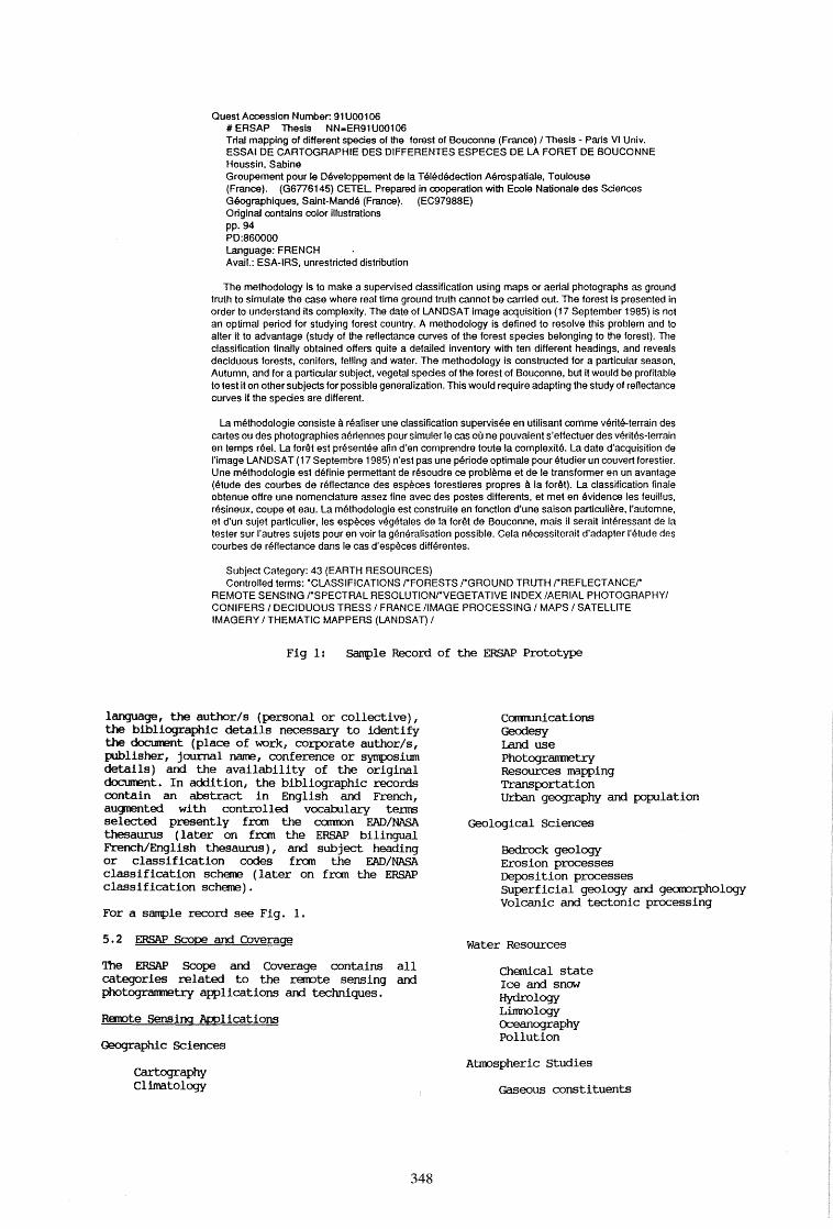
Quest Accession Number. 91 UOO 1 06 # ERSAP Thesis NN-ER91UOO106 Trial mapping of different species of the forest of Bouconne (France) I Thesis - Paris VI Univ. ESSAI DE CARTOGRAPHIE DES DIFFERENTES ESPECES DE LA FORET DE BOUCONNE Houssin, Sabine Groupement pour Ie Developpement de la Teled9dection Aerospatlale. Toulouse (France). (GSnS145) CETEL Prepared in cooperation with Ecole Nationale des Sciences Geographiques. Saint-Mande (France). (EC97988E) OriginaJ contains color illustrations pp.94 PD:8S0000 language: FRENCH Avail.: ESA-IRS, unrestricted distribution
The methodology is to make a supervised dassification using maps or aeriaJ photographs as ground truth to simulate the case where real time ground truth cannot be carried out. The forest is presented in order to understand its complexity. The date of LANDSAT image acquisition (17 September 1985) is not an optimaJ period for studying forest country. A methodology is defined to resolve this problem and to alter it to advantage (study of the reflectance curves of the forest spedes belonging to the forest). The classification finaJly obtained offers quite a detailed inventory with ten different headings, and reveals deciduous forests, conifers, felling and water. The methodology is constructed for a particular season, Autumn, and for a particular subject, vegetaJ spedes of the forest of Bouconne, but it would be profitable to test it on other subjects for possible generaJization. This would require adapting the study of reflectance curves if the spedes are different.
La methodologie consiste a realiser une classification supervisee en utilisant comme verite-terrain des cartes ou des photographies aeriennes pour simuler Ie cas ou ne pouvaient s'effectuer des verites-terrain en temps reel. La lor~t est presentee afin d'en comprendre toute la complexite. La date d'acquisition de I'image LAN DSA T (17 Septembre 1985) n' est pas une peri ode optimaJe pour etudier un couvert forestier. Une methodologie est definie permettant de resoudre ce probleme et de Ie transformer en un avantage (etude des courbes de reflectance des especes forestieres prop res a la for~t). La classification finale obtenue offre une nomendature assez fine avec des postes difterents, et met en evidence les feuillus, resineux, coupe et eau. La methodologie est construite en fonction d'une saison particuliere, ,'automne, et d'un sujet particulier, les especes vegetales de la for~t de Bouconne, mais iI serait interessant de la tester sur I'autres sujets pour en voir la generalisation possible. Cela necessiterait d'adapter I'etude des courbes de reflectance dans Ie cas d'especes differentes.
Subject Category: 43 (EARTH RESOURCES) Controlled terms: ·CLASSIFICATIONS rFORESTS rGROUND TRUTH rREFLECTANCEr
REMOTE SENSING rSPECTRAL RESOLUTIONrVEGETATIVE INDEX IAERIAL PHOTOGRAPHYI CONIFERS I DECIDUOUS TRESS I FRANCE !IMAGE PROCESSING I MAPS I SATELLITE IMAGERY I THEMATIC MAPPERS (LANDSAT) I
Fig 1: Sample Record of the ERSAP Prototype
language, the author/s (personal or collective), the bibliographic details necessary to identify the dcx:\.urent (place of work, corporate author/s, publisher, journal name, conference or symposium details) and the availability of the original document. In addition, the bibliographic records contain an abstract in English and French, aUC}D9nted with controlled vocabulary tenns selected presently fran the ccmnon EAD/NASA thesaurus ( later on fran the ERSAP bilingual French/English thesaurus), and subject heading or classification codes fran the EAD/NASA classification scherre (later on fran the ERSAP classification scherre).
Ccmnunications Geodesy Land use Photogranmetry Resources mapping Transportation Urban geography and population
Geological Sciences
Bedrock geology Erosion processes Deposition processes Superficial geology and geomorphology Volcanic and tectonic processing
For a sample record see Fig. 1.
5.2 ERSAP Scope and Coverage
The ERSAP Scope and Coverage contains all categories related to the rarote sensing and photogran:metry applications and techniques.
Raoote Sensing Awlications
Geographic Sciences
cartography Climatology
348
water Resources
Chemical state Ice and snow Hydrology Limnology Oceanography Pollution
Atmospheric Studies
Gaseous constituents
Meteorology Particulate constituents
Biological related studies
Agriculture Fisheries Forestry Vegetation Wildlife
Integrated Environmental Studies
Cllm3tology Desertification Land degradation Land pollution Multiapplication studies Soil science
Raoote Sensing Techniques
Sensing Platforms
Aircraft Balloons and aerostats Helicopters Manned orbital platforms Rockets Satellites Ships SUrface data platforms
Sensors
Acti ve microwave sensors Active optical devices Acoustic devices Arrays sensors Imaging systems and lm3gery Photographic systems Scanners Spect.rc:.tooters Radiooeters Television systems
Physical Principles and Phenooena
Sensing and Ccrmrunications Paths
Ground Stations and Data Processing Laboratories and Facilities
Automatic classification Computer systems description Data processing Data correction Enhancement Manual interpretation Mathematical analysis Statistical analysiS
Data Storage/Retrieval and Data catalogues
Project and Mission Design
Prograrme Planning and Policy
Cost and benefits Technology transfer User related services
Sensing Techniques
Acoustic sensing Active microwave sensing
349
Active optical sensing Imaging sensing Array sensing Photographic sensing Television sensing Scanner sensing Spectranetry Radianetry
Pattern Recognition
Imagery
The ERSAP Scope and Coverage docum:mt will be continuously updated by an ad-hoc steering group of experts from the European Space Agency and experts from European rarote sensing organisations, and will be the major tool used to select and include the original documents to be processed for entry into the database.
5.3 ERSAP Document Types
In the first implementation phase, unpublished documents will be included in the database such as:
Technical Notes, Maooranda and Technical Papers Technical Handbooks Theses/Dissertations Contractor Reports Patent Applications Pre-Conference Papers Research in Progress Conference and SympoSia Proceedings
as well as
Dictionaries of Remote Sensing and Photograrmetry Terms Thesauri of Remote Sensing and Photograrmetry Terms Glossaries of Remote Sensing and Photograrmetry Encyclopaedia of Remote Sensing and Photograrmetry Directories of Remote Sensing and Photograrmetry Centres, organisations, Professional Societies, Data Centres, Laboratories, etc.
Later on the conventional published literature will be included in the database, such as:
Books Journals Journal Issues
5.4 ERSAP Document Sources
The sources of the doa.nnents of the ERSAP database will be:
European Spa.ce Agency and its contractors Research Institutes and Centres and universities Governmental Organisations Data Centres other organisations
working in the field of rarote sensing and photograrmetry and their respective applications.
5.5 The ERSAP Input/Validation Processing ~
The requirements to process the documents and input the data directly fran various centres and organisations to the European Aerospace Database led ESA-IRS to develop the FAD Input and Validation SystE'ffi, based on the FAD bibliographic standards.
The roodulari ty of the systE'ffi, used for creating not only FAD records but also other databases produced internally by the European Space Agency, allows the adaptation to changes in the dOclmll,mt processing standards.
The systE'ffi consists of two separate packages, the "local" and the "central" functions. The local entry/validation software which can be very easily adapted to the ERSAP bibliographic standards perfonns three major functions:
the data entry to ERSAP standards the local, validation of records I contents against authority files (thesaurus, corporate authors I etc .. ) and tables services procedures, such as:
the systE'ffi parametrisation, enabling the continual updating and irrprovement of the ERSAP bibliographic standards the transfer of data to the ESA-IRS host (via floppy disk or electronically)
The central software operating at ESA-IRS will manage all the data received fran various local input centres or database producers. The rrost irrp:>rtant features of this software are:
the reception of data transferred fran rerrote input centres the preparation and formatting of data transferred to the ERSAP Retrieval SystE'ffi the identification and elimination of potential duplicates the generation of statistical reports of acquisitions
In order to perform the final quality assurance and control, the central systE'ffi disposes of functionalities identical to those of the local level and can be considered at the administration level, which has full control over all entered data at any time of operations.
It is intended to make available the local ERSAP software to the organisations who will process their data directly to the ERSAP database as well as keep a local database. The systE'ffi runs on a starrlard personal carputer, i t ~is advisable to run the systE'ffi on PS/2 or AT machines, al though it could theoretically also be run on XT rrodels. At least 20 magabytes of free disk space and 512 kilobytes of memory must be available.
6. ACCPISITIOOS AND INFORMATIOO F'I.!.M
The ERSAP database documents acquisi tion and gathering procedures, adopted by the European
350
Space Agency, follow the traditional General Acquisition SystE'ffi aiming at the conclusion of bilateral agreements between the European Space Agency and the European organisations releasing the documents for entry into the database. Modelled on the European Aerospace Database agreements, these contracts will require the organisations to release their documents to the database.
Copyright issues will also be dealt with, in order to create at ESRIN a new centralised archive of all documents referred to in the database. Indeed ESRIN has currently the responsibility to acquire, process, archive and distribute a great deal of information related particularly to earth observation. This includes bibliographic, full text, diagrarrmatic and acquired earth observation data. Fran the time of the initial selection of documents, the contributing organisation will, in particular, be requested to determine the copyright status of its documents. If same permission will be proved difficult to obtain for a legal reproduction of the document by the Agency, the document will not be integrated into the ERSAP central archives for further distribution to third parties. It will only be processed as citation in the database.
upon reception of a document fram various rerrote sensing sources, the initial processing will include:
the determination of the copyright status and right of legal reproducibility the special handling when appropriate allocation of a native ERSAP number
The next processing step will include:
the descriptive cataloguing according to the ERSAP unified standards. These standards will be very similar to the international FAD/NASA standards the production of the French and English summaries the indexing or allocation of controlled vocabulary keywords fram the cammon EAD/NASA thesaurus (or successors) the loading of the records in the ERSAP Information Retrieval SystE'ffi or database
The documents that the Agency is authorised to archive and distribute will also be microfiched using ANSI standards (98 frames with a reduction factor of 24: 1) and the resulting master microfiche will be routed to its corresponding archives.
The text of the original documents will be ordered online from the reference retrieved as a search result by the ERSAP end-user.
Carmunications between the user and the ESA-IRS host will be handled via online ordering status, where an order will be either "waiting", "accepted" , or "rejected" ; the latter c~se applying to a document for which the permiss10n to reproduce and disseninate was not granted by the supplying organisation.
The document reproduced either in microfiche or blowback paper copy according to the end-user

r'-'-'-'-'-'-'-'"
Remote cJ-i r-------, Sen,ing
Phorogromm .... elr-y .............. Sources
Originol Documents
END· USERS --"-"-"-"-"-"1 : I i I
t t Search & Retrievol
+ Online Document Ordering
ERSAP Information
Retrieval .
.11 ~:·-o·· Reader /Prinler Blowbodl : t Documenb
-4---_.. ! •. _ .• _""_.11_.1-1
i i i i i i i i
>1 ! i
.. - .. _ .. _ .. _ .. _., L-----M-ic-ro~lic~he~A-rc~hiv-e--~ ~
DOCUMENT ENTRY PATH
a· Microfiche Duplicoror Microfichei
PfKXESSINGPATH -._._.-DOCUMENT SEARCH PATH ................ .
DOCUMENT ORDERING PATH - - - - - -DOCUMENT DEliVERY PATH _ .. - .. - .. ,
Fig 2: CUrrent ERSAP Information Flow
requirements will be delivered to the user either via ordinary mail or fac-simdle services. 'Ihis process is illustrated in Fig. 2: "Current ERSAP Information Flow".
7 • FUruRE PROSPEC'IS
7.1 The ERSAP Thesaurus
According to the dictionary, a thesaurus is a store of words, or synonyms or antonyms, which can be used as categorised index terms for use in information retrieval. Thesauri are tools used in tenninology to translate the user's language into an artificial, but agreed upon, roore restrictive controlled language. It is a hierarchical succession in a scientific representation (domain representative) with normati ve character. This secures an unequivocal access even if the information is unknown. Some databases to-day incorporate thesauri structure which allow to branch fran selection lists. They typically follow the hierarchical IS0-00RM approach. In addition, modern thesauri, simdlar to hypertext (hypertext prograrrmes allow to branch directly within applications fran one tenn to other terms, images, graphics, or annotations), allow direct hierarchy-independent links. The links between terms are presented in a network structure. Electronic thesauri search may consist of means like, matching of synonyms, acronyms, and haIDnyms, lernnatisation, and other methods which ease and simplify utilisation.
Mlltilingual thesauri are essential, so that resear:ching docwnents in various languages do
351
not depend on specific knowledge and use of a prevailing language. Whenever possible, indexers and users should have the opportunity of working in their rrother tongue or, at least I in a familiar language. In the same way I roul tilingual thesauri might also be considered as playing an important part in improving control of literature and subjects being investigated.
It is intended to develop an ERSAP bilingual French and English thesaurus which will be later on translated into the official languages of the European Communities.
The aim is:
to create a master list of "descriptors" to be used for indexing and searching remote sensing, photograrrmetry, and related subjects in English to provide the translation of each "descriptor" initially in French, ultimately in all European Communities languages.
To this effect, an ad-hoc working group will be created carposed of experts in the field of remote sensing and related applications, in the thesauri design and national language expertise. The group will examine and select in a single list all descriptors used in national or international information systems relevant to remote sensing, photogrammetry, and related applications research. Systems like INFOterra, the International Enviromental Information System of the United Nations Environment

Optical Character Recognition/
Encading7Processing
END- USERS I I
-----.. _ .. _ .. _ .. _ .. -:
...,.. .. _ .. _ .. _ .. _ .. -1. :, Intelligent User Interfaces
+Full Text Search & Retrieval + Online Document Ordering
ERSAP Information
Retr'eval
I: :1 I: :1 I: :1 I: :1 I· :j r-'-{~J _._.-.
i ~--~~--~ i: :, I: :1 I: :1 !:
i
Remolt! Sen&ing
Photogrammelry SOurces
j O-~i~~". eJ··_[J_·· l
Printing Originol (Bit-map file) t Hard copy
Documents Documents
~ .... ------ ! Storage ~ I ~~tical ~ _ .. _ .. _ .. _ •• _ .. .J D.sck ~ _ .. _ •• _ .. _ •• _ .. _ .. _ •• _ •• _ .. _ ..
Document Storage System
D<XUMENT ENTRY PATH PReXESSINGPATH _._._.-
OCXUMENT SEARCH PATH ................ .
OCXUMENT ORDERING PATH - - - - - -OCXUMENT DfUVERY PATH _ .. _ .. _ ...
(Eledronic delivery)
Fig 3: Future ERSAP Information Flow
Programne - UNEP or thesaurus of environmental terms (English, French, Spanish and Russian), the ISPRS dictionary I the PASCAL-GEODE thesaurus, the IBISCUS-cEGET thesaurus for generic terms, a rmlltilingual dictionary of raoote sensing and photograrnnetry and other thesauri to be identified will be examined and screened. A single list of selected terms will be provided to fonn the basis for discussions with the experts. One of the main targets will be the standardisation and ha.rm:Jnisation of naoonclature. To fulfill this task, the information to be ha.rm:Jnised will be analysed and distributed to all relevant groups who will evaluate, contribute and make relevant amerrlnents .
This thesaurus will be part of a Unified Remote Sensing, Photograrnnetry, and Related I\Wlications System, a long tenn effort to build an increasingly intelligent automated system that understands the relevant terms and their interrelationship and uses this understanding to help users to retrieve and organise information from a variety of machine-readable sources.
Meanwhile, Hyperline, the prototype hypertext system developed by the Agency will enable ERSAP users to interrogate the ERSAP database in their natural languages, navigate through the nul tilingual thesaurus structure and browse the doclmlents associated with thesaurus terms.
7.2 The Future ERSAP Information Flow
In the future ERSAP Information Flow, the original docurcents will be scanned on a high performance scanner. Scanned docurcents will be transferred to an optical disk based archiving
352
system.
In parallel, an OCR (Optical Character Recognltion)/Processing system will enable full text search and retrieval combined to traditional search capabilities on title, sumnaries, keywords from the ERSAP thesaurus etc.. Access to the search capabilities of the ESA-IRS will be perfo:z:rred through conventional workstations connected to the ESA-IRS Data Dissemination Network (DON) or all the interconnected networks.
However, an interesting option could be achieved via workstations with two windows. The first window, connected to the computer would be used to access the ERSAP database via the ESA-QUEST search software. The required documents, identified by searching the database would be retrieved and displayed in the other window. The docurcents could then be ordered online and either printed and mailed/faxed, delivered on optical media (i.e. CD-RGi etc .. ) or transmitted via traditional communication networks, via the emerging ISDN networks or via broadband. satellite links.
An example of this process is given in fig. 3.: "Future ERSAP Information Flow"
7.3 The ERSAP Dissemination Products
From the ERSAP database, ESA-IRS will produce a variety of current awareness products and services.
7.3.1 The ERSAP SOls The Selective Dissemination of Information is of particular
importance to the remote sensing and photogranmetry ccmmmi ty . ~STALERI' will allow the user to be kept informed on the latest news on a given topic. Using this facility, an ERSAP 1Jser will store a specific subject in a file of interest am receive autcma.tically new information on the chosen subject upon each up::late of the ERSAP database.
7.3.2 The ERSAP Standard Titles Selected CUrrent Awareness publications will bring attention to recently entered report literature pertaining to remote sensing and photogranmetry. Each of the ERSAP standard titles will be carefully tailored to fit the given needs of a special research activity. New topics will be added as the need arises, others will be discontinued or redefined as research demands dictate.
8 • CCN.:llJSIOOS
As can be seen fran the above outline of the features of the proposed European Raoote Sensing and Photogranmetry Database, the European Space lv:Jency responds to the needs of European and international ccmmmities with a new service.
Many space agencies are contributing to an international effort to understand the global Earth system and to IOOni tor the intricate links between atrrosphere, ocean and land. ERS-l (European Remote Sensing satellite) I launched in July 1991, represents the European Space Agency's first contribution to environmental IOOnitoring via radar systems. Addi tional European contributing progranmes include EARSEC (the European Airborne Raoote Sensing Capability Project) jointly supported by ESA and. the CEC (Carmission of the European Camunities), ERS-2 and. follow on European Polar Platfonns which will be launched starting fran 1989 onwards.
Environmental space data, handled by these' missions I will be used by the scientific camunities to generated report literature, publications etc. which will be progressively included into the proposed ERSAP database.
The proposed ERSAP database will complement and be integrated into other services provided by the ESRIN establishment in the field of Earth observation. This database can be viewed as the initial step towards an international endeavour and. effort to provide a complete coverage and. availability of ciocuIoontary resources in the field of remote sensing, photogranmetry and. related a.rplications.
REFEREOCES
Burette, D., Latarche, Ch. -H., pouyllau, D., Ten Haken, J. H' I
1988. Prospecti ve study for an ISPRS Database In: Int. Arch. Photograrnmetry Remote Sensing, Kyoto - Japan, Vol. XXVII, Part B6, pp. 29-38
353
HOUmer, J., 1984. The ISPRS-IRS Information Retrieval System for Literature and Factual Data. In: Int. Arch. Photogrammetry Raoote Sensing, Rio - Brasil, Vol. XXV, Part A6, pp. 155-169
HOUmer, J., 1988. Information Retrieval for Literature and. Factual Data in Photogranmetry and Raoote Sensing, In: Int. Arch. Photogrammetry Raoote Sensing, Kyoto - Japan Vol. XXVII I Part B6, pp 85-94
Latarche, Ch.-H., Buffeteau, A., 1984. Contribution du GDTA a l'Evaluation des Bases de Dormees en Ligne pour la r:relooetection. In: Int. Arch. Photogranmetry Raoote Sensing, Rio - Brasil, Vol. XXV, Part A6, pp. 220-224
Linding, G., 1988. status 1987 of ISPRS Dictionary. In: Int. Arch. Photogrammetry Raoote Sensing, Kyoto - Japan, Vol. XXVII, Part B6, pp. 98-107
Ten Haken, J. H., 1980. Autcma.ted Storage and Retrieval Systems for Photogrammetry and Raoote Sensing. In: Int. Arch. Photograrnmetry Raoote Sensing, Hamburg -Germany, Vol. XXII I, Part B6 I
.rp. 99-108
Ten Haken, J. H" 1982. An Investigation of Available On-line Data Bases in the Field of Photogranmetry Raoote Sensing. In: Int. Arch. Photogrammetry Raoote Sensing, Mainz - Germany, Vol. XXIV, Part VI, pp. 82-94
Ten Haken, J. H' I 1988. Data Bases in the Field of Aerospace and Related Fields, International Institute for Aerospace Survey and Earth Science, lTC, Netherlands