Embed Size (px)
Citation preview

D R A F T W O R K I N G P A P E R S
POUGHKEEPSIE CITY CENTER REVITALIZATION PLAN
March 31st, 2014
D R A F T
W O R K I N G P A P E R # 1 : E X I S T I N G C O N D I T I O N S
POUGHKEEPSIE CITY CENTER REVITALIZATION PLAN
March 31st, 2014
D R A F T
POUGHKEEPSIE CITY CENTER REVITALIZATION PLAN DRAFT WORKING PAPER 1: EXISTING CONDITIONS
2 | K E V I N D W A R K A L L C
Table of Contents
INTRODUCTION ............................................................................................................................................. 4
GEOGRAPHIC FOCUS ..................................................................................................................................... 4
DEMOGRAPHICS............................................................................................................................................ 5
Population ............................................................................................................................................. 5
Racial and Ethnic Demographics ........................................................................................................... 6
Age ........................................................................................................................................................ 6
Educational Attainment ........................................................................................................................ 7
Income .................................................................................................................................................. 7
Family Structure ........................................................................................................................................ 8
HOUSING ....................................................................................................................................................... 8
Total Number of Housing Units ............................................................................................................ 8
Housing Type ......................................................................................................................................... 9
Housing Tenure ..................................................................................................................................... 9
Average Household Size ...................................................................................................................... 10
Age of Housing Units ........................................................................................................................... 10
Housing Vacancies .............................................................................................................................. 10
Median Housing Value ........................................................................................................................ 11
ECONOMIC INDICATORS ............................................................................................................................. 12
Unemployment Rate ........................................................................................................................... 12
Sources of Employment ...................................................................................................................... 12
TRANSPORTATION CONDITIONS ................................................................................................................. 13
Transit Access ...................................................................................................................................... 13
POUGHKEEPSIE CITY CENTER REVITALIZATION PLAN DRAFT WORKING PAPER 1: EXISTING CONDITIONS
3 | K E V I N D W A R K A L L C
Table of Figures
Figure 1: Boundaries of the Analysis Area .................................................................................................... 5
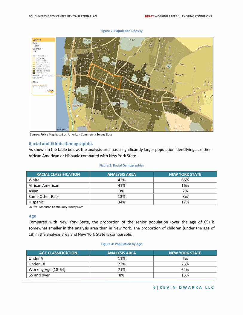
Figure 2: Population Density ......................................................................................................................... 6
Figure 3: Racial Demographics ...................................................................................................................... 6
Figure 4: Population by Age .......................................................................................................................... 6
Figure 5: Estimated Percentage of Population with at least a Bachelor's Degree ....................................... 7
Figure 6: Comparison of Income Levels ........................................................................................................ 7
Figure 7: Family Composition ....................................................................................................................... 8
Figure 8: Number of Housing Units............................................................................................................... 8
Figure 9: Comparison of Housing Type ......................................................................................................... 9
Figure 10: Estimated Number of Studio or One Bedroom Apartments ....................................................... 9
Figure 11: Comparison of Average Household Size .................................................................................... 10
Figure 12: Median Year of Construction for Housing Units ........................................................................ 10
Figure 13: Estimated Percent of Vacant Housing Units .............................................................................. 11
Figure 14: Median Housing Value Map ....................................................................................................... 11
Figure 15: Comparison of Unemployment Rates for July 2013 .................................................................. 12
Figure 16: Sources of Employment by Industry .......................................................................................... 12
Figure 17: Distance to Closest Rail Station ................................................................................................. 13
Figure 18: Percentage of Workers Using Public Transit to Commute to Work .......................................... 14
POUGHKEEPSIE CITY CENTER REVITALIZATION PLAN DRAFT WORKING PAPER 1: EXISTING CONDITIONS
4 | K E V I N D W A R K A L L C
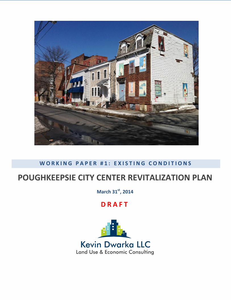
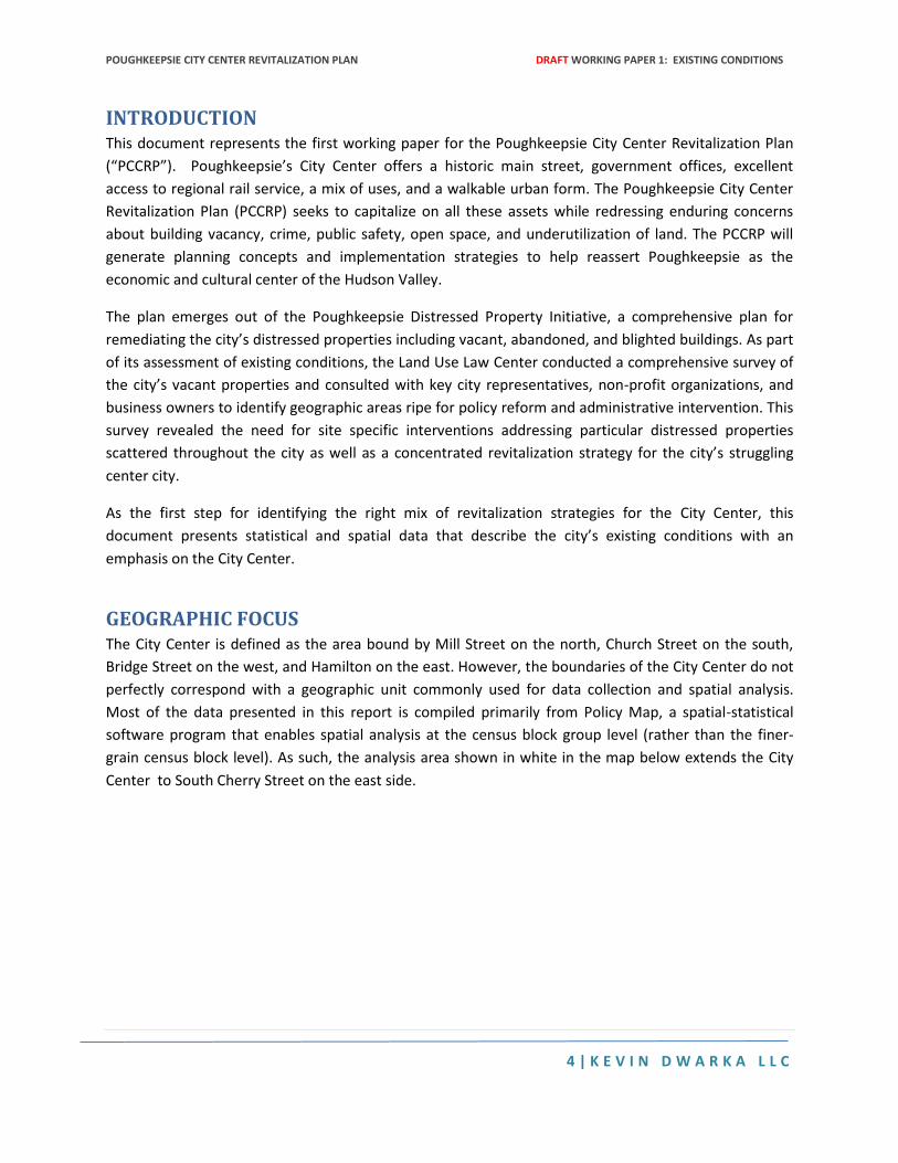
INTRODUCTION This document represents the first working paper for the Poughkeepsie City Center Revitalization Plan
(“PCCRP”). Poughkeepsie’s City Center offers a historic main street, government offices, excellent
access to regional rail service, a mix of uses, and a walkable urban form. The Poughkeepsie City Center
Revitalization Plan (PCCRP) seeks to capitalize on all these assets while redressing enduring concerns
about building vacancy, crime, public safety, open space, and underutilization of land. The PCCRP will
generate planning concepts and implementation strategies to help reassert Poughkeepsie as the
economic and cultural center of the Hudson Valley.
The plan emerges out of the Poughkeepsie Distressed Property Initiative, a comprehensive plan for
remediating the city’s distressed properties including vacant, abandoned, and blighted buildings. As part
of its assessment of existing conditions, the Land Use Law Center conducted a comprehensive survey of
the city’s vacant properties and consulted with key city representatives, non-profit organizations, and
business owners to identify geographic areas ripe for policy reform and administrative intervention. This
survey revealed the need for site specific interventions addressing particular distressed properties
scattered throughout the city as well as a concentrated revitalization strategy for the city’s struggling
center city.
As the first step for identifying the right mix of revitalization strategies for the City Center, this
document presents statistical and spatial data that describe the city’s existing conditions with an
emphasis on the City Center.
GEOGRAPHIC FOCUS The City Center is defined as the area bound by Mill Street on the north, Church Street on the south,
Bridge Street on the west, and Hamilton on the east. However, the boundaries of the City Center do not
perfectly correspond with a geographic unit commonly used for data collection and spatial analysis.
Most of the data presented in this report is compiled primarily from Policy Map, a spatial-statistical
software program that enables spatial analysis at the census block group level (rather than the finer-
grain census block level). As such, the analysis area shown in white in the map below extends the City
Center to South Cherry Street on the east side.
POUGHKEEPSIE CITY CENTER REVITALIZATION PLAN DRAFT WORKING PAPER 1: EXISTING CONDITIONS
5 | K E V I N D W A R K A L L C
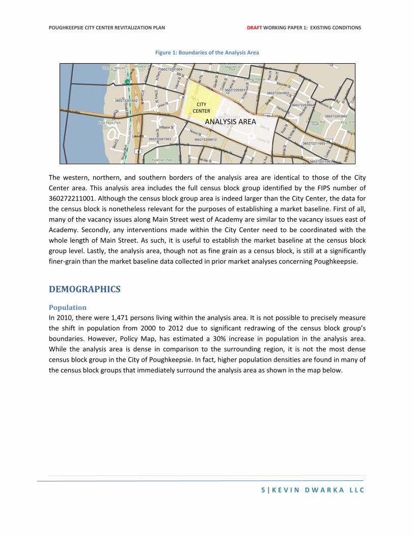
Figure 1: Boundaries of the Analysis Area
The western, northern, and southern borders of the analysis area are identical to those of the City
Center area. This analysis area includes the full census block group identified by the FIPS number of
360272211001. Although the census block group area is indeed larger than the City Center, the data for
the census block is nonetheless relevant for the purposes of establishing a market baseline. First of all,
many of the vacancy issues along Main Street west of Academy are similar to the vacancy issues east of
Academy. Secondly, any interventions made within the City Center need to be coordinated with the
whole length of Main Street. As such, it is useful to establish the market baseline at the census block
group level. Lastly, the analysis area, though not as fine grain as a census block, is still at a significantly
finer-grain than the market baseline data collected in prior market analyses concerning Poughkeepsie.
DEMOGRAPHICS
Population
In 2010, there were 1,471 persons living within the analysis area. It is not possible to precisely measure
the shift in population from 2000 to 2012 due to significant redrawing of the census block group’s
boundaries. However, Policy Map, has estimated a 30% increase in population in the analysis area.
While the analysis area is dense in comparison to the surrounding region, it is not the most dense
census block group in the City of Poughkeepsie. In fact, higher population densities are found in many of
the census block groups that immediately surround the analysis area as shown in the map below.
CITY CENTER
ANALYSIS AREA
POUGHKEEPSIE CITY CENTER REVITALIZATION PLAN DRAFT WORKING PAPER 1: EXISTING CONDITIONS
6 | K E V I N D W A R K A L L C
Figure 2: Population Density
Source: Policy Map based on American Community Survey Data
Racial and Ethnic Demographics
As shown in the table below, the analysis area has a significantly larger population identifying as either
African American or Hispanic compared with New York State.
Figure 3: Racial Demographics
RACIAL CLASSIFICATION ANALYSIS AREA NEW YORK STATE
White 42% 66%
African American 41% 16%
Asian 3% 7%
Some Other Race 13% 8%
Hispanic 34% 17% Source: American Community Survey Data
Age
Compared with New York State, the proportion of the senior population (over the age of 65) is
somewhat smaller in the analysis area than in New York. The proportion of children (under the age of
18) in the analysis area and New York State is comparable.
Figure 4: Population by Age
AGE CLASSIFICATION ANALYSIS AREA NEW YORK STATE
Under 5 11% 6%
Under 18 22% 23%
Working Age (18-64) 71% 64%
65 and over 8% 13%
POUGHKEEPSIE CITY CENTER REVITALIZATION PLAN DRAFT WORKING PAPER 1: EXISTING CONDITIONS
7 | K E V I N D W A R K A L L C
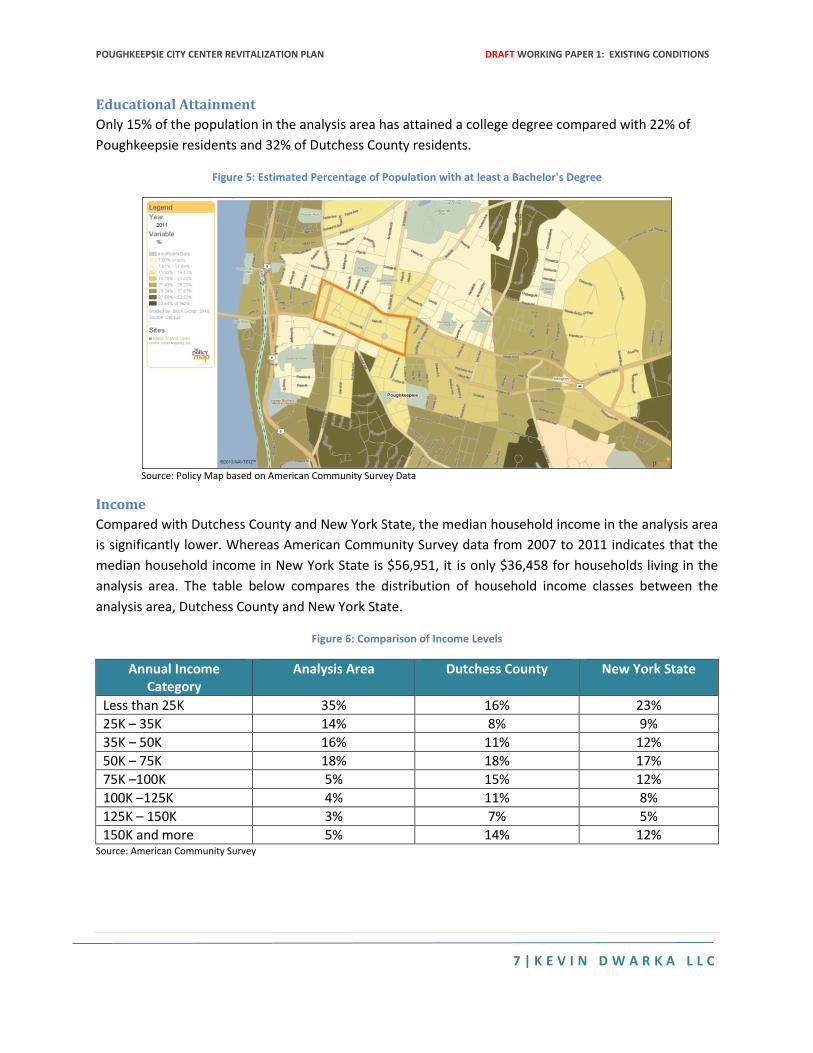
Educational Attainment
Only 15% of the population in the analysis area has attained a college degree compared with 22% of
Poughkeepsie residents and 32% of Dutchess County residents.
Figure 5: Estimated Percentage of Population with at least a Bachelor's Degree
Source: Policy Map based on American Community Survey Data
Income
Compared with Dutchess County and New York State, the median household income in the analysis area
is significantly lower. Whereas American Community Survey data from 2007 to 2011 indicates that the
median household income in New York State is $56,951, it is only $36,458 for households living in the
analysis area. The table below compares the distribution of household income classes between the
analysis area, Dutchess County and New York State.
Figure 6: Comparison of Income Levels
Annual Income Category
Analysis Area Dutchess County New York State
Less than 25K 35% 16% 23%
25K – 35K 14% 8% 9%
35K – 50K 16% 11% 12%
50K – 75K 18% 18% 17%
75K –100K 5% 15% 12%
100K –125K 4% 11% 8%
125K – 150K 3% 7% 5%
150K and more 5% 14% 12% Source: American Community Survey
POUGHKEEPSIE CITY CENTER REVITALIZATION PLAN DRAFT WORKING PAPER 1: EXISTING CONDITIONS
8 | K E V I N D W A R K A L L C
Family Structure Based on 2007-2011 American Community Survey data, there are a total of 315 families in the analysis
area. Compared with Dutchess County and New York State, the analysis area has a much greater portion
of families compromised of single parent households, especially female-headed households.
Figure 7: Family Composition
Family Composition Analysis Area Dutchess County New York State
Total Families 315 73,232 4,656,855
Married with Children 15% 34% 30%
Single with Children 34% 11% 15%
Single Female with Children 26% 8% 12%
Other Families 51% 54% 55% Source: American Community Survey
HOUSING
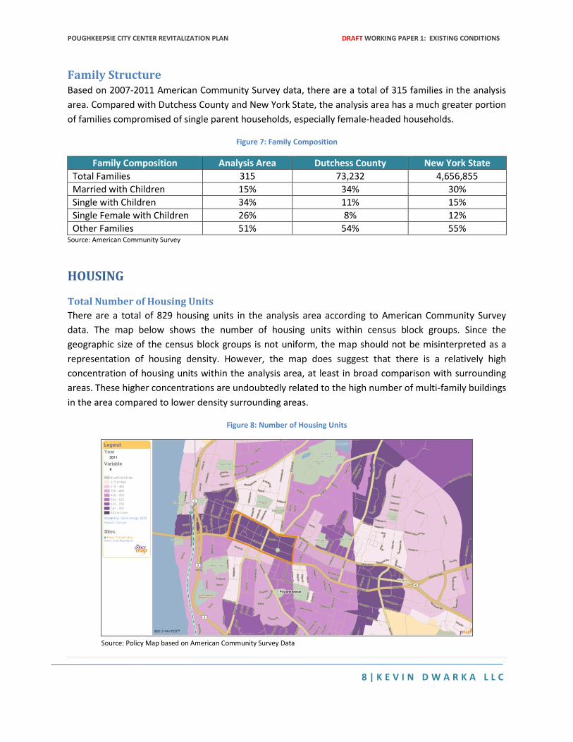
Total Number of Housing Units
There are a total of 829 housing units in the analysis area according to American Community Survey
data. The map below shows the number of housing units within census block groups. Since the
geographic size of the census block groups is not uniform, the map should not be misinterpreted as a
representation of housing density. However, the map does suggest that there is a relatively high
concentration of housing units within the analysis area, at least in broad comparison with surrounding
areas. These higher concentrations are undoubtedly related to the high number of multi-family buildings
in the area compared to lower density surrounding areas.
Figure 8: Number of Housing Units
Source: Policy Map based on American Community Survey Data
POUGHKEEPSIE CITY CENTER REVITALIZATION PLAN DRAFT WORKING PAPER 1: EXISTING CONDITIONS
9 | K E V I N D W A R K A L L C
Housing Type
Whereas the single family detached home prevails as the dominant housing type in Dutchess County,
apartments in small multi-family building is the prevailing housing type in the analysis area.
Figure 9: Comparison of Housing Type
Housing Type Analysis Area Dutchess County New York State
Single family detached homes 3% 63% 42%
Single family attached homes 0% 5% 5%
2-unit homes and duplexes 17% 7% 11%
Units in small apartment buildings 60% 18% 25%
Units in large apartment buildings 20% 3% 15%
Mobile Homes (or manufactured housing) 0% 4% 2% Source: American Community Survey
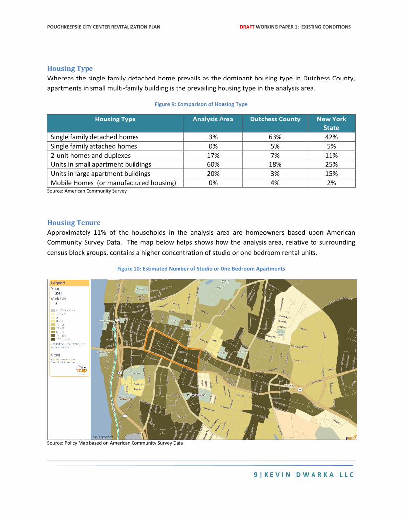
Housing Tenure
Approximately 11% of the households in the analysis area are homeowners based upon American
Community Survey Data. The map below helps shows how the analysis area, relative to surrounding
census block groups, contains a higher concentration of studio or one bedroom rental units.
Figure 10: Estimated Number of Studio or One Bedroom Apartments
Source: Policy Map based on American Community Survey Data
POUGHKEEPSIE CITY CENTER REVITALIZATION PLAN DRAFT WORKING PAPER 1: EXISTING CONDITIONS
10 | K E V I N D W A R K A L L C
Average Household Size
Compared with Dutchess County and New York State, the analysis area has a higher average household
size.
Figure 11: Comparison of Average Household Size
Analysis Area Dutchess County New York State
2.82 2.59 2.59 Source: American Community Survey
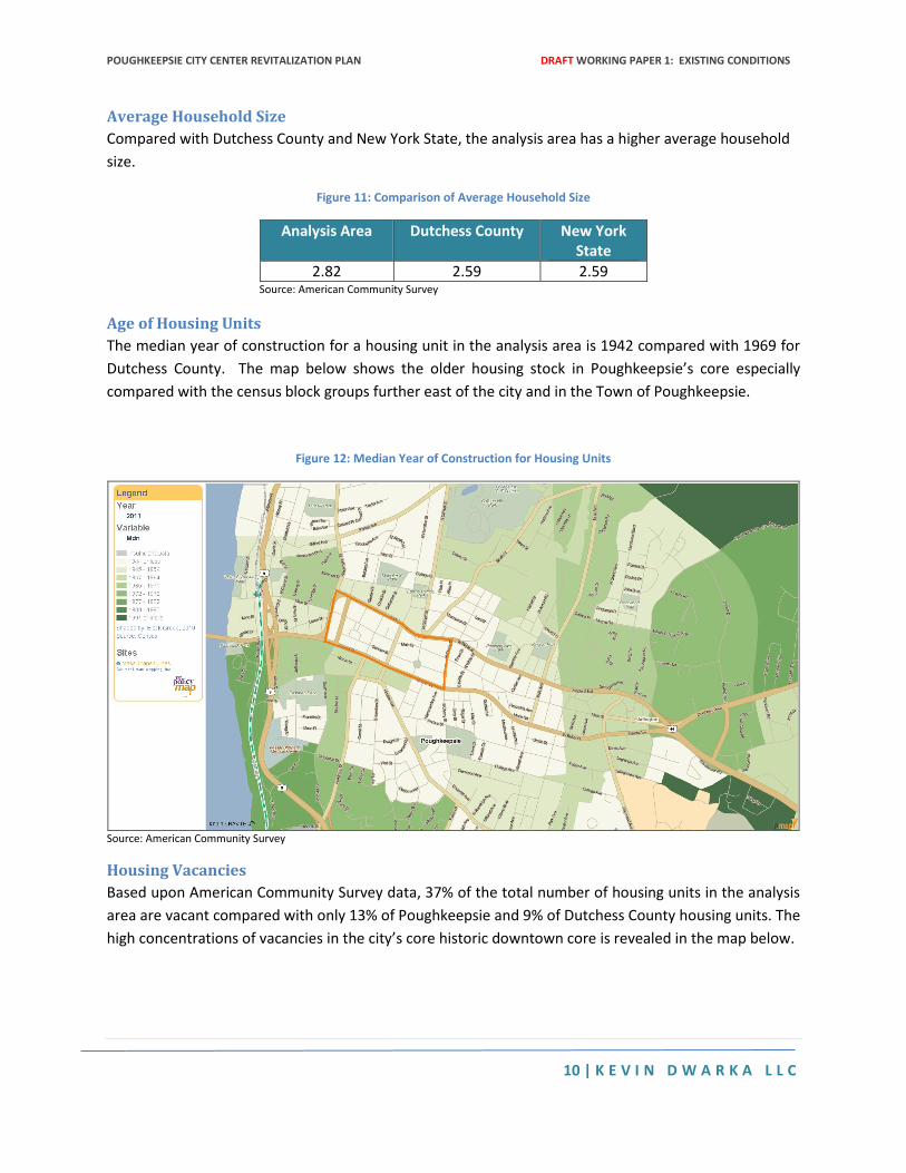
Age of Housing Units
The median year of construction for a housing unit in the analysis area is 1942 compared with 1969 for
Dutchess County. The map below shows the older housing stock in Poughkeepsie’s core especially
compared with the census block groups further east of the city and in the Town of Poughkeepsie.
Figure 12: Median Year of Construction for Housing Units
Source: American Community Survey
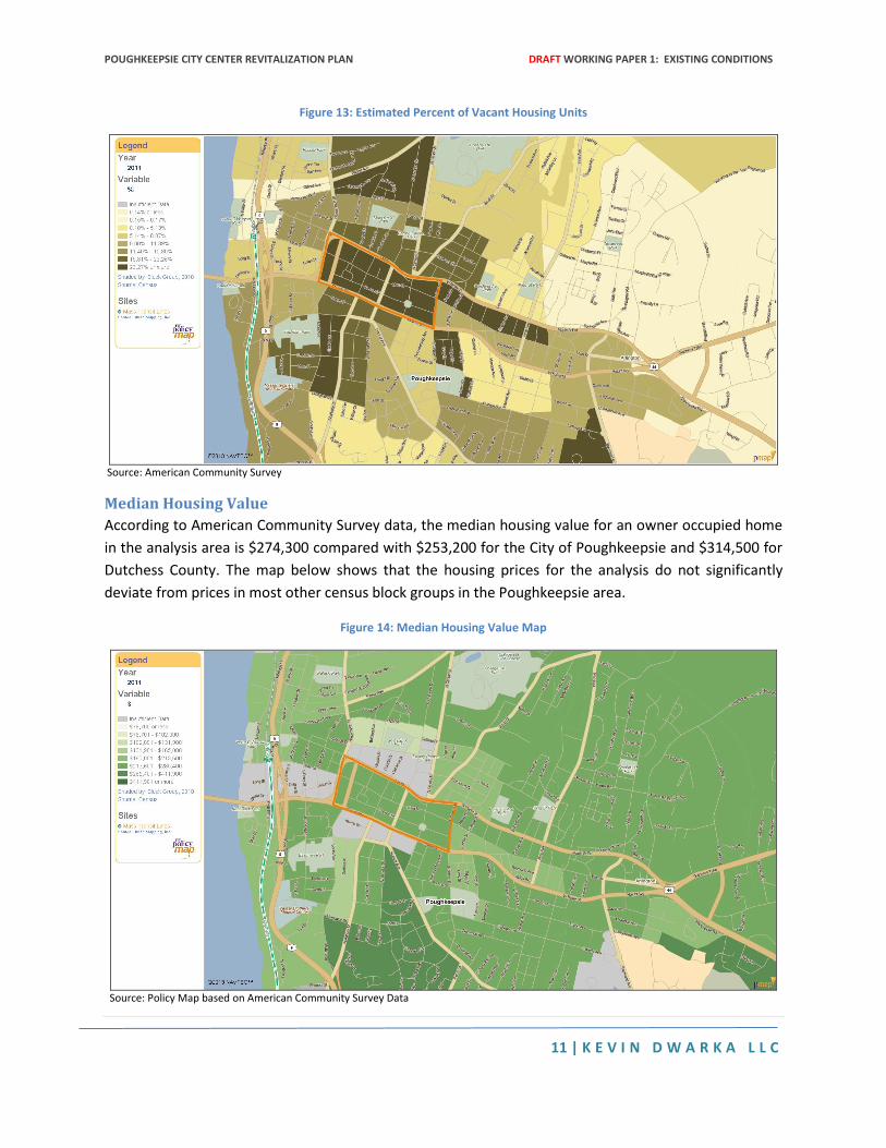
Housing Vacancies
Based upon American Community Survey data, 37% of the total number of housing units in the analysis
area are vacant compared with only 13% of Poughkeepsie and 9% of Dutchess County housing units. The
high concentrations of vacancies in the city’s core historic downtown core is revealed in the map below.
POUGHKEEPSIE CITY CENTER REVITALIZATION PLAN DRAFT WORKING PAPER 1: EXISTING CONDITIONS
11 | K E V I N D W A R K A L L C
Figure 13: Estimated Percent of Vacant Housing Units
Source: American Community Survey
Median Housing Value
According to American Community Survey data, the median housing value for an owner occupied home
in the analysis area is $274,300 compared with $253,200 for the City of Poughkeepsie and $314,500 for
Dutchess County. The map below shows that the housing prices for the analysis do not significantly
deviate from prices in most other census block groups in the Poughkeepsie area.
Figure 14: Median Housing Value Map
Source: Policy Map based on American Community Survey Data
POUGHKEEPSIE CITY CENTER REVITALIZATION PLAN DRAFT WORKING PAPER 1: EXISTING CONDITIONS
12 | K E V I N D W A R K A L L C
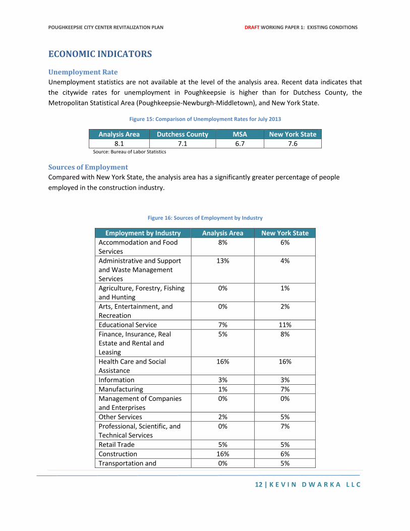
ECONOMIC INDICATORS
Unemployment Rate
Unemployment statistics are not available at the level of the analysis area. Recent data indicates that
the citywide rates for unemployment in Poughkeepsie is higher than for Dutchess County, the
Metropolitan Statistical Area (Poughkeepsie-Newburgh-Middletown), and New York State.
Figure 15: Comparison of Unemployment Rates for July 2013
Analysis Area Dutchess County MSA New York State
8.1 7.1 6.7 7.6 Source: Bureau of Labor Statistics
Sources of Employment
Compared with New York State, the analysis area has a significantly greater percentage of people
employed in the construction industry.
Figure 16: Sources of Employment by Industry
Employment by Industry Analysis Area New York State
Accommodation and Food Services
8% 6%
Administrative and Support and Waste Management Services
13% 4%
Agriculture, Forestry, Fishing and Hunting
0% 1%
Arts, Entertainment, and Recreation
0% 2%
Educational Service 7% 11%
Finance, Insurance, Real Estate and Rental and Leasing
5% 8%
Health Care and Social Assistance
16% 16%
Information 3% 3%
Manufacturing 1% 7%
Management of Companies and Enterprises
0% 0%
Other Services 2% 5%
Professional, Scientific, and Technical Services
0% 7%
Retail Trade 5% 5%
Construction 16% 6%
Transportation and 0% 5%
POUGHKEEPSIE CITY CENTER REVITALIZATION PLAN DRAFT WORKING PAPER 1: EXISTING CONDITIONS
13 | K E V I N D W A R K A L L C
Warehousing, and Utilities
Wholesale Trade 6% 3% Source: Bureau of Labor Statistics
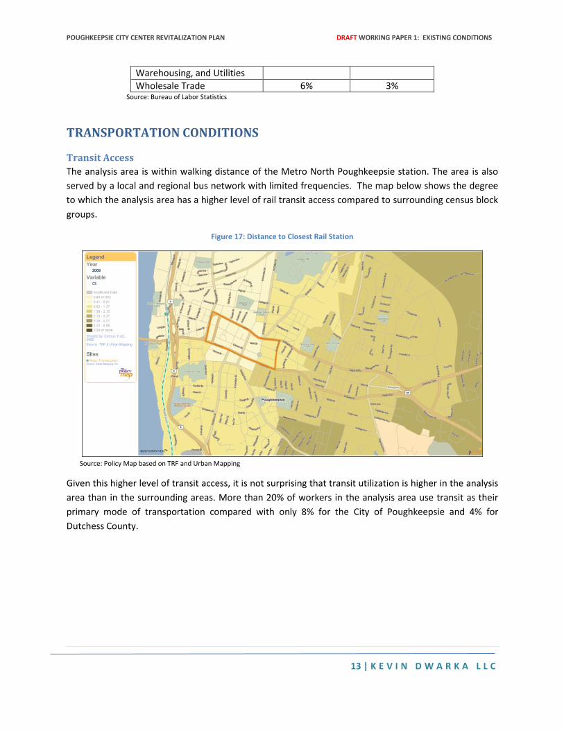
TRANSPORTATION CONDITIONS
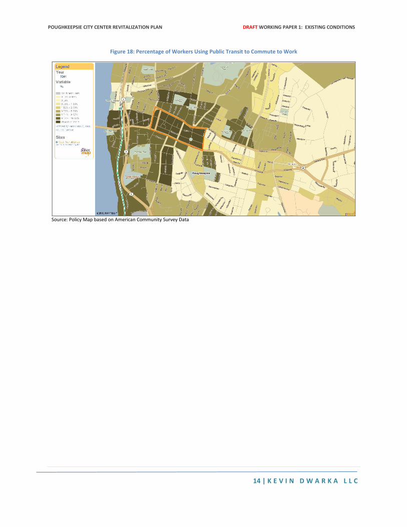
Transit Access
The analysis area is within walking distance of the Metro North Poughkeepsie station. The area is also
served by a local and regional bus network with limited frequencies. The map below shows the degree
to which the analysis area has a higher level of rail transit access compared to surrounding census block
groups.
Figure 17: Distance to Closest Rail Station
Source: Policy Map based on TRF and Urban Mapping
Given this higher level of transit access, it is not surprising that transit utilization is higher in the analysis
area than in the surrounding areas. More than 20% of workers in the analysis area use transit as their
primary mode of transportation compared with only 8% for the City of Poughkeepsie and 4% for
Dutchess County.
POUGHKEEPSIE CITY CENTER REVITALIZATION PLAN DRAFT WORKING PAPER 1: EXISTING CONDITIONS
14 | K E V I N D W A R K A L L C
Figure 18: Percentage of Workers Using Public Transit to Commute to Work
Source: Policy Map based on American Community Survey Data
W O R K I N G P A P E R # 2 : P R O P O S E D A C T I O N S
POUGHKEEPSIE CITY CENTER REVITALIZATION PLAN
March 31st, 2014
D R A F T
POUGHKEEPSIE CITY CENTER REVITALIZATION PLAN DRAFT WORKING PAPER II: PROPOSED ACTIONS
2 | K E V I N D W A R K A L L C
Table of Contents EXECUTIVE SUMMARY .................................................................................................................................. 5
Action #1: Introduce Frequent Transit Service Along Main Street ....................................................... 5
Action #2: Transform Market Street into a Complete Street ............................................................... 5
Action #3: Convert the Arterials into Boulevards ................................................................................. 5
Action #4: Restore Main Street as the Region’s Primary Commercial Corridor ................................... 6
Action #5: Convert Vacant Lots into Transit-Oriented Housing ............................................................ 6
SECTION I: INTRODUCTION ........................................................................................................................... 7
Study Area ................................................................................................................................................. 7
Goals and Objectives ................................................................................................................................. 7
The Case for Revitalizing the City Center .................................................................................................. 8
SECTION II: PROPOSED ACTIONS .................................................................................................................. 9
Action #1: Reintroduce High Performance Transit Along Main Street ................................................... 10
The Problem ........................................................................................................................................ 10
The Opportunity .................................................................................................................................. 10
Suggested Intervention ....................................................................................................................... 11
Case Studies ........................................................................................................................................ 12
Action #2: Transform Market Street into a Complete Street ................................................................. 12
The Problem ........................................................................................................................................ 12
The Opportunity .................................................................................................................................. 14
Suggested Intervention ....................................................................................................................... 14
Case Studies ........................................................................................................................................ 14
Action #3: Convert the Arterials into Boulevards ................................................................................... 15
The Problem ........................................................................................................................................ 15
The Opportunity .................................................................................................................................. 15
Suggested Intervention ....................................................................................................................... 16
Case Studies ........................................................................................................................................ 16
Action #4: Restore Main Street as the Region’s Primary Commercial Corridor ..................................... 19
The Problem ........................................................................................................................................ 19
The Opportunity .................................................................................................................................. 20
Suggested Intervention ....................................................................................................................... 20
POUGHKEEPSIE CITY CENTER REVITALIZATION PLAN DRAFT WORKING PAPER II: PROPOSED ACTIONS
3 | K E V I N D W A R K A L L C
Case Studies ........................................................................................................................................ 20
Action #5: Convert Vacant Lots into Transit-Oriented Housing .............................................................. 24
The Problem ........................................................................................................................................ 24
The Opportunity .................................................................................................................................. 25
Suggested Intervention ....................................................................................................................... 25
Case Studies ........................................................................................................................................ 26
POUGHKEEPSIE CITY CENTER REVITALIZATION PLAN DRAFT WORKING PAPER II: PROPOSED ACTIONS
4 | K E V I N D W A R K A L L C
Table of Figures Figure 1: Study Area ...................................................................................................................................... 7
Figure 2: Goals and Objectives of the Poughkeepsie City Center Revitalization Plan .................................. 7
Figure 3: Assets and Liabilities in the City Center ......................................................................................... 9
Figure 4: Five Proposed Actions for Revitalizing Poughkeepsie's City Center .............................................. 9
Figure 5: Main Street in 1906 ..................................................................................................................... 11
Figure 6: The Mill Street Weave ................................................................................................................. 13
Figure 7: Dudley Village Under Construction in 2008 ................................................................................. 21
Figure 8: New Streetscaping Along Barracks Row ...................................................................................... 21
Figure 9: Roslindale Village (Belgrade Avenue and Birch Street) ............................................................... 22
Figure 10: Bike Parking in Cedar Falls (Iowa) .............................................................................................. 23
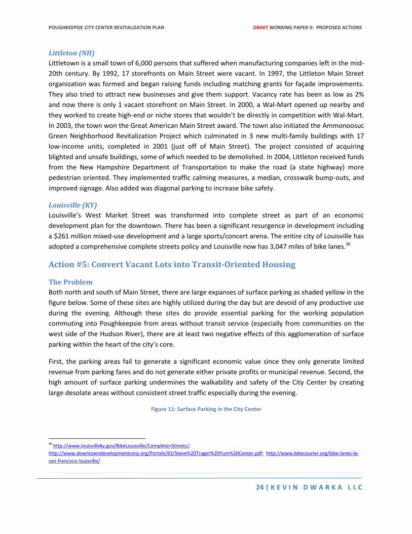
Figure 11: Surface Parking in the City Center ............................................................................................. 24
POUGHKEEPSIE CITY CENTER REVITALIZATION PLAN DRAFT WORKING PAPER II: PROPOSED ACTIONS
5 | K E V I N D W A R K A L L C
EXECUTIVE SUMMARY This document is the second working paper in the Poughkeepsie City Center Revitalization Plan (PCCRP).
The purpose of this document is to present the five proposed actions aimed at the long-term
revitalization of Poughkeepsie’s City Center. These actions focus largely on modifications to the city’s
transportation network. There are two intertwined reasons why the PCCRP focuses on transportation
actions. First, the existing transportation network has an immeasurable negative impact on the city’s
economic development. Specifically, the absence of a high quality transit service, the barricade effects
of the westbound and eastbound arterials, and the “superblock” form created by the downtown
circulation network all impede the flow of goods, services, people, and economic activity to the City
Center. Second, the upgrading of the transportation network has the potential to generate new private
investment in the city and facilitate the transformation of the City Center not only to help re-establish
the City of Poughkeepsie as a commercial as well civic capital but also to enhance sustainability for the
entire region.
Action #1: Introduce Frequent Transit Service Along Main Street
The City of Poughkeepsie, in partnership with Dutchess County, should implement a high quality transit
east-west service along the full length of Main Street between the waterfront and Raymond Avenue. At
the intersection of Main Street and Raymond Avenue, the transit service would veer south and
terminate at the entrance to the Vassar College campus located at Raymond Avenue and Main Campus
Drive. This service would provide a connection high-speed connection between the waterfront, the train
station, the Central Business District, the Middle Main Area, and the Vassar College Campus.
Action #2: Transform Market Street into a Complete Street
The City of Poughkeepsie in partnership with New York State Department of Transportation should
redesign Market Street as a “complete street” in which all transportation users including pedestrians,
bicyclists, and transit riders are sufficiently accommodated. Designing Market Street as a complete
street requires more than the insertion of a median and pedestrian bulbouts. A true complete street
approach will also install sufficient bike and transit infrastructure within the right of way, resolve the
hazardous intersections between Market Street and the arterials, and convert the intersection of
Columbus Drive and Mill Street into a T-intersection.
Action #3: Convert the Arterials into Boulevards
The City of Poughkeepsie in partnership with the New York State Department of Transportation should
convert both the westbound and eastbound arterials into pedestrian friendly boulevards. There are a
variety of ways in which a boulevard concept could be introduced including (1) the retention of the
existing number of travel lanes but the modification of the arterials’ intersections with north-south
streets (2) the retention of the existing number of travel lines but the conversion of one lane on each
arterial into a contra-flow lane and (3) the elimination of a travel lane on each arterial and its
replacement with either a median or a bike lane. The feasibility of these concepts as well as the
potential for combining them needs to be performed in the context of a comprehensive analysis of the
City Center circulation system in its totality. This analysis needs to evaluate not only the existing levels of
POUGHKEEPSIE CITY CENTER REVITALIZATION PLAN DRAFT WORKING PAPER II: PROPOSED ACTIONS
6 | K E V I N D W A R K A L L C
service for automobiles but also assess the performance of the bike, pedestrian, and transit network in
the current circulation system. The impacts of the various scenarios need to be analyzed not only in
accordance with traffic engineering concepts but also within the larger redevelopment plan and transit
plan for the City Center and its potential to capture a greater number of trips through alternative
transportation.
Action #4: Restore Main Street as the Region’s Primary Commercial Corridor
The City of Poughkeepsie should restore Main Street as the region’s primary commercial corridor
especially within the segment between Bridge and Hamilton Streets. In order to eliminate vacancies,
shorten absorption times, and maximize street traffic, the City must undertake four key interventions.
First, in accordance with Action #1, a high-performing transit system should be introduced along Main
Street. Second, the City must enhance the overall visual image of Main Street through a comprehensive
streetscaping initiative that goes beyond incremental façade improvements and improves the street’s
lighting, pavement, curbs, landscaping, transit infrastructure, and bike infrastructure. Third, the City
needs to prioritize the rehabilitation of distressed buildings and promotion of infill development through
the introduction of a new redevelopment entity such as a land bank or a community development
corporation.
Action #5: Convert Vacant Lots into Transit-Oriented Housing
The City of Poughkeepsie in partnership with Dutchess County should develop a long-term strategy for
converting the surface parking lots in the City Center into a transit-oriented housing development that
coincides with the installation of a high quality transit service along Main Street. Given the large expanse
of land, it is possible for the City to undertake redevelopment at a fairly large scale in which a new
mixed-income and multi-family housing complex is carefully coordinated with interior open spaces and
pedestrian connections to the Main Street. The developments should be constructed to exploit the
area’s proximity to the rail station and the potential to capture residents’ retail needs through walk trips
to the Main Street Corridor.
POUGHKEEPSIE CITY CENTER REVITALIZATION PLAN DRAFT WORKING PAPER II: PROPOSED ACTIONS
7 | K E V I N D W A R K A L L C
SECTION I: INTRODUCTION
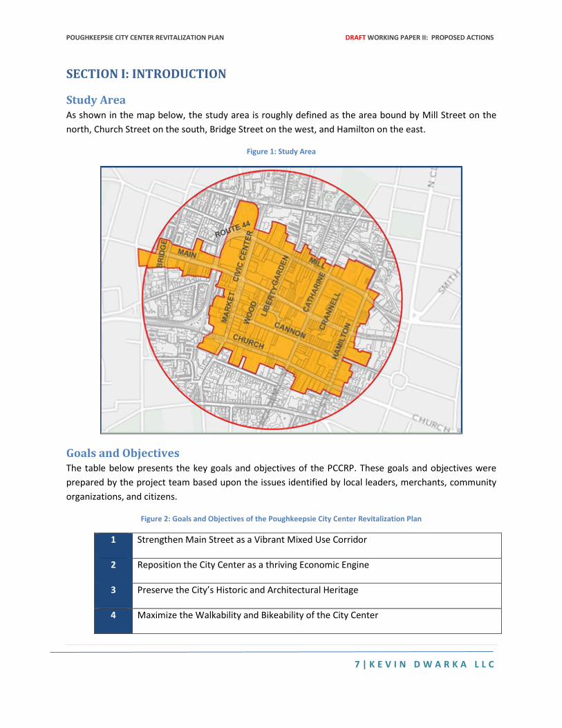
Study Area As shown in the map below, the study area is roughly defined as the area bound by Mill Street on the
north, Church Street on the south, Bridge Street on the west, and Hamilton on the east.
Figure 1: Study Area
Goals and Objectives The table below presents the key goals and objectives of the PCCRP. These goals and objectives were
prepared by the project team based upon the issues identified by local leaders, merchants, community
organizations, and citizens.
Figure 2: Goals and Objectives of the Poughkeepsie City Center Revitalization Plan
1 Strengthen Main Street as a Vibrant Mixed Use Corridor
2 Reposition the City Center as a thriving Economic Engine
3 Preserve the City’s Historic and Architectural Heritage
4 Maximize the Walkability and Bikeability of the City Center
POUGHKEEPSIE CITY CENTER REVITALIZATION PLAN DRAFT WORKING PAPER II: PROPOSED ACTIONS
8 | K E V I N D W A R K A L L C
5 Connect the Waterfront, the City Center, Middle Main, & Vassar
6 Minimize Traffic & Parking Impacts of New Development
7 Redress Crime and Public Safety Concerns
8 Coordinate Revitalization of the City Center with the Waterfront Redevelopment and Middle Main Initiatives
9 Offer a Network of Public Open Spaces and Streets that are Safe, Accessible, and Clean
The Case for Revitalizing the City Center West of the City Center is the Poughkeepsie Metro North Station. East of the City Center is the Middle
Main Area, a part of the city targeted for façade improvement and revitalization by the non-profit
organization, Hudson River Housing. While these areas west and east of the City Center have received
attention as redevelopment opportunity sites, a focused revitalization strategy for the center city has
not yet been undertaken. In this context, the Poughkeepsie City Center Revitalization Plan aims to fill in
the planning gap along Main Street, the city’s historic east west corridor that connects the various
districts within its downtown to each other as well as to the waterfront and the Metro North station.
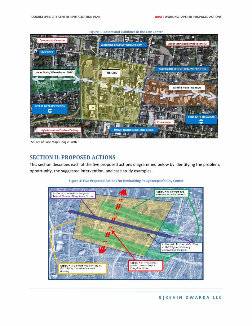
The diagram below presents in red some of the key issues in the City Center: commercial vacancies,
upper story residential vacancies, crime, and underutilized land uses devoted to surface parking. The
PCCRP is an opportunity to redress all of these issues.
Meanwhile, the diagram presents in blue some of the key assets in the City Center: proximity to a
regional rail hub, civic uses including courts and government offices, a walkable compact urban form,
some examples of successful redevelopment projects, proximity to Vassar College, and an intact historic
building district. These assets can be leveraged to create a Poughkeepsie City Center that is a vibrant
center for new development and that is seamlessly connected to the redevelopment of the waterfront
as well as the Middle Main Area.
One obvious barrier to revitalizing the City Center is market demand especially given the multiplicity of
development sites in the city. As of now, there are three key sources for measuring the demand for
residential, commercial, and retail real estate in Poughkeepsie: AECOM’s market study performed for
the TOD Waterfront Plan; HR&A’s peer review of the AECOM study; and the housing needs assessment
included in the city’s Consolidated Plan. However, none of these studies fully evaluates the potential for
Poughkeepsie to capture a growing regional market demand for transit-oriented development through
significant changes to its local transportation network. The demand for residential and commercial
space needs to be evaluated not simply on the basis of population and employment trends but in the
context of the impacts that public infrastructure investments have on land values and market capture.
POUGHKEEPSIE CITY CENTER REVITALIZATION PLAN DRAFT WORKING PAPER II: PROPOSED ACTIONS
9 | K E V I N D W A R K A L L C
Figure 3: Assets and Liabilities in the City Center
Source of Base Map: Google Earth
SECTION II: PROPOSED ACTIONS This section describes each of the five proposed actions diagrammed below by identifying the problem,
opportunity, the suggested intervention, and case study examples.
Figure 4: Five Proposed Actions for Revitalizing Poughkeepsie's City Center
POUGHKEEPSIE CITY CENTER REVITALIZATION PLAN DRAFT WORKING PAPER II: PROPOSED ACTIONS
10 | K E V I N D W A R K A L L C
Action #1: Reintroduce High Performance Transit Along Main Street
The Problem
Poughkeepsie is anchored by a Metro North and Amtrak rail station that provides excellent connectivity
to New York City as well as other key cities along the Hudson River. However, a passenger arriving at the
Poughkeepsie station is quickly confronted by the dismal state of the city’s local transit system. The
station is served by both city and county bus lines. However, the local transit system does not capture a
significant percentage of the total number of local trips within Poughkeepsie because of the poor
performance of the existing system. Specifically, the bifurcation of local service into county and city
service is confusing if not redundant especially with regard to connections to the City Center. Moreover,
there is not a frequent transit service that regularly provides rail passengers with connecting local
service along the length of Main Street. As such, travelers bound for the City Center or the Middle Main
Area or Vassar College are dependent on taxis or arranging a pick-up from an automobile driver.
Meanwhile, the City Center is characterized by underutilized land uses including vacant surface parking
lots and empty storefronts. The redevelopment potential of these parcels is impeded by the lack of a
high performing local transit service as well as the cordoning effects of the eastbound and westbound
arterials.
The Opportunity
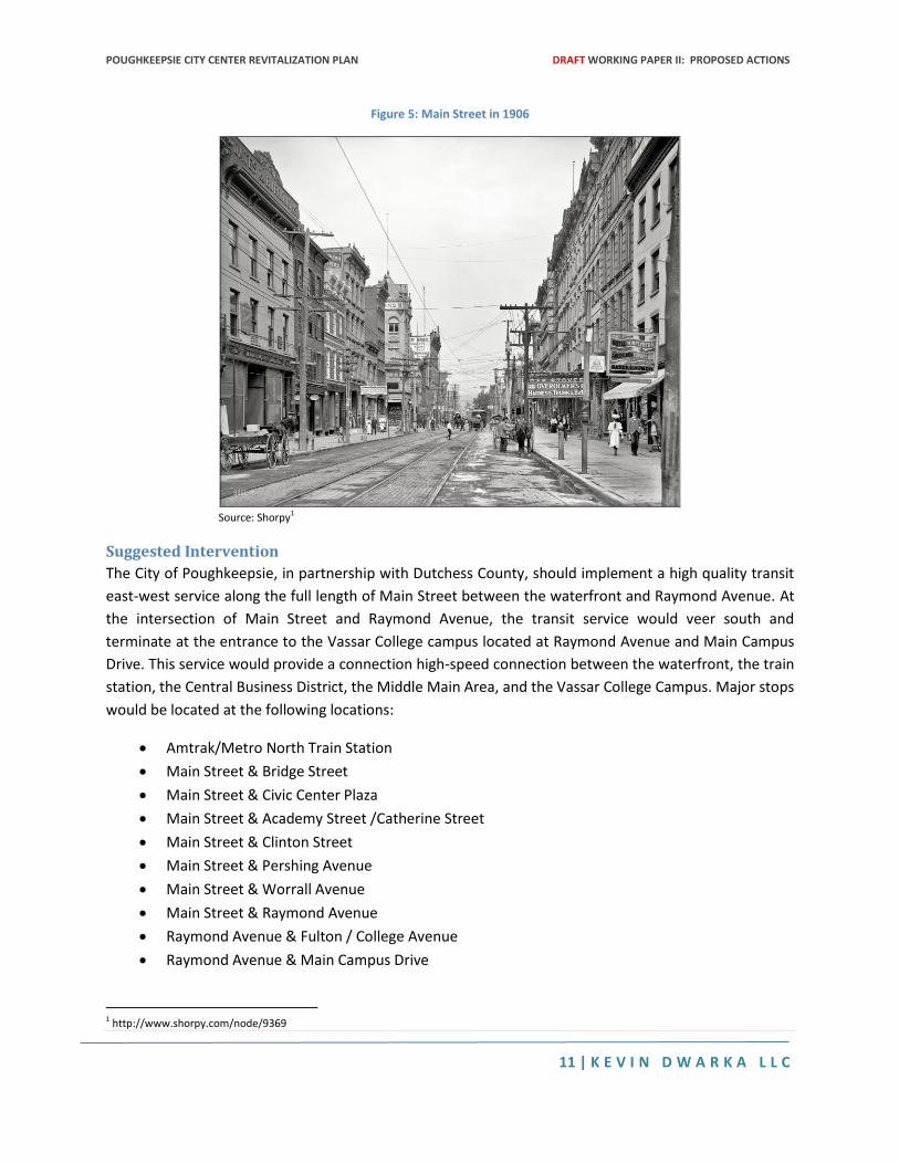
Up until 1935, as shown in Figure 1, Poughkeepsie was well-served by a streetcar line that connected
the rail station with points along Main Street. Although Main Street no longer is the bustling commercial
corridor that it was during its heyday, the enduring mix of land uses and the scale of the built form are
amenable to the reintroduction of a high quality transit service along the full length of Main Street.
Frequent transit service along Main Street would do more than provide a valuable alternative to
automobile access for both regional and local trips. It would also improve pedestrian flows along Main
Street and thereby assist property owners in securing stable tenants for retail, commercial, and
residential spaces. Transit would also open the possibility for the redevelopment of the surface parking
lots in the blocks north and south of the Main Corridor in a way that would minimize parking and traffic
impacts. With the installation of a frequent and reliable service along Main Street, the City of
Poughkeepsie would be better positioned to capture the growing market for transit-oriented
development.
POUGHKEEPSIE CITY CENTER REVITALIZATION PLAN DRAFT WORKING PAPER II: PROPOSED ACTIONS
11 | K E V I N D W A R K A L L C
Figure 5: Main Street in 1906
Source: Shorpy1
Suggested Intervention
The City of Poughkeepsie, in partnership with Dutchess County, should implement a high quality transit
east-west service along the full length of Main Street between the waterfront and Raymond Avenue. At
the intersection of Main Street and Raymond Avenue, the transit service would veer south and
terminate at the entrance to the Vassar College campus located at Raymond Avenue and Main Campus
Drive. This service would provide a connection high-speed connection between the waterfront, the train
station, the Central Business District, the Middle Main Area, and the Vassar College Campus. Major stops
would be located at the following locations:
Amtrak/Metro North Train Station
Main Street & Bridge Street
Main Street & Civic Center Plaza
Main Street & Academy Street /Catherine Street
Main Street & Clinton Street
Main Street & Pershing Avenue
Main Street & Worrall Avenue
Main Street & Raymond Avenue
Raymond Avenue & Fulton / College Avenue
Raymond Avenue & Main Campus Drive
1 http://www.shorpy.com/node/9369
POUGHKEEPSIE CITY CENTER REVITALIZATION PLAN DRAFT WORKING PAPER II: PROPOSED ACTIONS
12 | K E V I N D W A R K A L L C
Additional stops could be provided on the eastern segment of the route if demand warranted tighter
stop spacing. Similarly, an “express” service could be provided with a more limited number of stops in
order to provide a more rapid connection between the train station and the Vassar Campus.
A variety of technologies could be used in order to serve the transit route. Initially, the route could be
served with a shuttle. As passenger demand increased, however, the route could be changed to a bus
rapid transit service and eventually to a light rail system. Regardless of the technology, the service
should be at a minimum of 15 minute headways in order to ensure a reliability of service interlined with
the rail station schedule. Also, regardless of technology, the transit stops should be designed in concert
with an overall urban design concept for Main Street that results in definable station areas that become
key nodes stimulating transit-oriented development.
Case Studies
Kansas City (MO)
Opened in 2005, the Kansas City Main Street Max is a bus rapid transit line that runs along the city’s
Main Street and connects key points in its downtown with a stop at the Union Station served by Amtrak.
MAX is a branded service that uses specially designed buses to enhance the legibility of the service. The
line operates in dedicated lanes during rush hours.
Portland (OR)
Portland built a streetcar line in the formerly industrial Pearl District to encourage private development
and the area is now the city’s densest and most popular neighborhood. The result was 10,000 units of
housing, one quarter of which is affordable, and 4.6 million square feet of commercial space within two
blocks of the streetcar.2
San Diego (CA)
The Downtown San Diego Partnership, a group of business owners, initiated a transportation planning
process in 2011 to explore options for providing a new downtown shuttle service that would not only
link key destinations in the downtown but also connect with other downtown mass transit services
including a BRT line, trolley line, and the Port of San Diego’s Big Bay Shuttle. The Partnership, working in
concert with the City of San Diego, hopes to make the new shuttle service operational by 2015.3
Action #2: Transform Market Street into a Complete Street
The Problem
Market Street is currently a one-way north bound commercial street that serves the City Center and
intersects with the west-bound and east-bound arterials. In many ways the intersection of Market Street
and Main Street is the gateway into the heart of Main Street’s historic commercial strip. However,
2 http://www.epa.gov/smartgrowth/pdf/phoenix-sgia-case-studies.pdf 3 http://www.downtownsandiego.org/park/shuttle-service/; http://media.utsandiego.com/news/documents/2014/01/15/January_2014_JT_Item_5_-_Circulator_Shuttle.pdf
POUGHKEEPSIE CITY CENTER REVITALIZATION PLAN DRAFT WORKING PAPER II: PROPOSED ACTIONS
13 | K E V I N D W A R K A L L C
Market Street is also a Main Street in its own right. It serves numerous county offices, courts, City Hall,
the theater, the Civic Center, and the newly completed transit hub. Given this density and variety of
anchor destinations, Market Street should be designed to flourish as a vibrant multi-modal urban
corridor. Instead, Market Street serves as a vehicular through-way between two hazardous intersections
with arterials roads and offering limited appeal to pedestrians, bicyclists, and transit-riders.
Part of the problem is the one-way directionality that serves to prioritize the expedient flow of
northbound vehicles over all other modes of transportation. However, another key issue is the lack of
pedestrian priority at the intersections with the arterials. For example, a pedestrian on the west side of
Market Street attempting to reach the City Hall from Main Street will confront a pedestrian impasse at
the intersection of Market and the westbound arterial. Instead of being able to cross the arterial and
proceed to the entrance of City Hall, the pedestrian will need to loop around the entire intersection and
cross three streets through demand responsive signal crossings in order to finally reach the setback
entrance to City Hall.
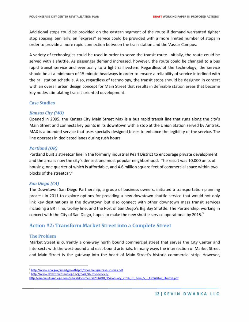
A related issue is the hazardous condition created by “the Mill Street Weave” in which the all three lanes
of the westbound arterial cross Market Street and then curves southward into a Columbus Drive. The
weave effect discourages the use of Market Street as a pedestrian connection to locations on Mill Street
that are west of Market Street, obfuscates the intersection of Columbus Drive and Mill Street, and
introduces dangerous lane crossing movements on southbound Columbus Drive.
Figure 6: The Mill Street Weave
Source: Google Earth
POUGHKEEPSIE CITY CENTER REVITALIZATION PLAN DRAFT WORKING PAPER II: PROPOSED ACTIONS
14 | K E V I N D W A R K A L L C
The Opportunity
The City has conducted an ongoing investigation into the possibility of converting Market Street to two
ways. This configuration would help improve vehicular circulation throughout the City Center and also
enhance pedestrian circulation by helping to reduce the speed of vehicles. Moreover, some preliminary
engineering and design studies have developed schemes for Market Street that would include
rearrangements of parking as well as reconfigurations of intersections in order to enable improved
pedestrian crossings. However, these preliminary schemes do not fully transform Market Street into a
multi-modal corridor. Given Market Street’s right of way, it is possible to design Market Street in a way
that would allocate even greater right of way to alternative transportation modes including better
landscaped sidewalks and dedicated bike lanes. Moreover, the intersections with the arterials could be
significantly redesigned in order to facilitate the introduction of complete streets concepts not only on
Market Street but also on the arterials themselves. Redesigning Market Street is also an opportunity to
not only enhance the performance of the street itself but also resolve the enduring hazards posed by
“the Mill Street weave”.
Suggested Intervention
The City of Poughkeepsie in partnership with New York State Department of Transportation should
redesign Market Street as a Complete Street in which all transportation users including pedestrians,
bicyclists, and transit riders are sufficiently accommodated. Designing Market Street as a “complete
street” requires more than the insertion of a median and pedestrian bulbouts. A true complete streets
approach will also install sufficient bike and transit infrastructure within the right of way, resolve the
hazardous intersections between Market Street and the arterials, and convert the intersection of
Columbus Drive and Mill Street into a T-intersection.
Case Studies
Lancaster (CA)
Lancaster implemented wider sidewalks, landscaping features, and traffic calming along Lancaster
Boulevard and the result was $125 million in private investment, 26% increase in sales tax revenue, and
800 new jobs. The city’s investment was just 10.6 million.4
Louisville (KY)
Louisville’s West Market Street was transformed into complete street as part of an economic
development plan for the downtown. There has been a significant resurgence in development including
a $261 million mixed-use development and a large sports/concert arena. The entire city of Louisville has
adopted a comprehensive complete streets policy and Louisville now has 3,047 miles of bike lanes.5
4 http://www.smartgrowthamerica.org/complete-streets/complete-streets-fundamentals/factsheets/economic-revitalization and http://www.cityoflancasterca.org/index.aspx?page=686 5 http://www.louisvilleky.gov/BikeLouisville/Complete+Streets/ and http://www.downtowndevelopmentcorp.org/Portals/83/Steve%20Trager%20Yum%20Center.pdf and http://www.bikecourier.org/bike-lanes-la-san-francisco-louisville/
POUGHKEEPSIE CITY CENTER REVITALIZATION PLAN DRAFT WORKING PAPER II: PROPOSED ACTIONS
15 | K E V I N D W A R K A L L C
New York City (NY)
New York City transformed portions of 8th and 9th Avenues with parking protected bike lanes and
pedestrian islands. As a result there was a 49% increase in retails sales and a 58% decrease in injuries to
all street users in this area.6
West Palm Beach (FL)
West Palm Beach’s Clematis Street was 70% vacant when the city converted the one-way road to two-
way and used a variety of measures to slow traffic. The project attracted $350 million in private
investment, property values more than doubled, and within 5 years more than 80% of space was
occupied.7
Lodi (CA)
Lodi, CA invested $4.5 million in a pedestrian-oriented project over 5 main downtown blocks by
widening sidewalks, extending curbs, and adding streetscaping amenities. Sixty new businesses came to
the area resulting in a 40% increase in sales tax revenue.8
Mission District, San Francisco (CA)
Valencia Street in San Francisco’s Mission District added bike lanes and slowed traffic. Forty percent of
local business reported increased sales and 60% increased shopping traffic.9
Action #3: Convert the Arterials into Boulevards
The Problem
One of the most significant barriers to City Center’s revitalization are the westbound and eastbound
arterials that result in continuing safety hazards, circulation interruption, and economic drainage.
Specifically, the arterials create a cordoning effect in which the City Center is cut off from surrounding
areas. The cordoning effect occurs for at least two reasons. First, the arterials are three lanes wide and
one-directional. As a result, vehicular traffic is encourage to travel fast especially during non-peak
periods. Secondly, the arterials are not sufficiently interrupted by signalized intersections to allow for
pedestrian crossings.
The Opportunity
Throughout the United States, cities are beginning to convert one-directional arterials into bi-directional
boulevards that facilitate the movement of pedestrians and bicyclists as well as automobiles. With the
conversion of Poughkeepsie’s arterials into boulevards, the City Center will become more accessible by
all modes of transportation from other parts of the city. Instead of the City Center being “walled in” by
the arterials, it will be easy for pedestrian and bicyclists to seamlessly enter and exit the City Center. The
conversion of the arterials into boulevard in tandem with the introduction of high-performing transit
6 http://www.nyc.gov/html/dot/downloads/pdf/2012-10-measuring-the-street.pdf 7 http://www.lgc.org/wordpress/docs/freepub/community_design/focus/walk_to_money.pdf 8 http://www.lgc.org/wordpress/docs/freepub/community_design/focus/walk_to_money.pdf 9 http://www.smartgrowthamerica.org/documents/cs/factsheets/cs-revitalize.pdf
POUGHKEEPSIE CITY CENTER REVITALIZATION PLAN DRAFT WORKING PAPER II: PROPOSED ACTIONS
16 | K E V I N D W A R K A L L C
service along Main Street will also allow for the redevelopment of the surface parking lots north and
south of Main Street.
Suggested Intervention
The City of Poughkeepsie in partnership with the New York State Department of Transportation should
convert both the westbound and eastbound arterials into pedestrian friendly boulevards. There are a
variety of ways in which a boulevard concept could be introduced including (1) the retention of the
existing number of travel lanes but the modification of the arterials’ intersections with north-south
streets (2) the retention of the existing number of travel lines but the conversion of one lane on each
arterial into a contra-flow lane and (3) the elimination of a travel lane on each arterial and its
replacement with either a median or a bike lane. The feasibility of these concepts as well as the
potential for combining them needs to be performed in the context of a comprehensive analysis of the
City Center circulation system in its totality. This analysis needs to evaluate not only the existing levels of
service for automobiles but also assess the performance of the bike, pedestrian, and transit network in
the current circulation system. The impacts of the various scenarios need to be analyzed not only in
accordance with traffic engineering concepts but also within the larger redevelopment plan and transit
plan for the City Center and its potential to capture a greater number of trips through alternative
transportation.
Case Studies
The highway construction boom in the mid-20th century left many cities with highly trafficked
expressways cutting through downtown neighborhoods, just like Poughkeepie’s arterials. Local
governments and state DOT’s are increasingly beginning the process of transforming these highways in
order to revitalize neighborhoods and enhance the circulation systems in dense urban areas.
San Francisco (CA)
San Francisco converted Central Expressway to Octavia Boulevard, a 4-lane boulevard featuring two
separated lanes for bicycle and pedestrian traffic, and as a result there was a neighborhood renaissance
in Hayes Valley. The elevated Central Expressway cut through several downtown neighborhoods. After
sustaining earthquake damage in 1989, the highway was converted into a tree-lined, pedestrian friendly
4-lane boulevard. The expressway, which had previously carried 90,000 vehicles per day, effectively
slowed traffic down and was found within 18 months to have a reduced total volume of car traffic and
no major disruptions to other roads. The newly created Octavia Street, finished in 2006, reconnected
neighborhoods and was the catalyst for a neighborhood renaissance in Hayes Valley. Revenue from land
sales allowed the city to create a new park.10
10http://www.seattle.gov/transportation/docs/ump/06%20SEATTLE%20Case%20studies%20in%20urban%20freeway%20removal.pdf ; http://anewdallas.com/research.html
POUGHKEEPSIE CITY CENTER REVITALIZATION PLAN DRAFT WORKING PAPER II: PROPOSED ACTIONS
17 | K E V I N D W A R K A L L C
San Francisco also converted the double-decker Embarcadero freeway to a landscaped boulevard and
pedestrian promenade. Property value of adjacent land shot up by more than 300% and former
warehouses south of Market Street were converted into apartments and condos. 11
San Diego (CA)
San Diego reduced La Jolla Boulevard from 4 lanes to 2, added bike lanes and sidewalks, and lowered
traffic speeds. The boulevard was transformed into a vibrant commercial center and sales increased by
20%.12
Santa Monica (CA)
Santa Monica added bicycles lanes and a right turn lane to Ocean Boulevard and saw a 65% decrease in
traffic accidents in the first 9 months after making the changes.13
Cleveland (OH)
Cleveland will begin construction in 2014 to convert the Shoreway freeway to a tree-lined boulevard
with bicycle and pedestrian lanes. In anticipation of the project, there has already been $500 million
private investment in new development around the boulevard.14
Milwaukee (WI)
Milwaukee was able to successfully convert Park East Freeway to a 6-lane boulevard and reconnect the
street grid. The elevated highway had cut off the northern area of downtown from the rest of the city.
After it was determined that it would be cheaper to convert the freeway rather than reconstruct it, Park
East was transformed into McKinley Avenue in 2004. Significant federal funds made the project feasible
($20 million of the total $25 million cost). Traffic on the corridor was decreased from approximately
54,000 to 18,600 vehicles per day. Twenty-six acres of land for private development was freed up and
has already created three new neighborhoods and five development projects worth a $340 million
investment.
New Haven (CT)
New Haven, CT is also in the process of converting State Road 34 into a pedestrian-friendly boulevard
called “Downtown Crossing.” Construction is scheduled to start in 2014 and open in 2016. The highway
was built through downtown to connect I-91 to another state road but the project was never
completed. An extensive study was conducted in 2007 to analyze traffic impacts for this important
commuting corridor, which connects two interstates (I-91 and I-95) to several large regional employers
(Yale-New Haven Hospital, Yale University, etc). The study found that while a boulevard would result in a
loss of traffic capacity, several long-term transportation strategies could manage and reduce demand
including traffic diversion to other corridors and public transit. The project will free up 10 acres of
development. Currently, a $360 million mixed-use development has been approved that will provide
11http://www.seattle.gov/transportation/docs/ump/06%20SEATTLE%20Case%20studies%20in%20urban%20freeway%20removal.pdf; http://anewdallas.com/research.html 12 http://www.smartgrowthamerica.org/documents/cs/resources/cs-in-california.pdf 13 http://www.smartgrowthamerica.org/documents/cs/resources/cs-in-california.pdf 14 http://www.newsnet5.com/news/local-news/cleveland-metro/plan-to-turn-clevelands-west-shoreway-into-boulevard-gets-funding
POUGHKEEPSIE CITY CENTER REVITALIZATION PLAN DRAFT WORKING PAPER II: PROPOSED ACTIONS
18 | K E V I N D W A R K A L L C
residential, retail, and office space as well as a hotel and public square. The boulevard will have a below-
grade access drive to bring vehicles to new development parcels.15
Syracuse (NY)
The NYSDOT is currently looking into the conversion of 1-81 in Syracuse. An elevated portion of the
highway, called the viaduct, currently cuts off a portion of downtown from the rest of the city. Despite a
recent revitalization in the rest of the city, this area has remained severely blighted. The viaduct will
reach the end of its functional life by 2017. As such, the state must reconstruct or convert the interstate.
An EIS was begun in August 2013 and in the fall, the DOT was actively soliciting public opinion on four
proposed alternatives: 1) reconstruct the viaduct to align with modern safety standards; 2) convert to a
below-grade highway; 3) convert to a tunnel; or 4) convert the viaduct to a boulevard and reconnect the
street grid. As of March 2014, no decision has been announced.
Pittsfield (MA)
Pittsfield, MA is in the process of redesigning the state road that passes through the center of the city.
Similar in size to Poughkeepsie, Pittsfield has undertaken a four-phase project to improve pedestrian
safety, improve and calm traffic circulation, and enhance the aesthetics of the road to improve
economic development.
Orlando (FL)
Edgwater Drive in Orlando was converted from 4 lanes to 2 lanes with the addition of bicycle lanes and
left turn lanes. The result was reduced speeding and accidents, increased pedestrian use, and a number
of new businesses.16
Norwalk, CT
Norwalk CT, population 87,000, is working to revitalize Wall Street as a central corridor of transit-
oriented, mixed-use development and civic attractions. Many buildings are vacant or underutilized.
There is a perceived lack of parking and low level of safety. The goal of the Greater Wall Street
Redevelopment Project, led by the city’s Redevelopment Agency, is to bring in more businesses and
offices for a mixed-use environment, reduce auto-oriented enterprises, expand the amount and variety
of housing, promote the historic character of the town and capitalize on the proximity to the river.
Norwalk’s plan for Wall Street also calls for increasing walking/biking, improving the Pulse Point transit
so that more people use it and implementing traffic calming measures.17 POKO Partners have proposed
a mixed-use development with 371 housing units, 42,481 square feet of retail space, 33,230 square feet
of live/work space and 1,040 parking spaces. 18 This development is expected to begin in 2014.19
The southern section of Norwalk near the Metro North station is also undergoing redevelopment. This
area is part of the 70 acre Reed Putnam Urban Renewal Area and is characterized by active industrial
15 http://nextcity.org/equityfactor/entry/new-haven-development-could-speed-up-highway-removal#disqus_thread 16 https://www.pps.org/reference/rightsizing-edgewater-drive-in-orlando-florida-for-safety-gains-and-to-promote-alternative-transportation/ 17 http://www.norwalkct.org/DocumentCenter/Home/View/558 18 http://www.pokopartners.com/articles/POKO-WSP_article-2.pdf 19 http://norwalk.dailyvoice.com/politics/norwalk-mayor-rilling-reflects-first-100-days-office
POUGHKEEPSIE CITY CENTER REVITALIZATION PLAN DRAFT WORKING PAPER II: PROPOSED ACTIONS
19 | K E V I N D W A R K A L L C
sites, surface parking lots and vacancies. West Avenue has had difficulty attracting retailers. Planned
improvements include the widening of West Avenue, wider sidewalks, moving utilities underground and
construction of a parking garage next to the newly built aquarium.20
Richmond, (VA)
The city of Richmond, population 210,000, is bounded on one side by Hull Street. The 4 mile stretch of
Hull Street that cuts through the city is characterized by high speeds, numerous building vacancies,
missing sidewalks, and a lack of transit options. The nearly 13,000 residents living along Hull Street walk
along the road at their own peril, often on dirt paths when there are no sidewalks.21 The city of
Richmond, Chesterfield County, and the Virginia Local Initiatives Support Corporation have created a
federally funded revitalization plan for the Hull Street Corridor. The plan calls for safer walking and
bicycling options, increased transit services, streetscaping, more housing options, and economic growth. 22
Action #4: Restore Main Street as the Region’s Primary Commercial Corridor
The Problem
There are three main issues along Main Street. First, there are several city-owned vacant properties that
are ripe for infill development. Second, there are a number of properties that are languishing in terms
of their physical condition, code compliance, as well tenancy. Vacant dilapidated buildings are especially
common along the stretch of Main Street between Academy and Hamilton. Lastly, there are a number
of buildings that are in good physical condition but nonetheless are underperforming with regard to
their upper story tenancy or long absorption times for their retail tenants.
Ongoing problems with street maintenance and crime in tandem with residual effects of the recession
have made it harder for property owners to secure commercial and residential tenants. The decline of
Poughkeepsie’s Main Street is not a new phenomenon or simply a product of the Great Recession. The
legacy of urban renewal including the construction of the arterials and incentives for suburban
development continues to siphon economic activity to exurban areas such as the Route 9 Corridor. Prior
efforts to compete with suburban areas through the construction of the ill-fated Main Mall only further
exasperated Main Street’s decline.
Beyond Main Street, there are a high number of vacancies scattered throughout the City of
Poughkeepsie. Remediating these scattered site properties require legal and regulatory interventions
that will facilitate the individual rehabilitation of distressed buildings, their redisposition to responsible
parties, and their restoration to the city’s tax rolls. The vacancies in the City Center, however, require a
more systemic approach. Whereas the scattered distressed sites are generally discontiguous, lower
density, and exclusively residential in nature, the distressed sites in the City Center are clustered, higher
density, and mixed use. As such, the impacts of vacancies along Main Street are more far-reaching
20 http://www.ct.gov/ecd/cwp/view.asp?a=3690&Q=433372&ecdNav 21 http://www.nelsonnygaard.com/Documents/Quals-Project-Profiles/NNproj-Richmond-Hull-Street-AWARD.pdf and http://www.chesterfieldobserver.com/news/2012-05-30/News/Citycounty_team_seeks_to_revitalize_Hull_Street_co.html 22 http://hullstreet360.com/
POUGHKEEPSIE CITY CENTER REVITALIZATION PLAN DRAFT WORKING PAPER II: PROPOSED ACTIONS
20 | K E V I N D W A R K A L L C
because they not only create concentrations of blight along Main Street itself but also have a downward
impact on the recovery potential for distressed parcels outside the City Center. A targeted set of
interventions aimed not at the scale of the parcel but at the entire length of Main Street from Bridge
Street to Hamilton will not only help to restore Main Street but also facilitate the reinvestment in
underperforming parcels throughout the City.
The Opportunity
Main Street retains a number of key economic assets including architecturally and historically significant
buildings, a walkable urban fabric, proximity to the train station, nearby government offices, the Civic
Center and several examples of successful redevelopment projects. Main Street continues to play a role
in connecting the waterfront with the train station, the central business district, the Middle Main Area,
and Vassar College. With the right package of infrastructure changes, public investments, and
partnerships with the private sector, Main Street can be re-established as the spine of Poughkeepsie’s
redevelopment.
Suggested Intervention
The City of Poughkeepsie should restore Main Street as the region’s primary commercial corridor
especially within the segment between Bridge and Hamilton Streets. In order to eliminate vacancies,
shorten absorption times, and maximize street traffic, the City must undertake four key interventions.
First, in accordance with Action #1, a high-performing transit system should be introduced along Main
Street. Second, the City must enhance the overall visual image of Main Street through a comprehensive
streetscaping initiative that goes beyond incremental façade improvements and improves the street’s
lighting, pavement, curbs, landscaping, transit infrastructure, and bike infrastructure. Third, the City
needs to prioritize the rehabilitation of distressed buildings and promotion of infill development through
the introduction of a new redevelopment entity such as a land bank or a community development
corporation.
Case Studies
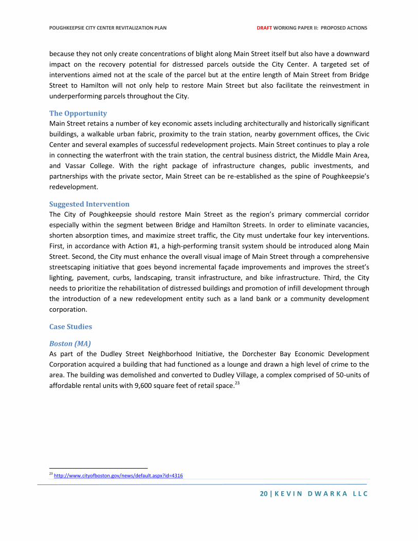
Boston (MA)
As part of the Dudley Street Neighborhood Initiative, the Dorchester Bay Economic Development
Corporation acquired a building that had functioned as a lounge and drawn a high level of crime to the
area. The building was demolished and converted to Dudley Village, a complex comprised of 50-units of
affordable rental units with 9,600 square feet of retail space.23
23 http://www.cityofboston.gov/news/default.aspx?id=4316
POUGHKEEPSIE CITY CENTER REVITALIZATION PLAN DRAFT WORKING PAPER II: PROPOSED ACTIONS
21 | K E V I N D W A R K A L L C
Figure 7: Dudley Village Under Construction in 2008
Source: City of Boston24
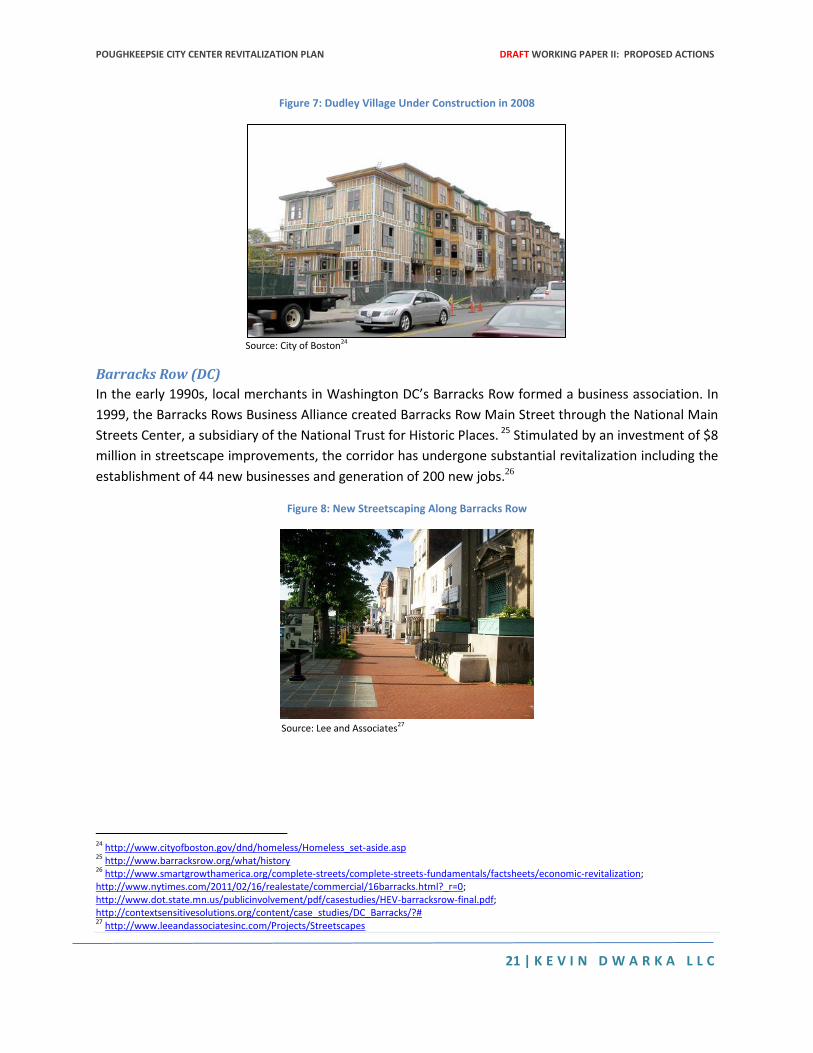
Barracks Row (DC)
In the early 1990s, local merchants in Washington DC’s Barracks Row formed a business association. In
1999, the Barracks Rows Business Alliance created Barracks Row Main Street through the National Main
Streets Center, a subsidiary of the National Trust for Historic Places. 25 Stimulated by an investment of $8
million in streetscape improvements, the corridor has undergone substantial revitalization including the
establishment of 44 new businesses and generation of 200 new jobs.26
Figure 8: New Streetscaping Along Barracks Row
Source: Lee and Associates27
24 http://www.cityofboston.gov/dnd/homeless/Homeless_set-aside.asp 25 http://www.barracksrow.org/what/history 26 http://www.smartgrowthamerica.org/complete-streets/complete-streets-fundamentals/factsheets/economic-revitalization; http://www.nytimes.com/2011/02/16/realestate/commercial/16barracks.html?_r=0; http://www.dot.state.mn.us/publicinvolvement/pdf/casestudies/HEV-barracksrow-final.pdf; http://contextsensitivesolutions.org/content/case_studies/DC_Barracks/?# 27 http://www.leeandassociatesinc.com/Projects/Streetscapes
POUGHKEEPSIE CITY CENTER REVITALIZATION PLAN DRAFT WORKING PAPER II: PROPOSED ACTIONS
22 | K E V I N D W A R K A L L C
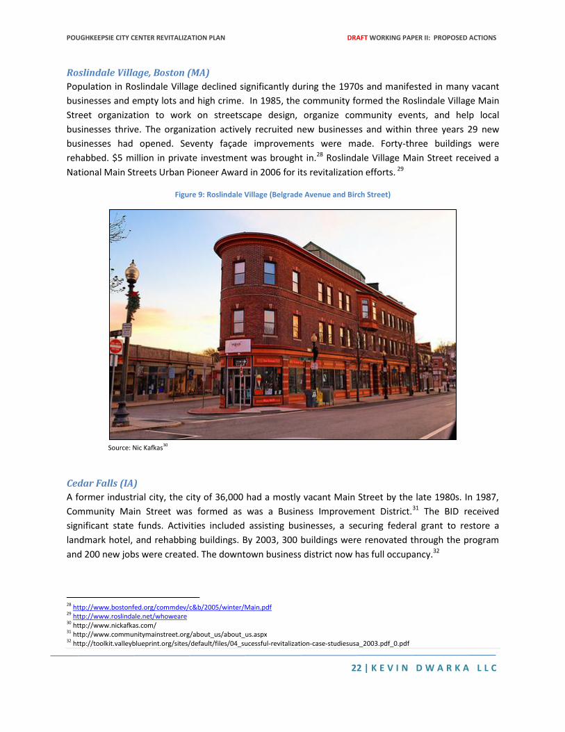
Roslindale Village, Boston (MA)
Population in Roslindale Village declined significantly during the 1970s and manifested in many vacant
businesses and empty lots and high crime. In 1985, the community formed the Roslindale Village Main
Street organization to work on streetscape design, organize community events, and help local
businesses thrive. The organization actively recruited new businesses and within three years 29 new
businesses had opened. Seventy façade improvements were made. Forty-three buildings were
rehabbed. $5 million in private investment was brought in.28 Roslindale Village Main Street received a
National Main Streets Urban Pioneer Award in 2006 for its revitalization efforts. 29
Figure 9: Roslindale Village (Belgrade Avenue and Birch Street)
Source: Nic Kafkas30
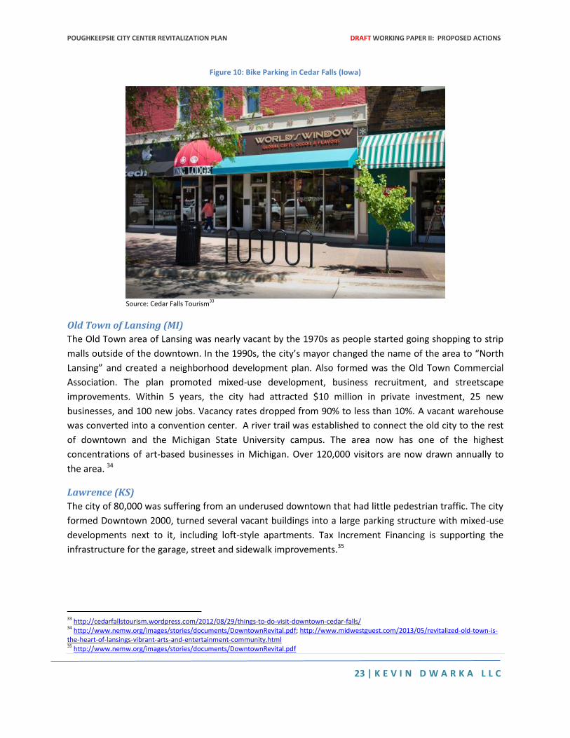
Cedar Falls (IA)
A former industrial city, the city of 36,000 had a mostly vacant Main Street by the late 1980s. In 1987,
Community Main Street was formed as was a Business Improvement District.31 The BID received
significant state funds. Activities included assisting businesses, a securing federal grant to restore a
landmark hotel, and rehabbing buildings. By 2003, 300 buildings were renovated through the program
and 200 new jobs were created. The downtown business district now has full occupancy.32
28 http://www.bostonfed.org/commdev/c&b/2005/winter/Main.pdf 29 http://www.roslindale.net/whoweare 30 http://www.nickafkas.com/ 31 http://www.communitymainstreet.org/about_us/about_us.aspx 32 http://toolkit.valleyblueprint.org/sites/default/files/04_sucessful-revitalization-case-studiesusa_2003.pdf_0.pdf
POUGHKEEPSIE CITY CENTER REVITALIZATION PLAN DRAFT WORKING PAPER II: PROPOSED ACTIONS
23 | K E V I N D W A R K A L L C
Figure 10: Bike Parking in Cedar Falls (Iowa)
Source: Cedar Falls Tourism33
Old Town of Lansing (MI)
The Old Town area of Lansing was nearly vacant by the 1970s as people started going shopping to strip
malls outside of the downtown. In the 1990s, the city’s mayor changed the name of the area to “North
Lansing” and created a neighborhood development plan. Also formed was the Old Town Commercial
Association. The plan promoted mixed-use development, business recruitment, and streetscape
improvements. Within 5 years, the city had attracted $10 million in private investment, 25 new
businesses, and 100 new jobs. Vacancy rates dropped from 90% to less than 10%. A vacant warehouse
was converted into a convention center. A river trail was established to connect the old city to the rest
of downtown and the Michigan State University campus. The area now has one of the highest
concentrations of art-based businesses in Michigan. Over 120,000 visitors are now drawn annually to
the area. 34
Lawrence (KS)
The city of 80,000 was suffering from an underused downtown that had little pedestrian traffic. The city
formed Downtown 2000, turned several vacant buildings into a large parking structure with mixed-use
developments next to it, including loft-style apartments. Tax Increment Financing is supporting the
infrastructure for the garage, street and sidewalk improvements.35
33 http://cedarfallstourism.wordpress.com/2012/08/29/things-to-do-visit-downtown-cedar-falls/ 34 http://www.nemw.org/images/stories/documents/DowntownRevital.pdf; http://www.midwestguest.com/2013/05/revitalized-old-town-is-the-heart-of-lansings-vibrant-arts-and-entertainment-community.html 35 http://www.nemw.org/images/stories/documents/DowntownRevital.pdf
POUGHKEEPSIE CITY CENTER REVITALIZATION PLAN DRAFT WORKING PAPER II: PROPOSED ACTIONS
24 | K E V I N D W A R K A L L C
Littleton (NH)
Littletown is a small town of 6,000 persons that suffered when manufacturing companies left in the mid-
20th century. By 1992, 17 storefronts on Main Street were vacant. In 1997, the Littleton Main Street
organization was formed and began raising funds including matching grants for façade improvements.
They also tried to attract new businesses and give them support. Vacancy rate has been as low as 2%
and now there is only 1 vacant storefront on Main Street. In 2000, a Wal-Mart opened up nearby and
they worked to create high-end or niche stores that wouldn’t be directly in competition with Wal-Mart.
In 2003, the town won the Great American Main Street award. The town also initiated the Ammonoosuc
Green Neighborhood Revitalization Project which culminated in 3 new multi-family buildings with 17
low-income units, completed in 2001 (just off of Main Street). The project consisted of acquiring
blighted and unsafe buildings, some of which needed to be demolished. In 2004, Littleton received funds
from the New Hampshire Department of Transportation to make the road (a state highway) more
pedestrian oriented. They implemented traffic calming measures, a median, crosswalk bump-outs, and
improved signage. Also added was diagonal parking to increase bike safety.
Louisville (KY)
Louisville’s West Market Street was transformed into complete street as part of an economic
development plan for the downtown. There has been a significant resurgence in development including
a $261 million mixed-use development and a large sports/concert arena. The entire city of Louisville has
adopted a comprehensive complete streets policy and Louisville now has 3,047 miles of bike lanes.36
Action #5: Convert Vacant Lots into Transit-Oriented Housing
The Problem
Both north and south of Main Street, there are large expanses of surface parking as shaded yellow in the
figure below. Some of these sites are highly utilized during the day but are devoid of any productive use
during the evening. Although these sites do provide essential parking for the working population
commuting into Poughkeepsie from areas without transit service (especially from communities on the
west side of the Hudson River), there are at least two negative effects of this agglomeration of surface
parking within the heart of the city’s core.
First, the parking areas fail to generate a significant economic value since they only generate limited
revenue from parking fares and do not generate either private profits or municipal revenue. Second, the
high amount of surface parking undermines the walkability and safety of the City Center by creating
large desolate areas without consistent street traffic especially during the evening.
Figure 11: Surface Parking in the City Center
36 http://www.louisvilleky.gov/BikeLouisville/Complete+Streets/;
http://www.downtowndevelopmentcorp.org/Portals/83/Steve%20Trager%20Yum%20Center.pdf; http://www.bikecourier.org/bike-lanes-la-
san-francisco-louisville/
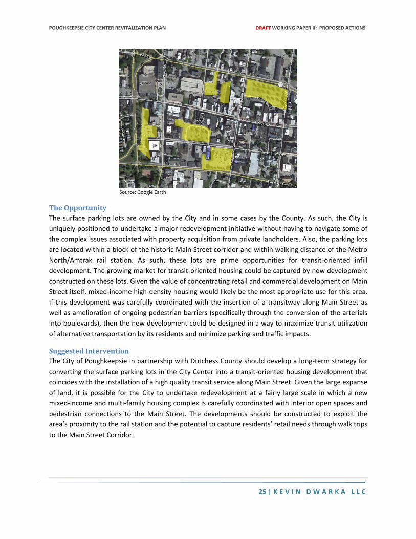
POUGHKEEPSIE CITY CENTER REVITALIZATION PLAN DRAFT WORKING PAPER II: PROPOSED ACTIONS
25 | K E V I N D W A R K A L L C
Source: Google Earth
The Opportunity
The surface parking lots are owned by the City and in some cases by the County. As such, the City is
uniquely positioned to undertake a major redevelopment initiative without having to navigate some of
the complex issues associated with property acquisition from private landholders. Also, the parking lots
are located within a block of the historic Main Street corridor and within walking distance of the Metro
North/Amtrak rail station. As such, these lots are prime opportunities for transit-oriented infill
development. The growing market for transit-oriented housing could be captured by new development
constructed on these lots. Given the value of concentrating retail and commercial development on Main
Street itself, mixed-income high-density housing would likely be the most appropriate use for this area.
If this development was carefully coordinated with the insertion of a transitway along Main Street as
well as amelioration of ongoing pedestrian barriers (specifically through the conversion of the arterials
into boulevards), then the new development could be designed in a way to maximize transit utilization
of alternative transportation by its residents and minimize parking and traffic impacts.
Suggested Intervention
The City of Poughkeepsie in partnership with Dutchess County should develop a long-term strategy for
converting the surface parking lots in the City Center into a transit-oriented housing development that
coincides with the installation of a high quality transit service along Main Street. Given the large expanse
of land, it is possible for the City to undertake redevelopment at a fairly large scale in which a new
mixed-income and multi-family housing complex is carefully coordinated with interior open spaces and
pedestrian connections to the Main Street. The developments should be constructed to exploit the
area’s proximity to the rail station and the potential to capture residents’ retail needs through walk trips
to the Main Street Corridor.
POUGHKEEPSIE CITY CENTER REVITALIZATION PLAN DRAFT WORKING PAPER II: PROPOSED ACTIONS
26 | K E V I N D W A R K A L L C
Case Studies
Palatine (IL)
Palatine, IL is a village (population 69,000) twenty-seven miles northwest of Chicago. In the 1990s, the
town embarked on a plan to revitalize the mostly vacant downtown area. A key part of the town’s plan
was to develop numerous surface parking lots in the city center, much of which was owned by the
Metra, Chicago’s commuter rail line. In exchange for the land, the town agreed to build a mixed-use
parking deck to replace the lost spaces for the rail line. The parking deck development has 100,000
square feet of office space, 33,000 square feet of retail, a restaurant, 240 condos and 40 row houses.
Fourteen other projects were built between 2000 and 2005, featuring city-style row houses, condos,
luxury homes and mixed-use buildings. By 2005, the town had developed 1,000 units of new housing
and 200,000 square feet of office and retail space mostly built on former surface parking lots.
Streetscaping features such as connected pathways, landscaping, and benches were put in place to
make the downtown more pedestrian friendly. In total, the village invested $40 million in funds
generated from Tax Increment Financing and just $5 million in non-village public funds. The result was
private investment totaling $240 million and a 32% increase in the tax base. Palatine’s downtown is now
a residential and commercial center with a walkable downtown and easy access to the commuter rail
line.37
Birmingham (MI)
Birmingham, MI is a town (population 20,000) 20 miles north of Detroit. In 1996, the town created a 20-
year master plan to develop and revitalize the downtown area. The plan was based on market research,
traffic studies, and residential preference surveys. The plan called for traffic calming measures,
streetscape improvements, and infill development of surface parking lots. In order to convert these
privately owned lots, the town created an overlaying zoning district that allowed developers to build up
to five times higher as long as they complied with various TOD friendly concepts (like building up to the
street line and placing parking behind the structure or underground).38
The incentives worked. Two former parking lots on Willets Street are now a luxury condo development
with ground floor restaurants, including a pedestrian loop on this formerly unwalkable block. Several
other former parking lots or vacant lots on Woodward Avenue (the main corridor) are now 4 and 5 story
mixed-use developments with ground floor retail. The 2016 plan emphasized pedestrian friendly street
design to create an urban experience.39 By 2009, 30 mixed-use developments were under construction
within the downtown.40 The town was voted one of the most walkable downtowns in America.41
37 Barry, Patrick and Ed Finkel. "So Very Different? Maybe Not: Development Success in Suburban Palatine Holds Lessons for Chicago's Grand
Boulevard" Urban Land Institute, 2005. 38 http://www.gibbsplanning.com/uploads/Birmingham_-_Michigan_s_First_Form-based_Code.pdf 39 http://www.a2gov.org/a2d2/designguidelines/Documents/Seminar3Birmingham.pdf 40 http://www.gibbsplanning.com/uploads/Birmingham_-_Michigan_s_First_Form-based_Code.pdf 41 http://www.gibbsplanning.com/uploads/Birmingham_-_Michigan_s_First_Form-based_Code.pdf
POUGHKEEPSIE CITY CENTER REVITALIZATION PLAN DRAFT WORKING PAPER II: PROPOSED ACTIONS
27 | K E V I N D W A R K A L L C
Yonkers (NY)
Yonkers (population 200,000) is in the process of an extensive downtown economic revitalization
project including development along the waterfront and infill development within the downtown area.
A key feature of the redevelopment is the waterfront land adjacent to the Metro North train station.
The Hudson Park development immediately adjacent to the train station has 780 residential units, office
and retail space, and public space.42 Palisades Point is planned for two vacant city-owned waterfront
parcels featuring two 25-story residential buildings with a public open space.43 The former Glenwood
Power Plant, located on 4 acres of waterfront property, is in the process of being redeveloped into a
public convention/exhibition space.44
Yonkers reduced parking requirements to 1 space per residential unit for all developments within ¼ mile
of the train station to encourage higher-density development.45 The Larkin Tower is a planned 24-story
residential/retail tower located 1 block from the Metro North train station. Station Plaza is a 6-story
office building located next to the train station.46
Other renovations and infill developments are in the planning process in downtown Yonkers. A former
19th century music hall, Teutonia Hall, is being redeveloped into a 24-story residential tower featuring a
Hyatt hotel, 360 residential units and 360 space parking garage.47 The River Park Center project is
planned for a former parking lot next to Getty Square. This development will become a 10-acre 11-story
indoor shopping mall with a triple AAA baseball stadium on the roof and two 29-story residential
buildings.48
New Rochelle (NY)
With a population of about 73,000 persons, New Rochelle hit hard economic times in 80s and 90s when
major retailers left for more suburban neighborhoods. New Rochelle has one of the busiest Metro North
stations in Westchester. The city’s 2011 sustainability plan committed to TOD principles including 95%
of new housing to be built within walking distance of mass transit and 65% within a half mile of the New
Rochelle Transit Center. The plan also sought to increase the walkability of the city and greatly increase
the number of bike lanes. New Rochelle has attracted considerable new development within the last 20
years. New Roc City, an entertainment complex, was built on a former vacant mall site and opened in
1999. The project includes a large parking garage shared with the residential Trump building next to it.49
More recently, the city completed a TOD Smart Growth study that investigated potential development
sites including vacant parcels, both city and privately owned, within downtown New Rochelle. It calls for
increased density in these areas and improvements to the streetscapes. The study also advocates for a
42http://lawweb.pace.edu/landuse/todline/TOD_Developments_Hudson_Park_Winter_2013.pdf 43 http://www.yonkers-csd.org/developmentsinyonkers.html 44 http://www.nytimes.com/2012/08/12/realestate/westchester-in-the-region-restored-river-a-boon-to-yonkers.html?_r=0 45 http://ecode360.com/15115941 46 http://www.blueprintforwestchester.com/wp-content/uploads/2013/08/Yonkers-City-Showcase.pdf 47 http://www.blueprintforwestchester.com/wp-content/uploads/2013/08/Yonkers-City-Showcase.pdf 48 http://www.yonkers-csd.org/developmentsinyonkers.html 49 http://lawweb.pace.edu/landuse/todline/New_Rochelle_article_TOD_Line_Winter_2013.pdf
POUGHKEEPSIE CITY CENTER REVITALIZATION PLAN DRAFT WORKING PAPER II: PROPOSED ACTIONS
28 | K E V I N D W A R K A L L C
reduction in parking (and shared parking) in the redevelopment area since much of it is located within a
¼ mile of the train station.50
Ossining (NY)
The village (population 25,000) is currently in the process of redeveloping their waterfront and Main
Street. Four new developments are underway on the waterfront. The redevelopment will include 400
new rental units including affordable housing. So far, three development projects were given approval.
A fourth waterfront development, Harbor Square, will feature a waterfront park and restaurant.51 The
city also sold a long vacant parcel of land on Main Street to a private developer who will build a 5-story
mixed-use development containing 31 apartments, retail space and restaurant space all within walking
distance to the train station. 52
Ossining is currently exploring the possibility of redeveloping 3 empty surface parking lots (1.5 acres) at
Main and Spring Streets and Market Square. The project would result in the displacement of 50 parking
spots. The proposal included mixed-use buildings and a public plaza. The consultants on the project also
proposed a Business Improvement District to ensure revenue generated from public parking went to
enhancing the downtown area.53
Hanover Park (IL)
Hanover Park is a town (population 38,000) 30 miles northwest of Chicago and features a Metra West
train station. In 2012, the town adopted a TOD Development plan for the area surrounding the train
station. The plan included infill development of surface parking lots and other undeveloped property.
The Metra station is surrounded by 8 surface parking lots. The plan calls for a structured parking facility
to be built next to the train and development of the other surface lots. The TOD plan also encouraged
mixed-use development of 6-10 stories in proximity to the train station.54 Hanover Park estimates that
the Village Center TOD could bring in annual sales tax revenue increase of $1.5 million and could
increase property values by over $1 billion. In January 2014, the town issued an RFP for a 9.8-acre
parking lot within walking distance of the train station and local bus service.55 A key part of the TOD
plan includes converting the Elgin O’Hare Expressway extension into a boulevard. This would free up 125
acres of land for development and would increase connectivity in the town center.56
LaGrange (IL)
Lagrange is a village (population 15,000) 13 miles west of Chicago with a Metra West train station. After
economic decline in the 1970s and 80s, the Village board created a Tax Increment Financing District in
1986 to fund revitalization and streetscaping efforts. The town added new sidewalks, landscaping, and
street furnishings. TIF funds allowed the town to build a structured parking facility and replace a former
50 http://www.sustainablenyct.org/docs/New%20Rochelle%20FinalReport1.8.14.pdf 51 http://www.rew-online.com/2014/01/09/new-development-ossining-waterfront-the-pearl-in-edgewater-nj/ 52 http://ossining.patch.com/groups/village-of-ossinings-blog/p/new-residential-developments-revitalize-historic-village-of-ossining 53 http://ossining.patch.com/groups/village-of-ossinings-blog/p/village-of-ossining-explores-possibilities-for-creative-redevelopment-of-
market-square 54 http://www.rtams.org/reportLibrary/1771.pdf 55 http://www.hanoverparkillinois.org/docs/Hanover-Square-RFP-2014.aspx 56 http://www.rtams.org/reportLibrary/1771.pdf
POUGHKEEPSIE CITY CENTER REVITALIZATION PLAN DRAFT WORKING PAPER II: PROPOSED ACTIONS
29 | K E V I N D W A R K A L L C
surface lot with a public plaza.57 The town’s comprehensive plan encourages higher-density housing and
mixed-use developments near the train station.58
A former brownfield site next to the train station was converted into La Grange Crossing, a 67,767
square foot retail facility with 78 condos and underground parking.59
Improvements in the downtown brought in private investment. The Kensington Station development
features 23 town houses. The La Grant Pointe development, built on a former IHOP and surface parking
lot, has 30 housing units and ground floor retail.60 LaGrange was voted “best downtown” in 2009 by
Chicago Magazine and the top transit suburb by Chaddick Institute in 2012.61
Tarrytown (NY)
Tarrytown’s waterfront has a new mixed-use development called Hudson Harbor, just north of the
Tappan Zee Bridge and within walking distance to the train station. The 28-acre development has 238
townhouses and condos and a ground floor River Market with retail and restaurants.62 Tarrytown is also
in the process of cleaning up the site of former manufactured gas plant on the waterfront. This property
will be converted into a $100 million development featuring residential and commercial buildings, a
riverwalk, ferry terminal and town facilities.63
Bronx (NY)
The Bronx has been able to successfully convert city owned parking lots into housing for low to middle
income residents as well as housing for seniors. These mixed-use developments have provided
thousands of square feet of new retail, commercial, and office space throughout the borough. The
Soundview Family Housing project will be built on two former parking lots in the Soundview
neighborhood of the South Bronx. This multi-building development will feature 120 units of family
housing, 86 units of senior housing and 16 two-family townhouses. All units will be affordable. The
development will also connect Bronx River Avenue, a previously unfinished road that will ease
connectivity to the neighborhood.64
In 2013, a new energy efficient housing complex opened on a vacant site owned by New York City
Housing Authority. The project, called “The Arbor House”, offers 124 units of housing to households
earning 60% of Annual Median Income.65
57 http://www.villageoflagrange.com/DocumentCenter/View/994 58 http://www.cnt.org/repository/PavedOver-Final.pdf 59 http://www.villageoflagrange.com/DocumentCenter/View/994 60 http://everythinglagrange.typepad.com/the_daily/2007/04/parking_ends_on.html 61 http://www.villageoflagrange.com/DocumentCenter/View/994 62 http://tarrytown.patch.com/groups/real-estate/p/hudson-harbor-halfway-done-no-slump-here 63 http://www.haleyaldrich.com/nodes/40.aspx?path=/capabilities/site_reuse/tarrytown/ 64 http://www.maparchitects.com/portfolio/soundview/; http://www.rew-online.com/2013/12/04/parking-lot-conversion-underway-in-south-bronx/ 65 http://observer.com/2013/02/an-arbor-in-the-forest-green-affordable-housing-development-opens-in-the-bronx/; http://observer.com/2013/02/an-arbor-in-the-forest-green-affordable-housing-development-opens-in-the-bronx/
POUGHKEEPSIE CITY CENTER REVITALIZATION PLAN DRAFT WORKING PAPER II: PROPOSED ACTIONS
30 | K E V I N D W A R K A L L C
The Rev. Ruben Diaz Gardens apartments were built on the site of a former parking lot and two fire-
damaged structures in the Hunts Point area. The project features 111 apartments; 20,000 square feet of
ground floor retail space; 27,000 square feet of office space; and 53 underground parking spots.66
The Bronxchester development is being built on 5 tax lots owned by city (vacant and surface parking) in
the Melrose neighborhood. La Central will feature 985 units of mixed-income housing, new retail,
community and recreation spaces including a new YMCA. The project is expected to break ground in
2015.67
Oakland (CA)
Oakland’s Fruitvale neighborhood is located just outside of San Francisco and within the BART (Bay Area
Rapid Transit) network. When BART wanted to build a parking garage between the Fruitvale station and
neighborhood commercial center, the community objected, believing it would hurt the already
distressed neighborhood. Instead, a Community Development Corporation worked with federal and
local partners to assemble and develop several vacant parcels near the station. This large mixed-use
transit village features retail, office space, residential units and public facilities such as a senior center
and library. Parking requirements were reduced to reduce developer costs. The station is now a
pedestrian corridor, connecting transit to the commercial hub of the neighborhood.68
Rockville (MD)
In 2007, Rockville (population 63,000) opened the Rockville Town Center, a 12.5 acre development built
on the vacant site of a former shopping mall. The development has retail, restaurant and community
facilities on the ground floors and condos and apartments located on the top floors. A 28,000 square
foot public plaza in the center serves as a focal point and gathering place for special events. The
development has structured parking, enhanced transportation and high walkability. Despite opening
during the recession, residential occupancy remains high and there have never been lingering retail
vacancies. Rockville Town Center is adjacent to the Rockville Metro Plaza. The development won a 2008
Charter award from the Congress of New Urbanism.69
66 http://www.nysenate.gov/news/affordable-housing-named-state-senator 67 http://www1.nyc.gov/office-of-the-mayor/news/428-13/mayor-bloomberg-city-will-reach-160-000-units-affordable-housing-financed-under-new/#/0; http://www.nydailynews.com/new-york/bronx/affordable-housing-la-central-importance-bronx-project-article-1.1559155 68 http://www.epa.gov/smartgrowth/pdf/phoenix-sgia-case-studies.pdf 69 http://www.terrain.org/unsprawl/27/
W O R K I N G P A P E R # 3 : I M P L E M E N T A T I O N S T R A T E G Y
POUGHKEEPSIE CITY CENTER REVITALIZATION PLAN
March 31st, 2014
D R A F T
POUGHKEEPSIE CITY CENTER REVITALIZATION PLAN DRAFT WORKING PAPER III: IMPLEMENTATION STRATEGY
2 | K E V I N D W A R K A L L C
Table of Contents INTRODUCTION ............................................................................................................................................. 5
Section I: Proposed Actions .......................................................................................................................... 5
Action #1: Introduce Frequent Transit Service Along Main Street ....................................................... 5
Action #2: Transform Market Street into a Complete Street ............................................................... 6
Action #3: Convert the Arterials into Boulevards ................................................................................. 6
Action #4: Restore Main Street as the Region’s Primary Commercial Corridor ................................... 6
Action #5: Convert Surface Parking Lots into Transit-Oriented Housing .............................................. 7
SECTION II: PHASING AND COORDINATION .................................................................................................. 7
SECTION III: ACTION PLAN ............................................................................................................................ 8
Action #1: Introduce High Performance Transit Along Main Street ......................................................... 8
Resolve City and County Management of Current Bus Service ............................................................ 8
Form Main Street Transit Advisory Committee .................................................................................... 9
Conduct Transit Feasibility Study .......................................................................................................... 9
Commence and Evaluate Pilot Program ............................................................................................... 9
Select Permanent Transit Solution ....................................................................................................... 9
Action #2: Transform Market Street into a Complete Street ................................................................... 9
Form Complete Streets Advisory Committee ....................................................................................... 9
Commence Demonstration Program .................................................................................................. 10
Study Downtown Circulation .............................................................................................................. 10
Develop Streets Design Manual .......................................................................................................... 10
Design and Engineer Market Street .................................................................................................... 10
Action #3: Convert the Arterials into Boulevards ................................................................................... 11
Form Complete Streets Advisory Committee ..................................................................................... 11
Analyze Existing Condition of Arterials ............................................................................................... 11
Study Downtown Circulation .............................................................................................................. 11
Design, Engineer, and Reconstruct the Arterials ................................................................................ 11
Action #4: Restore Main Street as the Region’s Primary Commercial Corridor ..................................... 11
Form Main Street Merchants Association .......................................................................................... 11
Secure Main Street Designation ......................................................................................................... 11
Create Redevelopment Authority ....................................................................................................... 12
POUGHKEEPSIE CITY CENTER REVITALIZATION PLAN DRAFT WORKING PAPER III: IMPLEMENTATION STRATEGY
3 | K E V I N D W A R K A L L C
Action #5: Convert Vacant Lots into Transit-Oriented Housing .............................................................. 12
Establish TOD Land Use and Design Guidelines for City Center ......................................................... 12
Study Downtown Circulation .............................................................................................................. 12
Create Redevelopment Authority ....................................................................................................... 12
SECTION IV: IMPLEMENTATION ENTITIES ................................................................................................... 12
Business Improvement District ........................................................................................................... 13
Anchor Partnership ............................................................................................................................. 13
Community Development Corporation .............................................................................................. 13
Housing Development Fund Corporation ........................................................................................... 14
Community Development Entity ........................................................................................................ 14
Land Bank ............................................................................................................................................ 14
Community Land Trust ............................................................................................................................ 15
Urban Renewal Agency ........................................................................................................................... 15
Industrial Development Agency .............................................................................................................. 15
Local Development Corporation ......................................................................................................... 16
SECTION V: FUNDING OPPORTUNITIES ...................................................................................................... 16
Appendix A: Acquisition of Distressed Properties (Jessica Bacher, Esq.) ................................................... 17
Taking in rem for Tax Delinquency ......................................................................................................... 17
RPAPL 19-A Proceedings ......................................................................................................................... 19
Eminent Domain ..................................................................................................................................... 20
Urban Renewal ........................................................................................................................................ 21
Appendix B: Complete Streets Policies in New York State (Conor Walline) ............................................... 24
Introduction ............................................................................................................................................ 24
New York State Complete Streets Initiatives .......................................................................................... 24
Town of Babylon ................................................................................................................................. 25
Town of Bethlehem ............................................................................................................................. 26
City of Binghamton ............................................................................................................................. 26
Town of Brookhaven ........................................................................................................................... 27
City of Buffalo ...................................................................................................................................... 27
Town of Colton .................................................................................................................................... 27
Town of Elizabethtown ....................................................................................................................... 28
POUGHKEEPSIE CITY CENTER REVITALIZATION PLAN DRAFT WORKING PAPER III: IMPLEMENTATION STRATEGY
4 | K E V I N D W A R K A L L C
Town of Fishkill ................................................................................................................................... 28
Village of Great Neck Plaza ................................................................................................................. 28
City of Kingston ................................................................................................................................... 29
Other Notable Complete Streets Policies ........................................................................................... 30
Recommendations .................................................................................................................................. 33
Conclusion ............................................................................................................................................... 34
APPENDIX C: ALTERNATIVE FINANING STRATEGIES FOR Transit and Transit Oriented Development (Kevin
Dwarka) ....................................................................................................................................................... 36
Tax Increment Financing ......................................................................................................................... 36
PILOTS ..................................................................................................................................................... 37
District Improvement Funds ................................................................................................................... 38
Special Assessment Districts ................................................................................................................... 39
Conclusion ............................................................................................................................................... 40
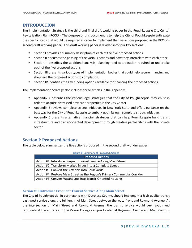
POUGHKEEPSIE CITY CENTER REVITALIZATION PLAN DRAFT WORKING PAPER III: IMPLEMENTATION STRATEGY
5 | K E V I N D W A R K A L L C
INTRODUCTION The Implementation Strategy is the third and final draft working paper in the Poughkeepsie City Center
Revitalization Plan (PCCRP). The purpose of this document is to help the City of Poughkeepsie anticipate
the specific steps that would be required in order to implement the five actions proposed in the PCCRP’s
second draft working paper. This draft working paper is divided into four key sections:
Section I provides a summary description of each of the five proposed actions.
Section II discusses the phasing of the various actions and how they interrelate with each other.
Section II describes the additional analysis, planning, and coordination required to undertake
each of the five proposed actions.
Section III presents various types of implementation bodies that could help secure financing and
shepherd the proposed actions to completion.
Section IV identifies the key funding options available for financing the proposed actions.
The Implementation Strategy also includes three articles in the Appendix:
Appendix A describes the various legal strategies that the City of Poughkeepsie may enlist in
order to acquire distressed or vacant properties in the City Center
Appendix B reviews complete streets initiatives in New York State and offers guidance on the
best way for the City of Poughkeepsie to embark upon its own complete streets initiative.
Appendix C presents alternative financing strategies that can help Poughkeepsie build transit
infrastructure and transit-oriented development through creative partnerships with the private
sector.
Section I: Proposed Actions The table below summarizes the five actions proposed in the second draft working paper.
Figure 1: Summary of Proposed Actions
Proposed Actions
Action #1: Introduce Frequent Transit Service Along Main Street
Action #2: Transform Market Street into a Complete Street
Action #3: Convert the Arterials into Boulevards
Action #4: Restore Main Street as the Region’s Primary Commercial Corridor
Action #5: Convert Vacant Lots into Transit-Oriented Housing
Action #1: Introduce Frequent Transit Service Along Main Street
The City of Poughkeepsie, in partnership with Dutchess County, should implement a high quality transit
east-west service along the full length of Main Street between the waterfront and Raymond Avenue. At
the intersection of Main Street and Raymond Avenue, the transit service would veer south and
terminate at the entrance to the Vassar College campus located at Raymond Avenue and Main Campus
POUGHKEEPSIE CITY CENTER REVITALIZATION PLAN DRAFT WORKING PAPER III: IMPLEMENTATION STRATEGY
6 | K E V I N D W A R K A L L C
Drive. This service would provide a connection high-speed connection between the waterfront, the train
station, the Central Business District, the Middle Main Area, and the Vassar College Campus.
Action #2: Transform Market Street into a Complete Street
The City of Poughkeepsie in partnership with New York State Department of Transportation should
redesign Market Street as a “complete street” in which all transportation users including pedestrians,
bicyclists, and transit riders are sufficiently accommodated. Designing Market Street as a complete
street requires more than the insertion of a median and pedestrian bulbouts. A true complete street
approach will also install sufficient bike and transit infrastructure within the right of way, resolve the
hazardous intersections between Market Street and the arterials, and convert the intersection of
Columbus Drive and Mill Street into a T-intersection.
Action #3: Convert the Arterials into Boulevards
The City of Poughkeepsie in partnership with the New York State Department of Transportation should
convert both the westbound and eastbound arterials into pedestrian friendly boulevards. There are a
variety of ways in which a boulevard concept could be introduced including (1) the retention of the
existing number of travel lanes but the modification of the arterials’ intersections with north-south
streets (2) the retention of the existing number of travel lines but the conversion of one lane on each
arterial into a contra-flow lane and (3) the elimination of a travel lane on each arterial and its
replacement with either a median or a bike lane. The feasibility of these concepts as well as the
potential for combining them needs to be performed in the context of a comprehensive analysis of the
City Center circulation system in its totality. This analysis needs to evaluate not only the existing levels of
service for automobiles but also assess the performance of the bike, pedestrian, and transit network in
the current circulation system. The impacts of the various scenarios need to be analyzed not only in
accordance with traffic engineering concepts but also within the larger redevelopment plan and transit
plan for the City Center and its potential to capture a greater number of trips through alternative
transportation.
Action #4: Restore Main Street as the Region’s Primary Commercial Corridor
The City of Poughkeepsie should restore Main Street as the region’s primary commercial corridor
especially within the segment between Bridge and Hamilton Streets. In order to eliminate vacancies,
shorten absorption times, and maximize street traffic, the City must undertake four key interventions.
First, in accordance with Action #1, a high-performing transit system should be introduced along Main
Street. Second, the City must enhance the overall visual image of Main Street through a comprehensive
streetscaping initiative that goes beyond incremental façade improvements and improves the street’s
lighting, pavement, curbs, landscaping, transit infrastructure, and bike infrastructure. Third, the City
needs to prioritize the rehabilitation of distressed buildings and promotion of infill development through
the introduction of a new redevelopment entity such as a land bank or a community development
corporation.
POUGHKEEPSIE CITY CENTER REVITALIZATION PLAN DRAFT WORKING PAPER III: IMPLEMENTATION STRATEGY
7 | K E V I N D W A R K A L L C
Action #5: Convert Surface Parking Lots into Transit-Oriented Housing
The City of Poughkeepsie in partnership with Dutchess County should develop a long-term strategy for
converting the surface parking lots in the City Center into a transit-oriented housing development that
coincides with the installation of a high quality transit service along Main Street. Given the large expanse
of land, it is possible for the City to undertake redevelopment at a fairly large scale in which a new
mixed-income and multi-family housing complex is carefully coordinated with interior open spaces and
pedestrian connections to the Main Street. The developments should be constructed to exploit the
area’s proximity to the rail station and the potential to capture residents’ retail needs through walk trips
to the Main Street Corridor.
SECTION II: PHASING AND COORDINATION The five proposed actions do not need to be sequenced. Ideally, they should be done simultaneously
and with close coordination. A successful outcome for any one of these actions is contingent upon the
successful outcome of other actions.
The introduction of frequent transit service on Main Street is obviously interwoven with the restoration
of Main Street as the region’s primary commercial corridor. A key part of enhancing Main Street’s
viability as a regional commercial corridor is providing a high quality transit environment that includes
adequate lighting, fixtures, signage, and other elements of a unified transit infrastructure program.
Meanwhile, the financial feasibility of transit service on Main Street is dependent in part on the capture
of choice riders travelling in the Main Street corridor. With higher levels of occupancy along Main Street
and increased street traffic there will be higher passenger demand and greater fare revenue for a transit
service. Similarly, the introduction of transit along Main Street is essential to the redevelopment
potential of vacant lots into transit-oriented housing. Similarly, the expanded population enabled
through redevelopment provides a stronger customer base for the transit service.
The conversion of Market Street into a complete street is closely linked with the conversion of the
arterials into boulevards. Without modifications to the intersection of the arterials with Market Street,
the multimodal connectivity along a north-south axis in the city center will remain compromised.
Moreover, any changes to Market Street should carefully anticipate how the introduction of a fixed
route transit service might require certain types of alterations to the intersection of Main and Market
Street, an ideal location for a transit stop given its proximity to the newly built transit hub.
The conversion of the arterials into boulevards should be performed in coordination with a downtown
circulation study that contemplates not only the pedestrian movements along Market Street but also
the way in which the pedestrianized arterials would be linked to a revitalized Main Street. These two
interventions are closely tied because residents from surrounding neighborhoods would be more likely
to patronize Main Street establishments if they can more easily cross the arterials. Similarly, a revitalized
Main Street will introduce the possibility for more street traffic to destinations along the arterials.
POUGHKEEPSIE CITY CENTER REVITALIZATION PLAN DRAFT WORKING PAPER III: IMPLEMENTATION STRATEGY
8 | K E V I N D W A R K A L L C
As mentioned above, the restoration of Main Street as the region’s primary commercial corridor
requires the introduction of transit as well as the elimination of the barricade effects created by the
current design of the arterials. Main Street’s viability as a commercial corridor is also contingent,
however, on the conversion of Market Street into a pedestrian friendly two-way street as part of a larger
reconfiguration of the downtown street network. Market Street is a gateway to the Main Street corridor
and any efforts to enhance its navigability by all transportation users will only help stimulate more
business activity along Main Street.
To some extent, the conversion of vacant lots may be seen as the last action required in the overall
revitalization of the city center. Afterall, the introduction of transit along Main Street and redesign of
the downtown circulation system will add a considerable premium on the developability of these sites.
On the other hand, the viability of redeveloping these sites is also contingent upon the City (and County)
retaining site control and enforcing transit-oriented design guidelines for their disposition. As such, the
redevelopment planning for vacant lots – especially the surface parking lots – should commence now so
that if any future development happens, it will happen in accordance with TOD principals. It is also
advisable to coordinate the redevelopment planning for the lots with the initial planning for transit
service along Market Street because of the potential for financing new transit infrastructure through
innovative value capture strategies.
In sum, the execution of the PCCRP must proceed in a holistic fashion where its various component parts
are pursued simultaneously in order to ensure coordination between design, circulation, and funding
opportunities.
SECTION III: ACTION PLAN This section presents the five proposed actions and identifies the specific planning analysis, research,
coordination, and outreach that should be done as incremental steps toward final implementation.
These steps are sequenced.
Action #1: Introduce High Performance Transit Along Main Street
Resolve City and County Management of Current Bus Service
Before any steps are taken toward introducing a high performance transit service along Main Street, the
City and Dutchess County need to establish a clear agreement regarding the management, operation,
and financing of the current bus network. There are a variety of ways in which a fixed transit service
along Main Street could be managed. Options include the absorption of a new service into a local transit
authority, inclusion of a new service as a feeder connection to a rail service, joint management of a new
service by a city and a larger jurisdiction such as a county, creation of a new public service corporation
charged with managing a particular route, or the creation a private organization such as a business
group or partnership of anchor institutions charged with managing the new service. Regardless of the
administrative entity selected, however, there needs to be a clear resolution on the management of the
current system.
POUGHKEEPSIE CITY CENTER REVITALIZATION PLAN DRAFT WORKING PAPER III: IMPLEMENTATION STRATEGY
9 | K E V I N D W A R K A L L C
Form Main Street Transit Advisory Committee
The insertion of a high performance transit system on Main Street will create a major physical as well as
economic change in the City Center. As such, it is imperative to have all stakeholders involved in
collaborative transit planning process that engages city leadership, county leadership, the operators of
the current bus system, Amtrak, Metro North, community organizations, residents, and the business
communities. Very often, the business community is especially effective in organizing this type of
committee and enfolding it within a formalized business alliance such as a merchants association or a
business improvement district.
Conduct Transit Feasibility Study
A detailed technical analysis of the various transit options and cost implications should be conducted for
a transit service that would connect the waterfront and Vassar College. The analysis needs to be
carefully coordinated with the land use planning for all areas along the length of Main Street including
the waterfront as well as infill opportunities along Main Street and the vacant lots within its proximity.
The transit feasibility study needs to examine the ideal locations for a transit stop and the potential for
these stops to function as redevelopment nodes. Another important part of the transit feasibility study
is examining various technologies (shuttles, buses, and light rail) and how the election of different
technologies will present different requirements in terms of capital and operating costs. The study also
needs to explore the full range of different financing options that include not only public funding for
capital infrastructure but possible sources for ongoing operating expense support.
Commence and Evaluate Pilot Program
Regardless of the technology desired for the long-term, it would be advisable for the City of
Poughkeepsie to commence service with a modest pilot program such as a limited service community
shuttle but still operating at high enough frequencies to provide a competitive alternative to the
automobile. The advantage of a less capital intensive pilot program is that it enables the city to
inaugurate a sustainable transportation program with considerably less costs and less time than that
required for an operation such as light rail.
Select Permanent Transit Solution
With the results from the evaluation of the pilot program, transit stakeholders will be in the best
position to determine the optimal route, technology, stops, management, and financing for a
permanent Main Street transit solution.
Action #2: Transform Market Street into a Complete Street
Form Complete Streets Advisory Committee
There are several reasons why the formation of a complete streets advisory committee is advisable for
Market Street. First, the implementation of a complete streets program will require coordination across
multiple jurisdictions including the City of Poughkeepsie, Dutchess County, and New York State
Department of Transportation. Secondly, the business community will be highly affected by any
interventions along Market Street and so should be consulted to ensure that any reconfigurations are
POUGHKEEPSIE CITY CENTER REVITALIZATION PLAN DRAFT WORKING PAPER III: IMPLEMENTATION STRATEGY
10 | K E V I N D W A R K A L L C
complementary with economic development goals. Also, certain funding programs (such as the federal
TAP program) require documentation of public outreach as a prerequisite to funding. Complete Streets
Advisory Committee programs can provide the administrative support required to plan and implement
public outreach strategies.
Commence Demonstration Program
Complete streets programs may take years to fully implement because so often the redesign of a street
requires more than the above-ground configuration of a street but also the rehabilitation or
replacement of utility infrastructure such as water and sewer mains. One way of moving forward with a
complete streets program without requiring extensive engineering is a demonstration program that
reconfigures traffic movements through the temporary placement of bollards, gravel, and surface paint.
This approach was widely done in New York City as part of a broader strategy to expand sidewalks,
expand the bike network, and build pedestrian plazas. The demonstration approach also allows the city
to evaluate different types of complete streets interventions, gauge the traffic and economic impacts,
and enlist feedback from the affected community.
Study Downtown Circulation
One of the key reasons for reconfiguring Market Street as a two way street is that it would enhance
circulation throughout the city’s downtown. However, the current configuration of Market Street as
one-way is only one element in a much larger set of issues affecting access and circulation in the City
Center. These issues include the impacts of the arterials on City Center access as well as the lack of
north-south connections between Market and Academy streets. As such, the reconfiguration of Market
Street as a complete street should be studied within the broader context of a downtown circulation
study expressly aimed at optimizing economic development by enhancing access to the City Center.
Develop Streets Design Manual
Market Street is not the only street in Poughkeepsie that would benefit from complete streets
principals. Other streets include the arterials, Main Street, Academy, and Hamilton. Additionally,
complete streets concepts would be relevant to many other streets throughout the city including purely
residential streets. As such, the planning process for complete streets on Market Street could also be
coordinated with the development of a streets design manual that described different typologies for
complete streets and matched them with candidate streets throughout the city.
Design and Engineer Market Street
With the completion of a downtown circulation study in tandem with evaluation of a demonstration
complete streets program, the city could commence the design and engineering of Market Street as a
long-term solution that would also include any necessary modifications to the intersections with the
arterials as well as with the below ground infrastructure.
POUGHKEEPSIE CITY CENTER REVITALIZATION PLAN DRAFT WORKING PAPER III: IMPLEMENTATION STRATEGY
11 | K E V I N D W A R K A L L C
Action #3: Convert the Arterials into Boulevards
Form Complete Streets Advisory Committee
The committee formed to develop complete street concepts for Market Street could also be enlisted to
coordinate stakeholders and solicit public input on changes to the arterials.
Analyze Existing Condition of Arterials
Although raw traffic data is available for the westbound and eastbound arterials, there is not currently
any evaluation of the existing performance of the arterials. This evaluation should be conducted to
provide a baseline assessment not only of the level of service for vehicles but also the level and quality
of service for pedestrians travelling along and across the arterials.
Study Downtown Circulation
As noted above, a downtown circulation study should be conducted in order to ensure that any
reconfigurations of the arterials occurs in holistic fashion that maximizes local connectivity and results in
a downtown circulation system that optimizes opportunities for economic development.
Design, Engineer, and Reconstruct the Arterials
With the formation of an advisory committee, completion of an existing conditions analysis, and the
completion of a downtown circulation study, the City can begin working with New York State
Department of Transportation on ways for modifying the arterials.
Action #4: Restore Main Street as the Region’s Primary Commercial Corridor
Form Main Street Merchants Association
Although there are number of merchants along Main Street who actively are committed to the street’s
revitalization as a commercial corridor, there is not a formalized merchants association or business
improvement district. In many cities, merchant associations are indispensable with regard to their input
on key service and infrastructure decisions but also in acting as financial stewards for key revitalization
projects including streetscaping initiatives and even transit operations. Prior efforts to form a BID have
not had a successful outcome. The merchants, city leadership, county leadership, and the Chamber of
Commerce should explore the best way for organizing the merchants into a body dedicated to Main
Street’s revitalization. There are a variety of formats in which such an organization could take place and
a range of ways for funding them.
Secure Main Street Designation
The City of Poughkeepsie may contemplate securing a Main Streets designation through the Main
Streets Program that is a subsidiary of the National Trust for Historic Places. The designation can be
useful in various ways including the acquisition of public and private funding, development of
revitalization plans, and generating public support and enthusiasm about a revitalization effort.
POUGHKEEPSIE CITY CENTER REVITALIZATION PLAN DRAFT WORKING PAPER III: IMPLEMENTATION STRATEGY
12 | K E V I N D W A R K A L L C
Create Redevelopment Authority
Currently, there is not an active development authority within the City of Poughkeepsie that is charged
with the specific task of redeveloping vacant parcels along Main Street or rehabilitating blighted
properties. In some cities, Economic Development Commissions and Local Development Authorities
have been the primary engines for revitalizing main streets. In other cities, land banks or community
development corporations have played a more important role. Either way, the City of Poughkeepsie
should explore the various options (as presented in Section IV) for creating a public, private, non-profit,
or hybrid partnership that is charged specifically with the redevelopment of vacant parcels in the City
Center including those parcels that are ripe for infill development along Main Street.
Action #5: Convert Vacant Lots into Transit-Oriented Housing
Establish TOD Land Use and Design Guidelines for City Center
As noted in Section 1, the redevelopment of the vacant lots within the Main Street corridor into transit-
oriented housing will require the implementation of a high performing transit service along Main Street.
However, even before the implementation of that service, the City of Poughkeepsie should undertake a
careful analysis of the zoning, land use regulations, and parking policies on these properties. Every step
should be taken to ensure that prospective developers comply with TOD guidelines with regard to
density, scale, and design. Infill development on the surface parking lots should maximize tax revenue
and impose the least amount of traffic and parking impacts.
Study Downtown Circulation
As part of the downtown circulation study mentioned above, the City of Poughkeepsie should undertake
a comprehensive inventory of existing parking supply and utilization from an economic perspective.
Specifically, the study should evaluate the economic value created through parking access and revenue
compared with the economic returns of transit-oriented housing. This type of analysis would help guide
the city on the best way to coordinate the development of TOD housing on the surface parking lots
without the need for building replacement parking.
Create Redevelopment Authority
As noted in the implementation steps for Action #4, the City of Poughkeepsie should explore the
possibility of creating a redevelopment authority charged specifically with the redisposition of vacant
land as well as the rehabilitation of buildings within the City Center. This authority is needed to enable
infill development along Main Street itself and also on the vacant surface parking lots north and south of
Main Street.
SECTION IV: IMPLEMENTATION ENTITIES The most obvious entity for initiating urban revitalization would be the City of Poughkeepsie through the
formation of an economic development corporation charged specifically with the redevelopment of infill
sites and rehabilitation of distressed parcels within the City Center. However, New York State has
several options for forming other types of urban economic revitalization entities, all of which would be
POUGHKEEPSIE CITY CENTER REVITALIZATION PLAN DRAFT WORKING PAPER III: IMPLEMENTATION STRATEGY
13 | K E V I N D W A R K A L L C
available to Poughkeepsie. This section reviews the terms of structure, legal requirements for formation,
and funding for these various types of entities. These revitalization bodies include Business
Improvement Districts, Anchor Partnerships, Community Development Corporations, Housing
Development Fund Corporations, Community Development Entities, Land Banks, Community Lands
Trusts, Urban Renewal Agencies, Industrial Development Agencies and Local Development Corporations.
Business Improvement District
A Business Improvement District (BID) is a special district created by a municipality to further
revitalization of a commercial area. A BID is incorporated under the state not-for-profit law and is
managed by a board of directors made up of property owners and some tenants within the designated
area. Funding for a BID comes from fees paid by property owners who will benefit from the
improvements. A BID maintains, improves, develops and markets the commercial district using methods
like street cleaning, landscaping, vacancy reduction, signs, holiday decorations, and community service.
In order to form a BID, a municipality must first adopt a local law, establish a district, prepare a plan and
get approval from the local legislative body and NYS Comptrollers Review.1
Anchor Partnership
An Anchor Partnership is a public/private partnership between community stakeholders, business
leaders and large local entities such as hospitals, universities, colleges and clinics to foster economic
development and community revitalization. The partnership promotes economic development by
coordinating resources from the public and private sector to support specific projects that will benefit
the community. In order to form an anchor partnership, the municipality must create a non-profit
organization. Possible partners for an anchor partnership in Poughkeepsie are Marist College, Dutchess
Community College, Vassar College, Vassar Brothers Medical Center, and Saint Francis Hospital.2 A local
example of an anchor partnership is the Greater Newburgh Partnership.3
Community Development Corporation
A Community Development Corporation (CDC) is a non-profit organization incorporated to provide
programs, offer services and engage in activities that promote and support community development.
Activities may include education programs, community organizing, and real estate development.
Municipalities can dispose of a property to a CDC4 and a CDC can sell/lease/dispose of real property to
the municipality or other approved entity by a resolution of a municipality’s local legislative body.5 A
CDC may also contract with the New York State Housing Finance Agency for mortgage loans. In order to
1 For more information on forming a BID, see: http://www.nyc.gov/html/sbs/downloads/pdf/bid_guide_complete.pdf
http://www.bidlaws.com/# 2 For more information on forming an anchor partnership see: http://www.isc.hbs.edu/pdf/2011-1114---NYC_Anchor_Institutions.pdf
http://community-wealth.org/strategies/panel/anchors/index.html
http://www.icic.org/ee_uploads/publications/ICIC_RESEARCH_anchor_institutions_r2.pdf 3 http://www.greaternewburghpartnership.org/index.php 4 A municipality may dispose of a property to a CDC without public auction or sealed bids provided that there is publication and a hearing not
less than 10 days after notice. 5 Subject to the approval of the Commissioner of the Division of Housing and Community Renewal
POUGHKEEPSIE CITY CENTER REVITALIZATION PLAN DRAFT WORKING PAPER III: IMPLEMENTATION STRATEGY
14 | K E V I N D W A R K A L L C
form a CDC, the municipality must form a non-profit organization and the NYS Commissioner of the
Division of Housing and Community Renewal must approve the certificate of incorporation.6
Housing Development Fund Corporation
A Housing Development Fund Corporation (HFDC) is a non-profit housing corporation formed under the
NYS Private Housing Finance Law to deal with the inadequate supply of safe and sanitary dwelling
accommodations within the financial reach of low-income families. An HDFC constructs or rehabilitates
housing as well as non-housing buildings like recreational or community facilities. A municipality may
dispose of a property to a HDFC.7 In order to form an HDFC, a municipality must designate a supervising
agency, create a non-profit organization, and receive approval from NYS Commissioner of the Division of
Housing and Community Renewal.8 A local example is the Pleasantville Housing Development Fund
Company.9
Community Development Entity
A Community Development Entity (CDE) is a corporation or partnership that serves as an intermediary
for the provision of loans, investments or financial counseling to low-income communities. A CDE can
apply to the Community Development Financial Institutions (CDFI) Fund to receive a New Markets Tax
Credit (NMTC) allocation to offer its investors in exchange for equity investments in the CDE, or to
receive loans or investments from other CDEs that have received NMTC allocations. In order to form a
CDE, a municipality must pass a Primary Mission Test and Accountability Test. A local example is the
Rural Ulster Preservation Company.10
Land Bank
A Land Bank is a non-profit corporation created to take control and redevelop vacant or abandoned
properties so they can better serve the public interest. A Land Bank may acquire vacant, abandoned,
and tax-delinquent properties for redevelopment. A municipality may also transfer real property and
interests in real properties to the land bank. Real property held by a land bank is then exempt from all
taxation from the state and its political subdivisions. A municipality can also transfer property taxes
collected from any specific parcel of property to the land bank (as designated by adoption of a local law
or resolution). In order to form a Land Bank, a municipality must adopt a local law, create a non-profit
6 For more information on forming a CDC, please see: http://codes.lp.findlaw.com/nycode/PVH/6-A;
http://www.nycom.org/images/Feesfines/Managementseriesreports/Comred104.pdf 7 A municipality may dispose of a property to a HDFC without public auction or sealed bids provided that there is publication and a hearing not
less than 10 days after notice. 8 For more information on forming a HDFC, please see:
http://www.cdfifund.gov/docs/certification/CDE/CDE%20Certification%20Application_01222013.pdf
http://www.cdfifund.gov/docs/2002_nmtc_cde_certification_guidance.pdf 9 http://www.pleasantville-ny.gov/Public_Documents/PleasantvilleNY_BComm/housing/index 10 http://www.rupco.org/
POUGHKEEPSIE CITY CENTER REVITALIZATION PLAN DRAFT WORKING PAPER III: IMPLEMENTATION STRATEGY
15 | K E V I N D W A R K A L L C
organization, and apply to the Empire State Development agency.11 A local example is the Newburgh
Community Land Bank.12
Community Land Trust A Community Land Trust (CLT) is a non-profit organization that holds and develops property for the
community interest, including affordable housing, community gardens, civic buildings, commercial
spaces and other community assets. A CLT owns the land but leases it long term to another user and
usually reserves the right to buy buildings from residents who move out to prevent speculation. This
enables the CLT to have some control over local land use in order to reduce absentee ownership,
provide affordable housing, and promote home ownership. In order to form a CLT, a municipality must
create a non-profit organization.13
Urban Renewal Agency An Urban Renewal Agency (URA) is the legal authority by which a municipality undertakes planned and
coordinated activities to redevelop entire neighborhoods. The URA transforms blighted areas into areas
that are beneficial for a public purpose. The URA may also administer federally funded programs for the
municipality, including CDBG and HOME programs. In order to form a URA, the municipality must adopt
a local law, make a blight finding, designate an urban renewal area and then develop and adopt an
urban renewal plan.14 Examples include the White Plains URA15 and the City of Mount Vernon URA.16
Industrial Development Agency An Industrial Development Agency (IDA) is a public benefit corporation formed by a municipality that
promotes, encourages, attracts and develops employment, industry, and recreation opportunities in
municipalities. IDAs can provide financial assistance to private entities through tax incentives as long as
the entity promotes the economic welfare and recreational opportunities for residents. Tax exemptions
include mortgage recording tax exemption, sales and use tax exemption, real property tax abatement,
and interest rate savings via tax-exempt financing. IDAs may purchase, sell, lease and/or mortgage real
property and may borrow or make money available for approved projects. All proposed projects are
subject to public hearings and IDAs must submit annual financial statements.17 Poughkeepsie does have
an existing IDA18 as does Dutchess County.19
11 For more information on forming a Land Bank, please see: http://esd.ny.gov/BusinessPrograms/NYSLBP.html; http://esd.ny.gov/BusinessPrograms/Data/NYSLBP/112111_LandBankGuidelines.pdf
12 http://www.newburghcommunitylandbank.org/ 13 For more information of forming a CLT, please see: http://community-wealth.org/strategies/panel/clts/index.html; http://cltnetwork.org/; http://www.hud.gov/offices/cpd/about/conplan/foreclosure/pdf/austincommtrust.pdf 14 For more information on forming an Urban Renewal Agency, please see: http://codes.lp.findlaw.com/nycode/GMU/15; http://codes.lp.findlaw.com/nycode/GMU/15-A; http://codes.lp.findlaw.com/nycode/GMU/XV-B 15http://www.cityofwhiteplains.com/templates/template_text_image_right_panel.aspx?ID=Urban%20Renewal%20Agency 16 http://cmvny.com/departments/planning/urbanrenewalagency/ 17 For more information on forming IDAs, please see:; http://www.osc.state.ny.us/localgov/pubs/research/idabackground.pdf; http://www.harrisbeach.com/publications/hb_econdevhandbook.pdf 18 http://www.cityofpoughkeepsie.com/downloads?dl_cat=18 19 http://www.dutchesscountyida.org/dcida_proto/
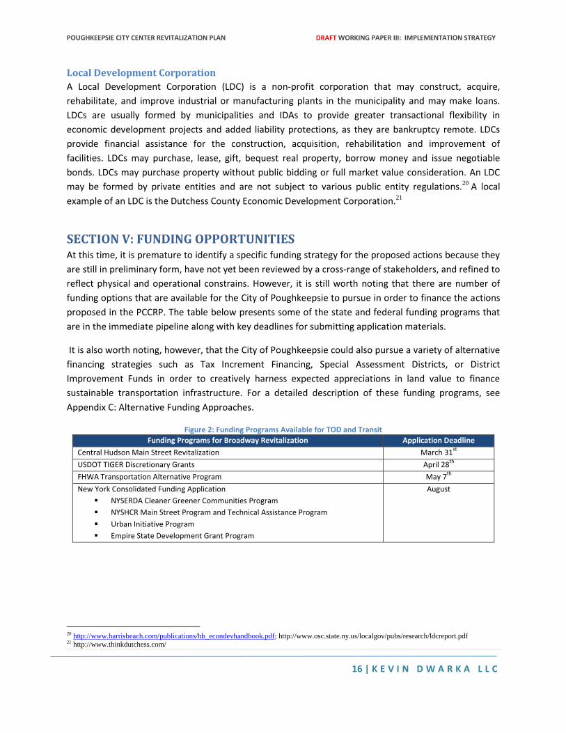
POUGHKEEPSIE CITY CENTER REVITALIZATION PLAN DRAFT WORKING PAPER III: IMPLEMENTATION STRATEGY
16 | K E V I N D W A R K A L L C
Local Development Corporation
A Local Development Corporation (LDC) is a non-profit corporation that may construct, acquire,
rehabilitate, and improve industrial or manufacturing plants in the municipality and may make loans.
LDCs are usually formed by municipalities and IDAs to provide greater transactional flexibility in
economic development projects and added liability protections, as they are bankruptcy remote. LDCs
provide financial assistance for the construction, acquisition, rehabilitation and improvement of
facilities. LDCs may purchase, lease, gift, bequest real property, borrow money and issue negotiable
bonds. LDCs may purchase property without public bidding or full market value consideration. An LDC
may be formed by private entities and are not subject to various public entity regulations.20 A local
example of an LDC is the Dutchess County Economic Development Corporation.21
SECTION V: FUNDING OPPORTUNITIES At this time, it is premature to identify a specific funding strategy for the proposed actions because they
are still in preliminary form, have not yet been reviewed by a cross-range of stakeholders, and refined to
reflect physical and operational constrains. However, it is still worth noting that there are number of
funding options that are available for the City of Poughkeepsie to pursue in order to finance the actions
proposed in the PCCRP. The table below presents some of the state and federal funding programs that
are in the immediate pipeline along with key deadlines for submitting application materials.
It is also worth noting, however, that the City of Poughkeepsie could also pursue a variety of alternative
financing strategies such as Tax Increment Financing, Special Assessment Districts, or District
Improvement Funds in order to creatively harness expected appreciations in land value to finance
sustainable transportation infrastructure. For a detailed description of these funding programs, see
Appendix C: Alternative Funding Approaches.
Figure 2: Funding Programs Available for TOD and Transit
Funding Programs for Broadway Revitalization Application Deadline
Central Hudson Main Street Revitalization March 31st
USDOT TIGER Discretionary Grants April 28th
FHWA Transportation Alternative Program May 7th
New York Consolidated Funding Application
NYSERDA Cleaner Greener Communities Program
NYSHCR Main Street Program and Technical Assistance Program
Urban Initiative Program
Empire State Development Grant Program
August
20 http://www.harrisbeach.com/publications/hb_econdevhandbook.pdf; http://www.osc.state.ny.us/localgov/pubs/research/ldcreport.pdf 21 http://www.thinkdutchess.com/
POUGHKEEPSIE CITY CENTER REVITALIZATION PLAN DRAFT WORKING PAPER III: IMPLEMENTATION STRATEGY
17 | K E V I N D W A R K A L L C
Appendix A: Acquisition of Distressed Properties (Jessica Bacher, Esq.) This article was prepared by the Land Use Law Center under the direction of its Managing Director,
Jessica Bacher.
There are several ways in which a town, city, or municipality to acquire a distressed or abandoned
property. The first two ways are intuitive, in that any parcel of land or property may be attained through
these methods. The first is a negotiated purchase between the municipality and either the previous
owner, mortgagee, or person having a lien, claim or interest in the property. This involved negotiation
and agreement of terms by both parties and a completed contract. The second method of acquisition of
a property is by donation. A donation may be made to the municipality by the property owner
regardless of what type of land the parcel qualifies as.
Poughkeepsie’s current Vacant and Abandoned Buildings project may utilize other methods of
acquisition including Taking in rem for Tax Delinquency, RPAPL 19-A Proceedings, Eminent Domain, and
Urban Renewal. Each will be discussed and analyzed, in turn.
Taking in rem for Tax Delinquency Taking in rem for tax delinquency is the ability of a tax district that owns an unpaid and due tax lien to
foreclose and acquire title to the property. McKinney's RPTL Ch. 50-a, Art. 11, T. 3; 2 Mortgages and
Mortgage Foreclosure in N.Y. § 43:11.50. This provides a municipality with another means to acquire
vacant or distressed properties required for their current project. In order to do this, the city
(Poughkeepsie) must abide by the New York Real Property Tax Law. NY rp Tax Ch. 50-A, Art. 11, T. 3.
The City of Poughkeepsie, within its municipal code, adopts the NY Property and Tax Law for in rem
foreclosure for tax delinquency, “establishing the foreclosure of tax lien by action in rem, for the
purpose of enforcing the collection of delinquent taxes in the city.” “[Ord. of 12-2-1940, § 1; Ord. of 8-
15-1977, § 1] Section 2-4: Enforcing Collection of delinquent taxes; state law adopted.
http://www.ecode360.com/27005770?highlight=foreclosure.
The first step toward foreclosure and title to a property is that the tax district must own the tax lien to
the property, and the tax lien must be due and unpaid for a period of at least four years from the date it
was created. 2 Mortgages and Mortgage Foreclosure in N.Y. § 43:11.50. Next, the enforcing officer must
create, according to N.Y. Real Prop. Tax Law § 1122, a list of all parcels of real property that are affected
by delinquent tax liens owned by that tax district, entitled “List of Delinquent Taxes.” N.Y. Real Prop. Tax
Law § 1122 (McKinney 2010). The necessary attributes of the descriptions of each property are outlined
in NYRPTL § 1122(6).
After filing the list of delinquent taxes, the enforcement officer must provide proper notice, as defined
by N.Y. Real Prop. Tax Law § 1224-5. First, the enforcement officer must publish notice of the
foreclosure in newspaper(s) and post a copy of the notice of foreclosure in the county court of which the
POUGHKEEPSIE CITY CENTER REVITALIZATION PLAN DRAFT WORKING PAPER III: IMPLEMENTATION STRATEGY
18 | K E V I N D W A R K A L L C
property is located. N.Y. Real Prop. Tax Law § 1124(1)-(5) (McKinney 2010). He/she must also post notice
in three “conspicuous places” within the community. N.Y. Real Prop. Tax Law § 1125(1) (McKinney
2010). Finally, the enforcement officer must send notice by both certified and ordinary first-class mail to
the last known address of the owner. Id. The procedure required for special circumstances such as if the
owner cannot be found, are outlined in NYRPTL § 1125. “Every person, including a tax district other
than the one foreclosing, having any right, title or interest in, or lien upon, any parcel described in such
list of delinquent taxes may redeem such parcel” before the expiration of the redemption period. N.Y.
Real Prop. Tax Law § 1122(9) (McKinney 2010). Any such person may also file an answer with a
response to the foreclosure of the tax lien notice and any defense or objection that person may have. 2
Mortgages and Mortgage Foreclosure in N.Y. § 43:11.50 citing N.Y. Real Prop. Tax Law § 1122(9). Any
such person who does not redeem or answer is considered in default, and is foreclosed from asserting
any right, title and interest in the property at any time in the future. 2 Mortgages and Mortgage
Foreclosure in N.Y. § 43:11.50.
If no answer or redemption is made, then the court will award the tax district possession and ownership
of the property through the execution of a tax deed in a final judgment. 2 Mortgages and Mortgage
Foreclosure in N.Y. § 43:11.50. Prior to a final judgment, the enforcement officer may, at any time, set
aside the proceedings for taking the parcel through foreclosure for several different reasons, put forth in
N.Y. Real Prop. Tax Law § 1138(1):
(1) there is reason to believe that there may be a legal impediment to the enforcement of the
tax lien affecting the parcel; (2) the tax has been canceled or is subject to cancellation; (3) the
filing of a bankruptcy petition has stayed the enforcement of the lien; (4) if the tax district
acquired the property, there would be a significant risk that the district could be exposed to a
liability substantially in excess of the amount recoverable by enforcing the lien; (5) the owner of
the parcel has agreed to pay the taxes in installments and has not defaulted on that agreement;
or (6) in a tax district which has extended the redemption period for residential or farm property
the parcel has been included on a petition for foreclosure, it has been demonstrated to the
enforcing officer's satisfaction that the parcel is residential or farm property and, as such, the
parcel is not yet subject to inclusion on such a petition. N.Y. Real Prop. Tax Law § 1138(1).
It is also important to note, and this ties into the other possibilities for acquiring abandoned or
distressed property mentioned above, that the tax district may accept conveyance of “the interest of
any person having any right, title, interest, claim, lien or equity of redemption in or to such parcel” in
lieu of a foreclosure proceeding. N.Y. Real Prop. Tax Law § 1170 (McKinney 2010).
**A good example of a municipality that took title to property through an in rem tax delinquency
foreclosure: Pompe v. City of Yonkers, 179 A.D.2d 628, 578 N.Y.S.2d 585 (1992)(where the tax deed was
legitimately acquired by city after tax delinquency).
POUGHKEEPSIE CITY CENTER REVITALIZATION PLAN DRAFT WORKING PAPER III: IMPLEMENTATION STRATEGY
19 | K E V I N D W A R K A L L C
Possibly the main obstacle or challenge is the fact that persons with an interest may keep pushing back
the redemption period, and therefore, it takes a LONG time.
RPAPL 19-A Proceedings A city, town or village may acquire title to a property that is abandoned through a special proceeding
under New York’s Real Property Actions and Proceedings Law 19-A. N.Y. Real Prop. Acts. Law § 1970
(McKinney 1983).
19-A first requires a certification or finding that the building or property in question is abandoned. This
classification is governed by RPAPL § 1971, which enumerates factors that must be fulfilled to classify an
occupied building as abandoned or a vacant building as abandoned. See RPAPL § 1971(1)(a) and (b). If
these factors are fulfilled, then the municipal department may find that a dwelling is abandoned, and
may then file in its records “a certification containing such finding and the facts on which it is based.”
N.Y. Real Prop. Acts. Law § 1971(2) (McKinney 1983). Then, the department must affix a notice that the
building is abandoned in a prominent and conspicuous location. In this notice, the department must also
state that taking, removing, or damaging any fixture of the building is criminal. Id.
Next, the department must provide sufficient notice. This requires that it file a copy of the certification
and a notice of intention to commence such proceedings, in the office of the clerk of the county where
the dwelling is located. RPAPL § 1972(1). The department must also serve a copy of the certification
upon the owner of the dwelling, this must be personally served or placed in a conspicuous location on
the dwelling accompanied by a mailing of certification to the last known owner at his/her last known
dwelling. RPAPL § 1972(2). Finally, within five days, a copy of verification must be served on the
mortgagee,, lienor, and lessee of record, personally or by registered mail. RPAPL § 1972(3). The
exceptions and intricacies of the procedure are clearly laid out in RPAPL § 1972.
Finally, the commencement of the proceeding to vest title in the city, town, or village can only occur
after there is certification, as mentioned previously, accompanied by proof by affidavit that RPAPL §
1972 has been complied with. RPAPL § 1973(1), (2). Petitions must be served upon all persons requiring
notice for § 1972, in accordance with Article 3 of CPLR. RPAPL § 1973. The petition is heard at least 15
days after service is completed. Id. Once the proceeding is in motion, there are two options. First, any
party that received service may apply to the court for a stay of the proceeding to get the building up to
code or pay off or foreclose the mortgage or lien. RPAPL § 1974(2). The stay cannot be more than six
months. Id. The second option is that the dwelling is found to be abandoned, and final judgment is given
in favor of the petitioner (the municipality), resulting in title of the estate in fee simple absolute to the
town, city, or village. RPAPL § 1974(3). It is always important to note that the burden of proof in
abandonment is on the department.
The procedure outlined above is a New York State requirement for abandoned property acquisition;
however, the City of Poughkeepsie has its own municipal ordinance that further governs abandoned or
vacant property issues, Ord. No. O-10-32, 11-15-2010, § 1. The ordinance is in Section 6-30
POUGHKEEPSIE CITY CENTER REVITALIZATION PLAN DRAFT WORKING PAPER III: IMPLEMENTATION STRATEGY
20 | K E V I N D W A R K A L L C
Abandoned/Vacant Property of the municipal code and aligns with New York mandates under RPAPL 19-
A. It adds specifics for definitions and details that aid in implementation of a 19-A proceeding.
Specifically, it defines what constitutes an abandoned or vacant building. Moreover, the municipal code
presents Poughkeepsie’s abandoned/vacant property registration plan in detail. See Section 6-39, Ord.
No. O-10-32, 11-15-2010, § 1.
Eminent Domain Eminent domain is the state government’s, or delegated local government and agencies, “legal power to
take title to private property for a public use upon payment of just compensation to the landowner.”
Alyse Terhune & Daniel Pennessi, Municipal Resources, in REINVENTING REDEVELOPMENT LAW 49, 49-
53 (Noelle V. Crisalli et al. eds., 2005).
This authority allows states and municipalities to facilitate projects for a public purpose in accordance
with New York’s Eminent Domain Law (EDL). Article 2 of the EPL, and Article IX § 1(e) allow
condemnation of private property if the project is for “public use, benefit, or purpose.” Id. at 49. The
designation is “highly discretionary, and the condemning authority must consider the balance of the
degree of public necessity versus the extent of deprivation of private property rights. Id. However, the
Fifth Amendment of the United States Constitution and Article I, § 7 of the New York State Constitution
limit the state’s inherent power of eminent domain by requiring just compensation to private property
owners when their property is taken for a public use. Id. at 50.
States may delegate their condemning authority to municipalities, governmental agencies, or public
service corporations, pursuant to “enabling legislation that specifies purposes for which the power may
be exercised.” Id. Municipalities are empowered to condemn “real property, or any interest therein for
the purpose of eliminating blight under Article 15, § 506 or New York General Municipal Law. The same
power is granted to municipal urban renewal agencies under Article 15-A. Id.
To implement the power of eminent domain, the municipality or condemning authority must first
determine that the taking is necessary to facilitate a public purpose. Following the determination,
proper public notice and service, pursuant to Article 2 § 202 of the EDPL, is required. Notice must
include the time, place, and purpose of the hearing as well as a statement that the property owners,
wishing to challenge the condemnation, are responsible for raising issues, facts, and objections at the
hearing in order to preserve them for judicial review. Terhune, supra at 50.
The hearing must be conducted at a location near the property to be acquired and include an
explanation of the public use to be served by the proposed project as well as the impact the project will
have on the environment, properties, and residents. Additionally, the attending public must then be
given an opportunity to be heard. Following the hearing, the condemning authority has 90 days to make
a decision regarding the taking. Id. The finding must be published in a synopsis pursuant to § 204 of the
EDPL. The condemning authority must then serve a notice of the synopsis to each owner of property to
be condemned, or the owner’s attorney of record. Id.
POUGHKEEPSIE CITY CENTER REVITALIZATION PLAN DRAFT WORKING PAPER III: IMPLEMENTATION STRATEGY
21 | K E V I N D W A R K A L L C
The main concern with using the power of eminent domain is the “public use” requirement that has
been found to be “broad and inclusive.” Berman v. Parker, 348 U.S. 26 (1954). In New York, “public use”
is interpreted broadly and is synonymous with “public purpose” and “public benefit;” the courts merely
require that it is the dominant purpose of the taking. This has created a fear of “one-to-one transfers
benefiting one private economic interest over another.” Id. at 51. However, this broad interpretation
was upheld in Vitucci v. N.Y. City School Construction Authority. Vitucci v. N.Y. City Sch. Constr. Auth.,
289 A.D.2d 479 (N.Y. App. Div. 2d Dep’t 2001). The court found that “the power of eminent domain may
be exercised for a public purpose in general,” and further “found it permissible to condemn property to
aid commercial development that may be beneficial to the area, notwithstanding that it may also
benefit the private sector.” Terhune, supra at 52. However, a limit to condemnation authority was
established in Kaufmann’s Carousel where the court found “that a condemning authority does not have
the right to condemn land in excess of what is needed for its public purpose,” and held “that the
condemning authority is permitted to acquire by condemnation leasehold and other contract rights
without also acquiring the underlying real property.” Id., see also Kaufmann’s Carousel v. City of
Syracuse Indus. Dev. Agency, 301 A.D.2d 292 (N.Y. App. Div. 4th Dep’t 2002).
An additional concern is the broad interpretation of “blight,” as an area that “contain[s], or will contain”
substandard buildings that could allow a taking of economically viable property as a preventative
measure. Terhune, supra at 52. The property could then be transferred to a private entity for use in an
economic manner similar to its existing use. These “transfer[s] of land to private individuals does not
vitiate the public purpose of rehabilitation.” Id.
Urban Renewal Urban renewal is “a government program or project established by a municipality for the
redevelopment of a blighted area, using financial incentives and a public/private partnership.” Daniel
Pennessi, Urban Renewal, in REINVENTING REDEVELOPMENT LAW 57, 57-61 (Noelle V. Crisalli et al. eds.,
2005). Through this process, blighted areas are transformed into areas that are beneficial to a “public
purpose.” Id at 57.
As discussed above, “public use” or “public purpose” is defined broadly in New York. The courts have
determined that urban renewal is a public purpose because it “eliminates slums and stimulates the
economy, resulting in such benefits as reduced physical blight, improvement of the aesthetic
appearance of the area, job creation, improved infrastructure, and the possible stimulation of new
private sector economic development.” Id. Thus, provided a blight finding, urban renewal may be used
to revitalize urban areas.
Blighted areas are characterized by “crime, juvenile delinquency and disease.” Id. These areas “contain
or will contain” substandard buildings that will impair sound growth and development. Under Article 18-
C of the General Municipal Law, a “blighted area” contains buildings that “may be unfit or unsafe to
occupy or where there are economically unproductive lands, buildings, or structures.” Id. In New York
POUGHKEEPSIE CITY CENTER REVITALIZATION PLAN DRAFT WORKING PAPER III: IMPLEMENTATION STRATEGY
22 | K E V I N D W A R K A L L C
courts have found many factors that contribute to blight: “irregular plots, inadequate streets, diverse
land ownership, incompatible mixture of residential and industrial property, overcrowding, lack of
sanitation, excessive drain on municipal services, high incidence or crime, fire hazards, traffic congestion
and pollution.” Id. Municipalities and intermediary corporations have been given the authority to make
blight findings based on “a high degree of practical judgment, common sense and sound discretion.”
Pennessi, supra. at 58.
New York State Legislature requires that “the powers necessary or convenient to carry out and
effectuate such projects” be construed liberally to “protect and promote the safety, health, morals, and
welfare of the people of New York.” Id. Municipalities are further empowered to “develop [urban
renewal] programs for proper planning, clearance, redevelopment, rehabilitation, or conservation… and
[to] encourage participation in these programs by private enterprise.” Id.
To undertake an urban renewal project, a municipality must meet the requirements found in Article 15
of the New York State General Municipal Law (GML), Urban Renewal, and in Title 9 of New York Codes,
Rules and regulations, Urban Renewal Assistance Program. Id. Municipalities also have the authority
under GML § 503-a to delegate urban renewal power to an intermediary corporation. Id.
To begin an urban renewal project, the municipality must “make a blight finding an designate the
blighted area as an urban renewal district.” Next, an urban renewal plan (Plan) is developed. The Plan
must contain details for the redevelopment of each parcel within the urban renewal area, and must
comply with the comprehensive community plan for the entire municipalities development. The Plan
must include a statement of the following:
Proposed land uses; Manner in which property will be acquired; Structures proposed to be demolished
and removed, and proposed methods or techniques of urban renewal (clearance, re-planning,
reconstruction, redevelopment, rehabilitation, restoration, or conservation); Propoed facilities or
utilities (public, semi-public, private); Proposed new codes, ordinances and amendments, required or
necessary to effectuate the Plan; and Proposed time schedule, specifying whether the project will be
initiated area wide or phased.
Id. at 59. Following a public review of the Plan, the commission or planning authority must ensure that
the Plan complies with statutory requirements. If the Plan is in compliance it must be submitted to the
local government for a public hearing, and approval. After approval, the local governing body must pass
a resolution finding:
(a) the area is or will become substandard or unsanitary, which tends to impair sound growth and
development, (b) the financial aid provided to the municipality is necessary to facilitate the project’s
conformance with the Plan, (c) the Plan affords maximum opportunity to private enterprises consistent
POUGHKEEPSIE CITY CENTER REVITALIZATION PLAN DRAFT WORKING PAPER III: IMPLEMENTATION STRATEGY
23 | K E V I N D W A R K A L L C
with the overall needs of the municipality and (d) there is an adequate relocation plan for displaced
individuals.
Id. Finally, the municipality will issue a “request for proposals (RFP), wherein private developers submit
proposals to redevelop the blighted areas.” Pennessi, supra. at 59. Developers are selected and a “land
disposition agreement (LDA) is entered into transferring the title of the land from the municipality to the
developer for development purposes.” Id. The LDA should include “a clear statement of the objectives
of the parties, the project and its details, and the respective commitments of the parties to complete
the project.” Id.
One concern surrounding Urban Renewal is making a blight finding solely to use the area in a manner
that is more beneficial. Although parties may challenge blight findings, courts “have limited authority to
review and generally defer to municipal decisions.” These decisions are constrained, and may not be
arbitrary and capricious. In a legal challenge, the authority entrusted with the decision-making authority
must establish that they “exercise[d] a high degree of practical judgment, common sense, and sound
discretion and must explain the reasons for a blight finding.” Id. at 60-1; see generally, Yonkers
Community Development Agency v. Morris, 37 N.Y.2d 478 (1975).
An additional concern is that urban renewal could be used to benefit private entities. While private
entities are “permitted to benefit from urban renewal and urban renewal seeks to stimulate private
investment in bighted areas,” the “dominant purpose of urban renewal must be the public purpose.” In
Amsterdam Urban Renewal Agency v. Bohlke, the court determined that “public and private sectors can
cooperate to facilitate urban renewal programs, including the transfer of condemned land.” Further the
court found that “the elimination of slums and unsanitary and blighted areas to be a public purpose.”
Pennessi, supra. at 61; see also Amsterdam Urban Renewal Agency v. Bohlke, 336 N.Y.S.2d 725 (N.Y.
App. Div. 1972). These findings lead to the conclusion that the elimination of blighted areas through
urban renewal may benefit private entities as lon gas the dominant purpose of the project is for a public
purpose.
POUGHKEEPSIE CITY CENTER REVITALIZATION PLAN DRAFT WORKING PAPER III: IMPLEMENTATION STRATEGY
24 | K E V I N D W A R K A L L C
Appendix B: Complete Streets Policies in New York State (Conor Walline) [This article was prepared by Conor Walline of the Land Use Law Center]
Introduction In August 2011, New York State enacted the Complete Streets Act, N.Y. Hwy Law § 331, (the “Act”) in an
effort to “achieve a cleaner, greener transportation system.”22 The Act requires the consideration of the
needs of all roadway users—including pedestrians, cyclists, public transit riders, motorists, and citizens
of all ages and abilities—in the planning, design, construction, reconstruction, and rehabilitation of
roadways. Its intent is to encourage balanced and thoughtful planning to reduce greenhouse gas
emissions and traffic congestion, better connect communities and regions with one another, and create
healthier and happier communities with more vibrant local economies.
The Act defines complete streets by reference to the numerous and varied users involved and the
potential for increased mobility, safety, accommodation, and convenient access for all. Examples of
design features associated with complete streets include “sidewalks, paved shoulders suitable for use by
bicyclists, lane striping, bicycle lanes, share the road signage, crosswalks, road diets, pedestrian control
signalization, bus pull outs, curb cuts, raised crosswalks and ramps and traffic calming measures.”23
The Act’s requirements apply primarily to those projects undertaken by the New York State Department
of Transportation (the “NYSDOT”) or that receive federal or state funding subject to United States
Department of Transportation (the “USDOT”) or NYSDOT oversight. However, in an effort to balance
costs and benefits, the Act excepts from its requirements projects where public safety would be
adversely impacted by the inclusion of complete streets features or where the cost of implementation
would be disproportionate to the need of the particular community (as determined by considering the
context of the land use system, current and projected traffic volumes, population densities, and levels of
community support).
Ultimately, the City of Poughkeepsie must comply with the requirements of the Act to be successful with
its New York State Consolidated Funding Application (“CFA”). What follows is an overview of complete
streets initiatives already implemented by communities around New York and recommendations for
Poughkeepsie to consider when implementing its own complete streets policy. By learning from existing
policies and adopting those provisions that have been successful, the City of Poughkeepsie has an
opportunity to implement a complete streets program capable of transitioning a community with great
potential into one with a thriving economic, cultural, and social center.
New York State Complete Streets Initiatives With nearly one thousand cities, towns, and villages, New York State exemplifies economically and
socially diverse communities. Of these communities, however, only about 6%, or 64 total, have adopted
and implemented official complete streets policies despite the fact that the State has the highest fatality
22
N.Y. Hwy Law § 331(1) (2011). 23
N.Y. Hwy Law § 331(b) (2011).
POUGHKEEPSIE CITY CENTER REVITALIZATION PLAN DRAFT WORKING PAPER III: IMPLEMENTATION STRATEGY
25 | K E V I N D W A R K A L L C
rate across the nation for pedestrians and cyclists. The following is a brief overview24 of a handful of
these communities’ complete streets policies, with particular attention being paid to the creative means
employed to best achieve the environmental, social, and health and welfare objectives identified.
Town of Babylon
The Town of Babylon’s Sustainable Complete Streets Policy seeks to reverse the effects of post-war
sprawl—and its influence on the creation of automobile-dependent, unsafe roads—by fully integrating
all modes of travel in the design and construction of new, complete streets. The Policy defines complete
streets as “roadways designed to safely and comfortably provide for the needs of all users, including,
but not limited to, motorists, cyclists, pedestrians, transit and school bus riders, movers of commercial
goods, persons with disabilities, seniors, and emergency users,” and throughout makes an effort to
consider each of these stakeholders’ interests in the decisionmaking process. Ultimately, the policy—
through balanced, responsible, and equitable design and execution of projects—seeks to increase
roadway capacity and efficiency, reduce congestion, limit greenhouse gas emissions, and improve
overall quality of life. By using all transportation improvement projects as opportunities to “improve
safety, access and mobility for all travelers,” the Policy ensures that future redevelopment will better
provide for the community as a whole.
Noting that New York State’s roadways are almost twice as dangerous for cyclists as anywhere else in
the United States, the Policy sets forth an objective to create a safer and fully connected transportation
network that accommodates all modes of transit. In particular, the Policy applies to “all roads under the
jurisdiction of the Town of Babylon, as well as the roadways of private developments within the Town of
Babylon.” It also includes a statement of intent to coordinate, when possible, with other jurisdictions
and utilities to implement complete streets on roadways outside the jurisdiction of the Town. Excepted
from compliance with the Policy are roadways, like limited-access highways, where access by non-
motorized users is prohibited by law. Because pedestrian and cyclist error and confusion contribute to
nearly 20% of all vehicle-pedestrian accidents, Babylon’s Policy includes best practices designed to
provide clearer and more obvious transportation channels. For example, the Policy recommends the
inclusion of medians, narrower vehicle travel lanes, secure bicycle storage facilities, on-street parking
situated between roadways and bicycle and pedestrian paths, decreased speed limits, and more
functional streetscaping and lighting. Moreover, the Policy is designed to facilitate transfer between
modes of transit and promote the concept of streets as “open space corridors forming a comprehensive
open space system.” Finally, the success of the Policy will be gauged by an array of metrics, including
roadways’ enhanced ability to accommodate all users, any attendant increase in cyclist and pedestrian
use, amount of bike lanes and shared-use lanes installed, and, most crucially, “the quality of the street
experience.”
24
A complete list of the Villages, Towns, and Cities that have enacted complete streets resolutions or policies can be found on the NYSDOT’s website at https://www.dot.ny.gov/programs/completestreets and at http://www.empirestatefuture.org/issues-and-campaigns/complete-streets/. More detail has been provided on those initiatives that include unique and creative complete streets measures, especially where they will form the basis for recommendations to the City of Poughkeepsie.
POUGHKEEPSIE CITY CENTER REVITALIZATION PLAN DRAFT WORKING PAPER III: IMPLEMENTATION STRATEGY
26 | K E V I N D W A R K A L L C
Town of Bethlehem Adopted in 2009, the Town of Bethlehem’s Complete Streets Resolution seeks to improve mobility of all
people, regardless of age or status, maintain and enhance bicycle and pedestrian connections within
and between neighborhoods, increase access to safe and efficient channels of transportation, reduce
traffic congestion and greenhouse gas emissions, and improve general quality of life. In furthering these
objectives, the Town has established a “pathways committee” to explore the design and
implementation of bicycle and pedestrian facility connections, improvements that ultimately contribute
to community health, fitness, neighborhood vitality, social interaction, and economic development.
The Resolution defines complete streets as “facilities that are designed and operated to enable safe and
efficient access for all users,” including “persons with disabilities, pedestrians, bicyclists, motorists and
transit riders.” In recognizing, during the planning and implementation process, that bicyclists and
pedestrians are equally important as motorists, the Resolution ultimately seeks to change the mindset
of all users of roadways through educational means. It also directs the Highway Superintendent to
consider the addition of safe cyclist and pedestrian facilities—such as curb cuts and ramps, marked
crosswalks, pedestrian actuated signals, paved shoulders, bicycle route signing and lanes, and shared
use paths—as well as traffic calming applications in the design and construction of new roadways
provided the associated expenses are not disproportionate to the cost of the larger project.
While the Resolution applies primarily to principal Town roads that experience high vehicle volumes and
speeds of travel, it also encourages the NYSDOT and Albany County to consider complete streets
objectives when constructing or reconstructing roadways under their jurisdiction within the Town.
Finally, in an attempt to increase the safety of roadways, the Resolution provides for balanced
enforcement of the New York State Vehicle and Traffic Law provisions for all users: motorists, cyclists,
and pedestrians alike.
City of Binghamton
The City of Binghamton adopted its complete streets policy on July 20, 2011, to address roadway
inefficiency, traffic congestion, limited mobility, greenhouse gas emissions, and the overall decline in the
general quality of life. Citing studies that have shown complete streets significantly increase the number
of pedestrians and cyclists who utilize them, the Policy seeks to anticipate and provide for this future
demand for cycling, walking, and other forms of transportation. The Policy requires the City, in all
construction and reconstruction of streets, to design “roadways that enable safe and convenient access
for all users, including bicyclists, children, persons with disabilities, motorists, movers of commercial
goods, pedestrians, users of public transportation and seniors.”
To this end, the Policy requires all new street projects—including planning, reconstruction,
rehabilitation, maintenance, and operations— be “designed and executed in a balanced, responsible
and equitable way to accommodate and encourage travel” by all users of roadways. All transportation
projects are to be viewed as opportunities to improve safety and facilitate access and mobility for all
travelers. The Policy appears to apply only to roadways under the jurisdiction of the City, and no state or
federal roads are explicitly included in its purview.
POUGHKEEPSIE CITY CENTER REVITALIZATION PLAN DRAFT WORKING PAPER III: IMPLEMENTATION STRATEGY
27 | K E V I N D W A R K A L L C
Town of Brookhaven
Brookhaven’s Town Council passed its complete streets resolution in 2010 “to ensure future design and
construction of new roads within the Town of Brookhaven for all users,” including “bicyclists, children,
persons with disabilities, motorists, movers of commercial goods, pedestrians, users of public
transportation, and seniors.” Interestingly, the Resolution defines complete streets in reference to
sustainable design, construction, and operation, and as places “more conducive to public life and
efficient movement of people” than traditional streets. The Resolution had no projected cost, and was
not passed in an effort to secure any external source of funding. Similar to other policies, Brookhaven’s
appears only to apply to Town—and not county, state, or federal—roadways.
City of Buffalo
In an effort to combat the rising health care costs associated with obesity and the many diseases it
contributes to, the City of Buffalo passed its complete streets ordinance in 2008. The Policy cites data on
those costs (New York State spends over $6 billion on medical expenditures related to obesity), as well
as costs associated with climate change and traffic accidents, to establish the need for a complete
streets program. It defines complete streets as providing for “safe, convenient and comfortable travel by
foot, bicycle, transit, vehicle, car and truck.”
Of particular interest is the section of the proposed Policy that commits the City to create and maintain
bicycle and pedestrian facilities at City offices and public buildings. These facilities include secure bicycle
parking, lockers, and showers—the availability of which encourages people to commute to work by foot
or bicycle—and the Ordinance requires that they be provided unless prohibited by law. In that case, the
Ordinance requires alternative facilities and accommodations to be provided in the same transportation
corridor. The proposed Policy and Ordinance do not specify which roadways they apply to.
Town of Colton
Resolution 3-2013, passed by the Town of Colton in February 2013, is intended to provide safe and
accessible streets and sidewalks for pedestrians, cyclists, motorists, children, seniors, and people with
disabilities. Passed in coordination with the Local Waterfront Revitalization Program, the Resolution
addresses complaints of excessive speed and unsafe driving on State Highway 56, Gulf Road, and Cold
Brook Drive. The reasons given for its passage are similar to those given by other towns: it will make
roadways safer for all users, reduce greenhouse gas emissions, increase healthful activities like walking
and cycling, and revitalize business districts.
The requirements apply only to streets under the jurisdiction of the Town, and there is an exception
built in for those circumstances where the costs of implementing complete streets features would be
disproportionate with the costs of the larger project. Some features expressly included as those
exemplary of complete streets are pedestrian crossing signage, audible pedestrian signals, and sidewalk
snow removal and routine shoulder and bike lane maintenance. Though, as noted, the Town’s complete
streets policy applies only to local roadways, it explicitly encourages the New York State DOT and St.
Lawrence County to consider complete streets when constructing and reconstructing highways,
roadways, and streets in and near the Town. Finally, the Resolution also includes an enforcement
POUGHKEEPSIE CITY CENTER REVITALIZATION PLAN DRAFT WORKING PAPER III: IMPLEMENTATION STRATEGY
28 | K E V I N D W A R K A L L C
provision committing the balanced enforcement of traffic laws with respect to all users of the roadways,
and commits the Town to reevaluate its complete streets policy and commitment every four years.
Town of Elizabethtown
The Town of Elizabethtown has adopted a Resolution of Commitment to Complete Streets, which differs
from an official complete streets policy in that it commits the Town to add the complete streets policy to
its comprehensive plan “once acted upon.” At this time, it is unclear whether the Resolution was ever
passed, since there is not a version available with signatures and a date. However, in passing the
Resolution as written, the Town would recognize the opportunity for incorporating complete streets
features as part of the larger Town Wastewater Treatment Plant and Sanitary Sewer System project. The
areas of concern and complete streets features cited in the Resolution are similar to those cited
elsewhere. The Resolution would also require the Town to “draw upon all possible funding sources to
plan and implement Complete Streets elements to make implementation economically feasible,” though
no additional information is included regarding which funding sources would be explored. Also absent
from the Resolution is any indication of which roadways the Resolution applies to, though it does refer
to “principal Town roads” that would be included in its purview.
Town of Fishkill
The Town of Fishkill’s complete streets resolution requires the Town to incorporate complete streets
policies and principles into the next substantial revision of the Town Zoning Code, Subdivision
Regulations, and Highway/Street Standards. Of particular interest is the commitment in the Resolution
to maintaining a “strong sense of place” with the implementation of complete streets features. To
ensure that this occurs, the Resolution requires that the Town “maintain sensitivity to local conditions in
both residential and business districts as well as urban, suburban, and rural areas” and “work with
residents, merchants, and other stakeholders” in the process of implementing complete streets
principles.
All relevant departments and agencies of the Town, as well as the New York State DOT, County
Department of Public Works, City of Beacon, and Village of Fishkill, are directed to coordinate plans and
policies to maximize connectivity. Should the Town create a Bicycle and Pedestrian Advisory Committee
(which the Resolution does not require, but instead recommends), it will serve as a panel to consider
deviations from the complete streets policy and provide comments and recommendations. The
Committee would also sit to determine whether locally-funded projects substantially comply with the
policy as set forth and encourage other transportation agencies to share planned projects in an effort to
increase coordination. Similar to the Town of Colton, the Town of Fishkill requires evaluation of
complete streets projects every three years.
Village of Great Neck Plaza
The Village of Great Neck Plaza’s Complete Streets Policy Guide sets forth a number of current needs to
be addressed and benefits to be achieved by implementation of complete streets design principles into
roadway projects. Among the reasons for implementing the policy were safety—for pedestrians, cyclists,
and school children—senior mobility, congestion, and economic activity. The Guide also explores several
POUGHKEEPSIE CITY CENTER REVITALIZATION PLAN DRAFT WORKING PAPER III: IMPLEMENTATION STRATEGY
29 | K E V I N D W A R K A L L C
local examples of complete streets and their tangible impacts. As anticipated, these case studies all
involved increasing safety for non-motorists by implementing such design features as bulb-outs and
corner extensions, shortened pedestrian crosswalks, wider sidewalks, and increased signage. All of these
help to slow vehicles and prevent rolling stops and turns.
Setting the Guide apart from other complete streets documents reviewed is the level of detail of
recommended design principles (e.g., the Guide recommends implementing on local streets 10’-12’
travel lanes with 7’-8’ parking lanes and 4’-6’ sidewalks equipped with ADA-compliant curb ramps).
Moreover, the categorization of the roadways within the jurisdiction as local, collectors, and minor
arterials should help promote more tailored approaches to each type of roadway. Like many other
resolutions, however, the Village’s exempts from coverage roadways not within its jurisdiction,
specifically those roads administered by NYSDOT, Nassau County Department of Public Works, and the
Town of North Hempstead. Finally, the Village commits to continue pursuing grants at the local, state,
and federal levels to fund projects, but provides no additional details into what steps it will take in those
efforts.
City of Kingston
The City of Kingston applied in 2013 for Transportation Enhancement Program (“TEP”) funding from
NYSDOT, and was awarded over $2 million for its complete streets Connectivity Project in early 2014.25
TEP, a federal reimbursement program administered by NYSDOT pursuant to New York law, provides
funding for certain kinds of roadway projects, including those implementing complete streets features.26
Kingston’s Connectivity Project involves creating bicycle lanes, installing new lighting and sidewalks, and
constructing a rail trail from Midtown to Kingston Point, all by 2016. Specifically, the City plans to design
and reconstruct it Broadway Corridor in an effort to enhance walkability and bikeability and facilitate
transit investment and development, with a projected project budget of over $4.7 million.
Prior to engaging in the TEP funding process, the City passed a complete streets policy citing its historical
character and increased health and economic opportunities as significant reasons for making its
roadways more equitable. Kingston’s resolution, adopted in November 2010, creates a Complete Streets
Advisory Council made up of 11 voting members from all areas of the community. The Council serves as
a resource and partner to elected City officials on all complete streets oriented projects, and is tasked
with identifying project opportunities and “options for achieving a quality community and street
environment, including improved accessibility,” and providing recommendations on proposed policies
and priorities.
Under this directive, the Council proposed in September 2011 its Complete Streets Strategy
Recommendations & Sustainability Plan, wherein it suggested that the City commence various projects
25
New York State Department of Transportation, Transportation Enhancement Program (TEP), (last visited March 30, 2014), https://www.dot.ny.gov/programs/tep. 26
Since passage of the current surface transportation act, Moving Ahead for Progress in the 21st Century, TEP is no longer a standalone program. In its place, TAP, or the Transportation Alternatives Program, will provide funding for many of the same types of projects that qualified under TEP.
POUGHKEEPSIE CITY CENTER REVITALIZATION PLAN DRAFT WORKING PAPER III: IMPLEMENTATION STRATEGY
30 | K E V I N D W A R K A L L C
comprising the Kingston Connectivity Project. During this same period, the City of Kingston also
developed and adopted a Climate Action Plan in 2012 and a Climate Smart and Green Jobs Community
Pledge in 2009, and is currently in the process of drafting and finalizing its new Comprehensive Plan
2025, expected to be completed mid-2014. To fund its projects, the City has applied for and received
several grants and awards, including a grant from the Robert Wood Johnson Foundation to address
obesity and other health concerns in children and Federal Development Block Grants annually since
2008. It also received in 2013 a Consolidated Funding Application (“CFA”) Heritage Area Grant of
$500,000.27 Its most recent achievement, the 2014 TEP funding, was the culmination of years of
planning and preparing for complete streets in the City.
Other Notable Complete Streets Policies
Several localities have adopted complete streets resolutions and policies with unique features and
provisions for achieving commonly cited health, safety, and environmental objectives. For example, the
Town of Islip (August 5, 2010)28 and City of New Rochelle (March 20, 2012) have adopted sustainable
complete streets policies under which all street projects are to be designed and executed in a balanced,
responsible, and equitable way to accommodate all stakeholders. 29 These localities’ focus on
sustainability is evident in their policies’ orientation towards realizing environmental benefits and
providing for future generations.
Interestingly, the City of New Rochelle and the Town of Newcomb’s resolutions include a requirement
that, for every project involving roadwork, a written explanation must be submitted to the City Manager
listing the reasons for including or excluding complete streets design features. Attached to the City of
New Rochelle’s resolution is an appendix identifying the most common features and leaving space for an
explanation as to why each particular feature was or was not included. The Town of Newcomb also
seeks to solicit citizen participation through the creation of an advisory board that is tasked with making
recommendations on planning, design, budgeting, and implementation of complete streets design
features.30
The City of Jamestown’s complete streets resolution (June 25, 2012) similarly makes a general
commitment to implementation of design principles and features into public works projects, but also
incorporates a lengthy list of exemptions that includes, for instance, a cost-benefit analysis
component.31 Where the costs of implementing complete streets features would be “excessively
disproportionate” to the need—as determined by reference to population density, land use, current and
projected traffic patterns, and bicycle and pedestrian use—the City’s resolution does not require the
implementation of such features.
27
New York State Office of Parks, Recreation and Historic Preservation, 2013 Grant Awards: Environmental Protection Fund, available at http://nysparks.com/grants/documents/2013EPFGrantAwards.pdf. 28
See https://www.dot.ny.gov/programs/completestreets/repository/cs_islip_policy.pdf. 29
See https://www.dot.ny.gov/programs/completestreets/repository/cs_newrochelle_resolution.pdf. 30
See https://www.dot.ny.gov/programs/completestreets/repository/CS%20resolution%20Newcomb.pdf. 31
See https://www.dot.ny.gov/programs/completestreets/repository/CS%20Ordinance%20Jamestown.pdf.
POUGHKEEPSIE CITY CENTER REVITALIZATION PLAN DRAFT WORKING PAPER III: IMPLEMENTATION STRATEGY
31 | K E V I N D W A R K A L L C
Also noteworthy are the complete streets resolutions passed by the Towns of Lewis (June 14, 2011),32
Newcomb (December 11, 2012),33 Westport (January 24, 2012),34 Willsboro (February 13, 2013),35 and
Wilmington (November 13, 2012)36 which commit the Towns to partnering with the Essex County
Complete Streets Coalition to educate the community about the potential of complete streets projects.
Included in the education objectives of the Town of Lewis’s resolution is an effort to teach the
community about roadway laws, safety, and etiquette. Not only will this help decrease fatal roadway
incidents, but it also should engender community support for complete streets projects. The Town’s
resolution also generally commits to seeking funding from all possible sources, but like many of the
others (excluding the City of Kingston, see supra), it does not identify any source in particular.
Similarly, the Village of Malone commits in its complete streets resolution to working with the Malone
Complete Streets Partnership to provide safe and accessible streets for all.37 The Partnership’s mission is
to “coordinate and advocate for development and implementation of Complete Streets plans and
policies in the Town and Village [] that promote a multi-modal transportation network for all users.” As
part of this effort, the Village lists several design features to be implemented and actions to be taken,
including sidewalk snow removal and routine shoulder and bike lane maintenance. Though these two
features are fairly straightforward, no other resolution has committed to snow removal and
maintenance of rights of way as part of an overall complete streets plan.
Also partnered with a local coalition in its efforts to implement complete streets policies is the City of
Saratoga Springs (May 1, 2012).38 Shared Access Saratoga, a local organization “focused on promoting
and encouraging access for all modes of transportation for all users throughout the City,” has helped the
City spearhead community outreach efforts to generate support for sustainable roadway policies.
Unique to the City’s policy is its breakdown of recommendations into immediate, short-term, mid-term,
and long-term action items. For instance, one immediate action item identified is the appointment of a
Shared Access Advisory Board tasked with advising the City on complete streets “philosophy.”
Taking a similar approach, the Village of Schoharie adopted a complete streets policy (February 20,
2013) with several guiding principles for implementation of design features.39 Included among these
principles are keeping projects simple by implementing easy and low cost solutions first, focusing on
problems as they relate to specific kinds of roadway classifications, identifying longer-term
improvement needs, and providing recreational opportunities through implementation of complete
streets principles into roadway development projects.
32
See https://www.dot.ny.gov/programs/completestreets/repository/CS%20policy%20Lewis.pdf. 33
See https://www.dot.ny.gov/programs/completestreets/repository/CS%20resolution%20Newcomb.pdf. 34
See https://www.dot.ny.gov/programs/completestreets/repository/CS%20Policy%20Westport.pdf. 35
See https://www.dot.ny.gov/programs/completestreets/repository/CS%20resolution%20Willsboro.pdf. 36
See https://www.dot.ny.gov/programs/completestreets/repository/CS%20resolution%20Wilmington.pdf. 37
See https://www.dot.ny.gov/programs/completestreets/repository/cs_malone_policy.pdf. 38
See https://www.dot.ny.gov/programs/completestreets/repository/cs_saratogasprings_policy.pdf. 39
See https://www.dot.ny.gov/programs/completestreets/repository/CS%20Policy_Scoharie.pdf.
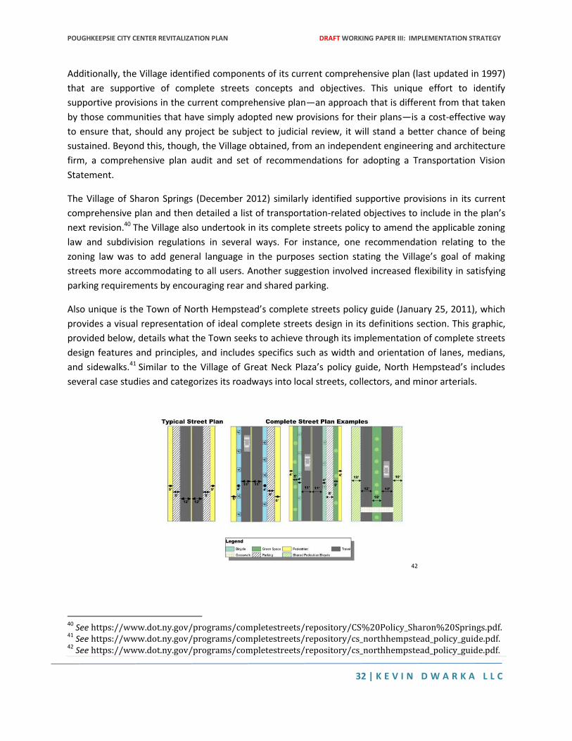
POUGHKEEPSIE CITY CENTER REVITALIZATION PLAN DRAFT WORKING PAPER III: IMPLEMENTATION STRATEGY
32 | K E V I N D W A R K A L L C
Additionally, the Village identified components of its current comprehensive plan (last updated in 1997)
that are supportive of complete streets concepts and objectives. This unique effort to identify
supportive provisions in the current comprehensive plan—an approach that is different from that taken
by those communities that have simply adopted new provisions for their plans—is a cost-effective way
to ensure that, should any project be subject to judicial review, it will stand a better chance of being
sustained. Beyond this, though, the Village obtained, from an independent engineering and architecture
firm, a comprehensive plan audit and set of recommendations for adopting a Transportation Vision
Statement.
The Village of Sharon Springs (December 2012) similarly identified supportive provisions in its current
comprehensive plan and then detailed a list of transportation-related objectives to include in the plan’s
next revision.40 The Village also undertook in its complete streets policy to amend the applicable zoning
law and subdivision regulations in several ways. For instance, one recommendation relating to the
zoning law was to add general language in the purposes section stating the Village’s goal of making
streets more accommodating to all users. Another suggestion involved increased flexibility in satisfying
parking requirements by encouraging rear and shared parking.
Also unique is the Town of North Hempstead’s complete streets policy guide (January 25, 2011), which
provides a visual representation of ideal complete streets design in its definitions section. This graphic,
provided below, details what the Town seeks to achieve through its implementation of complete streets
design features and principles, and includes specifics such as width and orientation of lanes, medians,
and sidewalks.41 Similar to the Village of Great Neck Plaza’s policy guide, North Hempstead’s includes
several case studies and categorizes its roadways into local streets, collectors, and minor arterials.
42
40
See https://www.dot.ny.gov/programs/completestreets/repository/CS%20Policy_Sharon%20Springs.pdf. 41
See https://www.dot.ny.gov/programs/completestreets/repository/cs_northhempstead_policy_guide.pdf. 42
See https://www.dot.ny.gov/programs/completestreets/repository/cs_northhempstead_policy_guide.pdf.
III. Definitions Complete Streets Complete streets are those designed and operated to accommodate all users, across a full range of transportation modes. Users must be able to travel safely along and across a complete street network. Ideal Cross Section The optimum number of travel lanes, paths and walkways, and their specific dimensions, for each functional classification of roadway and associated design speed. Examples of ideal cross sections: Roadway Network A multi-modal, integrated system of public thoroughfares that includes local and arterial roads (exclusive of limited-access highways), walkways, paths, trails and fixed-route transit corridors. Users Motorists, pedestrians, bicyclists, children, persons with disabilities, movers of commercial goods, and transit riders of all ages and abilities utilizing all modes of ground transportation.
Complete Streets Policy Guide Town of North Hempstead January 2011 New York
5
POUGHKEEPSIE CITY CENTER REVITALIZATION PLAN DRAFT WORKING PAPER III: IMPLEMENTATION STRATEGY
33 | K E V I N D W A R K A L L C
Further, the Town of North Hempstead has already obtained “Safe Routes to School” grants for several
projects and is committed to “vigorously pursue” additional federal, state, and local sources of funding.
The Village of Pittsford, like other localities, identifies among the chief concerns to be addressed by its
complete streets resolution (2011) is declining property values and loss of community charm.43 Because
Pittsford recognizes that “[p]leasant walkable streets are required to attract and sustain compatible
community development,” the Village adopted a complete streets component into its Comprehensive
Plan as early as 2002.
Recommendations Based on the above review of complete streets policies and resolutions in New York State, the author
makes the following recommendations to the City of Poughkeepsie for its planning and adoption of a
complete streets policy:
1. The City should conduct a comprehensive plan audit to determine which provisions currently
support complete streets policies and initiatives, and to identify where improvements can be made
to that plan. Once deficient areas have been identified, the plan must be supplemented with
language that sets forth the City’s desire to implement complete streets projects to achieve its
planning and development goals. For example, the following language would achieve this: “…to
ensure that the existing and future built environment promotes healthy active lifestyles, and
provides optimal transportation accessibility and choices for its residents and visitors.”44 Not only
does including a provision like this in the comprehensive plan help to insulate projects from attack in
court, but it also shows a level of coordination that can make applications for external funding more
competitive.
2. The City should incorporate a general statement of its complete streets policies and purposes into
the Zoning Code and Subdivision Regulations while those codes are currently being revised. This will
ensure that consideration of future projects takes into account whether they advance complete
streets policies and principles, and will more effectively lead to the benefits sought.
3. Similar to the City of New Rochelle, the City of Poughkeepsie should require a written explanation
for every decision to include or exclude complete streets design features into roadway projects.
Written rationales help to clarify objectives and costs, and allow the public to evaluate their
representatives’ decisions in a transparent way. Allowing this kind of stakeholder involvement
should help resolve any community opposition and make the policy effort more fruitful.
4. Instead of simply listing objectives and action steps without any reference to a timeframe, the City
should identify immediate, short-term, and long-term goals and action items. Breaking down these
43
See https://www.dot.ny.gov/programs/completestreets/repository/cs_resolution_pittsford.pdf. 44
See https://www.dot.ny.gov/programs/completestreets/repository/CS%20Policy_Scoharie.pdf.
POUGHKEEPSIE CITY CENTER REVITALIZATION PLAN DRAFT WORKING PAPER III: IMPLEMENTATION STRATEGY
34 | K E V I N D W A R K A L L C
efforts into more manageable pieces increases the likelihood of a successful outcome by eliminating
the appearance of overwhelmingly complex problems and solutions.
5. The City should include specific commitments to design features, including where applicable, street
and sidewalk dimensions, crosswalk lengths, parking distances and widths, and bump-out distances.
Providing details like this exhibits the feasibility of integrating these features into roadway projects
and thus increases the likelihood of their implementation.
6. When a complete streets policy is successful, motorists, cyclists, and pedestrians come into close
contact more frequently. Typically, cyclists and pedestrians are less closely policed than motorists,
but their failure to follow basic traffic safety laws (including, for example, stopping at red lights and
stop signs) endangers everyone. Therefore, Poughkeepsie should include an enforcement provision
in its complete streets policy committing to the equal enforcement of traffic laws. For instance, the
following language would achieve this objective: “The City of Poughkeepsie, in cooperation with
[insert cooperating law enforcement agencies] will encourage and promote a balanced enforcement
of the New York State Vehicle and Traffic Law for motorists, pedestrians, and cyclists. This will
include enforcement of, among other things, pedestrians’ right-of-way in crosswalks, cyclists riding
with traffic, and all modes sharing roadways safely.” This type of provision will engender community
support for complete streets by officially endorsing the notion that no one form of transportation
should be treated specially or differently with respect to safe and efficient maintenance of traffic
laws.
7. The City should include a provision in its policy requiring construction and maintenance of
pedestrian and cyclist facilities (including secure bicycle parking, lockers, and showers) in each
distinct transportation corridor, but allow flexibility in where these facilities are sited (for example,
through allowing placement in different corridors when facilities are prohibited by law in another).
This will promote cycling and walking to and from work, decrease vehicle miles travelled, and
contribute to the overall health and welfare of the community.
Conclusion Adopting and implementing complete streets policies is a trend in New York State that appears to be on
the rise. As recently as 2008, there were only three such policies in existence in the State; as of 2014,
there are over 60, with almost half of these being adopted in the last three years alone.45 This trend
reveals overwhelming opportunity to create positive change at the local level through implementation
of similar policies.
The City of Poughkeepsie is uniquely situated to capitalize on these opportunities by learning from those
programs that have already been developed and put into action. Many of the current New York State
45
New York Academy of Medicine, Center for Evaluation and Applied Research, An Evaluation of Complete Streets in New York State: An Assessment of Policies and Case Studies of Implementation, (Oct. 1, 2013), at 9.
POUGHKEEPSIE CITY CENTER REVITALIZATION PLAN DRAFT WORKING PAPER III: IMPLEMENTATION STRATEGY
35 | K E V I N D W A R K A L L C
complete streets policies do not include recommended performance measures to assess
implementation or next steps for implementation, and few provide education and training programs to
overcome negative attitudes in the community towards alternative methods of transportation. By
including specific implementation goals in the policy and educating the public during the process of
adopting it, the City can ensure future action on complete streets and avoid significant community
opposition and the costs associated with it. Most importantly, by exhibiting a commitment to a safer,
healthier, and more connected community, the City will position itself to receive state and federal
funding to carry out its mission.
POUGHKEEPSIE CITY CENTER REVITALIZATION PLAN DRAFT WORKING PAPER III: IMPLEMENTATION STRATEGY
36 | K E V I N D W A R K A L L C
APPENDIX C: ALTERNATIVE FINANING STRATEGIES FOR Transit and
Transit Oriented Development (Kevin Dwarka) [This article was prepared by Kevin Dwarka and originally published in the September 2013 edition of
the TOD Line ]
Transit agencies and municipalities throughout the United States have adopted value capture to offset
the public costs of transit infrastructure, maximize transit ridership, discourage automobile use, and
channel new affordable housing to areas within walking distance of a transit station. Presented below is
a description of the most widely considered value capture strategies and examples of the way they have
been enlisted in various TOD contexts.
Tax Increment Financing A widely used tool for redeveloping blighted areas is tax increment financing (“TIF”). TIF programs are
most commonly used to promote economic development in areas where a high number of distressed or
vacant properties cripples the city’s capacity to recover its ongoing operating costs through property
taxes. By capturing the value of future land appreciation, a TIF program aims to heighten the level of
public services in a given area while also helping a city become fiscally solvent.
Under this approach, a municipality designates a part of the city as a TIF district and enhances the area
with infrastructure improvements. The city finances these improvements by selling bonds that are
repaid by the higher property taxes that are collected in the TIF. However, not all of the property taxes
of a given property in a TIF are used to service the debt on the bonds. The city repays the bonds only
with the incremental increase in property tax that accrues as a result of the infrastructure investment.
The baseline amount of property tax that was collected prior to the improvements continues to flow to
the city’s general revenues. Upon the expiration of a TIF program, which can last as long as 20 to 30
years, the total amount of property tax assessed within the district goes back to the general revenues.
In this way, the benefits of the TIF program are not simply limited to the TIF district but eventually serve
to expand the tax base for the entire city.
Historically, TIF has not been used to fund transportation infrastructure. However, there are a few cities
that are currently using TIF to finance transit infrastructure and stimulate transit oriented development.
One notable example is Atlanta’s Beltline Redevelopment Plan approved in 2005 by the Atlanta City
Council, the Fulton County Board of Commissioners, and the Atlantic Public School Board of Education.
Aiming to redress decades of suburban sprawl and rising traffic congestion, the $2.8 billion Beltline
project envisions the building of almost 30,000 new housing units, 1.3 million square feet of retail space,
and 5.2 million square feet of industrial space in a 6,500 acre redevelopment district served by a 22 mile
looped rail corridor. Affordable housing is also a key part of the Beltline redevelopment strategy. Fifteen
percent of the bond funds must be used to finance a housing trust fund that will help finance more than
5,500 units of workforce housing.
POUGHKEEPSIE CITY CENTER REVITALIZATION PLAN DRAFT WORKING PAPER III: IMPLEMENTATION STRATEGY
37 | K E V I N D W A R K A L L C
The rail corridor will be built in the alignment of abandoned rail right-of-way. To fund the rail line along
with a host of other amenities including parks and trails, the Atlantic City Council approved the sale of
bonds that will be repaid from the incremental property tax collected from the new development in the
Beltline redevelopment area. The financing mechanism will stay in effect for 25 years after which all of
the property taxes in the redevelopment area will be channeled back into general revenues and split
between the city, county, and schools.
PILOTS Payments in Lieu of Taxes (or “PILOTS”) is a financing mechanism similar to tax increment financing. As
in a TIF district, the real property-revenues collected from a certain property are not absorbed into the
city’s general revenues. Instead, these funds are used to finance the project itself or its supporting
infrastructure. And also like a TIF district, a PILOT district can be created so that new development in a
given area is designated as a special financing district where real property revenue is channeled to
service the bond debt acquired to finance area improvements.
However, PILOT programs vary from TIF programs in two fundamental ways. First, the revenue collected
is not property tax per se but a substitute fee. In essence, the PILOT property becomes tax exempt but
subject to a tax equivalency payment that is lower than the amount the developer would have paid as a
property tax. As such, the PILOT is as much a tool for infrastructure finance as it is an incentive for
developers. Secondly, and more importantly, the total amount of the PILOT revenue is used to repay the
bonds. Under a TIF arrangement, only the incremental increase in property tax is captured for the
purposes of infrastructure financing.
The Hudson Yards Financing District (HYFD) is the best example of a PILOT program used to finance
transit and support transit-oriented development. In 2005, the New York City Council approved a
redevelopment plan for Manhattan’s far west side. Through a comprehensive rezoning as well as the
extension of a New York City subway line, the Hudson Yards plan entails the sale of development rights
for the area above open air rail yards as well as infill development throughout the surrounding area. At
buildout, this industrial underbuilt district will accommodate 26 million square feet of office space,
20,000 units of housing including 5,000 units of affordable housing, 2 million square feet of retail, and 3
million square feet of office space. All of this new development will occur within close proximity to
transit infrastructure including an extension of the #7 subway line, now under construction.
To finance the subway extension as well as other public realm improvements in the redevelopment
area, a newly created development corporation, the Hudson Yards Infrastructure Corporation (HYIC)
sold $3 billion in bonds with one issue of $2 billion in 2007 and another $1 billion issue in 2012. As part
of a complex financing program that also includes considerable city support from New York City’s
general revenues, PILOTs will eventually be used to repay these bonds. Under the Hudson Yards PILOT
program, certain qualifying commercial properties within the HYFD can apply to the New York City
POUGHKEEPSIE CITY CENTER REVITALIZATION PLAN DRAFT WORKING PAPER III: IMPLEMENTATION STRATEGY
38 | K E V I N D W A R K A L L C
Industrial Development Agency (IDA) in order to contribute PILOTs instead of property taxes. The
monies collected by the IDA would then be appropriated by the HYIC to repay the debt.
So far, however, no PILOT revenue has been used to service the bonds. In order for an office building to
qualify for inclusion in the PILOT program, it must be 1 million square feet in size, dedicate 75% of its
usable space to Class A office space or other commercial uses, and utilize 90% of its allowable floor area
ratio. The first building to meet these qualifications will be an office tower built by the Related Company
on the Eastern Rail Yards. Based upon the current construction schedule, PILOTS for this first building
will not be collected for another four or five years.
District Improvement Funds The success of TIF and PILOT programs are contingent upon the real estate market. If the market is
sluggish or land value increases are overestimated, then the public sector may end up having to dip into
its general revenues in order to service its debt. An alternative value capture approach that does not
involve this type of risk is the District Improvement Fund (DIF). Under a DIF program, developers
contribute to a special fund in exchange for the right to build new projects at a greater density than
would be permissible under the existing zoning code. The revenue that accumulates in the fund is then
used for improvements such as transit and pedestrian infrastructure to accommodate the increased
densification resulting from the upzoning.
Along with PILOTS, DIF is another financing strategy enlisted for Hudson Yards. Under the 2005 rezoning
for the area, developers were authorized to build additional floor area space if they contributed to a DIF.
This provision not only incentivized developers to build community facilities as part of their new projects
but also enabled the construction of taller building heights, an especially valuable premium for the sale
of top floor luxury apartments. The cost for participating in the Hudson Yards DIF program was initially
set in 2005 at $100 dollars a square foot but has since risen to $120 per square foot in accordance with
annual increases in the consumer price index. So far, the HYIC has collected more than $88 million in
revenue through the DIF program.
A DIF is also proposed as part of the planned rezoning of Manhattan’s East Midtown including the area
between East 39th Street to the south, East 57th street to the north, Second and Third Avenue to the
east, and Fifth Avenue to the west. Currently winding its way through the city’s land review process, the
proposed rezoning would enable the replacement of the area’s older office buildings with large floor-
plate Class A office buildings built at a higher scale than permissible under the current zoning resolution.
Developers would pay $250 per square foot for the additional air rights that would be made available on
certain qualifying sites as of right or by special permit depending on location and the degree of density
bonus. The sale of the air rights presumes the demolition of existing buildings and their replacement
with new higher buildings rather than the construction of rooftop additions.
POUGHKEEPSIE CITY CENTER REVITALIZATION PLAN DRAFT WORKING PAPER III: IMPLEMENTATION STRATEGY
39 | K E V I N D W A R K A L L C
While the district improvement funds for Hudson Yards and East Midtown appear be a safer financing
strategy than the issuance of bonds, the incremental aspect of this strategy carries its own risks. The
already high rates of congestion in Midtown East’s transit facilities and pedestrian infrastructure have
raised concerns that the district improvement funds may not generate a sufficient amount of revenue to
cover the costs of the improvements necessary in the immediate as well as in the long-term.
Special Assessment Districts Another way that municipalities might think about recovering the infrastructure costs associated with
TOD programs would be through impact fees. Whether as part of the building permit process or as an
environmental mitigation, a transportation impact fee could be assessed on the basis of a new project’s
scale or location. These fees could be used to help offset the costs associated with the additional transit
service and infrastructure required to support a new project. Alternatively, transportation impact fees
could be designed in a way that incentivizes TOD by assessing a higher impact fee for lower density
developments and a lower impact fee for higher density and more transit oriented developments. In
general, however, transportation impact fees are rarely used in the United States for a combination of
legal and administrative reasons. Though places like San Francisco and Orlando have successfully
implemented such fees, most municipalities have steered clear of them and instead pursued alternative
approaches to recovering infrastructure costs. One such alternative approach is the special assessment
district (SAD).
In a SAD, a city assesses a tax on properties receiving a direct benefit from a certain infrastructure
improvement. The amount of the special assessment (sometimes called a betterment levy) corresponds
with the degree of benefit that accrues to a certain property. What distinguishes special assessment
districts from impact fees is that they are created with the support of the property owners themselves.
The enabling legislation for SADs typically requires that certain percentage of property owners in the
SAD district agree to be taxed in order to reap the benefits of a proposed public improvement. The SAD
concept does not necessarily require a major capital infrastructure project. Business Improvement
Districts (BID) in many cities have also embraced the special assessment concept in order to pay for the
operating and maintenance costs associated with street improvements and beautification projects along
major commercial corridors.
A good example of a SAD is the Dulles Metrorail expansion in Washington D.C. The 23 mile extension of
the Metrorail system to serve the rapidly growing Dulles Corridor is being financed in part by a special
assessment against commercial landowners along the corridor. The SAD was created because a
sufficient percentage of landowners petitioned the Virginia Board of Supervisors to assess the tax, which
rises to as much as 22 cents per $100 dollar of assessed property value. The revenues raised by the SAD
helps not only to service the debt acquired to finance the extension but also serves as the required local
match for securing federal funding.
POUGHKEEPSIE CITY CENTER REVITALIZATION PLAN DRAFT WORKING PAPER III: IMPLEMENTATION STRATEGY
40 | K E V I N D W A R K A L L C
Conclusion Value capture strategies are not risk-free nor are they necessarily simple to design. Before embarking
upon a value capture approach to TOD finance, cities need to make difficult projections about future
land use values. The best projections are still subject to the inherent volatility of real estate markets no
matter how well documented are the positive effects of transit access on land values. On the other
hand, value capture is as much of a conceptual planning framework as it is a financing strategy. Simply
by examining the possibility for financing transit through land use appreciation, cities not only uncover
potential funding sources but also arrive at new ways of tightening the linkage between transit
investment and land use planning.
KEVIN DWARKA LAND USE AND ECONOMIC CONSULTING | 40 WALL STREET – 28th FLOOR, NY NY 10005| 646.512.5693| [email protected]
FIRM PROFILE
Kevin Dwarka LLC is a land use and economic consulting firm specializing in transit-oriented
development. Headquartered on Wall Street, KDLLC provides legal guidance and quantitative analysis to
real estate developers, municipalities, housing authorities, community development corporations,
transit agencies, law firms, architects, and building contractors. The firm is managed by Dr. Kevin
Dwarka, a Senior Fellow at Pace Land Use Law Center. Prior to forming his consultancy, Kevin held senior
positions at the Israel Union for Environmental Defense, New York City Transit, and Nelson Nygaard
Consulting Associates.
KDLLC’s land use services include zoning analysis, site selection, development approvals, environmental
review, and right-way acquisition for transit infrastructure projects. Versed in all aspects of the New
York City land use approvals process, the firm helps builders navigate the complex web of land use
regulations enforced by the New York City Department of City Planning, Board of Standards and
Appeals, the Department of Buildings, and the Landmarks Preservation Commission.
Economic consulting services include real estate market analysis, affordable housing finance,
infrastructure benefit-cost analysis, financial feasibility analysis for TOD redevelopment projects, and
transit economic impact studies. Current projects include the Newburgh Broadway Corridor Access Plan;
the Newburgh Land Use and Market Analysis; the Newburgh Neighborhood Redevelopment Plan, the
Newburgh Waterfront Mobility and Access Strategy; the Poughkeepsie City Center Revitalization Plan,
the Poughkeepsie Waterfront Redevelopment Strategy; and the Ridgefield Economic Development
Strategic Plan.
KDLLC also provides a full suite of litigation support services including expert testimony, real property
valuation, and technical analysis of land use, traffic, and environmental impact documents. Kevin also
helps mediate community land use disputes through consensus building and conflict resolution
strategies.
Since 2010, Kevin has served as an Adjunct Professor at Baruch College, where he has taught land use,
urban economic development, and environmental policy. He also teaches Israeli Politics at Yeshiva
University. His dissertation at Hebrew University in Jerusalem, examined the use of global capital and
public private partnerships for financing light rail projects in Israel, the United Kingdom, and the United
States. He received his BA from Columbia University, JD from Pace Law School, MCP from UC Berkeley,
and PhD from Hebrew University. Kevin is admitted to practice before the New York State Bar and
serves on the New York City Bar Association’s Housing and Urban Development Committee. He also
serves on the board of the New York chapter of the Congress for New Urbanism.