Embed Size (px)
Citation preview
Poughkeepsie City Center Multi-Modal Transportation Existing Conditions Report
Prepared for the City of Poughkeepsie
Prepared by Sam Schwartz Engineering, DPC
February 10, 2017
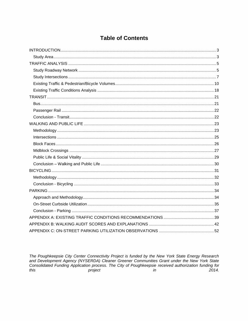
Table of Contents
INTRODUCTION ........................................................................................................................................... 3
Study Area ................................................................................................................................................. 3
TRAFFIC ANALYSIS .................................................................................................................................... 5
Study Roadway Network ........................................................................................................................... 5
Study Intersections .................................................................................................................................... 7
Existing Traffic & Pedestrian/Bicycle Volumes ........................................................................................ 10
Existing Traffic Conditions Analysis ........................................................................................................ 18
TRANSIT ..................................................................................................................................................... 21
Bus ........................................................................................................................................................... 21
Passenger Rail ........................................................................................................................................ 22
Conclusion - Transit ................................................................................................................................. 22
WALKING AND PUBLIC LIFE .................................................................................................................... 23
Methodology ............................................................................................................................................ 23
Intersections ............................................................................................................................................ 25
Block Faces ............................................................................................................................................. 26
Midblock Crossings ................................................................................................................................. 27
Public Life & Social Vitality ...................................................................................................................... 29
Conclusion – Walking and Public Life ..................................................................................................... 30
BICYCLING ................................................................................................................................................. 31
Methodology ............................................................................................................................................ 32
Conclusion - Bicycling ............................................................................................................................. 33
PARKING .................................................................................................................................................... 34
Approach and Methodology..................................................................................................................... 34
On-Street Curbside Utilization ................................................................................................................. 35
Conclusion - Parking ............................................................................................................................... 37
APPENDIX A: EXISTING TRAFFIC CONDITIONS RECOMMENDATIONS ............................................. 39
APPENDIX B: WALKING AUDIT SCORES AND EXPLANATIONS .......................................................... 42
APPENDIX C: ON-STREET PARKING UTILIZATION OBSERVATIONS ................................................. 52
The Poughkeepsie City Center Connectivity Project is funded by the New York State Energy Research and Development Agency (NYSERDA) Cleaner Greener Communities Grant under the New York State Consolidated Funding Application process. The City of Poughkeepsie received authorization funding for this project in 2014.
Poughkeepsie City Center Multi-Modal Transportation Existing Conditions Report Page 3 of 54
INTRODUCTION
Sam Schwartz, in partnership with Street Plans Collaborative, was hired by the City of Poughkeepsie to assist in performing traffic engineering analysis for a complete streets initiative in the downtown area. This is part of a long-term transportation planning initiative closely linked with the city’s broader efforts to revitalize its downtown and promote transit-oriented economic development. The following Existing Conditions Report documents and assesses how well the current transportation network in downtown Poughkeepsie works for a range of users. The results of the Existing Conditions Report will inform the development of alternative design scenarios, as well as establish a baseline against which the proposed alternative scenarios can be measured and evaluated.
Study Area
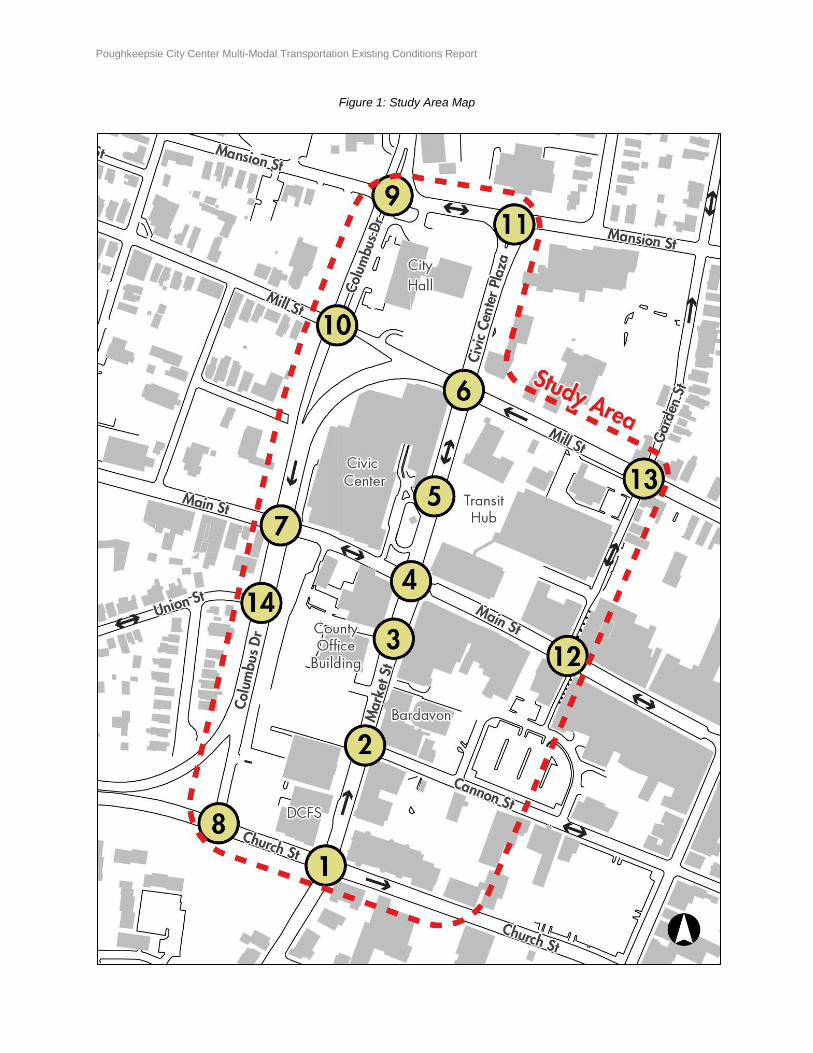
Market Street and Main Street are the primary commercial streets and center for business in downtown, and are home to a range of local retail and City and County office buildings. City Center is often described as being cut off from the rest of Poughkeepsie by Mill Street to the north, Church Street to the south, and Columbus Drive to the west. These streets, which are under the jurisdiction of the New York State Department of Transportation (NYSDOT), are collectively known as the East-West Arterials, or colloquially as just the Arterials. Completed in 1979, the arterials are generally three lanes of one-way traffic with signal timings that are designed to maximize vehicular traffic through Poughkeepsie east to Routes 44 and 55 and west to Route 9 and the Mid-Hudson Bridge. The project’s primary study area (the “Study Area”) is roughly bounded by Mansion Street to the north, Church Street to the south, Garden Street to the east, and Columbus Drive to the west, as depicted in Figure 1. While the primary focus of this study is on the Study Area, and in particular Market Street and the East-West Arterials, some analyses look at a broader area to include connections to local destinations such as the Walkway Over the Hudson or the train station. Intersections included in the scope of this report are numbered 1 through 14 in Figure 1.
Poughkeepsie City Center Multi-Modal Transportation Existing Conditions Report Page 4 of 54
Figure 1: Study Area Map
Poughkeepsie City Center Multi-Modal Transportation Existing Conditions Report Page 5 of 54
TRAFFIC ANALYSIS
Study Roadway Network
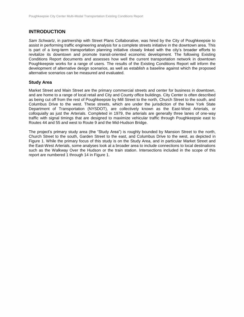
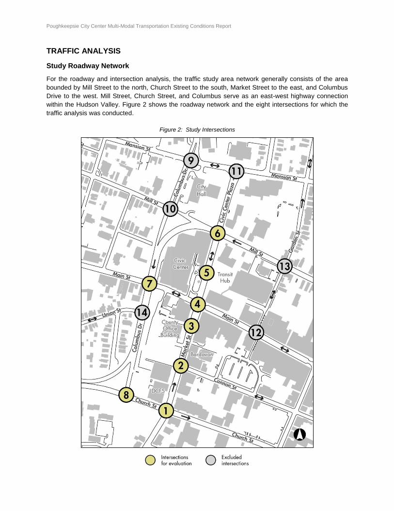
For the roadway and intersection analysis, the traffic study area network generally consists of the area
bounded by Mill Street to the north, Church Street to the south, Market Street to the east, and Columbus
Drive to the west. Mill Street, Church Street, and Columbus serve as an east-west highway connection
within the Hudson Valley. Figure 2 shows the roadway network and the eight intersections for which the
traffic analysis was conducted.
Figure 2: Study Intersections
Poughkeepsie City Center Multi-Modal Transportation Existing Conditions Report Page 6 of 54
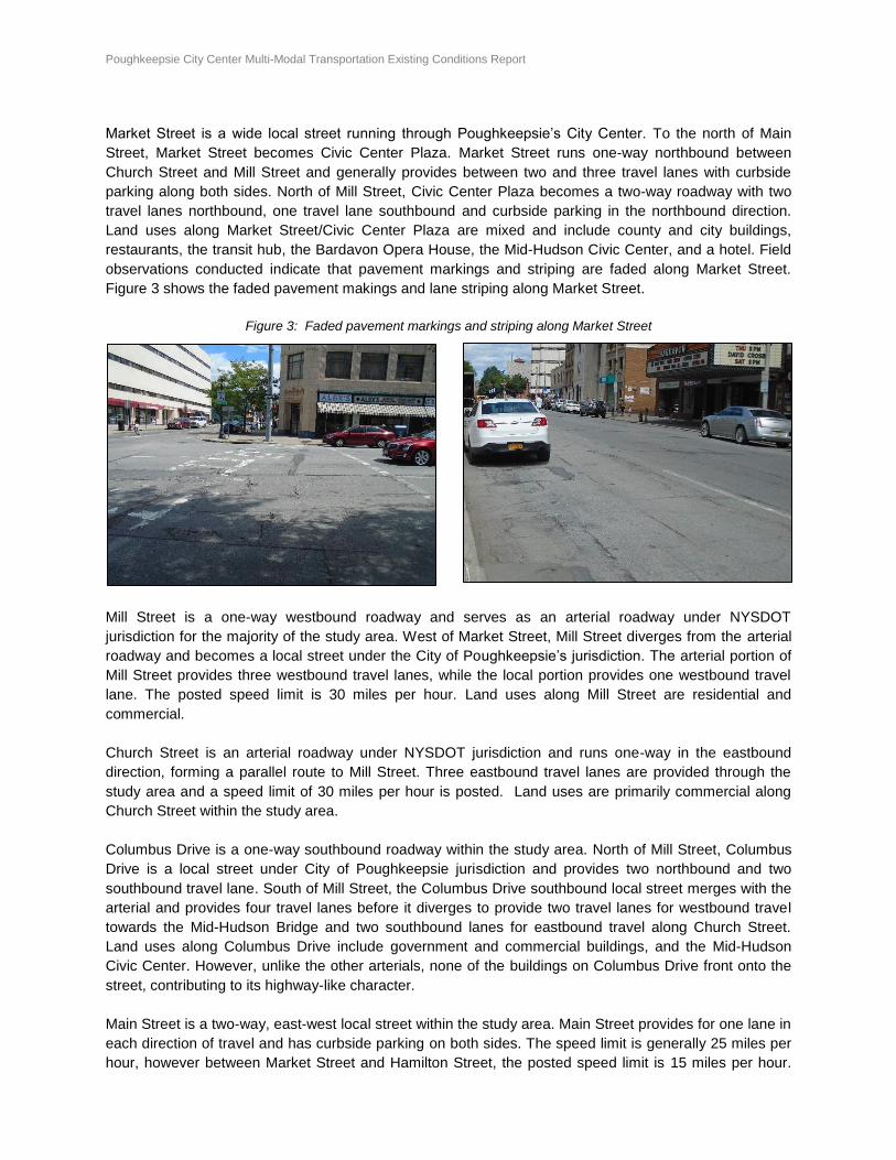
Market Street is a wide local street running through Poughkeepsie’s City Center. To the north of Main
Street, Market Street becomes Civic Center Plaza. Market Street runs one-way northbound between
Church Street and Mill Street and generally provides between two and three travel lanes with curbside
parking along both sides. North of Mill Street, Civic Center Plaza becomes a two-way roadway with two
travel lanes northbound, one travel lane southbound and curbside parking in the northbound direction.
Land uses along Market Street/Civic Center Plaza are mixed and include county and city buildings,
restaurants, the transit hub, the Bardavon Opera House, the Mid-Hudson Civic Center, and a hotel. Field
observations conducted indicate that pavement markings and striping are faded along Market Street.
Figure 3 shows the faded pavement makings and lane striping along Market Street.
Figure 3: Faded pavement markings and striping along Market Street
Mill Street is a one-way westbound roadway and serves as an arterial roadway under NYSDOT
jurisdiction for the majority of the study area. West of Market Street, Mill Street diverges from the arterial
roadway and becomes a local street under the City of Poughkeepsie’s jurisdiction. The arterial portion of
Mill Street provides three westbound travel lanes, while the local portion provides one westbound travel
lane. The posted speed limit is 30 miles per hour. Land uses along Mill Street are residential and
commercial.
Church Street is an arterial roadway under NYSDOT jurisdiction and runs one-way in the eastbound
direction, forming a parallel route to Mill Street. Three eastbound travel lanes are provided through the
study area and a speed limit of 30 miles per hour is posted. Land uses are primarily commercial along
Church Street within the study area.
Columbus Drive is a one-way southbound roadway within the study area. North of Mill Street, Columbus
Drive is a local street under City of Poughkeepsie jurisdiction and provides two northbound and two
southbound travel lane. South of Mill Street, the Columbus Drive southbound local street merges with the
arterial and provides four travel lanes before it diverges to provide two travel lanes for westbound travel
towards the Mid-Hudson Bridge and two southbound lanes for eastbound travel along Church Street.
Land uses along Columbus Drive include government and commercial buildings, and the Mid-Hudson
Civic Center. However, unlike the other arterials, none of the buildings on Columbus Drive front onto the
street, contributing to its highway-like character.
Main Street is a two-way, east-west local street within the study area. Main Street provides for one lane in
each direction of travel and has curbside parking on both sides. The speed limit is generally 25 miles per
hour, however between Market Street and Hamilton Street, the posted speed limit is 15 miles per hour.
Poughkeepsie City Center Multi-Modal Transportation Existing Conditions Report Page 7 of 54
Land uses are mixed along Main Street, with a variety of local retail on the ground floor and offices above
that.
Cannon Street is an east-west local roadway with one lane in each direction. Parking is not provided
along Cannon Street, however several large parking lots are located along Cannon Street to the east of
Market Street. Land uses are mixed along Cannon Street.
Study Intersections
There are eight (8) study intersections including the following:
(1) Market Street at Church Street
(2) Market Street at Cannon Street
(3) Market Street at County Office Building Driveway
(4) Market Street at Main Street
(5) Market Street at Hotel Entrance Driveway/Transit Hub Exit Driveway
(6) Market Street at Mill Street
(7) Columbus Drive at Main Street
(8) Columbus Drive at Church Street
Intersection 1: Church Street intersects Market Street to form a four-leg signalized intersection. The
eastbound Church Street approach provides a shared left-turn/through lane, through lane, and shared
through/right-turn lane. The northbound Market Street approach provides for one shared through/right-
turn lane. Ladder-type painted crosswalks are provided for all approach crossings.
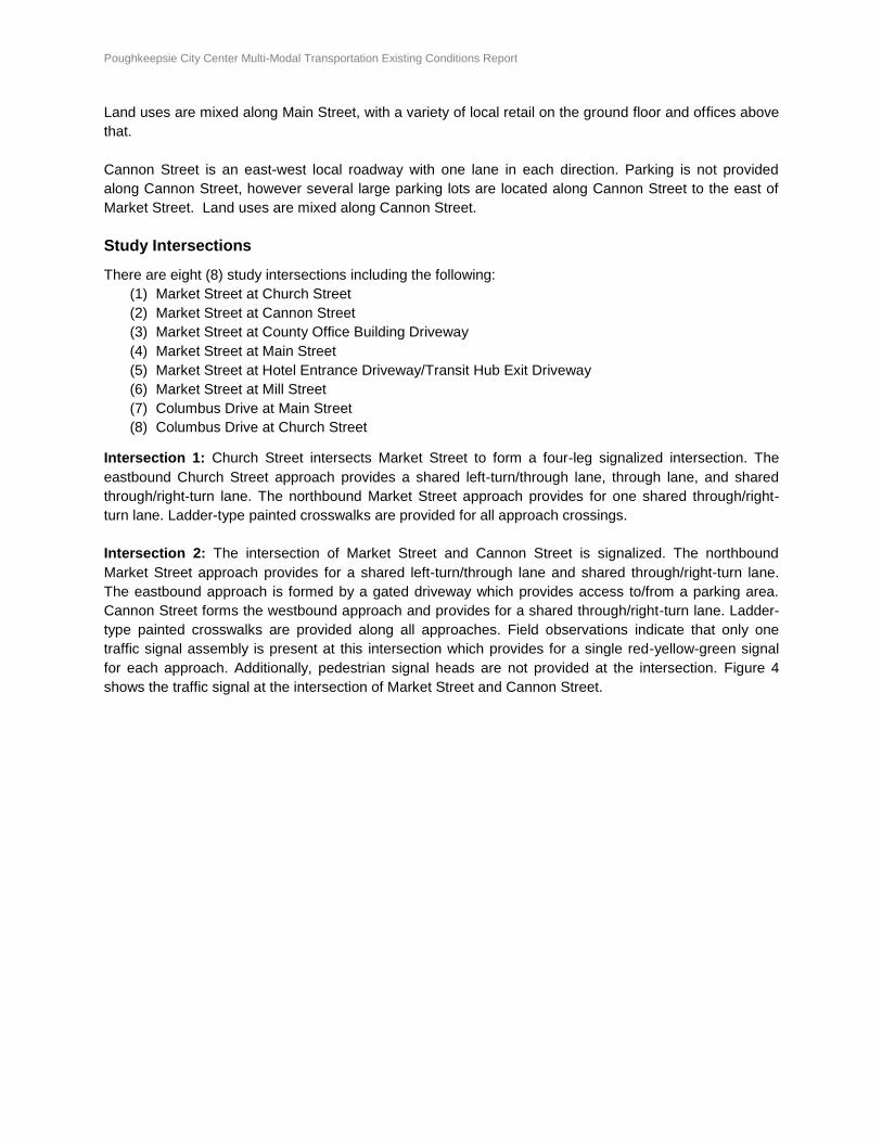
Intersection 2: The intersection of Market Street and Cannon Street is signalized. The northbound
Market Street approach provides for a shared left-turn/through lane and shared through/right-turn lane.
The eastbound approach is formed by a gated driveway which provides access to/from a parking area.
Cannon Street forms the westbound approach and provides for a shared through/right-turn lane. Ladder-
type painted crosswalks are provided along all approaches. Field observations indicate that only one
traffic signal assembly is present at this intersection which provides for a single red-yellow-green signal
for each approach. Additionally, pedestrian signal heads are not provided at the intersection. Figure 4
shows the traffic signal at the intersection of Market Street and Cannon Street.
Poughkeepsie City Center Multi-Modal Transportation Existing Conditions Report Page 8 of 54
Figure 4: Single Red-Yellow-Green Traffic Signal at Market Street and Cannon Street Intersection (Intersection 2)
Intersection 3: The intersection of Market Street and the County Office Building driveway is an
unsignalized, three-leg intersection. The northbound Market Street approach provides for a shared left-
turn/through lane and through lane. The County Office Building ingress/egress driveway forms the
eastbound approach and provides for left-turn movements only from the driveway. No crosswalks are
provided at this intersection.
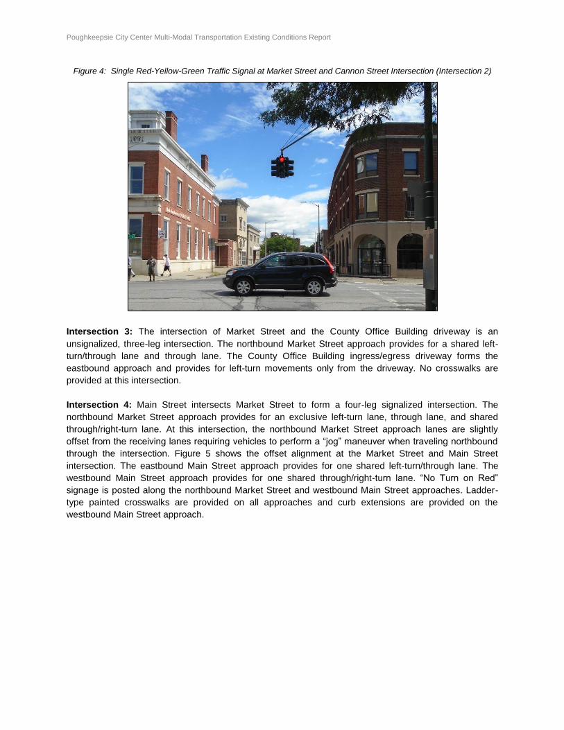
Intersection 4: Main Street intersects Market Street to form a four-leg signalized intersection. The
northbound Market Street approach provides for an exclusive left-turn lane, through lane, and shared
through/right-turn lane. At this intersection, the northbound Market Street approach lanes are slightly
offset from the receiving lanes requiring vehicles to perform a “jog” maneuver when traveling northbound
through the intersection. Figure 5 shows the offset alignment at the Market Street and Main Street
intersection. The eastbound Main Street approach provides for one shared left-turn/through lane. The
westbound Main Street approach provides for one shared through/right-turn lane. “No Turn on Red”
signage is posted along the northbound Market Street and westbound Main Street approaches. Ladder-
type painted crosswalks are provided on all approaches and curb extensions are provided on the
westbound Main Street approach.
Poughkeepsie City Center Multi-Modal Transportation Existing Conditions Report Page 9 of 54
Figure 5: Offset Northbound Market Street Approach & Receiving Lanes at Main Street Intersection (Intersection 4)
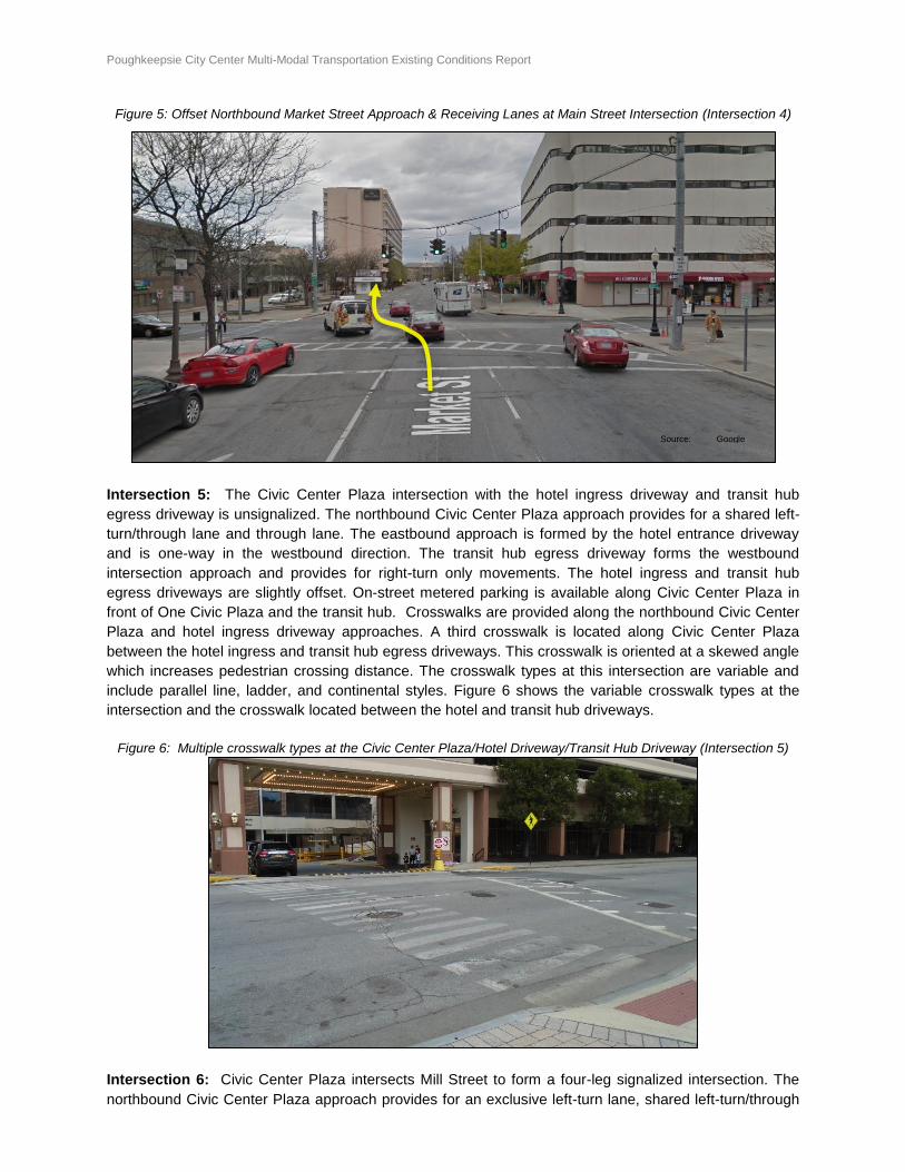
Intersection 5: The Civic Center Plaza intersection with the hotel ingress driveway and transit hub
egress driveway is unsignalized. The northbound Civic Center Plaza approach provides for a shared left-
turn/through lane and through lane. The eastbound approach is formed by the hotel entrance driveway
and is one-way in the westbound direction. The transit hub egress driveway forms the westbound
intersection approach and provides for right-turn only movements. The hotel ingress and transit hub
egress driveways are slightly offset. On-street metered parking is available along Civic Center Plaza in
front of One Civic Plaza and the transit hub. Crosswalks are provided along the northbound Civic Center
Plaza and hotel ingress driveway approaches. A third crosswalk is located along Civic Center Plaza
between the hotel ingress and transit hub egress driveways. This crosswalk is oriented at a skewed angle
which increases pedestrian crossing distance. The crosswalk types at this intersection are variable and
include parallel line, ladder, and continental styles. Figure 6 shows the variable crosswalk types at the
intersection and the crosswalk located between the hotel and transit hub driveways.
Figure 6: Multiple crosswalk types at the Civic Center Plaza/Hotel Driveway/Transit Hub Driveway (Intersection 5)
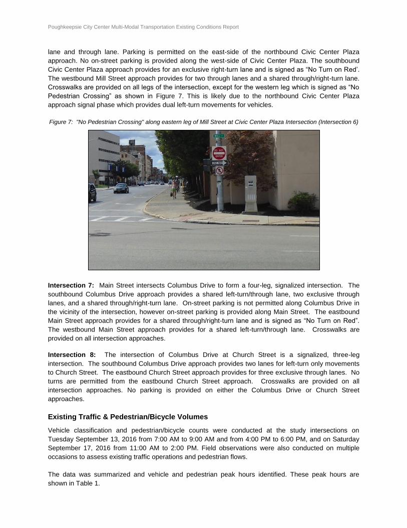
Intersection 6: Civic Center Plaza intersects Mill Street to form a four-leg signalized intersection. The
northbound Civic Center Plaza approach provides for an exclusive left-turn lane, shared left-turn/through
Source: Google Earth
Poughkeepsie City Center Multi-Modal Transportation Existing Conditions Report Page 10 of 54
lane and through lane. Parking is permitted on the east-side of the northbound Civic Center Plaza
approach. No on-street parking is provided along the west-side of Civic Center Plaza. The southbound
Civic Center Plaza approach provides for an exclusive right-turn lane and is signed as “No Turn on Red’.
The westbound Mill Street approach provides for two through lanes and a shared through/right-turn lane.
Crosswalks are provided on all legs of the intersection, except for the western leg which is signed as “No
Pedestrian Crossing” as shown in Figure 7. This is likely due to the northbound Civic Center Plaza
approach signal phase which provides dual left-turn movements for vehicles.
Figure 7: "No Pedestrian Crossing" along eastern leg of Mill Street at Civic Center Plaza Intersection (Intersection 6)
Intersection 7: Main Street intersects Columbus Drive to form a four-leg, signalized intersection. The
southbound Columbus Drive approach provides a shared left-turn/through lane, two exclusive through
lanes, and a shared through/right-turn lane. On-street parking is not permitted along Columbus Drive in
the vicinity of the intersection, however on-street parking is provided along Main Street. The eastbound
Main Street approach provides for a shared through/right-turn lane and is signed as “No Turn on Red”.
The westbound Main Street approach provides for a shared left-turn/through lane. Crosswalks are
provided on all intersection approaches.
Intersection 8: The intersection of Columbus Drive at Church Street is a signalized, three-leg
intersection. The southbound Columbus Drive approach provides two lanes for left-turn only movements
to Church Street. The eastbound Church Street approach provides for three exclusive through lanes. No
turns are permitted from the eastbound Church Street approach. Crosswalks are provided on all
intersection approaches. No parking is provided on either the Columbus Drive or Church Street
approaches.
Existing Traffic & Pedestrian/Bicycle Volumes
Vehicle classification and pedestrian/bicycle counts were conducted at the study intersections on
Tuesday September 13, 2016 from 7:00 AM to 9:00 AM and from 4:00 PM to 6:00 PM, and on Saturday
September 17, 2016 from 11:00 AM to 2:00 PM. Field observations were also conducted on multiple
occasions to assess existing traffic operations and pedestrian flows.
The data was summarized and vehicle and pedestrian peak hours identified. These peak hours are
shown in Table 1.
Poughkeepsie City Center Multi-Modal Transportation Existing Conditions Report Page 11 of 54
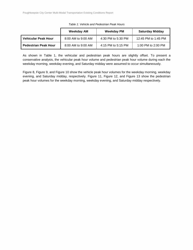
Table 1: Vehicle and Pedestrian Peak Hours
Weekday AM Weekday PM Saturday Midday
Vehicular Peak Hour 8:00 AM to 9:00 AM 4:30 PM to 5:30 PM 12:45 PM to 1:45 PM
Pedestrian Peak Hour 8:00 AM to 9:00 AM 4:15 PM to 5:15 PM 1:00 PM to 2:00 PM
As shown in Table 1, the vehicular and pedestrian peak hours are slightly offset. To present a
conservative analysis, the vehicular peak hour volume and pedestrian peak hour volume during each the
weekday morning, weekday evening, and Saturday midday were assumed to occur simultaneously.
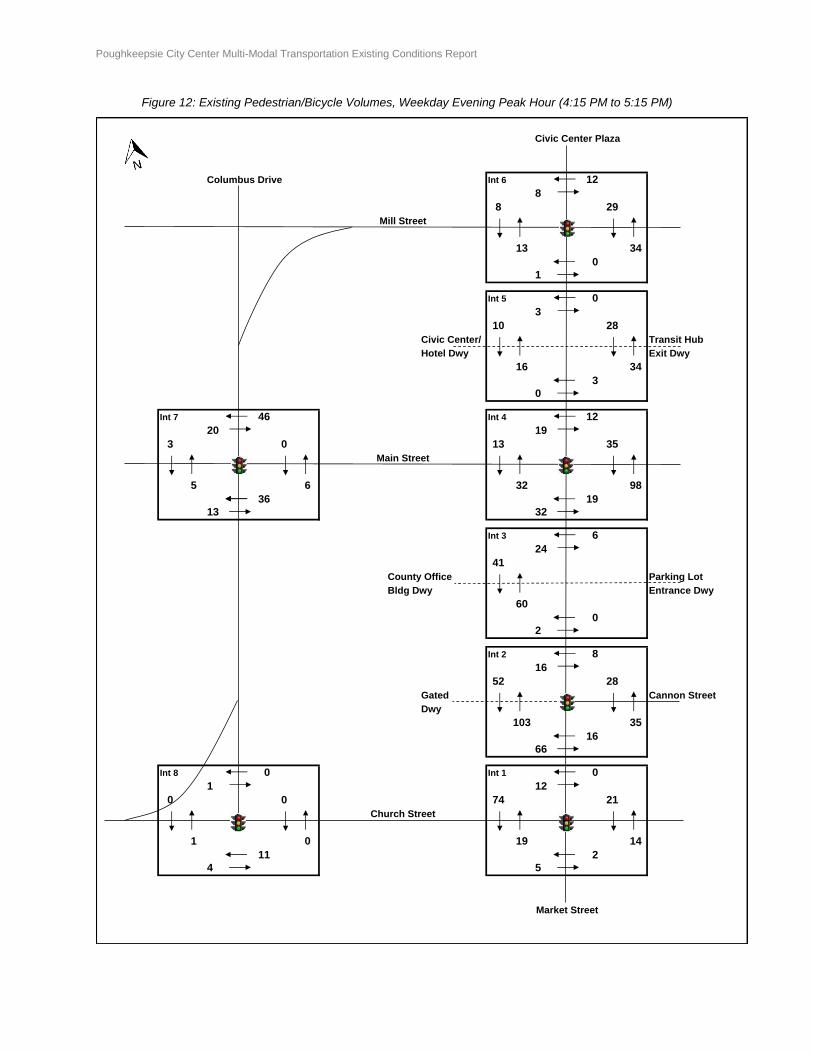
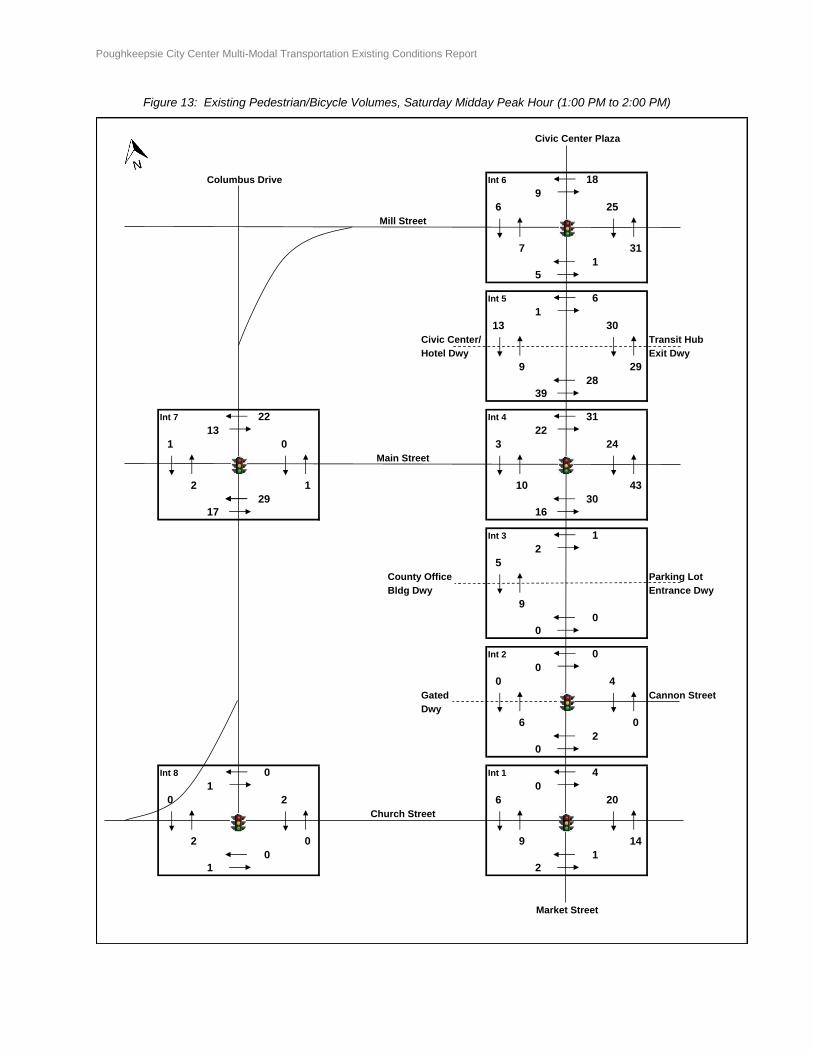
Figure 8, Figure 9, and Figure 10 show the vehicle peak hour volumes for the weekday morning, weekday
evening, and Saturday midday, respectively. Figure 11, Figure 12, and Figure 13 show the pedestrian
peak hour volumes for the weekday morning, weekday evening, and Saturday midday respectively.

Poughkeepsie City Center Multi-Modal Transportation Existing Conditions Report Page 12 of 54
Figure 8: Existing Traffic Volumes, Weekday Morning Peak Hour (8:00 to 9:00 AM)
Civic Center Plaza
Columbus Drive
102
135
630 Mill Street 1508
1120
140 227
400
21
Civic Center/ 0 Transit Hub
Hotel Dwy Exit Dwy
0 346
123 1284 113 82
94 58
Main Street 107
124
67 131
106 69 378 56
County Office Parking Lot
Bldg Dwy Entrance Dwy
6
0 22 535 0
52
Gated 13 Cannon Street
Dwy
1
924 1 18 504 72
521
Church Street
1643
414
1531 180 103
219
Market Street
Int 4
Int 5
Int 6
Int 7
Int 8 Int 1
Int 2
Int 3
Poughkeepsie City Center Multi-Modal Transportation Existing Conditions Report Page 13 of 54
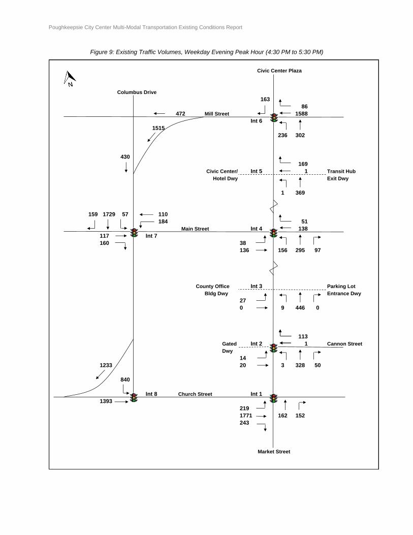
Figure 9: Existing Traffic Volumes, Weekday Evening Peak Hour (4:30 PM to 5:30 PM)
Civic Center Plaza
Columbus Drive
163
86
472 Mill Street 1588
1515
236 302
430
169
Civic Center/ 1 Transit Hub
Hotel Dwy Exit Dwy
1 369
159 1729 57 110
184 51
Main Street 138
117
160 38
136 156 295 97
County Office Parking Lot
Bldg Dwy Entrance Dwy
27
0 9 446 0
113
Gated 1 Cannon Street
Dwy
14
1233 20 3 328 50
840
Church Street
1393
219
1771 162 152
243
Market Street
Int 4
Int 5
Int 6
Int 7
Int 8 Int 1
Int 2
Int 3
Poughkeepsie City Center Multi-Modal Transportation Existing Conditions Report Page 14 of 54
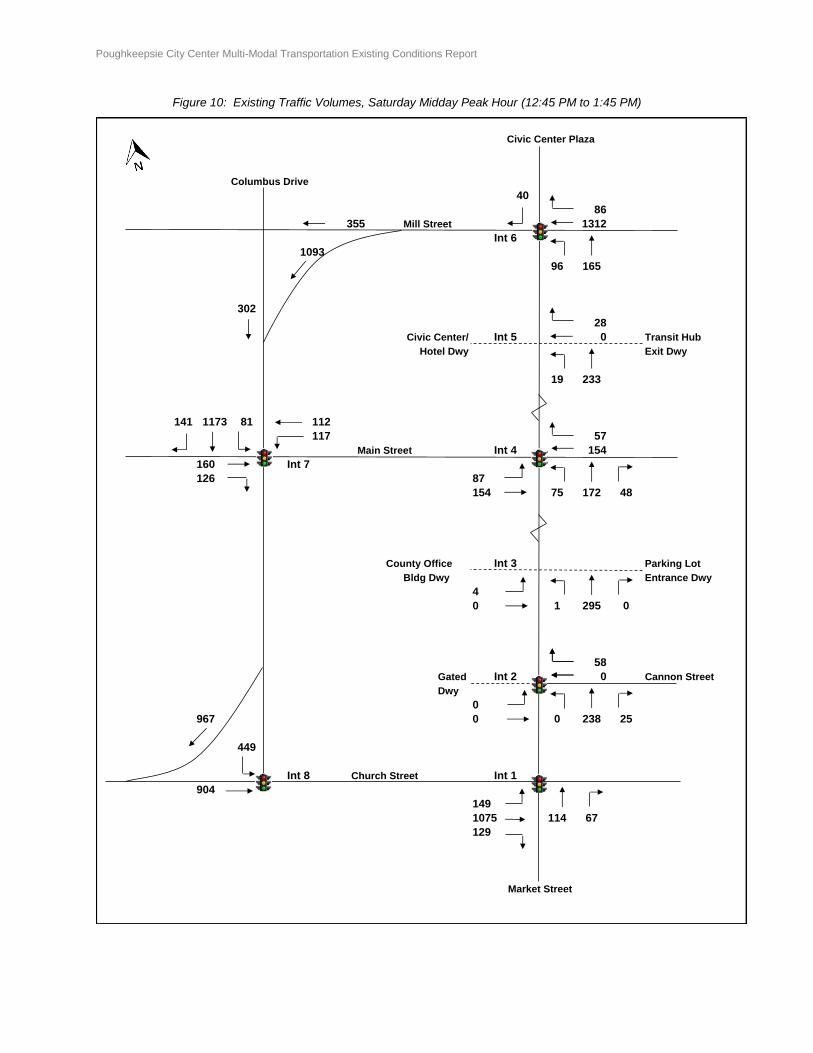
Figure 10: Existing Traffic Volumes, Saturday Midday Peak Hour (12:45 PM to 1:45 PM)
Civic Center Plaza
Columbus Drive
40
86
355 Mill Street 1312
1093
96 165
302
28
Civic Center/ 0 Transit Hub
Hotel Dwy Exit Dwy
19 233
141 1173 81 112
117 57
Main Street 154
160
126 87
154 75 172 48
County Office Parking Lot
Bldg Dwy Entrance Dwy
4
0 1 295 0
58
Gated 0 Cannon Street
Dwy
0
967 0 0 238 25
449
Church Street
904
149
1075 114 67
129
Market Street
Int 4
Int 5
Int 6
Int 7
Int 8 Int 1
Int 2
Int 3

Poughkeepsie City Center Multi-Modal Transportation Existing Conditions Report Page 15 of 54
Figure 11: Existing Pedestrian/Bicycle Volumes, Weekday Morning Peak Hour (8:00 AM to 9:00 AM)
Civic Center Plaza
Columbus Drive Int 6 7
12
2 39
Mill Street
7 30
1
4
Int 5 4
0
6 35
Civic Center/ Transit Hub
Hotel Dwy Exit Dwy
12 31
5
8
Int 7 13 Int 4 27
48 23
7 7 22 121
Main Street
2 1 11 36
15 29
20 9
Int 3 40
8
22
County Office Parking Lot
Bldg Dwy Entrance Dwy
33
12
7
Int 2 13
7
49 47
Gated Cannon Street
Dwy
38 17
49
3
Int 8 0 Int 1 68
0 1
1 1 16 10
Church Street
0 0 54 13
3 0
5 2
Market Street
Poughkeepsie City Center Multi-Modal Transportation Existing Conditions Report Page 16 of 54
Figure 12: Existing Pedestrian/Bicycle Volumes, Weekday Evening Peak Hour (4:15 PM to 5:15 PM)
Civic Center Plaza
Columbus Drive Int 6 12
8
8 29
Mill Street
13 34
0
1
Int 5 0
3
10 28
Civic Center/ Transit Hub
Hotel Dwy Exit Dwy
16 34
3
0
Int 7 46 Int 4 12
20 19
3 0 13 35
Main Street
5 6 32 98
36 19
13 32
Int 3 6
24
41
County Office Parking Lot
Bldg Dwy Entrance Dwy
60
0
2
Int 2 8
16
52 28
Gated Cannon Street
Dwy
103 35
16
66
Int 8 0 Int 1 0
1 12
0 0 74 21
Church Street
1 0 19 14
11 2
4 5
Market Street
Poughkeepsie City Center Multi-Modal Transportation Existing Conditions Report Page 17 of 54
Figure 13: Existing Pedestrian/Bicycle Volumes, Saturday Midday Peak Hour (1:00 PM to 2:00 PM)
Civic Center Plaza
Columbus Drive Int 6 18
9
6 25
Mill Street
7 31
1
5
Int 5 6
1
13 30
Civic Center/ Transit Hub
Hotel Dwy Exit Dwy
9 29
28
39
Int 7 22 Int 4 31
13 22
1 0 3 24
Main Street
2 1 10 43
29 30
17 16
Int 3 1
2
5
County Office Parking Lot
Bldg Dwy Entrance Dwy
9
0
0
Int 2 0
0
0 4
Gated Cannon Street
Dwy
6 0
2
0
Int 8 0 Int 1 4
1 0
0 2 6 20
Church Street
2 0 9 14
0 1
1 2
Market Street
Poughkeepsie City Center Multi-Modal Transportation Existing Conditions Report Page 18 of 54
To assess 24-hour volume trends along Market Street, an Automatic Traffic Recorder (ATR) was installed
on Market Street between Church Street and Cannon Street over a consecutive 7-day period beginning
Monday September 12, 2016 and ending Sunday September 18, 2016. ATR data was also obtained from
Dutchess County for various locations along Market Street. This data was reviewed and was generally
found consistent with the ATR data recorded in September 2016. Traffic signal timing and as-built plan
information was also obtained from the New York State Department of Transportation and the City of
Poughkeepsie.
Existing Traffic Conditions Analysis
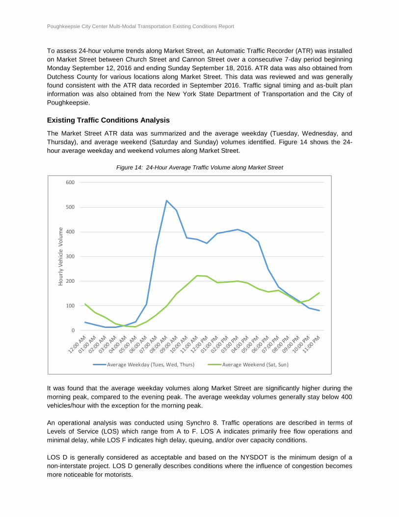
The Market Street ATR data was summarized and the average weekday (Tuesday, Wednesday, and
Thursday), and average weekend (Saturday and Sunday) volumes identified. Figure 14 shows the 24-
hour average weekday and weekend volumes along Market Street.
Figure 14: 24-Hour Average Traffic Volume along Market Street
It was found that the average weekday volumes along Market Street are significantly higher during the
morning peak, compared to the evening peak. The average weekday volumes generally stay below 400
vehicles/hour with the exception for the morning peak.
An operational analysis was conducted using Synchro 8. Traffic operations are described in terms of
Levels of Service (LOS) which range from A to F. LOS A indicates primarily free flow operations and
minimal delay, while LOS F indicates high delay, queuing, and/or over capacity conditions.
LOS D is generally considered as acceptable and based on the NYSDOT is the minimum design of a
non-interstate project. LOS D generally describes conditions where the influence of congestion becomes
more noticeable for motorists.
0
100
200
300
400
500
600
Ho
url
y V
ehic
le V
olu
me
Average Weekday (Tues, Wed, Thurs) Average Weekend (Sat, Sun)
Poughkeepsie City Center Multi-Modal Transportation Existing Conditions Report Page 19 of 54
At signalized intersections, delay is referred to as “control delay” or the total delay experienced by an
approaching vehicle as it passes through the intersection, including time spent waiting for the traffic signal
to turn green. A vehicle can also incur delay when volume-to-capacity (v/c) conditions exceed 1.0. As
such, LOS criteria for signalized intersections is based on control delay and v/c conditions.
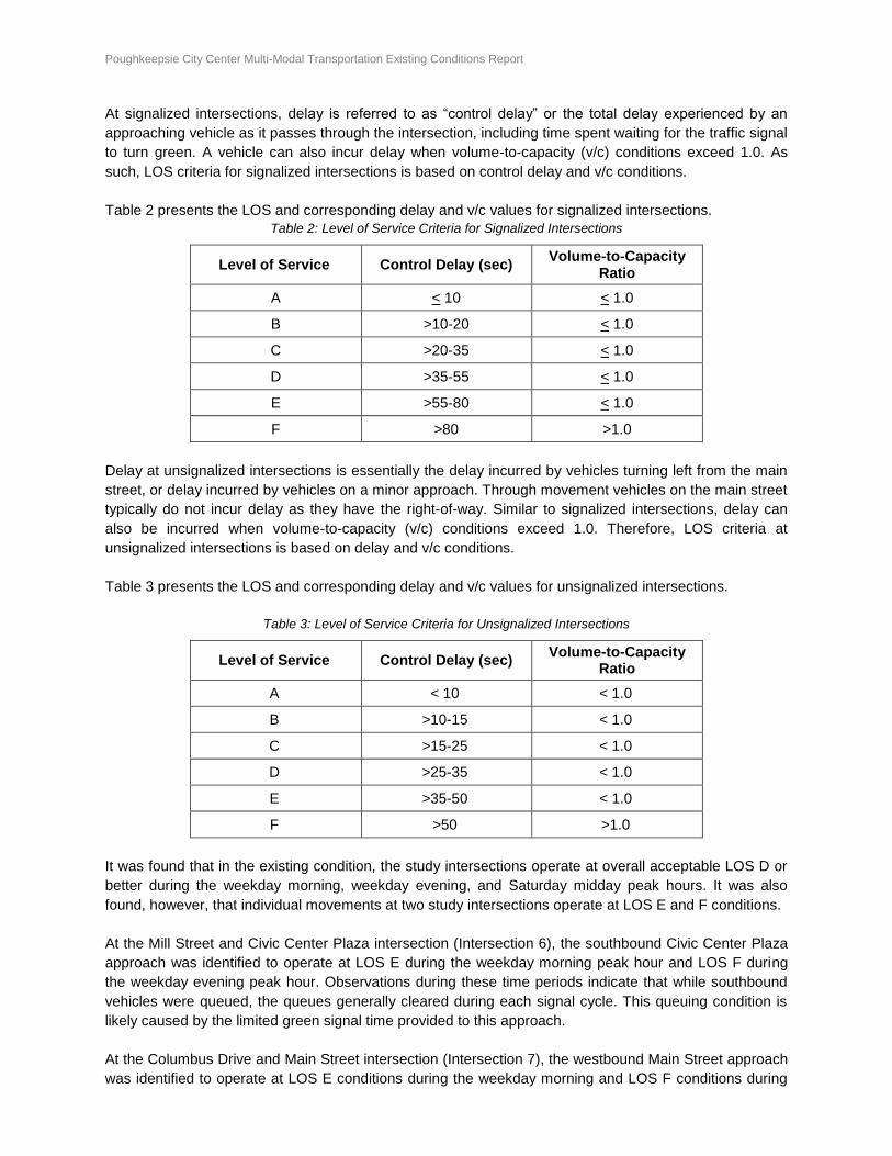
Table 2 presents the LOS and corresponding delay and v/c values for signalized intersections.
Table 2: Level of Service Criteria for Signalized Intersections
Level of Service Control Delay (sec) Volume-to-Capacity
Ratio
A < 10 < 1.0
B >10-20 < 1.0
C >20-35 < 1.0
D >35-55 < 1.0
E >55-80 < 1.0
F >80 >1.0
Delay at unsignalized intersections is essentially the delay incurred by vehicles turning left from the main
street, or delay incurred by vehicles on a minor approach. Through movement vehicles on the main street
typically do not incur delay as they have the right-of-way. Similar to signalized intersections, delay can
also be incurred when volume-to-capacity (v/c) conditions exceed 1.0. Therefore, LOS criteria at
unsignalized intersections is based on delay and v/c conditions.
Table 3 presents the LOS and corresponding delay and v/c values for unsignalized intersections.
Table 3: Level of Service Criteria for Unsignalized Intersections
Level of Service Control Delay (sec) Volume-to-Capacity
Ratio
A < 10 < 1.0
B >10-15 < 1.0
C >15-25 < 1.0
D >25-35 < 1.0
E >35-50 < 1.0
F >50 >1.0
It was found that in the existing condition, the study intersections operate at overall acceptable LOS D or
better during the weekday morning, weekday evening, and Saturday midday peak hours. It was also
found, however, that individual movements at two study intersections operate at LOS E and F conditions.
At the Mill Street and Civic Center Plaza intersection (Intersection 6), the southbound Civic Center Plaza
approach was identified to operate at LOS E during the weekday morning peak hour and LOS F during
the weekday evening peak hour. Observations during these time periods indicate that while southbound
vehicles were queued, the queues generally cleared during each signal cycle. This queuing condition is
likely caused by the limited green signal time provided to this approach.
At the Columbus Drive and Main Street intersection (Intersection 7), the westbound Main Street approach
was identified to operate at LOS E conditions during the weekday morning and LOS F conditions during
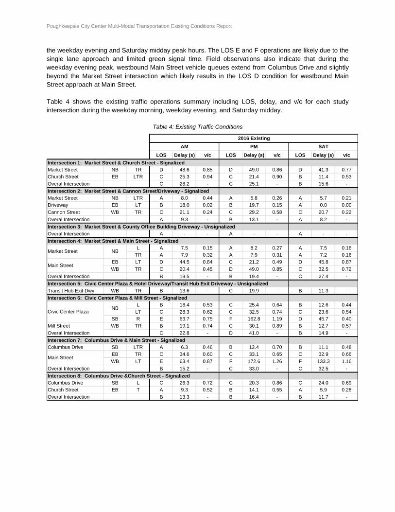
Poughkeepsie City Center Multi-Modal Transportation Existing Conditions Report Page 20 of 54
the weekday evening and Saturday midday peak hours. The LOS E and F operations are likely due to the
single lane approach and limited green signal time. Field observations also indicate that during the
weekday evening peak, westbound Main Street vehicle queues extend from Columbus Drive and slightly
beyond the Market Street intersection which likely results in the LOS D condition for westbound Main
Street approach at Main Street.
Table 4 shows the existing traffic operations summary including LOS, delay, and v/c for each study
intersection during the weekday morning, weekday evening, and Saturday midday.
Table 4: Existing Traffic Conditions
LOS Delay (s) v/c LOS Delay (s) v/c LOS Delay (s) v/c
Intersection 1: Market Street & Church Street - Signalized
Market Street NB TR D 48.6 0.85 D 49.0 0.86 D 41.3 0.77
Church Street EB LTR C 25.3 0.94 C 21.4 0.90 B 11.4 0.53
Overal Intersection C 28.2 - C 25.1 - B 15.6 -
Intersection 2: Market Street & Cannon Street/Driveway - Signalized
Market Street NB LTR A 8.0 0.44 A 5.8 0.26 A 5.7 0.21
Driveway EB LT B 18.0 0.02 B 19.7 0.15 A 0.0 0.00
Cannon Street WB TR C 21.1 0.24 C 29.2 0.58 C 20.7 0.22
Overal Intersection A 9.3 - B 13.1 - A 8.2 -
Intersection 3: Market Street & County Office Building Driveway - Unsignalized
Overal Intersection A - - A - - A - -
Intersection 4: Market Street & Main Street - Signalized
L A 7.5 0.15 A 8.2 0.27 A 7.5 0.16
TR A 7.9 0.32 A 7.9 0.31 A 7.2 0.16
EB LT D 44.5 0.84 C 21.2 0.49 D 45.8 0.87
WB TR C 20.4 0.45 D 49.0 0.85 C 32.5 0.72
Overal Intersection B 19.5 - B 19.4 - C 27.4 -
Intersection 5: Civic Center Plaza & Hotel Driveway/Transit Hub Exit Driveway - Unsignalized
Transit Hub Exit Dwy WB TR B 13.6 - C 19.9 - B 11.3 -
Intersection 6: Civic Center Plaza & Mill Street - Signalized
L B 18.4 0.53 C 25.4 0.64 B 12.6 0.44
LT C 28.3 0.62 C 32.5 0.74 C 23.6 0.54
SB R E 63.7 0.75 F 162.8 1.19 D 45.7 0.40
Mill Street WB TR B 19.1 0.74 C 30.1 0.89 B 12.7 0.57
Overal Intersection C 22.8 - D 41.0 - B 14.9 -
Intersection 7: Columbus Drive & Main Street - Signalized
Columbus Drive SB LTR A 6.3 0.46 B 12.4 0.70 B 11.1 0.48
EB TR C 34.6 0.60 C 33.1 0.65 C 32.9 0.66
WB LT E 63.4 0.87 F 172.6 1.26 F 133.3 1.16
Overal Intersection B 15.2 - C 33.0 - C 32.5 -
Intersection 8: Columbus Drive &Church Street - Signalized
Columbus Drive SB L C 26.3 0.72 C 20.3 0.86 C 24.0 0.69
Church Street EB T A 9.3 0.52 B 14.1 0.55 A 5.9 0.28
Overal Intersection B 13.3 - B 16.4 - B 11.7 -
Market Street NB
Main Street
AM PM SAT
Main Street
NBCivic Center Plaza
2016 Existing
Poughkeepsie City Center Multi-Modal Transportation Existing Conditions Report Page 21 of 54
TRANSIT
Bus and rail transit play an important role in the City of Poughkeepsie’s transportation system by providing residents and visitors with transportation alternatives to private automobiles. Transit services within the Study Area are provided by the City of Poughkeepsie Transit System, which is the primary provider of bus services in and around the Poughkeepsie area, and Dutchess County Public Transit (DCPT), which offers fixed route bus services on major roadway corridors and connects high population density areas to major activity centers in the county. Efforts are currently under way to integrate the City of Poughkeepsie Bus System and the DCPT under one bus system operator. In 2013, the City of Poughkeepsie constructed a new transit hub on Market Street that serves as a transfer point for the DCPT and City of Poughkeepsie bus systems, and other inter-county bus services such as the Ulster County Area Transit (UCAT), Leprechaun Lines, Coach USA, and Trailways. Both the DCPT and City of Poughkeepsie bus systems also provide bus routes connecting passengers from the Poughkeepsie Train Station, located to the west of the Study Area, to the Market Street transit hub. Passenger Rail Service to and from Poughkeepsie is provided by Amtrak and Metro-North Railroad at the Poughkeepsie Train Station.
Bus
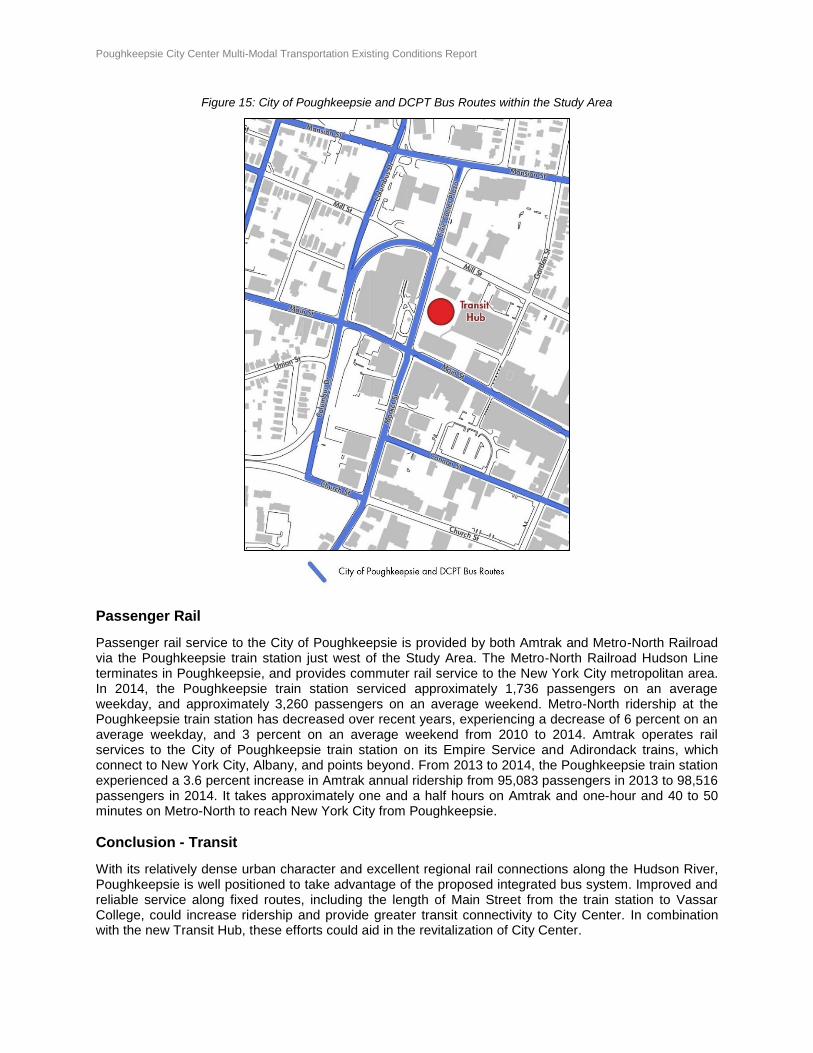
The City of Poughkeepsie Bus System is the primary provider of bus services in the City of Poughkeepsie, as well as parts of the Town of Poughkeepsie and Hyde Park. The system operates six routes from Monday to Friday, with most routes also operating on Saturdays. While nominally fixed routes, buses will often provide flag service and deviate from the set route. All City bus routes run mostly as unidirectional loops, and intersect the Study Area to converge at the Market Street transit hub near the intersection of Main Street and Market Street. The City of Poughkeepsie bus system served over 364,500 passengers in 2014, which represented a decrease of over 55,000 passengers (14 percent) from 2012. Ridership peaked in 2009 with almost 434,000 passengers, but has declined in recent years. The Main Street and Northside routes are the most popular routes, accounting for over half of the City’s annual ridership. The City of Poughkeepsie Bus System is composed of eight buses located at a City-owned facility. DCPT provides a variety of bus services throughout Dutchess County ranging from fixed-route services, commuter shuttles to/from Hudson Line Metro-North rail stations, and demand-responsive services. DCPT operates eight fixed routes (labelled Route A through Route H) running mostly on Routes 9, 9D, 44, 52, and 55 from Monday to Saturday. All seven fixed routes intersect with the Study Area to provide transfer services at the Market Street transit hub and connect with the Poughkeepsie Train Station. DCPT also operates three RailLink lines, which provide morning and evening peak period bus service that coincides with peak hour commuter trains operated by Metro-North Railroad. In 2014, the DCPT bus system served over 483,000 passengers, with most of these passengers (approximately 96 percent) travelling on the system’s fixed routes. DCPT ridership has increased over recent years, experiencing an annual increase of 3.4 percent in total passengers from 2010 to 2014. Routes A and B are the most popular routes, accounting for over 60 percent of total DCPT ridership. The DCPT bus system operates 47 buses that are based at a county-owned facility in the Town of LaGrange. All buses have front-end bicycle racks, which carry between two and three bicycles each. Both the City of Poughkeepsie and DCPT bus routes are illustrated in Figure 15.
Poughkeepsie City Center Multi-Modal Transportation Existing Conditions Report Page 22 of 54
Figure 15: City of Poughkeepsie and DCPT Bus Routes within the Study Area
Passenger Rail
Passenger rail service to the City of Poughkeepsie is provided by both Amtrak and Metro-North Railroad via the Poughkeepsie train station just west of the Study Area. The Metro-North Railroad Hudson Line terminates in Poughkeepsie, and provides commuter rail service to the New York City metropolitan area. In 2014, the Poughkeepsie train station serviced approximately 1,736 passengers on an average weekday, and approximately 3,260 passengers on an average weekend. Metro-North ridership at the Poughkeepsie train station has decreased over recent years, experiencing a decrease of 6 percent on an average weekday, and 3 percent on an average weekend from 2010 to 2014. Amtrak operates rail services to the City of Poughkeepsie train station on its Empire Service and Adirondack trains, which connect to New York City, Albany, and points beyond. From 2013 to 2014, the Poughkeepsie train station experienced a 3.6 percent increase in Amtrak annual ridership from 95,083 passengers in 2013 to 98,516 passengers in 2014. It takes approximately one and a half hours on Amtrak and one-hour and 40 to 50 minutes on Metro-North to reach New York City from Poughkeepsie.
Conclusion - Transit
With its relatively dense urban character and excellent regional rail connections along the Hudson River, Poughkeepsie is well positioned to take advantage of the proposed integrated bus system. Improved and reliable service along fixed routes, including the length of Main Street from the train station to Vassar College, could increase ridership and provide greater transit connectivity to City Center. In combination with the new Transit Hub, these efforts could aid in the revitalization of City Center.
Poughkeepsie City Center Multi-Modal Transportation Existing Conditions Report Page 23 of 54
WALKING AND PUBLIC LIFE
Methodology
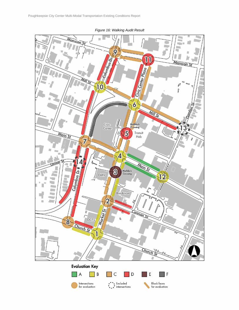
To gain a comprehensive understanding of the current transportation network in downtown Poughkeepsie, a walking audit was conducted to evaluate the condition and walkability of streets from the pedestrian’s perspective. The project team evaluated a total of 12 intersections, 2 midblock crossings, and 14 block segments (2 block faces per block segment) using a checklist that considered various elements that impact a pedestrian’s experience, and completed it based on site visits in September 2016. These locations were selected for this evaluation because they are where pedestrians would likely walk or would like to walk (desire lines). This analysis looks at a broader set of intersections than the traffic analysis to capture more fully how pedestrians experience City Center. Evaluation criteria were graded on a simple 1 to 3 scale, combined and averaged to create an aggregate score, which was then converted to a typical letter grade (A through F) scale. Detailed explanations of each evaluation criterion are provided in Appendix A. The evaluation results are illustrated in Figure 16 below and can also be found in Appendix A.
Poughkeepsie City Center Multi-Modal Transportation Existing Conditions Report Page 24 of 54
Figure 16: Walking Audit Result
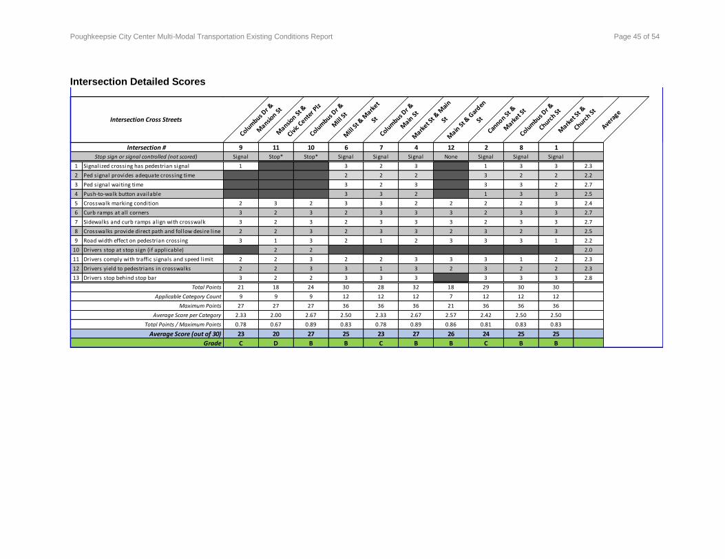
Poughkeepsie City Center Multi-Modal Transportation Existing Conditions Report Page 25 of 54
Intersections
Selected elements of the intersection crossing evaluation include:
Condition of crosswalk markings
Location and alignment of curb ramps and crosswalks
Crossing distance (roadway width)
Presence of pedestrian signals
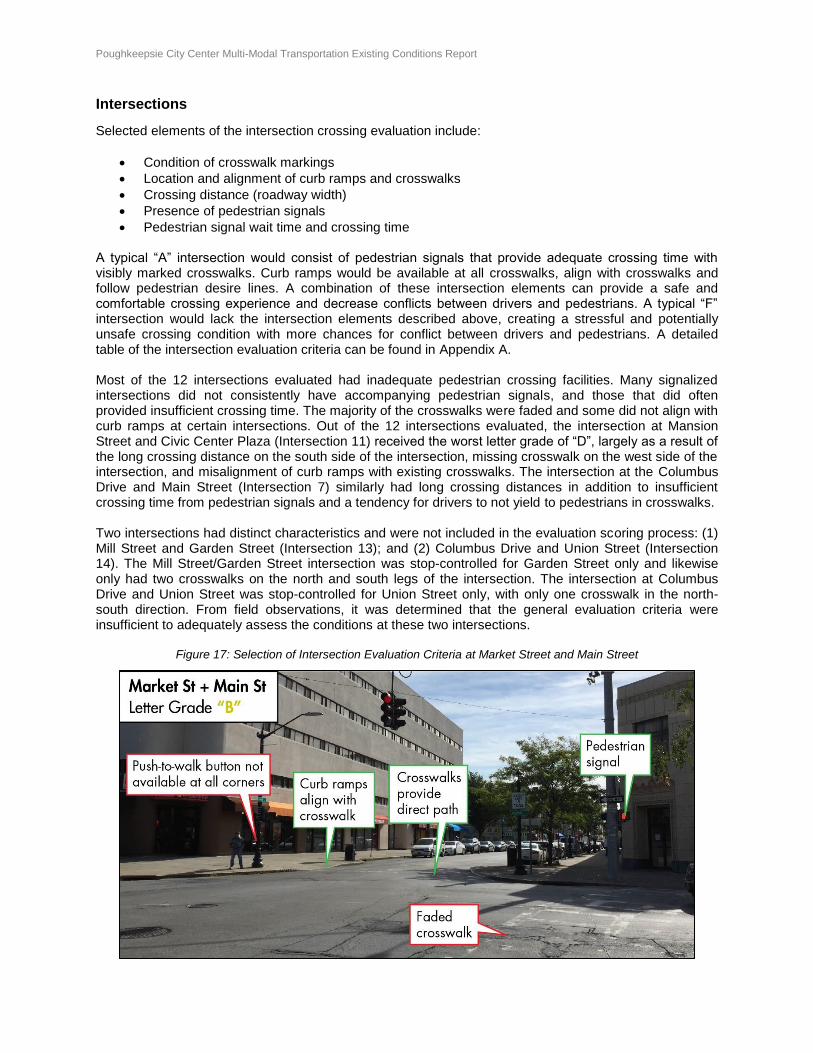
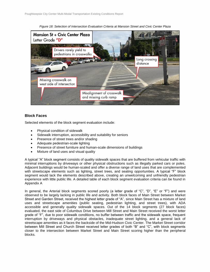
Pedestrian signal wait time and crossing time A typical “A” intersection would consist of pedestrian signals that provide adequate crossing time with visibly marked crosswalks. Curb ramps would be available at all crosswalks, align with crosswalks and follow pedestrian desire lines. A combination of these intersection elements can provide a safe and comfortable crossing experience and decrease conflicts between drivers and pedestrians. A typical “F” intersection would lack the intersection elements described above, creating a stressful and potentially unsafe crossing condition with more chances for conflict between drivers and pedestrians. A detailed table of the intersection evaluation criteria can be found in Appendix A. Most of the 12 intersections evaluated had inadequate pedestrian crossing facilities. Many signalized intersections did not consistently have accompanying pedestrian signals, and those that did often provided insufficient crossing time. The majority of the crosswalks were faded and some did not align with curb ramps at certain intersections. Out of the 12 intersections evaluated, the intersection at Mansion Street and Civic Center Plaza (Intersection 11) received the worst letter grade of “D”, largely as a result of the long crossing distance on the south side of the intersection, missing crosswalk on the west side of the intersection, and misalignment of curb ramps with existing crosswalks. The intersection at the Columbus Drive and Main Street (Intersection 7) similarly had long crossing distances in addition to insufficient crossing time from pedestrian signals and a tendency for drivers to not yield to pedestrians in crosswalks. Two intersections had distinct characteristics and were not included in the evaluation scoring process: (1) Mill Street and Garden Street (Intersection 13); and (2) Columbus Drive and Union Street (Intersection 14). The Mill Street/Garden Street intersection was stop-controlled for Garden Street only and likewise only had two crosswalks on the north and south legs of the intersection. The intersection at Columbus Drive and Union Street was stop-controlled for Union Street only, with only one crosswalk in the north-south direction. From field observations, it was determined that the general evaluation criteria were insufficient to adequately assess the conditions at these two intersections.
Figure 17: Selection of Intersection Evaluation Criteria at Market Street and Main Street
Poughkeepsie City Center Multi-Modal Transportation Existing Conditions Report Page 26 of 54
Figure 18: Selection of Intersection Evaluation Criteria at Mansion Street and Civic Center Plaza
Block Faces
Selected elements of the block segment evaluation include:
Physical condition of sidewalk
Sidewalk interruption, accessibility and suitability for seniors
Presence of street trees and/or shading
Adequate pedestrian-scale lighting
Presence of street furniture and human-scale dimensions of buildings
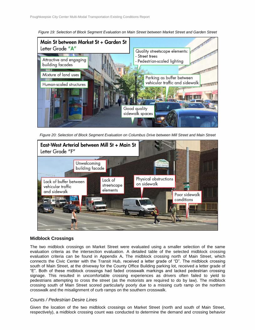
Mixture of land uses and visual quality A typical “A” block segment consists of quality sidewalk spaces that are buffered from vehicular traffic with minimal interruptions by driveways or other physical obstructions such as illegally parked cars or poles. Adjacent buildings would be human-scaled and offer a diverse range of land uses that are complemented with streetscape elements such as lighting, street trees, and seating opportunities. A typical “F” block segment would lack the elements described above, creating an unwelcoming and unfriendly pedestrian experience with little public life. A detailed table of each block segment evaluation criteria can be found in Appendix A In general, the Arterial block segments scored poorly (a letter grade of “C”, “D”, “E” or “F”) and were observed to be largely lacking in public life and activity. Both block faces of Main Street between Market Street and Garden Street, received the highest letter grade of “A”, since Main Street has a mixture of land uses and streetscape amenities (public seating, pedestrian lighting, and street trees), with ADA accessible and generally quality sidewalk spaces. Out of the 14 block segments (27 block faces) evaluated, the east side of Columbus Drive between Mill Street and Main Street received the worst letter grade of “F”, due to poor sidewalk conditions, no buffer between traffic and the sidewalk space, frequent interruption by driveways and physical obstacles, inadequate street lighting, and a general lack of streetscape amenities as it faces the backside of the Mid-Hudson Civic Center. The Market Street corridor between Mill Street and Church Street received letter grades of both “B” and “C”, with block segments closer to the intersection between Market Street and Main Street scoring higher than the peripheral blocks.
Poughkeepsie City Center Multi-Modal Transportation Existing Conditions Report Page 27 of 54
Figure 19: Selection of Block Segment Evaluation on Main Street between Market Street and Garden Street
Figure 20: Selection of Block Segment Evaluation on Columbus Drive between Mill Street and Main Street
Midblock Crossings
The two midblock crossings on Market Street were evaluated using a smaller selection of the same evaluation criteria as the intersection evaluation. A detailed table of the selected midblock crossing evaluation criteria can be found in Appendix A. The midblock crossing north of Main Street, which connects the Civic Center with the Transit Hub, received a letter grade of “D”. The midblock crossing south of Main Street, at the driveway for the County Office Building parking lot, received a letter grade of “E”. Both of these midblock crossings had faded crosswalk markings and lacked pedestrian crossing signage. This resulted in uncomfortable crossing experiences as drivers often failed to yield to pedestrians attempting to cross the street (as the motorists are required to do by law). The midblock crossing south of Main Street scored particularly poorly due to a missing curb ramp on the northern crosswalk and the misalignment of curb ramps on the southern crosswalk.
Counts / Pedestrian Desire Lines
Given the location of the two midblock crossings on Market Street (north and south of Main Street, respectively), a midblock crossing count was conducted to determine the demand and crossing behavior
Poughkeepsie City Center Multi-Modal Transportation Existing Conditions Report Page 28 of 54
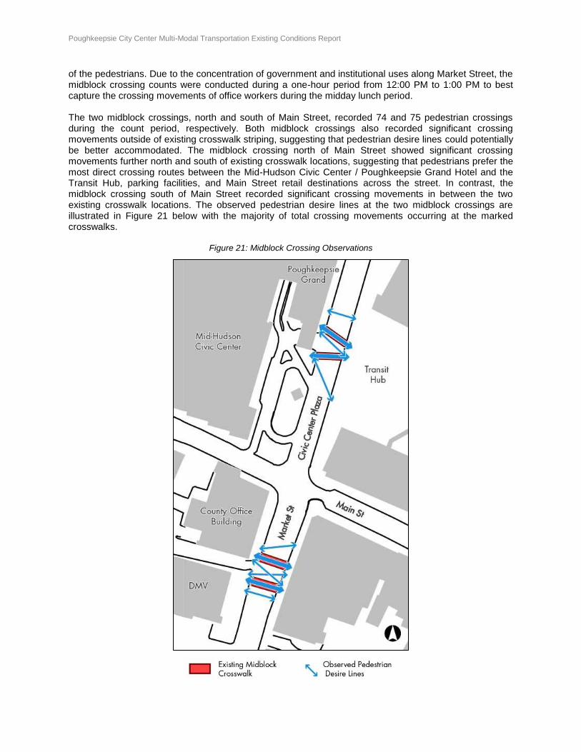
of the pedestrians. Due to the concentration of government and institutional uses along Market Street, the midblock crossing counts were conducted during a one-hour period from 12:00 PM to 1:00 PM to best capture the crossing movements of office workers during the midday lunch period. The two midblock crossings, north and south of Main Street, recorded 74 and 75 pedestrian crossings during the count period, respectively. Both midblock crossings also recorded significant crossing movements outside of existing crosswalk striping, suggesting that pedestrian desire lines could potentially be better accommodated. The midblock crossing north of Main Street showed significant crossing movements further north and south of existing crosswalk locations, suggesting that pedestrians prefer the most direct crossing routes between the Mid-Hudson Civic Center / Poughkeepsie Grand Hotel and the Transit Hub, parking facilities, and Main Street retail destinations across the street. In contrast, the midblock crossing south of Main Street recorded significant crossing movements in between the two existing crosswalk locations. The observed pedestrian desire lines at the two midblock crossings are illustrated in Figure 21 below with the majority of total crossing movements occurring at the marked crosswalks.
Figure 21: Midblock Crossing Observations
Poughkeepsie City Center Multi-Modal Transportation Existing Conditions Report Page 29 of 54
Public Life & Social Vitality
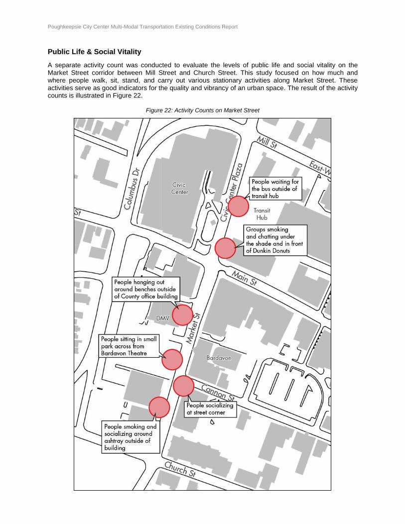
A separate activity count was conducted to evaluate the levels of public life and social vitality on the Market Street corridor between Mill Street and Church Street. This study focused on how much and where people walk, sit, stand, and carry out various stationary activities along Market Street. These activities serve as good indicators for the quality and vibrancy of an urban space. The result of the activity counts is illustrated in Figure 22.
Figure 22: Activity Counts on Market Street
Poughkeepsie City Center Multi-Modal Transportation Existing Conditions Report Page 30 of 54
Observations of outdoor street life were made over the course of two hours from 10 AM to 12 PM on Wednesday, September 21, 2016. The weather conditions were conducive for outdoor activities and recorded to be a warm and sunny day with a high temperature in the lower 80’s. Observed activities ranged from people taking a break from work to people either waiting for an appointment at one of the county buildings on Market Street or for the bus at the transit hub north of Main Street. Popular gathering areas observed were either formal (public bench) or informal (entrance steps or low railings) seating, with shade where available. Eating establishments, such as Dunkin Donuts or Café Primavera, were also popular gathering locations where people were observed to be drinking coffee or eating outside. In general, people were commonly observed to be smoking outside, and would concentrate around ashtrays where available such as at the county building on Market Street, between Church Street and Cannon Street. Other popular gathering places include the pocket park across the street from the Bardavon Theatre, the plaza in front of the Mid-Hudson Civic Center, and various public benches such as those in front of the Dutchess Supreme and County Court or in front of the Transit Hub. During the observation period, most activities along Market Street are concentrated around city or county office buildings where employees and visitors were consistently observed to enter and exit. Poughkeepsie City Hall is separated from the observation corridor on Market Street by Mill Street, and no pedestrian crossing is provided on the west leg of this intersection (i.e. the City Hall side). However, pedestrians were observed to cross on the west side of the intersection despite the existing “no-pedestrian” crossing restriction. This suggests a need for a more direct connection between City Hall and the mix of land uses on Market Street south of Mill Street that better responds to the needs of those walking. Based on qualitative observations, Market Street had light vehicular traffic and minimal queuing during the midday observation period. The atmosphere along the Market Street corridor suggested a calm urban downtown environment where people did not feel rushed and were generally friendly towards strangers. Pedestrian foot traffic along sidewalks was light, and shared the same space as bicyclists riding in either direction to avoid riding in traffic on Market Street. As Market Street was observed to have excess capacity with relatively low traffic volume, busses and private vehicles were comfortable with pick-ups and drop-offs anywhere along the three-block corridor. However, the existing road width and low traffic volume on Market Street can potentially encourage high traffic speeds, which often resulted pedestrians being forced to yield to vehicles at intersection and mid-block crosswalks.
Conclusion – Walking and Public Life
Downtown Poughkeepsie has a rich mix of pedestrian scale streets and land uses that are regularly separated by wide streets with speeding traffic and a lack of high quality pedestrian crossings at many intersections. The Arterials create a barrier to pedestrian activity and public life, while Main Street is a hub of street life. Market Street has a natural constituency for street activity owing to its several large office buildings, however the street conditions and the quality of the public spaces could do more to encourage this type of activity. Overall, creating safer pedestrian crossings, slowing traffic, and enhancing the streetscape could encourage greater pedestrian mobility and increased street life.
Poughkeepsie City Center Multi-Modal Transportation Existing Conditions Report Page 31 of 54
BICYCLING
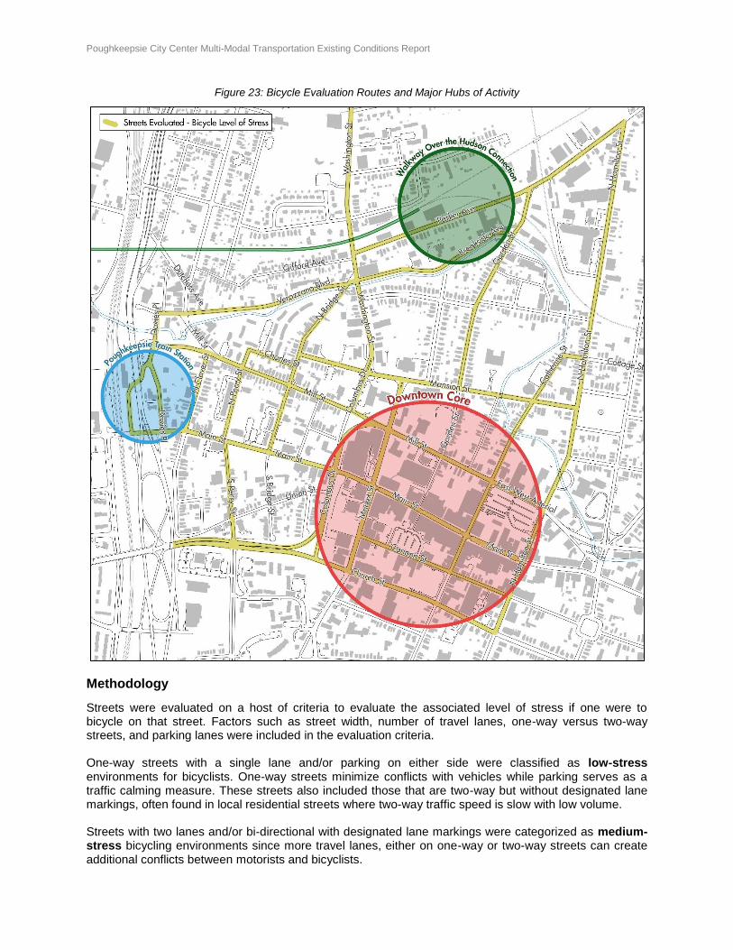
An evaluation of a city’s or region’s bicycling network often focuses on the roads and paths on which bicycling is permitted and/or the inventory of existing bicycling facilities. However, some streets provide such poor level of safety and comfort for bicycling that despite existing bicycle facilities such as bike lanes or segregated bike paths, the average bicyclists may still consider them unsuitable for bicycling. Research has indicated that a narrow inventory analysis of a city’s bicycling network can deviate substantially from the network of paths and streets people deem safe enough to use. It may exclude streets that have no bicycle-related improvements yet are perfectly suitable for bicycling due to low traffic speeds and volumes. As the City of Poughkeepsie currently does not have any formal on-street bicycle facilities, a simplified bicycle level of stress analysis was conducted based on existing roadway and street conditions, focusing on the connectivity between the Walkway Over the Hudson, City Center, and the Poughkeepsie Train Station. The streets highlighted in yellow in Figure 23 are the streets within the broader downtown area that connect to these three major activity hubs. These are the streets that people might use to bicycle between these locations if an adequately safe on-street bicycling facility were provided.
Poughkeepsie City Center Multi-Modal Transportation Existing Conditions Report Page 32 of 54
Figure 23: Bicycle Evaluation Routes and Major Hubs of Activity
Methodology
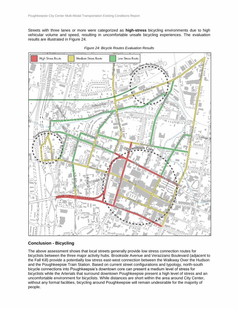
Streets were evaluated on a host of criteria to evaluate the associated level of stress if one were to bicycle on that street. Factors such as street width, number of travel lanes, one-way versus two-way streets, and parking lanes were included in the evaluation criteria. One-way streets with a single lane and/or parking on either side were classified as low-stress environments for bicyclists. One-way streets minimize conflicts with vehicles while parking serves as a traffic calming measure. These streets also included those that are two-way but without designated lane markings, often found in local residential streets where two-way traffic speed is slow with low volume. Streets with two lanes and/or bi-directional with designated lane markings were categorized as medium-stress bicycling environments since more travel lanes, either on one-way or two-way streets can create additional conflicts between motorists and bicyclists.
Poughkeepsie City Center Multi-Modal Transportation Existing Conditions Report Page 33 of 54
Streets with three lanes or more were categorized as high-stress bicycling environments due to high vehicular volume and speed, resulting in uncomfortable unsafe bicycling experiences. The evaluation results are illustrated in Figure 24.
Figure 24: Bicycle Routes Evaluation Results
Conclusion - Bicycling
The above assessment shows that local streets generally provide low stress connection routes for bicyclists between the three major activity hubs. Brookside Avenue and Verazzano Boulevard (adjacent to the Fall Kill) provide a potentially low stress east-west connection between the Walkway Over the Hudson and the Poughkeepsie Train Station. Based on current street configurations and typology, north-south bicycle connections into Poughkeepsie’s downtown core can present a medium level of stress for bicyclists while the Arterials that surround downtown Poughkeepsie present a high level of stress and an uncomfortable environment for bicyclists. While distances are short within the area around City Center, without any formal facilities, bicycling around Poughkeepsie will remain undesirable for the majority of people.
Poughkeepsie City Center Multi-Modal Transportation Existing Conditions Report Page 34 of 54
PARKING
Approach and Methodology
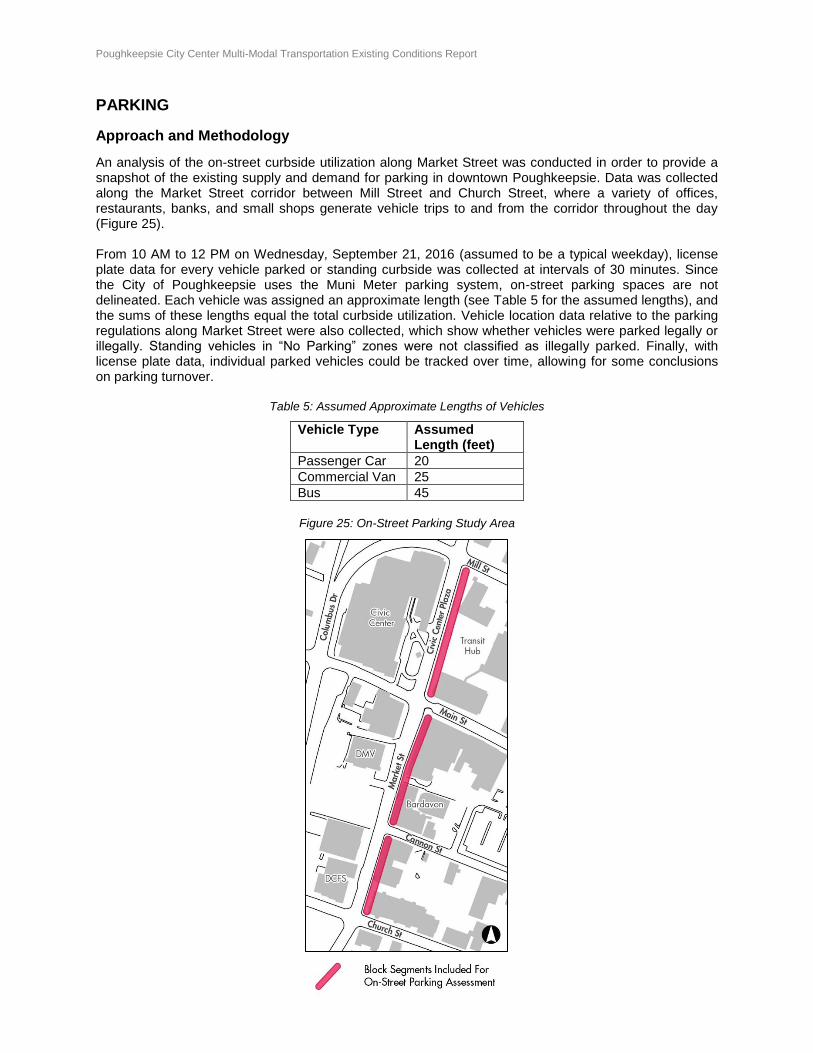
An analysis of the on-street curbside utilization along Market Street was conducted in order to provide a snapshot of the existing supply and demand for parking in downtown Poughkeepsie. Data was collected along the Market Street corridor between Mill Street and Church Street, where a variety of offices, restaurants, banks, and small shops generate vehicle trips to and from the corridor throughout the day (Figure 25). From 10 AM to 12 PM on Wednesday, September 21, 2016 (assumed to be a typical weekday), license plate data for every vehicle parked or standing curbside was collected at intervals of 30 minutes. Since the City of Poughkeepsie uses the Muni Meter parking system, on-street parking spaces are not delineated. Each vehicle was assigned an approximate length (see Table 5 for the assumed lengths), and the sums of these lengths equal the total curbside utilization. Vehicle location data relative to the parking regulations along Market Street were also collected, which show whether vehicles were parked legally or illegally. Standing vehicles in “No Parking” zones were not classified as illegally parked. Finally, with license plate data, individual parked vehicles could be tracked over time, allowing for some conclusions on parking turnover.
Table 5: Assumed Approximate Lengths of Vehicles
Vehicle Type Assumed Length (feet)
Passenger Car 20
Commercial Van 25
Bus 45
Figure 25: On-Street Parking Study Area
Poughkeepsie City Center Multi-Modal Transportation Existing Conditions Report Page 35 of 54
On-Street Curbside Utilization
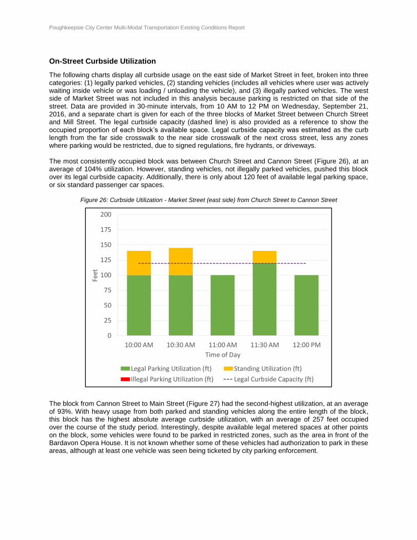
The following charts display all curbside usage on the east side of Market Street in feet, broken into three categories: (1) legally parked vehicles, (2) standing vehicles (includes all vehicles where user was actively waiting inside vehicle or was loading / unloading the vehicle), and (3) illegally parked vehicles. The west side of Market Street was not included in this analysis because parking is restricted on that side of the street. Data are provided in 30-minute intervals, from 10 AM to 12 PM on Wednesday, September 21, 2016, and a separate chart is given for each of the three blocks of Market Street between Church Street and Mill Street. The legal curbside capacity (dashed line) is also provided as a reference to show the occupied proportion of each block’s available space. Legal curbside capacity was estimated as the curb length from the far side crosswalk to the near side crosswalk of the next cross street, less any zones where parking would be restricted, due to signed regulations, fire hydrants, or driveways. The most consistently occupied block was between Church Street and Cannon Street (Figure 26), at an average of 104% utilization. However, standing vehicles, not illegally parked vehicles, pushed this block over its legal curbside capacity. Additionally, there is only about 120 feet of available legal parking space, or six standard passenger car spaces.
Figure 26: Curbside Utilization - Market Street (east side) from Church Street to Cannon Street
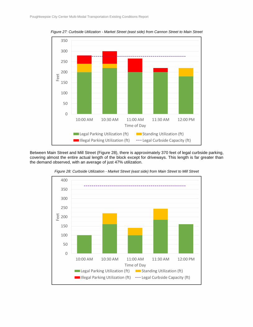
The block from Cannon Street to Main Street (Figure 27) had the second-highest utilization, at an average of 93%. With heavy usage from both parked and standing vehicles along the entire length of the block, this block has the highest absolute average curbside utilization, with an average of 257 feet occupied over the course of the study period. Interestingly, despite available legal metered spaces at other points on the block, some vehicles were found to be parked in restricted zones, such as the area in front of the Bardavon Opera House. It is not known whether some of these vehicles had authorization to park in these areas, although at least one vehicle was seen being ticketed by city parking enforcement.
0
25
50
75
100
125
150
175
200
10:00 AM 10:30 AM 11:00 AM 11:30 AM 12:00 PM
Feet
Time of Day
Legal Parking Utilization (ft) Standing Utilization (ft)
Illegal Parking Utilization (ft) Legal Curbside Capacity (ft)
Poughkeepsie City Center Multi-Modal Transportation Existing Conditions Report Page 36 of 54
Figure 27: Curbside Utilization - Market Street (east side) from Cannon Street to Main Street
Between Main Street and Mill Street (Figure 28), there is approximately 370 feet of legal curbside parking, covering almost the entire actual length of the block except for driveways. This length is far greater than the demand observed, with an average of just 47% utilization.
Figure 28: Curbside Utilization - Market Street (east side) from Main Street to Mill Street
0
50
100
150
200
250
300
350
10:00 AM 10:30 AM 11:00 AM 11:30 AM 12:00 PM
Feet
Time of Day
Legal Parking Utilization (ft) Standing Utilization (ft)
Illegal Parking Utilization (ft) Legal Curbside Capacity (ft)
0
50
100
150
200
250
300
350
400
10:00 AM 10:30 AM 11:00 AM 11:30 AM 12:00 PM
Feet
Time of Day
Legal Parking Utilization (ft) Standing Utilization (ft)
Illegal Parking Utilization (ft) Legal Curbside Capacity (ft)
Poughkeepsie City Center Multi-Modal Transportation Existing Conditions Report Page 37 of 54
Conclusion - Parking
In general, land uses that tend to have higher trip generation throughout the day, such as quick-service restaurants, banks, and shops, were the areas where higher rates of parking utilization and turnover was observed. A tendency for drivers to want to park as close to their destination as possible may have led to the parking in the restricted zones observed between Cannon Street and Main Street. Despite all legal parking on the east side of Market Street being 2-hour metered parking, some vehicles were found to have stayed there for longer than the allowable time. Of the 82 unique vehicles observed on the east side of the Market Street, 7 vehicles, or about 9%, were found to have been parked in the same spot the entire 2-hour period. Although a more thorough analysis of the parking usage in the area was not completed, this observation raises questions as to why so many drivers are risking a parking ticket with several off-street lots and garages nearby. City parking enforcement officers were observed to be active during the observation period. On the west side of Market Street between Church Street and Mill Street, there is no curbside parking allowed for general public usage during weekday midday hours. Several vehicles with special government or police license plates were parked in front of the various county office and county court buildings. Additionally, at times, taxis or postal vehicles used the curb space for standing and loading or unloading. In general, however, there were few violations of the parking restriction on the west side of the street by private passenger cars. Finally, although double parking was recorded on three instances during the two-hour observation period, overall, double parking is infrequent and has a minimal effect on traffic along Market Street. The double parked vehicles were buses or utility, postal, or delivery trucks that were stopped for a short period of time on the east side of Market Street.
Poughkeepsie City Center Multi-Modal Transportation Existing Conditions Report Page 38 of 54
CONCLUSION
The City of Poughkeepsie, despite its rich offerings of commerce, higher education, culture, and retail, has lagged behind other Hudson Valley towns in revitalizing its downtown. One structural obstacle to this growth has been the nature of City Center roadways, which were reconstructed in the middle of the last century to primarily move traffic through (and past) downtown. As a result, downtown streets serve motorists driving through the city with little consideration for people who want to drive, walk, bike, or take transit in and around City Center. Main Street and Market Street serve as the anchors for the area, attracting people to the area for a variety of reasons. However, the Arterial system creates a barrier to connecting the activity of City Center to the adjacent residential neighborhoods and other attractions such as the Train Station and the Walkway Over the Hudson. Making it safer and more enjoyable to travel to and within City Center, and reconnecting it to the rest of Poughkeepsie, would be a monumental step towards the revitalization of downtown. This Existing Conditions assessment lays the foundation for the Poughkeepsie City Center Connectivity Project, which is a high-level transportation planning initiative focused on developing scenarios for street designs that will improve mobility and support the city’s broader efforts to revitalize its downtown and promote economic development. The next step will be to use this information to develop and implement a demonstration project on Market Street to show how physical changes to the street could help to reshape downtown. The demonstration project will be followed by the creation of scenarios, selecting a preferred alternative, and then analyzing its impacts. The result of this project will be an action plan for how to quickly and relatively inexpensively improve Poughkeepsie’s streets while longer term plans and funding can be identified.
Poughkeepsie City Center Multi-Modal Transportation Existing Conditions Report Page 39 of 54
APPENDIX A: EXISTING TRAFFIC CONDITIONS RECOMMENDATIONS
The existing traffic conditions assessment revealed that the study intersections operate at overall
intersection LOS D or better, with the exception of the southbound right-turn at the Mill Street and Civic
Center Plaza intersection (Intersection 6) and the westbound approach at the Columbus Drive and Main
Street intersection (Intersection 7). Furthermore, field observations indicate that immediate improvements
could be made to the existing street network to improve vehicle and pedestrian safety.
These recommendations are intended to be relatively simple and inexpensive improvements that are
within the City’s jurisdiction that could improve traffic conditions in City Center. They generally do not
necessitate major capital construction or changes to signal timing that would require the significant
involvement of NYSDOT.
Recommendations for further consideration include the following measures:
1. Restripe Market Street
Existing pavement markings and lane striping were observed to be faded and worn along the Market
Street corridor. When pavement markings and lane striping become faded, vehicle crash rates may
increase. As such, it is recommended to restripe Market Street to improve vehicular safety.
2. Upgrade traffic signal at the Market Street and Cannon Street intersection (Intersection 2)
The existing traffic signal at this intersection provides for a single traffic signal face (red-yellow-green)
for each approach. In the event maintenance is required on the traffic signal or a traffic signal light
bulb goes out, vehicles may not be provided with a red, yellow, and/or green signal. Therefore, it is
recommended that a second traffic signal assembly be installed in compliance with the Manual on
Uniform Traffic Control Devices (MUTCD) to allow for redundancy of red, yellow, and green signals
for each approach. Field observations also noted that pedestrian signals are not provided. Therefore,
it is recommended to install ADA-compliant pedestrian countdown signals and pushbuttons for all
approaches. It should be noted that any changes to the existing traffic signal would require upgrading
the intersection for ADA-compliance.
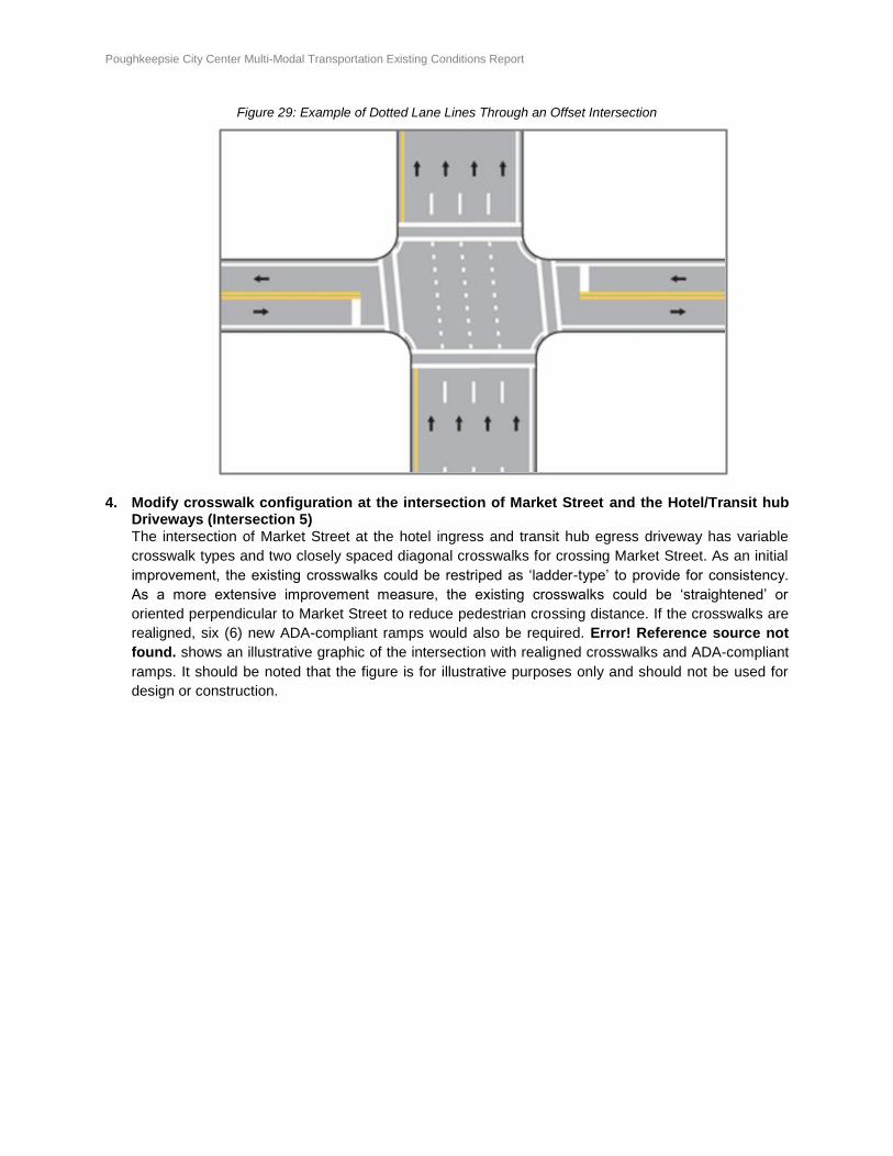
3. Restripe Market Street at Main Street to Include Dotted Lane Line Extensions (Intersection 4)
The northbound Market Street approach is slightly offset from its receiving lanes. In the existing
condition, dotted pavement lane line extensions are severely faded. Therefore, it is recommended
that the intersection and lane line extensions be restriped to provide for improved guidance of
motorists traveling northbound on Market Street. Error! Reference source not found. shows an
example of dotted line extensions through an offset intersection.
Poughkeepsie City Center Multi-Modal Transportation Existing Conditions Report Page 40 of 54
Figure 29: Example of Dotted Lane Lines Through an Offset Intersection
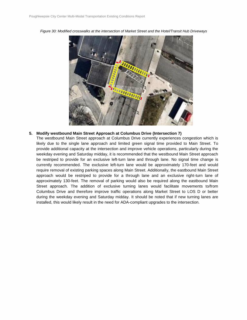
4. Modify crosswalk configuration at the intersection of Market Street and the Hotel/Transit hub Driveways (Intersection 5)
The intersection of Market Street at the hotel ingress and transit hub egress driveway has variable
crosswalk types and two closely spaced diagonal crosswalks for crossing Market Street. As an initial
improvement, the existing crosswalks could be restriped as ‘ladder-type’ to provide for consistency.
As a more extensive improvement measure, the existing crosswalks could be ‘straightened’ or
oriented perpendicular to Market Street to reduce pedestrian crossing distance. If the crosswalks are
realigned, six (6) new ADA-compliant ramps would also be required. Error! Reference source not
found. shows an illustrative graphic of the intersection with realigned crosswalks and ADA-compliant
ramps. It should be noted that the figure is for illustrative purposes only and should not be used for
design or construction.
Poughkeepsie City Center Multi-Modal Transportation Existing Conditions Report Page 41 of 54
Figure 30: Modified crosswalks at the intersection of Market Street and the Hotel/Transit Hub Driveways
5. Modify westbound Main Street Approach at Columbus Drive (Intersection 7)
The westbound Main Street approach at Columbus Drive currently experiences congestion which is
likely due to the single lane approach and limited green signal time provided to Main Street. To
provide additional capacity at the intersection and improve vehicle operations, particularly during the
weekday evening and Saturday midday, it is recommended that the westbound Main Street approach
be restriped to provide for an exclusive left-turn lane and through lane. No signal time change is
currently recommended. The exclusive left-turn lane would be approximately 170-feet and would
require removal of existing parking spaces along Main Street. Additionally, the eastbound Main Street
approach would be restriped to provide for a through lane and an exclusive right-turn lane of
approximately 130-feet. The removal of parking would also be required along the eastbound Main
Street approach. The addition of exclusive turning lanes would facilitate movements to/from
Columbus Drive and therefore improve traffic operations along Market Street to LOS D or better
during the weekday evening and Saturday midday. It should be noted that if new turning lanes are
installed, this would likely result in the need for ADA-compliant upgrades to the intersection.
Poughkeepsie City Center Multi-Modal Transportation Existing Conditions Report Page 42 of 54
APPENDIX B: WALKING AUDIT SCORES AND EXPLANATIONS
Poughkeepsie City Center Multi-Modal Transportation Existing Conditions Report Page 43 of 54
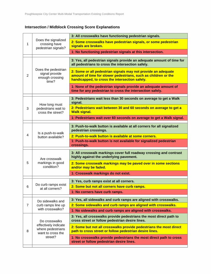
Intersection / Midblock Crossing Score Explanations
1 Does the signalized
crossing have pedestrian signals?
3: All crosswalks have functioning pedestrian signals.
2: Some crosswalks have pedestrian signals, or some pedestrian signals are broken.
1: No functioning pedestrian signals at this intersection.
2
Does the pedestrian signal provide
enough crossing time?
3: Yes, all pedestrian signals provide an adequate amount of time for all pedestrians to cross the intersection safely.
2: Some or all pedestrian signals may not provide an adequate amount of time for slower pedestrians, such as children or the handicapped, to cross the intersection safely.
1: None of the pedestrian signals provide an adequate amount of time for any pedestrian to cross the intersection safely.
3 How long must
pedestrians wait to cross the street?
3: Pedestrians wait less than 30 seconds on average to get a Walk signal.
2: Pedestrians wait between 30 and 60 seconds on average to get a Walk signal.
1: Pedestrians wait over 60 seconds on average to get a Walk signal.
4 Is a push-to-walk button available?
3: Push-to-walk button is available at all corners for all signalized pedestrian crossings.
2: Push-to-walk button is available at some corners.
1: Push-to-walk button is not available for signalized pedestrian crossings.
5 Are crosswalk
markings in good condition?
3: All crosswalk markings cover full roadway crossing and contrast highly against the underlying pavement.
2: Some crosswalk markings may be paved over in some sections and/or may be faded.
1: Crosswalk markings do not exist.
6 Do curb ramps exist
at all corners?
3: Yes, curb ramps exist at all corners.
2: Some but not all corners have curb ramps.
1: No corners have curb ramps.
7 Do sidewalks and curb ramps line up with crosswalks?
3: Yes, all sidewalks and curb ramps are aligned with crosswalks.
2: Some sidewalks and curb ramps are aligned with crosswalks.
1: No sidewalks and curb ramps are aligned with crosswalks.
8
Do crosswalks effectively indicate where pedestrians want to cross the
street?
3: Yes, all crosswalks provide pedestrians the most direct path to cross street or follow pedestrian desire lines.
2: Some but not all crosswalks provide pedestrians the most direct path to cross street or follow pedestrian desire lines.
1: No crosswalks provide pedestrians the most direct path to cross street or follow pedestrian desire lines.
Poughkeepsie City Center Multi-Modal Transportation Existing Conditions Report Page 44 of 54
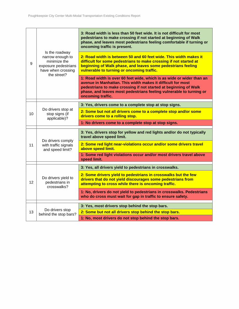
9
Is the roadway narrow enough to
minimize the exposure pedestrians have when crossing
the street?
3: Road width is less than 50 feet wide. It is not difficult for most pedestrians to make crossing if not started at beginning of Walk phase, and leaves most pedestrians feeling comfortable if turning or oncoming traffic is present.
2: Road width is between 50 and 60 feet wide. This width makes it difficult for some pedestrians to make crossing if not started at beginning of Walk phase, and leaves some pedestrians feeling vulnerable to turning or oncoming traffic.
1: Road width is over 60 feet wide, which is as wide or wider than an avenue in Manhattan. This width makes it difficult for most pedestrians to make crossing if not started at beginning of Walk phase, and leaves most pedestrians feeling vulnerable to turning or oncoming traffic.
10 Do drivers stop at
stop signs (if applicable)?
3: Yes, drivers come to a complete stop at stop signs.
2: Some but not all drivers come to a complete stop and/or some drivers come to a rolling stop.
1: No drivers come to a complete stop at stop signs.
11 Do drivers comply with traffic signals and speed limit?
3: Yes, drivers stop for yellow and red lights and/or do not typically travel above speed limit.
2: Some red light near-violations occur and/or some drivers travel above speed limit.
1: Some red light violations occur and/or most drivers travel above speed limit.
12 Do drivers yield to
pedestrians in crosswalks?
3: Yes, all drivers yield to pedestrians in crosswalks.
2: Some drivers yield to pedestrians in crosswalks but the few drivers that do not yield discourages some pedestrians from attempting to cross while there is oncoming traffic.
1: No, drivers do not yield to pedestrians in crosswalks. Pedestrians who do cross must wait for gap in traffic to ensure safety.
13 Do drivers stop
behind the stop bars?
3: Yes, most drivers stop behind the stop bars.
2: Some but not all drivers stop behind the stop bars.
1: No, most drivers do not stop behind the stop bars.
Poughkeepsie City Center Multi-Modal Transportation Existing Conditions Report Page 45 of 54
Intersection Detailed Scores
Colum
bus Dr &
Mansio
n St
Mansio
n St &
Civic
Center P
lz
Colum
bus Dr &
Mill
St
Mill
St &
Mark
et
St
Colum
bus Dr &
Main
St
Mark
et St &
Mai
n
St
Main
St &
Gar
den
St
Cannon St
&
Mark
et St
Colum
bus Dr &
Church St
Mark
et St &
Church St
Avera
geIntersection Cross Streets
9 11 10 6 7 4 12 2 8 1
Signal Stop* Stop* Signal Signal Signal None Signal Signal Signal
1 Signalized crossing has pedestrian signal 1 3 2 3 1 3 3 2.3
2 Ped signal provides adequate crossing time 2 2 2 3 2 2 2.2
3 Ped signal waiting time 3 2 3 3 3 2 2.7
4 Push-to-walk button available 3 3 2 1 3 3 2.5
5 Crosswalk marking condition 2 3 2 3 3 2 2 2 2 3 2.4
6 Curb ramps at all corners 3 2 3 2 3 3 3 2 3 3 2.7
7 Sidewalks and curb ramps align with crosswalk 3 2 3 2 3 3 3 2 3 3 2.7
8 Crosswalks provide direct path and follow desire l ine 2 2 3 2 3 3 2 3 2 3 2.5
9 Road width effect on pedestrian crossing 3 1 3 2 1 2 3 3 3 1 2.2
10 Drivers stop at stop sign (if applicable) 2 2 2.0
11 Drivers comply with traffic signals and speed limit 2 2 3 2 2 3 3 3 1 2 2.3
12 Drivers yield to pedestrians in crosswalks 2 2 3 3 1 3 2 3 2 2 2.3
13 Drivers stop behind stop bar 3 2 2 3 3 3 3 3 3 2.8
21 18 24 30 28 32 18 29 30 30
9 9 9 12 12 12 7 12 12 12
27 27 27 36 36 36 21 36 36 36
2.33 2.00 2.67 2.50 2.33 2.67 2.57 2.42 2.50 2.50
0.78 0.67 0.89 0.83 0.78 0.89 0.86 0.81 0.83 0.83
23 20 27 25 23 27 26 24 25 25
C D B B C B B C B BGrade
Stop sign or signal controlled (not scored)
Intersection #
Total Points
Applicable Category Count
Maximum Points
Average Score per Category
Total Points / Maximum Points
Average Score (out of 30)
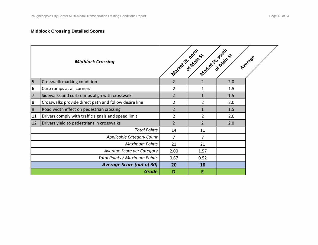
Poughkeepsie City Center Multi-Modal Transportation Existing Conditions Report Page 46 of 54
Midblock Crossing Detailed Scores
Mark
et St,
north
of Main
St
Mark
et St,
south
of Main
St
Avera
geMidblock Crossing
5 Crosswalk marking condition 2 2 2.0
6 Curb ramps at all corners 2 1 1.5
7 Sidewalks and curb ramps align with crosswalk 2 1 1.5
8 Crosswalks provide direct path and follow desire line 2 2 2.0
9 Road width effect on pedestrian crossing 2 1 1.5
11 Drivers comply with traffic signals and speed limit 2 2 2.0
12 Drivers yield to pedestrians in crosswalks 2 2 2.0
14 11
7 7
21 21
2.00 1.57
0.67 0.52
20 16
D EGrade
Total Points
Applicable Category Count
Maximum Points
Average Score per Category
Total Points / Maximum Points
Average Score (out of 30)
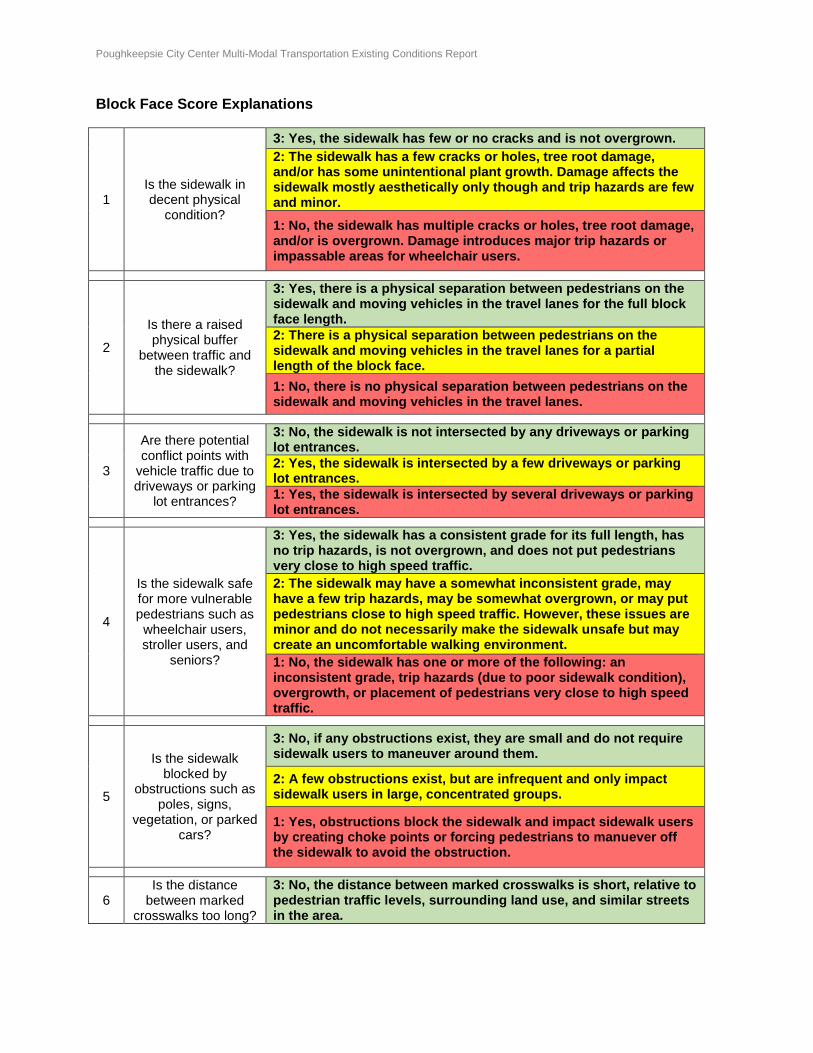
Poughkeepsie City Center Multi-Modal Transportation Existing Conditions Report Page 47 of 54
Block Face Score Explanations
1 Is the sidewalk in decent physical
condition?
3: Yes, the sidewalk has few or no cracks and is not overgrown.
2: The sidewalk has a few cracks or holes, tree root damage, and/or has some unintentional plant growth. Damage affects the sidewalk mostly aesthetically only though and trip hazards are few and minor.
1: No, the sidewalk has multiple cracks or holes, tree root damage, and/or is overgrown. Damage introduces major trip hazards or impassable areas for wheelchair users.
2
Is there a raised physical buffer
between traffic and the sidewalk?
3: Yes, there is a physical separation between pedestrians on the sidewalk and moving vehicles in the travel lanes for the full block face length.
2: There is a physical separation between pedestrians on the sidewalk and moving vehicles in the travel lanes for a partial length of the block face.
1: No, there is no physical separation between pedestrians on the sidewalk and moving vehicles in the travel lanes.
3
Are there potential conflict points with
vehicle traffic due to driveways or parking
lot entrances?
3: No, the sidewalk is not intersected by any driveways or parking lot entrances.
2: Yes, the sidewalk is intersected by a few driveways or parking lot entrances.
1: Yes, the sidewalk is intersected by several driveways or parking lot entrances.
4
Is the sidewalk safe for more vulnerable pedestrians such as wheelchair users, stroller users, and
seniors?
3: Yes, the sidewalk has a consistent grade for its full length, has no trip hazards, is not overgrown, and does not put pedestrians very close to high speed traffic.
2: The sidewalk may have a somewhat inconsistent grade, may have a few trip hazards, may be somewhat overgrown, or may put pedestrians close to high speed traffic. However, these issues are minor and do not necessarily make the sidewalk unsafe but may create an uncomfortable walking environment.
1: No, the sidewalk has one or more of the following: an inconsistent grade, trip hazards (due to poor sidewalk condition), overgrowth, or placement of pedestrians very close to high speed traffic.
5
Is the sidewalk blocked by
obstructions such as poles, signs,
vegetation, or parked cars?
3: No, if any obstructions exist, they are small and do not require sidewalk users to maneuver around them.
2: A few obstructions exist, but are infrequent and only impact sidewalk users in large, concentrated groups.
1: Yes, obstructions block the sidewalk and impact sidewalk users by creating choke points or forcing pedestrians to manuever off the sidewalk to avoid the obstruction.
6 Is the distance
between marked crosswalks too long?
3: No, the distance between marked crosswalks is short, relative to pedestrian traffic levels, surrounding land use, and similar streets in the area.
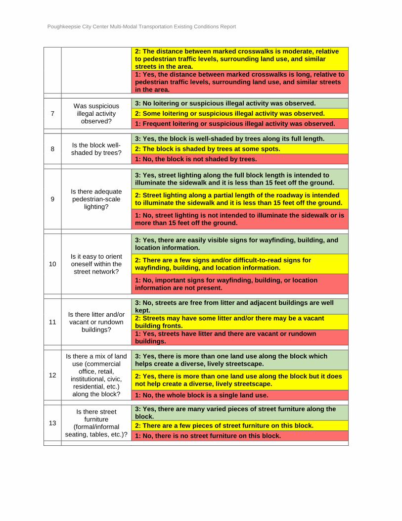
Poughkeepsie City Center Multi-Modal Transportation Existing Conditions Report Page 48 of 54
2: The distance between marked crosswalks is moderate, relative to pedestrian traffic levels, surrounding land use, and similar streets in the area.
1: Yes, the distance between marked crosswalks is long, relative to pedestrian traffic levels, surrounding land use, and similar streets in the area.
7 Was suspicious illegal activity
observed?
3: No loitering or suspicious illegal activity was observed.
2: Some loitering or suspicious illegal activity was observed.
1: Frequent loitering or suspicious illegal activity was observed.
8 Is the block well-shaded by trees?
3: Yes, the block is well-shaded by trees along its full length.
2: The block is shaded by trees at some spots.
1: No, the block is not shaded by trees.
9 Is there adequate pedestrian-scale
lighting?
3: Yes, street lighting along the full block length is intended to illuminate the sidewalk and it is less than 15 feet off the ground.
2: Street lighting along a partial length of the roadway is intended to illuminate the sidewalk and it is less than 15 feet off the ground.
1: No, street lighting is not intended to illuminate the sidewalk or is more than 15 feet off the ground.
10 Is it easy to orient oneself within the street network?
3: Yes, there are easily visible signs for wayfinding, building, and location information.
2: There are a few signs and/or difficult-to-read signs for wayfinding, building, and location information.
1: No, important signs for wayfinding, building, or location information are not present.
11 Is there litter and/or vacant or rundown
buildings?
3: No, streets are free from litter and adjacent buildings are well kept.
2: Streets may have some litter and/or there may be a vacant building fronts.
1: Yes, streets have litter and there are vacant or rundown buildings.
12
Is there a mix of land use (commercial
office, retail, institutional, civic, residential, etc.) along the block?
3: Yes, there is more than one land use along the block which helps create a diverse, lively streetscape.
2: Yes, there is more than one land use along the block but it does not help create a diverse, lively streetscape.
1: No, the whole block is a single land use.
13
Is there street furniture
(formal/informal seating, tables, etc.)?
3: Yes, there are many varied pieces of street furniture along the block.
2: There are a few pieces of street furniture on this block.
1: No, there is no street furniture on this block.
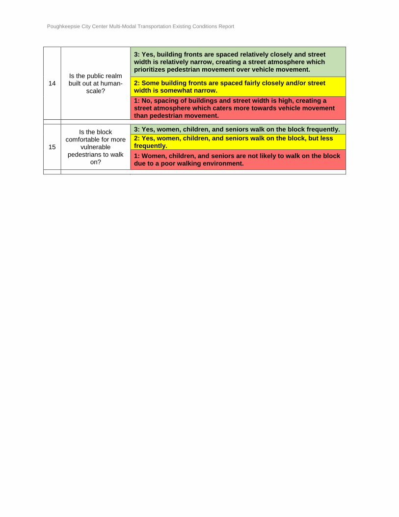
Poughkeepsie City Center Multi-Modal Transportation Existing Conditions Report Page 49 of 54
14 Is the public realm built out at human-
scale?
3: Yes, building fronts are spaced relatively closely and street width is relatively narrow, creating a street atmosphere which prioritizes pedestrian movement over vehicle movement.
2: Some building fronts are spaced fairly closely and/or street width is somewhat narrow.
1: No, spacing of buildings and street width is high, creating a street atmosphere which caters more towards vehicle movement than pedestrian movement.
15
Is the block comfortable for more
vulnerable pedestrians to walk
on?
3: Yes, women, children, and seniors walk on the block frequently.
2: Yes, women, children, and seniors walk on the block, but less frequently.
1: Women, children, and seniors are not likely to walk on the block due to a poor walking environment.
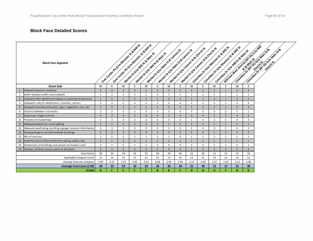
Poughkeepsie City Center Multi-Modal Transportation Existing Conditions Report Page 50 of 54
Block Face Detailed Scores
Civic
Center P
lz b/w
Mansio
n St &
Mill
St
Civic
Center P
lz b/w
Mansio
n St &
Mill
St
Mark
et St b
/w M
ill St
& M
ain S
t
Mark
et St b
/w M
ill St
& M
ain S
t
Mark
et St b
/w M
ain S
t & C
annon St
Mark
et St b
/w M
ain S
t & C
annon St
Mark
et St b
/w C
annon S
t & C
hurch St
Mark
et St b
/w C
annon S
t & C
hurch St
Colum
bus Dr b
/w M
ansio
n St &
Mill
St
Colum
bus Dr b
/w M
ansio
n St &
Mill
St
Colum
bus Dr b
/w M
ill St
& M
ain St
WB E
ast-W
est A
rteria
l (NY-5
5) b
/w M
ill
St &
Mai
n St
Colum
bus Dr (
NY-55) b
/w M
ain S
t &
Church St
Colum
bus Dr (
NY-55) b
/w M
ain S
t &
Church StBlock Face Segment
W E W E W E W E W E W E W E
1 Sidewalk physical condition 2 3 2 3 2 3 3 2 2 2 2 1 3 3
2 Buffer between traffic and sidewalk 1 2 1 3 1 3 1 1 1 1 1 1 1 1
3 Sidewalk interrupted by driveways or parking lot entrances 1 1 1 2 2 2 3 2 3 1 3 1 3 2
4 Sidewalks safe for wheelchairs, strollers, seniors 3 3 2 3 3 3 3 3 2 2 3 1 3 3
5 Sidewalks blocked with poles, signs, vegetation, cars, etc 2 3 3 2 2 3 3 2 3 3 3 1 3 3
6 Distance between crosswalks 2 2 2 2 3 3 3 3 3 3 3 2 1 1
7 Suspicious il legal activity 3 3 3 3 3 3 3 3 3 3 3 3 3 3
8 Presence of shade/trees 1 3 2 2 2 2 3 2 1 1 3 2 3 3
9 Adequate pedestrian-scale l ighting 1 1 2 2 2 2 2 2 1 1 1 1 1 1
10 Adequate wayfinding, building signage, location information 3 3 3 3 3 3 3 3 3 3 3 2 3 2
11 Street garbage or vacant/rundown buildings 3 2 3 3 3 2 3 3 3 3 1 3 3 3
12 Mix of land use 1 2 2 1 1 3 1 3 1 1 1 1 1 1
13 Street furniture (informal/formal seating, tables, etc) 2 1 3 2 3 1 2 1 1 1 1 1 1 1
14 Dimensions of buildings and spaces are human scale 2 2 2 2 2 3 3 3 2 2 1 1 2 1
15 Women, children, seniors walk on the block 3 3 3 3 3 3 3 3 3 3 2 2 1 2
30 34 34 36 35 39 39 36 32 30 31 23 32 30
15 15 15 15 15 15 15 15 15 15 15 15 15 15
2.00 2.27 2.27 2.40 2.33 2.60 2.60 2.40 2.13 2.00 2.07 1.53 2.13 2.00
20 23 23 24 23 26 26 24 21 20 21 15 21 20
D C C C C B B C D D D F D D
Total Points
Applicable Category Count
Average Score per Category
Average Score (out of 30)
Grade
Street Side
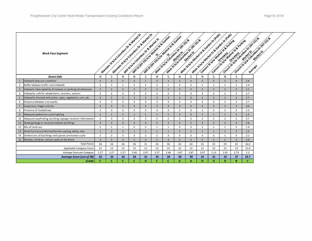
Poughkeepsie City Center Multi-Modal Transportation Existing Conditions Report Page 51 of 54
Mansio
n St b
/w C
olum
bus Dr &
Mar
ket S
t
Mansio
n St b
/w C
olum
bus Dr &
Mar
ket S
t
Mill
St b
/w C
olum
bus Dr &
Mar
ket S
t
Mill
St (
NY-55)
b/w
Mar
ket S
t & G
arden
St
Mill
St (
NY-55)
b/w
Mar
ket S
t & G
arden
St
Main
St b
/w C
olum
bus Dr (
NY-55) &
Mark
et St
Main
St b
/w C
olum
bus Dr (
NY-55) &
Mark
et St
Main
St b
/w M
arket S
t & G
arden St
(Pat
h)
Main
St b
/w M
arket S
t & G
arden St
(Pat
h)
Cannon St
b/w
Mar
ket S
t & P
arkin
g
Drivew
ay
Cannon St
b/w
Mar
ket S
t & P
arkin
g
Drivew
ay
Church St
b/w
Colu
mbus D
r (NY-5
5) &
Mark
et St
Church St
b/w
Colu
mbus D
r (NY-5
5) &
Mark
et St
Avera
ge
Block Face Segment
N S N N S N S N S N S N S
1 Sidewalk physical condition 3 2 2 3 1 3 3 3 3 2 3 2 3 2.4
2 Buffer between traffic and sidewalk 2 1 1 1 1 2 1 3 3 1 1 1 1 1.4
3 Sidewalk interrupted by driveways or parking lot entrances 2 2 2 2 2 2 2 3 3 2 2 3 3 2.1
4 Sidewalks safe for wheelchairs, strollers, seniors 2 2 3 3 2 3 3 3 3 3 3 2 3 2.7
5 Sidewalks blocked with poles, signs, vegetation, cars, etc 3 3 3 3 3 3 3 3 3 3 3 2 2 2.7
6 Distance between crosswalks 3 3 3 3 3 3 3 3 3 3 3 3 3 2.7
7 Suspicious il legal activity 3 3 3 3 3 3 3 3 3 3 3 3 3 3.0
8 Presence of shade/trees 1 3 2 2 2 3 3 2 3 1 2 2 3 2.2
9 Adequate pedestrian-scale l ighting 1 1 1 1 1 1 2 3 3 1 1 1 3 1.5
10 Adequate wayfinding, building signage, location information 3 3 3 3 3 2 2 3 3 2 2 2 3 2.7
11 Street garbage or vacant/rundown buildings 3 3 3 3 3 3 3 3 2 3 2 3 3 2.8
12 Mix of land use 2 1 1 2 2 1 1 3 3 1 1 1 3 1.6
13 Street furniture (informal/formal seating, tables, etc) 1 2 2 1 1 1 1 2 2 1 1 1 3 1.5
14 Dimensions of buildings and spaces are human scale 2 2 2 3 2 2 3 3 3 3 3 1 3 2.2
15 Women, children, seniors walk on the block 3 3 3 3 2 2 3 3 3 2 2 2 2 2.6
34 34 34 36 31 34 36 43 43 31 32 29 41 34.0
15 15 15 15 15 15 15 15 15 15 15 15 15 15.0
2.27 2.27 2.27 2.40 2.07 2.27 2.40 2.87 2.87 2.07 2.13 1.93 2.73 2.3
23 23 23 24 21 23 24 29 29 21 21 19 27 22.7
C C C C D C C A A D D D B C
Average Score (out of 30)
Grade
Street Side
Total Points
Applicable Category Count
Average Score per Category
Poughkeepsie City Center Multi-Modal Transportation Existing Conditions Report Page 52 of 54
APPENDIX C: ON-STREET PARKING UTILIZATION OBSERVATIONS
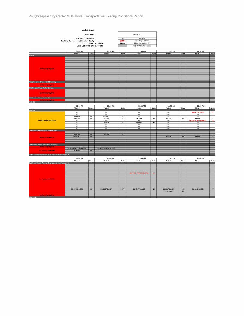
Poughkeepsie City Center Multi-Modal Transportation Existing Conditions Report Page 53 of 54
Market Street
West Side
Mill St to Church St ---
Parking Turnover / Utilization Study (STD)
Date: 9/21/2016 (HP-V)
Date Collected By: B. Yeung
Plate # State Plate# State Plate# State Plate # State Plate # State
Mill St
Poughkeepsie Grand Hotel Driveway
Mid-Hudson Civic Center Entrance
Mid-Hudson Civic Center Exit
No Parking Anytime
Main St
Plate # State Plate# State Plate# State Plate # State Plate # State
Main St
--- --- --- --- AWG7874 (STD) NY
--- --- --- --- ---
2011DAV NY 2011DAV NY --- --- ---
AF1785 NY AF1785 NY AF1785 NY AF1785 NY AF1785 NY
--- --- --- --- W202664C (TAXI) (STD) NY
--- AE4831 NY AE4831 NY --- ---
--- --- --- --- ---
--- --- --- --- ---
--- --- --- --- ---
Dutchess Supreme Court Parking Exit
AE4789 NY AE4789 NY
56255MG NY AE4858 NY AE4858 NY
Dutchess County Office Bldg Driveway
No Parking Anytime
USPS VEHICLE# 6426224 USPS VEHICLE# 6426224
AG9176 NY
Dutchess County Pretrial Bldg (across from Cannon St)
Plate # State Plate# State Plate# State Plate # State Plate # State
Dutchess County Pretrial Bldg (across from Cannon St)
BB77891 (TRAILER) (STD) NY
DC-60 (POLICE) NY DC-60 (POLICE) NY DC-60 (POLICE) NY DC-60 (POLICE) NY DC-60 (POLICE) NY
PRW1527 GA
No Parking Anytime
Church St
11:30 AM 12:00 PM
11:30 AM 12:00 PM
No Parking 6AM-6PM
No Parking 6AM-6PM
10:00 AM 10:30 AM 11:00 AM 11:30 AM 12:00 PM
10:00 AM 10:30 AM 11:00 AM
No Parking Anytime
No Parking Except Police
No Parking Anytime
10:00 AM 10:30 AM 11:00 AM
No Parking Anytime
No Parking Anytime
LEGEND
Empty
Standing Vehicle
Handicap Vehicle
Illegal Parking Space
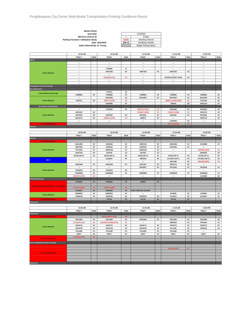
Poughkeepsie City Center Multi-Modal Transportation Existing Conditions Report Page 54 of 54
Market Street
East Side
Mill St to Church St ---
Parking Turnover / Utilization Study (STD)
Date: 9/21/2016 (HP-V)
Date Collected By: B. Yeung
Plate # State Plate# State Plate# State Plate # State Plate # State
Mill St
--- --- --- --- ---
--- --- --- --- ---
--- Z705800 IL --- --- ---
--- HER7359 NY HER7359 NY HER7359 NY ---
--- --- --- --- ---
--- GSU9384 (STD) NY --- AX5196 (COUNTY BUS) NY ---
--- --- --- --- ---
--- --- --- --- ---
Changepoint Church Driveway
Bus Station Exit
--- C14CZU NJ --- --- ---
FSB8869 NY FSB8869 NY FSB8869 NY FSB8869 NY FSB8869 NY
--- MAHAIRA NY MAHAIRA NY MAHAIRA NY MAHAIRA NY
ORT173 NY ORT173 (STD) NY --- 30953LV (TAXI) (STD) NY CTR7329 NY
--- HDX8580 NY --- 798AXH ND GDE1276 NY
Bus Station Ent Driveway
--- HJC5923 NY EHG6712 (STD) NY HKD7843 NY HHV9204 NY
HEC3222 NY --- FXF4075 (STD) NY FXF4075 (STD) NY EHG6712 NY
HEC5901 NY HEC5901 NY HEC5901 NY HEC5901 NY HEC5901 NY
EHG6712 NY FSE5372 (STD) NY AD8972 NY --- HFM7172 NY
--- --- --- GCB6096 NY ---
No Parking Anytime FST7761 (STD) NY
Main St
Plate # State Plate# State Plate# State Plate # State Plate # State
Main St
No Parking Anytime
BGG1899 NY DZN9430 NY GBR4136 NY HHW3466 NY GVG6885 NY
HKD7843 NY GSE8162 NY GSE8162 NY HGK2395 NY ---
FEY3108 NY DWD5198 NY DWD5198 NY --- FRZ4455 (STD) NY
HGK7784 NY S57FNX NJ S57FNX NJ --- HBH6292 NY
DC525 (HP-V) NY DC525 (HP-V) NY DC525 (HP-V) NY DC525 (HP-V) NY DC525 (HP-V) NY
--- ELB2027 NY FBR2919 NY GYU3387 (HP-V) NY GYU3387 (HP-V) NY
--- --- --- HBJ1398 NY HBJ1398 (STD) NY
GMG3445 NY GMG3445 NY GSE7657 NY GDE1276 NY ---
--- --- BKZ9907 NY HKV9198 NY HKV9198 NY
GSU9313 NY GSU9313 NY --- --- ---
GWM9829 NY GWM9829 NY GWM9829 NY GWM9829 NY GWM9829 NY
BXN1973 (STD) NY --- --- --- CLD4438 NY
TD Bank Driveway
DVE6966 NY DVE6966 NY AD8973 NY
FJF5157 (STD) NY FJF5157 (STD) NY
HFA2634 NY HHM1563 NY USPS VEHICLE# 3511208
GWM6857 NY GWM6857 NY --- 8153590 NY 8153590 NY
GSE8148 NY GSE8148 NY GSE8148 NY ELA6512 NY ELA6512 NY
No Parking Anytime DC728 NY DC728 NY DC728 NY
Cannon St
Plate # State Plate# State Plate# State Plate # State Plate # State
Cannon St
No Parking Anytime 515118 (HP-V) (STD) NY
GRV3384 NY GRV3384 NY GRV3384 NY GRV3384 NY GRV3384 NY
GYU1000 (STD) NY 19122MD (COMM) (STD) NY --- HER6363 NY FPM4164 NY
HAA6715 NY HAA6715 NY HAA6715 NY HAA6715 NY HAA6715 NY
HGU5726 NY HGU5726 NY HGU5726 NY ACL1681 NY FGE9419 NY
HJC4458 NY HJC4458 NY HJC4458 NY HJC4458 NY ---
KIM77 NY KIM77 NY KIM77 NY KIM77 NY KIM77 NY
GCG3591 (STD) NY
New Poughkeepsie Diner Driveway
WILSTR (STD) NY
Church St
11:30 AM 12:00 PM
2-Hour Metered
2-Hour Metered (ped xing)
2-Hour Metered
2-Hour Metered
LEGEND
Empty
Standing Vehicle
Handicap Vehicle
Illegal Parking Space
10:00 AM 10:30 AM 11:00 AM
2-Hour Metered
10:00 AM 10:30 AM 11:00 AM 11:30 AM 12:00 PM
HP-V
2-Hour Metered
No Parking Anytime (Bardavon / fire hydrant)
2-Hour Metered
2-Hour Metered
10:00 AM 10:30 AM 11:00 AM 11:30 AM 12:00 PM
No Parking Anytime
No Parking Anytime