Embed Size (px)
Citation preview
POLICY REPORT DEVELOPMENT AND BUILDING
Report Date: September 6, 2016 Contact: Karen Hoese Contact No.: 604.871.6403 RTS No.: 11634 VanRIMS No.: 08-2000-20 Meeting Date: September 20, 2016 TO: Vancouver City Council
FROM: Acting General Manager of Planning, Urban Design and Sustainability
SUBJECT: CD-1 Rezoning:1550 Alberni Street
RECOMMENDATION
A. THAT the application by Merrick Architecture in conjunction with Kengo Kuma and Associates, on behalf of 1550 Alberni Property Inc., to rezone 1550 Alberni Street [Lots A to E of Lots 11 to 13, Block 43, District Lot 185, Plan 1354; PIDs 014-829-410, 014-829-428, 014-829-444, 014-829-461 and 014-829-487 respectively] from DD (Downtown) District to CD-1 (Comprehensive Development) District to increase the floor space ratio (FSR) from 6.00 to 14.15 to allow for the construction of a 43-storey mixed-use building, comprised of market residential with commercial uses at grade, be referred to a Public Hearing, together with:
(i) plans prepared by Merrick Architecture in conjunction with Kengo Kuma
and Associates, received May 3, 2016; (ii) draft CD-1 By-law provisions, generally as presented in Appendix A; and (iii) the recommendation of the Acting General Manager of Planning, Urban
Design and Sustainability to approve the application, subject to the conditions contained in Appendix B;
FURTHER THAT the Director of Legal Services be instructed to prepare the necessary CD-1 By-law generally in accordance with Appendix A for consideration at Public Hearing.
B. THAT, if the application is referred to a Public Hearing, the application to amend Schedule E of the Sign By-law to establish regulations for this CD-1 in accordance with Schedule B to the Sign By-law [assigned Schedule “B” (DD)], generally as set out in Appendix C, be referred to the same Public Hearing;
CD-1 Rezoning: 1550 Alberni Street – RTS 11634 2
FURTHER THAT the Director of Legal Services be instructed to prepare the necessary by-law generally as set out in Appendix C for consideration at the Public Hearing.
C. THAT, subject to enactment of the CD-1 By-law, the Noise Control By-law be amended to include this CD-1 in Schedule A, generally as set out in Appendix C;
FURTHER THAT the Director of Legal Services be instructed to bring forward the amendment to the Noise Control By-law at the time of enactment of the CD-1 By-law.
D. THAT, subject to enactment of the CD-1 By-law, the Parking By-law be
amended to include this CD-1 and to provide parking regulations generally as set out in Appendix C;
FURTHER THAT the Director of Legal Services be instructed to bring forward the amendment to the Parking By-law at the time of enactment of the CD-1 By-law.
E. THAT, if the application is referred to Public Hearing, that prior to Public
Hearing, the registered property owner shall submit confirmation, in the form of “Letter A”, that an agreement has been reached with the registered owner of the proposed donor sites for the purchase of heritage and amenity bonus density as set out in Appendix B.
F. THAT Recommendations A through E be adopted on the following conditions:
(i) THAT the passage of the above resolutions creates no legal rights for the
applicant or any other person, or obligation on the part of the City; any expenditure of funds or incurring of costs is at the risk of the person making the expenditure or incurring the cost;
(ii) THAT any approval that may be granted following the Public Hearing shall not obligate the City to enact a bylaw rezoning the property, and any costs incurred in fulfilling requirements imposed as a condition of rezoning are at the risk of the property owner; and
(iii) THAT the City and all its officials, including the Approving Officer, shall not in any way be limited or directed in the exercise of their authority or discretion, regardless of when they are called upon to exercise such authority or discretion.
REPORT SUMMARY
This report evaluates a rezoning application to rezone 1550 Alberni Street from DD (Downtown) District to CD-1 (Comprehensive Development) District. The proposal is for a 43-storey mixed-use building, comprised of market residential with commercial uses at grade, all over eight levels of underground parking. A height of 132.35 m (434 ft.) and an FSR of 14.15 are proposed.
The application has been assessed and staff support the proposed uses and form of development, subject to the design development and other conditions outlined in Appendix B.

CD-1 Rezoning: 1550 Alberni Street – RTS 11634 3
The report recommends that the Community Amenity Contribution (CAC) from this rezoning application, if approved, be allocated towards the purchase of heritage density, public realm improvements, community facilities serving the West End area, and affordable housing, which would achieve key public benefit objectives in the West End neighbourhood. It is recommended that the application be referred to a Public Hearing, with the recommendation of the Acting General Manager of Planning, Urban Design and Sustainability to approve it, subject to the Public Hearing, along with the conditions of approval outlined in Appendix B.
COUNCIL AUTHORITY/PREVIOUS DECISIONS
Relevant Council Policies for this site include: • West End Community Plan (2013) • Rezoning Policy for the West End (2013) • Downtown Official Development Plan (1975, last amended 2015) • Downtown Design Guidelines (1975; last amended 1993) • DD (except Downtown South) C-5, C-6, HA-1 and HA-2 Character Area Descriptions (1975) • View Protection Guidelines (1989) • Green Buildings Policy for Rezonings (2009, last amended 2014) • Vancouver Neighbourhood Energy Strategy (2012) • Neighbourhood Energy Connectivity Standards - Design Guidelines (2014) • High-Density Housing for Families With Children Guidelines (1992) • Community Amenity Contributions — Through Rezonings (1999, last amended 2016) • Financing Growth Policies (2003) • Transfer of Density Policy and Procedure (1983; last amended 2013) • CD-1 Rezoning and Amenity Bonus: Woodward’s Site (101 and 149 West Hastings Street
and 150 West Cordova Street) (2006) • Woodward's Heritage Revitalization Agreement - 101 West Hastings Street
(100 West Cordova Street) DE 409942 (2006) • Public Art Policy and Procedures for Rezoned Developments (2014) • Transportation 2040
REPORT
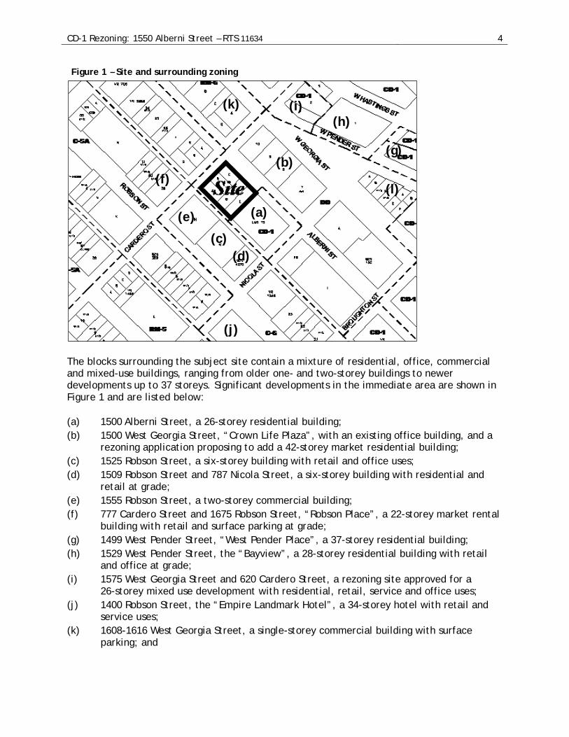
Background/Context 1. Site and Context This 1,920.8 m2 (20,675 sq. ft.) site is situated at the southeast corner of Alberni and Cardero streets (see Figure 1) and is currently developed with an eight-storey office building. The site is comprised of five legal parcels with a frontage of 39.89 m (131 ft.) along Cardero Street and 48.15 m (158 ft.) along Alberni Street.
CD-1 Rezoning: 1550 Alberni Street – RTS 11634 4
Figure 1 – Site and surrounding zoning
The blocks surrounding the subject site contain a mixture of residential, office, commercial and mixed-use buildings, ranging from older one- and two-storey buildings to newer developments up to 37 storeys. Significant developments in the immediate area are shown in Figure 1 and are listed below:
(a) 1500 Alberni Street, a 26-storey residential building; (b) 1500 West Georgia Street, “Crown Life Plaza”, with an existing office building, and a
rezoning application proposing to add a 42-storey market residential building; (c) 1525 Robson Street, a six-storey building with retail and office uses; (d) 1509 Robson Street and 787 Nicola Street, a six-storey building with residential and
retail at grade; (e) 1555 Robson Street, a two-storey commercial building; (f) 777 Cardero Street and 1675 Robson Street, “Robson Place”, a 22-storey market rental
building with retail and surface parking at grade; (g) 1499 West Pender Street, “West Pender Place”, a 37-storey residential building; (h) 1529 West Pender Street, the “Bayview”, a 28-storey residential building with retail
and office at grade; (i) 1575 West Georgia Street and 620 Cardero Street, a rezoning site approved for a
26-storey mixed use development with residential, retail, service and office uses; (j) 1400 Robson Street, the “Empire Landmark Hotel”, a 34-storey hotel with retail and
service uses; (k) 1608-1616 West Georgia Street, a single-storey commercial building with surface
parking; and
(a)
(b)
(c) (d)
(e)
(f)
(g)
(h) (i)
(j)
(k)
(l)
CD-1 Rezoning: 1550 Alberni Street – RTS 11634 5
(l) 1445-1455 West Georgia Street, where a rezoning application may be considered for a “gateway landmark” higher building.
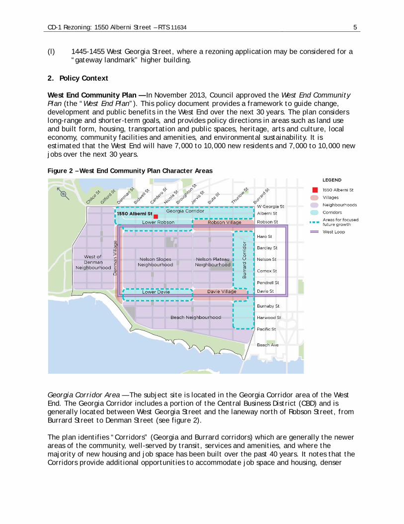
2. Policy Context West End Community Plan — In November 2013, Council approved the West End Community Plan (the “West End Plan”). This policy document provides a framework to guide change, development and public benefits in the West End over the next 30 years. The plan considers long-range and shorter-term goals, and provides policy directions in areas such as land use and built form, housing, transportation and public spaces, heritage, arts and culture, local economy, community facilities and amenities, and environmental sustainability. It is estimated that the West End will have 7,000 to 10,000 new residents and 7,000 to 10,000 new jobs over the next 30 years. Figure 2 – West End Community Plan Character Areas
Georgia Corridor Area — The subject site is located in the Georgia Corridor area of the West End. The Georgia Corridor includes a portion of the Central Business District (CBD) and is generally located between West Georgia Street and the laneway north of Robson Street, from Burrard Street to Denman Street (see figure 2). The plan identifies “Corridors” (Georgia and Burrard corridors) which are generally the newer areas of the community, well-served by transit, services and amenities, and where the majority of new housing and job space has been built over the past 40 years. It notes that the Corridors provide additional opportunities to accommodate job space and housing, denser
CD-1 Rezoning: 1550 Alberni Street – RTS 11634 6
development close to transit, local services and amenities, which help meet the needs of the community. Rezoning Policy for the West End — In November 2013, Council approved the Rezoning Policy for the West End. For sites in the Georgia Corridor, east of Cardero Street, rezoning may be considered for increasing the permitted density for market residential. Subject to urban design performance, typical tower floor plates of 603.9 m2 (6,500 sq. ft.) may be considered, with heights of up to 152.4 m (500 ft.), although building proposals within established view corridors should not exceed view cone height limits, unless in accordance with the General Policy for Higher Buildings. 3. Revisions to Rezoning Application The original application, submitted on September 11, 2015, proposed to rezone the site from 6.00 FSR to 14.37 FSR, to allow for a 43-storey mixed use building with market residential and commercial uses at grade, and a height of 132.35 m (434 ft.). Following engagement with the neighbourhood on this proposal, and in response to staff analysis and advice, a revised rezoning application was submitted. The revised application, received May 3, 2016, reduced the average tower floor plate on floors 7 to 43 from 636 m2 (6,845 sq. ft.) to 615 m2 (6,620 sq. ft.), resulting in these consequent changes:
• A reduction in the density from 14.37 FSR to 14.15 FSR (while the project statistics initially included a proposed FSR of 14.08 for the revised application, staff review of the application material has indicated an FSR of 14.15);
• A reduction in the number of residential units from 188 to 181; and • An increase in the number of vehicle parking spaces from 271 to 277.
The proposed height and land use are consistent between the two application submissions.
CD-1 Rezoning: 1550 Alberni Street – RTS 11634 7
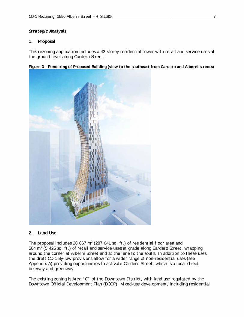
Strategic Analysis 1. Proposal
This rezoning application includes a 43-storey residential tower with retail and service uses at the ground level along Cardero Street. Figure 3 – Rendering of Proposed Building (view to the southeast from Cardero and Alberni streets)
2. Land Use The proposal includes 26,667 m2 (287,041 sq. ft.) of residential floor area and 504 m2 (5,425 sq. ft.) of retail and service uses at grade along Cardero Street, wrapping around the corner at Alberni Street and at the lane to the south. In addition to these uses, the draft CD-1 By-law provisions allow for a wider range of non-residential uses (see Appendix A) providing opportunities to activate Cardero Street, which is a local street bikeway and greenway. The existing zoning is Area “G” of the Downtown District, with land use regulated by the Downtown Official Development Plan (DODP). Mixed-use development, including residential
CD-1 Rezoning: 1550 Alberni Street – RTS 11634 8
and commercial uses, may be considered under the existing zoning for the site. There is no requirement for continuous retail and commercial uses in this area of the DODP. The DODP is structured in such a way that if a site within its boundaries is rezoned to Comprehensive Development (CD-1) District, the rezoned site is automatically removed from the Downtown District (DD) zoning district (no amendments to the DODP are required) and, as a result, the DODP no longer applies to the rezoned site. Although no longer part of the DODP, the DODP land use policy and urban design considerations (in this case the Downtown (Except Downtown South) Design Guidelines) are applied where possible in creating the new CD-1. A total of 181 market residential units are proposed, including 140 two-bedroom units (77%) and 20 three-bedroom units (11%). The West End Plan requires that 25% of units in new market residential developments have two- and three-bedroom units for families, designed in accordance with the High-Density Housing for Families with Children Guidelines. With a total of 88% family units, this application exceeds that requirement. While this application was received prior to the recent adoption of the a new Family Room: Housing Mix Policy for Rezoning Projects (July 2016) which requires 35% family units of which 10% are three-bedroom units, the proposal nonetheless meets the new policy. The proposed land uses are supported, consistent with the intent of the DODP and the West End Plan, achieving primarily residential development with ground level uses that help animate the pedestrian experience for passersby along Cardero Street.
4. Density and Form of Development West End Built Form Principles — The West End Plan uses a principled approach to shape how and where growth and development occurs and the appropriate built form. Seven community-wide contextual design principles provide structure and guidance to the more detailed policies, guidelines and regulations applied to the individual character areas (see Appendix E for more information) The “Places” section of the West End Plan outlines additional built form parameters specific to the Georgia Corridor area. Rezoning sites should have a minimum site frontage of 39.6 m (130 ft.), although smaller frontages can be considered at the discretion of the Director of Planning. For this sub-area of the Georgia Corridor, east of Cardero Street, heights of up to 152.4 m (500 ft.) may be considered, subject to Council-approved view corridors, with typical tower floor plates of 609.9 m2 (6,500 sq. ft.) to maximize views and sunlight on sidewalks. Maximum densities are subject to urban design considerations on a site by site basis. Density — Under the existing DODP, the density permitted on the site in Area “G” is a floor space ratio (FSR) of 6.0, with Office uses limited to a maximum FSR of 5.0. The rezoning application, as submitted on May 3, 2016, proposes an overall floor area of 27,171 m2 (292,466 sq. ft.), equivalent to 14.15 FSR. For rezoning sites in the Downtown District (DD), open balconies representing up to 12% of the residential floor area may be excluded from the FSR calculation. The proposal includes 4,757 m2 (51,204 sq. ft.) of open balcony, equivalent to 19.2% of the proposed residential floor area. The open balcony overage of 1,787 m2 (19,235 sq. ft.) would be included in the FSR calculation, equivalent to 0.93 FSR, with the requirement that those balconies remain open for the life of the building (see Appendix A and Appendix B).

CD-1 Rezoning: 1550 Alberni Street – RTS 11634 9
Under the provisions of the DODP, residential amenity up to 929 m2 (10,000 sq. ft.) may be excluded from the calculation of FSR. The proposal includes a total 1,060 m2 (11,410 sq. ft.) of residential amenity, in excess of the maximum excludable amount. The residential amenity overage of 131 m2 (1,410 sq. ft.), equivalent to 0.07 FSR, would be included in the FSR calculation (see Appendix A and Appendix B). Staff urban design assessment concludes that this floor area can be appropriately accommodated on the site, subject to the design development conditions in Appendix B. Architecture and Form of Development —The application proposes a 43-storey mixed-use building, with commercial uses at grade along Cardero Street, and a covered landscaped forecourt fronting on Alberni Street. The proposal’s sculpted form has been distinctively shaped in response to an intent to preserve nearby private views. The gently curved sculpting of the Alberni Street façade also serves as a respectful gesture that will frame the finely crafted office building at 1500 West Georgia Street (the Crown Life building). The proposed form and evocative expression have demonstrated a significant and recognizable new benchmark for architectural creativity for the residential tower, and the domed garden and treed forecourt will create a unique spatial presence to the public realm in this urban context. Further design development is recommended to the proposal’s intention of providing high quality materials and detailing for the building expression, which will weather well and retain a quality appearance into the future (see Appendix B). Height and Shadowing — The height of the proposed tower is 132.35 m (434 ft.), to the underside of View Cone 3.2.1 (Queen Elizabeth Park to the North Shore mountains). The proposed height has been assessed and it has been concluded that the height supportable given the broader urban design objectives, embodied in the West End Plan, to achieve a legible “dome shaped” skyline and to strengthen the “urban frame” of the Georgia and Burrard corridors in contrast with the established neighbourhoods of the West End. Shadow impacts on public spaces have also been assessed. Analysis provided by the applicant indicates that shadows caused by the proposed tower cross over West Georgia Street, but will not reach the nearest open green space, that of 699 Cardero Street on the equinox. Staff have concluded that the proposed height does not contribute to additional shadow impacts during key daylight hours. View Impacts — The applicant has prepared a thorough view impact analysis, particularly focused on impacts to private views from nearby 1500 Alberni Street. Accepting that westerly views would be affected from tall development on the subject site, staff are satisfied that the design of the proposed building has been sited and specifically shaped to be responsive to nearby views to preserve as much view angle from the westerly units of 1500 Alberni Street as possible. Conditions of approval (see Appendix B) seek compliance with the objectives of the floorplate parameters established in the West End Plan to further improve view angles, from nearby private residences, and as viewed from public areas (refer to Appendix E for additional discussion and analysis).
CD-1 Rezoning: 1550 Alberni Street – RTS 11634 10
Urban Design Panel — The rezoning application and the proposed form of development were reviewed by the Urban Design Panel, receiving support on December 2, 2015 (see Appendix D). It is recommended, subject to the Public Hearing, that the proposal be approved, subject to the conditions in Appendix B, which seek further design refinement at the Development Permit stage. The form of development drawings are included in Appendix F and the development statistics are included in Appendix H. 5. Parking and Transportation Parking — The application includes eight levels of underground parking, accessed off the lane, providing a total of 277 parking spaces. The Parking By-law would require a minimum 194 parking spaces. Loading and Access — Based on the Parking By-law, the proposed development would require a minimum of three Class B loading spaces. A total of two Class A loading spaces and two Class B loading spaces are proposed. Staff have indicated support for a loading relaxation to two Class A loading spaces and two enlarged Class B loading spaces. This relaxation is reflected in the recommended Parking By-law amendment (Appendix C) and in the recommended conditions of approval (Appendix B). Bicycle Spaces — The application would meet or exceed the Parking By-law for bicycle spaces, with access from the lane using a bicycle elevator. Staff have indicated support for the proposed location and elevator access for the bicycle parking, subject to refinements as noted in the recommended conditions of approval (Appendix B). Neighbourhood Transportation — A transportation study was prepared as part of the rezoning application material for the site. The study indicated that the proposed development would generate a similar number of vehicular trips as the existing office building on site, and as such would not result in an increase in traffic during the peak hours. Located in the Georgia Corridor of the West End, the subject site is well located with regard to transit, with multiple bus routes nearby, as well as bicycle routes on both Alberni and Cardero Streets. Enhancements to the existing pedestrian and cycling network are anticipated along Cardero Street, from the lane south of Alberni Street, to the north to Hastings Street. Rezoning conditions in Appendix B seek the completion of a 3.15 m (10 ft.) concrete sidewalk, a 1.2 m (4 ft.) boulevard with street trees, and a 2.5 m (8 ft.) protected bike facility along Cardero Street adjacent to the subject site. The Engineering conditions of approval are set out in Appendix B. 6. Environmental Sustainability The Green Buildings Policy for Rezonings (amended by Council on June 25, 2014) requires that rezoning applications achieve a minimum of LEED® Gold rating, with targeted points for water efficiency and stormwater management and a 22% reduction in energy cost as compared to ASHRAE 90.1 2010, along with registration and application for certification of the project. The applicant submitted a preliminary LEED® scorecard, which generally conforms to
CD-1 Rezoning: 1550 Alberni Street – RTS 11634 11
the rezoning policy, indicating that the project could attain the required LEED® points and energy efficiency and, therefore, would be eligible for a LEED® Gold rating. One of the strategies of the Green Buildings Policy for Rezonings is the provision of low carbon energy. The Greenest City Action Plan seeks to reduce citywide greenhouse gas emissions by 33 percent or 1,110,000 tonnes of CO2 per year by 2020. Neighbourhood Energy Systems (NES) are targeted to deliver 11 percent of this reduction by more efficiently delivering thermal energy to connected buildings while also incorporating low carbon energy sources into the NES network. In October, 2012, Council adopted the Vancouver Neighbourhood Energy Strategy which identified the Downtown as a target area for NES development. The Rezoning Policy for the West End also requires new developments in the West End to be designed to include a hydronic heating system in order to easily connect to a neighbourhood energy system when one becomes available. The City is working with utility partners on expanding downtown NES and converting them to low carbon energy by 2020. Increasing the amount of connected floor area will effectively improve the business case for the fuel switch and associated GHG reductions. Conditions of approval are set out in Appendix B.
PUBLIC INPUT
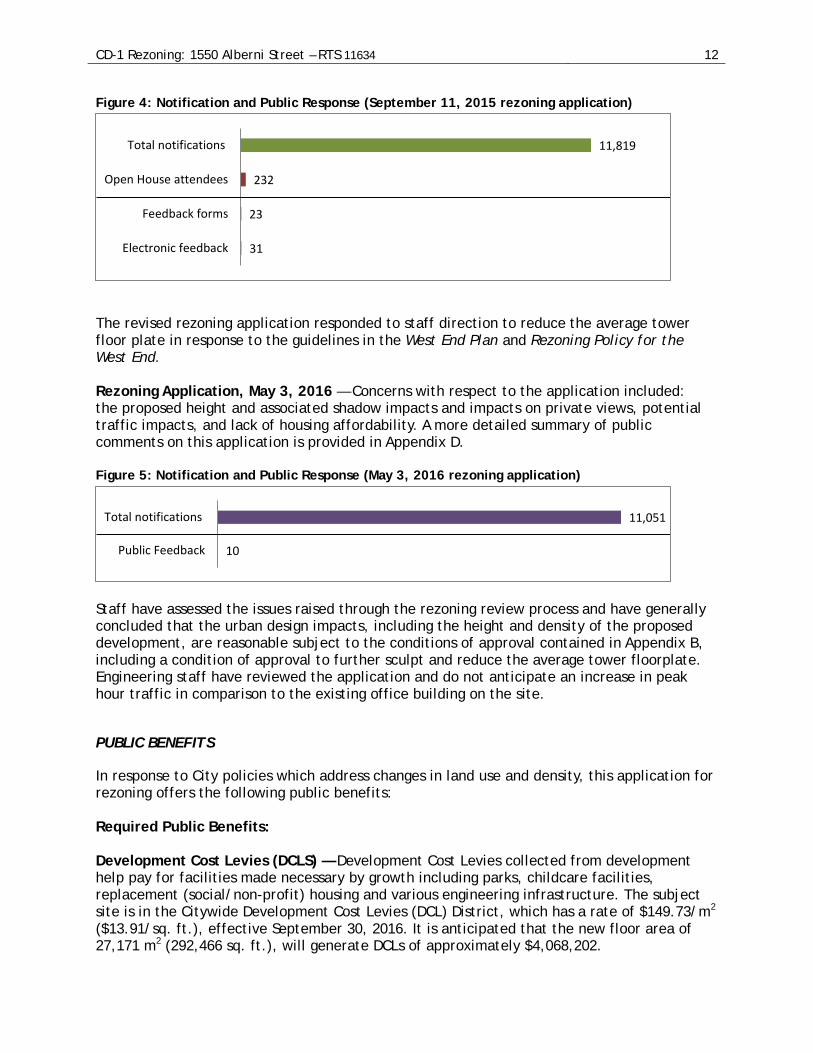
Public Notification — A rezoning information sign was installed on the site on October 2, 2015. Approximately 11,819 notifications were sent out to surrounding residents and businesses on or about October 17, 2015. A community open house was held on November 3, 2015. Staff, the applicant team, and a total of approximately 232 people attended the Open House. For the revised rezoning application, total of 11,819 notifications were distributed within the neighbouring area on or about June 2, 2016, and a new rezoning information sign was installed on the site. Notification and application information, as well as an online comment form, was provided on the City of Vancouver Rezoning Centre webpage (vancouver.ca/rezapps). Below is an overview of the public feedback provided in response to the application: Rezoning Application, September 11, 2015 — While there was support for new development on the site, concerns with respect to the application included: the proposed height and associated impacts on private views, potential shadow impacts, particularly on Alberni Street, potential traffic impacts, lack of housing affordability, and the rate of change resulting from new development in this area. A more detailed summary of public comments on this application is provided in Appendix D.
CD-1 Rezoning: 1550 Alberni Street – RTS 11634 12
Figure 4: Notification and Public Response (September 11, 2015 rezoning application)
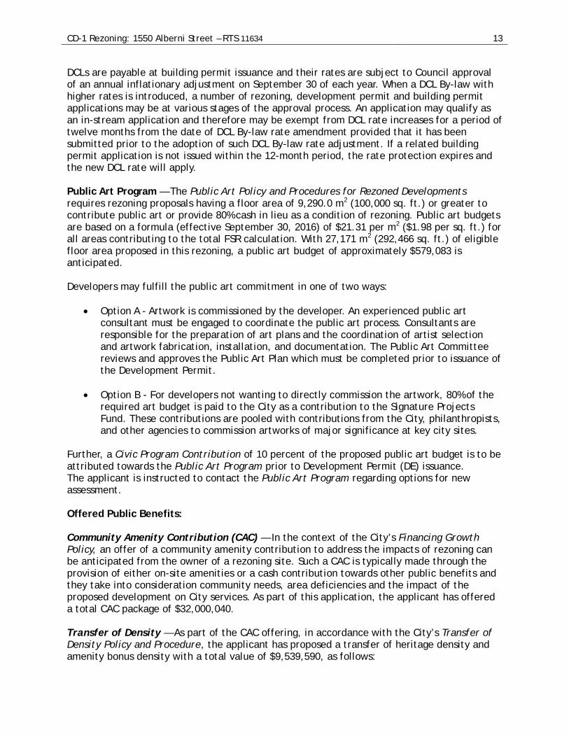
The revised rezoning application responded to staff direction to reduce the average tower floor plate in response to the guidelines in the West End Plan and Rezoning Policy for the West End. Rezoning Application, May 3, 2016 — Concerns with respect to the application included: the proposed height and associated shadow impacts and impacts on private views, potential traffic impacts, and lack of housing affordability. A more detailed summary of public comments on this application is provided in Appendix D. Figure 5: Notification and Public Response (May 3, 2016 rezoning application)
Staff have assessed the issues raised through the rezoning review process and have generally concluded that the urban design impacts, including the height and density of the proposed development, are reasonable subject to the conditions of approval contained in Appendix B, including a condition of approval to further sculpt and reduce the average tower floorplate. Engineering staff have reviewed the application and do not anticipate an increase in peak hour traffic in comparison to the existing office building on the site.
PUBLIC BENEFITS
In response to City policies which address changes in land use and density, this application for rezoning offers the following public benefits: Required Public Benefits: Development Cost Levies (DCLS) — Development Cost Levies collected from development help pay for facilities made necessary by growth including parks, childcare facilities, replacement (social/non-profit) housing and various engineering infrastructure. The subject site is in the Citywide Development Cost Levies (DCL) District, which has a rate of $149.73/m2 ($13.91/sq. ft.), effective September 30, 2016. It is anticipated that the new floor area of 27,171 m2 (292,466 sq. ft.), will generate DCLs of approximately $4,068,202.
31
23
232
11,819
Electronic feedback
Feedback forms
Open House attendees
Total notifications
10
11,051
Public Feedback
Total notifications
CD-1 Rezoning: 1550 Alberni Street – RTS 11634 13
DCLs are payable at building permit issuance and their rates are subject to Council approval of an annual inflationary adjustment on September 30 of each year. When a DCL By-law with higher rates is introduced, a number of rezoning, development permit and building permit applications may be at various stages of the approval process. An application may qualify as an in-stream application and therefore may be exempt from DCL rate increases for a period of twelve months from the date of DCL By-law rate amendment provided that it has been submitted prior to the adoption of such DCL By-law rate adjustment. If a related building permit application is not issued within the 12-month period, the rate protection expires and the new DCL rate will apply. Public Art Program — The Public Art Policy and Procedures for Rezoned Developments requires rezoning proposals having a floor area of 9,290.0 m2 (100,000 sq. ft.) or greater to contribute public art or provide 80% cash in lieu as a condition of rezoning. Public art budgets are based on a formula (effective September 30, 2016) of $21.31 per m2 ($1.98 per sq. ft.) for all areas contributing to the total FSR calculation. With 27,171 m2 (292,466 sq. ft.) of eligible floor area proposed in this rezoning, a public art budget of approximately $579,083 is anticipated. Developers may fulfill the public art commitment in one of two ways:
• Option A - Artwork is commissioned by the developer. An experienced public art consultant must be engaged to coordinate the public art process. Consultants are responsible for the preparation of art plans and the coordination of artist selection and artwork fabrication, installation, and documentation. The Public Art Committee reviews and approves the Public Art Plan which must be completed prior to issuance of the Development Permit.
• Option B - For developers not wanting to directly commission the artwork, 80% of the required art budget is paid to the City as a contribution to the Signature Projects Fund. These contributions are pooled with contributions from the City, philanthropists, and other agencies to commission artworks of major significance at key city sites.
Further, a Civic Program Contribution of 10 percent of the proposed public art budget is to be attributed towards the Public Art Program prior to Development Permit (DE) issuance. The applicant is instructed to contact the Public Art Program regarding options for new assessment. Offered Public Benefits: Community Amenity Contribution (CAC) — In the context of the City’s Financing Growth Policy, an offer of a community amenity contribution to address the impacts of rezoning can be anticipated from the owner of a rezoning site. Such a CAC is typically made through the provision of either on-site amenities or a cash contribution towards other public benefits and they take into consideration community needs, area deficiencies and the impact of the proposed development on City services. As part of this application, the applicant has offered a total CAC package of $32,000,040. Transfer of Density — As part of the CAC offering, in accordance with the City’s Transfer of Density Policy and Procedure, the applicant has proposed a transfer of heritage density and amenity bonus density with a total value of $9,539,590, as follows:

CD-1 Rezoning: 1550 Alberni Street – RTS 11634 14
• A purchase of 6,916 m2 (74,444 sq. ft.) of heritage density valued at $6,258,590; and • A purchase of 3,586 m2 (38,600 sq. ft.) of amenity bonus density valued at $3,281,000.
These purchases would help support citywide heritage conservation by contributing to the reduction of the Heritage Density Bank, as well as supporting public amenity space delivered as part of the redevelopment of 101 West Hastings Street (Woodwards). This allocation is supported as part of the public benefits associated with this application and, if this application is referred to Public Hearing, a letter of intent for the purchase of heritage density (Letter A) must be submitted prior to the Public Hearing. Cash CAC — In addition to the purchase of heritage and amenity bonus density, the applicant has offered a cash CAC of $22,460,450. Based on the Public Benefits Strategy adopted by Council as part of the West End Plan, it is recommended that the cash CAC be allocated as follows:
• $8,250,000 toward public realm improvements in and around the West End area, which could include improvements to the Cardero Stroll, Alberni Street, Georgia Gateway, and Robson Village areas, including a new public plaza at Bute Street.
• $10,657,838 toward renewal and expansion of community facilities in and around the West End area, which could include the West End Community Centre complex, childcare, library, seniors’ centre, and/or cultural space.
• $3,552,613 toward affordable housing in and around the West End area. See Appendix G for a summary of all of the public benefits for this application. Phased Approach to Cash CAC Payment The Community Amenity Contributions – Through Rezonings policy currently requires full payment of any cash CAC (including the purchase of heritage density) prior to rezoning enactment. In this exceptional case, given the scale of the cash CAC being offered and associated financing implications, staff are recommending a phased approach to CAC payment, as outlined in sub-section (c)10 of Appendix B. This approach would constitute a waiver by Council of the current requirements of the Community Amenity Contributions – Through Rezonings policy. If approved by Council, the majority of the CAC (the purchase and transfer of heritage and amenity bonus density with a value of $9,539,590 and the payment of $10,460,450 of the cash CAC) would be delivered prior to enactment, with the remainder of the cash CAC to be paid within eighteen months of the date of enactment of the CD-1 By-law (see Appendix B for further details). Real Estate Services has reviewed the applicant’s development pro forma for this rezoning application and have concluded that the CAC offered by the property owner is appropriate, and recommend that the offer be accepted.
CD-1 Rezoning: 1550 Alberni Street – RTS 11634 15
Implications/Related Issues/Risk (if applicable) Financial As noted in the section on Public Benefits, the applicant has offered a total CAC package of $32,000,040, comprised of: Transfer of Density:
• Purchase and transfer of heritage density with a value of $6,258,590 which will reduce the density bank by approximately 6,916 m2 (74,444 sq. ft.) of floor area; and
• Purchase and transfer of amenity bonus density with a value of $3,281,000, which will complete the transfer of available amenity density from 101 West Hastings Street (Woodwards) by 3,586 m2 (38,600 sq. ft.).
Cash CAC:
• $8,250,000 toward public realm improvements in and around the West End area, which could include improvements to the Cardero Stroll, Alberni Street, Georgia Gateway, and Robson Village areas, including a new public plaza at Bute Street.
• $10,657,838 toward renewal and expansion of community facilities in and around the West End area, which could include the West End Community Centre complex, childcare, library, seniors’ centre, and/or cultural space.
• $3,552,613 toward affordable housing in and around the West End area. Subject to Council approval, approximately $10.5 million of the cash CAC would be paid prior to enactment, with the remainder of the cash CAC to be paid within eighteen months of the date of enactment of the CD-1 By-law. The City will secure payment of the deferred portion of the cash CAC through a first mortgage on the land and/or other security approved by the Director of Legal Services (see Appendix B for further details). Approval and timing of specific projects will be brought forward as part of the Capital Plan and Budget processes. If the rezoning application is approved, the applicant will be required to provide new public art on-site, or make a cash contribution to the City for off-site public art, at an estimated value of $579,083. The site is within the Citywide Development Cost Levies (DCL) District and it is anticipated that the applicant will pay $4,068,202 in DCLs.
CONCLUSION
Assessment of this rezoning application has concluded that the proposed land uses, density and height are supported, subject to the recommended changes as outlined above and in Appendix B, and that the public benefits of this project would provide a significant contribution towards the targets set in the West End Plan Public Benefits Strategy, as well as providing additional residential and commercial space in the Georgia Corridor, as anticipated in the West End Plan and Rezoning Policy for the West End.

CD-1 Rezoning: 1550 Alberni Street – RTS 11634 16
The Acting General Manager of Planning, Urban Design and Sustainability recommends that the application be referred to Public Hearing together with a draft CD-1 By-law as generally shown in Appendix A and with a recommendation of the Acting General Manager of Planning, Urban Design and Sustainability that these be approved, subject to the Public Hearing, along with the conditions of approval listed in Appendix B, including approval in principle of the form of development as shown in plans included as Appendix F.
* * * * *
APPENDIX A PAGE 1 OF 4
1550 Alberni Street PROPOSED CD-1 BY-LAW PROVISIONS
Note: A By-law will be prepared generally in accordance with the provisions listed below,
subject to change and refinement prior to posting. Zoning District Plan Amendment 1.1 This By-law amends the Zoning District Plan attached as Schedule D to By-law No.
3575, and amends or substitutes the boundaries and districts shown on it, according to the amendments, substitutions, explanatory legends, notations, and references shown on the plan marginally numbered Z-(___) attached as Schedule A to this By-law, and incorporates Schedule A into Schedule D, to By-law No. 3575.
[Schedule A is a map that will be prepared for the draft by-law, and that will be posted prior to the Public Hearing.]
Uses 2.1 The description of the area shown within the heavy black outline on Schedule A is CD-1
(___).
2.2 Subject to approval by Council of the form of development, to all conditions, guidelines and policies adopted by Council, and to the conditions set out in the By-law or in a development permit, the only uses permitted and the only uses for which the Director of Planning or Development Permit Board will issue development permits are:
(a) Cultural and Recreational Uses, limited to Artist Studio – Class A, Arts and
Culture Indoor Event, and Community Centre or Neighbourhood House; (b) Dwelling Uses, limited to Dwelling Units in conjunction with any of the uses
listed in this By-law; (c) Institutional Uses, limited to Child Day Care Facility; (d) Retail Uses, limited to Liquor Store, Neighbourhood Grocery Store, and
Retail Store; (e) Service Uses, limited to Barber Shop or Beauty Salon, Beauty and Wellness
Centre, and Restaurant - Class 1; and (f) Accessory Use customarily ancillary to any use permitted by this section.
Conditions of Use 3.1 The design and lay-out of at least 25% of the dwelling units must:
(a) be suitable for family housing; (b) include two or more bedrooms; and (c) comply with Council’s “High Density Housing for Families with Children
Guidelines”. 3.2 All commercial uses must be carried on wholly within an enclosed building except for:
APPENDIX A PAGE 2 OF 4
(a) Restaurant; (b) Retail Store; and (c) Display of flowers, plants, fruits, and vegetables, in conjunction with a
permitted use. 3.3 Residential uses are not permitted on floors located at street level, fronting on
Cardero Street. Density 4.1 Computation of floor space ratio must assume that the site consists of 1,920.8 m2
[20,675 sq. ft.], being the site size at the time of the application for the rezoning evidenced by this By-law, prior to any dedications.
4.2 The floor space ratio for all uses combined must not exceed 14.15.
4.3 The floor space ratio for Dwelling Uses must not exceed 13.89, except that: (a) 0.93 is limited to open balcony space, in excess of that excluded in 4.5 (a), and
may not be enclosed for the life of the building; and
(b) 0.07 is limited to enclosed residential amenity space in excess of that excluded in 4.6 (a).
4.4 Computation of floor area must include all floors having a minimum ceiling height of
1.2 m, including earthen floor, both above and below ground level, measured to the extreme outer limits of the building.
4.5 Computation of floor area must exclude:
(a) open residential balconies or sundecks and any other appurtenances which, in the opinion of the Director of Planning, are similar to the foregoing, except that: (i) the total area of all such exclusions must not exceed 12 % of the
residential floor area; and (ii) the balconies must not be enclosed for the life of the building;
(b) patios and roof gardens only if the Director of Planning first approves the
design of sunroofs and walls;
(c) where floors are used for off-street parking and loading, the taking on or discharging of passengers, bicycle storage, heating and mechanical equipment, or uses which in the opinion of the Director of Planning are similar to the foregoing; those floors or portions thereof so used, which are at or below the base surface, except that the exclusion for a parking space must not exceed 7.3 m in length; and

APPENDIX A PAGE 3 OF 4
(d) all residential storage area above or below base surface, except that if the residential storage area above base surface exceeds 3.7 m2 for a dwelling unit there will be no exclusion for any of the residential storage area above base surface for that unit.
4.6 Computation of floor area may exclude, at the discretion of the Director of Planning or
Development Permit Board:
(a) amenity areas, except that the exclusion must not exceed, in aggregate, the lesser of 20 % of the permitted floor area or 929 m2; and
(b) unenclosed outdoor areas underneath tower building overhangs, provided they are at grade level, except that they must remain unenclosed for the life of the building.
4.7 The use of floor area excluded under section 4.5 or 4.6 must not include any use other
than that which justified the exclusion. Building Height 5.1 The building height, measured above base surface, must not exceed
132.35 m [434 ft.], except that no part of the development shall protrude into the approved view corridors, as set out in the City of Vancouver View Protection Guidelines.
Horizontal Angle of Daylight 6.1 Each habitable room must have at least one window on an exterior wall of a building.
6.2 The location of each such exterior window must allow a plane or planes extending
from the window and formed by an angle of 50 degrees, or two angles with a sum of 70 degrees, to encounter no obstruction over a distance of 24.0 m.
6.3 Measurement of the plane or planes referred to in section 6.2 must be horizontally from the centre of the bottom of each window.
6.4 If: (a) the Director of Planning or Development Permit Board first considers all the
applicable policies and guidelines adopted by Council; and (b) the minimum distance of the unobstructed view is not less than 3.7 m; the Director of Planning or Development Permit Board may relax the horizontal angle of daylight requirement.
6.5 An obstruction referred to in section 6.2 means: (a) any part of the same building including permitted projections; or
APPENDIX A PAGE 4 OF 4
(b) the largest building permitted under the zoning on any site adjoining CD-1 (___).
6.6 A habitable room referred to in section 6.1 does not include:
(a) a bathroom; or (b) a kitchen whose floor area is the lesser of:
(i) 10 % or less of the total floor area of the dwelling unit, or (ii) 9.3 m2
.
Acoustics 7.1 All development permit applications require evidence in the form of a report and
recommendations prepared by a person trained in acoustics and current techniques of noise measurement, demonstrating that the noise levels in those portions of dwelling units listed below do not exceed the noise level set opposite such portions. For the purposes of this section, the noise level is the A-weighted 24-hour equivalent (Leq) sound level and is defined simply as noise level in decibels.
Portions of dwelling units Noise levels (Decibels) Bedrooms 35 Living, dining, recreation rooms 40 Kitchen, bathrooms, hallways 45
* * * * *
APPENDIX B PAGE 1 OF 18
1550 Alberni Street DRAFT CONDITIONS OF APPROVAL
Note: Recommended approval conditions will be prepared generally in accordance with the
draft conditions listed below, subject to change and refinement prior to finalization of the agenda for the Public Hearing.
CONDITIONS OF APPROVAL OF FORM OF DEVELOPMENT (a) That the proposed form of development be approved by Council in principle, generally
as prepared by Merrick Architecture in conjunction with Kengo Kuma and Associates, and stamped “Received City Planning Department, May 3, 2016”, provided that the Acting General Manager of Planning, Urban Design and Sustainability may allow minor alterations to this form of development when approving the detailed scheme of development as outlined in (b) below.
(b) That, prior to approval by Council of the form of development, the applicant shall obtain approval of a development application by the Director of Planning, who shall have particular regard to the following:
Urban Design
1. Design development to further reduce the average floorplate of the tower
above a height of 18.3 m (60 ft.) to meet the floorplate size objective of 603.9 m2 (6,500 sq. ft.) as set out in the West End Plan. Note to Applicant: The intent of the floorplate control is to limit building bulk in order to preserve views and maintain access to light to public areas. As such, the technical measure of floorplate should include areas of a floor that are open to below, structure, and storage; and should only exclude exterior balcony areas. The degree of visual porosity of the full-height parapet walls at the perimeter of Level 43 (transparency of glass, design of supporting structural members, and translucency of aluminum panels) will determine whether the roof deck areas of that level will be included into the computation of floorplate. Refer also to Condition 4.
2. Design development to maintain the general building form, balconies and architectural expression as illustrated. Note to Applicant: Balcony area in excess of 12% will be included in the calculation of FSR, but shall not be captured in or converted to enclosed floor area or otherwise cause an increase in building bulk.
3. Design development to maintain the high quality materials and to maintain the level of detailing implied and necessary to accomplish and construct the proposed design aesthetic (this includes the minimal and flush detail conditions at floors, columns, soffits, guards, wedge-shaped floor extrusions, the layering of shingle panels, perforated metal panels and the domed lattice work at the forecourt).
APPENDIX B PAGE 2 OF 18
Note to Applicant: Particular attention should be applied to the effects of weathering of architectural elements that are exposed contrasted to similar elements that are covered, such as exterior concrete columns. The proposed materials (aluminum shingle panels, domed lattice wood grid structure, butt glazing at commercial frontage, structural glass with glass fins on levels two through six, clear glazing in concealed aluminum frames on residential levels) and detailing are to be carried forward and remain through the development permit process.
4. Retention of the unique architectural design and resulting low-efficiency floor layout of the building.
Note to Applicant: These were key factors in the pro forma analysis and resolution of the community benefits offering. The City has acknowledged several premium cost components in the pro forma reviewed as part of the rezoning application, including the significantly reduced floor layout efficiency rate at 69%. If the applicant chooses to make alterations to the elements of the building design, which result in the removal of such premium cost items or in increasing the efficiency above 69%, Council approval must be sought through an application to change the form of development under Schedule 1, Section 16 of the Zoning and Development Fee By-law. Any implications this would have for the Community Amenity Contribution would be reported to Council at that time.
5. Design development to the physical composition and positioning of perforated aluminum screens at balcony locations to provide a high degree of visual porosity and to ensure the openness of these outdoor spaces. Note to Applicant: The intent is to ensure good access to daylight for residents and to reduce the impression of solidity at balcony locations as viewed from public areas. Sufficient visual porosity of the panels as viewed both directly through and at an angle is required to 1) satisfy the technical requirement of Horizontal Angle of Daylight; and 2) to exclude the affected exterior balconies from the floorplate calculation. Details of perforated screens indicating material, finish and dimensions of components will be required. Screens at balconies should be noted as open to air flow and include dimensions to show that the screens occupy less than half of the balcony width, or in the case of a corner location, less than half of the balcony perimeter.
6. Design development to provide an enhanced public realm on Cardero Street
consistent with the Triangle West Streetscape Design Details (see also Engineering enactment condition 4 (c)).
7. Design development to enhance the laneway interface. Note to Applicant: Explore opportunities to improve and activate the laneway with active land uses. Consider pedestrian lighting, landscaping and gardens,

APPENDIX B PAGE 3 OF 18
seating, and other public realm improvements (see also Landscape condition 19).
8. Clarification of the intent of the use of the area on the roof of the loading area. Note to Applicant: Further study and review of the neighbouring context is required to determine suitability of any use at that area. Any proposed structure located on the roof of the loading bay must not compromise the horizontal angle of adjacent residential units.
9. Provision of confirmation that the open domed garden and forecourt will not be enclosed at any time in the future; Note to Applicant: This condition will be carried forward through to the development permit stage.
10. Design development to the landscaping and proposed use along Alberni Street
to: (a) Provide improved visibility to the ground level commercial space as
viewed from the sidewalk;
(b) Imply that the forecourt area is for private use;
(c) Clearly identify entry locations; and
(d) Respond to Crime Prevention Through Environmental Design (CPTED) principles.
Note to Applicant: See also CPTED condition 15.
11. Provision of a vertical vent space to accommodate future exhaust from the
commercial level. Note to Applicant: Intent is to allow for a wider range of uses, including restaurants, without requiring the retrofitting of exhaust ducting on the outside of the building.
12. Submission of a bird friendly strategy for the design of the building and landscape is encouraged in the application for a development permit. Note to Applicant: Strategy should identify any particular risks with regard to the Bird Friendly Design Guidelines and propose design features or to reduce these risks. For more information, see the guidelines at http://former.vancouver.ca/commsvcs/guidelines/B021.pdf.
13. Design development to improve the circulation to the exterior children’s play area.
APPENDIX B PAGE 4 OF 18
Note to Applicant: The play area should be both handicap accessible and more conveniently accessed. Refer also to Urban Design condition 13.
14. Design development to create ground-oriented open spaces suitable for children’s play with adjacent common amenity room. Refer to the High-Density Housing for Families with Children Guidelines for more information.
15. Design development to comply with the Horizontal Angle of Daylight provision of the CD-1 By-law.
Note to Applicant: Ensure that exterior perforated aluminum panels are sufficiently porous to permit the required visual access to daylight from habitable spaces. Details of panels will be required at the development permit stage to meet the satisfaction of staff. Refer also to Condition 4. Design development is also required to provide Horizontal Angle of Daylight to habitable spaces of units 302 and 303 if the area on top of the loading area is to be developed. Refer also to Condition 7.
Crime Prevention Through Environmental Design (CPTED)
16. Design development to respond to CPTED principles, having particular regards for: (a) theft in the underground parking; (b) residential break and enter; (c) mail theft; and (d) mischief in alcoves and vandalism, such as graffiti.
Note to Applicant: Building features proposed in response to this condition should be noted on the plans and elevations. Consider use of a legend or key to features on the drawings.
Sustainability 17. Confirmation that the application is on track to meeting the Green Buildings
Policy for Rezonings including a minimum of LEED® Gold rating, with 1 point for water efficiency and stormwater management and a 22% reduction in energy cost as compared to ASHRAE 90.1 2010, along with registration and application for certification of the project.
Note to applicant: A Sustainable Design Strategy must submitted as part of the Development Permit that articulates which credits the applicant will be pursuing and how their building application, as submitted, incorporates strategies, features or technologies that will help achieve these credits. The design strategy, along with the LEED checklist must be incorporated into the drawing submission. A letter from a LEED Accredited Professional or Administrator must confirm that the proposed strategy aligns with the

APPENDIX B PAGE 5 OF 18
applicable goals of the rezoning policy. Proof of registration from the CaGBC must be provided with the application and the project registration number incorporated into the drawings. Application for Certification will be required at a subsequent stage.
Landscape 18. Design development to the covered landscaped forecourt area to allow
transparent visibility into the plaza from Alberni Street, while ensuring the plaza functions as a private space for private use only; Note to Applicant: Confirmation is required that the planting will maintain visual access over time. The taller bamboo should be replaced with another plant for safe visual access from the street. The public to private transition should clearly indicate the plaza as a private space. The children’s play area should be visible from all angles, rather than completely screened by planting. See also Urban Design conditions 12 and 13.
19. Design development to improve sustainability and expand programming to
include urban agriculture plots if possible, as well as edible plants. Note to Applicant: Edible plants can be used as ornamentals as part of the landscape design. Shared gardening areas should reference and be designed to adhere to Council’s Urban Agriculture Guidelines for the Private Realm and should provide maximum solar exposure, universal accessibility and provided with amenities such as, raised beds, water for irrigation, potting bench, tool storage and composting.
20. Provision of a pedestrian friendly experience at the lane edges by the use of down lighting and more substantial planting at grade. Note to Applicant: The lane edge planting should be protected from vehicles by a 0.2 m (8 in.) high curb.
21. Design development to ensure locations of hydro kiosk in areas screened by soft landscape, or in internal mechanical room. Any other emergency generators, transformers or gas meters to be located, integrated, and fully screened in a manner which minimizes their impact on the architectural expression and the building’s open space and public realm.
22. Arrangements to be made for the City Engineer and Vancouver Board of Parks to review all existing City-owned trees, including along Alberni and Cardero streets, as well as the six trees along the lane. Note to Applicant: Tree locations noted on the survey. Please call 311 for referral to Cabot Lyford, Urban Forestry, Park Board, and Kevin Cavell, Engineering Services. See also Engineering enactment condition 4 (i).
APPENDIX B PAGE 6 OF 18
23. A full Landscape Plan to be provided at the development permit submission stage: (a) The Landscape Plan should illustrate proposed plant materials (with
common and botanical names, plant sizes and quantities), paving, walls, railings, light fixtures, site grading and other landscape features. Plant material should be listed in a Plant List that is clearly keyed to the Landscape Plan. The Landscape Plan should be a minimum 1:100 or 1/8” scale.
(b) Section details at a minimum scale of 1/4"=1'-0" scale to illustrate typical proposed landscape elements including planters on structures, benches, fences, gates, arbours and trellises, and other features. Planter section details must confirm depth of proposed planting on structures is deep enough to accommodate rootballs of proposed trees well into the future.
(c) Sections (1/4”=1’ or 1:50) illustrating the buildings to public realm interface facing the street, confirming a delineated private to public transition of spaces.
Note to Applicant: The section should include the building façade, as well as any steps, retaining walls, guardrails, fences and planters. The location of the underground parking slab should be included in the section.
(d) Design development to locate, integrate and fully screen lane edge gas
meters and parking garage vents in a manner which minimizes their impact on the architectural expression and the project’s open space and public realm.
(e) New proposed street trees should be noted “Final species, quantity and
spacing to the approval of City Engineer and Park Board”. Contact Eileen Curran (604-871-6131) of Engineering Streets Division regarding street tree spacing and quantity. Contact Cabot Lyford (604-257-8587) of Park Board regarding tree species.
(f) A high-efficiency automatic irrigation system to be provided for all
planters on parkade slab and minimum of hose bibs to be provided for landscape on grade;
(g) A Landscape Lighting Plan to be provided for security purposes.
Note to Applicant: Lighting details can be added to the landscape drawings; all existing light poles should be shown.
(h) Please place the following notes on the landscape plans;

APPENDIX B PAGE 7 OF 18
(i) All plant material within the same continuous planting area which is located on street right-of-way within 10 m (32.8 ft.), measured from the corner, of an intersection, pedestrian crossing, entrance to a driveway or other conflict areas where sightlines need to be maintained for safety reasons, shall not exceed a mature height of 0.6 m (2 ft.), measured from the sidewalk.
(ii) All plant material within the street right-of-way which is located
outside of the areas described above shall not exceed 1 m (3.3 ft.) in height, measured from the sidewalk. Exceptions will be approved on a case-by-case basis by the City of Vancouver’s Street Activities Branch.
(iii) All plant material shall be planted in such a way that it does not
encroach on the adjacent roadway, sidewalk, bike lane or lane.
(iv) Planting proposed on street right-of-way should take into consideration parking and boulevard access requirements.
Engineering 24. Clarification is required that no portion of the building will encroach over the
property lines. Note to Applicant: Based on the grid-line locations, some building elements appear to be shown over the property lines on the elevation drawings (pages A310 - A313).
25. Clarification if any canopies or awnings are proposed to extend over the
property lines (future property lines or SRW areas); if so a separate application to the General Manager of Engineering Services is required.
26. Clarify garbage pick-up operations. Confirm whether all bins are to be pulled out through the loading bays for pick up.
27. Delete the proposed curbing shown in the lane on drawing A206. The existing
rollover curb is to remain.
28. Provision of two Class B loading spaces with double loading throats, to accommodate MSU trucks and provide 4.1 m (13.5 ft.) of vertical clearance.
Note to Applicant: The dimensions for the 2 Class B spaces shown on drawing A204 would meet this requirement. Confirm 4.1 m (13.5 ft.) of vertical clearance and the required loading throats are being provided and note on plans.
29. Provision of a Loading Management Plan outlining the following:

APPENDIX B PAGE 8 OF 18
(a) How the loading facility will operate, as two Class B spaces are proposed to be shared. Provide the framework for the detailed shared loading agreement.
(b) Management of the facility, including the name, phone number and email of the on-site loading manager.
(c) Provision of a sign outlining the loading procedure and site contact
information to be posted on-site.
(d) Specify routing of the trucks from the arterial streets to and from the loading space and show maneuvering for the largest truck to identify any required geometric changes at the lane entrance/exit that are required. The truck routing should avoid using the Cardero Street Bikeway, if possible.
(e) Show the access route from the Class B loading spaces to reach the
commercial and residential uses. The route must be ‘stairs free’ and confirm the use of an elevator, if required.
30. Provide automatic door openers on the doors providing access to the bicycle
room(s) and note on plans.
31. Compliance with the Parking and Loading Design Supplement to the satisfaction of the General Manager of Engineering Services.
Note to Applicant: The following items are required to meet provisions of the parking by-law and the parking and loading design supplement:
(a) Provision of design elevations on both sides of the parking ramp at all
breakpoints, within the parking area, both sides of the loading bay, and at all entrances.
Note to Applicant: Where there is a curved ramp, provide grades two feet from the wall on the inside radius (Section I.A). The slope and length of the ramp sections must be shown on the submitted drawings. The slope and crossfall of the loading bay must not exceed 5%.
32. Modification of the parking ramp design to the satisfaction of the General
Manager of Engineering Services. The following must be addressed:
(a) The slope must not exceed 10% for the first 6.1 m (20 ft.) from the property line. Additional design elevations are required along the outside radius of the ramp to confirm the slope and crossfall.
(b) The crossfall must not exceed 5%.
(c) The slope must not exceed 12.5% after the first 6.1 m (20 ft.) from the property line. Slopes of 15% may be acceptable if a 7.5% to 10%
APPENDIX B PAGE 9 OF 18
transition ramp is provided at the bottom for at least 4 m (13.1 ft.) in length.
(d) Provision of two-way traffic flow in the main ramp (Section I.B) – the
current ramp design and column placements on the ramp does not allow for opposing vehicles to pass and affects maneuvering.
(e) Provision of 6.1m (20 ft.) of ramp width as 5.7 m (18.7 ft.) and
5.8 m (19.0 ft.) ramp widths are shown on drawing A205 and A206. (f) Parking ramps must be designed to position vehicles perpendicular to
the lane to facilitate ease of vehicle ingress and egress from either direction of travel in the lane.
(g) Provide corner cuts through the inside radiuses of the main parking
ramp to enable two vehicles to pass each other unobstructed. Corner cuts are required at the top and bottom of ramps to provide adequate radii for continuous two-way traffic flow where 200 or more vehicles are being served. A standard 6m (20 ft.) ramp width would require a 2.7 m by 2.7m (9 ft. by 9 ft.) corner cut. Reduced corner cuts would be acceptable for wider ramps upon review.
(h) Provide increased width through the curved section of the parking ramp
to enable two vehicles to pass unobstructed.
(i) Provision of additional maneuvering analysis for the parking ramp and parking levels. Exhibit 2 in the Bunt analysis dated March 22, 2016 is missing column locations on the ramp, walls adjacent to the maneuvering aisle, and the maneuvering for the exiting vehicles from P1. Further analysis is required showing two-way flow on the ramp where 200 or more vehicles are being served with the necessary corner cuts and column adjustments. Confirm two-way flow is being provided by the bicycle elevator on drawing A203.
Note to Applicant: Explore providing two separate 3.7 m (12 ft.) wide ramps (inbound and outbound) with corner cuts and different ramp slopes. The existing slopes and crossfalls for the site may not work with a single ramp. Consultation with a Transportation Engineer is recommended.
(j) Consider relocating the maneuvering aisle at the bottom of the ramp on
P1 to be along the north property line to create greater separation between the maneuvering aisle and the revised drop-off space.
(k) Remove the column encroachment into the maneuvering aisle at gridline
A/3 on P1 and P2 to provide and improve 2-way flow.
Note to Applicant: The large column along the south wall encroaches into the maneuvering aisle.
APPENDIX B PAGE 10 OF 18
(l) Dimension all parking stalls and column encroachments and label all
types of parking and loading spaces on the drawings as commercial or residential spaces.
Note to Applicant: A column 0.61 m (2 ft.) in length must be set back 0.61 m (2 ft.) from either the opening to or the end of the parking space. A column 0.91 m (3 ft.) long may be set back 0.1 m (1 ft.). Provide additional parking stall width for stalls adjacent to walls or stalls with columns set back more than 1.2 m from the end of the stall. Provide a minimum 0.3 m (1 ft.) setback from the drive aisle for all columns.
(m) Provision of minimum vertical clearances for the main ramp, security
gates, and loading bays.
Note to applicant: A section drawing is required showing elevations, and vertical clearances. The minimum vertical clearance should be noted on plans. A minimum vertical clearance of 2.3 m (7.5 ft.) is required for access and maneuvering to all disability spaces. A minimum vertical clearance of 4.1 m (13.5 ft.) is required for Class B loading spaces and maneuvering.
(n) Provision of a bicycle elevator to the satisfaction of the
General Manager of Engineering Services.
Note to Applicant: The minimum dimensions for a bicycle elevator are 2 m (6.6 ft.) in length and 2.1 m (6.9 ft.) in width with doors on either end. Provide additional detailed information for the bike lift and swinging doors shown on drawing A205.
(o) Provision of an improved plan showing the access route from the Class A
bicycle spaces to reach the outside.
Note to Applicant: The route must be ‘stairs free’ and confirm the use of the parking ramp, if required.
Neighbourhood Energy Utility
33. The proposed approach to site heating and cooling, developed in collaboration
with the City and the City-designated NES Utility Provider, shall be provided prior to the issuance of any development permit, to the satisfaction of the General Manager of Engineering Services.
34. The building(s) heating and domestic hot water system shall be designed to be easily connectable and compatible with Neighbourhood Energy to supply all heating and domestic hot water requirements. Design provisions related to Neighbourhood Energy compatibility must be to the satisfaction of the General Manager of Engineering Services.
APPENDIX B PAGE 11 OF 18
Note to Applicant: The applicant shall refer to the Neighbourhood Energy Connectivity Standards – Design Guidelines for general design requirements related to Neighbourhood Energy compatibility at the building scale. The applicant is also encouraged to work closely with City staff during mechanical design to ensure compatibility with a neighbourhood-scale system. As a pre-condition to building permit, a declaration signed by the registered professional of record certifying that the Neighbourhood Energy connectivity requirements have been satisfied will be required.
35. Building-scale space heating and ventilation make-up air shall be provided by hydronic systems without electric resistance heat or distributed heat generating equipment (including but not limited to gas fired make-up air heaters, heat producing fireplaces, distributed heat pumps, etc.) unless otherwise approved by the General Manager of Engineering Services.
36. Provide for 21 m2 (226 sq. ft.) of adequate and appropriate dedicated space to be utilized for an energy transfer station connecting the building(s) to the City-designated Neighbourhood Energy System, as outlined in the Neighbourhood Energy Connectivity Standards - Design Guidelines, at development permit.
37. Provide for up to 93 m2 (1001 sq. ft.) of suitably located dedicated Neighbourhood Energy Room and design provisions to accommodate the City-designated NES, as outlined in the Neighbourhood Energy Connectivity Standards – Design Guidelines, to the satisfaction of the General Manager of Engineering Services.
38. Detailed design of the building HVAC and mechanical heating system at the building permit stage must be to the satisfaction of the General Manager of Engineering Services.
CONDITIONS OF BY-LAW ENACTMENT (c) That, prior to enactment of the CD-1 By-law, the registered owner shall on terms and
conditions satisfactory to the Director of Legal Services and to the General Manager of Planning, Urban Design and Sustainability, the General Manager of Engineering Services, and Approving Officer, as necessary, and at the sole cost and expense of the owner/developer, make arrangements for the following:
Engineering
1. Consolidation of Lots A, B, C, D & E, All of Lots 11 to 13, Block 43, DL 185, Plan
1354 to create a single parcel.
2. Provision of a building setback and a surface Statutory Right of Way (SRW) on Alberni Street to achieve a 4.5 m (14.8 ft.) distance from the back of the existing City curb to the proposed building face. A legal survey of the existing dimension from the back of the City curb to the existing property line is
APPENDIX B PAGE 12 OF 18
required to determine the final setback/SRW dimension. The SRW will be free of any encumbrance such as structure, stairs, door swing and plantings at grade but the encroaching building portions shown below grade and at the 3rd storey and above will be accommodated within the SRW agreement.
3. Release of Easement & Indemnity Agreement 535278M (commercial crossing)
prior to building occupancy.
Note to Applicant: Arrangements are to be secured prior to zoning enactment, with release to occur prior to issuance of an occupancy permit for the site. Provision of a letter of commitment will satisfactorily address this condition for zoning enactment. Prior to building occupancy the applicant is to supply a written request to the City, a fresh title search and a copy of the documents along with executable discharge documents to affect the releases.
4. Provision of a Services Agreement to detail the on and off-site works and services necessary or incidental to the servicing of the site (collectively called the “services”) such that they are designed, constructed and installed at no cost to the City and all necessary street dedications and rights of way for the services are provided. No development permit for the site will be issued until the security for the services are provided:
(a) Provision of a standard concrete pedestrian lane crossing and new curb
returns at the lane entrance south of Alberni Street on the east side of Cardero Street.
(b) Provision of a new curb return and curb ramps at the south east corner of Alberni Street and Cardero Street (adjacent to the site).
(c) Provision of Triangle West sidewalk treatments on the Cardero Street
frontage of the site.
(d) Relocation of the exiting utility kiosk mid-block on the Cardero Street frontage of the site so that it is out of the future sidewalk planned for this street frontage.
Note to Applicant: Should an acceptable location not be found on public property then the site is to provide on-site space to accommodate this kiosk including any legal arrangements (rights of way) to accommodate placement onto the site.
(e) Provision of new 3.15 m (10.3 ft.) concrete sidewalks and
1.35 m (4.4 ft.) exposed aggregate front filler sidewalk with saw cut joints adjacent to the Alberni Street frontage of the site.
(f) Provision of upgraded street lighting adjacent the site and new pedestrian scale lighting on Cardero Street adjacent to the site. A review of the existing lighting is required to determine its adequacy and upgraded lighting is to be provided where required.
APPENDIX B PAGE 13 OF 18
(g) Provision of geometric changes and street re-construction at the
Cardero Street and Alberni Street intersection to allow for a fully protected bicycle and pedestrian friendly intersection adjacent to the site. Work to include adjustment of all utilities and services to accommodate the proposed geometric changes.
(h) Provision of street reconstruction on Cardero Street adjacent to the site
to allow for new curb and gutter, 2.5 m (8.2 ft.) raised protected bicycle lane, grass boulevard with street trees, CIP broomed finished sidewalks with saw cut joints and new curb ramps where required. Work to include adjustment of all utilities and services to accommodate the proposed geometric changes.
(i) Provision for removal and/or relocation of the street trees on Cardero
Street adjacent to the site to accommodate the proposed geometric changes and new street trees adjacent the site where space permits.
(j) Provision of adequate water service to meet the fire flow demands of
the project. The current application lacks the details to determine if water main upgrading is required. Please supply project details including projected fire flow demands as determined by the applicant’s mechanical consultant to determine if water system upgrading is required. Should upgrading be necessary then arrangements to the satisfaction of the General Manager of Engineering Services and the Director of Legal Services will be required to secure payment for the upgrading. The developer is responsible for 100% of any water system upgrading that may be required.
5. Provision of all utility services to be underground from the closest existing
suitable service point. All electrical services to the site must be primary with all electrical plant, which include but are not limited to, junction boxes, switchgear, pad mounted transformers and kiosks (including non BC Hydro Kiosks) are to be located on private property with no reliance on public property for placement of these features. There will be no reliance on secondary voltage from the existing overhead electrical network on the street right-of-way. Any alterations to the existing overhead/underground utility network to accommodate this development will require approval by the Utilities Management Branch. The applicant may be required to show details of how the site will be provided with all services being underground.
Neighbourhood Energy Utility
6. Enter into such agreements as the General Manager of Engineering Services and
the Director of Legal Services determine are necessary for connection to a City-designated Neighbourhood Energy System (NES), if and when the opportunity is available and in accordance with the City’s Neighbourhood Energy Strategy and the West End Plan, that may include but are not limited to agreements which:

APPENDIX B PAGE 14 OF 18
(a) Require buildings within the development to connect to the
City-designated NES at such time that a system becomes available; (b) Grant access to the mechanical system and thermal energy
system-related infrastructure within the development for the purpose of enabling NES connection and operation;
(c) Grant use of and access to suitable space required for the purposes of
an energy transfer station as established in the Neighbourhood Energy Connectivity Standards - Design Guidelines, to the satisfaction of the General Manager of Engineering Services; and
(d) Grant use of and access to the Neighbourhood Energy Room for the
purposes of infrastructure and distribution equipment to the satisfaction of the General Manager of Engineering Services.
Note to Applicant:
(i) A City-designated NES utility provider has been identified, and the Owner will be prohibited from entering into any third party energy supply contract for thermal energy services, other than conventional electricity and natural gas connections, unless otherwise approved by the General Manager of Engineering Services.
(ii) The Development will be required to connect to a NES prior to occupancy if the General Manager of Engineering Services deems a connection is available and appropriate at the time of development permit issuance. If connection to a NES is not available at that time, the agreement will provide for future connection.
(iii) At the building permit stage, the applicant will be required to submit final detailed drawings, signed and sealed by a professional engineer where necessary, for review by Engineering Services to confirm final room dimensions and technical information.
(iv) Design shall provide suitable space for the installation of NES
equipment with adequate provisions for connection to outside NES distribution piping and communications conduit. Neighbourhood energy equipment may include, but is not limited to; a steam to hot water converter station sized for neighbourhood service provision, an energy plant sized for neighbourhood service, energy transfer stations (ETS), and/or boiler equipment. At the building permit stage, the applicant will be required to submit final detailed drawings, signed and sealed by a professional engineer where necessary, for review by
APPENDIX B PAGE 15 OF 18
Engineering Services to confirm final room dimensions and technical information.
Heritage Density Transfer 7. Secure the purchase and transfer of a total of 6,916 m2 (74,444 sq. ft.) of
heritage density (which has a total value of $6,258,590) as follows: (a) A purchase of 6,274 m2 (67,529 sq. ft.) of heritage density valued at
$5,739,965 from 101 West Hasting Street (Woodwards). Note to applicant: The stipulated value for this heritage density is $85.00 per buildable square foot.
(b) A purchase of 642 m2 (6,915 sq. ft.) of heritage density valued at $518,625 from 71-77 East Hastings Street.
Note to applicant: Given the stipulated value that the City attributes to the creation of new transferable bonus density, currently $75.00 per buildable square foot as of this date, the City recognizes that the Owner may negotiate its best price to secure the required density at a lower cost, but in no event shall the City recognize the value of the density above $75.00 per buildable square foot unless bona fide market conditions demonstrate transactional evidence to the contrary.
Note to applicant: “Letter B” in the City’s standard format is to be completed by both the owner of the subject site, also referred to as the “receiver” site, and the owner of the “donor” site, and submitted to the City prior to enactment together with receipt(s) of heritage density purchase, including the amount, sale price, and total cost of the heritage density.
Amenity Bonus Density Transfer 8. Secure the purchase and transfer of a total of 3,586 m2 (38,600 sq. ft.) of
amenity bonus density (which has a total value of $3,281,000) from 101 West Hastings Street (Woodwards). Note to applicant: The stipulated value for this transferrable amenity bonus density is $85.00 per buildable square foot.
Note to applicant: “Letter B” in the City’s standard format is to be completed by both the owner of the subject site, also referred to as the “receiver” site, and the owner of the “donor” site, and submitted to the City prior to enactment together with receipt(s) of amenity bonus density purchase, including the amount, sale price, and total cost of the amenity bonus density.
APPENDIX B PAGE 16 OF 18
Community Amenity Contribution (CAC) – Cash Payments 9. Pay to the City the cash component of the Community Amenity Contribution of
$22,460,450 which the applicant has offered to the City and is allocated as follows:
(a) $8,250,000 toward public realm improvements in the West End area,
which could include improvements to the Cardero Stroll, Alberni Street, Georgia Gateway, and Robson Village areas, including a new public plaza at Bute Street.
(b) $10,657,838 toward renewal and expansion of community facilities
serving the West End area, which could include the West End Community Centre complex, childcare, library, seniors’ centre, and/or cultural space.
(c) $3,552,613 toward affordable housing in the West End area.
10. Payment of the cash portion of the CAC is to be made as outlined below, at no
cost to the City, and on terms and conditions satisfactory to the Director of Legal Services:
(a) $10,460,450 must be paid in cash prior to enactment of the
CD-1 By-law; and
(b) The balance of $12,000,000 must be paid in cash on the following milestones:
(i) $3,000,000 to be paid upon the earlier of: (i) the date of issuance of the first Development Permit; and (ii) the date that is 12 months (measured in calendar days) following the date of rezoning enactment, with interest accruing at prime plus 3% (per Bank of Montreal daily prime rates) from the date that is 12 months following the date of rezoning enactment until the date that such amount is fully paid; and
(ii) $9,000,000 to be paid at or before the date that is 18 months (measured in calendar days) following the date of rezoning enactment, with interest accruing at prime plus 3% (per Bank of Montreal daily prime rates) from the date that is 18 months following the date of rezoning enactment until the date that such amount is fully paid.
(c) The deferral of $12,000,000 of the cash CAC will be secured by a mortgage registered as a first charge against the Rezoning Lands in the Land Title Office (LTO) in priority over all other financial charges and any other charges as required by the City’s Director of Legal Services or by such other security acceptable to the Director of Legal Services (the “City Security”). The City will be entitled to realize on the City
APPENDIX B PAGE 17 OF 18
Security if the required payments are not made to the City in the amounts and at the times set out above.
Public Art 11. Execute an agreement satisfactory to the Directors of Legal Services and
Cultural Services for the provision of public art in accordance with the City’s Public Art Policy, such agreement to provide for security in a form and amount satisfactory to the aforesaid officials; and provide development details to the satisfaction of the Public Art Program Manager (a checklist will be provided).
Note to applicant: Please call 311 to be directed to the Public Art Program Manager to discuss your application.
Soils 12. If applicable:
(a) Submit a site profile to the Environmental Planning, Real Estate and Facilities Management (Environmental Contamination Team);
(b) As required by the Manager of Environmental Planning and the Director of Legal Services in their discretion, do all things and/or enter into such agreements deemed necessary to fulfill the requirements of Section 571(B) of the Vancouver Charter; and
(c) If required by the Manager of Environmental Planning and the Director of Legal Services in their discretion, enter into a remediation agreement for the remediation of the site and any contaminants which have migrated from the site on terms and conditions satisfactory to the Manager of Environmental Planning, the General Manager of Engineering Services and the Director of Legal Services, including a Section 219 Covenant that there will be no occupancy of any buildings or improvements on the site constructed pursuant to this rezoning until a Certificate of Compliance satisfactory to the City for the on-site and off-site contamination, issued by the Ministry of Environment, has been provided to the City.
Note: Where the Director of Legal Services deems appropriate, the preceding agreements are to be drawn, not only as personal covenants of the property owners, but also as Covenants pursuant to Section 219 of the Land Title Act. The preceding agreements are to be registered in the appropriate Land Title Office, with priority over such other liens, charges and encumbrances affecting the subject sites as is considered advisable by the Director of Legal Services, and otherwise to the satisfaction of the Director of Legal Services prior to enactment of the by-laws.
APPENDIX B PAGE 18 OF 18
The preceding agreements shall provide security to the City including indemnities, warranties, equitable charges, letters of credit and withholding of permits, as deemed necessary by and in a form satisfactory to the Director of Legal Services. The timing of all required payments, if any, shall be determined by the appropriate City official having responsibility for each particular agreement, who may consult other City officials and City Council.
* * * * *
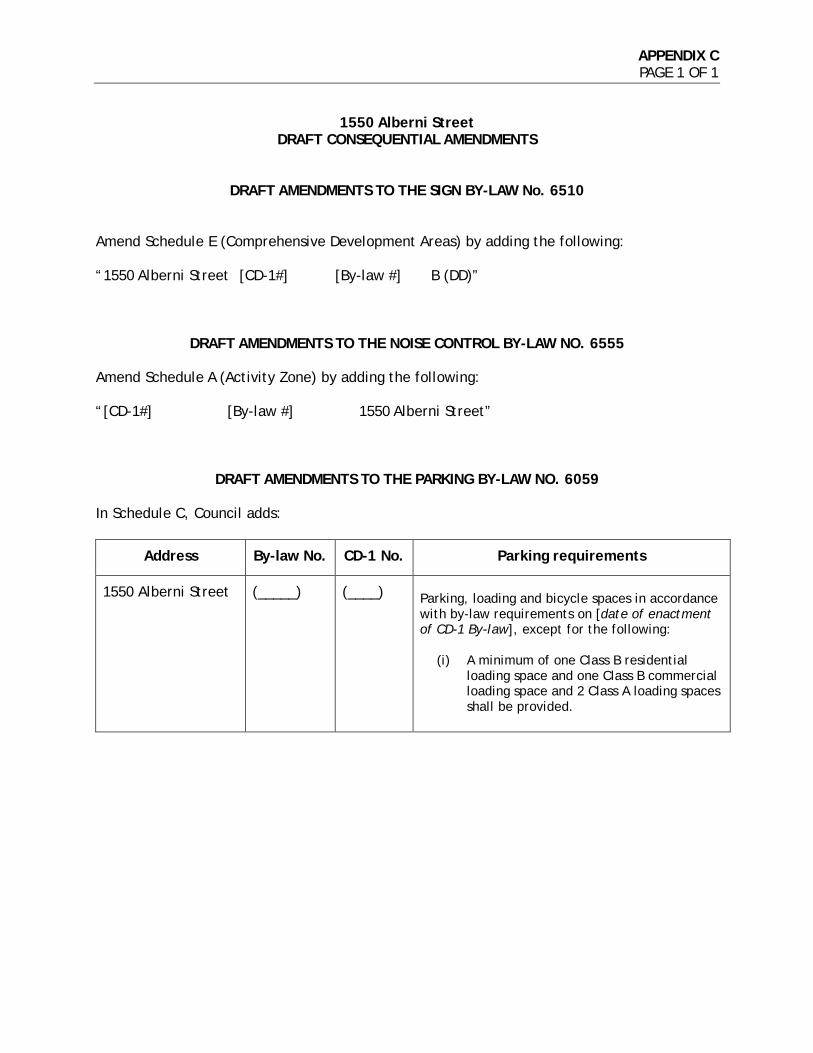
APPENDIX C PAGE 1 OF 1
1550 Alberni Street DRAFT CONSEQUENTIAL AMENDMENTS
DRAFT AMENDMENTS TO THE SIGN BY-LAW No. 6510
Amend Schedule E (Comprehensive Development Areas) by adding the following: “1550 Alberni Street [CD-1#] [By-law #] B (DD)”
DRAFT AMENDMENTS TO THE NOISE CONTROL BY-LAW NO. 6555
Amend Schedule A (Activity Zone) by adding the following: “[CD-1#] [By-law #] 1550 Alberni Street”
DRAFT AMENDMENTS TO THE PARKING BY-LAW NO. 6059 In Schedule C, Council adds:
Address By-law No. CD-1 No. Parking requirements
1550 Alberni Street (_____) (____) Parking, loading and bicycle spaces in accordance with by-law requirements on [date of enactment of CD-1 By-law], except for the following:
(i) A minimum of one Class B residential loading space and one Class B commercial loading space and 2 Class A loading spaces shall be provided.
APPENDIX D PAGE 1 OF 9
1550 Alberni Street ADDITIONAL INFORMATION 1. Urban Design Panel
The Urban Design Panel (UDP) reviewed this rezoning application on December 2, 2015. The application was supported 6-0. EVALUATION: SUPPORT (7-0) Introduction: Linda Gillan, Rezoning Planner, introduced the rezoning application for 1550 Alberni Street. The site is located on the southeast corner of Alberni Street and Cardero Street, with a frontage of 158 ft. on Alberni, and 131 ft. on Cardero. The site is 20,700 sq. ft. in size and is currently occupied by an eight-storey office building. This application is being considered under the Rezoning Policy for the West End, and the West End Community Plan. The site is part of the Georgia Corridor area of the West End Plan. For sites with a minimum frontage of 130ft., rezoning applications can be considered for: • Market residential, • With heights of up to 500 ft. subject to view corridors, • Typical tower floor plates of 6,500 sq. ft. The Green Buildings Policy for Rezonings also applies to this site, requiring a minimum of LEED Gold or equivalent. The application is to rezone from DD (Downtown District) to CD-1 to allow for a 43 storey mixed-use building, with 41-storeys of market residential and commercial uses at grade along Cardero and Alberni streets. There is a proposed total floor area of 290,000 sq. ft. (residential/commercial), with a density of 14 FSR and height of 133.3 m (437 ft.). The proposal is for a total of 188 residential units; parking access is proposed from the lane. The site slopes down approximately 3.5 m (11.5 ft.) from the southeast corner at the lane, to the northwest corner at Alberni and Cardero Streets. The lane is 33 foot wide lane. Cardero and Nicola Streets, to the east and west of the site, are local bikeways. There is a nearby rezoning application for 1575 West Georgia St (NE corner of Georgia & Cardero, currently a three-storey concrete office. Downtown Official Development Plan classifies this as Downtown District Area G (up to 6 FSR total, maximum discretionary heights of 450 feet). View Protection Guidelines are applicable to view cones B1, C1, and 3.2.1 limits height to approximately 438 feet.
APPENDIX D PAGE 2 OF 9
The commercial streets recommendation is for buildings to be set back to allow 5.5 metres (18 feet) of open space for pedestrian use between the existing curb and start of a building. Rezoning Policies and Guidelines Built Form Guidelines in the Plan include the following three design principles of note: • Ensure that new development does not adversely impact shadowing on recognized
public open space and village areas as a performance measure to ensure that these spaces have solar access when citizens are typically more active
• New development should be responsive to adjacent and nearby private views by shaping built form to optimize performance. Responsive building forms can help achieve a distinctive architectural identity
• New development needs to contribute to public realm vitality by contributing active uses towards pedestrian interest as well as thoughtful building, tenancy and related public realm design quality.
The West End Development Plan also established adjacent C-6 zoning on Robson Street offering up to 8.75 FSR / 300 feet tall for developments creating new social or rental housing. Of note is that towers above 60 foot should provide horizontal separation of 80 foot to other towers, to allow light and views between them. Given the minimal lane setback shown, proposal suggests that redeveloped 1555 Robson Street tower element would have to be set back 47 foot from the lane. The Rezoning Policy for the West End supports the rezoning for market residential but recommends a maximum floor plate of up to 603.9 m² (6,500 sq. ft.), to support light and air movement. Regarding the form and massing, the tower separation above 60ft. is in-line with policies and guidelines for the adjoining parcel. In terms of the floor plate, levels 6-15 and floors 27-41 exceed the maximum floor plate expectations of the West End Plan and rezoning policy of 603.9 m2 (6,500 sq. ft.). The average floor area for all floors is 6,673 sq. ft., with plates such as at level 32, up to 7,072 sq. ft. Proposed sculpting of built form at upper levels is intended to preserve sunlight access to sidewalks as well as public and private views. Varying the tower floor-plates sizes can be considered subject to evaluation of the resultant massing and its effect on light and views. Nineteen percent of floor plates have balconies, rather than the typical exclusion of twelve percent. Note that FSR of fourteen includes balcony space over twelve percent in floor area calculation. A two-storey penthouse floor with stairs in units, assume no elevator overrun is required. No intrusion is permitted into the view cone.

APPENDIX D PAGE 3 OF 9
Given orientation of open space at grade and proposed pedestrian routes, the applicant may wish to comment on how the proposed design will work in terms of pedestrian legibility and explain how daylight penetration to the Japanese garden area works. Advice from the Panel on this application is sought on the following: 1. Does the Panel support the overall form of development, including the proposed
height (437 ft.), setbacks (zero at the lane, 6.7 ft. on Alberni St, and 2 ft. on Cardero), and density (14 FSR)?
2. Considering the intents of policy for the West End to maintain natural light and views
by limiting floor plate sizes to 6,500 sq. ft., does the Panel support the applicant’s rationale for increasing plate sizes as shown?
3. Given the increased pedestrian amenity and commercial activity expected along
Cardero Street, does the Panel support the proposed public realm interface on this street?
4. Considering the proposed relationship to the nearby site of 1555 Robson Street
(the site across the lane), does the Panel support the proposed lane interface?
5. Are there any other comments on the landscape or architectural design proposed in this rezoning application, in general?
Applicant’s Introductory Comments: Bridging the natural and the organic; the mountains and the built form, were the main drivers for this development. The form is derived from the surrounding context, with the form shaped by its natural environment; the sun angles, temperature, water currents, humidity. The articulation creates an ephemeral, temporal quality to the façade on one hand, contrasting with the warm wood expression of the balconies. This has been articulated in a shingle format, referencing a certain vernacular in this region that is very practical in terms of drainage, and has a way of reflecting light that is different from the way a flat panel will reflect light. Glass and anodised aluminum panels will create constantly shifting qualities of light reflection with changes in the weather. From every angle the form has a different quality; there is a sensuous curvature to the building, there is a subdued quality. The sculptural form is quite logical in construction; diagonally symmetrical. The building recesses from the adjacent towers. It creates frames of space and linkages. It creates an entrance way into the city, and enhances the stroll along Cardero and along Alberni to Lost Lagoon. The design process was driven by the deductive optimisation of Alberni Street. The carving in the lower part of the form allows views to open up and light to come into Alberni Street, creating an urban space with lobby and a big Japanese garden at ground level on one side, and a tree-lined promenade with canopy and retail alongside the scoop on the other.
APPENDIX D PAGE 4 OF 9
The lobby on Alberni Street shows views through to the parkade ramp, creating a visual transparency between the front and the back. All vehicular traffic, access, drop offs, loading and parking has been pushed to the back lane. This creates two distinct characters to the building, the quiet front and the vehicular rear. The urban space at the base of the tower is open, with an alignment of bamboo and art work, that creates a good feeling; something that both the public and residents can see and experience. A partial amphitheatre has been created around the moss garden for people to sit, there is Vals stone paving, and a piano that can be moved into this space for performances. A bamboo forest only accessible from a private second floor is imbedded with a children’s play area. Sidewalks will be expanded and new street trees proposed to replace the current ones which are not thriving. The applicant took questions from the Panel. Panel’s Consensus on Key Aspects Needing Improvement: • The pedestrian amenity is visual, and it is important for the public to potentially
experience it • The bamboo is not good for CPTED (safety) as it creates a forest that you have to walk
through at night, and potentially makes it unsafe for women in the area. It also creates a barrier to people being able to appreciating the building, and should be considered further
• The decking is not good for certain types of footwear • Do not lose the expression of the building with the penthouse views • The articulation of the columns is important as they are the basis of the project; do
not obviated them • The passive response could be improved in the façade development; maybe the
pixilation is too busy • Improve the glazing performance where there is continuous glazing, and consider pool
condensation • Consider how the water feature will appear aesthetically in dry conditions. Related Commentary: The Panel generally supported the Kengo Kuma design, and commented positively that it brings a sensitivity and poetry to the duality of urbanity and nature, from which the best architecture emerges. It is thoroughly researched and sculpturally beautiful. It is a high caliber design that brings west coast modernism into this time and place. The Panel supported the overall form of development, including height, density or massing. Concerns were expressed that the setbacks were tight. Consider repositioning the tower away from the lane. The setbacks are tight on Cardero and the lane. Moving parking access is the
APPENDIX D PAGE 5 OF 9
best option. Animating the sidewalk with seating and cafes is great but it should be on your property. The Panel supported the floor plate variance, as it is a very clever solution and it works well. The Panel supported the proposed public realm interface and offered suggestions. Visual amenity is about art and design and having a feeling of excitement and is something which is really needed in the city. Consider improving visual access as it is important for the public to be able to experience the space. The carved sculptural element is very powerful. Try and achieve some tables along the boulevard to activate the street further. The Cardero setbacks could be more expansive and do not work as shown. Concern was expressed that the decking is not safe for stilettos. Overall the Panel supported the setback to the lane interface at 1555 Robson Street. When developed, the site across the street will have to respond sensitively to this development. Some concern was expressed that the lane was too tight and should be rethought. The Panel expressed a range of views on the bamboo at street level. The thickness of the bamboo is tricky; the thin depth might not be enough, but too thick would be to miss out on the beautiful materiality and art. Consider alternatives that show you peek-a-boo views, and perhaps some areas that are more open. The bamboo is not good for safety as it creates a forest that has to be walked through at night. The Panel commented on detailing of the building. Opacity of panel is needed to get a void read at the penthouse level. The columns are a dominant feature and how they are finished and expressed is important. The pixilation could be calmer. The podium is well thought through and much appreciated. The play space feels left over and would not fully function without an amenity space with it. It needs to be bigger if it is required or desired. In terms of sustainability, the balconies have been dealt with well. A passive response to dealing with sun could be improved in facade development; perhaps vary shingle angle. Look at improving glazing performance at continuous glazing areas, including at the pool, as condensation on glazing needs to be considered. Consider how the water feature will deal with drought esthetically. Applicant’s Response: The applicant team noted that the comments were excellent, and that it is still early so the project will keep improving.

APPENDIX D PAGE 6 OF 9
2. Public Consultation Summary
2.1. Public Notification Rezoning Application: September 11, 2015 A rezoning information sign was installed on the site on October 2, 2015. Approximately 11,819 notifications were sent out to surrounding residents and businesses on or about October 17, 2015. A community open house was held on November 3, 2015. Notification and application information, as well as an online comment form, was provided on the City of Vancouver Rezoning Centre webpage (vancouver.ca/rezapps). Revised Rezoning Application: May 3, 2016 A revised application was received on May 3, 2016. A new sign with the updated rezoning information for the revised application was installed on the site on May 30, 2016. Approximately 11,022 notifications were sent out to surrounding residents and businesses on or about June 2, 2016. The updated notification and application information, as well as an online comment form, was provided on the City of Vancouver Rezoning Centre webpage (vancouver.ca/rezapps). 2.2. Public Consultation Community Open House: November 3, 2015 A community open house was held from 5:00-8:00 pm on March, 2016, at 1550 Alberni Street. A total of 11,819 notifications were distributed within the neighbouring area on or about October 19, 2016. Staff, the applicant team, and a total of approximately 232 people attended the Open House. 2.3. Public Response Rezoning Application: September 11, 2015 Public responses to this proposal have been submitted to the City as follows:
• At the November 3, 2016 open house, a total of 23 comment sheets were submitted from individuals.
• A total of 31 letters, e-mails, and online comment forms were submitted from individuals.
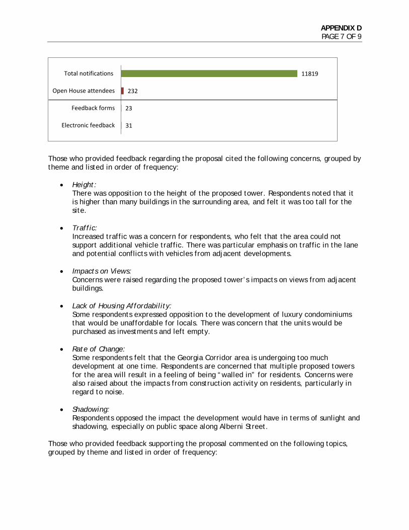
APPENDIX D PAGE 7 OF 9
Those who provided feedback regarding the proposal cited the following concerns, grouped by theme and listed in order of frequency:
• Height: There was opposition to the height of the proposed tower. Respondents noted that it is higher than many buildings in the surrounding area, and felt it was too tall for the site.
• Traffic: Increased traffic was a concern for respondents, who felt that the area could not support additional vehicle traffic. There was particular emphasis on traffic in the lane and potential conflicts with vehicles from adjacent developments.
• Impacts on Views: Concerns were raised regarding the proposed tower’s impacts on views from adjacent buildings.
• Lack of Housing Affordability: Some respondents expressed opposition to the development of luxury condominiums that would be unaffordable for locals. There was concern that the units would be purchased as investments and left empty.
• Rate of Change: Some respondents felt that the Georgia Corridor area is undergoing too much development at one time. Respondents are concerned that multiple proposed towers for the area will result in a feeling of being “walled in” for residents. Concerns were also raised about the impacts from construction activity on residents, particularly in regard to noise.
• Shadowing: Respondents opposed the impact the development would have in terms of sunlight and shadowing, especially on public space along Alberni Street.
Those who provided feedback supporting the proposal commented on the following topics, grouped by theme and listed in order of frequency:
31
23
232
11819
Electronic feedback
Feedback forms
Open House attendees
Total notifications
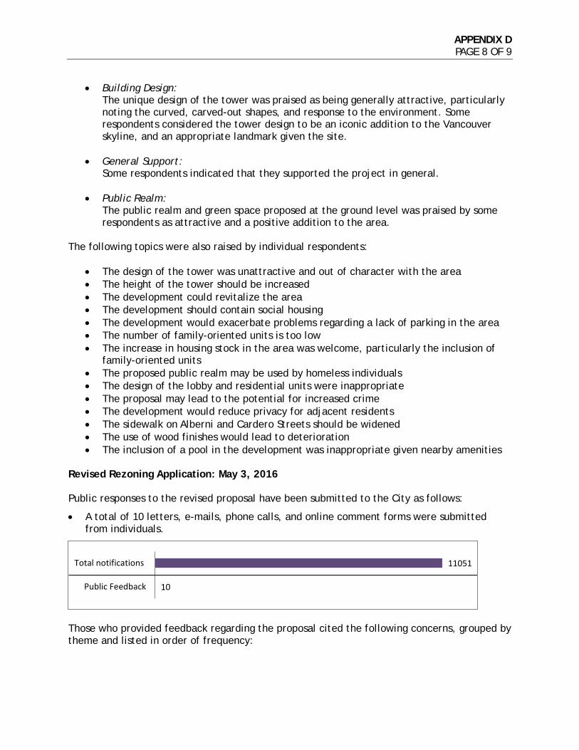
APPENDIX D PAGE 8 OF 9
• Building Design: The unique design of the tower was praised as being generally attractive, particularly noting the curved, carved-out shapes, and response to the environment. Some respondents considered the tower design to be an iconic addition to the Vancouver skyline, and an appropriate landmark given the site.
• General Support: Some respondents indicated that they supported the project in general.
• Public Realm: The public realm and green space proposed at the ground level was praised by some respondents as attractive and a positive addition to the area.
The following topics were also raised by individual respondents:
• The design of the tower was unattractive and out of character with the area • The height of the tower should be increased • The development could revitalize the area • The development should contain social housing • The development would exacerbate problems regarding a lack of parking in the area • The number of family-oriented units is too low • The increase in housing stock in the area was welcome, particularly the inclusion of
family-oriented units • The proposed public realm may be used by homeless individuals • The design of the lobby and residential units were inappropriate • The proposal may lead to the potential for increased crime • The development would reduce privacy for adjacent residents • The sidewalk on Alberni and Cardero Streets should be widened • The use of wood finishes would lead to deterioration • The inclusion of a pool in the development was inappropriate given nearby amenities
Revised Rezoning Application: May 3, 2016 Public responses to the revised proposal have been submitted to the City as follows:
• A total of 10 letters, e-mails, phone calls, and online comment forms were submitted from individuals.
Those who provided feedback regarding the proposal cited the following concerns, grouped by theme and listed in order of frequency:
10
11051
Public Feedback
Total notifications

APPENDIX D PAGE 9 OF 9
• Height: There was opposition to the height of the proposed tower. Respondents noted that it is higher than many buildings in the surrounding area, and felt it was too tall for the site.
• Traffic: Increased traffic was a concern for respondents, who felt that the area could not support additional vehicle traffic.
• Shadowing: Respondents opposed the impact the development would have in terms of sunlight and shadowing, especially on public space along Alberni Street.
• Impacts on Views:
Concerns were raised regarding the proposed tower’s impacts on views from adjacent buildings.
• Lack of Housing Affordability: Some respondents expressed opposition to the development of luxury condominiums that would be unaffordable for locals. There was concern that the units would be purchased as investments and left empty.
The following topics were also raised by individual respondents:
• The property might be mismanaged or neglected • The unique architectural style of the building was better suited for the Northeast False
Creek planning area • The community amenity contribution should go to affordable housing within the
building, as opposed to the community centre • There is a lack of parking in the area • The local sidewalks should be widened to support sociability, and planted with large
trees • Demolishing the existing building was not sustainable

APPENDIX E PAGE 1 OF 9
1550 Alberni Street URBAN DESIGN ANALYSIS
West End Built Form Principles: The West End Plan uses a principled approach to shape how and where growth and development occurs and the appropriate built form. The following community-wide contextual design principles provide structure and guidance to the more detailed policy, guidelines and regulations to be applied in the individual character areas. The West End Plan built form principles are:
• Reinforce the Dome-Shaped Skyline: New development opportunity should reinforce the legibility of the downtown’s recognized dome-shaped skyline when viewed from longer distances. Appropriate form and scale to “fill the gaps” can strengthen the image of the city.
• Strengthen the Urban Frame: Recognize the Thurlow-Burrard and Georgia-Alberni corridors as two edges of an “urban frame” to the lower, existing scale of the West End. Intensify these corridors towards greater clarity, and contrast with, the established neighbourhoods.
• Adhere to Prevailing View Corridors: Support Council approved view corridors (protected public views) towards shaping the evolving skyline, while also recognizing the need for spatial separation of higher buildings from the more localized scale of the Davie, Denman and Robson Villages.
• Recognize Transitional Role in Form and Scale: Ensure a thoughtful urban design response for new development opportunity by recognizing the local, contextual role new built form can offer in mediating between established development and respective sites. Form and scale to “fill the gaps” can strengthen the image of the city.
• Demonstrate Shadowing Performance: Ensure that new development does not adversely impact shadowing on recognized public open space and Village areas as a performance measure to ensure that these spaces have solar access when citizens are typically more active.
• Responsive Form to Private Views: New development should be responsive to adjacent and nearby private views by shaping built form to optimize performance. Responsive building forms can help achieve a distinctive architectural identity.
• Ground Oriented Focus in Uses and Public Realm Quality: New development needs to contribute to public realm vitality by contributing active uses towards pedestrian interest as well as thoughtful building, tenancy and related public realm design quality.
The “Places” section of the West End Plan outlines additional built form parameters specific to the Georgia Corridor area. Development proposals should have a minimum site frontage of 39.6 m (130 ft.), although smaller frontages can be considered at the discretion of the Director of Planning. For this sub-area of the Georgia Corridor, east of Cardero Street, heights of up to 152.4 m (500 ft.) may be considered, subject to Council-approved view corridors, with typical tower floor plates of 609.9 m2 (6,500 sq. ft.) to maximize views and sunlight on sidewalks. Maximum densities are subject to urban design considerations on a site by site basis. Density: Under the existing DODP, the density permitted on the site in Area “G” is a floor

APPENDIX E PAGE 2 OF 9
space ratio (FSR) of 6.0, with Office uses limited to a maximum FSR of 5.0. The rezoning application, as submitted on May 3, 2016, proposes an overall floor area of 27,171 m2 (292,466 sq. ft.), equivalent to 14.15 FSR. For rezoning sites in the Downtown District (DD), open balconies representing up to 12% of the residential floor area may be excluded from the FSR calculation. The proposal includes 4,757 m2 (51,204 sq. ft.) of open balcony, equivalent to 19.2% of the proposed residential floor area. The open balcony “overage” of 1,787 m2 (19,235 sq. ft.) would be included in the FSR calculation, equivalent to 0.93 FSR, with the requirement that those balconies remain open for the life of the building (see Appendix A and Appendix B). Under the provisions of the DODP, residential amenity up to 929 m2 (10,000 sq. ft.) may be excluded from the calculation of FSR. The proposal includes a total 1,060 m2 (11,410 sq. ft.) of residential amenity, in excess of the maximum excludable amount. The residential amenity overage of 131 m2 (1,410 sq. ft.), equivalent to 0.07 FSR, would be included in the FSR calculation (see Appendix A and Appendix B). Architecture and Form of Development: The application proposes a 43-storey mixed-use building with commercial uses at grade along Cardero Street and a domed landscaped forecourt fronting Alberni Street. The proposal’s sculpted form has been distinctively shaped in response to an intent to preserve nearby private views. The gently curved sculpting of the Alberni Street façade also serves as a respectful gesture that will frame the finely crafted office building at 1550 West Georgia Street. The proposal form and evocative expression have demonstrated a significant and recognizable new benchmark for architectural creativity for the residential tower; and the domed garden and treed forecourt will create a unique spatial presence to the public realm in this urban context. Further design development is recommended to ensure provision of high quality materials and detailing for the building expression that will weather well and retain a quality appearance into the future. View Impacts - The West End Plan emphasizes the importance of responsiveness of new development to adjacent and nearby private views by shaping built form to optimize performance. The West End Plan also states that responsive building forms can help achieve a distinctive architectural identity. The application material includes a view angle analysis from ten nearby residential buildings and a more detailed comparison of view angles resulting from the proposed tower to a conventionally shaped tower as viewed from 1500 Alberni Street constructed in 1991, the most impacted nearby residential building. The analysis indicates that the design of the proposed tower embraces the West End Plan’s guidance by mitigating impacts to private views by 1) locating the tower at the southwest corner of its site, allowing greater access to westerly views from 1500 Alberni St.; and 2) sculpting the form to present a slender profile as viewed from private views from the east. The view studies demonstrate that the silhouette of the proposal’s east elevation, provides a view angle from mid and higher levels approximately seven degrees greater than would result from a more conventionally shaped tower as viewed from the most affected levels of 1500 Alberni Street (levels 7 through 28). While this area of the Downtown District does not specify tower separation, the West End Plan anticipates that the part of any new residential building which exceeds 18.3 m (60 ft.) in height should be spaced at least 24.3 m (80 feet) from any other residential building
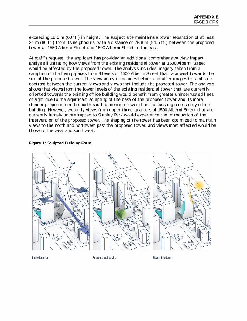
APPENDIX E PAGE 3 OF 9
exceeding 18.3 m (60 ft.) in height. The subject site maintains a tower separation of at least 24 m (80 ft.) from its neighbours, with a distance of 28.8 m (94.5 ft.) between the proposed tower at 1550 Alberni Street and 1500 Alberni Street to the east. At staff’s request, the applicant has provided an additional comprehensive view impact analysis illustrating how views from the existing residential tower at 1500 Alberni Street would be affected by the proposed tower. The analysis includes imagery taken from a sampling of the living spaces from 9 levels of 1500 Alberni Street that face west towards the site of the proposed tower. The view analysis includes before-and-after images to facilitate contrast between the current views and views that include the proposed tower. The analysis shows that views from the lower levels of the existing residential tower that are currently oriented towards the existing office building would benefit from greater uninterrupted lines of sight due to the significant sculpting of the base of the proposed tower and its more slender proportion in the north-south dimension tower than the existing nine-storey office building. However, westerly views from upper three-quarters of 1500 Alberni Street that are currently largely uninterrupted to Stanley Park would experience the introduction of the intervention of the proposed tower. The shaping of the tower has been optimized to maintain views to the north and northwest past the proposed tower, and views most affected would be those to the west and southwest.
Figure 1: Sculpted Building Form

APPENDIX E PAGE 4 OF 9
Figure 2: Quantitative View Studies (Comparison of Typical Tower with Proposed Sculpted Tower)
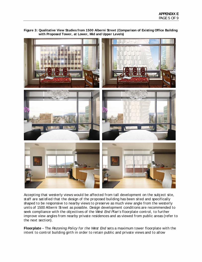
APPENDIX E PAGE 5 OF 9
Figure 3: Qualitative View Studies from 1500 Alberni Street (Comparison of Existing Office Building
with Proposed Tower, at Lower, Mid and Upper Levels)
Accepting that westerly views would be affected from tall development on the subject site, staff are satisfied that the design of the proposed building has been sited and specifically shaped to be responsive to nearby views to preserve as much view angle from the westerly units of 1500 Alberni Street as possible. Design development conditions are recommended to seek compliance with the objectives of the West End Plan’s floorplate control, to further improve view angles from nearby private residences and as viewed from public areas (refer to the next section). Floorplate - The Rezoning Policy for the West End sets a maximum tower floorplate with the intent to control building girth in order to retain public and private views and to allow
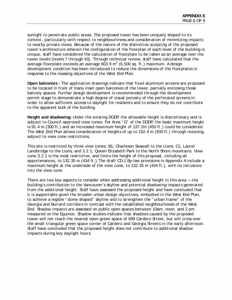
APPENDIX E PAGE 6 OF 9
sunlight to penetrate public areas. The proposed tower has been uniquely shaped to its context, particularly with respect to neighbourliness and consideration of minimizing impacts to nearby private views. Because of the nature of the distinctive sculpting of the proposed tower’s architecture wherein the configuration of the floorplan of each level of the building is unique, staff have considered the calculation of floorplate to be taken as an average over the tower levels (levels 7 through 43). Through technical review, staff have calculated that the average floorplate exceeds an average 603.9 m2 (6,500 sq. ft.) maximum. A design development condition has been introduced to reduce the dimensions of the floorplates in response to the massing objectives of the West End Plan. Open balconies - The application drawings indicate that fixed aluminum screens are proposed to be located in front of many inset open balconies of the tower, partially enclosing those balcony spaces. Further design development is recommended through the development permit stage to demonstrate a high degree of visual porosity of the perforated screens in order to allow sufficient access to daylight for residents and to ensure they do not contribute to the apparent bulk of the building. Height and shadowing: Under the existing DODP, the allowable height is discretionary and is subject to Council-approved view cones. For Area “G” of the DODP, the basic maximum height is 91.4 m (300 ft.) and an increased maximum height of 137.2m (450 ft.) could be considered. The West End Plan allows consideration of heights of up to 152.4 m (500 ft.) through rezoning, subject to view cone restrictions. This site is restricted by three view cones: B1, Charleson Seawall to the Lions; C1, Laurel Landbridge to the Lions; and 3.2.1, Queen Elizabeth Park to the North Shore mountains. View cone 3.2.1 is the most restrictive, and limits the height of this proposal, including all appurtenances, to 132.35 m (434 ft.).The draft CD-1 By-law provisions in Appendix A include a maximum height at the underside of the view cone, to 132.35 m (434 ft.), with no intrusions into the view cone. There are two key aspects to consider when addressing additional height in this area — the building’s contribution to the Vancouver’s skyline and potential shadowing impacts generated from the additional height. Staff have assessed the proposed height and have concluded that it is supportable given the broader urban design objectives, embodied in the West End Plan, to achieve a legible “dome shaped” skyline and to strengthen the “urban frame” of the Georgia and Burrard corridors in contrast with the established neighbourhoods of the West End. Shadow impacts are assessed on public open spaces between 10am, noon, and 2 pm measured on the Equinox. Shadow studies indicate that shadows caused by the proposed tower will not reach the nearest open green space of 699 Cardero Street, but will cross over the small triangular green space corner of Cardero and Georgia Streets in the early afternoon. Staff have concluded that the proposed height does not contribute to additional shadow impacts during key daylight hours.
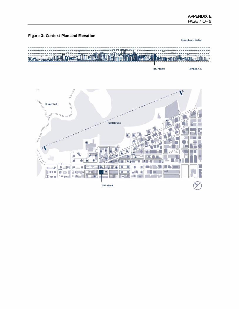
APPENDIX E PAGE 7 OF 9
Figure 3: Context Plan and Elevation
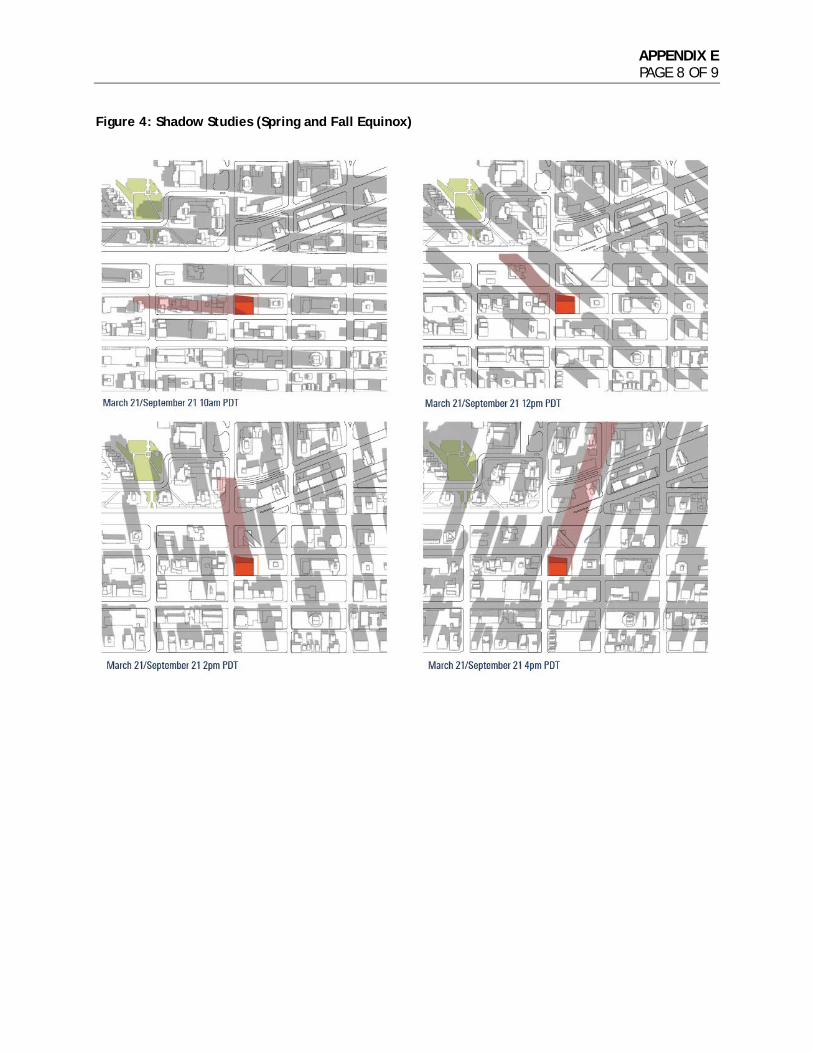
APPENDIX E PAGE 8 OF 9
Figure 4: Shadow Studies (Spring and Fall Equinox)
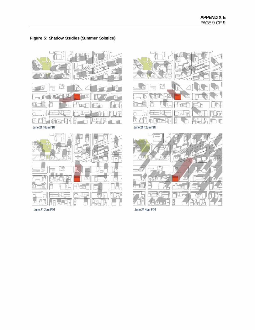
APPENDIX E PAGE 9 OF 9
Figure 5: Shadow Studies (Summer Solstice)
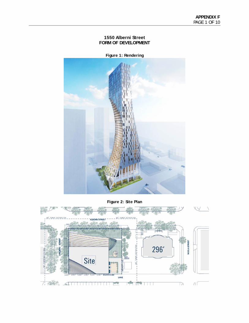
APPENDIX F PAGE 1 OF 10
1550 Alberni Street FORM OF DEVELOPMENT
Figure 1: Rendering
Figure 2: Site Plan
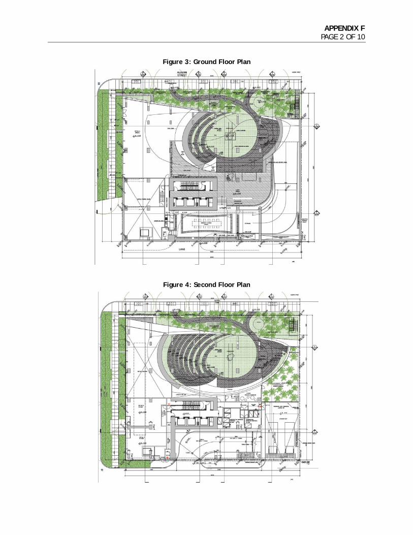
APPENDIX F PAGE 2 OF 10
Figure 3: Ground Floor Plan
Figure 4: Second Floor Plan
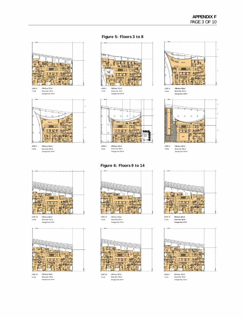
APPENDIX F PAGE 3 OF 10
Figure 5: Floors 3 to 8
Figure 6: Floors 9 to 14
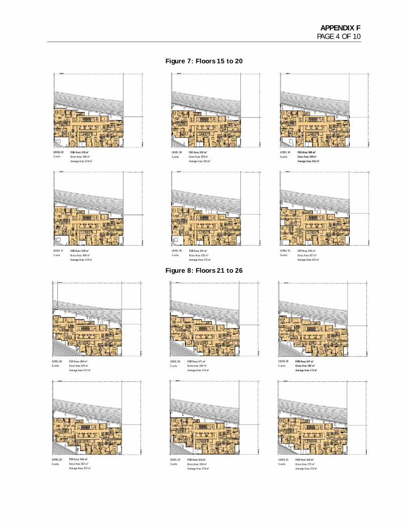
APPENDIX F PAGE 4 OF 10
Figure 7: Floors 15 to 20
Figure 8: Floors 21 to 26
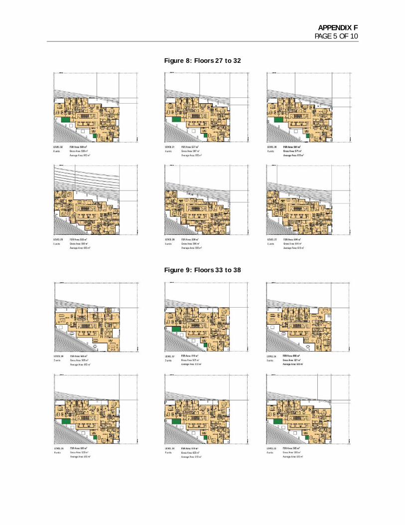
APPENDIX F PAGE 5 OF 10
Figure 8: Floors 27 to 32
Figure 9: Floors 33 to 38

APPENDIX F PAGE 6 OF 10
Figure 10: Floors 39 to 43 and Roof

APPENDIX F PAGE 7 OF 10
Figure 11: Alberni Street Elevation
Figure 12: Cardero Street Elevation

APPENDIX F PAGE 8 OF 10
Figure 13: Typical Parking Floor (P2 to P7)
Figure 14: Parking Level 1
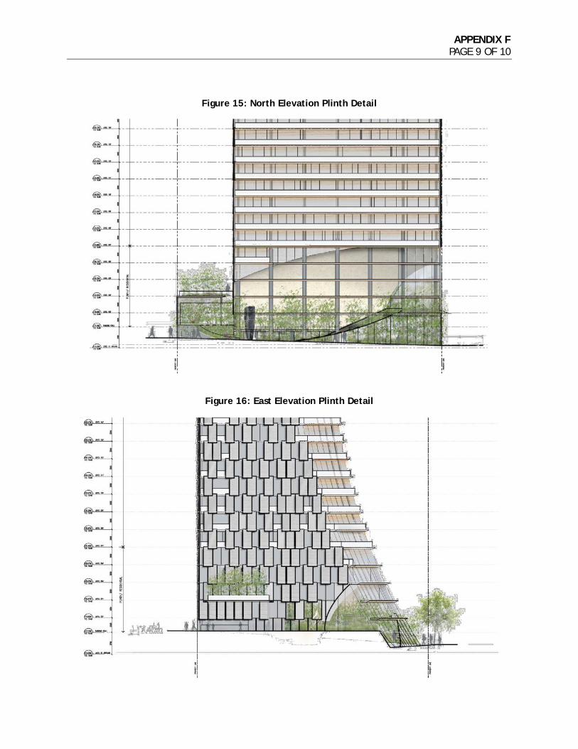
APPENDIX F PAGE 9 OF 10
Figure 15: North Elevation Plinth Detail
Figure 16: East Elevation Plinth Detail

APPENDIX F PAGE 10 OF 10
Figure 17: Public Realm and Landscape Plan

APPENDIX G PAGE 1 OF 1
1550 Alberni Street PUBLIC BENEFITS SUMMARY
Project Summary: A 43-storey mixed-use building with market residential and commercial uses.
Public Benefit Summary: The project would result in a cash CAC contribution of $22,460,450, the purchase of heritage and amenity bonus density,
a public art contribution, and a DCL payment.
Current Zoning Proposed Zoning
Zoning District DD CD-1
FSR (site area = 20,675 sq. ft.) 6.00 14.15
Buildable Floor Space (sq. ft.) 124,054 sq. ft. 292,466 sq. ft.
Land Use Mixed-use Mixed-use
Public Benefit Statistics Value if built under Current Zoning ($)
Value if built under Proposed Zoning ($)
Requ
ired
*
DCL (City-wide rate, effective September 30, 2016) ($13.91/sq. ft.) $1,725,591 $4,068,202
DCL (Area Specific)
Public Art (effective September 30, 2016: $1.98/sf) $245,627 $579,083
20% Social Housing
Oth
er P
ubli
c Be
nefi
ts O
ffer
ed
Heritage and Amenity Bonus Density $9,539,590
Childcare Facilities
N/A
Cultural Facilities
Green Transportation/Public Realm $4,250,000
Housing (e.g. supportive, seniors) $3,552,613
Parks and Public Spaces $4,000,000
Social/Community Facilities $10,657,838
Unallocated
Other
TOTAL VALUE OF PUBLIC BENEFITS $1,971,218 $36,647,325
Other Benefits (non-quantified components):
* DCLs, Public Art and Social Housing may have exemptions and/or minimum thresholds for qualification.
For the City-Wide DCL, revenues are allocated into the following public benefit categories: Engineering (22%); Replacement Housing (32%); Parks (41%); and Childcare (5%). Revenue allocations differ for each of the Area Specific DCL Districts.
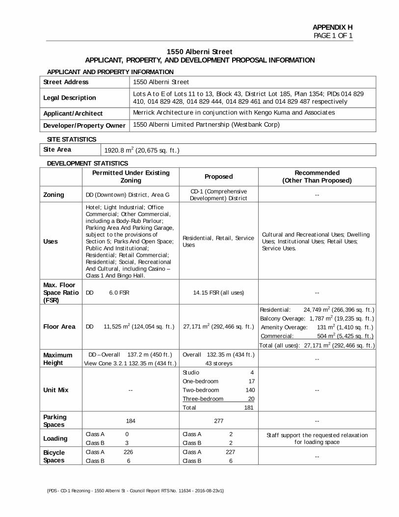
APPENDIX H PAGE 1 OF 1
1550 Alberni Street
APPLICANT, PROPERTY, AND DEVELOPMENT PROPOSAL INFORMATION
APPLICANT AND PROPERTY INFORMATION
Street Address 1550 Alberni Street
Legal Description Lots A to E of Lots 11 to 13, Block 43, District Lot 185, Plan 1354; PIDs 014 829 410, 014 829 428, 014 829 444, 014 829 461 and 014 829 487 respectively
Applicant/Architect Merrick Architecture in conjunction with Kengo Kuma and Associates
Developer/Property Owner 1550 Alberni Limited Partnership (Westbank Corp)
SITE STATISTICS
Site Area 1920.8 m2 (20,675 sq. ft.)
DEVELOPMENT STATISTICS
Permitted Under Existing Zoning Proposed Recommended
(Other Than Proposed)
Zoning DD (Downtown) District, Area G CD-1 (Comprehensive Development) District --
Uses
Hotel; Light Industrial; Office Commercial; Other Commercial, including a Body-Rub Parlour; Parking Area And Parking Garage, subject to the provisions of Section 5; Parks And Open Space; Public And Institutional; Residential; Retail Commercial; Residential; Social, Recreational And Cultural, including Casino – Class 1 And Bingo Hall.
Residential, Retail, Service Uses
Cultural and Recreational Uses; Dwelling Uses; Institutional Uses; Retail Uses; Service Uses.
Max. Floor Space Ratio (FSR)
DD 6.0 FSR 14.15 FSR (all uses) --
Floor Area DD 11,525 m2 (124,054 sq. ft.) 27,171 m2 (292,466 sq. ft.)
Residential: 24,749 m2 (266,396 sq. ft.) Balcony Overage: 1,787 m2 (19,235 sq. ft.) Amenity Overage: 131 m2 (1,410 sq. ft.) Commercial: 504 m2 (5,425 sq. ft.)
Total (all uses): 27,171 m2 (292,466 sq. ft.)
Maximum Height
DD – Overall 137.2 m (450 ft.) View Cone 3.2.1 132.35 m (434 ft.)
Overall 132.35 m (434 ft.) 43 storeys
--
Unit Mix --
Studio 4 One-bedroom 17 Two-bedroom 140 Three-bedroom 20 Total 181
--
Parking Spaces 184 277 --
Loading Class A 0 Class B 3
Class A 2 Class B 2
Staff support the requested relaxation for loading space
Bicycle Spaces
Class A 226
Class B 6
Class A 227
Class B 6 --
{PDS - CD-1 Rezoning - 1550 Alberni St - Council Report RTS No. 11634 - 2016-08-23v1}