Embed Size (px)
Citation preview

RoadwayUsers travel along the roadway as it winds through the landscape. Watch for the following historic features conveying the road’s original design:
CorridorBuildings, landscape, and land uses define the road corridor. Watch for these scenic and historic features of the corridor’s original character:
View ShedViews of the surroundings comprise the view shed. Watch for these features of the scenic vistas along this historic route:
State Routes 162 & 165Scenic Tour | 25 miles | 1.5 hours
State Roads (SR) 162 and 165 follow the Puyallup and Carbon river valleys up into the foothills below Mount Rainier. Views from the two-lane roads include farmland, scenic river crossings, forest lands, and Mount Rainier. Pull outs afford scenic views.
HistorySR 162 is a compilation of old roads including Permanent Highway (PH) 5B, PH 5D, PH 5E, PH 5F, and PH 19. By at least 1937, these became part of Secondary State Highway 5E, then SR 162 in 1964.
The portion of SR 165 connecting Carbonado and Wilkeson appears on maps as early as 1897 but was not identified within the SR system until 1931 when designated as a branch of SR No. 5 (National Park Highway). Sections of the road were previously known as the Burnett-Fairfax Highway and the Wilkeson-Carbonado Road. The road narrows to one lane crossing over the Fairfax Bridge.
AlterationsSR 162 maintains its historic path, dating back to the Permanent Highway system and possibly earlier. SR 162 closely followed the path of the railroad(s) through rural communities in Pierce County such as Orting, Broomfield, Crocker, Alderton, and McMillin. While some of the communities no longer exist apart from a handful of surviving buildings, SR 162 continues to pass through downtown Orting and South Prairie.
SR 165 remains a two-lane road, with narrow shoulders (when shoulders are present). General alterations to the route include paving, fog lines, striping, and contemporary guardrails.
CreditsThis tour was created in collaboration with the Washington State Department of Archaeology and Historic Preservation, Washington State Department of Transportation, and Puget Sound Regional Council. Images courtesy of WSDOT Engineering, USDA, and Washington State Archives.
• Artifacts Consulting, Inc. Artifacts-Inc.com
• WSDOT, Washington State Scenic and Recreation Highways
• DAHP, Transportation Preservation
• PSRC, Puget Sound Regional Council
• Two-lane road with ditches along both SR 162 and 165.
• Narrow shoulders along most of SR 162 and 165, including near McMillin Bridge and south of Orting, and from Buckley to Carbonado.
R1 Extremely narrow (if any) shoulders along SR 165, from Carbonado and southward.
• SR 165 bordered by rock walls and cliff drop-offs as it climbs up into the mountains.
C1 Alderton and Alderton School.
C2 Spooner and Red Barn Tree farms.
C3 McMillin, including the McMillin Bridge, school, and store.
C4 Orting, including the Odd Fellows/Orting Eagles Hall, and nearby Harman Barn, Woolrey-Koehler Hop Kiln, and Puyallup Fish Hatchery.
C5 South Prairie, including the William Bisson House, and Burnett.
C6 Wilkeson, including the Holy Trinity Orthodox Church, Martha Washington Hotel, Wilkeson School, and Town Hall.
C7 Carbonado, a historic coal town.
• Farms and related buildings directly along SR 162.
• Historic single-family residences, present sporadically in rural sections and dense concentrations within communities like Sumner and Orting.
• Scenic river crossings, including the Fairfax Bridge crossing, and views of forest lands, the Carbon River, and the Cascades.
• Gravel pull-outs to facilitate passing and scenic overlooks.
• Railroad tracks parallel the roadway almost the entire route with steel railroad bridges adjacent to the road. Some sections of railroad have been converted to use as a recreational trail, the Foothills Trail.
Points of InterestState Routes 162 & 165

!
!
!
!
•
•
•
••
• ••
•
•
•
•
•
•
!
!
!
!
!
!
!!
!
!
!
!
!!
!
!!
!
!
!!
!
!4
5
6
7
8
9
1918
17
1916
15 18
1417
13 1610
1215
11
14
13
Coke Ovens
Wilkeson Arch
Alderton School
McMillin School
McMillin Bridge
Wilkeson School
Bisson, House
Martha Washington Hotel
Orton, Charles W., House
Woolrey-KoehlerHop Kiln
CarbonadoSchool Gymnasium
Holy TrinityOrthodox Church
Harman Barn
Schoenbachler Barn
Masonic Lodge
FairfaxBridge
PuyallupFish Hatchery
Paul Emery DonationLand Claim
Burnett
McMillin
Alderton
Carbonado
South Prairie
CascadeJunction
C1
C2
C3
C4
4
SR 162 and 165Scenic Tour | 25 miles | 1.5 hoursState Roads 162 and 165 are located in Pierce County. This route follows portions of the Puyallup and Carbon rivers, starting from Sumner and passing through Alderton, Orting, South Prairie, Burnett, Wilkeson, Carbonado.
North to Sumner
South to Mount Rainier National Park
Ah, the joys of the outdoors!Map Overlay (1873 / 2011)Wagon road and land claims.
Along SR 165 just south of milepost 13, looking north, 1946.
Map Overlay (1873 / 2011)Paul Emery claim near South Prairie
Along SR 165 just 0.4 miles north of the Mount Rainier Park boundary, 1946.
Tour 1
²
Tour 1
²
0 1 2 30.5Miles
3
C5
C6
C7
R1
2
1
3
4
1
2
Moderate historic and scenic qualitiesAverage historic and scenic qualities High historic and scenic qualities Historic/modern route overlap

RoadwayUsers travel along the roadway as it winds through the landscape. Watch for the following historic features conveying the road’s original design:
CorridorBuildings, landscape, and land uses define the road corridor. Watch for these scenic and historic features of the corridor’s original character:
View ShedViews of the surroundings comprise the view shed. Watch for these features of the scenic vistas along this historic route:
State Route 530 (Pioneer Highway)Scenic Tour | 16 miles | 1 hour
Former State Road (SR) 530 and SR 530 (also known as Pioneer Highway) follow the Stillaguamish River valley from Stanwood to Arlington. Views from the two-lane road include farmland and working agricultural buildings directly against the road.
HistoryBefore its incorporation within the state highway system, SR 530 served as a county road connecting the lumber towns up in the mountains, like Hazel and Darrington, and farms along the Stillaguamish River with the trading center Stanwood. Portions of the general corridor of SR 530 follow county wagon roads established in the early 1890s. By 1914 the state was working on the route and paving sections through the Permanent Highway program. The route was included within the state highway system as SSH 1E in 1937.
AlterationsThe route’s alignment largely remains the same. The road follows the base of the hill above the valley bottom. Farming operations continue working from historic barns along the road. Portions of an original brick road and concrete gutters remain visible in Stanwood along Cedarhome Drive NW.
CreditsThis tour was created in collaboration with the Washington State Department of Archaeology and Historic Preservation, Washington State Department of Transportation, Washington State Library and Puget Sound Regional Council. Images courtesy of WSDOT Engineering, USDA, and Washington State Archives.
• Artifacts Consulting, Inc. Artifacts-Inc.com
• WSDOT, Washington State Scenic and Recreation Highways
• DAHP, Transportation Preservation
• PSRC, Puget Sound Regional Council
R1 Original brick road and concrete gutters.
• Two-lane road with ditches in places.
• Placement along the base of the hill side (Prestliens Bluff) above the wet river valley.
• Historic barns and farmland abutting road on either side.
• Historic barns, including the Jensen Barn and William Grimm barns.
C1 East Stanwood.
C2 Zion Lutheran Church.
C3 Silvana.
C4 Stillaguamish River.
• Scenic views of Port Susan, the Olympic and Cascade Mountains, and agricultural land along the Stillaguamish River valley.
V1 Former Great Northern Railway line parallels the route along the Stillaguamish River.
Points of InterestState Route 530 (Pioneer Highway)

• •
•
•
••
•
•
•
•
! !!
!20
18 1917
Zion Lutheran Church
Stanwood IOOFPublic Hall
Barn
Barn
Jensen Barn
Olson, Barn
Long, Barn
Falling, Barn
Grimm, Barn
Gerritzen, Barn
Stanwood
Arlington
East Stanwood
North to Mount Vernon
East up into the Cascade Mountains to Darrington
²
²
Tour 2Tour 2
²
Map Overlay (1872 / 2011)Settlement at the west end of the valley
Map Overlay (1875 / 2011)Former route of the Stillaguamish River
Ca. 1936 highway map showing former road names.
WSDOT engineering map showing the layers of previous roadwork.
²
State Route 530Scenic Tour | 16 miles | 1 hourState Road (SR) 530 and former SR 530 are located in Snohomish County. This route follows the Stillaguamish River valley, starting from just north of Stanwood, and passing through Silvana before ending at Arlington.
0 1 2 30.5Miles
Silvana main street, 1969
R1
C1
1
C4
C3
C2
V1
2
43
1
2
3
4
Moderate historic and scenic qualitiesAverage historic and scenic qualities High historic and scenic qualities Historic/modern route overlap
RoadwayUsers travel along the roadway as it winds through the landscape. Watch for the following historic features conveying the road’s original design:
CorridorBuildings, landscape, and land uses define the road corridor. Watch for these scenic and historic features of the corridor’s original character:
View ShedViews of the surroundings comprise the view shed. Watch for these features of the scenic vistas along this historic route:
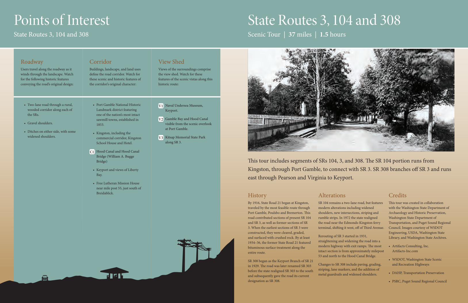
State Routes 3, 104 and 308Scenic Tour | 37 miles | 1.5 hours
This tour includes segments of SRs 104, 3, and 308. The SR 104 portion runs from Kingston, through Port Gamble, to connect with SR 3. SR 308 branches off SR 3 and runs east through Pearson and Virginia to Keyport.
HistoryBy 1916, State Road 21 began at Kingston, traveled by the most feasible route through Port Gamble, Poulsbo and Bremerton. This road contributed sections of present SR 104 and SR 3, as well as former sections of SR 3. When the earliest sections of SR 3 were constructed, they were cleared, graded, and surfaced with crushed rock. By at least 1934–36, the former State Road 21 featured bituminous surface treatment along the entire route.
SR 308 began as the Keyport Branch of SR 21 in 1929. The road was later renamed SR 303 before the state realigned SR 303 to the south and subsequently gave the road its current designation as SR 308.
AlterationsSR 104 remains a two-lane road, but features modern alterations including widened shoulders, new intersections, striping and rumble strips. In 1972 the state realigned the road near the Edmonds-Kingston ferry terminal, shifting it west, off of Third Avenue.
Rerouting of SR 3 started in 1931, straightening and widening the road into a modern highway with exit ramps. The most intact section is from approximately milepost 53 and north to the Hood Canal Bridge.
Changes to SR 308 include paving, grading, striping, lane markers, and the addition of metal guardrails and widened shoulders.
CreditsThis tour was created in collaboration with the Washington State Department of Archaeology and Historic Preservation, Washington State Department of Transportation, and Puget Sound Regional Council. Images courtesy of WSDOT Engineering, USDA, Washington State Library, and Washington State Archives.
• Artifacts Consulting, Inc. Artifacts-Inc.com
• WSDOT, Washington State Scenic and Recreation Highways
• DAHP, Transportation Preservation
• PSRC, Puget Sound Regional Council
• Two-lane road through a rural, wooded corridor along each of the SRs.
• Gravel shoulders.
• Ditches on either side, with some widened shoulders.
• Port Gamble National Historic Landmark district featuring one of the nation’s most intact sawmill towns, established in 1853.
• Kingston, including the commercial corridor, Kingston School House and Hotel.
C1 Hood Canal and Hood Canal Bridge (William A. Bugge Bridge)
• Keyport and views of Liberty Bay.
• Free Lutheran Mission House near mile post 55, just south of Breidablick.
V1 Naval Undersea Museum, Keyport.
V2 Gamble Bay and Hood Canal visible from the scenic overlook at Port Gamble.
V3 Kitsap Memorial State Park along SR 3.
Points of InterestState Routes 3, 104 and 308

•
••
!
!
!
!
!
!
!
!!
!
!
!
!
!
!
!!
!
2
3
16
60 17
5918
58
19
57
20 22 2321
5624
55
54
Kingston HotelKingston School House
Free Lutheran Mission House
PearsonKeyport
Virginia
Port Gamble
BreidablickEast to Edmonds
South to Bremerton
Late 1940s road resurfacing equipment
Map Overlay (1860 / 2011)Former trail from Appletree Cove (Kingston) to Port Gamble
Early view of the Port Gamble mill site from Hood Canal.
1907 view looking south along Rainier Avenue.
Late 1940s DOT road worker.
Map Overlay (1873 / 2011)Development of Port Gamble
Port Gamble, early 1900s
²
²
SRs 3, 104 and 308Scenic Tour | 37 miles | 1.5 hoursThe tour follows segments of SRs 104, 3, and 308. The route passes through the communities of Kingston, Port Gamble, and Keyport.
0 1 2 30.5Miles
V1
V3
V2
C11 2
4
3
1
3
4
2
Moderate historic and scenic qualitiesAverage historic and scenic qualities High historic and scenic qualities Historic/modern route overlap

RoadwayUsers travel along the roadway as it winds through the landscape. Watch for the following historic features conveying the road’s original design:
CorridorBuildings, landscape, and land uses define the road corridor. Watch for these scenic and historic features of the corridor’s original character:
View ShedViews of the surroundings comprise the view shed. Watch for these features of the scenic vistas along this historic route:
State Route 203Scenic Tour | 27 miles | 1 hour
State Road (SR) 203 winds through the Snoqualmie Valley along the base of the foothills. Views from the two-lane road include farmland, scenic river crossings, wooden railroad trestles, farmsteads, and barns. Pull outs along the road afford scenic views.
HistoryThe earliest section opened as Permanent Highway (PH) 16 in 1915, connecting present Tualco Road with Monroe. More sections followed: PH 15 (1917); PH 15A (1927); PH 15B (1928); PH 16 (1915); PH 19 (1916); PH 45 (1929); PH 46 (1929). These early permanent highways were graded and surfaced, typically with gravel. By 1937, the former individual roads combined under the state road system as Secondary State Highway 15B.
AlterationsMost of the road has a high degree of integrity, retaining a two-lane rural highway character. Shoulders were selectively widened but remain narrow. The corridor looks much as it did 50 years ago. Between 1953 and 1957, the alignment was straightened slightly south of Monroe. The former section along Tualco Road, branches to the west, through open farmland and swings east as 203rd Avenue to meet with the current route. Within the communities of Duvall and Carnation (Tolt), the original gravel road had hard paving by 1946. Rural sections remained gravel through at least 1963.
CreditsThis tour was created in collaboration with the Washington State Department of Archaeology and Historic Preservation, Washington State Department of Transportation, Puget Sound Regional Council, and King County. Images courtesy of WSDOT Engineering, USDA, King County, and Washington State Archives.
• Artifacts Consulting, Inc. Artifacts-Inc.com
• WSDOT, Washington State Scenic and Recreation Highways
• DAHP, Transportation Preservation
• PSRC, Puget Sound Regional Council
• King County, 206.477.4528 Heritage and Scenic Corridors Project
• Road alignment follows the topography, staying to the higher, drier ground at the base of the foothills. This placement avoids flooding, preserves the most arable land, and usually provides a better through route that connects the best locations for farmsteads.
• Two-lane road with narrow shoulders.
• Skykomish, Snoqualmie and Tolt rivers along the road.
• Historic downtowns of Duvall, Carnation, Monroe and Fall City. The location and spacing of towns reflects the era when the railroad was the highway.
• Multiple barns and farmsteads between Duvall and Pleasant Hill including the Adair and Hjertoos farms, the Gustovson barn, and Entwistle house attest to the valley’s agricultural history.
• Fall City, the Fall City Riverfront Park, and the Fall City Hop Shed.
• Along the former section of SR 203 in Snohomish County, now known as Tualco Road and 203rd Street East, there are numerous historic farmsteads with various types of barns and houses extant. The John O’Dell Barn is listed on the Washington Heritage Register and is located along this former route. There are also the Swiss Hall and the Tualco Grange.
• Views of farmland, rivers, wetlands, Cascade foothills, and the Snoqualmie Valley.
• Scenic river crossings and sporadic close views of the Snoqualmie River along the corridor.
• Barns and other agriculture-related buildings along the road corridor as well as visible throughout view corridor.
• Wooden railroad trestles parallel in low-lying areas of the Snoqualmie Valley.
• Former Chicago, Milwaukee and St. Paul Railroad line along the roadway as a trail.
Points of InterestState Route 203
5

•
•
•
•
•
•••
•••
•
•
!
!
!
!
!
!
!
!
!
!!
!
!
!
!
!
!
!
!
!
!
!
!
!
9
8
7
6
5
4
3
2
1
24
23
22
21
20
19
18
17
16
15
14
13
12
11 10
Stossel Bridge
Hop ShedNeighbor-Bennett HouseMasonic Hall - Fall City
Adair Farm
Entwistles House
Hjertoos Farm Independent Order of Odd Fellows (IOOF) Hall No. 148
Platt Barn
Pickering Barn
Gustovson Barn
Carnation Farms
Monroe
Duvall
Novelty
High Rock
Fall City
Stillwater
Pleasant Hill
Carnation
Southeast to Snoqualmie Falls
Northwest to Everett
²Stillwater
²
²
Map Overlay (1873 / 2011)Convergence of wagon roads at Fall City
Map Overlay (1873 / 2011)Settlements at Stillwater and Carnation
Map Overlay (1873 / 2011)Settlement near Duvall
Dougherty House, 1890
Fishing along the Snoqualmie River (1940-70)
Unloading logs at Wagner & Wilson mill (1880-1940)
Field of lettuce near Monroe (1920-30)
Covered bridge over Tolt River (1945-55)
State Route 203Scenic Tour | 27 miles | 1 hourState Road (SR) 203 is located in King and Snohomish counties. This north-south route connects Monroe with Fall City. Established in sections between 1915 and 1929, the road passes through the historic downtowns of Monroe, Duvall, Carnation, and Fall City.
0 1 2 30.5Miles
87
5
2 1
1
2
3
4
4
3
5
6
5
6
7
8
Duvall
Stillwater
Fall City
Carnation
Moderate historic and scenic qualitiesAverage historic and scenic qualities High historic and scenic qualities Historic/modern route overlap

RoadwayUsers travel along the roadway as it winds through the landscape. Watch for the following historic features conveying the road’s original design:
CorridorBuildings, landscape, and land uses define the road corridor. Watch for these scenic and historic features of the corridor’s original character:
View ShedViews of the surroundings comprise the view shed. Watch for these features of the scenic vistas along this historic route:
State Route 20 and Country RoadsScenic Tour | 34 miles | 2 hours
State Road 20 passes through the middle of Ebey’s Landing National Historical Reserve. The county roads provide the principal circulation networks within the reserve and providing a remarkable opportunity for experiencing the 17,400 acre reserve.
HistoryThe county roads are some of the first features built by Euro-American settlers. Many of these follow property lines and take advantage of topography. By 1870 seven of the roads had been established, with the rest in place by 1899.
AlterationsSR 20 is an amalgamation of various historic roads, with multiple route changes over the years. Along the current route of SR 20, the oldest section dates to 1915, with additional sections from the 1920s.
CreditsThis tour was created in collaboration with the Washington State Department of Archaeology and Historic Preservation, Washington State Department of Transportation, and Ebey’s Landing National Historical Reserve, and Island County.. Images courtesy of WSDOT Engineering, USDA, National Park Service, and Washington State Archives. For more information contact:
• Artifacts Consulting, Inc. Artifacts-Inc.com
• WSDOT, Washington State Scenic and Recreation Highways
• DAHP, Transportation Preservation
• Ebey’s Landing National Historical Reserve
R1 Two lane, often without striping and narrow road widths, a good example of which is Hill Road as it winds up the hill to Engle Road. These two lane roads enabled movement through the country side. Roads were some of the first features developed by Euro-American settlers.
Narrow to no shoulders
Ditches
Fences along roadway
C1 Ferry House (1860), originally used as a trading post, tavern, hotel and mail station
C2 Front Street in Coupeville
C3 Engle Road to Uplands and west coast
C4 Jacob Ebey House (1855) and blockhouse (1856)
C5 Davis blockhouse (1855) and moved to this location (1857)
C6 Alexander blockhouse (1855-57) and moved to this location (1930s)
C7 Granville Haller House (ca. 1866)
C8 San de Fuca School, used as a school from 1903-1933
V1 View of Ebey’s Prairie from the cemetery, and from Engle Road
V2 View from Front Street and the Wharf, across Penn Cove
V3 View to Crockett Prairie and Camp Casey from Wanamaker Road
V4 View to Crockett Prairie and uplands from the top of Patmore Road
V5 View to Grasser’s Lagoon from SR 20
V6 Views to and across Penn Cove along Madrona Way
V7 View of Smith Prairie from SR 20, entering the Reserve
Points of InterestState Route 20 and Country Roads

•
•
•• •
!
!
!
!
!
!
!
!!
!
!25
24
2223
21
20
19
18
15
14
13
Willowood Barn
Sherman Hog House
Kineth, John Jr., Barn
Crockett, Colonel Walter, Barn
Coupeville
San de Fuca
20
Mai
n St
Engl
e Rd
Fort
Cas
ey R
d
Madrona Wy
Ebey R
d
Hill Rd
Keys
tone
Rd
Terry Rd
Patmore Rd
Libbey Rd
Wanamaker Rd
Front St
Cook Rd
Sher
man
Rd
Cemete
ry Rd
2020
²
²
²South to Clinton ferry terminal
North to Deception Pass
San de Fuca School (1903)
Map Overlay (1856 / 2011)Settlement at the SW corner of the reserve
Map Overlay (1856 / 2011)Coveland and the Penns Cove reservation
Map Overlay (1856 / 2011)Coupeville prior to development
Central Hotel, Coupeville, Washington, ca. 1905
1936 highway map showing the former route of SR 20
State Route 20Scenic Tour | 34 miles | 2 hoursState Road 20 between mileposts 18 and 25 near Coupeville and county roads within Ebey’s Landing National Historical Reserve.
²
1
1
3
4
V5
V2 C2
C1
R1 C3
C8C6
C5
C4
V1
V4
V3
V7
V6
2
3
4
2
Road into Fort Casey
Coupeville Wharf
Fort Casey Road
SR 20
SR 20
SR 20
Mai
n St
reet
0 1 20.5Miles
Moderate historic and scenic qualitiesAverage historic and scenic qualities High historic and scenic qualities Historic/modern route overlap