Embed Size (px)
Citation preview
City of Chamblee | Planning and Development Department 5576 Peachtree Rd, Ste 102 | Chamblee, GA 30341
770-986-5010 | [email protected] | www.chambleega.gov
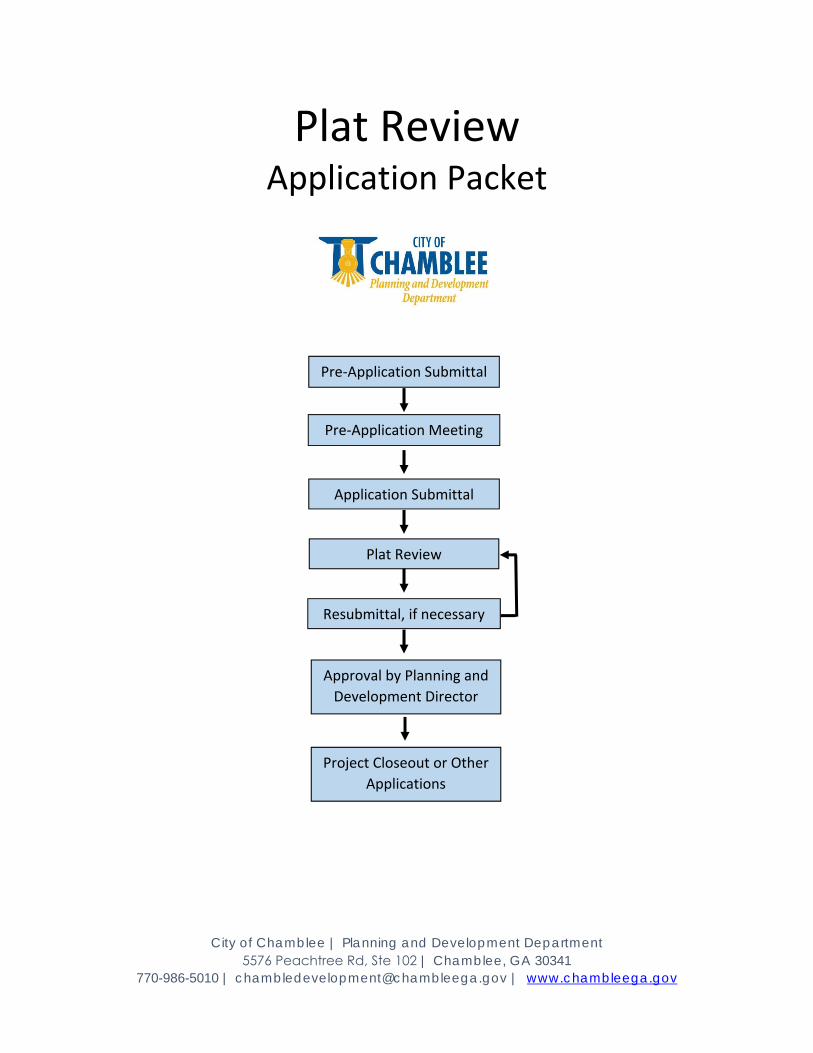
Plat Review Application Packet
Application Submittal
Plat Review
Resubmittal, if necessary
Project Closeout or Other
Applications
Pre‐Application Submittal
Pre‐Application Meeting
Approval by Planning and Development Director
City of Chamblee | Planning and Development Department 5576 Peachtree Rd, Ste 102 | Chamblee, GA 30341
770-986-5010 | [email protected] | www.chambleega.gov
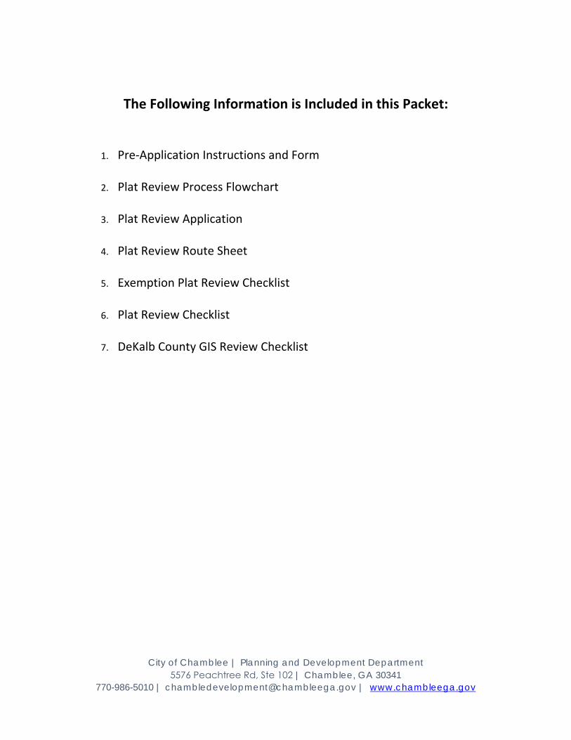
The Following Information is Included in this Packet:
1. Pre‐Application Instructions and Form
2. Plat Review Process Flowchart
3. Plat Review Application
4. Plat Review Route Sheet
5. Exemption Plat Review Checklist
6. Plat Review Checklist
7. DeKalb County GIS Review Checklist
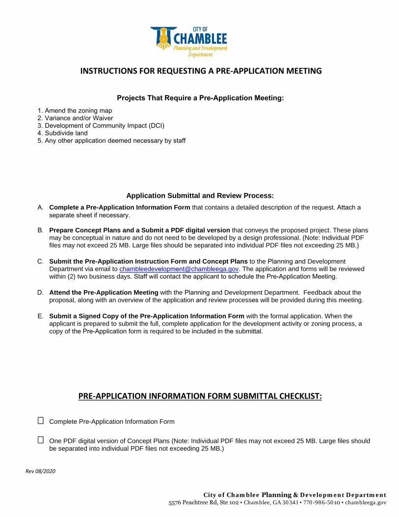
INSTRUCTIONS FOR REQUESTING A PRE-APPLICATION MEETING
1. Amend the zoning map2. Variance and/or Waiver3. Development of Community Impact (DCI)4. Subdivide land5. Any other application deemed necessary by staff
Application Submittal and Review Process: A. Complete a Pre-Application Information Form that contains a detailed description of the request. Attach a
separate sheet if necessary.
B. Prepare Concept Plans and a Submit a PDF digital version that conveys the proposed project. These plansmay be conceptual in nature and do not need to be developed by a design professional. (Note: Individual PDFfiles may not exceed 25 MB. Large files should be separated into individual PDF files not exceeding 25 MB.)
C. Submit the Pre-Application Instruction Form and Concept Plans to the Planning and DevelopmentDepartment via email to [email protected]. The application and forms will be reviewedwithin (2) two business days. Staff will contact the applicant to schedule the Pre-Application Meeting.
D. Attend the Pre-Application Meeting with the Planning and Development Department. Feedback about theproposal, along with an overview of the application and review processes will be provided during this meeting.
E. Submit a Signed Copy of the Pre-Application Information Form with the formal application. When theapplicant is prepared to submit the full, complete application for the development activity or zoning process, acopy of the Pre-Application form is required to be included in the submittal.
PRE-APPLICATION INFORMATION FORM SUBMITTAL CHECKLIST:
� Complete Pre-Application Information Form
� One PDF digital version of Concept Plans (Note: Individual PDF files may not exceed 25 MB. Large files shouldbe separated into individual PDF files not exceeding 25 MB.)
Rev 08/2020
City of Chamblee Planning & Development Department5576 Peachtree Rd, Ste 102 • Chamblee, GA 30341 • 770-986-5010 • chambleega.gov
Projects That Require a Pre-Application Meeting:
PRE-APPLICATION INFORMATION FORM This page must be completed by the Applicant.
APPLICANT
_______________________________________________________________________________ Name
_______________________________________________________________________________ Company
_______________________________________________________________________________ Mailing Address Suite/Apt. # City, State Zip Code
_________________ _________________ _________________ Primary Phone # Alternate Phone # E-mail
PROJECT SUMMARY _______________________________________________________________________________ Address of Project
_______________________________________________________________________________ Name of Project
_______________________________________________________________________________ Application Type (Amend Zoning Map, Development of Community Impact (DCI), Variance/Waiver, Subdivide Land, Other)
______________________ Total Project Acreage
Detailed Description (Include Proposed Use(s) and Square Footage of Floor Area for each use):
_______________________________________________________________________________
_______________________________________________________________________________
_______________________________________________________________________________
_______________________________________________________________________________
_______________________________________________________________________________
________________________________________________________ Date: ______ / ______ / ___________Applicant Signature
NOTE: This form must be signed by staff and submitted with your application.
For Internal Use Only:
Pre-Application Meeting Date: _______________________
Staff Printed Name: _________________________ Signed: _________________________________
City of Chamblee Planning & Development Department5576 Peachtree Rd, Ste 102 • Chamblee, GA 30341 • 770-986-5010 • chambleega.gov
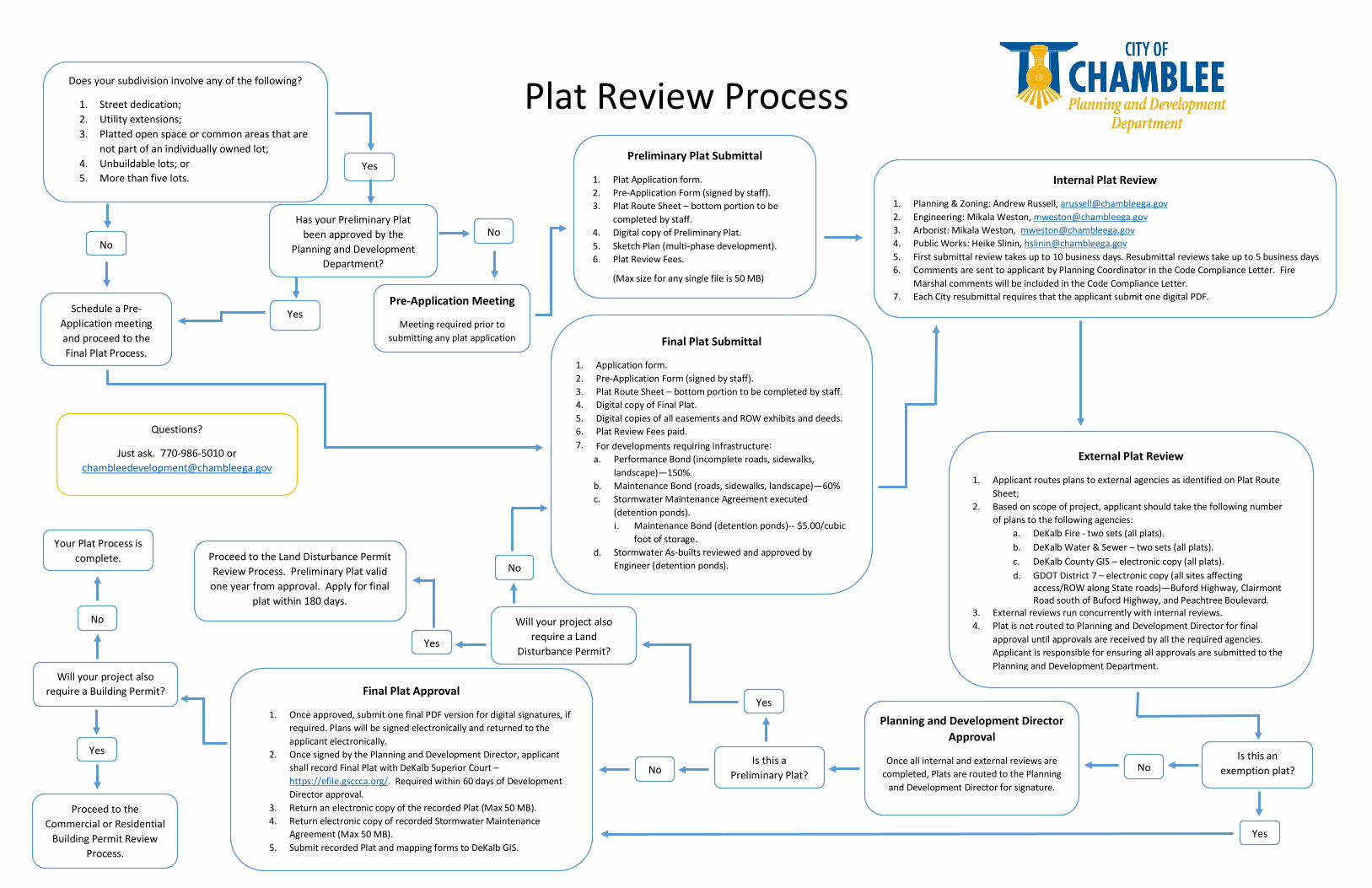
Plat Review Process
Yes
Does your subdivision involve any of the following?
1. Street dedication; 2. Utility extensions; 3. Platted open space or common areas that are
not part of an individually owned lot; 4. Unbuildable lots; or 5. More than five lots.
No
Yes
Schedule a Pre-Application meeting and proceed to the Final Plat Process.
Has your Preliminary Plat been approved by the
Planning and Development Department?
No
Final Plat Submittal
1. Application form. 2. Pre-Application Form (signed by staff). 3. Plat Route Sheet – bottom portion to be completed by staff. 4. Digital copy of Final Plat. 5. Digital copies of all easements and ROW exhibits and deeds. 6. Plat Review Fees paid. 7. For developments requiring infrastructure:
a. Performance Bond (incomplete roads, sidewalks, landscape)—150%.
b. Maintenance Bond (roads, sidewalks, landscape)—60% c. Stormwater Maintenance Agreement executed
(detention ponds). i. Maintenance Bond (detention ponds)-- $5.00/cubic
foot of storage. d. Stormwater As-builts reviewed and approved by
Engineer (detention ponds).
Is this a Preliminary Plat?
Preliminary Plat Submittal
1. Plat Application form. 2. Pre-Application Form (signed by staff). 3. Plat Route Sheet – bottom portion to be
completed by staff. 4. Digital copy of Preliminary Plat. 5. Sketch Plan (multi-phase development). 6. Plat Review Fees.
(Max size for any single file is 50 MB)
Final Plat Approval
1. Once approved, submit one final PDF version for digital signatures, if required. Plans will be signed electronically and returned to the applicant electronically.
2. Once signed by the Planning and Development Director, applicant shall record Final Plat with DeKalb Superior Court – https://efile.gsccca.org/. Required within 60 days of Development Director approval.
3. Return an electronic copy of the recorded Plat (Max 50 MB). 4. Return electronic copy of recorded Stormwater Maintenance
Agreement (Max 50 MB). 5. Submit recorded Plat and mapping forms to DeKalb GIS.
Yes
External Plat Review
1. Applicant routes plans to external agencies as identified on Plat Route Sheet;
2. Based on scope of project, applicant should take the following number of plans to the following agencies:
a. DeKalb Fire - two sets (all plats). b. DeKalb Water & Sewer – two sets (all plats). c. DeKalb County GIS – electronic copy (all plats). d. GDOT District 7 – electronic copy (all sites affecting
access/ROW along State roads)—Buford Highway, Clairmont Road south of Buford Highway, and Peachtree Boulevard.
3. External reviews run concurrently with internal reviews. 4. Plat is not routed to Planning and Development Director for final
approval until approvals are received by all the required agencies. Applicant is responsible for ensuring all approvals are submitted to the Planning and Development Department.
Questions?
Just ask. 770-986-5010 or [email protected]
Pre-Application Meeting
Meeting required prior to submitting any plat application
Internal Plat Review
1. Planning & Zoning: Andrew Russell, [email protected] 2. Engineering: Mikala Weston, [email protected] 3. Arborist: Mikala Weston, [email protected] 4. Public Works: Heike Slinin, [email protected] 5. First submittal review takes up to 10 business days. Resubmittal reviews take up to 5 business days 6. Comments are sent to applicant by Planning Coordinator in the Code Compliance Letter. Fire
Marshal comments will be included in the Code Compliance Letter. 7. Each City resubmittal requires that the applicant submit one digital PDF.
Planning and Development Director Approval
Once all internal and external reviews are completed, Plats are routed to the Planning
and Development Director for signature.
Yes
No Is this an
exemption plat? No
Will your project also require a Land
Disturbance Permit?
Will your project also require a Building Permit?
Yes
Proceed to the Commercial or Residential
Building Permit Review Process.
No
Your Plat Process is complete.
Yes
No Proceed to the Land Disturbance Permit Review Process. Preliminary Plat valid one year from approval. Apply for final
plat within 180 days.
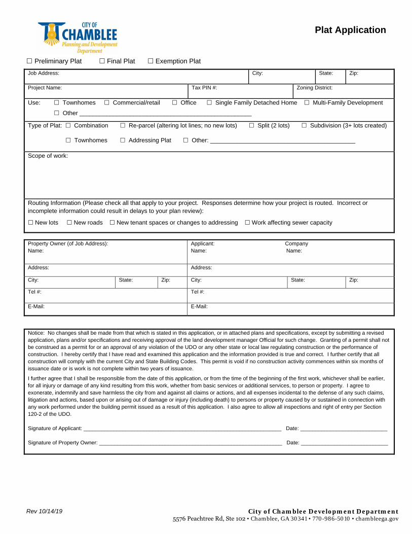
Plat Application
Rev 10/14/19 City of Chamblee Development Department5576 Peachtree Rd, Ste 102 • Chamblee, GA 30341 • 770-986-5010 • chambleega.gov
Preliminary Plat Final Plat Exemption Plat
Job Address: City: State: Zip:
Project Name: Tax PIN #: Zoning District:
Use: Townhomes Commercial/retail Office Single Family Detached Home Multi-Family Development
Other ___________________________________________________
Type of Plat: Combination Re-parcel (altering lot lines; no new lots) Split (2 lots) Subdivision (3+ lots created)
Townhomes Addressing Plat Other: ___________________________________________
Scope of work:
Routing Information (Please check all that apply to your project. Responses determine how your project is routed. Incorrect or incomplete information could result in delays to your plan review):
New lots New roads New tenant spaces or changes to addressing Work affecting sewer capacity
Property Owner (of Job Address): Name:
Applicant: Company Name: Name:
Address: Address:
City: State: Zip: City: State: Zip:
Tel #: Tel #:
E-Mail: E-Mail:
Notice: No changes shall be made from that which is stated in this application, or in attached plans and specifications, except by submitting a revised application, plans and/or specifications and receiving approval of the land development manager Official for such change. Granting of a permit shall not be construed as a permit for or an approval of any violation of the UDO or any other state or local law regulating construction or the performance of construction. I hereby certify that I have read and examined this application and the information provided is true and correct. I further certify that all construction will comply with the current City and State Building Codes. This permit is void if no construction activity commences within six months of issuance date or is work is not complete within two years of issuance.
I further agree that I shall be responsible from the date of this application, or from the time of the beginning of the first work, whichever shall be earlier, for all injury or damage of any kind resulting from this work, whether from basic services or additional services, to person or property. I agree to exonerate, indemnify and save harmless the city from and against all claims or actions, and all expenses incidental to the defense of any such claims, litigation and actions, based upon or arising out of damage or injury (including death) to persons or property caused by or sustained in connection with any work performed under the building permit issued as a result of this application. I also agree to allow all inspections and right of entry per Section 120-2 of the UDO.
Signature of Applicant: __________________________________________________________________ Date: _____________________________
Signature of Property Owner: _____________________________________________________________ Date: _____________________________
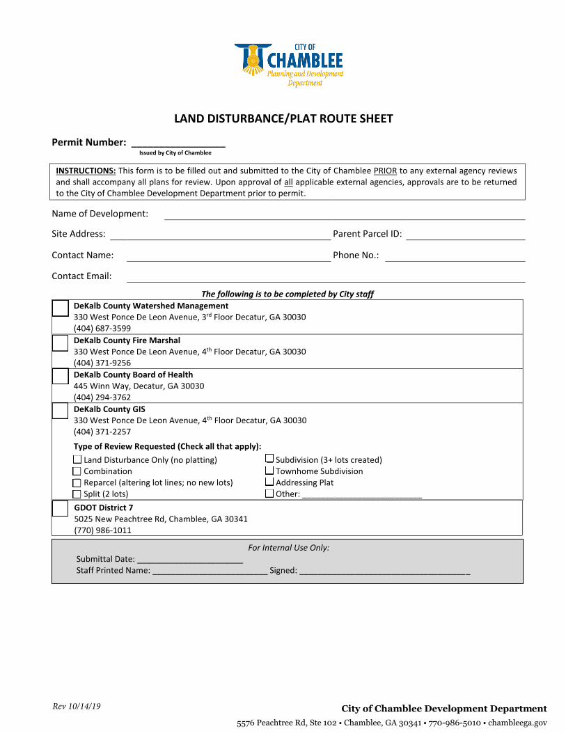
LAND DISTURBANCE/PLAT ROUTE SHEET
Permit Number: _________________ Issued by City of Chamblee
INSTRUCTIONS: This form is to be filled out and submitted to the City of Chamblee PRIOR to any external agency reviews and shall accompany all plans for review. Upon approval of all applicable external agencies, approvals are to be returned to the City of Chamblee Development Department prior to permit.
Name of Development:
Site Address: Parent Parcel ID:
Contact Name: Phone No.:
Contact Email:
The following is to be completed by City staff
DeKalb County Watershed Management 330 West Ponce De Leon Avenue, 3rd Floor Decatur, GA 30030 (404) 687-3599
DeKalb County Fire Marshal330 West Ponce De Leon Avenue, 4th Floor Decatur, GA 30030(404) 371-9256
DeKalb County Board of Health 445 Winn Way, Decatur, GA 30030 (404) 294-3762
DeKalb County GIS 330 West Ponce De Leon Avenue, 4th Floor Decatur, GA 30030 (404) 371-2257
Type of Review Requested (Check all that apply):
Land Disturbance Only (no platting) Combination Reparcel (altering lot lines; no new lots) Split (2 lots)
Subdivision (3+ lots created) Townhome Subdivision Addressing Plat Other: __________________________
For Internal Use Only: Submittal Date: _______________________ Staff Printed Name: _________________________ Signed: _____________________________________
GDOT District 75025 New Peachtree Rd, Chamblee, GA 30341(770) 986-1011
Rev 10/14/19 City of Chamblee Development Departm ent
5576 Peachtree Rd, Ste 102 • Chamblee, GA 30341 • 770-986-5010 • chambleega.gov
Rev 10/14/19 City of Chamblee Development Department
5576 Peachtree Rd, Ste 102 • Chamblee, GA 30341 • 770-986-5010 • chambleega.gov
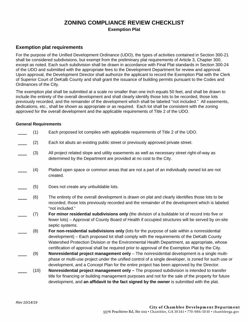
ZONING COMPLIANCE REVIEW CHECKLIST Exemption Plat
Exemption plat requirements For the purpose of the Unified Development Ordinance (UDO), the types of activities contained in Section 300-21 shall be considered subdivisions, but exempt from the preliminary plat requirements of Article 3, Chapter 300, except as noted. Each such subdivision shall be drawn in accordance with Final Plat standards in Section 300-24 of the UDO and submitted with the appropriate fees to the Development Department for review and approval. Upon approval, the Development Director shall authorize the applicant to record the Exemption Plat with the Clerk of Superior Court of DeKalb County and shall grant the issuance of building permits pursuant to the Codes and Ordinances of the City.
The exemption plat shall be submitted at a scale no smaller than one inch equals 50 feet, and shall be drawn to include the entirety of the overall development and shall clearly identify those lots to be recorded, those lots previously recorded, and the remainder of the development which shall be labeled “not included.” All easements, dedications, etc., shall be shown as appropriate or as required. Each lot shall be consistent with the zoning approved for the overall development and the applicable requirements of Title 2 of the UDO.
General Requirements
____ (1) Each proposed lot compiles with applicable requirements of Title 2 of the UDO.
____ (2) Each lot abuts an existing public street or previously approved private street.
____ (3) All project related slope and utility easements as well as necessary street right-of-way as determined by the Department are provided at no cost to the City.
____ (4) Platted open space or common areas that are not a part of an individually owned lot are not created.
____ (5) Does not create any unbuildable lots.
____ (6) The entirety of the overall development is drawn on plat and clearly identifies those lots to be recorded, those lots previously recorded and the remainder of the development which is labeled “not included.”
____ (7) For minor residential subdivisions only (the division of a buildable lot of record into five or fewer lots) – Approval of County Board of Health if occupied structures will be served by on-site septic systems.
____ (8) For non-residential subdivisions only (lots for the purpose of sale within a nonresidential development) – Each proposed lot shall comply with the requirements of the DeKalb County Watershed Protection Division or the Environmental Health Department, as appropriate, whose certification of approval shall be required prior to approval of the Exemption Plat by the City.
____ (9) Nonresidential project management only – The nonresidential development is a single multi-phase or multi-use project under the unified control of a single developer, is zoned for such use or development, and a Concept Plan for the entire project has been approved by the Director.
____ (10) Nonresidential project management only – The proposed subdivision is intended to transfer title for financing or building management purposes and not for the sale of the property for future development, and an affidavit to the fact signed by the owner is submitted with the plat.
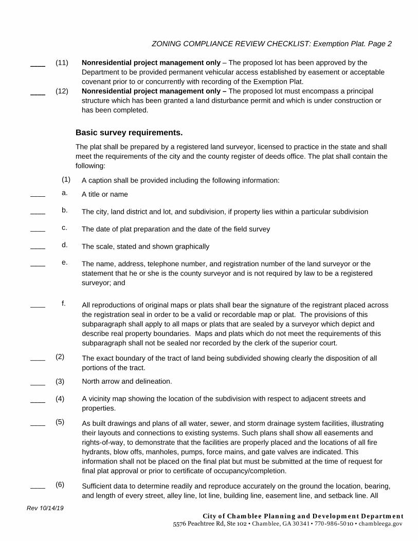
ZONING COMPLIANCE REVIEW CHECKLIST: Exemption Plat. Page 2
Rev 10/14/19 City of Chamblee Planning and Development Department
5576 Peachtree Rd, Ste 102 • Chamblee, GA 30341 • 770-986-5010 • chambleega.gov
____ (11) Nonresidential project management only – The proposed lot has been approved by the Department to be provided permanent vehicular access established by easement or acceptable covenant prior to or concurrently with recording of the Exemption Plat.
____ (12) Nonresidential project management only – The proposed lot must encompass a principal structure which has been granted a land disturbance permit and which is under construction or has been completed.
Basic survey requirements. The plat shall be prepared by a registered land surveyor, licensed to practice in the state and shall meet the requirements of the city and the county register of deeds office. The plat shall contain the following:
(1) A caption shall be provided including the following information:
____ a. A title or name
____ b. The city, land district and lot, and subdivision, if property lies within a particular subdivision
____ c. The date of plat preparation and the date of the field survey
____ d. The scale, stated and shown graphically
____ e. The name, address, telephone number, and registration number of the land surveyor or thestatement that he or she is the county surveyor and is not required by law to be a registeredsurveyor; and
____ f. All reproductions of original maps or plats shall bear the signature of the registrant placed acrossthe registration seal in order to be a valid or recordable map or plat. The provisions of thissubparagraph shall apply to all maps or plats that are sealed by a surveyor which depict anddescribe real property boundaries. Maps and plats which do not meet the requirements of thissubparagraph shall not be sealed nor recorded by the clerk of the superior court.
____ (2) The exact boundary of the tract of land being subdivided showing clearly the disposition of allportions of the tract.
____ (3) North arrow and delineation.
____ (4) A vicinity map showing the location of the subdivision with respect to adjacent streets andproperties.
____ (5) As built drawings and plans of all water, sewer, and storm drainage system facilities, illustratingtheir layouts and connections to existing systems. Such plans shall show all easements andrights-of-way, to demonstrate that the facilities are properly placed and the locations of all firehydrants, blow offs, manholes, pumps, force mains, and gate valves are indicated. Thisinformation shall not be placed on the final plat but must be submitted at the time of request forfinal plat approval or prior to certificate of occupancy/completion.
____ (6) Sufficient data to determine readily and reproduce accurately on the ground the location, bearing,and length of every street, alley line, lot line, building line, easement line, and setback line. All
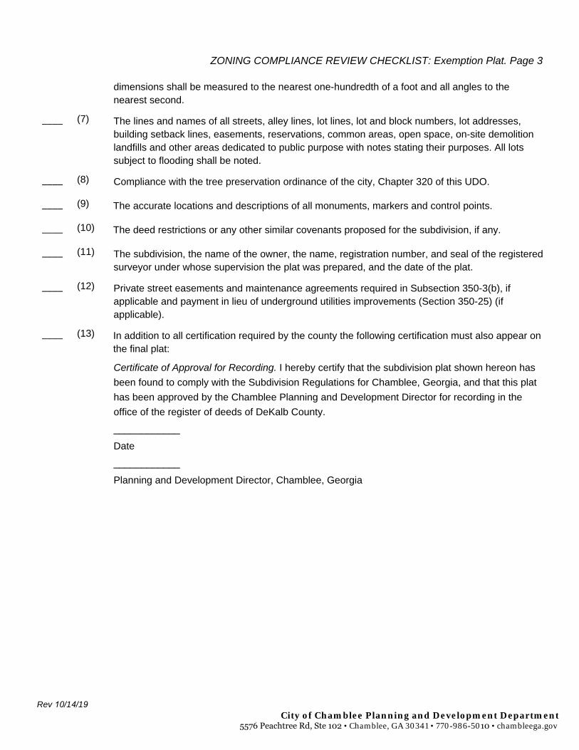
ZONING COMPLIANCE REVIEW CHECKLIST: Exemption Plat. Page 3
Rev 10/14/19 City of Chamblee Planning and Development Department
5576 Peachtree Rd, Ste 102 • Chamblee, GA 30341 • 770-986-5010 • chambleega.gov
dimensions shall be measured to the nearest one-hundredth of a foot and all angles to the nearest second.
____ (7) The lines and names of all streets, alley lines, lot lines, lot and block numbers, lot addresses, building setback lines, easements, reservations, common areas, open space, on-site demolition landfills and other areas dedicated to public purpose with notes stating their purposes. All lots subject to flooding shall be noted.
____ (8) Compliance with the tree preservation ordinance of the city, Chapter 320 of this UDO.
____ (9) The accurate locations and descriptions of all monuments, markers and control points.
____ (10) The deed restrictions or any other similar covenants proposed for the subdivision, if any.
____ (11) The subdivision, the name of the owner, the name, registration number, and seal of the registered surveyor under whose supervision the plat was prepared, and the date of the plat.
____ (12) Private street easements and maintenance agreements required in Subsection 350-3(b), if applicable and payment in lieu of underground utilities improvements (Section 350-25) (if applicable).
____ (13) In addition to all certification required by the county the following certification must also appear on the final plat:
Certificate of Approval for Recording. I hereby certify that the subdivision plat shown hereon has
been found to comply with the Subdivision Regulations for Chamblee, Georgia, and that this plat
has been approved by the Chamblee Planning and Development Director for recording in the
office of the register of deeds of DeKalb County.
____________
Date
____________
Planning and Development Director, Chamblee, Georgia
Rev 10/14/19 City of Chamblee Planning and Development Department
5576 Peachtree Rd, Ste 102 • Chamblee, GA 30341 • 770-986-5010 • chambleega.gov
ZONING COMPLIANCE REVIEW CHECKLIST Indicate which is being reviewed: Preliminary Plat ____; Final Plat ____
Preliminary plat requirements. The preliminary plat shall be submitted at a scale no smaller than one inch equals 50 feet. No certifications other than the certificate of survey and accuracy must be provided in connection with the submission.
As per UDO Section 300-23, the preliminary subdivision plat must be drawn to the following specifications and must contain or be accompanied by the information listed below. No processing or review of a preliminary plat will proceed without all of the following information:
____ (1) The boundary, as determined by survey, of the area to be subdivided with all bearings and distances shown and the location within the area, or contiguous to it, of any existing streets, railroad lines, watercourses, easements or other significant features of the tract.
____ (2) Scale denoted both graphically and numerically with north arrow and declination.
____ (3) Complete construction plans, in accordance with the requirements in Section 300-34, as applicable, prepared by a registered engineer and approved by the city and the appropriate state agency.
____ (4) The location of proposed streets, alleys, easements, lots, parks or other open spaces, reservations (i.e., school sites), property lines with street dimensions, tentative lot dimensions, lot and block numbers, and the location of any building restriction areas, i.e., flood hazard areas, watershed protection districts, wetlands. Site calculations shall include total acreage of tract, acreage in parks and other nonresidential uses, total number and acreage of parcels, and the total number of housing units.
____ (5) The proposed name of the subdivision, street names, the owners name and address, signature of the owner or owner's duly authorized agent, the name of the surveyor, the names of adjoining subdivisions or property owners, the name of the city, county, and state in which the subdivision is located, the date of plat preparation, and the zoning classification of the tract to be subdivided and of adjoining properties.
____ (6) Typical cross sections of proposed streets showing rights-of-way, pavement widths, grades, and design engineering data for all corners and curves. Where a proposed street is an extension of an existing street the profile of the street shall include 300 feet of the existing roadway, with a cross section of the existing street. Where a proposed street within the subdivision abuts a tract of land that adjoins the subdivision and where said street may be expected to extend into said adjoining tract of land, the profile shall be extended to include 300 feet of the said adjoining tract.
____ (7) The location of any existing or proposed demolition landfills in the site. Such sites shall not be used for building.
____ (8) A timetable for estimated project completion for each phase covered by the preliminary.
____ (9) The following wording must be shown on the preliminary plat:
ZONING COMPLIANCE REVIEW CHECKLIST: Preliminary Plat and Final Plat. Page 2
Rev 10/14/19
City of Chamblee Planning and Development Department5576 Peachtree Rd, Ste 102 • Chamblee, GA 30341 • 770-986-5010 • chambleega.gov
"This preliminary plat has been submitted to and approved by the City of Chamblee, on this ____________ day of ____________ , ____________ ____________ .
By: ____________ ____________ (By Dir.)
____ (10) Any additional information deemed necessary by the Development Department to determine compliance with ordinance standards.
In addition to the above required information, the following additional information may be necessary for unique sites:
____ (1) Original contours at intervals of not less than five feet for the entire area to be subdivided and extending into adjoining property for a distance of 300 feet at all points where street rights-of-way connect to the adjoining property.
____ (2) Where a proposed water and sewer system does not contemplate the use of facilities owned and operated by the city or a sanitary district, the proposed facility plans as approved by the appropriate agency, shall be submitted with the preliminary application.
Final plat requirements. The final plat shall be prepared by a registered land surveyor, licensed to practice in the state and must be drawn to a scale no smaller than one inch equals 50 feet, and shall meet the requirements of the city and the county register of deeds office. The final plat shall constitute all portions of the preliminary plat site which the subdivider proposes to record and develop at the time.
As per UDO Section 300-24, no final plat shall be approved unless and until the subdivider has installed in that area all improvements required by this appendix. The final plat shall contain the following:
____ (1) A caption including the following information:
____ a. A title or name
____ b. The city, land district and lot, and subdivision, if property lies within a particularsubdivision
____ c. The date of plat preparation and the date of the field survey
____ d. The scale, stated and shown graphically
____ e. The name, address, telephone number, and registration number of the land surveyor orthe statement that he or she is the county surveyor and is not required by law to be aregistered surveyor; and
____ f. All reproductions of original maps or plats shall bear the signature of the registrant placedacross the registration seal in order to be a valid or recordable map or plat. Theprovisions of this subparagraph shall apply to all maps or plats that are sealed by asurveyor which depict and describe real property boundaries. Maps and plats which do
ZONING COMPLIANCE REVIEW CHECKLIST: Preliminary Plat and Final Plat. Page 3
Rev 10/14/19
City of Chamblee Planning and Development Department5576 Peachtree Rd, Ste 102 • Chamblee, GA 30341 • 770-986-5010 • chambleega.gov
not meet the requirements of this subparagraph shall not be sealed nor recorded by the clerk of the superior court.
____ (2) The exact boundary of the tract of land being subdivided showing clearly the disposition of all portions of the tract.
____ (3) North arrow and delineation.
____ (4) A vicinity map showing the location of the subdivision with respect to adjacent streets and properties.
____ (5) As built drawings and plans of all water, sewer, and storm drainage system facilities, illustrating their layouts and connections to existing systems. Such plans shall show all easements and rights-of-way, to demonstrate that the facilities are properly placed and the locations of all fire hydrants, blow offs, manholes, pumps, force mains, and gate valves are indicated. This information shall not be placed on the final plat but must be submitted at the time of request for final plat approval or release of any surety for required improvements, whichever comes later.
____ (6) Sufficient data to determine readily and reproduce accurately on the ground the location, bearing, and length of every street, alley line, lot line, building line, easement line, and setback line. All dimensions shall be measured to the nearest one-hundredth of a foot and all angles to the nearest second.
____ (7) The lines and names of all streets, alley lines, lot lines, lot and block numbers, lot addresses, building setback lines, easements, reservations, on-site demolition landfills and areas dedicated to public purpose with notes stating their purposes. All lots subject to flooding shall be noted.
____ (8) Compliance with the tree preservation ordinance of the city, Chapter 320 of the UDO.
____ (9) The accurate locations and descriptions of all monuments, markers, and control points.
____ (10) The deed restrictions or any other similar covenants proposed for the subdivision, if any.
____ (11) The name of the township in which the subdivision is located, the name of the subdivision, the name of the owner, the name, registration number, and seal of the registered surveyor under whose supervision the plat was prepared, and the date of the plat.
____ (12) Private street easements and maintenance agreements required in UDO Section 350-3(b), if applicable and payment in lieu of underground utilities improvements (Section 350-25), if applicable.
____ (13) In addition to all certification required by the county the following certification must also appear on the final plat:
Certificate of Approval for Recording. I hereby certify that the subdivision plat shown
hereon has been found to comply with the Subdivision Regulations for Chamblee,
Georgia, and that this plat has been approved by the Chamblee Planning and
Development Director for recording in the office of the register of deeds of DeKalb
County.
____________
Date
____________
Planning and Development Director, Chamblee, Georgia
1 330 W. Ponce De Leon Avenue, Suite 600 Decatur, GA 30030 Phone: 404.371.2257 Fax: 404.371.3211
www.dekalbcountyga.gov
DeKalb County Geographic Information Systems Department
GIS CHECK LIST
PROJECT: ________________________________
GIS FILE LOCATOR/AP #: __________________
DATE: ___________________________________
The following items marked (X) need to be shown or addressed on site plan. GIS review and is not limited to the following items; additional comments may be provided as warranted.
1. ( ) Project name must be approved by GIS Addressing Coordinator
2. ( ) Street name(s) must be submitted for both private streets located in therear of Lots 1-5 & 6-8 for approval by GIS Addressing Coordinator
3. ( ) GIS will assign street addresses : Contact GIS for street addresses
4. ( ) Show names of adjoining property owner with deed book and pagenumbers, parcel ID, and addresses: please cad all items onto plan set
5. ( ) Show North Arrow
6. ( ) Please add the Sheets Index of Drawings for:( ) Existing Conditions Sheet ( ) Demolition Sheet (if applicable) ( ) Site Plan Sheet (include each parcel dimensions)
7. ( ) Label all open spaces as “common areas/open spaces”
8. ( ) Show name, address and phone number of developer on Sketch Plat and/orcoversheet
9. ( ) Show name, address and phone number of owner on Sketch Plat and/orcoversheet
10. ( ) DeKalb County Records show ownership in: City of Chamblee Allparcels must be in the same exact name prior to any map changes
11. ( ) Provide Site Plan for a residential combination/separation/re-parcel ofexisting parcels. Site Plan Sheet should include the
2 330 W. Ponce De Leon Avenue, Suite 600 Decatur, GA 30030 Phone: 404.371.2257 Fax: 404.371.3211
www.dekalbcountyga.gov
( ) Please add coversheet to plans
( ) Show name, address and phone number of owner(s) on plat
( ) Show all parcel id number of existing parcel on Existing Conditions Sheet
( ) Show dimensions and legal description(s) of proposed parcel
( ) Record plat after final stamped approval with original signatures.
12. ( ) Provide recorded digitized site plan on diskette to DevelopmentDepartment; to the attention of Director, Stacy Grear. Diskette should be inAutoCAD or Microstation platform (Subdivisions, Condos & Townhomes).GIS prefers the digital file containing separate layers of the following:Lot Boundaries, Right of Way Boundaries, Legal Lot/Unit #’s, Address #’s,Street Centerline, & Dimensions
13. ( ) Provide a copy of the recorded plan to GIS Department. Note: GISDepartment must receive stamped/written approval plans from the designatedmunicipality. At that time, a combination/separation/Reparcel form will becompleted by customer. Note: If customer is not the owner of the parcel(s);land owner must submit an Agent Authorization Form granting thecustomer permission to serve as owner’s agent. Both GIS Mapping Formand Agent Authorization must have original signatures.
14. ( ) If applicable, Complete Final/Commercial Plat Mapping Form whenrequesting model homes. Provide brief description for model home, i.e. legallot number and the number of model homes requested.
15. ( ) Have Engineer to provide preliminary plat with addresses for each lot.(Condos/Townhomes only)
Cassandra Odom
Cassandra Odom | Addressing Coordinator | Email: [email protected]
DeKalb County | Geographical Information Systems Department Clark Harrison Bldg. | 330 W. Ponce de Leon Ave., 6th Fl | Decatur, GA 30030 Main: 404.371.2257 | Direct: 404.371.2914 | Fax: 404.371.3211
“Always Gaining In Sight” – DeKalb County GIS - Web: www.DeKalbCountyga.gov