Embed Size (px)
Citation preview

ATTACHMENT B
PLANNING PROPOSAL: APDG SITE BLOCK 4 (REVISED JUNE 2016)
ATTACHMENT B

PLANNING PROPOSAL – APDG SITE BLOCK 4 June 2016
ATTACHMENT B

Planning Proposal: APDG Site Block 4 –June 2016 Page 2
ATTACHMENT B

INTRODUCTION In September 2014 Lend Lease Development Pty Ltd (Lend Lease) submitted a planning justification report to the City of Sydney requesting site-specific amendments to Sydney Local Environmental Plan 2012 (SLEP2012) to enable significant redevelopment of a parcel of land (comprising of several properties) within the city block bound by Alfred, Pitt, Dalley and George Streets (the APDG block), Sydney.In June 2015 the Council and Central Sydney Planning Committee endorsed Planning Proposal - APDG Site Block 4 for public exhibition and the Minister’s delegate issued a Gateway determination for the planning proposal on 18 August 2015. Before Planning Proposal - APDG Site Block 4 could proceed to exhibition, Lend Lease requested that it be modified. In December 2015 Lend Lease submitted a revised planning justification report to the City of Sydney seeking changes to the planning proposal to allow for modifications to its redevelopment scheme. This planning proposal is a response to both requests and takes into consideration the impact of development consents on the adjoining Wanda One site. It has been prepared in accordance with Section 55 of the Environmental Planning and Assessment Act 1979 (the Act) and relevant Department of Planning and Infrastructure guidelines, including A guide to preparing local environmental plans and A Guide to preparing planning proposals. SITE IDENTIFICATION Location The planning proposal relates to a collection of properties with frontage to Pitt and George Streets. Referred to in this report as the ‘Lend Lease Circular Quay site’ (LLCQ site), it is located close to Circular Quay, at the northern end of Sydney Central Business District between Pitt and George Streets. See location map below at Figure I.
Figure I: Site Location Map
Planning Proposal: APDG Site Block 4 –June 2016 Page 3
ATTACHMENT B

The planning proposal relates principally to the properties identified on the diagram at Figure II below.
Figure II: Land to which the planning proposal relates Land ownership Lend Lease owns the Jacksons on George site, 33 to 35 Pitt Street (the Pitt St site) and 182 George Street (the George St site). When they initiated the planning proposal, Lend Lease was in discussions with the Rugby Club Limited about the possibility of including the Rugby Club site (31A Pitt Street) in a future combined development. However, the Rugby Club site has since been sold to Wanda One Sydney Pty Ltd and is included in their consent for development of 1 Alfred Street and adjoining land (discussed below). The City of Sydney owns Crane Lane which is classified as operational land under the Local Government Act 1993. The triangular portion of land known as the Mirvac Triangle is proposed to be transferred to the City of Sydney under a planning agreement relating to the Mirvac site at 200 George Street.
Planning Proposal: APDG Site Block 4 –June 2016 Page 4
ATTACHMENT B

Site area The total site area is approximately 4,600m2 excluding the Rugby Club or 5,036m2 including the Rugby Club. Existing improvements A general description of existing improvements on the site is in Table A below.
Property Description of improvements
Pitt St site
2,594 m2
The Atrium at 33-35 Pitt Street was completed in 1984. It comprises two, 12 storey buildings connected by an 8 level glass covered atrium, with frontages to Pitt Street, Underwood Street, Crane Lane and Rugby Place. It features extensive areas of colonnades on the eastern and northern frontages.
George St site
1,124.6 m2
A 15 storey commercial office building was completed in 1981. It features extensive areas of overhangs and colonnades on the western and northern edges. The northern part of the building overhangs Blue Anchor Lane.
Crane Lane
176.6 m2
A narrow, L-shaped parcel of land which connects George Street to Rugby Place. The east-west section is trafficable only by foot and the north-south section provides vehicular access to the rear of the George St site.
It comprises lots 1 and 2 DP880891. Lot 1 is a stratum lot that sits within and surrounded by Lot 2 and is developed as an upper level enclosed walkway (footbridge) over Crane Lane, connecting the commercial buildings on the George St and Pitt St sites.
Jacksons on George site
485.9 m2
A purpose-built hotel building over four levels, dating from the late 1970’s and constructed generally to the site boundaries. The building presents as three storeys to George Street, and due to the fall in finished ground level from west to east, the lowest or basement level is increasingly exposed such that the eastern section of the building is four storeys above ground level. The hotel business includes food and beverage, a dance club and gaming room and has existing approvals and liquor license for late night trading.
Mirvac Triangle
218.9 m2
The Mirvac Triangle currently forms part of the Mirvac development site at 200 George Street. Under the approval for that development it is to be developed as part road and part public plaza. The whole of the Mirvac Triangle has been earmarked for dedication to Council for public purposes including the road and public plaza.
Rugby Club site (optional site)
436 m2
The Rugby Club comprises a six-storey building, which is used as a licensed club with three function rooms, a public bar and bistro and associated infrastructure and amenities, and upper level office accommodation. The building is generally built to the site boundaries, with the exception of the laneway known as Rugby Place, including an outdoor courtyard area which partially extends over Rugby Place.
Table A: Description of existing improvements
Planning Proposal: APDG Site Block 4 –June 2016 Page 5
ATTACHMENT B

CONTEXT APDG Block The APDG block is located at the junction of the western edge of Circular Quay and George Street. It contains a large number of multi-storey commercial buildings that line the northern end of George and Pitt Streets. The APDG block was the subject of an urban design study undertaken in 2009 by the Government Architects Office which resulted in the site-specific controls currently included in Sydney Local Environmental Plan 2012 and Sydney Development Control Plan 2012. This study was initiated by the City of Sydney. The LLCQ site is situated centrally within the APDG block, adjoining the following sites for which consents have been granted:
188-208 George Street, 1 Underwood Street and 4 Dalley Street, Sydney (the Mirvac George St site) – construction of a 37 storey commercial office building and refurbishment of the remainder of 4 Dalley Street for plant and servicing is currently underway. The design of the new building is the outcome of a competitive design process.
19-31 Pitt St Sydney (the former Fairfax site) – in 2011 consent was granted to a Stage 1 development application (D/2010/1533) for demolition of the existing building and development of a new mixed use building envelope comprising a commercial/retail podium, a residential tower, and basement parking. To date an associated Stage 2 development application has not been submitted. This consent is to be surrendered if the State Significant consent (D/2015/1049) discussed below is activated. 1 Alfred Street, 19-31 Pitt St and 31A Pitt Street Sydney (the Wanda One site) – on 10 December 2015 consent was granted to an application for State Significant Development (D/2015/1049). In particular, the consent is for: • Stage 1 building envelopes and proposed uses for two towers (Tower A and Tower B); • Tower A comprises a mixed use (residential and retail) building with a proposed maximum height of 185m / RL191; • Tower B comprises a mixed use (hotel and retail premises) building with a proposed maximum height of 110m / RL112.5; • a six level basement car park across the site; • vehicle access arrangements for subsequent stages of the development; and • realignment of Rugby Place and new pedestrian link connecting Rugby Place to Herald Square. 1 Alfred Street, Sydney – in 2012 consent was granted to a Stage 2 development application (D/2010/2029) for the detailed design of a new mixed-use development comprising two buildings of 55 storeys and 15 storeys. An application to amend this consent (D/2015/882) was considered concurrently with the State Significant Development application discussed above. It was also approved on 10 December 2015. The current approval is for the demolition of Goldfields House and construction of a single, 57-storey tower (Tower A in the State Significant Development consent) containing 184 apartments, retail space and landscaping. The tower retains the previously approved building height but is marginally wider on two sides than that approved in 2012.
Land owned by Mirvac in the south-eastern corner of the APDG block at 37 Pitt Street, 39-57 Pitt Street and 6-8 Underwood Street (the Mirvac Pitt St site) is also the subject of a request from Mirvac for amendment to the APDG block planning controls - by way of a separate planning proposal. This request is being separately considered.
Planning Proposal: APDG Site Block 4 –June 2016 Page 6
ATTACHMENT B
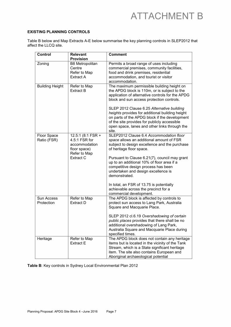
EXISTING PLANNING CONTROLS Table B below and Map Extracts A-E below summarise the key planning controls in SLEP2012 that affect the LLCQ site.
Control Relevant Provision
Comment
Zoning B8 Metropolitan Centre Refer to Map Extract A
Permits a broad range of uses including commercial premises, community facilities, food and drink premises, residential accommodation, and tourist or visitor accommodation.
Building Height Refer to Map Extract B
The maximum permissible building height on the APDG block is 110m, or is subject to the application of alternative controls for the APDG block and sun access protection controls. SLEP 2012 Clause 6.25 Alternative building heights provides for additional building height on parts of the APDG block if the development of the site provides for publicly accessible open space, lanes and other links through the site.
Floor Space Ratio (FSR)
12.5:1 (8:1 FSR + 4.5:1 FSR for accommodation floor space) Refer to Map Extract C
SLEP2012 Clause 6.4 Accommodation floor space allows an additional amount of FSR subject to design excellence and the purchase of heritage floor space. Pursuant to Clause 6.21(7), council may grant up to an additional 10% of floor area if a competitive design process has been undertaken and design excellence is demonstrated. In total, an FSR of 13.75 is potentially achievable across the precinct for a commercial development.
Sun Access Protection
Refer to Map Extract D
The APDG block is affected by controls to protect sun access to Lang Park, Australia Square and Macquarie Place. SLEP 2012 cl.6.19 Overshadowing of certain public places provides that there shall be no additional overshadowing of Lang Park, Australia Square and Macquarie Place during specified times.
Heritage Refer to Map Extract E
The APDG block does not contain any heritage items but is located in the vicinity of the Tank Stream, which is a State significant heritage item. The site also contains European and Aboriginal archaeological potential
Table B: Key controls in Sydney Local Environmental Plan 2012
Planning Proposal: APDG Site Block 4 –June 2016 Page 7
ATTACHMENT B
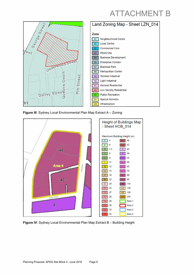
Figure III: Sydney Local Environmental Plan Map Extract A – Zoning
Figure IV: Sydney Local Environmental Plan Map Extract B – Building Height
Planning Proposal: APDG Site Block 4 –June 2016 Page 8
ATTACHMENT B

Figure V: Sydney Local Environmental Plan Map Extract C – Floor Space Ratio
Figure VI: Sydney Local Environmental Plan Map Extract D – Sun Access Protection
Planning Proposal: APDG Site Block 4 –June 2016 Page 9
ATTACHMENT B
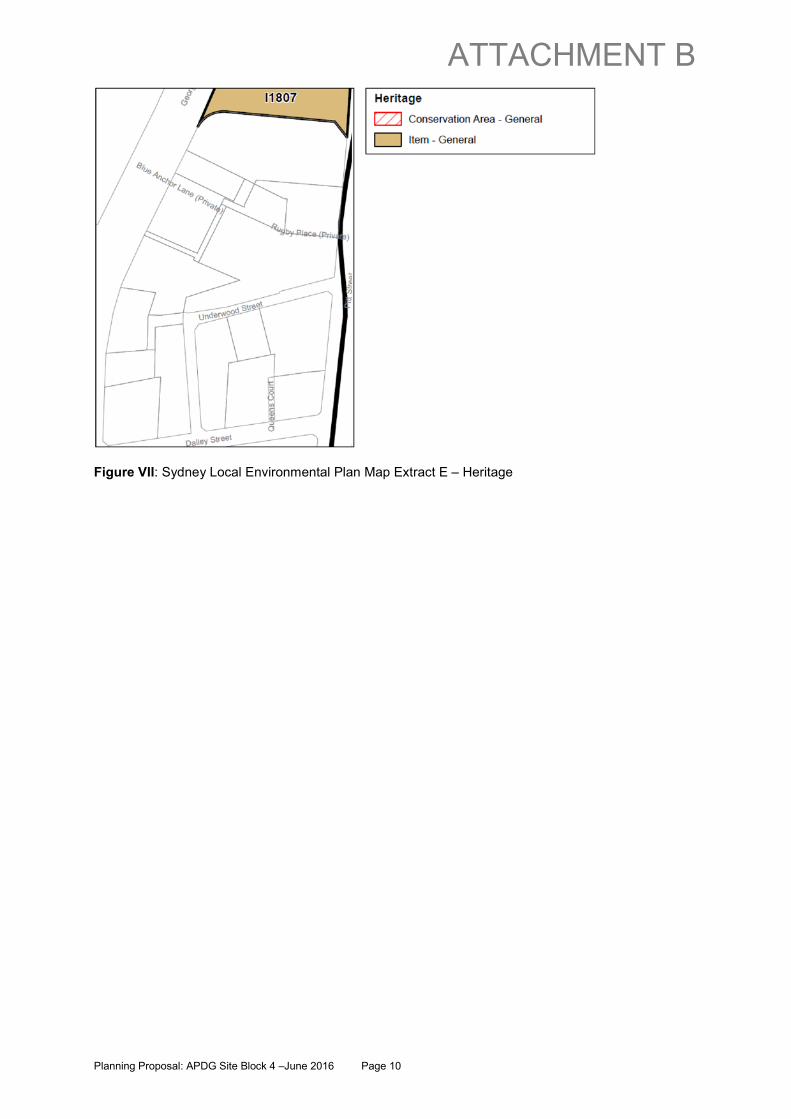
Figure VII: Sydney Local Environmental Plan Map Extract E – Heritage
Planning Proposal: APDG Site Block 4 –June 2016 Page 10
ATTACHMENT B

PLANNING PROPOSAL – APDG SITE BLOCK 4 PART 1 – OBJECTIVES OR INTENDED OUTCOMES Objectives
• To provide another development option in SLEP2012 for the appropriate distribution of built form and floor space within the APDG block;
• To identify the LLCQ site as an alternative site where additional building height may be achieved if the development provides for certain public benefits, including publicly accessible open space, lanes and other links through the site;
• To facilitate a land swap for the purpose of achieving a more efficient building floor plate and a better configuration of public open space;
• To ensure that fine grain uses will activate the laneway network; • To encourage the inclusion of community facilities and associated retail premises in the
redevelopment of the LLCQ site; • To encourage the inclusion of a business innovation space in the LLCQ site; and • To ensure that only non-residential uses are permitted within the LLCQ site.
Intended Outcomes The planning proposal is intended to take advantage of current property ownership patterns to ‘unlock’ the development potential of the APDG block and achieve public domain improvements. Its intent is to facilitate a major redevelopment of the LLCQ site for the following purposes:
• a commercial office tower with a maximum height of 248 metres and additional low scale buildings to provide definition to and activation of the public domain;
• a significant public plaza directly accessible from George Street, and a secondary plaza space on Rugby Lane;
• an enhanced network of lanes within and connected to the LLCQ site, with activated laneway frontages;
• community facilities and associated uses in a low-scale building on the eastern edge of the George Street plaza and in basement space below the George Street plaza; and
• the remodelling of Jacksons on George, and the optional remodelling of the Rugby Club.
PART 2 – EXPLANATION OF THE PROVISIONS The following amendments to SLEP2012 are sought to facilitate the objectives and intended outcomes outlined in Part 1 of this planning proposal:
• amend clause 6.25 APDG block to o allow for another development scenario by establishing block 4 (the LLCQ site) as
an alternative option to block 1; o include land in block 4 that is not currently included in any identified development
block under clause 6.25; o allow a maximum building height of 248m (RL 250.8m) on a building footprint on one
part of block 4 comprising no more than 25% of the area of development block 4; o allow a maximum building height of 238m (RL 240.8m) on a building footprint on
another part of block 4 comprising no more than 12% of the area of development block 4;
o allow only the development of non-residential uses within block 4; and o calculate the above percentages based on the area of block 4 only and not the
‘optional addition’ Rugby Club site’. • a new clause to permit the inclusion of public land (Crane Lane) in the site area for the
purpose of calculating the FSR of block 4 and to enable the FSR generated by Crane Lane to be transferred for use on another part of block 4;
• a new clause which excludes the ‘Mirvac Triangle’ from the site area of block 4 for the purposes of calculating the FSR of block 4;
• a new clause to exclude from the calculation of FSR on block 4 the GFA of a community stratum comprising
o a building adjoining the George St plaza which is to be used for a community facility and associated retail premises, such as a cafe; and
Planning Proposal: APDG Site Block 4 –June 2016 Page 11
ATTACHMENT B
• space underneath the George St plaza which is to be used for a community facility and
associated retail premises, such as cycle hire or a public end-of-journey facility; • a new clause to exclude from the calculation of FSR on block 4 the amount of GFA, up to a
maximum of 4,000 3900 sq.m, of any office premises that is: o located within the podium or the lower levels of the tower building; and o provided to the Council to be used as a business innovation space for the purpose
of promoting business innovation and economic development; • amend the Lanes Development Floor Space controls so that they apply to new development
on block 4 and lanes that may not legally be a public road; • a new clause to ensure that only non-residential uses are permitted within the LLCQ site.
The amendments outlined above will make it possible to achieve either block 1 or block 4 but not both. While the Mirvac Pitt Street site will continue to be included in block 1, development of block 4 would effectively prevent the application of the alternate controls in clause 6.25 to the Mirvac Pitt Street site. The City is currently considering a separate planning proposal for the Mirvac Pitt site which is seeking to identify that site as another development block (i.e. potentially ‘block 5’) to which alternate height controls could apply. Revised height and reconfigured development blocks under clause 6.25 Under clause 4.3 of SLEP2012, the height of a building in the APDG block is not to exceed the maximum height shown for the land on the Height of Buildings map, namely 110m. Notwithstanding this provision, clause 6.25 enables higher buildings to be approved on certain land within the APDG block. The objective of Clause 6.25 is:
to provide for additional building height on parts of certain sites (within the area bounded by Alfred Street, Pitt Street, Dalley Street and George Street) if the development of the site provides for publicly accessible open space, lanes and other links through the site.
The existing controls in clause 6.25 permit three towers over 110m on the APDG block, being a 200m tower at the corner of Pitt and Dalley Streets, a 185m tower on Alfred Street, and a 155m tower on George Street. Applicants may only ‘opt in’ to the alternative building heights where a development application relates to all parcels of land within a development block (whether or not including one or more optional parcels). The approach in the existing controls in clause 6.25 is that towers may be built within a defined proportion of the area of each development block expressed as a percentage of the area of each development block. A similar approach to building height is proposed for block 4 as follows:
• a maximum building height of 248m (RL 250.8m) may be permitted on 25% of the area of block 4;
• maximum building height of 238m (RL 240.8m) may be permitted on 12% of the area of block 4; and
• the percentages above are calculated using the area of block 4 only and not the ‘optional addition’ Rugby Club site’.
Currently, clause 6.25 does not apply to the Jacksons on George site or 182 George Street. Existing development on the Jacksons on George site comprises of a purpose-built hotel building over four levels, and there is an existing 15-storey commercial building with a height of approximately 70m on 182 George Street. This planning proposal proposes an alternative development block layout, as set out visually in Figures 1 and 2 below (existing and proposed development blocks).
Planning Proposal: APDG Site Block 4 –June 2016 Page 12
ATTACHMENT B

Figure 1: APDG development blocks - Existing development block layout
Figure 2: APDG development blocks - Proposed development block layout
Planning Proposal: APDG Site Block 4 –June 2016 Page 13
ATTACHMENT B

The proposed amendment to SLEP2012 would retain blocks 1 to 3, as identified in the existing controls, and identify block 4 (the LLCQ site shown in dark blue in Figure 2 above) by referencing the relevant Lot and DP numbers as follows:
• Lot 7 DP 629694 (33-35 Pitt Street ) • Lot 182 DP 606865 (182 George Street) • Lot 181 DP 606865 (174-176A George Street) • Lot 2 in the draft plan of subdivision 10 October 2014, issue 4, approved by Council under
development consent D/2014/1921 on 5 February 2015 (Mirvac Triangle); • Lots 1 and 2 DP 880891 (Crane Lane) • Lot 180 DP 606866 (the Rugby Club (optional site))
Calculation of site area and permissible GFA Inclusion of public land in site area for purpose of calculating FSR Crane Lane (178A George Street) is proposed to be sold to Lend Lease to facilitate redevelopment of the LLCQ site. Although this is currently public land owned by the City of Sydney, Crane Lane is classified as operational land under the Local Government Act 1993. Clause 4.5 of the LEP sets out the circumstances in which a site may be included in the Site Area for the purpose of calculating Floor Space Ratio (FSR). Clause 4.5 of SLEP 2012 provides that public land may only be included in site area for the purpose of calculating FSR if the FSR generated from the public land is dealt with “separately”; that is, by calculating a stand-alone FSR for that part of the site which comprises public land and on which development will be carried out. It prevents the transfer of FSR from public land onto other land. The planning proposal seeks to override clause 4.5 in relation to Crane Lane. It is proposed to enable Crane Lane to be included in site area and to enable the FSR generated from Crane Lane to be transferred to another part of the LLCQ site. ‘Mirvac Triangle’ to be excluded from the calculation of site area The GFA achievable from of the Mirvac Triangle is not to be counted in floor space calculations because the GFA that could be achieved from the area comprising the Mirvac Triangle has already been approved to be used in the redevelopment of the Mirvac site currently under construction on APDG block 2 (200 George Street). To avoid ‘double-dipping’, a new clause is proposed which excludes the ‘Mirvac Triangle’ from the site area of block 4 for the purposes of calculating the FSR of block 4. Floor space incentive for provision of community facilities
A floor space incentive is proposed to encourage the provision of community facilities and associated uses on block 4 to complement and activate the proposed public squares. The Dictionary in SLEP2012 defines a community facility as:
“a building or place:
(a) owned or controlled by a public authority or non-profit community organisation, and (b) used for the physical, social, cultural or intellectual development or welfare of the
community,
but does not include an educational establishment, hospital, retail premises, place of public worship or residential accommodation.”
Hence, the planning proposal seeks to exclude from the calculation of the GFA of development on block 4 the GFA of a community stratum comprising
• a building adjoining the George St plaza which is to be used for a community facility and associated retail premises, such as a cafe; and
• basement space below the George St plaza which is to be used for a community facility, such as a public end-of-journey facility, or associated retail premises, such as cycle hire.
Planning Proposal: APDG Site Block 4 –June 2016 Page 14
ATTACHMENT B

Floor space incentive for provision of business innovation space A floor space incentive is proposed to encourage office premises in the podium of the tower to be made available to the City for use as a business innovation space. The floor space is intended to be used primarily to provide affordable accommodation for high-growth businesses such as tech startups. The planning proposal therefore seeks to exclude from the calculation of FSR on block 4 the GFA of office premises located in the podium of the tower and used by the Council primarily for the purpose of promoting innovation and economic development. Under this proposed new clause, the amount that may be excluded from the FSR calculation is to be capped at 4,000 3900sq.m. Lanes development floor space It is proposed to amend the lanes development floor space provisions of SLEP2012 to encourage new fine grain tenancies along the lanes within and adjoining block 4. In seeking to secure small scale tenancies, the proposed amendment supplements clause 6.25(4) which does not allow additional height on the APDG block unless the development includes roads and lanes fronted by business premises and retail premises. Clause 6.8 Lanes Development Floor Space in SLEP2012 allows additional floor space for alterations and additions to an existing building that results in small premises (maximum of 100m2) that front a lane, are accessed from the lane, and are used for retail or other specified ‘active’ uses. The additional floor space allowed is equal to the total area of the laneway premises. Under the current controls, block 4 would not be eligible for additional floor space under clause 6.8 since it applies only to existing buildings. Further, the clause provides that the lane must be a public road whereas Rugby Place is currently privately held and subject to shared access easements. In 2015 the Council exhibited a planning proposal that seeks to make minor policy and housekeeping amendments to SLEP2012, including an amendment to clause 6.8 Lanes Development Floor Space. The amendment proposes to delete the existing requirement in clause 6.8(1) that the lane must have a width of 6m or less and replace it with a map identifying the lanes to which the clause applies. In August 2015 the Council and CSPC approved the planning proposal for making. The LEP amendment is currently being finalised with a Lanes Map that identifies Underwood Street as a lane to which clause 6.8 applies. This planning proposal seeks to amend clause 6.25 by inserting a sub-clause that would supplement the draft Lanes Map and
• enable new development on block 4 to be eligible for additional floor space under clause 6.8 Lanes Development Floor Space; and
• in the event of development of block 4, enable additional floor space under clause 6.8 to be granted in respect of Rugby Place and the proposed new north-south lane on block 4 notwithstanding that the land may not legally comprise a public road.
In association with this amendment, it is proposed to amend the Lanes Map to identify that a site specific provision applies to block 4 under clause 6.25. Non-residential uses To provide future floor space capacity for employment uses within the APDG block, only non-residential uses will be permitted on block 4 under clause 6.25. A provision is proposed to ensure that additional height may only be permitted within block 4 for development that comprises of non-residential uses only. This includes uses such as offices, business premises, retail premises, child care centres; community facilities; education establishments; entertainment facilities and the like. Although residential accommodation (such as residential flat buildings and dwellings) will not be permitted under the proposed ‘alternative’ controls for block 4, the existing controls within SLEP2012
Planning Proposal: APDG Site Block 4 –June 2016 Page 15
ATTACHMENT B

still allow residential uses within the APDG block, but building height is capped at the existing height control of 110 metres. Associated amendments to Sydney Development Control Plan 2012 As a consequence of the proposed changes to the LEP controls, it is also proposed to amend Sydney Development Control Plan 2012 to alter the site-specific DCP controls for the APDG block. The draft DCP will be publicly exhibited with the planning proposal. While retaining the existing provisions relating to the development of blocks 1 to 3, the draft DCP introduces a parallel set of provisions for block 4. The draft DCP addresses the following key design considerations:
• Streets, lanes and through-site links • New squares • Active frontages • Awnings • Building height • Street frontage heights and setbacks • Building design and bulk • Parking and vehicular access
As well, it includes
• design excellence strategy provisions; • a site-specific provision to clarify the methodology for calculating the amount of any
additional FSR available to block 4 under SLEP 2012 clause 6.21 Design Excellence; • provisions to mitigate wind impacts; and • a refinement of the Late Night Trading Area Map to include the two plazas in the Late Night
Management Area. PART 3 – JUSTIFICATION This section of the planning proposal provides the rationale for the amendment to SLEP2012 and responds to questions set out in the document entitled A guide to preparing planning proposals, published by the Department of Planning and Infrastructure in October 2012. SECTION A – NEED FOR THE PLANNING PROPOSAL Q1. Is the planning proposal a result of any strategic study or report? The planning proposal is a result of a detailed Urban Design Analysis Report undertaken by Hassell Architects on behalf of Lend Lease. The Hassell report provides a sound basis upon which to progress the planning proposal. The report establishes a strategy as to how the City’s vision for the APDG block can be achieved in an alternative way, how unrealised floor space (within Jacksons on George, Crane Lane, and potentially the Rugby Club) can be ‘unlocked’ with minimal adverse environmental impacts, and how demonstrable public benefits such as a connected and active laneway network, and a large public plaza with good solar access can be realised. A number of technical studies have also been undertaken by Lend Lease to support the planning proposal. They are attached as the following appendices to this planning proposal:
Appendix 1 Lend Lease Circular Quay Urban Design Analysis Report prepared by Hassell – December 2015
Appendix 2 Photographic Survey prepared by BBC Consulting Planners Appendix 3 Title and Easement Report prepared by Rygate and Company – October 2015 Appendix 4 Geotechnical Desk Top Study prepared by Coffey Geotechnics – October 2015 Appendix 5 Phase 1 Contamination Due Diligence prepared by AECOM – 16 October 2015 Appendix 6 Built Heritage Assessment prepared by Orwell & Peter Phillips Heritage
Architecture – June 2014 and letter from O P Phillips dated 16 October 2015 Appendix 7 Non-Aboriginal Archaeological Assessment & Impact Statement prepared by
Casey and Lowe – June 2014 updated October 2015
Planning Proposal: APDG Site Block 4 –June 2016 Page 16
ATTACHMENT B
Appendix 8 Tank Stream Conservation Report prepared by Coffey Geotechnics – October
2015 Appendix 9 Aboriginal Archaeological Assessment prepared by Comber Consulting – October
2015 Appendix 10 Multi-Disciplinary Services Review prepared by ARUP – October 2015 Appendix 11 Planning Proposal Acoustic [and Vibration] Assessment prepared by Renzo
Tonin and Associates – October 2015 Appendix 12 Wind Tunnel Test Report and Wind Assessment prepared by CPP Wind
Engineering – 18 November 2013 and letter from CPP dated 14 October 2015 Appendix 13 Concept Design Accessibility Report prepared by Morris Goding Associates – 14
October 2015 Appendix 14 Assessment Of Vehicular Transport Aspects of Planning Proposal prepared by
Colston Budd Hunt & Kafes – October 2015 Appendix 15 Transport, Traffic, Pedestrian and Parking Assessment prepared by ARUP – 12
October 2015 Appendix 16 Assessment of Interim CBD Rail Link Corridor prepared by ARUP – October 2015 Appendix 17 Jacksons on George Adaptive Reuse Study prepared by TTW and Hassell –
October 2015 Appendix 18 Ecologically Sustainable Design Report prepared by Cundall – October 2015 Appendix 19 BCA Compliance prepared by Metro Building Consultancy – 15 October 2015 Appendix 20 Key Policies and Opportunities prepared by Elton Consulting – 13 October 2015 Appendix 21 View Impact Analysis prepared by Hassell and incorporating December 2015
approved towers for Wanda One site Q2. Is the planning proposal the best means of achieving the objectives or intended outcomes, or is there a better way? A planning proposal is the only means of providing for an alternative development scenario for the APDG Block that, like the current controls, would ‘unlock’ development capacity and allow for additional building height in exchange for significant and quantifiable public domain improvements. The existing controls are capable of delivering the City’s intended outcomes for the APDG block and are therefore proposed to be retained as an option. However, the alternative option set out in the planning proposal may be more effective and deliver a superior outcome. Without an amendment to the planning controls in SLEP2012, the proposed LLCQ concept cannot be realised despite it offering significant public benefits as detailed below. Revitalisation of the APDG block In 2008, the City recognised that there were barriers imposed under the standard planning controls that prevented the floor space potential in some key CBD areas from being fully realised. In addition, the public amenity associated with buildings in these areas designed in accordance with the standard planning controls was considered to be highly compromised resulting in poor built form outcomes and missed opportunities for significant public domain improvements. The City determined that a potential solution to this issue was to identify strategic groups of sites in central Sydney where additional height could be offered in exchange for significant and quantifiable public domain improvements. The first of these groups of sites was the APDG block. The City noted the APDG block is a significant street block in a highly prominent location and that two Stage 1 development applications (for 1 Alfred Street and 188-208 George Street) which had recently been approved, demonstrated that current planning controls could be improved to achieve better built form and significant public domain improvements. An urban design study was prepared in 2009 and contained four options for improving planning outcomes in the APDG block. The preferred option was the ‘internal square’, because:
… it offered the most significant improvements to built form outcomes, opportunity for a new square with a connected, activated laneway network, and minimal lot amalgamation between land owners …
Planning Proposal: APDG Site Block 4 –June 2016 Page 17
ATTACHMENT B

The study resulted in amendments being made to the then applicable Sydney Local Environmental Plan 2005 and Central Sydney Development Control Plan 1996. Further refinements to the APDG block-specific LEP and DCP provisions occurred with the commencement of SLEP2012 and SDCP2012. These provisions operate as alternative development controls where additional height is only offered in exchange for public domain improvements. The City recognised that the adopted APDG provisions did not represent the only solution. The business paper of 8 November 2010 noted that:
…alternative floor space transfer mechanisms and/or alternative development block arrangements may be possible within the APDG site south of the 1 Alfred Street site. The City is open to the consideration of such alternatives on their merits, particularly if it can be demonstrated that alternative approaches can result in public benefits and high quality urban design outcomes similar to the alternative scheme. Consideration of alternative development scenarios which result in significantly different built form outcomes would be subject to a separate Planning Proposal, or LEP amendment, process.
It is noted that the possibility of alternative options has already been recognised … It is therefore acknowledged that there may be other scenarios for the APDG Block that are yet to be explored.
The LLCQ proposal provides an alternative scenario for the APDG block, one which embraces and expands upon the benefits of the ‘Internal Square’ option. The LLCQ proposal will achieve the revitalisation of the APDG block through the redevelopment of sites at the centre of the block, thus enabling the City to achieve the objectives of the APDG block controls in an alternative way to that currently contemplated under the applicable planning controls. A ‘once in a generation’ opportunity Having acquired Jacksons on George and the George and Pitt Street properties, Lend Lease is well-positioned to achieve the revitalisation of the APDG block through the redevelopment of sites at the centre of the block. The LLCQ proposal would enable the objectives of the APDG block controls to be achieved in an alternative way to that currently contemplated under the applicable planning controls. The LLCQ proposal presents an alternative development block arrangement that has significant merit insofar as it delivers improved public benefits and high quality urban design outcomes. Opportunities to unlock the development potential of the APDG block, revitalise the precinct and achieve public domain improvements do not arise often. Lend Lease is currently in a unique position to consolidate and redevelop the key central portion of the APDG block, in accordance with these objectives. In the event that the planning proposal is not supported or cannot proceed in a timely fashion, Lend Lease may elect to refurbish or divest key parcels, or carry out ‘opt out’ development on individual parcels. In either case, the opportunity to achieve the key objectives of the City’s 2009 APDG Urban Design Study, including the delivery of new public spaces and an enhanced laneway network, will likely be lost for the foreseeable future. Significant public domain benefits Like the existing alternate controls for the APDG block, the LLCQ proposal is capable of delivering significant public domain improvements in the form of a ‘connected and active laneway network’ and large, well-located public areas. The following features of the LLCQ proposal will facilitate the provision of an enhanced, connected and activated laneway network:
• Connected spaces including: o a well-defined north-south activated laneway connected to other approved laneways
in the APDG block;
Planning Proposal: APDG Site Block 4 –June 2016 Page 18
ATTACHMENT B

o pedestrian movement is prioritised by concentrating vehicle access at the edges; o multiple east-west connections from George Street to Pitt Street; o integration into the precinct with linkages to George Street, Circular Quay, Essex
Street, Bulletin Place, Underwood Street and laneways; and o the potential for a ground level through site link (between lift banks) to connect the
proposed extension of Queens Court (on the 37 Pitt Street site) and Underwood Street to Rugby Place.
• Activated laneways:
o an enhanced network of fine grain, activated streets and laneways that are open to the sky; and
o public spaces that will be activated at day and night by the creation of new commercial offices, retail and food and beverage outlets fronting both the public plaza and laneways and the precinct in the vicinity of an improved Jacksons on George hotel.
The current controls provide for a public square with a minimum area of 1,300 sqm. By comparison, the proposed development will involve the creation of a major new public plaza and smaller secondary plaza with a combined area of approximately 1,866 sqm. This adjoins a significant area of land (approximately 226 sq.m) within the adjoining 200 George Street site which is publicly accessible footway and recreation space. The larger plaza on the LLCQ site is bound on the eastern side by a low scale building which is proposed for community use and associated activities. The area of the footprint of the community building is approximately 193 sq.m. An equivalent community building is not envisaged in the current alternate controls for the APDG block. The location of the proposed George Street plaza and the proposed limited building height to the immediate north (Jacksons on George), results in a vastly superior solar access outcome for the plaza compared to the public domain currently envisaged in the SDCP2012 controls. The existing controls would result in a plaza with no solar access between 10am and 2pm in midwinter. In contrast, up to 74% of the George Street plaza (including the adjacent publicly accessible land at 200 George Street) will achieve solar access during the same period, and an additional period of sunlight reaches the plaza in the late afternoon. Outside mid-winter, the George Street plaza enjoys far superior solar access to that contemplated in the SDCP2012 controls. The plaza will have physical and visual access from the surrounding streets and laneways and is proposed to be activated up to 24 hours per day, 7 days per week by a diverse range of neighbouring land uses including hotel, club, retail, commercial and residential uses. A world class commercial office building and urban precinct The commercial tower will be designed in accordance with a competitive design process as contemplated by the design excellence provisions of SLEP2012 in order to ensure that the LLCQ development delivers to Sydney a world-class, iconic new commercial office building. Low rise buildings fronting the new public plaza and laneways and a revitalised, activated Jacksons on George will further enhance the public benefit. Business innovation space In 2015 the City exhibited a Draft Tech Startups Action Plan which outlines how the City can work with partners to create an environment that enables technology entrepreneurs to start and grow successful global businesses. Actions proposed to increase the density of the tech startup ecosystem include
• using planning regulations to encourage more innovation spaces and/or affordable office spaces; and
• create affordable work spaces.
Planning Proposal: APDG Site Block 4 –June 2016 Page 19
ATTACHMENT B

The LLCQ proposal picks up on these actions and provides the opportunity for the City to secure well-located office space that could be made available to tech start ups or otherwise used to support the City’s Economic Development Strategy. SECTION B – RELATIONSHIP TO STRATEGIC PLANNING FRAMEWORK Q3. Is the planning proposal consistent with the objectives and actions of the applicable regional or sub-regional strategy (including the Sydney Metropolitan Strategy and exhibited draft strategies)? In December 2014 the NSW Government published A Plan for Growing Sydney. Consistency with A Plan for Growing Sydney and the draft Sydney City Subregional Strategy is discussed below. A Plan for Growing Sydney The Plan for Growing Sydney is a State Government strategic document that outlines a vision for Sydney over the next 20 years. It identifies key challenges facing Sydney including a population increase of 1.6 million by 2034, 689,000 new jobs by 2031 and a requirement for 664,000 new homes. In responding to these and other challenges, the Plan for Sydney sets out four goals:
1. a competitive economy with world-class services and transport; 2. a city of housing choice with homes that meet our needs and lifestyles; 3. a great place to live with communities that are strong, healthy and well connected; and 4. a sustainable and resilient city that protects the natural environment and has a balanced
approach to the use of land and resources. To achieve these goals, the plan proposes 22 directions and associated actions, including: Direction 1.1 Grow a more internationally competitive Sydney CBD; Direction 1.7 Grow strategic centres – providing more jobs closer to home; Direction 3.3 Create healthy built environments; and Direction 3.4 Promote Sydney’s heritage, arts and culture. The planning proposal is consistent with relevant goals, directions and actions of the plan. By facilitating the development of commercial premises on a site that is highly accessible by public transport, it will support the achievement of Goal 1: A competitive economy with world class services and transport and Direction 1.1: Grow a more internationally competitive CBD. In particular, it is consistent with the action create new and innovative opportunities to grow Sydney CBD office space by identifying redevelopment opportunities and increasing building heights in the right locations. Site specific provisions in SLEP 2012 already identify the APDG Block as a redevelopment precinct where additional height can be contemplated. The planning proposal is also consistent with the following priorities for Global Sydney and Sydney CBD:
• recognise and plan Global Sydney as a transformational place; • plan Sydney CBD as Australia’s premier location for employment, supported by a vibrant
mixture of land uses and cultural activity, and iconic places and buildings including Sydney Harbour, the Opera House and the Sydney Harbour Bridge;
• provide capacity for long-term office growth in Sydney CBD; • provide capacity for additional mixed-use development in the precincts that make up Global
Sydney for offices, retail, tourism, arts, culture, services and housing; • improve walking and cycling connections between Global Sydney precincts and to the
surrounding area. The proposed amendments to SLEP2012 will directly facilitate these priorities by ‘unlocking’ commercial office supply through reconfiguring the identified development blocks and public open space in the APDG block to take advantage of the current pattern of land ownership. In turn, this will help to transform this highly-accessible block into a global corporate address with a high-quality public open space network as well as retail premises and community facilities that support recreational, cultural and tourism activities.
Planning Proposal: APDG Site Block 4 –June 2016 Page 20
ATTACHMENT B

Draft Sydney City Subregional Strategy The NSW Government’s draft Sydney City Subregional Strategy sets directions and actions for the implementation of the metropolitan plan at a more detailed local level. Subregional planning provides a framework for coordinating planning, development, infrastructure, transport, open space networks and environmental actions across local and state government agencies. The Sydney City Subregion is identified in the Plan for Growing Sydney as being part of Global Sydney and the hub of the Australian Economy. Key directions of relevance to this planning proposal are:
• Reinforce global competitiveness and strengthen links to the regional economy • Ensure adequate capacity for new office and hotel developments • Plan for sustainable development of major urban renewal projects • Develop an improved and increasingly integrated transport system that meets the
subregion’s multiple transport needs • Improve the quality of the built and natural environment while decreasing the subregion’s
ecological footprints • Enhance the subregion’s prominence as a diverse global cultural centre. • Influence travel choices to encourage more sustainable travel
This planning proposal supports the above key directions and the subregional strategy more broadly in that it will: provide for a high-quality office building in a highly-accessible location; promote sustainable redevelopment of the APDG block; complement the new light rail and proposed cycle network in Central Sydney; provide for recreation, cultural and tourism activities; and include premises for the use of startup businesses. Q4. Is the planning proposal consistent with Council’s local strategy or other local strategic plan? Sustainable Sydney 2030 (SS2030) outlines the City’s vision for a ‘green’, ‘global’ and ‘connected’ City of Sydney and sets targets, objectives and actions to achieve that vision. In summary, the planning proposal is consistent with the broad SS2030 vision in that:
• The concept is ‘green’. It provides the opportunity for best practice ESD to be achieved through the design development phase.
• The concept is ‘global’. It will make an important contribution to the economic role of Sydney by providing premium office accommodation at Circular Quay.
• The concept is ‘connected’. The LLCQ site is pivotal in terms of its central location within the APDG Block, the proposed location of the major plaza, and its proximity to the Circular Quay transport hub, the light rail along George Street and the proposed cycleway along Pitt Street. The proposal will facilitate significant improvements to the ground plane with improved pedestrian access, connectivity and amenity within and around the site.
The consistency of the planning proposal with the ten Directions of SS2030 is outlined in Table 1 below.
Direction Comment Direction 1: A Globally Competitive and Innovative City
The planning proposal ‘unlocks’ capacity in order to provide for employment growth in Central Sydney. It provides the opportunity to design a large floor-plate, quality commercial tower as favoured by globally oriented organisations. It also offers the opportunity to provide affordable and appropriately-located office space for startup businesses, as proposed in the Draft Tech Startups Action Plan exhibited by the City in 2015.
Direction 2: A Leading Environmental Performer
Redevelopment of the LLCQ site in accordance with the planning proposal provides the
Planning Proposal: APDG Site Block 4 –June 2016 Page 21
ATTACHMENT B
opportunity to incorporate environmentally-sensitive features into the new buildings. To this end, Lend Lease has made high level commitments such as targeting a 6 Star Green Star rating for the tower building.
Direction 3: Integrated Transport for a Connected City
The planning proposal allows for development that will complement the light rail and the Circular Quay transport hub by providing increased employment and recreational opportunities nearby
Direction 4: A City for Walking and Cycling The planning proposal provides for enhanced pedestrian access via activated laneways between George Street and Pitt Street. It also provides for the incorporation of cycling facilities that would complement the proposed Pitt St cycleway.
Direction 5: A Lively and Engaging City Centre The LLCQ site is intended to become a new activated destination with laneway retail, dining and bars. With its concentration on 'fine grain' development at the ground plane, redevelopment of the site will contribute to a livelier, engaging city.
Direction 6: Vibrant Local Communities and Economies
The planning proposal facilitates development that will enhance the CBD and Harbour area by increasing business opportunities and providing recreational opportunities for workers, local residents, and tourists.
Direction 7: A Cultural and Creative City The public plaza and laneways create an opportunity to bring culture to the area, such as public art works and outdoor events.
Direction 8: Housing for a Diverse Population As the priority for the CBD commercial core is to retain land for commercial uses, this planning proposal does not include residential development. Instead it provides for the employment and recreational needs of the City’s diverse population.
Direction 9: Sustainable Development, Renewal and Design
The planning proposal includes building envelope controls that are aimed at delivering design excellence. It also provides for new public squares and development that will activate the public domain.
Direction 10: Implementation through Effective Governance and Partnerships
The planning proposal is being prepared in accordance with the requirements of the EP&A Act, including consultation with the community and relevant Government agencies as part of the planning proposal process.
Table 1: Consistency with Sustainable Sydney 2030 Directions Q5. Is the planning proposal consistent with applicable State Environmental Planning Policies? The consistency of the planning proposal with applicable State Environmental Planning Policies (SEPPs) and Regional Environmental Plans (deemed SEPPs) is outlined in Table 2.
State Environmental Planning Policy (SEPP) Comment SEPP No 1—Development Standards Consistent – The planning proposal will not
contradict or hinder application of this SEPP. SEPP No 14—Coastal Wetlands Not applicable. SEPP No 15—Rural Landsharing Communities Not applicable.
Planning Proposal: APDG Site Block 4 –June 2016 Page 22
ATTACHMENT B

State Environmental Planning Policy (SEPP) Comment SEPP No 19—Bushland in Urban Areas Not applicable. SEPP No 21—Caravan Parks Not applicable. SEPP No 26—Littoral Rainforests Not applicable. SEPP No 29—Western Sydney Recreation Area Not applicable. SEPP No 30—Intensive Agriculture Not applicable. SEPP No 32—Urban Consolidation (Redevelopment of Urban Land)
Consistent - The planning proposal will not contradict or hinder application of this SEPP.
SEPP No 33—Hazardous and Offensive Development
Not applicable.
SEPP No 36—Manufactured Home Estates Not applicable. SEPP No 39—Spit Island Bird Habitat Not applicable. SEPP No 44—Koala Habitat Protection Not applicable. SEPP No 47—Moore Park Showground Not applicable. SEPP No 50—Canal Estate Development Not applicable. SEPP No 52—Farm Dams and Other Works in Land and Water Management Plan Areas
Not applicable.
SEPP No 55—Remediation of Land Consistent – refer to discussion following this table
SEPP No 59—Central Western Sydney Regional Open Space and Residential
Not applicable.
SEPP No 62—Sustainable Aquaculture Not applicable. SEPP No 64—Advertising and Signage Consistent - The planning proposal will not
contradict or hinder application of this SEPP. SEPP No 65—Design Quality of Residential Flat Development
Not applicable.
SEPP No 70—Affordable Housing (Revised Schemes)
Not applicable.
SEPP No 71—Coastal Protection Not applicable. SEPP (Building Sustainability Index: BASIX) 2004
Not applicable.
SEPP (Housing for Seniors or People with a Disability) 2004
Not applicable.
SEPP (Major Development) 2005 Consistent - The planning proposal will not contradict or hinder application of this SEPP.
SEPP (Sydney Region Growth Centres) 2006 Not applicable. SEPP (Infrastructure) 2007 Consistent – refer to discussion following this
table SEPP (Kosciuszko National Park— Alpine Resorts) 2007
Not applicable.
SEPP (Mining, Petroleum Production and Extractive Industries) 2007
Not applicable.
SEPP (Miscellaneous Consent Provisions) 2007 Consistent - The planning proposal will not contradict or hinder application of this SEPP.
SEPP (Exempt and Complying Development Codes) 2008
Consistent - The planning proposal will not contradict or hinder application of this SEPP.
SEPP (Rural Lands) 2008 Not applicable. SEPP (Western Sydney Parklands) 2009 Not applicable. SEPP (Affordable Rental Housing) 2009 Not applicable. SEPP (Western Sydney Employment Area) 2009
Not applicable.
Planning Proposal: APDG Site Block 4 –June 2016 Page 23
ATTACHMENT B

State Environmental Planning Policy (SEPP) Comment SEPP (Kurnell Peninsula) 1989 Not applicable. SEPP (Penrith Lakes Scheme) 1989 Not applicable SEPP (Urban Renewal) 2010 Not applicable. SEPP (Sydney Drinking Water Catchment) 2011 Not applicable. SEPP (State and Regional Development) 2011 Consistent - The planning proposal will not
contradict or hinder application of this SEPP. SEPP (Three Ports) 2013 Not applicable Regional Environmental Plan (REP) Comment Sydney REP No 9—Extractive Industry (No 2—1995)
Not applicable.
Sydney REP No 16 – Walsh Bay Not applicable Sydney REP No 20—Hawkesbury- Nepean River (No 2—1997)
Not applicable.
Sydney REP No 24—Homebush Bay Area Not applicable. Sydney REP No 26 – City West Not applicable Sydney REP No 30—St Marys Not applicable. Sydney REP No 33—Cooks Cove Not applicable. Sydney REP (Sydney Harbour Catchment) 2005 Consistent – refer to discussion following this
table. Table 2 – Consistency with State Environmental Planning Policies and Regional Environmental Plans State Environmental Planning Policy (SEPP) No. 55 - Remediation of Land AECOM has undertaken a Phase 1 Contamination Due Diligence assessment (see Appendix 5), in general accordance with the requirements of the NSW EPA endorsed and published guidelines. AECOM’s assessment identifies the potential for presence of contamination at the site, associated with fill materials, an underground storage tank (UST) located at 182 George Street, a potential former bowser and fuel dispensing area at 33-35 Pitt Street, and a grease trap and chemical storage in the basement of Jacksons on George. AECOM’s assessment notes that risk to current users under the existing site use is generally considered to be low. However, the potential for vapour migration associated with the UST at 182 George Street should be considered. Integrity testing records for the UST located at 182 George Street have indicated that while the integrity of the tank was confirmed, the return pipework may have leaked, and further investigations should be undertaken to confirm the nature and extent of any resultant contamination and to assess the potential for leaks from this feature to impact on the site and/or result in off-site migration of contamination. AECOM notes that if redevelopment at the site exposes fill materials beneath the basement, there is potential for contact with contaminated materials. AECOM recommends that intrusive investigations are undertaken where potential sources of contamination have been identified and to characterise the fill material and groundwater quality beneath the site, and assess the requirements for remediation, if any. It is proposed that these investigations be undertaken prior to lodgement of the future DA for the LLCQ proposal. AECOM considers that the site is suitable for ongoing commercial land use in its current form, and can be made suitable for the land uses proposed by the LLCQ development, including commercial (office, pub and retail) and public open space, subject to the investigations being completed and remediation (if required) being undertaken. Subject to a detailed site investigation being undertaken prior to lodgement of a development application, the requirements of SEPP 55 can be met.
Planning Proposal: APDG Site Block 4 –June 2016 Page 24
ATTACHMENT B
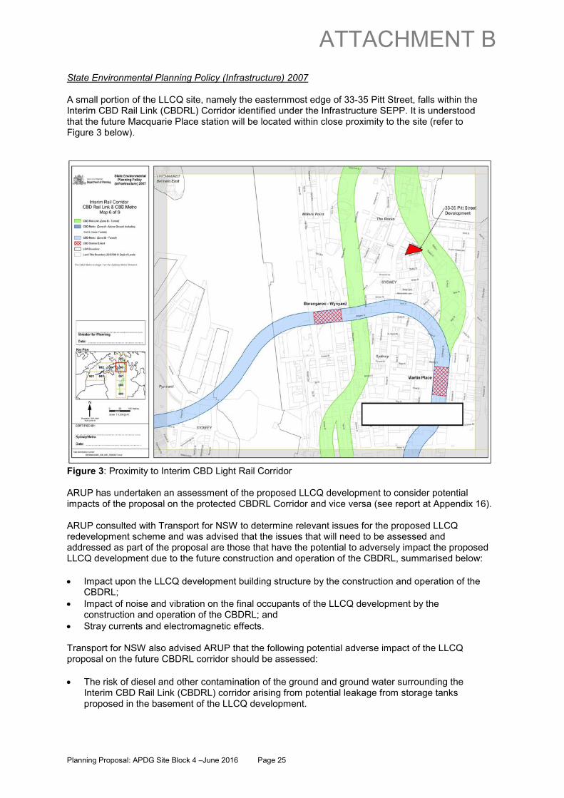
State Environmental Planning Policy (Infrastructure) 2007 A small portion of the LLCQ site, namely the easternmost edge of 33-35 Pitt Street, falls within the Interim CBD Rail Link (CBDRL) Corridor identified under the Infrastructure SEPP. It is understood that the future Macquarie Place station will be located within close proximity to the site (refer to Figure 3 below).
Figure 3: Proximity to Interim CBD Light Rail Corridor ARUP has undertaken an assessment of the proposed LLCQ development to consider potential impacts of the proposal on the protected CBDRL Corridor and vice versa (see report at Appendix 16). ARUP consulted with Transport for NSW to determine relevant issues for the proposed LLCQ redevelopment scheme and was advised that the issues that will need to be assessed and addressed as part of the proposal are those that have the potential to adversely impact the proposed LLCQ development due to the future construction and operation of the CBDRL, summarised below:
• Impact upon the LLCQ development building structure by the construction and operation of the CBDRL;
• Impact of noise and vibration on the final occupants of the LLCQ development by the construction and operation of the CBDRL; and
• Stray currents and electromagnetic effects. Transport for NSW also advised ARUP that the following potential adverse impact of the LLCQ proposal on the future CBDRL corridor should be assessed:
• The risk of diesel and other contamination of the ground and ground water surrounding the Interim CBD Rail Link (CBDRL) corridor arising from potential leakage from storage tanks proposed in the basement of the LLCQ development.
Planning Proposal: APDG Site Block 4 –June 2016 Page 25
ATTACHMENT B
The issue of noise and vibration was separately considered by Renzo Tonin & Associates (refer Appendix 11), who advise that:
• The CBDRL is in closer proximity to the existing Marriott Hotel, which would otherwise determine the noise and vibration mitigation design for the CBDRL in the locality;
• The introduction of basement levels in LLCQ, in closer proximity to the CBDRL will also not result in an increase in vibration and structure radiated noise at occupied levels above ground;
• Notwithstanding, preliminary assessment is that noise and vibration from the CBDRL would have a low risk of impacting the commercial development at LLCQ given the distance to the CBDRL alignment and that LLCQ is adjacent a proposed station location (Macquarie Place) where trains would be travelling slowly; and
• LLCQ has been assessed not to adversely affect the viability of the proposed CBDRL, by otherwise increasing the likely cost of developing the proposed CBDRL.
ARUP has completed an assessment in accordance with Transport for NSW requirements, also taking into account Renzo Tonin’s advice, and concludes that on the basis that recommended industry standard design and construction practices outlined in this assessment are implemented, that impacts arising from both the proposed LLCQ development and CBDRL Corridor can be adequately managed within acceptable limits. It is proposed that further detail of proposed mitigation measures will accompany the future DA. Sydney Regional Environmental Plan (Sydney Harbour Catchment) 2005 Under Sydney Regional Environmental Plan (Sydney Harbour Catchment) 2005, the LLCQ site is located within the Sydney Harbour Catchment Boundary but not within the Foreshores and Waterways Area Boundary. The planning proposal does not contradict or hinder the application of the planning principles for Sydney Harbour Catchment, as set out in Clause 13 of the REP: The most relevant of these principles relate to views from the waterway and foreshores and the management of acid sulfate soils. These issues are discussed in Section C below. 6. Is the planning proposal consistent with applicable Ministerial Directions (s117 directions)? The planning proposal has been assessed against each Section 117 Direction. The consistency of the planning proposal with these directions is shown in Table 3 below.
No. Title Comment Consistency 1. Employment and Resources 1.1 Business and
Industrial Zones The objectives of section117 direction 1.1 are to encourage employment growth, protect employment land, and support the viability of strategic centres. The planning proposal is consistent with these objectives. It will protect employment land within an existing business area and will not reduce but increase the total potential floor space area for employment uses and related activities.
Yes
1.2 Rural Zones Not applicable N/A 1.3 Mining, Petroleum
Production and Extractive Industries
Not applicable N/A
1.4 Oyster Aquaculture Not applicable N/A 1.5 Rural Lands Not applicable N/A 2. Environment and Heritage 2.1 Environment
Protection Zones Not applicable N/A
2.2 Coastal Protection Not applicable N/A
Planning Proposal: APDG Site Block 4 –June 2016 Page 26
ATTACHMENT B

2.3 Heritage Conservation The objective of section117 direction 2.3 is to
conserve items, areas, objects and places of environmental heritage significance and indigenous heritage significance. With the exception of the Tank Stream, there are no listed heritage items on the site of this planning proposal. The following technical reports are included as appendices to this planning proposal: • a built heritage assessment; • a non-aboriginal archaeological assessment
and impact statement; • a detailed conservation report for the Tank
Stream; and • an aboriginal archaeological assessment. The planning proposal does not contain provisions that contradict or would hinder application of this direction.
Yes
2.4 Recreation Vehicle Areas
Not applicable N/A
3. Housing Infrastructure and Urban Development 3.1 Residential Zones Not applicable N/A 3.2 Caravan Parks and
Manufactured Home Estates
Not applicable N/A
3.3 Home Occupations Not applicable N/A 3.4 Integrating Land Use
and Transport The objectives of s117 direction 3.4 are to improve accessibility, increase transport options, reduce travel demand and dependence on cars, support public transport, and provide for efficient movement of freight. Facilitating the redevelopment of this site will increase the number of workers and visitors in this location. This is consistent with s117 direction 3.4 as the site is optimally located in terms of access to existing public transport - with major rail, bus and ferry services within close walking distance, as well as the future Light Rail. It also adjoins the proposed Pitt St cycleway.
Yes
3.5 Development Near Licensed Aerodromes
The planning proposal seeks to increase the permissible building height to 238m. As this would encroach the Obstacle Limitation Surface (OLS), section117 direction 3.5 applies to the planning proposal. Clause 4(d) of this direction requires that a council must obtain permission from the relevant Department of the Commonwealth, or their delegate, prior to undertaking community consultation in satisfaction of section 57 of the EP&A Act. An inconsistency with section 117 direction 3.5 can be justified on the basis of clause 7(d), namely that the inconsistency is considered to be of minor significance. This is because current
An inconsistency with this direction is justified in accordance with clause 7(d) of the Section 117 direction because the provisions of the planning proposal that are inconsistent are
Planning Proposal: APDG Site Block 4 –June 2016 Page 27
ATTACHMENT B
height controls in SLEP2012 and existing tower development in Central Sydney (several of which are in close proximity to the site) already significantly encroach the OLS. Therefore the OLS is already largely encroached in this area and the draft LEP height controls are likely to have a minor cumulative impact to the OLS.
considered to be of minor significance.
3.6 Shooting Ranges Not applicable N/A 4. Hazard and Risk 4.1 Acid Sulfate Soils The objective of section 117 direction 4.1 is to
avoid significant adverse environmental impacts from the use of land that has a probability of containing acid sulfate soils. The site is partially located within a Class 2 Acid Sulfate Soils (ASS) zone. Appendix 4 to this planning proposal is a Geotechnical Desk Top Study prepared by Cofffey Geotechnics which includes an assessment of the risk of ASS being present on the site. It is discussed in Section C of this planning proposal.
Yes
4.2 Mine Subsidence and Unstable Land
Not applicable N/A
4.3 Flood Prone Land Not applicable N/A 4.4 Planning for Bushfire
Protection Not applicable N/A
5. Regional Planning 5.1 Implementation of
Regional Strategies The planning proposal is consistent with key strategic directions including the Metropolitan Strategy and the draft Sydney Subregional Strategy, primarily in that it will support the development of Central Sydney as a Global City. The planning proposal is consistent with the aims, objectives and provisions of the Metropolitan Strategy (as supported by the draft Sydney Subregional Strategy) in that it will:
• reinforce the global competitiveness of Sydney through the provision of high quality office accommodation;
• contribute to ensuring adequate capacity for office developments to meet future demand; and
• improve the quality of the built environment
Yes
5.2 Sydney Drinking Water Catchments
Not applicable N/A
5.3 Farmland of State and Regional Significance on the NSW Far North Coast
Not applicable N/A
5.4 Commercial and Retail Development along the Pacific Highway, North Coast
Not applicable N/A
5.8 Second Sydney Airport, Badgerys Creek
Not applicable N/A
Planning Proposal: APDG Site Block 4 –June 2016 Page 28
ATTACHMENT B

6. Local Plan Making 6.1 Approval and Referral
Requirements The planning proposal does not include concurrence, consultation or referral provisions or identify any developments as designated development.
Yes
6.2 Reserving Land for Public Purposes
The planning proposal does not contain any land reserved for a public purpose, and no requests have been made by a Minister or public authority to reserve such land
Yes
6.3 Site Specific Provisions
The planning proposal does not introduce unnecessarily restrictive site-specific controls. The planning proposal in fact introduces provisions that will provide greater flexibility in order to achieve better development outcomes.
Yes
7. Metropolitan Planning 7.1 Implementation of A
Plan for Growing Sydney
As discussed under question 3 above, the planning proposal is consistent with the aims, objectives and provisions of A Plan for Growing Sydney.
Yes
Table 3 - Consistency with applicable Ministerial Directions under Section 117 SECTION C – ENVIRONMENTAL, SOCIAL AND ECONOMIC IMPACT Q7. Is there any likelihood that critical habitat or threatened species, populations or ecological communities, or their habitats, will be adversely affected as a result of the proposal? The subject site is located in an existing business precinct in a built up area of Central Sydney. As such, the planning proposal is unlikely to adversely affect critical habitat or threatened species, populations or ecological communities, or their habitats. Q8. Are there any other likely environmental effects as a result of the planning proposal and how are they proposed to be managed? It is unlikely that the proposed amendments to SLEP2012 will result in development creating any environmental effects that cannot be controlled. As it is envisaged that future development will comprise contemporary commercial buildings, existing policies, regulations and standards are already in place to ensure environmental impacts are mitigated during the construction phase and eventual use of the development. The key environmental considerations arising from the planning proposal, particularly in relation to urban amenity, are discussed in detail below. Solar Access and Overshadowing A Shadow Studies Report has been prepared by Hassell and is attached as Appendix A to the Urban Design Analysis Report at Appendix 1 to this planning proposal. Part 01 of the Shadow Studies Report considers shadows cast by the proposed building envelope. It confirms that the LLCQ building envelope will not cause additional overshadowing to Australia Square, Lang Park or Macquarie Place between 14 April and 31 August at the critical times of day nominated in SLEP 2012 clause 6.19 Overshadowing of certain public places. Part 02 of the Shadow Studies Report provides a comparison of shadows cast over the proposed plaza, and compares this with the currently adopted SDCP2012 scheme. These shadow diagrams (extract at Figure 4 below) and the accompanying summary table (Table 4 below) demonstrate that the proposed George St plaza is able to achieve excellent solar access throughout the year, in sharp contrast to the poor solar amenity which would be afforded to the centrally located plaza envisaged under the existing DCP controls. For example, up to 74% of the George Street Plaza (including the
Planning Proposal: APDG Site Block 4 –June 2016 Page 29
ATTACHMENT B
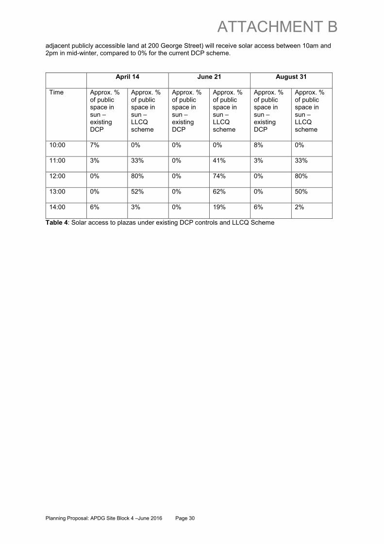
adjacent publicly accessible land at 200 George Street) will receive solar access between 10am and 2pm in mid-winter, compared to 0% for the current DCP scheme.
April 14 June 21 August 31
Time Approx. % of public space in sun – existing DCP
Approx. % of public space in sun – LLCQ scheme
Approx. % of public space in sun – existing DCP
Approx. % of public space in sun – LLCQ scheme
Approx. % of public space in sun – existing DCP
Approx. % of public space in sun – LLCQ scheme
10:00 7% 0% 0% 0% 8% 0%
11:00 3% 33% 0% 41% 3% 33%
12:00 0% 80% 0% 74% 0% 80%
13:00 0% 52% 0% 62% 0% 50%
14:00 6% 3% 0% 19% 6% 2%
Table 4: Solar access to plazas under existing DCP controls and LLCQ Scheme
Planning Proposal: APDG Site Block 4 –June 2016 Page 30
ATTACHMENT B

Existing DCP – solar access to internal plaza – 12:00 and 13:00 on 21 June
LLCQ proposal – solar access to public plazas – 12:00 and 13:00 on 21 June
Figure 4: Comparison of mid-winter solar access to public plazas Although the Shadow Studies Report prepared by Hassell incorporates the previously approved building envelopes for the Wanda One site, the consent for State Significant Development on the Wanda One site took account of potential overshadowing of the proposed George Street square. Shadow diagrams prepared by Crone Architects on behalf of Wanda One Pty Ltd indicated that the revised Wanda One proposal will not result in any discernible increase in overshadowing of the proposed George Street plaza between 10am and 2pm compared with the previously approved building envelopes. Tower separation To allow for better views and daylight access, clause 6.1.6.1 of Sydney DCP 2012 currently requires new towers above 75m on the APDG block to have a minimum separation of 28m above the relevant street frontage heights. Although this is not achievable under the LLCQ proposal, the proposed configuration of buildings and public domain will allow for views and sunlight access, while also rectifying existing crowding conditions in this central portion of the APDG block. The proposed tower will be approximately 9.5 metres from the approved tower at 19-31 Pitt Street and, at its closest point, 6 metres from the commercial tower at 200 George Street. This separation is consistent with setback requirements applying elsewhere in Central Sydney under SDCP2012 and consistent with the overall built form character of Central Sydney. The demolition of the 15 storey building at 182 George Street offers improvements on the existing tower crowding conditions and increased separation from approved buildings on adjoining sites. Specifically, it will:
• remove the current tower crowding condition directly adjacent to Jacksons on George; • eliminate the approved separation condition of only 4.9m between 200 George Street and
182 George Street; • replace the existing 3.4m approved separation between 200 George street and 33-35 Pitt
Street with a minimum separation of 6.0m to the proposed tower;
Planning Proposal: APDG Site Block 4 –June 2016 Page 31
ATTACHMENT B

• result in a more compatible separation between approved residential development at 1 Alfred
Street and commercial land uses, by increasing the separation from 200 George Street from the currently approved 16.8m to 55.2m and by providing for 33.4m separation to the proposed Lend Lease commercial tower.
The demolition of two 12 storey buildings on 33-35 Pitt Street and replacement with the proposed tower will remove the current crowding of Rugby Club and will allow the enhancement of Rugby Place and the provision of an open-air plaza outside Rugby Club. It will also
• increase the separation between the Rugby Club and adjacent commercial from approximately 4.0m to a minimum of 8.8m increasing to 16.6m at the plaza;
• increase the separation between approved residential at 19-31 Pitt Street and adjoining commercial from 7.9m (to the existing building at 33-35 Pitt St) to approximately 9.5m (to the proposed tower).
The proposed tower setback of 6.0m to Pitt St is intended to allow for view sharing with 37-57 Pitt Street north along the view corridor of Pitt Street to Circular Quay. In summary, the proposal generally improves current and approved tower crowding conditions for all adjacent landowners within the APDG Block. The LLCQ proposal offers an alternative outcome for the APDG block, and would not preclude the potential for development to proceed on the existing block 1 in accordance with the prevailing planning controls, should the control of key land parcels change in the future. Visual and View Impacts Hassell has undertaken a View Impact Analysis that incorporate the tower at 200 George Street and the December 2015 approved towers for the Wanda One site (Appendix 21 of this planning proposal). The analysis includes the preparation of photomontages of the proposed LLCQ building envelope using 3D Studio Max, based on the 3D Sydney City Model. The views contained in the analysis are separated into three categories:
• Street level views (from prominent locations); • High level views (at roof level of ten existing towers); and • Plaza views (two views of the new plaza). Hassell also undertook a similar analysis that incorporates the previously approved towers at 1 Alfred Street and 19-31 Pitt Street. It is included in the Urban Design Analysis Report at Appendix 1 of this planning proposal.
Visual Impact and Public Views Hassell has prepared views from the following public vantage points (numbered as per the View Impact Analysis Report):
1. Observatory Hill 2. Corner of Argyle and Harrington Street 3. Overseas passenger terminal 4. Circular Quay / First Fleet Park 5. Opera House steps 6. Circular Quay / Bennelong Apartments 7. Mrs. Macquarie’s Chair 8. Farm Cove 9. Corner of Pitt and Bridge Street 10. Corner of George and Bridge Street 11. George Street / Grosvenor Tower 12. Corner of Essex and Harrington Street 13. View from Circular Quay ferry
Planning Proposal: APDG Site Block 4 –June 2016 Page 32
ATTACHMENT B

A review of the above images confirms that the tower will not unduly impact on important public views and view corridors, including those from the waterway and foreshores of Sydney Harbour. Further, due to the proximity of the proposed LLCQ tower to the approved towers on the Wanda One site and 200 George Street, the visual presence of the proposed tower is balanced by the adjoining towers of a similar but staggered height. The LLCQ tower will not be a dominant individual feature in the skyline, but rather one of a small cluster of new, landmark commercial and residential towers which will mark the revitalised APDG block. The visual impact is therefore considered to be acceptable and consistent with the location and context of the site.
Impact on Private Views Hassell has prepared views from the rooftop of the following privately owned buildings (numbered as per the View Impact Analysis Report):
14. 225 George St (Grosvenor Place) 15. 255 George Street (NAB House) (Two views - 15a and 15b) 16. 129-131 Harrington Street (Cove Apartments) 17. 259 George St (Suncorp Plaza) 18. 199 George St (Four Seasons Hotel) 19. 264 George St (Australia Square) 20. 273 George St (Metcentre Sydney) 21. 30 Pitt St (Marriott Hotel) 22. APDG South east tower (Mirvac Pitt St site) 23. 200 George Street (Mirvac George St development) It is recognised that the proposed LLCQ building envelope impacts on some private commercial building view corridors, in some cases more significantly than others (NAB House and Suncorp Plaza). In the case of NAB House (Views 15a and 15b), which is 140m in height, the proposed LLCQ envelope will obstruct the existing Opera House view. However, this view would be obstructed in any event by the approved 1 Alfred Street tower and the 200m tower envelope envisaged on Development Block 1 under the current APDG controls. The 200 George Street (155m) development currently under construction will further impact NAB House views. Only NAB House floors above Gold Fields House (115m) currently enjoy unobstructed views to the north, however 200 George Street will erode this view. North east views to the harbour from NAB House will be retained at upper levels. In the case of Suncorp Plaza (View 17), NAB House already blocks views to the Opera House up to 140m (approx.), and 200 George Street will block views up to 155m. The proposed LLCQ building envelope will obstruct the remaining existing Opera House view above 155m. Suncorp Plaza will continue to enjoy Sydney Harbour views and glimpses of the Bridge. Coupled with the approved tower on the 1 Alfred Street site, the view to the Harbour Bridge would be lost from Australia Square (View 19). However, the current APDG controls provide for a 200m tower envelope on block 1 which would obstruct this view. Panoramic harbour views, including a view to the Opera House, are expected to remain unaffected by the LLCQ envelope. Although not shown in View 14, the view from Grosvenor Tower to the east will be significantly improved above 120m (Marriot Hotel building height), with the removal of the 200m tower proposed for block 1. Harbour views from Metcentre at 273 George Street (View 20) have already been substantially eroded by the approved buildings on the APDG Block and the adopted building envelope for a 200m tower on block 1.
Planning Proposal: APDG Site Block 4 –June 2016 Page 33
ATTACHMENT B
View sharing with other towers in the APDG block has been considered and can be accommodated. View corridors have been identified for 200 George Street (View 23) and the Mirvac Pitt Street site (View 22). The proposed building envelope will not impact on significant views enjoyed by existing residential buildings including serviced apartments and hotels (Views 16, 18, 21). Although no view analysis has been undertaken for the approved residential buildings at 1 Alfred Street and 19-31 Pitt Street, it is apparent that the proposed LLCQ building will restrict views to the south. However, these same views would be affected as a result of development of a 200m tower on block 1, or an opt-out development on 33-35 Pitt Street (110m). Apart from views to the south affected by the tower, enhanced outlook and views from both the approved residential buildings will arise from the demolition of 182 George Street.
Street Level Plaza Views Hassell has prepared two views of the plaza from Grosvenor Place (numbered as per the View Impact Analysis Report):
24. Grosvenor Tower Street Level to Plaza 25. Grosvenor Place to Plaza A series of architectural renders are provided in the Urban Design Analysis report at Appendix 1 to this planning proposal which provides a further indication of the anticipated outcomes at street level. At street level, the visual amenity along George Street will be significantly enhanced, with the demolition of outdated commercial buildings, the creation of a landscaped and activated public plaza, design excellence in plaza building architecture, and the adaptive reuse of Jacksons on George with new materiality including sandstone, glass and timber.
Reasonableness of Private View Loss from Commercial Buildings In considering the existing APDG block controls before their adoption in 2011, the City concluded that the view loss arising from the alternative building height envelopes for the APDG block were acceptable for the following reasons:
• the then applicable DCP did not protect private views (and Sydney DCP 2012 now only requires consideration of impacts on the views and outlooks from existing residential development);
• within the context of central Sydney, where high rise built form is commonplace, there would be a reasonable expectation that new development will be characterised by tower forms and that a partial loss of views resulting from nearby development cannot be fully mitigated;
• the public domain benefits of the alternative APDG scheme outweigh private interests; and • the considerable economic and employment benefits resulting from the redevelopment of the
APDG Block should take preference above private interests. The above reasons equally apply to the proposed LLCQ alternative option which simply relocates the tower envelope from block 1 to block 4. In conclusion, the impact on private views from commercial buildings is considered to be reasonable and in some cases beneficial (Grosvenor Tower), when balanced with the exceptional public benefit associated with the LLCQ proposal, and the expectations of Sydney Harbour view corridor impacts to CBD buildings as the northern part of the CBD continues to experience revitalisation in accordance with adopted Council policy. Wind impacts In November 2013 Cermak, Peterka Pattersen (CPP) Wind Engineering Consultants undertook a wind tunnel study of the proposed development to assess pedestrian wind comfort at ground level. A model of the project was fabricated to a 1:400 scale and centred on a turntable in the wind tunnel.
Planning Proposal: APDG Site Block 4 –June 2016 Page 34
ATTACHMENT B

Replicas of surrounding buildings within a 570 m radius were constructed and placed on the turntable. The wind tunnel study is included in Appendix 12. It found the street level wind environment to be similar to typical street level wind conditions in the surrounding area. The study assessed a number of different design outcomes, specifically, the following configurations: A. The existing 1 Alfred Street and 19-31 Pitt Street sites remaining undeveloped, and no buildings
on the proposed LLCQ plaza; B. The 1 Alfred Street and 19-31 Pitt Street sites being re-developed as per their development
consents, and no buildings on the proposed LLCQ plaza; and C. Those sites being developed, plus buildings on the perimeter (largely the eastern edge) of the
LLCQ plaza. Under configuration C, locations in the public domain were found to pass the distress criterion (with the exception of three locations on Pitt Street outside the site), supporting the proposed land uses and general configurations contemplated under the LLCQ proposal. Wind conditions in the proposed plaza were found to be relatively calm for an outdoor area in the CBD thereby supporting the proposed public plaza land use and general configuration as contemplated under the LLCQ proposal. Portions of the internal laneways were found to be suitable for window-shopping and café-style activities thereby supporting the proposed laneway configuration for pedestrian access as contemplated under the LLCQ proposal. Windier conditions were observed along Pitt Street, but these conditions were considered typical of this location and due in large part to the surrounding massing. Appendix 12 includes an October 2015 assessment by CPP of the impact of changes to the LLCQ envelope that are reflected in the current proposal. They concluded that the changes to the scheme will not significantly change the local wind conditions from those measured with the massing model during the November 2013 wind-tunnel testing. It is proposed that wind effects will be further considered as part of the future DA, and mitigating measures incorporated where appropriate. Site specific provisions to mitigate wind impacts are also included in the DCP provisions. CPP also recently undertook a wind assessment on behalf of Wanda One Pty Ltd for the 1 Alfred Street development. One of the findings of that November 2015 report was that the reconfiguration of the tower buildings on the Wanda One site is likely to increase wind flow through the north-south laneway that connects to and extends across the Lend Lease site in the vicinity of the proposed plaza on Rugby Place. CPP noted that any activation of the section of the north-south lane on the Wanda One site for pedestrian sedentary activities such as an outdoor café would require additional local amelioration in the space such as vertical screens, particularly in the summer months when the north-east winds are prevalent. For the purposes of consultation and to better inform the DCP, it is proposed to seek an update of the wind assessment for the LLCQ site to take account of the December 2015 consents for the Wanda One site. Acid sulfate soils The LLCQ site lies within land shown as Class 2 and Class 5 on the SLEP 2012 Acid Sulfate Soils Map. The Coffey Geotechnical Study (attached at Appendix 4) advises that it is unlikely, but nevertheless possible, that acid sulfate soils may be present. Coffey consider that the risk of exposing such soils during construction can be effectively managed by the development and implementation of an Acid Sulfate Soils Management Plan (ASSMP) in accordance with accepted guidelines, and the implementation of proven industry standard engineering design and construction techniques.
Planning Proposal: APDG Site Block 4 –June 2016 Page 35
ATTACHMENT B

As the LLCQ proposal will include substantial excavation below the natural ground surface, an ASSMP will be required at the DA stage to outline how acid sulfate soils will be managed. Access, road, car parking and public transport Two reports have been commissioned in relation to access, traffic, transport and car parking: 1. Assessment of Vehicular Transport Aspects of Planning Proposal prepared By Colston Budd
Hunt & Kafes (CBHK) (refer Appendix 14); CBHK conclude that vehicular transport issues commensurate with the proposal can be adequately managed within the constraints of both the existing (or as amended) local and broader CBD road network.
2. Transport, Traffic, Pedestrian and Parking Assessment prepared by ARUP (refer Appendix 15).
The following is drawn from the ARUP report. Further details and associated maps and diagrams are available in the report:
• The site is served by the high quality Circular Quay public transport interchange, which provides an environment where passengers may easily transfer between bus, rail and ferry modes. In addition, the site is served by Wynyard transport interchange.
• Circular Quay Railway Station is located approximately 250m away from the precinct, equating to a walk of less than 5 minutes from the centre of the platform. Wynyard Station is approximately 400m from the George St frontage and is a good alternative for users of other rail lines.
• The site is currently served by approximately 50 bus routes, operated by Sydney Buses, using George Street, Elizabeth Street, Alfred Street and Wynyard Park, the latter being a 300m walk from the site.
• Located within a 5 minute walk of the site, Circular Quay provides over eight regular ferry routes. The journey to work mode share by ferry for the site is approximately double the Sydney CBD average mode share – indicating its convenience for site users.
• Further public transport accessibility will occur with the completion of the Light Rail in 2018.
• The site is well connected via a network of good quality, wide pedestrian footpaths with signalised crossings of main roads. The northern end of the site through the Circular Quay precinct and along Alfred Street is a pedestrianised environment particularly conducive to walking trips. Blue Anchor Lane and Rugby Place provides pedestrian access between George Street and Pitt Street. Crane Place also provides a pedestrian connection from George Street along the southern side of 182 George Street. These are fairly poor quality connections with no footpaths and shared with traffic but not appropriately signed/treated for this type of interaction.
• There are a number of key cross-city cycle routes which form part of City of Sydney’s new cycling network which provide linkages to the site.
Q9. Has the planning proposal adequately addressed any social and economic effects? Heritage There are no listed heritage items within the LLCQ Site, nor within the boundary of the entire APDG Block. However, there are a number of heritage items in the vicinity of the site, including the Tank Stream, an item of State Significance, which lies outside the boundary of the site. There are also heritage items within The Rocks area that are in the vicinity of the site. The heritage impacts of the proposed LLCQ redevelopment scheme have been considered in the following studies
• Built Heritage Assessment report prepared by Orwell and Peter Phillips, Heritage Architects (at Appendix 6)
Planning Proposal: APDG Site Block 4 –June 2016 Page 36
ATTACHMENT B
• Non-Aboriginal Archaeological Assessment & Impact Statement prepared by Casey and Lowe (at
Appendix 7) • Tank Stream Conservation Report prepared by Coffey Geotechnics (at Appendix 8) • Aboriginal Archaeological Assessment prepared by Comber Consulting (at Appendix 9) Some of the key conclusions and recommendations arising from the abovementioned studies are: • The unlisted built heritage items within the site are almost all of relatively recent construction and
would not meet the thresholds for local significance when assessed under Heritage Council criteria;
• Other listed items in the vicinity are separated from the site by streets or intervening modern buildings, and it is unlikely that redevelopment of the subject site would affect the significance of any of the listed items in its vicinity;
• The site has potential to contain relics which requires an application under S139/140 of the NSW Heritage Act 1977. While most of the potential archaeological remains are considered to have local heritage significance, it is possible that part of the site has potential for State-significant archaeology. Casey and Lowe’s assessment contains a series of recommendations which would be actioned in association with the future DA and development consent, as relevant. An updated report would accompany the future DA;
• Due to the proximity to the Tank Stream and Sydney Cove, there is potential for environmental evidence associated with the earliest phase of historic settlement of the colony as well as much earlier environmental evidence.
• Tank Stream-specific conservation engineering criteria are appropriate to address vibration, deflection, differential settlement (including “twist”), clearance, groundwater fluctuation and other engineering impacts that would need to be satisfied during adjacent LLCQ redevelopment works at 33-35 Pitt Street so as to reduce the risk of detrimental impacts on the Tank Stream both during and post redevelopment works;
• There are no known Aboriginal sites recorded within the site. However, Comber concludes that the site has the potential to contain Aboriginal subsurface archaeological deposits, and recommends that a program of subsurface testing and salvage be undertaken prior to commencement of the redevelopment works.
SECTION D: STATE AND COMMONWEALTH INTERESTS Q10. Is there adequate public infrastructure for the planning proposal? Utilities and services ARUP has prepared a Multi-Disciplinary Services Review (refer Appendix 10) to:
• assess the ability of existing infrastructure to service the proposed LLCQ redevelopment, including electricity, gas, communications, water, sewer and stormwater;
• assess any augmentation works required to existing utility infrastructure where necessary to service the proposed LLCQ redevelopment, and
• where existing utility infrastructure identified have the potential to prevent the proposed LLCQ development, assess whether any diversion works are required to facilitate the redevelopment and confirm that such works are feasible.
ARUP concluded that generally, there is sufficient capacity within utility providers existing CBD district networks in the immediate vicinity of the site to adequately service the proposed LLCQ development. In some cases local diversions, modifications or other works to utility providers’ existing CBD district networks in the vicinity of the proposed LLCQ may be required. ARUP considers that such diversions, modifications and other works are considered industry practice and are manageable utilising proven industry standard engineering techniques. Diversions or modifications to utility providers services should be closely coordinated with the relevant service providers and be to their approval such that adjacent landowners are not impacted.
Planning Proposal: APDG Site Block 4 –June 2016 Page 37
ATTACHMENT B
On the basis that diversions, modifications and other works to utilities are coordinated with and approved by respective utility providers, ARUP is satisfied that the site is suitable for the proposed LLCQ development. Stormwater The Multi-Disciplinary Services Review prepared by ARUP (Appendix 10) includes a consideration of stormwater. ARUP notes that the LLCQ site is currently covered in its entirety with impervious surfaces. The developed site will alter this introducing a new plaza and landscaped areas. The introduction of landscaping alters the discharges from the site in terms of stormwater runoff. Planted areas attenuate runoff considerably reducing the peak flows seen by the stormwater network. On this basis, ARUP expects peak flows for the site to reduce from the current discharge. The stormwater systems in Sydney are partly owned by the City of Sydney and Sydney Water. In the area of the development site the critical infrastructure is owned by Sydney Water. ARUP have consulted with Sydney Water and received confirmation that Sydney Water will not mandate On Site Detention for this development. The LLCQ site is close to the downstream end of the catchment, and Sydney Water want such developments to discharge runoff as quickly as possible so that the storm drains are clear for the load generated by catchments far further upstream. ARUP anticipates that new connections from the site will be required to match the redeveloped configuration. It is proposed that the roads and plazas will be piped for the 1:10 year ARI with the 1:100 ARI being conveyed by overland flow. The coordination of stormwater supplies with Sydney Water and the works described above are considered by ARUP to be industry standard, and will be further addressed in the future development application. Q11. What are the views of state and Commonwealth public authorities consulted in accordance with the Gateway determination? The Gateway determination will advise the full list of public authorities that will need to be consulted with as part of the planning proposal process. It is requested that public authority consultation be undertaken concurrently with community consultation. Public authority consultation will be as directed by the Gateway determination. It is proposed that the following authorities be consulted in relation to the planning proposal as part of public authority consultation:
• Transport for NSW • Sydney Harbour Foreshore Authority • Sydney Airport Corporation Limited / CASA • Roads and Maritime Services
PART 4 – MAPPING The planning proposal does not require any changes to, or new, maps in SLEP2012, except in relation to the Lanes Development Floor Space provisions. In 2015 the Council exhibited a planning proposal to make minor policy and housekeeping amendments to SLEP 2012, including changes to clause 6.8 Lanes Development Floor Space. That planning proposal is seeking to map the lanes to which cl.6.8 applies. The Council and CSPC approved the planning proposal for making in August 2015 and the LEP amendment is currently being finalised with a Lanes Map that identifies Underwood Street as a lane to which clause 6.8 applies. It may be necessary for this planning proposal to amend the Lanes Map to identify that a site-specific clause applies to Development Block 4 under clause 6.25.
Planning Proposal: APDG Site Block 4 –June 2016 Page 38
ATTACHMENT B
PART 5 – COMMUNITY CONSULTATION Public Exhibition Public consultation will take place in accordance with the Gateway determination made by the Minister for Planning, in accordance with Sections 56 and 57 of the EP&A Act. It is proposed that, at a minimum, this involves notification of the public exhibition of the planning proposal:
• on the City of Sydney website; • in newspapers that circulate widely in the City of Sydney local government area; and • in writing to the owners; the adjoining and nearby landowners; relevant community groups;
and the surrounding community in the immediate vicinity of the site. It is requested that the planning proposal be publicly exhibited for a period of 28 days to coincide with the exhibition of an accompanying draft DCP amendment and draft planning agreement. PART 6 – PROJECT TIMELINE The anticipated timeframe for the completion of the planning proposal is as follows:
Milestone Timeframe and/or date Anticipated commencement date
Date of Gateway determination
Anticipated timeframe for the completion of required technical information
Not applicable. Technical analyses have already been commissioned by Lend Lease to support the planning proposal
Timeframe for government agency consultation (pre and post exhibition as required by Gateway determination)
As specified in Gateway determination. Anticipated timeframe is 21 days and to run concurrently with public exhibition period
Commencement and completion dates for public exhibition period
Dates are dependent on date of Gateway determination. Anticipated timeframe for public exhibition is 28 days
Dates for public hearing (if required) Not applicable at this stage Timeframe for consideration of submissions To be determined Timeframe for consideration of proposal post exhibition
To be determined
Date of submission to Department to finalise LEP
To be determined
Anticipated date Council will make the LEP (if delegated)
To be determined
Anticipated date Council will forwarded to Department for notification
To be determined
Planning Proposal: APDG Site Block 4 –June 2016 Page 39
ATTACHMENT B