Embed Size (px)
Citation preview

1
ESSENTIAL ELEMENTS TO MAINTAIN ECOLOGICAL BALANCE

1
PLANNING OF MOUNTAINOUS REGIONSR.G. Gupta1/1/1994
The paper has been dealt with under the following heads:-
1. Basis for action to plan and develop;
2. Objectives
3. Hill areas in India;
4. Planning proposals in various Five Year Plans of the country.
. Planning criteria to ful l the objectives;
5.1 General criteria 5.2 Data and information base; 5.3 Implementation of the proposals; 5.4 Management criteria;
6. Methodo1ogy
7. Nepal as an example (Map of Nepal has been attached)
*R.G. Gupta is Director Planning, DDA

2
1. Basis for action to plan and develop:
Mountains are an important source of water, energy and biological diversity. Furthermore, they are source of such key resources as minerals, forest products, agriculture products, tourism and recreation on which lot of economy of a country depends. Mountain environments are essential to the survival of life and eco-system which are rapidly changing towards degrading side, They are susceptible to accelerated soil erosion, landslides and rapid loss of habitat and genetic diversity. In settlement, there is wide spread poverty, loss of indigenous knowledge, literacy and as a result of this these are experiences environmental degradation. The subject is so important that government of India very seriously considering to constitute a Himalaya Development Authority and for this creation of a National Himalayan Environment and Development Fund for the integrated development of south-west Himalaya Region.
Nearly half of the world population i.e. about 3 billion is concerned in one way or the other by mountain ecology and degradation of water shed areas. About 10% of the earth’s population lives in mountain areas with higher a1titutes/ s1opes while 40% occupies the other medium and lower water shed areas. Soil erosion has a. devastating impact on large number of rural population who depend on rain fed agriculture, poverty, unemployment, poor health and bad sanitation and many other points of the areas. An integrated approach is very much necessary for conserving, upgrading and using the natural resources i.e. land, water, plant, animal, and human resources in mountainous regions. An example has been given in photograph No.2 attached with the article that how agricultural activities can be carried out without affecting ecology.
Mountains are highly vulnerable to human and natural ecological imbalance. These are very sensitive to all climatic and weather changes in the atmosphere. It is necessary to have information on ecology, natural resource potential and socioeconomic activity. For this, a system has to be established as at present there is a lack of knowledge not only in the country but in other parts of the world too. This paper has been written based or. primary surveys and discussions in Kathmandu and secondary data, from various books and sources.

3
PHOTO NO.2 TERRACED FARMING
FARMING

4
2. Objectives:
There are two sets of objectives -
i) To generate data and information base.
a. To generate data based on surveys of the different forms of soils, forest, water use, crop, plant and animal resources of mountain ecosystems.
b. To improve and build the existing land/water ecological knowledge base data.
c. Create and strengthen the communication network between various centres of information on the subject.
d. Coordination of regional efforts through the consideration of appropriate mechanisms, including regional legal and other- instruments.
ii) To promote integrated water shed development and alternative livelihood opportunities.
a. By the year 2000, to develop appropriate land-use planning and management for both arable and non-arable land in mountain- fed. Watershed areas to prevent soil erosion, increase biomass production and maintain the ecological balance;
b. To promote income-generating activities, such as sustainable tourism, sheries and environmentally sound mining, and to improve infrastructure and social services, in particular to protect the livelihoods of local communities and - indigenous people.
c. To develop technical and institutional arrangements for the above, so that an integrated comprehensive physical and nancial plan along with coordination, integration, evaluation and monitoring is there; otherwise Kathmandu which is a small Valley has three development committees, three municipalities and 100 Village Panchayats would be with no proper controls/overall view.
d. To preserve and conserve old historical monuments/townships, elements and facades of architecture importance. In this, example of
5
Patan (Lalitpur) has been taken.
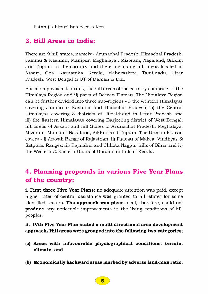
3. Hill Areas in India:
There are 9 hill states, namely - Arunachal Pradesh, Himachal Pradesh, Jammu & Kashmir, Manipur, Meghalaya., Mizoram, Nagaland, Sikkim and Tripura in the country and there are many hill areas located in Assam, Goa, Karnataka, Kerala, Maharashtra, Tamilnadu, Uttar Pradesh, West Bengal & UT of Daman & Diu,
Based on physical features, the hill areas of the country comprise - i) the Himalaya Region and ii) parts of Deccan Plateau. The Himalaya Region can be further divided into three sub-regions - i) the Western Himalayas covering Jammu & Kashmir and Himachal Pradesh; ii) the Central Himalayas covering 8 districts of Uttrakhand in Uttar Pradesh and iii) the Eastern Himalayas covering Darjeeling district of West Bengal, hill areas of Assam and hill States of Arunachal Pradesh, Meghalaya, Mizoram, Manipur, Nagaland, Sikkim and Tripura. The Deccan Plateau covers - i) Aravali Range of Rajasthan; ii) Plateau of Malwa, Vindhyas & Satpura. Ranges; iii) Rajmahai and Chhota Nagpur hills of Bihar and iv) the Western & Eastern Ghats of Gordaman hills of Kerala.
4. Planning proposals in various Five Year Plans of the country:i. First three Five Year Plans; no adequate attention was paid, except higher rates of central assistance was granted to hill states for some identi ed sectors. The approach was piece meal, therefore, could not produce any noticeable improvements in the living conditions of hill peoples.
ii. IVth Five Year Plan stated a multi directional area development approach. Hill areas were grouped into the following two categories;
(a) Areas with infavourable physiographical conditions, terrain, climate, and
(b) Economically backward areas marked by adverse land-man ratio,

6
lack of infrastructure or inadequate development of resource potentials.
In 1971, the National Development Commission (NDC) gave special attention to four states, namely - Uttar Pradesh, Assam, West Bengal and Tamilnadu. Later on Western Ghats covering Maharashtra, Karnataka, Tamilnadu, Kerala and Goa were also added.
In 1972-73, two projects with 100% central assistance were introduced in Pauri Garhwal in Uttar Pradesh and Nungba division in Manipur State. These were water shed economic development programmes along with provisions of strengthening of infrastructure like roads, markets and godowns.
iii. Fifth Five Year Plan (1974-79) Integrated Programmes (economy of plains and hill areas) was introduced and based on this a separate chapter on hill area development programme (HADP) and background on special areas was added in the plan document.
iv. During the 6th Plan (1980-85), Tiwari Committee was set up and based on the recommendations of this Committee, department of environment was constituted in 1980 along with National Land Resource Conservation Commission and National Land Board. This Committee also identi ed , names given under:-
a. Preservation of threatened species of ora and fauna and also the fragile eco-system from extinction,
b. Protection of land and water from po11ution and
c. Improvement of conditions of human settlements.
During this Five Year Plan period, exclusive chapter on hill area development. (HAD) was added, making provision of Rs. 5.6 billion a s against Rs.1.7 bi1lion in the 5th Five Year Plan, The thrust of the strategy during this Five Year Plan was on –
a. Development in harmony with ecological balance. This has been shown in photograph No. 3 on the next page.
b. Permission of quality of life of the hill people.

7
The various programmes/schemes were aimed at better land use, control of soil erosion, water shed management, afforestation, pasture development, appropriate agriculture crops and plantation groups and forestry in steep slopes. This entire proposal was based on water shed area as a. basic unit.
The programme evaluation organisation (PEO) of the Planning Commission took up an evaluation study of western ghats in 1980-81 and recommended as under:-
a. Improvements in the programme methodology, formulation and implementation.
b. Setting up of an ef cient planning machinery at state level for formulation and monitoring, and
c. development of a comprehensive regional plan for the area.
In the 6th Five Year Plan, hill Area Development Programme (HADP) con rmed that in this duration also the approach was sectoral, adhoc and little reference to eco-restoration, eco-preservation and eco-development.

8
PHOTO NO.3FARMING IN HARMONY WITH ECOLOGY

9
v. 7th Five Plan Plan (1985-90) emphasized a harmonised approach to the HADP aimed at the following three points:-
a. Socio-economic growth and promotion of a secure basic life support system and judicious utilisation of land, mineral, water and biotic resources in a. total perspective embracing complementarity of both the hills and the plains,
b. development of infrastructure, and
c. promotion of ecology.
The hill area was divided into three distinct zones, high attitude and inaccessible zone where natural geophysical processes’ are taking place. More populated lower attitudes zone and the zone of plains below the hills.
Strategy was worked out for planning of these three types of distinct zones. The Town & Country Planning Organisation, Ministry of Urban Development prepared western ghats with provision of sub regional plans of Kerala, Karnataka, Tamilnadu, Maharashtra, and Goa,
vi. 8th Five Year Plan (1992-97): This plan declared the hill
states as special category states for giving central assistance. It has also made provisions of special central assistance for HADP which will be in addition to the normal state funds, Basic objectives, approach and strategy remained the same as in 7th Plan with more details. Basic objective was socio-economic development of the hills and people living there in harmony with the ecology. An example of natural ecological preservation has been given in Photograph No.4.
For further detailing out the strategy, six tables from No.1 to No.6, after taking them from Planning Commission have been reproduced as under. These tables would be useful for further discussions, inferences and decisions.

10
PHOTO NO.4NATURAL FLORA AND FAUNA

11
Table-1:Hill Areas in India Area & Population 1981-91
Hill States/AressGeographi-
cal area000 sq.km,
Population inmillion in 1981
1991
Growth of Popn.1981-91
Urban Popn. in million in 1991
1 2 3 4 5 6Hill StatesArunachal Pradesh 83.58 0.63 0.86 35.92 0.10Himachal Pradesh 55.67 4.28 5.11 19.39 0.44Jammu & Kashmir 222.24 5.99 7.72 28.93 1.84Manipur 22.36 1.42 1.83 28.57 0.51Meghalaya 22.49 1.34 1.76 31.81 0.33Mizoram 21.09 0.49 0.69 38.87 .32Nagaland 16.53 0.78 1.22 56.90 0.21Sikkim 7.29 0.32 0.41 28.48 0.04Tripura 10.48 2.05 2.75 33.71 0.42Hill Areas ofUttar Pradesh 51.13 4.84 N. A. -- --Assam 15.21 6.30 N. A. -- --West Bengal 24.17 0.50 N. A -- --All India (Hill and Plains) -- 683.33 844.33 23.57 --
Sources: a) Cols. 2,3 : Planning Commission (1985), Report of the Working Group of Hill Area Development for the Seventh Five Year Plan 1935-30, Annexure XIII pp. 115-121.
b) Cols, 4,5,6 : Census of India, 1991 Statement 7 p.15.
Note: Population of Jammu and Kashmir is estimated by the Registrar of Census of India.
Table-2: Hill Areas in India: Physical Development Scenario 1981-91
Hill States
Area inHa, percapita1991
Densityper sq.
km. 1991
Levelof Urbanisation
Road length100
sq.km.(Km.)
1831 1991
1 2 3 4 5 6 7Arunachal Pradesh 9.7 10 6.56 12.21 86.13 15.17Himachal Pradesh 1.1 92 7.61 8.70 14.32 35.35

12
Hill States
Area inHa, percapita1991
Densityper sq.
km. 1991
Levelof Urbanisation
Road length100
sq.km.(Km.)
1831 1991
1 2 3 4 5 6 7Jammu & Kashmir 2.9 35 21.03 23.83 13.21 5.22Manipur 1.2 82 26.42 27.69 4.81 26.06Meghalaya 1.3 68 18.07 18.69 3.43 21.20Mizoram 3.1 33 24.67 46.20 87.27 5.35Nagaland 1.4 74 15.52 17.28 11.34 35.31Sikkim 1.8 26 16.15 9.12 43.53 14.54Tripura 0.4 262 10.99 15.26 38.85 74.74Hill Areas ofUttar Pradesh 1.1 95 24.30Assam 0.24 414 * * * 8.45West Bengal 4.8 21 2.85All India 0.4 284 23.34 25.72 10.20
Table-3:Distribution of Towns in Hill States in India by
Their Class :1991
Hill States Pop. in C—I as
% of TUP
Number of Towns in ClassTotal No.
townsI II III iV V VI
1 2 3 4 5 6 7 8 9Arunachal — — — — 5 5 — 10H.P. 24.7 1 — 4 7 9 34 55J&K — NA NA NA NA NA NA NAManipur 39.7 1 — 3 5 17 4 30Meghalaya 67.5 1 — 2 2 2 — 7Mizoram 48.7 1 — 2 3 5 11 22Nagaland — 2 2 3 2 — 9Sikkim — — 1 7 8Tripura 37.6 1 — 4 7 4 18
Class I: 100,000 and above, II : 50,000-99,999; III : 20,000- 49,999; VI :10,000-19,999, V:5,000-9,999: less than 5000
TUP : Total Urban Population
Source : Census of India,1991,
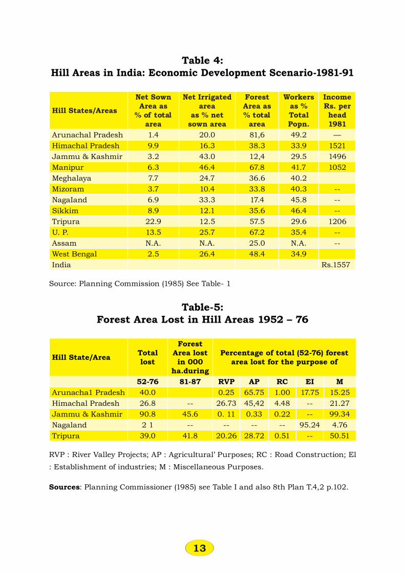
13
Table 4: Hill Areas in India: Economic Development Scenario-1981-91
Hill States/Areas
Net SownArea as% of total
area
Net Irrigated area
as % netsown area
ForestArea as% total
area
Workersas %TotalPopn.
IncomeRs. perhead1981
Arunachal Pradesh 1.4 20.0 81,6 49.2 —Himachal Pradesh 9.9 16.3 38.3 33.9 1521Jammu & Kashmir 3.2 43.0 12,4 29.5 1496Manipur 6.3 46.4 67.8 41.7 1052Meghalaya 7.7 24.7 36.6 40.2Mizoram 3.7 10.4 33.8 40.3 --NagaIand 6.9 33.3 17.4 45.8 --Sikkim 8.9 12.1 35.6 46.4 --Tripura 22.9 12.5 57.5 29.6 1206U. P. 13.5 25.7 67.2 35.4 --Assam N.A. N.A. 25.0 N.A. --West Bengal 2.5 26.4 48.4 34.9India Rs.1557
Source: Planning Commission (1985) See Table- 1
Table-5: Forest Area Lost in Hill Areas 1952 – 76
Hill State/Area Total lost
Forest Area lost in 000
ha.during
Percentage of total (52-76) forest area lost for the purpose of
52-76 81-87 RVP AP RC EI MArunacha1 Pradesh 40.0 0.25 65.75 1.00 17.75 15.25Himachal Pradesh 26.8 -- 26.73 45,42 4.48 -- 21.27Jammu & Kashmir 90.8 45.6 0. 11 0.33 0.22 -- 99.34Nagaland 2 1 -- -- -- -- 95.24 4.76Tripura 39.0 41.8 20.26 28.72 0.51 -- 50.51
RVP : River Valley Projects; AP : Agricultural’ Purposes; RC : Road Construction; El : Establishment of industries; M : Miscellaneous Purposes.
Sources: Planning Commissioner (1985) see Table I and also 8th Plan T.4,2 p.102.

14
Table-6:Quality of Life in Hill Areas of India 1981-91
Hill States/Areas
Con. of Elec. perCapita(KWH)
Vill. Elect. % of total
No. ofvillages
Hosp. Bedper
1000
Post per
2000
H.S.School
Per 1500
Literacy rate%
India/Standard 67.0 0.80 1.00 1,00 36.00Hill StatesArunacha1 Pradesh 38.1 21.4 1.53 0.76 2.26 35.25Himachal Pradesh 52.2 83.7 0.72 1.09 2.41 41.94Jammu & Kashmir 65.0 85.2 0.69 0.43 2.14 26,67Manipur 4.5 20.4 0.89 0.56 3.08 41.52Meghalaya 24.8 23.2 1.22 0.57 2.13 32.04Mizoram 5.3 13.3 1.47 1.63 4.40 48.55Nagaland 23.3 93.8 1.41 0.42 2.17 50.05Sikkim 30.2 38.0 1.60 N.A 1.90 50.77Tripura 9.7 17.0 0.62 0.50 1.43 31.92Hill Areas ofU.P 82.5 35.4 1,36 N. A. 0.08 39.29Assam N. A. 58.8 0.08 0.37 — 20.50West Bengal 6.5 11.4 1.14 0,06 3,61 42. 52
Con.: Consumption, Elect. : Electricity/Electri ed Hosp.: Hospital HS: High/Higher. Secondary Schools
Source’ Planning Commission (1985), See Table-1
5. Criteria to the objective:
5.1 General Criteria;5.2 Data & information base;5.3 Implementation Criteria;5.4 Management Criteria
5.1 General Criteria:
There are 12 factors required to be considered and adopted:
a. Water source - surface water and ground water.b. Land - availability of useable land with slopes less than 30 degree.

15
c. Climato1ogica1 and weather conditions suitable for human being.
d. Availability of natural resources i.e. minerals and forests, its location, accessibility and suitability.
e. Accessibility of the settlements with the surrounding areas sand also with international, national and local level via roads, rails, water and air,
f. Importance/order of the settlement at the national, state and local level.
g. Trade, commerce and industry; their export and import and consumption within the settlement.
h. Environmental problems with gard to water, air, noise and soil pollution.
i. Large social cultural and educational and research institutions, universities, medical college, hospitals, police lines, te1e-communcation system, art gallery, meditation centre, dramatic halls, etc.
j. The hill regions generally suffer from the inadequacy of roads, marketing facilities, supporting services and lack of physical, social and economic infrastructure.
k. Forest is being used as a major fuel wood because of lack of alternative source of energy substitute.
l. By adopting proper land development measures, there is large scope to bring more area under agriculture, forest and tourism. Planning of agricultural lands based on scienti c methods have to be evolved.
5.2 Data and information base:
Following six criteria are very important and steps should be taken to achieve them. The data should be made available to various institutions:
a. Maintain and establish data base about meteorological, hydrological and clinical monitoring analysis and capabilities of different mountainous regions and areas.
b. Build an inventory of different forms of soils, forests, water use and crop, plant and animal genetic resources.
c. Identify hazardous areas which are most vulnerable to erosion, oods, land slides, earth-quakes, snow avalanches and other natural
hazards.

16
d. Identify mountain areas threatened by air pollution from neighbouring industrial and large urban areas and natural calamities,
e. Maintain and establish seismic observation and evaluation capacity at various levels.
f. General data and alternative livelihood and diversify production system on tree crops, livestock, poultry, bee-keeping, shery, village industries, markets, transport and income earning opportunities.
g. Establishment of National Fark and Wild Life Sanctuary, One of the scene is given in Photograph No.5 of Rhinoceros mother and calf at the Royal Chitvan National Park Nepal,

17
5.3 Implementation Criteria:
a. Prepare proper paper plans as per methodology given in para-6; get these plans approved from competent authorities. These plans should include plans of regional planning, physical land use planning, planning of physical, social, economic and ecological infrastructure. Financial planning with sources of funds (public, private and cooperative).
b. All the policy decisions should be taken at the higher level along with proper coordination, integration, evaluation and monitoring. Implementation should be by various organisations and authorities.
c. Project should be implemented by involving public sector, private sector and cooperative sector.
d. While implementing the project, ecology should not be disturbed rather should be improved to the extent possible.
e. Implementation would be easier, if implemented with the help of
5.4 Management criteria:
This is meant for planning, development, construction, disposal, maintenance and replacement of urban spaces. For this, following should be the strategy:
a. Strengthen existing institutions or establish new at various levels and at proper locations for the functions stated above.
b. Promote national policies to provide incentives to local people for the use and transfer of environment - friendly technologies and farming and conservation practices. Encourage policies which provide incentives to farmers and local people to undertake conservation and regenerative measures.
c. Diversify mountain economies with the help of tourism, other suitable non-polluting industries and activities based on water and timber resources.
d. Integrate all forest range land and wild life activities in such a way

18
that speci c mountain eco-systems are maintained, preserved and improved.
6. Methodology:i. Arrange latest base map in a proper scale with the help of remote sensing and aerial photography Suitable scale are 1:100,0000, 1:25,000 for macro level planning and 1:10,000 or 1:5000 depending upon the importance for detailed micro level planning.
ii. Delineate water shed areas with the help of above maps.
iii. Find highest potential areas so that urban and rural spaces are delineated and developed in an optimum physical and economic way within the existing and predicted resources. For this, following steps are necessary,
a. Divide the area as per altitude -- Upto 600 mt,
- 601 to 2000 mt,
- 2001 mt, to 3000 mt,
- Above 3000 mt,
b. Divide the area as per slopes -- Upto 30%
- 31% to 45% and
- More than 45%
c. Settlement Pattern -- Upto 500 persons
- 501 to 2000
- 2001 to 5000
- Above 5000
d. Detailed studies of physical characteristics- Rainfall distribution = Population to density
- Language
- Cultivation of land in terms percentage of the total area

19
- Location of industries
- Type of tocks
- Transportation, roads, rail and air.
- Potential areas for tourism with regard to archaeological monuments, religious structures, air routes, trekking routes, wild life, guest house, hotel, tourists centre,
e. Superimposition of all .he above data to get settlement:- With the help of above analysis and superimposition highest potential
areas can be earmarked.
7. Nepal as an example:
7.1 General description of Nepal, Kathmandu Valley and Patan:
General:-
Nepal is a. tiny country sand witched between the two most populous countries of the world - India, and China. Undoubtedly it is a. land of contrast in altitude of hills varying from 500 mt. to more than 8,000 mts., wild life sanctuaries, rivers, beautiful art and architecture so, number of tourists are increasing day by day. In 19S0, number was 255,000 in comparison to 6200 in 1961. Nepal is a small country of 141577 sq.km, consisting maximum variation in altitude from the low land Tarai, almost at the sea level to mount everest at 8848 mts. The country is about 800 kmt. long and ranges from 90 to 230 km. wide. Nepal is the only country in the world which contains -
- the highest mountain peak in the world (everest - 8848M)- the deepest river Gorge (Kaligandaki River)- the birth place of Budha-
- the only Hindu King- Kathmandu the capital city has as many idols as men and as
many temples as houses.

20
- a hotel in Everest national park is at an altitude of 3870M - the highest hotel in the world.
- it is one of the world’s great trekking paradise- contains one of the 10 best rivers in the world for rafting,- is one of the least developed among the countries of the third world
with one of the lowest per capita income.
Economy:- Nepal is pre-dominant1y an agricultural country. It used to export rice and jute and now since few years tourism has taken an important place. Nepal has vast potential for the development of hydro-electric power to the extent- of 82,000 MW but so far only few hundred MW has been developed. Being a land-locked country it is dependent upon India for excess to sea. In 1991, a new ‘Trade And Transit Treaty’ was signed between India and Nepal .
Kathmandu Valley:- The area is 750 sq.km, with 1.1 million population at a height of 1350 mts. surrounded by hills of 2400 mt. in altitude. Three important cities are in the valley, namely - Kathmandu, Patan, and Bhakatpur, Until the uni cation of Nepal, started 50 years ago, the Kathmandu Valley consisted of small independent kingdoms. All these kingdoms had sophisticated art and architecture, especially during the seventeenth century which was the golden age for the construction of temples and palaces in these three cities. In many respects these cities are similar to old parts of the city of Europe, There is city centre containing the royal palaces and “Darbar Squa5re” or Squares in front of the palace. Old cities are with narrow alleys and markets. In one of the book, it is written that at no other place in the world there is this type of concentration of art, culture and tradition as here in Kathmandu, Patan and Bhakatpur.
Patan:- The city of beauty is situated across the Bhaghmati River. Patan is not a planned city and it may be that it might have existed before the Christian era, Patan has Durbar Square area, Bhimsen Temple, Shiva Temple, Krishna Temple, Hari Shankar Temple, Narasimha Temple, Narain Temple, column with king Yogander Malla. Water tap on Mangal Hity, Royal Palace etc.
21
7.2. Pre-requisites of development of Kathmandu Valley:
1. Development Act
The name may be kept as Kathmandu Environment and Development Act (KEDA).
Structure:
Concerned Minister - Chairman.
Three representatives of Development Committees of three local bodies - members.
Three representatives from local bodies, namely, Kathmandu, Bhakatpur and Patan - members.
Three representatives from rural areas - members.
Full time members - Vice Chairman, Member Planning, Member Engineering, Member Finance. Other staff would be appointed as per decision.
Functions:
- Paper planning (physical and nancial) along with coordination, integration, evaluation and monitoring of all the urban development and housing functions. Execution of various subjects/projects may be by various departments, organisation and authorities.
Land Policy
- Acquisition
- Planning
- Development, Construction, Disposal and Maintenance of urban spaces.
- Public and private partnership
- To charge part of unearned increase from bene ciaries
Seed Capital/Revolving Fund
- Rs.10 crore to start with.

22
Environmental Planning
- Ring Road may be taken as an outer limit of permitting development and construction of urban spaces at least for the period ending 2010 A.D.
- Areas outside Ring Road should be controlled and developed as green with the help of strict zoning regulations.
- Special areas should be earmarked for the present and future wholesale trades, trucking activities, metal industries, and light polluting industries.
- Tree plantation along the roads, parks, playground and open spaces.
- Studies should be got conducted of water, air, soil and noise pollution. Areas of tree plantation should be earmarked and supply of urban spaces in public and private sector should be increased to meet the demand more or less.
Duration of the Plan
Planning of airport, historical monuments and places, drainage system, beauti cation of the river and tourism activities should be planned for a period of 50 years,
- Plans of water supply, sewage disposal, power, traf c and transportation should be between 20-25 years.
- Landuse planning should be only of 5-10 years.
Planning of river Baghmati bed
It should consist the following components:
i) to clean the water;
ii) to improve the environments;
iii) to channelise the river;
iii) to reclaim the land and
iv) to develop the reclaimed land.