Embed Size (px)
Citation preview

PLANNING FOR MARYLAND’S FLOOD-PRONE ARCHEOLOGICAL RESOURCES

This material is based upon work assisted by a grant from the Department of the Interior, Na-tional Park Service. Any opinions, findings, and conclusions or recommendations expressed in this material are those of the authors and do not necessarily reflect the views of the Department of the Interior.
© 2019, State of Maryland
Cover Image: A volunteer looks on as bay water floods an excavation unit and exposed prehistoric shell midden. Source: Anne Arundel County Trust for Preservation, 2016
Prepared by:• Jennifer Sparenberg, Maryland Environmental
Service• Maryland Historical Trust Office of Archeology
Staff
Edited by:• Anne Raines and Nell Ziehl, Maryland Historical
Trust

3TABLE OF CONTENTS
QUICK GUIDE TO WHAT’S INSIDE
1. INTRODUCTION
Archeology Under Threat
Who Should Use This Planning Document?
2. WHAT IS ARCHEOLOGY?
Highlight: Artifacts and Ecofacts
Highlight: Features
Why Conduct Archeology?
Who is Qualified to Conduct Archeological Work?
3. IDENTIFYING THE FLOOD VULNERABILITY OF KNOWN ARCHEOLOGICAL SITES
Archival and Background Research on Known Archeological Sites
Mapping the Flood Risk to Known Archeological Sites
Flood Impacts to Archeological Sites
Table: Quick Guide to Flood Hazard Impacts to Archeological Resources
4. IDENTIFYING POTENTIAL ARCHEOLOGICAL SITES PRONE TO FLOODING
Predictive Models to Identify Archeological Sensitivity
Archeological Survey and Documentation
5. EVALUATING AND DESIGNATING ARCHEOLOGICAL SITES
Highlight: Are Cemeteries Archeological Sites?
6. PRIORITIZING NEW RESEARCH: SURVEY, AND FLOOD VULNERABILITY
~continues~
5
6
6
7
9
9
10
13
14
15
15
17
21
24
25
25
26
29
31
33
TABLE OF CONTENTS
4
7. IDENTIFYING, EVALUATING, AND PRIORITIZING MITIGATION OPTIONS
Site Stewardship
Additional Evaluation and Investigation
Protect in Place
No Action
Salvage Archeology
8. CONCLUSION
APPENDIX 1: CASE STUDIES
Case Study 1: Using GIS Applications to Determine Vulnerability to Shoreline Erosion
Case Study 2: Determining Vulnerability to Multiple Hazards and Prioritizing Actions
Case Study 3: A Predictive Model for Prehistoric Sites in the Lower Potomac
Case Study 4: Significance as a Determining Factor for Prioritizing Investigation
Case Study 5: Living Shorelines at Jefferson Patterson Park and Museum
Case Study 6: Natural Shoreline Protection of a Prehistoric Ossuary
APPENDIX 2: FUNDING SOURCES
APPENDIX 3: ADDITIONAL RESOURCES
APPENDIX 4: REFERENCES CITED
APPENDIX 5: LEGISLATIVE AND REGULATORY BACKGROUND
35
35
36
36
41
41
43
45
45
45
47
49
51
52
55
57
59
61
TABLE OF CONTENTS

5QUICK GUIDE TO WHAT’S INSIDE
QUICK GUIDE TO WHAT’S INSIDE
Archeological sites are increasingly threatened by flooding along Mary-land’s rivers and coastlines. Development projects to help address flood-ing can also damage archeological sites.
Sections 1 & 3
Unfortunately, most local governments do not have the ability to plan for archeology, in part because access to data and key planning informa-tion is restricted to qualified archeologists. The Maryland Historical Trust (MHT) can help in some cases, but local governments should consider adding staff or contractual archeologists to assist in this work.
Section 2
Preliminary planning can be as simple as overlaying maps of known sites with maps of the known hazard areas.
Section 3
Identifying vulnerable and undocumented archeological sites is more dif-ficult. Strategies include predictive modeling and field survey.
Section 4
To make decisions about how to treat archeological sites, local govern-ments should work with archeologists and MHT to assess the integrity and potential significance of the site - that is, its ability to yield important information about the past - as well as site vulnerability.
Sections 5, 6, & 7
Treatment options can include local site stewardship programs, addition-al research and investigation, site protection, and -- in severe cases where important data may be lost -- salvage archeology. Some sites will not be good candidates for treatment and will be lost over time.
Section 7
Without local capacity for archeology, most archeological site protection and mitigation will occur as a result of federal and state project review.
Section 2
Readers can also learn the basics of archeological practice and how some approaches to archeological planning have been applied around the state.
Section 2 &Appendix 1: Case Studies

6 1. INTRODUCTION
The Chesapeake Bay, rivers and other waterways have long provided humans with transportation routes, food and other resources. Many areas as-sociated with Maryland’s historic and prehistoric human activity are therefore located adjacent
Archeology under Threat
1. INTRODUCTION
Archeology – the study of human culture through excavation and examination of material remains – helps us understand the lives and practices of the people who came before us. Archeology can illuminate the lives of those who did not leave a written record, including prehistoric indigenous groups such as Native Americans. Where archi-val documents or oral traditions exist, archeol-ogy can still fill in missing pieces of the historical record, helping to ensure that people ordinarily forgotten or intentionally excluded (for example, enslaved African Americans or poor industrial workers) are featured in our explanations of the past. Likewise, certain aspects of daily life (for example, how and what people ate, what con-stituted a “typical” household, or the lives and activities of children) may be mischaracterized or absent from written records, leaving archeology to provide a more complete, less biased represen-tation of the past.
The research, preservation, and interpretation of archeological sites can also contribute to the local, state, and national economy. Museums, historic sites, and educational programs use archeological data to better interpret Maryland’s past. When exhibits and tours include direct ac-cess to archeological sites and artifacts, visitors can engage with tangible pieces of our shared history, facilitating a more direct, and often more memorable, connection. In addition to educat-ing Maryland residents, these efforts help bring tourists to a community, contributing to the local economy.
Finally, by linking the past to the present, archeol-ogy can also inform the future. Archeology can illuminate social, environmental, and economic trends over long periods of time, helping us understand contemporary patterns as well as future possibilities. In an era of climate change,
this aspect of archeology may become increas-ingly relevant, as living people seek to learn more about how humans have adapted to changing conditions.
In 2017 MHT addressed the effects of flood hazards on archeological sites by making it the theme of Archeology Month.

71. INTRODUCTION
This document’s intended audience is planners in local government with limited archeological experience. As such, a large portion of this docu-ment is devoted to basic information about the practice of archeology, including an explanation of what archeology is, where archeological sites occur, and who is qualified to conduct archeologi-cal work in Maryland (refer to Section 2).
Who Should Use this Planning Document?
to water and are prone to flooding. As sea levels rise and storms become increasingly intense and frequent, the effects on archeological resources will be devastating. Riverine sites will be eroded away by precipitation and flash floods. Coastlines will be remodeled by storm surge and scoured by increasingly higher tides, eroding coastal sites until nothing remains. Resources that were once dry or only intermittently wet will be subject to longer or permanent inundation. These factors can lead to the deterioration of floral and faunal materials, delicate artifacts, and archeological features (refer to “Flood Impacts to Archeologi-cal Sites” in Section 3). Losing these materials will diminish our ability to understand and interpret past lifeways and cultures.
Although this document is geared toward non-archeologists, the actual work described must be undertaken by qualified archeologists (refer to Section 2). Unfortunately, many local govern-ments do not have qualified archeologists on staff. Some communities have addressed this gap by hiring archeologists as consultants on an as-needed basis. While there is no universal solution, local governments can apply for grants, including through MHT, to undertake archeology projects with the help of qualified professionals (refer to Appendix 2: Funding Sources).
This guidance document will help local govern-ment planners understand how to identify ar-cheological resources and sites in flood-prone areas and how flooding can affect those sites. The document outlines considerations for pro-tecting or examining such sites, as well as options for resources that may not be able to be saved. The Maryland Historical Trust (MHT) encourages planners to consult with MHT staff archeologists prior to launching flood protection or mitigation plans that may affect archeological sites. MHT is
also available for technical assistance throughout the duration of the project.
MHT’s Flood Mitigation Guide: Maryland’s Historic Buildings is a guidance documented oriented to-ward historic structures and communities.
8 1. INTRODUCTION
This background provides the context for subse-quent sections that define flood hazards (refer to “Mapping the Flood Risk to Known Archeologi-cal Sites” in Section 3), explain how to assess the threats they pose to archeological sites (refer to “Flood Impacts to Archeological Sites” in Sec-tion 3), and outline how to reduce the effects of those threats (refer to Section 7). The Additional Resources at the end of this guidance will direct the reader to more information on the topics discussed.
Planning for Maryland’s Flood-Prone Archeologi-cal Resources is an introduction to the issues and options surrounding archeological sites and the threat of flooding. Readers may also wish to consult MHT’s Flood Mitigation Guide: Maryland’s Historic Buildings, developed to provide local gov-ernments with a planning process that balances historic preservation and flood protection. The Flood Mitigation Guide also provides a primer on floodplain management regulations, the National Flood Insurance Program, and the emergency management cycle, which are not covered in this document. The planning process in the Flood Miti-gation Guide may also be applied to archeological resources and can be used in conjunction with this guidance to develop projects to include in local hazard mitigation plans which also address vulnerable archeological resources. In time, these planning documents may be updated, refined and combined into a single guidance document or toolkit for local governments with historic and cultural resources threatened by flooding.

92. WHAT IS ARCHEOLOGY?
2. WHAT IS ARCHEOLOGY?
Archeology is the study of ancient and recent cultures through the examination of material remains. Material remains are any physical ob-jects from the past – including objects as large as a building foundation or as small as a piece of pottery – which can help archeologists better un-derstand human activity. Archeology may supple-ment the historical record or be used to research cultures when historic documentation is limited, unreliable, or altogether non-existent. Archeol-ogy can include any part of the process of iden-tification, excavation, preservation, or analysis of material remains, and can encompass sites on land and underwater. Archeology involves many activities including library research, remote sens-ing with tools that “see beneath the soil,” survey work to identify sites, the meticulous excavation and recording of artifact locations, cataloging and
conservation of artifacts, lab analysis, and report-ing of results.
Of course, archeology involves more than just “digging for artifacts.” An archeological site contains a concentration of material remains from the past, and the location of artifacts (refer to highlight below) and features (refer to high-light on p. 11) in relation to one another helps the archeologist make determinations about the se-quence and nature of human activity at the site. This context, and proper recordation, is in many ways more important than the artifacts them-selves. Once taken out of context, an artifact can yield little to no scientific data.
The vertical context of the site usually refers to the location of an archaeological find in the strata
Artifacts are portable objects made, used, or modified by humans. They vary in size, shape, and material, and a single artifact can be comprised of several different materials. To place artifacts within a geographic or temporal context, archeologists consider material, style, and other factors that may indicate origin and use. Examples of artifacts can include, but are not limited to, ceramics, worked stone, ar-rowheads (and other projectile points), bone tools, brick, nails, glass, and worked metal. By contrast, an ecofact is any natural remain(s) that relates to human activity and helps to place the archeological site in its broader ecological context. Unmodified animal bones and plant remains are common examples of ecofacts, which provide information about what species were present in the past at an archeological site. However, if a bone shows evidence of being sawed, burned, made into
ARTIFACTS AND ECOFACTS a tool, or modified by past human activity, most archeologists would consider it to be an artifact. Artifacts and ecofacts help archeolo-gists make determinations about how past people lived, used tools, ate food, and traded between groups.
Artifacts drying in a screen at the Billingsley site.
(soil layers) of the earth. Accurate recordation of vertical context helps the archeologist evaluate changes though time. The deeper an artifact or feature sits, the further back in time it may origi-nate. The horizontal context of the site refers to how objects within the same strata, but separat-ed horizontally, relate to each other. Horizontal contexts are important to making determinations about contemporaneous activities at the site, as artifacts and features in the same horizontal con-text are often associated with the same period of time.
Given the importance of archeological context, archeologists have developed methods for each
10 2. WHAT IS ARCHEOLOGY?
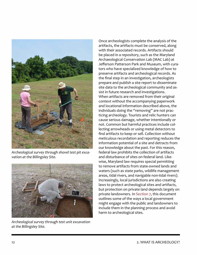
stage of archeological investigation to ensure both the appropriate recovery of artifacts and the accurate documentation of locational data. Following background research, archeologists usually begin investigations with field survey, oriented towards the discovery of new sites or locating the boundaries of existing sites. Archeol-ogists use techniques such as controlled surface collection or the excavation of shovel test pits at regular intervals to locate sites. Controlled sur-face collection involves using survey instruments (such as compass and tape, a surveyor’s transit, or GPS) to lay out a grid of “collection squares” or linear transects, and then collecting and re-cording the position of all of the artifacts encoun-
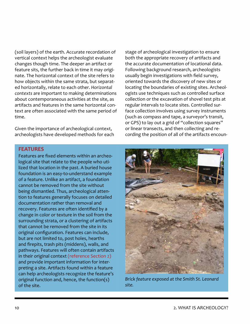
Features are fixed elements within an archeo-logical site that relate to the people who uti-lized that location in the past. A buried house foundation is an easy-to-understand example of a feature. Unlike an artifact, a foundation cannot be removed from the site without being dismantled. Thus, archeological atten-tion to features generally focuses on detailed documentation rather than removal and recovery. Features are often identified by a change in color or texture in the soil from the surrounding strata, or a clustering of artifacts that cannot be removed from the site in its original configuration. Features can include, but are not limited to, post holes, hearths and firepits, trash pits (middens), walls, and pathways. Features will often contain artifacts in their original context (reference Section 2) and provide important information for inter-preting a site. Artifacts found within a feature can help archeologists recognize the feature’s original function and, hence, the function(s) of the site.
FEATURES
Brick feature exposed at the Smith St. Leonard site.

112. WHAT IS ARCHEOLOGY?
tered within a given square or transect. Shovel testing involves digging small test holes (about the width of a shovel blade and 50-100 cm deep) at regular intervals and then recording the loca-tion of each shovel test pit as well as any artifact finds. In this way, archeologists can discover new sites and better define the boundaries of known sites.
When an archeological site is the subject of more rigorous in-depth study, archeologists will often dig in formal test units. These test units are usu-ally a standardized size (such as 5x5 ft or 2x2 me-ters), and all artifacts and features encountered
An excavation unit profile from the deeply-strati-fied Pig Point site in Anne Arundel County. Image courtesy of Dr. Al Luckenbach.
in each test unit are recorded on paperwork specific to that unit and stratigraphic level. Arche-ologists record the locations of test units on a de-tailed site map and often record the locations of items within a test unit down to the nearest cen-timeter or fraction of an inch. Such in-depth study and recordation is usually associated with either academic research or evaluation of a site to de-termine its significance and/or the time periods or cultures represented by the artifacts recovered.
12 2. WHAT IS ARCHEOLOGY?
Once archeologists complete the analysis of the artifacts, the artifacts must be conserved, along with their associated records. Artifacts should be placed in a repository, such as the Maryland Archaeological Conservation Lab (MAC Lab) at Jefferson Patterson Park and Museum, with cura-tors who have specialized knowledge of how to preserve artifacts and archeological records. As the final step in an investigation, archeologists prepare and publish a site report to disseminate site data to the archeological community and as-sist in future research and investigations. When artifacts are removed from their original context without the accompanying paperwork and locational information described above, the individuals doing the “removing” are not prac-ticing archeology. Tourists and relic hunters can cause serious damage, whether intentionally or not. Common but harmful practices include col-lecting arrowheads or using metal detectors to find artifacts to keep or sell. Collection without meticulous recordation and reporting reduces the information potential of a site and detracts from our knowledge about the past. For this reason, federal law prohibits the collection of artifacts and disturbance of sites on federal land. Like-wise, Maryland law requires special permitting to remove artifacts from state-owned lands and waters (such as state parks, wildlife management areas, tidal rivers, and navigable non-tidal rivers). Increasingly, local jurisdictions are also creating laws to protect archeological sites and artifacts, but protection on private land depends largely on private landowners. In Section 7, this document outlines some of the ways a local government might engage with the public and landowners to include them in the planning process and avoid harm to archeological sites.
Archeological survey through shovel test pit exca-vation at the Billingsley Site.
Archeological survey through test unit excavation at the Billingsley Site.

132. WHAT IS ARCHEOLOGY?
Archeologists engage in their practice for re-search, planning, and regulatory purposes. Non-profit organizations (e.g., the Archeological Society of Maryland and the Lost Towns Project) and universities and colleges undertake archeol-ogy for pure research, as do some state and local government agencies (including MHT) that have professional archeologists on staff. Some coun-ties and municipalities, through professional staff or contractors, review development proposals for archeological impacts and otherwise plan for the protection and interpretation of local archeo-logical resources. Archeological research and planning activities are generally funded by grants, including Historic Preservation Non-Capital grants and Certified Local Government grants available via MHT (reference Appendix 2: Funding Sourc-es).
Local project review for archeology occurs based on regulations and policies set forth by the local government. However, many local governments
lack the staff capacity or expertise to conduct these reviews. MHT recommends that local gov-ernments hire a qualified archeologist to serve in the local planning office or another branch of local government, but this may require enacting local legislation or getting the “buy in” of local elected officials to create such a position. Alter-native strategies could include contracting with a cultural resource management firm or archeo-logical consultant to serve as a local government consultant.
Many archeological surveys are carried out as a result of the federal and state historic preserva-tion review process established under Section 106 of the National Historic Preservation Act (36 CFR 800), as amended, and the Maryland Historical Trust Act of 1985, as amended (§5A-325 and 326). Both laws require federal and state agencies to consult with MHT regarding any project that in-volves federal or state funds, permits, or licenses to assess their potential impacts to historic prop-erties, including archeological sites. (For more in-formation about related legislation, see Appendix 5: Legislative and Regulatory Background.) Typi-cally, archeology conducted for federal and state regulatory purposes is undertaken by contrac-tors, on behalf of the project sponsor or solicited directly by the involved federal or state agency.
Museums, living history sites, colleges and univer-sities, and local historical societies can and should make use of archeological data. The public gen-erally has a strong interest in history (especially local history) and prehistory. Guided by qualified staff, planners and local government officials can play a role in bringing archeology to the local level. Unfortunately, disseminating archeologi-cal data is often difficult. Once artifacts go to a curatorial facility (see above) or site reports are accepted as legally sufficient to meet state and
Why Conduct Archeology?
Conservator Francis Lukezic reattaching paper labels to solder dot cans from Deadwood, South Dakota.

14
An MHT archeologist directs volunteers in the field.
federal laws, they have a tendency to be forgot-ten.
To help make archeological information more accessible, MHT has begun making some classes of data available to the public. The Maryland Ar-cheological Synthesis Project (described further in Section 3) makes capsule summaries of many site reports available to the public for free over the internet. Collections donated to the state or curated at the MAC Lab are available for further research, traveling exhibits, and long-term loans. While not a substitute for qualified archeologi-cal staff, tools such as the Diagnostic Artifacts webpage and Small Finds database can provide planners with valuable resources they can use in trying to understand local archeology and engage the public in the preservation of archeological resources.
Archeological investigations should only be con-ducted by or under the direct supervision of indi-viduals who meet or exceed the Secretary of the Interior’s Professional Qualifications Standards (36 CFR 61). The minimum professional qualifications in archeology are a graduate degree in archeol-ogy, anthropology, or a closely related field plus:
1. At least one year of full-time professional experience or equivalent specialized training in archeological research, administration or management;
2. At least four months of supervised field and analytic experience in general North American archeology, and
2. WHAT IS ARCHEOLOGY?
Who is Qualified to Conduct Archeological Work?
3. Demonstrated ability to carry research to completion.
In addition to these minimum qualifications, a professional in prehistoric archeology shall have at least one year of full-time professional expe-rience at a supervisory level in the study of ar-cheological resources of the prehistoric period. A professional in historic archeology shall have at least one year of full-time professional experience at a supervisory level in the study of archeological resources of the historic period.
Archeology undertaken to comply with federal and state regulations, or to support projects funded by the federal government or the State of Maryland, must be conducted by professionals who meet the Secretary’s Professional Qualifica-tions Standards. The work must also comply with MHT’s Standards and Guidelines for Archeologi-cal Investigations in Maryland, which provide a methodology for conducting investigations and a format for the report that documents the inves-tigation. MHT recommends that all archeological work conducted in Maryland adhere to these Standards and Guidelines whether or not it is re-quired as part of the investigation.

153. IDENTIFYING THE FLOOD VULNERABILITY OF KNOWN ARCHEOLOGICAL SITES
Maryland’s diverse archeological heritage spans over 12,000 years of human occupation and demonstrates to us how the state’s rich natural environment - from the tidal wetlands of the Eastern Shore to the forests of the Appalachian Mountains – has supported people throughout prehistory and history, to the present day. The ar-cheological sites that remain today are irreplace-able: they are tangible links to the past, providing data that is not otherwise readily available. Found in rural areas and urban settings, sites include, but are not limited to: Native American villages, encampments, shelters, and resource procure-ment areas; Colonial towns and farmsteads; plan-tations, associated landscape features and out-buildings, including slave quarters; fortifications and battlefields; industrial complexes, such as mills, tanneries, or iron furnaces; infrastructure, such as historic military roads, dams, or canals; and historic residential and commercial sites, such as cabins, inns, or taverns. Common under-water archeological sites in Maryland include shipwrecks; piers, wharves, boatyards, and land-ings; and inundated sites, from all time periods, that become submerged as a result of coastal changes. It is important to note that while the locations of many archeological sites have been documented (as discussed in this section), many more are unknown or undocumented (refer to Section 4); both known and unknown sites are vulnerable to flooding.
3. IDENTIFYING THE FLOOD VULNERABILITY OF KNOWN ARCHEOLOGICAL SITES
collected via the Maryland Archeological Site Survey (MASS) form. Due to the threat of looting and vandalism, the location of archeological re-sources is considered sensitive information. MHT allows full access for agency representatives, archeologists and researchers who meet the Sec-retary of the Interior’s Professional Qualifications Standards (refer to Section 2). To obtain access to archeological site files, you must request a Me-dusa account online. In addition to site location, archival and back-ground research will help illuminate the known significance and integrity of sites for prioritiza-tion purposes (refer to Section 3), identify sites that were documented and destroyed (so are no longer a factor for planning), and help planners understand what additional areas may need to be researched (refer to Section 6). When conducting background research to learn more about poten-tial sites at risk, or prior to beginning an archeo-logical investigation, researchers should always consult MHT and the local county government for information on previous investigations and local history/prehistory. Because archeological data is restricted to protect site location information, it is imperative that local planners work with a qualified archeologist to undertake this work, ei-ther by having this expertise on staff or by hiring a consultant.
Located at its headquarters in Crownsville, the MHT Library currently includes site-specific ar-cheological survey reports, maps, slides, and documentation for over 14,000 terrestrial and underwater archeological sites. The MASS forms, available online through Medusa, are also filed in the library along with extensive hard copy re-search for each site, which often includes more detailed information than is accessible online. Many site reports describe the results of past
To plan for the protection, research, or inter-pretation of archeological sites, the first step is understanding what sites have been identified and documented. MHT maintains an inventory of known archeological sites in Medusa, Mary-land’s Cultural Resource Information System,
Archival and Background Research on Known Archeological Sites
16 3. IDENTIFYING THE FLOOD VULNERABILITY OF KNOWN ARCHEOLOGICAL SITES
fieldwork activities and catalog artifact finds. Like the online locational records, access to archeological documentation in the library is by appointment only and is restricted to qualified researchers who have been approved by MHT ar-cheological staff. Before visiting the MHT Library, individuals should apply online for a Medusa ac-count.
The MHT Archeological Synthesis Project consists of a searchable database that links the MASS data to additional information housed in the MHT Library, including excavation synopsis reports and cover sheets. Synopsis reports contain a capsule summary of the overall site report, organized in a way that makes it easier for researchers to quickly pull out the most relevant information they would need to understand the past activities at a site. The cover sheets address the history of archeological activity at a site, including the jus-tifications for fieldwork, research objectives, and
the potential for future research at the locale. For members of the general public, detailed geo-graphic information is restricted to protect site locations, but all other data is otherwise present. Qualified users can access more accurate geo-graphic information.
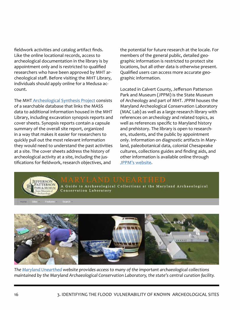
Located in Calvert County, Jefferson Patterson Park and Museum (JPPM) is the State Museum of Archeology and part of MHT. JPPM houses the Maryland Archeological Conservation Laboratory (MAC Lab) as well as a large research library with references on archeology and related topics, as well as references specific to Maryland history and prehistory. The library is open to research-ers, students, and the public by appointment only. Information on diagnostic artifacts in Mary-land, paleobotanical data, colonial Chesapeake cultures, collections guides and finding aids, and other information is available online through JPPM’s website.
The Maryland Unearthed website provides access to many of the important archaeological collections maintained by the Maryland Archaeological Conservation Laboratory, the state’s central curation facility.

173. IDENTIFYING THE FLOOD VULNERABILITY OF KNOWN ARCHEOLOGICAL SITES
To determine how flooding might impact local archeological sites, the next step is to contact the local emergency management office, which prepares the local hazard mitigation plan, to learn more about what types of flooding affect the area of interest. The hazard mitigation plan will provide information on the occurrence of flood hazards within a County and its municipali-ties. (Annapolis, Baltimore, and Ocean City have separate municipal plans.) The hazard mitigation plan assesses the vulnerability of local jurisdic-tions and will serve as a useful starting point, but it is unlikely to address the impact at the scale needed to determine the effect on individual archeological sites. Hazard mitigation plans very rarely include climate change projections. (Refer to the Flood Mitigation Guide, Section 2: Planning and Preparedness for more information on haz-ard mitigation plans, other planning options, and how to integrate cultural resource planning into these processes.)
With information about local archeological sites plus information about local flood risks, it is possi-ble to overlay these maps with one another using tools like Geographic Information Systems (GIS) to better understand the risk to sites within the area of interest. Common mapping tools for dif-ferent types of flood risks are outlined below. GIS layers for cultural resources are available as ESRI shapefiles from MHT to qualified archeologists. MHT’s GIS data access policy is available online. It is important to note that overlaying data layers provides a rough assessment of vulnerability and only encompasses known archeological sites. An in-person assessment would be needed to under-stand the actual vulnerability of a site. (Refer to “Vulnerability Assessments” in Appendix 3.)
Mapping the Flood Risk to Known Archeological Sites
Counties that have a professional archeologist on staff and conduct archeological investigations typically have local repositories for archeologi-cal records, reports, and related information. Information held in local collections might not be contained in the MHT Library. Access to this information might be restricted to protect the lo-cation of the sites. Colleges and universities with archeology programs are also a good source for information on archeological work and academic research conducted by the university, including dissertations, theses, project reports, and journal articles by faculty and students. Some universities (e.g., the University of Maryland, St. Mary’s Col-lege of Maryland, Johns Hopkins University) may have special collections related to archeology, which may also have restricted access or appoint-ment requirements.
In addition to official sources, contacting and vis-iting with property owners is always useful when gathering information on a site or area. Resi-dents may provide information or artifacts they have collected from local sites, as well as tips on who else has collected from the site and/or who might know more about the area. However, local residents often do not have notes or recorded observations, and they may rely on memory alone or second-hand information. This informa-tion should always be verified. MHT encourages avocational archeologists and collectors to report their findings on MHT’s Archeological Find Re-porting Form. The form does not record the find as an official archeological site but does gather basic data and should be accompanied by a USGS quadrangle map or other map depicting the loca-tion of the find.
18 3. IDENTIFYING THE FLOOD VULNERABILITY OF KNOWN ARCHEOLOGICAL SITES
Hunting Creek showing Category 1-4 storm Surge (Calvert County). Source: Maryland Flood Risk Ap-plication, MDE, 2019.
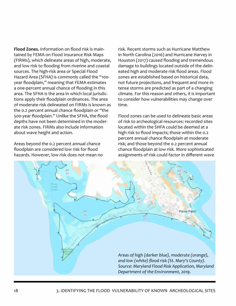
Flood Zones. Information on flood risk is main-tained by FEMA on Flood Insurance Risk Maps (FIRMs), which delineate areas of high, moderate, and low risk to flooding from riverine and coastal sources. The high-risk area or Special Flood Hazard Area (SFHA) is commonly called the “100-year floodplain,” meaning that FEMA estimates a one-percent annual chance of flooding in this area. The SFHA is the area in which local jurisdic-tions apply their floodplain ordinances. The area of moderate risk delineated on FIRMs is known as the 0.2 percent annual chance floodplain or “the 500-year floodplain.” Unlike the SFHA, the flood depths have not been determined in the moder-ate risk zones. FIRMs also include information about wave height and action.
Areas beyond the 0.2 percent annual chance floodplain are considered low risk for flood hazards. However, low risk does not mean no
risk. Recent storms such as Hurricane Matthew in North Carolina (2016) and Hurricane Harvey in Houston (2017) caused flooding and tremendous damage to buildings located outside of the delin-eated high and moderate risk flood areas. Flood zones are established based on historical data, not future projections, and frequent and more in-tense storms are predicted as part of a changing climate. For this reason and others, it is important to consider how vulnerabilities may change over time.
Flood zones can be used to delineate basic areas of risk to archeological resources: recorded sites located within the SHFA could be deemed at a high risk to flood impacts; those within the 0.2 percent annual chance floodplain at moderate risk; and those beyond the 0.2 percent annual chance floodplain at low risk. More sophisticated assignments of risk could factor in different wave
Areas of high (darker blue), moderate (orange), and low (white) flood risk (St. Mary’s County). Source: Maryland Flood Risk Application, Maryland Department of the Environment, 2019.

193. IDENTIFYING THE FLOOD VULNERABILITY OF KNOWN ARCHEOLOGICAL SITES
heights (e.g. the higher the wave heights, the more damage), proximity to flood source within the high flood risk areas, and/or climate projec-tions. The more sophisticated the analysis, the more likely it is that it should be done by some-one who has specialized knowledge about the functions of floodplains, like the local floodplain administrator or a Certified Floodplain Manager working in conjunction with an archeologist.
FIRMs and supporting data are available for download as GIS layers in the Flood Risk Applica-tion maintained by the Maryland Department of the Environment (Refer to “GIS Resources” in Appendix 3). (For more information on how to read a FIRM and understanding floodplain man-agement, refer to the Flood Mitigation Guide, Section 1.A. Flooding and Section 1.B. Floodplain Management.)
Storm Surge. Mapping that depicts the extent of the predicted storm surge associated with hur-ricanes is generated using the GIS application Sea, Lake, and Overland Surges from Hurricanes (SLOSH). The SLOSH program creates a model in-corporating the wind field of hurricane categories 1-5, which drives the storm surge based on esti-mated values from historical, hypothetical and/or predicted hurricanes, while also accounting for atmospheric pressure, size, forward speed and wind data (National Weather Service, 2018). The model forecasts the predicted reach (horizontal extent) and height or depth (vertical extent) of water surge above ground level. The SLOSH pro-
The 10-year shoreline erosion level at Cove Point Lighthouse (Calvert County). Green lines depict where the shoreline is accreting, gray lines where it is protected, and red lines for high rate of erosion. Source: Maryland Flood Risk Application, MDE, 2018.
Hunting Creek showing Category 1-4 storm Surge (Calvert County). Source: Maryland Flood Risk Ap-plication, MDE, 2019.
20 3. IDENTIFYING THE FLOOD VULNERABILITY OF KNOWN ARCHEOLOGICAL SITES
gram then produces a map of inundation levels based on the five categories of hurricanes. Static SLOSH GIS layers are available to view through a variety of sources: the local govern-ment’s Office of Emergency Management (or department responsible for updating the local hazard mitigation plan), MDE’s Maryland Flood Risk Application, and the National Weather Ser-vice (refer to “GIS Resources” in Appendix 3). Determining risk could be as simple as overlaying the locations of archeological resources with the storm surge layers. For those who feel confident using the SLOSH application themselves, the loca-tions of archeological resources can be imported into the application and used to create models that show the predicted depths and velocity of surge at specific locations, as was done for Hunt-ing Creek in Calvert County (Tyler et al, 2017) (refer to Case Study #2 in Appendix 1). If SLOSH is used for specific locations, there will be quantifi-able impacts to those specific areas.
Shoreline Erosion (Riverine and Coastal). Many factors contribute to the loss of a shoreline, such as whether adjacent shorelines are armored; the presence or absence of breakwaters, such as jetties; the movement of water towards the shore; the soil composition; and the presence or absence of a vegetative covering. Basic informa-tion on shoreline erosion is available through Maryland iMap for several counties (refer to “GIS Resources” in Appendix 3). Rates of shoreline erosion can also be deter-mined using GIS applications (described below), or by analyzing various characteristics (geology, geography, hydrography) at specific locations to quantify the risk of erosion to individual ar-cheological sites. Determining rates of shoreline erosion is a complicated endeavor best done in consultation with a specialist such as a coastal geomorphologist. Two different examples of how to determine the rate of shoreline erosion are presented in Appendix 1: Case Studies.
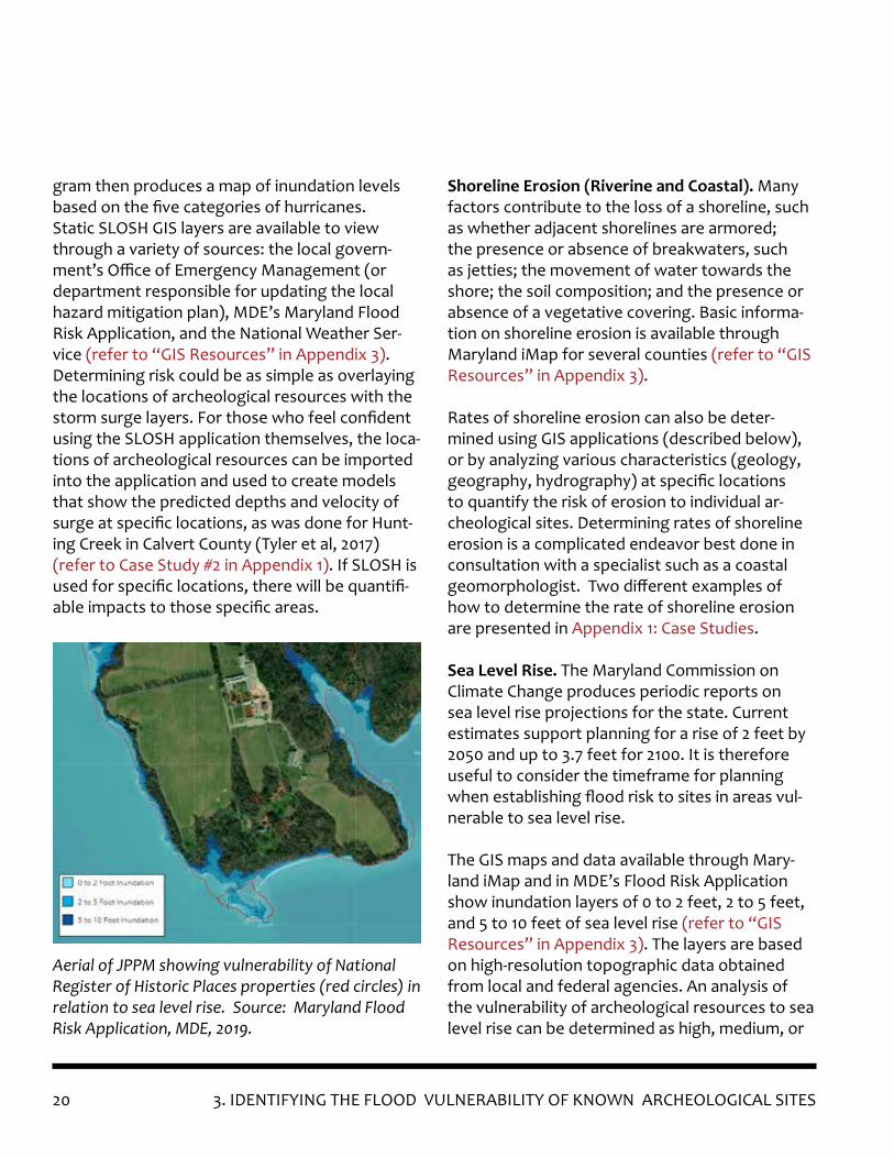
Sea Level Rise. The Maryland Commission on Climate Change produces periodic reports on sea level rise projections for the state. Current estimates support planning for a rise of 2 feet by 2050 and up to 3.7 feet for 2100. It is therefore useful to consider the timeframe for planning when establishing flood risk to sites in areas vul-nerable to sea level rise.
The GIS maps and data available through Mary-land iMap and in MDE’s Flood Risk Application show inundation layers of 0 to 2 feet, 2 to 5 feet, and 5 to 10 feet of sea level rise (refer to “GIS Resources” in Appendix 3). The layers are based on high-resolution topographic data obtained from local and federal agencies. An analysis of the vulnerability of archeological resources to sea level rise can be determined as high, medium, or
Aerial of JPPM showing vulnerability of National Register of Historic Places properties (red circles) in relation to sea level rise. Source: Maryland Flood Risk Application, MDE, 2019.
213. IDENTIFYING THE FLOOD VULNERABILITY OF KNOWN ARCHEOLOGICAL SITES
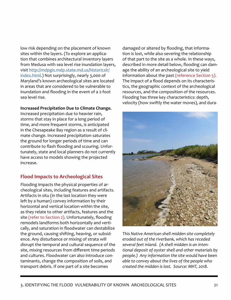
Flooding impacts the physical properties of ar-cheological sites, including features and artifacts. Artifacts in situ (in the last location they were left by a human) convey information by their horizontal and vertical location within the site, as they relate to other artifacts, features and the site (refer to Section 2). Unfortunately, flooding remodels landforms both horizontally and verti-cally, and saturation in floodwater can destabilize the ground, causing shifting, heaving, or subsid-ence. Any disturbance or mixing of strata will disrupt the temporal and cultural sequence of the site, mixing resources from different time periods and cultures. Floodwater can also introduce con-taminants, change the composition of soils, and transport debris. If one part of a site becomes
Flood Impacts to Archeological Sites
This Native American shell midden site completely eroded out of the riverbank, which has receded several feet inland. (A shell midden is an inten-tional deposit of oyster shell and other materials by people.) Any information the site would have been able to convey about the lives of the people who created the midden is lost. Source: MHT, 2018.
low risk depending on the placement of known sites within the layers. (To explore an applica-tion that combines architectural inventory layers from Medusa with sea level rise inundation layers, visit http://mdpgis.mdp.state.md.us/historicslr/index.html.) Not surprisingly, nearly 3,000 of Maryland’s known archeological sites are located in areas that are considered to be vulnerable to inundation and flooding in the event of a 2-foot sea level rise.
Increased Precipitation Due to Climate Change. Increased precipitation due to heavier rain, storms that stay in place for a long period of time, and more frequent storms, is anticipated in the Chesapeake Bay region as a result of cli-mate change. Increased precipitation saturates the ground for longer periods of time and can contribute to flash flooding and scouring. Unfor-tunately, state and local planners do not currently have access to models showing the projected increase.
damaged or altered by flooding, that informa-tion is lost, while also severing the relationship of that part to the site as a whole. In these ways, described in more detail below, flooding can dam-age the ability of an archeological site to yield information about the past (reference Section 5). The impact of a flood depends on its characteris-tics, the geographic context of the archeological resources, and the composition of the resources. Flooding has three key characteristics: depth, velocity (how swiftly the water moves), and dura-

22 3. IDENTIFYING THE FLOOD VULNERABILITY OF KNOWN ARCHEOLOGICAL SITES
tion (how long areas remain inundated before the water recedes). However, the ground cover and composition of the land affects those three characteristics. For example, narrow, restricted river valleys or man-made concrete channels can funnel floodwater and increase the depth and velocity of the flow. Open land can reduce veloc-ity because of the friction provided by vegeta-tion and can spread water across a larger area,
Located on a rise overlooking a river, this test unit at the River Farm Site, a Native American camp or village occupied from the Late Archaic through Woodland periods, flooded overnight due to a high water table rising with the tides. On the left is the unit before archeologists packed up for the day. On the right is the same test unit the next morning. Any microbotanical materials present were de-stroyed by the rising water. Source: Anne Arundel County Trust for Preservation, 2016.
reducing flood depths. If the ground is already saturated from recent storms, its ability to drain might be compromised, keeping areas wet lon-ger. Clay soils and rock are less absorbent than silty or sandy soils. Marshes can act as sponges, absorbing floodwaters. Impervious surfaces like concrete do not absorb water; instead, the water flows along the surface until it reaches a point where it can drain away. Therefore, depending on the kind of flood and the geographic context of an archeological site, the damage to the site may vary significantly.
Water can have numerous deleterious effects on archeological resources. Sites that are preserved because they are dry can degenerate in water. Water washes away delicate materials like mi-croscopic pieces of flora and fauna, which could indicate, for example, what type of diet was con-sumed at a site. Water can break down charcoal which might be useful for radiocarbon dating of a site. Saltwater can change the pH of soil, making it more acidic and prone to dissolve certain types of archeological resources such as bone or other organics. Flood water can also be contaminated with hazards, including sewage, gasoline, motor oil, fertilizer, and dead animals. If floodwater is contaminated with a particularly corrosive mate-rial, the archeological resources could breakdown even faster, especially materials that are more water-sensitive like metal.
Floodwater transports and redeposits debris. We commonly think of debris as sediment from scoured riverbanks or coastal areas, rocks, trees, and other natural materials, but archeological resources can be removed by floodwater and redeposited elsewhere. This causes sites to lose integrity because the artifacts are no longer as-sociated with their original location. Floods can also deposit other materials on top of a site, inter-
233. IDENTIFYING THE FLOOD VULNERABILITY OF KNOWN ARCHEOLOGICAL SITES
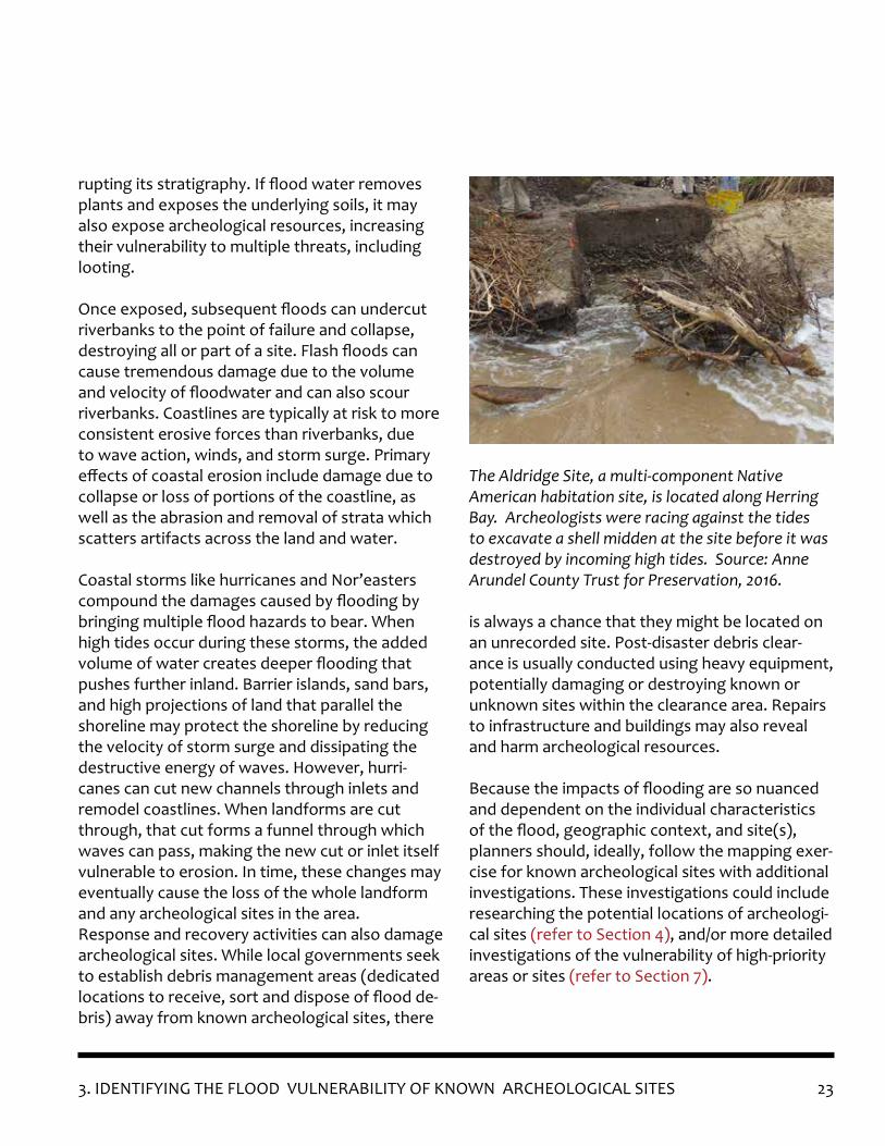
The Aldridge Site, a multi-component Native American habitation site, is located along Herring Bay. Archeologists were racing against the tides to excavate a shell midden at the site before it was destroyed by incoming high tides. Source: Anne Arundel County Trust for Preservation, 2016.
rupting its stratigraphy. If flood water removes plants and exposes the underlying soils, it may also expose archeological resources, increasing their vulnerability to multiple threats, including looting.
Once exposed, subsequent floods can undercut riverbanks to the point of failure and collapse, destroying all or part of a site. Flash floods can cause tremendous damage due to the volume and velocity of floodwater and can also scour riverbanks. Coastlines are typically at risk to more consistent erosive forces than riverbanks, due to wave action, winds, and storm surge. Primary effects of coastal erosion include damage due to collapse or loss of portions of the coastline, as well as the abrasion and removal of strata which scatters artifacts across the land and water.
Coastal storms like hurricanes and Nor’easters compound the damages caused by flooding by bringing multiple flood hazards to bear. When high tides occur during these storms, the added volume of water creates deeper flooding that pushes further inland. Barrier islands, sand bars, and high projections of land that parallel the shoreline may protect the shoreline by reducing the velocity of storm surge and dissipating the destructive energy of waves. However, hurri-canes can cut new channels through inlets and remodel coastlines. When landforms are cut through, that cut forms a funnel through which waves can pass, making the new cut or inlet itself vulnerable to erosion. In time, these changes may eventually cause the loss of the whole landform and any archeological sites in the area.Response and recovery activities can also damage archeological sites. While local governments seek to establish debris management areas (dedicated locations to receive, sort and dispose of flood de-bris) away from known archeological sites, there
is always a chance that they might be located on an unrecorded site. Post-disaster debris clear-ance is usually conducted using heavy equipment, potentially damaging or destroying known or unknown sites within the clearance area. Repairs to infrastructure and buildings may also reveal and harm archeological resources.
Because the impacts of flooding are so nuanced and dependent on the individual characteristics of the flood, geographic context, and site(s), planners should, ideally, follow the mapping exer-cise for known archeological sites with additional investigations. These investigations could include researching the potential locations of archeologi-cal sites (refer to Section 4), and/or more detailed investigations of the vulnerability of high-priority areas or sites (refer to Section 7).
24
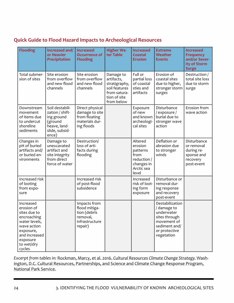
Flooding Increased and/or Heavier Precipitation
Increased Occurrence of Flooding
Higher Wa-ter Table
Increased Coastal Erosion
Extreme Weather Events
Increased Frequency and/or Sever-ity of Storm Surge
Total submer-sion of sites
Site erosion from overflow and new flood channels
Site erosion from overflow and new flood channels
Damage to artifacts, stratigraphy, soil features from satura-tion of site from below
Full or partial loss of coastal sties and artifacts
Erosion of coastal sites due to higher, stronger storm surges
Destruction / total site loss due to storm surge
Downstream movement of items due to undercut shoreline sediments
Soil destabili-zation / shift-ing ground (ground heave, land-slide, subsid-ence)
Direct physical damage to site from floating materials dur-ing floods
Exposure of new and known archeologi-cal sites
Disturbance / exposure / burial due to stronger wave action
Erosion from wave action
Changes in pH of buried artifacts and/or buried en-vironments
Damage to unexcavated artifact and site integrity from direct force of water
Destruction/loss of arti-facts during flooding
Altered erosion patterns from reduction / changes in Arctic sea level
Deflation or abrasion due to stronger winds
Disturbance or removal during re-sponse and recovery post-event
Increased risk of looting from expo-sure
Increased risk of post-flood subsidence
Increased risk of loot-ing form exposure
Disturbance or removal dur-ing response and recovery post-event
Increased erosion of sites due to encroaching water levels, wave action exposure, and increased exposure to wet/dry cycles
Impacts from flood mitiga-tion (debris removal, infrastructure repair)
Destabilization / damage to underwater sites through movement of sediment and/or protective vegetation
Quick Guide to Flood Hazard Impacts to Archeological Resources
Excerpt from tables in: Rockman, Marcy, et al. 2016. Cultural Resources Climate Change Strategy. Wash-ington, D.C. Cultural Resources, Partnerships, and Science and Climate Change Response Program, National Park Service.
3. IDENTIFYING THE FLOOD VULNERABILITY OF KNOWN ARCHEOLOGICAL SITES

25
4. IDENTIFYING POTENTIAL ARCHEOLOGICAL SITES PRONE TO FLOODING
Of course, archeologists have not studied, sur-veyed, or investigated every flood-prone area in Maryland to determine the location of archeo-logical sites. Following the mapping analysis described in Section 3, planners and archeologists may wish to conduct additional research about known sites, to better assess integrity and vul-nerability (refer to Section 6), and/or to identify potential archeological sites within the areas af-fected by flooding.
A research design should guide where to invest the time, money, and labor to systematically investigate an area. An outline of what to in-clude in a research design is provided in MHT’s Standards and Guidelines for Archeological Investigations in Maryland specific to the stage of archeological research being undertaken (survey, evaluation through test unit excava-tion, etc.). In general, the research design sets the parameters and focus of the investigation, provides the theoretical framework for answer-ing questions about the past, and outlines the methods through which the investigation will be conducted. Depending on the project goals and the capacity available, research might proceed in several different ways, including predictive mod-eling, survey, and field testing, outlined below.
A number of factors may also constrain research and therefore affect the research design, includ-ing available time and resources, property access, and consultation with the public. In Maryland, permits are required to perform archeologi-cal investigations on state-owned lands, state-controlled lands, in caves, and on certain private properties. This includes state-owned or state-controlled submerged lands. Researchers need landowners’ permission to enter private property and conduct investigations, and property own-ers may also share personal knowledge about
archeological resources on the property, as well as changes they have observed in the micro-environment during their tenure on the land. For these reasons, establishing and maintaining good relationships with landowners is strongly recom-mended.
Predictive modeling is one method to determine the potential archeological sensitivity of an area (i.e., its likelihood to contain archeological re-sources). Predictive models are developed by analyzing human patterns of interaction with landscapes, using a combination of environmen-tal, cultural, and historical data to determine potential locations for prehistoric activities and settlement. Predictive models should be project-specific, but will often share many variables in common, such as distance to water or the near-est transportation route, slope, soil type, soil drainage, etc. Archeologists typically conduct the analysis and develop the model in GIS. Although primarily used to identify where to conduct field survey, predictive modeling can also be used to test theories on human settlement based on char-acteristics observed at the locations of similar sites (refer to Case Study #3 in Appendix 1).
Predictive models will usually identify areas of high, moderate, and low potential for the pres-ence of archeological resources, based on pa-rameters and questions set forth in the research design. For the purposes of this guidance docu-ment, a predictive model would map the poten-tial location of archeologically sensitive areas in relation to flood hazards. The data can then be used to guide planning for flood mitigation and make decisions about where and how to con-duct field survey (refer to Section 7). It should be
Predictive Models to Identify Archeological Sensitivity
4. IDENTIFYING POTENTIAL ARCHEOLOGICAL SITES PRONE TO FLOODING

26 4. IDENTIFYING POTENTIAL ARCHEOLOGICAL SITES PRONE TO FLOODING
Archeological Survey and Documentation
noted that a predictive model is only as good as the data and variables that go into it. The biases and prior knowledge of the model designer con-tribute to the utility of the model. (For additional information, refer to “Predictive Modeling” in Ap-pendix 3 as well as Case Study #3 in Appendix 1.)
Depending on the project goals and research design, archeological survey and documentation may be necessary to locate unidentified sites and/or to gather additional information about known sites. It can also be used to ground-truth predictive modeling. Any archeological project using state or federal funding will be required to conduct survey and documentation in compliance with state and federal standards, as described be-low. Projects undertaken entirely by local govern-ments or private entities are strongly encouraged to comply with these standards and to share research findings with MHT, to ensure that data remains complete and accessible for the future.
Secretary of the Interior’s Standards for Archeo-logical Documentation. The Secretary of the Interior’s Standards for Archeological Documenta-tion provide a framework for the systematic and consistent collection of data when identifying and evaluating archeological sites. The philoso-phy of the Standards is to take the lightest touch possible, requiring that researchers first examine existing information and only supplementing with new investigations as needed. Excavation meth-ods are destructive even when they are done in accordance with the Standards; therefore, limiting site disturbance (sub-surface testing or excavation) is always a goal when investigating archeological resources.
Standards and Guidelines for Archeological In-vestigations in Maryland. Developed by profes-sional archeologists on MHT’s staff, the Standards and Guidelines for Archeological Investigations in Maryland provide consistency for recording archeological sites in Maryland and completing MASS forms, along with the accompanying report in accordance with the Secretary of the Interior’s Standards for Archeological Documentation. While primarily geared towards compliance archeology for state and federal project review, MHT’s Stan-dards and Guidelines is flexible enough to be ap-plied to other archeological investigations, such as work completed to meet local requirements, research projects, and public archeology projects.
MHT prefers approaches that focus on using pedestrian survey and remote sensing first, with physical excavation as a secondary method for gathering data. However, subsurface testing and/or excavation may be necessary, due to field con-ditions or other factors outlined in the research design. The level of effort should be commensu-rate with the requirement to evaluate the archeo-logical resources for future investigation, deter-mine their significance, and recommend adaptive strategies for the management of impacts to the resources.
Pedestrian Survey. Ideally, archeologists will uti-lize both terrestrial and marine pedestrian survey during the investigation of archeological resourc-es in areas endangered by coastal hazards. In addition to the information collected relating to archeological resources, surveys provide an op-portunity to record observations of existing con-ditions and refine the vulnerability analysis (refer to Flood Impacts in Section 3 and Section 6). A better understanding of an area’s vulnerability can inform adaptive strategies for the treatment of a site and help establish a baseline of existing

274. IDENTIFYING POTENTIAL ARCHEOLOGICAL SITES PRONE TO FLOODING
conditions for use when tracking and recording future damages to a site or area.
If approaching “pedestrian” survey by water, researchers should note that state waters in-clude tidal waters up to the mean high tide line and three miles from the coastline, as well as non-tidal waters that were navigable under the laws of the United States as of April 28, 1788, up to the ordinary high-water mark. A permit is not required to inspect, study, explore, photograph, measure, record, conduct a reconnaissance survey, or otherwise study a submerged archeo-logical historic property in Maryland, if the use or activity does not involve excavation, destruction, or substantive injury to the historic property or its immediate environment. For more information on terrestrial and underwater archeology permits, visit MHT’s website under Permits for Archeology on State Property.
Remote Sensing. Remote sensing is a surface or sub-surface investigative technique that allows for the collection of data through no or limited physical contact with the subject or object under study. Whereas physical excavation is destructive, ending in the removal of at least some portion of the site, remote sensing techniques do not harm a site. This approach requires specialized equip-ment and training for use and to interpret data. (To learn how archeologists used remote sensing at Calverton, refer to Case Study #4 in Appendix 1.)
Remote sensing techniques can be limited if ob-stacles, such as heavy vegetation or forest, exist between survey equipment and the target area for survey. However, remote sensing is faster than excavating shovel test pits across a land-scape and can identify areas with a high potential
for archeological resources. Archeologists ana-lyze data from remote sensing survey to guide where and how additional investigation should occur.
Magnetic susceptibility, magnetometry or gra-diometry, electrical resistivity, and ground pen-etrating radar are all geophysical remote sensing techniques that each have their specific strengths and weaknesses. An analysis of the utility of each technique is beyond the scope of this paper, but planners should consult with an archeological consultant with extensive experience in remote sensing before undertaking such a project. A knowledgeable consultant can advise on the best methods and equipment for a given environment or site type.
Sub-surface Testing. Sub-surface testing can be undertaken as part of survey (as in the case of shovel test pit excavation, described previously), evaluation of a site using formal test units, or salvage/mitigation of a site threatened by devel-opment or natural forces. Sub-surface testing entails artifact recovery as well as the documen-
Archeologists collect fluxgate gradiometer and magnetic susceptibility data during a remote sens-ing survey in Caroline County.
28
tation of artifact locations and the recordation of any features encountered. If an investigation progresses beyond survey work, sub-surface test-ing usually involves the controlled excavation of formal test units under the supervision of a pro-fessional archeologist, who serves as the Principal Investigator (PI) for the project. The PI is respon-sible for completing the work, including fulfilling the research design, publishing the report, and ensuring the curation of artifacts and data. Thor-ough documentation of the site at this stage will usually involve survey and mapping equipment, photography, screening and sampling of soils, analyses, cataloging, and interpretation. The PI – who should meet the Secretary of the Interior’s Professional Qualification Standards – is there to ensure that each of these tasks meets profession-al standards of practice, including those outlined in MHT’s Standards and Guidelines.
Reporting and Cataloguing Artifacts. All phases of archeological investigation should end in a written report. The reporting requirements for compliance-related work can be found in MHT’s Standards and Guidelines for Archeological Inves-tigations in Maryland, which includes the specific information required by the Secretary of the Inte-rior’s Guidelines for Archeological Documentation. For academic archeological investigations, MHT strongly encourages adherence to the relevant portions of the Standards and Guidelines to en-sure consistency in the recording and reporting of archeological properties. MHT incorporates data from archeological report submissions into the Maryland Inventory of Historic Properties archeo-logical site files through either new or updated MASS forms.
Artifacts from archeological investigations in Maryland should be conserved and curated for future study in a facility with experience in the
handling of both archeological data and artifacts. Such a facility should provide climate-controlled storage of the artifacts, as well as curation of the collection in bags and boxes that are conducive to the long-term preservation of the artifacts. Curators with experience in artifact conservation and cataloging will help steward collections and protect their long-term viability for research. In 2018, a technical update to MHT’s Standards and Guidelines provided curation and conservation standards for collections undergoing permanent curation at the MAC Lab. These guidelines can be used as a benchmark for evaluating curation practices and facilities.
4. IDENTIFYING POTENTIAL ARCHEOLOGICAL SITES PRONE TO FLOODING

295. EVALUATING AND DESIGNATING ARCHEOLOGICAL SITES
5. EVALUATING AND DESIGNATINGARCHEOLOGICAL SITES
Of the 14,153 archeological sites that have been identified in Maryland (as of June 2019), only 2,435 (17%) have been evaluated to determine their eligibility for the National Register of His-toric Places, the official list of the Nation’s historic places deemed by the National Park Service to be worthy of preservation. Authorized by the National Historic Preservation Act of 1966, the National Register of Historic Places and its crite-ria (described below) underpin federal and state historic preservation programs. If an archeo-logical site is recognized by MHT or the National Park Service as meeting the criteria for National Register eligibility, then that site is understood as “historic” by federal and state agencies. In the case of federal or state undertakings (permitting, funding, construction, etc.), this means that the federal or state agency must consider ways to avoid, minimize or compensate for harm to the historic property (refer to Section 2). Archeologi-cal sites in Maryland that are listed in, or deter-mined eligible for listing in, the National Register of Historic Places are included in Medusa, with their relevant documentation (refer to Section 3).
Of the 2,435 sites evaluated, 318, or 13%, were determined to be eligible for listing in the Na-tional Register, while 2,117 have been determined to be ineligible for the National Register. This disparity underscores the importance of profes-sional evaluation: just because a site exists, it is not necessarily significant. While it is possible to determine an archeological site important for protection or research due to local cultural asso-ciations, National Register eligibility is, by far, the most common standard by which archeological sites are prioritized for treatment. National Reg-ister eligibility is evaluated by examining a site’s integrity and significance.
Integrity. Integrity relates to the ability of a site to demonstrate its significance and to retain most, if not all, of the aspects that make it sig-nificant. The integrity of the site will help deter-mine whether it is a viable candidate for further research, though archeologists use a variety of factors to make that decision. One of the most important factors in determining the integrity of the site is whether provenience within the site re-mains intact. Provenience is the three-dimension-al location of an artifact, ecofact, or feature that allows archeologists to determine its relationship to other artifacts, ecofacts, or features on site. Archeologists record both the horizontal and ver-tical location of an archeological find to evaluate its context within the site. This provenience is, in many ways, more important than the artifacts recovered from a site (refer to Section 2).
Significance. Once archeologists have deter-mined that a site has integrity, the next step is to determine whether the site is significant. Archeologists may consider a site significant if it is a rare, unique, or unspoiled example from a specific time period, geographic region, or event. Sites vary dramatically in size and can have local, state, national, or international significance. It is important to stress, however, that the majority of recorded sites have not been evaluated for significance, due in part to the research designs and the purposes of the excavations.
To be determined eligible for listing in the Nation-al Register of Historic Places, archeological sites must meet one or more of the following criteria:
A. association with events that have made a significant contribution to the broad patterns of our history;
30 5. EVALUATING AND DESIGNATING ARCHEOLOGICAL SITES
B. association with the lives of persons sig-nificant in our past;
C. embody the distinctive characteristics of a type, period, or method of construction, or that represent the work of a master, or that possess high artistic value, or that represent a significant and distinguishable entity whose components may lack individual distinction; or
D. that have yielded, or may be likely to yield, information important in prehistory or his-tory.
Criterion D is most often applied to archeological sites. For a site to be eligible under Criterion D, sufficient research and testing must have been completed to demonstrate that a site not only has the potential to yield information, but that the information is important enough to make a significant contribution to the knowledge and understanding of defined aspects of prehistory or history. Typically, that evaluation is performed through sub-surface site testing (usually involving the excavation of formal test units) conducted in accordance with MHT’s Standards and Guidelines. An archeologist may recommend a site with both significance and integrity for a determination of eligibility for the National Register. Depending on the circumstance, this determination may be made by the involved federal or state agency in consultation with MHT or by the National Park Service. Listing in the National Register of Historic Places requires a public process and evaluation by the National Park Service.
Evaluation is an important tool for prioritizing valuable, or potentially valuable, archeological resources while those resources are still intact enough to provide additional information. It is also a necessary step in determining the appropri-
ate treatment of the resources. Treatments can include, but are not limited to, additional re-search, interpretation, stabilization, and field sur-vey. In evaluating resources vulnerable to flood hazards, treatment options should also include potential adaptive strategies for flood protection. At this time, flooding and inundation threatens archeological sites from all time periods in loca-tions across Maryland. Most have never been evaluated. The artifacts and data recovered from these sites will be all that remains once the sites are destroyed or become inaccessible.
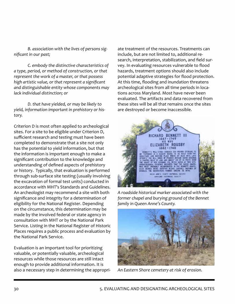
A roadside historical marker associated with the former chapel and burying ground of the Bennet family in Queen Anne’s County.
An Eastern Shore cemetery at risk of erosion.
31
Although largely underground and amenable to exploration using archeological tech-niques, burial sites represent a unique type of historic resource. Their value often centers around aesthetic beauty or their significance to living descendants or affiliat-ed groups. Unlike archeological sites, cemeteries do not have a high potential to yield information about the lives of historical persons, social and economic trends, archi-tecture and design, or other characteristics more typical of places where people have lived and left traces in the environment. Because of this, as a property type, cemeter-ies are not normally considered eligible for National Register listing (NPS 1992). Al-though biological information about buried humans can be gleaned from cemetery sites, MHT generally discourages the excavation of burial sites solely for the recovery of biological data as archeological research.
MHT does not maintain a dedicated inventory of burial sites. If cemeteries appear in MHT’s records, those with visible above ground features (grave markers, monuments, boundary markers, furniture, ornamental plantings, etc.) are generally inventoried as architectural or landscape resources, in the MIHP. Those lacking such features are often inventoried as archeological resources, via MASS forms. Many burial sites are inventoried as part of architectural complexes, such as a family cemetery located on a nineteenth century farmstead, and some burial sites may be listed in both the ar-chitectural and archeological inventories. Occasionally a burial site may possess ar-chitectural or landscape design or artistic qualities that distinguish it, or it may be the only surviving site associated with an important historical figure. These consid-erations may render a burial site eligible for National Register listing. In these cases, researchers may find information about inventoried cemeteries in Medusa, but it is important to note that MHT’s data is incomplete and largely incidental, and research-ers are encouraged to seek additional information elsewhere.
Many counties maintain inventories at the local level. As of July 2019, ten counties have ordinances that protect or prescribe the treatment of burial sites. MHT encour-ages local planning for cemeteries and can provide technical assistance for communi-ties that wish to take these resources into consideration. As with other types of his-toric properties, treatment depends on the circumstances of the property, the needs and resources of property owners, and the will of the community. When cemeteries are threatened by natural processes, some communities choose to intervene, and others prefer to allow the burial sites to return to the earth. Further information on cemetery law, the state of cemetery data maintained by counties, and technical assis-tance can be found on the MHT website.
ARE CEMETERIES ARCHEOLOGICAL SITES?
5. EVALUATING AND DESIGNATING ARCHEOLOGICAL SITES

32
336. PRIORITIZING NEW RESEARCH: SURVEY AND FLOOD VULNERABILITY
With limited resources to conduct investigations, planners and researchers must prioritize new survey and documentation efforts. Factors for pri-oritization might include, but are not limited to:
• Significance, or potential significance, of the archeological site or potential resource;
• Underrepresented site types, cultural groups, or periods of time;
• Areas with high potential for unidentified sites, located in high hazard areas; and
• Areas that are less impacted by natural haz-ards.
There is no “right way” to prioritize; however, pri-oritization should be based on the flood vulner-ability of known archeological sites (refer to Sec-tion 3), the results from archival and background research (refer to Section 3), and any predictive modeling (refer to Section 4). A “gap analysis” – an assessment of what data is missing within the archeological record –can guide investigations to potentially significant sites, unstudied or under-studied site types, temporal periods, or geo-graphic areas. MHT’s database resources, such as Medusa or the Archeological Synthesis Project, can be accessed and used by qualified archeolo-gists to facilitate such gap analyses. However, because “underrepresented” may equate to be-ing understudied, additional research phases may be needed to inform a gap analyses or develop archeological contexts.
Prioritizing significance may make funding more readily available for the work, as it is easier to justify expenditures for the most important (or potentially important) sites. However, there are disadvantages to using significance as the prima-ry factor for prioritizing where to investigate and what to protect. Not all recorded sites have been evaluated (refer to Section 5), and potential sites
are difficult to prioritize. Further, “significance” is a loaded term: what a researcher finds significant may not be understood or valued as significant by the community. Significance may seem like an expedient way to prioritize investigation and pro-tection of sites, but it is more complex and may require more research than is apparent.
Prioritizing based on vulnerability focuses the investigation on locations with high potential for archeological resources that are also at high risk to flood hazards. For this method, it is nec-essary to conduct a more detailed analysis to comprehensively quantify the threat. Key ques-tions include: How susceptible to erosion is a shoreline? What is the rate of shoreline retreat per year? What is the ability of saturated soils to quickly drain? How much rain can the soil absorb before liquefying and collapsing? What is the rate at which saltwater marshes are overtaking fresh-water marshes and dry land? What is the extent of the predicted storm surge for the different hurricane storm categories? What is the extent of predicted sea level rise? Will these potential effects negatively impact archeological resources, and if yes, then how? This more in-depth analysis of hazards and their specific effects on archeo-logical resources requires coordination between an emergency manager or floodplain administra-tor, a GIS analyst and a professional archeologist. (Refer to “Flood impacts to Archeological Sites” in Section 3 and Appendix 1: Case Studies.)
A detailed hazard analysis, conducted by the ar-cheologist with a floodplain specialist, will also be useful when determining what, if any, actions can be taken to slow, reduce, or halt the detrimental effects of the flood hazards on locations (poten-tially) containing archeological resources (refer to Section 7). This analysis will also help forecast how long it might take for a vulnerable site to
6. PRIORITIZING NEW RESEARCH: SURVEY AND FLOOD VULNERABILITY

34 6. PRIORITIZING NEW RESEARCH: SURVEY AND FLOOD VULNERABILITY
be destroyed and lost for research purposes. For example, if a shoreline erodes at a rate of 20 feet within five years, and most sites lie at the water’s edge, waiting two to three years to begin an investigation will mean a potential loss of 8 to 12 feet of land, including archeological resources, before the project can begin. In some cases, the hazard may be so great that it makes more sense to prioritize research on areas less prone to flooding impacts (or at least immediate flood-ing impacts), than those archeological resources which cannot be salvaged by the time excavation funding and resources can be brought to bear. Finally, areas actively threatened by flooding are more likely to be targeted for mitigation by local or state government, especially if flood mitiga-tion measures will protect life and property. This could be good or bad for archeological sites – good because mitigation may also protect sites further inland, and bad because the construction related to mitigation might damage or destroy any sites on the coast. If flood mitigation action requires state or federal permits or funding, it will trigger compliance with the National Historic Preservation Act and the Maryland Historical Trust Act (refer to Section 2).
Of course, all prioritization decisions involve some acceptance of loss in areas that were not prioritized for investigation or protection. Priori-tization privileges the selected sites over other sites that might also be endangered by natural hazards. Because of this, as much as possible, decisions regarding prioritization should be made with community input and only after careful con-sideration of background research and an analysis of the flood threat and area’s vulnerability (refer to Section 3).
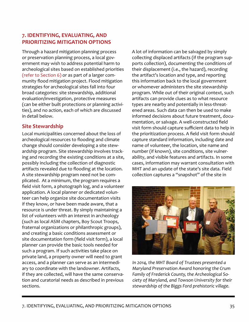
357. IDENTIFYING, EVALUATING, AND PRIORITIZING MITIGATION OPTIONS
Through a hazard mitigation planning process or preservation planning process, a local gov-ernment may wish to address potential harm to archeological sites based on established priorities (refer to Section 6) or as part of a larger com-munity flood mitigation project. Flood mitigation strategies for archeological sites fall into four broad categories: site stewardship, additional evaluation/investigation, protective measures (can be either built protections or planning activi-ties), and no action, each of which are discussed in detail below.
Local municipalities concerned about the loss of archeological resources to flooding and climate change should consider developing a site stew-ardship program. Site stewardship involves track-ing and recording the existing conditions at a site, possibly including the collection of diagnostic artifacts revealed due to flooding at the location. A site stewardship program need not be com-plicated. At a minimum, the program requires a field visit form, a photograph log, and a volunteer application. A local planner or dedicated volun-teer can help organize site documentation visits if they know, or have been made aware, that a resource is under threat. By simply maintaining a list of volunteers with an interest in archeology (such as local ASM chapters, Boy Scout Troops, fraternal organizations or philanthropic groups), and creating a basic conditions assessment or site documentation form (field visit form), a local planner can provide the basic tools needed for such a program. If such activities take place on private land, a property owner will need to grant access, and a planner can serve as an intermedi-ary to coordinate with the landowner. Artifacts, if they are collected, will have the same conserva-tion and curatorial needs as described in previous sections.
A lot of information can be salvaged by simply collecting displaced artifacts (if the program sup-ports collection), documenting the conditions of their displacement (i.e., the hazard), recording the artifact’s location and type, and reporting this information back to the local government or whomever administers the site stewardship program. While out of their original context, such artifacts can provide clues as to what resource types are nearby and potentially in less-threat-ened areas. Such data can then be used to make informed decisions about future treatment, docu-mentation, or salvage. A well-constructed field visit form should capture sufficient data to help in the prioritization process. A field visit form should capture standard information, including date and name of volunteer, the location, site name and number (if known), site conditions, site vulner-ability, and visible features and artifacts. In some cases, information may warrant consultation with MHT and an update of the state’s site data. Field collection captures a “snapshot” of the site in
7. IDENTIFYING, EVALUATING, ANDPRIORITIZING MITIGATION OPTIONS
Site Stewardship
In 2014, the MHT Board of Trustees presented a Maryland Preservation Award honoring the Crum Family of Frederick County, the Archeological So-ciety of Maryland, and Towson University for their stewardship of the Biggs Ford prehistoric village.
36 7. IDENTIFYING, EVALUATING, AND PRIORITIZING MITIGATION OPTIONS
time, making it possible to begin tracking change over time at a given resource.
Site stewardship programs may serve as a tool for public outreach about the effects of natural hazards, including climate change, and for edu-cating the public on the proper and ethical treat-ment of archeological resources. These programs can be established as public-private partnerships between local government and academic institu-tions, nonprofit groups, and landowners. Pro-gram guidelines should address the program’s purpose, requirements for participants, whether the program supports artifact collecting (includ-ing why or why not), and a code of ethics.
Stewardship programs typically rely heavily on volunteer labor. Volunteers may be professional archeologists, people with an interest but no experience in archeology, and everyone in be-tween. Training and education are the hallmarks of a good stewardship program, and topics might include: ethics, “Archeology 101,” artifact identi-fication (if the program supports collecting), the prehistory and history of the area, field safety, how to assess site vulnerability, and how to re-cord existing conditions.
These partnerships require trust: that the volun-teers will abide by the code of ethics and that the local government or program sponsor will pro-vide volunteers with the training they need. With care and investment, site stewardship programs can play an important role in developing and pri-oritizing mitigation strategies for vulnerable sites. (Refer to “Site Stewardship” in Appendix 3 for more information on stewardship programs.)
In some cases, following archival and background research, predictive modeling, and/or field survey, the archeologist might determine the need for additional investigations to gather sufficient data (refer to Section 4) to evaluate the archeological resources and/or make a formal determination of significance (refer to Section 5). Under these circumstances it might be prudent to include objectives in the research design that relate to archeological resources and flood hazards. For example, in addition to the objectives listed in the Standards and Guidelines for Archeological Investi-gations in Maryland, consider including objectives that address the effects of flood hazards:
• Quantify the threat to the site by flood haz-ard,
• Determine the horizontal and vertical extent of the damage to the resources by those haz-ards, and
• Analyze adaptive methods to determine addi-tional management strategies for the project area.
Successfully protecting archeological resources reduces or (more rarely) eliminates the effects of the hazard. Hazard mitigation projects, espe-cially those funded by FEMA as part of a hazard mitigation plan, are used to protect the life and safety of people, infrastructure, buildings, and sometimes agricultural land. (See MHT’s Flood Mitigation Guide: Maryland’s Historic Buildings, Chapter 2 for more information about the hazard mitigation planning process.) These projects do not usually prioritize undeveloped land or cultur-ally significant areas, such as archeological sites, for protection, in part due to the federal require-
Additional Evaluation and Investigation
Protect in Place
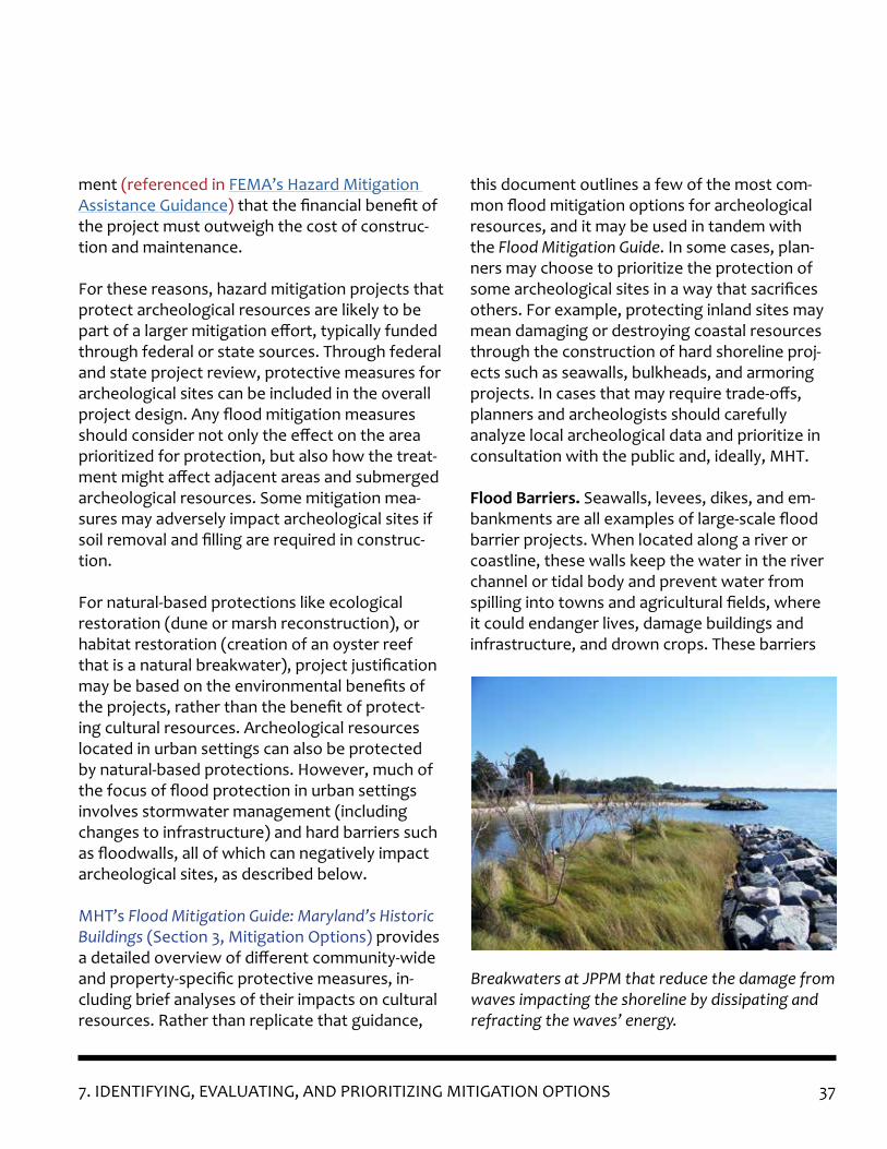
37
ment (referenced in FEMA’s Hazard Mitigation Assistance Guidance) that the financial benefit of the project must outweigh the cost of construc-tion and maintenance.
For these reasons, hazard mitigation projects that protect archeological resources are likely to be part of a larger mitigation effort, typically funded through federal or state sources. Through federal and state project review, protective measures for archeological sites can be included in the overall project design. Any flood mitigation measures should consider not only the effect on the area prioritized for protection, but also how the treat-ment might affect adjacent areas and submerged archeological resources. Some mitigation mea-sures may adversely impact archeological sites if soil removal and filling are required in construc-tion.
For natural-based protections like ecological restoration (dune or marsh reconstruction), or habitat restoration (creation of an oyster reef that is a natural breakwater), project justification may be based on the environmental benefits of the projects, rather than the benefit of protect-ing cultural resources. Archeological resources located in urban settings can also be protected by natural-based protections. However, much of the focus of flood protection in urban settings involves stormwater management (including changes to infrastructure) and hard barriers such as floodwalls, all of which can negatively impact archeological sites, as described below.
MHT’s Flood Mitigation Guide: Maryland’s Historic Buildings (Section 3, Mitigation Options) provides a detailed overview of different community-wide and property-specific protective measures, in-cluding brief analyses of their impacts on cultural resources. Rather than replicate that guidance,
this document outlines a few of the most com-mon flood mitigation options for archeological resources, and it may be used in tandem with the Flood Mitigation Guide. In some cases, plan-ners may choose to prioritize the protection of some archeological sites in a way that sacrifices others. For example, protecting inland sites may mean damaging or destroying coastal resources through the construction of hard shoreline proj-ects such as seawalls, bulkheads, and armoring projects. In cases that may require trade-offs, planners and archeologists should carefully analyze local archeological data and prioritize in consultation with the public and, ideally, MHT.
Flood Barriers. Seawalls, levees, dikes, and em-bankments are all examples of large-scale flood barrier projects. When located along a river or coastline, these walls keep the water in the river channel or tidal body and prevent water from spilling into towns and agricultural fields, where it could endanger lives, damage buildings and infrastructure, and drown crops. These barriers
Breakwaters at JPPM that reduce the damage from waves impacting the shoreline by dissipating and refracting the waves’ energy.
7. IDENTIFYING, EVALUATING, AND PRIORITIZING MITIGATION OPTIONS

38
are coupled with pump stations located at critical points to pump water that overtops the wall back into the river or tidal body.
Construction of large-scale flood protection always involves ground disturbance and is likely to damage/destroy any subsurface archeological resources. Barriers are typically constructed to meet a specific kind of storm risk. If a storm of a greater magnitude occurs, the water will overtop the barrier, and even if there are pumps, it could still flood the “protected” areas behind the wall. These types of protection can also cause negative environmental impacts if they sever the natural connection between the water and the land, de-stroying habitat and interfering with the natural functions of the floodplain.
Typically, barrier projects are funded by federal entities like the U.S. Army Corps of Engineers or FEMA (and administered through the Maryland Emergency Management Agency) and will trigger compliance with Section 106 of the National His-toric Preservation Act and the Maryland Historical Trust Act (refer to Section 2).
Stormwater Management Systems. A storm-water management system can include drain-age ditches, culverts, subsurface piping, water storage areas, retention ponds, and pump sta-tions. These systems can be overwhelmed due to increasingly intense storms, undersized or older systems that are not designed to handle the current precipitation patterns, and the lack of routine maintenance. Generally, the engineered subsurface systems protect more urban areas, while ditches and culverts provide drainage in rural areas.
The construction or expansion of stormwater management systems usually involves some type
Example of an armored embankment along the Potomac River (Allegany County).
Protecting the shoreline using a combination of coir fiber logs and stacked sandbags to protect a Native American ossuary (resting place for human skeletal remains).
7. IDENTIFYING, EVALUATING, AND PRIORITIZING MITIGATION OPTIONS

39
of ground disturbance and is likely to damage or destroy subsurface archeological resources (although improved stormwater management may provide protection as well). On the other hand, if existing systems fail, the effects can be catastrophic: archeological resources could be inundated and saturated for days with contami-nated floodwater. As with any large-scale project, federal or state funding or permits will likely be involved and trigger compliance with Section 106 of the National Historic Preservation Act or the Maryland Historical Trust Act.
Natural Infrastructure Solutions. Utilizing natu-ral or “green” infrastructure, such as ecosystem restoration, can reduce the effects of storm surge by returning the floodplain to its natural water management function. Natural infrastructure is often a better option for flood protection than “hardscape” infrastructure or barriers, because it provides ancillary benefits related to habitat res-toration and improvement in water quality. For example, a healthy dune system can absorb the impact of storm surge and high waves and pre-vent or delay flooding by providing a natural bar-rier against flood and wind-driven storm surge. Coastal wetlands can reduce the velocity, depth, and wave energy of the storm surge. The extent to which a wetland can reduce the effect of storm surge is dependent on the characteristics of the wetland such as the geography, size, and type of wetland. Wetlands also function as natural spong-es, storing excess flood water. Natural breakwa-ters, like oyster reefs, help with wave attenua-tion, reducing the impact of the surge. Natural infrastructure is often preferred for protecting preserves and parkland, or when using natural ar-eas as buffers for developed areas, like the dune system protecting Ocean City, Maryland.
In many cases, natural infrastructure restora-tion can serve a dual purpose by also protecting archeological resources located in those areas, with less of an impact than barrier or hard infra-structure development. As a result, these adap-tive measures can be more suitable to protecting archeological resources in undeveloped or rural areas. Natural infrastructure projects, whether or not they require compliance with the Na-tional Historic Preservation Act or the Maryland Historical Trust Act, still involve changes to the environment and should take care to ensure the protection of archeological sites in the design and implementation phases.
Natural infrastructure projects have different funding streams than structural projects and have different requirements related to environmen-tal benefits. These projects may be undertaken by forming partnerships with environmental nonprofits, either through collaborative fund-raising or volunteer efforts. For example, the Chesapeake Bay Foundation conducts oyster reef restoration projects, creating living breakwaters composed of oysters, which are natural filters and improve water quality. A joint project with the Foundation could both protect archeological resources and improve environmental conditions in the Bay.
Shoreline Protection. Both “hard” structural solutions and natural infrastructure solutions are used to address shoreline loss due to wave action and coastal erosion. Examples of hard structural solutions include revetments and rip-rap (fortified slopes or banks constructed from large stones or pieces of concrete); groins (ori-ented perpendicular to the shoreline; constructed from large stones or pieces of concrete); jetties (oriented parallel to shoreline, constructed from large stones or pieces of concrete constructed
7. IDENTIFYING, EVALUATING, AND PRIORITIZING MITIGATION OPTIONS
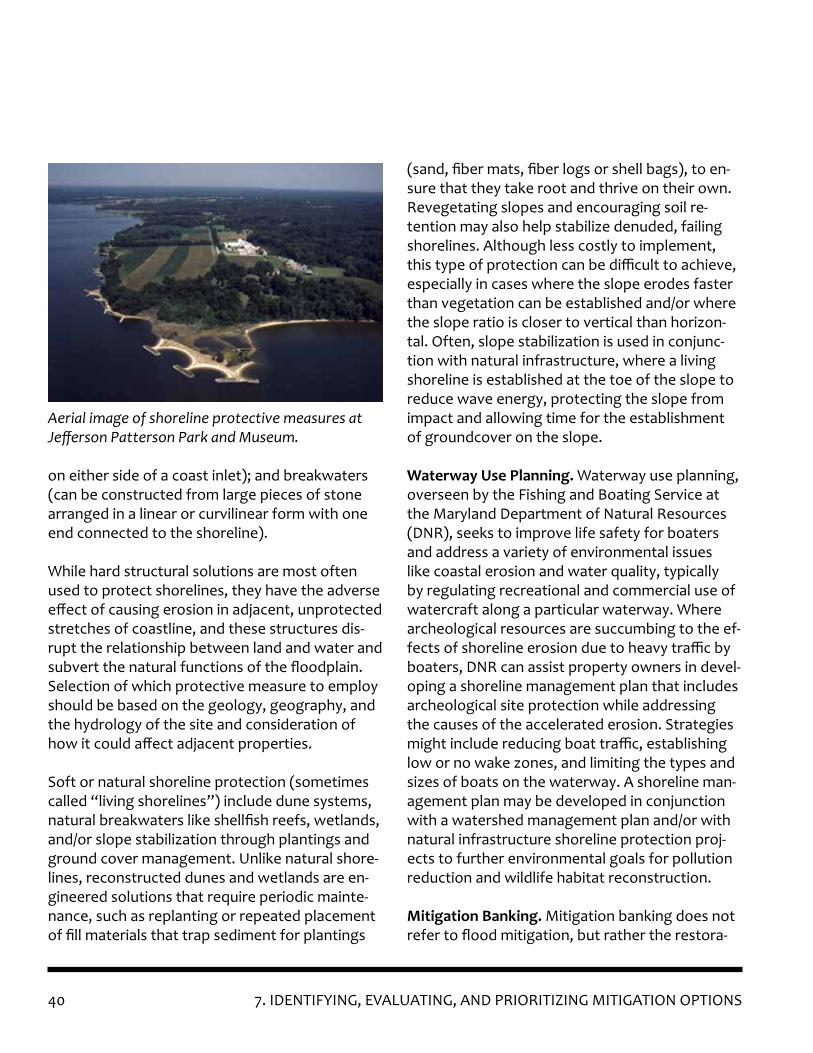
40
on either side of a coast inlet); and breakwaters (can be constructed from large pieces of stone arranged in a linear or curvilinear form with one end connected to the shoreline).
While hard structural solutions are most often used to protect shorelines, they have the adverse effect of causing erosion in adjacent, unprotected stretches of coastline, and these structures dis-rupt the relationship between land and water and subvert the natural functions of the floodplain. Selection of which protective measure to employ should be based on the geology, geography, and the hydrology of the site and consideration of how it could affect adjacent properties.
Soft or natural shoreline protection (sometimes called “living shorelines”) include dune systems, natural breakwaters like shellfish reefs, wetlands, and/or slope stabilization through plantings and ground cover management. Unlike natural shore-lines, reconstructed dunes and wetlands are en-gineered solutions that require periodic mainte-nance, such as replanting or repeated placement of fill materials that trap sediment for plantings
(sand, fiber mats, fiber logs or shell bags), to en-sure that they take root and thrive on their own.Revegetating slopes and encouraging soil re-tention may also help stabilize denuded, failing shorelines. Although less costly to implement, this type of protection can be difficult to achieve, especially in cases where the slope erodes faster than vegetation can be established and/or where the slope ratio is closer to vertical than horizon-tal. Often, slope stabilization is used in conjunc-tion with natural infrastructure, where a living shoreline is established at the toe of the slope to reduce wave energy, protecting the slope from impact and allowing time for the establishment of groundcover on the slope.
Waterway Use Planning. Waterway use planning, overseen by the Fishing and Boating Service at the Maryland Department of Natural Resources (DNR), seeks to improve life safety for boaters and address a variety of environmental issues like coastal erosion and water quality, typically by regulating recreational and commercial use of watercraft along a particular waterway. Where archeological resources are succumbing to the ef-fects of shoreline erosion due to heavy traffic by boaters, DNR can assist property owners in devel-oping a shoreline management plan that includes archeological site protection while addressing the causes of the accelerated erosion. Strategies might include reducing boat traffic, establishing low or no wake zones, and limiting the types and sizes of boats on the waterway. A shoreline man-agement plan may be developed in conjunction with a watershed management plan and/or with natural infrastructure shoreline protection proj-ects to further environmental goals for pollution reduction and wildlife habitat reconstruction.
Mitigation Banking. Mitigation banking does not refer to flood mitigation, but rather the restora-
Aerial image of shoreline protective measures at Jefferson Patterson Park and Museum.
7. IDENTIFYING, EVALUATING, AND PRIORITIZING MITIGATION OPTIONS
41
tion of a wetland, stream, or other aquatic re-source as compensation for unavoidable adverse impacts to aquatic resources under federal, state, or local wetland regulation. It is similar in concept to mitigation for harm to historic and cultural properties, established through consultation un-der Section 106 of the National Historic Preserva-tion Act. Mitigation banking for aquatic resources is typically more stringent than mitigation for his-toric and cultural properties, requiring a project’s ecological success and long-term protection. If archeological sites or areas of high archeological sensitivity occur in areas suitable for mitigation banking, selection of bank areas could be done with both goals in mind. (More on mitigation banking can be found in Appendix 3.)
MHT’s Standards and Guidelines for Archeological Investigations in Maryland refers to the accep-tance of loss as a rare occurrence. Sadly, current flood hazards, coupled with those projected to in-crease with climate change, means that unavoid-able loss may become more common. In areas of extreme coastal erosion, the shoreline loss may occur too quickly to meaningfully investigate ar-eas under threat. Areas actively converting from dry land to marshland and freshwater marshes converting to saltwater marshes transition too quickly for vulnerable, fragile archeological re-sources to withstand those changes. Sites which are actively degrading may not have enough left to evaluate by the time the fieldwork begins or to conduct further investigation after the site has been surveyed. These sites are among those colloquially described as “goners” – the sites that will not survive another generation without extraordinary measures to save them (Berenfeld, 2015: 6).
No Action
In some cases, “no action” may become the best possible alternative, especially for sites that may already lack integrity or significance, making them less able to convey information that advances our understanding or knowledge of the past. For sites at risk, the decision to take no action should be based on a careful analysis of the background and archival research, additional survey (if ap-propriate), and a thorough understanding of the vulnerability of the archeological resources. Using all the information at hand to decide when to let sites go is a difficult decision, but there are too many resources at risk to investigate and save all of them.
Salvage or “rescue” archeology is sub-surface excavation, usually undertaken at speed, to docu-ment a site and collect archeological data when destruction is imminent. Although salvage arche-ology is not ideal, it may be the only viable option for data recovery under certain circumstances. Unfortunately, unless a local jurisdiction has an archeology program or a standing arrangement with an archeological consultant, it is unlikely that the necessary funding, expertise, and resources can be mustered to salvage an exceptional, but threatened, site.
As always, salvage archeology should only be undertaken by, or under the guidance of a quali-fied archeologist (refer to Section 2). Planners and archeologists should consider the following criteria in determining whether to conduct sal-vage archeology.
1. The site should be under imminent threat of destruction (within a few months to 1 or 2 years). Justification for this threat assess-ment should be based on predictive model-
Salvage Archeology
7. IDENTIFYING, EVALUATING, AND PRIORITIZING MITIGATION OPTIONS
42
ing, documentation of erosion rates from site stewardship activities or other monitoring, or an assessment by a professional archeological consultant.
2. The site appears to have intact cultural fea-tures which will be lost or are under active erosion.
3. A preliminary assessment of the site (at a minimum) has been made to determine the site type, the cultures or communities repre-sented, and time periods in evidence. If a re-source type is well-represented across Mary-land, salvage archeology may be a wasted or redundant effort.
4. Sufficient resources, including a qualified PI, can be brought to bear to ensure that rigor-ous scientific excavation, documentation, and publication will be carried through to comple-tion.
5. All required permissions and permits have been obtained.
6. Consideration has been made for the final dis-position of the artifact collection and records (i.e. conservation and curation).
7. There are no other reasonable alternatives to salvage and the resource is simply too impor-tant or potentially.
Because excavation destroys an archeological site, salvage archeology should be avoided if other investigative alternatives are feasible.
7. IDENTIFYING, EVALUATING, AND PRIORITIZING MITIGATION OPTIONS

43
Although floodwaters threaten many known and as-yet-unidentified archeological sites along Maryland’s coasts and waterways, planners and archeologists can work together to prioritize and manage areas at risk and protect our past for future generations. MHT looks forward to assisting communities around the state as they begin these efforts by helping to connect them to funding resources, technical assistance, and each other.
8. CONCLUSION
8. CONCLUSION
Six hundred years ago, this farm field along the Po-tomac was home to a large Native American village with several houses surrounded by a tall palisade.
Drone imagery of the submerged WWI-era Emer-gency Fleet Corporation ships in the Mallows Bay National Marine Sanctuary. Source: Marine Robot-ics and Remote Sensing, Duke University.

44
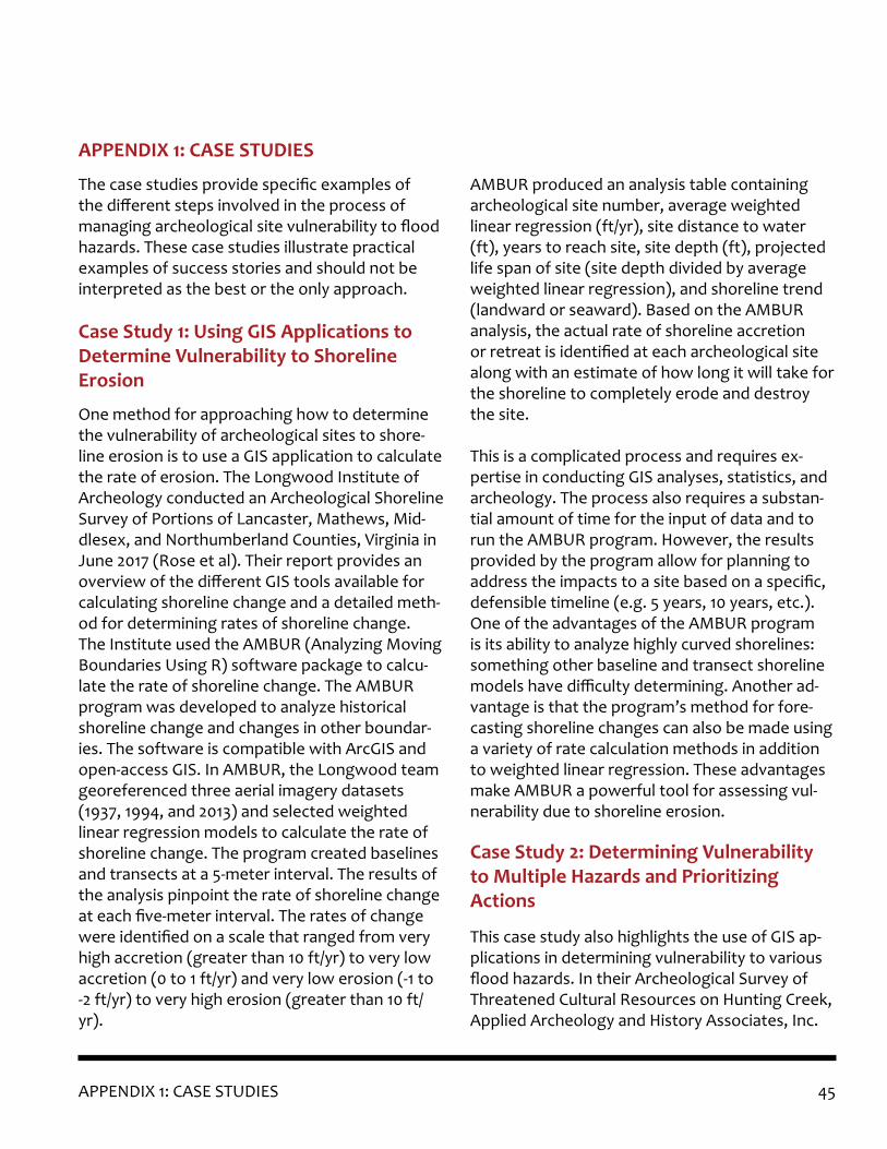
45APPENDIX 1: CASE STUDIES
The case studies provide specific examples of the different steps involved in the process of managing archeological site vulnerability to flood hazards. These case studies illustrate practical examples of success stories and should not be interpreted as the best or the only approach.
One method for approaching how to determine the vulnerability of archeological sites to shore-line erosion is to use a GIS application to calculate the rate of erosion. The Longwood Institute of Archeology conducted an Archeological Shoreline Survey of Portions of Lancaster, Mathews, Mid-dlesex, and Northumberland Counties, Virginia in June 2017 (Rose et al). Their report provides an overview of the different GIS tools available for calculating shoreline change and a detailed meth-od for determining rates of shoreline change. The Institute used the AMBUR (Analyzing Moving Boundaries Using R) software package to calcu-late the rate of shoreline change. The AMBUR program was developed to analyze historical shoreline change and changes in other boundar-ies. The software is compatible with ArcGIS and open-access GIS. In AMBUR, the Longwood team georeferenced three aerial imagery datasets (1937, 1994, and 2013) and selected weighted linear regression models to calculate the rate of shoreline change. The program created baselines and transects at a 5-meter interval. The results of the analysis pinpoint the rate of shoreline change at each five-meter interval. The rates of change were identified on a scale that ranged from very high accretion (greater than 10 ft/yr) to very low accretion (0 to 1 ft/yr) and very low erosion (-1 to -2 ft/yr) to very high erosion (greater than 10 ft/yr).
AMBUR produced an analysis table containing archeological site number, average weighted linear regression (ft/yr), site distance to water (ft), years to reach site, site depth (ft), projected life span of site (site depth divided by average weighted linear regression), and shoreline trend (landward or seaward). Based on the AMBUR analysis, the actual rate of shoreline accretion or retreat is identified at each archeological site along with an estimate of how long it will take for the shoreline to completely erode and destroy the site.
This is a complicated process and requires ex-pertise in conducting GIS analyses, statistics, and archeology. The process also requires a substan-tial amount of time for the input of data and to run the AMBUR program. However, the results provided by the program allow for planning to address the impacts to a site based on a specific, defensible timeline (e.g. 5 years, 10 years, etc.). One of the advantages of the AMBUR program is its ability to analyze highly curved shorelines: something other baseline and transect shoreline models have difficulty determining. Another ad-vantage is that the program’s method for fore-casting shoreline changes can also be made using a variety of rate calculation methods in addition to weighted linear regression. These advantages make AMBUR a powerful tool for assessing vul-nerability due to shoreline erosion.
This case study also highlights the use of GIS ap-plications in determining vulnerability to various flood hazards. In their Archeological Survey of Threatened Cultural Resources on Hunting Creek, Applied Archeology and History Associates, Inc.
APPENDIX 1: CASE STUDIES
Case Study 1: Using GIS Applications to Determine Vulnerability to Shoreline Erosion
Case Study 2: Determining Vulnerability to Multiple Hazards and Prioritizing Actions

46 APPENDIX 1: CASE STUDIES
evaluated the vulnerability of archeological sites to shoreline erosion, storm surge, and sea level rise and prioritized sites for further action based on that information. Field survey was conducted from the water via canoe, with investigators beaching the craft below mean high tide, as to remain on state land and not enter private prop-erty. Field visits included a visual inspection of the shoreline, photographs, and using a handheld GPS device to record site locations. The sites were plotted on USGS maps and aerial photo-graphs.
Investigators used the Maryland Department of Natural Resources’ MERLIN (Maryland Envi-
ronmental Resources and Land Network) GIS application to determine the vulnerability to sea level rise, storm surge, and shoreline erosion. MERLIN allows users to customize existing base maps (e.g. historical shoreline erosion, sea level rise, etc.) and import their own data. The loca-tion information for each site was imported into MERLIN and compared to the historical shoreline maps. In comparing their observations of the shoreline to the maps, they found that the latest maps were mostly accurate except for a single area where the shoreline had receded more than 40 meters near one site. Vulnerability to shoreline erosion was calculated based on these attributes: maximum fetch, maximum water depth along
Case Study 2: Vulnerability and Cultural Ranking Table excerpted from: Archeological Survey of Threatened Cultural Resources on Hunting Creek, report produced for the Board of County Commissioners of Calvert County.

47APPENDIX 1: CASE STUDIES
maximum fetch, compass orientation of maxi-mum fetch, the presence/absence of shoreline breaks, and anticipated boat wakes. The attri-butes were analyzed in relation to the cumulative effect they could have on each site and then the site was ranked at low, medium, or high for ero-sion risk. More than half the sites in the project area were determined to be at high risk to coastal erosion.
MERLIN was also used to analyze site locations in relation to sea level rise and storm surge to deter-mine the level of impact (high, medium, or low) for each hazard. Sea level rise maps are linked as a layer that can be added to the base map in MERLIN. However, for storm surge the National Weather Service’s SLOSH (Sea, Lake, and Over-land Surge from Hurricanes) Model from 2014 needed to be imported into MERLIN. Vulnerability was ranked as high, medium, or low depending on the predicted impact of the hazard on each site.
After analyzing the vulnerability, sites were ranked by potential research value. The investiga-tors acknowledge that the ranking is subjective, and disadvantages newly recorded/unstudied sites, while favoring known/studied sites. None-theless, sites were ranked using professional judgement, by the type and quantity of artifacts, site size and the dated components of the site. The research value rankings were compared to the vulnerability rankings for shoreline erosion, sea level rise, and storm surge. Because it is not financially feasible to investigate or protect all endangered sites, investigators prioritized sites that ranked high in potential research value that were at high risk to the three hazards. As a result, five out of 19 sites were recommended for fur-ther action.
This case study illustrates the use of an open source GIS application and free data from state and federal sources in conjunction with data obtained in the field to analyze vulnerability. It also illustrates a process of conducting fieldwork involving non-invasive survey (no subsurface testing) and using the observations and data collected in the field to truth and supplement the vulnerability analysis. This is one approach to determining vulnerability and using those de-terminations to prioritize which sites need to be targeted for further action.
A criticism of predictive modeling is that it is used as a tool to minimize fieldwork and not as a tool for examining spatial patterning of archeologi-cal sites (Verhagen and Whitley, 2012). However, examples like Strickland, Busby, and King’s work on identifying the Indigenous Cultural Landscape (ICL) for the Nanjemoy and Mattawoman creek watersheds creates a predictive model as a by-product of identifying indigenous settlement patterns during the Late Woodland and Contact periods within the project area (2015). Their analy-sis for settlement patterning is based on how people moved throughout and utilized resources across the landscape. The process presented in their work could be adapted for use in identifying archeologically sensitive areas.
The ICL for the Nanjemoy and Mattawoman creek watershed was created to identify Native land-scapes as they appeared during the Late Wood-land and Contact periods along a section of the Captain John Smith Chesapeake National Historic Trail. The Trail travels along the waterways of the Chesapeake and follows Captain John Smith’s 1608 voyages in the Bay. The different ICLs iden-
Case Study 3: A Predictive Model for Pre-historic Sites in the Lower Potomac
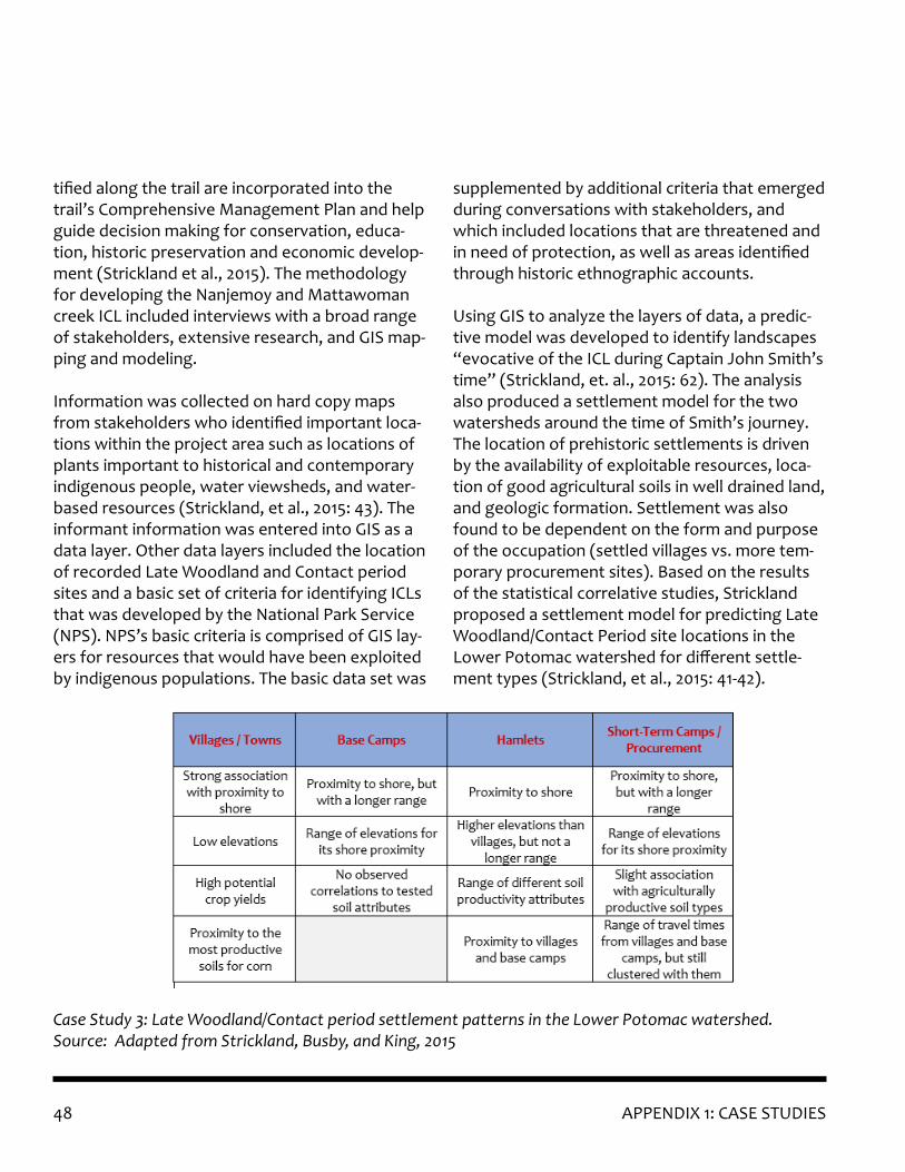
48 APPENDIX 1: CASE STUDIES
tified along the trail are incorporated into the trail’s Comprehensive Management Plan and help guide decision making for conservation, educa-tion, historic preservation and economic develop-ment (Strickland et al., 2015). The methodology for developing the Nanjemoy and Mattawoman creek ICL included interviews with a broad range of stakeholders, extensive research, and GIS map-ping and modeling.
Information was collected on hard copy maps from stakeholders who identified important loca-tions within the project area such as locations of plants important to historical and contemporary indigenous people, water viewsheds, and water-based resources (Strickland, et al., 2015: 43). The informant information was entered into GIS as a data layer. Other data layers included the location of recorded Late Woodland and Contact period sites and a basic set of criteria for identifying ICLs that was developed by the National Park Service (NPS). NPS’s basic criteria is comprised of GIS lay-ers for resources that would have been exploited by indigenous populations. The basic data set was
supplemented by additional criteria that emerged during conversations with stakeholders, and which included locations that are threatened and in need of protection, as well as areas identified through historic ethnographic accounts.
Using GIS to analyze the layers of data, a predic-tive model was developed to identify landscapes “evocative of the ICL during Captain John Smith’s time” (Strickland, et. al., 2015: 62). The analysis also produced a settlement model for the two watersheds around the time of Smith’s journey. The location of prehistoric settlements is driven by the availability of exploitable resources, loca-tion of good agricultural soils in well drained land, and geologic formation. Settlement was also found to be dependent on the form and purpose of the occupation (settled villages vs. more tem-porary procurement sites). Based on the results of the statistical correlative studies, Strickland proposed a settlement model for predicting Late Woodland/Contact Period site locations in the Lower Potomac watershed for different settle-ment types (Strickland, et al., 2015: 41-42).
Case Study 3: Late Woodland/Contact period settlement patterns in the Lower Potomac watershed. Source: Adapted from Strickland, Busby, and King, 2015

49APPENDIX 1: CASE STUDIES
Taking this information and going one step fur-ther to pinpoint areas of archeological sensitivity will require a closer look at Strickland’s data and modeling. However, the methodology for iden-tifying settlement patterns could be replicated. This case study highlights a portion of the work done by Strickland, King, and Busby in identifying an ICL. Readers interested in following Strick-land’s approach or in seeking to identify ICLs may find more information under “Predictive Model-ing” in Appendix 3.
The Calverton Site provides an example of using significance to prioritize volunteer effort and lim-ited research funding to target a threatened site for further investigation and evaluation. The work conducted at the site beginning in 2017 illustrates several concepts and investigative techniques de-scribed in this document. This case study is based on the work conducted at the site during the 2017 Tyler Bastian Field Session in Maryland Archeol-ogy, a joint effort by MHT and the Archeologi-cal Society of Maryland. The town of Calverton is depicted on a 1682 plat in the location of the site and previous investigations found evidence of 17th century colonial artifacts. Calverton was laid out in 1668 and was the second town in the colony of Maryland and the first town in Calvert County (Shearn, et al., 2017: 1). The Calverton site had been subject to past study including an NRHP nomination form that was prepared for the site in 1986, but not submitted to the NPS (Shearn, et al., 2017: 14). The site is threatened by an actively eroding coastline.
Calverton is an extremely rare and, thus, signifi-cant resource type: the remains of a 17th century town and county seat. The 1682 plat depicted the
presence of a courthouse, jail, church, multiple dwellings, dependencies, and possibly a clerk’s office all laid out in linear fashion along the shore of Battle Creek. But the extent to which these re-sources had been damaged by erosion and storm events was unknown. Due to the potential signifi-cance of the site as an early planned town in the Maryland colony and the threat of losing more of the site to erosion, further investigation became a priority for County preservation personnel. The goals of the 2017 investigations were to identify what remains of the town and to determine the accuracy of the locations of structures indicated on the georeferenced 1682 map and the results of a magnetic susceptibility survey (Shearn, et al., 2017: 24).
Prior to beginning subsurface testing, the site was remotely tested using magnetic susceptibil-ity. Magnetic susceptibility measures the “mag-netizability” of surface soils, a variable that can be influenced by past human activity. The results produced a map of magnetic anomalies depicting areas of potentially high archeological sensitivity. These anomalies were overlaid with the georefer-enced historical plat to identify areas in which to conduct subsurface investigations.
Subsurface testing consisted of shovel test pits in areas too dense to test using magnetic suscepti-bility and test units located in areas correspond-ing to magnetic susceptibility hot spots, three of which matched the locations of structures on the 1682 plat (Shearn, et al., 2017; 26). Surface collec-tion was conducted along the beach below the coastline; artifacts were recovered from the exca-vation of a feature in the cliff profile in a location that may correspond to a house on the 1682 plat. ArcGIS was used to determine how much of the site has been lost to erosion by comparing the distribution of artifacts across the site to the
Case Study 4: Significance as a Determin-ing Factor for Prioritizing Investigation
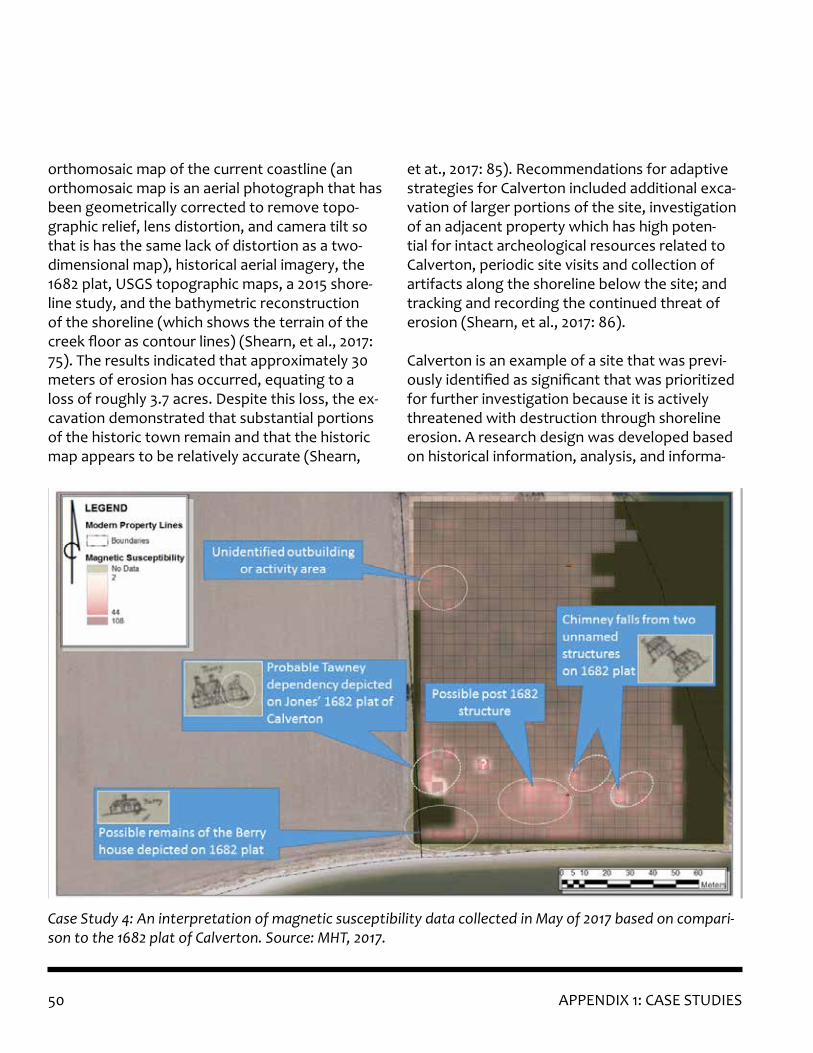
50 APPENDIX 1: CASE STUDIES
orthomosaic map of the current coastline (an orthomosaic map is an aerial photograph that has been geometrically corrected to remove topo-graphic relief, lens distortion, and camera tilt so that is has the same lack of distortion as a two-dimensional map), historical aerial imagery, the 1682 plat, USGS topographic maps, a 2015 shore-line study, and the bathymetric reconstruction of the shoreline (which shows the terrain of the creek floor as contour lines) (Shearn, et al., 2017: 75). The results indicated that approximately 30 meters of erosion has occurred, equating to a loss of roughly 3.7 acres. Despite this loss, the ex-cavation demonstrated that substantial portions of the historic town remain and that the historic map appears to be relatively accurate (Shearn,
et at., 2017: 85). Recommendations for adaptive strategies for Calverton included additional exca-vation of larger portions of the site, investigation of an adjacent property which has high poten-tial for intact archeological resources related to Calverton, periodic site visits and collection of artifacts along the shoreline below the site; and tracking and recording the continued threat of erosion (Shearn, et al., 2017: 86).
Calverton is an example of a site that was previ-ously identified as significant that was prioritized for further investigation because it is actively threatened with destruction through shoreline erosion. A research design was developed based on historical information, analysis, and informa-
Case Study 4: An interpretation of magnetic susceptibility data collected in May of 2017 based on compari-son to the 1682 plat of Calverton. Source: MHT, 2017.
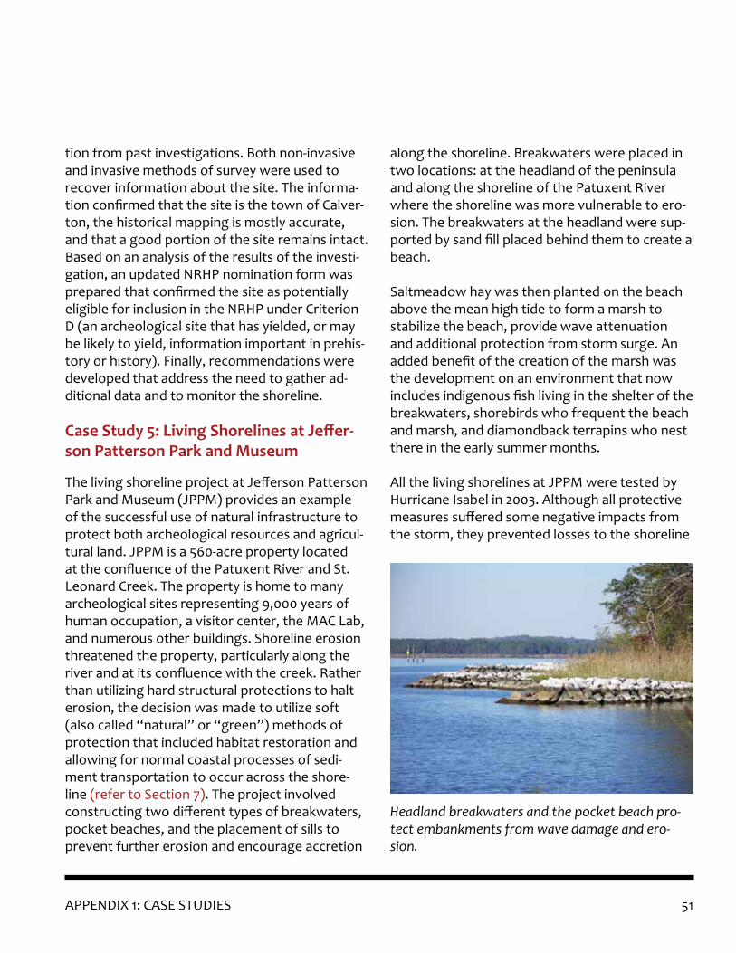
51APPENDIX 1: CASE STUDIES
tion from past investigations. Both non-invasive and invasive methods of survey were used to recover information about the site. The informa-tion confirmed that the site is the town of Calver-ton, the historical mapping is mostly accurate, and that a good portion of the site remains intact. Based on an analysis of the results of the investi-gation, an updated NRHP nomination form was prepared that confirmed the site as potentially eligible for inclusion in the NRHP under Criterion D (an archeological site that has yielded, or may be likely to yield, information important in prehis-tory or history). Finally, recommendations were developed that address the need to gather ad-ditional data and to monitor the shoreline.
The living shoreline project at Jefferson Patterson Park and Museum (JPPM) provides an example of the successful use of natural infrastructure to protect both archeological resources and agricul-tural land. JPPM is a 560-acre property located at the confluence of the Patuxent River and St. Leonard Creek. The property is home to many archeological sites representing 9,000 years of human occupation, a visitor center, the MAC Lab, and numerous other buildings. Shoreline erosion threatened the property, particularly along the river and at its confluence with the creek. Rather than utilizing hard structural protections to halt erosion, the decision was made to utilize soft (also called “natural” or “green”) methods of protection that included habitat restoration and allowing for normal coastal processes of sedi-ment transportation to occur across the shore-line (refer to Section 7). The project involved constructing two different types of breakwaters, pocket beaches, and the placement of sills to prevent further erosion and encourage accretion
along the shoreline. Breakwaters were placed in two locations: at the headland of the peninsula and along the shoreline of the Patuxent River where the shoreline was more vulnerable to ero-sion. The breakwaters at the headland were sup-ported by sand fill placed behind them to create a beach.
Saltmeadow hay was then planted on the beach above the mean high tide to form a marsh to stabilize the beach, provide wave attenuation and additional protection from storm surge. An added benefit of the creation of the marsh was the development on an environment that now includes indigenous fish living in the shelter of the breakwaters, shorebirds who frequent the beach and marsh, and diamondback terrapins who nest there in the early summer months.
All the living shorelines at JPPM were tested by Hurricane Isabel in 2003. Although all protective measures suffered some negative impacts from the storm, they prevented losses to the shoreline
Headland breakwaters and the pocket beach pro-tect embankments from wave damage and ero-sion.
Case Study 5: Living Shorelines at Jeffer-son Patterson Park and Museum

52 APPENDIX 1: CASE STUDIES
and succeeded in protecting the archeological resources. Funding for the project came from a variety of non-profit, state, and federal sources. This project demonstrates that a variety of natu-ral solutions can be used to provide protection for archeological sites while also providing habi-tat for native species and restoring marshlands.
Another example of natural shoreline protection, this case study demonstrates that success is mea-sured according to the goals of the protection project. Erosion along the banks of a waterway popular with recreational boaters had revealed the presence of human remains. MHT conducted a field visit to the site and determined that the remains were associated with a Native American ossuary (a location where human remains are re-interred once flesh has decayed). The ossuary was eroding out of a steep embankment due to the repeated impact of waves generated by boat-ers along the river.
MHT entered into consultation with the indige-nous community on whose ancestral lands the os-suary is located to determine adaptive strategies for managing the impacts to the ossuary. All par-ties involved in the consultation were concerned with potential malfeasance should the remains stay uncovered. The indigenous community wished for the remains to continue their natu-ral journey, thus the solution needed to ensure the protection of the remains while allowing for coastal processes to occur naturally. The agreed-upon action was to stabilize the riverbank, which would allow for a more controlled, but concealed, continuation of the movement of the shoreline.Fiber logs were staked at the toe of the slope to encourage soil retention to fill in behind the logs.
Sandbags were laid against and stacked on top of the bank. Fiber cloth was staked to the top of the bank to hold soil in place. No planting was done at the time of the installation as work had to be done during winter to ensure the ossuary was protected immediately.
A recent visit to the site found that while the stabilization measures had not taken hold as was intended, it was nonetheless still serving its purpose. The vegetation at the top of the bank had grown in, forming a nearly impenetrable barrier. Approaching the shoreline from the river, displaced sandbags were immediately appar-ent, extending downstream to the point of the landform. The sandbag “wall” had slumped but remained in place covering the ossuary. The fiber logs were all gone, their location only identifiable by the line of wooden stakes that were still intact in the water. Some vegetation has opportunisti-cally begun to grow in scattered locations on the articulated sandbags still against the bank. While
Even though the coir log is gone, and the sandbags are disarticulated, some sandbags remain in place protecting the embankment. Source: MHT, 2018.
Case Study 6: Natural Shoreline Protec-tion of a Prehistoric Ossuary

53APPENDIX 1: CASE STUDIES
this is not completely a success story in that the coir logs washed away and vegetation did not fill in to create a new, more protected natural shore-line, the protective measure still met the goals set forth at the outset of the project: to cover and protect the ossuary while allowing for nature to take its course. While some projects focus on sta-bilization for long-term protection, this project’s goal is to allow the ossuary to decay while safe-guarding the human remains from disturbance.

54

55APPENDIX 2: FUNDING SOURCES
Potential funding streams for investigation or protection of archeological resources at risk to flood hazards are presented below. There are also many grant programs that address the con-servation of natural resources, and some of these might be used to protect or conserve archeologi-cally sensitive areas. It is up to the researcher to think outside the box in utilizing natural resourc-es grants to address the protection of archeologi-cal sites: the few programs discussed below are merely a starting point.
FederalThe U.S. Department of Agriculture’s Natural Re-sources Conservation Service has funding oppor-tunities related to land conservation that could be used to protect archeologically sensitive land, provided it also serves environmental conserva-tion needs and meets the criteria of eligibility.
The U.S. Fish & Wildlife Service’s National Coastal Wetlands Conservation Grant Program could be used to protect, restore, and enhance coastal wetlands and their associated uplands. This could potentially be used to protect archeological sites in these areas or to restore and enhance wet-lands that provide protection for upland areas where sites are located, depending on whether the project meets eligibility criteria.
StateThe Maryland Department of Natural Resources’ Chesapeake and Coastal Grants Gateway provides technical and financial support for projects that improve the environment and increase resilience to climate change – the ability to withstand envi-ronmental changes – of vulnerable Chesapeake Bay communities. The grants fund studies, plan-ning, and construction of projects that improve the recovery and restoration of natural resources, address flood risks due to climate change, and
that use nature-based infrastructure to achieve those results. The grant program could be used for protecting sites or sensitive areas, but not for investigation.
The Maryland Emergency Management Agency manages FEMA’s Hazard Mitigation Assistance Grant Program. Under this program, FEMA has two grants dedicated to pre-disaster hazard mitigation (Pre-Disaster Mitigation Grant, PDM, and the Flood Mitigation Assistance Grant, FMA) and one post-disaster grant (Hazard Mitigation Grant Program, HMGP). These programs could be used for projects that protect vulnerable sites or archeologically sensitive areas in place, provided those protections also protect infrastructure or buildings. The intent of these projects is to pro-tect buildings, infrastructure, people, and other assets. Cultural resources can be considered an asset. Investigation of endangered archeological sites might be possible under HMGP if that inves-tigation also includes an analysis of the vulnerabil-ity of the sites to flood hazards and recommenda-tions to eliminate or reduce their vulnerability. Project eligibility should be discussed with MEMA.
MHT has several grant programs that can support archeological investigation.• The Certified Local Government (CLG) Pro-
gram funds projects and education opportu-nities in Maryland’s 11 towns and 10 counties that have gone through the certification pro-cess. Archeological investigation is an eligible activity under the CLG grant guidelines.
• Archeological investigation is an eligible activity under MHT’s Historic Preservation Non-Capital Grant Program, which supports local governments and non-profit organiza-tions that conduct research, survey, planning and educational activities involving cultural resources.
APPENDIX 2: FUNDING SOURCES

56

57APPENDIX 3: ADDITIONAL RESOURCES
Daly, Cathy. 2015. “A Framework for Assessing the Vulnerability of Archeological Sites to Climate Change: Theory, Development, and Applica-tion.” Conservation and Management of Archeo-logical Sites 16 (3): 268–82. http://eprints.lincoln.ac.uk/18822/1/18822%20Daly_16_3.pdf
Beavers, R.L., A.L. Babson, and C.A. Schupp [eds]. 2016. Coastal Adaptation Strategies Handbook. NPS 999/134090. National Park Service, Washing-ton, D.C. https://www.nps.gov/subjects/climat-echange/coastalhandbook.htm
Rockman, Marcy, et al. 2016. Cultural Resources Climate Change Strategy. Washington, D.C. Cul-tural Resources, Partnerships, and Science and Climate Change Response Program, National Park Service. https://www.nps.gov/subjects/climat-echange/culturalresourcesstrategy.htm
AMBUR-R, Analyzing Moving Boundaries Using R: http://ambur.r-forge.r-project.org/
Maryland Historical Trust – State Archeology Files: https://mht.maryland.gov/secure/MEDUSA/ Note: Full site containing location details is only available online to registered users, who in-clude persons that within these categories: profes-sional archeologists, agency representatives, and researchers.
MD iMAP – Maryland’s Mapping & GIS Data Por-tal: https://imap.maryland.gov/Pages/default.aspx
Maryland Department of the Environment’s Flood Risk Application: https://mdfloodmaps.net/
Maryland Department of Natural Resources – Maryland’s Environmental Resources and Land Information Network (MERLIN): https://dnr.mary-land.gov/Pages/maps.aspx
Maryland Department of Natural Resources (in Maryland iMaps) – Maryland New Wetland Areas Year 2050: https://data.imap.maryland.gov/datas-ets/maryland-new-wetland-areas-year-2050
Maryland Department of Natural Resources (in Maryland iMaps) – Maryland New Wetland Areas Year 2100: https://data.imap.maryland.gov/datas-ets/maryland-new-wetland-areas-year-2100
Maryland Department of Natural Resources (in Maryland iMaps) – Maryland New Wetland Ad-aptation Areas (0-2 ft rise; 2-5 ft ris; 5-10 ft rise): https://data.imap.maryland.gov/datasets/mary-land-sea-level-rise-wetland-adaptation-areas
Maryland Geological Survey. Aerial Photograph Collection: http://www.mgs.md.gov/publications/mgs_data_preservation/aerial_photos.html
Maryland Geological Survey. Quadrangle Geologic Maps: http://www.mgs.md.gov/publications/data_pages/quadrangle_geo.html
National Park Service – Indigenous Cultural Land-scapes: https://www.nps.gov/cajo/learn/indige-nous-cultural-landscapes.htm
National Weather Service – Sea Lake and Over-land Surge from Hurricanes (SLOSH): https://slosh.nws.noaa.gov/slosh/
U.S. Department of Agriculture, Natural Resourc-es Conservation Service. Web Soil Survey: https://websoilsurvey.sc.egov.usda.gov/App/HomePage.htm
Vulnerability Assessments
APPENDIX 3: ADDITIONAL RESOURCES
GIS Resources

58 APPENDIX 3: ADDITIONAL RESOURCES
U.S. Fish & Wildlife Service. National Wetlands Inventory: https://www.fws.gov/wetlands/
U.S. Geological Survey. USGS National Elevation Dataset: https://www.usgs.gov/core-science-sys-tems/national-geospatial-program/national-map
U.S. Geological Survey. National Hydrography Dataset: https://www.usgs.gov/core-science-sys-tems/ngp/national-hydrography
Watershed Resources Registry. Maryland: https://watershedresourcesregistry.org/states/maryland.html
Busby, Virginia R., Julia A. King, and Scott M. Strickland. 2015. Indigenous Cultural Landscapes Study for the Nanjemoy and Mattawoman Creek Watersheds. St. Mary’s College of Maryland, St. Mary’s City, Maryland. Prepared for the National Park Service Chesapeake Bay, Annapolis, Mary-land: https://www.nps.gov/chba/learn/news/up-load/NanjemoyMattawoman-ICL-FINAL-red.pdf
Rose, Craig, Mary Farrell, Brian D. Bates, Wal-ter Witschey, and Erin West. 2017. Archeological Shoreline Study, Portions of Lancaster, Mathews, Middlesex, and Northumberland Counties, Virginia. Longwood Institute of Archeology, prepared for Virginia Department of Historic Resources, June 2017. Contact the authors at: http://www.long-wood.edu/archeology/staff/
Waller, Joseph M., Jr., and Alan Leveillee. 2016. Hurricane Sandy Disaster Relief Grant Phase I and Phase II Archeological Survey, Rhode Island South Coast: Narragansett, South Kingstown, Charles-town, and Westerly, Rhode Island. Volume 1: Tech-nical Report. Prepared by the Public Archeology
Laboratory, Inc., Pawtucket, Rhode Island. Pre-pared for the Rhode Island Historical Preservation & Heritage Commission and the National Park Service. Contact Timothy Ives at the Rhode Island Historical Preservation & Heritage Commission (SHPO) at http://www.preservation.ri.gov/about/directory.php
Heritage Monitoring Scouts, State of Florida: https://fpan.us/projects/HMSflorida.php
Thames Discovery Program, “FROG” Foreshore Recording & Observation Group: http://www.thamesdiscovery.org/
Dawson, Tom, Joanna Hambly, and Ellie Graham. “A central role for communities: climate change and coastal heritage management in Scotland.” In Public Archeology & Climate Change, edited by Tom Dawson, Courtney Nimura, Elias Lopez-Romero, and Marie-Yvane Daire, pp. 23-33. Ox-ford, Oxfordshire, England: Oxbow Books, 2017.
Wragg, Elliott, Nathalie Cohen, Gustav Milne, Stephanie Ostrich, and Courtney Nimura. “Com-munity recording and monitoring of vulnerable sites in England.” In Public Archeology & Climate Change, edited by Tom Dawson, Courtney Nimura, Elias Lopez-Romero, and Marie-Yvane Daire, pp. 44-51. Oxford, Oxfordshire, England: Oxbow Books, 2017.
U.S. Environmental Protection Agency. Mitigation Banking Factsheet: https://www.epa.gov/cwa-404/mitigation-banking-factsheet
Predictive Modeling
Site Stewardship
Protect in Place

59APPENDIX 4: REFERENCES CITED
Berenfeld, Michelle L. 2015. Planning for perma-nent emergency: “triage” as a strategy for man-aging cultural resources threatened by climate change. The George Wright Forum, vol. 32 no. 1 (2015): 5-12.
Busby, Virginia R., Julia A. King, and Scott M. Strickland. 2015. Indigenous Cultural Landscapes Study for the Nanjemoy and Mattawoman Creek Watersheds. St. Mary’s College of Maryland, St. Mary’s City, Maryland. Prepared for the National Park Service Chesapeake Bay, Annapolis, Mary-land.
National Park Service (NPS). 1992. “Guidelines for Evaluating and Registering Cemeteries and Burial Places.” National Register Bulletin 41: 9-18. https://www.nps.gov/subjects/nationalregister/upload/NRB41-Complete.pdf
Rockman, Marcy, et al. 2016. Cultural Resources Climate Change Strategy. Washington, D.C. Cul-tural Resources, Partnerships, and Science and Climate Change Response Program, National Park Service.
Rose, Craig, Mary Farrell, Brian D. Bates, Wal-ter Witschey, and Erin West. 2017. Archeological Shoreline Study, Portions of Lancaster, Mathews, Middlesex, and Northumberland Counties, Virginia. Longwood Institute of Archeology, prepared for Virginia Department of Historic Resources, June 2017.
Shearn, Isaac, Jason L. Tyler, Matthew Cochran, W. Brett Arnold, and Jeanne A. Ward. 2018. Re-port on the 2017 Tyler Bastian Field Session in Mary-land Archeology at the Calverton Site (18CV22), Calvert County, Maryland. Prepared for Calvert County Government, Prince Frederick, Maryland. Prepared by Applied Archeology and History As-
sociates, Inc., Annapolis, Maryland.
Tyler, Jason L., Christopher R. Polglase, Jeanne A. Ward, and Zachary Andrews. 2017. Archeological Survey of Threatened Cultural Resources Hunting Creek Shoreline, Calvert County, Maryland. Final re-port prepared by Applied Archeology and History Associates, Inc. Prepared for Board of County Commissioners of Calvert County, August 2017.
Verhagen, Philip and Thomas G. Whitley. 2011. Integrating Archaeological Theory and Predictive Modeling: a Live Report from the Scene. Journal of Archaeological Method and Theory Vol 19. Issue 1: 49-100. https://doi.org/10.1007/s10816-011-9102-7
APPENDIX 4: REFERENCES CITED

60
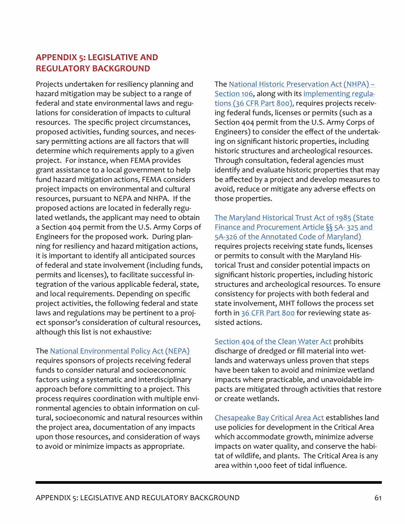
61APPENDIX 5: LEGISLATIVE AND REGULATORY BACKGROUND
Projects undertaken for resiliency planning and hazard mitigation may be subject to a range of federal and state environmental laws and regu-lations for consideration of impacts to cultural resources. The specific project circumstances, proposed activities, funding sources, and neces-sary permitting actions are all factors that will determine which requirements apply to a given project. For instance, when FEMA provides grant assistance to a local government to help fund hazard mitigation actions, FEMA considers project impacts on environmental and cultural resources, pursuant to NEPA and NHPA. If the proposed actions are located in federally regu-lated wetlands, the applicant may need to obtain a Section 404 permit from the U.S. Army Corps of Engineers for the proposed work. During plan-ning for resiliency and hazard mitigation actions, it is important to identify all anticipated sources of federal and state involvement (including funds, permits and licenses), to facilitate successful in-tegration of the various applicable federal, state, and local requirements. Depending on specific project activities, the following federal and state laws and regulations may be pertinent to a proj-ect sponsor’s consideration of cultural resources, although this list is not exhaustive:
The National Environmental Policy Act (NEPA) requires sponsors of projects receiving federal funds to consider natural and socioeconomic factors using a systematic and interdisciplinary approach before committing to a project. This process requires coordination with multiple envi-ronmental agencies to obtain information on cul-tural, socioeconomic and natural resources within the project area, documentation of any impacts upon those resources, and consideration of ways to avoid or minimize impacts as appropriate.
The National Historic Preservation Act (NHPA) – Section 106, along with its implementing regula-tions (36 CFR Part 800), requires projects receiv-ing federal funds, licenses or permits (such as a Section 404 permit from the U.S. Army Corps of Engineers) to consider the effect of the undertak-ing on significant historic properties, including historic structures and archeological resources. Through consultation, federal agencies must identify and evaluate historic properties that may be affected by a project and develop measures to avoid, reduce or mitigate any adverse effects on those properties.
The Maryland Historical Trust Act of 1985 (State Finance and Procurement Article §§ 5A- 325 and 5A-326 of the Annotated Code of Maryland) requires projects receiving state funds, licenses or permits to consult with the Maryland His-torical Trust and consider potential impacts on significant historic properties, including historic structures and archeological resources. To ensure consistency for projects with both federal and state involvement, MHT follows the process set forth in 36 CFR Part 800 for reviewing state as-sisted actions.
Section 404 of the Clean Water Act prohibits discharge of dredged or fill material into wet-lands and waterways unless proven that steps have been taken to avoid and minimize wetland impacts where practicable, and unavoidable im-pacts are mitigated through activities that restore or create wetlands.
Chesapeake Bay Critical Area Act establishes land use policies for development in the Critical Area which accommodate growth, minimize adverse impacts on water quality, and conserve the habi-tat of wildlife, and plants. The Critical Area is any area within 1,000 feet of tidal influence.
APPENDIX 5: LEGISLATIVE AND REGULATORY BACKGROUND

62


Maryland Department of Planning100 Community Place
Crownsville, MD 21032mht.maryland.gov
410-697-9575
Maryland Historical Trust
Larry Hogan, GovernorBoyd Rutherford, Lt. Governor
Robert S. McCord, Secretary of Planning
Elizabeth HughesDirector, Maryland Historical TrustState Historic Preservation Officer