Embed Size (px)
Citation preview

Planning for a stronger, more resilient Queensland
Presentation to the World Bank Integrated flood risk management in Queensland
Kate Isles Director, Land Use Planning
12 December 2011
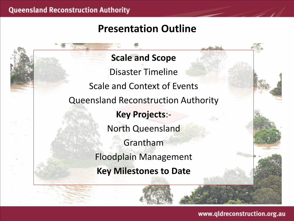
Presentation Outline
Scale and Scope
Disaster Timeline
Scale and Context of Events
Queensland Reconstruction Authority
Key Projects:-
North Queensland
Grantham
Floodplain Management
Key Milestones to Date

Dec 2010 Jan 2011 Feb 2011 Mar 2011 Apr 2011
Disasters Timeline
Dec 3: 120mm rain Emerald
Dec 23: Rainfall central & Nth QLD (200-600mm)
Dec 25: TC Tasha (Cat 1)
Dec 27: Declarations & evacs begin in Theodore
Dec 28: Emerald, Bundaberg, Central Highlands, Nth Burnett disaster declared
Dec 29: Theodore evacuated (300)
Dec 30: Condamine evacuated
Jan 10: Flash flooding Lockyer Valley
Jan 11: Brisbane flood and regional evacuations
Jan 13: Brisbane floods Dam at 183% capacity
Jan 31: TC Anthony (Cat 2)
Feb 2/3: TC Yasi (Cat 5)
February: Monsoonal Flooding
Apr 4: Maranoa Flooding
Jan 19: QRA announced

2
3
7
1
5
4
6
Texas
Disaster Events
Dec 2010 Flooding South east/west Dec 2010 Tropical Cyclone Tasha Jan 2011 Flash Flooding Lockyer Valley Jan 2011 Brisbane/Ipswich Flooding Jan / Feb TCs Anthony & Yasi Feb 2011 Monsoonal Flooding Apr 2011 Maranoa flooding
Disasters Overview

Dec 2010 – Central Queensland

January 2011 – Toowoomba & Lockyer Valley

January 2011 – Toowoomba & Lockyer Valley

January 2011 – Toowoomba & Lockyer Valley

Brisbane Flooding Jan 10-13

Brisbane Flooding Jan 10-13


Tropical Cyclone Yasi 2-3 Feb

Disaster Comparison
Cyclone Larry (2006) Vic Bushfires
Qld Summer
LGAs affected 5 / 73 16 / 79 73 / 73
Communities affected 40 80 210
Estimated Damage $1.5b $1.2b $6.8b
Insurance Claims $540m 10 000 ($1.09b) 124,500 ($3.6B)
Donated Relief Funds $22m $392m $273m
Houses destroyed 600 2133 7800
Loss of Life - 173 37
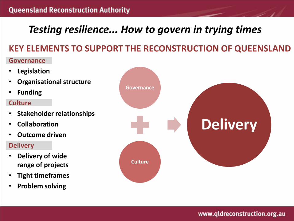
Testing resilience... How to govern in trying times
KEY ELEMENTS TO SUPPORT THE RECONSTRUCTION OF QUEENSLAND Governance
• Legislation
• Organisational structure
• Funding
Culture
• Stakeholder relationships
• Collaboration
• Outcome driven
Delivery
• Delivery of wide range of projects
• Tight timeframes
• Problem solving
Governance
Culture
Delivery

Governance...Queensland Reconstruction Authority
... reconnect, rebuild and improve Queensland communities and its economy...
• Legislated 21 Feb 2011 • 2 year sunset clause • Coordinate reconstruction
• Prioritise infrastructure & services
• Ascertain community needs
• Distribute finance
• Collect information
• Facilitate flood mitigation
• Implement Commission of Inquiry recommendations where needed
New Chair, Major General Dick Wilson and CEO, Graeme Newton with outgoing Chair Major General Mick Slater
Strategic Objectives 1. Maintain the self-confidence of Queensland 2. Build a resilient Qld & support resilient
Queenslanders 3. Enhance preparedness and disaster mitigation

Reconnect, rebuild and improve Qld and its economy
Governance... Operation Queenslander: The State Plan

Submission Process Overview – Value for Money
Reconstruction budget $6.8B
• New structure to support
funding assessment, approval & verification
• Advance payments for works to commence early
• Teams dedicated to LGAs • NDRRA framework
established by Federal Government
• Focus on Value for Money • Quality Assurance Team • Efficient submission review
and verification process
Governance... NDRRA
75% - Federal Government 25% - State Government

Governance... Legislation The QldRA was created as a statutory authority through the Queensland Reconstruction Authority Act (QldRAA) on 21 February 2011 The QldRAA vests significant powers to respond to disaster events for the purposes of addressing both short term and longer term goals, including: declaration of declared projects and reconstruction areas powers to compulsorily acquire land general powers to enter any land powers to create new development schemes powers to direct changes to existing planning schemes powers to hasten decisions and processes of decision makers The QldRAA applies to all disaster activated areas Powers only used when all other avenues have been explored.

Culture.....Resilience
• Governance is one only aspect • Stakeholder relationships:
Meaningful engagement especially with the community
• Collaboration at all levels of Government:
State agency cooperation is key • Outcome driven:
Proactive not reactive • The right staff for the job:
Having the right attitude

They came from all walks of life, all communities and nationalities, all occupations, all religious denominations and all ages...

...some from interstate, others overseas ... armed with shovels, buckets, mops & brooms, hoses, gurneys …

... others had utes, trucks and trailers. Builders, plumbers, electricians ... community groups and individuals ... stalls with free food and drinks ... for the days and weeks that followed.

This sea of humanity whose sole purpose was to aid those in need ... every time I looked up there were new faces ... all asking how they could help…

And help they did: selflessly, compassionately, generously. It was a sight to behold and something I never expected to see in my home or my neighbourhood.
– Neil Ross, Brisbane flood victim

Delivery.... achieving results
Having the right governance systems in place and a positive culture allows for:
– Delivery of wide range of projects
– In tight timeframes
– Not letting process get in the way of outcomes
– Efficient and effective recovery
– Problem solving (thinking outside the box)

Delivery... The reconstruction effort
Disaster peak Nov – Mar
Repair as at October 2011
Roads 9170 km 8482km reopened (92%)
Rail 4748 km 4596km operational (97%)
Schools 411 411
Bridges & Culverts 89 89
Water supply schemes 104 104
National Parks 138 126 re-opened
Coal Mines 54 54 operational - 48 operating between 80- 100% capacity - remaining 6 at between 50-80%
Insurance Claims 128 875
Power outages 480 000 389 still out
Buildings affected 150 000
Still plenty of work to be done but reconstruction is on track and being delivered in record time
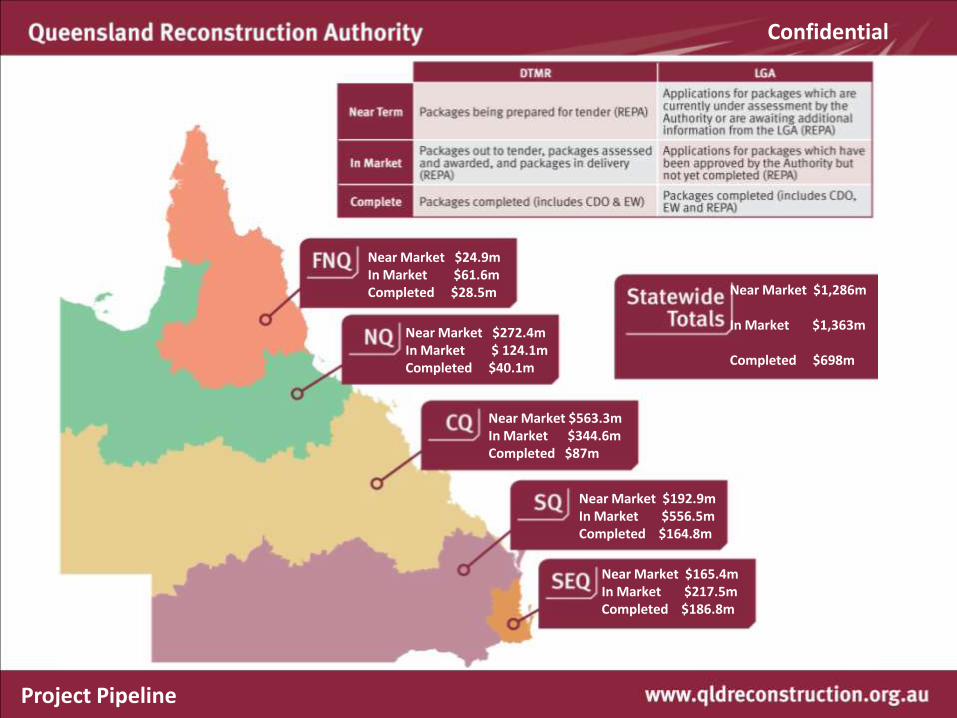
Near Market $24.9m In Market $61.6m Completed $28.5m
Near Market $272.4m In Market $ 124.1m Completed $40.1m
Near Market $563.3m In Market $344.6m Completed $87m
Near Market $192.9m In Market $556.5m Completed $164.8m
Near Market $165.4m In Market $217.5m Completed $186.8m
Near Market $1,286m In Market $1,363m Completed $698m
Project Pipeline
Confidential

89 culverts & bridges with major damage
Alf Williams Bridge, Somerset
Confidential

89 recovered
Alf Williams Bridge, Somerset
Confidential

4748km rail lines affected
Alpha Jericho rail
Confidential

Alpha Jericho rail
4596km operational
Confidential

9170 km Roads damaged
Warrego Highway Marburg Range June 2011
Confidential

Warrego Highway Marburg Range June 2011
8482 km roads recovered
Confidential

Townsville: The Strand post Cyclone Yasi
Confidential

Reconstruction
Confidential


• Resources for Reconstruction • Floodplain Management
• Stream Flow Gauges
• Damage Assessment & Reconstruction Monitoring • Build Back Blitz • Rebuilding Guidelines
• Storm-tide prone areas • Wind resistant housing • Stronger, more resilient electrical infrastructure
• Rebuilding Grantham Together
Strategic Works
Confidential
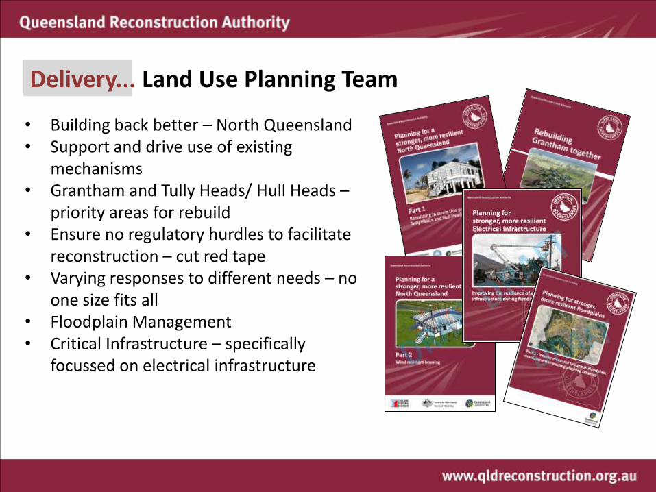
• Building back better – North Queensland • Support and drive use of existing
mechanisms • Grantham and Tully Heads/ Hull Heads –
priority areas for rebuild • Ensure no regulatory hurdles to facilitate
reconstruction – cut red tape • Varying responses to different needs – no
one size fits all • Floodplain Management • Critical Infrastructure – specifically
focussed on electrical infrastructure
Delivery... Land Use Planning Team

Build it back better: Resilience planning
Cyclone Yasi damage Tully Heads / Hull Heads


Part 1: Rebuilding in Storm tide prone areas Part 2: Wind Resistant Housing
Proposed Part 3 - Building in low lying coastal areas (mid 2012)
Build it back better - North Queensland
Guidelines to support build back better

Guidelines • Partnered with key cyclone and design
experts • Part 1 - Storm tide – an Australian first • Practical design solutions • Plain english/ easy to understand/ visual • Provide the residents with a greater
understanding • Part 2 – reiteration of what current standards
exist • Understanding hidden damage • Importance of maintenance especially in pre-
80s homes • Preparation for next cyclone season

Far North Queensland Guidelines in action
Confidential

Delivery in action... Grantham Reconstruction Area


Council’s Community
Recovery Plan

Community Consultation process
• Number of workshops • One on ones • Overwhelming response to stay in
Grantham but wanted to feel safe • Most wanted to move to higher
ground • Reopening key community
facilities including the shop • Strong community will • Positive engagement process
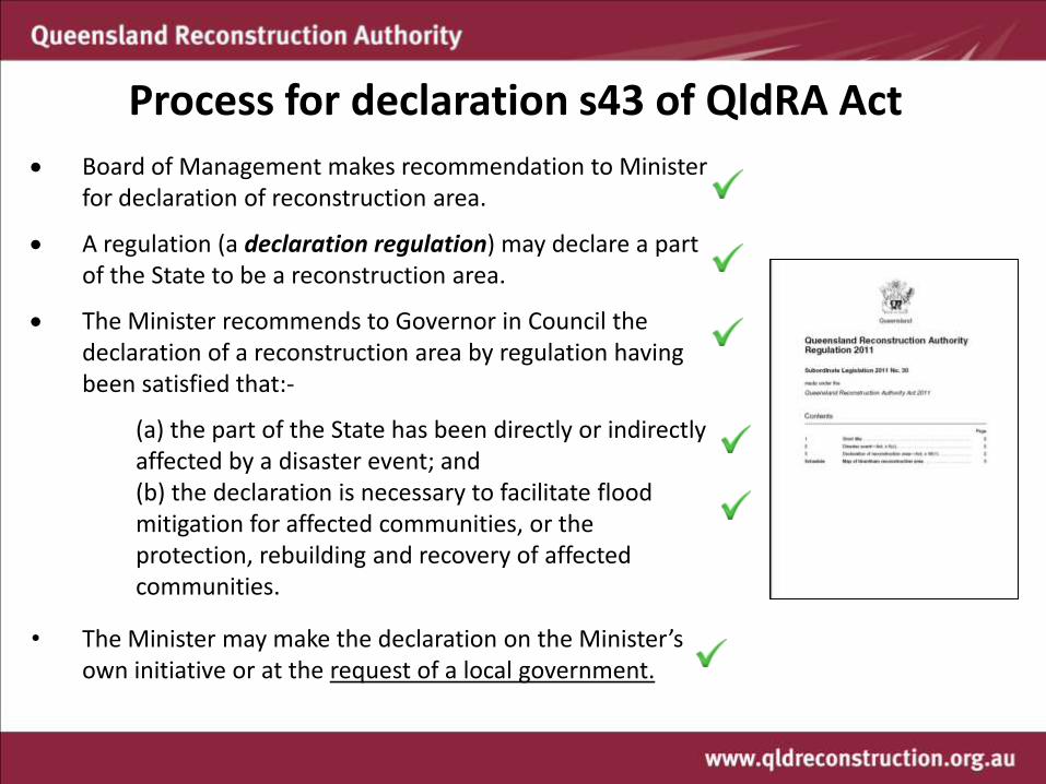
Board of Management makes recommendation to Minister for declaration of reconstruction area.
A regulation (a declaration regulation) may declare a part of the State to be a reconstruction area.
The Minister recommends to Governor in Council the declaration of a reconstruction area by regulation having been satisfied that:-
(a) the part of the State has been directly or indirectly affected by a disaster event; and
(b) the declaration is necessary to facilitate flood mitigation for affected communities, or the protection, rebuilding and recovery of affected communities.
• The Minister may make the declaration on the Minister’s own initiative or at the request of a local government.
Process for declaration s43 of QldRA Act

On 8 April 2011, the Queensland Reconstruction Authority Regulation 2011 was created which declared the Grantham Reconstruction Area


The past and the future...

Reconstruction Area
Translating the Master Plan into a
Land Use plan

The Authority can prepare a Development Scheme for a Reconstruction Area
Convert the Master Plan into a regulatory framework Vision Land Use Plan – similar to a Local Plan. Regulates what development can occur Infrastructure plan – supports Land Use Plan relating to infrastructure, eg water, sewer stormwater & power Implementation strategy Qld’s first Queensland Planning Provision compliant Planning Scheme – took effect on 4 August 2011. Less than four months after declaration which includes 2 1/2 months of community consultation

Delivery... a stronger, more resilient Grantham
• First designated Reconstruction Area under QRA powers
• Fast track processes – years to weeks
• Cut red tape to support delivery
• Developed Master Plan & translated this into a Development Scheme
• First Queensland Planning Provision compliant scheme in the State
• Construction has begun on first stage
• People in new homes by Christmas 2011

Grantham Reconstruction Area

Delivery... a stronger, more resilient Grantham

Delivery... a stronger, more resilient Grantham
Less than 12 months after the event the First home is relocated to the new estate

Planning for stronger, more resilient floodplains

Delivery... stronger, more resilient floodplains
• Flooding is not new to Queensland • 2010/2011 - 91% of the State disaster activated as a
result of flooding events • 210 townships/suburbs were affected by flooding • 13 river catchments recorded their highest peak
levels • 65% of planning schemes do not contain any flood
mapping • Floodplains do not correlate with local government
boundaries • New building codes will be brought in by the end of
2011 promoting resilience in houses • The ‘Queenslander’ style home performed better in
floodplain areas • Limited visibility of flood studies

To assist Councils to ensure that floodplain management is addressed through land use planning.
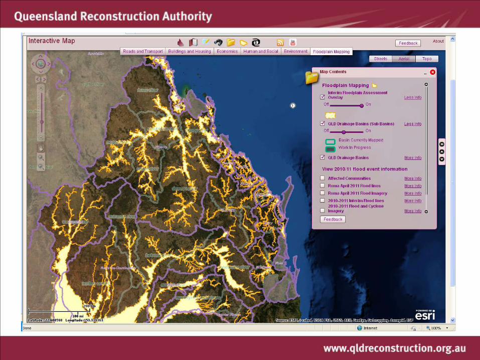
• Part 1 – Interim measures to support floodplain management in existing planning schemes, is an information toolkit including mapping identifying an interim floodplain assessment overlay and interim floodplain management controls.
• Part 2 – Standard planning scheme provisions and flood study template, will enable consistency in application of floodplain management controls and regulation across Queensland within new planning schemes prepared under the Sustainable Planning Act 2009.
Interim Solution
Flo
od
Stu
dy
du
rin
g P
lan
nin
g Sc
hem
e p
rep
Current Planning Scheme
New SPA Planning Scheme
Delivery... stronger, more resilient floodplains

Toolkit released on 17 September 2011 for consultation Guideline Mapping (hard copy and digital) for each sub-basin within an LGA boundary Planning scheme provisions – Model Code Part 1 offers an Overlay to be inserted into existing planning schemes that can be used like any other Overlay to assess a development’s ability to deal with potential flooding impacts. Mapping - provided for whole of the scheme area and not just townships. Can be amended and encouraged to be amended with best local information.
Mapping Code provisions
GUIDELINE Part 1
TOOLKIT Delivery... Interim solution

Many existing schemes contain overlays/ development codes ie. Bushfire, Landslide, Biodiversity, Aerodromes, Rural Lands etc.
Part 1 offers an Overlay to be inserted into existing planning schemes that can be used like any other Overlay to assess a development’s ability to deal with potential flooding impacts.
Mapping - provided for whole of the scheme area and not just townships. Can be amended and encouraged to be amended with best local information.
Code provisions would apply to areas triggered by the mapping.
What exactly is Part 1?

Flood Mapping – Needs to be fit for purpose

Floodplain - Line of Sight
National = 12 Queensland = 5 (40%) including: Northeast Coast (1) Gulf of Carpentaria (9) Murray Darling Division (4) Bulloo – Bancannia Division (10) Lake Eyre Division (11)
National = 246 Queensland = 75 (30%) Ie. Fitzroy River Basin Condamine River Basin
129 Sub-basins in Queensland Ie. Dawson River , Nogoa River
DRAINAGE DIVISION
RIVER-BASINS
SUB- BASINS

Fitzroy River Basin & Dawson River Sub-basin
Note the overlay of local government
boundaries
Drainage Division
I - Northeast Coast Division
River Basin Fitzroy
River sub-basin Dawson River

Queensland Drainage Divisions

BoM – Flood Risk Towns

LGA Boundaries (green)
Sub River Basins (purple)
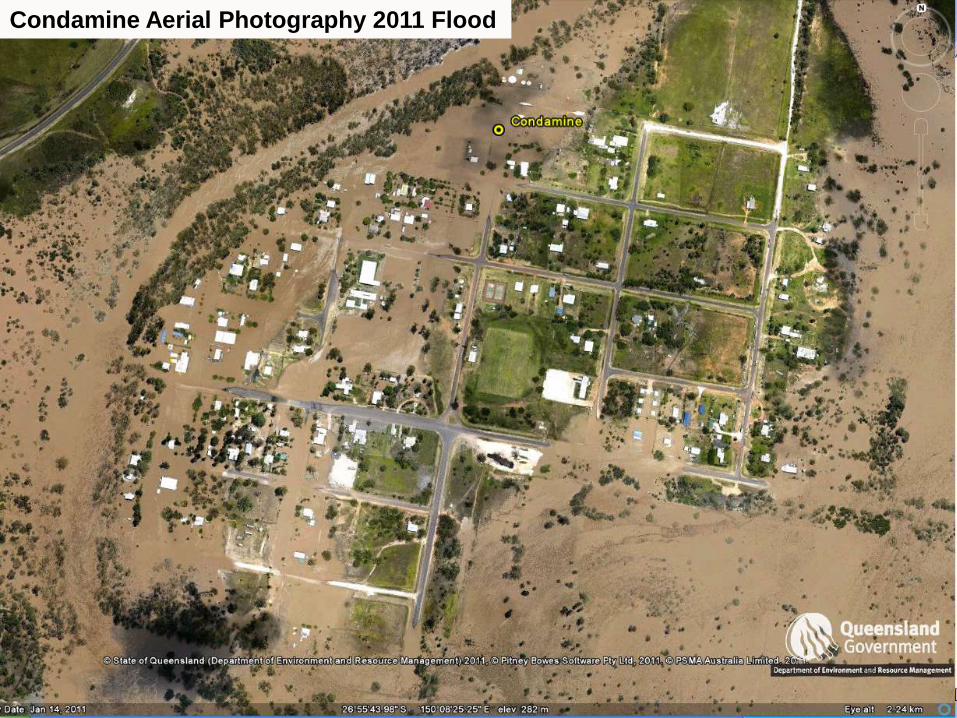
Condamine Aerial Photography 2011 Flood

Condamine River Sub Basin
Balonne River Sub Basin

Alluvial Soils & Pre-Clear Vegetation Layer

2011 Flood Event – Satellite Imagery
over
Alluvial Soils & Pre-Clear Vegetation Layer

Contours from the 1 second DEM
(Best available elevation data)

Interim Floodplain Overlay Assessment
determined by DERM cartographers from all inputs

Satellite Imagery & Aerial Photography
Aerial Photography 2011 Flood Event

Condamine River Sub Basin
Balonne River Sub Basin
2011 Flood Event – Satellite Imagery
Detailed Flood lines from Aerial Photography
(joined into the satellite imagery layer)

Condamine River Sub Basin
Balonne River Sub Basin
2011 Flood Event – Satellite Imagery
Isolations – typically due to cloud (can’t map what we can’t see)

Alluvial Soils & Pre-Clear Vegetation Layer

Interim Floodplain Overlay Assessment
determined by DERM cartographers from all inputs
including DEM / Contours


Delivery ...the Interim Floodplain Assessment Overlay
10m Contours LandSat Gauging Heights
Pre-cleared vegetation
Stream Orders 5 – 9
Aerial for towns
• State-wide datasets to deliver a state-wide mapping product.
• Sub-basin product translated into a mapbook containing a series of maps at a scale of 1:50,000
• All available on line

Flood Mapping Maturity Levels
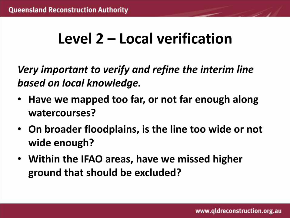
Level 2 – Local verification
Very important to verify and refine the interim line based on local knowledge.
• Have we mapped too far, or not far enough along watercourses?
• On broader floodplains, is the line too wide or not wide enough?
• Within the IFAO areas, have we missed higher ground that should be excluded?


• 63 river basins now completed as at 19 October (128 in Queensland) representing 40% of Queensland
• Over 2500 map pages produced to date (A3 @1:50,000 scale)
• 110,000km2 identified as part of Interim Floodplain Assessment Overlay from these 63 river basins.
• Largest mapping exercise currently underway across the country
• Using more than 35 experienced cartographers
Progress

Turkey mound ....?? Bird’s nest.....??
Provisions needed to support mapping

Model Code
Applicable to assessable development as determined by existing planning scheme ie. is unlikely to capture single dwellings (as not assessable under schemes) however would be picked up by new QDC provisions Based on principles set out in SPP1/03 Promotes better built form ie. elevation, filling Front loads questions around flooding impacts – should reduce information requests Would be triggered as an overlay within the existing scheme

TSPP & SPP1/03 SPP1/03 currently under review – not just flooding bushfire and landslide components - DCS lead agency. SPP1/03 includes default state-wide mechanisms for bushfire and landslide components. QldRA work to inform the review process. QldRA work does not replace the SPP1/03 review. Needed a mechanism by which Councils could adopt mapping as an interim measure until new schemes were developed – TSPP TSPP – does not require any public notification. Expire after 1 year. Will commence on 14 November 2011.

Implementation
Step 1: Council obtains toolkit 1. Guideline 2. Model Code 3. Mapping
Hard copy mapbook Digital copy mapbook Digital datasets
Step 2: Council commences review process including the mapping product and the planning scheme provisions Use existing studies knowledge, photographs to visually inspect the mapping. QRA to visit the Council.
Step 3: Council resolves to undertake a minor scheme amendment a) Adopt mapping and Model Code as provided by the Authority unchanged; or b) Adopt Model Code as provided by the Authority and adopt locally amended mapping; or c) Adopt mapping as provided by the Authority and adopt amended Model Code; or d) Adopt locally amended mapping and amended Model Code.

Implementation cont’d.
Step 3a: Designate as NHMA (Flood) and nominate Flood Level Supports Building provisions
Step 4: Council forwards amendment package to DLGP If package proposes amendment to the mapping DLGP forwards to QldRA for verification Seek to have amendment package to Minister for consideration within 10 days of receipt
Step 5: Council incorporates into existing scheme
Step 6: Assessment of any new applications triggered in the “Floodplain Overlay Area” against the Floodplain Code
TLPIs are also an option however preference is for scheme amendment

CHRC – all four existing schemes do not appropriately reflect SPP1/03 (flood)
CHRC have resolved to undertake minor amendments to all four planning schemes.
QRA/ DERM/DLGP supporting Council in the refinement of both mapping and model code.
TOOLKIT IN ACTION – Central Highlands Regional Council

Consultation... Roadshow
Industry:
• Qld Chief Scientist Briefing
• Qld Spatial Information Council
• CSIRO
• State agency briefings
• Engineers Australia
• Spatial Information Officers Conference
• National Flood Risk Advisory Meeting
• State of the Commonwealth Cities
• Urban Development Institute of Australia
• Trowbridge Review
Collectively over 70 briefings on the project

Consultation... LGAs visited to date
Local Government:
• Over 34 Councils visited on the Roadshow
• 3 teams made up of an Authority and DERM officer
• Over 3,000km of driving

Response to date... Well received
• Very positive response from the 34 Councils now visited
• Mapping is being well received across each LGA with only minor changes proposed particularly in areas where there is no mapping
• All Councils are likely to use the mapping either to amend existing or to inform their new schemes
• QRA has prepared templates to assist Councils i.e. Council resolution, new parts to the scheme and overlay templates
• DERM are supporting the mapping refinement where existing mapping or local knowledge exists
• Minister has agreed in principle to Minor Scheme amendment process thereby accelerating the process

PART 2 – Long term solution
Flood Study Template Needs to be outcome driven rather than via
process or methodology
Needs to be economic
Fit for purpose
Queensland Planning Provisions new standardised approach in Qld for all new
planning schemes – means consistency across the State
Interim overlay and flood study to help inform the strategic planning process
Transition strategies for land use zones
Measures to support floodplain management in future planning schemes – Mid December 2011

PART 2 – Long term solution

PART 2 – Long term solution


Governing in trying times... Lessons learnt
• Having the right legislation is key to busting through red tape and removing unnecessary process
• Where there is a will there is a way
• Outcome driven
• Donations and industry support has been remarkable
• Collaboration is key
• Build awareness and capacity at all levels
• Ensure transition back to core government business – capitalise on the key partnerships
• Resilience and betterment are a must
• Unique opportunity in Queensland with new planning schemes being prepared.
Still plenty of work to be done but we are on the way to a stronger, more resilient Queensland

www.qldreconstruction.org.au
Ms Kate Isles, Director, Land Use Planning