Embed Size (px)
Citation preview

1
Santa Ynez Valley Community Plan
Planning Commission
Solvang Veteran’s Memorial Hall
May 13, 2009

2
May 4, 2009 Planning Commission Hearing
• A Planning Commission Hearing received an overview of the Draft Santa Ynez Valley Community Plan and the Proposed Final EIR.
• Staff recommended the Downzone Alternative for adoption.
• A memo was distributed to Planning Commission that responded to questions directed towards Staff at the hearing.
• This presentation will cover Planning Commission key areas of concern.

3
May 6, 2009 AAC Meeting
On May 6, 2009 Long Range Planning staff presented the SYVCP to the Agricultural Advisory Committee. The committee had the following recommendations:
1. Reduce the SYVCP boundary so that it is co-terminus with the existing rural boundary line.
2. Within the rural boundary line, there should be no conversion of existing lots to AG-II zoning.
3. Sites within the rural boundary line that are identified in the Downzone Alternative should be studies for their agricultural potential before rezoning is determined.
4. Study the appropriateness of retaining existing AG-II lots within the rural boundary line.

4
Draft SYVCP VS. Proposed Final SYVCP EIR
Mitigation

5
Santa Ynez Valley Draft Community Plan
� Updates the Comprehensive Plan last updated in 1980-81
� Creates a focused planning document for the region
� Key Elements
- Mixed Use Overlay in the Townships of Santa Ynez and Los Olivos
- Four Affordable Housing Overlay Sites studied in the EIR
- (D) Design Control Overlay
- Heritage Sites Overlay

6

7
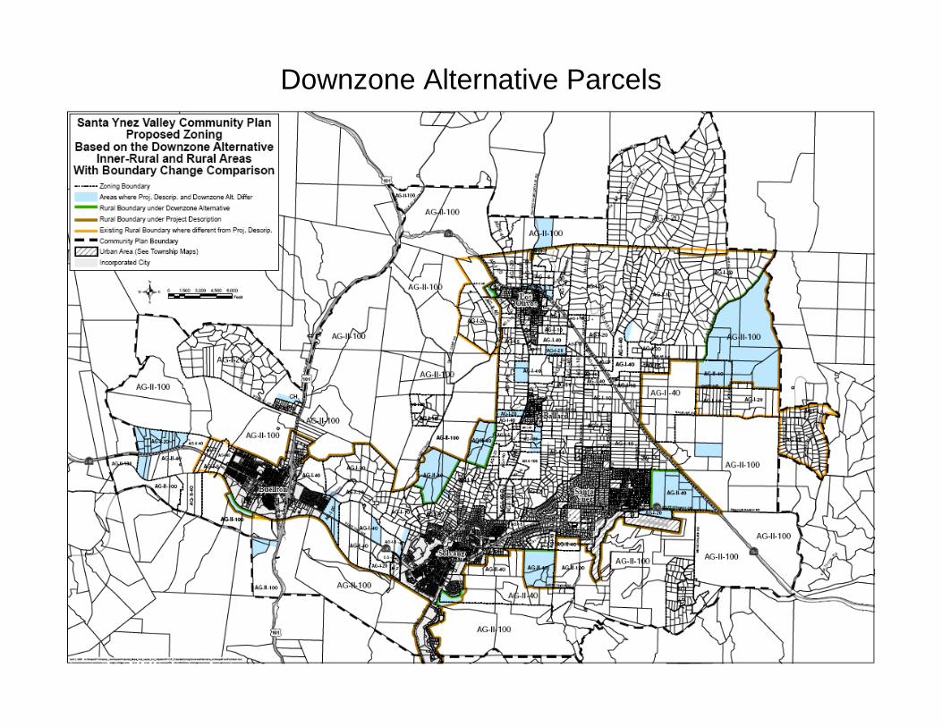
Staff’s Recommendation
• Downzone Alternative recommended by VPAC for study in EIR (Appendix K).
• Proposes changes to land use designations and zoning for 119 parcels in Rural Area:– 172 less units at full theoretical build out.– Precludes further subdivision of properties.– Reduces VMT and ADT (841).– Incrementally reduces wastewater, water, and solid
waste impacts.

8
Land Use Townships Mixed Use Overlay
The Mixed Use Overlay has been designed to:
1. Generate additional opportunities for in-fill housing while simultaneously protecting the commercial viability and potential of the C2 zone district.
2. Maintaining the pedestrian-oriented character of the old town areas, ensuring attractive and compatible architectural design of projects.
3. Reducing regulatory barriers to mixed-use development.
4. Prohibiting uses that conflict with the townships’ rural ambiance.

9
Land Use Townships Mixed Use Overlay Development Standards
The development of a site or building with a combination of residential and commercial use shall be restricted as follows:
1. Residential use equal to or less than 25% of the gross floor area shall be allowed under the base zone district.
2. Gross residential floor area shall not exceed 66% of the total gross floor area.
3. Residential use of more than 25% and up to 50% may be allowed with approval of a Minor Conditional Use Permit.
4. Residential use consisting of 51% to 66% of total gross floor area may be allowed with approval of a Major Conditional Use Permit.

10
Mixed Use Parking
• Proposed Mixed-Use Overlay District to reduce commercial parking requirements by 50%, while retaining existing residential parking requirements (SYVCP Appx. A).
• Review Authority discretion would allow for flexibility if it can be found that:
– Adequate parking exists either on the street or within the public parking lots in the Mixed-Use Overlay District to accommodate the parking demand generated by the project,
– The project parcel’s configuration does not allow for driveway access from the rear or side and would require installation of a driveway along a pedestrian oriented stretch of sidewalk to the detriment of pedestrian safety or streetscape aesthetics or,
– A shared parking agreement in a form acceptable to County Counsel is executed and recorded by the applicant and nearby property owners to accommodate the parking deficit.

11
Mixed Use Parking
• A shared parking agreement would encompass nearby properties to allow overflow parking on each property as may be necessary. These agreements are not designed to manage shared tenant parking on a single site.
• This is in contrast to a conjunctive use parking calculation for a mixed-use development, which is allowed Countywide pursuant to the LUDC (§35.36.080.G).

12
Land Use Townships Mixed Use Overlay Development Standards
Affordable Housing Requirement:
1) 25% of residential units shall be rented to a very low or low income household at a level that meets County affordability criteria.
2) For projects that result in a fractional unit, the fractional requirement may be met through the payment of an in-lieu fee consistent with the in-lieu fee policy detailed in the Housing Element.

13
Santa Ynez Mixed Use Overlay

14
Los Olivos Mixed Use Overlay

15
(D) Design Overlay Parcels

16
Land Use-Rural, Inner-Rural, and EDRN’s (Heritage Sites)
17
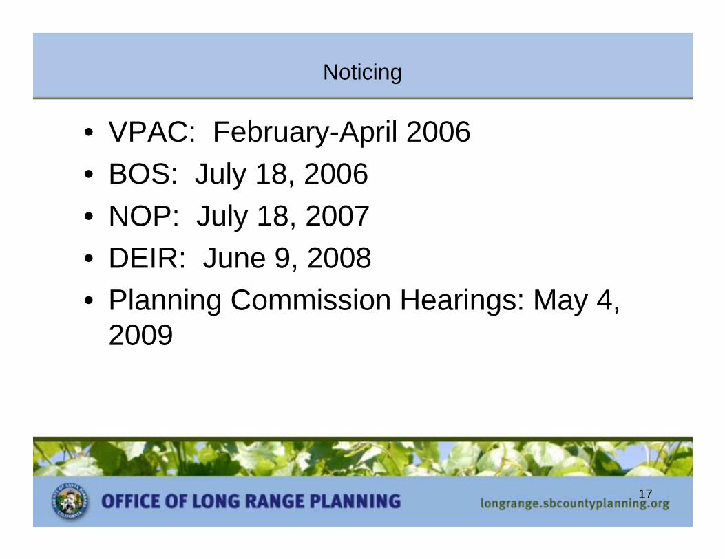
Noticing
• VPAC: February-April 2006• BOS: July 18, 2006 • NOP: July 18, 2007• DEIR: June 9, 2008• Planning Commission Hearings: May 4,
2009
18
Downzone Alternative Parcels

19
Non-Conforming Lots
• Of the 3,901 total parcels in the planning area, over one-third (1,321) are already non-conforming as to size.
• Of the 48,131 parcels in the unincorporated portion of the County, approximately 18,000 are non-conforming as to lot-size.
Non-Conforming Parcels
Parcels Non-Conforming
Proposed Change
Change (%) Cumulative Proportion to 3,901 Total Parcels (%)
Existing 1,321 n/a n/a 33.9 Initiated Plan 1,328 7 0.5 34.0 Downzone Alternative
1,375 47 3.6 35.2
Total n/a 54 4.1 35.2

20
Non-Conforming as to Size Lots
• 119 parcels would be rezoned as part of the Downzone Alternative.– Existing Zoning: 1,321 parcels are currently non-conforming
as to lot size.– Downzone Alternative Zoning: 54 additional parcels will be
nonconforming as to lot size under the Downzone Alternative for a total of 1,375.
• Property owners who currently own parcels that are nonconforming to lot size, or which will become nonconforming as to lot size as a result of this Plan would still have the ability to renovate, build new primary residential structures or rebuild a residential structure in the event of a disaster.

21
Non-Conforming Lots Under the Existing Comp Plan, SYVCP and Downzone Alternative

22
Non-Conforming as to Size Lots
• The LUDC defines (§35.11.N) a non-conforming lot as:
• “A lot the area, dimensions or location of which was lawful prior to the effective date of this Development Code or any amendments, or previously adopted County Zoning Ordinances, and that does not conform to the present regulations of this Development Code.”

23
Non-Conforming as to Size Lots
• The LUDC (§35.30.190.B.1) is clear that legally created lots, even if non-conforming as to size, may be developed with a residence if the lot complies with all other requirements of the LUDC.
• Non-conforming lots cannot be further subdivided.
• Lot line adjustments are allowed for non-conforming lots (LUDC §35.30.110.B.3).

24
Downzones: Non-Conforming Structures
• A nonconforming structure does not conform to a limitation of the Zone District.
• A non-conforming structure, if built before modern ordinances were enacted, is considered legal.
• The proposed SYVCP would have no effect on the conformance status of structures.

25
Non-Conforming Uses
• A non-conforming use is the use of a property for a purpose not permitted in a particular Zone District.
• Allowed uses are more numerous and less restrictive in the AG-II Zone as compared with AG-I.

26
AG-I/AG-II Comparison
• Grazing/Cultivation
• Ag. Accessory Bldg.• Animal Keeping
• Oil & Gas• Winery
• Equine Facilities• Guest Ranch
• Animal Hospital• Employee Housing
• Allowed
• Land Use Permit(LUP)
• 1:20,000 s.f./No limit
• CUP+Oil PP/LUP• No Distinction
• CUP/LUP• Not allowed/CUP
• MCUP/LUP• MCUP

27
AG-I/AG-II Comparison
• Residential 2nd
Unit-Attached• Residential 2nd
Unit-Detached • Setbacks-Front
• Setbacks-Side,Rear• Height Limit
• LUP/Not Allowed
• MCUP/Not Allowed
• 50ft. & 20ft.
• 20-feet/None• 35ft. residential
None otherwise

28

29
Affordable Housing Overlay Sites Considered by the VPAC

30
Affordable Housing Overlay Sites
31
Affordable Housing
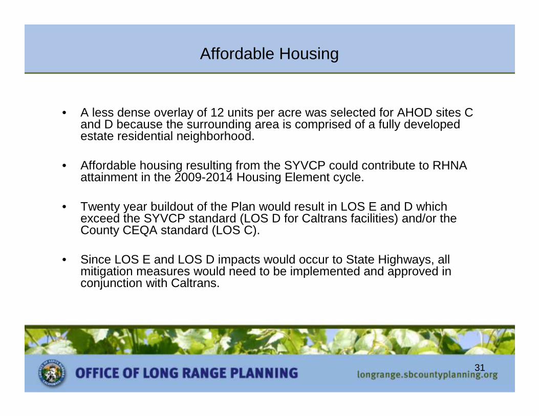
• A less dense overlay of 12 units per acre was selected for AHOD sites C and D because the surrounding area is comprised of a fully developed estate residential neighborhood.
• Affordable housing resulting from the SYVCP could contribute to RHNA attainment in the 2009-2014 Housing Element cycle.
• Twenty year buildout of the Plan would result in LOS E and D which exceed the SYVCP standard (LOS D for Caltrans facilities) and/or the County CEQA standard (LOS C).
• Since LOS E and LOS D impacts would occur to State Highways, allmitigation measures would need to be implemented and approved inconjunction with Caltrans.

32
Mixed Use Overlay
• SYVCP policies require 25% of mixed-use units to be provided as onsite affordable housing.
• Units generated by community plan overlays (Affordable or Mixed Use) cannot be counted towards the County RHNA until they are “built”. Only units generated by base zoning can be counted.

33
Affordable Housing Income Requirements

34
Biological Resources
• 25-foot minimum stream corridor setback in urban and inner-rural areas.
• Setback from edge of riparian vegetation or top-of-bank, whichever is more protective.
• Setbacks are a minimum of 50-feet in other areas of the County.

35
Biological Resources
• The goal of the setback is to balance protection of the riparian habitat with reasonable development opportunities.
• The development standard recognizes the character of riparian habitat in the Santa Ynez Valley, while allowing for site-specific setback adjustments.

36
Biological Resources
• The SYVCP EIR addresses the programmatic impacts which could result from implementation of the proposed plan.
• A substantial component of the residential build-out would occur on large agriculturally-zoned parcels outside of the townships.
• The EIR included mitigation measures in addition to the 46 policies, development standards, and action items proposed by the SYVCP.
• However, under full buildout, impacts to sensitive habitats would remain Class I, Significant and Unavoidable.

37
Wastewater
• Proposed SYVCP policy is to preclude sanitary district annexations or sewer service extensions within the inner-rural or rural areas (Policy WW-SYV-3).
• Sewer service feasibility studies for the for the communities of Los Olivos, Ballard, Janin Acres, and certain areas of West Santa Ynez (Actions WW-SYV-3.1,-3.2, & -3.3).
• DevStd WW-SYV-2.3 would require the installation of an advanced treatment system.

38
Groundwater
• As cited in the SYVCP EIR and the 2005 Santa Barbara County Groundwater Report (2005 Report), the status of the three groundwater basins is as follows:
• Santa Ynez Uplands Basin - The basin is likely in overdraft on the order of 2,000 acre-feet per year (AFY), based on historical groundwater demand.
• Buellton Uplands Basin - The basin is in surplus on the order of 800 AFY.
• Santa Ynez River Alluvial Basin - Overdraft calculations do not apply.

39
SY High School (Early ‘90s) Field work $ 9,500 Pony Little League (7/95) Permit Fees $ 790 Pony Little League (10/01) CUP Fees $ 6,000 Recreational Needs (8/02) Study $ 40,000 Assessment Park Mitigation Fee Status Report - Santa Ynez Valley (04/15/09) Quimby Development Fees Total $57,724 $145,327 $203,051
Parks and Recreation
40
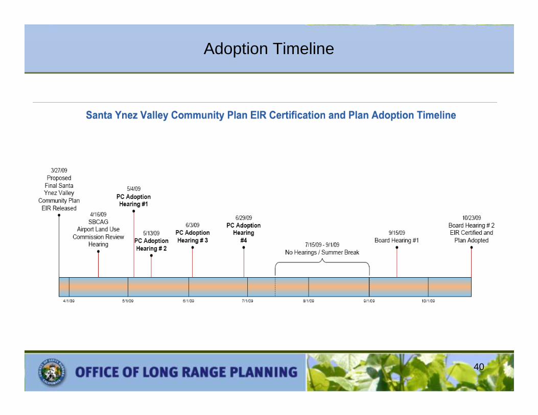
Adoption Timeline