Embed Size (px)
Citation preview
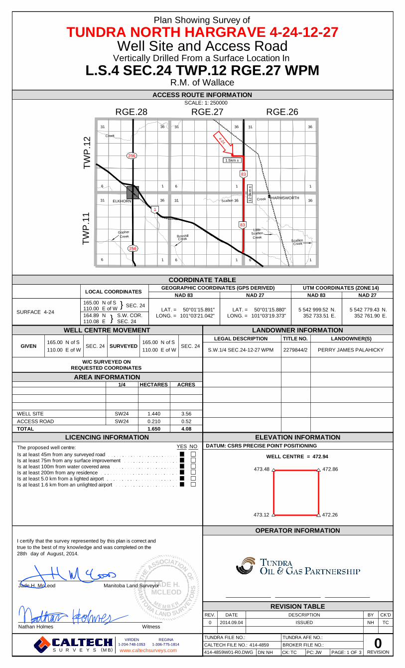
Plan Showing Survey of
TUNDRA NORTH HARGRAVE4-24-12-27Well Site and Access Road
Vertically Drilled From a Surface Location ln
L.S.4 SEC.24 TWP.12 RGE.27 WPMR.M. of Wallace
ACCESS ROUTE INFORMATION
RGE.28SCALE''50000
RGE.27 RGE.26
36 36 31
CL256
1 skmk
83
31 ELK ORN 0 k HAR swo TH8 ii 36
ph* k
286
s
83
60 *k
0 *!
LOCALCOORDINATES
COORDINATE TABLEGEOGRAPHIC COORDINATES (GPS DERIVED)
NAD 27NAD 83
UTM COORDINATES (ZONE14)NAD 27NAD 83
SURFACE 4-24
16500 N ofS T SEC 2411000 EofW 7
164 89 N 1 S.W. COR.11008 E I SEC.24
LAT. = 50'01'15.891"LONG = 101'03'21.042"
LAT. = 50'01'15 880"
LONG. = 101'03'19 373"5 542 99952 N.
352 733 51 E.5 542 779.43 N.
352 761 90 E.
WELL CENTRE MOVEMENT LANDOWNER INFORMATION
165 00 N of S 165.00 N ofSGIVEN SEC.24 SURVEYED SEC. 24
11000 EofW 110.00 E of W
LEGAL DESCRIPTION TITLE NO.
S.W 1/4 SEC.24-12-27 WPM 2279844/2
LANDOWNER(S)
PERRY JAMES PALAHICKY
W/C SURVEYED ONREQUESTED COORDINATES
AREA INFORMATION1/4 HECTARES ACRES
WELL SITE
ACCESS ROAD
TOTAL
SW24
SW24
1.440
0.210
1.650
3. 56
0. 52
4.08
LICENCING INFORMATION
The proposed well centre:
Is at least 45m from any surveyed roadIs at least 75m from any surface improvementIs at least 100m from water covered areaIs at least 200m from any residenceIs at least 5.0 km from a hghted airportIs at least 1.6 km from an unhghted airport
YES NO
473.48 472. 86
ELEVATIONINFORMATIONDATUM: CSRS PRECISE POINT POSITIONING
WELL CENTRE = 472.94
473 12 472.26
I certify that the survey represented by this plan is correct and
true to the best of my knowledge and was completed on the
28th day of August, 2014
OPERATOR INFORMATION
~W TVNDRAOIL & GAS PARTNERSHIP
Nathan Holmes Witness
REV DATE
0 2014 09 04
REVISION TABLEDESCRIPTION
ISSUED
BY CK'D
NH TC
gCALTKCH 1-204748-1063 1-3067767874Cr S U R V E Y S (MB) wwwcaltechsurveys.corn
TUNDRA AFE NOTUNDRA FILE NO
0CALTECH FILE NO 414-4859 BROKER FILE NO
414-4859W01-RO DlNG DN NH CK TC PC JlN PAGE I OF 3 REVISION
RGE.26RGE.27RGE.28
LittleScallionCreek
CreekScallion
Scallion Creek
GopherCreek
Creek
TWP
.11
TWP
.12
BosshillCreek
16
3631
16
3631
16
3631
16
3631
16
3631
16
3631ELKHORNHARMSWORTH
473.48
472.94
473.12
WELL CENTRE =
true to the best of my knowledge and was completed on theday of
I certify that the survey represented by this plan is correct and
The proposed well centre: NOYES
Is at least 75m from any surface improvementIs at least 45m from any surveyed road
Is at least 200m from any residenceIs at least 5.0 km from a lighted airportIs at least 1.6 km from an unlighted airport
Is at least 100m from water covered area
LEGAL DESCRIPTION TITLE NO. LANDOWNER(S)
S.W.1/4 SEC.24-12-27 WPM 2279844/2 PERRY JAMES PALAHICKY
1.4400.2101.650
SW24SW24 3.56
0.524.08
ACCESS ROADWELL SITE
TOTAL
472.86
472.26
WitnessNathan Holmes
DATUM: CSRS PRECISE POINT POSITIONINGELEVATION INFORMATION
Plan Showing Survey ofTUNDRA NORTH HARGRAVE 4-24-12-27
Well Site and Access RoadVertically Drilled From a Surface Location In
L.S.4 SEC.24 TWP.12 RGE.27 WPMR.M. of Wallace
SCALE: 1:ACCESS ROUTE INFORMATION
250000
LANDOWNER INFORMATION
GIVEN SURVEYED
W/C SURVEYED ONREQUESTED COORDINATES
165.00110.00
N of SE of W
SEC. 24165.00110.00
N of SE of W
SEC. 24
WELL CENTRE MOVEMENT
HECTARES ACRESAREA INFORMATION
1/4
JADE H.MCLEOD
C
O
SSO OO
N
TIAI
THE F
A
VALABOT
IN
AM
RUSDN
SR
OYEEBMEM R
Jade H. McLeod Manitoba Land Surveyor
1
83
83
256
256
4-24
LICENCING INFORMATION
OPERATOR INFORMATION
REVISION TABLE
0
28th
PAGE: 1 OF414-4859W01-R0.DWG REVISIONPC:CK:DN:CALTECH FILE NO.: BROKER FILE NO.:TUNDRA FILE NO.: TUNDRA AFE NO.:
414-4859NH TC JW 3
August, 2014.
www.caltechsurveys.com
VIRDEN1-204-748-1053
REGINA1-306-775-1814
U M B( )S R V E Y S
12.9
km ±
1.5km ±
N.E.
N.E.
LAT. =LONG. =
{{SURFACE
LONG. =LAT. =4-24
165.00110.00164.89110.08
N of SE of WNE
SEC. 24
S.W. COR.50°01'15.891"
101°03'21.042"50°01'15.880"
101°03'19.373"5 542 999.52
352 733.515 542 779.43
352 761.90SEC. 24
LOCAL COORDINATESGEOGRAPHIC COORDINATES (GPS DERIVED)
NAD 27UTM COORDINATES (ZONE )
COORDINATE TABLE
NAD 83NAD 83 NAD 2714
REV. DESCRIPTION BY CK'DDATE0 2014.09.04 ISSUED NH TC

Fd. 0.025Sq. I.B.
Mp.
C)
co
0 oCO
CIUJ
rn
c'oCO
FIELD LINE
123.01CULVERT 8
SIGHT LINES APPROACH REQD0.8km+ 1.0km+
807.65 (1/4 DIST) Fd. 0.025Sq. I.B.
SCALE 1:5000 METRES
150 100 50 0 100 200
LEGENDProposed well centre shown thus .
Proposed int casing, landing & target entry points shown thus
Proposed end horizontals & bottom holes shown thus
Proposed drilling locations ..Existing well locations shown thus .
Existing int casing, landing & target entry points shown thus............Existing end hz / bottom holes shown thus .
Abandoned wells shown thus.
Survey monuments found shown thus .
Survey monuments planted shown thus
Survey marks (Spikes) planted shown thus .
Survey marks (Hubs) planted shown thus .
Survey marks (Spikes) found shown thus ..Temporary points shown thus ..Portions referred to shown thus ..Workspace shown thus
Bearings shown are True North and are derived from GPS measurements.
Local coordinates shown are perpendicular to the referenced boundary.
Distances are in metres.
TUNDRA NORTH HARGRAVE4-24-12-27 (WPM)
+Qo
Qo
Qo
+040
k
BURIED FACILITIES INFORMATION
CALTECH FILE NO.: 414-4859 PAGE: 2 OF 3 REVISION
Prior to any construction on lease or access road,MTS Communications Inc.
and Manitoba Hydro must be contacted for location of any undergroundfacilities that may exist.
Underground facilities shown on this plan are those that could be found andlocated at time of survey. Other facilities may exist, of which we wereunaware or unable to locate.
All buried facilities must be located by the respective authority prior toconstruction.Manitoba Hydro: 1-888-624-9376MTS: 1-800-837-6448Flowlines: Individual Operator
R.M. Contact Info.:
R.M. of WallaceVirden, MB
Ph. (204) 748-1239
XX
XX
XX
XX
XX
XX
XX
XX
XX
XX
XX
XX
XX
XX
90°0
1'40
"
X X X X X X X X X X X X X X X X X X X X X X X X X X X X
XX
XX
XX
X X
XX
XX
XX
XX
XX
XX
XX
XX
XX
XX
XX
XX
XX
XX
SIGHT LINES0.8km± 1.0km±
807.65 (1/4 DIST)
804.
94 (1
/4 D
IST)
AS
SU
ME
D 1
80°0
1'40
"
30.175 ROAD ALLOWANCE
30.1
75 U
ND
EVE
LOPE
D R
OAD
ALL
OW
ANC
E
L.S. 5 L.S. 6L.S. 4 L.S. 3
2412-27 WPM
LOW GRADE GRAVEL ROAD(69N)
(157
W)
(DRY)AREAS
LOW
(DRY)AREALOW
(DRY)AREAS
LOW
BUSH
FIE
LD L
INE
&
DRAINAGESEASONAL
BUSHFIELD LINE
DRAINAGESEASONAL
OIL TARGET BDY.
DRAINAGESEASONAL
CULTIVATIONROLLING
20.00
90°
123.01
135.
17
SEE W/SDETAIL
Sq. I.B.Fd. 0.025
Sq. I.B.Fd. 0.025
Mp.
Sq. I.B.Fd. 0.025
Mp.
PAGE:CALTECH FILE NO.: REVISIONOF0
3414-4859TUNDRA NORTH HARGRAVE 4-24-12-27 (WPM) 2
Survey marks (Hubs) planted shown thus
Survey monuments found shown thus
Temporary points shown thus
Survey marks (Spikes) planted shown thus
Portions referred to shown thus
Existing end hz / bottom holes shown thusExisting int casing, landing & target entry points shown thus
Survey monuments planted shown thus
Proposed end horizontals & bottom holes shown thus
Survey marks (Spikes) found shown thus
Proposed int casing, landing & target entry points shown thusProposed well centre shown thus
Existing well locations shown thus
Abandoned wells shown thus
Proposed drilling locations
Local coordinates shown are perpendicular to the referenced boundary.Bearings shown are True North and are derived from GPS measurements.
LEGEND
Workspace shown thus
Distances are in metres.
Prior to any construction on lease or access road,MTS Communications Inc.and Manitoba Hydro must be contacted for location of any undergroundfacilities that may exist.
Underground facilities shown on this plan are those that could be found andlocated at time of survey. Other facilities may exist, of which we were
All buried facilities must be located by the respective authority prior to
BURIED FACILITIES INFORMATION
R.M. Contact Info.:
unaware or unable to locate.
construction.Manitoba Hydro: 1-888-624-9376MTS: 1-800-837-6448Flowlines: Individual Operator
R.M. of WallaceVirden, MBPh. (204) 748-1239
N
150 50100 0 100 200
METRESSCALE 1:5000
SURFACE165.00110.00
N/SE/W
CULVERT &APPROACH REQ'D
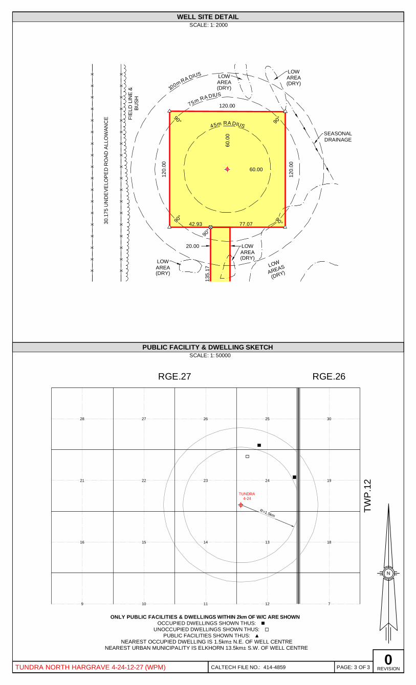
WELL SITE DETAILSCALE: 1: 2000
lgUJZ za MCI ~UJ
( )
LOW~~AREA(DRY)
q.p~o'US
12O OO
LOWAREA
i (DRY)
SEASONALDRAINAGE
/
LOWARE(DR
PUBLIC FACILITY& DWELLING SKETCHSCALE: 1: 50000
RGE.27 RGE.26
ONLY PUBLIC FACILITIES & DWELLINGS WITHIN 2km OF W/C ARE SHOWNOCCUPIED DWELLINGS SHOWN THUS: ~
UNOCCUPIED DWELLINGS SHOWN THUS:PUBLIC FACILITIESSHOWN THUS:
NEAREST OCCUPIED DWELLING IS 1.5km+ N.E. OF WELL CENTRENEAREST URBAN MUNICIPALITYIS ELKHORN 13.5km+ S.W. OF WELL CENTRE
PAGE: 3 OF 3 REVISIONTUNDRA NORTH HARGRAVE4-24-12-27 (WPM) C ALT EC H FILE NO J 414-4859
XX
XX
XX
XX
XX
XX
XX
XX
XX
XX
XX
XX
XX
XX
XX
XX
XX
XX
75m RA DIUS
45m RA DIUS
100m RA DIUS
TUNDRA4-24
(DRY)AREASLOW
60.0
0
60.00
120.00
120.
00
77.07
120.
00
90°
90° 90°
90°
DRAINAGESEASONAL
(DRY)AREALOW
(DRY)AREALOW
30.1
75 U
ND
EVE
LOPE
D R
OAD
ALL
OW
ANC
E
BUSH
FIE
LD L
INE
&
(DRY)AREALOW (DRY)
AREALOW20.00
90°
42.93
135.
17
NEAREST URBAN MUNICIPALITY IS ELKHORN 13.5km± S.W. OF WELL CENTRENEAREST OCCUPIED DWELLING IS 1.5km± N.E. OF WELL CENTRE
UNOCCUPIED DWELLINGS SHOWN THUS:
ONLY PUBLIC FACILITIES & DWELLINGS WITHIN 2km OF W/C ARE SHOWNOCCUPIED DWELLINGS SHOWN THUS:
PUBLIC FACILITIES SHOWN THUS:
16 15 14 13 18
9 10 11 12 7
28 27 26 25 30
21 22 23 24 19
RGE.27TW
P.1
2RGE.26
SCALE: 1:WELL SITE DETAIL
2000
SCALE: 1:PUBLIC FACILITY & DWELLING SKETCH
50000
PAGE:CALTECH FILE NO.: REVISIONOF0
3414-4859TUNDRA NORTH HARGRAVE 4-24-12-27 (WPM) 3
R=1.5km
N

TUNDRA OIL AND GAS PARTNERSHIP
PHOTO MOSAIC PLAN
TUNDRA NORTH HARGRAVE4-24-12-27
S.W.1/4 SEC.24 TWP.12 RGE.27 WPMSCALE: 1:10000
CALTECH 1-204-748-1053 1-306-775-1814
S U R Y E Y S (MB) wwwcaltechsurveys corn
DESCRIPTION
ISSUED
PHOTO DATE 2011
BY CICD
NH TC
800m RAD IUS
2412-27 WPM
1312-27 WPM
CALTECH FILE NO.: 414-4859 TUNDRA FILE NO.: PHOTO DATE: 2011
PROPOSEDTUNDRA
4-24
TUNDRA OIL AND GAS PARTNERSHIP
PHOTO MOSAIC PLAN
SCALE: 1:10000
IN THE
SHOWING
TUNDRA NORTH HARGRAVE 4-24-12-27S.W.1/4 SEC.24 TWP.12 RGE.27 WPM
N
www.caltechsurveys.com
VIRDEN1-204-748-1053
REGINA1-306-775-1814
U M B( )S R V E Y S
REV. DESCRIPTION BY CK'DDATE0 2014.09.04 ISSUED NH TC

Innovation, Energy end Mines
APPLICATIONFOR WELL LICENCEIn comphance with Ihe Oil and Gas Act and the Drilhng and Production Regulation, application is hereby made for a well
licence for.
Well Name Tundra North Har ave 04-24-12-27 WP
Well Location 04 24(LSD) (Quadrant) (Section)
Name of Well Owner Tundra Oil Ec Gas Partnershi
12 27(Township) (Rauge)
hfanitoba Corporation No
Address of Well Owner 1700 One Lombard Place W MB R3B OX3
Telephone 204 -934-5850
Surface Location 04(LSD)
Ground Elevation 472 94
Fax 204 -934-5820
24 12 27(Quadraat) (Seciiou) (Tonus hip) (Rmge)
metres above sea level
Surface Co-ordinates
165.00m N of S of Sec 24
110.00m E of Wof Sec 24
Directional or Horizontal WellBottomHoie Co-ordinates
165.00m N of S of Sec 24
110.00m Eof Wof Sec 24
Surface Owner Pe Palahic S4409
Occupant Trevor Soder
Royalty Owner(s) See Attached
Freehohl Oil and Gas Rights Leased By
Crown Reservation or Lease No.
Prairie Land T. Jordan(Naue of Otl md Gas Lease Agent aad Corporation)
Type of Well OIL
Projected Total Depth 743.0m in Devonian
Casing SizeOj). mm
1. 244.50
177.80
Weightim
48.07
29.76
Grade
H-40
J-55
From
Surface
Surface
To
135.00
707.50
EstimatedCemented Interval
Surface
257.00
Drilhng Contractor Trinidad Drillin Ltd.
Expected Spud Date 12-Se -2015
Responsible Agent of Company at Well Eric B'ornsson
Rig No. 10
06-Jul-2015(Date) DD.'htbtbl YYYY (Siguature of applicaat)
For assistance in completing this form contact Paulette Seymour at (204) 945-6575 or Dan Smzyshyn at (204) 945-8102.
For Department Use Only
Well Licence No.: 10414 UWIt 100.04-24-012-27W1.00
Well ClasssTscation J)EVELOPMENT (CONFIDENTIAL)Please see attached conditions.
Date of Issue evtewed by:

Lic. No. 10414 Tundra North Hargrave 04-24-12-27 (WPM)
A licence to drill a well known as Tundra North Hargrave 04-24-12-27 (WPM) is hereby
granted to Tundra Oil A Gas Partnership.
The Licensee shall comply with all the provisions of the Oil and Gas Act, the Drilling and
Production Regulation and the following terms and conditions:
1. The Petroleum Branch will forward a copy of the surface lease for the above location to the
Surface Rights Board to satisfy the requirements of Section 15 of the Surface Rights Act.
2. The lease is to be constructed in a manner that it does not impede the flow of seasonal
drainage.
3. Tundra must ensure that the core box is labeled with the licence ¹, bottomhole location and
intervals for that particular box. (In Large Bold Letters).
Lic. No. 10414 Tundra North Hargrave 04-24-12-27 (WPM)
A licence to drill a well known as Tundra North Hargrave 04-24-12-27 (WPM) is hereby
granted to Tundra Oil & Gas Partnership.
The Licensee shall comply with all the provisions of the Oil and Gas Act, the Drilling and
Production Regulation and the following terms and conditions:
1. The Petroleum Branch will forward a copy of the surface lease for the above location to the
Surface Rights Board to satisfy the requirements of Section 15 of the Surface Rights Act.
2. The lease is to be constructed in a manner that it does not impede the flow of seasonal
drainage.
3. Tundra must ensure that the core box is labeled with the licence #, bottomhole location and
intervals for that particular box. (In Large Bold Letters).

Lie. No. 10414 Tundra North Hargrave 04-24-12-27 (WPM)
MANIT BA BMI I NRE IREMENT F RNEWWELL
The following notiTications and information must be provided to the appropriate district office.
OPERATIONS IN TOWNSHIPS 1 TO 6Dept. of Innovation, Energy and MinesPetroleum BranchBox 22023 Railway AvenueWaskadaMB ROM2EOPhone: 2044I73-2472 (24 hour service)Fax: 204-673-2767
OPERATIONS NORTH OF TOWNSHIP 6Dept. of Innovation, Energy and MinesPetroleum BranchBox 1359227 King Street WestVlrden MB ROM 2CO204-7484260 (24 hour service)204-748-2208
DRILLING, COMPLETION AND INITIALPRODUCTION SUBMSSION REGUIREMENTS
COMPANY REPRESENTATIVE ATWELLSITE IS RESPONSIBLE FOR ITEMS 1 TO 9.
1. 24 hours advance noses of Intent to spud a well.
FOR OEPr, u% ONLY
RECEIVED
2, 2 hours advance notice of intent to run and cement surface casing or production casing.
3. 2 hours advance notice of intent to pull pipe after running a DST.
4. 2 hours advance notice of a dry hole abandonment. Verbal approval to abandon must be obtained
horn the district oNce.
5, Weekly status reports on all acdvitles up to rig release. R rts tobe called in each MONDAY
6. Acomplete copy of the drilling tours.
7. Two (2) copies of field prints of all logs.
8. Tagged Image Ales of all open hole logs and cased hole logs and LAS (Log ASCII) Flies) for any
log that may be represented in LAS format (submlsed on 1.44 floppy disk, CD or DVD format) as
per Informational Nodce 054I5.
Two (2) copies of any directional sunreys run (submitted in digital format as per Informational
10. Aone (1) litre sample of drilling fluids. Squeezing of a pit is not to proceed without the consent of
the district office.
11. Any drill cutting samples and cores are to be shipped to: Rock Preparation Lab, 10 Midland
Street, Winnipeg MB, R3E 2Y6.
12. Two (2) copies of all reporls of drill stem tests, oore analyses or of any other test. (E.g, fluid
analyses, pressure surveys, etc.)
13. Two (2) copies of any Geological Repon,
14. Chronological report of all completion operations incluMng full details.
15. Two (2) copies of all completion logs.
16. Two (2) copies of the Initial Produchon Report (lorms ssached).
Lic. No. 10414 Tundra North Hargrave 04-24-12-27 (WPM)

TUNDRA NORTH HARGRAVE04-24-12-27 WPMVERTICALSTRAT WELL
License ¹: 10414
UWI: 100.04-24-012-27W1.00
Tundra Oil 4 Gas Partnership1000, 715-5've S.K
Calgary, AlbertaT2P 2%6
Well Data ReportAugust 4, 2015
Compiled by: Chris Frank, B.Sc.Troy Cockerill, B.Sc.
5405492 MB LTD.612 —12
" STREETBranson, Manitoba, Canada
(204) 851-2937
Troy Cockerill
TUNDRA NORTH HARGRAVE 04-24-12-27 WPM
VERTICAL STRAT WELL
License #: 10414
UWI: 100.04-24-012-27W1.00
Tundra Oil & Gas Partnership
1000, 715-5th Ave S.W.
Calgary, Alberta
T2P 2X6
Well Data Report
August 4, 2015
Compiled by: Chris Frank, B.Sc.
Troy Cockerill, B.Sc.
5405492 MB LTD.
612 – 12TH
STREET
Branson, Manitoba, Canada
(204) 851-2937
____________________
Troy Cockerill

Tundra North Hargrave 04-24-12-27 WPM1
Contents
Well Data Summary
Geological Markers
Mud Record
Bit Record
Daily Operations Summary
Surveys
Coring ¹I & 2 Report
Core Descriptions
Logging Report
Geological Summary
Strip Log (s)
2
3
4
4
5
5
6
7
9
10
in back pocket
5405492 MANITOBALTD.612-12'treet, Brandon, Manitoba, Canada R7A 4M9
(204) 851-2937
Tundra North Hargrave 04-24-12-27 WPM
1
5405492 MANITOBA LTD.
612-12th Street, Brandon, Manitoba, Canada R7A 4M9
(204) 851-2937
Contents
Well Data Summary 2
Geological Markers 3
Mud Record 4
Bit Record 4
Daily Operations Summary 5
Surveys 5
Coring #1 & 2 Report 6
Core Descriptions 7
Logging Report 9
Geological Summary 10
Strip Log (s) in back pocket

Tundra North Hargrave 04-24-12-27 WPM2
WELL DATASUMMARY
WELL NAME:LEGALLOCATION:FIELD / REGION:PROVINCE:OPERATOR:PARTICIPANTS:DRILLING LICENSE:SECURITY STATUS:
Tundra North Hargrave 04-24-12-27 WPM04-24-012-27 WPMHargraveManitobaTundra Oil and Gas PartnershipN/A10414
Development (Confidential)
CO-ORDINATES: SURFACE: 165.00m N of S, 110.00m E of W, Section 24BOTTOM: 165.00m N of S, 110.00m E of W, Section 24
ELEVATIONS: GROUND: 472.94mK.B.: 477.04m
DATES:SPUD DATE:DRILL OUT:SAMPLE POINT:CORE POINT:TOTALDEPTH:
11:00 hrs, August 1, 201500:25 hrs, August 2, 201505:15 hrs, August 2, 201509:25 hrs, August 2, 201511:24 hrs, August 3, 2015
TOTALDEPTH:
OBJECTIVE:
745.0m TVD
Regolith Porosity
SAMPLE INTERVAL: 5 m samples washed and vialed from 400m to TD.
SAMPLE QUALITY: Fair.
CASING: Surface: 11 jts 244.5mm, 48.07kg/m, H-40, STkC; landed @138.0m.
DRILL CONTRACTOR: Trinidad 10
TOOLPUSH: Vern FalloonWELL ENGINEER: Tom UnderwoodWELL GEOLOGIST: Troy Cockerill / Chris FrankSERVICE CO'S: DRILLING MUD: Moose Mountain Mud
DIRECTIONAL: N/ACEMENTING: TricanHOLE SURVEYS: N/ALOGGING: WeatherfordCORING: Blackie's Coring Services
WELL STATUS: Strat hole prepared for vertical well completion.
5405492 MANITOBALTD.612-12'treet, Brandon, Manitoba, Canada R7A 4M9
(204) 851-2937
Tundra North Hargrave 04-24-12-27 WPM
2
5405492 MANITOBA LTD.
612-12th Street, Brandon, Manitoba, Canada R7A 4M9
(204) 851-2937
WELL DATA SUMMARY
WELL NAME: Tundra North Hargrave 04-24-12-27 WPM
LEGAL LOCATION: 04-24-012-27 WPM
FIELD / REGION: Hargrave
PROVINCE: Manitoba
OPERATOR: Tundra Oil and Gas Partnership
PARTICIPANTS: N/A
DRILLING LICENSE: 10414
SECURITY STATUS: Development (Confidential)
CO-ORDINATES: SURFACE: 165.00m N of S, 110.00m E of W, Section 24
BOTTOM: 165.00m N of S, 110.00m E of W, Section 24
ELEVATIONS: GROUND: 472.94m
K.B.: 477.04m
DATES:
SPUD DATE: 11:00 hrs, August 1, 2015
DRILL OUT: 00:25 hrs, August 2, 2015
SAMPLE POINT: 05:15 hrs, August 2, 2015
CORE POINT: 09:25 hrs, August 2, 2015
TOTAL DEPTH: 11:24 hrs, August 3, 2015
TOTAL DEPTH: 745.0m TVD
OBJECTIVE: Regolith Porosity
SAMPLE INTERVAL: 5 m samples washed and vialed from 400m to TD.
SAMPLE QUALITY: Fair.
CASING: Surface: 11 jts 244.5mm, 48.07kg/m, H-40, ST&C; landed @
138.0m.
DRILL CONTRACTOR: Trinidad 10
TOOLPUSH: Vern Falloon
WELL ENGINEER: Tom Underwood
WELL GEOLOGIST: Troy Cockerill / Chris Frank
SERVICE CO’S: DRILLING MUD: Moose Mountain Mud
DIRECTIONAL: N/A
CEMENTING: Trican
HOLE SURVEYS: N/A
LOGGING: Weatherford
CORING: Blackie’s Coring Services
WELL STATUS: Strat hole prepared for vertical well completion.

Tundra North Hargrave 04-24-12-27 WPM3
GEOLOGICALMARKERSKB = 477.04m
FORMATIONTOPS PROGNOSIS SAMPLE* LOGS
Sub sea
DethmTrue Vertical
DethmSub sea
Deth mTrue Vertical
Deth mSub sea
Dethm
Base Fish Scales
Mannville Sand
Jurassic
MelitaRed Jacket
Core Point ¹ILodgepoleRegolith Porosity
Upper Virden
Upper BakkenMiddle Bakken
Birdbear
DuperowTD
131
70
27
-12.5
-30.5
-79.5
-85.5
-101.5
-170.0
-171.0
-195.5
-230.5
-266
346.0
407.0
451.0
491.0
506.0
553.0
556.4
561.0
577.5
650.4
651.2
675.5
710.4
745.0
131.0
70.0
26.0-14.0
-29.0
-76.0
-79.4
-84.0
-100.5
-173.4
-174.2
-198.5
-233.4
-268.0
349.7
406.5
451.0
491.8
505.0
557.2
560.0
576.0
651.0
651.8
676.5
711.2
745.3
127.3
70.5
26.0-14.8
-28.0
-80.2
-83.0
-99.0
-174.0
-174.8
-199.5
-234.2
-268.3
*Tops based on ROP, mud gas, and samples +/- core.
5405492 MANITOBALTD.612-12'treet, Brandon, Manitoba, Canada R7A 4M9
(204) 851-2937
Tundra North Hargrave 04-24-12-27 WPM
3
5405492 MANITOBA LTD.
612-12th Street, Brandon, Manitoba, Canada R7A 4M9
(204) 851-2937
GEOLOGICAL MARKERS KB = 477.04m
FORMATION TOPS PROGNOSIS SAMPLE* LOGS
Subsea True Vertical Subsea True Vertical Subsea
Depth (m) Depth (m) Depth (m) Depth (m) Depth (m)
Base Fish Scales 131 346.0 131.0 349.7 127.3
Mannville Sand 70 407.0 70.0 406.5 70.5
Jurassic 27 451.0 26.0 451.0 26.0
Melita -12.5 491.0 -14.0 491.8 -14.8
Red Jacket -30.5 506.0 -29.0 505.0 -28.0
Core Point #1 - 553.0 -76.0 --- ---
Lodgepole -79.5 556.4 -79.4 557.2 -80.2
Regolith Porosity -85.5 561.0 -84.0 560.0 -83.0
Upper Virden -101.5 577.5 -100.5 576.0 -99.0
Upper Bakken -170.0 650.4 -173.4 651.0 -174.0
Middle Bakken -171.0 651.2 -174.2 651.8 -174.8
Birdbear -195.5 675.5 -198.5 676.5 -199.5
Duperow -230.5 710.4 -233.4 711.2 -234.2
TD -266 745.0 -268.0 745.3 -268.3
*Tops based on ROP, mud gas, and samples +/- core.

Tundra North Hargrave 04-24-12-27 WPM4
MUD RECORD
Mud TypeMud CompanyMudman
Polymer.Moose Mountain MudRyan Miller
Pump Liner Size ¹1 152.0 mm Stroke Length 229 mm
Volume per Pump Stroke ¹1 0.0112 m (100.0% efficiency) (Gardner-Denver PZ-9)
Pump Output
Mud Gas:
¹1 1.40 m /min @ 125 Stk/min (100% efficiency)
Mud gas logged from surface to TD of well with a Pason total gas detection system.
BIT RECORD
5405492 MANITOBALTD.612-12'treet, Brandon, Manitoba, Canada R7A 4M9
(204) 851-2937
Tundra North Hargrave 04-24-12-27 WPM
4
5405492 MANITOBA LTD.
612-12th Street, Brandon, Manitoba, Canada R7A 4M9
(204) 851-2937
MUD RECORD
Mud Type Polymer.
Mud Company Moose Mountain Mud
Mudman Ryan Miller
Pump Liner Size #1 152.0 mm Stroke Length 229 mm
Volume per Pump Stroke #1 0.0112 m3 (100.0% efficiency) (Gardner-Denver PZ-9)
Pump Output #1 1.40 m3/min @ 125 Stk/min (100% efficiency)
Mud Gas: Mud gas logged from surface to TD of well with a Pason total gas detection system.
BIT RECORD
Date Depth Density Viscosity Fluid Filter pH Pressure Chlorides
(m) (Kg/m3) (sec/l) Loss (cm3) Cake (mm) (kPa) (ppm)
August 3 724 1155 156 6.3 1.1 10.5 5771 1380
Bit Size (mm) Type Jets Out Meters Hours RPM Force (daN)
1 349 Western 4x12.50 138 138 2.0 165 10.0
2 222 Security FX54 5x11.1 553 415 4.5 150 3.0
3 199 Blackies 6x9.5 563 10 1.5 90 2.0
3RR 199 Blackies 6x9.5 572 9 1.5 75 2.6
2RR 222 Security FX54 5x11.1 745 192 --- 140 6.0
Tundra North Hargrave 04-24-12-27 WPM5
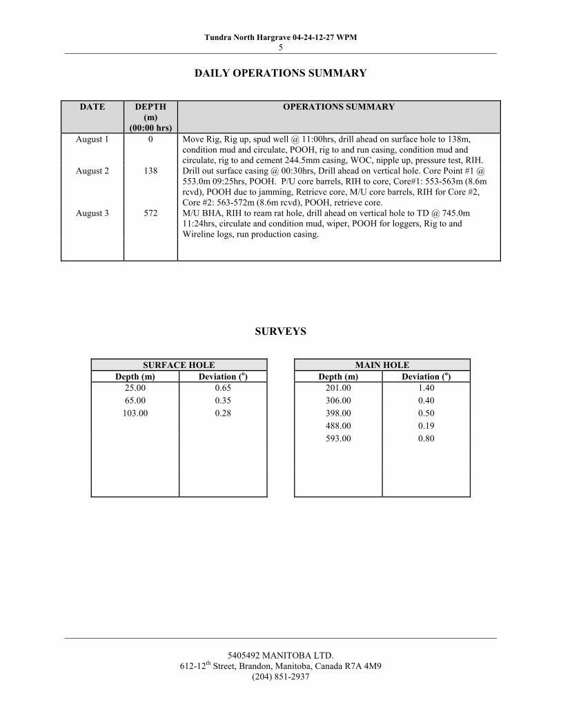
DAILYOPERATIONS SUMMARY
I ~g
~
I I I I
August 1
August 2
August 3
138
572
Move Rig, Rig up, spud well @ 11:00hrs, drill ahead on surface hole to 138m,condition mud and circulate, POOH, rig to and run casing, condition mud and
circulate, rig to and cement 244.5mm casing, WOC, nipple up, pressure test, RIH.Drill out surface casing @ 00:30hrs, Drill ahead on vertical hole. Core Point ¹1 @553.0m 09:25hrs, POOH. P/U core barrels, RIH to core, Core¹1: 553-563m (8.6mrcvd), POOH due to jamming, Retrieve core, M/U core barrels, RIH for Core ¹2,Core ¹2: 563-572m (8.6m rcvd), POOH, retrieve core.
M/U BHA, RIH to ream rat hole, drill ahead on vertical hole to TD @ 745.0m11:24hrs, circulate and condition mud, wiper, POOH for loggers, Rig to and
Wireline logs, run production casing.
SURVEYS
5405492 MANITOBALTD.612-12'treet, Brandon, Manitoba, Canada R7A 4M9
(204) 851-2937
Tundra North Hargrave 04-24-12-27 WPM
5
5405492 MANITOBA LTD.
612-12th Street, Brandon, Manitoba, Canada R7A 4M9
(204) 851-2937
DAILY OPERATIONS SUMMARY
DATE DEPTH
(m)
(00:00 hrs)
OPERATIONS SUMMARY
August 1 0 Move Rig, Rig up, spud well @ 11:00hrs, drill ahead on surface hole to 138m,
condition mud and circulate, POOH, rig to and run casing, condition mud and
circulate, rig to and cement 244.5mm casing, WOC, nipple up, pressure test, RIH.
August 2 138 Drill out surface casing @ 00:30hrs, Drill ahead on vertical hole. Core Point #1 @
553.0m 09:25hrs, POOH. P/U core barrels, RIH to core, Core#1: 553-563m (8.6m
rcvd), POOH due to jamming, Retrieve core, M/U core barrels, RIH for Core #2,
Core #2: 563-572m (8.6m rcvd), POOH, retrieve core.
August 3 572 M/U BHA, RIH to ream rat hole, drill ahead on vertical hole to TD @ 745.0m
11:24hrs, circulate and condition mud, wiper, POOH for loggers, Rig to and
Wireline logs, run production casing.
SURVEYS
SURFACE HOLE MAIN HOLE
Depth (m) Deviation (o) Depth (m) Deviation (
o)
25.00 0.65 201.00 1.40
65.00 0.35 306.00 0.40
103.00 0.28 398.00 0.50
488.00 0.19
593.00 0.80
Tundra North Hargrave 04-24-12-27 WPM6
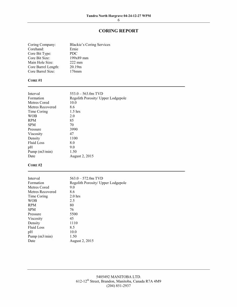
CORING REPORT
Coring Company:Corehand:Core Bit Type:Core Bit Size:
Main Hole Size:
Core Barrel Length:Core Barrel Size:
Blackie's Coring Services
ErniePDC199x89 mm222 mm20.19m176mm
CoRE ¹1
IntervalFormationMetres CoredMetres RecoveredTime CoringWOBRPMSPMPressure
ViscosityDensityFluid Loss
pHPump (m3/min)Date
553.0 —563.0m TVDRegolith Porosity/ Upper Lodgepole10.0
8.61.5 hrs
2.0
85
70
399047
1100
8.0
9.01.50
August 2, 2015
CoRE ¹2
IntervalFormationMetres CoredMetres RecoveredTime CoringWOBRPMSPMPressure
ViscosityDensityFluid Loss
pHPump (m3/min)Date
563.0 —572.0m TVDRegolith Porosity/ Upper Lodgepole9.0
8.62.0 hrs
2.5
80
76
550045
1110
8.5
10.0
1.50
August 2, 2015
5405492 MANITOBALTD.612-12'treet, Brandon, Manitoba, Canada R7A 4M9
(204) 851-2937
Tundra North Hargrave 04-24-12-27 WPM
6
5405492 MANITOBA LTD.
612-12th Street, Brandon, Manitoba, Canada R7A 4M9
(204) 851-2937
CORING REPORT
Coring Company: Blackie’s Coring Services
Corehand: Ernie
Core Bit Type: PDC
Core Bit Size: 199x89 mm
Main Hole Size: 222 mm
Core Barrel Length: 20.19m
Core Barrel Size: 176mm
CORE #1
Interval 553.0 – 563.0m TVD
Formation Regolith Porosity/ Upper Lodgepole
Metres Cored 10.0
Metres Recovered 8.6
Time Coring 1.5 hrs
WOB 2.0
RPM 85
SPM 70
Pressure 3990
Viscosity 47
Density 1100
Fluid Loss 8.0
pH 9.0
Pump (m3/min) 1.50
Date August 2, 2015
CORE #2
Interval 563.0 – 572.0m TVD
Formation Regolith Porosity/ Upper Lodgepole
Metres Cored 9.0
Metres Recovered 8.6
Time Coring 2.0 hrs
WOB 2.5
RPM 80
SPM 76
Pressure 5500
Viscosity 45
Density 1110
Fluid Loss 8.5
pH 10.0
Pump (m3/min) 1.50
Date August 2, 2015
Tundra North Hargrave 04-24-12-27 WPM7
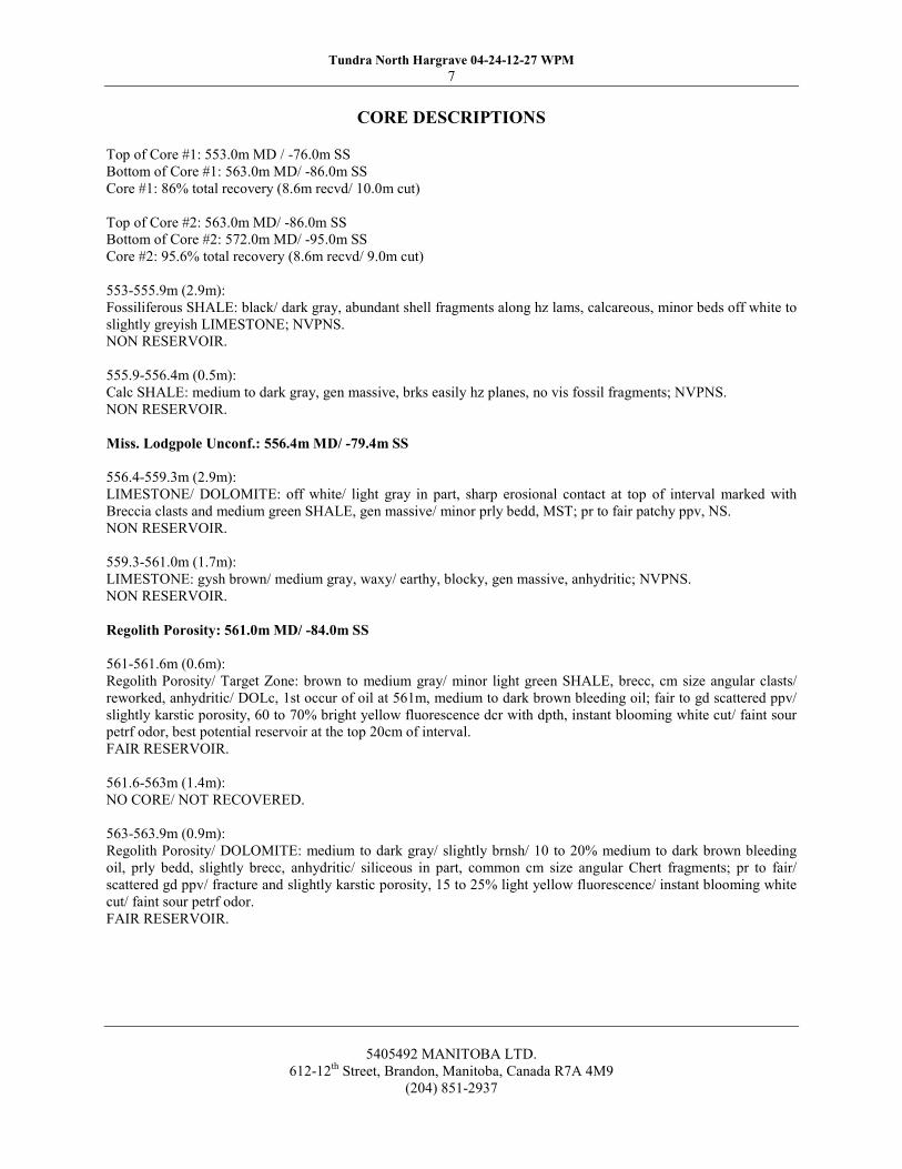
CORE DESCRIPTIONS
Top of Core ¹1: 553.0m MD / -76.0m SS
Bottom of Core ¹1: 563.0m MD/ -86.0m SS
Core ¹1: 86% total recovery (8.6m recvd/ 10.0m cut)
Top of Core ¹2: 563.0m MD/ -86.0m SS
Bottom of Core ¹2: 572.0m MD/ -95.0m SS
Core ¹2: 95.6% total recovery (8.6m recvd/ 9.0m cut)
553-555.9m (2.9m):Fossiliferous SHALE: black/ dark gray, abundant shell fragments along hz lams, calcareous, minor beds off white to
slightly greyish LIMESTONE; NVPNS.NON RESERVOIR.
555.9-556.4m (0.5m):Calc SHALE: medium to dark gray, gen massive, brks easily hz planes, no vis fossil fragments; NVPNS.NON RESERVOIR.
Miss. Lodgpole Unconf.: 556.4m MD/-79.4m SS
556.4-559.3m (2.9m):LIMESTONE/ DOLOMITE: off white/ light gray in part, sharp erosional contact at top of interval marked withBreccia clasts and medium green SHALE, gen massive/ minor prly bedd, MST; pr to fair patchy ppv, NS.NON RESERVOIR.
559.3-561.0m (1.7m):LIMESTONE: gysh brown/ medium gray, waxy/ earthy, blocky, gen massive, anhydritic; NVPNS.NON RESERVOIR.
Regolith Porosity: 561.0m MD/-84.0m SS
561-561.6m (0.6m):Regolith Porosity/ Target Zone: brown to medium gray/ minor light green SHALE, brecc, cm size angular clasts/
reworked, anhydritic/ DOLc, 1st occur of oil at 561m, medium to dark brown bleeding oil; fair to gd scattered ppv/slightly karstic porosity, 60 to 70% bright yellow fluorescence dcr with dpth, instant blooming white cut/ faint sour
petrf odor, best potential reservoir at the top 20cm of interval.FAIRRESERVOIR.
561.6-563m (1.4m):NO CORE/ NOT RECOVERED.
563-563.9m (0.9m):Regolith Porosity/ DOLOMITE: medium to dark gray/ slightly brnsh/ 10 to 20% medium to dark brown bleedingoil, prly bedd, slightly brecc, anhydritic/ siliceous in part, common cm size angular Chert fragments; pr to fair/scattered gd ppv/ fracture and slightly karstic porosity, 15 to 25% light yellow fluorescence/ instant blooming whitecut/ faint sour petrf odor.FAIRRESERVOIR.
5405492 MANITOBALTD.612-12'treet, Brandon, Manitoba, Canada R7A 4M9
(204) 851-2937
Tundra North Hargrave 04-24-12-27 WPM
7
5405492 MANITOBA LTD.
612-12th Street, Brandon, Manitoba, Canada R7A 4M9
(204) 851-2937
CORE DESCRIPTIONS Top of Core #1: 553.0m MD / -76.0m SS
Bottom of Core #1: 563.0m MD/ -86.0m SS
Core #1: 86% total recovery (8.6m recvd/ 10.0m cut)
Top of Core #2: 563.0m MD/ -86.0m SS
Bottom of Core #2: 572.0m MD/ -95.0m SS
Core #2: 95.6% total recovery (8.6m recvd/ 9.0m cut)
553-555.9m (2.9m):
Fossiliferous SHALE: black/ dark gray, abundant shell fragments along hz lams, calcareous, minor beds off white to
slightly greyish LIMESTONE; NVPNS.
NON RESERVOIR.
555.9-556.4m (0.5m):
Calc SHALE: medium to dark gray, gen massive, brks easily hz planes, no vis fossil fragments; NVPNS.
NON RESERVOIR.
Miss. Lodgpole Unconf.: 556.4m MD/ -79.4m SS
556.4-559.3m (2.9m):
LIMESTONE/ DOLOMITE: off white/ light gray in part, sharp erosional contact at top of interval marked with
Breccia clasts and medium green SHALE, gen massive/ minor prly bedd, MST; pr to fair patchy ppv, NS.
NON RESERVOIR.
559.3-561.0m (1.7m):
LIMESTONE: gysh brown/ medium gray, waxy/ earthy, blocky, gen massive, anhydritic; NVPNS.
NON RESERVOIR.
Regolith Porosity: 561.0m MD/ -84.0m SS
561-561.6m (0.6m):
Regolith Porosity/ Target Zone: brown to medium gray/ minor light green SHALE, brecc, cm size angular clasts/
reworked, anhydritic/ DOLc, 1st occur of oil at 561m, medium to dark brown bleeding oil; fair to gd scattered ppv/
slightly karstic porosity, 60 to 70% bright yellow fluorescence dcr with dpth, instant blooming white cut/ faint sour
petrf odor, best potential reservoir at the top 20cm of interval.
FAIR RESERVOIR.
561.6-563m (1.4m):
NO CORE/ NOT RECOVERED.
563-563.9m (0.9m):
Regolith Porosity/ DOLOMITE: medium to dark gray/ slightly brnsh/ 10 to 20% medium to dark brown bleeding
oil, prly bedd, slightly brecc, anhydritic/ siliceous in part, common cm size angular Chert fragments; pr to fair/
scattered gd ppv/ fracture and slightly karstic porosity, 15 to 25% light yellow fluorescence/ instant blooming white
cut/ faint sour petrf odor.
FAIR RESERVOIR.

Tundra North Hargrave 04-24-12-27 WPM8
CORE DESCRIPTIONS
563.9-566.2m (2.3m):DOLOMITE/ LIMESTONE: light to medium gray/ occasional off white, MICXL to VFXL/occasional ALTMST,slightly limy increase with dpth, minor spotty medium brown bleeding oil, anhydritic, occasional white Chert nods,
gen massive/ moderately bedd; pr to fair patchy gd ppv and intercrystalline porosity, spotty faint to light yellowfluorescence/ instant strmg cut.POOR RESERVOIR.
566.2-572m (5.8m):LIMESTONE: off white/ slightly gray in part, MST/ MICXL, anhydritic/ slightly dolomitic dcr with dpth,occasional white large Chert nods, prly bedd becoming massive; pr to fair patchy gd ppv and intercrystalline/microfrac porosity, rare spotty light yellow fluorescence with faint cut/ last occur of oil at 566.5m.VERY POOR to NON RESERVOIR.
BOTTOM OF CORE ¹2: 572.0m MD/ -95.0m SS
5405492 MANITOBALTD.612-12'treet, Brandon, Manitoba, Canada R7A 4M9
(204) 851-2937
Tundra North Hargrave 04-24-12-27 WPM
8
5405492 MANITOBA LTD.
612-12th Street, Brandon, Manitoba, Canada R7A 4M9
(204) 851-2937
CORE DESCRIPTIONS
563.9-566.2m (2.3m):
DOLOMITE/ LIMESTONE: light to medium gray/ occasional off white, MICXL to VFXL/ occasional ALT MST,
slightly limy increase with dpth, minor spotty medium brown bleeding oil, anhydritic, occasional white Chert nods,
gen massive/ moderately bedd; pr to fair patchy gd ppv and intercrystalline porosity, spotty faint to light yellow
fluorescence/ instant strmg cut.
POOR RESERVOIR.
566.2-572m (5.8m):
LIMESTONE: off white/ slightly gray in part, MST/ MICXL, anhydritic/ slightly dolomitic dcr with dpth,
occasional white large Chert nods, prly bedd becoming massive; pr to fair patchy gd ppv and intercrystalline/
microfrac porosity, rare spotty light yellow fluorescence with faint cut/ last occur of oil at 566.5m.
VERY POOR to NON RESERVOIR.
BOTTOM OF CORE #2: 572.0m MD/ -95.0m SS

Tundra North Hargrave 04-24-12-27 WPM9
LOGGING REPORT
COMPANY:DISTRICT:ENGINEER:UNIT:HOLE SIZE:
WeatherfordEstevan
K. Canning13380
222 mm
DEPTH CHECKS:
K.B. ELEVATION:SURFACE CSG:TOTALDEPTH:
DRILLER477.04
138.0745.0
LOGGER477.04
138.0745.3
DIGITALLOGS: Posted FIELD PRINTS: 2 FINALPRINTS: N/A
MUD TYPE: Gel Chem
Density:Viscosity:Mud pH:Fluid Loss:
Rm:Rmf:Rmc:Rm@BHTBHT @ T.D.:Circulation Ended:Start Logging (btm):Operating Time:
1110.0 kg/m120.0sec/1
10.0
7.0 ml/30min0.88 ohmm @ 20.0 'C0.76 ohmm @ 20.0'C0.90 ohmm @ 20.0'C0.64 ohmm @ 35'C35'C @ 745.3m18:00 hrs, August 3, 201523:00 hrs, August 3, 2015
8.0 hrs
REMARKS: Dipole Sonic —GR, Spectral Pe Density-CN, STI, Spectral GR, High resolution Neutron Density
logged in combination.
5405492 MANITOBALTD.612-12'treet, Brandon, Manitoba, Canada R7A 4M9
(204) 851-2937
Tundra North Hargrave 04-24-12-27 WPM
9
5405492 MANITOBA LTD.
612-12th Street, Brandon, Manitoba, Canada R7A 4M9
(204) 851-2937
LOGGING REPORT
COMPANY: Weatherford
DISTRICT: Estevan
ENGINEER: K. Canning
UNIT: 13380
HOLE SIZE: 222 mm
DEPTH CHECKS:
DRILLER LOGGER
K.B. ELEVATION: 477.04 477.04
SURFACE CSG: 138.0 138.0
TOTAL DEPTH: 745.0 745.3
DIGITAL LOGS: Posted FIELD PRINTS: 2 FINAL PRINTS: N/A
MUD TYPE: Gel Chem
Density: 1110.0 kg/m3
Viscosity: 120.0sec/l
Mud pH: 10.0
Fluid Loss: 7.0 ml/30min
Rm: 0.88 ohmm @ 20.0 oC
Rmf: 0.76 ohmm @ 20.0oC
Rmc: 0.90 ohmm @ 20.0oC
Rm @ BHT 0.64 ohmm @ 35oC
BHT @ T.D.: 35oC @ 745.3m
Circulation Ended: 18:00 hrs, August 3, 2015
Start Logging (btm): 23:00 hrs, August 3, 2015
Operating Time: 8.0 hrs
REMARKS: Dipole Sonic – GR, Spectral Pe Density-CN, STI, Spectral GR, High resolution Neutron Density
logged in combination.
Tundra North Hargrave 04-24-12-27 WPM10
GEOLOGICALSUMMARY
The purpose of drilling this exploration well was to quantify and qualify reservoir potential in the UpperLodgepole Dolomitic Breccia Formation in the Hargrave, Manitoba area; specifically oil / watersaturations, effective porosity and permeability of zone of interest. The primary analytical methods used
included core lab analysis and standard wireline logging (Spectral Gamma Ray, Spectral Pe Density-CN,STI, etc.). Mud gas was monitored by a Pason gas detector from surface to TD. Drill cuttings were takenat 5m intervals from 400m to TD (745.0m). The quality of the cuttings was fair throughout the well.Two cores were cut over the Regolith Porosity / Upper Lodgepole Dolomitic Breccia. The cores were drilledfrom 553.0 —572.0m (19.0m cut / 17.2m recovered, combined).
Typically the top of the Mississippian Lodgepole is underlain by the targeted regolith porosity in this
area. The cored interval started in the Red Jacket Shale and was terminated in the Lodgepole Limestone.The interval did show the presence of hydrocarbons within the Lodgepole Dolomitic Breccia (regolith);considered to have Fair reservoir potential. The best oil shows were noted from 561.0-561.6m TVD and
from 563.0-563.9m (see sample descriptions for further details). The dolomite breccia was noted to have
a fair to good pin point and slightly karstic porosity, bright yellow fluorescence and an instant bloomingwhite cut. The Lodgepole LS had rare spotty light yellow fluorescenced and was considered VERY POORto NON RESERVOIR. The well was terminated in the Duperow formation, -34.6m below the top of the
Birdbear / Duperow contact.
The vertical well was completed for oil production.
5405492 MANITOBALTD.612-12'treet, Brandon, Manitoba, Canada R7A 4M9
(204) 851-2937
Tundra North Hargrave 04-24-12-27 WPM
10
5405492 MANITOBA LTD.
612-12th Street, Brandon, Manitoba, Canada R7A 4M9
(204) 851-2937
GEOLOGICAL SUMMARY
The purpose of drilling this exploration well was to quantify and qualify reservoir potential in the Upper
Lodgepole Dolomitic Breccia Formation in the Hargrave, Manitoba area; specifically oil / water
saturations, effective porosity and permeability of zone of interest. The primary analytical methods used
included core lab analysis and standard wireline logging (Spectral Gamma Ray, Spectral Pe Density-CN,
STI, etc.). Mud gas was monitored by a Pason gas detector from surface to TD. Drill cuttings were taken
at 5m intervals from 400m to TD (745.0m). The quality of the cuttings was fair throughout the well.
Two cores were cut over the Regolith Porosity / Upper Lodgepole Dolomitic Breccia. The cores were drilled
from 553.0 – 572.0m (19.0m cut / 17.2m recovered, combined).
Typically the top of the Mississippian Lodgepole is underlain by the targeted regolith porosity in this
area. The cored interval started in the Red Jacket Shale and was terminated in the Lodgepole Limestone.
The interval did show the presence of hydrocarbons within the Lodgepole Dolomitic Breccia (regolith);
considered to have Fair reservoir potential. The best oil shows were noted from 561.0-561.6m TVD and
from 563.0-563.9m (see sample descriptions for further details). The dolomite breccia was noted to have
a fair to good pin point and slightly karstic porosity, bright yellow fluorescence and an instant blooming
white cut. The Lodgepole LS had rare spotty light yellow fluorescenced and was considered VERY POOR
to NON RESERVOIR. The well was terminated in the Duperow formation, ~34.6m below the top of the
Birdbear / Duperow contact.
The vertical well was completed for oil production.

T:tGeologyipubliciNorm HopkinsQUORTH MANAREASiNorth HargraveiWellDataiSection 2434-24-12-27wliProgi4-24-12-27WI PRELIM Geological Prognosis 2015
06 09.docx
TUNDRAOIL 6'FAS LIMITED
Preliminar Geolo ical Pro nosis
Well Name: Tundra North Hargrave 4-24-12-27WIM
Location:
Target: Regolith
GR: 472.94 m KB: 477.04 m (est)
TD: 743.04m (MD), 743.04m (TVD)Formation: Duperow
Geological Tops:Prognosis Actual
Formation mSS m TVD mMD mSS m TVD mMD
Base Fish Scale
Mannville Sand
Jurassic
Melita
Red Jacket
Mississippian/LDGP
Regolith Porosity
Upper Virden
Bakken
Middle Bakken
Birdbear
Duperow
TD
131.00
70.00
27.00
-12.50
-30. 50
-79. 50
-85. 50
-101.50
-170.00
-171.00
-195.50
-230.50
-266.00
346. 04
407. 04
450. 04
489. 54
507. 54
556. 54
562. 54
578. 54
647. 04
648. 04
672. 54
707. 54
743. 04
First generated Hepkms 2015 01 09
6/23/2015, sk00 PM 1/2
T:\Geology\Public\Norm Hopkins\NORTH MAN AREAS\North Hargrave\Well Data\Section 24\4-24-12-27w1\Prog\4-24-12-27W1 PRELIM Geological Prognosis 2015 06 09.docx
First generated Hopkins 2015 01 09 6/23/2015, 4:00 PM 1/2
Preliminary Geological Prognosis Well Name: Tundra North Hargrave 4-24-12-27W1M Location: Feature N-S (local) E-W (local) Reference Elevation Surface 165.00 N of S 110.00 E of W Sec. 24 472.94m Bottom 165.00 N of S 110.00 E of W Sec. 24 743.04
Target: Regolith GR: 472.94 m KB: 477.04 m (est)
TD : 743.04m (MD), 743.04m (TVD) Formation: Duperow Geological Tops:
Prognosis Actual
Formation mSS mTVD mMD mSS mTVD mMD
Base Fish Scale 131.00 346.04
Mannville Sand 70.00 407.04
Jurassic 27.00 450.04
Melita -12.50 489.54
Red Jacket -30.50 507.54
Mississippian/LDGP -79.50 556.54
Regolith Porosity -85.50 562.54
Upper Virden -101.50 578.54
Bakken -170.00 647.04
Middle Bakken -171.00 648.04
Birdbear -195.50 672.54
Duperow -230.50 707.54
TD -266.00 743.04
T:tGeology)Public)Norm Hopkins)NORTH MANAREAS)North Hargrave)WellData)Section 2414-24-12-27w1)Prog)4-24-12-27WI PRELIM Geological Prognosis 201506 09.docxTesting: none
Coring: 9m core over the Regolith
Logging: See attached program.
Samples: As per government requirements, Tundra: 400m (TVD)to TD (5 m intervals)
Reports: 3 copies of wellsite geology report and striplog, two disks.
Contacts:
Office PhoneHome PhoneCellularCellularOffice Fax
Geologist:Norm Hopkins403-767-1238403-282-0453403-999-0458403-681-4531403-261-1042
Engineer:Lindsey Snyder403-910-1665
403-650-1973
Date: 2015-06-09
First generated Hopkins 2015 01 096/23/2015, 4:00 PM 2/2
T:\Geology\Public\Norm Hopkins\NORTH MAN AREAS\North Hargrave\Well Data\Section 24\4-24-12-27w1\Prog\4-24-12-27W1 PRELIM Geological Prognosis 2015 06 09.docx
First generated Hopkins 2015 01 09 6/23/2015, 4:00 PM 2/2
Testing: none Coring: 9m core over the Regolith Logging: See attached program. Samples: As per government requirements, Tundra: 400m (TVD) to TD (5 m intervals) Reports: 3 copies of wellsite geology report and striplog, two disks. Contacts: Geologist:
Norm Hopkins Engineer: Lindsey Snyder
Office Phone 403-767-1238 403-910-1665 Home Phone 403-282-0453 Cellular 403-999-0458 403-650-1973 Cellular Office Fax
403-681-4531 403-261-1042
Date: 2015-06-09

f¹0tTCRIDRA
W 0th & GAS PARTNERSHIP
License ¹. XXXKX
Verbca Depth.74304 m ND
Est. Dri I Time. 4 Days
AFE¹r'02015IDX
North Hargrave 04 240t227 WPM
KB (est)r 477.04 m
RigKBtoGLL410m
GL (surveyed)r 47294 m
Drilling Rig. Trinidad XX
I~Ill I I
DrilincIDMana er: Eric Biomsson
Office: 204.748.3095 Ce: 204851 2397
Geo orlisti Norm Hopkins
Office:403.767.1238 Cell 403.9994N58
I» III III ~(
m AMSL m TVD
C~as>n 6 Cement
Vendors Fontana's 8 Trican
~Dr>lin Fluid
Vendor: Moose Mountain Mud
Other Information
Surface Casing
BFSC
MANNVLLE
JURASS C
MELITA
REDJACKET
LODGEPOLE
REGOLITH
UPPER VRDEN
BAKKEN U
BAKKENM
BIRDBEAR
DUPEROW
342.0>
135.0
CEMENT TOP 257.0
150 M ABOVE THE MANNVILLE
131 0 346 0
70 0 407 0
27 0 450 0
.12.5 489 5
.30.5 5075
.79.5 5565
85.5 562.5
101 5 578 5
170 0 647 0
171 0 648 0
195 5 672 5
230 5 707 5
266.0 743.0
~Surface Casin . 2445 mm 48 07 kg/m, H4 STSC(Surface to TD)
Centra izers. On upper most jomt and bottom mostjoint
(~I( (
151t(13 7 m31 TSCt 3'/I
CaC 2 (0 905m3/T,100'/I
excess)
TSC 1700@
17Mlkglm3
Adjusttonnage accordingly based on previous cement returns to surface.
Geolo ical Sam les 8 Well Evaluation Pr ram.
Tundra. 400 mND. TD (5 m interva s).
P Branch. As per icense requirements.
Cores.'1.18m core (Regolith Porosity), as per geo prognosis
Logs: Aspergeoogica prognosis.
DST'sr Check with area geologist afteroggmg
Once Logs are posted, immediatey
notify Virden DNtce and
decision wit be made to order casing, cement, or DST.
Prlucti~ Casin4I: 1778mm. JS5,29.76kglm. STI C
Scratchers. 10 Scratchers,5 per jomt over perforationinterva.
Centra izers. P aced around the casing coupling on everyjomt from TD
to Red Jacket top then every 3rdiomt to panned cement top.
t~uli t I t»(:
Prefush. 20m3mhibited water,20m3 Dpi flush
Scavenger. 09t(20m3) (2408m3/T)
TAC.405'/ICaCI2(B 1250kglm3
Fil:(257mto493m): 54t(59m3) (1098m3/T.BO'/oexcessl
TAC.405'/ICaCI2(B 1550kglm3
Tailr(493to743mMD): 47t(47m3) (1004m3/T.35'Aexcessl
TAC.405'/ICaCI2(B 1600kglm3
Note. In the case of an Exp oratory Verical adjust cement volumes to
35'/I over Caliper (either Abandonment or Production Cement)
Surface Hole.
Mud Type. Ge Chemical
Spud inmth I sack causic and fresh water
Maintain ow vise un ass ho e condifions dictate
otherwise.
~yo Hole Section.
F oc water dri from surface casmg shoe to either
Manviatop
or midway through Watrous.
Use cone tank, maintain ca crom IB 600.800
mglL with Envirofloc. Momtor shee returns and
pump pressure treat mud rigs with detergent.
I(
Mud Type. EnerPAC Regu ar
MW: 1050 kglm FV: 40.45slL
PV 8.16mPa.YP: 4 IOPa
10 secge
3 6 Pa. 10 mm ge: 6.
12 Pa
FL 8.
10cm'H:
9.
9 5. Ca:<
400 mglL
(~i(it II
MW: 1100 kglm3 FV 50 55slL
FL 8.10cm3 pH:95 10
~ll II It I»m
MW: 1100 kglm3 FV IOOuslL
FL 8.10cm3 pH:95 10
S~urve .
349 mm 517 Button Surface Bil
Maintainhole Inc< Ideg, Surveyevery30m
Production Ho e.
222mm Security PDC from surface shoe to TD
Hod'PreSpud'meetwith Geoogy,l Too Pushoutining
responsibi ries and requirements
BHA
Ensure strmg stabilizer for 222mm hue is run one drill colar above the
bit Contact Security to have stabilizer brought to ocafion.
Survey 75 m beow shoe, thenin 150mmterva s to TD. (Survey@
Mannville Top, not during)
Reduce rotary speed when the Watrous and Lodgepoe formaions are
encountered. Advise dn erato reduce rotary speed through rough
drilling sections as well
SSiecial Notes
Refer to TOGP Procedure for Exploratory Vertical and Strat Wells Casing,
Cement and Verical Well Abandonment
9herrequesutmsampletnteivat and descnpttonsforthe
uppert5mofthe
Birdbear formation
N24/2015 "DIAGRAMNOT TO SCALE" North Hargrave 04 24012 27 WPM Stick Diagram
Drilling Rig Supervisor:
License #: XXXXX KB (est): 477.04 m Drilling Manager: Eric BjornssonVertical Depth: 743.04 m TVD Rig KB to GL: 4.10 m Office: 204-748-3095 Cell: 204-851-2397Est. Drill Time: 4 Days GL (surveyed): 472.94 m Geologist: Norm Hopkins
AFE#: 02015XXXDX Drilling Rig: Trinidad XX Office: 403-767-1238 Cell: 403-999-0458
Drilling Fluid Other Informationm AMSL m TVD Vendor: Moose Mountain Mud
Surface Casing : 244.5 mm, 48.07 kg/m, H-40 ST&C (Surface to TD) Surface Hole: Surveys: Centralizers: On upper most joint and bottom most joint. Mud Type: Gel Chemical 349 mm 517 Button Surface Bit
Surface Casing Cement: Spud in with 1 sack caustic and fresh water. Maintain hole Inc < 1 deg, Survey every 30 m
Surface Casing 342.0 > 135.0 TSC 1700 @ 1700 kg/m3Top Hole Section: Production Hole:
CEMENT TOP 257.0 222mm Security PDC from surface shoe to TD.150 M ABOVE THE MANNVILLE
BFSC 131.0 346.0
MANNVILLE 70.0 407.0Mud up to Core Point: BHA
JURASSIC 27.0 450.0 Mud Type: EnerPAC RegularMW: 1050 kg/m3 FV: 40 - 45 s/L
MELITA -12.5 489.5 PV: 8 - 16 mPa, YP: 4 - 10 Pa
10 sec gel: 3 - 6 Pa, 10 min gel: 6 - 12 PaRED JACKET -30.5 507.5 FL: 8 - 10 cm3 pH: 9 - 9.5, Ca: < 400 mg/L
LODGEPOLE -79.5 556.5Scratchers: 10 Scratchers, 5 per joint over perforation interval.
REGOLITH -85.5 562.5
UPPER VIRDEN -101.5 578.5
BAKKEN U -170.0 647.0 Production Casing Cement: Preflush: 2.0 m3 inhibited water, 2.0 m3 Opti-flush Coring Mud Properties
BAKKENM -171.0 648.0 Scavenger: 0.9 t (2.0 m3) (2.408 m3/T) MW: 1100 kg/m3 FV: 50 - 55 s/L
T.A.C. + 0.5% CaCl2 @ 1250 kg/m3 FL: 8 - 10 cm3 pH: 9.5 - 10Fill: (257 m to 493 m): 5.4 t (5.9 m3) (1.098 m3/T, 80% excess) Logging Mud Properties T.A.C. + 0.5% CaCl2 @ 1550 kg/m3 MW: 1100 kg/m3 FV: 100+ s/L Special Notes
BIRDBEAR -195.5 672.5 Tail: (493 to 743 mMD): 4.7 t (4.7 m3) (1.004 m3/T, 35% excess) FL: 8 - 10 cm3 pH: 9.5 - 10 T.A.C. + 0.5% CaCl2 @ 1600 kg/m3
DUPEROW -230.5 707.5
TD -266.0 743.0
Logs : As per geological prognosis.DST's: Check with area geologist after logging.
Formations / Hole Size
Hold "Pre-Spud" meet with Geology, & Tool Push outlining responsibilities and requirements.
Use cone tank, maintain calcium @ 600-800 mg/L with Envirofloc. Monitor shale returns and pump pressure, treat mud rigs with detergent.
Casing & CementVendors: Fontana's & Trican
Floc water drill from surface casing shoe to either Manville top or midway through Watrous.
Geological Prognosis
Adjust tonnage accordingly, based on previous cement returns to surface.
15.1 t (13.7 m3) TSC + 3% CaCl2 (0.905m3/T, 100% excess) Maintain low visc unless hole conditions dictate otherwise.
North Hargrave 04-24-012-27 WPM
Reduce rotary speed when the Watrous and Lodgepole formations are encountered. Advise drillers to reduce rotary speed through rough
drilling sections as well.
Survey 75 m below shoe, then in 150 m intervals to TD. (Survey @ Mannville Top, not during)
Centralizers: Placed around the casing coupling on every joint from TD to Red Jacket top, then every 3rd joint to planned cement top.
Once Logs are posted, immediately notify Virden Off ice and decision will be made to order casing, cement, or D ST.
Note - Circulate hole clean prior to penetrating the Blairemore. Lost circulation is possible in
the Lodgepole, mix sawdust through the upper part of the lodgepole while drilling.
Wiper trip or backream through the Lodgepole as tight hole conditions dictate.
Production Casing: 177.8mm, J-55, 29.76 kg/m, ST&C
Ensure string stabilizer for 222mm hole is run one drill collar above the bit. Contact Security to have stabilizer brought to location.
Refer to TOGP Procedure for Exploratory Vertical and Strat Wells Casing, Cement and Vertical Well Abandonment.
Note: In the case of an Exploratory Vertical adjust cement volumes to 35% over Caliper. (either Abandonment or Production Cement)
Geological Samples & Well Evaluation Program:Tundra: 400 mTVD - TD (5 m intervals).P-Branch: As per license requirements.
Cores: 1 - 18 m core (Regolith Porosity), as per geo prognosis.
Other requests: 1m sample interval and descriptions for the upper 15 m of the Birdbear formation.
Surface Hole:349 mm
Production Hole:222 mm
6/24/2015 **DIAGRAM NOT TO SCALE** North Hargrave 04-24-012-27 WPM Stick Diagram

RTNitR IIIP
ra Oil & Gas Limited Partnership
eoff Puckett
Completion Field Report
Well Name
undra North Hargrave 04-24-012-27 (WPM)
Unique Well Identifier
100.04-24-012-27W1.00
Surface Location
04-24-012-27 (WPM)
Licence Number
10414
AFE Number
02015366DD
Province:
Region: Manitoba
Fietd:
Start Date: 19-Aug-2015 End Date: 05-Dec-2015
Serv.Rig Start Date: 19-Aug-2015 Serg.Rtg End Date: 05-Dec-2015
Field Supervisor
Dan Rudneski
Vwsan 026 wellman 9-rrasowce Energy solulmns Inc roost 2450220 www msowoeenergysolusons corn January 20 2016 oagetorr
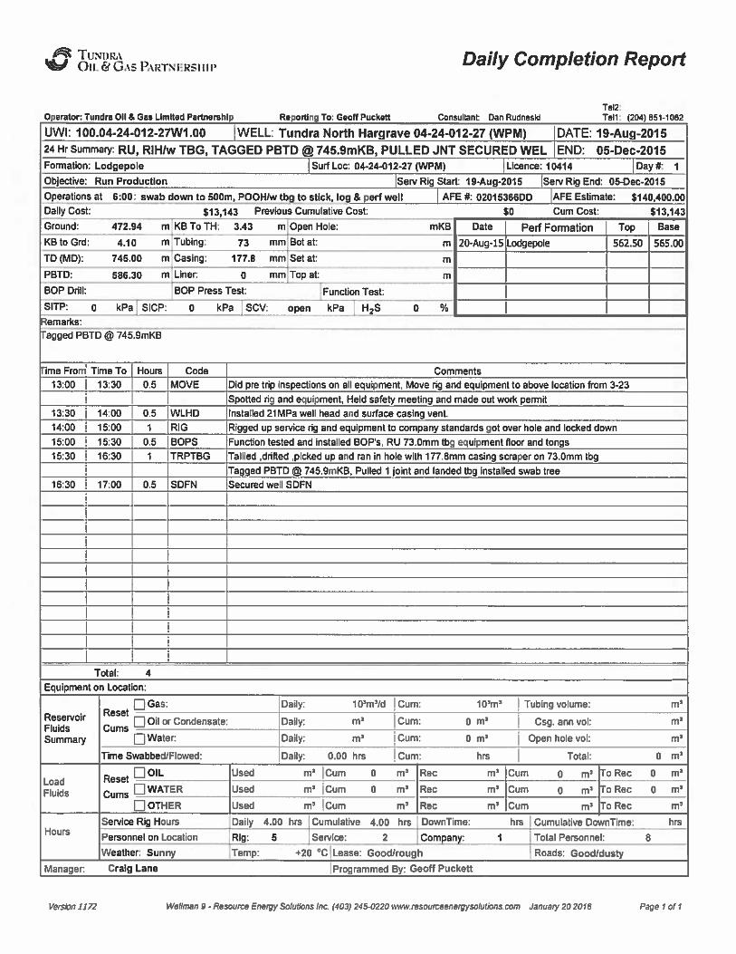
~TUNIIRAOil. Fy GA5 PARTNIIRslllp Daily Completion Report
Operator: Tundra Oil 8 Gas Limited Psruwmhlp Rspora Tor Gsoa puclwlt Consulant Oan RudnssklTsl2:Tsn: i204) 551-1052
UWI: 100.04-24-012-27W1.00 WELL: Tundra North Hargrave 04-24-012-27 (WPM) DATE: 19-Aug-201524 Hr Summary: RU, RIH/w TBG, TAGGED PBTD int 745.9mKB, PULLED JNT SECURED WEL END: 05-Dec-2015Formation: Lodgepole Surf Loc 04-244I12-27 tWPM) Lienee: 10414 Day¹: 1
Objective: Run Production Serv Rig Start 1thaug-2015 Serv Rig End: 064)ec-2016
Operations at 8:00: swab down to 600m, POOH/w to sgck, log 5 perf wellDally Cost: $ 13,143 Previous Cwnulative Cost
AFE ¹: 0201536600 AFE Estimate: $ 140,400.00
$ 0 Cum Cost: $ 13,143
Data Perf Formation Top Base
20.Aug-t5 epole 562.50 565.00
SITP: 0 kPs SICP: 0 kPa SCV: open kPa H2S 0emarks:
ag gad PBTD @ 745.9mKB
trna Fro Time To
13;00 13:30
13;30 14:00
1500I
14;00
15:00 15:30
Hours
0.5
0.5
0.5
Code
MOVE
WLHD
RIG
BOPS
Did pre trip krspecoons on al equipment. Move rig and equipment to above location from 3-23
Spotted rig and equipment, Held safety meering and made out work permit
Instalhd 21 MPa well head and surface casksg venL
Rigged up service rig and equipment to company standards got over hole and locked down
Fundion tested and installed BOFss. Rt/ 73.0mm Ibg equipment tloor and tongs
15;30 16:30 TRpTBG Tallied,ddoed,picked up and ran in hole with 177.8mm casing scraper on 73.0mm lbg
Ta ged PBTD @ 745.0mKB, Pulled 1 jomt and landed tbg instaled swab tree
16:30 17'.00 0.5 SDFN Secured wel SDFN
Total: 4
Equipment on Location:
ReservoirFluidsSummary
Gas:Reset
Oil or Condensate:Gums
Water.
Time Swabbed/Flowed:
Daily:
Dally:
Hpnp/d
Daiy: r/P
Daily: 0.00 hrs
Cum:
Cum:
Cum:
Cum:
10'm'
m'm'ubing volume;
Csg. ann vol:
Open hole vol:
Total:
m''
m'oad
Flukls
Hours
R tOIL
WATER
OTHER
Service Rig Hours Daily 4.00 hrs Cumulahve 4.00 hrs
Personnel on Location Rig: 5 Sewlce: 2
Rec m'umRec m'um
0 m'o Roc 0m''o
Rec
m'ompany:
hrs I Cumulative DownTime: hrs
1 Total Personnel: 8
m'um 0 m'o Rec 0
m'eather.
Sunny
Manager. Craig Lane
,Temp: +20 'CILease: Good/rough
Iprogrammed By: Geolf Puckett
Roads; Good/dusty
Vmstrrr //22 Wellman 0 - Resource Enwpy oaaabrm lsc /402/2454220 www nwomcssswgysolvasns som January 20 2016 Rscs r orr

4¹tb TLIN»ibt%J Ou. Fd GAs PARTNEREIIIP Daily Completion Report
0 rater: Tundra ON & Gas LlmNed Psrinershl Re To: Geoff Puckett ConsuNanc Dan RudneskiT912:Tell: (204) 551-IOS2
UWj: 100.04-24-012-27W1.00 WELL: Tundra North Hargrave 04-24-012-27 (WPM) DATE: 20-Aug-201524 Hr Summary: swab down to 500m, POOH/w tbg to stick, log & perf well, RjH/w tbg 5m b p END: 05-Dec-2015Formafion: Lodgepole Surf Loc: 04-24012-27 lWPM) Licence: 10414 Day¹: 2
Daily Cost: $ 18,040 Previous Cumulative Cost:
Objective: Run Production
Operations at 6:00: SWAB AND EVALUATEWELL
Serv Rig Start: 19-Aug-2015 Serv Rig End: 054)ec-2015
AFE fk 02015366DD AFE Estimate: $ 140,400.00
$ 13,143 Cum Cost: $ 31,182
Ground: 472.94 m KB To TH: 3.43 m Open Hole: mKB Date Perf Formation Top Base
KB to Grd: 4.10 m
TD (MDj: 745.00 m
PBTD: 586.30 m
BOP Drill:
Liner: 0 mm
BOP Press Test:
Tubing: 73 mm
Casing: 177.8 mm
Bot at: 576.56 m 20-Aug-15
Set at:
Top ab
Function Test:
Lodgepole 562.50 565.00
SITP: 0 kPa SICP: 0 kPa SCV; open kPa H2S 0 '/o
emarks:
OT LANDED e 576.56mKB, PSN LANDED @566.88mKB, BOT IS LANDED 168.44m ABOVE PBTD @745.00mKB, BOT IS LANDED 11.56mELOW PERFS @562 5-565mKB
ime Frorrl Time To
07;30 08:00
08:00 09'/00
09:00 09:15
Houm Code
0.5 SAFE
I CIRC0.25 PTST
Comments
Service and start rig and equipment, Held pre job safety meeting and discussed afi hazards
Issued permits to afi contratsors on location, Applied scavenger to produced H20
Rigged up and reverse circulated well over to produced water Pumped 18m3 @ 600Umin
Pressure test BOP's and TIW too 1 &14Mpa, RO circ equipment
09;15 j 10:30
10;30 12:00
12;00 14:00
1.25 SWAB Rigged in swab equipment, swabbed fluid level down to 510 m, Recovered 9.60m3 to tank
2 LOGS Rigged in wireline truck, held safety meet ran in hole and performed GR-CCL log from
PBTD 744,8 to Surf CSG shoe, Lay out logging tools, Held pre shoot meeting
1.5 TRPTBG jPufied and stood 77 joints of 73.0mm,9.67kg/m,J-55,EUE tubing in derrick, RU weatherford
14:00 15:00 I PERF
Made up 101.6mm, 2.5m REHSC gun,17 spm, 25g, SDP, 60 phasing and ran in hole, fluid 49 520m
Did CCL log from TD because afi collars the same length, No marker joint, Confirmed afi ¹¹5Perforated interval 562.50m - 565.00mKB. POOH/w gun confirmed afi shots fired
15:00 15:30
15:30 j 16:15
Pull back to 200m and re tagged fluid 62 475mKB, POOH/w gun confirmed afi shots fired
RO weatherford & RU 73.0mm Ibg handling equipment0.5 PERF
0.75 ITRPTBG RIH/w 73.0mm tbg as follows:
1- 73.0rnm EPOXY COATED BC
1- 73.0mm 4'ERF PUP
1 - 73.0mm TAILJOINTS1- 73.0mm A.P.I PSN
.13m
1.24m
9.55m
.33m
59- 73.0mm JOINTS OF TBG 564.58m
Total: 9
Equipment on Location:
KB Diff 1.97m
ReservoirFluidsSummary
Gas;Reset
Oil or Condensate:Gums
Water.
Daily: I Iyms/d Cum:
Daily: m'um:Cum:Daily; m'
m'
ms
Csg. ann vok
Open hole voh
0 10'm'ubing volume:
m'''oad
Fluids
Time Swabbed/Flawed;
Reset Q OIL
WATER
OTHER
Daily: 0.00 hrs Cum: Total:
Rec m'um 0 ms
Rec m'um 0m'ec
20 m'um 20 ms
0m'o
Rec 0m'o
Rec 0m'o
Rec 0
m'oursService Rig Hours
Personnel on Location
Weather. Sunny
DownTime:Daily 9.00 hrs Cumulative 13.00 hrs
Company: 1Rig: 5 Service: 2
Temp: +20 'C ILeasia Good/rough
Cumulative DownTime: hrs
Total Personnel: 8
Roads; Good/dusty
Manager. Craig Lane jProgrammed By: Geoff Puckett
Verskw 2222 vyel/msn 9 - Resource Energy 90/ui/cns inc. (402/ 245 0220 www rssouiceeneigysc/urisns corn Jenueiy 20 2015 Page 1 or 2
~T1INI)RA%J OIL CJ GASPr1ar'1741!RSIID'aily Completion Report
Consunsnr Oan Rudnaskl
Tal2.Tel1: 1204) 881-1082
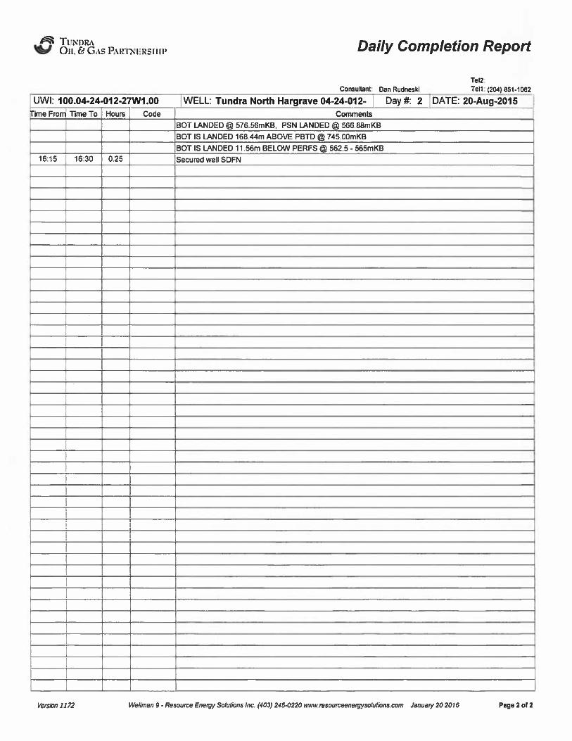
UWI: 100.04-24-012-27W1.00 WELL: Tundra North Hargrave 04-24-012- Day ¹: 2 DATE: 20-Aug-2015Tlime Fmrrl Time To Hours Code
BOT LANDEDI 576.56mKB, PSN LANDED @ 566.88mKB
BOT IS LANDED 168.44m ABOVE PBTD @745.00mKB
BOT IS LANDED 11.56m BELOW PERFS I 562.5 - 565mKB
16;15 16:30 0.25 Secured well SDFN
rsrsrrm 1172 Wellman 6 -Remurce Energy Soludons inc. (403) 246 0220 www resourceensrrrsoluuons corn Januarrr 202016 Paga2of2

daft TL/Nl)iht%J Oil. & Ons PARTNIIRsI IIV Daily Completion Report
0 rater: Tundra OS 8 Gss Umltsd Partnsmhl Reporu To; Geoe Puckelt Consukanz Oan RudneskiTel2:Ten: 1204) 051-1002
UWI: 100.04-24-012-27W1.00 WELL: Tundra North Hargrave 04-24412-27 fWts
24 Hr Summary: IFLISurf, pulled 10swahs and flowed 4.1m3lhr, rec 3.89m3 H20,Formation: Lodgepole Surf Loc: 04-24412-27 tWPM):Ucence: 10414
ug-2015
ec-2015Day¹: 3
Objective: Run Production
Operations at 6:00: Circ well over rungacker/w2/108le slick JolnL swab onDaily Cost: $7,395 Pnwious Cumulathe Cost: $31,1$ 2 Cum Cost:
Datej
Perf Formation Top
$ 38,678
Base
Serv Rig StarL'9dtug-2015 Serv Rig End: 054)ec-2015
'AFE1802015366DD AFEEstimate: $ 140,400.00
20-Aug-t5 Lodgepole 552.50 565.00
marks
intake @ 576.56mKB. PSN @ 566.8&mKB/Pulled 10 swabs, started Rowing back 4m3 95% dl Recovered 35.35m3 totalW «389m3 & 31.45m3 dl/ H20 cut last hour= 5%, IFL O surf / 01% bs/last Salkrty readlng @72000ppm / Csg shut in pressure =250 kPA,
me From Time To Hours Code07.'30
07:50
08:00
08:30
09:15
17:15
07:50 0.33 SAFE
08:00 0.17 SHUT
08:30 0.5 SWAB
09:15 0.75 WAIT
17:15 8 SWAB
17:30 0.25 SDFN
Start and service rig and equipment, held 0101ob safeiy meeting, discussed hazards
Went over Eergency Response Plan, issued Safe Work Permit
Recorded shut in pressures, 50kPA on the tubing and 250kPA on the casing,
Rigged in swab equipment, changed sandline Rags, blew out lines
Waited on air Irailer to amve on location, Pulled 8000ppm sour HZS sample
First swab of the day had a fluid level @ surface
Swabbed and evaluated well. pulled 10 swabs, well started Rowing an avg of 4m3/hr
Recovered 35.35m3 total, SW =3.89m3 & 31.45m3 oil / H20 cut last hour= 85%
Secured wall, SDFNcc«cccccc«cccc SWAB DETAILS»»»»»»»»»INITIALFLUID LEVEL-RNAL FLUID LEVEL-INIT5ALCASING PRESSURE-
RNALCASING PRESSURE-
SWAB RATE IN THE lAST HOUR-WATER CUT IN THE LAST HOUR-SAND CUT IN THE lAST HOUR-SALINITY IN THE LAST HOUR-LASTH2S READING-
surf
Flowing
250k PA250k PA4.3m3/HOUR
0.1% / TRACE72000PPM
1.4%
Total: 10
Equipment on Location: FALCON ¹7 RIG AND EQUIPMENT, 400BBL TANK,PRESSURE VESSEI„FLARE,TBG TRAILER
ReservoirFluklsSummary
LoadFluids
Gas:Reset
Oil or Condensate:Gums
Water.
Time Swabbed/Flowed:
Reset Q OIL
WATER
Dalir. 1lpm*/d Gum: 01lpm'aily.
31.45 nP
Daily. 3.89 np
Daily. 880 hm
Cum: 31.45 np
Cum: 3.89 nP
Cum: $ .5 hm
Recm'ec
m'sed
m'um 0m'sedm'um 20
m'ubingvolume:
Csg. ann vok
Open hole vok
Total:
0 m'um
Cum 20
m''r0m'o
Rec 0m'o
Rec 0
m'ours
OTHER
Service Rig Hours
Personnel on Location
Used m'um 0 rrp
Daily 10.00 hrs CumuaRve 23.00 hrs
Rig: 5 Servke: 3
Rec rrP
Down Tine:
Company: 1
Gum 0 m'o Rec 0m'rs
Cumulative DownTime; hrs
Total Personnel: 9
Weather. Sunny
Manager. Craig Lane
Temp: I+20 'CI Lease: Good/rough
I Programmed By: GeoN Puckeu
Roads: Good/dusty
Versed //22 Wsanan 0 - Rvuwrce Ensrpy Scadkws /nc. (402/ 2104/220 www.nw urceenwwso/vdons.cow January 20 2016 Pare 1 0/1
dN5'UNI/Lt%!J Oil. Fd GAS PARTNlsRSllll'aily Completion Report
Operator. Tundra Ou 8 Gss Umited Partnership RepoNng To: Geoff Puckett Consultant: Dan RudnesklTel2:Tel1: (204) 551-1052
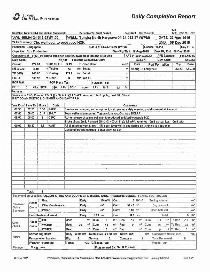
UWI: 100.04-24-012-27W1.00 WELL: Tundra North Hargrave 04-24-012-27 lWPM) DATE: 22-Aug-201524 Hr summary: Circ well over to produced H20, END: 05-Dec-2015Formation: Lodgepole Surf Loci'04-24412-27 (WPM) Llcanca: 10414 Day e 4
Oblactlvru Run Production Sarv Rig Start: 19%ug.2016 Serv Rig End: 054300-2016
Operations at 8:00: trp tbg to stick run packer, swab back on and plug well AFE th 02016368DD AFE Estimate: $ 140,400.00
D08y Cost: $ 8,387 Previous Cumulative Cost: $ 38,678 Cum Cost: $46,985
Date Perf Formation Top Base
20.Aug-15 Lodgepole 562.50 565.00
amerks:
roke circ/w 2m3, Pumped 25m3 @ 400IJmln O 1 SmPA, returned 12m3 up tbg, Lost 10m3 totalHUT DOWN DUE TO LIGHTNING AND HEAVYRAIN
ime Fro
07:30
07:50
06.00
09:00
Time To07:50
08;00
09:00
10;30
Hours
0.33
0.17
1.5
Code
SAFE
SHUT
CIRC
WAIT
Comments
Service and start eig and equipment Held pre lob safety meeting and discussed ag hazards
Took wellhead pressures: Tbg on slight vac, Csg was 260kPA
RU to reverse circulate well over to produced inhibited lodgepole H20
Broke circ/w 2m3, Pumped 25m3@400L/min 1.5mPA, returned 12m3 up tbg, Lost 10m3 total
Ag og returned very stinky 1,4% sour, Shut well in and waited on lightnin to pass over
Called office and decided to shut down for day!
Total: 3
Equipment on Location: FALCON87 RIG AND EQUIPMENT, 400BBL TANK, PRESSURE VESSEL, FLARE, TBG TRAILER
ReservoirFluklsSummary
Gas:Reset
Oil or Condensate;Gums
Water.
Time Swabbed/Flowed:
1IPms/d
m'a6y:
RP
Daily: 0.00 hm
Cum: 0
10'm'um:
Cum:
3.89m'.5
hm
Cum; 31.45
m'ubing volume;
Csg. ann vok
Open hole vok
Total:
m'''
m'oad
Fluids
Hours
ROIL
WATER
OTHER
Service Rig Hours
Personnel on Location
Daily 3.00 hrs Cumulative 26.00 hrs DownTime; hrs Cumulative DownTime:
Rig: 5 Service Company: 1 Total Personnel; 8
Rec 12 m'um 12 m'o Rec -12m'ec
0 m'um 20 m' Rec 25m'ecm'um 0 m'oRec 0
m'eather.
storming
Manager. Craig Lane
Temp: +20 'C ILease: wet
programmed By; Geoff Puckett
Roads: wet
verzun /JTJ wellman 0-Resomceanmgysoludnns inc. /402/245 0220 www resculceenergymlnllcnc corn January 20 2015 Pagerol1

tfigjfi TUNI/R,iM Oil. (IG,is PARTHIIRsiiip Daily Completion Report
0 rater: Tundra Oil & Gml Linllted Parlnemhl
UW(: 100.04-24-012-24 Hr Summary: POOHFormation: Lodgepole
Objective: Run Producti
Operations at 6:00/ .Ret
Re rtl To: Geoff Puckett Consultant Dan RvdnesktTei2:Tell: (204) 651-1052
Daily Cost: 519 363 Previous Cumulative Cost:
Ground: 472.94 m KB To TH: 3.43 m
KB to Grd: 4,10 m Tubing: 73 mm
Open Hole:
Bot ak
546,965 Cum Cost:
mKB Date
554.28 m 20-Aug-15
Perf Formation
Lodgepole
566,328
Top Base
562.50 555.00
TD (MDj: 745.00 m Casing: 177.5 mm Set at: 745 m
PBTD: 586.30 m Liner. 0 mm Top at:
BOP Drill: BOP Press Test: Function Test:
SITP: vac kPa SICP: 0 kPa SCV: open kPa H2S 1.4
erne rks:
ryton mech set DBL GRP Retrievable PKR 177.fimm x 73.0mm, C/W TX slick joint, otls 73.0mm x 47.63mm Profile Packer Bottom set @54 28mKB, TOP @550 96mKB, COE @552 62mKB, 73 gmm on/off stem I w 1.87" tx profile, Got out 2 78m2 H20 & 2 11m3Emulsion well started
recordersWork strln lett in hole to II lu &
ime From Time To Hours Code
07:30 08:00I
0 5 SAFE
08:00 06:10I
0 17 SHUT
08;10 09:00 0.83 TRPTBG
09:00 10:00 I TRPTBG
10:00 10:30 0.5 TRPTBG
CommentsService and start rig and equipmenl, held pre job safety meeting and discussed afi hazards
Issued permits to ag personeg on location
Took welhead pressums: Tbg on slight vac, Csg was tstm, Pulled gas test, no H2S readings
RU 73.0mm tbg equipment, POOHku tbg to stick 60jnts lotal and layed out BHA
Pkked up hylon mech set DBL GRP Relrievable PKR 177 8mm x 73 Omm
25,3Kg/m - 38.7Kg/m 152.4mm OD: 6.00", TX slick joint, olis 73.0mm x 47.63mm Profile
TL on/off Tool, 7k, 139.7mm x 73.0mm
RIH/w tbg to land packer COE 10m above I le rfs @562 50mKB-565 00mKB
Installed dog nut made measurment, split and Set packer I/4 turn and down, Did usht ufi
Came off 177.8mm PKR. Re land dognut and stripped off BOP's. Pulbd and re spfit dognut
10:30
11:00
11:15
12:00
13:30
11:00
11:15
12;00
13;30
15:00
0.5 BOPS
0.25 PTST
0.75 SWAB
1.5 WIRE
1.5 RIG
Latched back onto acker and did sh/pufi, Landed packer in 4dAN tension, Installed bonnet
Packer Bottom set @ 554.28mKB, TOP @ 550.96mKB, COE @ 552.62mKB
Pressum lasted CSG to 3.5mPA (HELD GOOD), Bled pressum back to tank instfied master valve
Swabbed and evaluated well, pulled 5 swabs. well started fkwring an avg of 2.3m3/hr
Got out 2.78m2 H20 & 2.11m3Emulsion well started Rowing back again with 4.9m3 swabbed back
RU quality wireline RIH/w 38mm tool string, 45mm x line 47.63m xx plug, Tagged nipple
552mKB set plug and POOH/w wireline, Closed master, Bled olf lube
Secured wefi, RO rig and equipment and cleaned up hcalion
Pulhd ag equipment onto matting
Total: 7.5
EquiPment on Location: FALCON 87 RIG AND EQUIPMENT, 400BBL TANK,PRESSURE VESSEL, FLARE, TBG TRAILER
ReservoirFluklsSummary
Gas:Reset
Oil or Condensate;Gums
Water:
Time Swabbed/Flowed:
11Fm'Id
Dafiy: 2.11m'afiy:
2.78m'aRy:
0.75 hm
Cum:
Cum: 33SSm'um:
6.67m'um:
92 hm
Csg. ann vol:
Open hole vol:
Total:
0 1lpnP Tubing volume:
m''
mr
LoadFlukls
Hours
R tOIL
WATER
OTHER
Service Rig Hours
Personnel on Location
Used rrp Cum 0 m* Rec m'um 12 mr ToRec -12m'sed
m'sed
m'aily
7.50 hrs Cumtdative 33.50 hm DownTkne:
Company. 1Rig: 5 Senrice: 3
Cumulative DownTime; hrs
Total Personnel: 9
Gum 45 m* Rec m'um 20 m'oRec 25m'um
0 m* Rec m'um 0 m'oRec 0
m'eather.
Windy
Manager. Craig Lane
Temp: 20 'C ILease: wet
I Frog/warned By: Geoff Puckett
Roads: wet
Vesta /222 wesmen 0- Rvmvice Enercy Sc/vdons /nc. /403/ 245 0220 www msovmemerpymkdknsmm Jstue/7202016 Fitge I of 1
dNh TL/Nnlbt%J OIL Fd G&5PARTNIIRSI IIV Daily Completion Report
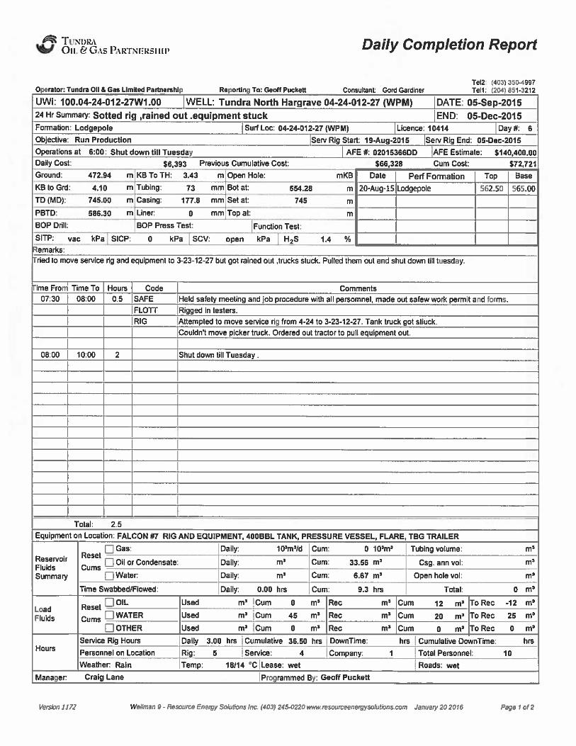
Operator: Tundra Ou & Gss Limned Psrtnemhlp Reportl To: Geoff Puckett Consultant: Gord GardinerTsl? (403l 3504997Tait: (204l 861-3212
UWI: 100.04-24-012-27W1.00 WELL: Tundra North Hargrave 04-24-012-27 iWP$ $ ) DATE: 05-Sep-201524 Hr summary: Sotted rig,reined out .equipment stuck END: 05-Dec-2015Formation: Lodgepole Surf Loc: 04.24.012-27 iWPM) Licence: 10414 Day¹: 6
Obiectlve Run Production
Operations at 6:00: Shut down till Tuesday
Serv Rig Start: 10+ug-2016 Sarv Rig End: 0643ec.2016
AFE ¹: 02016388DD AFE Estimate: $ 140,400.00
Dally Cost: $ 6,303 Previous Cumulative Cost: $ 88,328 Cum CosL $72,721
Data Perf Formation Top Base
20-Aug.t5 Lodgepole 562.50 565,00
emarks:
ried to move service rig and equlpmenl to 3-23-12-27 but got rained out,trucks stuck. Pulled them out and shut dawn till tuesday.
ime Fro
07.'30
Time To08:00
Houm Code
0.5 SAFEComments
Held safety meeting andiob procedure with all persomnel made out safew work permit and forms.
FLOTT I Rigged in testers
I RIG lAttempted to move service rig from 4-24 to 3-23-12-27. Tank buck got stiuck.
Couldn't move picker truck. Ordered out tractor to pull equipment out.
08: 00 10:00 Shut down till Tuesday.
Total: 2.5
Equipment on L ': FALCON ¹7 RIG ANDEQUIPMENT, 400BBL TANK,PRESSURE VESSEI„FLARE, TBG TRAILERneutron
ReservoirFluklsSummary
Gas:Reset
Oil or Condensate:Gums
Water.
0 1Ãnp
Daily:m'aily:
m'um: 33.86m'um:
6.67
m'aily.
1 tpm»20 Cum: Tubing volume:
Csg. ann vok
Open hole vok
m»
m»
m'ime
Swabbed/Flowed: Daily: 0.00 hm Cum: 9.3 hrs Total: 0
m'oad
Fluids
0 OIL
WATER
OTHER
m»m'um 12 m'o Rec -12m'um
20 m'o Rec 25m'um
0 m'o Rec 0
m'oursService Rig Hours
Personnel on Location
Weather. Rain
Dally 3.00 hrs Cumulatim 36.50 hrs
Rig: 5 Senrice: 4
Temp: 18H4 'C ILease: wet
IDownTine: hrs
I Company: 1
Cumulative DownTime; hrs
Total Personnel: 10
Roads: wet
Manager. Craig LaneI Programmed By: Geolf Puckett
Vd»atm 2/22 we//men 0- Resource Enerpy sorurons /nc /403/ 2464/220 wwwm»omcssnerpy»olvrmn»corn Janvery 20 20/6 Pape 1 0/2

~TUernL1OIL C~ Gas PRRl>tiasilfi'aily Completion Report
Consultant: Gord Gardlnar
Tel2 (403) 3604001Tal1: I204I 361-3212
UWI; 100.04-24-012-27W1.00 WELL: Tundra NorthHargrave04-24-012- 'ay¹: 6 DATE: 05-Sep-2015ime From Time To Hours Code Comments
I 5:00
verssw 2272 wellman e - Resource Eneroy sorurons inc f403l 240o220 www rawrurceenereysolutisns corn January 20 2016 Paaasof2

rfslk TIINUP t%J Oii. & G.ts PAI4TNFRSllll Daily Completion Report
OPerator. Tundra OS 5 Gas Limited Partnership Repomn Tor Geoe Puckslt Concllsallc Geol GsldlhefTel2'. /403i 350-4997Ten: (204) 551-3212
LjWj: 100.04-24-012-27W1.00 WELL: Tundra North Hargrave 04-24-012-27 (WPM) DATE: 00$ ep-201524 Hr summary: Rig up,rig in slickline truck, pull plug and recorders, kill well, trip packer END: 05-Dec-2015
Day fk 7Ucance: 10414Surf Loc: 04-24412-27 twpujFormation: Lodgepole
Objective: Run Production
Operations at 6:00: Tumed well over to operator
Smv Rig Start 194tug-2015 Sere Rig End: 054iec-2015
AFE ¹: 02015366DD AFE Estimate: 5140 400.00
Daily Cost: 627,859 Prevbus Cumulegve Cost 572,721 Cum Cost: 6100,680
Date Perf Formation Top Base
20-Aug-15 Lodgepole 562,50 565.00
emarks
Igged up,service rig, rigged In wlreline, pulled tubing plug, pated recorders, rsn tubing plug, Rekmsed an/oN connector end pulled up .Sm. ReverseIrculated well over to inhibited fresh water. Latched on/offend putsd tubkrg in tenskm. Installed wellhead snd secured. Rig ouL
ime From Time To07.'30 08'.00
08'.00 09'.00
09:00 I 11:30
11:30 13:00
13;00 13:30
13:30I
14:30
14:30 15:00
0,5 SAFE
I I RIG
2.5 WIRE
1.5 TRPTBG
CIRC0.5 TRPTBG
RIG
0.5 MOVE
Hours Code Comments
Held safely meegn and job procedure with at personnel. Made out safe work permit and safety
meefing fonna..
Rigged up senrice rig snd testers. To Tundra regulations.
Moved in slkktine buck and rigged up to pull tubing plug from packer. Ran in hole and
retrkwed recordem from packer st 552mKB.
Rsn in hole and latched onto Olis 47 S3mm plug @ 551 mKB,pulled out of hole.
Ran in ovemhot and latched onto recorders at 552mKB. And poled out of hole.
Made up 000 47.63mm tubing plug and ran in and sst in X profse of packer at 552.62mKB.
Pressure tested pl to 3500 Kpa fopr 10 min. Bled off pmsssme and rigged out wireline.
Rigged off velhead,krstalhd pup joint and valve, Released on lolf and picked up I/2 meter.
Reverse circulated well over to inhibited fresh water 14m3 .
Latched onto on/olf connerdor and pulled tubing into 4000 daN tension.
Rigged up wellhead and master vahre.
Secumd well. Riggerd out at equipment .
Empeed rig tank and P-tank.
Moved at equipment to 3-23-1 2-27
Total: 7.5
Equipment on Location: FALCON ¹7 RIG ANDEQUIPMENT, 400BBL TANK,PRESSURE VESSEL, FLARE, TBG TRAILER
ReservoirFluidsSummary
GaeReset
Q Oil or Condensate:Gums
Water.
Time Swabbed/Flowed;
010*m'aily.
m'aily.
m'aily:
0.00 hm
~Gum: 33.56m'curn:
6.67 m'
Cum: 9.3 hrs
Daily: 10'm'Id Cum: Tubing volume:
Csg. ann vok
Open hole vok
Total:
m''
m'oad
Fluids
R IOIL
Q WATER
OTHER
Rec
Rec
Rec
m'um0 m'Rec 0
m'um
12 m'o Rec -12m'um
20 m'o Rec 25
m'oursService Rig Hours
Personnel on Location
Weather. ovsmast
Daily 7.60 hrs Cumulafive 44.00 hrs
Rig: 5 Sen/ice: 6
Temp: 18/7 'C Lease: wet spots
DownTime:
Company; 1
hrs Cumulative DownTime: hrs
Total Personnel: 12
Roads: good
Manager. Craig Lane Progranmed By: Geoff Puckett
version II22 are/sean 0 - Resowce Eeersy sessbrm Iec. /403/ 2450220 www ~verve/bes cern Jeev cry 20 20/ 5 Pere I 0/2

~TtrRIIL(Ott. & Gas PARTTQ(iREIIIP Daily Completion Report
UWI: 100.04-24-012-27W1.00fime Froni Time To Hours Code
Tat? (403) 3304332Consultant: Gord Gardinar Tel1: (204) 331-3212
WELL: Tundra North Hargrave 04-24-012- Day ¹: 7 +DATE: 08-Set)-2015Comments
15'too
trsrsam 3222 Wellman u - Resource Energy Sotufons inc. (403) 2450220 wwrr nwoumeenmgysululluns curn January 20 20ld Page 2 of 2
4508 TUNDibt%J Oil. & GAS i ARTNERSIIIP Daily Completion Report
rstorr Tundra 08 & Gss Limited Partnership Ra purlin Tor Gmrif Puckalt Consunsns Dau RudneskiTsl2.Tsn: (204) 051-1062
24 Hr summary: Move in and RU, Red hawk rig 6, Did rig inspection END: 05-Dec-201 5
Day¹: 8Licence: 10414Formation: Lodgepole
Objective: Run Production
Surf Loc: 04-24012-27 tWPMj
Serv Iag Start 1 94kug-2015 Serv Rig End: 0543ec-2015
UWI: 100.04-24-012-27W1.00 WELL: Tundra North Hargrave 04-24-012-27 (WPM) DATE: 02-Dec-2015
Operations at 6:00: Begin final com letlon AFE fk 02015366DD AFE Estimate: $ 140 400.00
Daily Cost: $ 5,738 Previous Cumulative Cost $100,580 Cum Cost: $ 106,318
Date Perf Formation Top Base
20-Aug-15 Ladgepole 562.50 565.00
emarks:
U RIG AND EQUIPMENT, DID RIG INSPECTION ON ALLEQUIPMENT. SDFN
ime From Time To
09:00 12:00
12:00 14:00
Hours Code
3 MOVE
SAFE
2 RIG
Moved rig and equipment to above loca90n from oxbow, sask, Spotted equipment on location
Held pre job safely meeting and discussed a8 poten0al hazards, Went through tkkets &
papewwuk on rig. A8 persone8 safety orientated on comply works
RU rig and equipment to company standards, Got over hole and locked down
IDId full rig inspecton on a8 equipment
SDFN
Total: 5
Equipment on Location: Red Hawk ¹6, RIG AND EQUIPMENT, PRESSURE VESSEI„FLARE,TBG TRAILER
ReservoirFluidsSummary
Gas:Reset
Oil or Condensate:Gums
Water.
Daily:m'aily:
m'aily:
1IFm'/d Cum: 0 10mr
Cum: 33.56m'um:
6.67
m'ubing volume:
Csg. ann vok
Open hole vokm''ime
Swabbed/Flowed: Daily: 0.00 hm Cum: 9.3 hrs Total: 0
m'oad
Flukls
P O8.
Cu WATER
OTHER
m'r Cum 12 m'o Rec -12m'um
20 m' Rec 25m'um
0 m'Rec 0
m'oursService Rig Hours
Personnel on Location
Weather. overcast
Rig: 2 Service
Temp: +2 'CILease: Dry
Company: 1
Daily 5.00 hrs Cumulative 49.00 hm DownTime: hrs Cumulative DawnTime:
Total Personnel; 4
Roads; good
Manager: Craig LaneI Programmed By: Geoff Puckett
Vurstm 3372 wellman 0 - /tusaurca Energy Solar/uns inc. (403/ 2450220 www rmaumuunergyxau/ious uom January 20 20m page I or l

JM2 TUNI>RAOIL fri GAS PARTNFRSI I IP Daily Completion Report
0 tori Tundra Dll & Gas Umltad Parinaishl R run To: Gaoff Puckatt Consultant Dan RudnasklTai2Tait: 204 051-1002
UWI: 100.04-24-012-27W1.00 WELL'undra North Hargrave 04-24-012-27 (WPM) DATE: 03-Dec-201524 Hr summahw Pull plug, RIH/w drlgable abandonment plug, dump cement for new PBTD END: 05-Dec-2015
Day 1k 9Surf Loc: 04-24612-27 jwPMl Licence: 10414Formation: Lodge pole
Objective: Run Production Serv Rig Start 19Aug-2015 Serv Rig End: 054>ec-2015
Daily Cost: $24,132 Previous Cumulabve Cost
Operations at 6:00: Logco, RIH/w1772imm lug, Dum bal cement AFE tt 0201 5366DD AFE Estimate: $ 140 400.00
$106.318 Cum Cost: $ 130,450
Ground: 472.94 m KB To TH: 3.43 m Open Hole: mKB Date Perf Formation Top Base
KB to Grd: 4.10 m Tubing: 73 mm
TD (MDj: 745.00 m Casing; 177.8 mm
Bot at 55448 m 20-Aug-15 Lodgepole
Set at 745 m
552.50 555.00
PBTD: 586.30 m Liner. 0 mm Top atBOP Drill: BOP Press Test: yes Fundion Test yes
SITP: 0 kPa SICP: 0 kPa SCV: open kPa HzS .2
erne rks:
U slkkline unit, POOH with slickline plug, Well equa9zed and on syght vac. POOH/w tryton 177.8mm TX-8 packer, RIH/w 177.8mm CSG scraper toD, Circ well over to inhibited FW, POOH/w scraper, RIH/w 177.8mm Dr9mble BP, Dumped 140LIr cement ontop of plug, Plug wouldn't shift sleeve
ime From
07:30
Time To Hours Code05:00
I05 SAFE Senrice and start rig and equipment, held pre job safety meeting and discussed all hazards
Ilssued permits to ag personeg on locarion
05:00 05:15 0.25 SHUT Took we9head pressures: Tbg on slight vac, Cag was tstm, Poled gas test, no H2S readings
08;15
09:00
09;30
10:00
10:30
11:30
12:30
12:30
13;15
09:00 0.75 SLICK
09:30 0.5 SLICK
10:00 0.5 WLHD
10:30 0.5 BOPS
11:30 I CIRC
12:30 I TRPTBG
13;30 I TRPTBG
13:15 0.75 CIRC
14:15 I I TRPTBG
Total: 11
RU quality wirelne RIWw 38mm tool shing, RIHhv 45mm GS CANequalizing rod, Set @ 552.00mKB
Jared down to equalize plug, TBG on slight vac. Jared plug free, Pushed to on/oif profile
Tagged nipple @ 555mKB, Jared mandrel free and POOH/w slickline and plug
RO qualky wkeline truck. Spot fonlanas lbg trailer with 40jnts to circ on bottom, R+R press
boih sides on slight vac, undressed wellhead, Instalhd pup, pulled up and split dognut
Dawn on 8>g put 2dAN compression, Unset packer, m landed dognut
Fundlon tested and kistalhd BOPs, Pressure test high/low to 14mPA
RU lo reverse drc well over to produced Ink 5>ited H20. Broke circ with 1.2m 3, Pumped 20m3 @l600Umtn returned 11.6m3 to tank, Total fluid loss of 8.4m3, RO circ equipment
IRU 73.0mm Ibg equipment goer and tongs, POOHhv Tryton mech set DBL GRP Retrievable PKR
lf77. 6mm x 73.0mm, C/W TX stck joint, Layed out on ground
Picked up1 77.8mm CSG scraper and RIWw 57 jnts fiom stick, Tallied, drifted, picked up and ran
in hoh with another 20jnls 73.0mm tbg off hailer TTInLc total in hole
IRU to revmse arc well over to Fresh inhibited H20, Broke circ with 3m3, Pumped 18m3 tgl600Umin mtumed 12.2m3 to tank, Total fluid loss of 4.8m3, RO circ equipment
POOH/w tbg, Layed out 16jnts and, Stood 61 jnts lo sgck, Layed out CSG scrapercccccc«cc<«c<cccc«<cconrd on page two»»»»»»»»»»»>
Equipment on Location: Rsd Hawk 86, RIG AND EQUIPMENT. PRESSURE VESSEL, FLARE. TBG TRAILER
ReservoirFluklsSummary
Gas:Reset
Oil or Condensate:Gums
Water:
Daily: 1 tpmahl
Daily: RP
Dai0F IIP
0 tipm*
Cum: u.56m'um:
6.67
m'ubing volume:
Csg. enn vot
Open hole votm''ime
Swabbed/Flowed: Dagy: 0.00 hm Cum: 92 hm Total: 0
m'oad
Fluids
Reset Q OIL
WATER
OTHER
m* Cum 12 ma o Rec -12 m*
Rec 23.8 m* Cum 43.8 ma o Rec 41.2m'ec
m* Cum 0 m' Rec 0
m'oursService Rig Hours
Personnel on Location
Weather: overcast
Rig: 5 Service
Temp: +5 'CILease: Dry
COII>puny: 1
Daily 11.00hrs Cumulative 60.00 hrs DownTime: hm Cumulative DcwnTime: hrs
Total Personnel: 8
Roads; good
Manager. Craig Lane jpmgrmnmed By: Geon Puckea
Varsraa//22 wellman 9- Ramvim Enarpy So/aaaaa lna. /402I 24&0220wwwmsoarcaanarpym/0/2>as<am January 20 20ia Pape I a/2

/¹0t TIR nLt~OH.E» GASPARTari RSitiP Daily Completion Report
Tel2corwuNanc Oen Ruaneskl Tell: l204) 651 1062
UWI: 100.04-24-012-27W1.00 WELL: Tundra North Hargrave 04-24412- Daj/¹: 9 DATE: 03-Dec-2015rime From Time To Hours Code Comments
14;15 15:30 1.25 MTLNR Picked up 177.8mm tryton drigabte bridge plug, RIHhv 6 jnts of 73.0mm tbg
Mixed up 2 -1 pa89 of water to 1 bag cement, Mhed 6 water to 3 bags in barrel, Used drilled
mixed up well so no clumps of cement, Ulled barrel to tbg opened valve cement came out 1-1/2
hose good, Total cement dumped was 10 bags cement to 20 pails of fresh H20
15:30
16:00
16:00
17;00
0.5 RPTBG
PTST
RIH to set plug with 61jnts 88 588.00mKB, Picked corer 89 586.00mKB, collar on depth
Installed 68, set plug on depth, Filled tbg with 1.5m3, Presswed up to 14mPA let sit Smins
Bud down paged on plug lo see if sleeve shiged, Plug wasn't set
Pressured up to 18500kPA, still didn't set, teed down tried to spud tbg to get packer to shift
Tried 3x to get plug to set up had no luck, Called 0$ ce, Tokl to POOH with packer17.'00 17:30 0.5 RPTBG POOHhv wet string to stick. Had vac out to suck up cement, Orilted first 6 jnts, RIH/w 20 jnt
kill string, Secured well SOFN
versen l/77 wellman 9-Resource Euurpy solusoos rnc /402/~www muoumuuuureyxo/u//oox corn Junuuiy 20 20i6 Page 2 of 2
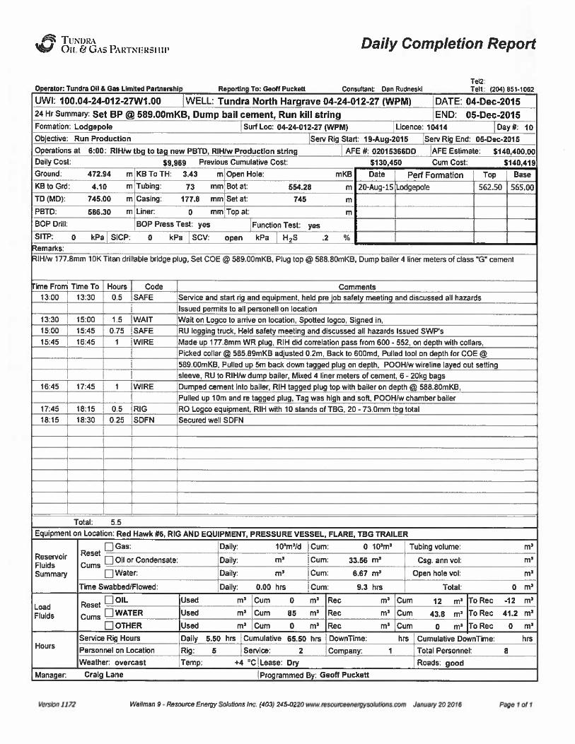
fdqv Tt/Ni>ibtOU. & GAS PAL'TNIIRSIlll'aily Completion Report
rstor: Tundra 00 5 eas Limned Pannsrshl Rs /tin To: esse Puckstl Consultant csn RudnssklTel2:Tsn: 204 551-1052
UWI: 100.04-24-012-27W1.00 WELL: Tundra North Hargrave 04-24-012-27 (WPjjgj DATE: 04-Dec-201524 Hr summary: Set BP II 589.00mKB, Dump bail cement, Run kill string END: 05-Dec-2015Formation: Lodgepole
Objective: Run Production
Ucence: 10414 Dayn 10Surf Loc: 04-24-012-27 (WPMj
Serv Rig Stark 19+ug-2015 Serv Rig End: 0543ec-2015
Operations at 6:00: RIH/w tbg to tag new PBTD, RINw Production string AFE fk 02015366DD AFE Estimate: $ 140,400.00
Daily Cost: $9,969 Previous Cumukdkre Cost: $130,450 Cum Cost:
Perf FormationDate
20-Aug-lS Lodgepole
$ 140,419
Topj
Base
562.50 565.00
emarks;
IH/w 177 8mm 10K Titan drillable bridge plug, Set COE O 589 oomKB, Phg top O 588 80mKB. Dump bailer 4 liner meters of class "G" cement
ime From
13;00
tn3oI
15'.00
15:45
16;45
17:45
18:15
Time To Hours
13:30 0.5
15:00 1.5
15:45 0.75
16:45
17:45
18:15 0.5
18:30 0.25
Code
SAFE
WAITSAFEWIRE
WIRE
RIG
SDFN
Sewice and start rig and equipment, held pre job safety meeting and discussed all hazards
Issued permits to ao personeo on location
Wait on Logco to anive on location, Spotted hgco, Signed in,
RU logging truck. Held safety meeting and discussed ao hazards Issued SWP's
Made up 177.8mm WR plug, RIH did correlation pass from 600- 552, on depth with collars,
Picked collar I 585.09mKB adjusted 0.2m, Back to 600md, Pulnd tool on depth for COE
589.00mKB, Pulnd up 5m back down tagged plug on depth, POOH/w wireline layed out setting
sleeve, RU to RIH/w dump bailer, Mixed 4 liner meters of cement, 6- 20kg bags
Dumped cement into bailer, RIH tagged plug top with bailer on depth @ 588 oomKB,
Pulled up 10m and re tagged plug. Tag was high and so0, POOH/w chamber bailer
RO Logco equipment, RIH with 10 stands of TBG, 20-73.0mm tbg total
Secured wet SDFN
Total: 5.5
Equipment on Location: Red Hawk 06, RIG ANDEQUIPMENT, PRESSURE VESSEL, FLARE. TBG TRAILER
ReservoirFluklsSummary
Q Gas:Reset
Oil or CondensatnGums
Water:
Time Swabbed/Flowed:
0 ttpnp
Daily: mr
Cum: u.ss np
Cum: S.87m'aily:
0.00 hrs I Cum: 9.3 hrs
Daily: 1 ipm*/d Cum: Tubing volume:
Csg, ann vok
Open hole vok
Total:
mr
m'
m'oad
Fluids
Hours
Reset Q OIL
WATER
OTHER
Service Rig Hours
Personnel on Location
Weather. overcast
Daily 5.50 hrs Cumulaove 65.50 hrs
Rig: 5 Service: 2
Twnp: +4 'CiLease: Dqr
Company. 1 Total Personnel: 8
Roads: good
m'um 12 m' Rec -12m''um
43.8 m' Rec 41.2 m*
m'um 0 m'oRec 0m'ownTlme:hrs Cumulative DownTime: hrs
Manager. Craig Lane jProgrammed By; Geon Puckett
nsstw 2222 n'essxw 5 - nsuxxce Enwor nsv sons /nc /402/ 245 022o euw resowosessrgysosuzwsuxs A/suey 20 zola page 1 M 1

/E5t TUNI)lb(%J Oil. & 6&5PARTNERSIIIP Daily Completion Report
Operator: Tundra On d Gss Limned Psrlnsmhip Reporting To: Gsoff Puckstt Consuusnt Osn RudnssklTsl2:Tsl1: i204) 551-1052
UW(; 100.04-24-012-27W1.00 WELL: Tundra North Hargrave 04-24-012-27 (WPM) JDATEI 05-Dec-201524 Hr Summav Circ, Round trip anchor, RlH/w BHP & rods, TWOTP END: 05-Dec-2015Formation: Lodgepoie
Objective: Run Production
Surf Loc: 04-24-012-27 (WPM) Licence: 10414 Dayik 11
Serv Rig Start 19+09-2015 Serv Rig End: 05-Dec-2015
Daily Cost; $ 37,625 Previous Cumulative Cost
Operations at 6:00: TWOTP, Move to next location JAFEf8 02015366DD JAPE Estimate: $ 140,400.00
$140,419 Cum Cost: $ 178,044
Date Perf Formation Top Base
20-Aug-15 Lodgepole 562.50 565.00
emerks:
OT LANDEDI 571.39mKB, TOP OF PSN LANDED @ 560.12mKB, BOT IS LANDED 14r) 1 m abave Cement top @ 586.30mKBnchor C/W tbg swivel & 50000¹ shear, BOTTOM OF TBG ANCHOR LANDEDei 550.52mKB, BHP ¹ TSMV- 31 515, (25-200 RWAC 24X3)
ed cement t 586.13 mKB NEWP BTD 586 30mKB - 1 3m BELOW PERSIme From Time To Hours Code
0&30 I08.00 0.5 SAFE Service and start rig and equipment, held pre iob safety meeting and discussed all hazards
Issued permits to ag pemoneg on locarion, Did walk around inspection
0&000&15
08:15
09:00
025 ISHUT
0.75 CIRC
Took wellhead Pressum. 50kPA - TBG, 80kPA - CSG, Oil @ surface
RU to circulate well with BOT landed @ 190mKB. Brake reverse circ instanly, Pumped sm3
450Um. Returned 4m3 to tank mostly os in returns, Bhd well down to zero
09 00
OP. 30
09; 30
1koo
0. 5 TRPTBG
1.5 CIRC
RU 73.0mm tbg handling equipment, RIH/W 41 jnts, picked 6'upTagged cement top @ 586.13mKB, (NEW PBTD ii 586.30mKB) - (21.3m BELOW PERS)
Layed out pup and pused grg 1m above slips, RU to drculate
Wait on mam water fmm bagery, Filled hole with 2m3, Pumped 16m3 total @ 500tjmin
Returned Sm3 to rig tank mostly oil. Shut in well R+R well pmssures, CSG and TBG on slight vac
RO circ equipment, Drained pump & lines. RO testers
11:00
1845
1215
11:45
12:15
12'45
0.75 TRPTBG
0.6ITRPTBG
0.5 BOPS
RU 730mm tbg handling equipment, POOH with 2 )nts too trailer & rest of TBG to stick = 59)nts
Surface tested and hstalled 177.8mm LHS tbg anchor C/W tbg swivel & 50000¹ shear, 10 pins
RIH with 57 -73 omm tbg fram derrick, landed dognut on depth for BOT 583 36mKB,
RO 73.0mm tbg equipment floor and tongs, Stripped off BOP's and Installed pup
Total: 10
<c<c<ccccc«cc<cDAV CONT'D ON PAGE ¹2»»»»»»»»»
Equipment on Location: Red Hawk ¹6, RIG ANDEQUIPMENT, PRESSURE VESSEL, FLARE, TBG TRAILER, AIR TRAILER
ReservoirFluidsSummary
Gas:Reset
Oil or CondensateCams
Water.
Dagy: 1(Pms/dIGum: 0
10'm'aily:
m' Cum: 33.56 m*
Daily: m' Cum: 6.67
m'ubing volume:
Csg, ann vot
Open hole votm'ime
Swabbed/Rowed: Dagy: 0.00 hrs I cum: 9.3 hrs Total: 0
m'oad
Flukls
Hours
ROIL
WATER
OTHER
Service Rig Hours
Personnel on Location
Weather. overcast
Daily 10.00 hm CumWalive 75.50 hrs
Rig: 5 Service:
Temp: +5 'C Lease: Dry
Company: 1 Total Personnel: 8
Roads: good
Rec m'um 12 ms o Rec -12m'ec
12 m'um 55.8 m' Rec 55.2m'ecm'um 0 m' Rec 0m'ownTime:hrs Cumulative DownTime; hrs
Manager. Craig Lane Programmed By: Geoff Puckett
Versus l f72 tetslmm 0 - RssasrrmEnser sokx/uns /nc /402) 2<$ 0220 www msosmssnsrgrsobussscom Jsnvsry 20 2015 Psus 1 o/2

i¹gt TUIvl)RA%J Oil. eu GASPARTNliRSllll'aily Completion Report
Consuganl. Dsn Rudneskl
Tel2Ten .'(204) 951.1092
UW(: 100.04-24-012-27W1.00 WELL: Tundra North Hargrave 04-24-012- Day ¹: 11 DATE: 05-Dec-2015iTime From Time To Hours Code
RIH w/prod string as desc: (Tbg desc in downhole progie)
I - 73.0mm epoxy Coated BC 0.13m (BOT Tbg @ 571.39mKB)
I - 73.0mm x 1.24m Perf Pup
I - 73.0mm Tail Jnt's
I - 73.0mm API PSN
I - 73.0mm J-55 EUE Tlxi
I - 73.0mm Tbg swivel
1.25m
034m ([email protected])
9.60m
0.34m (Botlom 48 550.52mkB)
I - 177.8x73mm LHS anchor S=50 K 0.93m
57-73.0mm J-55EUETbg 545 32m
I - Stretch for 700MaN Tension 0.15m
I - 73.0mm DBB ctw nipple 0.35m
KB- TH 3.43m
Tbg landed in 7000daN Tension, (0.15m) with KB-THF of 3.43m
BOT @ 571.39KB, PSN is @ 560.12mKB, anchor is @ 550 52mKB.
12;45 14:30 1.75 LHD Broke apart welhead and tumed I/2 turn so valves gned up with gowiine
Set Tryton 177.8mm x 73.0mm LHS/anchor in 7000daN tension
Relanded split bushing dognut. dressed wellhead
Rushed tbg with 5.0m3 produced Mhibited hdgepole H20
Pick-up 8 surf test used BHP ¹TSMV-31 515 (25-200 RWAC 24 X 3) S SSC2" x 20 Dura G Baneg - Metal Spray Plunger c/w 10 cup -1 aaniwn balls,
tungsten seats, 2.5" x 3 cup hold down, 1.5" HPT Pull Rod. Fishneck 2", 232" max stroke
14:30
15:45
16:00
16:30
15:45 1.25 RPROD
16:00 0.25 PUMP
16:30 0.5 LHD
17:30 I RIG
Rig to RIH w/BHP 6 rods off traiksras desc.
I - BHP ¹ TSMV-31515. (25-200 RWAC 24X3) - MAXSTROKE 232"
10- 38.1mm SINKER BARS
44 - 19.1mm plain rods Reconditioned 11/10
18- 19 lmm Std. 2 5" 6/rod Grd 'D78" (01/15)
I - 19 Imm x 1.24m SCRAPE RED PONY (11/I 4)I - 9 72m x 31.8mm (30') 4140 S/M Polish rod ( just off lap wffsgck up
Scatted BHP, spaced out, Hole was full
Skoke lasted to 3.5mpA, took aprox 5 strokes, (held 5min's - good test)
Installed hmses head and landed pogsh rod in bridle of jack
ROSR - secum well
Notilied olfice job is complete
SEE DOWNHOLE PROFILE OR PUMP AND ROD REPORT FOR DETAILED LANDINGDEPTHS
Vnrsrtm 1/TJ Wellman 9- Resource Energy So/et/nns tnc /402/ ar50220 www msmsceenergysotutions corn January 20 20/9 Page 2 ol 2

~TUitht)I21tOIL C~G 18 PJLRTNI-:RSIln'luid Transfer Report
Operator: Tundra 00 & Oas Limited parlnemhlp Repmdng Tor esca puctmtt ConsussnL Oan Rudnesul
Tern
Tel1: (204) 061-1062
UWI: 100.04-24-012-27W1.00 WELL Tundra North Hargrave 04-24-012-27 (WPM DATE: 20-Aug-2015,PROJECT: C pi ii I
INCOMING FROM:
ZONE: Lodgepole
Opening Inventorlr.
Page 1 of 1
DATE FROM TRUCKERTYPE TICKET¹ OIL (m') WATER (m')
20-Aug-2015
21-Aug-2015
22-Aug-2015
6-29-10-26
8-19-11-26
8-19-11-26
Slverltne 49776
Stlverline 50461
Silverline 50462
LPW 9776/10254
LPW
LPW 7610I7611
20
10
22
23-Aug-2015
03-Dec-201 5
03-Dec-2015
05-Dec-201 5
05-Dec-201 5
8-19-11-26
12-24-10-29
Silverline Yard
6-29-10-26
12-24-10-29
Silverline 50463I
LPW
TSL ISW
Silva rline IFW
Silverline ¹54146I
SW
TSLI
SW
7612
130901
47636
1141 7
113076
10
20
20
10
20
05-Dec-2015 12-24-10-29 TSL SW 113078
OUTGOING Tor
Receipts Total: .00
0 nin Invento nks + Remi Total: .00
137.00
137.00
DATE
20-Aug-2015
TO
6-29-10-26
TRUCKER
Silverline 49776
FLUIDTYPE
SW 4145/4146 20
TICKET¹ OIL (m') WATER (m')
20-Aug-2015
21-Aug-2015
22-Aug-2015
03-Dec-2015
04-Dec-2015
05-Dec-2015
05-Dec-2015
05-Dec-2015
6-29-10-26
6-29-10-26
6-29-10-26
New Alla
7-18 Kiwi
7-18 tgwt
7-18 Kiwi
7-18 Kiwi
Silverline 49776
Silverline 50461
Silvedine 50463
Slgverline
TSL
TSL
TSL
TSL
SW
SW
SW
Cement
SW
SW
SW
4147
7613
43674
113074
113078
113077
113079
20
30 18
0.5
15
14
12
"Negative total mCecta new wa'Ibore fluid.
COMMENTS:
Outgoing Total:
Closing Inventory (tanks):
Closing Inventory + Outgoing Total;
Fluid to Recover:
wellman 0- Resource Energy salubbns inc. Ihgsl 24$ 0220 www rasrmrcrumayysolurionscom January 20 2016 page 1 of 1

JP6( TUNI7RA~Oil. & GAs PARTNi(Rsiiip
Consukant: Dan Rudneskl
UWI: 100.04-244( 2-27W1.00
Downhole Profile
Operator: Tundra Oil 8 Gas Limned PReporting Ta: Geoff Puckett
Tell: lzosj 851-1062 Tel2:
IDATE: 19.Aug-2010
WELL: Tundra North Hargrave 04-24-012-27 (WPM) AFE ¹: 02016366DDELBE/ATIONS lmi
KB: 477.04
Ground: 472.94
CASING / TUBINGSurface Casing
Intermediate Casing
Size (mm) Weight(kg/m)
48.06
Grade Depth(mKB)
138.00HM
TD: 745.00
KB to GL: 4.10
KB to CBF: 3.85
KB to THF: 3.43
PBTD: 586.30
Producaon Casing
Production Liner
Tie Back Casing
Tubing
Open Hole
177.80
73.00
29.76
9.67
J.55
J.55
746.00
571.39
TUBING Type/Class:
TUBING String Description:
Make: Zone:
Tubing Number 1 Tally
Lodaeoole
Lan)Lth0 13
1.25
9.550. 34
9801.27
545.32
0.120.15
0.23
T mKB571,26570 01
580 46580.12550 52
549 25
3.93
3 81
343
Weight orTension on
String
Packer
Tubing deN 'Str or Slackofl 4+ daN Correc8on+/- .00 m
daN Total Siring Weight 8401 daN String Length 567.96 m
Hanger daN Landed String WL daN Adjusted Length 567.ea m
From TH- KB to TH 3.43 m Wireline+/- .00 m Depth from KB 571.39 mKB
Diredlons to Site:
ve~~/084 Wellman 9- Resource Enenly Saluaans inc. /403/ 245 0220 www resourceenergysa/ul/ans cern January 20 2016 Pages of2
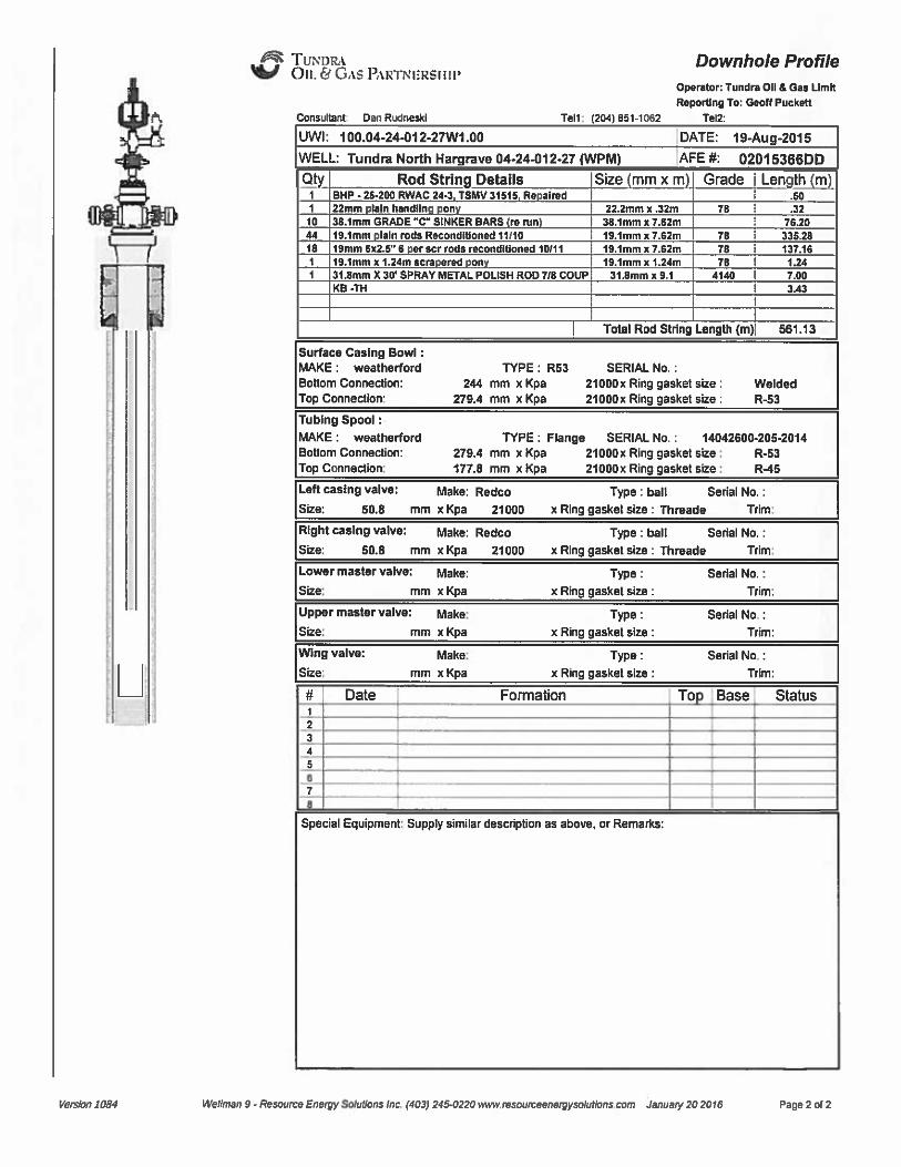
~TUNIIRA~Oil. & GASPARTNIIRSIIII'onsursnt
Dan Rudneski
Downhole ProfileOperator: Tundra Og 6 Gns UmltReporting To: Gcnff Puckctt
Tel1: I204) 851-1 062 Tel2:
UWI: 100.04-24-012-27W1.00
WELL: Tundra North Hargrave 04-24012-27 iWPM)
DATE: 19-Aug-2015
AFE tk 02015366DD
Qty Rod String Details1 BHP-25.200RWAC243 TSNV31515 Re Imd
22mm In hnndan n
Size mmxm
222mm x a2m
Grade
78
Len ~th m
3210
18
38.1mm GRADE "C" SINKER BARS m mn19.1mm lain rods Recondrdoned11l1019mm sx25" 6 r acr rods ondafnmm ref f119.1mm x 1.24m cern
39.tmm x T.szm19.1mm x 7.62m19.1mm x 7.62m18.1mm x f~
787878
7620335 28
137 16
1241 31 smm X 30'PRAY METALPOUSH ROD Tla COUP
KB -TH313hnm x 9.1 4140 7 00
Total Rod String Length (m) 561.13
Surface Casing Bowl:MAKE: weatherfordBottom Connection:
Top Connectiorr.
TYPE: R53 SERIAL No.:244 mm x Kpa 21000x Ring gasket size:
279.4 mm x Kpa 210Nx Ring gasket size:WeldedR-53
Tubing Spool:MAKE: weatherfordBoNom Connection:
Top Connection:
TYPE: Flange SERIAL No.: 14042600-205-2014279.4 mm x Kpa 21000x Ring gasket size: R-53
177.0 mm x Kpa 210Nx Ring gasket size: RX5
Left casing valve: Make: Redco Type; ball Serial No.:Size: 50.8 mm x Kpa 21000 x Ring gasket size: Threads Trim:
Right casing valve: Make: Redco Type ball Senal No
Size; 50.6 mm x Kpa 21000 x Ring gasket size: Threads Trim:
Lower master valve: Make:
Size: mm xKpa
UPPer master valve: 85ake
Size: mm xKpa
Type:x Ring gasket size:
Type:x Ring gasket size:
Serial No.:
Tllm;
Serial No.:
Trim:
Wing valve:
Size:
Make:
mm xKpaType:
x Ring gasket size:
Serial No.:
Trim:
ycrzfcn 7 084 Wellman 9- Resource Energy Sdurcnz inc. Iuozf 245 0220 www rescurceeneqlyuoludcns corn January 20 2016 Page 2 of 2
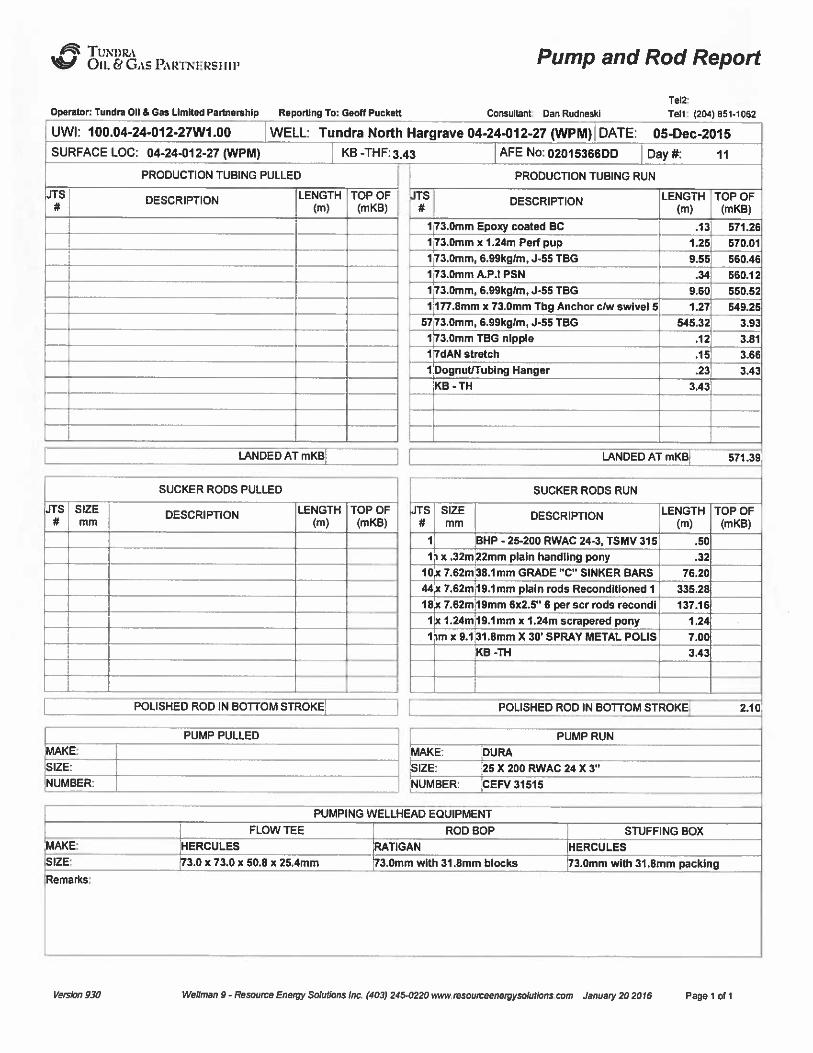
dpas TUNDRA~On. Ei Gas PiglydlI'RSI III Pump and Rod Report
Operator: Tundra 00 5 Gss Limited Partnamblp Repordna Tor Geelf Puckelt onsuaant. Oan Rudneski
Tel2:
Ten: (204) 651-1062
UWI: 100.04-24-012-27W1.00 WELL: Tundra North Hargrave 04-244)12-27 (WPM) DATE: 05-Dec-2015
SURFACE LOC: 04-24-012-27 (WPM)
PRODUCTION TUBING PULLED
KB -THF.'.43 AFE No: 02015366DD Day ¹: 11
PRODUCTION TUBING RUN
JTS
/
DESCRIPTION LENGTH TOP OF(m) (mKB)
DESCRIPTION
73.0mm Epoxy coated BC
3.0mm x 1.24m Perf pup3.0mm, 6.99kg/m, J-55 TBG
3.0mm A.P.I PSN
3.0mm, 6.99kglm, J-55 TBG
17
17
177.8mm x 73.0mm Tbg Anchor clw swivel 5
LENGTH TOP OF(m) (mKB)
.13 571.26
1.25 570.01
9.55 560.46
560.12
9.60 550.52
1.27 649.25
73.0mm, 6.99kglm, J-55 TBG57 545.32 3.93
3.0mm TBG nipple .12 3.81
7dAN stretch .15 3.66
DognutlTublng Hanger'KB - TH
.23
3.43
3.43
LANDEDATmKB LANDED ATmKB 571.39
JTS SIZEmm
SUCKER RODS RUN
DESCRIPTION LENGTH TOP OF(m) (mKB)
1 BHP - 25-200 RWAC 24-3, TSMV 315 .50
11 x .32m 22mm plain handling pony .32
10x 7.62m
44 x 7.62m
18x 7.62m
38.1 mm GRADE "C" SINKER BARS
19.1 mm plain rods Recondltloned 1
19mm 6x2.5" 6 per scr rods recondl
76.20
335.28
137.16
1 x 1.24m 19.1mm x 1.24m scrapered pony 1.24
1 9.1 31.8mm X 30'PRAY METALPOLIS
KB -TH7.00
3.43
POLISHED ROD IN BOTTOM STROKE ( POLISHED ROD IN BOTTOM STROKE 2.10
MAKE: DURA
PUMP RUN
SIZE:
NUMBER:
25 X 200 RWAC 24 X 3"
CEFV 31515
FLOW TEE
PUMPING WELLHEAD EQUIPMENT
ROD BOP STUFFING BOX
BIZE:
IRemarks:
HERCULES
3.0 x 73.0 x 50.8 x 25.4mm
RATIGAN
3.0mm with 31.8mm blocks
HERCULES
73.0mm with 31.8mm packing
yurstm 030 wellman 0 - Resource Enurpy Suenfans lnc. (403) 2450220 wwwrmuurceeneffyscfuffsns curn January 20 2016 page 1 of 1
CORE ANALYSIS REPORTFOR
TUNDRA OIL & GAS PARTNERSHIP
TUNDRA NORTH HARGRAVE4-24-12-27LSD 00/04-24-012-27 W1M
NORTH HARGRAVE, MANITOBA
Lic. ¹ 10414
THESE ANALYSES, OPINIONS OR INTERPRETATIONS ARE BASED ON OBSERVATIONS AND MATERIALSSUPPLIED BY THE CLIENT TO WHOM; AND FOR WHOSE EXCLUSIVE AND CONFIDENTIAI
USE; THIS REPORT IS MADE. THE INTERPRETATIONS OR OPINIONS EXPRESSED REPRESENT THE BEST JUDGEMENT OF CORE LABORATORIES (ALL ERRORS AND OMISSIONS EXCEPTED); BUT
CORE LABORATORIES AND ITS OFFICERS AND EMPLOYEES, ASSUME NO RESPONSIBILITY AND MAKENO WARRANTY OR REPRESENTATIONS, AS TO THE PRODUCTIVITY, PROPER OPERATIONS,
OR PROFITABLENESS OF ANY OIL, GAS OR MINERAL WELL OR FORMATION IN CONNECTION WITH WHICH SUCH REPORT IS USED OR RELIED UPON. CORE LABORATORIES IS COMMITTED TO
CUSTOMER SATISFACTIONAND WELCOMES YOUR FEEDBACK. YOU CANE-MAILTHE GENERAL MANAGERWITH YOUR COMMENTS ATFSCAJVADA.FEEDBACK COBELAB.COM.
THESE ANALYSES, OPINIONS OR INTERPRETATIONS ARE BASED ON OBSERVATIONS AND MATERIALS SUPPLIED BY THE CLIENT TO WHOM; AND FOR WHOSE EXCLUSIVE AND CONFIDENTIALUSE; THIS REPORT IS MADE. THE INTERPRETATIONS OR OPINIONS EXPRESSED REPRESENT THE BEST JUDGEMENT OF CORE LABORATORIES (ALL ERRORS AND OMISSIONS EXCEPTED); BUT
CORE LABORATORIES AND ITS OFFICERS AND EMPLOYEES, ASSUME NO RESPONSIBILITY AND MAKE NO WARRANTY OR REPRESENTATIONS, AS TO THE PRODUCTIVITY, PROPER OPERATIONS,
OR PROFITABLENESS OF ANY OIL, GAS OR MINERAL WELL OR FORMATION IN CONNECTION WITH WHICH SUCH REPORT IS USED OR RELIED UPON. CORE LABORATORIES IS COMMITTED TO
CUSTOMER SATISFACTION AND WELCOMES YOUR FEEDBACK. YOU CAN E-MAIL THE GENERAL MANAGER WITH YOUR COMMENTS AT [email protected] .
Lic. # 10414
CORE ANALYSIS REPORT FOR
NORTH HARGRAVE , MANITOBA
TUNDRA OIL & GAS PARTNERSHIP
TUNDRA NORTH HARGRAVE 4-24-12-27LSD 00/04-24-012-27 W1M
RESERVOIR OPTINIZATION
September 29, 2015
Iaetrolleurtrt gastric=ea IDitriaionCore Laboratones Canada, Ltd2510 — 12 Street N.ECalgary, Alberta, Canada T2E 7P7Tel: (403) 250-4000Fax: (403) 250-5120www,corelab.corn
Tundra Oil R Gas Partnership1000, 715 —5've SWCalgary, Alberta T2P 2X6
Attention: Norman Hopkins
Subj ect: TUNDRA NORTH HARGRAVE 4-24-12-27 W1MOur File Number: 52131 —15-0052
Diamond coring equipment and water base mud were used to core the subject well. Thecore was boxed at the wellsite and transported to our Calgary laboratory.
Prior to analysis, spectral gamma ray activity and bulk density index were measured.
Prior to analysis, the core material was photographed and one set of white light 216 mmX 280 mm, photographs and one compact disk were forwarded to your office.
1. Conventional, Plug Type Analysis
Five samples (38.1 mm diameter) were cleaned in a vapour phase extractor usingtoluene and dried. in a. friction air oven Analysis includes porosity by &oyle's 1 awtechnique using helium as the gaseous medium, residual fluid determination by retorton adjacent material, and horizontal permeability to air
2. Full Diameter Analysis
Fifteen samples were cleaned in a vapour phase extractor using toluene and dried ina friction air oven. Porosity was determined by the Boyle's Law technique usinghelium as the gaseous medium. Permeability to air was measured in both horizontal(Kmax, K90) and vertical (Kv) directions. The summation o f fluid saturationtechnique (retort) was used to determine residual fluid saturation on full diametersample end pieces.
3. Pressure Decay Profile Permeability
The Pressure Decay Profile Permeameter measures slip —corrected (Klinkenberg) andconventional gas permeabilities; both of which are free from inertial flow resistanceeffects.
ISO 9001 2000FS 51856
Tundra Oil A. Chas PartnershipNorman Hopkins
September 29, 2015
The instrument is an unsteady state device that measures the rate of pressure decayof gas through a probe tip sealed onto the core surface using an Q-ring.
The Profile Permeameter utilizes four gas reservoirs of different calibrated volumes;large volumes for high permeability intervals and small volumes for lowpermeability intervals. This allows for permeability measurements to be takenquickly over a wide range of permeabilities (0.001 mD to 20 Darcies).
During operation a reservoir tank of the appropriate volume is filled with gas at aknown pressure. After the probe tip is sealed against the core surface the probevalve is opened and the tank pressure is recorded as a function of the time. Thehigher the permeability, the larger the tank selected and the faster the pressure willdecay. The slope of the pressure-decay curve at any time yields an instantaneousflow rate function. and. permeability'an be calculated.
The utilization of different volume reservoirs and a laser guided probe allows a largenumber of permeability measurements to be taken rapidly and provides a continuousdetailed description of core permeability.
Interchangeable probe assemblies accommodate permeability measurements ondifferent rock types. The probe is equipped with a laser light to allow accuratepositioning on the core surface.
Recording o f permeability measurements along with their accompanying x-ycoordinates facilitates plotting the data on a depth log comparable in format to coresample permeability plots or downhole logs.
The data for the subj ect well was measured on clean, slabbed core withmeasurements taken at 2.5 cm spacing.
The results of these analyses are reported in both tabular and graphical form.
Samples outside the 95 lo confidence interval (three standard deviations) on thePermeability X Porosity crossplot have been identified and have been checked and re-analyzed to ensure data integrity.
As a guide to evaluation and correlation with other data, statistics with tabulated cut-offranges and plots are also presented herein.
The core material was slabbed in accordance with government regulations and one set ofwhite light, 216 mm X 280 mm, photographs and one compact disk were forwarded toyour office under a. separate cover.
Tundra Oil M Chas PartnershipNorman Hopkins
September 29, 2015
Thank you for the opportunity to be of service.
&ours truly,
CORE LABORATORIES CANADA, LTD.
Derrick J. DavisSupervisor, Routine Rock Properties
DD/soenclosures

Field: NORTH HARGRAVE
Province: MANITOBA
License : 10414
TUNDRA OIL & GAS PARTNERSHIPTUNDRA NORTH HARGRAVE4-24-12-27
LSD 00/04-24-012-27 W1M
Formation: LODGEPOLE
Coring Equip: DIAMOND
Coring Fluid: WATER BASE MUD
File No.: 52131-15-0052
Date: 2015-08-03
Analysts: DJB
Core Dia: 100 mm
CORE ANALYSIS FINAL RESULTS
SAMPLENUMBER
DEPTHm
INTVL SAMPLE
REP LENGTH
SPOT PERMEABILITY CAPACITY(MAXIMUM) (90 DEG) (VERTICAL) (MAXIMUM)
Kair Kair Kair Kairm mD mD mD mD-m
POROSITY CAPACITY BULK GRAIN
fraction k /m3 k /m3
(HELIUM) (HELIUM) DENSITY DENSITY
SATURATION(PORE VOLUME)OIL WATERfrac frac
COMMENTS
NA 553.00- 556.25 3.25
CORE NO.1 553.00 - 563.00 m (CORE RECEIVED 8.17 m) (8 BOXES)
JURASSIC
LODGEPOLEsh
NA
FD
FD
FD
NA
NA
NA
FD
NA
LC
556.25- 556.63
556.63- 556.79
556.79- 556.92
3 556.92- 557.09
557.09- 559.00
559.00- 559.52
559.52- 560.70
560.70- 560.91
560. 91- 561. 1 7
561.17- 563.00
0.38
0.16 0.09
0.13 0.07
0.17 0.10
1.91
0.52
1.18
0.21 0.13
0.26
1.83
706. 594.
32.3 29.4
23.7 19.8
170. 126.
938. 148.260
3.39 5.168
3.61 3.081
5.04 28.900
0.072
0.103
0.102
0.148
0.012
0.013
0.017
0.031
2630
2540
2530
2380
sh
2830 0.000 0.691 dol i sv
2830 0.000 0.477 dol i ppv sv calc
2820 0.000 0.530 dol i ppv sv calc
dol
dol sshy
sh
2790 0.112 0.463 dol i ppv sv mv calc vfrac
dol ru
Lost core
CORE NO.2 563.00 - 572.00 m (CORE RECEIVED 8.22 m) (8 BOXES)
SPA
SP
5 563.00- 563.50 0.50
6 563.50- 563.64 0.14
563.30 0.012
563.55 1420.
0.006
198.800
0.032
0.077
0.016
0.011
2490 2570 0.135 0.514 cht
2440 2640 0.160 0.310 dol i sdy cht
Page 1 of 2
File No. : 52131-15-0052
Field : NORTH HARGRAVE Formation : LODGEPOLE Date : 2015-08-03
Province : MANITOBA Coring Equip : DIAMOND Analysts : DJB
License : 10414 Coring Fluid : WATER BASE MUD Core Dia : 100 mm
INTVL
REP
m
SAMPLE
LENGTH
m
SPOT
DEPTH
m
(MAXIMUM)
Kair mD
PERMEABILITY (90 DEG)
Kair mD
(VERTICAL)
Kair mD
CAPACITY (MAXIMUM)
Kair mD-m
POROSITY
(HELIUM)
fraction
CAPACITY
(HELIUM)
ø-m
BULK
DENSITY
kg/m3
GRAIN
DENSITY
kg/m3
COMMENTS
NA 553.00- 556.25 3.25 sh
NA 556.25- 556.63 0.38 sh
FD 1 556.63- 556.79 0.16 0.09 32.3 29.4 3.39 5.168 0.072 0.012 2630 2830 0.000 0.691 dol i svFD 2 556.79- 556.92 0.13 0.07 23.7 19.8 3.61 3.081 0.103 0.013 2540 2830 0.000 0.477 dol i ppv sv calc
FD 3 556.92- 557.09 0.17 0.10 170. 126. 5.04 28.900 0.102 0.017 2530 2820 0.000 0.530 dol i ppv sv calc
NA 557.09- 559.00 1.91 dol
NA 559.00- 559.52 0.52 dol sshy
NA 559.52- 560.70 1.18 sh
FD 4 560.70- 560.91 0.21 0.13 706. 594. 938. 148.260 0.148 0.031 2380 2790 0.112 0.463 dol i ppv sv mv calc vfracNA 560.91- 561.17 0.26 dol ru
LC 561.17- 563.00 1.83 Lost core
SPA 5 563.00- 563.50 0.50 563.30 0.012 0.006 0.032 0.016 2490 2570 0.135 0.514 chtSP 6 563.50- 563.64 0.14 563.55 1420. 198.800 0.077 0.011 2440 2640 0.160 0.310 dol i sdy cht
SATURATION (PORE VOLUME) OIL WATER frac frac
CORE NO.1 553.00 - 563.00 m (CORE RECEIVED 8.17 m) (8 BOXES)
JURASSIC
LODGEPOLE
CORE NO.2 563.00 - 572.00 m (CORE RECEIVED 8.22 m) (8 BOXES)
TUNDRA OIL & GAS PARTNERSHIPTUNDRA NORTH HARGRAVE 4-24-12-27
LSD 00/04-24-012-27 W1M
C O R E A N A L Y S I S F I N A L R E S U L T S
SAMPLE NUMBER
DEPTH m
Page 1 of 2

Field: NORTH HARGRAVE
Province: MANITOBA
License : 10414
TUNDRA OIL & GAS PARTNERSHIPTUNDRA NORTH HARGRAVE4-24-12-27
LSD 00/04-24-012-27 W1M
Formation: LODGEPOLE
Coring Equip: DIAMOND
Coring Fluid: WATER BASE MUD
File No.: 52131-15-0052
Date: 2015-08-03
Analysts: DJB
Core Dia: 100 mm
CORE ANALYSIS FINAL RESULTS
SAMPLENUMBER
DEPTHm
INTVL SAMPLE
REP LENGTH
SPOT PERMEABILITY CAPACITY(MAXIMUM) (90 DEG) (VERTICAL) (MAXIMUM)
Kair Kair Kair Kairm mD mD mD mD-m
POROSITY CAPACITY BULK GRAIN
fraction k /m3 k /m3
(HELIUM) (HELIUM) DENSITY DENSITY
SATURATION(PORE VOLUME)OIL WATERfrac frac
COMMENTS
FD
SP
7 563.64- 564.04 0.40 0.13
8 564.04- 564.14 0.10
414. 264.
564.10 3080.
29.8 165.600
308.000
0.131
0.324
0.052
0.032
2400
1800
2760 0.000 0.119 dol i ppv sv calc
2670 0.134 0.655 ss vf f m dol
NA
FD
FD
FD
NA
FD
FD
NA
10
12
13
564.14- 564.48
564.48- 564.70
564.70- 564.94
564.94- 565.06
565.06- 565.86
565.86- 566.12
566.12- 566.34
566.34- 566.58
0.34
0.22 0.13
0.24 0.12
0.12 0.11
0.80
0.26 0.13
0.22 0.13
0.24
202. 155.
29.0 17.8
4.63 52.520
5.98 6.380
427. 386. 84.2 93.940
272. 208. 128. 65.280
375. 365. 230. 45.000
0.233
0.284
0.208
0.205
0.109
0.051
0.068
0.025
0.053
0.024
2170
2020
2230
2240
2390
2830 0.120
2830 0.071
2810 0.000
dol
0.652 dol i ppv sv calc
0.559 dol i ppv sv calc
0.671 dol i ppv sv calc
dol
2810 0.052 0.726 dol i ppv sv mv Iv calc
2690 0.000 0.673 Is i ppv sv mv Iv sty
dol
SP
FD
SP
NA
FD
NA
FD
FD
FD
NA
LC
14
15
16
17
18
19
20
566.58- 566.71
566.71- 566.86
566.86- 566.98
566.98- 567.24
567.24- 567.67
567.67- 568.47
568.47- 568.77
568.77- 569.05
569.05- 569.30
569.30- 571.22
571.22- 572.00
0.13
0.15 0.11
0.12
0.26
0.43 0.13
0.80
0.30 0.10
0.28 0.13
0.25 0.11
1.92
0.78
566.62 77.3
2.74 2.67
63.2 19.3
1.50
3. 53
0.20
1.40
3.40
0.17
566.90 96.9
10.049
1.32 0.411
11.628
2.58 27.176
0.44 0.450
0.34 0.988
0.08 0.050
0.169
0.081
0.108
0.082
0.095
0.091
0.057
0.022
0.012
0.013
0.035
0.029
0.025
0.014
2330
2490
2520
2440
2540
2510
2620
2810 0.109 0.521 dol i ppv calc
2710 0.000 0.815 Is i
2820 0.107 0.413 dol i ppv sv mv 1am
dol
2660 0.000 0.577 Is i ppv sv
dol
2800 0.000 0.708 Is i dol sty
2760 0.000 0.723 Is i ppv sv mv
2780 0.000 0.626 Is i dol
dol
Lost core
Page 2 of 2
File No. : 52131-15-0052
Field : NORTH HARGRAVE Formation : LODGEPOLE Date : 2015-08-03
Province : MANITOBA Coring Equip : DIAMOND Analysts : DJB
License : 10414 Coring Fluid : WATER BASE MUD Core Dia : 100 mm
INTVL
REP
m
SAMPLE
LENGTH
m
SPOT
DEPTH
m
(MAXIMUM)
Kair mD
PERMEABILITY (90 DEG)
Kair mD
(VERTICAL)
Kair mD
CAPACITY (MAXIMUM)
Kair mD-m
POROSITY
(HELIUM)
fraction
CAPACITY
(HELIUM)
ø-m
BULK
DENSITY
kg/m3
GRAIN
DENSITY
kg/m3
COMMENTS
SATURATION (PORE VOLUME) OIL WATER frac frac
TUNDRA OIL & GAS PARTNERSHIPTUNDRA NORTH HARGRAVE 4-24-12-27
LSD 00/04-24-012-27 W1M
C O R E A N A L Y S I S F I N A L R E S U L T S
SAMPLE NUMBER
DEPTH m
FD 7 563.64- 564.04 0.40 0.13 414. 264. 29.8 165.600 0.131 0.052 2400 2760 0.000 0.119 dol i ppv sv calcSP 8 564.04- 564.14 0.10 564.10 3080. 308.000 0.324 0.032 1800 2670 0.134 0.655 ss vf f m dol
NA 564.14- 564.48 0.34 dol
FD 9 564.48- 564.70 0.22 0.13 427. 386. 84.2 93.940 0.233 0.051 2170 2830 0.120 0.652 dol i ppv sv calc
FD 10 564.70- 564.94 0.24 0.12 272. 208. 128. 65.280 0.284 0.068 2020 2830 0.071 0.559 dol i ppv sv calc
FD 11 564.94- 565.06 0.12 0.11 375. 365. 230. 45.000 0.208 0.025 2230 2810 0.000 0.671 dol i ppv sv calc
NA 565.06- 565.86 0.80 dolFD 12 565.86- 566.12 0.26 0.13 202. 155. 4.63 52.520 0.205 0.053 2240 2810 0.052 0.726 dol i ppv sv mv lv calc
FD 13 566.12- 566.34 0.22 0.13 29.0 17.8 5.98 6.380 0.109 0.024 2390 2690 0.000 0.673 ls i ppv sv mv lv sty
NA 566.34- 566.58 0.24 dol
SP 14 566.58- 566.71 0.13 566.62 77.3 10.049 0.169 0.022 2330 2810 0.109 0.521 dol i ppv calc
FD 15 566.71- 566.86 0.15 0.11 2.74 2.67 1.32 0.411 0.081 0.012 2490 2710 0.000 0.815 ls i
SP 16 566.86- 566.98 0.12 566.90 96.9 11.628 0.108 0.013 2520 2820 0.107 0.413 dol i ppv sv mv lam
NA 566.98- 567.24 0.26 dol
FD 17 567.24- 567.67 0.43 0.13 63.2 19.3 2.58 27.176 0.082 0.035 2440 2660 0.000 0.577 ls i ppv sv
NA 567.67- 568.47 0.80 dol
FD 18 568.47- 568.77 0.30 0.10 1.50 1.40 0.44 0.450 0.095 0.029 2540 2800 0.000 0.708 ls i dol sty
FD 19 568.77- 569.05 0.28 0.13 3.53 3.40 0.34 0.988 0.091 0.025 2510 2760 0.000 0.723 ls i ppv sv mv
FD 20 569.05- 569.30 0.25 0.11 0.20 0.17 0.08 0.050 0.057 0.014 2620 2780 0.000 0.626 ls i dol
NA 569.30- 571.22 1.92 dol
LC 571.22- 572.00 0.78 Lost core
Page 2 of 2

CODE KEY - DESCRIPTIONS
ACAanhyargASTbitbkccalccarbcblcglchtcoalcoqdolffcFD
foesfreefriglaucgrnl
gyphei
hfrac
IFD
incl1am
Removed for advanced core analysisAnhydriteArgillaceousAppears similar toBitumenBreakCoarseCalcite (calcareous)CarbonaceousCobbleConglomerateChertCoal/coal inclusionCoquinaDolomiteFineFilter cake on suface of core sampleFull diameter analysis including threedirectional permeabilities, porosity anddensitiesFossil (fossiliferous)Fracture (undifferentiated)FriableGlauconite (glauconitic)GranuleGypsumHalite (sa It)Ho rizo nta I fractureIntercrystallineInner Full Diameter (Full diameter sampleis drilled from the bulk portion of thecore in the vertical direction forpermeability and porosity measurements)InclusionsLaminae (laminated)
Is
Iv
mmimvNANROB
oolpblPFDppvPRPSAPSPpyrpyrbitI'u
SAsdySEMsh
shySld
sltstsltySP
SPA
= Limestone= Large vug= Medium= Mud invaded= Medium vug= Not analyzed by request= Not received= Overburden sample (permeability and
porosity measured at net overburdenstress)
= Oolitic= Pebble= Preliminary Full Diameter sample= Pinpoint vug= Preserved for future studies= Particle size analysis= Preliminary Small Plug sample= Pyrite (pyritic)= Pyrobitumen= Rubble= Sieve analysis= Sandy= Scanning electron microscope analysis= Shale= Moderately shaly (20% -40%)= Siderite= Siltstone= Silty= Small plug (sample drilled from core in
maximum horizontal direction and parallel tobedding plane where possible) permeabilityporosity, and grain density are measured
= (Prefix A) Horizontal matrix permeabilitymeasured by pressure decay profilepermeametry through a probe tip dueto sample quality
SPH
SPPSPTss
ssdyashystysulfsvTEC
TSunconsVC
vfvfracVISVOB
vshyVSP
vugwsXRD
10240
= Humidity analysis of small plug sample at 60
degrees Celsius and 50% relative humidty= Small plug from preserved section of the core= Small Plug used for tracer analysis= Sandstone= Slightly sandy (<20%)= Slightly shaly («20%)= Stylolite (ic)= Sulphur= Small vug= Thermal Extraction Chromatography to
determine oil richness= Thin section= Unconsolidated= Very coarse= Very fine= Vertical fracture= Viscosity of oil measured= Vertical overburden sample (vertical
permeability measured at net overburdenstress)
= Very shaly (>40%)= Vertical small plug drilled from whole
core to measure vertical permeability(and occasionally porosity)
= Vuggy(vuggular)= Water sand= X-ray diffraction= Data unavailable due to poor sample quality= Permeability»10 Darcies, (maximum
routine permeability measurement)
CODE KEY - DESCRIPTIONS
ACA = Removed for advanced core analysis Is = Limestone SPH = Humidity analysis of small plug sample at 60anhy = Anhydrite lv = Large vug degrees Celsius and 50 % relative humidtyarg = Argillaceous m = Medium SPP = Small plug from preserved section of the coreAST = Appears similar to mi = Mud invaded SPT = Small Plug used for tracer analysisbit = Bitumen mv = Medium vug ss = Sandstonebk = Break NA = Not analyzed by request ssdy = Slightly sandy (<20%)c = Coarse NR = Not received sshy = Slightly shaly (<20%)calc = Calcite (calcareous) OB = Overburden sample (permeability and sty = Stylolite (ic)carb = Carbonaceous porosity measured at net overburden sulf = Sulphurcbl = Cobble stress) sv = Small vugcgl = Conglomerate ool = Oolitic TEC = Thermal Extraction Chromatography tocht = Chert pbl = Pebble determine oil richnesscoal = Coal/coal inclusion PFD = Preliminary Full Diameter sample TS = Thin sectioncoq = Coquina ppv = Pinpoint vug uncons = Unconsolidateddol = Dolomite PR = Preserved for future studies vc = Very coarsef = Fine PSA = Particle size analysis vf = Very finefc = Filter cake on suface of core sample PSP = Preliminary Small Plug sample vfrac = Vertical fractureFD = Full diameter analysis including three pyr = Pyrite (pyritic) VIS = Viscosity of oil measured
directional permeabilities, porosity and pyrbit = Pyrobitumen VOB = Vertical overburden sample (verticaldensities ru = Rubble permeability measured at net overburden
foss = Fossil (fossiliferous) SA = Sieve analysis stress)frac = Fracture (undifferentiated) sdy = Sandy vshy = Very shaly (>40%)fri = Friable SEM = Scanning electron microscope analysis VSP = Vertical small plug drilled from wholeglauc = Glauconite (glauconitic) sh = Shale core to measure vertical permeabilitygrnl = Granule shy = Moderately shaly (20% - 40%) (and occasionally porosity)gyp = Gypsum sid = Siderite vug = Vuggy (vuggular)hal = Halite (salt) sltst = Siltstone ws = Water sandhfrac = Horizontal fracture slty = Silty XRD = X-ray diffractioni = lntercrystalline SP = Small plug (sample drilled from core in * = Data unavailable due to poor sample qualityIFD = Inner Full Diameter (Full diameter sample maximum horizontal direction and parallel to 10240 = Permeability >10 Darcies, (maximum
is drilled from the bulk portion of the bedding plane where possible) permeability routine permeability measurement)core in the vertical direction for porosity, and grain density are measuredpermeability and porosity measurements) SPA = (Prefix A) Horizontal matrix permeability
incl = Inclusions measured by pressure decay profilelam = Laminae (laminated) permeametry through a probe tip due
to sample quality

CORE LABORATORIES
Company:TUNDRA OIL & GAS PARTNERSHIPWell: TUNDRA NORTH HARGRAVE4-24-12-27
Field:NORTH HARGRAVEFormation:LODGE POLE
File No:52131-15-0052Date:2015-08-03
TABLE 2
SUMMARY OF FINAL CORE DATA
~ g ~ ~ ~ g g L L L ~
DATATYPE:
orosity--------------P (HELIUM)
Permeability----------- (MAXIMUM)Kair
CUTOFFS:
ZONE:
Identification---------- LODGEPOLE
Top Depth------------556 25 m
Bottom Depth----------572.00 m
Number of Samples------20
ZONE:
Number of Samples---- 20
Thickness Represented-- 4.53 m
POROSITY:
Storage Capacity------ 0.557 8 -m
Arithmetic Average----- 0.123 frac
Minimum------------0.032 frac
Maximum----------- 0.324 frac
Median-------------0.106 frac
Standard Deviation-----+0.078 frac
PERMEABILITY:
Flow Capacity-------Arithmetic Average---Geometric Average---Harmonic Average----
inimum-----------M'
aximum----------M
edian------------M
Standard Dev. (Geom)-
1171.69 mD-m
258.65 mD
21.35 mD
0.10 mD
0.01 mD
3080.00 mD
87.10 mD
K"10'-" "'D
Porosity(Minimum)------- 0.0000 frac
Porosity(Maximum)------ 1.0000 frac
Permeability(Minimum)---- 0.0000 mD
Permeability(Maximum)---- 100000 mD
Water Saturation(Maximum)- 1.000 frac
Oil Saturation(Minimum)--- 0.000 frac
Grain Density(Minimum)---2000. kg/m3
Grain Density(Maximum)--- 3000. kg/m3
Lithology Excludes------- NONE
GRAIN DENSITY:
Arithmetic Average----- 2745. kg/m3
Minimum------------2570. kg/m3
Maximum----------- 2830. kg/m3
Median-------------2795. kg/m3
Standard Deviation-----+77. kg/m3
HETEROGENEITY(Permeability):
Dykstra-Parsons Var.— 0.295
Lorenz Coefficient---- 0.723
Oil- 0.053 frac
Water------------ 0.565 frac
AVERAGESATURATION(Pore Volume):
Company :TUNDRA OIL & GAS PARTNERSHIP Field :NORTH HARGRAVE File No :52131-15-0052Well :TUNDRA NORTH HARGRAVE 4-24-12-27 Formation :LODGEPOLE Date :2015-08-03
ZONE: ZONE:Identification------------------- LODGEPOLE Number of Samples-------- 20Top Depth-------------------------556.25 m Thickness Represented--- 4.53 m Flow Capacity------------- 1171.69 mD-mBottom Depth-------------------- 572.00 m Arithmetic Average------ 258.65 mDNumber of Samples------------20 Geometric Average------ 21.35 mD
Harmonic Average-------- 0.10 mDDATA TYPE: Storage Capacity------------ 0.557 ø -m Minimum--------------------- 0.01 mD
Porosity---------------------------- (HELIUM) Arithmetic Average----------0.123 frac Maximum-------------------- 3080.00 mDPermeability---------------------- (MAXIMUM) Kair Minimum-----------------------0.032 frac Median------------------------ 87.10 mD
Maximum---------------------- 0.324 frac Standard Dev. (Geom)-- K*10±1.351 mDCUTOFFS: Median------------------------- 0.106 frac
Standard Deviation----------±0.078 fracPorosity(Minimum)--------------0.0000 fracPorosity(Maximum)-------------1.0000 fracPermeability(Minimum)--------0.0000 mD Dykstra-Parsons Var.-- 0.295Permeability(Maximum)-------100000 mD Lorenz Coefficient-------- 0.723Water Saturation(Maximum)-1.000 frac Arithmetic Average----------2745. kg/m3Oil Saturation(Minimum)------ 0.000 frac Minimum-----------------------2570. kg/m3Grain Density(Minimum)------ 2000. kg/m3 Maximum---------------------- 2830. kg/m3Grain Density(Maximum)----- 3000. kg/m3 Median------------------------- 2795. kg/m3 Oil----------------------------- 0.053 fracLithology Excludes--------------NONE Standard Deviation----------±77. kg/m3 Water------------------------ 0.565 frac
C O R E L A B O R A T O R I E S
ZONE AND CUTOFF DATA CHARACTERISTICS REMAINING AFTER CUTOFFS
PERMEABILITY:
S U M M A R Y O F F I N A L C O R E D A T A
TABLE 2
AVERAGE SATURATION(Pore Volume):
GRAIN DENSITY:
POROSITY:
HETEROGENEITY(Permeability):
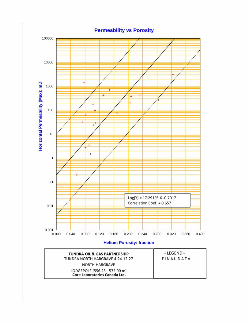
100000
Permeability vs Porosity
1 OOOO
1 000
Cll
CllCll
gCll
ClCll
IV
100
10
0.1
0.01
0.0010.000 0.040 0.080 0.120 0.160 0.200 0.240 0.280 0.320 0.360 0.400
Helium Porosity: fraction
0.001
0.01
0.1
1
10
100
1000
10000
100000
0.000 0.040 0.080 0.120 0.160 0.200 0.240 0.280 0.320 0.360 0.400
Hor
izon
tal P
erm
eabi
lity
(Max
): m
D
Helium Porosity: fraction
Permeability vs Porosity
Log(Y) = 17.2919* X ‐0.7017Correlation Coef. = 0.657
TUNDRA OIL & GAS PARTNERSHIPTUNDRA NORTH HARGRAVE 4‐24‐12‐27
NORTH HARGRAVE
LODGEPOLE (556.25 ‐ 572.00 m)Core Laboratories Canada Ltd.
‐ LEGEND ‐F I N A L D A T A
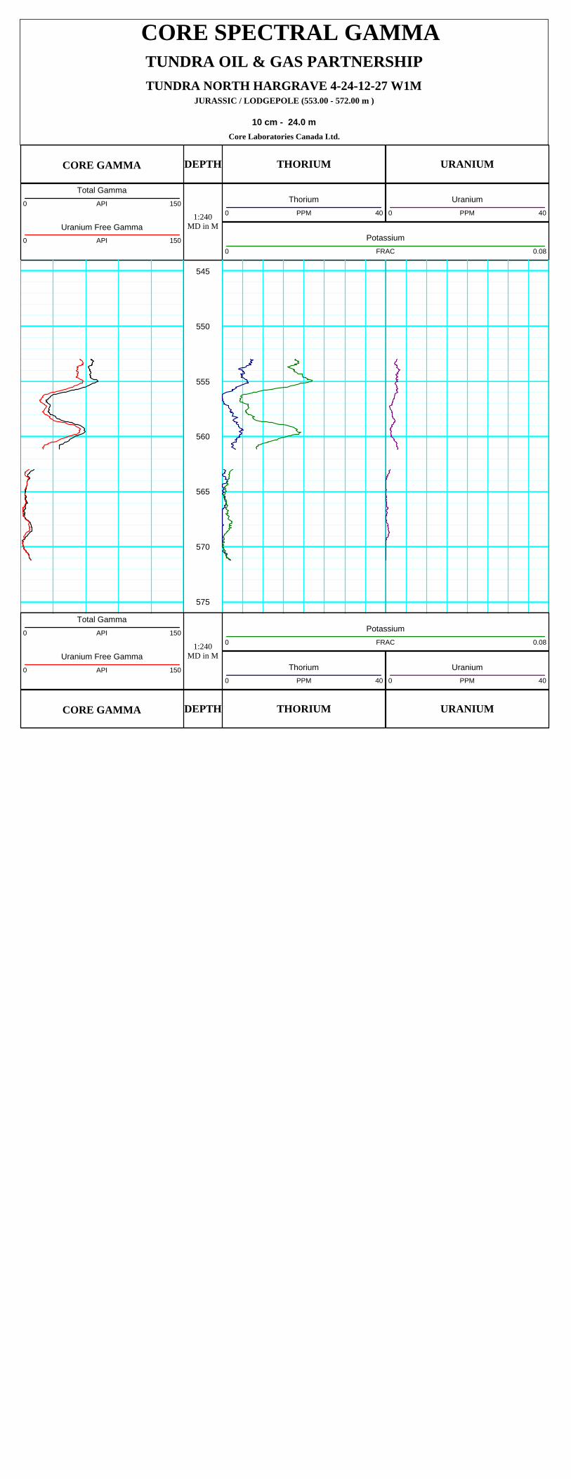
CORE SPECTRAL GAMMA
TUNDRA NORTH HARGRAVE 4-24-12-27 W1MJURASSIC / LODGEPOLE (553.00 - 572.00 m )
10 cm - 24.0 mCore Laboratories Canada Ltd.
TUNDRA OIL & GAS PARTNERSHIP
CORE GAMMA
1:240MD in M
DEPTH THORIUM URANIUM
Total Gamma0 API 150
Uranium Free Gamma0 API 150
Uranium0 PPM 40
Thorium0 PPM 40
Potassium0 FRAC 0.08
545
550
555
560
565
570
575
CORE GAMMA
1:240MD in M
DEPTH THORIUM URANIUM
Total Gamma0 API 150
Uranium Free Gamma0 API 150 Uranium
0 PPM 40
Thorium0 PPM 40
Potassium0 FRAC 0.08
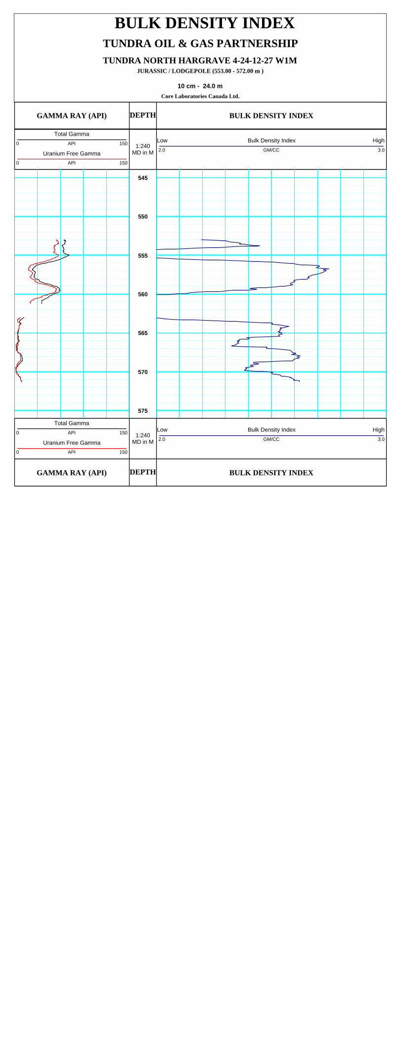
BULK DENSITY INDEX
TUNDRA NORTH HARGRAVE 4-24-12-27 W1MJURASSIC / LODGEPOLE (553.00 - 572.00 m )
10 cm - 24.0 mCore Laboratories Canada Ltd.
TUNDRA OIL & GAS PARTNERSHIP
GAMMA RAY (API)
1:240MD in M
DEPTH BULK DENSITY INDEX
Total Gamma0 API 150
Uranium Free Gamma0 API 150
Low Bulk Density Index High2.0 GM/CC 3.0
545
550
555
560
565
570
575
GAMMA RAY (API)
1:240MD in M
DEPTH BULK DENSITY INDEX
Total Gamma0 API 150
Uranium Free Gamma0 API 150
Low Bulk Density Index High2.0 GM/CC 3.0

CORRELATION COREGRAPH
TUNDRA NORTH HARGRAVE 4-24-12-27 W1MJURASSIC / LODGEPOLE ( 556.25 - 572.00 m)
10 cm - 24.0 mCore Laboratories Canada Ltd.
TUNDRA OIL & GAS PARTNERSHIP
LithologyLimestone Dolomite Sandstone
Conglomerate
Shale
Glauconite
Anhydrite
CoalSiltstoneShaley Sandstone
GAMMA RAY (API)
1:240MD in M
DEPTH POROSITY / GRAIN DENSITY
Total Gamma0 API 150
Uranium Free Gamma0 API 150
Helium Porosity
0.4 FRACTION 0.0
Core Grain Density
2000 KG/M3 3000
545
550
555
560
565
570
575
GAMMA RAY (API)
1:240MD in M
DEPTH POROSITY / GRAIN DENSITY
Total Gamma0 API 150
Uranium Free Gamma0 API 150
Helium Porosity
0.4 FRACTION 0.0
Core Grain Density
2000 KG/M3 3000
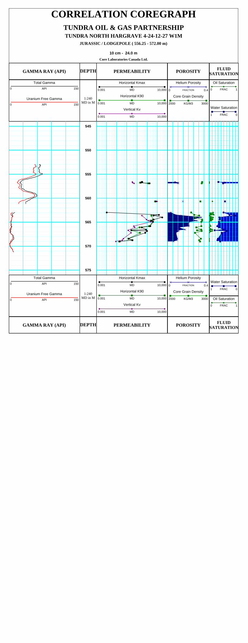
CORRELATION COREGRAPH
TUNDRA NORTH HARGRAVE 4-24-12-27 W1MJURASSIC / LODGEPOLE ( 556.25 - 572.00 m)
10 cm - 24.0 mCore Laboratories Canada Ltd.
TUNDRA OIL & GAS PARTNERSHIP
GAMMA RAY (API)
1:240MD in M
DEPTH PERMEABILITY POROSITYFLUID
SATURATION
Total Gamma0 API 150
Uranium Free Gamma0 API 150
Horizontal Kmax
0.001 MD 10,000
Horizontal K90
0.001 MD 10,000
Vertical Kv
0.001 MD 10,000
Helium Porosity
0 FRACTION 0.4
Core Grain Density
2000 KG/M3 3000Water Saturation
1 FRAC 0
Oil Saturation
0 FRAC 1
545
550
555
560
565
570
575
GAMMA RAY (API)
1:240MD in M
DEPTH PERMEABILITY POROSITYFLUID
SATURATION
Total Gamma0 API 150
Uranium Free Gamma0 API 150
Horizontal Kmax
0.001 MD 10,000
Horizontal K90
0.001 MD 10,000
Vertical Kv
0.001 MD 10,000
Helium Porosity
0 FRACTION 0.4
Core Grain Density
2000 KG/M3 3000
Water Saturation
1 FRAC 0
Oil Saturation
0 FRAC 1

PROFILE PERMEAMETRY
TUNDRA NORTH HARGRAVE 4-24-12-27 W1MJURASSIC / LOGEPOLE ( 553.00 - 572.00 m )
10 cm - 24.0 mCore Laboratories Canada Ltd.
TUNDRA OIL & GAS PARTNERSHIP
GAMMA RAY (API)
1:240MD in M
DEPTH PERMEABILITYPOROSITY
GRAIN DENSITYFLUID
SATURATION
Total Gamma0 API 150
Uranium Free Gamma0 API 150
Profile Permeability Kair0.001 MD 10,000
Permeability Kmax
0.001 MD 10,000
Helium Porosity
0.4 FRACTION 0.0
Core Grain Density
2500 KG/M3 3500
Water Saturation
1 FRAC 0
Oil Saturation
0 FRAC 1
545
550
555
560
565
570
575
GAMMA RAY (API)
1:240MD in M
DEPTH PERMEABILITYPOROSITY
GRAIN DENSITYFLUID
SATURATION
Total Gamma0 API 150
Uranium Free Gamma0 API 150
Profile Permeability Kair0.001 MD 10,000
Permeability Kmax
0.001 MD 10,000
Helium Porosity
0.4 FRACTION 0.0
Core Grain Density
2500 KG/M3 3500
Water Saturation
1 FRAC 0
Oil Saturation
0 FRAC 1

PROFILE PERMEAMETER INDEXTUNDRA NORTH HARGRAVE 4-24-12-27
00/04-24-01 2-27 W1 M
Point Depth (m) K Air (mD) K Liquid (mD) Comment
1
23456789
10111213141516171819202122232425262728293031323334353637383940
554.6632554.6973554. 7249554. 7586554.851 1
554. 902554. 9475554. 9901555. 0286555. 0663555. 1 689555. 1 921555.2338555.7571555. 8032555. 8398555. 8802555. 9095555. 9388555. 9751556. 0054556. 0357556. 0661556. 1 053556. 1 307556. 1 702556.2646556.2995556. 3307556. 3665556.409
556.4447556.4906556. 5229556. 5535556. 5984556.6653556.681 8556. 6944556. 7288
0.03870.1560.441
0.290. 09630.01 780. 07750.051 3
0.1990. 06570. 02820. 03930. 02340.01 560.01 230.01 730.01 050.01 130.01 050.01 85
0.01 1
0.01450.01 120.01 580. 02470.01 390.01 93
0.0140.01 330. 02750.01 560.01 640.01 820.01 720. 0267
0.187103
31.82.223. 51
0.01 240.0749
0.2610.159
0. 04090. 00424
0. 03090.01 80.101
0. 02490.00803
0.01 270.006230.003530.002520.004080.002010.00222
0. 0020.004470.0021 20.0031 80.0021 80.003590.006710.002980.004750.00302
0. 00280.007760.003530.003770.004390.004050.00747
0. 093594. 327.8
1.62.67
FD 1
FD 1
FD 1
FD 1
Page 1 of 10
Point Depth (m) K Air (mD) K Liquid (mD) Comment
1 554.6632 0.0387 0.0124
2 554.6973 0.156 0.0749
3 554.7249 0.441 0.261
4 554.7586 0.29 0.159
5 554.8511 0.0963 0.0409
6 554.902 0.0178 0.00424
7 554.9475 0.0775 0.0309
8 554.9901 0.0513 0.018
9 555.0286 0.199 0.101
10 555.0663 0.0657 0.0249
11 555.1689 0.0282 0.00803
12 555.1921 0.0393 0.0127
13 555.2338 0.0234 0.00623
14 555.7571 0.0156 0.00353
15 555.8032 0.0123 0.00252
16 555.8398 0.0173 0.00408
17 555.8802 0.0105 0.00201
18 555.9095 0.0113 0.00222
19 555.9388 0.0105 0.002
20 555.9751 0.0185 0.00447
21 556.0054 0.011 0.00212
22 556.0357 0.0145 0.00318
23 556.0661 0.0112 0.00218
24 556.1053 0.0158 0.00359
25 556.1307 0.0247 0.00671
26 556.1702 0.0139 0.00298
27 556.2646 0.0193 0.00475
28 556.2995 0.014 0.00302
29 556.3307 0.0133 0.0028
30 556.3665 0.0275 0.00776
31 556.409 0.0156 0.00353
32 556.4447 0.0164 0.00377
33 556.4906 0.0182 0.00439
34 556.5229 0.0172 0.00405
35 556.5535 0.0267 0.00747
36 556.5984 0.187 0.0935
37 556.6653 103 94.3 FD 1
38 556.6818 31.8 27.8 FD 1
39 556.6944 2.22 1.6 FD 1
40 556.7288 3.51 2.67 FD 1
TUNDRA NORTH HARGRAVE 4-24-12-27
00/04-24-012-27 W1M
PROFILE PERMEAMETER INDEX
Page 1 of 10
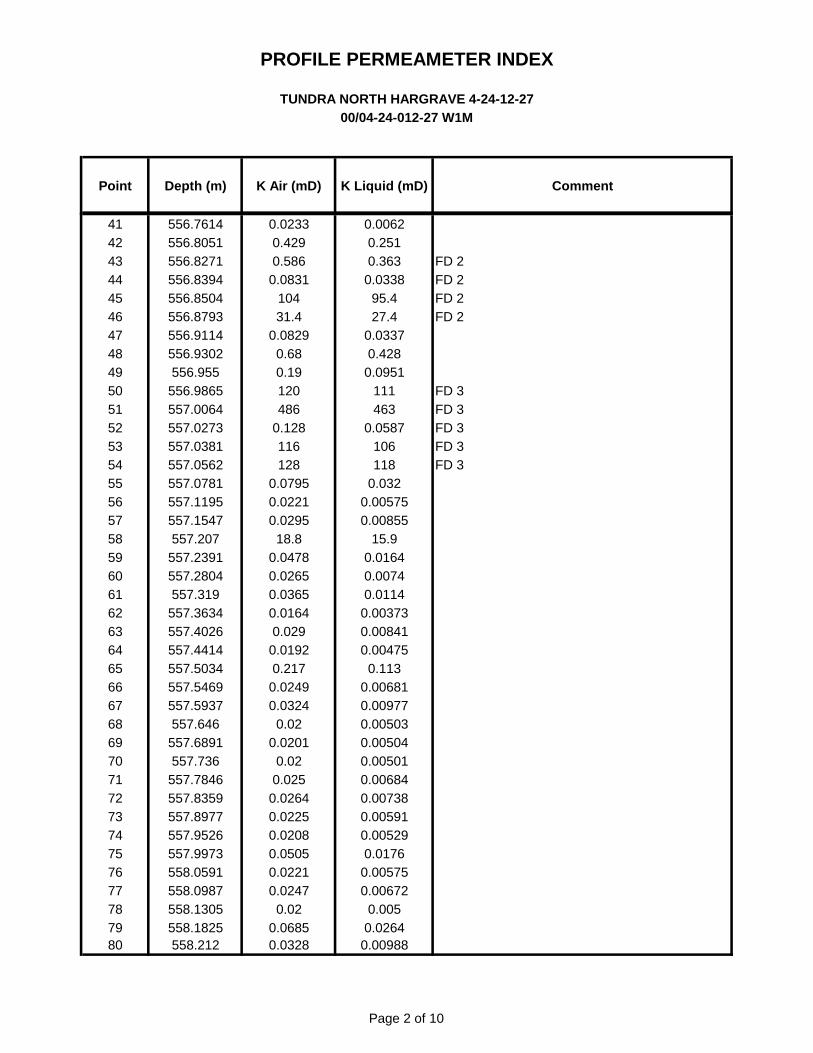
PROFILE PERMEAMETER INDEXTUNDRA NORTH HARGRAVE 4-24-12-27
OO/04-24-01 2-27 W1 M
Point Depth (m) K Air (mD) K Liquid (mD) Comment
41424344454647484950515253545556575859606162636465666T68697071727374757677787980
556. 761 4556. 8051556. 8271556. 8394556. 8504556. 8793556. 91 1 4556. 9302
556. 955556. 9865557. 0064557. 0273557.0381557. 0562557.0781557.1 195557. 1 547557.207
557.2391557. 2804
557.31 9557. 3634557.4026557.4414557. 5034557. 5469557. 5937557.646
557.6891557. 736
557. 7846557. 8359557. 8977557. 9526557. 9973558. 0591558. 0987558. 1 305558. 1 825
558.21 2
0. 02330.4290. 586
0.0831104
31.40. 0829
0.680.19120486
0.1281 16128
0. 07950.02210. 0295
1 8.80. 04780. 02650. 03650.01 64
0. 0290.01 92
0.21 T0. 02490. 0324
0.020.0201
0.020. 025
0. 02640. 02250. 02080. 05050.02210. 024T
0.020. 06850. 0328
0. 00620.2510. 363
0. 033895.427.4
0. 03370.428
0.0951111463
0. 058T1061 18
0. 0320.005750.00855
1 5.90.01 640. 00'740.01 14
0.003730.008410.00475
0.1 130.006810.009770.005030.005040.005010. 006840.007380.005910.00529
0.01 760.005750.006T2
0. 0050. 0264
0.00988
FD 2FD 2FD 2FD 2
FD 3FD 3FD 3FD 3FD 3
Page 2 of 10
Point Depth (m) K Air (mD) K Liquid (mD) Comment
TUNDRA NORTH HARGRAVE 4-24-12-27
00/04-24-012-27 W1M
PROFILE PERMEAMETER INDEX
41 556.7614 0.0233 0.0062
42 556.8051 0.429 0.251
43 556.8271 0.586 0.363 FD 2
44 556.8394 0.0831 0.0338 FD 2
45 556.8504 104 95.4 FD 2
46 556.8793 31.4 27.4 FD 2
47 556.9114 0.0829 0.0337
48 556.9302 0.68 0.428
49 556.955 0.19 0.0951
50 556.9865 120 111 FD 3
51 557.0064 486 463 FD 3
52 557.0273 0.128 0.0587 FD 3
53 557.0381 116 106 FD 3
54 557.0562 128 118 FD 3
55 557.0781 0.0795 0.032
56 557.1195 0.0221 0.00575
57 557.1547 0.0295 0.00855
58 557.207 18.8 15.9
59 557.2391 0.0478 0.0164
60 557.2804 0.0265 0.0074
61 557.319 0.0365 0.0114
62 557.3634 0.0164 0.00373
63 557.4026 0.029 0.00841
64 557.4414 0.0192 0.00475
65 557.5034 0.217 0.113
66 557.5469 0.0249 0.00681
67 557.5937 0.0324 0.00977
68 557.646 0.02 0.00503
69 557.6891 0.0201 0.00504
70 557.736 0.02 0.00501
71 557.7846 0.025 0.00684
72 557.8359 0.0264 0.00738
73 557.8977 0.0225 0.00591
74 557.9526 0.0208 0.00529
75 557.9973 0.0505 0.0176
76 558.0591 0.0221 0.00575
77 558.0987 0.0247 0.00672
78 558.1305 0.02 0.005
79 558.1825 0.0685 0.0264
80 558.212 0.0328 0.00988
Page 2 of 10
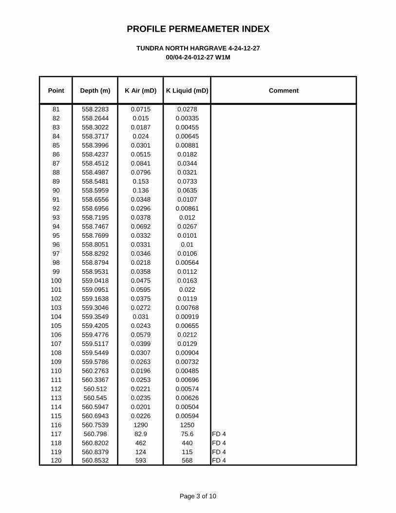
PROFILE PERMEAMETER INDEXTUNDRA NORTH HARGRAVE 4-24-12-27
OO/04-24-01 2-27 W1 M
Point Depth (m) K Air (mD) K Liquid (mD) Comment
81828384858687888990919293949596979899
1001011021031041051061071081091 101111 121 131141 151 161171 181 19120
558.2283558. 2644558. 3022558. 371 7558.3996558.4237558.451 2558.4987558. 548 1
558. 5959558.6556558.6956558.71 95558. 7467558. 7699558. 8051558. 8292558. 8794558. 9531559.041 8559. 0951559. 1 638559. 3046559. 3549559.4205559.4776559.51 17559. 5449559. 5786560.2763560. 3367
560.51 2560. 545
560. 5947560.6943560. 7539
560. 798560. 8202560. 8379560. 8532
0.071 50.01 5
0.01 870. 024
0.03010.051 50.08410. 0796
0.1530.136
0. 03480. 02960. 03780. 06920. 03320.03310. 03460.021 80. 03580. 04750. 05950.03750. 0272
0.0310. 02430. 05790. 03990.03070. 02630.01 960. 02530.02210. 02350.02010. 0226
1 29082.9462124593
0. 02780.003350.004550.006450.00881
0.01 820. 03440.03210. 07330. 06350.01 07
0.008610.01 2
0. 02670.01 01
0.010.01 06
0.005640.01 120.01 63
0. 0220.01 19
0.007680.0091 90.00655
0.02120.01 29
0. 009040.007320.004850.006960.005740.006260. 005040.00594
1 25075.6440115568
FD 4FD 4FD 4FD 4
Page 3 of 10
Point Depth (m) K Air (mD) K Liquid (mD) Comment
TUNDRA NORTH HARGRAVE 4-24-12-27
00/04-24-012-27 W1M
PROFILE PERMEAMETER INDEX
81 558.2283 0.0715 0.0278
82 558.2644 0.015 0.00335
83 558.3022 0.0187 0.00455
84 558.3717 0.024 0.00645
85 558.3996 0.0301 0.00881
86 558.4237 0.0515 0.0182
87 558.4512 0.0841 0.0344
88 558.4987 0.0796 0.0321
89 558.5481 0.153 0.0733
90 558.5959 0.136 0.0635
91 558.6556 0.0348 0.0107
92 558.6956 0.0296 0.00861
93 558.7195 0.0378 0.012
94 558.7467 0.0692 0.0267
95 558.7699 0.0332 0.0101
96 558.8051 0.0331 0.01
97 558.8292 0.0346 0.0106
98 558.8794 0.0218 0.00564
99 558.9531 0.0358 0.0112
100 559.0418 0.0475 0.0163
101 559.0951 0.0595 0.022
102 559.1638 0.0375 0.0119
103 559.3046 0.0272 0.00768
104 559.3549 0.031 0.00919
105 559.4205 0.0243 0.00655
106 559.4776 0.0579 0.0212
107 559.5117 0.0399 0.0129
108 559.5449 0.0307 0.00904
109 559.5786 0.0263 0.00732
110 560.2763 0.0196 0.00485
111 560.3367 0.0253 0.00696
112 560.512 0.0221 0.00574
113 560.545 0.0235 0.00626
114 560.5947 0.0201 0.00504
115 560.6943 0.0226 0.00594
116 560.7539 1290 1250
117 560.798 82.9 75.6 FD 4
118 560.8202 462 440 FD 4
119 560.8379 124 115 FD 4
120 560.8532 593 568 FD 4
Page 3 of 10
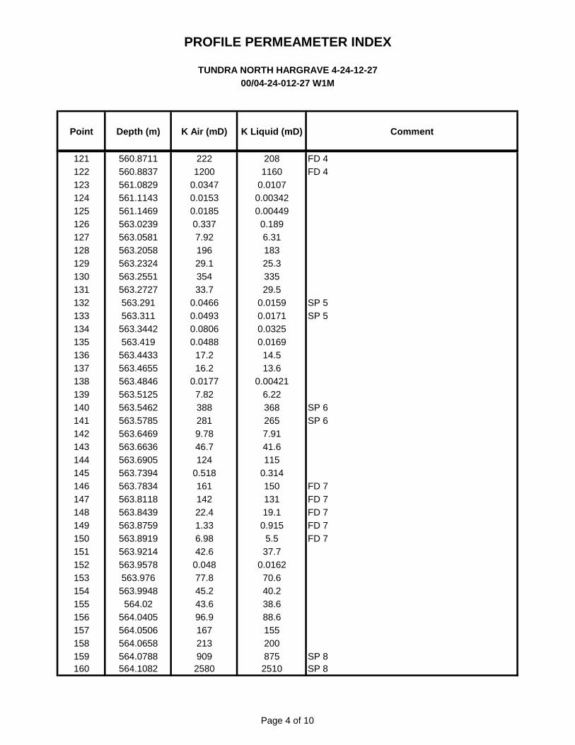
PROFILE PERMEAMETER INDEXTUNDRA NORTH HARGRAVE 4-24-12-27
OO/04-24-01 2-27 W1 M
Point Depth (m) K Air (mD) K Liquid (mD) Comment
121122123124125126127128129130131132133134135136137138139140141142143144145146147148149150151152153154155156157158159160
560.871 1
560. 8837561 .0829561.1 143561 . 1 469563. 0239563. 0581563.2058563. 2324563.2551563.2727
563.291563.31 1
563. 3442563.41 9
563.4433563.4655563.4846563.51 25563. 5462563. 5785563.6469563.6636563.6905563. 7394563. 7834563.81 18563. 8439563. 8759563.891 9563. 921 4563. 9578
563. 976563. 9948
564. 02564. 0405564. 0506564. 0658564. 0788564. 1 082
2221200
0. 03470.01 530.01 85
0. 3377.92196
29. 1
35433.7
0. 04660. 04930. 08060. 0488
1 7.21 6.2
0.01 777.823882819. 7846.7124
0.51 8161142
22.41.336.9842.6
0. 04877.845.243.696.9167213909
2580
2081160
0.01 070.003420.00449
0.1896.31183
25.3335
29.50.01 590.01 710. 03250.01 69
1 4.51 3.6
0.004216.223682657.9141.6115
0.314150131
19.10.91 5
5.537.7
0.01 6270.640.238.688.6155200875
251 0
FD 4FD 4
SP 5SP 5
SP 6SP 6
FD 7FD 7FD 7FD 7FD 7
SP 8SP 8
Page 4 of 10
Point Depth (m) K Air (mD) K Liquid (mD) Comment
TUNDRA NORTH HARGRAVE 4-24-12-27
00/04-24-012-27 W1M
PROFILE PERMEAMETER INDEX
121 560.8711 222 208 FD 4
122 560.8837 1200 1160 FD 4
123 561.0829 0.0347 0.0107
124 561.1143 0.0153 0.00342
125 561.1469 0.0185 0.00449
126 563.0239 0.337 0.189
127 563.0581 7.92 6.31
128 563.2058 196 183
129 563.2324 29.1 25.3
130 563.2551 354 335
131 563.2727 33.7 29.5
132 563.291 0.0466 0.0159 SP 5
133 563.311 0.0493 0.0171 SP 5
134 563.3442 0.0806 0.0325
135 563.419 0.0488 0.0169
136 563.4433 17.2 14.5
137 563.4655 16.2 13.6
138 563.4846 0.0177 0.00421
139 563.5125 7.82 6.22
140 563.5462 388 368 SP 6
141 563.5785 281 265 SP 6
142 563.6469 9.78 7.91
143 563.6636 46.7 41.6
144 563.6905 124 115
145 563.7394 0.518 0.314
146 563.7834 161 150 FD 7
147 563.8118 142 131 FD 7
148 563.8439 22.4 19.1 FD 7
149 563.8759 1.33 0.915 FD 7
150 563.8919 6.98 5.5 FD 7
151 563.9214 42.6 37.7
152 563.9578 0.048 0.0162
153 563.976 77.8 70.6
154 563.9948 45.2 40.2
155 564.02 43.6 38.6
156 564.0405 96.9 88.6
157 564.0506 167 155
158 564.0658 213 200
159 564.0788 909 875 SP 8
160 564.1082 2580 2510 SP 8
Page 4 of 10
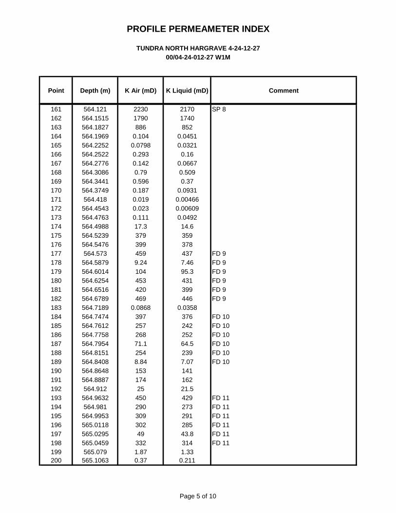
PROFILE PERMEAMETER INDEXTUNDRA NORTH HARGRAVE 4-24-12-27
OO/04-24-01 2-27 W1 M
Point Depth (m) K Air (mD) K Liquid (mD) Comment
161162163164165166167168169170171172173174175176177178179180181182183184185186187188189190191192193194195196197198199200
564. 1 21564.1515564. 1 827564. 1 969564.2252564.2522564.2776564. 3086564. 3441564. 3749
564.41 8564.4543564.4763564.4988564. 5239564. 5476
564. 573564. 5879564.6014564. 6254564.651 6564.6789564.71 89564. 7474564. 761 2564. 7758564. 7954564.81 51564. 8408564. 8648564. 8887
564.91 2564. 9632
564.981564. 9953565.01 18565. 0295565. 0459
565. 079565. 1 063
22301790886
0.1040. 0798
0.2930.142
0.790. 5960.1870.01 90. 0230.111
1 7.33793994599.24104453420469
0. 086839725726871.12548.8415317425
45029030930249
3321 .870.37
21 701 740852
0.04510.0321
0.160. 0667
0. 5090.37
0.09310.004660.00609
0. 04921 4.63593784377.4695.3431399446
0. 035837624225264. 52397.07141162
21.5429273291285
43.83141.33
0.21 1
SP 8
FD 9FD 9FD 9FD 9FD 9FD 9
FD 10FD 10FD 10FD 10FD 10FD 10
FD 11FD 11FD 11FD 11FD 11FD 11
Page 5 of 10
Point Depth (m) K Air (mD) K Liquid (mD) Comment
TUNDRA NORTH HARGRAVE 4-24-12-27
00/04-24-012-27 W1M
PROFILE PERMEAMETER INDEX
161 564.121 2230 2170 SP 8
162 564.1515 1790 1740
163 564.1827 886 852
164 564.1969 0.104 0.0451
165 564.2252 0.0798 0.0321
166 564.2522 0.293 0.16
167 564.2776 0.142 0.0667
168 564.3086 0.79 0.509
169 564.3441 0.596 0.37
170 564.3749 0.187 0.0931
171 564.418 0.019 0.00466
172 564.4543 0.023 0.00609
173 564.4763 0.111 0.0492
174 564.4988 17.3 14.6
175 564.5239 379 359
176 564.5476 399 378
177 564.573 459 437 FD 9
178 564.5879 9.24 7.46 FD 9
179 564.6014 104 95.3 FD 9
180 564.6254 453 431 FD 9
181 564.6516 420 399 FD 9
182 564.6789 469 446 FD 9
183 564.7189 0.0868 0.0358
184 564.7474 397 376 FD 10
185 564.7612 257 242 FD 10
186 564.7758 268 252 FD 10
187 564.7954 71.1 64.5 FD 10
188 564.8151 254 239 FD 10
189 564.8408 8.84 7.07 FD 10
190 564.8648 153 141
191 564.8887 174 162
192 564.912 25 21.5
193 564.9632 450 429 FD 11
194 564.981 290 273 FD 11
195 564.9953 309 291 FD 11
196 565.0118 302 285 FD 11
197 565.0295 49 43.8 FD 11
198 565.0459 332 314 FD 11
199 565.079 1.87 1.33
200 565.1063 0.37 0.211
Page 5 of 10

PROFILE PERMEAMETER INDEXTUNDRA NORTH HARGRAVE 4-24-12-27
OO/04-24-01 2-27 W1 M
Point Depth (m) K Air (mD) K Liquid (mD) Comment
201202203204205206207208209210211212213214215216217218219220221222223224225226227228229230231232233234235236237238239240
565. 1 263565. 1 662565. 1 989565.2206565.2526565.275
565. 321 4565. 3521565. 3827565.41 26565.4368565.4635565.501 6565. 5402565. 5634565.61 39565.6469565.6657565.6866565.71 63565. 7368565. 7585565. 7906565. 8338565. 8492565. 8784565. 9028565. 9287565. 9463565. 9565
565.971565. 9885566.001 9
566. 025566. 048
566.1 1 18566. 1 444566. 1 733566. 1 955
566.21 6
2.351 .43
0.71 1
5. 5866.8143
60.4127
80.61 7.843.547.553.730.833.273. 1
94. 8151302712
1 54093.5
9669. 1
0.12434721915839435538.8
4586.5
0. 5571 9.20.76
0.1078.685.6440.4
1.710. 9940.4514.3360.2132
54. 3117
73.215.138.542.248. 1
26.829. 1
66. 1
86.6140286682
1 49085.487.762.4
0. 056432920514737333734. 2
4078.7
0. 3421 6.3
0.4870. 0468
6.934.3835. 7
FD 12FD 12FD 12FD 12FD 12FD 12FD 12
FD 13FD 13FD 13
Page 6 of 10
Point Depth (m) K Air (mD) K Liquid (mD) Comment
TUNDRA NORTH HARGRAVE 4-24-12-27
00/04-24-012-27 W1M
PROFILE PERMEAMETER INDEX
201 565.1263 2.35 1.71
202 565.1662 1.43 0.994
203 565.1989 0.711 0.451
204 565.2206 5.58 4.33
205 565.2526 66.8 60.2
206 565.275 143 132
207 565.3214 60.4 54.3
208 565.3521 127 117
209 565.3827 80.6 73.2
210 565.4126 17.8 15.1
211 565.4368 43.5 38.5
212 565.4635 47.5 42.2
213 565.5016 53.7 48.1
214 565.5402 30.8 26.8
215 565.5634 33.2 29.1
216 565.6139 73.1 66.1
217 565.6469 94.8 86.6
218 565.6657 151 140
219 565.6866 302 286
220 565.7163 712 682
221 565.7368 1540 1490
222 565.7585 93.5 85.4
223 565.7906 96 87.7
224 565.8338 69.1 62.4
225 565.8492 0.124 0.0564
226 565.8784 347 329
227 565.9028 219 205
228 565.9287 158 147 FD 12
229 565.9463 394 373 FD 12
230 565.9565 355 337 FD 12
231 565.971 38.8 34.2 FD 12
232 565.9885 45 40 FD 12
233 566.0019 86.5 78.7 FD 12
234 566.025 0.557 0.342 FD 12
235 566.048 19.2 16.3
236 566.1118 0.76 0.487
237 566.1444 0.107 0.0468
238 566.1733 8.68 6.93 FD 13
239 566.1955 5.64 4.38 FD 13
240 566.216 40.4 35.7 FD 13
Page 6 of 10
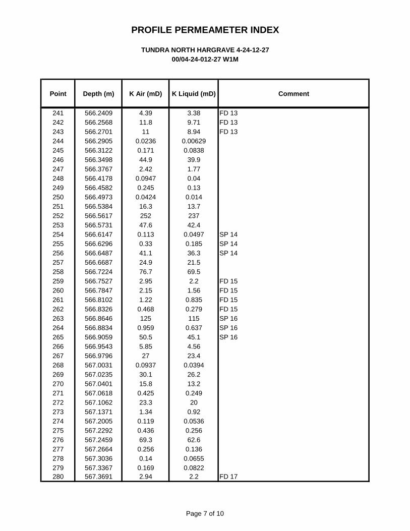
PROFILE PERMEAMETER INDEXTUNDRA NORTH HARGRAVE 4-24-12-27
OO/04-24-01 2-27 W1 M
Point Depth (m) K Air (mD) K Liquid (mD) Comment
241242243244245246247248249250251252253254255256257258259260261262263264265266267268269270271272273274275276277278279280
566.2409566.2568566.2701566.2905566.31 22566. 3498566. 3767566.41 78566.4582566.4973566. 5384566.561 7566. 5731566.61 47566.6296566.6487566.6687566. 7224566. 7527566. 7847566.81 02566. 8326566. 8646566. 8834566. 9059566. 9543566. 9796567. 0031567. 0235567.0401567.061 8567. 1 062567. 1 371567.2005567.2292567.2459567. 2664567. 3036567. 3367567. 3691
4.391 1.8
110. 0236
0.1 7144.92.42
0. 09470.245
0. 04241 6.3252
47.60.1 13
0.3341.124.976.72.952.151 .22
0.468125
0. 95950.55.85
270. 0937
30. 1
1 5.80.42523.31.34
0.1 190.436
69.30.256
0.140.1692.94
3. 389.718.94
0.006290. 0838
39.91.770.040.13
0.0141 3.7237
42.40. 0497
0.18536.321.569.52.2
1.560. 8350.279
1150.63745. 1
4. 5623.4
0. 039426.21 3.2
0.24920
0.920. 0536
0.25662.6
0.1360. 06550. 0822
2.2
FD 13FD 13FD 13
SP 14SP 14SP 14
FD 15FD 15FD 15FD 15SP 16SP 16SP 16
FD 17
Page 7 of 10
Point Depth (m) K Air (mD) K Liquid (mD) Comment
TUNDRA NORTH HARGRAVE 4-24-12-27
00/04-24-012-27 W1M
PROFILE PERMEAMETER INDEX
241 566.2409 4.39 3.38 FD 13
242 566.2568 11.8 9.71 FD 13
243 566.2701 11 8.94 FD 13
244 566.2905 0.0236 0.00629
245 566.3122 0.171 0.0838
246 566.3498 44.9 39.9
247 566.3767 2.42 1.77
248 566.4178 0.0947 0.04
249 566.4582 0.245 0.13
250 566.4973 0.0424 0.014
251 566.5384 16.3 13.7
252 566.5617 252 237
253 566.5731 47.6 42.4
254 566.6147 0.113 0.0497 SP 14
255 566.6296 0.33 0.185 SP 14
256 566.6487 41.1 36.3 SP 14
257 566.6687 24.9 21.5
258 566.7224 76.7 69.5
259 566.7527 2.95 2.2 FD 15
260 566.7847 2.15 1.56 FD 15
261 566.8102 1.22 0.835 FD 15
262 566.8326 0.468 0.279 FD 15
263 566.8646 125 115 SP 16
264 566.8834 0.959 0.637 SP 16
265 566.9059 50.5 45.1 SP 16
266 566.9543 5.85 4.56
267 566.9796 27 23.4
268 567.0031 0.0937 0.0394
269 567.0235 30.1 26.2
270 567.0401 15.8 13.2
271 567.0618 0.425 0.249
272 567.1062 23.3 20
273 567.1371 1.34 0.92
274 567.2005 0.119 0.0536
275 567.2292 0.436 0.256
276 567.2459 69.3 62.6
277 567.2664 0.256 0.136
278 567.3036 0.14 0.0655
279 567.3367 0.169 0.0822
280 567.3691 2.94 2.2 FD 17
Page 7 of 10
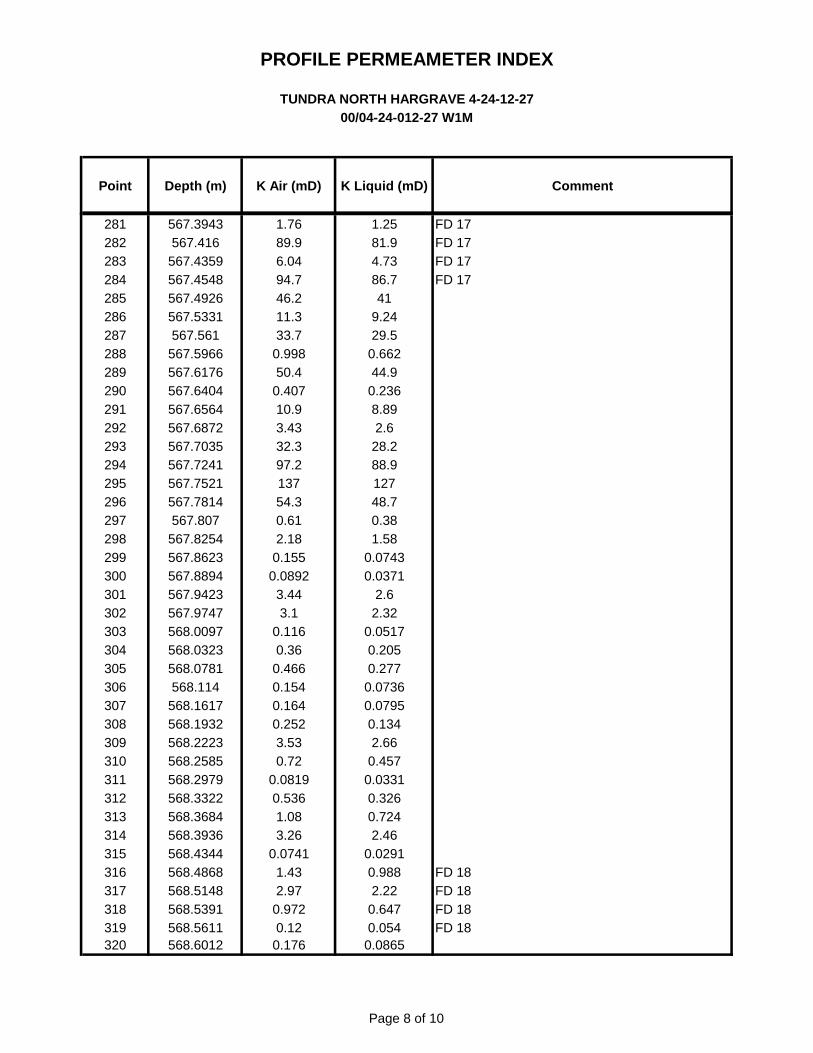
PROFILE PERMEAMETER INDEXTUNDRA NORTH HARGRAVE 4-24-12-27
OO/04-24-01 2-27 W1 M
Point Depth (m) K Air (mD) K Liquid (mD) Comment
281282283284285286287288289290291292293294295296297298299300301302303304305306307308309310311312313314315316317318319320
567. 3943567.41 6
567.4359567.4548567.4926567. 5331
567.561567. 5966567.61 '76567. 6404567. 6564567.6872567. 7035567. 7241567. 7521567. 781 4
567. 807567. 8254567. 8623567. 8894567. 9423567. 9747568. 0097568. 0323568. 0781
568.1 14568. 1 61 7568. 1 932568.2223568.2585568.2979568. 3322568. 3684568. 3936568.4344568.4868568. 51 48568. 5391568.561 1
568.601 2
1.7689.96.0494. 746.21 1.333.7
0. 99850.4
0.4071 0.93.4332.397.2137
54. 30.612.18
0.1550. 0892
3.443.1
0.1 160.36
0.4660.1540.1640.252
3. 530.72
0.081 90.536
1 .083.26
0.07411 .432.97
0. 9720.12
0.1 76
1 .2581.94.7386. 7
419.2429.5
0. 66244.9
0.2368.892.6
28.288.9127
48.70.381.58
0.07430.0371
2.62.32
0. 051 70.2050.277
0. 07360. 0795
0.1342.66
0.4570.0331
0. 3260. 7242.46
0.02910. 9882.22
0.6470. 054
0. 0865
FD 17FD 17FD 17FD 17
FD 18FD 18FD 18FD 18
Page 8 of 10
Point Depth (m) K Air (mD) K Liquid (mD) Comment
TUNDRA NORTH HARGRAVE 4-24-12-27
00/04-24-012-27 W1M
PROFILE PERMEAMETER INDEX
281 567.3943 1.76 1.25 FD 17
282 567.416 89.9 81.9 FD 17
283 567.4359 6.04 4.73 FD 17
284 567.4548 94.7 86.7 FD 17
285 567.4926 46.2 41
286 567.5331 11.3 9.24
287 567.561 33.7 29.5
288 567.5966 0.998 0.662
289 567.6176 50.4 44.9
290 567.6404 0.407 0.236
291 567.6564 10.9 8.89
292 567.6872 3.43 2.6
293 567.7035 32.3 28.2
294 567.7241 97.2 88.9
295 567.7521 137 127
296 567.7814 54.3 48.7
297 567.807 0.61 0.38
298 567.8254 2.18 1.58
299 567.8623 0.155 0.0743
300 567.8894 0.0892 0.0371
301 567.9423 3.44 2.6
302 567.9747 3.1 2.32
303 568.0097 0.116 0.0517
304 568.0323 0.36 0.205
305 568.0781 0.466 0.277
306 568.114 0.154 0.0736
307 568.1617 0.164 0.0795
308 568.1932 0.252 0.134
309 568.2223 3.53 2.66
310 568.2585 0.72 0.457
311 568.2979 0.0819 0.0331
312 568.3322 0.536 0.326
313 568.3684 1.08 0.724
314 568.3936 3.26 2.46
315 568.4344 0.0741 0.0291
316 568.4868 1.43 0.988 FD 18
317 568.5148 2.97 2.22 FD 18
318 568.5391 0.972 0.647 FD 18
319 568.5611 0.12 0.054 FD 18
320 568.6012 0.176 0.0865
Page 8 of 10

PROFILE PERMEAMETER INDEXTUNDRA NORTH HARGRAVE 4-24-12-27
OO/04-24-01 2-27 W1 M
Point Depth (m) K Air (mD) K Liquid (mD) Comment
321322323324325326327328329330331332333334335336337338339340341342343344345346347348349350351352353354355356357358359360
568.6308568.6647568.71 81568. 7542568. 7932568. 8305568. 8561568. 8822
568.9568. 9294568. 9691569. 0009569. 0324569. 0727
569. 1 1 1
569. 1 396569. 1 699
569. 1 93569.2272569.258
569.321 8569. 3684569.406
569.4452569.4909569. 5549569. 5855569.61 58569.6683569.6931569. 7231569. 7869569. 8351569. 8821569.91 93569. 9648570.0071570. 0448
570. 085570. 1 024
0.350.4060. 0530.2360.2060. 3630. 3580.244
1 7.8338
0.2470.0381
5.1 1
0.1950. 0959
0. 7480.191
0.150.1442.8
0. 3460.162
0. 05520.202
0.31.34
0. 869343
21.34.7
0. 03670. 357
0. 02250.01 13
2.053.28
132.624.3
9. 58
0.1980.235
0.01 880.1240.1050.2060.2030.129
15320
0.1310.01 21
3.970.09810. 0406
0.4780. 09570.071 30. 0655
37.90.195
0. 07850.01 99
0.1020.1650.91 90. 568
3241 8.23.62
0.01 150.202
0.005910.00223
1 .482.471 0.71 .933.287. 75
FD 19FD 19FD 19FD 19FD 19
FD 20FD 20FD 20FD 20
Page 9 of 10
Point Depth (m) K Air (mD) K Liquid (mD) Comment
TUNDRA NORTH HARGRAVE 4-24-12-27
00/04-24-012-27 W1M
PROFILE PERMEAMETER INDEX
321 568.6308 0.35 0.198
322 568.6647 0.406 0.235
323 568.7181 0.053 0.0188
324 568.7542 0.236 0.124
325 568.7932 0.206 0.105
326 568.8305 0.363 0.206 FD 19
327 568.8561 0.358 0.203 FD 19
328 568.8822 0.244 0.129 FD 19
329 568.9 17.8 15 FD 19
330 568.9294 338 320 FD 19
331 568.9691 0.247 0.131
332 569.0009 0.0381 0.0121
333 569.0324 5.11 3.97
334 569.0727 0.195 0.0981
335 569.111 0.0959 0.0406 FD 20
336 569.1396 0.748 0.478 FD 20
337 569.1699 0.191 0.0957 FD 20
338 569.193 0.15 0.0713 FD 20
339 569.2272 0.14 0.0655
340 569.258 42.8 37.9
341 569.3218 0.346 0.195
342 569.3684 0.162 0.0785
343 569.406 0.0552 0.0199
344 569.4452 0.202 0.102
345 569.4909 0.3 0.165
346 569.5549 1.34 0.919
347 569.5855 0.869 0.568
348 569.6158 343 324
349 569.6683 21.3 18.2
350 569.6931 4.7 3.62
351 569.7231 0.0367 0.0115
352 569.7869 0.357 0.202
353 569.8351 0.0225 0.00591
354 569.8821 0.0113 0.00223
355 569.9193 2.05 1.48
356 569.9648 3.28 2.47
357 570.0071 13 10.7
358 570.0448 2.62 1.93
359 570.085 4.3 3.28
360 570.1024 9.58 7.75
Page 9 of 10

PROFILE PERMEAMETER INDEXTUNDRA NORTH HARGRAVE 4-24-12-27
00/04-24-01 2-27 W1 M
Point Depth (m) K Air (mD) K Liquid (mD) Comment
361362363364365366367368369370371372373374375376377378379380381382383384385386
570. 1 732570. 1 952570.2391570. 2754570. 3038570.341 6570. 3798
570.41570.436
570.4695570.499
570.541 3570. 5805570.624
570.6872570. 7239570. 7524570. 7973570. 8229570. 8731570.921 3570. 9806571 .0253
571 .086571 . 1 444571.1831
7.480. 077
94. 70.495
68. 1
2.487.43506
0.4840.12
0. 9863.84449
0. 09680. 0294
0.2330. 05250. 0643
300. 08390. 0644
1 7.30. 0952
0.770.0661
0.501
5.930. 0307
86.40.298
61.61 .835.89483
0.2890.0541
0.6582.94427
0.04120.00852
0.1220.01 860. 0243
26. 1
0. 03420. 0243
1 4.60. 0403
0.4980. 0252
0. 303
Page 10 of 10
Point Depth (m) K Air (mD) K Liquid (mD) Comment
TUNDRA NORTH HARGRAVE 4-24-12-27
00/04-24-012-27 W1M
PROFILE PERMEAMETER INDEX
361 570.1732 7.48 5.93
362 570.1952 0.077 0.0307
363 570.2391 94.7 86.4
364 570.2754 0.495 0.298
365 570.3038 68.1 61.6
366 570.3416 2.48 1.83
367 570.3798 7.43 5.89
368 570.41 506 483
369 570.436 0.484 0.289
370 570.4695 0.12 0.0541
371 570.499 0.986 0.658
372 570.5413 3.84 2.94
373 570.5805 449 427
374 570.624 0.0968 0.0412
375 570.6872 0.0294 0.00852
376 570.7239 0.233 0.122
377 570.7524 0.0525 0.0186
378 570.7973 0.0643 0.0243
379 570.8229 30 26.1
380 570.8731 0.0839 0.0342
381 570.9213 0.0644 0.0243
382 570.9806 17.3 14.6
383 571.0253 0.0952 0.0403
384 571.086 0.77 0.498
385 571.1444 0.0661 0.0252
386 571.1831 0.501 0.303
Page 10 of 10

PROFILE PERMEAMETRY
TUNDRA NORTH HARGRAVE 4-24-12-27 W1MJURASSIC / LODGEPOLE ( 553.00 - 572.00 m )
10 cm - 24.0 mCore Laboratories Canada Ltd.
TUNDRA OIL & GAS PARTNERSHIP
GAMMA RAY (API)
1:240MD in M
DEPTH PROFILE PERMEABILITY
Total Gamma0 API 150
Uranium Free Gamma0 API 150
Profile Permeability Kair0.001 MD 10,000
545
550
555
560
565
570
575
GAMMA RAY (API)
1:240MD in M
DEPTH PROFILE PERMEABILITY
Total Gamma0 API 150
Uranium Free Gamma0 API 150
Profile Permeability Kair0.001 MD 10,000
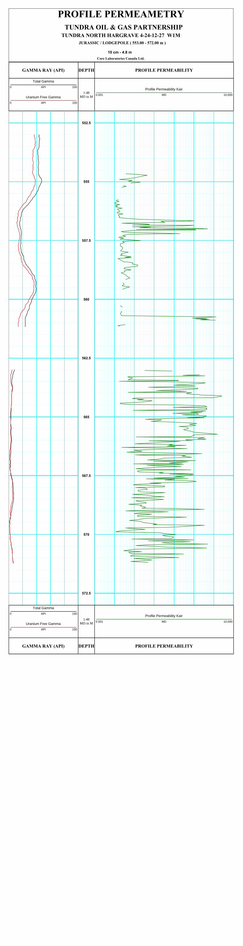
C~~&Q
C~~W+
PROFILE PERMEAMETRY
TUNDRA NORTH HARGRAVE 4-24-12-27 W1MJURASSIC / LODGEPOLE ( 553.00 - 572.00 m )
10 cm - 4.8 mCore Laboratories Canada Ltd.
TUNDRA OIL & GAS PARTNERSHIP
GAMMA RAY (API)
1:48MD in M
DEPTH PROFILE PERMEABILITY
Total Gamma0 API 150
Uranium Free Gamma0 API 150
Profile Permeability Kair0.001 MD 10,000
552.5
555
557.5
560
562.5
565
567.5
570
572.5
GAMMA RAY (API)
1:48MD in M
DEPTH PROFILE PERMEABILITY
Total Gamma0 API 150
Uranium Free Gamma0 API 150
Profile Permeability Kair0.001 MD 10,000
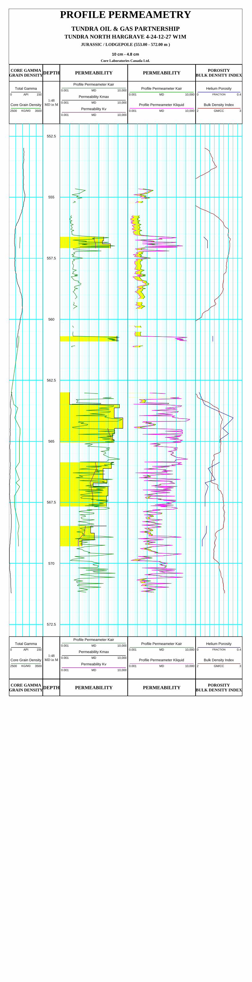
PROFILE PERMEAMETRY
TUNDRA NORTH HARGRAVE 4-24-12-27 W1MJURASSIC / LODGEPOLE (553.00 - 572.00 m )
10 cm - 4.8 cmCore Laboratories Canada Ltd.
TUNDRA OIL & GAS PARTNERSHIP
CORE GAMMAGRAIN DENSITY
1:48MD in M
DEPTH PERMEABILITY PERMEABILITY POROSITYBULK DENSITY INDEX
Total Gamma0 API 150
Core Grain Density2500 KG/M3 3500
Profile Permeameter Kair0.001 MD 10,000
Permeability Kmax0.001 MD 10,000
Permeability Kv0.001 MD 10,000
Profile Permeameter Kair0.001 MD 10,000
Profile Permeameter Kliquid0.001 MD 10,000
Helium Porosity0 FRACTION 0.4
Bulk Density Index2 GM/CC 3
552.5
555
557.5
560
562.5
565
567.5
570
572.5
CORE GAMMAGRAIN DENSITY
1:48MD in M
DEPTH PERMEABILITY PERMEABILITY POROSITYBULK DENSITY INDEX
Total Gamma0 API 150
Core Grain Density2500 KG/M3 3500
Profile Permeameter Kair0.001 MD 10,000
Permeability Kmax0.001 MD 10,000
Permeability Kv0.001 MD 10,000
Profile Permeameter Kair0.001 MD 10,000
Profile Permeameter Kliquid0.001 MD 10,000
Helium Porosity0 FRACTION 0.4
Bulk Density Index2 GM/CC 3
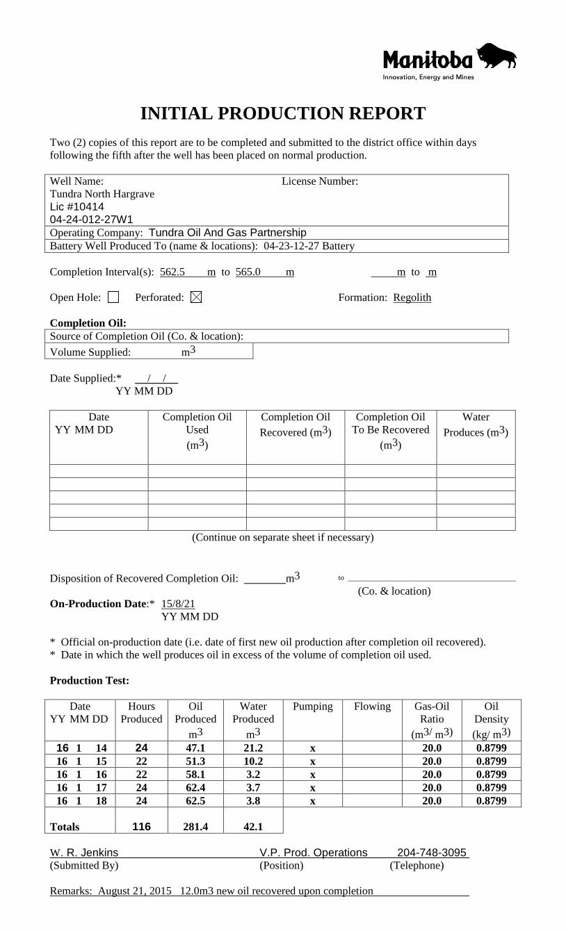
Innovation, Energy and Mines
INITIALPRODUCTION REPORT
Two (2) copies of this report are to be completed and submitted to the dishict office within days
following the fifth after the well has been placed on normal production.
Completion Interval(s): 562.5 m to 565.0 m mto m
Open Hole: Perforated: H
Completion Oil:Source of Completion Oil (Co. & location):
Formation: ~Re olith
Volume Supplied: m3
Date Supplied:* / /YY MM DD
(Continue on separate sheet ifnecessary)
Disposition of Recovered Completion Oil:
On-Production Date:e 15/8/21
YY MM DD
m3
(Co. & location)
* Official on-production date (i.e. date of first new oil production after completion oil recovered).* Date in which the well produces oil in excess of the volume of completion oil used.
Production Test:
W. R. Jenkins V.P. Prod. 0 erations 204-748-3095(Submitted By) (Position) (Telephone)
Remarks: Au st 21 2015 12.0m3 new oil recovered u on com letion
INITIAL PRODUCTION REPORT
Two (2) copies of this report are to be completed and submitted to the district office within days
following the fifth after the well has been placed on normal production.
Well Name:
Tundra North Hargrave Lic #10414 04-24-012-27W1
License Number:
Operating Company: Tundra Oil And Gas Partnership
Battery Well Produced To (name & locations): 04-23-12-27 Battery
Completion Interval(s): 562.5 m to 565.0 m m to m
Open Hole: Perforated: Formation: Regolith
Completion Oil:
Source of Completion Oil (Co. & location):
Volume Supplied: m3
Date Supplied:* / /
YY MM DD
Date
YY MM DD DD
Completion Oil
Used
(m3)
Completion Oil
Recovered (m3)
Completion Oil
To Be Recovered
(m3)
Water
Produces (m3)
(Continue on separate sheet if necessary)
Disposition of Recovered Completion Oil: m3 to
(Co. & location)
On-Production Date:* 15/8/21
YY MM DD
* Official on-production date (i.e. date of first new oil production after completion oil recovered).
* Date in which the well produces oil in excess of the volume of completion oil used.
Production Test:
Date
YY MM DD DD
Hours
Produced
Oil
Produced
m3
Water
Produced
m3
Pumping Flowing Gas-Oil
Ratio
(m3/ m3)
Oil
Density
(kg/ m3)
16 1 14 24 47.1 21.2 x 20.0 0.8799
16 1 15 22 51.3 10.2 x 20.0 0.8799
16 1 16 22 58.1 3.2 x 20.0 0.8799
16 1 17 24 62.4 3.7 x 20.0 0.8799
16 1 18 24 62.5 3.8 x 20.0 0.8799
Totals 114
116
281.4
42.1
W. R. Jenkins V.P. Prod. Operations 204-748-3095
(Submitted By) (Position) (Telephone)
Remarks: August 21, 2015 12.0m3 new oil recovered upon completion


![Q.P. Code : 03185 [Time : 2½ Hours] [ Total Marks:75] : 75](https://img.pdfslide.us/doc/110x75/628f8e2290a5732933781805/qp-code-03185-time-2-hours-total-marks75-75-.jpg)