Embed Size (px)
Citation preview
PLAN OF OPERATION FOR A REGIONAL STORM WATER MANAGEMENT DISTRICT
IN THE MAUMEE RIVER WATERSHED
FINAL REPORT
BY THE MAUMEE RIVER REGIONAL STORM WATER COALITION
AND THE MAUMEE RIVER RAP URBAN RUNOFF ACTION GROUP
JANUARY 2002
TOLEDO METROPOLITAN AREA COUNCIL OF GOVERNMENTS 300 CENTRAL UNION PLAZA
P.O. BOX 9508 TOLEDO OH 43697-9508
Phone: 419-241-9155
Fax: 419-241-9116

Plan of Operation for a Regional Storm Water Management District in the Maumee River Watershed
Table of Contents i
TABLE OF CONTENTS Acknowledgements ............................................................................................................. v Abstract .............................................................................................................................vii TMACOG Officers and Staff...........................................................................................viii Introduction ......................................................................................................................... 1
I. Plan Development ....................................................................................... 1 A. Steering Committee..................................................................................... 1 B. Mission Statement and Goals...................................................................... 2 C. Roles and Responsibilities of the District ................................................... 2 D. Benefits of the District ................................................................................ 4
II. Organization and Staffing ........................................................................... 4 A. Board of Trustees ........................................................................................ 4 B. District Staff ................................................................................................ 4
III. Responsibilities ........................................................................................... 5 A. Administration............................................................................................. 5 B. Engineering and Planning ........................................................................... 5 C. Regulation and Enforcement....................................................................... 6 D. Operation and Maintenance ........................................................................ 6 E. Capital Improvements ................................................................................. 6
IV. Finance ........................................................................................................ 6 A. Cost of Service Analysis ............................................................................. 6 B. Rate Structure.............................................................................................. 7 C. Revenue....................................................................................................... 7
Policy 1: Organizational Scenarios ..................................................................................... 9 I. Introduction ................................................................................................. 9 II. Background ................................................................................................. 9 III. District Functional Activities .................................................................... 11
A. Funding Activity ....................................................................................... 11 B. Staffing ...................................................................................................... 11 C. Technical ................................................................................................... 11 D. Responsibilities ......................................................................................... 12 E. Summary ................................................................................................... 12
IV. Description of District Scenarios .............................................................. 12 V. Advantages and Disadvantages of Each Scenario..................................... 20 VI. Consultant Recommendation .................................................................... 22
Policy 2: Cost Of Service Analysis for the 6119 District ................................................. 23 I. What is Cost of Service............................................................................. 23 II. Cost of Service – Program Description..................................................... 23
A. Administration........................................................................................... 25 B. Engineering & Planning ............................................................................ 26 C. Regulation & Enforcement........................................................................ 27 D. Operation & Maintenance ......................................................................... 29 E. Capital Improvements Program ................................................................ 29
III. Recommendations ..................................................................................... 29
Plan of Operation for a Regional Storm Water Management District in the Maumee River Watershed
Table of Contents ii
POLICY 3: NPDES Phase II Permit Checklist................................................................. 35 I. NPDES Phase II Storm Water Program.................................................... 35
A. Municipal Separate Storm Sewer Systems (MS4s)................................... 35 B. Controlling Impacts of Development and Construction ........................... 36 C. Who Is Involved ........................................................................................ 36 D. Deadline for Submission of Permit Application ....................................... 37 E. What the Regulation Require .................................................................... 37 F. How Much Will it Cost ............................................................................. 38 G. Other Community Examples..................................................................... 40 H. NPDES Permit Checklist .......................................................................... 41
POLICY 4: Storm Water Master Planning Guidelines ..................................................... 65 I. What is Storm Water Master Planning?.................................................... 65 II. Principals of Storm Water Master Planning.............................................. 66
A. Understand the Mission............................................................................. 66 B. Include Stakeholders ................................................................................. 67 C. Multi-Objective Approach ........................................................................ 67 D. Integrate Water Quantity and Water Quality ............................................ 68 E. Balance Economic Development and Environmental Issues.................... 68 F. Establish Partnerships ............................................................................... 69 G. Use Technology Effectively...................................................................... 69 H. Communicate Effectively.......................................................................... 70
III. Master Planning Elements & Steps........................................................... 71 IV. Local Master Planning Elements and Steps .............................................. 72 V. Master Plan Document .............................................................................. 73 VI. Master Planning Process Chart ................................................................. 75
POLICY 5: Financing Plan for the District....................................................................... 77 I. Introduction ............................................................................................... 77 II. Cost Allocation / Rate Structure Method .................................................. 77 III. Impervious Area Method .......................................................................... 78 IV. Gross Population ....................................................................................... 78
A. Roadway and Transportation System........................................................ 78 B. Parcels Contained in the County Auditors GIS......................................... 79 C. Proof .......................................................................................................... 79
V. Rate Study Assessment Analysis .............................................................. 80 A. Gross Revenue Projections........................................................................ 81 B. User Fee Analysis...................................................................................... 81 C. Cash Flow Analysis................................................................................... 82
VI. RECOMMENDATIONS .......................................................................... 83 POLICY 6: Regional Standards Review.......................................................................... 85
I. Purpose ...................................................................................................... 85 II. Review Areas ............................................................................................ 86
A. Technical Content ..................................................................................... 86 B. Consistency ............................................................................................... 86 C. Readability ................................................................................................ 86 D. Manual Organization................................................................................. 87
III. Findings..................................................................................................... 87
Plan of Operation for a Regional Storm Water Management District in the Maumee River Watershed
Table of Contents iii
A. Overview ................................................................................................... 87 B. Major Comments....................................................................................... 88 C. Final Comments ........................................................................................ 96
Appendix A: Petion to Court of Common Pleas ............................................................... 97

Plan of Operation for a Regional Storm Water Management District in the Maumee River Watershed
Table of Contents iv
Plan of Operation for a Regional Storm Water Management District in the Maumee River Watershed
Acknowledgments v
ACKNOWLEDGEMENTS
Maumee River Regional Storm Water Coalition The Maumee River Regional Storm Water Coalition (MRRSWC) is a joint project of the Toledo Metropolitan Area Council of Governments (TMACOG) and interested local Governments in the study area. The purpose of the MRRSWC is to provide a forum for participating partners to address storm water management at a watershed level; to develop and implement policies and procedures for the long term management of storm water in the region; to collectively address state and federal regulations for storm water management; to solicit input and guidance of the private sector into matters of storm water management; and to assist in the implementation of the policies set forth by this organization. The MRRSWC served as the steering committee, guiding the decision-making process and development of the Plan of Operation for a Regional Storm Water Management District in the Maumee River Watershed.
The Maumee River RAP Urban Runoff Action Group (URAG) played a key role in developing the regional Storm Water Management Standards Manual. The URAG also served as a technical advisory committee to the MRRSWC and provided input on the acceptability of proposed policies. This project was made possible by a grant from the Lake Erie Protection Fund (LEPF) and matching funds from local governments.
This study was conducted with the assistance and guidance of technical consultants. Environmental Rate Consultants, Inc. (ERC) provided financial, planning, and institutional services needed to successfully develop the Plan of Operation. Fuller Mossbarger Scott & May, Engineers was the sub-contractor and provided technical support in the engineering, GIS and planning aspects of the project.
Lake Erie Protection Fund
Plan of Operation for a Regional Storm Water Management District in the Maumee River Watershed
Acknowledgments vi
Maumee River Regional Storm Water Coalition Community Members
Lucas County Jerusalem Township Maumee City Oregon City Ottawa Hills Village Springfield Township Swanton Township Sylvania City Sylvania Township Toledo City Washington Township Monroe County, MI
Wood County Bowling Green City Haskins Village Lake Township Middleton Township Millbury Village Northwood City Perrysburg City Rossford City
Plan of Operation for a Regional Storm Water Management District in the Maumee River Watershed
Abstract vii
ABSTRACT
Title: Plan of Operation for a Regional Storm Water Management District in the Maumee River Watershed
Authors: Maumee River Regional Storm Water Coalition Subject: Storm Water Management in the Lower Maumee River Watershed Date: January 2002 Source: TMACOG 300 Central Union Plaza P.O. Box 9508 Toledo OH 43697-9508 (419) 241-9155 voice (419) 241-9116 fax [email protected] e-mail Element Number: FY 2001-2002: 5410 and 5420 Number of Pages: 108 Abstract: This report contains the findings and recommendations of a two-
year study to develop a Plan of Operation for a Regional Storm Water Management District in the Maumee River Watershed. Included as part of the report are all the necessary documentation to petition the Court of Common Pleas for the formation of the district under Ohio Revised Code (ORC) Chapter 6119. Policy papers include organizational scenarios for 6119, cost of service analysis for the 6119 district, an NPDES Phase II compliance checklist, master planning guidelines, and a financing plan for the 6119 district. Model regional storm water management standards were prepared as part of this project. A technical review and comments on the standards manual provides guidance on further development and implementation. Formation of the district and implementation of the standards was left to the discretion of the participating communities.
Plan of Operation for a Regional Storm Water Management District in the Maumee River Watershed
TMACOG Officers and Staff viii
TMACOG OFFICERS AND STAFF
Marge Brown- Chair President of Council, City of Oregon
Ed Snyder- Vice Chair Trustee, Swanton Township
Susan Meek- 2nd Vice Chair Trustee, Springfield Township
Anthony Reams
President
William E. Best Vice-President of Finance and Administration David Dysard, AICP Vice-President of Transportation Kurt Erichsen, Vice-President of Environmental Planning Kathy Mehl, Vice-President of Commuter Services Jennifer Allen Secretary Cindy Bland Administrative Assistant Phil Brooks Transportation Project Manager Kathy Bucher Commuter-link Manager Tamra Deringer Transportation Technician Therese Dusseau Receptionist
Pat Finn Secretary David Gedeon Growth Strategies Manager Greg Gettum Marketing Manager Matthew Horvat Maumee River Coordinator Gwen Killmer Share-A-Ride Manager Adrian Lilly Public Information Manager Lori Pugh Assistant Car-Buy Manager Diane Reamer-Evans Transportation Planner Peggy Ricard Graphics Supervisor Stacy Riccobene Commuter Services Program Specialist
Plan of Operation for a Regional Storm Water Management District in the Maumee River Watershed
TMACOG Officers and Staff ix
TMACOG OFFICERS AND STAFF CONTINUED
Marquetta Roberts Accountant Keith Schrecongost Print Shop Manager Donna Seeber Secretary Vickie Snyder Project Services Manager Sujatha Srinivasan Transportation Engineer Russ Stasiak Car-Buy Manager Dan Swallow Environmental Planner Mike Tippet Graphics Technician

Plan of Operation for a Regional Storm Water Management District in the Maumee River Watershed
TMACOG Officers and Staff x
Plan of Operation for a Regional Storm Water Management District in the Maumee River Watershed

Plan of Operation for a Regional Storm Water Management District in the Maumee River Watershed
Introduction 1
INTRODUCTION I. PLAN DEVELOPMENT This is the Plan of Operation for a Regional Storm Water Sewer District under Ohio Revised Code Chapter 6119. The District will be responsible for the NPDES Phase II regional permit development, implementation, reporting, and master planning activities. The NPDES Phase II Permit Regulations Mandate that many member communities comply with six minimum control measures; Public Education and Outreach; Public Involvement / Participation; Illicit Discharge Detection and Elimination; Construction Site Storm Water Runoff Control; Post-Construction; Pollution Prevention / Good House- Keeping. The normal operation and maintenance and capital improvement projects of local storm water systems will be left to the respective local jurisdictions. Membership in the regional district is voluntary. Local jurisdictions can join by vote of the Board of Trustees and will be able to leave after the first three years with a 12-month notice to leave. A. STEERING COMMITTEE A Steering Committee was established by the Maumee River Regional Storm Water Coalition (MRRSWC) to develop the roles and responsibilities of the district. Bi-monthly steering committee meetings have been held since mid 1999 to craft a regional storm water program. The following members served on the Steering Committee:
• Anthony Allion Wood County Engineer • Pat Bacon City of Northwood • David Bench LWO Farm Bureau • Jeff Ballmer City of Sylvania • Cherie Blair OEPA NWDO • Patty Blevins Property Rights Coal. • Ray Cedoz Jerusalem Township • Fred Densic Village of Millbury • Keith Earley Lucas County Engineer • Jon Eckel City of Perrysburg • Larry Gamble City of Maumee • Tom Gergich Zyndorf/Serchuk • Pete Gerken City of Toledo • Penny Getz Township of Middleton • Jon Gockenour Springfield Township • Jerry Greiner Wood County • Jeremy Harrison LWO Farm Bureau • D.J. Mears Wood County • Brian Miller Lucas County Engineer • Vincent Langevin City of Rossford
• Don Moline City of Toledo • Ann Moore Chamber of Commerce • Patrick Ng City of Bowling Green • Alvin Perkins Wood County • Charles Peyton Lucas County • Bob Phelps OEPA • Steve Piccher Village of Whitehouse • Anthony Robinson OEPA • Paul Roman City of Oregon • Don Romes City of Toledo • Dan Saevig Home Builders Assoc. • David Scott Monroe County, MI • Scott Sibley City of Toledo • Edward Snyder Swanton Township • Kathy Steingraber Lake Township • Marc Thompson Village of Ottawa Hills • Dock Treece Sylvania Township • Rollin Webb Monroe County, MI • Jean Youngen Mayor of Ottawa Hills
Plan of Operation for a Regional Storm Water Management District in the Maumee River Watershed
Introduction 2
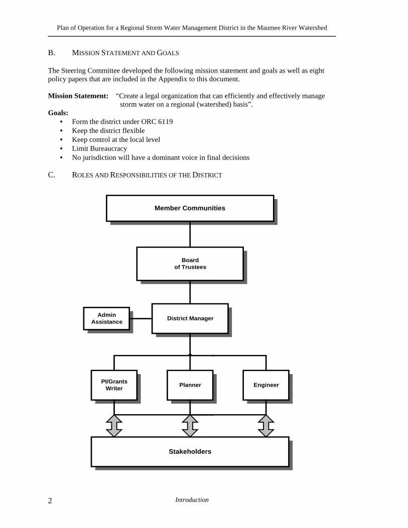
B. MISSION STATEMENT AND GOALS The Steering Committee developed the following mission statement and goals as well as eight policy papers that are included in the Appendix to this document.
Mission Statement: “Create a legal organization that can efficiently and effectively manage
storm water on a regional (watershed) basis”. Goals:
• Form the district under ORC 6119 • Keep the district flexible • Keep control at the local level • Limit Bureaucracy • No jurisdiction will have a dominant voice in final decisions
C. ROLES AND RESPONSIBILITIES OF THE DISTRICT
Member Communities
Boardof Trustees
District ManagerAdmin
Assistance
PI/GrantsWriter
Stakeholders
Planner Engineer
Plan of Operation for a Regional Storm Water Management District in the Maumee River Watershed
Introduction 3
The graphic on the previous page shows the primary structure of the District as well as the relationship of each function to the structure. There are five major functions of the district:
• Member Communities – Are those communities from the regional area that do not object to becoming a part of the District (see map – Appendix I).
• Board of Trustees – Consists of a seventeen-member group appointed by local governmental authorities to govern the District. Will meet on a regular basis to set and modify District policy. Member communities that do not have direct representation on the Board of Trustees may provide input during the regularly scheduled meetings.
• District Manager – Will direct the day-to-day operations of the District.
• Staff – Comprised of the administrative assistant, public relations/grants writer, planner and engineer who will carry out the day-to-day duties of the District.
• Stakeholders – Those communities, groups, and citizens that have a “stake” in storm water management in the region and will have direct input to the decision-making process.
The Member Communities will work with the Board of Trustees to develop policy, and set the direction for the district. The Board of Trustees will hire a District Manager and work with the Manager to develop policy, interpret policy, and implement policy. The District Manager will, under direction from the Board of Trustees, hire the Staff and work with the Staff to implement policy. The District Manager and Staff will be accountable to the Board of Trustees. The District Staff will carry out the policies, procedures and recommendations of the Board of Trustees. The District Staff will interact with all Member Communities, key Stakeholder groups including State of Ohio and Federal EPA, ODNR, local business community and citizens of the District. The primary duties of the District are to:
• Develop regional storm water management standards; • Enforce regional standards and certify local community compliance; • Develop a regional storm water master plan to identify regional drainage
problems and determine the approximate cost of improvements; • Coordinate inter-jurisdictional storm water projects and improvements; • Leverage grant monies to be used for regional storm water improvements; • Develop regional public information materials and educational programs; • Coordinate and submit one NPDES Phase II Permit application on a regional
(watershed) basis.
Plan of Operation for a Regional Storm Water Management District in the Maumee River Watershed
Introduction 4
D. BENEFITS OF THE DISTRICT The major benefits of the Regional District are:
• Addressing storm water runoff issues on a regional (watershed) basis; • Enforcing of consistent storm water control standards throughout the region; • Securing and coordinating, funding and implementation of a regional storm water
master plan; • Implementing and coordinating funding for regional storm water projects; • Securing federal and state grant monies for planning and capital improvements for
the region • Providing an efficient and effective means of complying with Federal and State
storm water regulations.
II. ORGANIZATION AND STAFFING A. BOARD OF TRUSTEES A seventeen (17) member Board of Trustees known as “The Board of Trustees of the Maumee River Regional Storm Water Sewer District” will govern the District. Board Members will be appointed by their respective local government authorities or by regional governmental consortiums. The Board Members will serve for a term of six years after initial staggered terms. This board will be comprised of:
• Seven City Board Members (City of Toledo (2), City of Bowling Green, City of Oregon, City of Sylvania, City of Maumee, City of Perrysburg);
• Two County Board Members (Lucas County, Wood County); • Three Township Board Members (Sylvania Township, Perrysburg Township,
Springfield Township); • Two rotating Township Board Members in Lucas County and Wood County; • Two rotating Municipal Board Members in Lucas County and Wood County; and • One rotating Private Board Member appointed by Board Members 1 through 16
after considering nominations by the private entity members of the TMACOG. B. DISTRICT STAFF The initial District staff will be comprised of four full-time professional employees and one full-time clerical employee. The four professional employees will be comprised of:
• Registered Professional Engineer (1); • District Manager (1); • Certified Planner (1); • Public Information Specialist / Grants Writer Position (1).
Plan of Operation for a Regional Storm Water Management District in the Maumee River Watershed
Introduction 5
III. RESPONSIBILITIES There are five major functions of a storm water management program:
• Administration; • Engineering and Planning; • Regulation and Enforcement; • Operation and Maintenance; and • Capital Improvements.
The District staff will provide or assist the Member Communities with the functions in the following manner. A. ADMINISTRATION The "Administrative" function associated with the cost of service and level of service will account for approximately 10% of the District staff time. The administration function is attributed to the following: The overall costs associated with managing the District; The Board of Trustees compensation and general expenses, The District Manager position, The Professional Engineer position, The Certified Planner position, The Public Information Specialist/Grants Writer position and the Clerical employee position, compensation and expenses, office rent, general accounting and bookkeeping services, any taxes due, billing and collection, equipment, computers, materials, supplies, legal representation, general consulting and any other costs not specifically accounted for. The District will provide the following services:
• Overall management of the District storm water program; • Prepare and submit the NPDES permit application; • Provide public information activities; • Hold quarterly meetings; • Prepare and submit grant applications.
B. ENGINEERING AND PLANNING
The "Engineering and Planning" function associated with the cost of service and level of service will account for approximately 40% of the District staff time. The District Manager, Professional Engineer and Certified Planner’s time will be directly attributable to developing, creating and finalizing the NPDES Phase II Regional Storm Water Co-permittee permit and the six minimum controls measures mandated by EPA. The District staff on behalf of all the Member Communities will assemble, package and submit the NPDES Phase II permit and plan. The District staff will also provide the following services:
• NPDES Phase II regional activities
Plan of Operation for a Regional Storm Water Management District in the Maumee River Watershed
Introduction 6
• Master planning; • Assist in plan review and inspection; • Coordination of activities.
C. REGULATION AND ENFORCEMENT The "Regulation and Enforcement" function associated with the cost of service and level of service will account for approximately 40% of the District staff time. The District Manager, Professional Engineer and Certified Planner’s time will be directly attributable to developing, creating and finalizing the NPDES Phase II Regional Storm Water Co-permittee permit and the six minimum controls measures mandated by EPA. The District staff on behalf of all the Member Communities will assemble, package and submit the NPDES Phase II permit and plan. The District staff will also provide the following services:
• NPDES Phase II regional activities • Master planning; • Update regional standards and guidelines; • Coordination of activities.
D. OPERATION AND MAINTENANCE
The "Operation and Maintenance" function associated with the cost of service and level of service will account for approximately 5% of the District staff time. The District will coordinate any Operation and Maintenance activities. The local communities will maintain and provide all Operation and Maintenance activities within their respective jurisdiction. E. CAPITAL IMPROVEMENTS The "Regional Capital Improvements Projects" function associated with the cost of service and level of service will account for approximately 5% of the District staff time. The District will coordinate Capital Improvement activities. The local communities will maintain and provide all Capital Improvement activities within their respective jurisdiction. IV. FINANCE A. COST OF SERVICE ANALYSIS The purpose of a cost of service analysis is to identify all expenditures associated with providing storm water services without consideration given to available resources. The
Plan of Operation for a Regional Storm Water Management District in the Maumee River Watershed
Introduction 7
Cost of Service is a measure of the level of storm water service that can be delivered to the citizens of the region for a determined rate. The Cost of Service analysis was performed based upon the organizational structure selected by the MRRSWC Steering Committee. After considering many alternative levels of service, the MRRSWC Steering Committee approved a $1,245,876 level of service, Cost of Service. B. RATE STRUCTURE The MRRSWC Steering Committee considered four alternative rate structures, and selected the parcel based rate structure as the most appropriate. Under a parcel based rate structure, each parcel owner within the Member Communities pays an annual user fee. The parcel based rate structure was selected using the following criteria:
• Fair and equitable to all members; • Reasonable to administer; • Cost efficient to implement; • Simple to understand, and • Accepted by the general public.
However, within the first five years of the program, the District will begin the process of developing the appropriate mapping information that will allow the District to assess property owners based on the impervious area rate structure method. This is the method used by the City of Toledo and most storm water utility programs across the country. This structure method is the preferred method and has been upheld in courts across the country as well as the State of Ohio Supreme Court, but is costly to create. C. REVENUE The MRRSWC Steering Committee accepted an annual user fee of $5.00 per parcel per year based on a $1,245,000 Cost of Service Analysis. This rate is recommended to be in effect for five years. A policy decision was made to limit the contribution by any one community to 42% of the annual budget. This decision resulted in a reduction of $0.58 for all City of Toledo parcels, and an increase of $0.58 for all other parcels. Therefore, City of Toledo parcel owners will pay $4.42 per parcel per year, and all others will pay $5.58 per parcel per year. Each Member Community has the option of electing to pay their portion of the district fee as a direct lump-sum payment. For example, the City of Toledo has elected to pay a direct lump-sum payment of $590,000 to the district from the Storm Water Utility Enterprise Fund, instead of charging the user fee to each individual parcel owner.

Plan of Operation for a Regional Storm Water Management District in the Maumee River Watershed
Introduction 8
Plan of Operation for a Regional Storm Water Management District in the Maumee River Watershed

Plan of Operation for a Regional Storm Water Management District in the Maumee River Watershed
Policy 1: Organizational Scenarios 9
POLICY 1: ORGANIZATIONAL SCENARIOS I. INTRODUCTION This policy paper has been prepared to provide information concerning examples of districts that manage storm water on a regional basis. It has been organized as follows:
I. Introduction II. Background III. District functional activities IV. Description of District scenarios V. Advantages and Disadvantages (of each district scenario) VI. Consultant Recommendation
The basis for this paper is the 4 scenarios attached to this policy paper as follows:
• Scenario # 1 – MRRSWC – Coalition • Scenario # 2 – Reduced Lake County • Scenario # 3 – Lake County • Scenario # 4 – MSD.
The scenarios presented, apply to all district development and organization. The district concept has more to do with how you work together and limits you put on the district authority than it does the rules and regulations that are used to create any district. II. BACKGROUND The information contained in this section has been taken directly from “The Toledo Metropolitan Area Regional Storm Water Management Study Final Report - April 1999- Executive Summary”. We have provided this information for the following reasons:
• As the foundation for our scope of work • As a reminder of the decisions that have previously been made • Assist in the decision making process • As the building block and foundation for implementation of a regional storm
water management program • Assist everyone in making the decision to join or don’t join the district
Abstract/Executive Summary This report contains the findings and recommendations of a two-year study of how best to address and fund storm water management within the Maumee River's Area of Concern.
Plan of Operation for a Regional Storm Water Management District in the Maumee River Watershed
Policy 1: Organizational Scenarios 10
It summarizes the research conducted to determine the extent of the storm water problem in the region as well as various alternatives for regional management activities, (ORGANIZATIONAL STRUCTURE BENEFITS) and funding mechanisms. This report provides a recommendation for a regional storm water management district and further steps for implementation. Recommendations After an evaluation of several options, the Storm Water Policy Board, at it's November meeting, recommended the exploration of a "regional storm water management district." Such a district would have the ability to address storm water on a watershed basis, develop and implement all of the potential activities of a regional storm water management plan, provide an effective funding mechanism for storm water projects, and formalize the commitment of local governments to regional storm water management. Regional Storm Water Management District The proposed storm water management district would be formed as a regional water and sewer district under Chapter 6119 of the O.R.C. for the explicit purpose of regional storm water management. The district would primarily address those storm water management issues of regional concern, leaving the normal operation and maintenance of local storm water systems to the individual jurisdictions. Membership in the district would be voluntary with individual jurisdictions able to join or leave the district at their discretion. Duties of Proposed District
• Develop a regional storm water management standards • Enforce regional standards or certify local communities to do so • Develop a regional storm water master plan to identify regional drainage
problems and determine approximate costs of improvements • Coordinate inter-jurisdictional projects • Leverage grant monies to be used for regional improvements • Assessment of property tax or levying of user charges to fund above duties
The plan of operation specifying the duties of the district can be modified as the governing board of the district sees fit. The duties of the district could evolve into providing services similar to that of a storm water utility. Benefits of District for the Region
• Address storm water runoff issues on a regional, watershed basis • Ensure use and enforcement of consistent storm water controls standards
throughout region • Will fund and implement regional storm water master planning • Potential funding source for regional storm water projects
Plan of Operation for a Regional Storm Water Management District in the Maumee River Watershed
Policy 1: Organizational Scenarios 11
• Make the region more competitive for planning and capital improvements grants • Provide easier and less expensive compliance with federal and state storm water
regulations III. DISTRICT FUNCTIONAL ACTIVITIES For any district there are four functional activities that are critical to the implementation and ultimate success. As in lake County, Illinois, it has been our experience when realistic and flexible decisions have made pertaining to these activities, the storm water organization works to the benefit (advantage) of all participating communities. As we discuss the district scenarios, the definition of the 4 functional activities (funding, staffing, technical, and responsibilities) will provide the necessary information to negotiate the district principles. Your community’s decision to join the regional district will be clear through flexible discussion, negotiation, and consensus agreement. The definitions and information we have provided are based on our experience and what we understand of your current situation. There is no strict definition for each of these activities. Our process invites your input to modify these definitions as well as how these activities are implemented. A. FUNDING ACTIVITY Funding is the money necessary for the regional storm water organization to operate, solve problems and sustain the programs. Funding pertains to the collection of money, the distribution of funds (to communities and activities), the definition of level of service and the determination of the cost of service. B. STAFFING Staffing is the number and type of personnel needed to perform the duties of the storm water organization. Staffing is dependent on the activities or services to be performed, the level of those services or activities that are identified to be performed, and the amount of funding available. Staffing will also define the level of bureaucracy that is required as well as the responsibilities of each community. C. TECHNICAL Technical issues are the items or activities that need to be accomplished to implement and sustain the storm water organization. Activities such as flood control; drainage infrastructure; erosion and sedimentation control; water quality; permitting and other
Plan of Operation for a Regional Storm Water Management District in the Maumee River Watershed
Policy 1: Organizational Scenarios 12
environmental considerations are key to the formation of the district. The numbers of activities as well as the frequency are critical decisions that need to be made by the MRRSWC committee. For example, the district can decide to perform flood control activities but not water quality or the regional district could perform all of the activities but limited to certain geographic areas, etc. D. RESPONSIBILITIES Responsibility of the district rest upon each of the communities desire to maintain and perform storm water activities at the local level or relinquish control of certain activities to the region. At stake is the community’s willingness to cooperate with neighboring or adjacent communities or work “region-wide” even if a specific project does not necessarily provide a direct benefit to that community. The responsibility that the organization assumes will determine the funding, staffing and the technical activities that are accomplished. E. SUMMARY Each of these activities is dependent upon each other and determines the extent to which the other elements are able to perform. The challenge for member communities is to craft a balance of funding, staffing, technical activities and responsibilities that build a successful regional storm water organization. The scenarios that are presented in the next section are intended to provide possible examples of what an organization may look like and assist in making the decision for your community to join and become an active member of the regional district and begin managing storm water on a multi-jurisdictional watershed basis. IV. DESCRIPTION OF DISTRICT SCENARIOS Now that we have defined the basic elements of a regional storm water organization, we need to look at the combined effect of the activities. We therefore, have developed four organizational scenarios based on the four functional activities discussed in the previous section. The four scenarios are as follows:
• Scenario # 1 – MRRSWC – Coalition • Scenario # 2 – Reduced Lake County • Scenario # 3 – Lake County • Scenario # 4 – MSD.
Plan of Operation for a Regional Storm Water Management District in the Maumee River Watershed
Policy 1: Organizational Scenarios 13
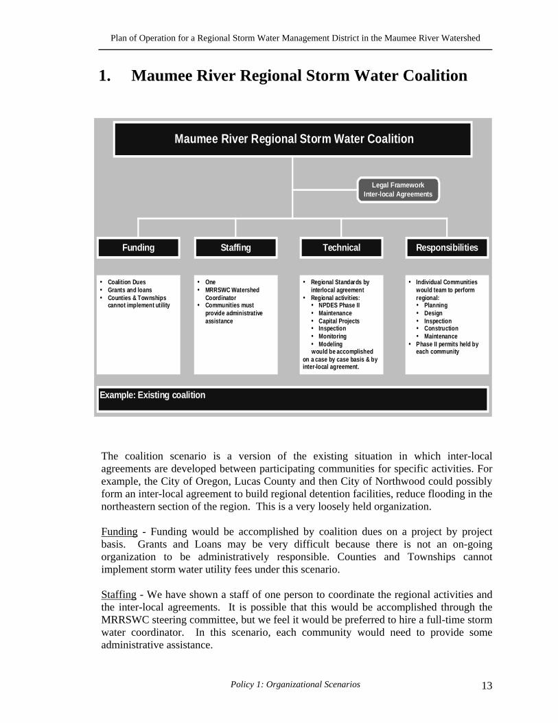
1. Maumee River Regional Storm Water Coalition The coalition scenario is a version of the existing situation in which inter-local agreements are developed between participating communities for specific activities. For example, the City of Oregon, Lucas County and then City of Northwood could possibly form an inter-local agreement to build regional detention facilities, reduce flooding in the northeastern section of the region. This is a very loosely held organization. Funding - Funding would be accomplished by coalition dues on a project by project basis. Grants and Loans may be very difficult because there is not an on-going organization to be administratively responsible. Counties and Townships cannot implement storm water utility fees under this scenario. Staffing - We have shown a staff of one person to coordinate the regional activities and the inter-local agreements. It is possible that this would be accomplished through the MRRSWC steering committee, but we feel it would be preferred to hire a full-time storm water coordinator. In this scenario, each community would need to provide some administrative assistance.
Maumee River Regional Storm Water Coalition
Legal FrameworkInter-local Agreements
Funding Responsibilities
Regional Standards byinterlocal agreementRegional activities:
NPDES Phase IIMaintenanceCapital ProjectsInspectionMonitoringModeling
would be accomplishedon a case by case basis & byinter-local agreement.
Staffing Technical
Coalition DuesGrants and loansCounties & Townshipscannot implement utility
OneMRRSWC WatershedCoordinatorCommunities mustprovide administrativeassistance
Individual Communitieswould team to performregional:
PlanningDesignInspectionConstructionMaintenance
Phase II permits held byeach community
Example: Existing coalition
Plan of Operation for a Regional Storm Water Management District in the Maumee River Watershed
Policy 1: Organizational Scenarios 14
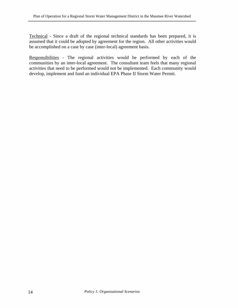
Technical - Since a draft of the regional technical standards has been prepared, it is assumed that it could be adopted by agreement for the region. All other activities would be accomplished on a case by case (inter-local) agreement basis. Responsibilities - The regional activities would be performed by each of the communities by an inter-local agreement. The consultant team feels that many regional activities that need to be performed would not be implemented. Each community would develop, implement and fund an individual EPA Phase II Storm Water Permit.
Plan of Operation for a Regional Storm Water Management District in the Maumee River Watershed
Policy 1: Organizational Scenarios 15
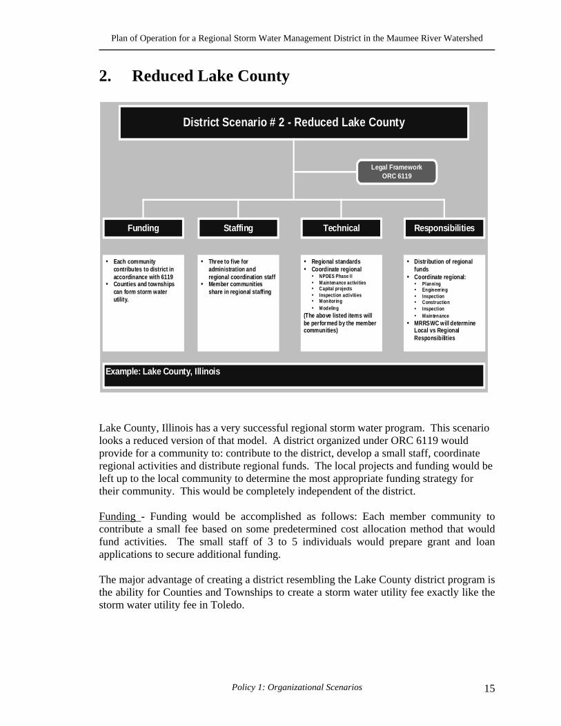
2. Reduced Lake County
Lake County, Illinois has a very successful regional storm water program. This scenario looks a reduced version of that model. A district organized under ORC 6119 would provide for a community to: contribute to the district, develop a small staff, coordinate regional activities and distribute regional funds. The local projects and funding would be left up to the local community to determine the most appropriate funding strategy for their community. This would be completely independent of the district. Funding - Funding would be accomplished as follows: Each member community to contribute a small fee based on some predetermined cost allocation method that would fund activities. The small staff of 3 to 5 individuals would prepare grant and loan applications to secure additional funding. The major advantage of creating a district resembling the Lake County district program is the ability for Counties and Townships to create a storm water utility fee exactly like the storm water utility fee in Toledo.
District Scenario # 2 - Reduced Lake County
Legal FrameworkORC 6119
Funding Responsibilities
Regional standardsCoordinate regional
NPDES Phase IIMaintenance activitiesCapital projectsInspection activitiesMonitoringModeling
(The above listed items willbe performed by the membercommunities)
Staffing Technical
Each communitycontributes to district inaccordinance with 6119Counties and townshipscan form storm waterutility.
Three to five foradministration andregional coordination staffMember communitiesshare in regional staffing
Distribution of regionalfundsCoordinate regional:
PlanningEngineeringInspectionConstructionInspectionMaintenance
MRRSWC will determineLocal vs RegionalResponsibilities
Example: Lake County, Illinois
Plan of Operation for a Regional Storm Water Management District in the Maumee River Watershed
Policy 1: Organizational Scenarios 16
Staffing - The staffing would include 3 to 5 employees with various job responsibilities. The positions would include a regional coordinator, an engineer, a planner and a public relations specialist. Technical - the regional staff will coordinate Region by working directly with communities to assist them with education, administration and enforcement of the standards. They would work with the "one stop shop" in reviewing and permitting of each community to streamline the regional projects. The regional staff will also coordinate regional aspects of the Phase II permits but utilize each community's resources to implement the permit. Responsibilities - In this scenario the regional staff will prioritize and distribute regional funds and coordinate the regional activities of planning, engineering (design), inspection, construction, maintenance. MRRSWC will determine local vs. regional responsibilities and will be coordinated by the regional coordinator. Implementation at the local level will be determined at and by the local staff.
Plan of Operation for a Regional Storm Water Management District in the Maumee River Watershed
Policy 1: Organizational Scenarios 17
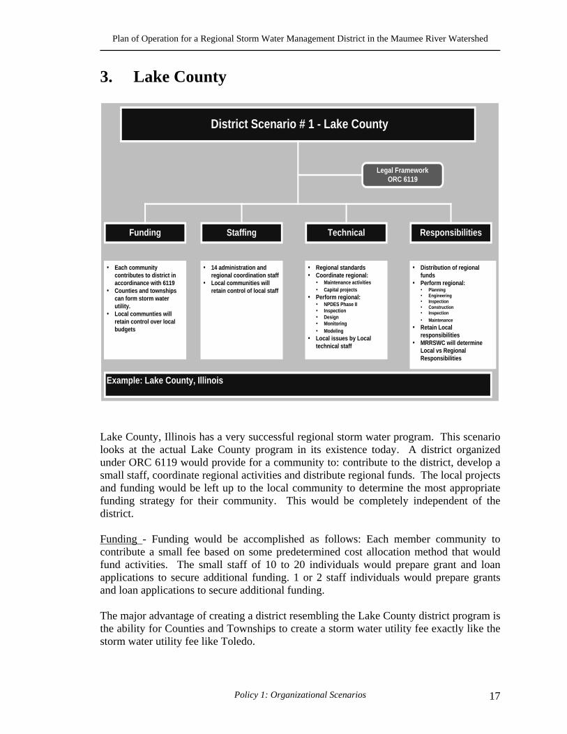
3. Lake County
Lake County, Illinois has a very successful regional storm water program. This scenario looks at the actual Lake County program in its existence today. A district organized under ORC 6119 would provide for a community to: contribute to the district, develop a small staff, coordinate regional activities and distribute regional funds. The local projects and funding would be left up to the local community to determine the most appropriate funding strategy for their community. This would be completely independent of the district. Funding - Funding would be accomplished as follows: Each member community to contribute a small fee based on some predetermined cost allocation method that would fund activities. The small staff of 10 to 20 individuals would prepare grant and loan applications to secure additional funding. 1 or 2 staff individuals would prepare grants and loan applications to secure additional funding. The major advantage of creating a district resembling the Lake County district program is the ability for Counties and Townships to create a storm water utility fee exactly like the storm water utility fee like Toledo.
District Scenario # 1 - Lake County
Legal FrameworkORC 6119
Funding Responsibilities
Regional standardsCoordinate regional:
Maintenance activitiesCapital projects
Perform regional:NPDES Phase IIInspectionDesignMonitoringModeling
Local issues by Localtechnical staff
Staffing Technical
Each communitycontributes to district inaccordinance with 6119Counties and townshipscan form storm waterutility.Local communties willretain control over localbudgets
14 administration andregional coordination staffLocal communities willretain control of local staff
Distribution of regionalfundsPerform regional:
PlanningEngineeringInspectionConstructionInspection
Maintenance
Retain LocalresponsibilitiesMRRSWC will determineLocal vs RegionalResponsibilities
Example: Lake County, Illinois
Plan of Operation for a Regional Storm Water Management District in the Maumee River Watershed
Policy 1: Organizational Scenarios 18
Staffing - The staffing would include 10 to 20 employees with various job responsibilities. For example, a regional coordinator/storm water director, engineers, planners, GIS specialist, financial specialist, a public relations specialist, etc. Technical - Regional standards will be coordinated and implemented by the regional staff. The district will coordinate the NPDES Phase II storm water permit and the regional activities will be implemented and maintained by district staff. In the same manner monitoring, modeling, inspection and design will be carried out by district staff. The district will coordinate maintenance activities and capital projects. However, the implementation and on-going maintenance will be performed by contract with local communities. Responsibilities - District staff will distribute regional funds and perform regional planning, engineering (design) and inspection as well as coordinate construction and maintenance activities. The district staff will be experts in storm water management. They will be available to support and help local communities. However, they will not have any local responsibilities. Local communities will retain local responsibility.
Plan of Operation for a Regional Storm Water Management District in the Maumee River Watershed
Policy 1: Organizational Scenarios 19
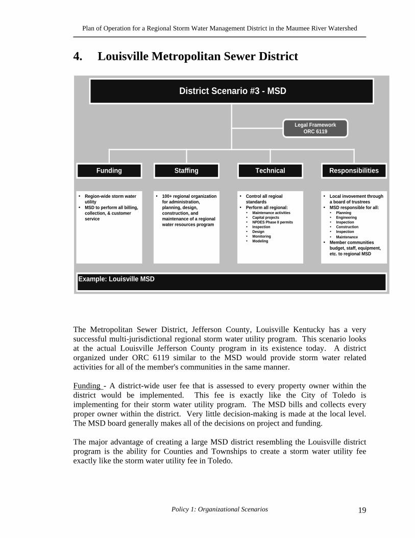
4. Louisville Metropolitan Sewer District
The Metropolitan Sewer District, Jefferson County, Louisville Kentucky has a very successful multi-jurisdictional regional storm water utility program. This scenario looks at the actual Louisville Jefferson County program in its existence today. A district organized under ORC 6119 similar to the MSD would provide storm water related activities for all of the member's communities in the same manner. Funding - A district-wide user fee that is assessed to every property owner within the district would be implemented. This fee is exactly like the City of Toledo is implementing for their storm water utility program. The MSD bills and collects every proper owner within the district. Very little decision-making is made at the local level. The MSD board generally makes all of the decisions on project and funding. The major advantage of creating a large MSD district resembling the Louisville district program is the ability for Counties and Townships to create a storm water utility fee exactly like the storm water utility fee in Toledo.
District Scenario #3 - MSD
Legal FrameworkORC 6119
Funding Responsibilities
Control all regioalstandardsPerform all regional:
Maintenance activitiesCapital projectsNPDES Phase II permitsInspectionDesignMonitoringModeling
Staffing Technical
Region-wide storm waterutilityMSD to perform all billing,collection, & customerservice
100+ regional organizationfor administration,planning, design,construction, andmaintenance of a regionalwater resources program
Local invovement througha board of trustreesMSD responsible for all:
PlanningEngineeringInspectionConstructionInspectionMaintenance
Member communitiesbudget, staff, equipment,etc. to regional MSD
Example: Louisville MSD
Plan of Operation for a Regional Storm Water Management District in the Maumee River Watershed
Policy 1: Organizational Scenarios 20
Staffing - The staffing would include 100 to 1000 employees with various job responsibilities. This organization would operate and maintain an entire storm water program. This would be a very large organization. Technical - The MSD would have control over all regional standards, including implementation and enforcement. The MSD will perform maintenance activities, design and construct all local and regional and capital projects. The MSD will develop, implement and maintain the NPDES Phase II permit. Local input will be through he board of trustees Responsibilities - The MSD will be responsible for all planning, engineering, regulation, enforcement, Inspection, construction maintenance and capital projects. Member community's budget, staff, equipment etc will be in the control of the regional MSD. Local input will be through the board of trustees V. ADVANTAGES AND DISADVANTAGES OF EACH SCENARIO Scenario #1- Maumee River Regional Storm Water Coalition Advantages:
1. No bureaucracy 2. Local government control 3. 1 regional staff 4. Some assistance for Phase II regulations
Disadvantages:
1. No change in current organizational structure 2. Counties and townships cannot create a storm water utility fee 3. No centralized organization 4. No regional funding mechanism 5. Regional standards by inter-local agreements 6. Master planning guidelines by inter-local agreements 7. All activated must be crafted by inter-local agreements 8. All communities must have their own NPDES permit 9. Little opportunity and no incentive for multi-jurisdictional capital projects
Scenario # 2 – Reduced Lake County Advantages:
1. Cities, Counties and Townships can create a storm water utility fee for funding

Plan of Operation for a Regional Storm Water Management District in the Maumee River Watershed
Policy 1: Organizational Scenarios 21
2. A small organization 3. Minimal (small) bureaucracy 4. Local community maintains decision making authority 5. Manage storm water on a watershed basis 6. Removes some of the pressure of addressing the NPDES Phase II regulations and
permit Disadvantages:
1. A small organization that has to be funded by members 2. Some bureaucracy 3. Local member communities will be required to assume a greater role in the
regional activities Scenario # 3 – Lake County Advantages:
1. Cities, Counties and Townships can create a storm water utility fee for funding 2. A small to medium organization 3. Medium bureaucracy 4. Local community maintains decision-making authority 5. Manage storm water on a watershed basis 6. Removes some of the pressure of addressing the NPDES Phase II regulations and
permit Disadvantages:
1. A small to medium size organization that has to be funded by members 2. Some bureaucracy
Scenario # 4 – MSD Advantages:
1. Cities, Counties and Townships can create a storm water utility fee for funding 2. Manage storm water on a watershed basis 3. Strong centralized organization that handles all storm water activities
Disadvantages:
1. A very large organization has to be funded 2. Large size bureaucracy 3. Local community looses all of the decision making authority
Plan of Operation for a Regional Storm Water Management District in the Maumee River Watershed
Policy 1: Organizational Scenarios 22
VI. CONSULTANT RECOMMENDATION The consultant recommendation is to create a district organization scenario that is modeled and based on option 2 and option 3.
Plan of Operation for a Regional Storm Water Management District in the Maumee River Watershed

Plan of Operation for a Regional Storm Water Management District in the Maumee River Watershed
Policy 2: Cost of Service Analysis for the 6119 District 23
POLICY 2: COST OF SERVICE ANALYSIS FOR THE 6119 DISTRICT
I. WHAT IS COST OF SERVICE The cost of service is a measure of the level of Storm Water service that can be delivered to the citizens of the region for a determined rate. The new rates will be designed to offset the estimated cost of providing storm water services. The cost of service will reflect current levels of service (expenditures) by the district for labor and other resources used in connection with all tasks associated with regional storm water management functions (activities). The purpose of a cost of service analysis is to identify all expenditures associated with providing storm water services without consideration given to available revenues. This process differs from the normal municipal general fund budgetary process whereby expenditures are identified as a result of available (requested) revenues. Furthermore, the cost of service analysis is very much like developing a business plan for a new company in the private sector. All aspects of creating a new business have to be considered, including planning, financing, human resources (staffing and board of trustees), office space, equipment, computer hardware and software, organizational policies and legal aspects, etc. Each of these aspects is discussed below. II. COST OF SERVICE – PROGRAM DESCRIPTION Based on the project team's experience from other programs such as the Lake County, Illinois regional storm water program, input from the MRRSWC, and based on information from the April 1999 Toledo Metropolitan Area Regional Storm Water Management Study, the project team has crafted a draft regional storm water program. The draft regional storm water program meets the mission of this project, which was to establish the new 6119 District. The following describes basic program elements, tasks, and sub-tasks of the newly established 6119 Regional Storm Water District Program. In addition, factors likely to influence future levels of service over the next five years have been incorporated in the analysis for certain sub-tasks. The Excel spreadsheets presented in the Appendix to this document illustrate the “basic” level of service over the next six years. The analysis is based on the first year as the "Start-Up" year, which begins January 1, 2002. The start up year will primarily fund the new hire (District Manager) and beginning process of developing the regional NPDES Phase II permit application. This process will be coordinated with outside assistance and with the newly created District Board of Trustees. Subsequently, the expenditures for the remaining five years are based on a "Test Year" data, which is intended to illustrate an "average" representative year of costs that will be incurred by this new 6119 organization. Each
Plan of Operation for a Regional Storm Water Management District in the Maumee River Watershed
Policy 2: Cost of Service Analysis for the 6119 District 24
spreadsheet is generated and organized by the Salary of each staff position and an estimated Fringe factor for payroll etc, (fringe is assumed to be 50% of actual labor). Labor is the basis of the cost of service analysis. For example, the project team identified staffing costs for the following full-time positions:
• The 17 Board of Trustee Member compensation expenses; • 4 professional full-time positions, including;
1 District Manager/Planner Position; 1 Public Relations/Grants Writer Position; 1 Registered Professional Engineer; and 1 Certified Planner.
• 1 full-time clerical position. The project team then used corresponding approximate salary and fringe calculations as the basis for the other remaining costs. For example, the inflated salary calculation was then used to develop overhead cost factors such as equipment (which includes computers), material and supplies and office rent. The remaining cost factor is the category for "outside consulting services" that represents any non-employee costs that are anticipated as part of the new 6119 district. Lastly, these costs are escalated each year for the five years using a 5% inflation factor. The discussion that follows describes major assumptions developed for each function to guide the project team in the analysis, the Cost of Service for the major functional elements, the sub-element activities and resources needed to implement that portion of the Storm Water Program. The major functional program elements are:
• Administration; • Engineering and Planning; • Regulation and Enforcement; • Operation and Maintenance (N/A not applicable); • Capital Improvement Program (N/A not applicable).
For each of the major functional program elements the following information will be provided:
1. Assumptions - This information are all of the assumptions that have gone into developing the costs of services for the new district.
2. Cost of Service – This is the total cost of service for the major functional element.
The detailed breakdown of the cost of service for the sub-elements can be found in the cost of service worksheet included in the Appendix to this document.
Plan of Operation for a Regional Storm Water Management District in the Maumee River Watershed
Policy 2: Cost of Service Analysis for the 6119 District 25
3. Sub- elements – Are the elements within each major functional program element that defines and describes the activities that will be accomplished for that element.
4. Activities – As the name implies, these are actions or tasks that will be performed
in order to meet the level of service to be performed.
5. Resources – Are the personnel, equipment, supplies and financial assistance need to meet the level of service and the cost of service.
6. Critical Path – This is a statement of the most critical element, activity and/or
resources needed to meet the needs of the major functional element. Without this effort, major breakdowns of the element will occur.
A. ADMINISTRATION
1. Assumptions:
• Use Lake County Model • 3 to 5 Staff Employees • Regional versus Local Activities • No Maintenance performed by District • No Capital Improvements performed by District • 1 Full Time Professional Planner ($75,000 Salary) • 1 Full Time Public Relations position ($75,000 Salary) • 1 Full Time Clerical • 17 Board of Trustee Members Compensation, Expenses and Mileage
($85,000) • Office Rent Expense • Accounting & Payroll Expenses • Attorney Fees ($50,000)
2. Cost of Service $335,100 (start-up)
$693,150 (test year)
3. Sub-Element:
• Board of Trustees • Public Relations / Grants Writer • Regional Planner & Manager • Clerical Position
4. Activities:
Plan of Operation for a Regional Storm Water Management District in the Maumee River Watershed
Policy 2: Cost of Service Analysis for the 6119 District 26
• Storm Water Program Management • Miscellaneous Staff Time • NPDES Permit Application • Public Relations Activities • Hold Quarterly Meeting • Grants Applications
5. Resources:
• Two Full Time Professional Positions • One Full Time Clerical Position
6. Critical Path:
The Board of Trustees and key management staff are critical to the start up and long term success of the district.
B. ENGINEERING & PLANNING
1. Assumptions:
• 1 Full Time Registered Engineer ($75,000 Salary) • Storm Water Background (10 years experience) • Support to Planner • No Service Vehicle • Understands today's Storm Water Technologies • Assists Member Communities with Storm Water Related Issues
2. Cost of Service $ 70,000 (start-up)
$275,814 (test year)
3. Sub-Element:
• NPDES Permit • Master Planning • Plan Review & Inspection • Coordination and Assistance
4. Activities:
• Develop Illicit Discharge Plan • Develop Model Ordinance • Develop BMP Manual • Document Storm Water Activities
Plan of Operation for a Regional Storm Water Management District in the Maumee River Watershed
Policy 2: Cost of Service Analysis for the 6119 District 27
• Contractor Selection/Bids (Assist Communities) • Contract Management/Administration • Consultant Selection & Management (Assist Communities) • Engineering Support for Maintenance (Assist Communities) • Capital Improvement Planning (Manages Plan) • Construction Management • Watershed Master Planning (Assists Communities) • Project Prioritization (Manages and Assists) • Trains Community Staff • Master Planning (Manages and Assists) • Community Rating System • Complaint Management • Land Acquisition (Assists Communities) • Preparation of Contract Documents (Assist Communities) • Maintenance of Engineering Maps/Recovery (Assists Communities) • GIS Plan Development • Customer response • FEMA Flood Insurance Program • Floodplain Management
5. Resources:
• Assistance from Planner • Assistance from Public Relations Staff Position • Consulting contracts • Public Education materials • Rain gauges (Assist Communities) • Stream flow monitors (Assist Communities)
6. Critical Path:
Engineering and planning are critical to the flow of work from discovering problems to constructing solutions that will decrease flooding and enhance water quality/permit issues. The water quality, drainage and capital improvements program is dependent on engineering and planning.
C. REGULATION & ENFORCEMENT
1. Assumptions:
• 1 Full Time Certified Planner • Storm Water Background • Assistance to Engineer • No Service Vehicle
Plan of Operation for a Regional Storm Water Management District in the Maumee River Watershed
Policy 2: Cost of Service Analysis for the 6119 District 28
• Understands today's Storm Water Technologies • Assists Member Communities with Storm Water Related Issues
2. Cost of Service: $110,000 (start-up) $276,913 (test year)
3. Sub-Elements:
• NPDES permit • Master Planning • Standards and Guidelines • Coordination & Assistance
4. Activities:
• Develop & Manage Ordinance • System inventory (GIS) (Assistance to Communities) • OEPA reporting • Water quality structures (Assistance to Communities) • Pollution detection & enforcement (Assistance to Communities) • Training (Lead) • Industry coordinator/Inspector • Spill response (Assistance to Communities) • Public education & outreach • Erosion and sedimentation • Credits program • Monitoring (Assistance to Communities)
Dry weather Wet weather Stream
• Complaint processing (Assistance to Communities) • Code and credit violation (Assistance to Communities) • Watershed management (manage) • Regional participation (Manage) • Greenways, buffers etc., • Volunteer monitoring program (Assistance to Communities) • Coordinate and Meet with OEPA • Coordinate with Regional Members
5. Resources:
• 1 Full Time Certified Planner • Storm Water Background • Assistance to Engineer • No Service Vehicle
Plan of Operation for a Regional Storm Water Management District in the Maumee River Watershed
Policy 2: Cost of Service Analysis for the 6119 District 29
• Brochures • Newsletters • Understands today's Storm Water Technologies • Assists Member Communities with Storm Water Related Issues • Pollution Prevention • Pollution Hotline
6. Critical Path:
Failure to manage and enforce the NPDES permit program could result in EPA violation ($25,000/day/violation) or 3rd party legal action.
D. OPERATION & MAINTENANCE
1. Assumptions:
The District will not perform any direct maintenance activities. The operation and maintenance function will be handled at the local level only. District staff will be available for assistance in operation and maintenance planning.
2. Cost of Service: $000
E. CAPITAL IMPROVEMENTS PROGRAM
1. Assumptions:
The District will not perform any direct capital improvement activities. The capital improvement function will be handled at the local level only. District staff will be available for assistance in capital improvements planning.
2. Cost of Service: $000
III. RECOMMENDATIONS The project team recommends accepting the $1,245,876 (test year) level of service and cost of service analysis outlined above.
Plan of Operation for a Regional Storm Water Management District in the Maumee River Watershed
Policy 2: Cost of Service Analysis for the 6119 District 30
Plan of Operation for a Regional Storm Water Management District in the Maumee River Watershed
Policy 2: Cost of Service Analysis for the 6119 District 31

Plan of Operation for a Regional Storm Water Management District in the Maumee River Watershed
Policy 2: Cost of Service Analysis for the 6119 District 32
Plan of Operation for a Regional Storm Water Management District in the Maumee River Watershed
Policy 2: Cost of Service Analysis for the 6119 District 33

Plan of Operation for a Regional Storm Water Management District in the Maumee River Watershed
Policy 2: Cost of Service Analysis for the 6119 District 34
Plan of Operation for a Regional Storm Water Management District in the Maumee River Watershed

Plan of Operation for a Regional Storm Water Management District in the Maumee River Watershed
Policy 3: NPDES Phase II Permit Checklist 35
POLICY 3: NPDES PHASE II PERMIT CHECKLIST
I. NPDES PHASE II STORM WATER PROGRAM Today, there is a new emphasis dealing with the quality of storm water. Since enactment of the Clean Water Act by Congress in 1972, local governments and industries in Ohio have spent hundreds of millions of dollars to upgrade, expand or rebuild their wastewater treatment plants. The net result of this massive capital program has been significantly improved effluents from wastewater plants with corresponding improvements in the quality of receiving streams. As these treatment plants have improved however, it has become apparent that there are other sources of pollutants to our rivers and streams that are adversely affecting their quality and impacting aquatic life. These "non-point" sources include agricultural runoff (fertilizers, pesticides), hydro modification (channelization, stream maintenance), mining, urban runoff, and land disposal and construction site runoff. A. MUNICIPAL SEPARATE STORM SEWER SYSTEMS (MS4S) To address these non-point sources of pollution, U.S. EPA initiated the National Pollution Discharge Elimination System (NPDES) Phase I storm and II water programs. The Phase I program required that major cities with populations greater than 100,000, which had separate storm sewer systems (does not include combined sanitary sewer and/or storm sewer systems) must obtain a permit from Ohio EPA by May 1993. In Ohio, only Columbus, Akron, Dayton and Toledo were required to obtain a Phase I permit. The other major cities meeting the population criteria were excluded from these regulations and fall under separate but related combined sewer system regulations. On December 8, 1999 US EPA adopted regulations that will require many of the remaining cities, villages, urban townships and counties to obtain NPDES Phase II storm water permits. Currently Ohio EPA estimates 400 local governments across Ohio will be required to obtain a Phase II storm water permit. All affected entities must obtain permit coverage by March 10, 2003. These local governments will be required to develop a storm water management program (The permit is a storm water quality plan for the community) that implements six minimum control measures, including:
• Public Education and Outreach Program • Public Involvement and Participation • Elimination of Illicit Discharges • Construction Site Storm Water Runoff Ordinance • Post-Construction Storm Water Management Ordinance • Pollution Prevention and Good Housekeeping
Each local government and many industries will be required to establish programs (Storm Water Quality Master Plans) to meet these six control measures and EPA will
Plan of Operation for a Regional Storm Water Management District in the Maumee River Watershed
Policy 3: NPDES Phase II Permit Checklist 36
periodically monitor the receiving stream(s) to evaluate compliance. Operators of small Municipal Separate Storm Sewer Systems (MS4s) (primarily those located in urbanized areas) are required to implement programs and practices to control polluted storm water runoff from the jurisdiction serviced by the MS4. The operator must design its storm water management program to satisfy applicable CWA water quality requirements and technology standards. The program must include the development and implementation of best management practices (BMPs) and measurable goals for the above listed six minimum control measures.
B. CONTROLLING IMPACTS OF DEVELOPMENT AND CONSTRUCTION Storm water Phase II requires operators of construction sites disturbing one to five acres to obtain an NPDES permit. Sediment, which runs off of construction sites at a rate of anywhere between 20 and 150 tons/acre/year, has been identified as the single largest cause of impaired water quality in rivers and the third largest cause of impaired water quality in lakes. The additional coverage provided under the storm water Phase II rule will ensure that sediment discharges from more than 97 percent of the land disturbed by construction activity will be controlled under a storm water permit. Types of controls could include sediment ponds, filter fences, storm drain inlet protections, and temporary mulching and seeding of exposed land areas. C. WHO IS INVOLVED The Phase II regulations would require that any jurisdiction with a population of more than 10,000 would be subject to these regulations. Local governments with populations greater than 1,000 but less than 10,000 must obtain a Phase II permit if they are shown to "substantially contribute" to storm water pollution. The Phase II Final Rule requires "automatic" nationwide coverage of all operators of small MS4s that are located within the boundaries of a Bureau of the Census-delineated “urbanized area” (UA) based on the latest Census. This doesn't just include municipal operators of small MS4s, but also universities, highway departments, and any other operator of a storm sewer system that is located fully or partially within the UA. The Phase II Final Rule also requires the NPDES permitting authority to develop a set of designation criteria and apply them, at a minimum, to all small MS4s located outside of a UA that serve a jurisdiction with a population of at least 10,000 and a population density of at least 1,000 people/square mile. The permitting authority is required to evaluate such small MS4s but is not required to designate them into the program unless they meet the designation criteria. EPA recommends in the Phase II regulations that the NPDES permitting authority use a balanced consideration of the following designation criteria on a watershed or other local basis:
Plan of Operation for a Regional Storm Water Management District in the Maumee River Watershed
Policy 3: NPDES Phase II Permit Checklist 37
• Discharge to sensitive waters; • High population density; • High growth or growth potential; • Contiguity to an Urbanized Area (UA); • Significant contributor of pollutants to waters of the United States; and • Ineffective protection of water quality concerns by other programs
Additionally, the Phase II Final Rule requires the NPDES permitting authority to designate any small MS4 located outside of a UA that contributes substantially to the pollutant loadings of a physically interconnected MS4 that is permitted by the NPDES storm water program. This means the other MS4 could be a large, medium, or regulated small MS4. Small MS4s located right outside the boundary of an urbanized area are the ones most likely to meet this criterion for designation and, therefore, should make an effort to become aware of whether they discharge pollutants directly into a regulated MS4. The sooner a small MS4 operator is prepared for potential designation and implementation of the Phase II program, the better. D. DEADLINE FOR SUBMISSION OF PERMIT APPLICATION The deadline for submission of each type of permit application is the same – it must be done no later than March 10, 2003 unless the NPDES permitting authority chooses to phase-in permit coverage on a watershed basis and establishes other deadlines E. WHAT THE REGULATION REQUIRE In March of 2003, all communities larger than 10,000 populations will be required to submit NPDES permits addressing water quality for storm water. As a part of the permit requirements, the communities must address six identified Best Management Practices or Minimum Control Measures. The six Minimum Control Measures are as follows:
1. Public Education and Outreach Distributing educational materials and performing outreach to inform citizens about the impacts polluted storm water runoff discharges can have on water quality.
2. Public Involvement / Participation Providing opportunities for citizens to participate in program development and implementation, including effectively publicizing public hearings and/or encouraging citizen representatives on a storm water management panel.
3. Illicit Discharge Detection and Elimination Developing and implementing a plan to detect and eliminate illicit discharges to the storm sewer system (includes developing a storm water system map and
Plan of Operation for a Regional Storm Water Management District in the Maumee River Watershed
Policy 3: NPDES Phase II Permit Checklist 38
informing the community about the hazards associated with illegal discharges and improper disposal of wastes).
4. Construction Site Storm Water Runoff Control Developing, implementing and enforcing an erosion and sediment control program for construction activities that disturb one or more acres of land.
5. Post-Construction Storm Water Management in New Development and Redevelopment This management practice involves the development, implementation and enforcement of a program to address discharges of post-construction storm water runoff from new development and redevelopment areas. Applicable controls could include preventative actions such as protecting sensitive areas (e.g., wetlands) or the use of structural BMP’s such as grassed swales or porous pavement.
6. Pollution Prevention / Good House Keeping Pollution Prevention / Good House Keeping involves developing and implementing a program with the goal of preventing or reducing pollutant runoff from municipal operations. The program must include municipal staff training on pollution prevention measures and techniques (e.g., regular street sweeping, and reduction in the use of pesticides or street salt or frequent catch basin cleaning).
Each of these management practices is described in detail in the attached six Minimum Control Measure documents. F. HOW MUCH WILL IT COST As a part of the work effort for this project the consulting team conducted a number of community workshops. These workshops provide a forum for education and feedback to the consulting team and the MRRSWC Steering Committee. In the December 2000 workshop the consulting team created an interactive session called a “mock regional meeting” where participants played characters in a “typical” regional setting. A factious regional watershed and communities was created with issues and problems similar to those in the Lower Maumee Region. In this program we developed some “typical” costs to show the benefits of a district. In our example we assumed the following:
• A community of population 20,000 to 30,000; • The mapping of storm water system and outfall inventory is complete; • Communities will have available State and Federal information and resources
such as the EPA Tool Box, BMP examples and guidance, and training materials; • Each community has existing billing system including a database of customers
and addresses;
Plan of Operation for a Regional Storm Water Management District in the Maumee River Watershed
Policy 3: NPDES Phase II Permit Checklist 39
• Each has community has existing newsletter, newspaper or community distribution system;
• Each community has a capital improvement program the includes at a minimum a nominal amount for storm water capital improvement;
• Each community has an infrastructure maintenance program that includes at a minimum a reactive storm water maintenance program through streets and roads maintenance; and
• Each community has the ability to craft and implement ordinances or codes that will fulfill the legal authority of the phase II permit.
These assumptions are important because if any of these are not in place the costs shown will increase. A minimum program based on the six management practices with the above listed assumption is as follows:
Individual Community Costs
• 5-Year Total Permit Cost $250,000 to $300,000 • Estimated Annual Cost $50,000 to $60,000 per year
(Note: We will use the lower limit of the estimated costs. Also costs from the “mock regional presentation” have been rounded)
If communities work together as a regional group (or district) – assume ten (10) communities – the cost may be as follows:
• 5-Year Regional Cost $175,000 +/-
• 5-Year Local Cost + $85,000 +/-
• 5-Year Total Program $260,000 +/- This example assumes that either a regional group or the groups of communities are working together to perform many of the permit tasks at a greatly reduced cost. For example many of the public information tasks such as brochures or newsletters can be developed by the group and distributed to all of the communities at a greatly reduced cost. There is also a local community component to the cost shown above. This cost covers those items that the regional group cannot such as the mapping of the local storm water system, implementation of the model ordinances, and distribution of brochures or newsletters. The annual regional cost per community and the local cost per community (in the regional setting) are shown below.
Annual Regional Cost: • $175,000 / 5-years = $35,000 per year
Annual Regional Cost per Community
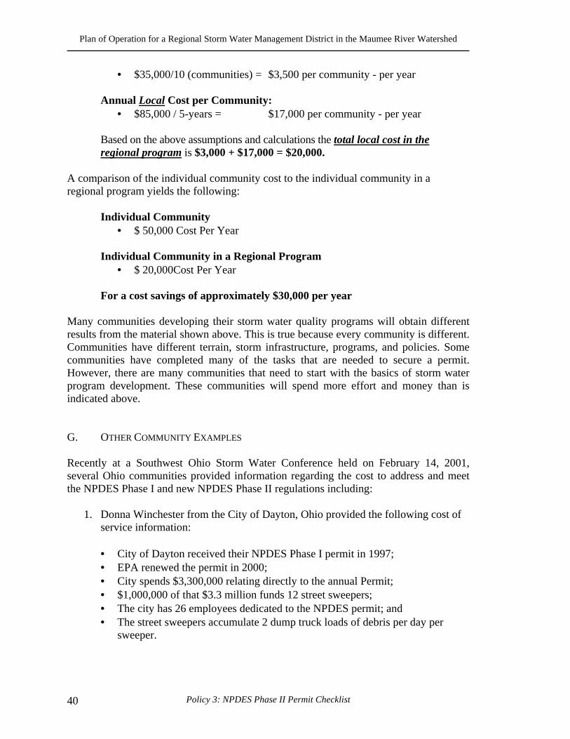
Plan of Operation for a Regional Storm Water Management District in the Maumee River Watershed
Policy 3: NPDES Phase II Permit Checklist 40
• $35,000/10 (communities) = $3,500 per community - per year Annual Local Cost per Community:
• $85,000 / 5-years = $17,000 per community - per year
Based on the above assumptions and calculations the total local cost in the regional program is $3,000 + $17,000 = $20,000.
A comparison of the individual community cost to the individual community in a regional program yields the following:
Individual Community • $ 50,000 Cost Per Year
Individual Community in a Regional Program
• $ 20,000Cost Per Year
For a cost savings of approximately $30,000 per year Many communities developing their storm water quality programs will obtain different results from the material shown above. This is true because every community is different. Communities have different terrain, storm infrastructure, programs, and policies. Some communities have completed many of the tasks that are needed to secure a permit. However, there are many communities that need to start with the basics of storm water program development. These communities will spend more effort and money than is indicated above. G. OTHER COMMUNITY EXAMPLES Recently at a Southwest Ohio Storm Water Conference held on February 14, 2001, several Ohio communities provided information regarding the cost to address and meet the NPDES Phase I and new NPDES Phase II regulations including:
1. Donna Winchester from the City of Dayton, Ohio provided the following cost of service information:
• City of Dayton received their NPDES Phase I permit in 1997; • EPA renewed the permit in 2000; • City spends $3,300,000 relating directly to the annual Permit; • $1,000,000 of that $3.3 million funds 12 street sweepers; • The city has 26 employees dedicated to the NPDES permit; and • The street sweepers accumulate 2 dump truck loads of debris per day per
sweeper.
Plan of Operation for a Regional Storm Water Management District in the Maumee River Watershed
Policy 3: NPDES Phase II Permit Checklist 41
Donna offered the following advice to more readily meet the annual permit requirements:
• Know your communities storm water system thoroughly; and • Identify your communities storm water problems.
2. David Riggs, City Engineer, Mason, Ohio
• 21,000 population of City of Mason; • In the process of implementing a storm water utility; • Estimating to collect $1,100,000 per year from the storm water utility; • The entire storm water program revolves around the NPDES Phase II permit; • Developing a GIS to address the illicit discharge minimum control measure;
and • Largest problem for Mason is the construction site runoff issues.
3. Louisville, Jefferson County, Kentucky - FMSM Engineers
• City of Louisville and Jefferson County have a regional storm water program
manages by the Metropolitan Sewer District; • The program includes approximately 90 communities; • The population of the regional program is approximately 800,000; • NPDES Phase I community that spends 50% of overall budget on the NPDES
permit and water quality issues; • A storm water utility was created in 1987; • The storm water rate is $3.15 per ERU per month; • The program generates $14,000,000 annual; and • MSD is organized in regional watershed approach.
H. NPDES PERMIT CHECKLIST Attached, as a part of this document are six (6) spreadsheets that is a checklist of the activities form the NPDES Phase II Storm Water Program for the MRRSWC. Each of the six worksheets represents one of the six management practices that must be implemented to meet the requirements of the Phase II permit. The spreadsheets have been titled in the upper left hand corner with the management practice name. The title and header for Public Education & Outreach is shown below. Each of the six spreadsheets has the following format. Also shown are the column headings for the Minimum Control Tasks that provide the information for the implementation of the program. For each Minimum Control Task there is a description, a measurable goal, the regional (district) responsibility, and the local responsibility.
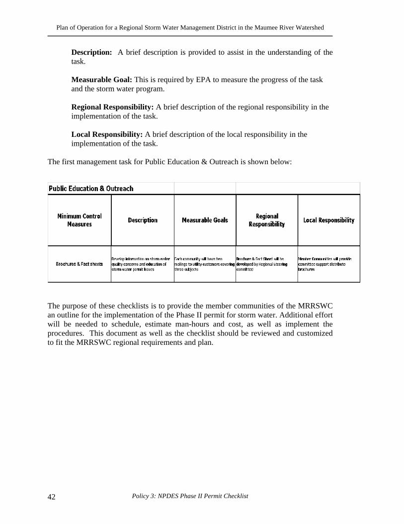
Plan of Operation for a Regional Storm Water Management District in the Maumee River Watershed
Policy 3: NPDES Phase II Permit Checklist 42
Description: A brief description is provided to assist in the understanding of the task.
Measurable Goal: This is required by EPA to measure the progress of the task and the storm water program.
Regional Responsibility: A brief description of the regional responsibility in the implementation of the task.
Local Responsibility: A brief description of the local responsibility in the implementation of the task.
The first management task for Public Education & Outreach is shown below:
The purpose of these checklists is to provide the member communities of the MRRSWC an outline for the implementation of the Phase II permit for storm water. Additional effort will be needed to schedule, estimate man-hours and cost, as well as implement the procedures. This document as well as the checklist should be reviewed and customized to fit the MRRSWC regional requirements and plan.
Plan of Operation for a Regional Storm Water Management District in the Maumee River Watershed
Minimum Control Measure #1 43
1. Public Education and Outreach
What Is Required? To satisfy this minimum control measure, the operator of a regulated small MS4 needs to:
• Implement a public education program to distribute educational materials to the community, or conduct equivalent outreach activities about the impacts of storm water discharges on local waterbodies and the steps that can be taken to reduce storm water pollution; and
• Determine the appropriate best management practices (BMPs) and measurable goals for this minimum control measure. Some program implementation approaches, BMPs (i.e., the program actions/activities), and measurable goals are suggested below.
Implementation The following activities or actions are part of the public education and outreach program.
FORMING PARTNERSHIPS Operators of regulated small MS4s are encouraged to enter into partnerships with other governmental entities to fulfill this minimum control measure’s requirements. It is generally more cost-effective to use an existing program, or to develop a new regional or statewide education program, than to have numerous operators developing their own local programs. Operators also are encouraged to seek assistance from non-governmental organizations (e.g., environmental, civic, and industrial organizations), since many already have educational materials and perform outreach activities.
EDUCATIONAL MATERIALS AND STRATEGIES
Brochures or fact sheets for general public and specific audiences: Recreational guides to educate groups such as golfers, hikers, paddlers, climbers, fishermen, and campers; Alternative information sources, such as web sites, bumper stickers, refrigerator magnets, posters for bus and subway stops, and restaurant placemats; A library of educational materials for community and school groups; Volunteer citizen educators to staff a public education task force;
Plan of Operation for a Regional Storm Water Management District in the Maumee River Watershed
Minimum Control Measure #1 44
Event participation with educational displays at home shows and community festivals; Educational programs for school-age children; Storm drain stenciling of storm drains with messages such as “Do Not Dump – Drains Directly to Lake” Storm water hotlines for information and for citizen reporting of polluters; Economic incentives to citizens and businesses (e.g., rebates to homeowners purchasing mulching lawnmowers or biodegradable lawn products) Tributary signage will increase public awareness of local water resources.
REACHING DIVERSE AUDIENCES The public education program should use a mix of appropriate local strategies to address the viewpoints and concerns of a variety of audiences and communities, including minority and disadvantaged communities, as well as children. Printing posters and brochures in more than one language or posting large warning signs (e.g., cautioning against fishing or swimming) near storm sewer outfalls are methods that can be used to reach audiences less likely to read standard materials. Directing materials or outreach programs toward specific groups of commercial, industrial, and institutional entities likely to have significant storm water impacts is also recommended. For example, information could be provided to restaurants on the effects of grease clogging storm drains and to auto garages on the effects of dumping used oil into storm drains.
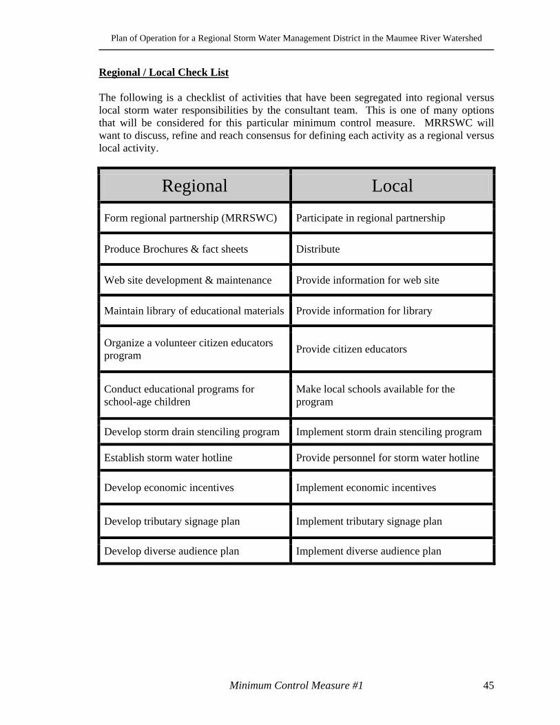
Plan of Operation for a Regional Storm Water Management District in the Maumee River Watershed
Minimum Control Measure #1 45
Regional / Local Check List The following is a checklist of activities that have been segregated into regional versus local storm water responsibilities by the consultant team. This is one of many options that will be considered for this particular minimum control measure. MRRSWC will want to discuss, refine and reach consensus for defining each activity as a regional versus local activity.
Regional Local
Form regional partnership (MRRSWC) Participate in regional partnership
Produce Brochures & fact sheets Distribute
Web site development & maintenance Provide information for web site
Maintain library of educational materials Provide information for library
Organize a volunteer citizen educators program
Provide citizen educators
Conduct educational programs for school-age children
Make local schools available for the program
Develop storm drain stenciling program Implement storm drain stenciling program
Establish storm water hotline Provide personnel for storm water hotline
Develop economic incentives Implement economic incentives
Develop tributary signage plan Implement tributary signage plan
Develop diverse audience plan Implement diverse audience plan
Plan of Operation for a Regional Storm Water Management District in the Maumee River Watershed
Minimum Control Measure #1 46
Plan of Operation for a Regional Storm Water Management District in the Maumee River Watershed
Minimum Control Measure #2 47
2. Public Participation / Involvement What Is Required? To satisfy this minimum control measure, the operator of a regulated small MS4 must:
• Comply with applicable State, Tribal, and local public notice requirements; and • Determine the appropriate best management practices (BMPs) and measurable
goals for this minimum control measure.
Implementation Possible implementation approaches, BMPs (i.e. the program actions and activities), and measurable goals are described below.
Public meetings/citizen panels allow citizens to discuss various viewpoints and provide input concerning appropriate storm water management policies and BMPs Volunteer water quality monitoring gives citizens first-hand knowledge of the quality of local water bodies and provides a cost-effective means of collecting water quality data Volunteer educators/speakers, who can conduct workshops, encourage public participation, and staff special events; Storm drain stenciling is an important and simple activity that concerned citizens, especially students, can do Community clean-ups along local waterways, beaches, and around storm drains Citizen watch groups can aid local enforcement authorities in the identification of polluters; and “Adopt A Storm Drain” programs encourage individuals or groups to keep storm drains free of debris and to monitor what is entering local waterways through storm drains.
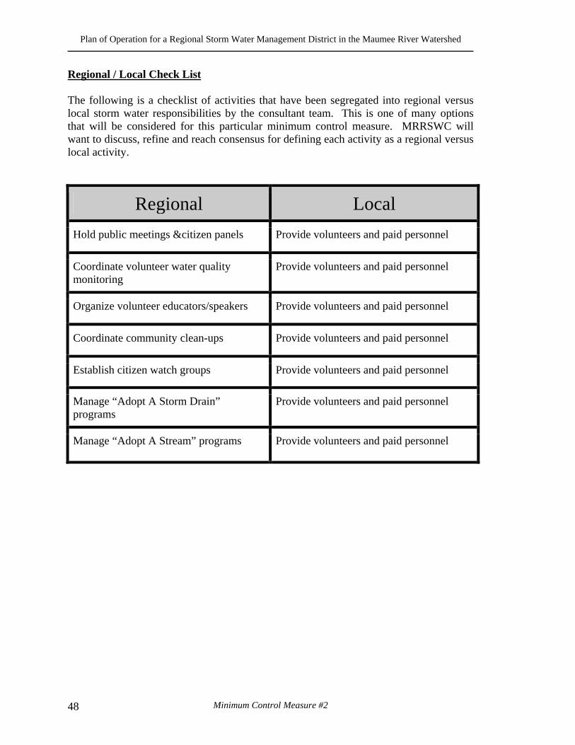
Plan of Operation for a Regional Storm Water Management District in the Maumee River Watershed
Minimum Control Measure #2 48
Regional / Local Check List The following is a checklist of activities that have been segregated into regional versus local storm water responsibilities by the consultant team. This is one of many options that will be considered for this particular minimum control measure. MRRSWC will want to discuss, refine and reach consensus for defining each activity as a regional versus local activity.
Regional Local
Hold public meetings &citizen panels Provide volunteers and paid personnel
Coordinate volunteer water quality monitoring
Provide volunteers and paid personnel
Organize volunteer educators/speakers Provide volunteers and paid personnel
Coordinate community clean-ups Provide volunteers and paid personnel
Establish citizen watch groups Provide volunteers and paid personnel
Manage “Adopt A Storm Drain” programs
Provide volunteers and paid personnel
Manage “Adopt A Stream” programs Provide volunteers and paid personnel

Plan of Operation for a Regional Storm Water Management District in the Maumee River Watershed
Minimum Control Measure #2 49
Plan of Operation for a Regional Storm Water Management District in the Maumee River Watershed
Minimum Control Measure #3 50
3. Illicit Discharge Detection and Elimination Definition Federal regulations define an illicit discharge as “...any discharge to an MS4 that is not composed entirely of storm water...” with some exceptions. These exceptions include discharges from NPDES-permitted industrial sources and discharges from fire-fighting activities. Illicit discharges are considered “illicit” because MS4s are not designed to accept, process, or discharge such non-storm water wastes. Sources of Illicit Discharges
• Sanitary wastewater • Effluent from septic tanks • Car wash wastewater • Improper oil disposal • Radiator flushing disposal • Laundry wastewater • Spills from roadway accidents • Improper disposal of auto and household toxins
What Is Required? Develop, implement and enforce an illicit discharge detection and elimination program to include the following:
• A storm sewer system map, showing the location of all outfalls and the names and location of all waters of the United States that receive discharges from those outfalls;
• Through an ordinance, or other regulatory mechanism, a prohibition on non-storm water discharges into the MS4, and appropriate enforcement procedures and actions;
• A plan to detect and address non-storm water discharges, including illegal dumping, into the MS4;
• The education of public employees, businesses, and the general public about the hazards associated with illegal discharges and improper disposal of waste; and
• The determination of appropriate best management practices (BMPs) and measurable goals for this minimum control measure. Some program implementation approaches, BMPs (i.e., the program actions/activities), and measurable goals are suggested below.
Plan of Operation for a Regional Storm Water Management District in the Maumee River Watershed
Minimum Control Measure #3 51
Implementation The objective of the illicit discharge detection and elimination minimum control measure is to have regulated small MS4 operators:
• Gain a thorough awareness of their systems; • Determine the types and sources of illicit discharges entering their system; and • Establish the legal, technical, and educational means needed to eliminate these
discharges. Some general guidance for each requirement is provided below.
THE MAP • Topographical map • Location of major pipes and outfalls • Collect all existing information on outfall locations (e.g., review city records,
drainage maps, storm drain maps) • Field surveys to verify locations • Walk (i.e., wade through small receiving waters or use a boat for larger
waters) the streambanks and shorelines for visual observation
Legal Prohibition and Enforcement
• Obtain the necessary authority to establish and enforce an ordinance or other regulatory mechanism prohibiting illicit discharges.
THE PLAN 1. Locate Problem Areas
• Identify priority areas (e.g., areas with older sanitary sewer lines). • Methods that can locate problem areas include:
Public complaints; Visual screening; Water sampling from manholes and outfalls during dry weather; and Use of infrared and thermal photography
2. Find the Source
• Dye-testing buildings in problem areas • Dye- or smoke-testing buildings at the time of sale • Tracing the discharge upstream in the storm sewer • Employing a certification program that shows that buildings have been
checked for illicit connections • Implementing an inspection program of existing septic systems
Plan of Operation for a Regional Storm Water Management District in the Maumee River Watershed
Minimum Control Measure #3 52
• Using video to inspect the storm sewers.
3. Remove/Correct Illicit Connections • Offending discharger should be notified and directed to correct the problem. • Education efforts and working with the discharger can be effective in
resolving the problem before taking legal action. 4. Document Actions Taken
• Annual reports: Number of outfalls screened; Complaints received and corrected; Number of discharges and quantities of flow eliminated; and Number of dye or smoke tests conducted
• Educational outreach efforts include: Informative brochures, and guidance's for specific audiences (e.g., carpet cleaning businesses) and school curricula; Designing a program to publicize and facilitate public reporting of illicit discharges; Coordinating volunteers for locating, and visually inspecting, outfalls or to stencil storm drains; and Initiating recycling programs for commonly dumped wastes, such as motor oil, antifreeze, and pesticides.
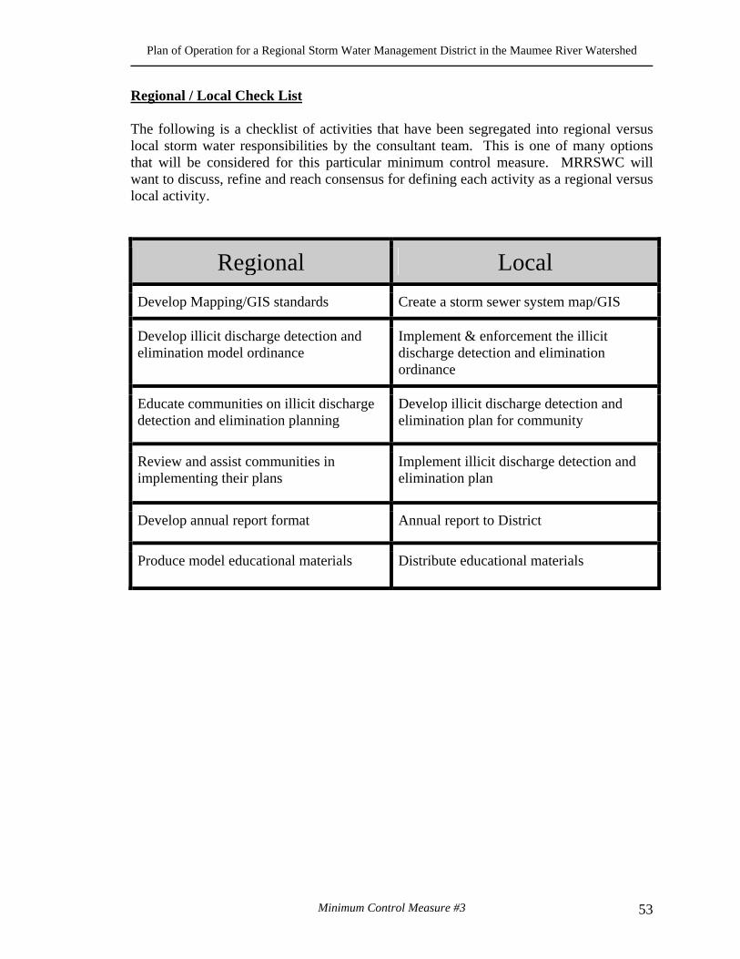
Plan of Operation for a Regional Storm Water Management District in the Maumee River Watershed
Minimum Control Measure #3 53
Regional / Local Check List The following is a checklist of activities that have been segregated into regional versus local storm water responsibilities by the consultant team. This is one of many options that will be considered for this particular minimum control measure. MRRSWC will want to discuss, refine and reach consensus for defining each activity as a regional versus local activity.
Regional Local
Develop Mapping/GIS standards Create a storm sewer system map/GIS
Develop illicit discharge detection and elimination model ordinance
Implement & enforcement the illicit discharge detection and elimination ordinance
Educate communities on illicit discharge detection and elimination planning
Develop illicit discharge detection and elimination plan for community
Review and assist communities in implementing their plans
Implement illicit discharge detection and elimination plan
Develop annual report format Annual report to District
Produce model educational materials Distribute educational materials

Plan of Operation for a Regional Storm Water Management District in the Maumee River Watershed
Minimum Control Measure #3 54
Plan of Operation for a Regional Storm Water Management District in the Maumee River Watershed
Minimum Control Measure #4 55
Construction Site Runoff Control What Is Required? The Phase II Final Rule requires an operator of a regulated small MS4 to develop, implement, and enforce a program to reduce pollutants in storm water runoff to their MS4 from construction activities that result in a land disturbance of greater than or equal to one acre. The small MS4 operator is required to:
• Have an ordinance or other regulatory mechanism requiring the implementation
of proper erosion and sediment controls, and controls for other wastes, on applicable construction sites;
• Have procedures for site plan review of construction plans that consider potential water quality impacts;
• Have procedures for site inspection and enforcement of control measures; • Have sanctions to ensure compliance (established in the ordinance or other
regulatory mechanism); • Establish procedures for the receipt and consideration of information submitted by
the public; and • Determine the appropriate best management practices (BMPs) and measurable
goals for this minimum control measure. Suggested BMPs (i.e., the program actions/activities) and measurable goals are presented below.
Implementation The following activities or actions are part of the construction site runoff program:
Regulatory Mechanism Through the development of an ordinance or other regulatory mechanism, the small MS4 operator must establish a construction program that controls polluted runoff from construction sites with a land disturbance of greater than or equal to one acre. Site Plan Review The small MS4 operator must include in its construction program requirements for the implementation of appropriate BMPs on construction sites to control erosion and sediment and other waste at the site. To determine if a construction site is in compliance with such provisions, the small MS4 operator should review the site plans submitted by the construction site operator before ground is broken. Site plan review aids in compliance and enforcement efforts since it alerts the small MS4 operator early in the process to the planned use or non-use of proper BMPs and provides a way to track new construction activities. The tracking of sites is useful not only for the
Plan of Operation for a Regional Storm Water Management District in the Maumee River Watershed
Minimum Control Measure #4 56
small MS4 operator’s record keeping and reporting purposes, which are required under their NPDES storm water permit but also for members of the public interested in ensuring that the sites are in compliance. Inspections and Penalties Once construction commences, BMPs should be in place and the small MS4 operator’s enforcement activities should begin. To ensure that the BMPs are properly installed, the small MS4 operator is required to develop procedures for site inspection and enforcement of control measures to deter infractions. Procedures could include steps to identify priority sites for inspection and enforcement based on the nature and extent of the construction activity, topography, and the characteristics of soils and receiving water quality. Inspections give the MS4 operator an opportunity to provide additional guidance and education, issue warnings, or assess penalties. To conserve staff resources, one possible option for small MS4 operators is to have these inspections performed by the same inspector that visits the sites to check compliance with health and safety building codes. Information Submitted by the Public A final requirement of the small MS4 program for construction activity is the development of procedures for the receipt and consideration of public inquiries, concerns, and information submitted regarding local construction activities. This provision is intended to further reinforce the public participation component of the regulated small MS4 storm water program and to recognize the crucial role that the public can play in identifying instances of noncompliance. The small MS4 operator is required only to consider the information submitted, and may not need to follow-up and respond to every complaint or concern. Although some form of enforcement action or reply is not required, the small MS4 operator is required to demonstrate acknowledgment and consideration of the information submitted. A simple tracking process in which submitted public information, both written and verbal, is recorded and then given to the construction site inspector for possible follow-up will suffice.
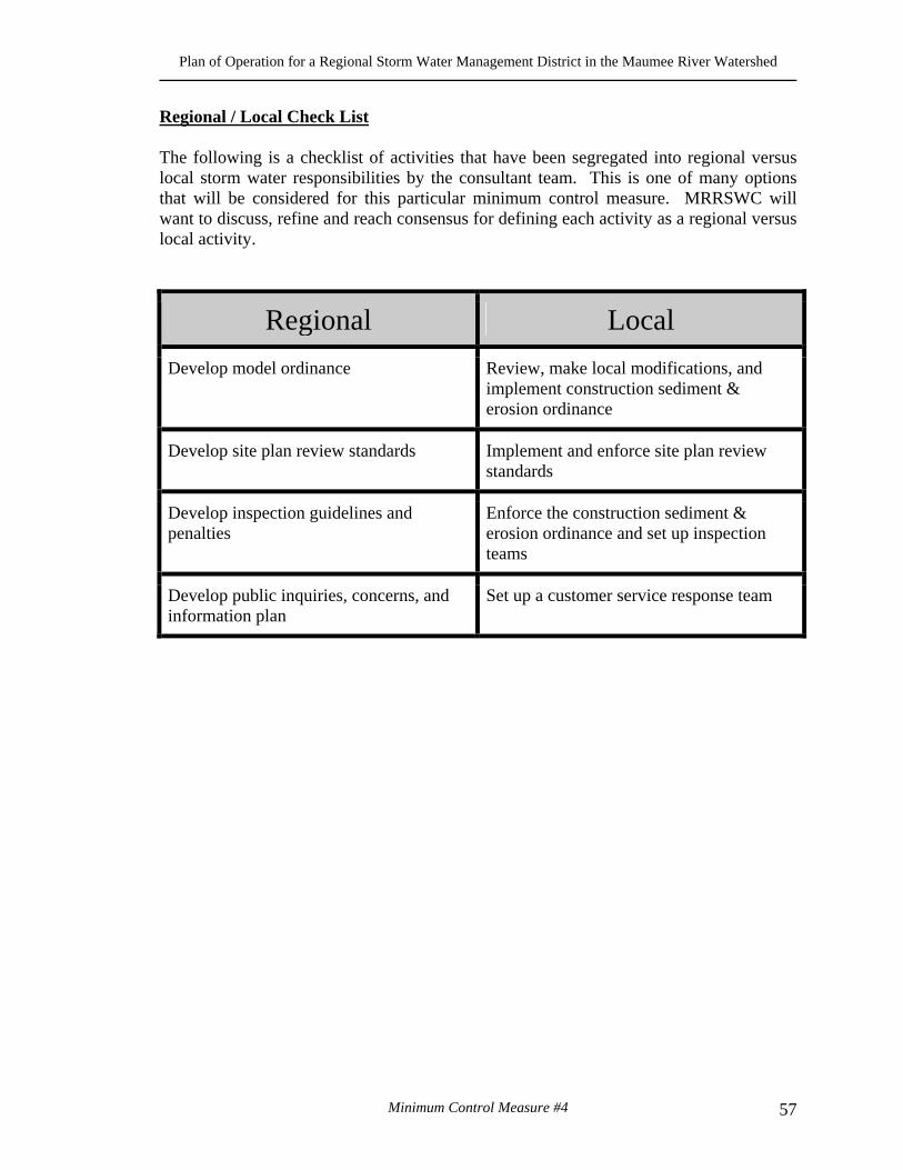
Plan of Operation for a Regional Storm Water Management District in the Maumee River Watershed
Minimum Control Measure #4 57
Regional / Local Check List The following is a checklist of activities that have been segregated into regional versus local storm water responsibilities by the consultant team. This is one of many options that will be considered for this particular minimum control measure. MRRSWC will want to discuss, refine and reach consensus for defining each activity as a regional versus local activity.
Regional Local
Develop model ordinance Review, make local modifications, and implement construction sediment & erosion ordinance
Develop site plan review standards Implement and enforce site plan review standards
Develop inspection guidelines and penalties
Enforce the construction sediment & erosion ordinance and set up inspection teams
Develop public inquiries, concerns, and information plan
Set up a customer service response team
Plan of Operation for a Regional Storm Water Management District in the Maumee River Watershed
Minimum Control Measure #4 58
Plan of Operation for a Regional Storm Water Management District in the Maumee River Watershed
Minimum Control Measure #5 59
5. Post-Construction Runoff Control What Is Required? The Phase II Final Rule requires an operator of a regulated small MS4 to develop, implement, and enforce a program to reduce pollutants in post-construction runoff to their MS4 from new development and redevelopment projects that result in the land disturbance of greater than or equal to 1 acre. The small MS4 operator is required to:
• Develop and implement strategies which include a combination of structural and/or non-structural best management practices (BMPs);
• Have an ordinance or other regulatory mechanism requiring the implementation of post-construction runoff controls to the extent allowable under State, Tribal or local law;
• Ensure adequate long-term operation and maintenance of controls; and • Determine the appropriate best management practices (BMPs) and measurable
goals for this minimum control measure. Implementation Types of post construction BMPs that should be implemented are as follows: Non-Structural BMPs.
Planning and Procedures: Runoff problems can be addressed efficiently with sound planning procedures. Master Plans, Comprehensive Plans, and zoning ordinances can promote improved water quality by guiding the growth of a community away from sensitive areas and by restricting certain types of growth (industrial, for example) to areas that can support it without compromising water quality. Site-Based Local Controls: These controls can include buffer strip and riparian zone preservation, minimization of disturbance and imperviousness, and maximization of open space.
Structural BMPs.
Storage Practices: Storage or detention BMPs control storm water by gathering runoff in wet ponds, dry basins, or multi-chamber catch basins and slowly releasing it to receiving waters or drainage systems. These practices both control storm water volume and settle out particulates for pollutant removal.
Plan of Operation for a Regional Storm Water Management District in the Maumee River Watershed
Minimum Control Measure #5 60
Infiltration Practices: Infiltration BMPs are designed to facilitate the percolation of runoff through the soil to ground water, and, thereby, result in reduced storm water quantity and reduced mobilization of pollutants. Examples include infiltration basins/trenches, dry wells, and porous pavement. Vegetative Practices: Vegetative BMPs are landscaping features that, with optimal design and good soil conditions, enhance pollutant removal, maintain/improve natural site hydrology, promote healthier habitats, and increase aesthetic appeal. Examples include grassy swales, filter strips, artificial wetlands, and rain gardens.
Regional / Local Check List The following is a checklist of activities that have been segregated into regional versus local storm water responsibilities by the consultant team. This is one of many options that will be considered for this particular minimum control measure. MRRSWC will want to discuss, refine and reach consensus for defining each activity as a regional versus local activity.
Regional Local
Develop BMP strategies & manual Implement BMP strategies & manual
Develop model post-construction runoff controls ordinance and enforcement strategy
Implement and enforce post-construction runoff controls ordinance
Develop long-term operation and maintenance program
Implement and sustain a long term operation and maintenance program
Plan of Operation for a Regional Storm Water Management District in the Maumee River Watershed
Minimum Control Measure #5 61
Plan of Operation for a Regional Storm Water Management District in the Maumee River Watershed
Minimum Control Measure #6 62
6. Pollution Prevention / Good Housekeeping What Is Required? Recognizing the benefits of pollution prevention practices, the rule requires an operator of a regulated small MS4 to:
• Develop and implement an operation and maintenance program with the ultimate goal of preventing or reducing pollutant runoff from municipal operations into the storm sewer system,
• Include employee training on how to incorporate pollution prevention/good housekeeping techniques into municipal operations such as park and open space maintenance, fleet and building maintenance, new construction and land disturbances, and storm water system maintenance. To minimize duplication of effort and conserve resources, the MS4 operator can use training materials that are available from EPA, their State or Tribe, or relevant organizations, and
• Determine the appropriate best management practices (BMPs) and measurable goals for this minimum control measure. Some program implementation approaches, BMPs (i.e., the program actions/activities), and measurable goals are suggested below.
Implementation The following actions/activities are components of a pollution prevention/ good housekeeping program.
Maintenance activities, maintenance schedules, and long-term inspection procedures for structural and non-structural controls to reduce floatables and other pollutants discharged from the separate storm sewers Controls for reducing or eliminating the discharge of pollutants from areas such as roads and parking lots, maintenance and storage yards (including salt/sand storage and snow disposal areas), and waste transfer stations. These controls could include programs that promote recycling (to reduce litter), minimize pesticide use, and ensure the proper disposal of animal waste Procedures for the proper disposal of waste removed from separate storm sewer systems and areas listed in the bullet above, including dredge spoil, accumulated sediments, floatables, and other debris Ways to ensure that new flood management projects assess the impacts on water quality and examine existing projects for incorporation of additional water quality protection devices or practices. EPA encourages coordination with flood control
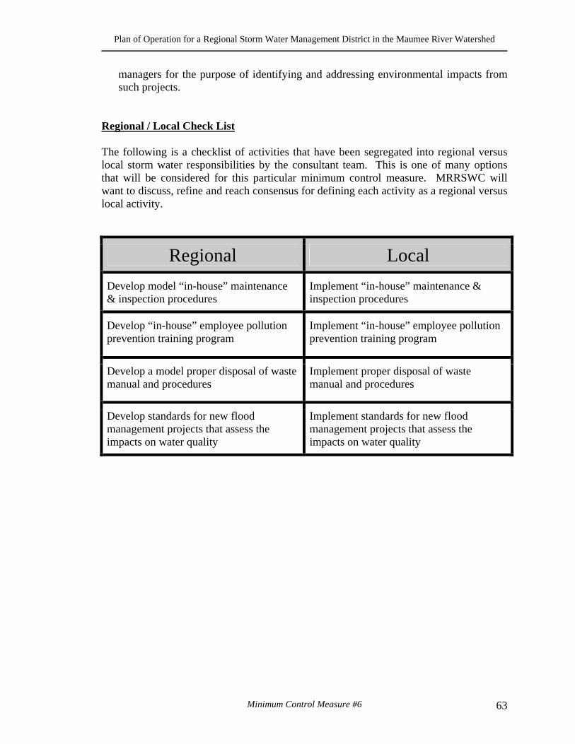
Plan of Operation for a Regional Storm Water Management District in the Maumee River Watershed
Minimum Control Measure #6 63
managers for the purpose of identifying and addressing environmental impacts from such projects.
Regional / Local Check List The following is a checklist of activities that have been segregated into regional versus local storm water responsibilities by the consultant team. This is one of many options that will be considered for this particular minimum control measure. MRRSWC will want to discuss, refine and reach consensus for defining each activity as a regional versus local activity.
Regional Local
Develop model “in-house” maintenance & inspection procedures
Implement “in-house” maintenance & inspection procedures
Develop “in-house” employee pollution prevention training program
Implement “in-house” employee pollution prevention training program
Develop a model proper disposal of waste manual and procedures
Implement proper disposal of waste manual and procedures
Develop standards for new flood management projects that assess the impacts on water quality
Implement standards for new flood management projects that assess the impacts on water quality
Plan of Operation for a Regional Storm Water Management District in the Maumee River Watershed
Minimum Control Measure #6 64
Plan of Operation for a Regional Storm Water Management District in the Maumee River Watershed

Plan of Operation for a Regional Storm Water Management District in the Maumee River Watershed
Policy 4: Storm Water Master Planning Guidelines 65
POLICY 4: STORM WATER MASTER PLANNING GUIDELINES
I. WHAT IS STORM WATER MASTER PLANNING? Master Planning is a process that integrates and coordinates various plans, programs, and procedures that a community, watershed or region can implement. It is a process that produces various products needed to guide local and regional storm water management decision-making. The functions performed by a master plan are many and complex, but they can be grouped under three principal categories:
a. The plan is an expression of what a community or region wants. It is a
statement of goals, a listing of objectives, and a vision of what might be.
b. The plan serves as a guide to decision making. It provides the means for guiding and influencing the many public and private decisions that create the future of the community or region.
c. The plan in some cases may represent the fulfillment of a legal requirement. It may be a necessary obligation. Such a mandated plan can still fulfill the first two functions, but the fact that it is required adds a distinctive dimension to the planning process.
Traditional Master Planning involves the development of capital projects, their costs, and prioritization of the projects. Traditional planning was essentially a technical exercise. Modern planning practice is both normative and technical, concerned with both ends and means. Normative planning develops the broad, general basis for action, whereas technical planning is concerned with specific, established purposes and the procedures employed in achieving those purposes. One is concerned with values, the other with methods. An effective plan should deal equally with the normative and the technical. Today planning occurs in a different political and social environment. Decision-making processes are more open and more democratic. A more sophisticated citizenry wants to know what the local government “plans” to do and wants to be part of the plan-making process.
Plan of Operation for a Regional Storm Water Management District in the Maumee River Watershed
Policy 4: Storm Water Master Planning Guidelines 66
II. PRINCIPALS OF STORM WATER MASTER PLANNING A. UNDERSTAND THE MISSION
Using a consensus building process through community stakeholders develop a mission, goals, and objectives. The mission, goals, and objectives are defined as follows:
Mission Statement:
Provides a clear and complete summation of the comprehensive storm water-planning program for the region. A good mission statement will provide the following:
• Purpose - Why the plan exists, and what it seeks to accomplish. • Business - The main method or activity through which the organization
tries to fulfill this purpose. • Values - The principals or beliefs that guide the organizations members as
they pursue the organizations purpose.
Example: Louisville Jefferson County Metropolitan Sewer District is creating a master plan for a major watershed in Jefferson County that has serious flooding and environmental problems. Over the next 20 years it will also be the location of increase economic development in the form of transportation facilities, warehouse distribution, and industrial. The following is the mission statement for the project:
Jefferson County Pond Creek Watershed
Reducing flooding and pollution through a cooperative effort
Goal Statement:
Provides a general statement of desirable end results, or a description of future conditions, towards which efforts are directed as part the storm water management program.
Example: The NPDES Phase II program develops program tasks as well as measurable goals. In this case the task description is the goal statement and the measurable goal is actually the objective (measurable). Under the Public Information minimum practice there is a task to develop tributary signage for the region. The Goal Statement (Task Description) is as follows:
Develop a program for the placement of tributary signage throughout the region.
Plan of Operation for a Regional Storm Water Management District in the Maumee River Watershed
Policy 4: Storm Water Master Planning Guidelines 67
Objective Statement:
Provides a specific, achievable and measurable result, which supports a goal.
Example: Using the example above the objective (EPA term: measurable goal) for Tributary Signage is:
Signage placed at major stream & road Intersections - 25 locations per Year.
A regular review and “tweaking” the goals and objectives should be performed on a regular basis (i.e. each year or every five years).
B. INCLUDE STAKEHOLDERS
As was stated in the development of the mission, goals, and objectives it is important to determine the needs and desires of the stakeholders. In a master-planning program the stakeholders could be the following:
• Member communities; • Public; • Elected officials; • Special interest groups (i.e. Developers; Environmental Groups); • Agencies (Local; State; Federal); and • Property owners.
Each of these groups will have a “stake” in the master planning process. Each of these groups will also have resources, talents, and energy to give to the planning process. They are potential partners that will help implement the plan and define success. Education of the stakeholders should be of the highest priority. Stakeholders must understand the purpose of your plan, process you will take to develop and implement the plan, and their responsibility in the master plan. The stakeholders can help you “sell” the plan and therefore implement the plan because the entire regional community is supporting the process and the plan. C. MULTI-OBJECTIVE APPROACH In today’s environment it is important to take a multi-objective approach to master planning. A successful multi-objective approach is a planning and implementation process through which local officials/and/or property owners develop the most
Plan of Operation for a Regional Storm Water Management District in the Maumee River Watershed
Policy 4: Storm Water Master Planning Guidelines 68
appropriate mix of government and private sector programs to implement community goals and objectives.
The multi-objective approach is a process that:
• Identifies diverse needs and goals related to rivers, lakes, and streams or
waterway or lake corridor; • Identifies numerous special – purpose programs and resources – both
private and public – that can support those needs and goals; • Develops a plan to best resolve the needs and achieve the goals; and • Coordinates and utilizes multiple programs and resources to implement
the plan. Example: A Stream Corridor Greenway Program can provide flood storage and keep structures from being build in the flood hazard zone, provide a water quality buffer, a habitat environment, human recreation, alternative transportation and improve water quality.
D. INTEGRATE WATER QUANTITY AND WATER QUALITY
If it is not possible to be as multi-objective as a Stream Corridor Greenway Program then at least combine water quantity and water quality issues. There is a tendency to view the new EPA NPDES Phase II regulations as a separate water quality program or stand alone effort. You may be tempted to create a separate group to manage the phase II program or to craft a separate plan. This should not be the approach. NPDES Phase II Permit issues can and should be integrated with drainage and flood management programs. The focus should be on the water corridors (receiving streams, estuaries, lakes, etc.), while planning watershed wide. It is important to go beyond just water quality and quantity and include resource management and protection, habitat management, biological diversity, land stewardship, sustainable land use concepts and stream stabilization using natural processes. E. BALANCE ECONOMIC DEVELOPMENT AND ENVIRONMENTAL ISSUES The balance of economic development and environmental issues is a critical element in the development of a water resource master plan. In many cases these two elements appose one another and there is a need to facilitate consensus. Economic development says that there should be an expansion of business and the community. This usually means the creation of more structures, more highways, more impervious area, more runoff, more flooding and more water quality problems. The Environmental will appose this by stopping development, increasing regulatory control, and increasing the cost development. The master planning process should strive facilitate a consensus balance between these two issues. The question becomes can there be economic development that is responsive to the environment and cost
Plan of Operation for a Regional Storm Water Management District in the Maumee River Watershed
Policy 4: Storm Water Master Planning Guidelines 69
effective and that the environmental community can live with. One such attempt is the Center for Watershed Protections’ “Low Impact Development” concept.
Example: Low Impact Development (development that utilizes Best Management Practices- BMPs, reduction of impervious area, green space development and alternative development rules) is an alternative that can provide designers and developers mechanisms to reduce the impacts of impervious area (flooding & water quality) while saving money.
F. ESTABLISH PARTNERSHIPS The development of partnership can best be described as:
Diverse groups working together and sharing resources to solve problems and implement solutions.
This creates a “win-win” situation where all partners benefit. There are three major benefits of establishing partnerships:
• Facilitation of implementation; • Creation of more resources; and • Reduction of costs.
The importance of this aspect should not be understated. You have already begun the partnership process by creating the Maumee River Regional Storm Water Coalition. By developing this coalition into a legal district, solutions that could not be attempted can be implemented, new resources will be developed, and operational costs will be reduced. G. USE TECHNOLOGY EFFECTIVELY GPS, digital communication, wireless technology, and Geographic Information System (GIS) are changing the way we do business and enhancing our ability to manage and implement wet weather programs. Of all of the technology available to communities, Geographic Information Systems (GIS) is the most powerful master-planning tool that you can use. A regional storm water district cannot be managed without the use of GIS. The number of communities, the size of the regional area, and the complexity of storm water all contribute to the need for GIS as a management and implementation tool. GIS is a multi-purpose tool that can be used for:
• Mapping; • Displaying opportunities & constraints;

Plan of Operation for a Regional Storm Water Management District in the Maumee River Watershed
Policy 4: Storm Water Master Planning Guidelines 70
• Reporting; • Managing resources; • Public information & education; • Efficient storage of data & results; • Visual understanding of difficult engineering and scientific concepts; and • Analysis
Another important element of storm water technology is the computer modeling. Computer models are used for determining:
• Flows or discharges; • Water surface elevations; • Size hydraulic structures like culverts and detention basins; • Flood hazard areas; • Erosion & sedimentation potential; and • Water quality problems.
Care should be taken in the development and use of computer modeling. There are a few guidelines that should be followed in the selection and operation of computer models. By following the guidelines computer modeling can be effective and cost efficient. The guidelines are as follows:
• Model Selection - Select models through a collaborative process that includes modeling experts, and model users, as well as those who are not model experts.
• Model Mission - Determine the purpose of the model and fit the model to the need or requirement.
• Be site specific. Modeling is expensive and there are different levels of modeling required for the different locations and needs.
• Use GIS - Integrate the modeling with GIS. GIS can develop the input data, analyze the results, display results, and manage the process.
• Evaluate the process – On some periodic basic evaluate the models, the need for modeling, new technology, and new area that may need to be modeled.
H. COMMUNICATE EFFECTIVELY With so many communities and partners involved in the regional storm water district effective communication is vital to success. Communication comes in many forms. There must be effective communication between the member communities in the district, with elected officials, with the public, and with regulatory agencies. Effective communication will begin with the crafting of the regional master plan. As was indicated in the beginning of this paper we are dealing with a very different public that want to be involved in the planning process and need to be educated on technical and process matters. The regional master plan needs to be understandable to the
Plan of Operation for a Regional Storm Water Management District in the Maumee River Watershed
Policy 4: Storm Water Master Planning Guidelines 71
community to eliminate sociopolitical factors that could influence the actual implementation of projects Effective communication should begin with the district staff and the district board of trustees. They must continually communicate the mission as well as the plan elements to the member communities, elected officials, federal and state agencies and the public. The principals described above and the elements and steps listed below all aid in the definition and implementation of effective communications through storm water master planning. III. MASTER PLANNING ELEMENTS & STEPS
1. Develop citizens advisory committee
Advises the Board & staff Diverse group Education must occur on an ongoing basis
2. Develop master plan goals and objectives
Must reflect the communities desires Process, values, and end products are equally important Objectives must be measurable
3. Inventory regional problems, issues, & resources
Create a constrains and opportunities map Inventory should include water quality, habitat, and other environmental issues GIS is critical
4. Create a problems / projects prioritization system
Need input from public and elected officials System will defend project choices This will be a continuous and ongoing effort
5. Refine Master Planning Standards
Standards or rules will be determined from the mission, goals, and objectives All member communities must be a part of defining and refining the standards Level of service and cost of service are critical to planning standards
6. Develop alternative funding sources for capital improvement
Define and refine level of service and cost of service
Plan of Operation for a Regional Storm Water Management District in the Maumee River Watershed
Policy 4: Storm Water Master Planning Guidelines 72
Continuous and ongoing grants writing program – This should be a major function of the district Educate the community and partner with the community on funding for storm water
7. Involve and educate the community and other partners
Critical to the plans success Use the EPA NPDES Phase II permit Be multi-objective
8. Develop master planning tools and reporting system
Geographic Information System – This may be the single most important element of the storm water master planning process. GIS should be used to integrate and communicate the master plan. In other words GIS houses and manages the plan and becomes the agent for change of the plan. Develop site-specific computer models that are common to the region and the member communities. A model of the entire region or watershed may note be necessary. Models should be developed for a specific purpose and location.
IV. LOCAL MASTER PLANNING ELEMENTS AND STEPS
The 6119 district that has been proposed is a very “light” organization in terms of the number of staff to carry out day-to-day operations. While they will be experts in storm water and provide assistance with many wet weather issues, they will not be able to do everything. It is therefore imperative that the local communities be engaged in the master planning process for the region as well as for their own local community. These plans should be coordinated. In order for that to occur the following elements and steps should be developed for each member community:
1. Develop a system map (best accomplished in the same GIS system as the
region). This should show drainage infrastructure, topographic information, roads, easements, buildings, and other utilities with in the community boundaries.
2. Develop an opportunities and constraints map (or GIS layer). 3. Develop a problem area map (or GIS layer) and database (also GIS) 4. Collect and organize data in a manner consistent with the regional
approach to collection and organization. The methods used to collect and organize data should be determined through a collaborative process involving the region and communities.
5. Determine those problem areas that are regional and communicate those areas to the district board and staff.
Plan of Operation for a Regional Storm Water Management District in the Maumee River Watershed
Policy 4: Storm Water Master Planning Guidelines 73
6. Adopt the plan and standards so that there is consistency throughout the region.
7. Communicate the master plan goals and elements as will as the benefits to the citizens and elected officials of your community.
V. MASTER PLAN DOCUMENT
How do we communicate something as complex and far reaching as a regional master plan? How should we organize the information so that we can implement, modify, and manage a dynamic process? History has shown us that a great deal of money has been spent on developing static master plans with little or no community input that gather dust on a shelf. A successful master plan is flexible, citizen supported, easy to update, and can be implemented over time. This type of plan is a “living” master plan. To obtain this type of master plan a cooperative effort by the member communities, the regional staff and the board of directors is critical. But the most important ingredient to an integrated, flexible, easy to update, and comprehensive master plan is Geographic Information System. GIS is the key to a “living” master plan. In fact the master plan should reside on the GIS system in the form of graphic layers and database information. All member communities should have the capability to share the master plan through the GIS. They can view the latest data, make changes to selected data, coordinate regional issues, and manage local issues. Instead of one large static document, there is an opportunity to produce targeted documents from an up to date graphic database. In addition to the master plan document we can produce brochures, newsletters, maps, detailed database information, and other graphic products. Regardless of whether a static hard copy document or digital GIS layers is used as the master plan, the organization and makeup of the material is critical. The following is an example of a possible organization of storm water or wet weather master plan material.
MAUMEE RIVER REGIONAL STORM WATER MASTER PLAN
• Watersheds & Streams o Regional Watersheds o Stream Systems o Natural & Human Changes o Uses, Benefits, and Values
• Land Use & Geography o Relief & Land Use o Climate & Water Cycle o Precipitation
Plan of Operation for a Regional Storm Water Management District in the Maumee River Watershed
Policy 4: Storm Water Master Planning Guidelines 74
o Communities (Political Sub-divisions) o Geology o Ground Water
• Water Quality and Pollution Control o Ecology and Habitat o Water Chemistry o Stream Quality o Point Source Pollution o Non-point Source Pollution o EPA NPDES Permits
• Infrastructure o Storm Water o Natural Streams o Regional Facilities o Other Infrastructure
• Problem Areas and Capital Projects o Problem area Assessment o Prioritization Criteria o Capital Projects Program
• Flood Management o Hydrology o Hydraulics o FEMA Flood Insurance o Floodplain Management
• Protection & Restoration o Stream Assessment o Restoration science o Stream Protection
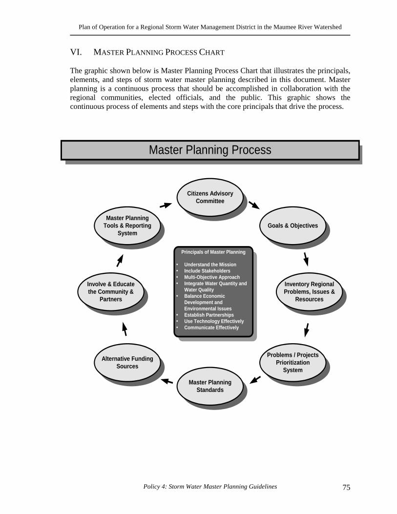
Plan of Operation for a Regional Storm Water Management District in the Maumee River Watershed
Policy 4: Storm Water Master Planning Guidelines 75
VI. MASTER PLANNING PROCESS CHART
The graphic shown below is Master Planning Process Chart that illustrates the principals, elements, and steps of storm water master planning described in this document. Master planning is a continuous process that should be accomplished in collaboration with the regional communities, elected officials, and the public. This graphic shows the continuous process of elements and steps with the core principals that drive the process.
Principals of Master Planning
Understand the MissionInclude StakeholdersMulti-Objective ApproachIntegrate Water Quantity andWater QualityBalance EconomicDevelopment andEnvironmental IssuesEstablish PartnershipsUse Technology EffectivelyCommunicate Effectively
Master PlanningTools & Reporting
System
Master Planning Process
Citizens AdvisoryCommittee
Involve & Educatethe Community &
Partners
Master PlanningStandards
Alternative FundingSources
Goals & Objectives
Inventory RegionalProblems, Issues &
Resources
Problems / ProjectsPrioritization
System

Plan of Operation for a Regional Storm Water Management District in the Maumee River Watershed
Policy 4: Storm Water Master Planning Guidelines 76
Plan of Operation for a Regional Storm Water Management District in the Maumee River Watershed

Plan of Operation for a Regional Storm Water Management District in the Maumee River Watershed
Policy 5: Financing Plan for the District 77
POLICY 5: FINANCING PLAN FOR THE DISTRICT
I. INTRODUCTION The purpose of this policy paper is to present the potential program revenues, user fees, and overall cash flow analysis for the Maumee River Regional Ohio Revised Code 6119 District Storm Water Program. This process includes determining gross revenues and the associated user fee assessments for all properties (regardless of whether it is publicly or privately owned and operated, residential versus non-residential) that are contained in the newly created Regional Storm Water District service area. The first step in this process is to determine the cost allocation base. The cost allocation base is typically referred to as the utility program rate structure. The rate structure/cost allocation method used and selected by the Project Team for the MRRSWC District was the Parcel Method. This, and the other considered methods, are discussed in the following section. II. COST ALLOCATION / RATE STRUCTURE METHOD The operating framework and general duties have been established for operating the Regional Storm Water Administrative office. The office staff will focus their efforts on developing and submitting a single NPDES Phase II NOI permit application for the District. Specific tasks to be performed at the District level will include such tasks as designing and printing region-wide brochures to comply with the Public Outreach and Involvement Best Management Practices required in the NPDES Phase II permit application. Furthermore, the District will not perform any operation and maintenance and/or capital improvement projects as part of its responsibility. However, the District will certainly coordinate any an all such projects if the Board of Trustees decides to actually perform these activities in the future. Therefore, each of the political subdivision members should share in the cost associated with operating the Regional Administrative duties of the District. Additionally, the cost should be allocated according to a base that is common to all members. Since the District responsibilities are primarily administrative in nature, a less defined and less expensive cost allocation approach is more appropriate. Several alternatives were considered in establishing the basis for cost allocation. Below is the selection criterion that was used for choosing a cost allocation basis (from the potential alternatives). The recommended method must be:
• Fair and equitable to all members; • Reasonable to administer; • Cost efficient to implement; • Simple to understand by the general public; • Accepted by the general public.
Plan of Operation for a Regional Storm Water Management District in the Maumee River Watershed
Policy 5: Financing Plan for the District 78
Additionally, the following characteristics of the District operations were considered in selected the cost allocation base. The District:
• Office will primarily be Administrative in nature (operation); • Will not perform any operation and maintenance projects; • Will not perform and capital improvements projects; • Will coordinate all NPDES and "project" activities; • Will maintain and update regional standards manual; and • Will maintain and update regional master planning guidelines.
Each of the alternative methods that were considered allocating costs to the District are presented and discussed below. They are:
• The Impervious Area Method; • Gross Population; • Roadway and Transportation System; and • Parcels contained in the County Auditors GIS.
III. IMPERVIOUS AREA METHOD Allocating costs to each member group based upon measured impervious area is an accepted method used by many storm water utilities, including The City of Toledo. Allocation by the Impervious Area method has withstood prior legal challenges. This method is fair and equitable, reasonable to administer and has been accepted by the general public. However, this method is costly to implement. Moreover, the District will not perform any projects so the detail necessary to implement an impervious area method is not required. However, if the District Board of Trustees decides to actually perform projects in the future, the project team strongly recommends implementing the impervious area method at that time. IV. GROSS POPULATION Allocating costs to each member group based upon population is reasonable to administer, is cost efficient to implement and acceptable to the general public. However, this method would not allocate costs fairly and equitably to all member groups. The larger cities or counties would have a large advantage over small villages or townships. A. ROADWAY AND TRANSPORTATION SYSTEM Allocation of costs based upon miles of roads also fails the fair and equitable test. Rural villages, townships or cities would have a large advantage over the larger cities or
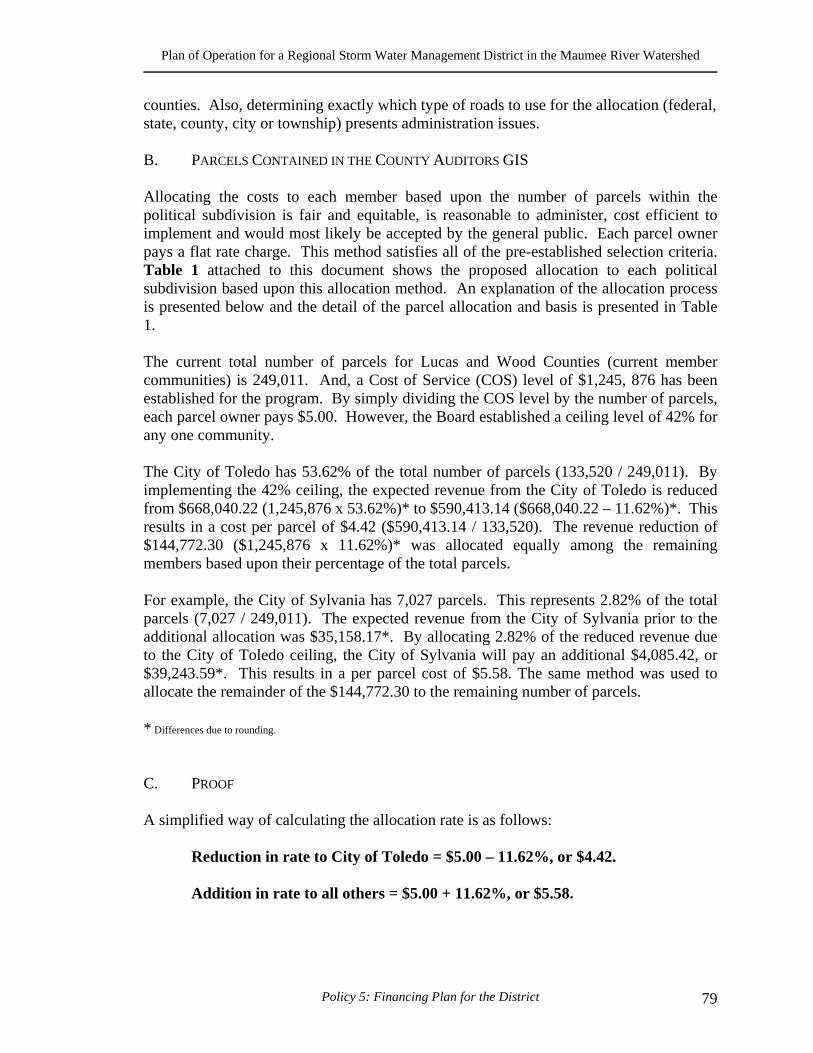
Plan of Operation for a Regional Storm Water Management District in the Maumee River Watershed
Policy 5: Financing Plan for the District 79
counties. Also, determining exactly which type of roads to use for the allocation (federal, state, county, city or township) presents administration issues. B. PARCELS CONTAINED IN THE COUNTY AUDITORS GIS Allocating the costs to each member based upon the number of parcels within the political subdivision is fair and equitable, is reasonable to administer, cost efficient to implement and would most likely be accepted by the general public. Each parcel owner pays a flat rate charge. This method satisfies all of the pre-established selection criteria. Table 1 attached to this document shows the proposed allocation to each political subdivision based upon this allocation method. An explanation of the allocation process is presented below and the detail of the parcel allocation and basis is presented in Table 1. The current total number of parcels for Lucas and Wood Counties (current member communities) is 249,011. And, a Cost of Service (COS) level of $1,245, 876 has been established for the program. By simply dividing the COS level by the number of parcels, each parcel owner pays $5.00. However, the Board established a ceiling level of 42% for any one community. The City of Toledo has 53.62% of the total number of parcels (133,520 / 249,011). By implementing the 42% ceiling, the expected revenue from the City of Toledo is reduced from $668,040.22 (1,245,876 x 53.62%)* to $590,413.14 ($668,040.22 – 11.62%)*. This results in a cost per parcel of $4.42 ($590,413.14 / 133,520). The revenue reduction of $144,772.30 ($1,245,876 x 11.62%)* was allocated equally among the remaining members based upon their percentage of the total parcels. For example, the City of Sylvania has 7,027 parcels. This represents 2.82% of the total parcels (7,027 / 249,011). The expected revenue from the City of Sylvania prior to the additional allocation was $35,158.17*. By allocating 2.82% of the reduced revenue due to the City of Toledo ceiling, the City of Sylvania will pay an additional $4,085.42, or $39,243.59*. This results in a per parcel cost of $5.58. The same method was used to allocate the remainder of the $144,772.30 to the remaining number of parcels. * Differences due to rounding.
C. PROOF
A simplified way of calculating the allocation rate is as follows:
Reduction in rate to City of Toledo = $5.00 – 11.62%, or $4.42.
Addition in rate to all others = $5.00 + 11.62%, or $5.58.
Plan of Operation for a Regional Storm Water Management District in the Maumee River Watershed
Policy 5: Financing Plan for the District 80
The revenue projections, user fee assessment analysis, and cash flow analysis have been developed and based on a $5.00 per parcel per month cost of service analysis based recommendation presented in Policy Paper # 3. This rate is recommended to be in effect for five consecutive years without change. Additionally, these estimates were derived using “developed parcel” properties only. Currently, all vacant “undeveloped” parcels/properties will not be assessed a storm water user fee. The intent of the user fee assessment revenues is to recover three out of the typical five functional (expenditure) categories identified in the comprehensive cost of service analysis including:
• 1.0 Administration; • 2.0 Engineering and Planning; and • 3.0 Regulation and Enforcement.
The remaining 2 functional elements listed below, are expenditures not funded by the District. As explained earlier, the primary purpose and responsibilities of the District is to develop, submit, and maintain all activities related to preparing the group NPDES Phase II NOI permit application.
• 4.0 Operation and Maintenance; and • 5.0 Capital Improvements Program.
Policy Paper #3, the Cost of Service Analysis, defined and presented two levels of service including “start-up” and “basic”. The “basic” or minimum cost of service analysis indicates that the needed combined revenue requirements are estimated to be approximately $1,245,055.00 for the five-year period of the program, beginning January 1, 2002 through December 31, 2007, for a six year projection and analysis. V. RATE STUDY ASSESSMENT ANALYSIS The primary objective of a regional storm water user fee assessment analysis is to estimate the total amount of revenues within a given district service area. To accomplish this objective, the project team used the most accurate data available from the Lucas County and Wood County Geographic Information Systems. Additionally, this data must maintain consistency with typical rate setting techniques accepted with other municipal utility rate setting environments such as water, sanitary and storm sewer utility rate studies.
Plan of Operation for a Regional Storm Water Management District in the Maumee River Watershed
Policy 5: Financing Plan for the District 81
A. GROSS REVENUE PROJECTIONS The project team utilized previous experience from other regional and municipal storm water programs and the following resources, to develop the revenue projections and user fee assessment analysis for the MRRSWC District Program:
• The Wood County Auditor's Geographic Information System; and • The Lucas County Auditor’s Geographic Information System.
Based on the resources listed above and best information available, the project team estimates approximately 249,011 parcels within the MRRSWC District service area. Therefore, based on the recommended rate of $5.00 per parcel, per month, total gross revenues generated from the user fees are estimated to be approximately $1,245,055.00 on an annual basis as illustrated in Table 1 of the Appendix to this document. B. USER FEE ANALYSIS The MRRSWC District user fee analysis is a culmination of many Scope of Work tasks performed by the project team and incorporates all information developed and described as part of this policy paper. For example, the following list of policy papers, which were reviewed and accepted by the MRRSWC Board, set precedence and established policy for the user fee assessment analysis, including:
Policy 1. Organizational Scenarios for ORC 6119 District; Policy 2. Cost of Service Analysis for the ORC6119 District; Policy 3. The NPDES Phase II checklist; Policy 4. Master Planning Guidelines; Policy 5. Financing Plan for the ORC 6119 District (this policy paper); Policy 6. Review and Comments on the Regional Standards Manual; Appendix A. Petition to Court of Common Pleas Court • Storm Water Management Standards Manual • Facilitating approximately 20 Steering Committee Meetings to achieve consensus
The developing and crafting of the Policy Papers was a project team effort. The important decisions regarding the rate assessments are as follows:
1. The parcel based cost allocation and rate structure method was accepted rather than the Impervious Area, Gross Population and the Roadway and Transportation System Methods, as the chosen policy;
2. If the District Board of Trustees modifies the current responsibilities of the District staff from administering the NPDES Phase II permit to performing operation and maintenance and/or capital improvement activities, the Impervious
Plan of Operation for a Regional Storm Water Management District in the Maumee River Watershed
Policy 5: Financing Plan for the District 82
Area Method that has been upheld in many state courts across the country should be used;
3. A single flat rate user fee assessment will be assessed to all parcels within the Lucas and Wood County District service area.
4. Definitions for two levels of service (start-up and five year basic) are considered; and
5. Expenditure estimates for basic level of service developed as part of the cost of service analysis is considered as part of this analysis.
C. CASH FLOW ANALYSIS The second objective of the user fee assessment analysis is to provide a cash flow projection based on the "basic" level of service determined in the cost of service analysis. The cash flow analysis is the management and implementation tool for the MRRSWC Regional District storm water program for the next 6 to years. Table 2, found in the Appendix to the document, is the Cash Flow Analysis Plan. The first column illustrates the element of the analysis, including:
• Beginning Fund Balance; • User Fee Assessment Revenue; • Total Annual Revenue; • Total Cash Available; • Cost of Service Expenditures; • Loan Repayment; and • Ending Fund Balance.
Moreover, the Cash Flow analysis is the process of illustrating how revenues are received and how funds are expended over the six-year planning period. For example, in the year 2002, it is assumed that a $250,000 "start-up" loan to fund the initial costs of creating and implementing the new District program is secured. Moreover, it is assumed that by mid-year in 2002, a half of year’s worth of assessments will be collected. Finally, from Table 2, it can be seen that a surplus in the amount of $2,669.00 at the end of year 2007 which proves the revenues from assessments are properly matching the expenditures derived from the cost of service analysis. Therefore, the cash flow analysis has incorporated the basic cost of service analysis, the gross revenue projections and the user fee assessment analysis into one table, and is the culmination of all scope of work tasks completed for this project over the last 2 years.
Plan of Operation for a Regional Storm Water Management District in the Maumee River Watershed
Policy 5: Financing Plan for the District 83
VI. RECOMMENDATIONS
1. The Project Team recommends implementing the Cost of Service Analysis presented in Policy Paper # 3 in the average amount of $1,245,876.00.
2. The Project Team recommends using the Parcels Method as the cost allocation
base and rate structure method for the District because the responsibilities are administrative in nature and apply specifically to maintaining the NPDES Phase II NOI permit.
3. The Project Team recommends that a user fee assessment of $4.42 per parcel per
year for the City of Toledo parcel owners and a user fee assessment of $5.58 per parcel per year be assessed for all other District parcel owners.
4. The Project Team recommends that staff and consultants begin to immediately
apply for grants to fund the start up year (the first year) of the District program.

Plan of Operation for a Regional Storm Water Management District in the Maumee River Watershed
Policy 5: Financing Plan for the District 84
Plan of Operation for a Regional Storm Water Management District in the Maumee River Watershed

Plan of Operation for a Regional Storm Water Management District in the Maumee River Watershed
Policy 6: Regional Standards Review 85
POLICY 6: REGIONAL STANDARDS REVIEW I. PURPOSE
MRRSWC Regional Storm Water Standards Purpose:
"To develop a uniform set of design standards that, if implemented, would reduce flooding and water quality problems associated with new development and improvements. The standards should be equitable, have a reasonable administration burden and be publicly acceptable".
ERC / FMSM Scope Purpose:
“We will review the draft standards for consistency with the overall storm water management program, and propose changes to the draft where necessary. We will also ensure that the recommended design criteria is consistent with local conditions.” We have defined the review of the Regional Storm Water Manual as providing comments and assistance to the MRRSWC with a Two Level Review of the document that includes the following:
o Level one was an overview of the document to capture major issues that would affect the acceptance of the document and a further detailed review. Example: In our initial review we suggested that the “Development Community” (i.e. Engineers, Contractors, Developers) review the standards prior to any further reviews. Our experience has been that the “Development Community” requires input to this type of document early on in the review process and there are issues that the development community deals with in a daily basis.
o Level Two will review the organization of the document, ease of
readability and understanding, and the daily use of the document.
Example: Our level one comments centered on the ability of the designer (user) to navigate through the document to obtain the information necessary to identify and meet the requirements of the situation and corresponding management technique. We provided an example for the Detention Section. The example (from the City of Greensboro, NC) shows how to organize the material and where to add graphics, photographs, and tables to assist in the understanding of the material.
Plan of Operation for a Regional Storm Water Management District in the Maumee River Watershed
Policy 6: Regional Standards Review 86
II. REVIEW AREAS There are four areas of review possible for a standards document. They are:
• Technical Content • Consistency • Readability • Manual Organization
A. TECHNICAL CONTENT
Our Level one review of the "Technical Content" identified the inclusion of the necessary engineering techniques and technical data necessary for the Lower Maumee Area region. We understand that the committee made a detailed search of the state of the art techniques available throughout the country as well as the Maumee River valley. B. CONSISTENCY
Consistency between the various elements, techniques, and sections is critical to the success of a standards manual. Examples of consistency issues are as follows:
• Storm Frequency; • Critical Velocity; • Storm Duration; • H & H Models; and • First Flush Amounts.
C. READABILITY
There are several questions that should be asked to determine if the designer (user) could effectively use the document. This is also critical to the reviewer so that the intent of the design technique can be conveyed and thus create a situation where reviews are less time consuming and less costly. Some of the typical questions that should be asked are as follows:
Is the document easy to read? Is the terminology consistent and appropriate? Is it easy to find the information needed? Are there appropriate graphics, photographs, and tables available to promote a good understanding of the material?
Plan of Operation for a Regional Storm Water Management District in the Maumee River Watershed
Policy 6: Regional Standards Review 87
D. MANUAL ORGANIZATION
The organization of a standards manual must be accomplished so that information can be found and applied to the appropriate situation. One of the key elements of this issue is the logical organization of the major sections (technical elements) and the division of these sections using easily identifiable tabs. III. FINDINGS A. OVERVIEW This document, as well as hand written comments on the “hard copy” manual document, represents the second review of the “Storm Water Management Standards Manual” developed by the Maumee River Regional Storm Water Coalition. Representatives of ERC/FMSM Engineers conducted this review as a part of the development of a regional storm water district for the lower Maumee River area. The review documentation is conveyed in two forms:
1) This document represents the major comments that require reorganization, rewriting, new chapters or sections, or additional research.
2) Hand written comments on the “Hard Copy” manual document that concern minor issues such as grammar, spelling, minor reorganization, or definitions.
This review was conducted with some basic considerations or understandings that guided the review of this document. These considerations and understandings are as follows:
• The topics, elements, sections, and chapters that are a part of this document were not removed or altered because they represent the elements that the coalition desires to be a part of the regional standards.
• The reviewers did not attempt to rewrite or change major elements or sections of the document. Comments were made to the document that suggest changes that the coalition may or may not want to incorporate into the standards manual.
• Comments are divided into two areas – major comments and minor comments. Major comments have a significant effect on the organization, use, understanding, and/or correctness of the standards manual. They are listed and described in this document. Minor comments are definitions, grammar, minor organizational problems, and other issues that can be placed in the document. These comments are hand written on a “hard copy” of the standards manual.
Plan of Operation for a Regional Storm Water Management District in the Maumee River Watershed
Policy 6: Regional Standards Review 88
B. MAJOR COMMENTS The following is a list of major comments that have a significant effect on the organization, use, understanding, and/or correctness of the standards manual. The coalition committee should carefully consider these items make every effort to understand the issue involved and consider actions that would create an effective document.
1) Chapter 1: Introduction – At the end of this section there is a table (Table 1-2: Components of an Effective Storm Water Management System) that is not referenced in chapter one or anywhere else in the document. This table should be referenced in chapter one, as well as the rest of the document and a brief description should be included so that the reader can understand the how effective storm water management will be accomplished.
2) Chapter 2: Development Definition and Classifications – A clearer definition of what development and /or other activities need a permit. We suggest that you define all of the various types of activities that a regional program may be involved in and then rename and expand Section 2.3 Development Requiring a Permit. The section should be renamed “Activities Requiring a Permit” and development activities should be added to the list. It is also important to make sure the member communities agree with these definitions and requirements. This section does not address enforcement. The document does not address enforcement. Will the standards manual address this issue? Will the District be responsible for enforcement? Will there be a regional ordinance or will each of the communities prepare an ordinance?
3) Chapter 3: Permit Submittal Requirements – We suggest that you create a general submittal section that has all of the basic requirements (name, address, location etc.) and have separate sections for the development classifications (Minor, Major, Public Road). A Public Road section needs to be added.
4) Chapter 4: Performance Criteria for Runoff and Detention – This section contains control measures or Best Management Practices (BMP) as well as some performance criteria. Our recommendation is the creation of a separate chapter for the BMPs (i.e. Chapter 5 – Best Management Practices or Source Controls). A revised organization for Section 4.2 Runoff Reduction Hierarchy is suggested and we have placed an example after page 4-2 that follows the existing source controls organization. We also recommend that Chapter 4: Performance Criteria for Runoff and Detention be expanded and contain the technical information for hydrology, hydraulics, and water quality analysis and design for the region.
The following review addresses the performance criteria for storm water management and the associated objectives and calculations.
Plan of Operation for a Regional Storm Water Management District in the Maumee River Watershed
Policy 6: Regional Standards Review 89
Review of Sections 4.1, 4.3 – What are we trying to achieve? Section 4.1 sets forth two objectives, a quantity/rate of discharge objective (hydrologic objective) and a water quality objective. (More on objectives below) The draft is not consistent in expressing the hydrologic objective, however. Sec. 4.1 references the 25-year frequency event. Sec. 4.3.4 (b) refers to desired limits on both volume and rate for the 2 through 100-year storm events. Sec. 4.3.4 (1st paragraph) asks for an analysis of impacts downstream until the water surface elevation increase is less than 0.1 ft. (Are these impacts even with the site limitations or is this instead of site limitations?). These are three different desired endpoints. (One can have different standards for different types (e.g., sizes) of developments but there should be a rationale behind the differences. In any case they should be directed at (follow from) a consistent objective.) Sec. 4.2 Para. 1 references an “adequate watercourse” to receive storm water runoff from a development, which is contrary to the objectives expressed in 4.1 and 4.3 regarding no increase in rate of flow or volume. Also Sec. 1.1 through 1.3 expresses a goal of no downstream impacts – i.e., that all watercourses will be adequate in their current condition. (Note some watercourses within the region are probably not adequate under current development and current storm water management conditions, even if no further development occurs.) The Coalition should firm up what endpoints are desired. This is more difficult than it seems. The deeper you get in the mechanics of implementing measures to achieve the objective, the more you understand the ramifications. It often is an iterative process. The outline for the chapter described below should help set up the objectives and the follow-through. Suggestions for Revisions to the performance criteria for storm water management chapter We suggest that the chapter be organized according to the following hierarchy:
Objectives general statements of specific desires Criteria statements of specific outcomes that will further
achievement of the objective(s) Standards statements of how to determine if criteria are met.
Standards are measurable and calculation/analysis oriented (and they often are expressed in terms of the analysis methods to be used)
Plan of Operation for a Regional Storm Water Management District in the Maumee River Watershed
Policy 6: Regional Standards Review 90
Actions Specific measures to be implemented. Ideally the implementation of actions can be related to the degree of achievement of a standard(s).
In this framework, the objectives expressed in Sec. 4.1 might be expressed as: 1) Reduce hydrologic impacts of development 2) Reduce water quality impacts of development
Then criteria related to the objectives might be: 1A. No increase in peak runoff rate from [list storm(s)] 1B. No increase in total runoff volume from [list storm(s)] 2A. Remove pollutants from the first one (1) inch of runoff There can be as many criteria as desired to express the objectives in more concrete terms.
For the criteria, the Coalition needs to think about exactly what is wanted. For example, other specifications for Criterion 1A could be:
• Absolute, as stated in 1A “No increase…” or “Maximum increase of …”
• Sliding scale of stringency of the control required based on the ratio of post development to predevelopment peak runoff rates (MORPC uses this) The greater the post: pre ratio, the greater the number of storms for which the peak runoff limitation applies.
• Based on the hydrologic condition of downstream receiving watercourses (included because the draft includes text referring to this consideration)
• Based on the magnitude of the development per se (as opposed to the post/pre peak Q)
Standards are needed to interpret/express what is intended by each criterion. For example, for Criterion 1A, different hydrologists would calculate different peak runoff rates or assume different storm characteristics. The differences arise because assumptions need to be made about how the real world operates. There are many methods of calculating hydrologic processes such as: infiltration, travel time, the shape of the runoff hydrograph, etc. (This is because hydrologic calculations are based on empirical, not theoretical, relationships.) By establishing standards, the TMACOG document will standardize how the achievement of the criteria is calculated. The calculation methods in effect define what is meant by the terms in the criterion that would otherwise be open to interpretation by the analyst. Terms in the criteria that seem specific and concrete such as “peak runoff rate” and “25-year frequency
Plan of Operation for a Regional Storm Water Management District in the Maumee River Watershed
Policy 6: Regional Standards Review 91
storm” in fact can have many different values because there are many different ways to calculate or analyze them. This is why standards are needed. Standards specify how the achievement of the criteria will be assessed (calculated). Chapter 4 begins to lay out standards, but a much-expanded treatment of standards is needed.
Sec. 4.3.0 Outline the steps in the hydrologic analysis. (The steps required will depend in part on the analysis methods incorporated in the standards (e.g., how detailed they are).)
Basic Information Identify watershed(s) and assumptions (e.g., imperviousness, soils, nature of development, etc.) Define rainfall event(s)
Duration Volume Intra-storm variation (if needed)
Calculate direct runoff (the amount of the rain that becomes surface runoff) Calculate the runoff hydrograph (or just the peak discharge rate, as appropriate)
Pre and post development As modified by detention/retention As modified by other BMPs
Downstream analysis, if appropriate It is not clear when the draft thinks downstream analysis is appropriate. {Reference Sec. 4.2 – “adequate watercourse” and Sec. 4.3.4}
4.3.1 Basic information Provide map with contours and watershed marked List assumptions Describe current and proposed conditions, planned storm water management system Etc.,
4.3.2 Rainfall event (4.3.1(a) of current draft has some rainfall information, but it should be pulled into a separate section since it applies to both minor and major development.)
• Storms (i.e., defined by return interval) will have been listed in the Criteria.
• This section should include a table that includes all the rainfall data that might be needed by a developer. We suggest Table 8 Section 01 from Bulletin 71. Include the whole table or just the entries that correspond to the return intervals and durations that apply.
Plan of Operation for a Regional Storm Water Management District in the Maumee River Watershed
Policy 6: Regional Standards Review 92
• If a project covers enough area that an intra-storm distribution is needed. We suggest that wording be included to handle that on a case-by-case basis.
• Suggest keep 4.3.1(b) re: duration of storm to be used.
4.3.3 Direct Runoff Estimation Division between minor and major developments is OK. Acreage doesn’t totally get at major/minor. 20 acres of small lots with driveways & parking can be a big impact on a small drainage area. When you let a minor area use the Rational Method (no “e” on Rational) you are limited in the evaluation of the effectiveness of proposed storm water management measures. There are methods for using the Rational Method to estimate the amount of storage volume needed based on pre and post peak runoff (assumed Rational Method hydrograph shape). See McCuen “Hydrologic Analysis and Design” pages 441 to 455. Also, the “C” coefficient actually increases with increasing rainfall amounts. If a range of storms is included in the criteria then consideration should be given to varying “C”. For 4.3.1 c) the document should include the general soil map (11x17) from the county soil surveys and a table of Hydrologic Soil Groups for the general soil types or figure out where the various soil HSGs are and draw the maps in terms of HSG instead of soil type. They should also consider requiring that the Hydrologic Soil Group be adjusted one group down for areas where the soil structure has been modified by equipment (grading, excavation, compaction). TR-55, and commercial packages such as Haested Methods models are so easy to use we would recommend their use wherever the development impact is sufficient to require use of detention / retention. These methods estimate hydrographs, not just peak runoff rates. Hydrographs can be used to evaluate storage facilities and the interrelationships between runoff from multiple watersheds. Sec. 4.3.4 Runoff Hydrograph Estimation For methods more complex than the Rational Method there is a two-step process (at least two steps…) in estimating the runoff. First the direct runoff is estimated (e.g., with SCS curve numbers) and then a hydrograph shape is assumed (e.g., SCS unit hydrograph, Snyder unit hydrograph…) and the direct runoff is converted to a hydrograph, from which the calculated peak runoff rate can be obtained. There are many methods for making these calculations. We suggest the standards specify one or two methods to be used. The SCS curve number method and the SCS unit hydrograph are probably the most
Plan of Operation for a Regional Storm Water Management District in the Maumee River Watershed
Policy 6: Regional Standards Review 93
commonly used for this level of analysis. Furthermore, NRCS has staff that can provide technical assistance to developers and to the storm water utility if needed. Major developments should have the freedom to use more complex methods if desired, subject to prior approval of the utility. Even with computer models it is difficult to model the impact of most storm water management BMPs other than dry and wet storage ponds. The standards need to give credit towards the achievement of the criteria for other BMPs that are implemented. Otherwise the incentives are entirely towards storage. For example, a Curve Number reduction can be granted for disconnected roof drains or for micro-storage. 4.3.5 Downstream Analysis Our interpretation of the objectives is that they wish to limit off-site impacts by setting criteria that limit what can leave the site to pre-development conditions (for selected storms). If so, the only downstream analysis that is needed is the case of a lower watershed development that is extending the peak runoff rate later into the storm and so may superimpose additional flow on a later-arriving peak of the hydrograph of water from the upper watershed. If their intent is to analyze impacts downstream (as in 4.3.4 and then work backward to what is needed for site controls, then a much more extensive H&H analysis needs to be laid out) Do you want a standard about how stored runoff may be discharged? Dual considerations – downstream impacts (as in previous paragraph) and the need to empty the storage volume so it is available for the next storm. This is also related to a runoff volume criterion (if specified). We suspect that there are few opportunities for significant infiltration of storm water in northwest Ohio.
Water Quality Objective This discussion has concentrated on the hydrologic objective. A similar process applies to the water quality objective. Table 4.1 is really the beginning of specifying standards for a criterion such as Criterion 2A on page 2. The top line specifies how to calculate the volume of runoff from the first inch of rain (not the same as the first inch of runoff, which is the way the objective is stated in paragraph 4.1). Additional standards are needed to describe what is to be done with that volume, which pollutants are involved, what is meant by “remove” the pollutants (so removal could be measured by an inspector, for instance), etc. The criterion intends to capture the volume from over the entire site, but just specifying a volume doesn’t completely achieve that intent. A standard is needed, for instance, to specify where or how that volume is to be collected.
Plan of Operation for a Regional Storm Water Management District in the Maumee River Watershed
Policy 6: Regional Standards Review 94
5) Chapter 5: Buffer Areas – In Chapter 5 it states “all surface waters”- (5.1 – Introduction) and “all surface flow channels” (5.2 – Linear Buffers) to be included as buffer areas? Does this mean all streams and channels past, present, and future? Each of the member communities will have to pass an ordinance to use “deed restrictions or provisions of master condominium agreements” as the method to set aside the buffer areas. Will they be willing to do this? If they do who will maintain this property? These same concerns apply to section “5.3 Waterbody Buffers”. Are all wetlands, lakes and ponds included? It will be very difficult to get owners of private lakes and ponds to agree to this. In item “b.” of “Section 5.4 Additional Requirements” you are basically saying the floodplains will be the extent of the buffer. What floodplain? – The 100-year floodplain? The floodplain will control the width of the buffer in 90% of the cases. This is a primary consideration and should be moved out of “Section 5.4 – Additional Requirements” and into sections 5.2 and 5.3. We suggest that you add section on conservation easements and greenways development.
6) Chapter 6: Regulatory Floodplain and Floodways – Another important issue in
dealing with regulatory floodplains is that of the land use / land cover that is used to create the discharges. In FEMA Flood Insurance Studies the existing land use of the time of the study is used to develop the discharges. This poses a problem as the watershed continues to develop and the runoff discharges increase. In many cases communities are relying on 1970’s and 1980’s maps to manage today’s floodplains. The City of Tulsa, Oklahoma and the Louisville-Jefferson County, Kentucky area changed their floodplain ordinance to create a discharge based on the runoff from a fully developed watershed or future land use. This approach provides for a comprehensive management approach. It is recommended that the Maumee River Regional Storm Water District use the fully developed watershed or future land use approach to develop runoff discharges.
The counties and communities have existing FEMA flood plain ordinances. These ordinances do not reflect the floodplain management issues stated in this document. It will be necessary to review and change the ordinances to mirror requirements of the standards manual. Review and coordinate “Chapter 5: Buffer Areas” with “Chapter 6: Regulatory Floodplains and Floodways”. Chapter 5 says that buffers will extend out to the limits of the floodplains and there will be no development in the buffers, (i.e. floodplains) and Chapter 6 says, “to eliminate, or at a minimum, severely restrict the impact of new development upon existing development and floodplains.” However section “6.5 d” and “6.6 Construction Standards” seems to suggest that it is ok to develop in the floodplains as long as you follow the standards.
Plan of Operation for a Regional Storm Water Management District in the Maumee River Watershed
Policy 6: Regional Standards Review 95
In “Section 6.7 Additional Performance Standards” for the Regulatory Floodway” is defined “as the stream channel plus that portion of the over banks that must be kept free from encroachment in order to discharge the 100-year flood without increasing flood levels by more than 1.0 foot”. In “Chapter 10: Definitions” the Regulatory Floodway is defined as “The channel, including on stream lakes, and that portion of the Regulatory Floodplain adjacent to a stream or channel which is needed to store and convey the existing and anticipated future 100 year frequency flood discharge with no more than 0.1 foot increase in stage due to loss of flood conveyance or storage, and no more than a 10% increase in velocities.” This difference must be resolved.
7) Chapter 7: Natural Wetlands Protection – This section should be carefully
reviewed for proper wetland terminology and definition. Also consider the following: Is this section necessary in light of the national wetlands policy of protection through the U.S. Army Corps of Engineers and EPA? Do you want to go beyond the existing standard? Could that be handled in the floodplain or buffers chapters? If you just want to emphasize natural wetlands, could this be accomplished through referencing existing laws and technical documents?
8) Chapter 8: Soil Erosion and Sediment Control – An erosion and sediment control PROGRAM that includes the development of an ordinance, technical standards manual, review standards, and inspection procedures are a necessary and critical part of the NPDES Phase II Permit Plan. Consideration should be given to the development of an independent process to craft a soil erosion and sediment control program as a part of Phase II. There should be a connection between “Section 8.4 – Soil Erosion and Sediment Control Measures” and “Section 4.4 Source Controls”. Note that we are recommending a new BMP chapter should be created that would include the material in “Section 4.4 Source Controls”.
9) Universal Operation and Maintenance Requirements - This chapter should be removed and O&M issues should be addressed with each of the elements or areas the require maintenance.
10) Definitions – Comments for definitions are hand written on the “hard copy”
document.
Plan of Operation for a Regional Storm Water Management District in the Maumee River Watershed
Policy 6: Regional Standards Review 96
C. FINAL COMMENTS This document represents a good start in the direction of a uniform set of regional standards that manage the storm water process in the Lower Maumee River Regional Area. We have made a number of suggestions and comments to improve the Standards Manual. There is an alternative approach that would meet the goals of the regional district and support the development of the NPDES Phase II permit. This alternative approach involves the development of separate programs and documents through a comprehensive process that would involve local communities, governments, business, special interests groups, and the public. The program areas and documents that need to be developed are as follows:
• Storm Water Design Manual – (i.e. Performance Criteria For Runoff And Detention)
• Floodplain Ordinance and Standards (This could include requirements for buffer areas)
• Best Management Practice Manual (i.e. Source Controls)
• Soil Erosion And Sediment Control Ordinance and Standards
• Illicit Discharge Detection and Elimination Ordinance and Standards
• Regional Permitting and Development Guide (This would guide regional development and act to tie the other programs and documents together)
• Comprehensive Watershed Management Plan (A holistic watershed based plan developed in a geographic information system (GIS) that would integrate the processes and plans listed above as well as manage the regional programs)
This approach could be accomplished in a step-by-step process over the five year Phase II permit term and within a public involvement forum. All areas of the permit plan development would be satisfied and the other areas of storm water management would also be addressed in a comprehensive manner. Pubic education and involvement would form the foundation of the effort while the critical programs and documents of a comprehensive storm water program would be crafted through a consensus building process.
Plan of Operation for a Regional Storm Water Management District in the Maumee River Watershed

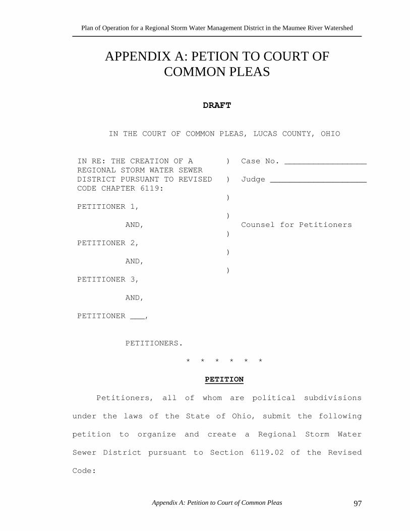
Plan of Operation for a Regional Storm Water Management District in the Maumee River Watershed
Appendix A: Petition to Court of Common Pleas 97
APPENDIX A: PETION TO COURT OF COMMON PLEAS
DRAFT IN THE COURT OF COMMON PLEAS, LUCAS COUNTY, OHIO IN RE: THE CREATION OF A REGIONAL STORM WATER SEWER DISTRICT PURSUANT TO REVISED CODE CHAPTER 6119: PETITIONER 1, AND, PETITIONER 2, AND, PETITIONER 3, AND, PETITIONER ___, PETITIONERS.
) ) ) ) ) ) )
Case No. _________________ Judge ____________________ Counsel for Petitioners
* * * * * * PETITION
Petitioners, all of whom are political subdivisions
under the laws of the State of Ohio, submit the following
petition to organize and create a Regional Storm Water
Sewer District pursuant to Section 6119.02 of the Revised
Code:
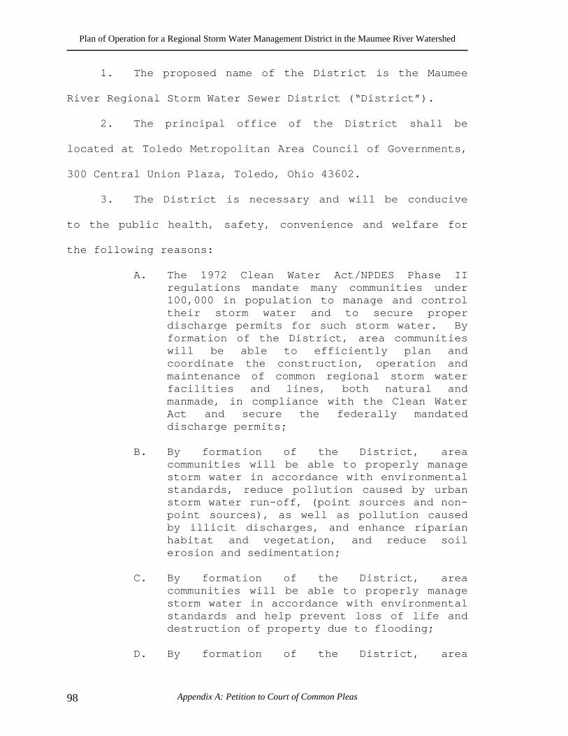
Plan of Operation for a Regional Storm Water Management District in the Maumee River Watershed
Appendix A: Petition to Court of Common Pleas 98
1. The proposed name of the District is the Maumee
River Regional Storm Water Sewer District (“District”).
2. The principal office of the District shall be
located at Toledo Metropolitan Area Council of Governments,
300 Central Union Plaza, Toledo, Ohio 43602.
3. The District is necessary and will be conducive
to the public health, safety, convenience and welfare for
the following reasons:
A. The 1972 Clean Water Act/NPDES Phase II regulations mandate many communities under 100,000 in population to manage and control their storm water and to secure proper discharge permits for such storm water. By formation of the District, area communities will be able to efficiently plan and coordinate the construction, operation and maintenance of common regional storm water facilities and lines, both natural and manmade, in compliance with the Clean Water Act and secure the federally mandated discharge permits;
B. By formation of the District, area
communities will be able to properly manage storm water in accordance with environmental standards, reduce pollution caused by urban storm water run-off, (point sources and non-point sources), as well as pollution caused by illicit discharges, and enhance riparian habitat and vegetation, and reduce soil erosion and sedimentation;
C. By formation of the District, area
communities will be able to properly manage storm water in accordance with environmental standards and help prevent loss of life and destruction of property due to flooding;
D. By formation of the District, area
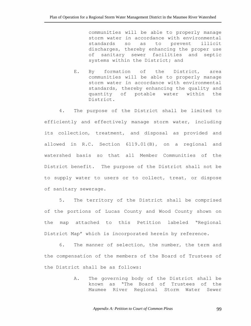
Plan of Operation for a Regional Storm Water Management District in the Maumee River Watershed
Appendix A: Petition to Court of Common Pleas 99
communities will be able to properly manage storm water in accordance with environmental standards so as to prevent illicit discharges, thereby enhancing the proper use of sanitary sewer facilities and septic systems within the District; and
E. By formation of the District, area
communities will be able to properly manage storm water in accordance with environmental standards, thereby enhancing the quality and quantity of potable water within the District.
4. The purpose of the District shall be limited to
efficiently and effectively manage storm water, including
its collection, treatment, and disposal as provided and
allowed in R.C. Section 6119.01(B), on a regional and
watershed basis so that all Member Communities of the
District benefit. The purpose of the District shall not be
to supply water to users or to collect, treat, or dispose
of sanitary sewerage.
5. The territory of the District shall be comprised
of the portions of Lucas County and Wood County shown on
the map attached to this Petition labeled “Regional
District Map” which is incorporated herein by reference.
6. The manner of selection, the number, the term and
the compensation of the members of the Board of Trustees of
the District shall be as follows:
A. The governing body of the District shall be known as “The Board of Trustees of the Maumee River Regional Storm Water Sewer
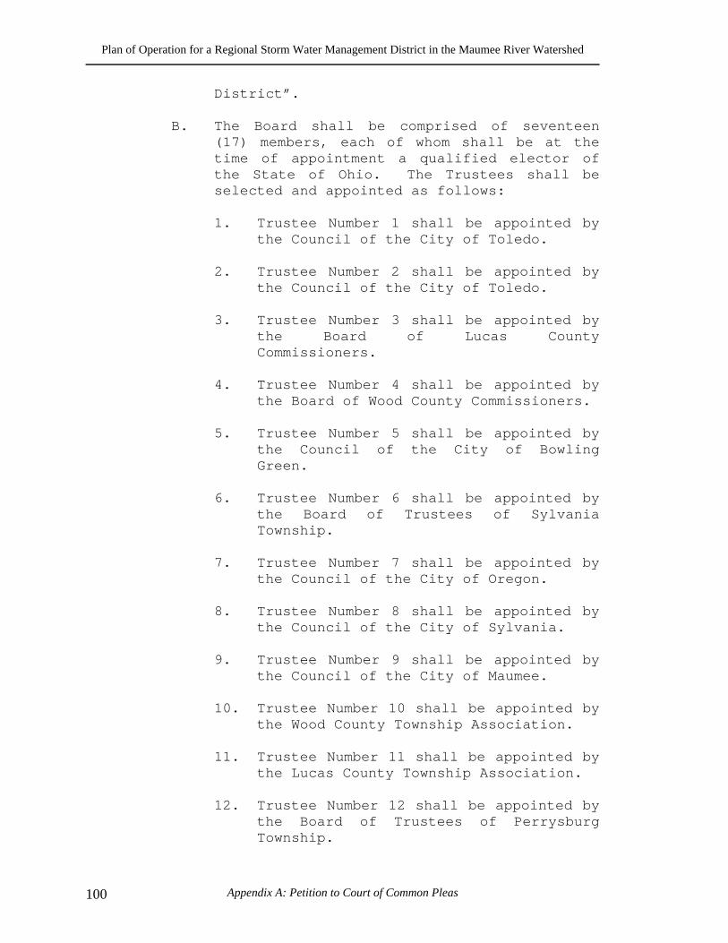
Plan of Operation for a Regional Storm Water Management District in the Maumee River Watershed
Appendix A: Petition to Court of Common Pleas 100
District”.
B. The Board shall be comprised of seventeen (17) members, each of whom shall be at the time of appointment a qualified elector of the State of Ohio. The Trustees shall be selected and appointed as follows:
1. Trustee Number 1 shall be appointed by
the Council of the City of Toledo. 2. Trustee Number 2 shall be appointed by
the Council of the City of Toledo. 3. Trustee Number 3 shall be appointed by
the Board of Lucas County Commissioners.
4. Trustee Number 4 shall be appointed by
the Board of Wood County Commissioners. 5. Trustee Number 5 shall be appointed by
the Council of the City of Bowling Green.
6. Trustee Number 6 shall be appointed by
the Board of Trustees of Sylvania Township.
7. Trustee Number 7 shall be appointed by
the Council of the City of Oregon. 8. Trustee Number 8 shall be appointed by
the Council of the City of Sylvania. 9. Trustee Number 9 shall be appointed by
the Council of the City of Maumee. 10. Trustee Number 10 shall be appointed by
the Wood County Township Association. 11. Trustee Number 11 shall be appointed by
the Lucas County Township Association. 12. Trustee Number 12 shall be appointed by
the Board of Trustees of Perrysburg Township.
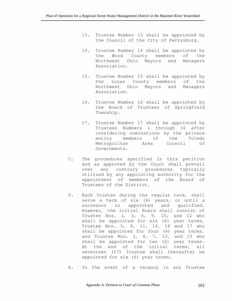
Plan of Operation for a Regional Storm Water Management District in the Maumee River Watershed
Appendix A: Petition to Court of Common Pleas 101
13. Trustee Number 13 shall be appointed by
the Council of the City of Perrysburg. 14. Trustee Number 14 shall be appointed by
the Wood County members of the Northwest Ohio Mayors and Managers Association.
15. Trustee Number 15 shall be appointed by
the Lucas County members of the Northwest Ohio Mayors and Managers Association.
16. Trustee Number 16 shall be appointed by
the Board of Trustees of Springfield Township.
17. Trustee Number 17 shall be appointed by
Trustees Numbers 1 through 16 after considering nominations by the private entity members of the Toledo Metropolitan Area Council of Governments.
C. The procedures specified in this petition
and as approved by the Court shall prevail over any contrary procedures typically utilized by any appointing authority for the appointment of members of the Board of Trustees of the District.
D. Each Trustee during the regular term, shall
serve a term of six (6) years, or until a successor is appointed and qualified. However, the initial Board shall consist of Trustee Nos. 1, 3, 6, 9, 10, and 12 who shall be appointed for six (6) year terms, Trustee Nos. 5, 8, 11, 14, 16 and 17 who shall be appointed for four (4) year terms, and Trustee Nos. 2, 4, 7, 13, and 15 who shall be appointed for two (2) year terms. At the end of the initial terms, all seventeen (17) Trustee shall thereafter be appointed for six (6) year terms.
E. In the event of a vacancy in any Trustee
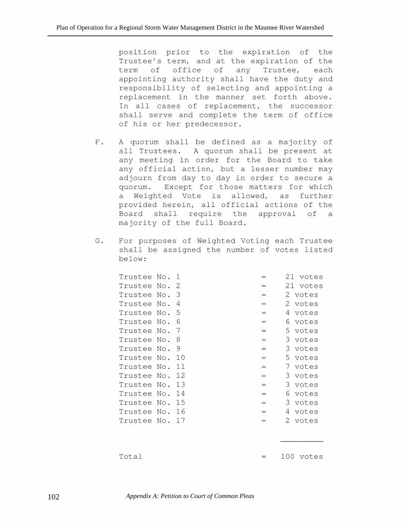
Plan of Operation for a Regional Storm Water Management District in the Maumee River Watershed
Appendix A: Petition to Court of Common Pleas 102
position prior to the expiration of the Trustee’s term, and at the expiration of the term of office of any Trustee, each appointing authority shall have the duty and responsibility of selecting and appointing a replacement in the manner set forth above. In all cases of replacement, the successor shall serve and complete the term of office of his or her predecessor.
F. A quorum shall be defined as a majority of
all Trustees. A quorum shall be present at any meeting in order for the Board to take any official action, but a lesser number may adjourn from day to day in order to secure a quorum. Except for those matters for which a Weighted Vote is allowed, as further provided herein, all official actions of the Board shall require the approval of a majority of the full Board.
G. For purposes of Weighted Voting each Trustee
shall be assigned the number of votes listed below:
Trustee No. 1 = 21 votes Trustee No. 2 = 21 votes Trustee No. 3 = 2 votes Trustee No. 4 = 2 votes Trustee No. 5 = 4 votes Trustee No. 6 = 6 votes Trustee No. 7 = 5 votes Trustee No. 8 = 3 votes Trustee No. 9 = 3 votes Trustee No. 10 = 5 votes Trustee No. 11 = 7 votes Trustee No. 12 = 3 votes Trustee No. 13 = 3 votes Trustee No. 14 = 6 votes Trustee No. 15 = 3 votes Trustee No. 16 = 4 votes Trustee No. 17 = 2 votes
_________
Total = 100 votes
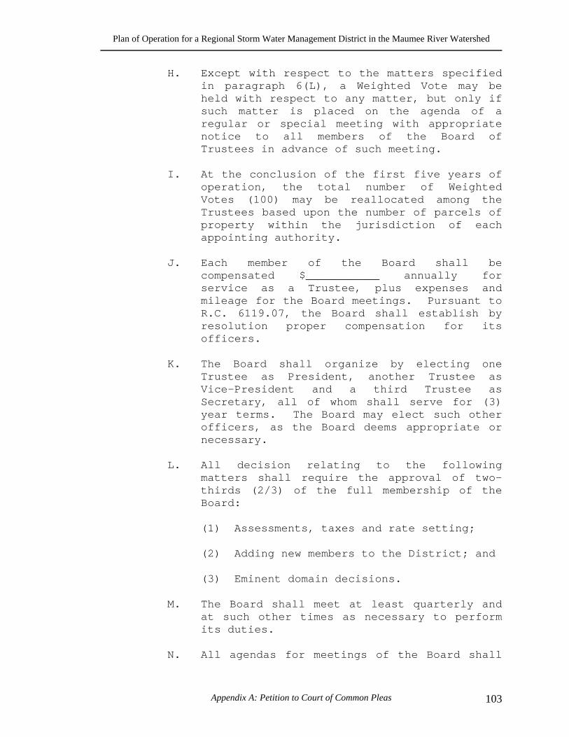
Plan of Operation for a Regional Storm Water Management District in the Maumee River Watershed
Appendix A: Petition to Court of Common Pleas 103
H. Except with respect to the matters specified in paragraph 6(L), a Weighted Vote may be held with respect to any matter, but only if such matter is placed on the agenda of a regular or special meeting with appropriate notice to all members of the Board of Trustees in advance of such meeting.
I. At the conclusion of the first five years of
operation, the total number of Weighted Votes (100) may be reallocated among the Trustees based upon the number of parcels of property within the jurisdiction of each appointing authority.
J. Each member of the Board shall be
compensated $___________ annually for service as a Trustee, plus expenses and mileage for the Board meetings. Pursuant to R.C. 6119.07, the Board shall establish by resolution proper compensation for its officers.
K. The Board shall organize by electing one
Trustee as President, another Trustee as Vice-President and a third Trustee as Secretary, all of whom shall serve for (3) year terms. The Board may elect such other officers, as the Board deems appropriate or necessary.
L. All decision relating to the following
matters shall require the approval of two-thirds (2/3) of the full membership of the Board:
(1) Assessments, taxes and rate setting;
(2) Adding new members to the District; and
(3) Eminent domain decisions.
M. The Board shall meet at least quarterly and
at such other times as necessary to perform its duties.
N. All agendas for meetings of the Board shall
Plan of Operation for a Regional Storm Water Management District in the Maumee River Watershed
Appendix A: Petition to Court of Common Pleas 104
be mailed, faxed or e-mailed to the Trustees at least fifteen (15) days prior to the meeting date. Changes to the agenda shall require the approval of two-thirds (2/3) of the full Board.
O. No member community shall pay more than 45%
of the annual budget to manage and operate the District.
P. A Weighted Vote shall be required to modify
the cost of service allocation base described in the District’s approved Plan for operation of the District.
7. Unless excluded pursuant to the Court’s final
order organizing the District, every township and
municipality (to include cities and villages) within Lucas
County and Wood County, together with the Boards of
Commissioners of Lucas and Wood Counties, shall be deemed
Member Communities of the District, and the District shall
have the authority to exercise its powers within the
geographical area constituting the District in accordance
with law.
8. No Member Community may withdraw from the
District during the first three years of the District’s
existence. After the third year of the District’s
existence, a Member Community may withdraw from the
District by ordinance or resolution adopted by the Member
Community’s legislative authority, which shall provide at
least twelve (12) months notice to the Board of Trustees of
Plan of Operation for a Regional Storm Water Management District in the Maumee River Watershed
Appendix A: Petition to Court of Common Pleas 105
the District of the Member Community’s withdrawal. During
the twelve (12) month period following the Board’s receipt
of the notice of withdrawal, the Board and the Member
Community shall determine any appropriate terms and
conditions of the Member Community’s withdrawal.
9. The plan for financing the costs of operation of
said District prior to receipt of revenues from its
operation is as follows:
A. Grants and loans from the United States Environmental Protection Agency, the Ohio Water Development Authority (“OWDA”), the Ohio Environmental Protection Agency (“OEPA”), or any other federal, state or local governmental agency;
B. The issuance of a promissory note(s) in
anticipation of the issuance of bonds, as provided in Chapter 6119 of the Revised Code; and/or
C. Advances or interest-bearing loans from the
any Member Community, pursuant to R.C. Section 505.705 and R.C. Section 6119.04 and with a predetermined rate of interest.
WHEREFORE, the Petitioners pray that the Court grant
the following relief:
1. Pursuant to R.C. Section 6119.02(C), determine
that this Petition complies with the
requirements of that Section as to form and
content.
2. Pursuant to R.C. Section 6119.03, provide
Plan of Operation for a Regional Storm Water Management District in the Maumee River Watershed
Appendix A: Petition to Court of Common Pleas 106
notice to the Court of Common Pleas of Wood
County, Ohio of the time and place of the first
meeting of the Court, which Court shall be
composed of a judge from each of the Courts of
Common Pleas of Lucas and Wood counties.
3. Pursuant to R.C. Section 6119.04, fix a time
and place for the final hearing on this
petition for the organization and establishment
of “The Maumee Regional Storm Water Sewer
District”, which final hearing is to be held
not later than sixty (60) days after the
Court’s first meeting.
4. Pursuant to R.C. Section 6119.04, direct the
Clerk to publish notice of the final hearing in
newspapers of general circulation in Lucas and
Wood counties once a week for four consecutive
weeks, and to send notice of the hearing by
certified mail to the State of Ohio Director of
Environmental Protection.
5. Pursuant to R.C. Section 6119.04(D), upon final
hearing on the petition, find that the
organization of the District is necessary, and
that it and the plan for the operation of the
District are conducive to the public health,
Plan of Operation for a Regional Storm Water Management District in the Maumee River Watershed
Appendix A: Petition to Court of Common Pleas 107
safety, convenience, and welfare, and that the
plan for the operation of the District is
economical, feasible, fair, and reasonable, and
further declare that the District is finally
and completely organized as a political
subdivision.
6. Grant such other and further relief as is
proper under the circumstances.
Respectfully submitted, ___________________________ Counsel for Petitioners PETITIONERS: PETITIONER 1, OHIO, PURSUANT TO RESOLUTION NO. ______ ADOPTED __________, 2001 (COPY ATTACHED) By:_______________________ PETITIONER 2, OHIO, PURSUANT TO RESOLUTION NO. _____ ADOPTED _____________, 2001 (COPY ATTACHED) By:_______________________
Plan of Operation for a Regional Storm Water Management District in the Maumee River Watershed
Appendix A: Petition to Court of Common Pleas 108
PETITIONER 3, OHIO, PURSUANT TO RESOLUTION NO._________ ADOPTED ____________, 2001 (COPY ATTACHED) By:_______________________ PETITIONER ___, OHIO, PURSUANT TO RESOLUTION NO._________ ADOPTED ____________, 2001 (COPY ATTACHED) By:_______________________
This document was created with Win2PDF available at http://www.daneprairie.com.The unregistered version of Win2PDF is for evaluation or non-commercial use only.