Embed Size (px)
Citation preview
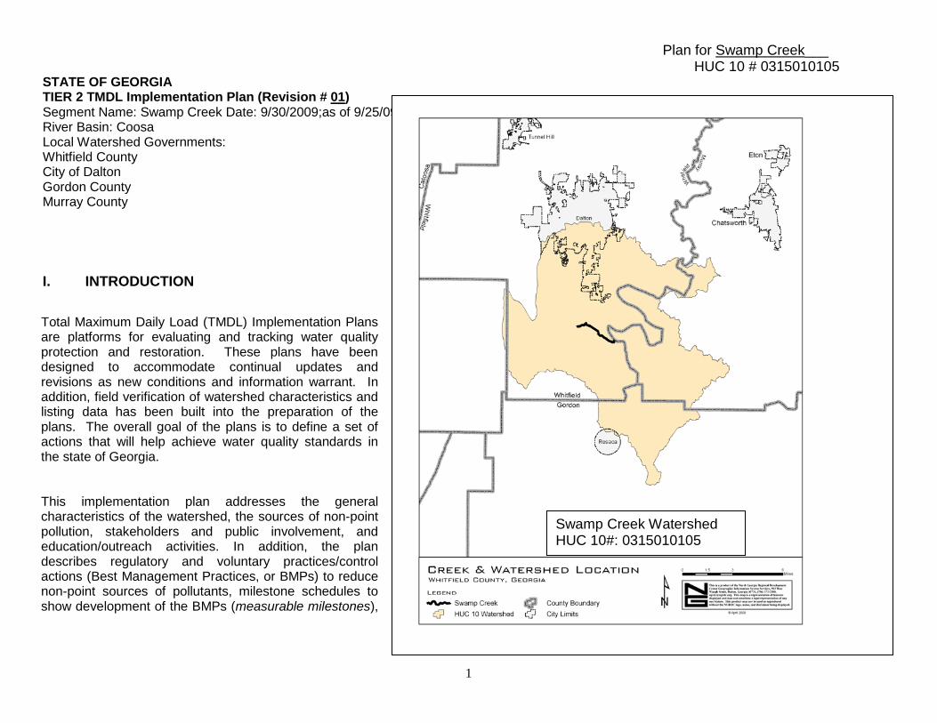
Plan for Swamp Creek___ HUC 10 # 0315010105
1
STATE OF GEORGIA TIER 2 TMDL Implementation Plan (Revision # 01) Segment Name: Swamp Creek Date: 9/30/2009;as of 9/25/09 River Basin: Coosa Local Watershed Governments: Whitfield County City of Dalton Gordon County Murray County I. INTRODUCTION
Total Maximum Daily Load (TMDL) Implementation Plans are platforms for evaluating and tracking water quality protection and restoration. These plans have been designed to accommodate continual updates and revisions as new conditions and information warrant. In addition, field verification of watershed characteristics and listing data has been built into the preparation of the plans. The overall goal of the plans is to define a set of actions that will help achieve water quality standards in the state of Georgia. This implementation plan addresses the general characteristics of the watershed, the sources of non-point pollution, stakeholders and public involvement, and education/outreach activities. In addition, the plan describes regulatory and voluntary practices/control actions (Best Management Practices, or BMPs) to reduce non-point sources of pollutants, milestone schedules to show development of the BMPs (measurable milestones),
Swamp Creek Watershed HUC 10#: 0315010105
Plan for Swamp Creek___ HUC 10 # 0315010105
2
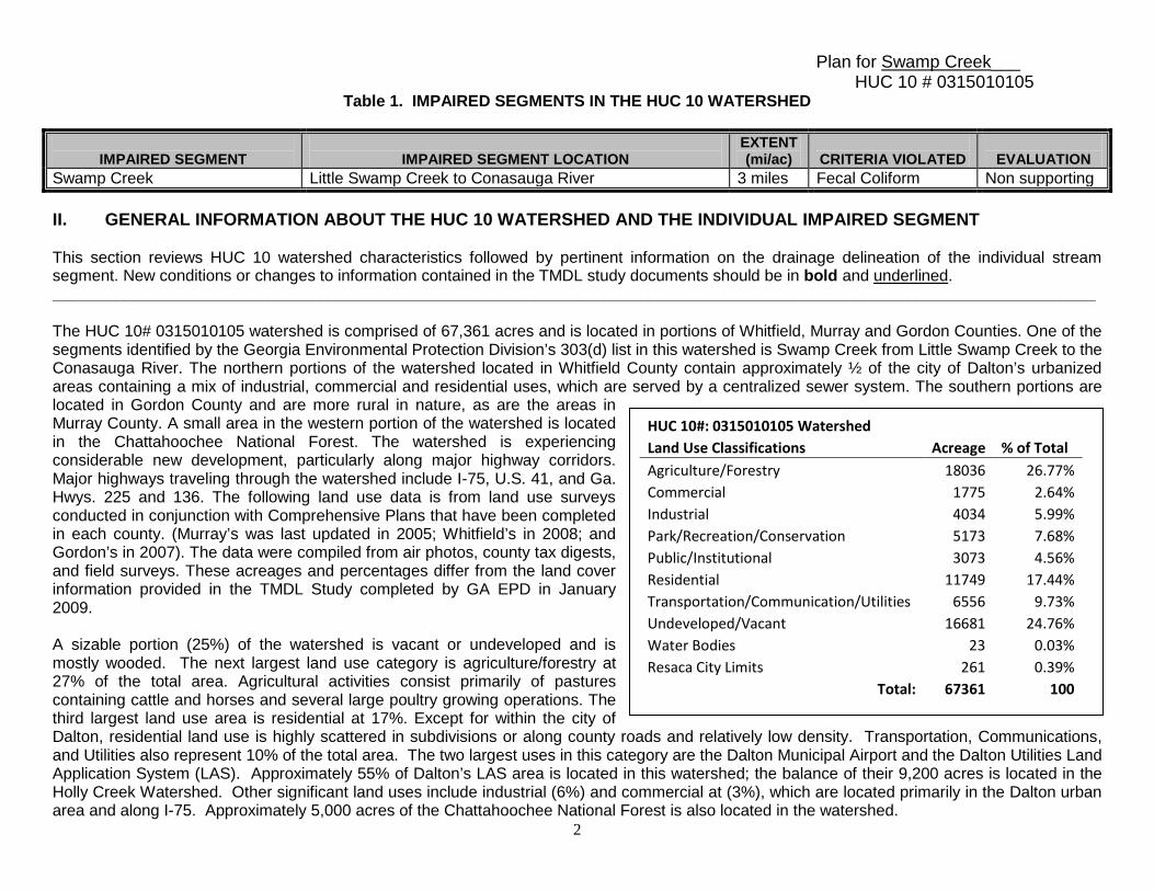
Table 1. IMPAIRED SEGMENTS IN THE HUC 10 WATERSHED
IMPAIRED SEGMENT
IMPAIRED SEGMENT LOCATION
EXTENT (mi/ac)
CRITERIA VIOLATED
EVALUATION
Swamp Creek Little Swamp Creek to Conasauga River 3 miles Fecal Coliform Non supporting II. GENERAL INFORMATION ABOUT THE HUC 10 WATERSHED AND THE INDIVIDUAL IMPAIRED SEGMENT This section reviews HUC 10 watershed characteristics followed by pertinent information on the drainage delineation of the individual stream segment. New conditions or changes to information contained in the TMDL study documents should be in bold and underlined. _____________________________________________________________________________________________________________________ The HUC 10# 0315010105 watershed is comprised of 67,361 acres and is located in portions of Whitfield, Murray and Gordon Counties. One of the segments identified by the Georgia Environmental Protection Division’s 303(d) list in this watershed is Swamp Creek from Little Swamp Creek to the Conasauga River. The northern portions of the watershed located in Whitfield County contain approximately ½ of the city of Dalton’s urbanized areas containing a mix of industrial, commercial and residential uses, which are served by a centralized sewer system. The southern portions are located in Gordon County and are more rural in nature, as are the areas in Murray County. A small area in the western portion of the watershed is located in the Chattahoochee National Forest. The watershed is experiencing considerable new development, particularly along major highway corridors. Major highways traveling through the watershed include I-75, U.S. 41, and Ga. Hwys. 225 and 136. The following land use data is from land use surveys conducted in conjunction with Comprehensive Plans that have been completed in each county. (Murray’s was last updated in 2005; Whitfield’s in 2008; and Gordon’s in 2007). The data were compiled from air photos, county tax digests, and field surveys. These acreages and percentages differ from the land cover information provided in the TMDL Study completed by GA EPD in January 2009. A sizable portion (25%) of the watershed is vacant or undeveloped and is mostly wooded. The next largest land use category is agriculture/forestry at 27% of the total area. Agricultural activities consist primarily of pastures containing cattle and horses and several large poultry growing operations. The third largest land use area is residential at 17%. Except for within the city of Dalton, residential land use is highly scattered in subdivisions or along county roads and relatively low density. Transportation, Communications, and Utilities also represent 10% of the total area. The two largest uses in this category are the Dalton Municipal Airport and the Dalton Utilities Land Application System (LAS). Approximately 55% of Dalton’s LAS area is located in this watershed; the balance of their 9,200 acres is located in the Holly Creek Watershed. Other significant land uses include industrial (6%) and commercial at (3%), which are located primarily in the Dalton urban area and along I-75. Approximately 5,000 acres of the Chattahoochee National Forest is also located in the watershed.
HUC 10#: 0315010105 Watershed Land Use Classifications Acreage % of Total
Agriculture/Forestry 18036 26.77% Commercial 1775 2.64% Industrial 4034 5.99% Park/Recreation/Conservation 5173 7.68% Public/Institutional 3073 4.56% Residential 11749 17.44% Transportation/Communication/Utilities 6556 9.73% Undeveloped/Vacant 16681 24.76% Water Bodies 23 0.03% Resaca City Limits 261 0.39%
Total: 67361 100
Plan for Swamp Creek___ HUC 10 # 0315010105
3
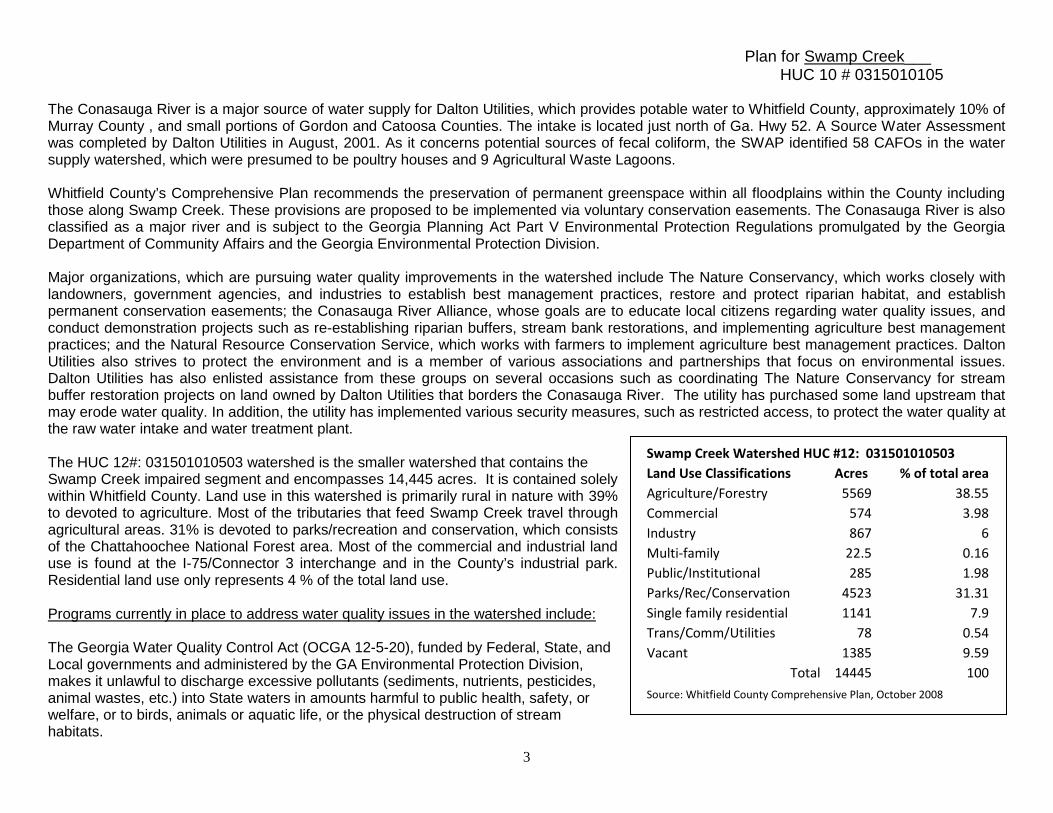
The Conasauga River is a major source of water supply for Dalton Utilities, which provides potable water to Whitfield County, approximately 10% of Murray County , and small portions of Gordon and Catoosa Counties. The intake is located just north of Ga. Hwy 52. A Source Water Assessment was completed by Dalton Utilities in August, 2001. As it concerns potential sources of fecal coliform, the SWAP identified 58 CAFOs in the water supply watershed, which were presumed to be poultry houses and 9 Agricultural Waste Lagoons. Whitfield County’s Comprehensive Plan recommends the preservation of permanent greenspace within all floodplains within the County including those along Swamp Creek. These provisions are proposed to be implemented via voluntary conservation easements. The Conasauga River is also classified as a major river and is subject to the Georgia Planning Act Part V Environmental Protection Regulations promulgated by the Georgia Department of Community Affairs and the Georgia Environmental Protection Division. Major organizations, which are pursuing water quality improvements in the watershed include The Nature Conservancy, which works closely with landowners, government agencies, and industries to establish best management practices, restore and protect riparian habitat, and establish permanent conservation easements; the Conasauga River Alliance, whose goals are to educate local citizens regarding water quality issues, and conduct demonstration projects such as re-establishing riparian buffers, stream bank restorations, and implementing agriculture best management practices; and the Natural Resource Conservation Service, which works with farmers to implement agriculture best management practices. Dalton Utilities also strives to protect the environment and is a member of various associations and partnerships that focus on environmental issues. Dalton Utilities has also enlisted assistance from these groups on several occasions such as coordinating The Nature Conservancy for stream buffer restoration projects on land owned by Dalton Utilities that borders the Conasauga River. The utility has purchased some land upstream that may erode water quality. In addition, the utility has implemented various security measures, such as restricted access, to protect the water quality at the raw water intake and water treatment plant. The HUC 12#: 031501010503 watershed is the smaller watershed that contains the Swamp Creek impaired segment and encompasses 14,445 acres. It is contained solely within Whitfield County. Land use in this watershed is primarily rural in nature with 39% to devoted to agriculture. Most of the tributaries that feed Swamp Creek travel through agricultural areas. 31% is devoted to parks/recreation and conservation, which consists of the Chattahoochee National Forest area. Most of the commercial and industrial land use is found at the I-75/Connector 3 interchange and in the County’s industrial park. Residential land use only represents 4 % of the total land use. Programs currently in place to address water quality issues in the watershed include: The Georgia Water Quality Control Act (OCGA 12-5-20), funded by Federal, State, and Local governments and administered by the GA Environmental Protection Division, makes it unlawful to discharge excessive pollutants (sediments, nutrients, pesticides, animal wastes, etc.) into State waters in amounts harmful to public health, safety, or welfare, or to birds, animals or aquatic life, or the physical destruction of stream habitats.
Swamp Creek Watershed HUC #12: 031501010503 Land Use Classifications Acres % of total area Agriculture/Forestry 5569 38.55 Commercial 574 3.98 Industry 867 6 Multi-family 22.5 0.16 Public/Institutional 285 1.98 Parks/Rec/Conservation 4523 31.31 Single family residential 1141 7.9 Trans/Comm/Utilities 78 0.54 Vacant 1385 9.59
Total 14445 100 Source: Whitfield County Comprehensive Plan, October 2008
Plan for Swamp Creek___ HUC 10 # 0315010105
4
Whitfield County Environmental Health Office’s Rules and Regulations for On-site Wastewater Management are administered by Local county government and Georgia Department of Human Resources. The Georgia Rules and Regulations for Water Quality Control, Chapter 391—3-6-20 & 21 for CAFOs 301 to 1,000 animal units, administered by the GA Department of Agriculture and the GA Environmental Protection Division outlines the swine and non-swine feeding operation permit requirements for Concentrated Animal Feeding Operations (CAFOs) with more than 300 animal units. CAFOs of more than 300 but equal to or less than 1,000 animal units receive a land application system (LAS) permit. Larger CAFOs with more than 1,000 animal units must obtain a NPDES permit from EPD. The National Pollution Discharge Elimination System (NPDES) Permit Regulations for CAFOs over 1,000 animal units, administered by the U.S. Environmental Protection Agency & GA Environmental Protection Division is a permitting program created to protect and improve water quality by regulating Concentrated Animal Feeding Operations (CAFOs) and providing minimum permit requirements for CAFOs of more than 1,000 animal units. Dalton Utilities’ Sanitary Sewer Maintenance Program, which conducts sanitary sewer system inventories and inspections; infiltration and inflow identification and reduction; and sewer line and manhole rehabilitation. According to the 2009 TMDL Evaluation for Twenty-Nine Stream Segments in the Coosa River Basin for Fecal Coliform, 7.4% of the Swamp Creek watershed is in the MS4 area (Table 6, p.14); none of the landfills listed in Table 25, p.25 is in the HUC 12, and none of the Dalton Utilities’ LAS impacts the HUC 12.
III. CAUSES AND SOURCES OF SEGMENT IMPAIRMENT(S) LISTED IN TMDLs Table 2. provides information contained in the current TMDL for the impaired water body. By definition, “wasteload allocations” (WLA) for municipal and industrial wastewater discharges and (WLAsw) for storm water outfalls are established in permitted areas, while “load allocations” (LA) are established for non-point sources of pollution. Wasteload allocations are assigned by Georgia EPD during the NPDES permitting process and are not part of the TMDL implementation planning process, which deals solely with non-point sources of pollutants.
Table 2. WASTE LOAD AND LOAD ALLOCATIONS AND TMDLS FOR THE IMPAIRED SEGMENT
STREAM SEGMENT
NAME
LOCATION
CRITERIA VIOLATED
WLA
WLAsw
LA
TMDL
Swamp Creek Little Swamp Creek to Conasauga River
Fecal Coliform 2.96E+10 3.63E+12 4.06E+11
Table 3. contains information presented in the TMDL study that this implementation plan addresses.
Plan for Swamp Creek___ HUC 10 # 0315010105
5
Table 3. POTENTIAL NON-POINT SOURCES OF IMPAIRMENT INDICATED IN THE TMDLs
CRITERA VIOLATED :______
WQ STANDARD
SOURCES OF IMPAIRMENT
NEEDED % REDUCTION (FROM THE TMDL)
Fecal collform 200 counts per 100 milliliters during May - October ; 1000 counts per 100 milliliters during November - April
Failing Septic Systems ; Agricultural operations (cattle, poultry,other) ; wildlife ; urban development ; land application systems ; landfills
49%
IV. IDENTIFICATION AND RANKING OF POTENTIAL NON-POINT SOURCES OF IMPAIRMENT This section identifies and describes in order of importance, as determined through this TMDL implementation planning process, the extent and relative contributions from historic as well as current potential non-point sources of pollutants to the water quality impairment. The comments below are based, in part, on observations made during the course of a visual field survey undertaken on May 21, 2009. The report of observations and conclusions can be found in Appendix C.
1) Wildlife: 1,385 acres in HUC 12 are classified as undeveloped/vacant, and are very likely wooded, to judge from aerial views. That figure represents 9.59% of the land mass. In addition, 4,523 acres of the HUC 12, some 31.31% of the land, are identified as park, recreation, and conservation land, most of which is in the Chattahoochee National Forest. Moreover, the land use data available for Whitfield County does not separate forestry from agriculture, so it is safe to say that wildlife occupy in excess of 37.3% of the watershed. In the HUC 12, the visual survey noted extensive wetland areas, suggesting a large amount of water fowl, along with beavers, muskrats, raccoons, and species of mammals that are found in and near aquatic environments. Land dwelling species, such as deer (25/square mile according to DNR), spend considerable time away from the water and, though their vegetated/forested habitats have a buffering effect on streams, they certainly contribute to the fecal coliform load.
2) Agricultural uses and activities: There are 5,569 acres of agricultural/forest land in the HUC 12, accounting for 38.55% of land use there. While the land use data for Whitfield County does not separate agriculture from forestry, the visual survey indicates that much of the agricultural land appears to be dedicated to grazing cattle and horses. The 2007 agricultural census estimates from USDA indicate that there are 5,672 head of beef cattle and 27 head of dairy cows throughout Whitfield County. Comparison of these statistics with earlier figures suggest that the number of cattle has dramatically decreased since 2001, but existing herds often have direct access to streams, and can foul the water. The visual survey identified chicken houses in the HUC, and the 2007 agricultural census estimates from USDA indicate that there are 23,932,550 broilers and 240,295 laying hens in the County. Agricultural run-off is a likely source of fecal coliform in Swamp Creek.
3) Urban development/run-off: 2,008 acres of the HUC 12 watershed (8.06%) are in residential use, 574 acres (3.98%) are in commercial use, and 867 (6%) acres are in industrial use. Since other land use categories available from the data may be either urban or rural, it is safe to say
Plan for Swamp Creek___ HUC 10 # 0315010105
6
that the urban environment exceeds the 18% accounted for by the categories listed above. However, it is very difficult to quantify urban run-off, and the fecal coliform component would most likely originate from domestic animals, and un-noticed sewer leaks. There is little to suggest that contamination is originating in commercial and industrial areas, though dumpsters can harbor wildlife, and contain trash contaminated with fecal coliform.
4) Failing Septic Systems: The Whitfield County Environmental Health Office reported that it issued 131 new septic system permits and 99
repair permits county-wide during FY-09. This contrasts sharply with the figures for FY-2000 when it issued 524 new septic system permits and 86 repair permits county-wide, and reflects the down-turn in the carpet industry. During the ten year period from FY-99 to FY-09, the Environmental Health Office issued 3,375 new system permits, and 1,455 repair permits county-wide. That is to say that, during that period, 30% of permits issued were for repairs. Given that 8.06 % of the HUC 12 is in residential use, a 30% overall septic system failure rate suggests that malfunctioning systems could account for some fecal coliform in Swamp Creek, though not a huge proportion of the total.
5) Wastewater Treatment and collection facilities: According to the 2009 TMDL Evaluation for Twenty-Nine Stream Segments in the Coosa
River Basin for Fecal Coliform, 7.4% of the Swamp Creek watershed is in the MS4 area (Table 6, p.14); None of the landfills listed in Table 25, p.25 is in the HUC 12, and none of the Dalton Utilities’ LAS impacts the HUC 12.
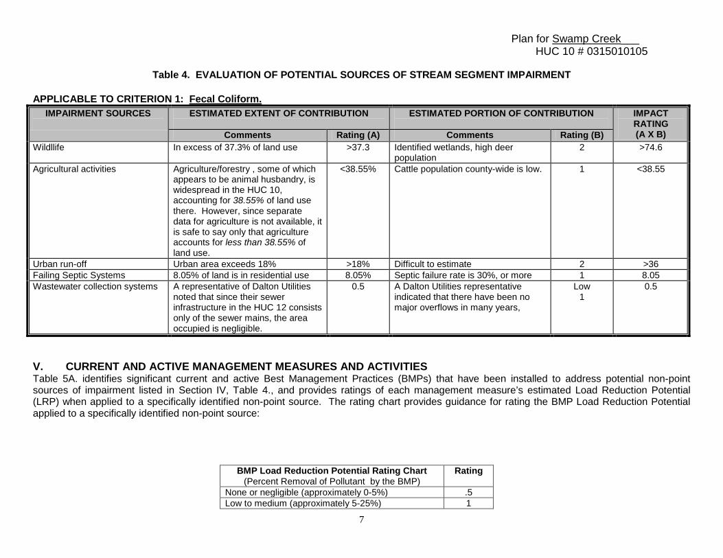
Table 4. offers a simple format to rank in order of importance, as determined through this TMDL implementation planning process, the extent and relative contribution to the water quality impairment from all the potential non-point sources of pollution identified in Section IV. A “rating scale” of 0.5 to 5 has been developed to rank the sources. The rating chart provides guidance for rating the estimated extent (Rating A) and portion of the contribution (Rating B) from each potential non-point source and cause:
Rating A: Rating Chart to Estimate Geographic Extent of the Source
or Cause in the Contributing Watershed
Rating B: Rating Chart to Estimate Portion of Contribution from the
Source to the Pollutant Load Causing the Impairment
Rating
None or negligible (approximately 0-5%) None or negligible (approximately 0-5%) 0.5 Scattered or low (approximately 5-20%) Scattered or low (approximately 5-20%) 1 Medium (approximately 20-50%) Medium (approximately 20-50%) 3 Widespread or high (approximately 50% or more) Widespread or high (approximately 50% or more) 5 Unknown Unknown UNK
Plan for Swamp Creek___ HUC 10 # 0315010105
7
Table 4. EVALUATION OF POTENTIAL SOURCES OF STREAM SEGMENT IMPAIRMENT
APPLICABLE TO CRITERION 1: Fecal Coliform.
IMPAIRMENT SOURCES
ESTIMATED EXTENT OF CONTRIBUTION
ESTIMATED PORTION OF CONTRIBUTION
IMPACT RATING (A X B) Comments Rating (A) Comments Rating (B)
Wildllife In excess of 37.3% of land use >37.3 Identified wetlands, high deer population
2 >74.6
Agricultural activities Agriculture/forestry , some of which appears to be animal husbandry, is widespread in the HUC 10, accounting for 38.55% of land use there. However, since separate data for agriculture is not available, it is safe to say only that agriculture accounts for less than 38.55% of land use.
<38.55% Cattle population county-wide is low. 1 <38.55
Urban run-off Urban area exceeds 18% >18% Difficult to estimate 2 >36 Failing Septic Systems 8.05% of land is in residential use 8.05% Septic failure rate is 30%, or more 1 8.05 Wastewater collection systems A representative of Dalton Utilities
noted that since their sewer infrastructure in the HUC 12 consists only of the sewer mains, the area occupied is negligible.
0.5 A Dalton Utilities representative indicated that there have been no major overflows in many years,
Low 1
0.5
V. CURRENT AND ACTIVE MANAGEMENT MEASURES AND ACTIVITIES Table 5A. identifies significant current and active Best Management Practices (BMPs) that have been installed to address potential non-point sources of impairment listed in Section IV, Table 4., and provides ratings of each management measure’s estimated Load Reduction Potential (LRP) when applied to a specifically identified non-point source. The rating chart provides guidance for rating the BMP Load Reduction Potential applied to a specifically identified non-point source:
BMP Load Reduction Potential Rating Chart (Percent Removal of Pollutant by the BMP)
Rating
None or negligible (approximately 0-5%) .5 Low to medium (approximately 5-25%) 1

Plan for Swamp Creek___ HUC 10 # 0315010105
8
Medium to High (approximately 25-75%) 3 High (approximately 75% or more) 5 Unknown UNK
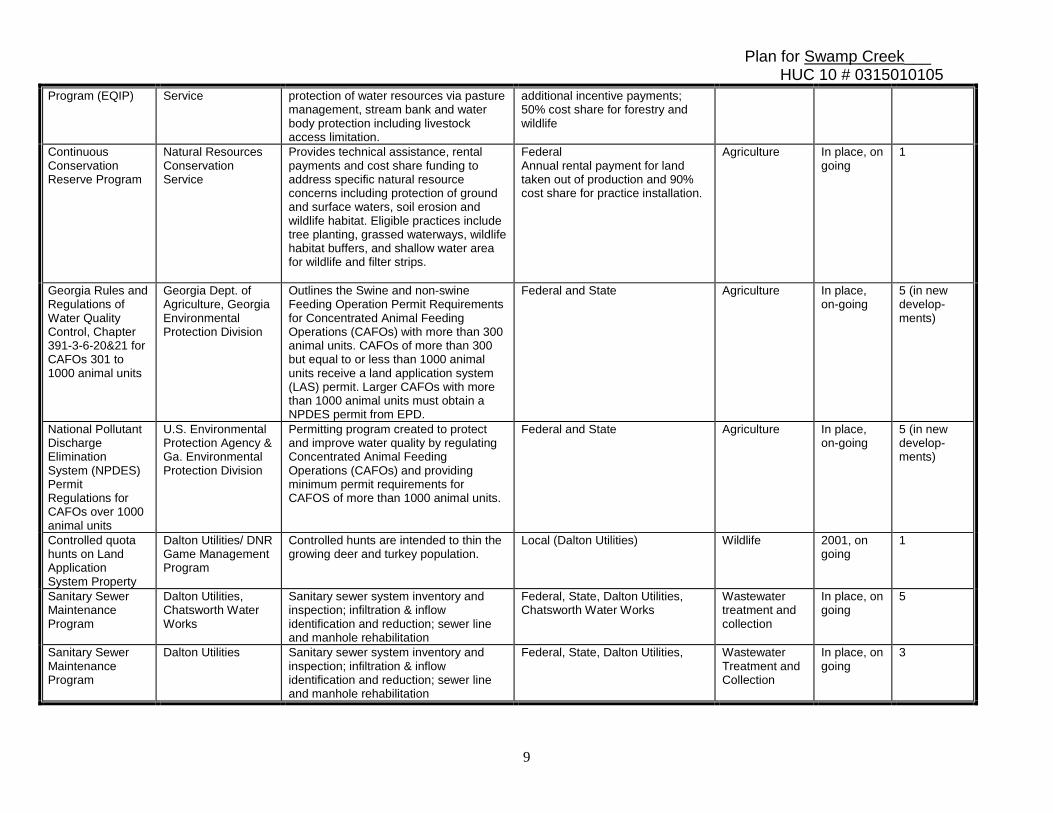
Table 5A. CURRENT AND ACTIVE MANAGEMENT MEASURES AND ACTIVITIES
Table 5A. MANAGEMENT MEASURES AND ACTIVITIES
MEASURES APPLICABLE TO SPECIFIC PARAMETER: __Fecal Coliform Bacteria_.
BMP’s (1)
RESPONSIBILITY (2)
DESCRIPTION OF MEASURES (3)
FUNDING & RESOURCES (4)
IMPAIRMENT SOURCES
(5)
DATE (6)
BMP LRP RATING
(7) Georgia Water Quality Control Act (OCGA 12-5-20)
Ga. Environmental Protection Division
Makes it unlawful to discharge excessive pollutants (sediments, nutrients, pesticides, animal wastes, etc.) into waters of the State in amounts harmful to public health, safety, or welfare, or to animals, birds, or aquatic life or the physical destruction of stream habitats
Federal, State, Local Governments Wastewater treatment and collection
On-going 5
Rules and Regulations for On-site Wastewater Management
Murray County Board of Health, Environmental Health Office
Stringent application/enforcement of the regulations
Local county government/ State Department of Human Resources
Wastewater treatment and collection
In place; on-going
5 (in new develop-ment)
Septic System Repair Assistance Program
Conasauga River Alliance.
Administer State/Federal grants to cost/share with land owners the repair of failing systems or install new systems to replace straight pipes
Section 319(h) Grant through Ga. Environmental Protection Division (from 25% to 75% match on sliding schedule based on proximity to impaired stream)
Failing septic systems
1/1/2007 through 9/30/2011
5
Agriculture BMP Installation Assistance Program
Conasauga River Alliance
Administer State/Federal grants to cost/share with land owners the installation of agriculture BMPs (pasture management, fencing along streams, alternative water supplies for cattle, poultry manure stack houses, etc.
Section 319(h) Grant through Ga. Environmental Protection Division (60% grant/40% match)
Agriculture 1/1/2007 through 6./30/2010
5
Environmental Quality Incentives
Natural Resources Conservation
Voluntary program that provides technical and cost share assistance for
Federal (Farm Bill 2002) 75% cropland cost share with possible
Agriculture In place, on-going
3
Plan for Swamp Creek___ HUC 10 # 0315010105
9
Program (EQIP) Service protection of water resources via pasture management, stream bank and water body protection including livestock access limitation.
additional incentive payments; 50% cost share for forestry and wildlife
Continuous Conservation Reserve Program
Natural Resources Conservation Service
Provides technical assistance, rental payments and cost share funding to address specific natural resource concerns including protection of ground and surface waters, soil erosion and wildlife habitat. Eligible practices include tree planting, grassed waterways, wildlife habitat buffers, and shallow water area for wildlife and filter strips.
Federal Annual rental payment for land taken out of production and 90% cost share for practice installation.
Agriculture In place, on going
1
Georgia Rules and Regulations of Water Quality Control, Chapter 391-3-6-20&21 for CAFOs 301 to 1000 animal units
Georgia Dept. of Agriculture, Georgia Environmental Protection Division
Outlines the Swine and non-swine Feeding Operation Permit Requirements for Concentrated Animal Feeding Operations (CAFOs) with more than 300 animal units. CAFOs of more than 300 but equal to or less than 1000 animal units receive a land application system (LAS) permit. Larger CAFOs with more than 1000 animal units must obtain a NPDES permit from EPD.
Federal and State Agriculture In place, on-going
5 (in new develop-ments)
National Pollutant Discharge Elimination System (NPDES) Permit Regulations for CAFOs over 1000 animal units
U.S. Environmental Protection Agency & Ga. Environmental Protection Division
Permitting program created to protect and improve water quality by regulating Concentrated Animal Feeding Operations (CAFOs) and providing minimum permit requirements for CAFOS of more than 1000 animal units.
Federal and State Agriculture In place, on-going
5 (in new develop-ments)
Controlled quota hunts on Land Application System Property
Dalton Utilities/ DNR Game Management Program
Controlled hunts are intended to thin the growing deer and turkey population.
Local (Dalton Utilities) Wildlife 2001, on going
1
Sanitary Sewer Maintenance Program
Dalton Utilities, Chatsworth Water Works
Sanitary sewer system inventory and inspection; infiltration & inflow identification and reduction; sewer line and manhole rehabilitation
Federal, State, Dalton Utilities, Chatsworth Water Works
Wastewater treatment and collection
In place, on going
5
Sanitary Sewer Maintenance Program
Dalton Utilities Sanitary sewer system inventory and inspection; infiltration & inflow identification and reduction; sewer line and manhole rehabilitation
Federal, State, Dalton Utilities, Wastewater Treatment and Collection
In place, on going
3
Plan for Swamp Creek___ HUC 10 # 0315010105
10
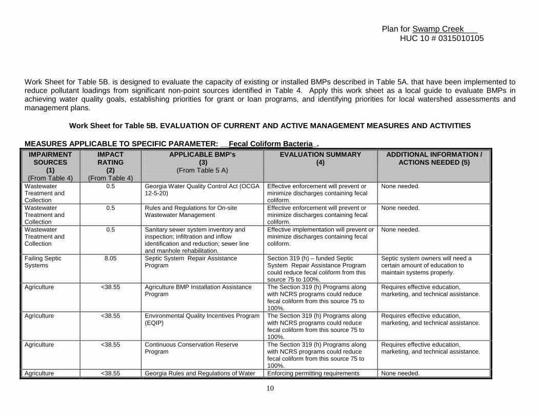
Work Sheet for Table 5B. is designed to evaluate the capacity of existing or installed BMPs described in Table 5A. that have been implemented to reduce pollutant loadings from significant non-point sources identified in Table 4. Apply this work sheet as a local guide to evaluate BMPs in achieving water quality goals, establishing priorities for grant or loan programs, and identifying priorities for local watershed assessments and management plans.
Work Sheet for Table 5B. EVALUATION OF CURRENT AND ACTIVE MANAGEMENT MEASURES AND ACTIVITIES MEASURES APPLICABLE TO SPECIFIC PARAMETER: __Fecal Coliform Bacteria_.
IMPAIRMENT SOURCES
(1) (From Table 4)
IMPACT RATING
(2) (From Table 4)
APPLICABLE BMP’s (3)
(From Table 5 A)
EVALUATION SUMMARY (4)
ADDITIONAL INFORMATION / ACTIONS NEEDED (5)
Wastewater Treatment and Collection
0.5 Georgia Water Quality Control Act (OCGA 12-5-20)
Effective enforcement will prevent or minimize discharges containing fecal coliform.
None needed.
Wastewater Treatment and Collection
0.5 Rules and Regulations for On-site Wastewater Management
Effective enforcement will prevent or minimize discharges containing fecal coliform.
None needed.
Wastewater Treatment and Collection
0.5 Sanitary sewer system inventory and inspection; infiltration and inflow identification and reduction; sewer line and manhole rehabilitation.
Effective implementation will prevent or minimize discharges containing fecal coliform.
None needed.
Failing Septic Systems
8.05 Septic System Repair Assistance Program
Section 319 (h) – funded Septic System Repair Assistance Program could reduce fecal coliform from this source 75 to 100%.
Septic system owners will need a certain amount of education to maintain systems properly.
Agriculture <38.55 Agriculture BMP Installation Assistance Program
The Section 319 (h) Programs along with NCRS programs could reduce fecal coliform from this source 75 to 100%.
Requires effective education, marketing, and technical assistance.
Agriculture <38.55 Environmental Quality Incentives Program (EQIP)
The Section 319 (h) Programs along with NCRS programs could reduce fecal coliform from this source 75 to 100%.
Requires effective education, marketing, and technical assistance.
Agriculture <38.55 Continuous Conservation Reserve Program
The Section 319 (h) Programs along with NCRS programs could reduce fecal coliform from this source 75 to 100%.
Requires effective education, marketing, and technical assistance.
Agriculture <38.55 Georgia Rules and Regulations of Water Enforcing permitting requirements None needed.
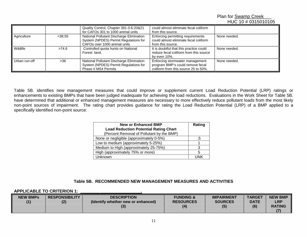
Plan for Swamp Creek___ HUC 10 # 0315010105
11
Quality Control, Chapter 391-3-6-20&21 for CAFOs 301 to 1000 animal units
could almost eliminate fecal coliform from this source.
Agriculture <38.55 National Pollutant Discharge Elimination System (NPDES) Permit Regulations for CAFOs over 1000 animal units
Enforcing permitting requirements could almost eliminate fecal coliform from this source.
None needed.
Wildlife >74.6 Controlled quota hunts on National Forest land.
It is doubtful that this practice could reduce fecal coliform from this source by even 10%.
None needed.
Urban run-off >36 National Pollutant Discharge Elimination System (NPDES) Permit Regulations for Phase II MS4 Permits
Enforcing stormwater management program BMP’s could remove fecal coliform from this source 25 to 50%.
None needed.
Table 5B. identifies new management measures that could improve or supplement current Load Reduction Potential (LRP) ratings or enhancements to existing BMPs that have been judged inadequate for achieving the load reductions. Evaluations in the Work Sheet for Table 5B. have determined that additional or enhanced management measures are necessary to more effectively reduce pollutant loads from the most likely non-point sources of impairment. The rating chart provides guidance for rating the Load Reduction Potential (LRP) of a BMP applied to a specifically identified non-point source:
New or Enhanced BMP Load Reduction Potential Rating Chart
(Percent Removal of Pollutant by the BMP)
Rating
None or negligible (approximately 0-5%) .5 Low to medium (approximately 5-25%) 1 Medium to High (approximately 25-75%) 3 High (approximately 75% or more) 5 Unknown UNK
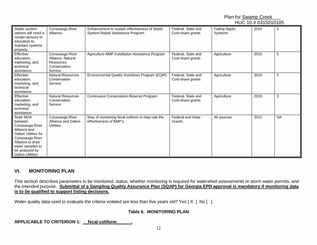
Table 5B. RECOMMENDED NEW MANAGEMENT MEASURES AND ACTIVITIES APPLICABLE TO CRITERION 1: ________ _________________.
NEW BMPs (1)
RESPONSIBILITY (2)
DESCRIPTION (Identify whether new or enhanced)
(3)
FUNDING & RESOURCES
(4)
IMPAIRMENT SOURCES
(5)
TARGET DATE
(6)
NEW BMP LRP
RATING (7)
Plan for Swamp Creek___ HUC 10 # 0315010105
12
Septic system owners will need a certain amount of education to maintain systems properly.
Conasauga River Alliance.
Enhancement to sustain effectiveness of Septic System Repair Assistance Program
Federal, State and Cost-share grants
Failing Septic Systems
2010 5
Effective education, marketing, and technical assistance.
Conasauga River Alliance, Natural Resources Conservation Service
Agriculture BMP Installation Assistance Program
Federal, State and Cost-share grants
Agriculture 2010 5
Effective education, marketing, and technical assistance.
Natural Resources Conservation Service
Environmental Quality Incentives Program (EQIP) Federal, State and Cost-share grants
Agriculture 2010 5
Effective education, marketing, and technical assistance.
Natural Resources Conservation Service
Continuous Conservation Reserve Program Federal, State and Cost-share grants
Agriculture 2010 3
Seek MOA between Conasauga River Alliance and Dalton Utilities for Conasauga River Alliance to draw water samples to be analyzed by Dalton Utilities
Conasauga River Alliance and Dalton Utilities
Way of monitoring fecal coliform to help rate the effectiveness of BMP’s.
Federal and State Grants.
All sources. 2012 NA
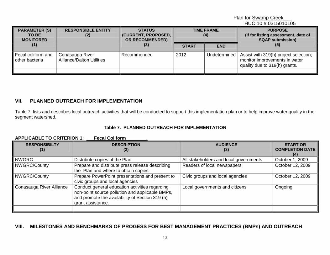
VI. MONITORING PLAN This section describes parameters to be monitored, status, whether monitoring is required for watershed assessments or storm water permits, and the intended purpose. Submittal of a Sampling Quality Assurance Plan (SQAP) for Georgia EPD approval is mandatory if monitoring data is to be qualified to support listing decisions. Water quality data used to evaluate the criteria violated are less than five years old? Yes [ X ] No [ ].
Table 6. MONITORING PLAN APPLICABLE TO CRITERION 1: __fecal coliform______.
Plan for Swamp Creek___ HUC 10 # 0315010105
13
PARAMETER (S) TO BE
MONITORED (1)
RESPONSIBLE ENTITY (2)
STATUS (CURRENT, PROPOSED,
OR RECOMMENDED) (3)
TIME FRAME (4)
PURPOSE (If for listing assessment, date of
SQAP submission) (5) START END
Fecal coliform and other bacteria
Conasauga River Alliance/Dalton Utilities
Recommended 2012 Undetermined Assist with 319(h) project selection; monitor improvements in water quality due to 319(h) grants.
VII. PLANNED OUTREACH FOR IMPLEMENTATION Table 7. lists and describes local outreach activities that will be conducted to support this implementation plan or to help improve water quality in the segment watershed.
Table 7. PLANNED OUTREACH FOR IMPLEMENTATION
APPLICABLE TO CRITERION 1: ___Fecal Coliform________.
RESPONSIBILTY (1)
DESCRIPTION (2)
AUDIENCE (3)
START OR COMPLETION DATE
(4) NWGRC Distribute copies of the Plan All stakeholders and local governments October 1, 2009 NWGRC/County Prepare and distribute press release describing
the Plan and where to obtain copies Readers of local newspapers October 12, 2009
NWGRC/County Prepare PowerPoint presentations and present to civic groups and local agencies
Civic groups and local agencies October 12, 2009
Conasauga River Alliance Conduct general education activities regarding non-point source pollution and applicable BMPs, and promote the availability of Section 319 (h) grant assistance.
Local governments and citizens Ongoing
VIII. MILESTONES AND BENCHMARKS OF PROGESS FOR BEST MANAGEMENT PRACTICES (BMPs) AND OUTREACH
Plan for Swamp Creek___ HUC 10 # 0315010105
14
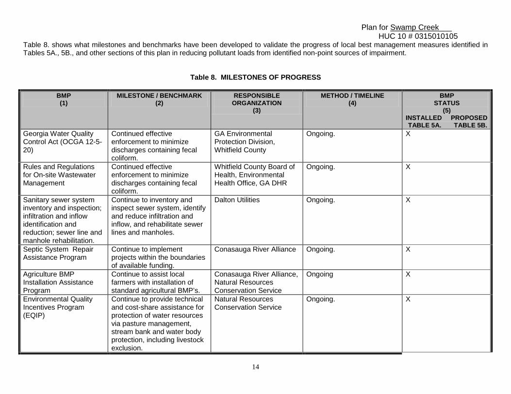
Table 8. shows what milestones and benchmarks have been developed to validate the progress of local best management measures identified in Tables 5A., 5B., and other sections of this plan in reducing pollutant loads from identified non-point sources of impairment.
Table 8. MILESTONES OF PROGRESS
BMP (1)
MILESTONE / BENCHMARK (2)
RESPONSIBLE ORGANIZATION
(3)
METHOD / TIMELINE (4)
BMP STATUS
(5) INSTALLED PROPOSED TABLE 5A. TABLE 5B.
Georgia Water Quality Control Act (OCGA 12-5-20)
Continued effective enforcement to minimize discharges containing fecal coliform.
GA Environmental Protection Division, Whitfield County
Ongoing. X
Rules and Regulations for On-site Wastewater Management
Continued effective enforcement to minimize discharges containing fecal coliform.
Whitfield County Board of Health, Environmental Health Office, GA DHR
Ongoing. X
Sanitary sewer system inventory and inspection; infiltration and inflow identification and reduction; sewer line and manhole rehabilitation.
Continue to inventory and inspect sewer system, identify and reduce infiltration and inflow, and rehabilitate sewer lines and manholes.
Dalton Utilities Ongoing. X
Septic System Repair Assistance Program
Continue to implement projects within the boundaries of available funding.
Conasauga River Alliance Ongoing. X
Agriculture BMP Installation Assistance Program
Continue to assist local farmers with installation of standard agricultural BMP’s.
Conasauga River Alliance, Natural Resources Conservation Service
Ongoing X
Environmental Quality Incentives Program (EQIP)
Continue to provide technical and cost-share assistance for protection of water resources via pasture management, stream bank and water body protection, including livestock exclusion.
Natural Resources Conservation Service
Ongoing. X
Plan for Swamp Creek___ HUC 10 # 0315010105
15
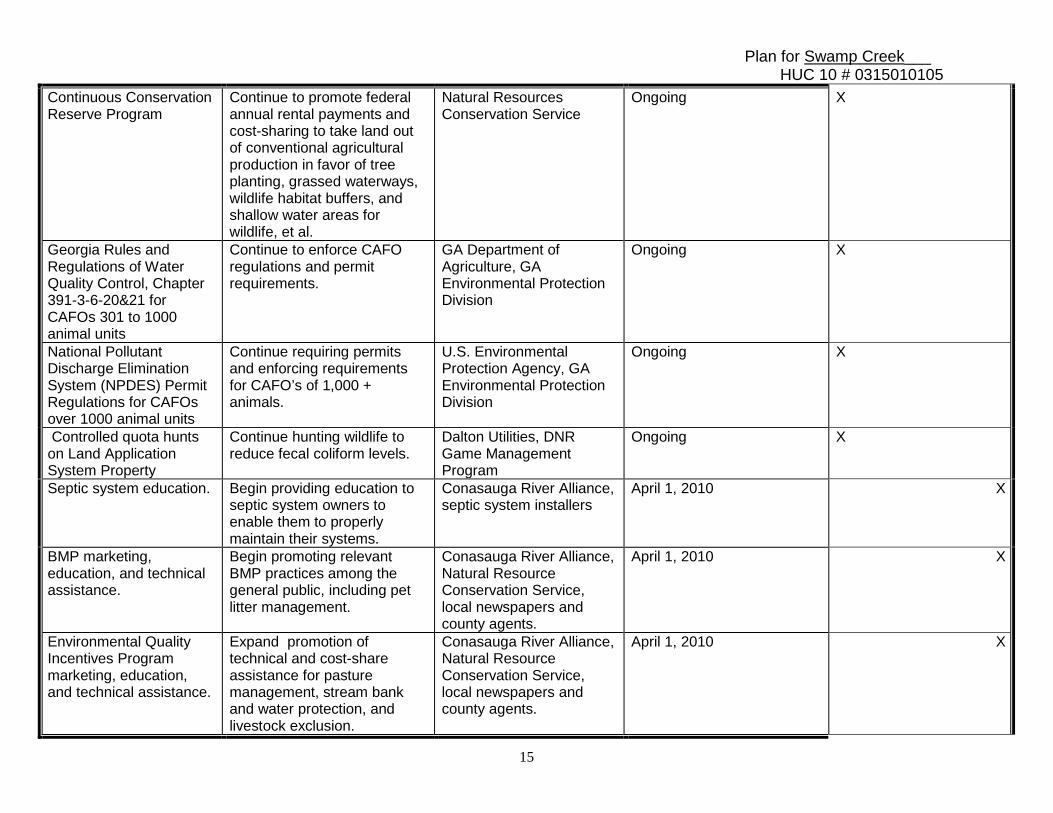
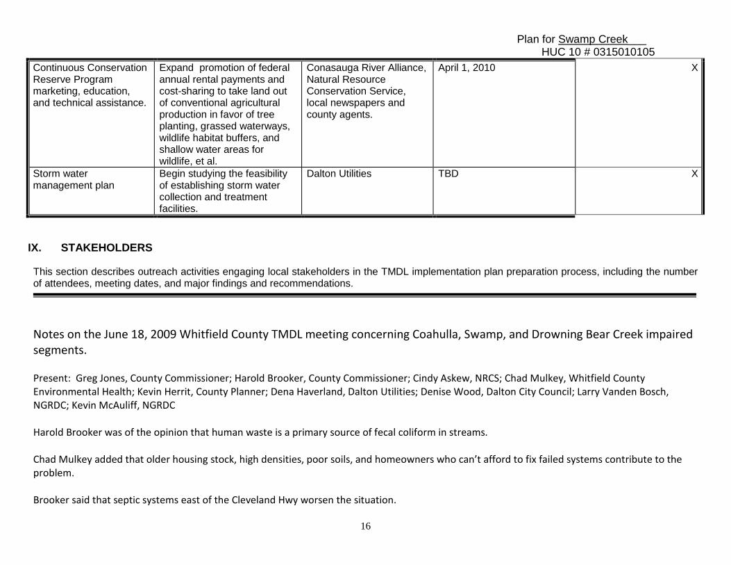
Continuous Conservation Reserve Program
Continue to promote federal annual rental payments and cost-sharing to take land out of conventional agricultural production in favor of tree planting, grassed waterways, wildlife habitat buffers, and shallow water areas for wildlife, et al.
Natural Resources Conservation Service
Ongoing X
Georgia Rules and Regulations of Water Quality Control, Chapter 391-3-6-20&21 for CAFOs 301 to 1000 animal units
Continue to enforce CAFO regulations and permit requirements.
GA Department of Agriculture, GA Environmental Protection Division
Ongoing X
National Pollutant Discharge Elimination System (NPDES) Permit Regulations for CAFOs over 1000 animal units
Continue requiring permits and enforcing requirements for CAFO’s of 1,000 + animals.
U.S. Environmental Protection Agency, GA Environmental Protection Division
Ongoing X
Controlled quota hunts on Land Application System Property
Continue hunting wildlife to reduce fecal coliform levels.
Dalton Utilities, DNR Game Management Program
Ongoing X
Septic system education. Begin providing education to septic system owners to enable them to properly maintain their systems.
Conasauga River Alliance, septic system installers
April 1, 2010 X
BMP marketing, education, and technical assistance.
Begin promoting relevant BMP practices among the general public, including pet litter management.
Conasauga River Alliance, Natural Resource Conservation Service, local newspapers and county agents.
April 1, 2010 X
Environmental Quality Incentives Program marketing, education, and technical assistance.
Expand promotion of technical and cost-share assistance for pasture management, stream bank and water protection, and livestock exclusion.
Conasauga River Alliance, Natural Resource Conservation Service, local newspapers and county agents.
April 1, 2010 X
Plan for Swamp Creek___ HUC 10 # 0315010105
16
Continuous Conservation Reserve Program marketing, education, and technical assistance.
Expand promotion of federal annual rental payments and cost-sharing to take land out of conventional agricultural production in favor of tree planting, grassed waterways, wildlife habitat buffers, and shallow water areas for wildlife, et al.
Conasauga River Alliance, Natural Resource Conservation Service, local newspapers and county agents.
April 1, 2010 X
Storm water management plan
Begin studying the feasibility of establishing storm water collection and treatment facilities.
Dalton Utilities TBD X
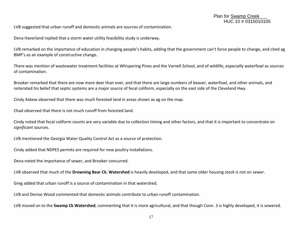
IX. STAKEHOLDERS This section describes outreach activities engaging local stakeholders in the TMDL implementation plan preparation process, including the number of attendees, meeting dates, and major findings and recommendations. Notes on the June 18, 2009 Whitfield County TMDL meeting concerning Coahulla, Swamp, and Drowning Bear Creek impaired segments. Present: Greg Jones, County Commissioner; Harold Brooker, County Commissioner; Cindy Askew, NRCS; Chad Mulkey, Whitfield County Environmental Health; Kevin Herrit, County Planner; Dena Haverland, Dalton Utilities; Denise Wood, Dalton City Council; Larry Vanden Bosch, NGRDC; Kevin McAuliff, NGRDC Harold Brooker was of the opinion that human waste is a primary source of fecal coliform in streams. Chad Mulkey added that older housing stock, high densities, poor soils, and homeowners who can’t afford to fix failed systems contribute to the problem. Brooker said that septic systems east of the Cleveland Hwy worsen the situation.
Plan for Swamp Creek___ HUC 10 # 0315010105
17
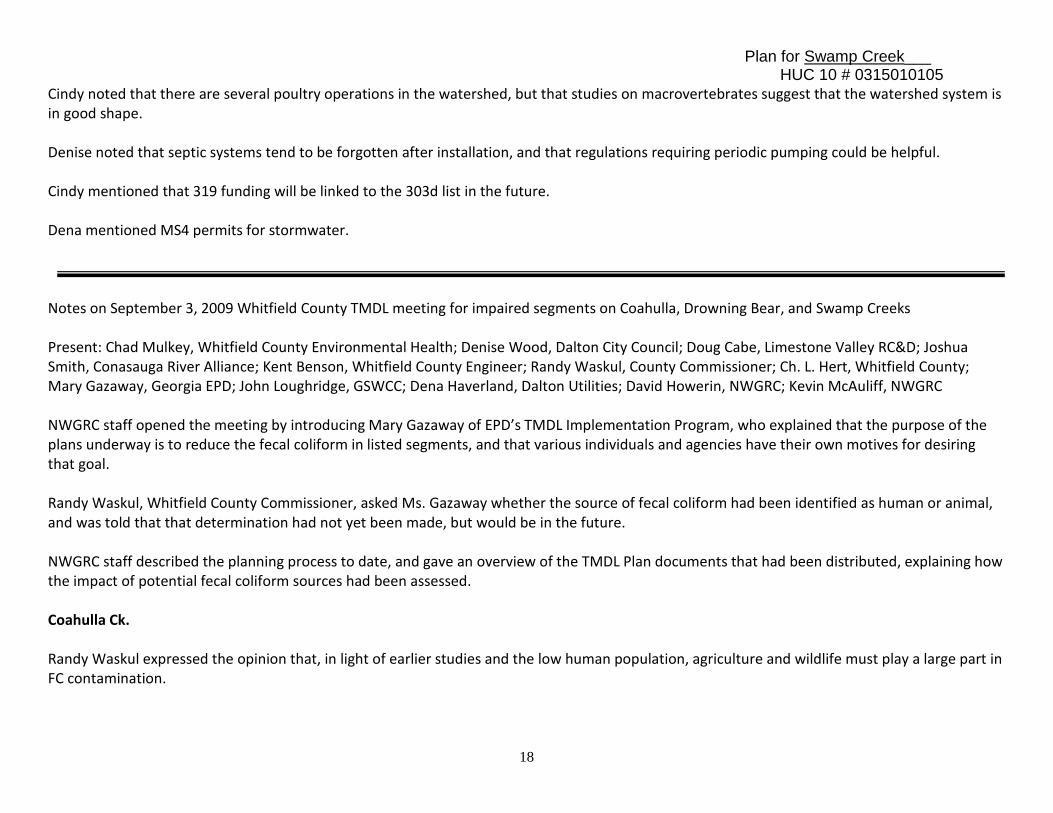
LVB suggested that urban runoff and domestic animals are sources of contamination. Dena Haverland replied that a storm water utility feasibility study is underway. LVB remarked on the importance of education in changing people’s habits, adding that the government can’t force people to change, and cited ag BMP’s as an example of constructive change. There was mention of wastewater treatment facilities at Whispering Pines and the Varnell School, and of wildlife, especially waterfowl as sources of contamination. Brooker remarked that there are now more deer than ever, and that there are large numbers of beaver, waterfowl, and other animals, and reiterated his belief that septic systems are a major source of fecal coliform, especially on the east side of the Cleveland Hwy. Cindy Askew observed that there was much forested land in areas shown as ag on the map. Chad observed that there is not much runoff from forested land. Cindy noted that fecal coliform counts are very variable due to collection timing and other factors, and that it is important to concentrate on significant sources. LVB mentioned the Georgia Water Quality Control Act as a source of protection. Cindy added that NDPES permits are required for new poultry installations. Dena noted the importance of sewer, and Brooker concurred. LVB observed that much of the Drowning Bear Ck. Watershed is heavily developed, and that some older housing stock is not on sewer. Greg added that urban runoff is a source of contamination in that watershed. LVB and Denise Wood commented that domestic animals contribute to urban runoff contamination. LVB moved on to the Swamp Ck Watershed, commenting that it is more agricultural, and that though Conn. 3 is highly developed, it is sewered.
Plan for Swamp Creek___ HUC 10 # 0315010105
18
Cindy noted that there are several poultry operations in the watershed, but that studies on macrovertebrates suggest that the watershed system is in good shape. Denise noted that septic systems tend to be forgotten after installation, and that regulations requiring periodic pumping could be helpful. Cindy mentioned that 319 funding will be linked to the 303d list in the future. Dena mentioned MS4 permits for stormwater. Notes on September 3, 2009 Whitfield County TMDL meeting for impaired segments on Coahulla, Drowning Bear, and Swamp Creeks Present: Chad Mulkey, Whitfield County Environmental Health; Denise Wood, Dalton City Council; Doug Cabe, Limestone Valley RC&D; Joshua Smith, Conasauga River Alliance; Kent Benson, Whitfield County Engineer; Randy Waskul, County Commissioner; Ch. L. Hert, Whitfield County; Mary Gazaway, Georgia EPD; John Loughridge, GSWCC; Dena Haverland, Dalton Utilities; David Howerin, NWGRC; Kevin McAuliff, NWGRC NWGRC staff opened the meeting by introducing Mary Gazaway of EPD’s TMDL Implementation Program, who explained that the purpose of the plans underway is to reduce the fecal coliform in listed segments, and that various individuals and agencies have their own motives for desiring that goal. Randy Waskul, Whitfield County Commissioner, asked Ms. Gazaway whether the source of fecal coliform had been identified as human or animal, and was told that that determination had not yet been made, but would be in the future. NWGRC staff described the planning process to date, and gave an overview of the TMDL Plan documents that had been distributed, explaining how the impact of potential fecal coliform sources had been assessed. Coahulla Ck. Randy Waskul expressed the opinion that, in light of earlier studies and the low human population, agriculture and wildlife must play a large part in FC contamination.
Plan for Swamp Creek___ HUC 10 # 0315010105
19
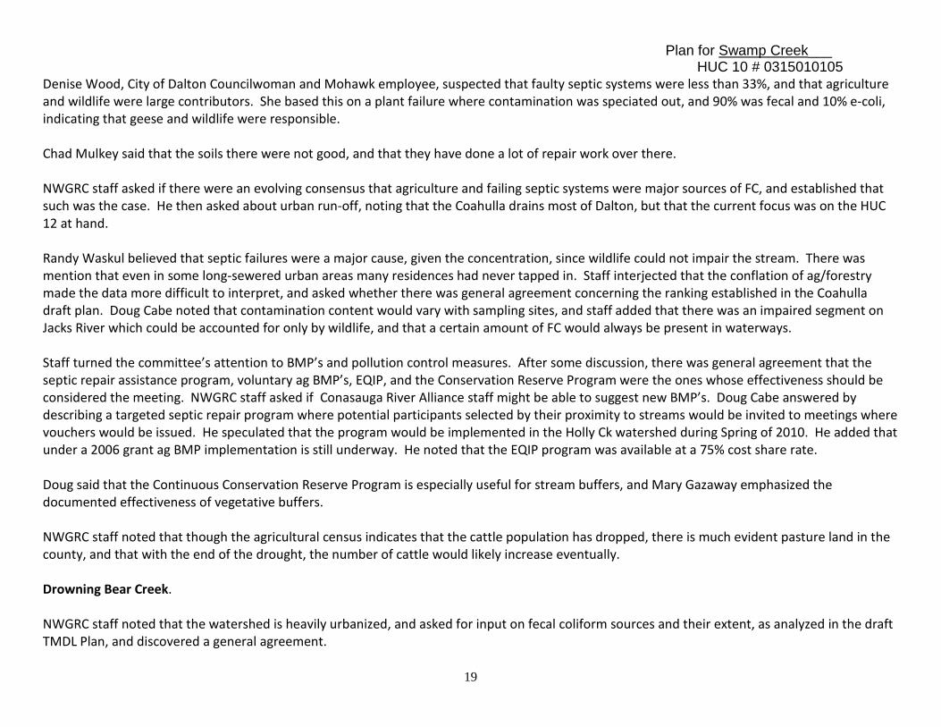
Denise Wood, City of Dalton Councilwoman and Mohawk employee, suspected that faulty septic systems were less than 33%, and that agriculture and wildlife were large contributors. She based this on a plant failure where contamination was speciated out, and 90% was fecal and 10% e-coli, indicating that geese and wildlife were responsible. Chad Mulkey said that the soils there were not good, and that they have done a lot of repair work over there. NWGRC staff asked if there were an evolving consensus that agriculture and failing septic systems were major sources of FC, and established that such was the case. He then asked about urban run-off, noting that the Coahulla drains most of Dalton, but that the current focus was on the HUC 12 at hand. Randy Waskul believed that septic failures were a major cause, given the concentration, since wildlife could not impair the stream. There was mention that even in some long-sewered urban areas many residences had never tapped in. Staff interjected that the conflation of ag/forestry made the data more difficult to interpret, and asked whether there was general agreement concerning the ranking established in the Coahulla draft plan. Doug Cabe noted that contamination content would vary with sampling sites, and staff added that there was an impaired segment on Jacks River which could be accounted for only by wildlife, and that a certain amount of FC would always be present in waterways. Staff turned the committee’s attention to BMP’s and pollution control measures. After some discussion, there was general agreement that the septic repair assistance program, voluntary ag BMP’s, EQIP, and the Conservation Reserve Program were the ones whose effectiveness should be considered the meeting. NWGRC staff asked if Conasauga River Alliance staff might be able to suggest new BMP’s. Doug Cabe answered by describing a targeted septic repair program where potential participants selected by their proximity to streams would be invited to meetings where vouchers would be issued. He speculated that the program would be implemented in the Holly Ck watershed during Spring of 2010. He added that under a 2006 grant ag BMP implementation is still underway. He noted that the EQIP program was available at a 75% cost share rate. Doug said that the Continuous Conservation Reserve Program is especially useful for stream buffers, and Mary Gazaway emphasized the documented effectiveness of vegetative buffers. NWGRC staff noted that though the agricultural census indicates that the cattle population has dropped, there is much evident pasture land in the county, and that with the end of the drought, the number of cattle would likely increase eventually. Drowning Bear Creek. NWGRC staff noted that the watershed is heavily urbanized, and asked for input on fecal coliform sources and their extent, as analyzed in the draft TMDL Plan, and discovered a general agreement.
Plan for Swamp Creek___ HUC 10 # 0315010105
20
There was a short discussion of commercial and industrial contribution to the problem, and there was a general feeling that current regulations limit fecal coliform run-off from those sources. Swamp Creek Staff noted that Swamp Creek originates on the mountain, and asked for input on fecal coliform sources and their extent, as analyzed in the draft TMDL Plan, and discovered a general agreement after some discussion. Ms. Gazaway wondered if actual animals were observed as potential sources, and staff admitted that animals had not been seen, but that wetlands implied their presence, whereupon Ms. Gazaway noted that urban encroachment was very likely driving wildlife into the area under consideration. There was little further discussion, and the meeting ended in general accord on the findings incorporated in the draft Plan.
Plan for Swamp Creek___ HUC 10 # 0315010105
21
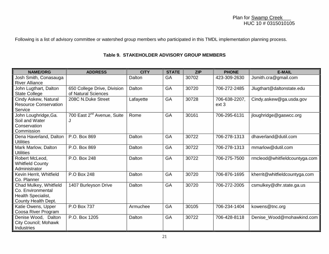
Following is a list of advisory committee or watershed group members who participated in this TMDL implementation planning process.
Table 9. STAKEHOLDER ADVISORY GROUP MEMBERS
NAME/ORG ADDRESS CITY STATE ZIP PHONE E-MAIL Josh Smith, Conasauga River Alliance
Dalton GA 30702 423-309-2630 [email protected]
John Lugthart, Dalton State College
650 College Drive, Division of Natural Sciences
Dalton GA 30720 706-272-2485 [email protected]
Cindy Askew, Natural Resource Conservation Service
208C N.Duke Street Lafayette GA 30728 706-638-2207, ext 3
John Loughridge,Ga. Soil and Water Conservation Commission
700 East 2nd Avenue, Suite J
Rome GA 30161 706-295-6131 [email protected]
Dena Haverland, Dalton Utilities
P.O. Box 869 Dalton GA 30722 706-278-1313 [email protected]
Mark Marlow, Dalton Utilities
P.O. Box 869 Dalton GA 30722 706-278-1313 [email protected]
Robert McLeod, Whitfield County Administrator
P.O. Box 248 Dalton GA 30722 706-275-7500 [email protected]
Kevin Herrit, Whitfield Co. Planner
P.O Box 248 Dalton GA 30720 706-876-1695 [email protected]
Chad Mulkey, Whitfield Co. Environmental Health Specialist, County Health Dept.
1407 Burleyson Drive Dalton GA 30720 706-272-2005 [email protected]
Katie Owens, Upper Coosa River Program
P.O Box 737 Armuchee GA 30105 706-234-1404 [email protected]
Denise Wood, Dalton City Council; Mohawk Industries
P.O. Box 1205 Dalton GA 30722 706-428-8118 [email protected]
Plan for Swamp Creek___ HUC 10 # 0315010105
22
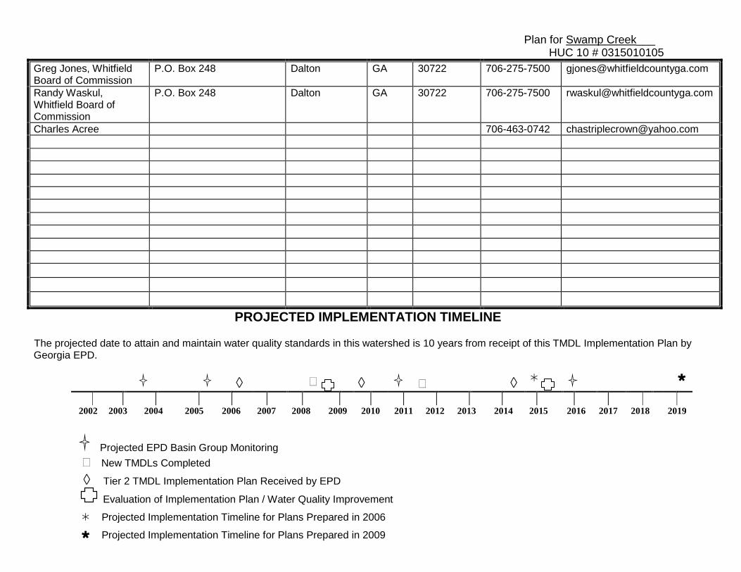
Greg Jones, Whitfield Board of Commission
P.O. Box 248 Dalton GA 30722 706-275-7500 [email protected]
Randy Waskul, Whitfield Board of Commission
P.O. Box 248 Dalton GA 30722 706-275-7500 [email protected]
Charles Acree 706-463-0742 [email protected]
PROJECTED IMPLEMENTATION TIMELINE The projected date to attain and maintain water quality standards in this watershed is 10 years from receipt of this TMDL Implementation Plan by Georgia EPD.
◊ � ◊
� ◊
2002 2003 2004 2005 2006 2007 2008 2009 2010 2011 2012 2013 2014 2015 2016 2017 2018 2019
Projected EPD Basin Group Monitoring � New TMDLs Completed
◊ Tier 2 TMDL Implementation Plan Received by EPD
Evaluation of Implementation Plan / Water Quality Improvement
Projected Implementation Timeline for Plans Prepared in 2006
Projected Implementation Timeline for Plans Prepared in 2009
Plan for Swamp Creek___ HUC 10 # 0315010105
23
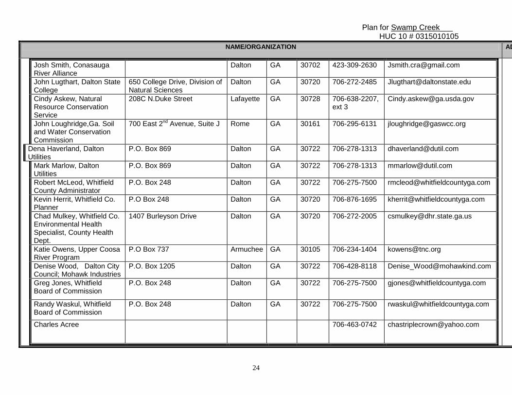
APPENDIX A.
OUTREACH ATTENDANCE Following is a list of the local governments, agricultural or commercial forestry organizations, significant landholders, businesses and industries, and local organizations, including environmental groups and individuals, with a major interest in this watershed.
Prepared By: Kevin McAuliff Agency: NWGRC Address: City:
503 West Waugh Street Dalton ST: GA ZIP: 30720
E-mail: [email protected] Date Submitted to EPD: Sept. 30, 2009
Revision:
Preparation of this report was financed in part through a grant from the U.S. Environmental Protection Agency under the
provisions of Section 106 of the Federal Water Pollution Control Act, as amended.
Plan for Swamp Creek___ HUC 10 # 0315010105
24
NAME/ORGANIZATION ADDRESS CITY STATE ZIP PHONE E-MAIL
Josh Smith, Conasauga River Alliance
Dalton GA 30702 423-309-2630 [email protected]
John Lugthart, Dalton State College
650 College Drive, Division of Natural Sciences
Dalton GA 30720 706-272-2485 [email protected]
Cindy Askew, Natural Resource Conservation Service
208C N.Duke Street Lafayette GA 30728 706-638-2207, ext 3
John Loughridge,Ga. Soil and Water Conservation Commission
700 East 2nd Avenue, Suite J Rome GA 30161 706-295-6131 [email protected]
Dena Haverland, Dalton Utilities
P.O. Box 869 Dalton GA 30722 706-278-1313 [email protected]
Mark Marlow, Dalton Utilities
P.O. Box 869 Dalton GA 30722 706-278-1313 [email protected]
Robert McLeod, Whitfield County Administrator
P.O. Box 248 Dalton GA 30722 706-275-7500 [email protected]
Kevin Herrit, Whitfield Co. Planner
P.O Box 248 Dalton GA 30720 706-876-1695 [email protected]
Chad Mulkey, Whitfield Co. Environmental Health Specialist, County Health Dept.
1407 Burleyson Drive Dalton GA 30720 706-272-2005 [email protected]
Katie Owens, Upper Coosa River Program
P.O Box 737 Armuchee GA 30105 706-234-1404 [email protected]
Denise Wood, Dalton City Council; Mohawk Industries
P.O. Box 1205 Dalton GA 30722 706-428-8118 [email protected]
Greg Jones, Whitfield Board of Commission
P.O. Box 248 Dalton GA 30722 706-275-7500 [email protected]
Randy Waskul, Whitfield Board of Commission
P.O. Box 248 Dalton GA 30722 706-275-7500 [email protected]
Charles Acree 706-463-0742 [email protected]
Plan for Swamp Creek___ HUC 10 # 0315010105
25
APPENDIX B.
STATUS REPORTS / UPDATES TO THIS PLAN If there are any revisions to an existing plan, this section will describe the date, section or table updated, and a summary of what was changed and why. A Status Report / Updates on Existing Local TMDL Implementation Plans and Watershed Remediation will be attached as a separate document. New plan.
APPENDIX C.
VISUAL FIELD SURVEYS, NOTES, PHOTOGRAPHS, AND MAPS. SEE ATTACHMENT.
Plan for Swamp Creek___ HUC 10 # 0315010105
26
APPENDIX D.
INSTRUCTIONS AND GUIDANCE

Plan for Swamp Creek___ HUC 10 # 0315010105
27